Embed Size (px)
Citation preview
CHERRY RIDGE-CAMPBELL MOUNTAIN WILD FOREST
UNIT MANAGEMENT PLAN
March 1987
New York State/Department of Environmental Conservation

CHERRY RIDGE - CAMPBELL MOUNTAIN WILD FOREST
UNIT MANAGEMENT PLAN
New York State/Department of Environmental Conservation
Mario Cuomo Governor
Henry G. Williams Commissioner

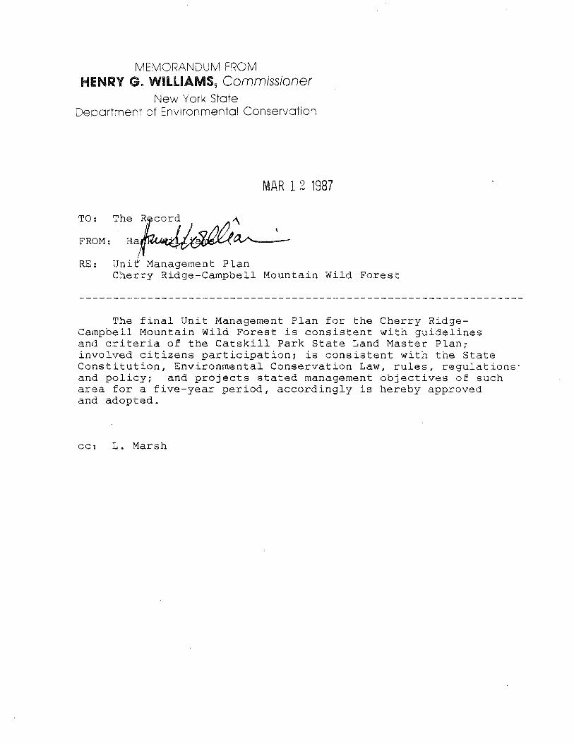
MEMORANDUM FROM HENRY G. WILLIAMS, Commissioner
New York State Department of Environmental Conservation
MAR 1 2 1987
RE: Uni~ Management Plan Cherry Ridge-Campbell Mountain Wild Forest
The final Unit Management Plan for the Cherry RidgeCampbell Mountain Wild Forest is consistent with guidelines and criteria of the Catskill Park State Land Master Plan; involved citizens participation; is consistent with the State Constitution, Environmental Conservation Law, rules, regulations· and policy; and projects stated management objectives of such area for a five-year period, accordingly is hereby approved and adopted.
cc: L. Marsh

TABLE OF CONTENTS
I. LOCATION AND DESCRIPTION OF UNIT 3
A. Location 3
B. Description 4
1. General 4
2. Wildlife 5
3. Fisheries 7
II. INVENTORY OF FACILITIES AND SYSTEMS 8
III. SPECIAL CONSTRAINTS AND ISSUES AFFECTING THE PLANNING AREA 13
A. General Constraints 13
B. Applicable Laws, Rules and Regulations-Wildlife and Fisheries 14
C. Overuse Problems and Special Issues 14
D. Non-conforming Uses 17
E. Critical Habitats 17
F. Primary Public Use 20
IV. Identification of Management Objectives 20
V. Basis for Management Objectives 20
VI. Proposed Management Actions 22
VII. Budgetary Proposals 24
VIII. Draft Environmental Impact Statement 25
IX.
x.
Bibliography 42
Aooendices -~.~~~
43
A. Sign Inventory 43
B. Status and Occurrence of Amphibians in the Delaware Hills Sub zone 49
c. Status and Occurrence of Reptiles in the Delaware Hills Subzone 50
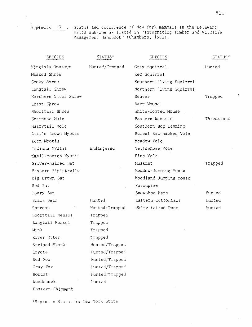
D. Status and Occurrence of Mammals in the Delaware Hills Subzone 51
E. Delaware Trails 52
F. Town of Colchester Snowmobile Trails 54
G. List of Bird Species by Breeding Category
H. Status and Occurrence of Breeding
55
Birds in the Delaware Hills Subzone 57
I. List of Protected Native Plants 60
ERRY RIDGE-OF CH LOCATION MOUNTAIN CAMPBELL
WILD FOREST / \
~ / \
\ \
WALTON
\ \
\ \
\ )
/ /
2A
\ HAMDEN
HANCOCK
t . e Campbell Cherry R1dq -
- Mt. Wild Fgqest
Other Forest ~Preserve Other State W, Land
LCHEST
F R E M 0 N T r--.J
/CAL
r....J I
AN D ES
I I
( \ \
v'
-...... r;J '-y-_, -) BOVINA
)...._
/ '----.... / -......
I "-...... / / '--....... MIDDLE·
"'("\. TOWN "'\
') \ 1 I
ROCKLAND
I Swan L -J..._
ground !\. State camp ---r: I ---. ---BETH 1.. b
3 M, I es

..
-3-
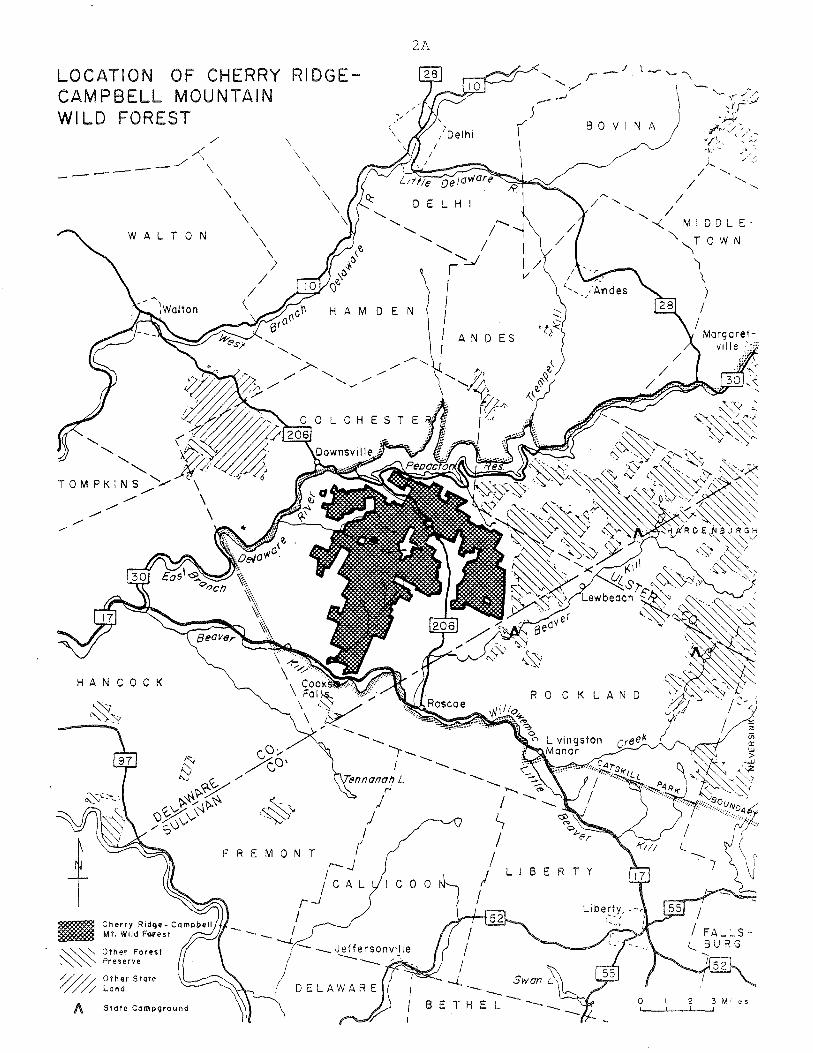
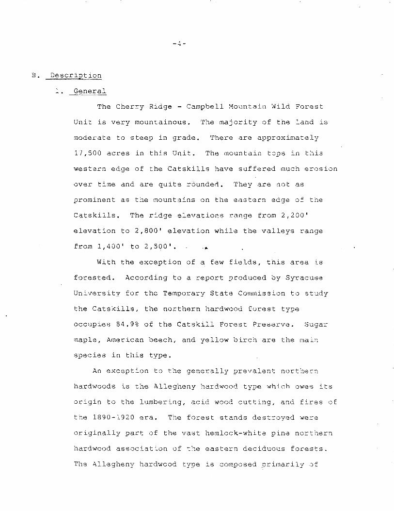
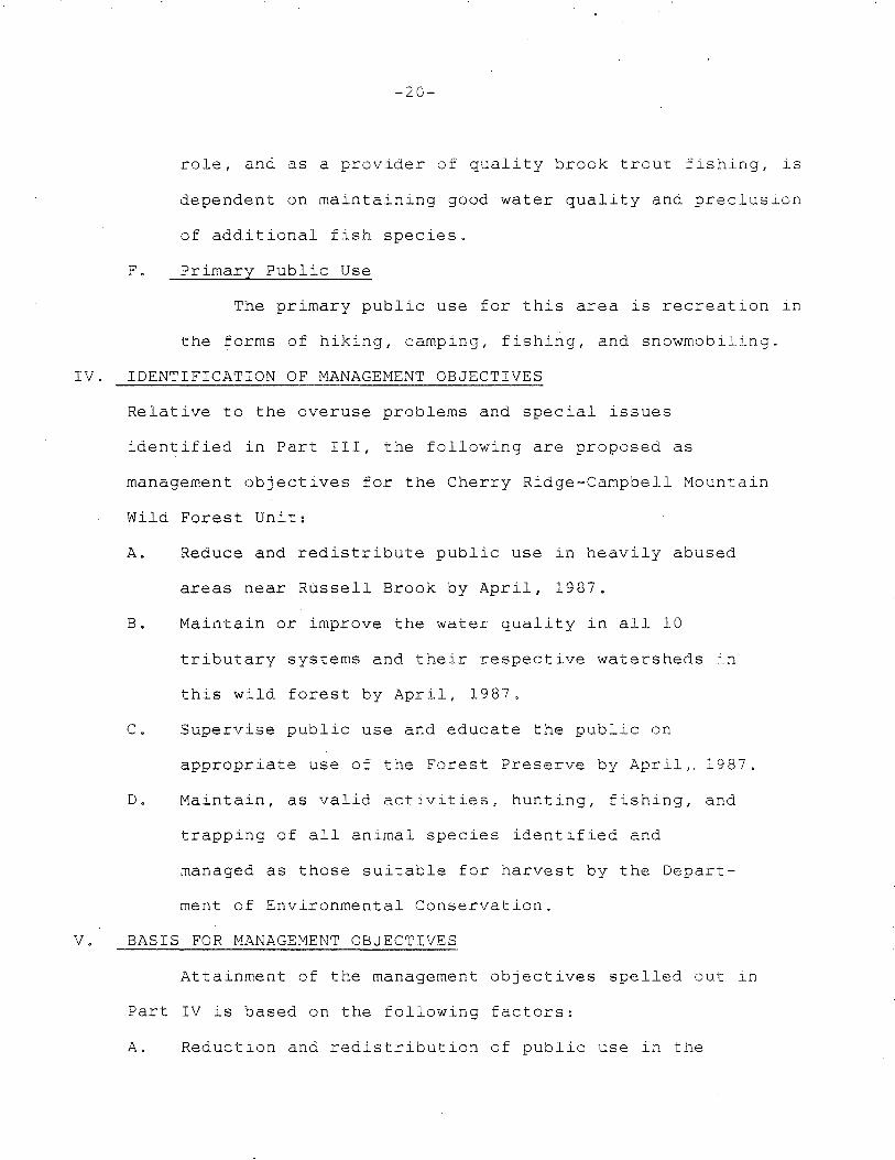
I. LOCATION AND DESCRIPTION OF UNIT
A. Location
This wild forest is part of the Catskill Forest Pre
serve in the Town of Colchester in Delaware County. It
is the most westerly unit within the Catskill Park.
County Route 17 and the Beaverkill are near the southerly
boundary while Russell Brook Road, 'Dry Brook Road, Fuller
Brook Road, Fuller Hill Road, Hawks Hollow Road, Campbell
Brook Road, Campbell Mountain Road, and Mink Brook Road
touch or are near the westerly boundaries. Pepacton
Reservoir, New York Route 30 and the-eity of New York
property are near the northern boundary while Holiday and
Berry Brook Road, which runs generally north and south is
near the easterly boundaries of Cherry Ridge-Campbell
Mountain Wild Forest Unit. County Route #7, Downsville
Rockland Road, State 206 or local name Cat Hollow Road,
Russell Brook Road, Morton Hill Road, Campbell Brook
Road, Campbell Mountain Road, and Jug Tavern Road provide
access through the area.
There is one small non-contiguous mountain tract of
land included within the Cherry Ridge-Campbell Mountain
Wild Forest Unit. It is located on the northwest corner
of the area 0ear Hog Hollow and south of Downsville.
(see map for location)
B. Description
1. General
The Cherry Ridge - Campbell ~ountain ~ild Forest
Unit is very mountainous. The majority of the land is
moderate to steep in grade. There are approximately
17,500 acres in this Unit. The mountain tops in this
western edge of the Catskills have suffered much erosion
over time and are quite rounded. They are not as
prominent as the mountains on the eastern edge of the
Catskills. The ridge elevations range from 2,200'
elevation to 2,800' elevation while the valleys range
from 1,400' to 2,500'.
With the exception of a few fields, this area is
forested. According to a report produced by Syracuse
University for the Temporary State Commission to study
the Catskills, the northern hardwood forest type
occupies 84.9% of the Catskill Forest Preserve. Sugar
maple, American beech, and yellow birch are the main
species in this type.
An exception to the generally prevalent northern
hardwoods is the Allegheny hardwood type which owes its
origin to the lumbering, acid wood cutting, and fires of
the 1890-1920 era. The forest stands destroyed were
originally part of the vast hemlock-white pine northern
hardwood association of the eastern deciduous forests.
The Allegheny hardwood type is composed primarily of
-5-
black cherry, red maple, sugar maple with white ash,
yellow birch, American beech, and eastern hemlock as
common associates. Some other forest types within this
area are plantation spruce, red pine, larch, and hemlock.
The soils in this unit have limited drainage and
hardpan is generally 12" to 24" from the soil surface.
The ground is very stony and in places the glaciers
deposited large shale, block-type rocks. Trout Pond and
Mud Pond are two large, attractive, man-made
ponds nestled back in the mountains. Several small
brooks and streams drain this area. Russell Brook is by
far the most picturesque with its scenic overlooks,· old
dams, and cascading waterfalls. Eventually, all the
water from this area drains into the Delaware River.
There are 13 mapped and inventoried wetlands within
this unit.
There are several miles of town roads that adjoin
or traverse the area so that no part of the Cherry Ridge
-Campbell Mountain Wild Forest Unit is very remote.
2. Wildlife
The Cherry Ridge-Campbell ~ountain Wild Forest
Unit lies within the Delaware Hills ecological subzone.
The extensive northern hardwoods forest with scattered
coniferous cover provide habitat for a variety of
wildlife species, especially those that favor mature to
old-growth forest stages.
There has never been a formal inventory of animal
,--o-
life on this area. Chambers, in his handbook,
"Integration Timber and Wildlife Management" (1983),
compiled an extensive listing of wildlife presumed to
reside within the Delaware Hills ecological subzone and
further qualified his listing by categorizing species by
forest type, forest stage, and·special habitat needs. Based
on Chambers' criteria, 51 species of mammals, 105 species
of birds, and 35 species of reptiles and amphibians likely
reside on the Cherry Ridge-Campbell Mountain Wild Forest Unit.
(See Appendix H,I,J,K). Records compiled for the Breeding
Bird Atlas (D.E.C. in cooperation with the Federation of
N.Y.S. Bird Clubs) indicate that 46 species of birds were
recorded as confirmed breeders, 55 species as probable
breeders, and 44 species as possible breeders in the
White-tailed deer are present and are eagerly sought
after by hunters. From four years (1980-83) of hunting
information in the Town of Colchester, it is known that
an average of 5.2 bucks per square mile of deer range
were taken. Extrapolating from this information and
assuming that the deer population is uniformly
distributed, the average pre-hunting season population
has been approximately 1,000 within the Unit.
The Cherry Ridge-Campbell Mountain Wild Forest
Unit is within the Northern Catskill Black Bear Range.
Although bears are not common in the area, conditions
-7-
are suitable to allow a bear hunting season. At least
one bear has been taken within the Unit and visitors
occasionally observe them. Recent DEC studies have
focused on the relationship between bears and humans in
the Catskills, in an effort to resolve or prevent
conflicts that recreationists encounter while hiking
or at campsites throughout the entire forest preserve.
3. Fisheries
The Unit is drained by 10 tributary systems
including five to the Beaver Kill, four to Pepacton
Reservoir, and one directly to the East Branch of the
Delaware River (see map). Pepacton Reservoir is an
impoundment of the East Branch at the Village of East
Branch. Three tributaries (Russell Brook, Campbell
Brook and Cat Hollow Brook) account for 72% of the 17.6
miles of flowing water within the Cherry Ridge
Campbell Mountain Wild Forest Unit. Of the three,
Russell Brook, approximately 6 miles, is the most
important. Russell Brook is impounded by a laid stone
dam on tributary #2 to form 26 acre Mud Pond and on the
main item to form 32 acre Trout Pond (formerly Cables
Lake). Trout Pond sustains a self-perpetuating
population of a wild Catskill Mountain strain of brook
trout, native to Tunis Lake, also in Delaware County,
Trout Pond is inhabited by golden shiners and bluntnose
minnows. Mud Pond is stocked with up to 300 spring
yearling rainbow trout each year. Stocked trout share
-8-
Mud Pond with red-breast sunfish, brown bullhead, and
golden shiners. Russell Brook has self-sustaining
populations of brook and brown trout.
The fish indigenous to this part of the State and
normally found in similar habitats are also found in the
tributary system of the Cherry Ridge - Campbell Mountain
Wild Forest Unit. The generally mountainous topography
features moderate gradient tributaries which are subject
to damming by beavers. The beaver dams form small trout
ponds of varying duration. The tributaries support
resident populations of brook trout and also serve as
spawning and nursery areas for the world renowned Beaver
Kill and the·East Branch of the Delaware River and its
impoundment, Pepacton Reservoir.
II. INVENTORY OF FACILITIES AND SYSTEMS
A. Barriers--Trail and Road
1. Junction of Russell Brook Road and the road to Trout and Mud Ponds.
2. Junction of Russell Brook Road and the access road above the junction listed in A.l.
3. Just off Campbell Brook Road and next to the large piece of private land there is a barrier at the junction of the snowmobile trail.
4. Located just south of Campbell Mountain Brook Road on the foot and snowmobile trail.
5. Located just north of Campbell Mountain Road on the foot and snowmobile trail.
6. Located just west of County Route 7 and the trailhead.
7. Located just west of an interior piece of private land in Pelnor Hollow.
-9-
8. Located at the northeast end of Dry Brook Road.
B. Pit Privies
1. Russell Brook field by the old Dye Works.
2. Russell Brook where Mud and Trout Pond Trails begin.
3. Mud Pond.
4. Two at Trout Pond.
5. Campbell Mountain Brook.
6. At the lean-to between Campbell Mountain Road and County Route 7.
7. At Pelnar Hollow Lean-to.
c. Trail Heads-Maintained Parking
1. Holiday and Berry Brook Road
2. Campbell Mountain Road
3. Russell Brook
Trail Heads-Without Maintained Parking
1. Pelnar Hollow
2. Little Spring Brook
3. Cat Hollow
4. Campbell Brook Road
D. Bridges-Snowmobile Bridges
1. Russell Brook to Mud Pond
2. At Trout Pond (2)
3. Russell Brook where the northerly loop crosses the brook
4. Campbell Mountain Brook (North Fork)
5. Campbell Mountain Brook (South Fork) (2)
6. Cat Hollow Brook
7. Little Spring Brook
Bridges-Road
1. Between Russell Brook Parking and the intersection of Russell Brook and Mud Pond trail system
E. Fireplaces
1. At each lean-to on Trout Pond (2)
2. One at Campbell Mountain Brook
3. One at the lean-to between Campbell Mountain Brook and Cat Hollow
4. One at Pelnar Hollow Lean-to
F. Foot Trails Locations (for trail names, guides, and .maps, see Appendix).
1. Russell Brook to Trout Pond
2. Russell Brook to Mud Pond
3. Trout Pond to Mud Pond
4. Trout Pond to Campbell Brook Road
5. Campbell Brook Road to Campbell Mountain Road
6. Campbell Mountain Road to Cat Hollow
7. Cat Hollow to the junction of Little Spring Brook
8. Little Spring Brook to the junction of the red trail to Holiday and Berry Brook Road
9. Red trail junction to Pelnar Hollow
10. Little Spring Brook Road to junction of the blue trail
11. Holiday and Berry Brook to the junction of the blue trail
G. Snowmobile Trails Locations (for trail names, guides, and maps, see Appendix).
-11-
1. Russell Brook to Trout Pond--Trout Pond to Mud Pond--Mud Pond to Russell Brook
2. Northern Russell Brook Trail to Trout Pond and extra loop
3. Trout Pond to Campbell Brook Road--two loops
4. Campbell Brook Road to Campbell Mountain Road
5. Campbell Mountain Road to Cat Hollow
6. Pelnar Hollow, one-way, dead end
7. Miller Hollow Road to the blue trail and back
8. Little Spring Brook to Berg Brook
9. Morton Hill Road, dead end to private land.
H. Lean-tos
1. Pelnar Hollow
~ 2. Between Campbell Mountain and Cat Hollow
3. Two at Trout Pond
I. Roads--Administrative
1. Administrative jeep trail from Russell Brook parking area to Trout ?ond
2. Administrative jeep trail from Russell Brook parking area to Mud Pond
Roads--Public Roads
1. Russell Brook Pond
2. Morton Hill Road
3. Campbell Brook Road
4. Campbell Mountain Road
5. Jug Tavern Road
6. Cat Hollow or County Route 7 & 206
7. Hawks Hollow Road
8. Dry Brook Road
-12-
9. County Route 17
10. Pelnor Hollow Road
11. Holiday and Berry Brook Road
12. Little Spring Brook Road
13. Miller Hollow Road Spur
14. Berg Brook Road
J. Trail Registers
None
K. Dams
1. At Mud Pond
2. At Trout Pond
L. Telephone and Electric Lines
1. West Delaware Aqueduct
2. East Delaware Aqueduct
M. Signs
The Sign Inventory can be found in the Appendix ~.
N. Garbage Disposal
1. There are 9 cans at Russell Brook Picnic Area.
2. There are 2 cans at Trout Pond.
3. There are 3 cans at Campbell Mountain Road Parking Lot.
4. There is 1 can at the lean-to between Cat Hollow and Campbell Mountain Road.
5. There is 1 can at Pelnar Hollow lean-to.
Oe Scenic Vistas
1. Brock Mountain
2. Extension of Miller Hollow Snowmobile Trail-south
III.
P. Spawning Structures
1. Trout Pond
-13-
SPECIAL CONSTRAINTS AND ISSUES AFFECTING THE PLANNING AREA
A. General Constraints
This unit management plan is developed within the
constraints set forth by Article XIV of the State
Constitution, Article 9 of the Environmental Conser
vation Law, Title 6 of the Codes, Rules and Regulations
of the State of New York, the Catskill Park State Land
Master Plan and established policies for the admin
istration of the lands involved.
The "forever wild fore~t lands•: clause of Article
XIV of the New York State Constitution imposes a
passive management scheme, which ultimately resulis in
mature to old-growth forest (and wildlife habitat)
conditions. On other State-owned lands controlled by
the Department, it is possible to devise and conduct
habitat modification to favor specific wildlife
species (usually game animals.) Natural succession is
allowed to progress toward ecological climax on Forest
Preserve lands. Game populations may not be large
under these conditions. The Forest Preserve concept
provides a strategy of land management that places
emphasis on the protection of natural processes rather
than individual species or groups of species.
-14-
B. Applicable Laws and Rules and Regulations-Wildlife and Fisheries
Deer management is gover~ed by the objectives of State-
wide deer management, Environmental Conservation Law
(ECL 11-0907) and Deer Management Unit 60 (ECL 11-0913, 6
NYCRR 1.21). The entire Cherry Ridge-Campbell Mountain Wild
Forest Unit is within DMU 60.
Fishing in most of the waters of the Cherry Ridge-
Campbell Mountain Wild Forest Unit is regulated by Statewide
seasons, size and creel limits specified in 6NYCRR10.l as
authorized by 11-1303-7 of the Environmental Conservation
Law of New York. Special Rules and regulations apply to .. ~ ~ ~
Trout Pond and include a three fish creel limit and a 10"
total length minimum size limit as specified in
6NYCRR10.2(13)(h). The use of fish for bait in Trout Pond
is disallowed under 6NYCRR10.6(h)(l).
C. Overuse Problems and Special Issues
1. General
Russell Brook, an intensively used area within the
Cherry Ridge-Campbell Mountain Wild Forest Unit, has been
notorious for its management vroblemse Peak use of the Unit
occurs during Memorial Day weekend, Fourth of July, Labor
Day, and on various summer weekends. Big Game hunting season
brings another peak of activity.
The main access to the Cherry Ridge-Campbell Mountain
Nild Forest Unit from State Route 17 is via Russell Brook
Road. Although passing through State Forest ?resecve land
-15-
and sharing a narrow valley with Russell Brook, it is owned
and maintained by the Town of Colchester. The road is
hazardously narrow and has limited parking and visibility.
It has been washed out frequently and there is minimal
stream bank protection.
Years ago the then Conservation D~partmeot rehabilitated
a wooden bridge over Russell Brook at the southern end of
t~e woods road (foot and snowmobile trail) to Trout Pond.
The open fields just north and west of this bridge are
intensively used areas. This area, although abused and
littered, is beautiful and charming. Just upstream from the
bridge are cascading waterfalls surrounded by hemlock-
covered, high rock cliffs. In 1983, a barrier gate was
constructed to eliminate vehicular travel accross the wooden
bridge. This barrier gate discouraged some campers from
using this area.
Other areas of moderate public use in the ~herry Ridge
Campbell Mountain Wild Forest Area are:
(1) Just off Campbell Brook Road immediately west of
the large piece of private land
(2) Campbell Mountain Road south of the parking area all
the way to Campbell Mountain Brook
(3) The area near the trail head on State Route 206 (Cat
Hollow) to Cat Hollow Brook
2. Specific
When many campers congregate in a small area, there
are problems. The most critical problem is control of
1 c ~u
rowdy, unlawful, and destructive activity. Numecous
incidents have required State Police attention.
Examples include: drug parties, gang fights, discharge
of firearms in a crowded area, beer parties, ethnic
confrontations, destruction of latrines for firewood
and by firearms, tree ~utting, and tree mutilation.
Another serious problem is the lack of sanitary
facilities. Remains of human defecation and toilet
paper are scattered throughout the camping area.
Drinking and cooking water is taken from the creek which
is being polluted by bathers, leaching of human defeca-
tion, and other garbage.
3. Economic
It is costly to maintain, police, and keep the area
clean. From Memorial Day weekend until after Labor Day at
least two Forest Rangers have been assigned to patrol
this area every weekend. The Operations crew is usually
sent out weekly to pick up truckloads of garbage.
4. Visual Degradation
The vegetation on the site shows constant abuse.
Trees have been chopped and partially girdled and cut
down. The grass is worn down to bare earth. Vegetative
growth is discouraged due to soil compaction. Soil
erosion has left gullies and many tree roots exposed.
There are many fire rings.
5. Adjacent Private Landowners
-17-
Near the south end of Cherry Ridge Campbell
Mountain Wild Forest Unit is a private campsite and
general store. The management has complained on many
occasions about campers at Russell Brook. Vandalism and
theft of services are their biggest complaints.
D. Nonconforming uses
Camping within 150 feet of a stream or pond
In certain areas within the unit, people have been
allowed to camp within 150' of a stream. The two lean-tos
on Trout Pond were constructed closer than 150' from the
water.
E. Critical Habitats
1. Plants
There are no known endangered or threatened plant
species on this unit. However, an in-depth inventory of plant
life has not been done in this area. In 1974, New York
adopted a law that provided for the development of a list or
lists of protected plant species (ECL 9-1503; ---). Plants
were to be listed if they were considered endangered,
threatened, rare, or exploitably vulnerable. Separate lists
were not adopted. Instead New York promulgated a single
list of "Protected Native Plants". (NYCRR193.3, Appendix ).
The act provides for a fine of up to $25.00 for anyone who
knowingly picks, plucks, severs, removes, da.mages by the
application of herbicides or defoliants, or carries away
a plant listed as 9rotected, without consent of the owner.
1 Q J..V
However, within the Forest Preserve, all plant species are
so protected.
2. Endangered Wildlife
None of the currently listed endangered or threatened
species (6NYCRR182.5) are known to reside on the area,
however, the timber rattlesnake {threatened) is a possible
resident. The bald eagle and peregrine falcon (both
endangered) may pass through the area during migration.
Bald eagles are observed on Pepacton Reservoir (located
immediately to the north of this unit) almost every winter.
Although the Indiana myotis (bat), an endangered species, is
listed as a resident of the Delawar.e Hills ecological
subzone, it has not been reported in the Cherry Ridge-
Campbell Mountain Wild Forest Unit. There are seven species
considered to be of "special concern" which may be observed
within the unit. These species are the Cooper's hawk,
barn owl, common nighthawk, Eastern bluebird, spotted
turtle, Jefferson salamander, and spotted salamander. The
National Audubon Society's Blue list (indicating species for
which there appear to be non-cyclical population declines or
range contractions) includes the sharp-shinned hawk, ruby-
throated hummingbird, hairy woodpecker, and yellow warbler;
all of which may reside on the unit.
3. Deer Winter Concentration Areas
One deer winter concentration area is known to exist
within the unit (Significant Habitat No. 13-121). This deer
-19-
wintering area is located along Russell Brook beginning
approximately one mile south of Mud Pond. It extends south
to the Beaver Kill Valley. Throughout the 1960's deer
wintering activity was quite heavy in this concentration
area. However, in recent years wintering activity has been
noticeably reduced. One additional area has been recently
identified but not surveyed (north of Morton Hill).
4. Wetlands
The Division of Fish and Wildlife New York State
Wetland Inventory has identified fourteen wetlands within
the Cherry Ridge-Campbell Mountain Wild Forest Unit (see
wetlands and wildlife map). Two of these wetlands are
large enough (12.4 acres) to be considered as protected
wetlands under ECL Article 24 (the Freshwater Wetlands
Law). Many of these wetlands have been influenced by
beaver activity. The presence of these wetlands provides
ecological diversity to this unit and creates a greater
variety of wildlife habitat.
5. Fisheries
The tributaries to the Beaverkill, Pepacton Reservoir,
and the East Branch of the Delaware River are important
trout spawning and nursery areas for the wild trout
inhabitating those waters. Maintenance of good water
quality in tributary streams is essential for continued high
quality trout fisheries in the receiving waters.
Trout Pond has been established as a refuge for Tunis
Lake strain brook trou~. Its continued function in this
-20-
role, and as a provider of quality brook trout fishing, is
dependent on maintaining good water quality and preclusion
of additional fish species.
F. Primary Public Use
The primary public use for this area is recreation in
the forms of hiking, camping, fishi6g, and snowmobiling.
IV. IDENTIFICATION OF MANAGEMENT OBJECTIVES
Relative to the overuse problems and special issues
identified in Part III, the following are proposed as
management objectives for the Cherry Ridge-Campbell Mountain
Wild Forest Unit:
A. Reduce and redistribute public use in heavily abused
areas near Russell Brook by April, 1987.
B. Maintain or improve the water quality in all 10
tributary systems and their respective watersheds in
this wild forest by April, 1987.
C. Supervise public use and educate the public on
appropriate use of the Forest Preserve by April,. 1987.
D. Maintain, as valid activities, hunting, fishing, and
trapping of all animal species identified and
managed as those suitable for harvest by the Depart
ment of Environmental Conservation.
V. BASIS FOR MANAGEMENT OBJECTIVES
Attainment of the management objectives spelled out in
Part IV is based on the following factors:
A. Reduction and redistribution of public use in the
-21-
heavily used areas should help reduce:
1. Hazardous parking along a narrow road
2. Soil erosion in traveled areas and around the
scenic, high rock cliffs
3. Damage and destruction of vegetation
4. Vandalism of physical properties
5. Unsanitary conditions
B. Water quality must be maintained or improved for the
following reasons:
1. Campers use watar for drinking, cooking, and
bathing.
2. New York City's P~pacton Reservoir, a water source
for that city, is fed by four tributary systems in
this wild forest unit.
3. The Beaverkill, a world-famous stream, is fed by
five tributary systems within this wild forest
area.
4. Fish, wildlife, and flora depend on water
quality for their continued existence.
C. The supervision and education of the public on this
wild forest is necessitated by the following factors:
1. On-site supervision to maintain the scenic beauty
of this Forest Preserve unit prior to Memorial Day
until after Labor Day and to educate the public on
how to use the Forest Preserve will eliminate the
past abuses that are, in a large part, responsible
for the degradation.
2. Vandalism will be reduced with on-site supervision
and education.
3. Litter or garbage laws are fully enforceable only
with on-site supervision.
4. Rules and regulations are completely enforceable
only with on-site supervision.
VI. PROPOSED MANAGEMENT ACTIONS
Proposed management actions include the priority and
schedule thereof within the constraints listed in III above.
Relative to the overuse problems and special issues
identified in Part III and to the management objectives to
satisfy these probiems and special issues in Part IV, and to
the need to respond to the management objective~ in Part v,
the following management actions are proposed in a priority
liat-inrr -Fr""\r t-ho -Fic,-.::i1 uo:..,.- 1QQ.<;. ------ ..... ;;;} --- ._ ..... - ............. ___ ...... .i- ...... ~ .._J __ _
A. Stabilize the administrative road to Mud Pond by
installing water bars where necessary.
B. Restrict camping within 150 feet of Mud Pond or Trout
Pond. An attempt will be made to jack up and move
the lean-tos at Trout Pond so that they conform with
the rules and regulations. If these structures cannot
be moved without tearing them apart, they will be
dismantled and new ones will be constructed at the
proper distance.
C. In conjunction with the Town of Colchester, prohibit
parking on Russell Brook Road or its shoulders along
-23-
Forest Preserve land f~om May 15 to September 15.
D. Hire a seasonal employee to oversee Russell Brook and
other Forest Preserve holdings in Delaware County.
E. Build four parking lots in the area near Russell Brook.
These lots will have a gravel base and will be outlined
with larger boulders. Ea.ch car will be allotted a
space 10 feet wide by 20 feet deep.
in Appendix)
(Location map
1. Lot #1--10-car, located between Morton Hill Road
and the Upper Russell Brook camping area.
2. Lot #2--20-car, located at the upper Russell Brook
area. . ...
3. Lot #3--12-car, located on the west side of
Russell Brook Road and just below the intersection
of the West Branch Aqueduct power line and the
road.
4. Lot #4--6-car, located at the shooting range.
F. Install a dumpster at each parking lot. The dumpster
will be in a three-sided rustic enclosure with a solid
base (concrete or blacktop).
G. Replace wooden pit privies with culvert privies and
install five additional privies in the Russell Brook
area.
H. Establish a new foot trail--the trail head will be at
the 12-car parking lot. The trail will lead to the
Mud Pond trail system. The majority of this trail
will utilize the old road that runs along tributary #2
from the Mud Pond area to the intersection of Russell
Brook. (location map in Appendix)
I. Establish annual hunting, fishing, and trapping
seasons and bag limits that include those species
found on the Cherry Ridge-Campbell Mountain Area.
If public use is shifted to another area within
this unit, then similar management strategies provided
in Part VI may be taken as necessary.
VII. BUDGETARY' PROPOSALS
A. 1986 priority recurring annual maintenance costs
Item
Seasonal Employee
Garbage Pickup
Dumpster Pickup (Garbage)
Boundary Line Main. (74.8 miles)
Cost
$6000
5400
4000
3100
Spawning Structure 500
Sign Replacement 1600
Foot Trails 1200
Snowmobile Trails 600
Latrine Replacement 800
Maintained Parking Lots 700
Snowmobile Bridges 500
Barrier Maintenance 300
Fireplaces 75
Annually
Annually
Annually
37 miles in year #1
Annually
Annually(32)
Annually
Annually
2 of 8 Annually
Annually
2 out of 7 Annually
2 out of 10 Annually
repair 1 of 5 Annually
VIII.
-25-
B. The anticipated costs proposed to implement management
actions on this area ara as follows:
Item Cost Frequency
Build four parking lots $4000 Year #1
Purchase (4) dumpsters 4000 Year #1 & their enclosures
Add culvert Privies & 2000 Year #1 camouflage Paint (5)
Move two lean-tos at Trout Pond or dismantle two lean-tos or build two new lean-tos
New signs l:t.40)
Stabilize one mile of administrative jeep trail
Establish & sign a new foot trail
Establish two trail registers
1200 Year #1
1000 Year #1
4000 Year #1
2000 Year #1
1200 Year #1
500 Year #1
200 Year #4
$24,775.00---------Maintenance
$15,700.00---------Construction =========== $40,475.00---------Total
DRAFT ENVIRONMENTAL IMPACT STATEMENT; CHERRY RIDGE-
CAMPBELL MOUNTAIN WILD FOREST UNIT MANAGEMENT PLAN
Environmental Setting
The Cherry Ridge-Campbell Mountain Wild Forest comprises
17,500 acres of Forest Preserve land in the Town of
-26-
Colchester, Delaware County, New York. This forested land
is mountainous, with the majority of the land being moderate
to steep in grade. There are 10 tributary systems, 13
identified wetlands, 22.4 miles of snowmobile trails, 19.9
miles of foot trails, 2 administrative roads 2 ponds,
and scenic,· intensively used camping areas (Refer to Plan
Parts I-II).
Descriotion of Action
The action is to adopt the Cherry-Ridge Campbell
Mountain Unit Management Plan and to achieve the objectives
of (1) reducing and redistributing public use in the heavily .
abused areas near Russell Brook by Year 5 of this plan,
(2) maintaining or improving the water quality in all 10
tributary systems and their respective watersheds in this
wild forest by Year 5 - .c: .L. l- 1 - - ., ~ -U.L LU.J..::; LJ.Ld.ll / (3) nupervising public
use and educating the public on appropriate use of the
Forest Preserve in Year 1 of this plan. (4) Maintain
hunting, fishing, and trapping as valid activities of all
animal species identified and managed as those suitable
for harvest by the Department of Environmental Conservation.
Description of the methods to c~rry out the management
objectives (See Plan, Part VI):
(1) Stabilize the administrative road to Mud Pond by
installing water bars where necessary.
-27-
(2) Enforce Forest Preserve rules and regulations regulating
camping within 150 feet of a stream of pond unless
otherwise designated. (Refer to Plan Part III-D
non-conforming uses.)
(3) Prohibit parking on Russell Brook Road or its shoulders
along Forest Preserve land from May 15 to September 15.
(4) Build four parking lots in the area near Russell Brook.
(5) Place dumpsters, in rustic enclosures, at each parking
lot.
(6) Enforce Forest Preserve rules and regulations regulating
camping within 150 feet of a stream or pond unless
otherwise designated. (Refer to Plan Part III-D non
conforming uses.)
(7) Establish a new foot trail (1.4 miles).
(8) Maintain all existing and proposed facilities on either
a periodic or as needed basis.
(9) Hire a seasonal employee •
. A. Significant Environmental Impacts
(1) Impact On Land
The majority of the land is over 15% grade. A new foot
trail is proposed as a means of redistributing public
use. This trail may result in changing public use
patterns that may lead to increased litter, erosion,
soil compaction, and vegetation degradation.
(2)Impact On Water
People will continue to use water for drinking, cooking,
and bathing. Such use of water, however insignificant
-28-
it may seem, has an impact on water quality. The
impact increases as the number of users increases. In
addition, runoff from trail erosion leads to turbidity
and sedimentation Qf surface waters.
(3)Impact On Visual Resource
Parking lots, dumpsters, dumpster pads, and culvert
privies may be offensive to the overall scenic beauty
of this area.
(4)Impact On Open Space and Recreation
The reduction and redistribution of public use in the
areas will limit the amount of use in an individual
area. The most critical problem in this unit has been
the control of rowdy, unlawful, and destructive activity.
See Plan Part III-C Overuse Problems and Special Issues.
(S)Imuact On Transuortation
The action to prohibit parking along hazardously narrow
Russell Brook from May 15 to September 15 will prevent
undirected access from the road.
(6)Impact On Archaeological Historic Site
One of our proposed actions is in the vicinity of a
possible historic site.
B. Unavoidable Adverse Effects
Solid waste disposal is a problem for the Town of
Colchester and the DEC managers.
Restricted parking along a town road is a law enforce
ment problem for the Town of Colchester and the forest
-29-
rangers and Environmental Conservation Officers.
C. Mitigation Measures To Minimize Environmental Impacts
(1) Mitigation For Impact On Land
Using the Forest Preserve manual as a guide, the
proposed foot trail will be laid out on a grade that is
compatible with the land and will keep soil erosion to
a minimum. All foot and snowmobile trails, and admin
istrative roads will be maintained with water bars to
prevent soil erosion.
(2) Mitigation For Impact On Water
Prohibit camping within 150 feet of streams or ponds
(refer to Plan, Part V-B). There will be few excep
tions (refer to Plan, Part III-D non-conforming uses).
Trail management should decrease trail erosion (See
Mitigation #1 above).
(3) Mitigation For Impact On Visual Resource
Wherever possible, all proposed facilities will be
sited and constructed so as to blend in with the
natural surroundings.
(4) Mitigation For Impact On Open Space & Recreation
Increase the quality of the environmental setting by
implementing the proposed actions in this management
plan. This includes the hiring of a seasonal employee.
(5) Mitigation For Impact On Transportation
Construction of designated parking areas along Russell
Brook Road reduces the potentially dangerous traffic
situation and provides necessary controlled vehicular
-30-
access.
(6) Mitigation For Impact On Archaeological Site
The management plan will be sent to the Off ice of
Parks, Recreation, and Historic Preservation for
historic review in accordance with section 14.09 of the
Parks, Recreation, and Historic Preservation Law.
F. Alternatives
There are no alternatives to preparing a unit
management plan for the Cherry Ridge-Campbell Mountain
Wild Forest. The Catskill Park State Land Master Plan
requires the Department of Environmental Conservation
(DEC) to prepare unit plans for all DEC-administered
land units within the Park. The Master Plan further
requires that unit management plans conform to the
comprehensive guidelines outlined in the Master Plan.
These guidelines are specific to the .. - - -- .! - . - - , - - _.:] V Cl.J.. .J..U U:::> .J..Cl.dU.
classifications set forth in the Master Plan.
The development of Forest Preserve lands in the
Cherry Ridge-Campbell Mountain area has been primarily
in response to the cumulative needs of those seeking
recreational enjoyment on State lands. Foot trails,
snowmobile trails, fireplaces, pit privies, etc., have
been constructed to facilitate recreational users. The
public has responded by using these facilities. In
turn, new facilities have been constructed and old ones
repaired or replaced. The result has been that a few
-31-
sites in the Russell Brook area have overuse problems
and conflicts do exist. The proposed plan to construct
parking lots and to control parking are primarily aimed
at the reduction and redistribution of public use of
these sites.
After thorough evaluation of needs and siting
alternatives, specific management actions have been
developed so as to reflect public input and user
preference while complying with the Master Plan
guidelines and Environmental Conservation Law.
As with any plan there are alternatives to the
proposed plan of action. One alternative would be no
action. This alternative will, at best, allow
conditions to remain as they are and, at worst, will
provide for continuing environmental degradation and a
declining recreational experience. Another alternative
would be to develop the Russell Brook area into a
regulated public campsite. Years ago this idea was
proposed and plans drawn up. However, implementation
was deemed too costly. On November 28, 1984, a public
meeting was held to receive input on ideas for the
area. During the meeting opposition to the idea of a
State-controlled campsite was expressed. All planned
actions in this plan are the result of perceived need
for the protection of the natural resources or users,
and/or the enhancement of the public's experience in
the unit. A second rneeCing -~vas

May 21, 1986 to review the final draft of the plan.
Comments received from the public were used in
developing the present final plan.
3 3 •
CHERRY RIDGE CAMPBELL MOUNTAIN UMP PUBLIC COMMENTS
Substantive comments on the Environmental Impact Statement received and responses
For convenience of reference, the following abbreviacions will be used:
SIERRA Sierra Club ADK Adirondack Mountain Club AMC = Appalachian Mountain Club N.Y.N.J.T.C. New York New Jersey Trail Conference C.C.C.D. Catskill Center for Conservation & Development D.E.C. Dept. of Environmental Conservation
COMMENT: The plan and E.I.S. does not discuss or evaluate in any
detail alternative management actions or sites for the
proposed parking facilities, dumpsters, culvert privies
and trails. (ADK)
RESPONSE: It should be noted that parking provided by the
pro'pose"tl parkirrg lots must not be co'nsidered as addir:ional
parking. The parking lots are offered as replacement
parking for vehicles displaced when roadside parking
is no longer allowed. Parking lots are also considered as
essential in control and distribution of use. The Russell
Brook Area provides a focus for use in that it includes such
attractions as the waterfalls, high rock cliffs, Russell Brooi,
Trout Pond and Mud Pond. By taking topography and road widti
into consideration, parking lot sites were selected close to
trailheads. Support facilities such as dumpsters and culvert
privies have been located in the vicinity of the
parking lots for the purpose of controlling use and lessening
environmental impact. Proposed support facilities will
be maintained and visual impacts will be minimized
34
within reason. If parking cannot be regulated along
Russell Brook Road, no parking lots or support
faciliries will be constructed.
COMMENT: Remove both lean-tos from Trout Pone and enforce
D.E.C .. 's 150 foot rule (no camping within 150 feet of
a stream, pond, trail or road). (ADK, AMC,N.Y.N.J.T.C.,
SIERRA, C.C.C.D. ,PLANCK, WHEELER)
RESPONSE: It is agreed that the lean-tos are too close to rhe
water. The plan has been ch&uged to reflect this comment.
COMMENT: " The E.I.S. is extremely weak. The action being
reviewed in this E.I.S., is the development concept of
of the management plan. The plan or action is a
purpose and that purpose under the present
review is the implementation of management objectives: .... (1) reduce and redistribute public use in the heavily
abused areas near Russell Brook by Year 1 of this plan.
(2) maintain or improve water quality in all 10
trihotRry systems Rnd their respective watersheds in
this wild forest by Year 1 of this plan. (3) supervise
public use and educate the public on appropriate use of
the Forest Preserve by Year 1 of this plan".(PLANCK)
RESPONSE: E.I.S. has been revised to reflect this comment.
ADMINISTRATIVE COMMENTS
Written or oral comments on the following subjects were
received at the public meeting and following the meeting, until
July 1, 1986.
SUBJECTS: Law Eflf orcement
Water Quality
Critical Plant 1abitat
Budget Staffing
Land Acquisitions
Hazardous Waste Site
Illegal Shooting Range
The Plan Itself
LAW ENFORCEMENT COMMENTS:
35
(1) Enforce the 150 foot rule and the contamination of t~e
water supply will be reduced. (SIERRA,A0K,C.C.C.D, TOWN
OF COLCHESTER, PLANCK)
(2) Restrict Russell Brook to day use. (ADK)
(3) Close the area for three years. (TOWN OF COLCHESTER)
(4) There should be cooperation between agencies and
municipalities in common solution. (C.C.C.D., LAWRENCE,
ADK).
(5) Seasonal employee concept acceptable, but the plan
spreads the activities thin. (C.C.C.D., ADK).
(6) Control rowdyism on State land at Russell Brook
and at the Berry Brook Road private parking
easement. (Wheeler)
(7) D.E.C. should take over all costs of enforcement,
supervision and maintenance on Russell Brook Road (Town
of Colchester).
(8) Reduce the undesirable type of use, redistribute the des~r~~les
(Planck).
(9) Enforce vehicle access (ATV's). (C.C.C.D. ,PLANCK)
(10) Eliminate the shooting range. (PLANCK)
36.
Comments 1,4,8,9:
This was and is our intent with this U.M.P. and the R ~
R should be enforced by the appropriate personnel.
Comments 2,3:
This kind of enforcement would require more manpower
and equipment. Besides, the Forest Preserve land
b2longs to the People of the State and they should be
able to use and enjoy it.
Comments 5,6:
By hir~ng a seasonal employee, the law enforcement
problems in this unit should be reduced.
Comment 7:
The only way D.E.C. could comply ~ith this comment
would be if the town abandoned maintenance on Russell
Brook Road.
Comment 10:
This area will be signed in conjunction with (6),
190.BP of the New York Code of Rules & Regulations.
CRITICAL PLANT & ANIMAL HABITATS:
Comment: Need more detailed information on these habitats
including identification and inventory of species
present. (National Heritage Program, Planck).
Response: Biological inventories and habitat inventories
are not appropriate for inclusion in the fast
track planning process. Habitat management and,
therefore, most species management, is generally
3 7 •
prohibited on Forest Preserve lands. However, if
the information is available it will be included
in the U.M.P. process. The plan has been
modified somewhat and inventories placed in the
appendix.
BUDGET STAFFING:
Comments:
Response:
D.E.C. Forest Preserve management understaffed
and under-budgeted. (J. Wheeler).
Assuming insufficient budgeting, projects and
cost estimates must be prioritzed. (ADK).
The plan has been revised to show projects on a
priority basis.
LAND ACQUISITION:
Comment: Get rid of detached parcel of Forest Preserve that
has no access. (ADK)
Acquire no more land - use acquisition monies to
take care of existing holdings. (TOWN)
Acquire more land for public access (PLANCK)
Response: Rf£orts ~n the past were made to consolidate
this detached piece with the main Forest
Preserve holdings. It would take a
Constitutional Amendment to sell a parcel
of State land within the Catskill Park. Ac-
quisition monies are separate and cannot be
used for mainte~ance. When a piece of property
becomes available for sale and it provides
access to Forest Preserve, D.E.C. will be an
38.
interested buyer.
HAZARDOUS WASTE:
Comment:
Response:
Assess the old dye works location as a potential
hazardous waste site. (Planck).
This site was investigated by D.E.C. 's Region 4
Environmental Quality Unit and their response is
"Some rubble and evidence of a former dam and
channel was discovered. No evidence of prior
dumping and/or disposal of industrial or
. hazardous waste was found after an extensive
search of the area".
THE PLAN ITSELF:
COMMENTS:
(1) Clarify trail system. (PLANCK)
(2) D.E..C. should use specific use -figures on which to
evaluate problems. (PLANCK,CCCD,ADK)
RESPONSES:
Comment #1 - The plan has been modified to reflect
these comments.
Comment 112:
this
Specific use figures are not available at
time and they are difficult,
impossible, to obtain with~n the
if not
budgetary
constraints. An alternative approach is signs of
overuse.
Parking Lots
Sanitary
FACILITIES COMMENTS
3 9 • Primitive Campsites
Trails
Fireplaces
General - All Facilities
PARKING LOTS:
COMMENTS: (SIERRA CLUB,ADK, CCCD, AMC, PLANCK,NYNJTC)
Agrees with proposal, but:
RESPONSE:
SANITARY:
COMMENTS:
RESPONSES:
DUMPSTERS:
COMMENTS:
(1) Disagrees with one car parking.
(2) Thinks visual impact needs assesswent i~
plan.
( 3 ) Should be smaller lots and should
scattered around the unit ~s a tool in
redistributing use.
be
The plan has be~n changed and no longer proposes
the 8, one car parking areas. Whenever
possible, D.E.C. goes out of its way to make
facilities visually acceptable to most people.
The size of the parking lots is judgemental and
we would gladly propose constructing other lots
in the unit if people would use them~
What is the long term care and maintencnce of the
proposed sanitary facilities. (AMC)
If there is a problem with the sanitary
facilities, perhaps a more sophisticated type
latrine could be proposed in the 5 year update.
Agrees that the dumpsters are needed and might
RESPONSES:
TRAILS:
COMMENTS:
RESPONSES:
40.
reduce the amount of litter around the general
area, but would attract a higher volume of trash.
(SIERRA,PLANCK,AMC).
The dumpsters should reduce the man day cost of
trash pickup.
(1) Maintenance is generally poor. (ADK,PLANCK).
(2) Rename the whole system of trails. (PLANCK).
(3) Need registration boxes. (ADK,CCCD).
(4) Trail relocations needed. (ADK).
(5) The new trail isn't needed. (PLANCK).
(6) Enforce non-vehicle use(snowmobiles on foot
trails. (PLANCK).
(7) An addition to the new trail could
take maximum advantage of the two proposed
parking lots. (AMC).
( 1 ) Delaware County forests were defoliated by
the Forest Tent Caterpillar and as a result at
the higher elevations,
hard maple trees died.
a tremendous number of
With no shade on the
forest floor the rubus (berry bushes) took
over creating a maintenance headache for the
Operations Unit. This problem is short term
and will correct itself with time.
( 2 ) The plan has changed to reflect this
comment.
(3) Other than the Trout Pond trail system,
41.
the low use of the other trails in this U.M.P.
does not justify the need for registration
boxes. However, the use of registration boxes
on the Trout Pond trail will be tried in Year
#4 of this U.M.P. if the vandalism in the area
decreases in the interim.
(4) The Little Spring Brook Trail needs to be
relocated around the beaver pond.
(5) Whether or not the new trail to Mud Pond
and vicinity is needed is judgemental. If the
town doesn't prohibit parking or abandon the
Russell Brook Road for maintenance, then the
trail won't be laid out. However, if
regulations can be drawn up, this trail will
provide the needed additional access to Mud
Pond and the southern end of this unit.
(6) The foot trail system receives very
little use during the winter time. Portions
of the foot trail system quplicate as a snow-
mobile trail. Russell Brook Road isn't plowed
in the winter and very few foot hikers use
this section of trails. Therefore, the foot
trail is used as a snowmobile trail in th~
winter.
(7) This may be an excellent idea and need2
further field work. In the 5 year update,
this may be considered.
42.
B I B L I 0 G R A P H Y
(1) S.U.N.Y. College of Envirnnmental Science and Forestry,
Syracuse, New York== Forest Resources of the Catskill
Reqion.
(2) Broughton, J.G., Fisher, D.W., Isachsen, Y.W.; Rickard,
L.V. G~~Joqy of New York.
(3) Catskill Report #15, 9/76 -- Rare and Endangered Plants
in the Catskills,
(4) Department of Environmental Conservation, 1985 --
State land Master Plan Catskill Reaion.
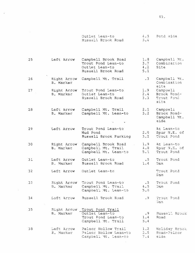
Sign #
8
10
11
12
13
14
15
Arrow Marker
Left Arrow B. Marker
Right Arrow B. Marker
Right Arrow B. Marker
Left Arrow B. Marker
Right Arrow B. Marker
Left Arrow Y. Marker
Right Arrow B. Marker
Right Arrow B. Marker
APPENDIX A SIGN INVENTORY
4 3 •
Legend Miles Location
Start of Pelnor Hollow Trail
1.5 Jct. of Berry Brook
Pelnor Hollow Trail Pelnor Hollow lean-to Mary Smith Trail Little Spring Brook Trail Campbell Mt. Trail Russell Brook Road
Berry Brook Road
Mary Smith Trail Little Spri~g Brook Trail Campbell Mt. Trail Campbell Mt. Lean-to Russell Brook Road
• 9 3.2 4.0 4.0
15.9
1. 5
2.3 3. 1 3 0 1 8.5
15.0
End of Pelnor Hollow Trail .9 Berry Brook Road 2.4 Little Spring Brook Trail
End of Little Spring Brook .6 Trail Cat Hollow Road 1. 7
Pelnor Hollow Trail Mary Smith Trail • 8 Pelnar Hollow Lean-to 3. 1 Berry Brook Road 5. 5
Cam12bell Mt. Trail Cat Hollow Road 4. 1 Campbell Mt. Lean-to 5.4 Trout Pond Trail 6.5 Russell Brook Road 11. 9
At start of Pelnor Hollow Trail. State Line on Pelnor Hollow Road
At start of Pelnor Hollow Trail. State Line on Pelnar Hollow Road
Pelnor Hollow Lean-to
Pelnor Hollow Lean-to
Jct. of Trails on Little Spring Brook Road
Jct. Trails on Little Spring Brook Road
Jct. of trails on Little Spring Brook Road
44.
16 Right Arrow Little s2rin9 Brook Trail Y. Marker Pelnor Hollow T::-ail • 6 Start of
Campbell Mt. T·cail • 6 Litt le Spring Mary Smith Trail 1. 4 Brook T::::-ail-Pelnor Hollow Lean-to 3.7 State Line Campbell Mt. Lean-to 6.0 across road
17 Left Arrow Cat Hollow Road 1.1 Start of Y. Marker Little Spr in·J
Brook Trail-State Line across Road
18 Left Arrow Little Spring Brook Trail 1.1 Jct. Cat B. Marker Pelnar Hollow Trail 1. 7 Hollow and
Campbell Mt. Trail 1. 7 Little Sprin9 Mary Smith Trail 2. 5 Brook Road
19 Left Arrow Campbell Mt. Lean-to 1. 3 Cat Hollow B. Marker Trout Pond Trail 2.4 Road-Campbell
, "' Tro"ut Pond Lean-to 6.4 Mt. Side Russell Brook Road 7.8
20 Right Arrow Pelnor Hollow Trail 4. 1 Cat Hollow B. Marker Little Spring Brook Trail 4.1 Road-Brock
Mary Smith Trail 4.9 Mt. side Pelnor Hollow Lean-to 7.3
21 Left Arrow Trout Pond Trail 1.1 Campbell ~1t . B. Marker Trout Pond Lean-to 5. 1 Lean-to
.Outlet Lean-to 5. 6 Russell Srook Road 6. 5
22 Right Arrow Cat Hollow Road 1. 3 Campbell '1t . B. Marker Pelnor Hollow Trail 5.4 Lean-to
Little Spring Brook T:?:"ail 5. 4 M;:irv Smith 'T'r;:ii 1 6. 2 ··-- J;
........ ..- -- ...-
Pelnor Hollow Lean-to 8.5
23 Left Arrow Cam2bell Mt. Trail B. Marker Campbell Mt. Lean-to 1.1 Campbell '1t •
Cat Hollow Road 2. 4 Road-Cat Pelnar Hollow Road 6. 5 Hollow side
Little Spring Brook Trail 6.5 Mary Smith Trail 7. 3
24 Right Arrow Trout Pond Trail B. Marker Campbell Brook Road 2 . 1 Campbell :vtt .
Trout Pond Lean-to 4. 0 Road-Trout
25 Left Arrow
26 Right Arrow B. Marker
27 Right Arrow B. Marker
28 Left Arrow B. Marker
29 Left Arrow
30 Right Arrow B. Marker
31 Left Arrow B. Marker
32 Left Arrow
33 Right Arrow B. Marker
34 Left 'A.rrow
35 Right Arrow B. Marker
38 Left Arrow R. tviarker
Outlet Lean-to Russell Brook Road
Campbell Brook Road Trout Pond Lean-to Outlet Lean-to Russell Brook Road
Campbell Mt. Trail
Trout Pond Lean-to Outlet Lean-to Russell Brook Road
Campbell Mt. Trail Campbell Mt. Lean-to
Trout Pond Lean-to Mud Pond Russell Brook Parking
Campbell Brook Road Campbell iv1t . Trail Campbell Mt. Lean-to
Outlet Lean-to R11ssell Brook Road
Outlet Lean-to
Trout Pond Lean-to Campbell Mt. Trail Campbell Mt. Lean-to
Russell Brook Road
Trout Pond Trail Outlet Lean-to Trout Pond Lean-to Campbell Mt. Trail
Pelnor Hollow T:::-ail Pc::lnor Hollow Lean-t8 Campbell Mt. Lean-t :)
45.
4. 5 Pond side 5. 4
1. 8 Campbell ;1t • 3. 7 Combina.t ion 4. 2 Site 5. 1
• 3 Campbell '1t . Comb ina. tit) o site
1. 9 Campbell 2. 4 Brook Road-3. 3 Trout P:)nd
site
2. 1 Campbell 3. 2 Brook Road-
Camp be 11 ~1t.
side
At Lean-to 2.0 Spur N.E. of 3.2 Trout Pond
1. 9 i\t Lean-to 4.0 Spur N.E. of 5. 1 Trout Pond
• 5 Trout Pond 1. 4 Dam
Trout Pond Dam
• 5 Trout Pond 4. 5 Dam 5 . i)
• 9 Tr:Jut ?:)nd Dam
.9 Russell Brook 1.4 Road 5. 4
1. 2 Holiday Br:-=ioK. 3. 5 Road- ?8 L1or
7 • '* side
51
52
1 from
53
54
55
Trout Pond Lean-to Russell Brook Road
Right Arrow Trout Pond Lean-to
Right Arrow Mud Pond
Left Arrow
Left Arrow
Left Arrow
Russell Brook Parking Area
Mud Pond Troµt Pond Lean-to
Trout Pond Lean-to Mud Pond Russell Brook Parking
Signing - Snowmobile Trails 22.4 miles
S-1
S-2
S-3
Left Arrow Snowmobile
Left Arrow Snowmobile
Right Arrow Snowmobile
.?elnor Hollow Lean-to End of Snowmobile Trail
Campbell Brook Parking Area Trout Pond Trail Trout Pond Lean-to Russell Brook Parking Area
Campbell Mt. Parking Area
12.5 13.9
2.0
• 3
1. 2
1. 2 3.2
2.0 3.2
• 9 1.4
• 4 1. 7 2.5 3. 9
2.5
46.
Jct. of Mud Pond Trail and Trout Pond Trail
Opposite end of Trail
Trout .?ond on Mud Pond Trail
Opposit2 end of Trail f':"om Trout Pond on Mud Pond Trail
"Y" in Trail at Russell Brook Picnic Area
Intersection Trail at Trout Pond
At start 0f Pelnar Hollow Trail where State Line crosses Road
At trail crossing on Campbell Brook Road
At Campbell Brook Parking Area
S-4
S-5
S-6
S-7
S-8
S-9
S-10
S-11
S-12
S-13
S-14
S-15
S-16
S-17
S-18
Right Arrow Snowmobile
Right Arrow Snowmobile
Left Arrow Snowmobile
Right Arrow Snowmobile
Right Arrow Snowmobile
Trout Pond Trail Trout Pond Lean-to Russell Brook Parking Area
Campbell Brook Parking Area Campbell Mt. Parking Area Trout Pond Lean-to Russell Brook Parking Area
Campbell Brouk Parking Area Campbell Mt. Parking Area
Mud Pond Russell Brook Parking Area
Left Arrow Upper Trail Area
Right Arrow End of Snowmobile Trail Snowm0bile
Left Arrow Russell Brook Parking Snowmobile Are·a
Right Arrow Trout Pond Lean-to Snowmobile
1. 3 2. 1 3. 5
1. 3
3.8 • 8
2. 2
2. 1
4. 6
2.0 3. 2
0 3
1.1
1.2
2.0
Right Arrow Russell Brook Parking 1.1 Snowmobile Area
Upper Russell Brook Road 2.1
Right Arrow Trout Pond Lean-to .3 Snowmobile
Left Arrow Russell Brook Parking 1.1 Snowmobile Area
Right Arrow Trout Pond Lean-to Snowmobile
Left Arrow Russell Brook Parking Snowmobile Area
• 9
1. 4
Right Arrow Upper Russell Brook Road 1.8 Snowmobile
4 7.
At Campbell Brook Parking Area
At. 3ct. with Trout Pond
At Jct. with Trout Pond Trail
At Trout Pond Lean-to Jct.
At Trout Pond Lean-to Jct.
At Trout Pond
At Mud Pond Trail Jct.
At Mud Pond Trail act.
At Mud Pond Trail ,Jct.
At. Jct. of Upper Trail Trail on Tr)ut Pond
At Jct. of Upper Trail on Trout Pond
At Jct. of Upper Trail on Tr:Jut Pond
At "Y" in Upper Trail
At "Y" in Upper Trail
At "Y" in Upper Trail
48.
S-19 Right Arrow Upper Russell Brook Road 2. 3 At Jct. near Snowmobile Trout Pond Lean-to 1. 4 Trout Pond
Dam
S-20 Right Arrow Trout Pond Lean-to 2. 7 At start of Snowmobile Campbell Brook Parking 4.8 Upper Trail
Area on Russell Campbell Mt. Parking 7.3 Brook Road Area Mud Pond 4.7
S-21 Left Arrow Mud Pond 1. 2 A.t Russell Snowmobile Trout Pond Lean-to 3.2 Brook Picnic
_i\rea S-22 Right Arrow End of Snowmobile Trail 2.3 At start of
Snowmobile State Road Trail
S-23 Right Arrow Campbell Brook Road 1. 9 At Jct. wit:i Snowmobile Trout Pond
Trail
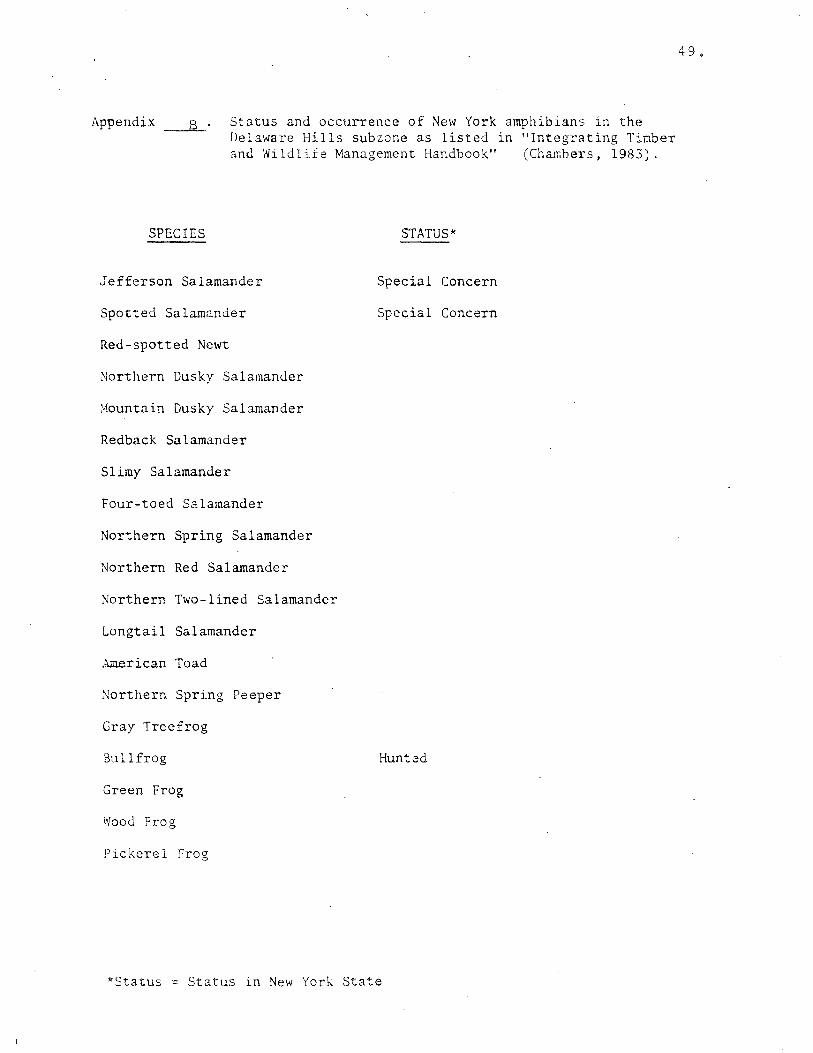
Appendix B Status and occurrence of New York amphibians in the Delaware Hills subzone as listed in ''Integrating Timber and Wildlife Management Handbook" (Chambers, 1983).
SPECIES STATUS*
Jefferson Salamander Special Concern
Spotted Salamander Special Concern
Red-spotted Newt
~orthern Dusky Salamander
:.-1ountain Dusky Salamander
Redback Salamander
Slimy Salamander
Four-toed S2lamander
Northern Spring Salamander
Northern Red Salamander
Northern Two-lined Salamander
Longtail Salamander
American Toad
Northern Spring Peeper
Gray Treefrog
Bullfrog Hunted
Green Frog
Wood Frog
Pickerel Frog
*Status = Status in New York State
4 9.
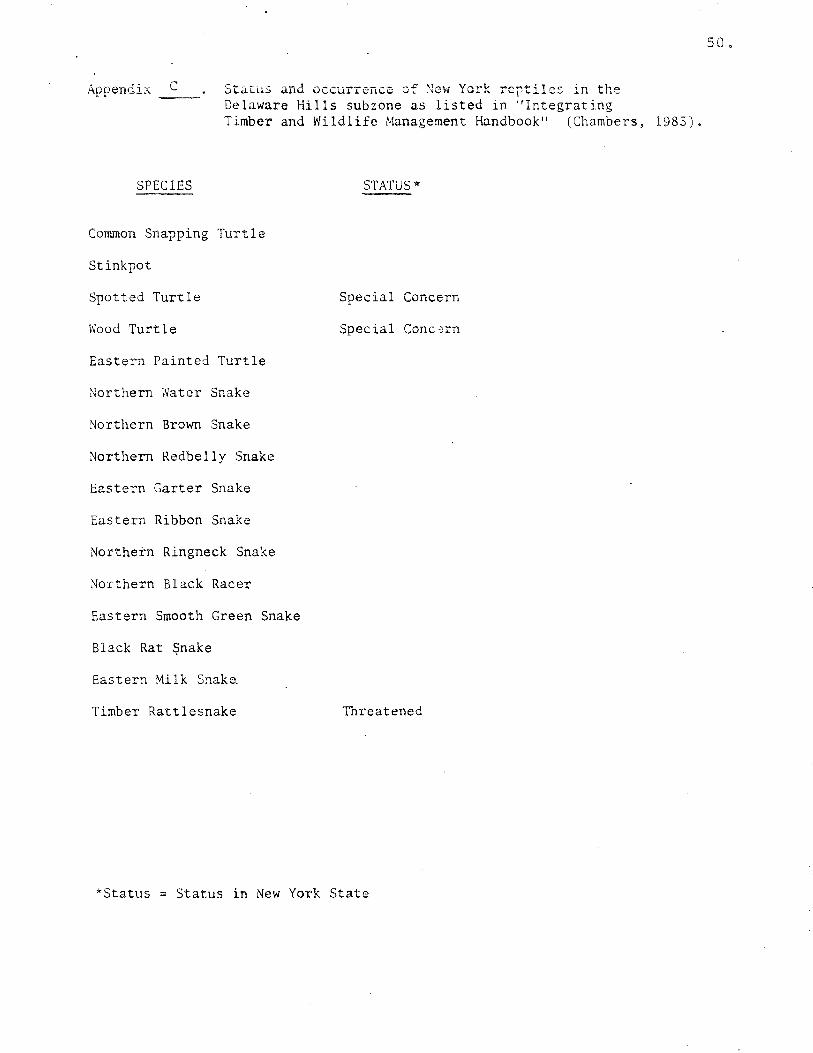
Appendix --- Status and occurrence of ~cw York reptile~ in the Delaware Hills subzone as listed in "Integrating Timber and Wildlife Management Handbook" (Chambers, 1983).
SPECIES STATUS*
Common Snapping Turtle
Stinkpot
Spotted Turtle Special Concern
Wood Turtle Special Conc:;rn
Eastern Painted Turtle
Northern Water Snake
Northern Brown Snake
Northern Redbelly Snake
Eastern Garter Snake
Eastern Ribbon Snake
Northern Ringneck Snake
Northern Black Racer
Eastern Smooth Green Snake
Black Rat ~nake
Eastern Milk Snaka
Timber Rattlesnake Threatened
*Status = Status in New York State
50.
51.
Appendix D Status and occurrence or ~ew York mammals in the Delaware Hills subzone as listed in "Integrating Timber and WilJlife Management Handbook" (Chambers, 1983).
SPECIES
Virginia Opossum
Masked Shrew
Smoky Shrew
Longtai 1 Sh re\.;
Northern Water Shrew
Least Shrew
Shorttai 1 Shrew
Starnose Mole
Hairytail Mole
Little Brown Myotis
Keen Myotis
Indiana Myotis
·small-footed Myotis
Silver-haired Bat
Eastern Pipistrelle
Big Brown Bat
Red Bat
'.~oary Bat
Black Bear
Raccoon
Shorttail Weasel
Longtail Weasel
Mink
River Otter
Striped Skunk
Coyote
Red Fox
Gray Fox
Bobcat
Woodchuck
Eastern Chipmunk
STATUS*
Hunted/Trapped
Endangered
Hunted
Hunted/Trapped
Trapped
Trapped
Trapped
Trapped
Hunted/Trapped
Hunted/Trapped
Hunted/Trapped
Huntcd/Tnppec'
Hunted/TrappeJ
Hunted
*Status= Sta'::'.!S in ':ew Yorl( St:ite
SPECIES
Gray Squirrel
Red Squirrel
Southern Flying Squirrel
Northern Flying Squirrel
Beaver
Deer Mouse
White-footed Mouse
Eastern Woodrat
Southern Bog Lemming
Bcreal Red-backed Vole
Meadow Vole
Yellownose Vole
Pine Vole
Muskrat
Meadow Jumping Mouse
Woodland Jumping Mouse
Porcupine
Snowshoe Hare
Eastern Cottontail
White-tailed Deer
STA':US"
Hunted
Trapped
Threatened
Trapped
Hunted
Hunted
Hunted
~
f. •" 92
HORTO":
\'ii'
,o
q;/o'"';'
.. '''
·r~:BU! l t~NU I ,,~UVl
.....
l<LlU!E l/ -
............ ,
t 0 ?
~..;:..
~ ~.
·-----. I_ II-;'!(:"''·.,,,,.,,,
\' ... 1-,_' - ,.~ - •---.
, Li " Ii·. 11•,
0
"' ' -2 0 :z: 0
lJ
/
····"\ ~
-------~------t..OC.n) b'..LL'.>
~ ~r
" l
/
-c 0
0
'
"' . "1
~
'-lo --~"" -~,- -o«" co-
,-;1>"' '">-.,)',.,.'-'
Pull !lfAVllll\111 ~
LIC C AMll(~H(ltJtJt)'
A, _______,,,,-
nr
(J OrJ;._,.i;.~
·----:....I( o o;
~\ .A~--- 1 ~g j( ' /)
~·\ I/ it ~
tlllll HJNO PlJllllC CAMl'GHUUNll
/
I ) EI , .-\\VA H E TH :\ I I ,:"' f0i'tr4'S lH AtiOIE~ ANU l.UL(t1l';.. It f~
OEl AWAf<t (UUHfY
llt,J ND
MAHKtil IHAllS ----8--- YtlluW
-·- lllllt -- it--- ill u
tf:At~IO'.) dbt
I -'
~~ M,!ccL
p 1-(j
'U tTJ z tJ H
>< [l:J
l51 l'-1
. ...
14
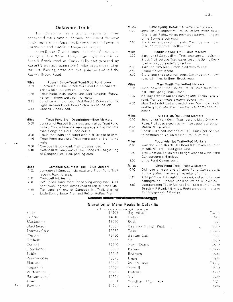
Delaware Trails 1 r1lt'r
rnnnec~~~d .... ails runntn~ :hrou12~~ ·h1· F1;re-...t f1:~" .. ,erve
Jnd'- ~ou:~1 ·>f thP ~)epdctor1 F~1"·q--'r'.n1r 'n ·~~t, T11\\r:-., or
Coich">·r and .\ nde' in D'"'"~ Jre '1u1"\
From RmJte 17. westbound f: \it Y ~ ,,: l:oni-;s f d1 Is.
eJstboL~nci Exit 9::' at Horton. turn northeastr·ri\ on
Ru:osell Brook road at Cooks Falls anG procel:c! up
Russell Brook approximate!v 5 miles to start or trail on
the !ert Parking areas are ,wailable on Jnd orr the
Ru"";; f3rook Road
'Jliles J.CJ
3. ~:,
-l.15
Miles 0.00
0.90
Russell Brook-Trout Pond-Mud Pond Loop Junction of Russe:i Breck Road and Trout P0no Trail. Follow olue markers uo .~: ·1 r:::ad. Trout Done 1niet. leantc. anc tra11 jur:cticn. Follow yellow markers west !:·ehind :eanto. Junction with old road ''11od ;J0nd 0.25 miles to the r1gnt. Russell Brook Road '. . .JO m 1 les to the left. Russe!! 3rook Poad.
Trout Pond Trail Description-Blue Markers Junction cf Russell Brock road and trail up Trout Pone outlet. Follow blue markers uograde along cld tote ·oad alongside Trout Pond out'-st. Trout Pond darn and ·outlet 1eanto at far end of darn.
1.40 -:-rout Pond inlet and Trout Pond leanto. Trail turns ric;ht .
3.30 5.40
Miles 0 00
1 1 r . u
2.40
4.10
Camobell Brook road. Trail crosses road. Camooe11 Mt. road, end of Trout Pone Trail. beginning of Campbell Mt. Trail. parking area.
Campbell Mountain Trail-Blue Markers Junc::,on oi '=::amooeil Mt. road and Trout Pond Trail soutn1. Parking area.
'.:;am:ibell Mt. leanto . Cat Hollow road. room for parking along road. Trail :::;ntinues 'Jpgrade across road to too of Brock Mt.
ra: ;unction. enc of Campbell Mt. Trail. start of Little Soring Brook Trai; and Pe!nor Hollow Trail.
tt'*''ff
Miles ('\co
Miles J.00
iJ.80 3.10 4 (':('.
Miles J.00
1.20
Miles 'J.00
0.90 2.00
Miles 0.00
1.90
3.50
Miles 0 00
0.20
1.60
53.
Little Spring Brook Trail-Yellow '11arkers Junction 0 1 Campbell 'At ~"l" lblue1 arv'. ?e• 110 1 >-1011cn Tra1: 1blue1. Follow yellow markers so1 .. :ner1·. .."c; o:'..J L:ttle Soring Brook road 3~ate Ian·; ends ana traii e.1ds. C.Jr'·nl.1e jcwr ·~ . .vn · :ac ' '. m;:e to Cat HcllC'N ·oac.
Pein or Hollow TrJil- Blue 'Via rkers "un:::t:on of Carnpoell Mt. Tr'!1i 101ue1 anc L,;:'e Serr; S'OOK Trail (yellow). Trali .eaves c1c L ttle Sor:n-:; Broe.:-; road in a southeasterly direc•:on. ~unction with ,\i1ary Smith ".'rail Ired) '.o e3st Pelnor '-iollow leanto. State land ends and trail ends. Continue Jown :own road 1.: mi ies to Berrv BrooK road.
Mary Smith Trail-Red Markers junc'. on with Pe1nor Hollow Trail 0.2 "''ie soc;tn '·: ~ oid .. ::tie Sprinc; BrooK Road. Ho11aay Brook Roaa and oarKing area on eas: s::::e :· road. Trai1 continues easterly across road Mary Smith Hill road and end of tra1, Tow~ ·cac 'eads northerly to Route 30 and southerly !O narn:~· :f ~e:.
beach.
Middle Mt.Trail-Red Markers Junc'.ion of ;,1ary Smith Tra11 !rec) ara M""' ;:~.-r- -Roaa. Trail c;oes steep1y Johlil 1n an easterly .::1rec: ,;· Miadle Mt. summit. Beech Hill Road and ena cf trail Turn w;rt or ·:ac to continue on Touch-Me-Not Tra1i 1C.25 m11ec:
Touch-Me-Not Trail-Red Markers Junction with Beech Hill Road 0.25 miles sou'r: r' Middle Mt. Trail. Trail goes east. Trail junction. Yellow trail to right .eads to :..ittle ;:>:;r:
Campground (1.6 miles\. L:ttle Pond Campground.
Little Pond Trail-Yellow Markers Old road at west end cf uttle ;:,Jr.c Carnogrc:i,.-;:;_ Foilow yellow markers atong edge of ;:io;1d. Trail junction. Trail right follows edge of oond ja:K of campground. ?roceed uphii~ to left on v>o'iow "a1: Junction with Toucn-Me-Not Tra:: Lert on ·ec .. ,. ;o Beech Hill Road. 1.9 miles. 1'1ight on rea <'ai: '"''~rr,s
to cam;:iground. 1.6 m11es.
Me•&
Elevation of Major Peaks in Catskills i T .nd: ... ::tes mark~S :r J il J 1. J ii"! J! e ~
Sl:de T..t204 Big I nd1an r 3 ~~.' ,' I
Hun:er T -W40 Fr1dav ~ f;\L!
Blac..:c0rne T3990 Rusk :-~.d{ ,'.
Blackhead T393:" Kaaters~1ll High P,•Jk 3h1·,iJ
T'lom<i, Co!P 13q3s Twin r ·n.11 i
i.\ f?S: h_ :l; T3«l80 Baisam Cc1p ~ l~. ~ 3 (; ·aharr 38b8 Fir 2f)~ 1, ':
Cmne1i T38hl) '-orth Dome Jb ·~ \ J
Doutcle''J>J 31)b0 Balsam '_:f),~l':
T ~ble T3847 Bearpen .. hUU PeekJrnoose T384 .l E agie .. 1J00 Plakclu T3840 i 11d1an He,;c! ( = - )
) ~
Su:;,:rloat T~llUU Sherrill , .. ) - . ,:J
IN1tt-·ntiur~ T )7f\l) Halcott Jc -I J
1)a i ,,, rr L Jr. r . .-' r r~J Viv ~)...: (,~
L=;rH:· ~; ,-. :.! 1 '.V1ndham ,l-·1 ,_:r; fJ1-1,1i< r ' .. J '.
fJ.1nther ~ );'=\) ~' H~ k \' ; ')iJ8
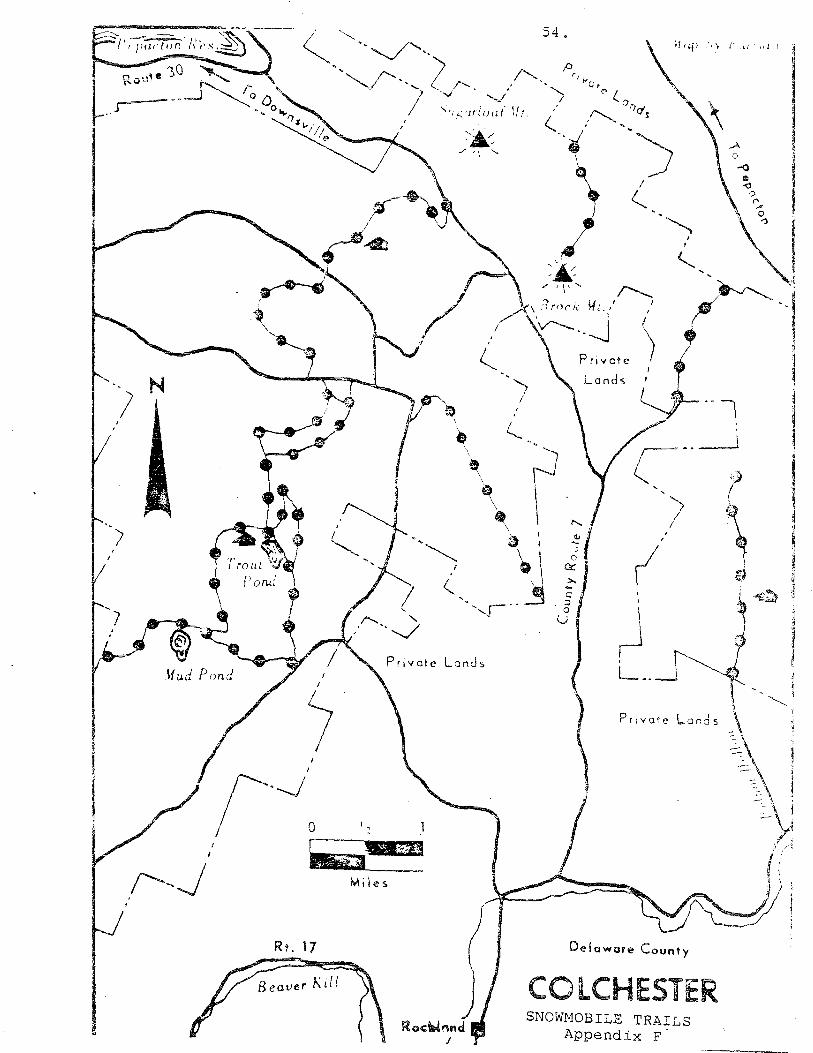
} N
Rt. 17
Miles
Roc::Wnnd I
Def aware County
COLCHESTER SNOWMOBILE TRAILS
Appendix F.
5 5 •
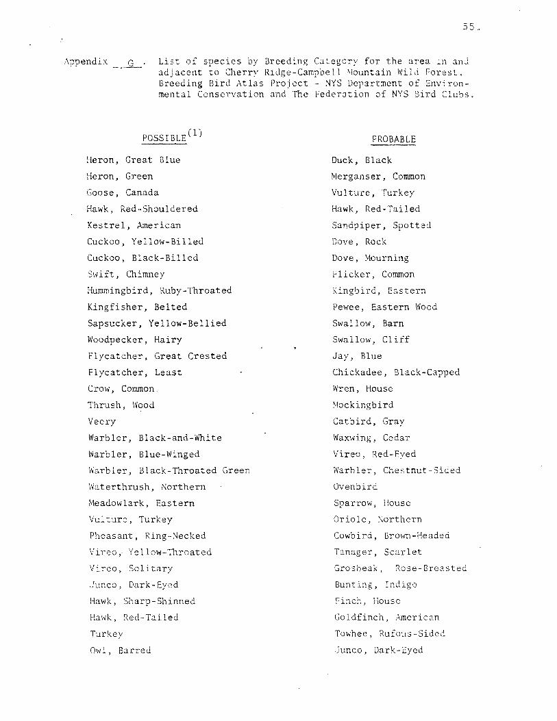
Appendix -~.£. List of species by Breeding Category for the area _n and adjacent to Cherry Ridge-Campbell \lountain Wild Forest. Breeding Bird Atlas Project - NYS Department of Environmental Conservation and The Federation of NYs· Bird Clubs.
POSSIBLE (1)
Heron, Great Blue
Heron, Green
Goose, Canada
Hawk, Red-Shouldered
Kestrel, American
Cuckoo, Yellow-Billed
Cuckoo, Black-Billed
Swift, Chimney
Hummingbird, Ruby-Throated
Kingfisher, Belted
Sapsucker, Yellow-Bellied
Woodpecker, Hairy
Flycatcher, Great Crested
Flycatcher, Least
Crow, Common
Thrush, Wood
Veery
Warbler, Black-and-White
Warbler, Blue-Winged
Warbler, Black-Throated Green
Waterthrush, Northern
Meadowlark, Eastern
Vulture, Turkey
Pheasant, Ring-~ecked
Vireo, Yellow-Throated
Vireo, Solitary
Junco, Dark-Eyed
Hawk, Sharp-Shinned
Hawk, Red-Tailed
Turkey
Ow 1, Barred
PROBABLE
Duck, Black
Merganser, Common
Vulture, Turkey
Hawk, Red-Tailed
Sandpiper, Spotted
Dove, Rock
Dove, Mourning
Flicker, Common
Kingbird, Eastern
Pewee, Eastern Wood
Swallow, Barn
Swallow, Cliff
Jay, Blue
Chickadee, Black-Capped
Wren, House
Mockingbird
Catbird, Gray
Waxwing, Cedar
Vireo, Red-Eyed
Warbler, Chestnut-Sided
Ovenbird
Sparrow, House
Oriole, ~orthern
Cowbird, Brown-Headed
Tanager, Scarlet
Grosbeak, Rose-Breasted
Bunting, Indigo
Finch, House
Goldfinch, American
Towhee, Rufous-Sided
Junco, Dark-Eyed
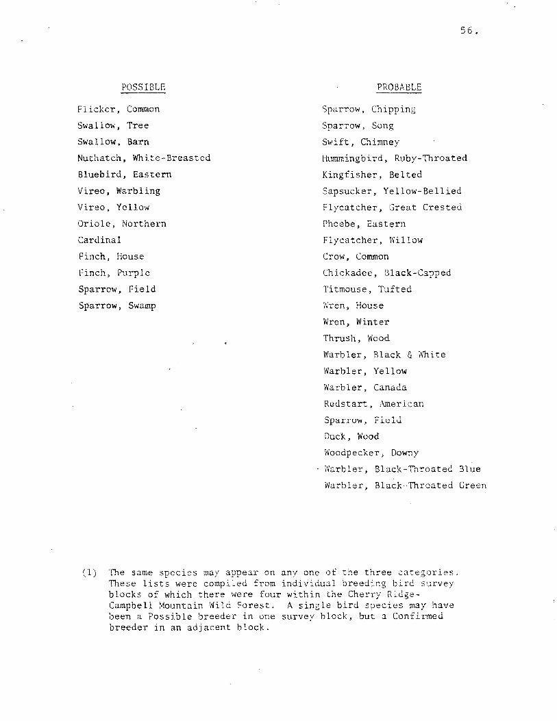
POSSIBLE
Flicker, Common
Swallow, Tree
Swallow, Barn
Nuthatch, White-Breasted
Bluebird, Eastern
Vireo, Warbling
Vireo, Yellow
Oriole, Northern
Cardinal
Finch, House
Finch, Purple
Sparrow, Field
Sparrow, Swamp
5 6.
PROBABLE
Sparrow, Chipping
Sparrow, Song
Swift, Chimney
Hummingbird, Ruby-Throated
Kingfisher, Belted
Sapsucker, Yellow-Bellied
Flycatcher, Great Crested
Phoebe, Eastern
Flycatcher, Willow
Crow, Common
Chickadee, Black-Capped
Titmouse, Tufted
Wren, House
Wren, Winter
Thrush, Wood
Warbler, Black & White
Warbler, Yellow
Warbler, Canada
Redstart, American
Sparruw, Fi.~ld
Duck, Wood
Woodpecker, Downy
Warbler, Black-Throated Blue
Warbler, Black-Throated Green
(1) The same species may appear on any one of the three c::itegories. These lists were compiled from individual breeding bird survey blocks of which there were four within the Cherry RidgeCampbell Mountain Wild Forest. A single bird species may have been a Possible breeder in one survey block, but a Confirmed breeder in an adjacent block.

Appendix H. Status and occurrence of New York breeding birds in the Delaware Hills subzone as listed in "Integrating Timber
SPECIES
Great Blue Heron
Green Heron
Mallard
and Wildlife Management Handbook" (Chambers, 1983).
STATUS* SPECIES
5 7 •
STATUS*
American Black Duck
Hunted
Hunted
Hunted
Hunted
Hunted
Pileated Woodpecker
Red-Headed Woodpecker
Yellow-Bellied Sapsucker
Hairy Woodpecker Blue List
Wood Duck
Common Merganser
Hooded Merganser
~orthern Goshawk
Sharp-Shinned Hawk
Cooper's Hawk
Red-Tailed Hawk
Red-Shouldered Hawk
B-road-Winged Hawk .
American Kestre-1
Ruffed Grouse
Wild Turkey
American Woodcock
Common Snipe
Mourning Dove
Yellow-Billed Cuckoo
Black-Billed Cuckoo
Barn Owl
Common Screech Owl
Great Horned Owl
Barred Owl
\\nip-?oor-lh 11
Common ~ighthawk
Chimney Swift
Blue List
Spec. Concern
Threatened
Hunted
Hunted
Hunted
Hunted
Spec. Concern
Spec. Concern
Ruby-Throated Hummingbird Blue List
Belted Kingfisher
Common flicker
Ked-Breastea Nuthatch
Downy Woodpecker
Eastern Kingbird
Great Crested Flycatcher
Eastern Phoebe
Willow Flycatcher
Alder Flycatcher
Least Flycatcher
Eastern Pewee
Tree Swallow
Bank Swallow
Rough-Winged Swallow
Barn Swallow
Cliff Swallow
Purple Martin
Blue Jay
American Crow
Black-Capped Cltickadee
Tufted Titmouse
White-Breasted '.'iuthatch
Brown Creeper
House Wren
Winter Wren
Gray C::i.tbird
Brown Thrasher
American Robin
Wood Thrush
Hermit Thrush
Swainson; s Thrush
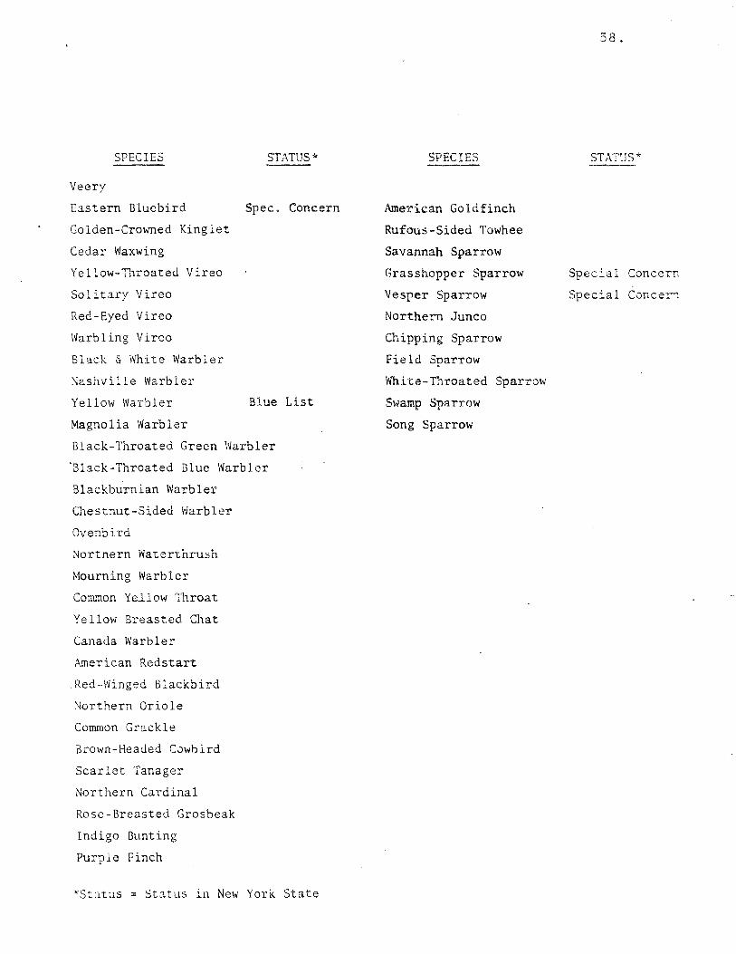
SPECIES ST,\TUS*
Veery
Eastern Bluebird Spec. Concern
Golden-Crowned Kinglet
Cedar Waxwing
Yellow-Throated Vireo
Solitary Vireo
Red-Eyed Vireo
Warbling Vireo
Bl:i.ck & White Warbler
Nashville Warbler
Yellow Warbler Blue List
Magnolia Warbler
Black-Throated Green Warbler
'Black-Throated Blue Warbler
Blackburnian Warbler
Chestnut-Sided Warbler
Ovenbird
Northern Wa~erthru~h
Mourning Warbler
Comrnon YeJ.low Throat
Yellow Breasted Chat
Canada Warbler
American Redstart
Red-Winged Blackbird
Northern Oriole
Common Grackle
Brown-Headed Cowbird
Scarlet Tanager
Northern Cardinal
Rose-Breasted Grosbeak
Indigo Bunting
Purple Finch
*Status = Status in New York State
SPECIES
American Goldfinch
Rufous-Sided Towhee
Savannah Sparrow
Grasshopper Sparrow
Vesper Sparrow
Northern Junco
Chipping Sparrow
Field Sparrow
White-Throated Sparrow
Swamp Sparrow
Song Sparrow
58.
STATUS*
Special Concern
Special Concer1
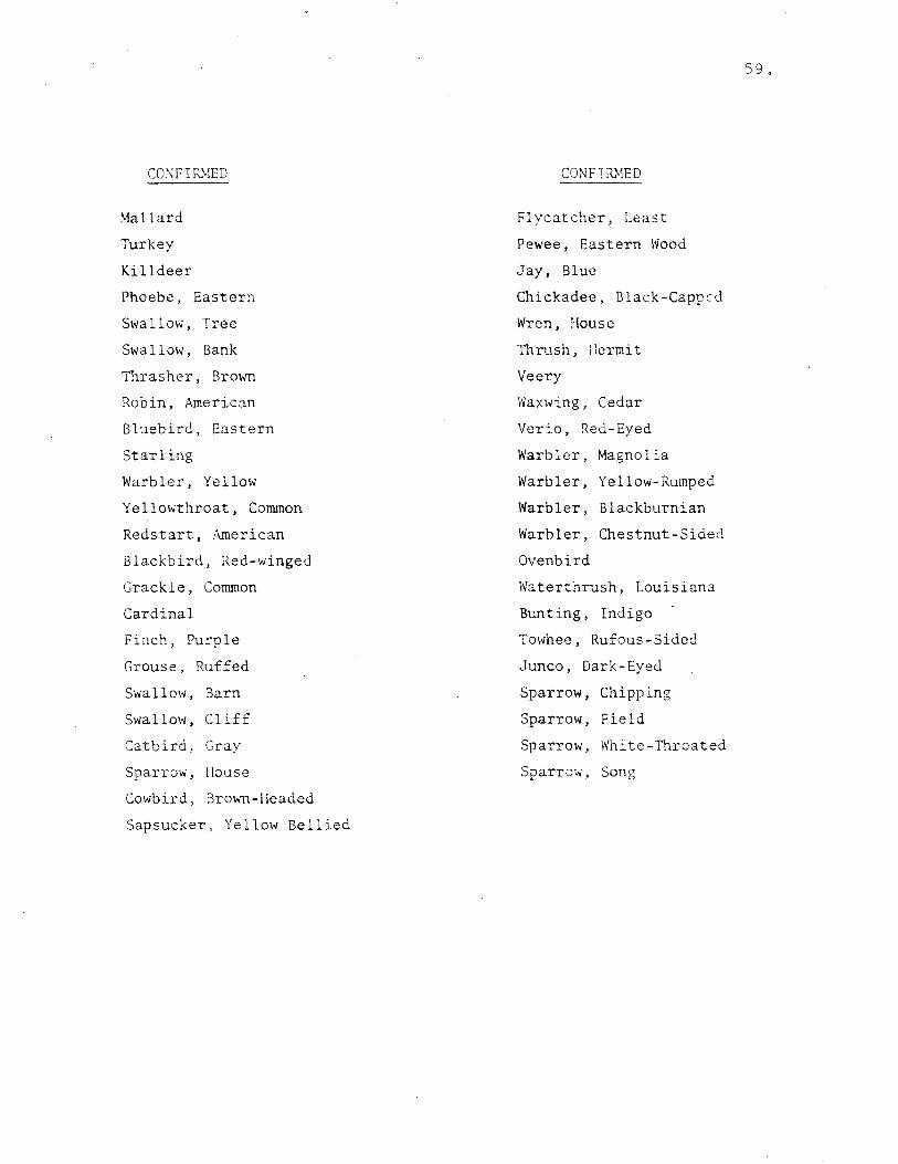
CO'.\: FIRMED
Mallard
Turkey
Killdeer
Phoebe, Eastern
Swallow, Tree
Swallow, Bank
Thrasher, Brown
Robin, American
Bluebird, Eastern
Starling
Warbler, Yellow
Yellowthroat, Common
Redstart, American
Blackbird, Red-winged
Grackle, Common
Cardinal
Finch, Purple
Grouse, Ruffed
Swallow, Barn
Swallow, Cliff
Catbird, Gray
Sparrow, House
Cowbird, Brown-Headed
Sapsucker, Yellow Bellied
CONFIRMED
Flycatcher, Least
Pewee, Eastern Wood
Jay, Blue
Chickadee, Black-Capped
Wren, House
Thrush, ::ermit
Veery
Waxwing, Cedar
Verio, Red-Eyed
Warbler, Magnolia
Warbler, Yellow-Rumped
Warbler, Blackburnian
Warbler, Chestnut-Sided
Ovenbird
Waterthrush, Louisiana
Bunting, Indigo
Towhee, Rufous-Sided
Junco, Dark-Eyed
Sparrow, Chipping
Sparrow, Field
Sparrow, White-Throated
Sparrow, Song
s 9 .

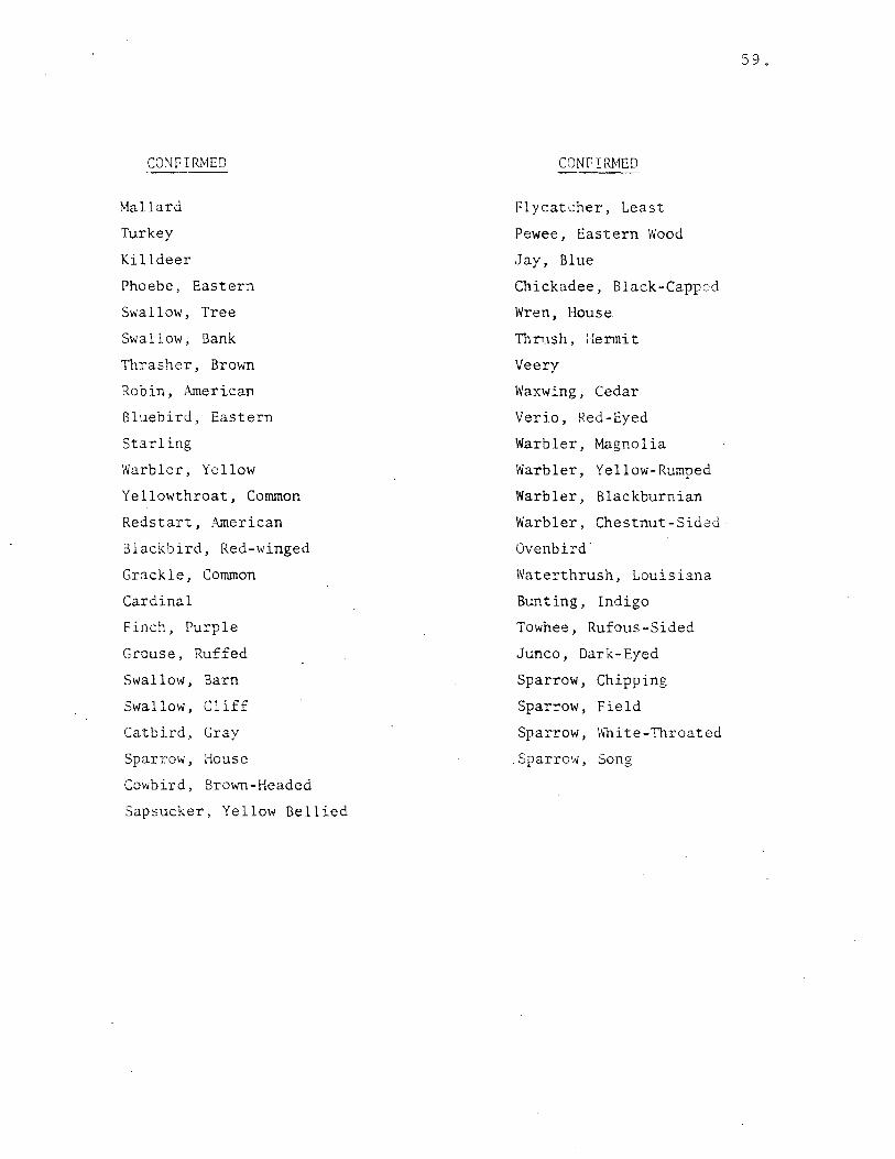
CO'.'JFIRMED
Mallard
Turkey
Killdeer
Phoebe, Eastern
Swallow, Tree
Swallow, Bank
Thrasher, Brown
Robin, American
Bluebird, Eastern
Starling
Warbler, Yellow
Yellowthroat, Common
Redstart, American
Blackbird, Red-winged
Grackle, Common
Cardinal
Finch, Purple
Grouse, Ruffed
Swallow, Barn
Swallow, Cliff
Catbird, Gray
Sparrow, House
Cowbird, Brown-Headed
Sapsucker, Yellow Bellied
CONFIRMED
Flycatcher, Least
Pewee, Eastern Wood
Jay, Blue
Chickadee, Black-Capped
Wren, House
Thn1sh, 11ermit
Veery
Waxwing, Cedar
Verio, Red-Eyed
Warbler, Magnolia
Warbler, Yellow-Rumped
Warbler, Blackburnian
Warbler, Chestnut-Sided
Ovenbird
Waterthrush, Louisiana
Bunting, Indigo
Towhee, Rufous-Sided
Junco, Dark-Eyed
Sparrow, Chipping
Sparrow, Field
Sparrow, Wbite-Throated
.Sparrow, Song
59.
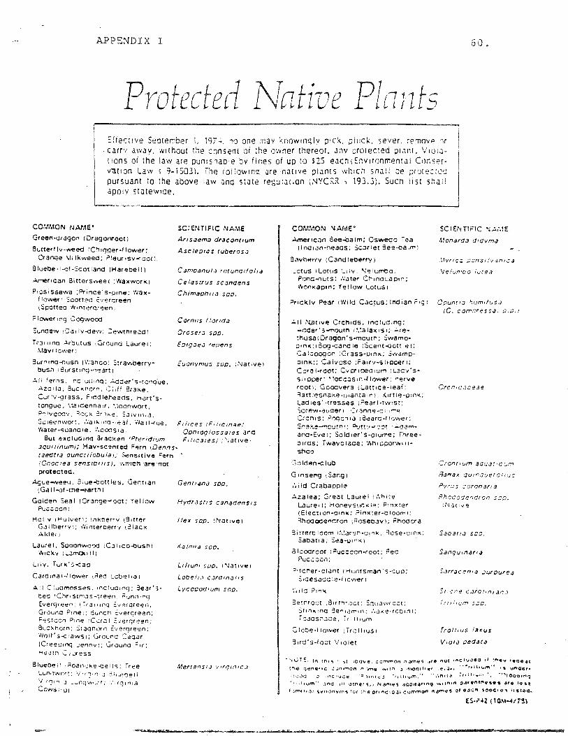
APPENDIX I 60.
Protected Native Plnnts Effec1ve Seotember i. 19n. :o one 11av :.:.now1m:;lv 01ck. µJuel\. sever removF' ,1r
. carrv awav, without the consent or the owner thereor. anv oroiected OIJnt. \/101Jt1ons or the law are punishable by fines of up to S25 eJCh1~1w1ronmenrJI C1inserv-at1on Law ; 9el503l. lhe 1ol!ow1n<:! are native p!Jnts which st1Jii be ;Jrureccs pursuant to the above law ana stJte regulation 1.~YCRR 1 193.J). Suen list shJit appiy statewide.
COMMON NAME'
Grettn-ar agon ( Oragonrootl
Butted Iv -weed (Ch t<Jger ·I lower: 0-anqe \1i lkweea: ?leut1sv-<oot1.
B lueoe; I-of -Scot land (Hareoe 11 l
~flcan Bittersweet 1Waxworlq
Piosissewa (Prince's-cone: wax-f lower 1 Sooneo E·1eroreen 1Soottea ·h1niergreen1
F I ewer 1 ng 0 ogwood
Sunoew ,oa1lv-<:1ew: Cewtnreao1
Tra1iina Arbutus .. Gccund Laurel; .\tavr1ower1
3urn1nq-ousn ( \\·anoo 1 Strawberrye busn 1Burst1 ~g --neart l
~ii ferns. ·r.c :u1.11nq: ...:...dd~r·s·tcng'ue. Azo1la. 0UCKl10rn. (;,ff 3raKe. Cur:v-qrass. F1c:o1eneaos. hart's· tongue. \la 1Cenna ir •. '.1oonwort, .:i'".)!vccc~1, :J.c::K :r1i-..e, S.J1v1n1q,
So ieenvvon. ·l·:a if... 1 f~O ~'~at. ·,\Ja 1 l-<ue. Water 0 -;uana1e. ·,\ooos1a.
SCiENTIFIC NAME
Aris.:iema draconr1um
Asctep1as ruberos.:i
C amoanuta rotunct1fof1a
Ceias1rus scandens
Chimaoh1/<J sp0 .
C or nus I fond;;
Orosera soo.
Eo1g<:1ea reoens
Euonvmus svc. ;.'1Jat1ve1
Fi/ices 1Fil1cinae:
But excluGing arac!<en rPrc-idium aqu1iinum1: Hay•scented Fern IDenns· taedria ouncuiobula1; Sensitive Fern
Ocn1oqlossales and F1!1caies1 ;,'Jat1ve1
protected.
Aaue-weeu. 31ue-<:Jottles. Gentian (Gdl 1-of-tne-eartn I
Golden Seal 1Crange....-oct: Yellow Pu.;::ccn1
Hollv 1Hulveri: lnkberrv (91t!er Gallberrvi: W1nteroerrv 1illac1< Alder1
Laurel. Sooonwooo 1C.3l1Co.()usn1 'o'"CKV il.JfT'.ot.111)
Liiy, furk's-<:ao
Caro1nal-llower 1Aed Lcoe11a1
All C:uomosses. 1nctud1ng; 3ear's· ted 1 Chr1stn,cs~veen ilunn1n9 Evef'(_Jree0 1. ffa111nq E.v~rgreen; Ground P1ne1; Suncn :Overnreen: Festoon Pine 1C~r.JI ::·,erq«een: Suc~narn; Stagnorn ~verqreen; Wo1l's-<:'aws1; Ground C.eo.:ir (C1eeu1nq Jennv1; Grounc Fir; He~tn C 1<..:<ess
Slueoe,1 ,Roan,J><e-oe11s; free Lun,rNrrt: \/ • rr;1n 1,J ~ 11iP~~1 l
V·rs10.J ._._,1ng1,~lJr: '.'·UJ1n1a
Ccws1•u1
Gen(lana soc.
Hydras11s canadens1s
t<a/n11a sea.,
L1/1um sµo. 1Nat•ve1
Lobe/1.J cJrd1n;;11s
LycooocJ1um soo.
COMMON NAME" SCIENTIFIC .'\J.!.,\1E
.l.mer1con See-balm; Osweoo iea Monarda d1dvma (lnd1<Jn-rieaos; Sc.:irlet 8ee-tia1m1
3avhP.rry 1Candleoerry1 :1·,nc:: ;;::ns1,"o1an1.:a
.otus 1Lotus ,_,iv. Nelumbo. .Ve!un·oo iucea Pono....,uts: .'later Ch1ncuao1n; l'<on1<ap1n: Yellow L.otus1
?ricklv Pear 1Wild Caqus: Indian F1g1 Oounr1a ~um1fus.:i
..:.11 N.at1ve Orchids. 1nclud1ng: "'dder's-moutn 1i.:a1ax1s1;· ..:.rethusa10ragon's-moucn; Swamo• p1n1<;1:3og-::ano1e 1Scent-oot1:e1: Ca ioaoqon i Gr ass·uin><: Swamopon1< 1; Caivoso 1Fa1rv-silcoer1; Coral-root: Cvcr1oec1um 1LaC'/'S· sl1ocer: '.locc::is1n-llower: ,..e,ve root1; Gooovera 1Latt1ce-1eaf: Ratt 1esna1<e ·<J1anta 1 n 1: :<irt :e-o• nK; Ladies· ·tresses 1Pear1-tw1st: Scrf!w .. "3uaer 1 ::ranci~ .. 01u~~ C:rcn1s: ?oocn1a 1:3earo-r1cwer: S!"!a~e~~~!.~~: .°'.J!!'.1 -"ca! ..:.~~,,, .. and•Eve1; Sold1er·s-01u!T'e; ihree· b1ras; fwavo1ace; 't.h1pporw11 I• she~
Golden-<: lub
G 1nseng 1Sang)
!11ld Crabapple
:..zalea; Great Laurel 1\';h1te Laure11; Honevsuc:><IP; P1nxter (Elect• on-01n1<; .0 inxter-o loom 1: Rhooooencron i Aoseoav 1; Rhooc.- a
3itteraloom 1~.'.arsri-01nk. Rcse-01n ... : Saoat1a; Sea-u1n1< 1
a I oooroot 1 Puc:: con-root: Reo ?uccoon1
"•tcner-otant 1 Huntsman ·s-cuo: S1desaca ie .. f 1cwer i
'1'-1ld ?1n\ic.
3ernrcct 181rrf'ir:;ct; Scuawtoot: St1nk1nci 3e"1am1n; .'.a,.;.e .. <corn1: i oacsn.Jae. r 1 111um
Glcbe·llower 1Troll1u:;1
3ird's-foot '!1olet
10. comr::ressa. ;;.o.J
Crcnr1um aar..:at1c~·m
fl.;,.,ax qu1rauerol1u:;
Pvrus :aronana
Rhcdodencron s;;o. tNat:ve1
Saoa11a s:::;:;.
5,,,_~nt! c.;ro11n1Jr..J
Trt!i1r_.·m 5~0.
V101.:i cecJ.Jra
"'n.JTE. In tM1!i ,.,, ibove. ccmmcn n,Jff'las .J'9 l"HJC ,,.,c:ivaeo d !R•v '•O•at
{MllJ qeneoc .;..;ni.nion /'\ ~• ,,.,0 iri J ,.noCJ1l1c1 e • .Ju "'frtlLt..,..,.,., ... ' ' ~Qet• .:JUO :,J nClu(ja "!> 111'!1.:'j -l!ll1ym," ... ,.,titld f'tti!iy(T; ', "'"'JO(Jc;jtNQ
rr,il1ym'' Jf'l<l 111 vtner"S~i Nat'9111f'!. .lOOf!dltt"li<I) ,,.,.,1n1n OJJf41tfHRQ1Ut~ •10 hltil
t Jm1 11 Jr \vnonvm-s !Of rn 6 Of, ric 1 0 J.I c i.;:.mmon Ft .t;ft'h1 $ of eJcR \OeC • o '\ I• 1' teQ~
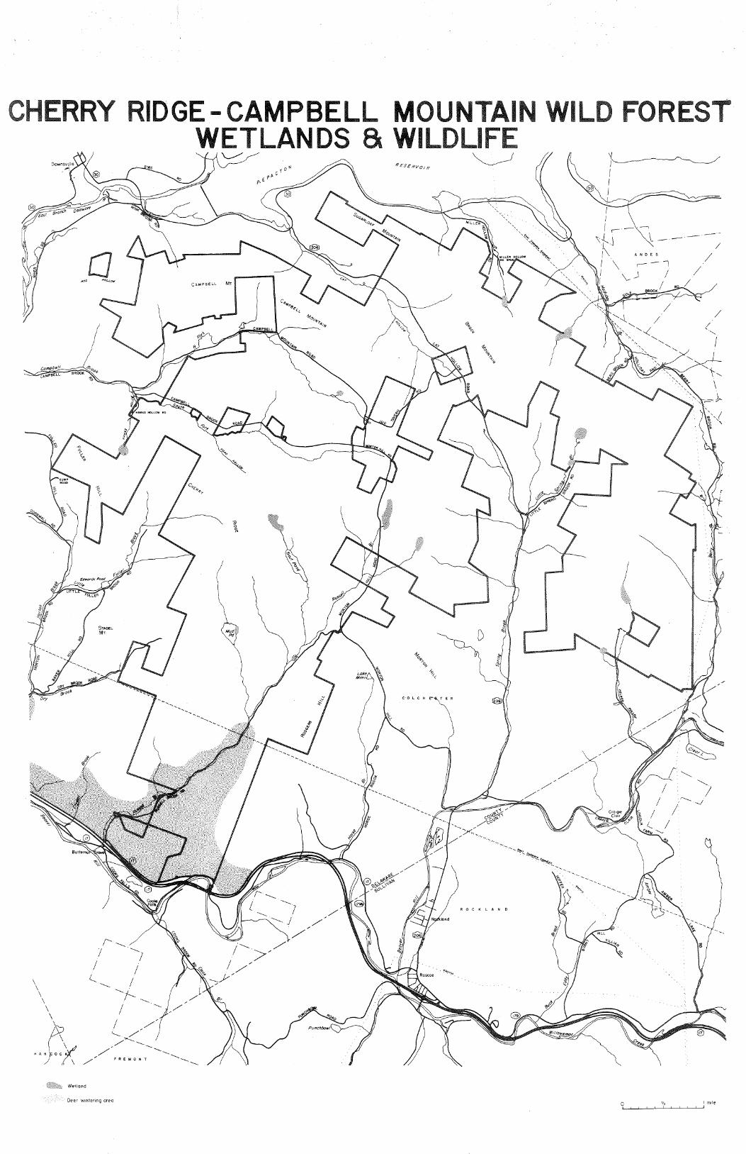
\ \
Campbell
~paEIT
\ \ \ \
RY
a HOG HO££~
~ BROOK~
I l__
/'~ I
~
-----...!
I I
IDGE- CAMPBELL MOU WETLANDS a WILDLIF
RESERvo1R ~
~
~7
~} ,/
/
/
% <>A
o.,_
-S;((
'°'J ................................
',_ ~~ /
r,<;f~ /<-o"
:;..<:: '// ·-·-,,_''-,.,
ROCKLAND
'!'•.e,~'c •
-~~. c-~. ,,...
'"*!.... .................. __
~/--------... ~ /
".rx /
I I //
'-----· / J' /.,.._____~
,/, " F ilf E. Y 0 N T
Wetland
Deer wintering area
RES
~
I I
I I I
I .-\-( 1
I " 1\ ~
A N D E S
,--I \ I I \_J
I I
ROOK,/
,/~,/-(
/
/ /
"
/
/
/ ( .,
I
'----"---- /
I --./
\
0 ~ lm1le
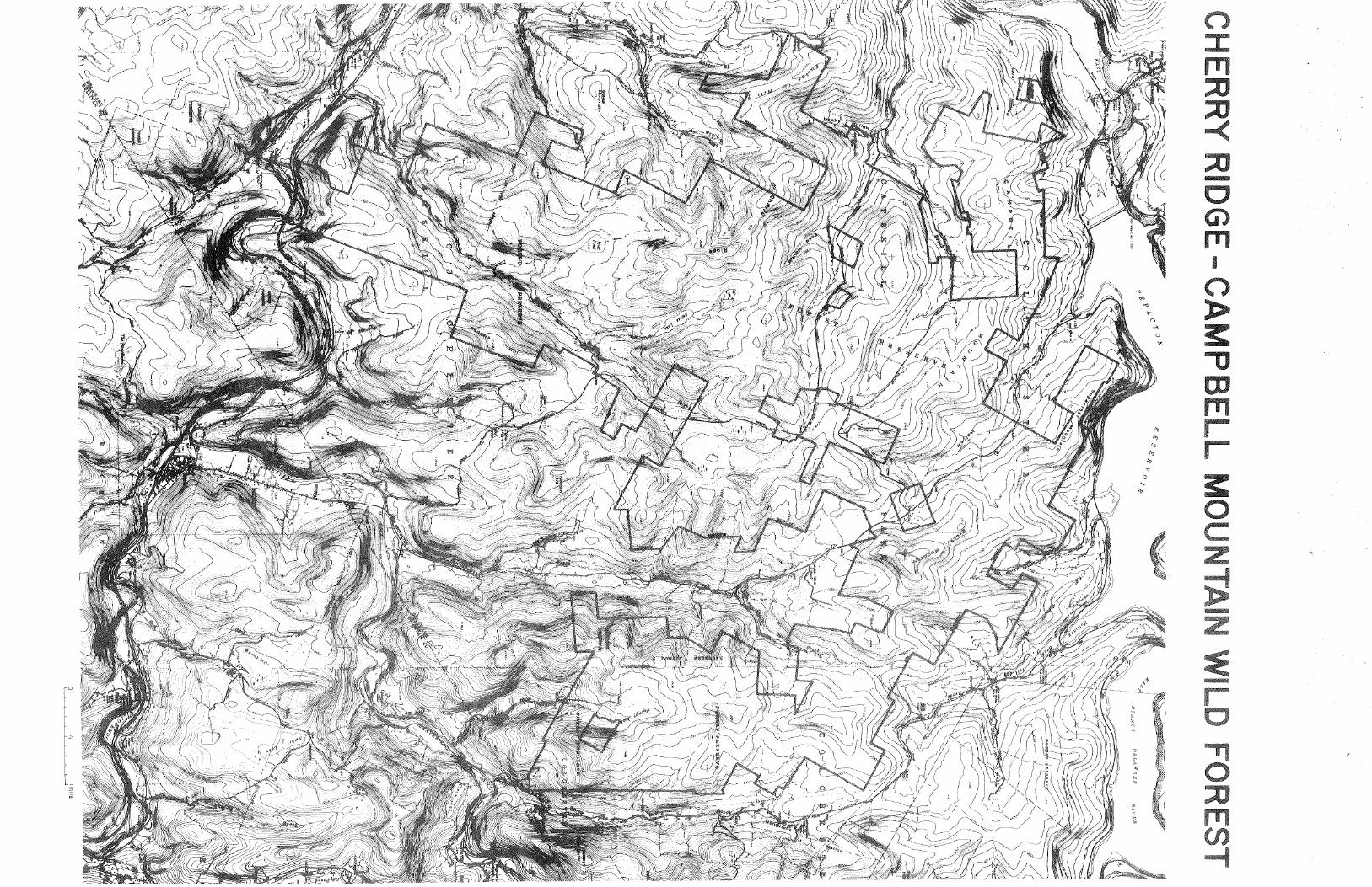
-


![[David Campbell, David Campbell] Promoting Participation](https://img.pdfslide.net/doc/110x75/577c83a61a28abe054b5a6fa/david-campbell-david-campbell-promoting-participation.jpg)