Embed Size (px)
Citation preview
Neighborhood Revitalization Plan for Southwest Delano
June 14, 2011
c i t y o f d e l a n o
Opticos Design, Inc. Berkeley, California
Prepared By:
Local Government Commission Sacramento, California
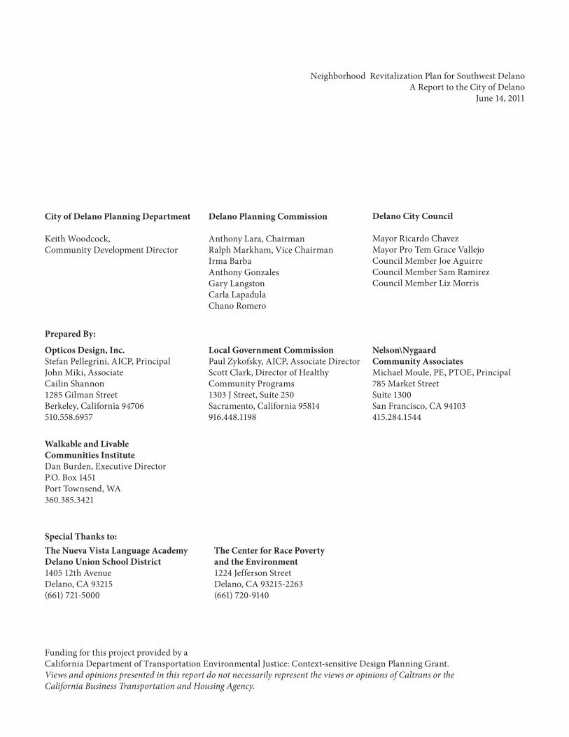
Neighborhood Revitalization Plan for Southwest Delano A Report to the City of Delano
June 14, 2011
Local Government Commission Paul Zykofsky, AICP, Associate Director Scott Clark, Director of Healthy Community Programs 1303 J Street, Suite 250 Sacramento, California 95814 916.448.1198
Opticos Design, Inc. Stefan Pellegrini, AICP, Principal John Miki, Associate Cailin Shannon 1285 Gilman Street Berkeley, California 94706 510.558.6957
Funding for this project provided by a California Department of Transportation Environmental Justice: Context-sensitive Design Planning Grant. Views and opinions presented in this report do not necessarily represent the views or opinions of Caltrans or the California Business Transportation and Housing Agency.
Prepared By:
Special Thanks to:
Walkable and Livable Communities Institute Dan Burden, Executive Director P.O. Box 1451 Port Townsend, WA 360.385.3421
The Center for Race Poverty and the Environment 1224 Jefferson Street Delano, CA 93215-2263 (661) 720-9140
The Nueva Vista Language Academy Delano Union School District 1405 12th Avenue Delano, CA 93215 (661) 721-5000
Nelson\Nygaard Community Associates Michael Moule, PE, PTOE, Principal 785 Market Street Suite 1300 San Francisco, CA 94103 415.284.1544
City of Delano Planning Department
Keith Woodcock, Community Development Director
Delano Planning Commission
Anthony Lara, ChairmanRalph Markham, Vice ChairmanIrma BarbaAnthony GonzalesGary LangstonCarla LapadulaChano Romero
Delano City Council
Mayor Ricardo ChavezMayor Pro Tem Grace VallejoCouncil Member Joe AguirreCouncil Member Sam RamirezCouncil Member Liz Morris
June 14, 2011
iiiNeighborhood Revitalization Plan for Southwest Delano Opticos Design, Inc.
Table of Contents
IntroductionIntroduction 1-1Project Area and the Community 2-1Physical Characteristics 2-2
Design ProposalsFramework for Revitalization 3-1Retrofit of Existing Streets 3-3Cecil Avenue 3-811th Avenue 3-9Garces Highway 3-13Woollomes Avenue 3-16Retrofitting and Creating New Neighborhoods 3-19
Phasing and ImplementationImplementation Strategies 4-1Funding Sources 4-4Other Local Opportunities 4-6
AppendixProject Advisory Committee Participants 5-2Public Events Participants 5-2Focus Groups Notes 5-3Public Participation Flyer in English 5-8Public Participation Flyer in Spanish 5-9
June 14, 2011
iv Neighborhood Revitalization Plan for Southwest Delano Opticos Design, Inc.
This page intentionally left blank.
Ne
igh
bo
rh
oo
d R
ev
ita
liz
at
ion
Pl
an
fo
r S
ou
th
we
st
De
la
no
chapter
Introduction
1
Introduction
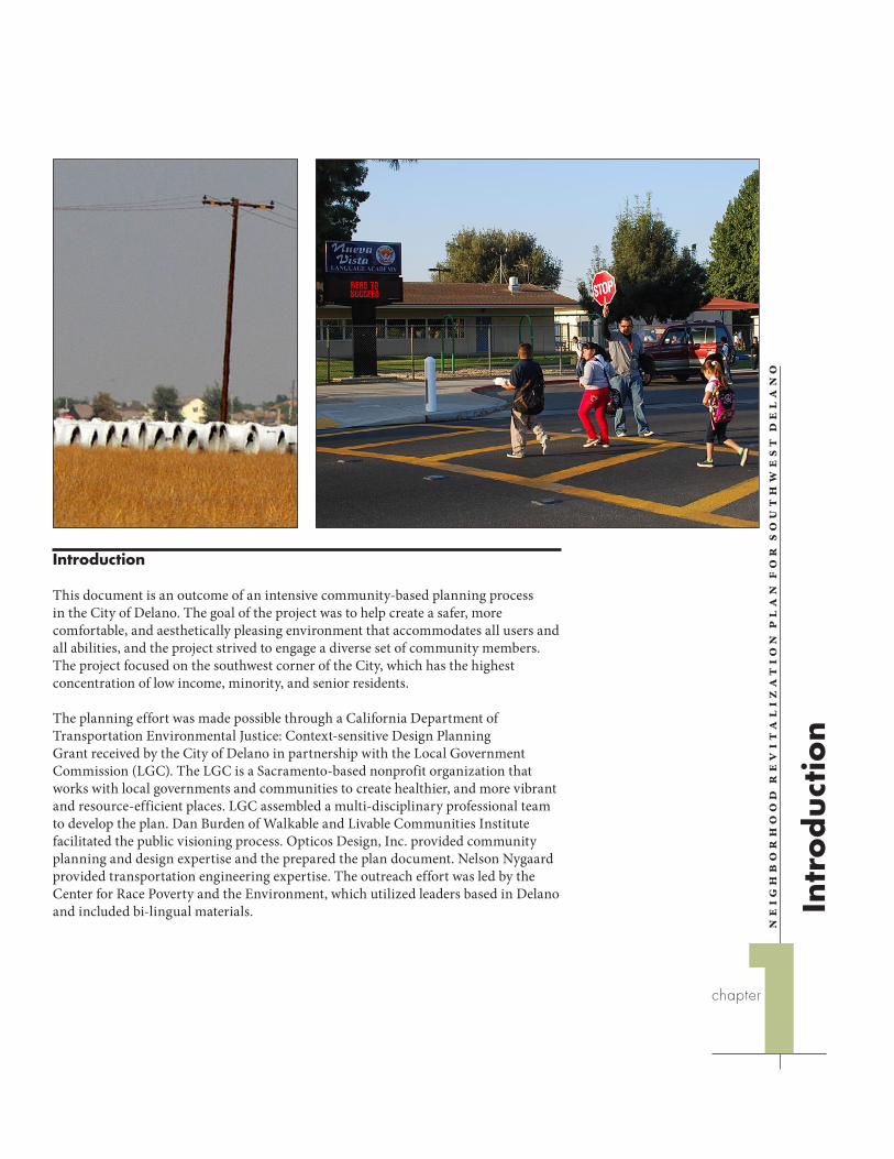
This document is an outcome of an intensive community-based planning process in the City of Delano. The goal of the project was to help create a safer, more comfortable, and aesthetically pleasing environment that accommodates all users and all abilities, and the project strived to engage a diverse set of community members. The project focused on the southwest corner of the City, which has the highest concentration of low income, minority, and senior residents.
The planning effort was made possible through a California Department of Transportation Environmental Justice: Context-sensitive Design Planning Grant received by the City of Delano in partnership with the Local Government Commission (LGC). The LGC is a Sacramento-based nonprofit organization that works with local governments and communities to create healthier, and more vibrant and resource-efficient places. LGC assembled a multi-disciplinary professional team to develop the plan. Dan Burden of Walkable and Livable Communities Institute facilitated the public visioning process. Opticos Design, Inc. provided community planning and design expertise and the prepared the plan document. Nelson Nygaard provided transportation engineering expertise. The outreach effort was led by the Center for Race Poverty and the Environment, which utilized leaders based in Delano and included bi-lingual materials. In
tro
duct
ion
Chapter 1: Introduction June 14, 2011
1-2 Neighborhood Revitalization Plan for Southwest Delano Opticos Design, Inc.
Charrette Process
In coordination with City of Delano staff and other community partners, the Local Government Commission organized a public design charrette process to produce conceptual plans for the community. A charrette is a series of interactive public events that spans several days or more and culminates in a vision or design. The bulk of the activities occurred October 13-18, 2010, with a closing workshop held on November 17, 2010.
The process included a series of focus group meetings, presentations, and workshops that engaged key stakeholders including residents and community organizations. The activities were designed to elicit concerns and suggestions, provide information about possible solutions, and foster collaborative development of a community vision.
The formal charrette process began with an event on the evening of October 14, with 44 people in attendance. It opened with a cultural celebration featuring a local Polynesian dance group, the Blue Waves. The event served as an orientation to the charrette process and participants were asked to share their vision of the future of the neighborhood, and discuss and vote on community priorities.
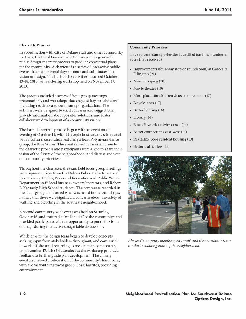
Throughout the charrette, the team held focus group meetings with representatives from the Delano Police Department and Kern County Health, Parks and Recreation and Public Works Department staff, local business owners/operators, and Robert F. Kennedy High School students. The comments recorded in the focus groups reinforced what was heard in the workshops, namely that there were significant concerns about the safety of walking and bicycling in the southeast neighborhood.
A second community-wide event was held on Saturday, October 16, and featured a “walk audit” of the community, and provided participants with an opportunity to put their vision on maps during interactive design table discussions.
While on-site, the design team began to develop concepts, seeking input from stakeholders throughout, and continued to work off-site until returning to present plan components on November 17. The 54 attendees at the workshop provided feedback to further guide plan development. The closing event also served a celebration of the community’s hard work, with a local youth mariachi group, Los Charritos, providing entertainment.
Community Priorities
The top community priorities identified (and the number of votes they received)
• Improvements (four-way stop or roundabout) at Garces & Ellington (21)
• More shopping (20)
• Movie theater (19)
• More places for children & teens to recreate (17)
• Bicycle lanes (17)
• Better lighting (16)
• Library (16)
• Block H youth activity area – (14)
• Better connections east/west (13)
• Revitalize poor resident housing (13)
• Better traffic flow (13)
Above: Community members, city staff and the consultant team conduct a walking audit of the neighborhood.
Chapter 1: Introduction June 14, 2011
1-3Neighborhood Revitalization Plan for Southwest Delano Opticos Design, Inc.
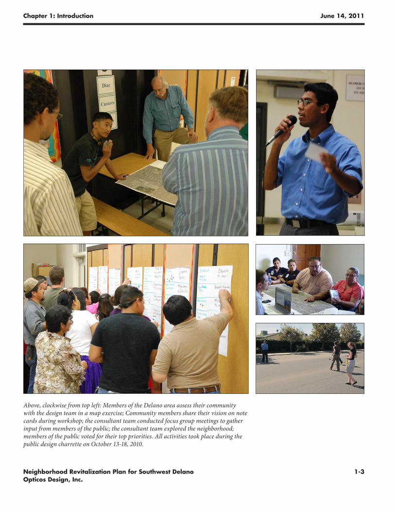
Above, clockwise from top left: Members of the Delano area assess their community with the design team in a map exercise; Community members share their vision on note cards during workshop; the consultant team conducted focus group meetings to gather input from members of the public; the consultant team explored the neighborhood; members of the public voted for their top priorities. All activities took place during the public design charrette on October 13-18, 2010.

Chapter 1: Introduction June 14, 2011
1-4 Neighborhood Revitalization Plan for Southwest Delano Opticos Design, Inc.
This page intentionally left blank.
Ne
igh
bo
rh
oo
d R
ev
ita
liz
at
ion
Pl
an
fo
r S
ou
th
we
st
De
la
no
chapter
An
aly
sis
an
d B
ack
gro
un
d
2
Project Area and the Community
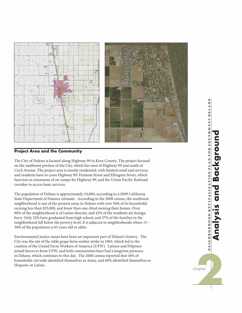
The City of Delano is located along Highway 99 in Kern County. The project focused on the southwest portion of the City, which lies west of Highway 99 and south of Cecil Avenue. The project area is mostly residential, with limited retail and services, and residents have to cross Highway 99; Fremont Street and Ellington Street, which function as extensions of on-ramps for Highway 99; and the Union Pacific Railroad corridor to access basic services.
The population of Delano is approximately 54,000, according to a 2009 California State Department of Finance estimate. According to the 2000 census, the southwest neighborhood is one of the poorest areas in Delano with over 56% of its households earning less than $25,000, and fewer than one-third owning their homes. Over 80% of the neighborhood is of Latino descent, and 42% of the residents are foreign born. Only 32% have graduated from high school, and 37% of the families in the neighborhood fall below the poverty level. It is adjacent to neighborhoods where 15 – 30% of the population is 65 years old or older.
Environmental justice issues have been an important part of Delano’s history. The City was the site of the table grape farm worker strike in 1965, which led to the creation of the United Farm Workers of America (UFW). Latinos and Filipinos joined forces to form UFW, and both communities have had a longtime presence in Delano, which continues to this day. The 2000 census reported that 16% of households citywide identified themselves as Asian, and 68% identified themselves as Hispanic or Latino.
0 2000' 4000'
Delano, CA
Chapter 2: Analysis and Background June 14, 2011
2-2 Neighborhood Revitalization Plan for Southwest Delano Opticos Design, Inc.
Since project area residents are very low income, they either need to walk in an area of inconsistent sidewalks and little shade, or spend a high percentage of their income to maintain a car. Adequate shade and shelter are not common along area streets, making it uncomfortable and sometimes physically impossible for pedestrians to reach services during hot summer months with temperatures rising above 100 degrees.
The City of Delano has shown great interest in providing improved facilities for its residents and is updating its General Plan to incorpoate healthy communities aspects in the Circulation and Land Use elements. The City has sought out and received a number of Safe Routes to School grants, and American Recovery and Reinvestment Act funds were used to build sidewalks throughout the City. Community Development staff have worked with consultants to design compact and walkable redevelopment concepts for the Block H area. The City also conducted a Pedestrian Safety Assessment. The recommendations in this report build on these efforts.
Physical Characteristics
Poor Connectivity
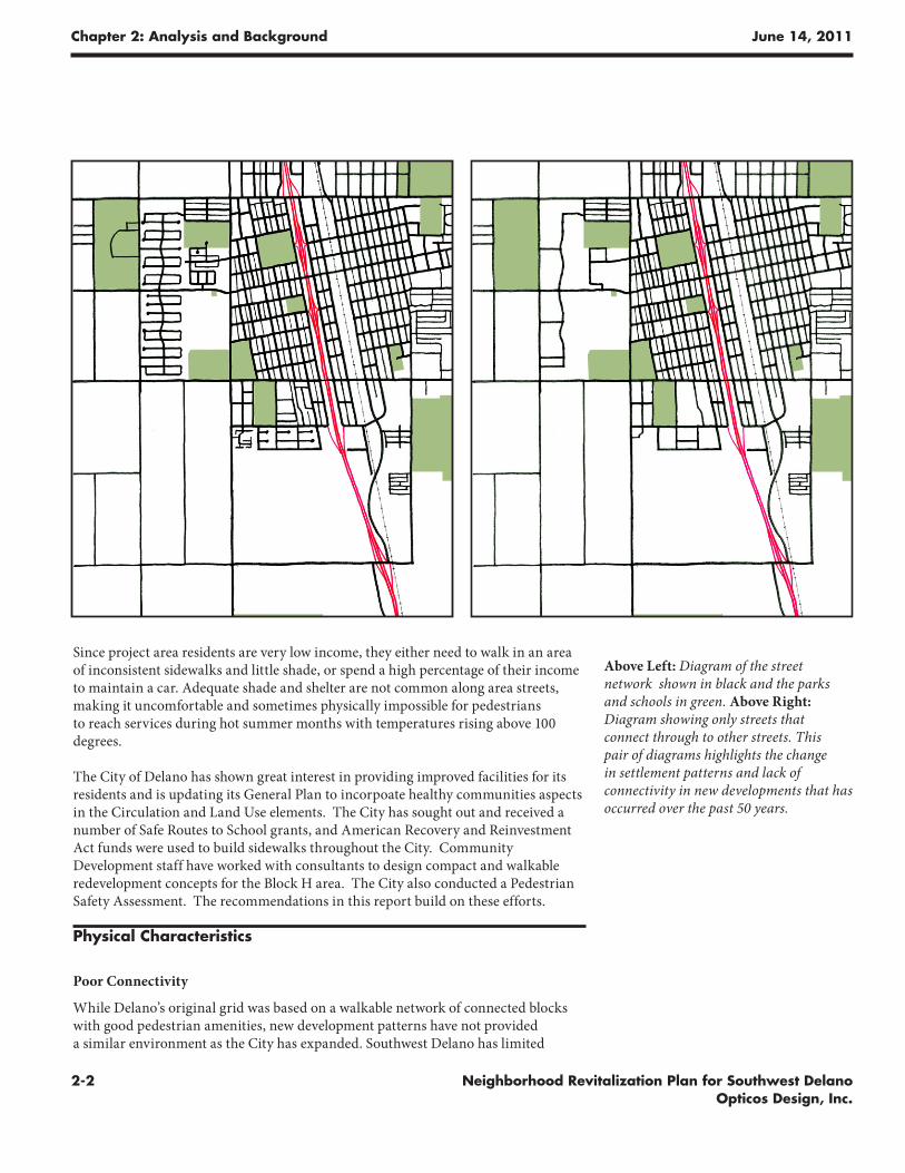
While Delano’s original grid was based on a walkable network of connected blocks with good pedestrian amenities, new development patterns have not provided a similar environment as the City has expanded. Southwest Delano has limited
Above Left: Diagram of the street network shown in black and the parks and schools in green. Above Right: Diagram showing only streets that connect through to other streets. This pair of diagrams highlights the change in settlement patterns and lack of connectivity in new developments that has occurred over the past 50 years.
Chapter 2: Analysis and Background June 14, 2011
2-3Neighborhood Revitalization Plan for Southwest Delano Opticos Design, Inc.
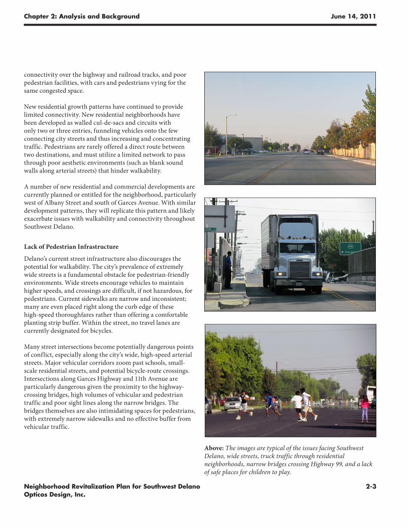
Above: The images are typical of the issues facing Southwest Delano, wide streets, truck traffic through residential neighborhoods, narrow bridges crossing Highway 99, and a lack of safe places for children to play.
connectivity over the highway and railroad tracks, and poor pedestrian facilities, with cars and pedestrians vying for the same congested space.
New residential growth patterns have continued to provide limited connectivity. New residential neighborhoods have been developed as walled cul-de-sacs and circuits with only two or three entries, funneling vehicles onto the few connecting city streets and thus increasing and concentrating traffic. Pedestrians are rarely offered a direct route between two destinations, and must utilize a limited network to pass through poor aesthetic environments (such as blank sound walls along arterial streets) that hinder walkability.
A number of new residential and commercial developments are currently planned or entitled for the neighborhood, particularly west of Albany Street and south of Garces Avenue. With similar development patterns, they will replicate this pattern and likely exacerbate issues with walkability and connectivity throughout Southwest Delano.
Lack of Pedestrian Infrastructure
Delano’s current street infrastructure also discourages the potential for walkability. The city’s prevalence of extremely wide streets is a fundamental obstacle for pedestrian-friendly environments. Wide streets encourage vehicles to maintain higher speeds, and crossings are difficult, if not hazardous, for pedestrians. Current sidewalks are narrow and inconsistent; many are even placed right along the curb edge of these high-speed thoroughfares rather than offering a comfortable planting strip buffer. Within the street, no travel lanes are currently designated for bicycles.
Many street intersections become potentially dangerous points of conflict, especially along the city’s wide, high-speed arterial streets. Major vehicular corridors zoom past schools, small-scale residential streets, and potential bicycle-route crossings. Intersections along Garces Highway and 11th Avenue are particularly dangerous given the proximity to the highway-crossing bridges, high volumes of vehicular and pedestrian traffic and poor sight lines along the narrow bridges. The bridges themselves are also intimidating spaces for pedestrians, with extremely narrow sidewalks and no effective buffer from vehicular traffic.
Chapter 2: Analysis and Background June 14, 2011
2-4 Neighborhood Revitalization Plan for Southwest Delano Opticos Design, Inc.
Need For Services on the West Side
As neighborhoods continue to expand westward, Southwest Delano warrants greater social infrastructure as well; residents require more accessible community services than those focused in the Downtown area across the Highway 99 divide. Charrette discussions revealed that residents hoped for a broad-reaching community development, especially in the form of shopping facilities, youth- and family-oriented spaces, and security services. A police substation, recreation center, library, and cinema all scored highly when polling community improvement priorities.
Current planning discussions have considered implementing “activity centers” throughout the Southwest Delano neighborhoods as a way to cluster services for local populations; however, there is currently no clear avenue for attaining this vision.
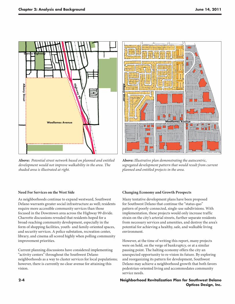
Above: Potential street network based on planned and entitled development would not improve walkability in the area. The shaded area is illustrated at right.
Above: Illustrative plan demonstrating the autocentric, segregated development pattern that would result from current planned and entitled projects in the area.
Alb
any Street
Woollomes Avenue
Changing Economy and Growth Prospects
Many tentative development plans have been proposed for Southwest Delano that continue the “status quo” pattern of poorly-connected, single-use subdivisions. With implementation, these projects would only increase traffic strain on the city’s arterial streets, further separate residents from necessary services and amenities, and destroy the area’s potential for achieving a healthy, safe, and walkable living environment.
However, at the time of writing this report, many projects were on hold, on the verge of bankruptcy, or at a similar pausing point. The halting economy offers the city an unexpected opportunity to re-vision its future. By exploring and reorganizing its pattern for development, Southwest Delano may achieve a neighborhood growth that both favors pedestrian-oriented living and accommodates community service needs.
Woollomes Avenue
Garces Highway
Highw
ay 99
Alb
any Street
Ne
igh
bo
rh
oo
d R
ev
ita
liz
at
ion
Pl
an
fo
r S
ou
th
we
st
De
la
no
chapter
Design Proposals
Des
ign
Pro
po
sals
3
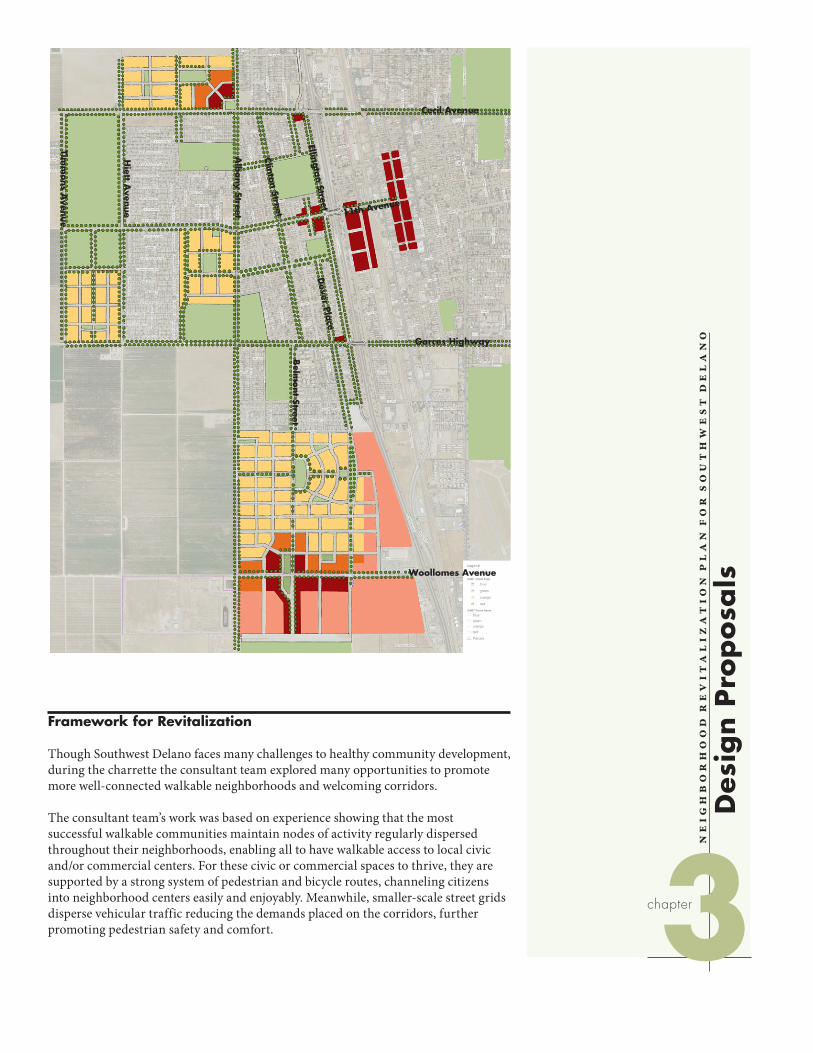
Framework for Revitalization
Though Southwest Delano faces many challenges to healthy community development, during the charrette the consultant team explored many opportunities to promote more well-connected walkable neighborhoods and welcoming corridors.
The consultant team’s work was based on experience showing that the most successful walkable communities maintain nodes of activity regularly dispersed throughout their neighborhoods, enabling all to have walkable access to local civic and/or commercial centers. For these civic or commercial spaces to thrive, they are supported by a strong system of pedestrian and bicycle routes, channeling citizens into neighborhood centers easily and enjoyably. Meanwhile, smaller-scale street grids disperse vehicular traffic reducing the demands placed on the corridors, further promoting pedestrian safety and comfort.
Cecil Avenue
Garces Highway
Timm
ons A
venue
Hiett A
venue
Alb
any Street
Clinton Street
Belm
ont Street
Ellington Street
Dover Pla
ce
Woollomes Avenue
11th Avenue
Chapter 3: Design Proposals June 14, 2011
3-2 Neighborhood Revitalization Plan for Southwest Delano Opticos Design, Inc.
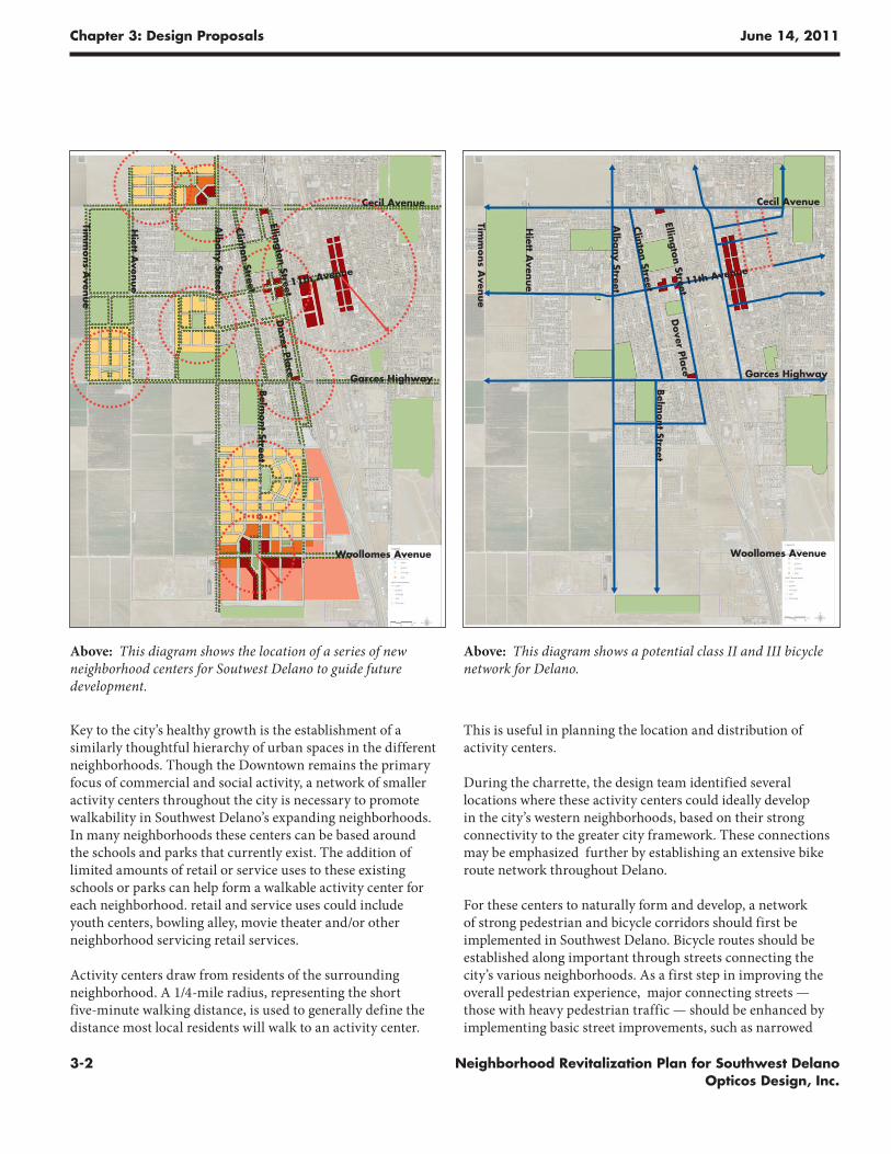
Key to the city’s healthy growth is the establishment of a similarly thoughtful hierarchy of urban spaces in the different neighborhoods. Though the Downtown remains the primary focus of commercial and social activity, a network of smaller activity centers throughout the city is necessary to promote walkability in Southwest Delano’s expanding neighborhoods. In many neighborhoods these centers can be based around the schools and parks that currently exist. The addition of limited amounts of retail or service uses to these existing schools or parks can help form a walkable activity center for each neighborhood. retail and service uses could include youth centers, bowling alley, movie theater and/or other neighborhood servicing retail services.
Activity centers draw from residents of the surrounding neighborhood. A 1/4-mile radius, representing the short five-minute walking distance, is used to generally define the distance most local residents will walk to an activity center.
This is useful in planning the location and distribution of activity centers.
During the charrette, the design team identified several locations where these activity centers could ideally develop in the city’s western neighborhoods, based on their strong connectivity to the greater city framework. These connections may be emphasized further by establishing an extensive bike route network throughout Delano.
For these centers to naturally form and develop, a network of strong pedestrian and bicycle corridors should first be implemented in Southwest Delano. Bicycle routes should be established along important through streets connecting the city’s various neighborhoods. As a first step in improving the overall pedestrian experience, major connecting streets — those with heavy pedestrian traffic — should be enhanced by implementing basic street improvements, such as narrowed
Above: This diagram shows the location of a series of new neighborhood centers for Soutwest Delano to guide future development.
Above: This diagram shows a potential class II and III bicycle network for Delano.
Cecil Avenue
Garces Highway
Timm
ons A
venue
Hiett A
venue
Alb
any Street
Clinton StreetBelm
ont Street
Ellington Street
Dover Pla
ce
Woollomes Avenue
11th Avenue
Cecil Avenue
Garces Highway
Timm
ons A
venue
Hiett A
venue
Alb
any Street
Clinton StreetBelm
ont Street
Ellington Street
Dover Pla
ce
Woollomes Avenue
11th Avenue
Chapter 3: Design Proposals June 14, 2011
3-3Neighborhood Revitalization Plan for Southwest Delano Opticos Design, Inc.
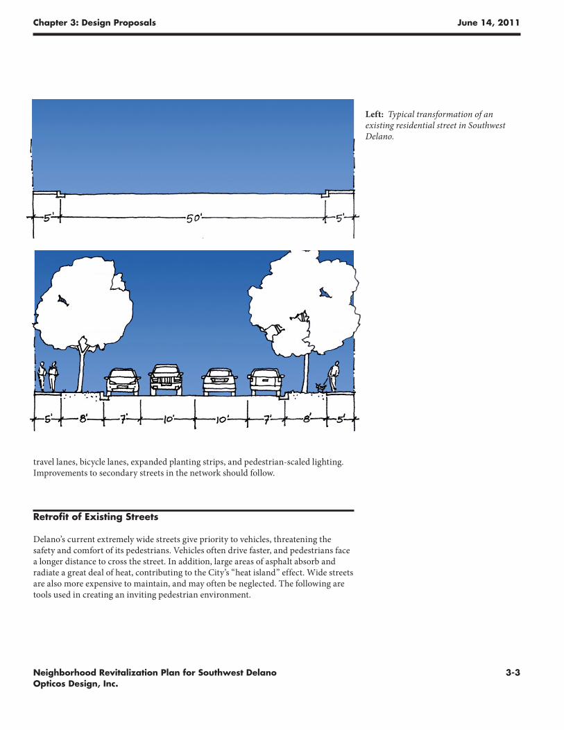
travel lanes, bicycle lanes, expanded planting strips, and pedestrian-scaled lighting. Improvements to secondary streets in the network should follow.
Retrofit of Existing Streets
Delano’s current extremely wide streets give priority to vehicles, threatening the safety and comfort of its pedestrians. Vehicles often drive faster, and pedestrians face a longer distance to cross the street. In addition, large areas of asphalt absorb and radiate a great deal of heat, contributing to the City’s “heat island” effect. Wide streets are also more expensive to maintain, and may often be neglected. The following are tools used in creating an inviting pedestrian environment.
Left: Typical transformation of an existing residential street in Southwest Delano.
Chapter 3: Design Proposals June 14, 2011
3-4 Neighborhood Revitalization Plan for Southwest Delano Opticos Design, Inc.
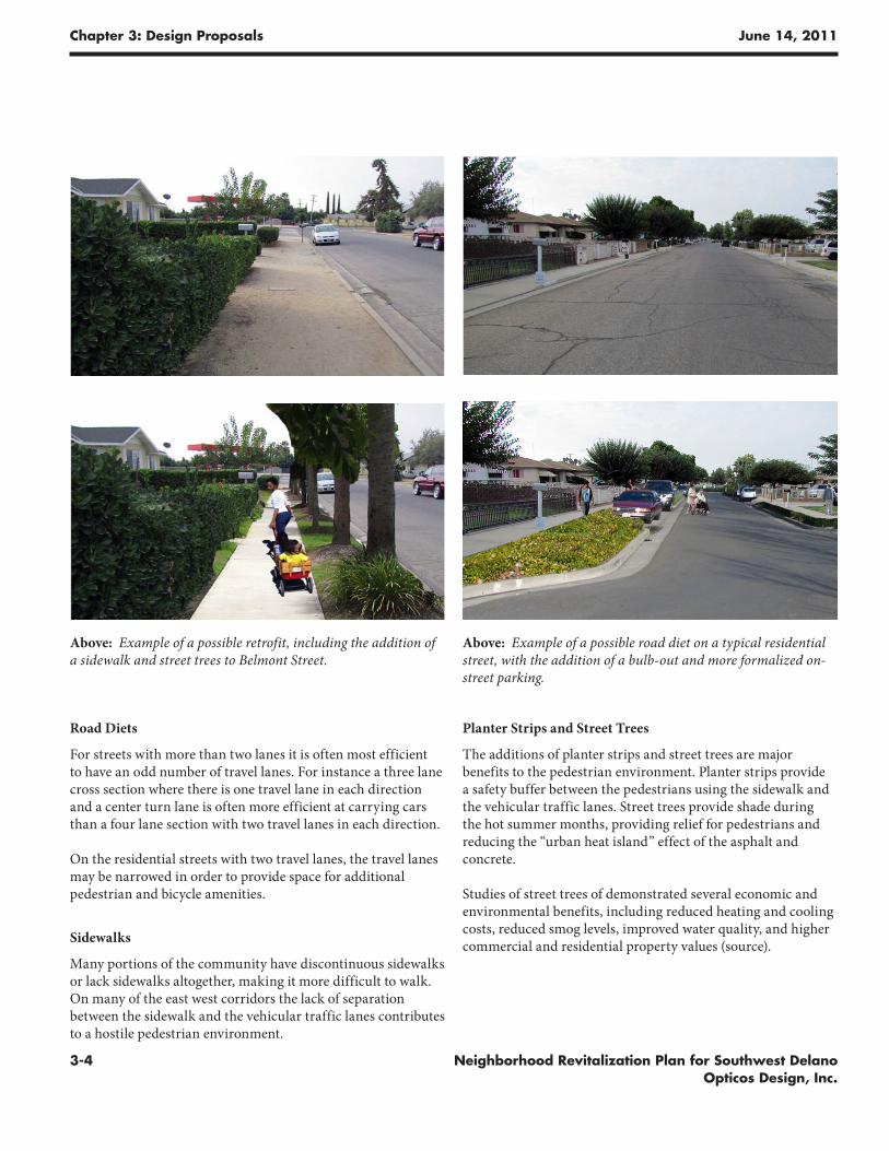
Road Diets
For streets with more than two lanes it is often most efficient to have an odd number of travel lanes. For instance a three lane cross section where there is one travel lane in each direction and a center turn lane is often more efficient at carrying cars than a four lane section with two travel lanes in each direction.
On the residential streets with two travel lanes, the travel lanes may be narrowed in order to provide space for additional pedestrian and bicycle amenities.
Sidewalks
Many portions of the community have discontinuous sidewalks or lack sidewalks altogether, making it more difficult to walk. On many of the east west corridors the lack of separation between the sidewalk and the vehicular traffic lanes contributes to a hostile pedestrian environment.
Planter Strips and Street Trees
The additions of planter strips and street trees are major benefits to the pedestrian environment. Planter strips provide a safety buffer between the pedestrians using the sidewalk and the vehicular traffic lanes. Street trees provide shade during the hot summer months, providing relief for pedestrians and reducing the “urban heat island” effect of the asphalt and concrete.
Studies of street trees of demonstrated several economic and environmental benefits, including reduced heating and cooling costs, reduced smog levels, improved water quality, and higher commercial and residential property values (source).
Above: Example of a possible retrofit, including the addition of a sidewalk and street trees to Belmont Street.
Above: Example of a possible road diet on a typical residential street, with the addition of a bulb-out and more formalized on-street parking.
Chapter 3: Design Proposals June 14, 2011
3-5Neighborhood Revitalization Plan for Southwest Delano Opticos Design, Inc.
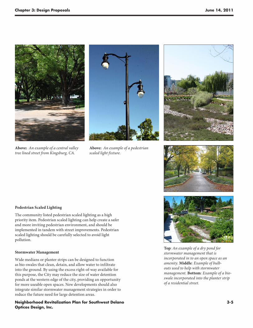
Pedestrian Scaled Lighting
The community listed pedestrian scaled lighting as a high priority item. Pedestrian scaled lighting can help create a safer and more inviting pedestrian environment, and should be implemented in tandem with street improvements. Pedestrian scaled lighting should be carefully selected to avoid light pollution.
Stormwater Management
Wide medians or planter strips can be designed to function as bio-swales that clean, detain, and allow water to infiltrate into the ground. By using the excess right-of-way available for this purpose, the City may reduce the size of water detention ponds at the western edge of the city, providing an opportunity for more useable open spaces. New developments should also integrate similar stormwater management strategies in order to reduce the future need for large detention areas.
Top: An example of a dry pond for stormwater management that is incorporated in to an open space as an amenity. Middle: Example of bulb-outs used to help with stormwater management. Bottom: Example of a bio-swale incorporated into the planter strip of a residential street.
Above: An example of a central valley tree lined street from Kingsburg, CA.
Above: An example of a pedestrian scaled light fixture.
Chapter 3: Design Proposals June 14, 2011
3-6 Neighborhood Revitalization Plan for Southwest Delano Opticos Design, Inc.
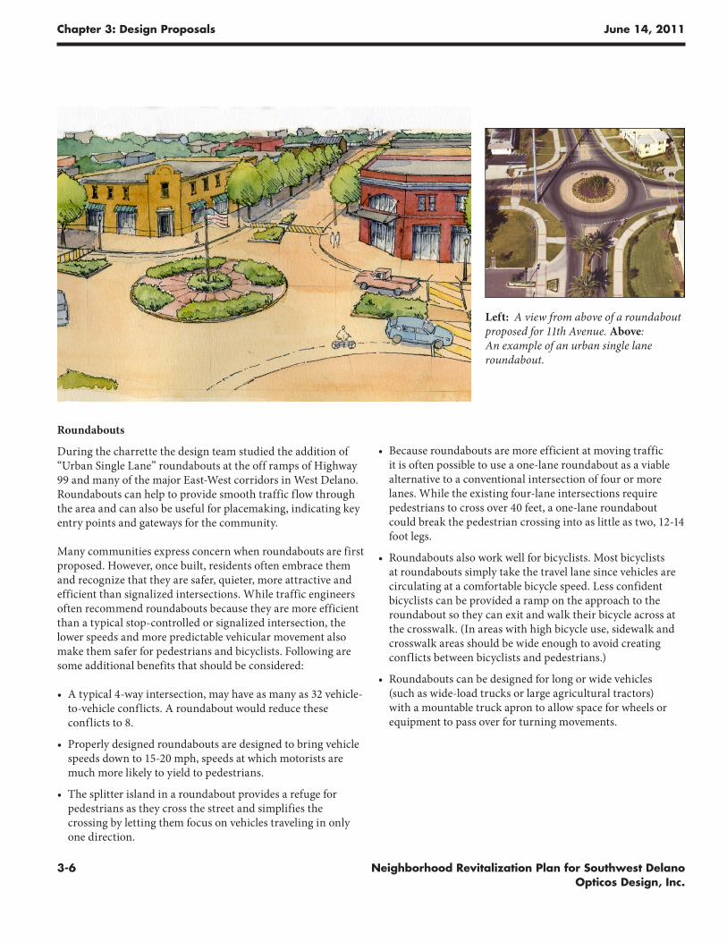
Roundabouts
During the charrette the design team studied the addition of “Urban Single Lane” roundabouts at the off ramps of Highway 99 and many of the major East-West corridors in West Delano. Roundabouts can help to provide smooth traffic flow through the area and can also be useful for placemaking, indicating key entry points and gateways for the community.
Many communities express concern when roundabouts are first proposed. However, once built, residents often embrace them and recognize that they are safer, quieter, more attractive and efficient than signalized intersections. While traffic engineers often recommend roundabouts because they are more efficient than a typical stop-controlled or signalized intersection, the lower speeds and more predictable vehicular movement also make them safer for pedestrians and bicyclists. Following are some additional benefits that should be considered:
• A typical 4-way intersection, may have as many as 32 vehicle-to-vehicle conflicts. A roundabout would reduce these conflicts to 8.
• Properly designed roundabouts are designed to bring vehicle speeds down to 15-20 mph, speeds at which motorists are much more likely to yield to pedestrians.
• The splitter island in a roundabout provides a refuge for pedestrians as they cross the street and simplifies the crossing by letting them focus on vehicles traveling in only one direction.
• Because roundabouts are more efficient at moving traffic it is often possible to use a one-lane roundabout as a viable alternative to a conventional intersection of four or more lanes. While the existing four-lane intersections require pedestrians to cross over 40 feet, a one-lane roundabout could break the pedestrian crossing into as little as two, 12-14 foot legs.
• Roundabouts also work well for bicyclists. Most bicyclists at roundabouts simply take the travel lane since vehicles are circulating at a comfortable bicycle speed. Less confident bicyclists can be provided a ramp on the approach to the roundabout so they can exit and walk their bicycle across at the crosswalk. (In areas with high bicycle use, sidewalk and crosswalk areas should be wide enough to avoid creating conflicts between bicyclists and pedestrians.)
• Roundabouts can be designed for long or wide vehicles (such as wide-load trucks or large agricultural tractors) with a mountable truck apron to allow space for wheels or equipment to pass over for turning movements.
Left: A view from above of a roundabout proposed for 11th Avenue. Above: An example of an urban single lane roundabout.
Chapter 3: Design Proposals June 14, 2011
3-7Neighborhood Revitalization Plan for Southwest Delano Opticos Design, Inc.
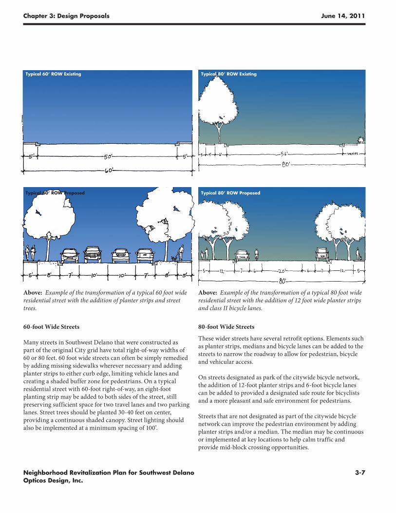
60-foot Wide Streets
Many streets in Southwest Delano that were constructed as part of the original City grid have total right-of-way widths of 60 or 80 feet. 60 foot wide streets can often be simply remedied by adding missing sidewalks wherever necessary and adding planter strips to either curb edge, limiting vehicle lanes and creating a shaded buffer zone for pedestrians. On a typical residential street with 60-foot right-of-way, an eight-foot planting strip may be added to both sides of the street, still preserving sufficient space for two travel lanes and two parking lanes. Street trees should be planted 30-40 feet on center, providing a continuous shaded canopy. Street lighting should also be implemented at a minimum spacing of 100’.
80-foot Wide Streets
These wider streets have several retrofit options. Elements such as planter strips, medians and bicycle lanes can be added to the streets to narrow the roadway to allow for pedestrian, bicycle and vehicular access.
On streets designated as park of the citywide bicycle network, the addition of 12-foot planter strips and 6-foot bicycle lanes can be added to provided a designated safe route for bicyclists and a more pleasant and safe environment for pedestrians.
Streets that are not designated as part of the citywide bicycle network can improve the pedestrian environment by adding planter strips and/or a median. The median may be continuous or implemented at key locations to help calm traffic and provide mid-block crossing opportunities.
Above: Example of the transformation of a typical 60 foot wide residential street with the addition of planter strips and street trees.
Above: Example of the transformation of a typical 80 foot wide residential street with the addition of 12 foot wide planter strips and class II bicycle lanes.
Typical 60’ ROW Existing
Typical 60’ ROW Proposed
Typical 80’ ROW Existing
Typical 80’ ROW Proposed
Chapter 3: Design Proposals June 14, 2011
3-8 Neighborhood Revitalization Plan for Southwest Delano Opticos Design, Inc.
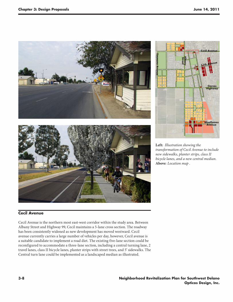
Cecil Avenue
Cecil Avenue is the northern most east-west corridor within the study area. Between Albany Street and Highway 99, Cecil maintains a 5-lane cross section. The roadway has been consistently widened as new development has moved westward. Cecil avenue currently carries a large number of vehicles per day, however, Cecil avenue is a suitable candidate to implement a road diet. The existing five-lane section could be reconfigured to accommodate a three-lane section, including a central turning lane, 2 travel lanes, class II bicycle lanes, planter strips with street trees, and 5’ sidewalks. The Central turn lane could be implemented as a landscaped median as illustrated.
Left: Illustration showing the transformation of Cecil Avenue to include new sidewalks, planter strips, class II bicycle lanes, and a new central median. Above: Location map .
Cecil Avenue
Garces Highway
Timm
ons A
venue
Alb
any
Street
Woollomes Avenue
11th Avenue
Chapter 3: Design Proposals June 14, 2011
3-9Neighborhood Revitalization Plan for Southwest Delano Opticos Design, Inc.
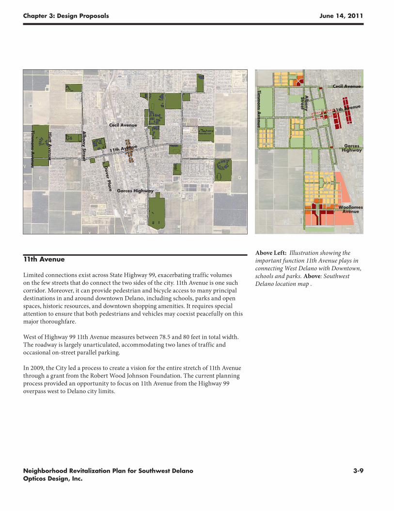
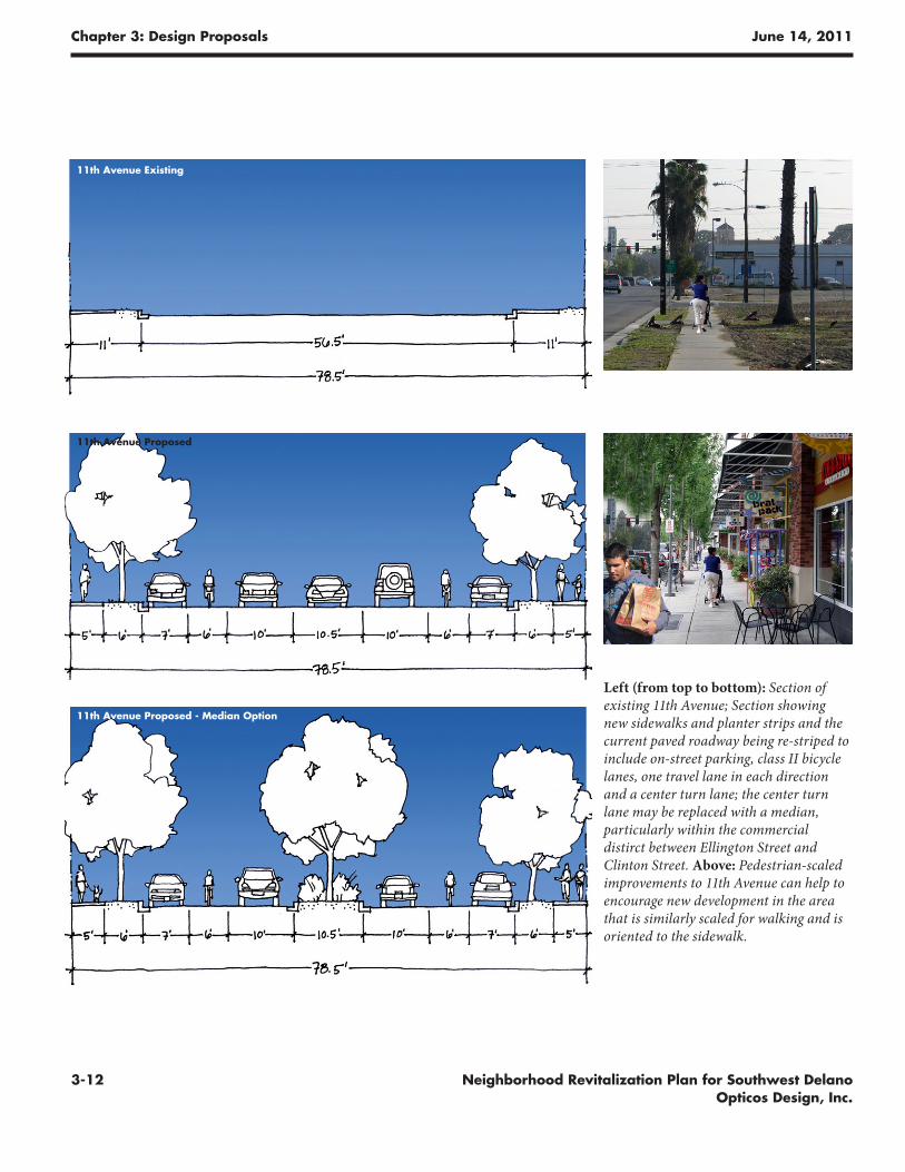
11th Avenue
Limited connections exist across State Highway 99, exacerbating traffic volumes on the few streets that do connect the two sides of the city. 11th Avenue is one such corridor. Moreover, it can provide pedestrian and bicycle access to many principal destinations in and around downtown Delano, including schools, parks and open spaces, historic resources, and downtown shopping amenities. It requires special attention to ensure that both pedestrians and vehicles may coexist peacefully on this major thoroughfare.
West of Highway 99 11th Avenue measures between 78.5 and 80 feet in total width. The roadway is largely unarticulated, accommodating two lanes of traffic and occasional on-street parallel parking.
In 2009, the City led a process to create a vision for the entire stretch of 11th Avenue through a grant from the Robert Wood Johnson Foundation. The current planning process provided an opportunity to focus on 11th Avenue from the Highway 99 overpass west to Delano city limits.
Above Left: Illustration showing the important function 11th Avenue plays in connecting West Delano with Downtown, schools and parks. Above: Southwest Delano location map .
Cecil Avenue
Garces Highway
Timm
ons A
venue
Hiett A
venue
Alb
any Street
Dover Pla
ce
11th Avenue
Cecil Avenue
Garces Highway
Timm
ons A
venue
Alb
any
Street
Woollomes Avenue
11th Avenue
Chapter 3: Design Proposals June 14, 2011
3-10 Neighborhood Revitalization Plan for Southwest Delano Opticos Design, Inc.
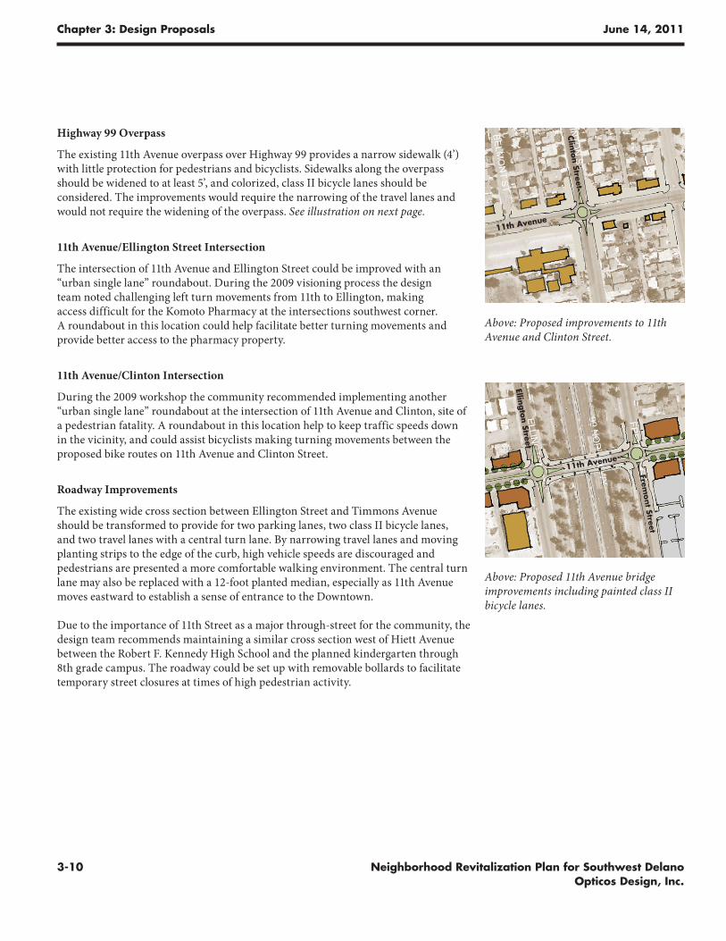
Highway 99 Overpass
The existing 11th Avenue overpass over Highway 99 provides a narrow sidewalk (4’)with little protection for pedestrians and bicyclists. Sidewalks along the overpass should be widened to at least 5’, and colorized, class II bicycle lanes should be considered. The improvements would require the narrowing of the travel lanes and would not require the widening of the overpass. See illustration on next page.
11th Avenue/Ellington Street Intersection
The intersection of 11th Avenue and Ellington Street could be improved with an “urban single lane” roundabout. During the 2009 visioning process the design team noted challenging left turn movements from 11th to Ellington, making access difficult for the Komoto Pharmacy at the intersections southwest corner. A roundabout in this location could help facilitate better turning movements and provide better access to the pharmacy property.
11th Avenue/Clinton Intersection
During the 2009 workshop the community recommended implementing another “urban single lane” roundabout at the intersection of 11th Avenue and Clinton, site of a pedestrian fatality. A roundabout in this location help to keep traffic speeds down in the vicinity, and could assist bicyclists making turning movements between the proposed bike routes on 11th Avenue and Clinton Street.
Roadway Improvements
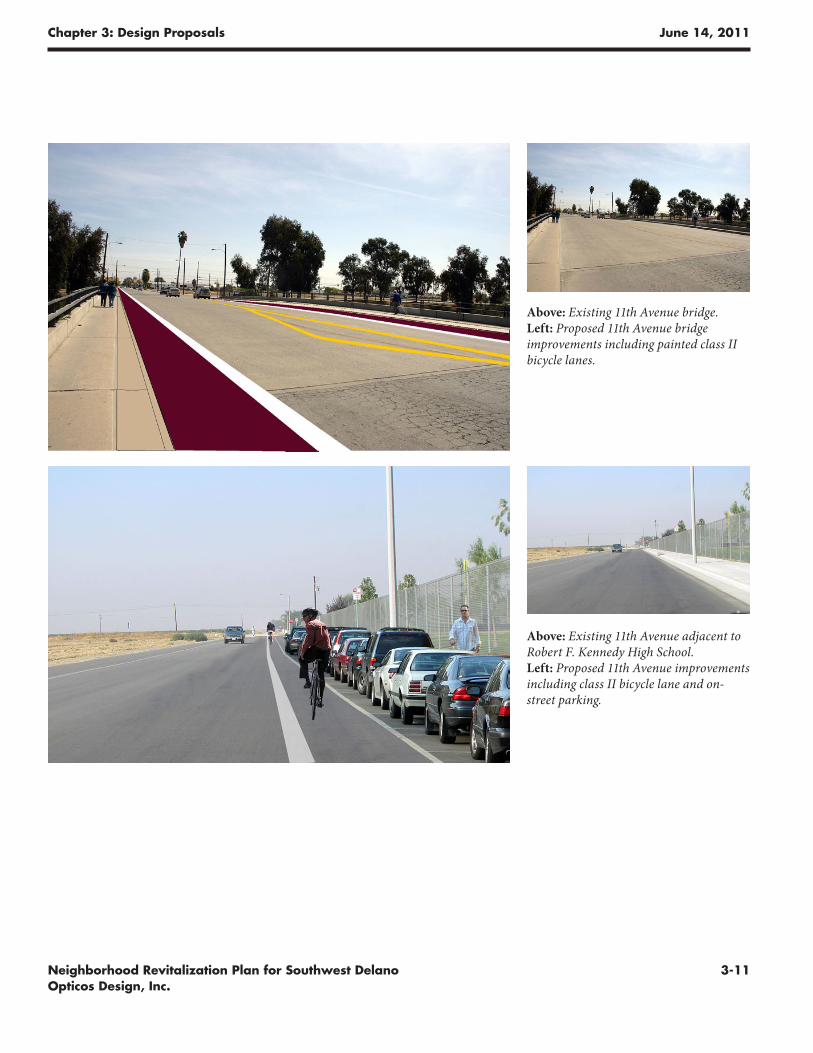
The existing wide cross section between Ellington Street and Timmons Avenue should be transformed to provide for two parking lanes, two class II bicycle lanes, and two travel lanes with a central turn lane. By narrowing travel lanes and moving planting strips to the edge of the curb, high vehicle speeds are discouraged and pedestrians are presented a more comfortable walking environment. The central turn lane may also be replaced with a 12-foot planted median, especially as 11th Avenue moves eastward to establish a sense of entrance to the Downtown.
Due to the importance of 11th Street as a major through-street for the community, the design team recommends maintaining a similar cross section west of Hiett Avenue between the Robert F. Kennedy High School and the planned kindergarten through 8th grade campus. The roadway could be set up with removable bollards to facilitate temporary street closures at times of high pedestrian activity.
Above: Proposed improvements to 11th Avenue and Clinton Street.
Above: Proposed 11th Avenue bridge improvements including painted class II bicycle lanes.
11th Avenue
Clinton Street
Fremont Street
Ellington Street
11th Avenue
Chapter 3: Design Proposals June 14, 2011
3-11Neighborhood Revitalization Plan for Southwest Delano Opticos Design, Inc.
Above: Existing 11th Avenue bridge. Left: Proposed 11th Avenue bridge improvements including painted class II bicycle lanes.
Above: Existing 11th Avenue adjacent to Robert F. Kennedy High School. Left: Proposed 11th Avenue improvements including class II bicycle lane and on-street parking.
Chapter 3: Design Proposals June 14, 2011
3-12 Neighborhood Revitalization Plan for Southwest Delano Opticos Design, Inc.
Left (from top to bottom): Section of existing 11th Avenue; Section showing new sidewalks and planter strips and the current paved roadway being re-striped to include on-street parking, class II bicycle lanes, one travel lane in each direction and a center turn lane; the center turn lane may be replaced with a median, particularly within the commercial distirct between Ellington Street and Clinton Street. Above: Pedestrian-scaled improvements to 11th Avenue can help to encourage new development in the area that is similarly scaled for walking and is oriented to the sidewalk.
11th Avenue Existing
11th Avenue Proposed
11th Avenue Proposed - Median Option
Chapter 3: Design Proposals June 14, 2011
3-13Neighborhood Revitalization Plan for Southwest Delano Opticos Design, Inc.
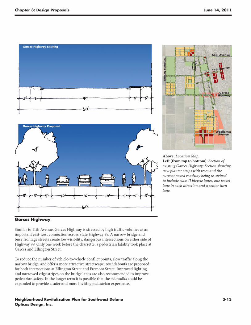
Garces Highway
Similar to 11th Avenue, Garces Highway is stressed by high traffic volumes as an important east-west connection across State Highway 99. A narrow bridge and busy frontage streets create low-visibility, dangerous intersections on either side of Highway 99. Only one week before the charrette, a pedestrian fatality took place at Garces and Ellington Street.
To reduce the number of vehicle-to-vehicle conflict points, slow traffic along the narrow bridge, and offer a more attractive streetscape, roundabouts are proposed for both intersections at Ellington Street and Fremont Street. Improved lighting and narrowed edge stripes on the bridge lanes are also recommended to improve pedestrian safety. In the longer term it is possible that the sidewalks could be expanded to provide a safer and more inviting pedestrian experience.
Above: Location Map. Left (from top to bottom): Section of existing Garces Highway; Section showing new planter strips with trees and the current paved roadway being re-striped to include class II bicycle lanes, one travel lane in each direction and a center turn lane.
Garces Highway Existing
Garces Highway Proposed
Cecil Avenue
Garces Highway
Timm
ons A
venue
Alb
any
Street
Woollomes Avenue
11th Avenue
Chapter 3: Design Proposals June 14, 2011
3-14 Neighborhood Revitalization Plan for Southwest Delano Opticos Design, Inc.
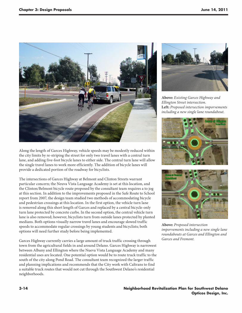
Along the length of Garces Highway, vehicle speeds may be modestly reduced within the city limits by re-striping the street for only two travel lanes with a central turn lane, and adding five-foot bicycle lanes to either side. The central turn lane will allow the single travel lanes to work more efficiently. The addition of bicycle lanes will provide a dedicated portion of the roadway for bicyclists.
The intersections of Garces Highway at Belmont and Clinton Streets warrant particular concern; the Neuva Vista Language Academy is set at this location, and the Clinton/Belmont bicycle route proposed by the consultant team requires a to jog at this section. In addition to the improvements proposed in the Safe Route to School report from 2007, the design team studied two methods of accommodating bicycle and pedestrian crossings at this location. In the first option, the vehicle turn lane is removed along this short length of Garces and replaced by a central bicycle-only turn lane protected by concrete curbs. In the second option, the central vehicle turn lane is also removed; however, bicyclists turn from outside lanes protected by planted medians. Both options visually narrow travel lanes and encourage slowed traffic speeds to accommodate regular crossings by young students and bicyclists; both options will need further study before being implemented.
Garces Highway currently carries a large amount of truck traffic crossing through town from the agricultural fields in and around Delano. Garces Highway is narrowest between Albany and Ellington where the Nueva Vista Language Academy and many residential uses are located. One potential option would be to route truck traffic to the south of the city along Pond Road. The consultant team recognized the larger traffic and planning implications and recommends that the City work with Caltrans to find a suitable truck routes that would not cut through the Southwest Delano’s residential neighborhoods.
Above: Existing Garces Highway and Ellington Street intersection. Left: Proposed intersection imporvements including a new single lane roundabout.
Above: Proposed intersection imporvements including a new single lane roundabouts at Garces and Ellington and Garces and Fremont.
Chapter 3: Design Proposals June 14, 2011
3-15Neighborhood Revitalization Plan for Southwest Delano Opticos Design, Inc.
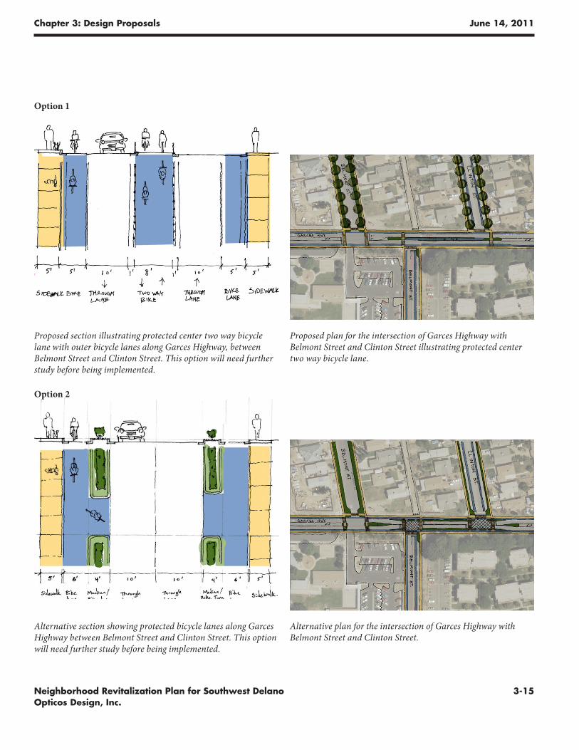
Alternative plan for the intersection of Garces Highway with Belmont Street and Clinton Street.
Proposed plan for the intersection of Garces Highway with Belmont Street and Clinton Street illustrating protected center two way bicycle lane.
Proposed section illustrating protected center two way bicycle lane with outer bicycle lanes along Garces Highway, between Belmont Street and Clinton Street. This option will need further study before being implemented.
Alternative section showing protected bicycle lanes along Garces Highway between Belmont Street and Clinton Street. This option will need further study before being implemented.
Option 1
Option 2
Chapter 3: Design Proposals June 14, 2011
3-16 Neighborhood Revitalization Plan for Southwest Delano Opticos Design, Inc.
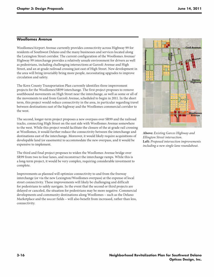
Woollomes Avenue
Woollomes/Airport Avenue currently provides connectivity across Highway 99 for residents of Southwest Delano and the many businesses and services located along the Lexington Street corridor. The current configuration of the Woollomes Avenue/Highway 99 interchange provides a relatively unsafe environment for drivers as well as pedestrians, including challenging intersections at Garzoli Avenue and High Street, and an at-grade railroad crossing just east of High Street. New development in the area will bring invariably bring more people, necessitating upgrades to improve circulation and safety.
The Kern County Transportation Plan currently identifies three improvement projects for the Woollomes/SR99 interchange. The first project proposes to remove southbound movements on High Street near the interchange, as well as some or all of the movements to and from Garzoli Avenue, scheduled to begin in 2011. In the short term, this project would reduce connectivity in the area, in particular regarding travel between destinations east of the highway and the Woollomes commercial corridor to the west.
The second, longer-term project proposes a new overpass over SR99 and the railroad tracks, connecting High Street on the east side with Woollomes Avenue somewhere to the west. While this project would facilitate the closure of the at-grade rail crossing at Woollomes, it would further reduce the connectivity between the interchange and destinations east of the interchange. Moreover, it would likely require acquisitions of developable land (or easements) to accommodate the new overpass, and it would be expensive to implement.
The third and final project proposes to widen the Woollomes Avenue bridge over SR99 from two to four lanes, and reconstruct the interchange ramps. While this is a long-term project, it would be very complex, requiring considerable investment to complete.
Improvements as planned will optimize connectivity to and from the freeway interchange (or via the new Lexington/Woollomes overpass) at the expense of local street connectivity. These improvements will likely be challenging and difficult for pedestrians to safely navigate. In the event that the second or third projects are delayed or canceled, the situation for pedestrians may be more negative. Commercial developments and community destinations along Woollomes – such as the Delano Marketplace and the soccer fields – will also benefit from increased, rather than less, connectivity.
Above: Existing Garces Highway and Ellington Street intersection. Left: Proposed intersection improvements including a new single lane roundabout.
Cecil Avenue
Garces Highway
Timm
ons A
venue
Alb
any
Street
Woollomes Avenue
11th Avenue
Chapter 3: Design Proposals June 14, 2011
3-17Neighborhood Revitalization Plan for Southwest Delano Opticos Design, Inc.
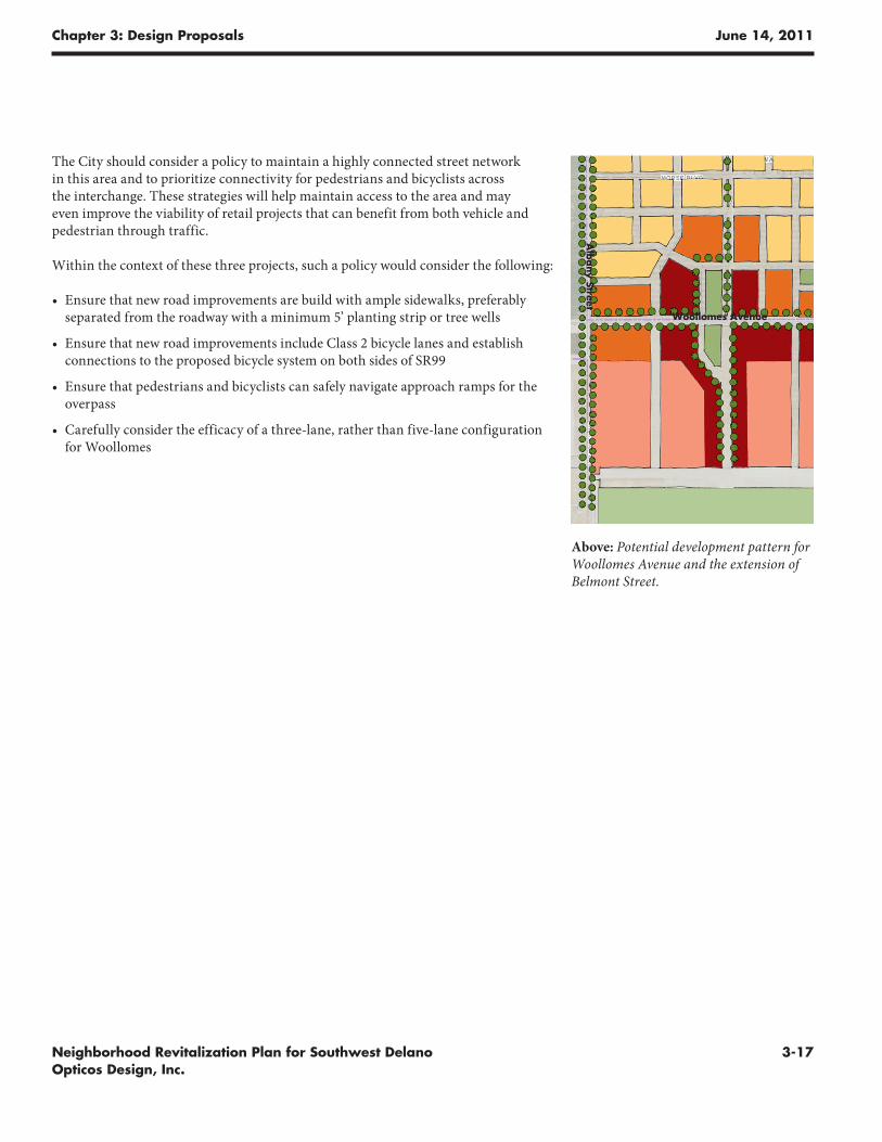
Above: Potential development pattern for Woollomes Avenue and the extension of Belmont Street.
The City should consider a policy to maintain a highly connected street network in this area and to prioritize connectivity for pedestrians and bicyclists across the interchange. These strategies will help maintain access to the area and may even improve the viability of retail projects that can benefit from both vehicle and pedestrian through traffic.
Within the context of these three projects, such a policy would consider the following:
• Ensure that new road improvements are build with ample sidewalks, preferably separated from the roadway with a minimum 5’ planting strip or tree wells
• Ensure that new road improvements include Class 2 bicycle lanes and establish connections to the proposed bicycle system on both sides of SR99
• Ensure that pedestrians and bicyclists can safely navigate approach ramps for the overpass
• Carefully consider the efficacy of a three-lane, rather than five-lane configuration for Woollomes
Alb
any Street
Woollomes Avenue
Chapter 3: Design Proposals June 14, 2011
3-18 Neighborhood Revitalization Plan for Southwest Delano Opticos Design, Inc.
Retrofitting and Creating New Neighborhoods
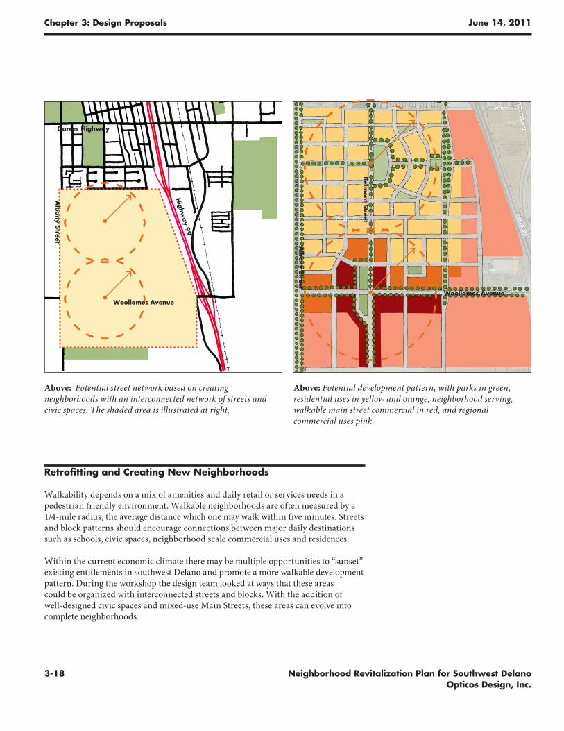
Walkability depends on a mix of amenities and daily retail or services needs in a pedestrian friendly environment. Walkable neighborhoods are often measured by a 1/4-mile radius, the average distance which one may walk within five minutes. Streets and block patterns should encourage connections between major daily destinations such as schools, civic spaces, neighborhood scale commercial uses and residences.
Within the current economic climate there may be multiple opportunities to “sunset” existing entitlements in southwest Delano and promote a more walkable development pattern. During the workshop the design team looked at ways that these areas could be organized with interconnected streets and blocks. With the addition of well-designed civic spaces and mixed-use Main Streets, these areas can evolve into complete neighborhoods.
Above: Potential street network based on creating neighborhoods with an interconnected network of streets and civic spaces. The shaded area is illustrated at right.
Above: Potential development pattern, with parks in green, residential uses in yellow and orange, neighborhood serving, walkable main street commercial in red, and regional commercial uses pink.
Alb
any Street
Woollomes AvenueWoollomes Avenue
Garces Highway
Highw
ay 99
Alb
any Street
Belm
ont Street
Chapter 3: Design Proposals June 14, 2011
3-19Neighborhood Revitalization Plan for Southwest Delano Opticos Design, Inc.
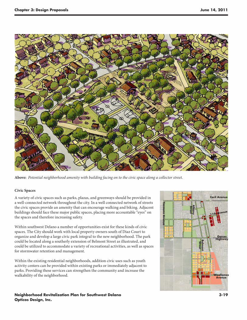
Above: Potential neighborhood amenity with building facing on to the civic space along a collector street.
Civic Spaces
A variety of civic spaces such as parks, plazas, and greenways should be provided in a well-connected network throughout the city. In a well connected network of streets the civic spaces provide an amenity that can encourage walking and biking. Adjacent buildings should face these major public spaces, placing more accountable “eyes” on the spaces and therefore increasing safety.
Within southwest Delano a number of opportunities exist for these kinds of civic spaces. The City should work with local property owners south of Diaz Court to organize and develop a large civic park integral to the new neighborhood. The park could be located along a southerly extension of Belmont Street as illustrated, and could be utilized to accommodate a variety of recreational activities, as well as spaces for stormwater retention and management.
Within the existing residential neighborhoods, addition civic uses such as youth activity centers can be provided within existing parks or immediately adjacent to parks. Providing these services can strengthen the community and increase the walkability of the neighborhood.
Cecil Avenue
Garces Highway
Timm
ons A
venue
Alb
any
Street
Woollomes Avenue
11th Avenue
Belm
ont
Street
Chapter 3: Design Proposals June 14, 2011
3-20 Neighborhood Revitalization Plan for Southwest Delano Opticos Design, Inc.
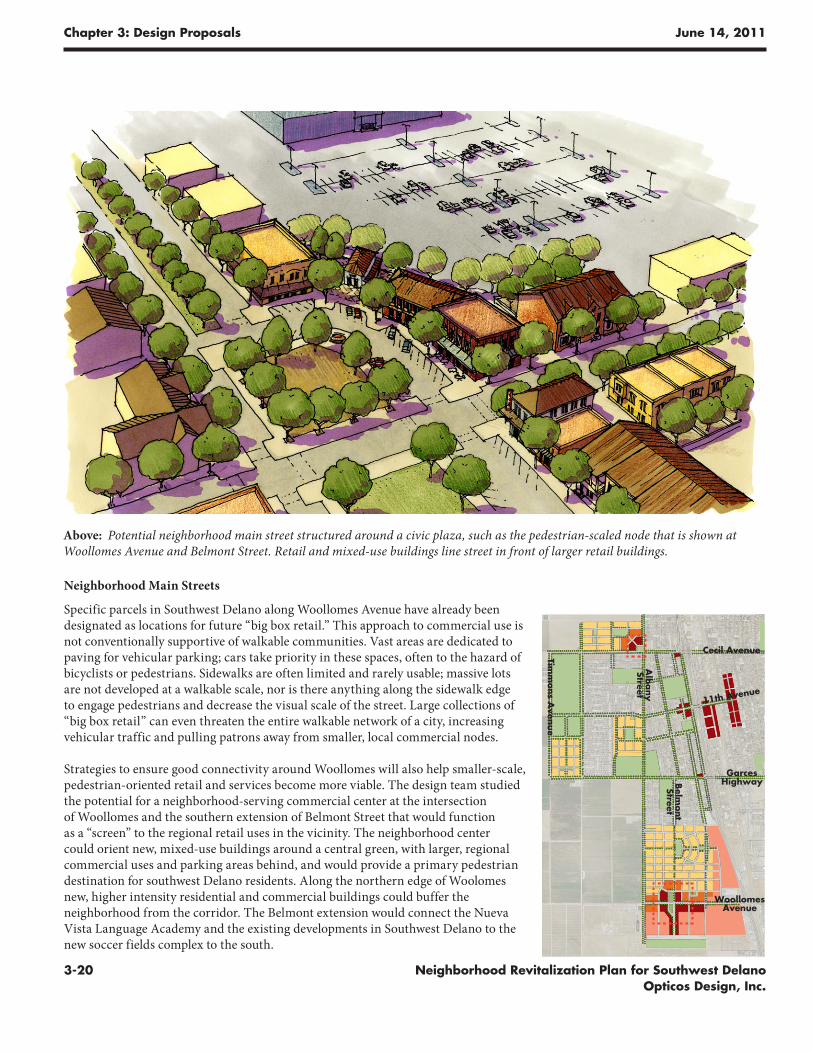
Neighborhood Main Streets
Specific parcels in Southwest Delano along Woollomes Avenue have already been designated as locations for future “big box retail.” This approach to commercial use is not conventionally supportive of walkable communities. Vast areas are dedicated to paving for vehicular parking; cars take priority in these spaces, often to the hazard of bicyclists or pedestrians. Sidewalks are often limited and rarely usable; massive lots are not developed at a walkable scale, nor is there anything along the sidewalk edge to engage pedestrians and decrease the visual scale of the street. Large collections of “big box retail” can even threaten the entire walkable network of a city, increasing vehicular traffic and pulling patrons away from smaller, local commercial nodes.
Strategies to ensure good connectivity around Woollomes will also help smaller-scale, pedestrian-oriented retail and services become more viable. The design team studied the potential for a neighborhood-serving commercial center at the intersection of Woollomes and the southern extension of Belmont Street that would function as a “screen” to the regional retail uses in the vicinity. The neighborhood center could orient new, mixed-use buildings around a central green, with larger, regional commercial uses and parking areas behind, and would provide a primary pedestrian destination for southwest Delano residents. Along the northern edge of Woolomes new, higher intensity residential and commercial buildings could buffer the neighborhood from the corridor. The Belmont extension would connect the Nueva Vista Language Academy and the existing developments in Southwest Delano to the new soccer fields complex to the south.
Above: Potential neighborhood main street structured around a civic plaza, such as the pedestrian-scaled node that is shown at Woollomes Avenue and Belmont Street. Retail and mixed-use buildings line street in front of larger retail buildings.
Cecil Avenue
Garces Highway
Timm
ons A
venue
Alb
any
Street
Woollomes Avenue
11th Avenue
Belm
ont
Street
Ne
igh
bo
rh
oo
d R
ev
ita
liz
at
ion
Pl
an
fo
r S
ou
th
we
st
De
la
no
chapter
Phasing and Implementation
Ph
asi
ng
an
d I
mp
lem
enta
tio
n
4
Implementation Strategies
At the time of writing the City was working on several simultaneous initiatives that were helping to make Delano as a whole a more walkable and pedestrian-oriented place. The 2007 Safe Routes to School report, for example, had identified several pedestrian improvements which by 2010 had begun to be implemented. City Planning Staff were also working to update portions of the General Plan that would promote more walkable development patterns.
The projects summarized in this document have been consolidated into a table that itemizes initiatives and identifies priorities which is shown on the following page. In order to help acquire funding for implementation, the City would want to go through the process of adding the projects to the Kern Regional Transportation Plan. For projects that relate to State highways, such as Route 255 (Garces Highway) and Route 99, it will be important for the City to work with Caltrans to discuss opportunities for implementation. Potential funding sources are listed in this section, but many of the funding progrms are in flux at the state and federal levels, as both are in the process of adopting budgets in a challenging economic environment. The City can best position itself for future funding by making sure the projects are listed in the Regional Plan and that those aspects involving highways have been discussed with Caltrans.
Chapter 4: Phasing and Implementation June 14, 2011
4-2 Neighborhood Revitalization Plan for Southwest Delano Opticos Design, Inc.
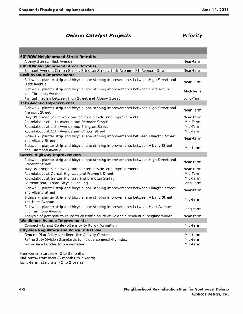
Delano Catalyst Projects Priority
60' ROW Neighborhood Street RetrofitsAlbany Street, Hiett Avenue Near-term
80' ROW Neighborhood Street RetrofitsBelmont Avenue, Clinton Street, Ellington Street, 14th Avenue, 9th Avenue, Dover Near-term
Cecil Avenue ImprovementsSidewalk, planter strip and bicycle lane striping improvements between High Street and Hiett Avenue
Near Term
Sidewalk, planter strip and bicycle lane striping improvements between Hiett Avenue and Timmons Avenue
Med-Term
Planted median between High Street and Albany Street Long-Term11th Avenue Improvements
Sidewalk, planter strip and bicycle lane striping improvements between High Street and Fremont Street
Near Term
Hwy 99 bridge 5' sidewalk and painted bicycle lane improvements Near-termRoundabout at 11th Avenue and Fremont Street Mid-TermRoundabout at 11th Avenue and Ellington Street Mid-TermRoundabout at 11th Avenue and Clinton Street Mid-TermSidewalk, planter strip and bicycle lane striping improvements between Ellington Street and Albany Street
Near-term
Sidewalk, planter strip and bicycle lane striping improvements between Albany Street and Timmons Avenue
Mid-term
Garces Highway ImprovementsSidewalk, planter strip and bicycle lane striping improvements between High Street and Fremont Street
Near-term
Hwy 99 bridge 5' sidewalk and painted bicycle lane improvements Near-termRoundabout at Garces Highway and Fremont Street Mid-TermRoundabout at Garces Highway and Ellington Street Mid-TermBelmont and Clinton Bicycle Dog Leg Long TermSidewalk, planter strip and bicycle lane striping improvements between Ellington Street and Albany Street
Near-term
Sidewalk, planter strip and bicycle lane striping improvements between Albany Street and Hiett Avenue
Mid-term
Sidewalk, planter strip and bicycle lane striping improvements between Hiett Avenue and Timmons Avenue
Long-term
Analysis of potential to route truck traffic south of Delano's residential neighborhoods Near-termWoollomes Avenue Improvements
Connectivity and Context-Sensitivity Policy Formation Mid-termCitywide Regulatory and Policy Initiatives
General Plan Policy for Mixed-Use Activity Centers Mid-termRefine Sub-Division Standards to include connectivity index Mid-termForm-Based Codes Implementation Mid-term
Near-term=start now (0 to 6 months)Mid-term=start soon (6 months to 2 years)Long-term=start later (2 to 5 years)
Chapter 4: Phasing and Implementation June 14, 2011
4-3Neighborhood Revitalization Plan for Southwest Delano Opticos Design, Inc.
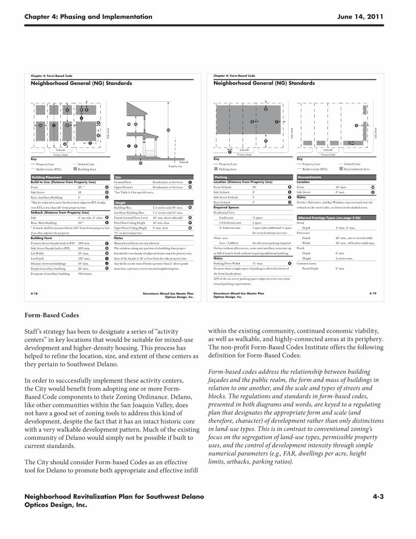
Form-Based Codes
Staff ’s strategy has been to designate a series of “activity centers” in key locations that would be suitable for mixed-use development and higher-density housing. This process has helped to refine the location, size, and extent of these centers as they pertain to Southwest Delano.
In order to succcessfully implement these activity centers, the City would benefit from adopting one or more Form-Based Code components to their Zoning Ordinance. Delano, like other communities within the San Joaquin Valley, does not have a good set of zoning tools to address this kind of development, despite the fact that it has an intact historic core with a very walkable development pattern. Much of the existing community of Delano would simply not be possible if built to current standards.
The City should consider Form-based Codes as an effective tool for Delano to promote both appropriate and effective infill
4-18 Downtown Mixed Use Master PlanOpticos Design, Inc.
Chapter 4: Form-Based Code
1" = 15'-0"
QM
P L
N
Use
Ground Floor Residential, or Services
Upper Floor(s) Residential, or Services
*See Table 4.4 for specific uses.
Height
Building Max. 2.5 stories and 30' max.
Ancillary Building Max. 1.5 stories and 15' max.
Finish Ground Floor Level 18" min. above sidewalk*
First Floor Ceiling Height 10' min. clear
Upper Floor Ceiling Height 8' min. clear
*6" on downslope lots.
Notes
Mansard roof forms are not allowed.
The windows along any portion of a building that project
beyond the rear façade of adjacent homes must be privacy win-
dows if the façade is 10' or less from the side property line.
Any decks on the rear of homes greater than 2' above grade
must have a privacy screen toward neighboring lots.
Building Placement
Build-to Line (Distance from Property Line)
Front 20' *
Side Street 10'
Rear, Ancillary Building 5'
*May be reduced to meet furthest back adjacent BTL if adja-
cent BTL is less than 20' from property line.
Setback (Distance from Property Line)
Side 4' one side, 8' other
Rear, Main Building 40'*
* Setback shall be measured from 120' from front property line
if no alley adjoins the property.
Building Form
Primary Street Façade built to BTL 50% min.
Side Street Façade built to BTL 30% min.
Lot Width 50' max.
Lot Depth 150' max.
Distance between buildings 10' min.
Depth of ancillary building 28' max.
Footprint of ancillary building 700 sf max.
L
A M
E
B
C
O
N
H
P
Q
OProperty Line
Sidewalk
Neighborhood General (NG) Standards
D
I
Sidewalk
Primary Street
Side
Stre
et
H
E
A
D
C
BI
J
K
Property Line
Build-to Line (BTL)
Setback Line
Building Area
Key
G
F
J
K
F
G
4-19Downtown Mixed Use Master PlanOpticos Design, Inc.
Chapter 4: Form-Based Code
Parking
Location (Distance from Property Line)
Front Setback 20'
Side Setback 0'
Side Street Setback 5'
Rear Setback 5'
Required Spaces
Residential Uses
Studio unit ½ space
1-2 bedroom unit 1 space
3+ bedroom unit 1 space plus additional ½ space
for every bedroom over two
Other uses
Uses < 3,000 sf No off-street parking required
On lots without alley access, a one-unit ancillary structure up
to 400 sf may be built without requiring additional parking.
Notes
Parking Drive Width 11' max.
No more than a single space of parking is allowed in front of
the front façade plane.
50% of the on-street parking spaces adjacent to lot can count
toward parking requirements.
Neighborhood General (NG) Standards
Property Line
Parking Area
R
U
V
T
W
SX
Key
Property Line
Build-to Line (BTL)
Setback Line
Encroachment Area
Key
R
S
T
Encroachments
Location
Front 10' max.
Side Street 8' max.
Notes
Porches, Balconies, and Bay Windows may encroach into the
setback on the street sides, as shown in the shaded areas.
Allowed Frontage Types (see page 4-26)
Stoop
Depth 4' min., 6' max.
Forecourt
Depth 20' min., not to exceed width
Width 20' min., 50% of lot width max.
Porch
Depth 8' min.
Height 2 stories max.
Common Lawn
Porch Depth 8' min.
U
V
W
X
Sidewalk
Primary Street
Side
Stre
et
Sidewalk
Primary Street
Side
Stre
et
within the existing community, continued economic viability, as well as walkable, and highly-connected areas at its periphery. The non-profit Form-Based Codes Institute offers the following definition for Form-Based Codes:
Form-based codes address the relationship between building façades and the public realm, the form and mass of buildings in relation to one another, and the scale and types of streets and blocks. The regulations and standards in form-based codes, presented in both diagrams and words, are keyed to a regulating plan that designates the appropriate form and scale (and therefore, character) of development rather than only distinctions in land-use types. This is in contrast to conventional zoning’s focus on the segregation of land-use types, permissible property uses, and the control of development intensity through simple numerical parameters (e.g., FAR, dwellings per acre, height limits, setbacks, parking ratios).
Chapter 4: Phasing and Implementation June 14, 2011
4-4 Neighborhood Revitalization Plan for Southwest Delano Opticos Design, Inc.
Form-based codes are often based on the concept of the Transect, which suggests that places can be organized in varying degrees of intensity, from least urban at the rural edge, to most urban at the center. In the case of Delano, the transect is very apparent and visible in a very short distance moving from the edge of town to downtown. The introduction of just a few, transect-based zone districts would do much to ensure the successful implementation of the City’s activity centers.
Form Based Codes are typically organized into a series of common sections, including a Regulating Plan (which indicates where different standards may apply), Public Space Standards (that regulate streets and other public space types) Building Form Standards (that regulate the configuration, features, and buildings as they address the public realm), Administration (that defines the application and review process), and Definitions. FBCs may also commonly include Architectural Standards, Landscaping Standards, Signage Standards, and Environmental Resource Standards.
Form-Based Codes could be implemented in a variety of ways, including the following:
1. The City could work to adopt a series of Form-Based Code zone districts that would be appropriate for use within the General Plan’s designated activity centers. This could be utilized in tandem with a “TND” Ordinance that would provide additional standards required of a walkable community plan.
2. The City could consider a complete Development Code Update of their existing zoning standards that would include a series of Form-Based Code zone districts as well as a “TND” Ordinance. Such an approach would provide an opportunity to tackle other issues and challenges with the zoning ordinance on a citywide basis.
3. The City could also consider using a coding template such as the Smart Code. Such an “off-the-shelf” template could be calibrated to follow Delano’s unique physical form and could be adopted as either a mandatory or optional code. An optional format would allow developers to choose between a fast-tracked process (if they adhere to the code), or a conventional process (if they follow existing county standards).
4.. Form-based standards could be required, even in a mandatory format, for any new developments requiring a Specific Plan.
For additional information on form-based codes, please consult the following resources:
• The Form-Based Codes Institute’s web site at www.formbasedcodes.org
• The Smart Code web site at www.smartcodecentral.org
• The book “Form Based Codes: A Guide for Planners, Urban Designers, Municipalities, and Developers” by Daniel Parolek, Karen Parolek, and Paul Crawford, available from Wiley Press
Funding Sources
A number of funding opportunities exist that can advance plan components. Sources of funding include:
• State and federal transportation funds• City road maintenance and construction funds• Development fees• Special districts• Community Development Block Grant (CDBG)• California Business, Transportation, and Housing Agency• Proposition 84 Urban Greening Grants• Compass Grants from SCAG• Volunteer initiatives and private donations
These programs offer opportunities to address street design, community facilities, and other infrastructure. Each of these funding sources is subject to changes in state and federal law, the economy and revenue levels, and project priorities. The following is a summary of programs, as they existed at the time of this report.
State and Federal Transportation Funds
Major state and federal transportation funding programs are outlined below. For more information, please visit the website for Caltrans’ Division of Local Assistance at www.dot.ca.gov/hq/LocalPrograms.
Congestion Mitigation and Air Quality Improvement Program
Funds are directed to areas that are in non-attainment or air quality maintenance areas for ozone, carbon monoxide or particulate matter. Projects that contribute to attainment are eligible, including traffic flow improvement programs and
Chapter 4: Phasing and Implementation June 14, 2011
4-5Neighborhood Revitalization Plan for Southwest Delano Opticos Design, Inc.
bicycle and pedestrian facilities. http://www.fhwa.dot.gov/environment/cmaq99gd.pdf
Regional Surface Transportation Program
Apportioned through MPOs and RTPAs, the program provides funding for bicycle and pedestrian facilities, safety improvements and hazard elimination, traffic management systems, intersections with high accident rates or congestion. http://www.dot.ca.gov/hq/transprog/federal/rstp/Official_RSTP_Web_Page.htm
Safe Routes to School
Caltrans administers state and federally funded Safe Routes to School (SRTS) programs to improve walking and bicycling conditions in and around schools. State grants are primarily focused on infrastructure (capital) projects. Federally funded projects can include infrastructure and non-infrastructure (education, encouragement, enforcement and evaluation) components. Applicants are encouraged to develop their proposals as partnerships of the school, city and community. www.dot.ca.gov/hq/LocalPrograms/saferoutes/saferoutes.htm
State Transportation Improvement Program (STIP)
This program represents the lion’s share of California’s state and federal transportation dollars. Three-quarters of the program’s funds are earmarked for improvements determined by locally adopted priorities contained in Regional Transportation Improvement Programs (RTIP), submitted by regional transportation planning agencies from around the state. STIP funds can be used for a wide variety of projects, including road rehabilitation, intersections, bicycle and pedestrian facilities, public transit, and other projects that enhance the region’s transportation infrastructure.
Transportation Enhancement Activities
Federal Transportation Enhancement funds are for construction projects that are “over and above” normal types of transportation projects. These projects may include street trees and landscaping along roadways, pedestrian and bicycle access improvements and other scenic beautification. These are apportioned throughout the county.
Bicycle Transportation Account (BTA)
This state fund, administered by the Caltrans Bicycle Facilities Unit, can be used to support bicyclists, including through bike lanes, median crossings, and bicycle/pedestrian signals. Annual
BTA funding is in the range of $5 million a year, statewide. To be eligible for BTA funds, a city or county must prepare and adopt a Bicycle Transportation Plan. Adoption of a plan establishes eligibility for five consecutive funding cycles.
Transportation Development Act (TDA)
TDA provides for two sources of funding: Local Transportation Funds (LTF) and State Transit Assistance (STA). Where TDA funds are not allocated solely to public transportation, TDA may fund other transportation programs, including planning and program activities, and pedestrian and bicycle facilities.
Community Development Block Grants (CDBG)
Under the State Small Cities Community Development Block Grant (CDGB) Program, cities and counties may seek funding for a broad range of activities ranging from establishment and operation of revolving loan funds and construction of infrastructure improvements to construction of new housing and community facilities. Applicants may also seek funding for planning studies and writing grant applications related to these activities. Funding programs under the CDBG Economic Development Allocation include the Planning and Technical Assistance Grants, Over-the-Counter Grants for public infrastructure associated with private-sector job creation, and Economic Enterprise Fund for small business loans. Applications under the Economic Development Allocation require a job creation/retention component. Potential projects include street and traffic improvements, water system expansion and improvements, and sewer system expansion and improvements. www.hcd.ca.gov/fa
California Business, Transportation, and Housing Agency (BTH) Revolving Loan Fund
The Business Transportation and Housing Agency (which includes Caltrans) administers a revolving loan fund for local governments to finance infrastructure improvements, including city streets. Cities may apply for and receive loan funding from $250,000 up to $10 million, with terms of up to 30 years for a broad range of projects. www.ibank.ca.gov
Chapter 4: Phasing and Implementation June 14, 2011
4-6 Neighborhood Revitalization Plan for Southwest Delano Opticos Design, Inc.
Urban Greening for Sustainable Communities Grant Program
The Proposition 84 Bond Act of 2006 provided funds for urban greening. Cities, counties and nonprofits are eligible to apply for these grants for projects to preserve, enhance, increase or establish community green areas such as urban forests, open spaces, wetlands and community spaces (e.g., community gardens). Funds for street trees and median landscaping might be eligible under this program. Up to 25 percent of the funds may be available for the preparation of comprehensive Urban Greening Plans. www.sgc.ca.gov
Other Local Opportunities
Sales Tax Measures
Local transportation sales tax measures can provide funding for street maintenance and rehabilitation.
Development fees
Some cities require developers to install or help pay for infrastructure improvements (streets, sidewalks, transit shelters, bike racks, landscaping, etc.) through individual development agreements. To avoid legal challenge of the City’s right to levy these fees, care must be taken to apply this strategy only where there is a clear link establishing that travel generated by the private project will use the facility to be funded with the fees. Public art funds derived from building projects can also be used for public art projects to enhance target areas.
Special Districts
A special district such as a Business Improvement District (BID) can provide up-front and on-going funding for projects benefiting specific commercial areas. Business-Based Improvement Districts are best suited for marketing, special events, and smaller expenditures like signage. Property-Based BIDs typically generate more revenues and are better suited for more expensive projects like landscaping. Landscaping and lighting districts are also sometimes established for streetscape improvements and maintenance. Other types of facilities and infrastructure districts are sometimes created for parks, drainage and sewage. Special districts generally assess a charge levied upon parcels of real property within the district’s boundaries to pay for “local improvements.” Unlike redevelopment, it is necessary to charge an assessment or fee to property owners and/or merchants to fund such a district.
Volunteer initiatives and private donations
In addition to funding sources, programs can be created for volunteer initiatives such as “Adopt-a” programs where individuals or groups engage in beautification projects such as tree plantings, or monitoring and keeping up local transit shelters. Local artists, art centers, or school art programs can be partners in community-based projects to create distinctive public artwork, transit shelters, sculptures, water features, or other amenities. Private donors or businesses can be solicited to sponsor downtown enhancement activities. These programs can be led by the City or by other community organizations.

Ne
igh
bo
rh
oo
d R
ev
ita
liz
at
ion
Pl
an
fo
r S
ou
th
we
st
De
la
no
chapter
Appendix
5
Ap
pen
dix
Appendix
Chapter 5: Appendix June 14, 2011
5-2 Neighborhood Revitalization Plan for Southwest Delano Opticos Design, Inc.
Brisa B. OcampoManuela RiveraFidel RodriguezMary RodriguezLychl RodriguezMaria RodriguezBreanna RodriquezRocio RosibesSusana SalazarNoemi SalazarAnnette SalimwesierAvtar N. SidhuRandy TreeceRefugio ValenciaArmando VeiascoMoises VelascoSilva VelazquezArmando VeloscoJose VillanuevaKeith WoodcockAngel YahelCecilia Yanez
Project Advisory Committee Participants
Gustavo Aguirre C.R.P.E.Richelle C. Carino City of DelanoJeffery Cooley Delano Elementary School DistrictMarta Frausto CaltransValerie Gorospe C.R.P.E.Linda Hinojosa Delano Elementary School DistrictCarla Lapadula Delano ChamberJohn Lippit City of DelanoLupe Martinez C.R.P.E.Mike McCabe City of DelanoAvtar N. Sidhu Kern County Environmental HealthPhil Newhouse City of DelanoMaria Ocampo City of DelanoJoe Rojas City of DelanoRandy Treece Caltrans-D6Keith Woodcock City of Delano
Public Events Participants
Gustavo AguirreChanto AnabezaKevin AnabezaLeslie AngbahanJerry AngkahanMelanie AngkahanKarlie AngkamaArturo AyalaHartellia AyalaHarterceia AyalaArturo AyoraIrma BarbaMardelano BoorRosa BrooksEsperava CamposRichelle CarinoRomona ChavezT. Jeffrey CooleyTeresa DeAndaAnthony DeAndaTina DeAndaYrancisco DerreroMorrison DobereKen DyarEsther Estrada
Francisco EstradaJuan FloresMarta FraustoAna FregosoEd GaleroJose A. GarciaHector GonzalezSocorro GonzalezDioseline GonzalezDonny GonzalezMorra C. GonzalezValerie GorospeBrian GorospeEmily GorospeAdam GorospeVaughn HaroirEricka HerreraArturo HerreraJiallo IbrahimaLeticia JassoPatricia LagusadRoberto LinaresMaria Luisa LiruimRosaliina LlamasGregorio Lopez
Teresa LopezGuadalupe LopezPaulo LopezDariana LopezIvan Lopez Leticia Mandujano Carolina ManonaLupe MartinezMaria MartinezPatricio MartinezMiguel MartinezDaniela MartinezMa Cristino MartinezRalph W MartinezMike McCabeMaria MedinaXochitl MoralesAnai MoralesLiz MorrisMike MsCabeSonia MunozRobert MurilloEmma N.Mina NaborMaria Ocampo
Chapter 5: Appendix June 14, 2011
5-3Neighborhood Revitalization Plan for Southwest Delano Opticos Design, Inc.
• People complain about speeding a lot.
• When kids get let out of school, lots of parents still working so high rates of kids walking home.
• This is a community that likes to participate in activities. They get along with their neighbors. Street fairs have been done very well here.
• Concern about access to resources that are needed every day, like grocery store. Filipino culture and Spanish culture here and both like community gardens whic do well here. People saying we want a park. Can schools open their schools so neighbors can use the properties.
• Lots of things in Delano need to be improved. At one time we had a vibrant recreation program, my kids learned how to swim in the pool. Girls played softball. Now tennis courts don’t even have nets.
• People haven’t turned out at neighborhood watch events. There is a sense of apathy that may have set in.
• From the community groups I work with, they do get involved and get a sense of pride and are very much concerned for the safety of their kids. A question is do they know how to report crime.
• I see the same people at the meetings or the meetings have no one at them.
• Police substation in neighborhood is a question of money.
• There is plenty of land along Cecil for stores that has been vacant for a long time.
• In the 60’s when the UFW was here, the west side was the union worker side and the other side was the farmers. Crime is equally dispersed throughout the city, despite east/west differences.
• Schools are closed campuses while in session. Would like to restrict zoning for alcohol/fast food near campus. Not outright outlaw, but move away from schools. No fast food on west side yet, but still might come with more development.
• Could RFK have a bike to school program? RFK is the area that has the most potential since there is new development expected out there.
• I see people walking on tracks, and playing basketball on school facilities after hours.
• Future school near RFK less likely now that they have empty classrooms at existing schools. Charter schools are getting
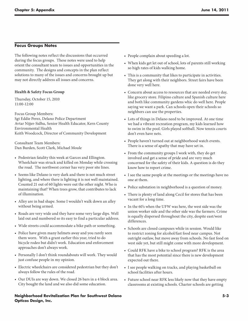
Focus Groups Notes
The following notes reflect the discussions that occurred during the focus groups. These notes were used to help orient the consultant team to issues and opportunities in the community. The designs and concepts in the plan reflect solutions to many of the issues and concerns brought up but may not directly address all issues and concerns.
Health & Safety Focus Group
Thursday, October 15, 2010 11:00-12:00
Focus Group Members: Sgt Eddie Perez, Delano Police Department Avtar Nijjer-Sidhu, Senior Health Educator, Kern County Environmental Health Keith Woodcock, Director of Community Development
Consultant Team Members: Dan Burden, Scott Clark, Michael Moule
• Pedestrian fatality this week at Garces and Ellington. Wheelchair was struck and killed on Monday while crossing the road. The northwest corner has very poor site lines.
• Seems like Delano is very dark and there is not much street lighting, and where there is lighting it is not well maintained. Counted 21 out of 60 lights were out the other night. Who is maintaining that? When trees grow, that contributes to lack of illumination.
• Alley are in bad shape. Some I wouldn’t walk down an alley without being armed.
• Roads are very wide and they have some very large dips. Well laid out and numbered so its easy to find a particular address.
• Wide streets could accommodate a bike path or something.
• Police have given many helmets away and you rarely seen them worn. With a grant earlier this year, tried to do bicycle rodeo but didn’t work. Education and enforcement approaches don’t always work.
• Personally I don’t think roundabouts will work. They would just confuse people in my opinion.
• Electric wheelchairs are considered pedestrian but they don’t always follow the rules of the road.
• Our DUIs are way down. We closed 26 bars in a 4 block area. City bought the land and we also did some education.
Chapter 5: Appendix June 14, 2011
5-4 Neighborhood Revitalization Plan for Southwest Delano Opticos Design, Inc.
more popular as well.
• For emergency response, we want a break in the walls, or no walls so there is enough access so ambulance could make it quicker.
• From law enforcement, we like connectivity. Lack of it slows us down. The brick walls don’t do anything but give a person something to tag and the City can’t afford to upkeep.
• Prison labor seems to be used for maintenance. City includes correctional facilities property and inmates count as ”residents”
• Streets are very dark at night, but more lighting equals higher energy costs, so what are our lighting alternatives?
• Police department is a small department. Not expected to grow soon.
• Are there principles we can use to make things less of a crime target?
• Loose dogs are a frequent source of calls. We have 3 animal officers. Don’t have sufficient capacity to hold dogs we catch.
• Speeding problem is a combination of lack of enforcement, bad judgment, and wide streets probably part of it too.
• Superintendent Aguilar is getting more involved in community development and HS district as well. DUESD doing town halls and allowing City to participate. Almond Tree meeting had 150 people attend – it helped that they gave away free lapbooks. Schools seems like a natural way to reach them.
City staff focus group
Thursday, October 14, 2010 2:00-3:00 pm
Focus Group Members: Keith Woodcock, Director of Community Development Marty Tracey, Director of Community Services John Lippitt, Special Projects Manager, Engineering
Consultant Team members: Dan Burden, Scott Clark, Michael Moule, Stefan Pellegrini
• Park development using Prop 84 funds, 20 acres, coming up. In some places, new parks were a component of subdivisions. Local residents began to resent others coming in from outside the area to access the parks. Morning Side is an example and it has no parking, but has restrooms. People are concerned that new parks in their areas will mean those kind of problems. These issues have not been resolved. Public parks are well utilized. If had to do it again, park would not have a gazebo or restrooms, and the play structure would be tot lot at maximum.
• Aiming for 1-acre parks, down from 5 acre parks (like south of Nueva Vista Langauge Acadmey spray park).
• Hesitant to work with school district as they tend to lock off facilities and there are lots of logistics to deal with.
• We haven’t gotten down to the level of neighborhood master plans. The next level we deal with is a specific plan.
• Some wide sidewalks are there to provide ADA space so people can more around trees, etc. People have built walls in the city ROW. Encroachments as done over years and people looked the other way. Standard is that fence in first 20 feet can be no more than 3.5’ height.
• In west part of town, there are more mature trees.
• Whatever landscaping is going to be done needs to be more on the drought tolerant side. Landscaping with new development is already outstripping our ability to take care of them. We don’t take care of the trees now – there is stuff we aren’t already doing, so as low as possible physical maintenance needs to be considered. Want better use of clever landscaping, such as in center divider. Rather have a center with some pavers or less trees, include hardscaping to get more of a balance. And easy to repair when damage. We have a problem with drunk drivers. We fight the battle on a daily basis, so haven’t had time to check into what others are doing.
• With ARRA funding were able to put in a lot of sidewalks.
Chapter 5: Appendix June 14, 2011
5-5Neighborhood Revitalization Plan for Southwest Delano Opticos Design, Inc.
• People on west side don’t participate much in planning, but still complain.
• Look at the purpose of the street, the ROW, lots of purposes – movement, landscaping. I think health is also key, keeping things walkable. Complete the sidewalk in this area. Lots of these lots of have dirt alleys behind them. Get muddy. Would be nice if we had a program to install alleys. That’s where most of the utilities are. We can also do more for bikes. They are streets with 80’ ROW, probably 60’ curb to curb, so could put bike lanes in and parking.
• There are certain areas that are hard to get to. In terms of future development we need to think about where are the things that people want to get to and how to get there. With new things coming up in south, it is currently a difficult link to the south, particularly for children.
• There is a huge inventory of existing tentative maps for subdivisions. What to do with that inventory as they expire? Do we deny it and say start over, or roll it over? Going to take some political will. Other thing is since this is an older part of town, what else can we do there to make it less auto dependant. It is still very much an auto-oriented town.
• Up until now our sidewalks have been along the curb. We need to change that now. Can get by with 36’ easily, we don’t need 60’.
• Few people are going to take care of a landscape strip themselves.
• Landscaping and lighting districts – typically district maintains the side yards but not the frontage. In Delano, most are under $100/yr per tax bill.
• Drainage sumps being counted as the park is unacceptable. Soil condition – it may look dry but have a clay layer and are wet and stay wet. If depth and draining conditions are addressed it can be doable. Newer subdivisions are putting in ditches to accommodate. Looking for 1-acre foot runoff storage for every 19 acres developed. We require only 5% of development to be landscaped.
• The property for the big basin along Albany was acquired from cemetery district along with space for the fire station.
• Have to have a good sub-base for pervious concrete.
• Vandalism budget annually $200,000/yr recently, and maybe as low as $125,000 now.
• Joint use agreements in place for swimming pool and now district wants city to help with tennis courts, but they haven’t really lived up to their side of the agreement. The relationship is improving, but they are very needy budget-wise as well.
Businesses focus group
Friday, October 15, 2010 3:00-4:00 pm
Focus Group Members: Shaun Dawkins Sandra Perez Rojas Laura Robles Rudy Rodriguez Maria Martinez Lupe Martinez Joan Flores Keith Woodcock Valerie Gorospo
Consultant Team Members: Dan Burden, Scott Clark, John Miki, Paul Zykofsky
• I own a service center, lived on west side for 11 yrs, but business in on east side and clients from west side.
• We do energy efficiency upgrades on west side. We partner up with PG&E insulate people’s houses or do minor repairs. We are seeing people without heaters, including elderly and those with children. Gas heaters are important as certain things, like gas heaters, have to be in place for us to do work. We can fix broken glass, doors, anything that has to do with “air infiltration” at no cost to homeowners. We provide outreach services, with outreach specialists, specifically in low-income neighborhoods. We can augment other grants. Current funded through end of 2010, could be longer, and have been around for many years. Delano has been worked very heavily in the past by environmental companies.
• Through some of the City’s Economic Development housing improvement funds, people can get some of the basic improvements. And it relates to want the City has to do to reduce our greenhouse gases.
• I was born in the neighborhood. My concern is what can we do with that little plaza that could be built in the area of 11th and Freemont. Also, should there be semis driving through Garces where the person was killed? Semi trucks on Garces go out to Highway 43. Can we get a four way stop or traffic light? Down the road on Garces, there are lots of children walking.
• When we exit 99 on 1st Ave, chain link fence obstructs the view, so you have to pull into middle of the street in order to be able to see the turn.
• We need more crosswalks on the west side.
Chapter 5: Appendix June 14, 2011
5-6 Neighborhood Revitalization Plan for Southwest Delano Opticos Design, Inc.
• Cesar Chavez Park has no benches to sit on and those that want to have day with the family have no where to barbeque.
• Went to CC Park once and it was very dark around 7 pm and there were some teenagers that were gang related. Adults could be contributing to youth problems in that area.
• Having youth activities is helpful.
• Check out Morningside Park and it looks inviting and want to make you go outside. The parks on the west side are the opposite. For 3 months there have been at least 2 city workers working on this gorgeous baseball field. Walkways at park follow the way people walk, green, so many trees. Its not fair that the east side looks amazing and that its getting this attention. Baseball field on west side is not nice, not inviting atmosphere.
• As far as the resources go, this area often gets neglected. Want to see more social cohesion in the area. Squeaky wheel that gets the grease.
• I grew up there and its always been that way. A division was created when HS was built on east side, but when community wanted it and needed it on the west side.
• We want to form a committee to counter the solution people have taken in the past, which was move to east side.
• When trying to get others to come to the workshop, people said they didn’t believe that this workshop would really lead to something.
• With free services, people are suspicious. Out of 700 addresses that need insulation, but can’t install because missing heaters.
• Tried to enroll my child in a HS here but wouldn’t let me chose. I can’t afford to take time and run around to take care of paperwork.
• While we were walking the streets, I noticed a lot of the streets are in bad condition. They are wide and cars blaze through there. Albany and Garces is a concern because when you turn onto Garces, and no sidewalk.
• We have wider streets so we can build wider sidewalks, bike lanes.
• For safety, you go walking at the cemetery because its safer than school fields. 6-7 am you will see people walking. Informal streets that are flat, smooth there.
• Dog issues. And a lot of cats. People say we have to have big dogs as security.
• A lot of empty lots need to be cleaned, including some that belong to the City. Need a better system of trash pick-up because elderly can’t move the containers.
• We need medical services on that side for basic check ups, physicals. We have none. We don’t have ambulances and only a fire station. We don’t have a police station.
• Current markets aren’t very good, and have always been small. They have beer and some groceries. Not really fresh produce or meats. Beer is more available on west side.
• We need a supermarket. Fairway on Garces is the biggest store. They have more stuff.
• How do we build community capacity? Cesar Chavez march is the biggest event on that side. There are also town hall meetings at the schools twice a year. Church get-togethers also are a draw. City has not done block parties on this side. If you closed off road specifically for people from that side, Dover, they would come out to something like a block party.
• The history from the 50s and 60s. There was a split. West side was farm workers. East side was farmers. Now its more mixed, but the perception continues.
• Parent site councils at schools has potential for neighborhood leadership.
• City government is not trusted. They don’t think they are going to do anything.
• We only see the council and mayor at this time of year at the elections. Otherwise we don’t ever see them on the west side.
• Some do acknowledge recent improvements. But making it a nicer place to live, that is going to take more work.
• People see the difference when they do down Main Street. The railroad tracks mark the division.
• I have a wish list. Lighting, walkways by RFK, I want to see as many trees on the west side as we have in other parts of town, I want inviting parks for families, use the room on these wide streets, better east/west side connections – takes a long time on Cecil. And Garces at certain times. Garces is one I’d like to most see improved.
• If Walgreens goes in at High and Cecil, will be another medical related resource outside of this neighborhood.
• More trees needed to encourage people to go out. More maintenance is needed. Prisoners clean our side, but not the other side.
• Semi trucks park across from Cesar Chavez park and along wider streets like Cecil and Garces. There isn’t really a commercial space where they can park.
• We have to start building the relationship with the government. We need a place for people to meet. Most of the school sites are closed.
Chapter 5: Appendix June 14, 2011
5-7Neighborhood Revitalization Plan for Southwest Delano Opticos Design, Inc.
High School Student Focus Group
Wednesday, November 17, 2010 3:00-4:00 pm
Focus Group Members: Mardelano Bool Elizabeth Braudrick Carlos Cabrera Aveli Ceja Emily Conrad Valerie Gorospe Karla Guzman Rayne Hill Griselda Jeronimo Anel Martinez Keith Woodcock Yessica Zavala
Consultant Team Members: John Miki, Paul Zykofsky
• Empty lots should be converting to something better.
• Lack of lighting is a problem.
• Add lighting to make it safe to walk on Cemetery trail and Ellington trail alongside.
• Lots of traffic on roads. Cecil, Garces and 11th are getting busier. How to route traffic through Hiett, and get pedestrians across safely?
• Most students walk to school.
• Nothing around here, we are isolated. No stores.
• We are going to have elementary, high school and college but no shopping around here.
• Delano High has things nearby. Open campus but no place to go. Would have to get a ride.
• 11th Avenue trees block sidewalk. No room for students to walk in groups.
• Near Valley Vista there are crosswalks with lights that are visible. But around HS outside gymnasium there is very little lighting.
• Stop lights needed. There are unpaved streets
• Lacking lighting around school.
• Need bowling alley, theater. Reopen old bowling alley.
• Grocery Store needed. None on the west side.
• Sports complex, like McDermott in the City of Lindsay desired. Batting cages, gym, boxing rink, gymnasium are desired activities.
• Want library on this side of town.
• Downtown library too busy, have to wait too long for computers.
Chapter 5: Appendix June 14, 2011
5-8 Neighborhood Revitalization Plan for Southwest Delano Opticos Design, Inc.
For more information contact:
Maria Ocampo, (661) 721-3340, [email protected] A. Gorospe, (661) 720-9140, [email protected] Shani Alford, (916) 448-1198, ext. 330, [email protected]
PLEASE JOIN US!Thursday, October 14, 2010Community Celebration & WorkshopNueva Vista School, 120 Garces Highway 5:30 pm - 8:00 pm Music & Food
Saturday, October 16, 2010Walking Tour & Community Design WorkshopNueva Vista School, 120 Garces Highway 10:00 am - 2:00 pm
Wednesday, November 17, 2010Closing Workshop & Presentation of Draft Plan: location & time to be announced
Organized by the Local Government Commission in partnership with the City of Delano, Community Development Department and the Center On Race, Poverty & The Environment. Funded by a California Department of Transportation Environmental Justice Context-Sensitive Planning Grant.
Revitalize Southwest Delano!
Share your ideas with friends and
neighbors for creating a safer, more
comfortable, thriving, and beautiful
neighborhood.
Door prizes
Food and refreshments provided
A team of urban design experts will
translate your vision into a plan to make
southwest Delano a more inviting place
to walk, play, gather, and do business.
Public Participation Flyer in English
Chapter 5: Appendix June 14, 2011
5-9Neighborhood Revitalization Plan for Southwest Delano Opticos Design, Inc.
Para más información comuníquese con:
María Ocampo, 661-721-3340, [email protected] A. Gorospe, 661-720-9140, [email protected] Alford, 916-448-1198 extensión 330, [email protected]
¡POR FAVOR PARTICIPE!jueves, 14 de octubre de 2010Reunión y taller de la comunidadEscuela Nueva Vista120 Garces Highway • 5:30 a 8:00 de la noche
Música y Comida
sábado, 16 de octubre de 2010Caminata de asesoría y taller de diseñoEscuela Nueva Vista120 Garces Highway • 10:00 am a 2:00 pm
miércoles, 17 de noviembre de 2010Reunión de clausura y presentación del plan(Se dará información sobre lugar y tiempo después)
Organizado por la Local Government Commission en coordinación con el Departamento de Desarrollo Comunitario de la Ciudad de Delano y el Centro En Raza, Pobreza y Medio Ambiente (CRPE). Financiado con una subvención para Justicia Ambiental del Departamento de Transporte de California (Caltrans).
¡Ayude a Revitalizar la parte
Suroeste de Delano!
Participe en estos eventos para compartir
sus ideas con amigos y vecinos para crear
un vecindario más seguro, próspero y
bello.
Rifas de premios, botanas y refrescos en todos los eventos.
Un grupo de expertos en diseño urbano
tomarán sus ideas y prepararán un plan
para que la parte suroeste de Delano sea
un lugar más placentero para caminar,
andar en bicicleta, reunirse con sus
amigos y trabajar.
Public Participation Flyer in Spanish
Chapter 5: Appendix June 14, 2011
5-10 Neighborhood Revitalization Plan for Southwest Delano Opticos Design, Inc.
This page intentionally left blank.