Embed Size (px)
Citation preview
Climate Change and Mountain TopographicEvolution in the Central Karakoram, PakistanMichael P. Bishop,∗ Andrew B. G. Bush,† Luke Copland,‡ Ulrich Kamp,§ Lewis A. Owen,#
Yeong B. Seong,¶ and John F. Shroder, Jr.∗
∗Department of Geography and Geology, University of Nebraska–Omaha†Department of Earth and Atmospheric Sciences, University of Alberta
‡Department of Geography, University of Ottawa§Department of Geography, The University of Montana
#Department of Geology, University of Cincinnati¶Department of Geography Education, Korea University
Mountain geodynamics represent highly scale-dependent interactions involving climate, tectonic, and surfaceprocesses. The central Karakoram in Pakistan exhibit strong climate–tectonic feedbacks, although the detailedtectonic and topographic responses to climate perturbations need to be systematically explored. This study focuseson understanding climate variations in relation to glacier erosion and relief production. Field data, climatemodeling, remote sensing, geomorphometry, geochronology, glaciology, and geomorphological assessment areutilized to characterize climate change and geomorphic response. Climate simulations suggest that the regionhas experienced significant climate change due to radiative forcing over at least the past million years due tochanges in Earth’s orbital configuration, as well as more temporally rapid climate dynamics related to the ElNino Southern Oscillation. Paleoclimate simulations support geomorphological evidence of multiple glaciationsand long-term glacier retreat. Mesoscale relief patterns clearly depict erosion zones that are spatially coincidentwith high peaks and rapid exhumation. These patterns depict extreme spatial and temporal variability of theinfluence of glacier erosion in the topographic evolution of the region. Results support the interpretation ofhigh-magnitude glacial erosion as a significant denudational agent in the exhumation of the central Karakoram.Consequently, a strong linkage is seen to occur between global, or at least hemispheric, climate change andthe topographic evolution of the Karakoram and the western Himalaya. Key Words: central Karakoram, climateforcing, erosion, glaciation, landscape evolution.
Las geodinamicas de montana representan interacciones altamente dependientes de la escala en las que estaninvolucrados procesos climaticos, tectonicos y topograficos. El Karakoram central de Pakistan muestra fuertesindicios de efectos climatico–tectonicos, aunque las respuestas tectonicas y topograficas detalladas a las perturba-ciones climaticas necesitan de una exploracion sistematica. El presente estudio esta enfocado a comprender lasvariaciones climaticas en relacion con la erosion glaciar y la produccion de relieve. Para caracterizar el cambioclimatico y la respuesta geomorfologica se utilizaron datos de campo, modelado climatico, percepcion remota,geomorfometrıa, geocronologıa, glaciologıa y analisis geomorfologico. Las simulaciones climaticas sugieren quela region ha experimentado cambio climatico significativo por forzamiento radiativo durante por lo menos elpasado millon de anos, causado por cambios en la configuracion de la orbita terrestre, lo mismo que por la dinamica
Annals of the Association of American Geographers, 100(4) 2010, pp. 1–22 C© 2010 by Association of American GeographersInitial submission, June 2009; revised submission, November 2009; final acceptance, January 2010
Published by Taylor & Francis, LLC.
Downloaded By: [Owen, Lewis A.] At: 10:57 20 August 2010
2 Bishop et al.
climatica de temporalidad mas rapida asociada con la Oscilacion Meridional de El Nino. Las simulaciones pale-oclimaticas refrendan la evidencia geomorfologica de multiples glaciaciones y recesion glaciar de larga duracion.Los patrones de relieve a escala mediana claramente muestran zonas de erosion espacialmente coincidentes conpicos altos y rapida exhumacion. Estos patrones muestran variabilidad temporal y espacial extremas de la influen-cia de erosion glaciar en la evolucion topografica de la region. Los resultados apoyan la interpretacion de erosionglacial de alta magnitud como agente de denudacion significativo en la exhumacion del Karakoram central. Enconsecuencia, se nota que existe un lazo fuerte entre el cambio climatico global, o por lo menos hemisferico, yla evolucion topografica del Karakoram y el Himalaya occidental. Palabras clave: Karakoram central, forzamientoclimatico, erosion, glaciacion, evolucion del paisaje.
Mountain topographic evolution has been tra-ditionally explained by collisional tectonics(Bender and Raza 1995; Turcotte and Schu-
bert 2002). Molnar and England (1990) suggested thatclimatic forcing in the Quaternary enhanced glacialerosion in the Himalaya, thereby causing isostatic up-lift of peaks and relief production. Conversely, Raymo,Ruddiman, and Froelich (1988) and Raymo and Ruddi-man (1992) indicated that enhanced chemical weath-ering of exposed rock in the Himalaya could reduceatmospheric CO2, such that tectonic forcing caused cli-matic cooling and glaciation. Central to these forcingarguments is the recognition of scale-dependent inter-actions among climatic, surface, and tectonic processes(Koons et al. 2002; Bishop, Shroder, and Colby 2003).
Key issues revolve around climate change, glaciererosion, erosion patterns, exhumation and upliftpatterns, and relief production (Montgomery 1994;Finlayson, Montgomery, and Hallet 2002; Bishop,Shroder, and Colby 2003; Spotila et al. 2004; Whipple2009). Complex feedback mechanisms are expected, al-though it is difficult to study these interactions becauseof the operational scale dependencies of numerous pro-cesses and polygenetic topographic evolution (Bishopet al. 2002; Bishop, Shroder, and Colby 2003). Conse-quently, many parameters and process rates need to beincluded, characterized, and quantified in the contextof polygenetic topographic evolution. Issues and debateinclude the importance of isostatic uplift (Gilchrist,Summerfield, and Cockburn 1994), exhumation rates(Whittington 1996), climate control and erosion dis-tribution and timing (Clift, Giosan, et al. 2008; Clift,Hodges et al. 2008; Rahaman et al. 2009), glaciers andrelief production (Harbor and Warburton 1992; Hallet,Hunter, and Bogen 1996; Whipple and Tucker 1999;Whipple, Kirby, and Brocklehurst 1999), focused ero-sion and spatial coincidence (Zeitler, Koons et al. 2001;Zeitler, Meltzer, et al. 2001; Finlayson, Montgomery,and Hallet 2002; Finnegan et al. 2008), geomorphom-etry and erosion modeling (Montgomery and Brandon
2002; Bishop and Shroder 2004), and equilibrium con-cepts such as topographic steady state (Tomkin andBraun 2002). Finding definitive field evidence of strongimpacts of climate change on mountain building hasbeen difficult (Whipple 2009). Glaciation’s role is prob-ably significant (Whipple 2009), although numerousissues are unresolved because erosion-process mechan-ics are not fully understood, glacier erosion is not ade-quately accounted for in numerous studies, the timingand mechanisms of climate-controlled erosion in theHimalaya are controversial (Pelletier 2008; Rahamanet al. 2009; van der Beek et al. 2009), and demonstra-tion of a cause-and-effect relationship between rapidexhumation and precipitation remains elusive (Pratt-Sitaula et al. 2009; Whipple 2009).
Nevertheless, there are three dominant conceptualmodels that attempt to characterize the nature of moun-tain geodynamics and relief production in active oro-gens. Researchers have recognized that variations influvial erosion are caused by precipitation gradientswherein rapid river incision causes larger scale massmovements that increase slope angles and relief (Bur-bank et al. 1996; Egholm et al. 2009). Associatedrapid rock uplift produces threshold slopes where re-lief is governed by rock strength. The proximity ofhigh-discharge rivers to massifs, with high exhumationand recently metamorphosed rocks, represents a newconceptual model termed a tectonic aneurysm (Zeitler,Koons et al. 2001; Zeitler, Meltzer et al. 2001), wheretectonic and isostatic rock uplift beneath a focused ero-sion zone advects hot and weak material from the mid-crust toward the surface. Finally, the so-called glacialbuzzsaw hypothesis suggests that the height of mountainranges is primarily governed by glaciation and high-magnitude denudation, such that height and relief ofmountain ranges are controlled by local climate ratherthan tectonic forces (Brozovic, Burbank, and Meigs1997; Egholm et al. 2009).
The K2 mountain region in the central Karakoram inPakistan represents an excellent natural laboratory for
Downloaded By: [Owen, Lewis A.] At: 10:57 20 August 2010
Climate Change and Mountain Topographic Evolution in the Central Karakoram, Pakistan 3
studying these concepts of landscape evolution, the roleof glaciers, and relief production. The central Karako-ram contains some of the highest peaks in the worldand exhibits extreme relief and high uplift rates (Foster,Gleadow, and Mortimer 1994; Seong et al. 2008). Theevolution of the K2 mountain region has been domi-nated by glacial and meltwater stream systems (Seonget al. 2007; Seong, Bishop et al. 2009). This is unlikeother massifs such as Nanga Parbat and Namche Barwa,which exhibit localized exhumation and are spatiallycoincident with large-discharge rivers (Zeitler, Koonset al. 2001; Zeitler, Meltzer et al. 2001; Finnegan et al.2008). However, a paucity of information exists re-garding long-term and high-altitude climate conditions,glacier fluctuations, and erosion and uplift patterns. Fur-thermore, the influence of glacier erosion on relief pro-duction is difficult to characterize, as glacier erosionincludes numerous processes including a nonlinear in-teraction with the overall climate. In addition, com-plications involving the coupling of climate-modulatederosion with rock rheology and strength have been rec-ognized (Schmidt and Montgomery 1995; Koons et al.2002). Although point estimates of river incision andexhumation in the western Himalaya of Pakistan do ex-ist (e.g., Foster, Gleadow, and Mortimer 1994; Burbanket al. 1996; Zeitler, Koons et al. 2001; Zeitler, Meltzeret al. 2001; Seong et al. 2008), little is known aboutclimate forcing dynamics and erosion patterns withinthe K2 region.
The objectives of this article are to summarize ourfieldwork studies on landscape dynamics in the centralKarakoram during the summer of 2005. Specifically weundertake (1) an assessment of historical, modern, andfuture climate conditions and effects; (2) an assessmentof the geomorphic conditions and the timing of glacia-tions; (3) characterization of relief and erosion patterns;and (4) characterization of modern glacial conditionsto provide insight into the magnitude of glacier erosionand relief production.
Study Area
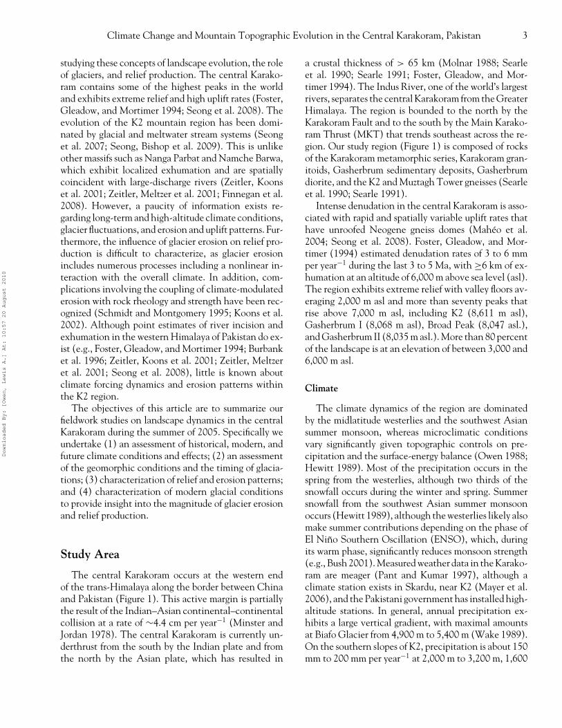
The central Karakoram occurs at the western endof the trans-Himalaya along the border between Chinaand Pakistan (Figure 1). This active margin is partiallythe result of the Indian–Asian continental–continentalcollision at a rate of ∼4.4 cm per year−1 (Minster andJordan 1978). The central Karakoram is currently un-derthrust from the south by the Indian plate and fromthe north by the Asian plate, which has resulted in
a crustal thickness of > 65 km (Molnar 1988; Searleet al. 1990; Searle 1991; Foster, Gleadow, and Mor-timer 1994). The Indus River, one of the world’s largestrivers, separates the central Karakoram from the GreaterHimalaya. The region is bounded to the north by theKarakoram Fault and to the south by the Main Karako-ram Thrust (MKT) that trends southeast across the re-gion. Our study region (Figure 1) is composed of rocksof the Karakoram metamorphic series, Karakoram gran-itoids, Gasherbrum sedimentary deposits, Gasherbrumdiorite, and the K2 and Muztagh Tower gneisses (Searleet al. 1990; Searle 1991).
Intense denudation in the central Karakoram is asso-ciated with rapid and spatially variable uplift rates thathave unroofed Neogene gneiss domes (Maheo et al.2004; Seong et al. 2008). Foster, Gleadow, and Mor-timer (1994) estimated denudation rates of 3 to 6 mmper year−1 during the last 3 to 5 Ma, with ≥6 km of ex-humation at an altitude of 6,000 m above sea level (asl).The region exhibits extreme relief with valley floors av-eraging 2,000 m asl and more than seventy peaks thatrise above 7,000 m asl, including K2 (8,611 m asl),Gasherbrum I (8,068 m asl), Broad Peak (8,047 asl.),and Gasherbrum II (8,035 m asl.). More than 80 percentof the landscape is at an elevation of between 3,000 and6,000 m asl.
Climate
The climate dynamics of the region are dominatedby the midlatitude westerlies and the southwest Asiansummer monsoon, whereas microclimatic conditionsvary significantly given topographic controls on pre-cipitation and the surface-energy balance (Owen 1988;Hewitt 1989). Most of the precipitation occurs in thespring from the westerlies, although two thirds of thesnowfall occurs during the winter and spring. Summersnowfall from the southwest Asian summer monsoonoccurs (Hewitt 1989), although the westerlies likely alsomake summer contributions depending on the phase ofEl Nino Southern Oscillation (ENSO), which, duringits warm phase, significantly reduces monsoon strength(e.g., Bush 2001). Measured weather data in the Karako-ram are meager (Pant and Kumar 1997), although aclimate station exists in Skardu, near K2 (Mayer et al.2006), and the Pakistani government has installed high-altitude stations. In general, annual precipitation ex-hibits a large vertical gradient, with maximal amountsat Biafo Glacier from 4,900 m to 5,400 m (Wake 1989).On the southern slopes of K2, precipitation is about 150mm to 200 mm per year−1 at 2,000 m to 3,200 m, 1,600
Downloaded By: [Owen, Lewis A.] At: 10:57 20 August 2010
4 Bishop et al.
Figure 1. Shuttle Radar Topographic Mission shaded relief map of the K2 study region of the central Karakoram in northeastern Pakistan.Bs = Busper sackung; MKT = Main Karakoram Thrust; KF = Karakoram Fault; B = Broad peak; K2 = K2 peak; G1 = Gasherbrum 1 peak;G2 = Gasherbrum 2 peak.
mm per year−1 at 6,100 m, and about 2,500 mm peryear−1 at 8,000 m (Mayer et al. 2006).
Surface Processes
The altitudinal zonation of the climatic-geomorphicconditions and their downslope relations have beenpreviously recognized in terms of landforms and thesediment-transfer cascade (Hewitt 1989, 1993; Seong,Bishop et al. 2009). In this region, the process regimesalternate in concert with climate fluctuations. Theoverall sediment-transfer cascade involves glacier andfluvial incision, pervasive high frequency, moderate tohigh-magnitude mass movements onto and into glaciersand rivers, as well as catastrophic floods that removevalley fill out of the system (Shroder and Bishop 2000;Bishop et al. 2002).
The mass-movement types can be best consideredin terms of regolith movement through common de-bris avalanches and flows, more deep-seated rock fallsand rockslides, and massive sackung failures in whichwhole mountain ridges collapse internally along manyinterlinked and widely distributed shear planes. In allprobability, debuttressing of rock slopes by glacier re-treat during interglacials is likely to have producedmany of the known rock falls and rockslides (Hewitt1988, 1998a, 1999). In the Braldu River valley thehuge Gomboro rockslide and the massive Busper sack-ing failure are seen to unroof the Neogene gneiss domesof Maheo et al. (2004). Regional rates of erosion bymass-movement processes in the Himalaya are difficultto quantify, although their pervasive effects are obvious(Shroder 1998).
In the valley bottoms, fluvial and glacial processesare themselves the main erosional and transporting
Downloaded By: [Owen, Lewis A.] At: 10:57 20 August 2010
Climate Change and Mountain Topographic Evolution in the Central Karakoram, Pakistan 5
agents. Hydrological monitoring of river discharges isextremely limited in the K2 region. Nevertheless, highsummer discharges result from monsoon precipitationand summer melt regimes. Monsoonal flood peaks dom-inate rivers at lower elevations with 60 to 80 percentof discharge from rain, whereas 50 to 70 percent of to-tal discharge at higher altitudes is glacier and snowmelt(Wohl 2000).
Drainage area is commonly used as a surrogate fordischarge, but drainage area–discharge relations are farfrom linear because of the glacier-melt addition. Forexample, the Upper Hunza River drains ∼5,000 km2
of somewhat lower mountains and small glaciers northof the highest Karakoram chain. The discharge of theUpper Hunza is then doubled by its confluence with theshort Batura River that drains the ∼300 km2 BaturaGlacier (Gerrad 1990; Wohl 2000).
Stream-channel characteristics in the western Hi-malaya are characteristically diverse, with alternatingreaches of exposed bedrock as well as long sectionsof gravel-armored beds. Coarse bedload has two op-posing roles in bedrock erosion (Sklar and Dietrich1998, 2001) such that at low sediment concentrations,an increase in gravel supply can provide more toolswith which water can erode the bedrock, whereas athigher concentrations the channel bed can be pro-tected. Rockfalls from unbuttressed walls during inter-glacials in the western Himalaya (Hewitt 1998a, 1999)can cause valley blocking and upstream sedimentationabove the bedrock. Incision rates appear to be highestat intermediate levels of sediment supply and trans-port capacity. On channels steeper than about 20 per-cent, incision is probably dominated by episodic debrisflows.
River incision into bedrock links topography to tec-tonics and climate but is poorly understood and is typ-ically modeled using the so-called stream-power law(Howard 1980; Sklar and Dietrich 1998), which is ap-pealing and has been used by many because it has aminimum number of parameters and can be empiricallycalibrated from topographic data. Nevertheless, it is notan actual physical law, is not directly process related,and must be applied with care (Hancock, Anderson, andWhipple 1998). In contrast, direct measures of incisionrates based on terrestrial cosmogenic nuclide (TCN)surface exposure dating of strath terraces on the Indusand Braldu Rivers (Burbank et al. 1996; Seong et al.2008), and other rivers in the Himalaya, might pro-duce the most reliable data concerning incision rates.Along a 100-km reach, incision rates were found tovary from ∼1 mm per year−1 to 12 mm per year−1,
which is quite commensurate with inferred high upliftrates there (Zeitler 1985). Combined glacial and fluvialincision rates on Nanga Parbat appear even higher at∼22 ± 11 mm per year−1 (Shroder and Bishop 2000)but are highly episodic and unlikely to be sustained overlong periods. Nevertheless, highly focused river incisioncan affect crustal structure in mountain belts by chang-ing the distribution of stress in the crust (Beaumontand Quinlan 1994; Wohl 2000; Koons et al. 2002).Rapid exhumation results from advecting crust, which isknown as the tectonic aneurysm. This is considered thecase at Nanga Parbat in Pakistan and Namche Barwa inTibet (Zeitler, Koons et al. 2001; Zeitler, Meltzer et al.2001; Finnegan et al. 2008).
Low-frequency, high-magnitude catastrophic floodsin the western Himalaya and trans-Himalaya might bethe single most important erosion process there becausethey scour the bedrock and transport such large quan-tities of sediment. Mass movement and glacial damscan be many hundreds of meters high, with the re-sult that lakes impounded behind the barriers can be-come quite large. Eventually the impounded water willovertop most landslide barriers, or float most glacialice, with the result that the large breakout floods canerode and transport considerable quantities of sediment(Cenderelli and Wohl 2003; Korup and Montgomery2008). Imbricated flood boulders of up to 15 m insize serve as evidence of this process in the K2 region(Seong, Bishop et al. 2009).
Glaciers
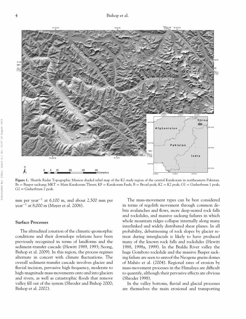
The glaciers in this region over the last century weremuch larger than they are today (Mayewski and Jeschke1979). Evidence of this is found in moraine deposits athigh altitude, high-altitude erosion surfaces, and largeU-shaped valleys that exhibit striated and ice-polishedbedrock surfaces (Figure 2). Currently, there are morethan thirty glaciers over 20 km in length in the cen-tral Karakoram. The glaciers in this region, includingthe Batura, Hispar, Biafo, and Baltoro Glaciers, com-prise some of the longest midlatitude ice masses in theworld. The surface gradients of the glaciers range fromvery steep to gentle, with the largest glaciers oftenhaving ablation areas with very low surface slope an-gles (e.g., Baltoro Glacier has an average surface slopeangle of about 2 degrees over its lowermost 35 km).Supraglacial debris covers most glaciers in their abla-tion zone. The thickness of this supraglacial debris ishighly variable, although there is a general increasedown-glacier, with maximum depths greater than 5 m.
Downloaded By: [Owen, Lewis A.] At: 10:57 20 August 2010
6 Bishop et al.
Figure 2. Ice-polished bedrock surfaceson the south side of the Braldu Valley.
Thick debris effectively insulates (Hagg et al. 2008),thereby reducing ablation rates and allowing glaciers toexist at lower altitudes. Most of the glaciers are of win-ter accumulation type, reflecting the dominant influ-ence of the midlatitude westerlies, although significantmonsoon-related summer snowfall does occur. Snowand ice avalanching is significant given the extreme re-lief and feeds many glaciers. Ice velocities have beendocumented to increase by up to double in the sum-mer compared to the winter due to increased meltwater
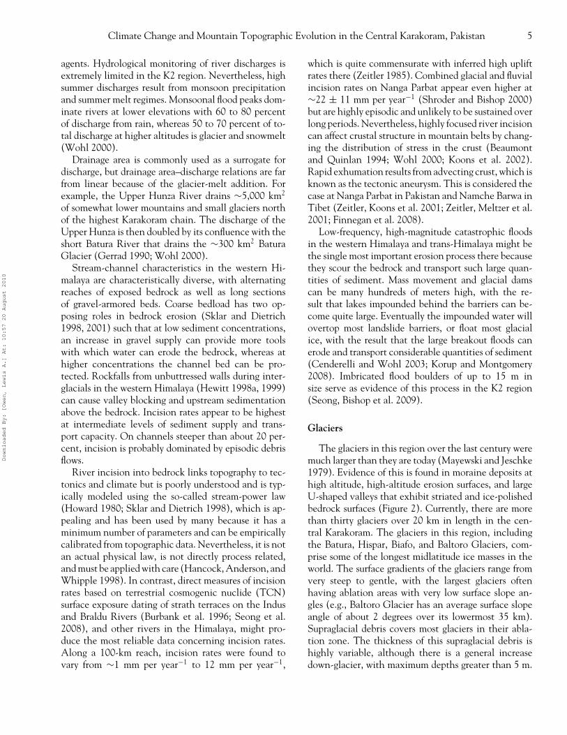
(Copland et al. 2009; Quincey et al. 2009), and manyglaciers actively incise the landscape (Figure 3).
The Karakoram is known for its many surgingglaciers, and new data indicate an increase in the num-ber of surging and advancing glaciers (Hewitt 1969,1998b, 2005, 2007; Copland et al. 2009). Glaciers inthis region are thought to be more responsive to changein precipitation than in temperature (Derbyshire 1981;Shi 2002; Owen et al. 2005), although systematicablation studies are limited to short-term measurements
Figure 3. Urdukas West Glacier is a trib-utary glacier of the Baltoro Glacier sys-tem on the south side of the valley. Theglacier has vertically incised into thelandscape generating steep valley slopesand extreme relief. The width of theglacier is approximately 261 m.
Downloaded By: [Owen, Lewis A.] At: 10:57 20 August 2010
Climate Change and Mountain Topographic Evolution in the Central Karakoram, Pakistan 7
such as Mihalcea et al. (2006). Unfortunately, individ-ual glacier and regional mass balance trends are notcurrently known with any certainty.
Climate Modeling
To better understand climate variations, we con-ducted seventy-year simulations with a fully coupledatmosphere–ocean general circulation model (see Bushand Philander [1999] for details on the model configura-tion). Specifically, we examine paleoclimate conditionsfor the Last Glacial Maximum (LGM ∼21 ka), 16 ka,9 ka, and 6 ka, and compared results to modern climateconditions. We also simulated a future climate scenarioassuming CO2 forcing double that of the present day. In-solation data in all simulations are from Berger (1992)and ice-sheet topography is from Peltier (1994). Theatmospheric model is spectral and has an equivalentspatial resolution of ∼2.250 of latitude by 3.750 of lon-gitude. The ocean model has comparable resolution.
Topographic heights are included in the modelby spectrally decomposing digital elevation data andthen truncating the resulting wave-number expansionat the smallest wave-number resolved by the model(wave-number thirty using a rhomboidal truncationscheme). Any resulting Gibbs oscillations are dampedby a spectral smoothing technique (Navarra, Stern, andMiyakoda 1994). Although the model resolution is rel-atively fine from a global perspective, it is quite coarsewhen examining results on spatial scales of hundreds ofkilometers. For this reason, spatial averages over mul-tiple grid cells are commonly used to describe regionalclimate fluctuations because the averaging procedureproduces statistically more significant and robust results.Nevertheless, the global model is incapable of gener-ating detailed results on spatial scales smaller than afew hundred kilometers, and alternative methods suchas statistical downscaling (e.g., Easterling 1999; vonStorch and Navarra 1999; Schoof and Pryor 2001) ornested modeling methodologies (e.g., Christensen et al.2001; Raisanen, Rummukainen, and Ullerstig 2001) arerequired to produce climate data in such fine spatialdetail. We specifically focus on temperature and snowaccumulation, as these parameters are most significantin governing glacier fluctuations and erosion.
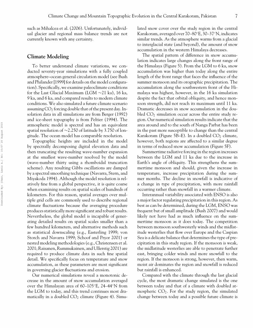
Our numerical simulations reveal a monotonic de-crease in the amount of snow accumulation averagedover the Himalayan area of 60–105◦E, 24–44◦N fromthe LGM to today, and this trend continues most dra-matically in a doubled CO2 climate (Figure 4). Simu-
lated snow cover over the study region in the centralKarakoram, averaged over 70–80◦E, 30–37◦N, indicatessimilar trends. As the atmosphere warms from a glacialto interglacial state (and beyond), the amount of snowaccumulation in the western Himalaya decreases.
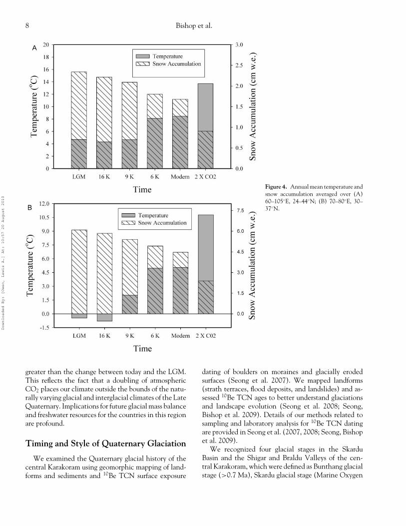
The spatial pattern of difference in snow accumu-lation indicates large changes along the front range ofthe Himalaya (Figure 5). From the LGM to 6 ka, snowaccumulation was higher than today along the entirelength of the front range that faces the influence of thesummer monsoon and its orographic precipitation. Theaccumulation along the southwestern front of the Hi-malaya was highest, however, in the 16 ka simulationdespite the fact that orbital obliquity, and hence mon-soon strength, did not reach its maximum until 11 ka.Dramatic decreases in snow accumulation in the dou-bled CO2 simulation occur across the entire study re-gion. Our numerical simulation results indicate that thearea around and to the south of Nanga Parbat has beenin the past more susceptible to change than the centralKarakoram (Figure 5B–E). In a doubled CO2 climate,however, both regions are affected to a similar degreein terms of reduced snow accumulation (Figure 5F).
Summertime radiative forcing in the region increasesbetween the LGM and 11 ka due to the increase inEarth’s angle of obliquity. This strengthens the sum-mertime monsoon and should, given the increase intemperature, increase precipitation during the sum-mer months. The decline in snowfall is indicative ofa change in type of precipitation, with more rainfalloccurring rather than snowfall in a warmer climate.
Interannual variability associated with ENSO is alsoa major factor regulating precipitation in this region. Asbest as can be determined, during the LGM, ENSO wasfrequent but of small amplitude (Bush 2007) and wouldlikely not have had as much influence on the sum-mertime monsoon as it does today. The competitionbetween monsoon southwesterly winds and the midlat-itude westerlies that flow over Europe and the CaspianSea is a delicate balance that determines the type of pre-cipitation in this study region. If the monsoon is weak,the midlatitude westerlies are able to penetrate furthereast, bringing colder winds and more snowfall to theregion. If the monsoon is strong, however, then warm,moist air dominates the region and snowfall is reducedbut rainfall is enhanced.
Compared with the climate through the last glacialcycle, the most dramatic change simulated is the onebetween today and that of a climate with doubled at-mospheric CO2. For the study region, the simulatedchange between today and a possible future climate is
Downloaded By: [Owen, Lewis A.] At: 10:57 20 August 2010
8 Bishop et al.
Figure 4. Annual mean temperature andsnow accumulation averaged over (A)60–105◦E, 24–44◦N; (B) 70–80◦E, 30–37◦N.
greater than the change between today and the LGM.This reflects the fact that a doubling of atmosphericCO2 places our climate outside the bounds of the natu-rally varying glacial and interglacial climates of the LateQuaternary. Implications for future glacial mass balanceand freshwater resources for the countries in this regionare profound.
Timing and Style of Quaternary Glaciation
We examined the Quaternary glacial history of thecentral Karakoram using geomorphic mapping of land-forms and sediments and 10Be TCN surface exposure
dating of boulders on moraines and glacially erodedsurfaces (Seong et al. 2007). We mapped landforms(strath terraces, flood deposits, and landslides) and as-sessed 10Be TCN ages to better understand glaciationsand landscape evolution (Seong et al. 2008; Seong,Bishop et al. 2009). Details of our methods related tosampling and laboratory analysis for 10Be TCN datingare provided in Seong et al. (2007, 2008; Seong, Bishopet al. 2009).
We recognized four glacial stages in the SkarduBasin and the Shigar and Braldu Valleys of the cen-tral Karakoram, which were defined as Bunthang glacialstage (>0.7 Ma), Skardu glacial stage (Marine Oxygen
Downloaded By: [Owen, Lewis A.] At: 10:57 20 August 2010
Climate Change and Mountain Topographic Evolution in the Central Karakoram, Pakistan 9
Figure 5. Annual mean snow accumulation (cm w.e.) over 73–80E,32–37N. K2 is depicted by a red circle and Nanga Parbat is repre-sented by a red square. (A) Modern climate simulation (control),with color scale range depicted overtop. (B–F) Last glacial maxi-mum, 16 ka, 9 ka, 6 ka, and 2× CO2, respectively, with color scalerange depicted over B.
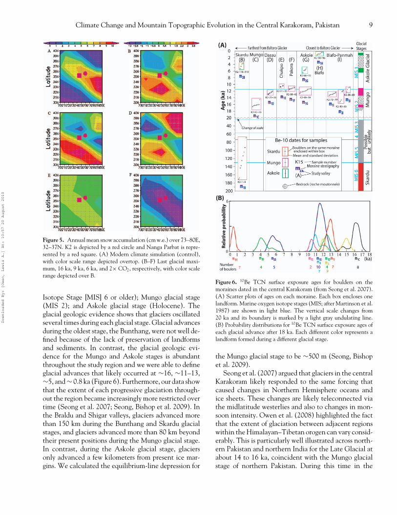
Isotope Stage [MIS] 6 or older); Mungo glacial stage(MIS 2); and Askole glacial stage (Holocene). Theglacial geologic evidence shows that glaciers oscillatedseveral times during each glacial stage. Glacial advancesduring the oldest stage, the Bunthang, were not well de-fined because of the lack of preservation of landformsand sediments. In contrast, the glacial geologic evi-dence for the Mungo and Askole stages is abundantthroughout the study region and we were able to defineglacial advances that likely occurred at ∼16, ∼11–13,∼5, and ∼ 0.8 ka (Figure 6). Furthermore, our data showthat the extent of each progressive glaciation through-out the region became increasingly more restricted overtime (Seong et al. 2007; Seong, Bishop et al. 2009). Inthe Braldu and Shigar valleys, glaciers advanced morethan 150 km during the Bunthang and Skardu glacialstages, and glaciers advanced more than 80 km beyondtheir present positions during the Mungo glacial stage.In contrast, during the Askole glacial stage, glaciersonly advanced a few kilometers from present ice mar-gins. We calculated the equilibrium-line depression for
Figure 6. 10Be TCN surface exposure ages for boulders on themoraines dated in the central Karakoram (from Seong et al. 2007).(A) Scatter plots of ages on each moraine. Each box encloses onelandform. Marine oxygen isotope stages (MIS; after Martinson et al.1987) are shown in light blue. The vertical scale changes from20 ka and its boundary is marked by a light gray undulating line.(B) Probability distributions for 10Be TCN surface exposure ages ofeach glacial advance after 18 ka. Each different color represents alandform formed during a different glacial stage.
the Mungo glacial stage to be ∼500 m (Seong, Bishopet al. 2009).
Seong et al. (2007) argued that glaciers in the centralKarakoram likely responded to the same forcing thatcaused changes in Northern Hemisphere oceans andice sheets. These changes are likely teleconnected viathe midlatitude westerlies and also to changes in mon-soon intensity. Owen et al. (2008) highlighted the factthat the extent of glaciation between adjacent regionswithin the Himalayan–Tibetan orogen can vary consid-erably. This is particularly well illustrated across north-ern Pakistan and northern India for the Late Glacial atabout 14 to 16 ka, coincident with the Mungo glacialstage of northern Pakistan. During this time in the
Downloaded By: [Owen, Lewis A.] At: 10:57 20 August 2010
10 Bishop et al.
central Karakoram an extensive valley glacier systemextended more than 80 km from the present ice margin,whereas in the Hunza valley to the northeast and Muz-tag Ata-Kongur Shan to the north, for example, glaciersonly advanced a few kilometers from their present po-sition (Owen et al. 2002; Seong et al. 2007; Owenet al. 2008; Seong, Owen et al. 2009). In Ladakh, tothe southeast of these regions, there is little evidenceof a glacier advance at this time, and when glaciers didadvance they were restricted to a few kilometers fromtheir present ice margins (Owen et al. 2006; Owenet al. 2008). Furthermore, to the south of Ladakh, inthe Lahul Himalaya, glaciers advanced more than 100km beyond their present positions at this time (Owenet al. 2001; Owen et al. 2008). These contrasts in theextent of glaciation within a relatively small region ofthe Himalaya and trans-Himalaya highlight the impor-tant local climatic gradients and the strong topographiccontrols on climate forcing and glaciation.
Nevertheless, by recalculating all of the TCN ages formoraine boulders and glacially eroded surfaces through-out the Himalayan–Tibetan region, Owen et al. (2008)were able to make broad statements regarding the syn-chroneity of glaciation. In essence, glaciers throughoutmonsoon-influenced Tibet and the Himalaya and thetrans-Himalaya (including the central Karakoram) ap-pear to have responded in a similar fashion to changesin monsoon-driven and Northern Hemisphere coolingcycles alone. In contrast, glaciers in the far westernregions of the Himalayan–Tibetan orogen are asyn-chronous with the other regions and appear to bedominantly controlled by the Northern Hemispherecooling cycles and by the influential interaction be-tween the relative strengths of the westerlies and thesummer monsoon.
Geomorphometry
Such dramatic glacier fluctuations generate extremerelief and U-shaped valleys. Relief, however, might notalways be related linearly to erosion and erosional effi-ciency. For glacier erosion, research has indicated thatglaciation can limit relief up to some altitude approach-ing the equilibrium-line altitude (ELA) and that ero-sion fluctuations at the ELA can generate extreme relief(Brozovic, Burbank, and Meigs 1997; Bishop, Shroder,and Colby 2003). Given the anisotropic nature of relief,as a function of a variety of surface processes and de-formation, it is necessary to quantitatively characterizethe topography and compare high-relief regions, as thetopography inherently represents the interplay among
climate, tectonics, and surface processes (Wobus et al.2006).
We conducted an analysis of the topography overthe western Himalaya of Pakistan using Shuttle RadarTopographic Mission (SRTM30) data, acquired fromthe Spaceborne Imaging Radar-C. The SRTM30 datawere constructed at thirty arc-second spacing, similarto GTOP030 data. GTOP030 data points were usedwhere SRTM data were invalid (i.e., radar shadows).We projected the data set (Universal Transverse Mer-cator) and resampled (bilinear interpolation) it to gen-erate an SRTM30 data set with a grid resolution of 1km. Given the coarse resolution of the data set, altitudeestimates and slope angle magnitudes are generalizedand underestimated. The projected SRTM30 data set,however, adequately characterizes the relief structure ofthe landscape and permits a first-order assessment of thetopography.
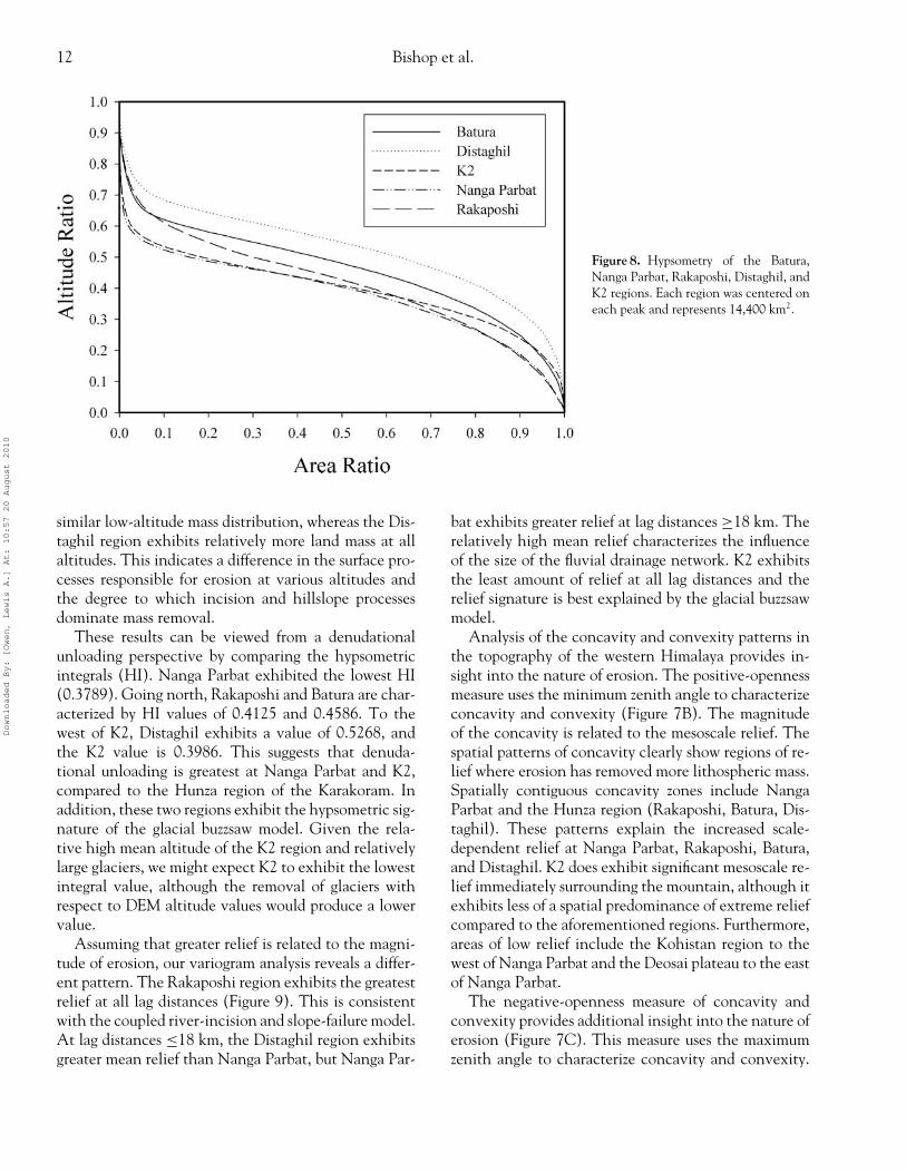
Geomorphometric analysis consisted of analyzingand comparing topographic regions (14,400 km2) thatwere centered on high-altitude peaks including BaturaMustagh, Distaghil, K2, Nanga Parbat, and Rakaposhi(Figure 7A). Hypsometric analyses permitted an exami-nation of the altitude/area relationship and the relativeamount of mass removed from each region. It is impor-tant to note that the relative patterns of hypsometriccurves are generally related to erosion potential, al-though the hypsometric integral does not represent anabsolute magnitude of erosion given systematic andnonsystematic biases in the digital elevation model(DEM).
Scale-dependent analysis of the topography was usedto characterize the relief structure of each region.Specifically, we performed semivariogram analysis andcompared every grid cell to every other grid cell withineach region. Within an nx× ny grid there will be Npoint pairs, where N = n2
x (n2y − 1)/2. The variance
component is �z = (z1 − z2)2, and the horizontal dis-tance is �x = [(x1 − x2)2 + (y1 − y2)2]0.5. The vari-ance was summed over a binned horizontal distanceinterval (1 km).
We also conducted spatial analysis to assessthe degree of landscape concavity and convexity.The approach represents a hemispherical analysis ofthe topography to measure the angular relation betweenthe surface relief and the multidirectional horizon-tal distances. Yokoyama, Shirasawa, and Pike (2002)referred to this measure as openness and provided aquantitative description of positive openness (P) andnegative openness (N). We computed P and N imagesusing a radius distance of 30 km around each grid cell
Downloaded By: [Owen, Lewis A.] At: 10:57 20 August 2010
Climate Change and Mountain Topographic Evolution in the Central Karakoram, Pakistan 11
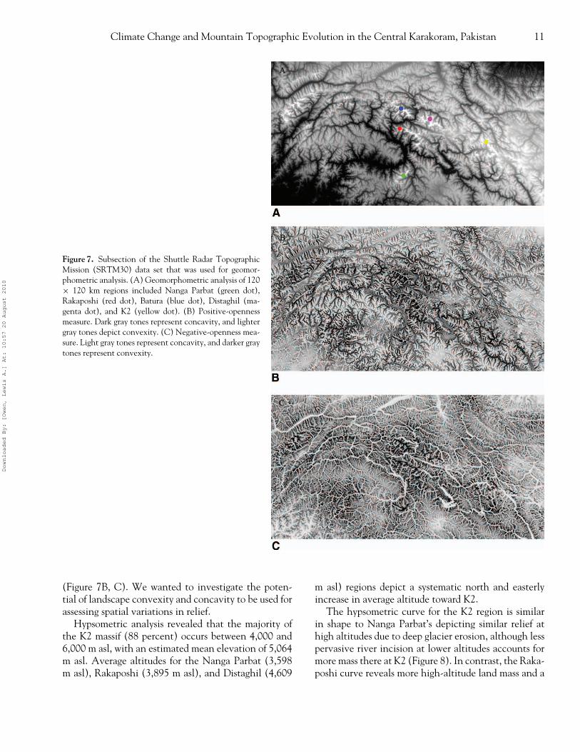
Figure 7. Subsection of the Shuttle Radar TopographicMission (SRTM30) data set that was used for geomor-phometric analysis. (A) Geomorphometric analysis of 120× 120 km regions included Nanga Parbat (green dot),Rakaposhi (red dot), Batura (blue dot), Distaghil (ma-genta dot), and K2 (yellow dot). (B) Positive-opennessmeasure. Dark gray tones represent concavity, and lightergray tones depict convexity. (C) Negative-openness mea-sure. Light gray tones represent concavity, and darker graytones represent convexity.
(Figure 7B, C). We wanted to investigate the poten-tial of landscape convexity and concavity to be used forassessing spatial variations in relief.
Hypsometric analysis revealed that the majority ofthe K2 massif (88 percent) occurs between 4,000 and6,000 m asl, with an estimated mean elevation of 5,064m asl. Average altitudes for the Nanga Parbat (3,598m asl), Rakaposhi (3,895 m asl), and Distaghil (4,609
m asl) regions depict a systematic north and easterlyincrease in average altitude toward K2.
The hypsometric curve for the K2 region is similarin shape to Nanga Parbat’s depicting similar relief athigh altitudes due to deep glacier erosion, although lesspervasive river incision at lower altitudes accounts formore mass there at K2 (Figure 8). In contrast, the Raka-poshi curve reveals more high-altitude land mass and a
Downloaded By: [Owen, Lewis A.] At: 10:57 20 August 2010
12 Bishop et al.
Figure 8. Hypsometry of the Batura,Nanga Parbat, Rakaposhi, Distaghil, andK2 regions. Each region was centered oneach peak and represents 14,400 km2.
similar low-altitude mass distribution, whereas the Dis-taghil region exhibits relatively more land mass at allaltitudes. This indicates a difference in the surface pro-cesses responsible for erosion at various altitudes andthe degree to which incision and hillslope processesdominate mass removal.
These results can be viewed from a denudationalunloading perspective by comparing the hypsometricintegrals (HI). Nanga Parbat exhibited the lowest HI(0.3789). Going north, Rakaposhi and Batura are char-acterized by HI values of 0.4125 and 0.4586. To thewest of K2, Distaghil exhibits a value of 0.5268, andthe K2 value is 0.3986. This suggests that denuda-tional unloading is greatest at Nanga Parbat and K2,compared to the Hunza region of the Karakoram. Inaddition, these two regions exhibit the hypsometric sig-nature of the glacial buzzsaw model. Given the rela-tive high mean altitude of the K2 region and relativelylarge glaciers, we might expect K2 to exhibit the lowestintegral value, although the removal of glaciers withrespect to DEM altitude values would produce a lowervalue.
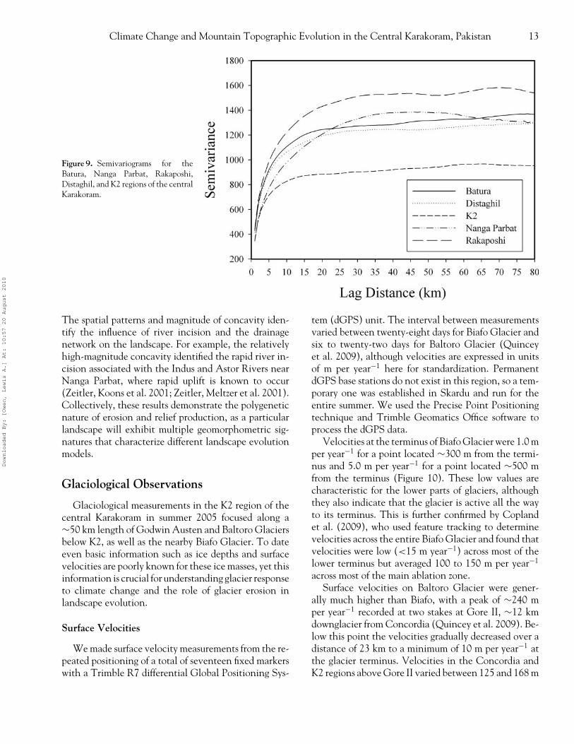
Assuming that greater relief is related to the magni-tude of erosion, our variogram analysis reveals a differ-ent pattern. The Rakaposhi region exhibits the greatestrelief at all lag distances (Figure 9). This is consistentwith the coupled river-incision and slope-failure model.At lag distances ≤18 km, the Distaghil region exhibitsgreater mean relief than Nanga Parbat, but Nanga Par-
bat exhibits greater relief at lag distances ≥18 km. Therelatively high mean relief characterizes the influenceof the size of the fluvial drainage network. K2 exhibitsthe least amount of relief at all lag distances and therelief signature is best explained by the glacial buzzsawmodel.
Analysis of the concavity and convexity patterns inthe topography of the western Himalaya provides in-sight into the nature of erosion. The positive-opennessmeasure uses the minimum zenith angle to characterizeconcavity and convexity (Figure 7B). The magnitudeof the concavity is related to the mesoscale relief. Thespatial patterns of concavity clearly show regions of re-lief where erosion has removed more lithospheric mass.Spatially contiguous concavity zones include NangaParbat and the Hunza region (Rakaposhi, Batura, Dis-taghil). These patterns explain the increased scale-dependent relief at Nanga Parbat, Rakaposhi, Batura,and Distaghil. K2 does exhibit significant mesoscale re-lief immediately surrounding the mountain, although itexhibits less of a spatial predominance of extreme reliefcompared to the aforementioned regions. Furthermore,areas of low relief include the Kohistan region to thewest of Nanga Parbat and the Deosai plateau to the eastof Nanga Parbat.
The negative-openness measure of concavity andconvexity provides additional insight into the nature oferosion (Figure 7C). This measure uses the maximumzenith angle to characterize concavity and convexity.
Downloaded By: [Owen, Lewis A.] At: 10:57 20 August 2010
Climate Change and Mountain Topographic Evolution in the Central Karakoram, Pakistan 13
Figure 9. Semivariograms for theBatura, Nanga Parbat, Rakaposhi,Distaghil, and K2 regions of the centralKarakoram.
The spatial patterns and magnitude of concavity iden-tify the influence of river incision and the drainagenetwork on the landscape. For example, the relativelyhigh-magnitude concavity identified the rapid river in-cision associated with the Indus and Astor Rivers nearNanga Parbat, where rapid uplift is known to occur(Zeitler, Koons et al. 2001; Zeitler, Meltzer et al. 2001).Collectively, these results demonstrate the polygeneticnature of erosion and relief production, as a particularlandscape will exhibit multiple geomorphometric sig-natures that characterize different landscape evolutionmodels.
Glaciological Observations
Glaciological measurements in the K2 region of thecentral Karakoram in summer 2005 focused along a∼50 km length of Godwin Austen and Baltoro Glaciersbelow K2, as well as the nearby Biafo Glacier. To dateeven basic information such as ice depths and surfacevelocities are poorly known for these ice masses, yet thisinformation is crucial for understanding glacier responseto climate change and the role of glacier erosion inlandscape evolution.
Surface Velocities
We made surface velocity measurements from the re-peated positioning of a total of seventeen fixed markerswith a Trimble R7 differential Global Positioning Sys-
tem (dGPS) unit. The interval between measurementsvaried between twenty-eight days for Biafo Glacier andsix to twenty-two days for Baltoro Glacier (Quinceyet al. 2009), although velocities are expressed in unitsof m per year−1 here for standardization. PermanentdGPS base stations do not exist in this region, so a tem-porary one was established in Skardu and run for theentire summer. We used the Precise Point Positioningtechnique and Trimble Geomatics Office software toprocess the dGPS data.
Velocities at the terminus of Biafo Glacier were 1.0 mper year−1 for a point located ∼300 m from the termi-nus and 5.0 m per year−1 for a point located ∼500 mfrom the terminus (Figure 10). These low values arecharacteristic for the lower parts of glaciers, althoughthey also indicate that the glacier is active all the wayto its terminus. This is further confirmed by Coplandet al. (2009), who used feature tracking to determinevelocities across the entire Biafo Glacier and found thatvelocities were low (<15 m year−1) across most of thelower terminus but averaged 100 to 150 m per year−1
across most of the main ablation zone.Surface velocities on Baltoro Glacier were gener-
ally much higher than Biafo, with a peak of ∼240 mper year−1 recorded at two stakes at Gore II, ∼12 kmdownglacier from Concordia (Quincey et al. 2009). Be-low this point the velocities gradually decreased over adistance of 23 km to a minimum of 10 m per year−1 atthe glacier terminus. Velocities in the Concordia andK2 regions above Gore II varied between 125 and 168 m
Downloaded By: [Owen, Lewis A.] At: 10:57 20 August 2010
14 Bishop et al.
Figure 10. Ice depths in meters (green dots) and velocities in metersper year−1 (red arrows) measured across the terminus of Biafo Glacierin summer 2005.
per year−1. Comparisons with velocities derived fromSynthetic Aperature Radar satellite imagery, featuretracking, and other field measurements (Mayer et al.2006; Copland et al. 2009; Quincey et al. 2009) indi-cate generally good agreement for summer patterns butthat the dGPS velocities are much higher than wintervelocities over most of the glacier > 10 km upglacierfrom the terminus. These patterns suggest that motionof the lowermost ∼10 km of the glacier is largely drivenby ice deformation, whereas motion over the remainderof the ablation zone is dominated by basal sliding, withsummer speed-ups of 200 percent or more compared towinter patterns (Quincey et al. 2009).
Surface Melt Rates
To sample a few surface melt rates, we placed abla-tion stakes at bare ice locations across Baltoro Glacierand remeasured them over periods of seven to nineteendays. The rates decreased with altitude, varying between6.52 cm per day−1 at 3,907 m, 5.91 cm per day−1 at4,055 m and 3.03 cm per day−1 at 4,837 m during aperiod with generally sunny weather and few clouds.These patterns agree well with those of Mihalcea et al.(2006), who also found a clear relationship betweenelevation and surface melt rates at Baltoro Glacier. Mi-
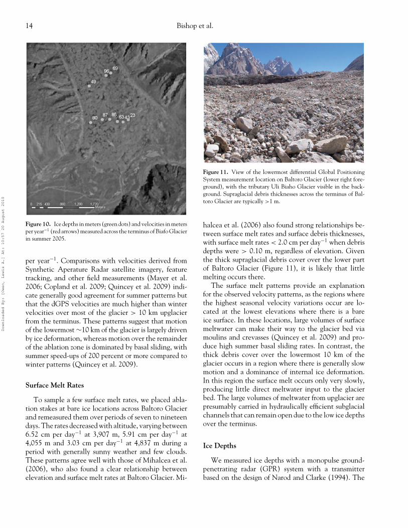
Figure 11. View of the lowermost differential Global PositioningSystem measurement location on Baltoro Glacier (lower right fore-ground), with the tributary Uli Biaho Glacier visible in the back-ground. Supraglacial debris thicknesses across the terminus of Bal-toro Glacier are typically >1 m.
halcea et al. (2006) also found strong relationships be-tween surface melt rates and surface debris thicknesses,with surface melt rates < 2.0 cm per day−1 when debrisdepths were > 0.10 m, regardless of elevation. Giventhe thick supraglacial debris cover over the lower partof Baltoro Glacier (Figure 11), it is likely that littlemelting occurs there.
The surface melt patterns provide an explanationfor the observed velocity patterns, as the regions wherethe highest seasonal velocity variations occur are lo-cated at the lowest elevations where there is a bareice surface. In these locations, large volumes of surfacemeltwater can make their way to the glacier bed viamoulins and crevasses (Quincey et al. 2009) and pro-duce high summer basal sliding rates. In contrast, thethick debris cover over the lowermost 10 km of theglacier occurs in a region where there is generally slowmotion and a dominance of internal ice deformation.In this region the surface melt occurs only very slowly,producing little direct meltwater input to the glacierbed. The large volumes of meltwater from upglacier arepresumably carried in hydraulically efficient subglacialchannels that can remain open due to the low ice depthsover the terminus.
Ice Depths
We measured ice depths with a monopulse ground-penetrating radar (GPR) system with a transmitterbased on the design of Narod and Clarke (1994). The
Downloaded By: [Owen, Lewis A.] At: 10:57 20 August 2010
Climate Change and Mountain Topographic Evolution in the Central Karakoram, Pakistan 15
receiver consisted of an airwave-triggered Tektronixdigital oscilloscope connected to a handheld computer.We typically used a center frequency of 10 MHz, al-though in locations where the ice was particularly deepand the bed could not be seen at 10 MHz, we used 5MHz. Errors in the ice-depth measurements are typicallyquoted as 1/10 of the transmitted wavelength (Bogorod-sky, Bentley, and Gudmandsen 1985), which equates to±1.7 m at 10 MHz and ±3.4 m at 5 MHz. The radio-wave velocity of the GPR signals through the ice wasassumed to be 0.168 m per ns–1, an average value fortemperate ice (Macheret, Moskalevsky, and Vasilenko1993). We used a handheld Garmin eTrex GPS unit tolocate the position of each GPR measurement to within±10 m horizontally.
We measured ice depths at two profiles across BiafoGlacier, at distances of ∼1 km and ∼2 km from theice front at surface elevations of ∼3,200 m asl (Fig-ure 10). The depths varied between 23 m and 85 macross the lower transect and 49 m and 96 m across theupper transect, in a part of the glacier that is heavilydebris covered (average debris thickness ∼1 m). Theonly other previous GPR measurements in this regionwere completed by Hewitt et al. (1989), who measuredcenterline ice depths of ∼500 to 700 m at a transect∼25 km upglacier from the terminus (4,100 m asl) anddepths up to ∼1,400 m at the equilibrium line ∼45km upglacier from the terminus (4,650 m asl). Theseauthors cautioned, however, that the measurements atthe equilibrium line had a high degree of uncertainty.
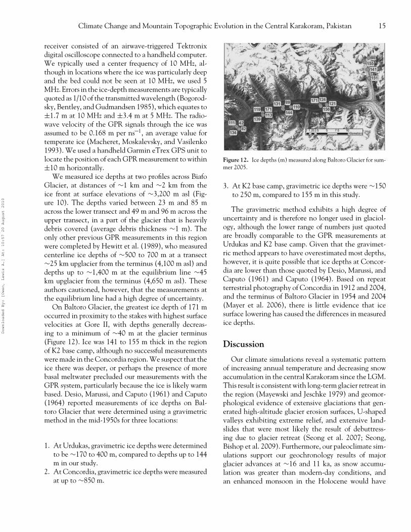
On Baltoro Glacier, the greatest ice depth of 171 moccurred in proximity to the stakes with highest surfacevelocities at Gore II, with depths generally decreas-ing to a minimum of ∼40 m at the glacier terminus(Figure 12). Ice was 141 to 155 m thick in the regionof K2 base camp, although no successful measurementswere made in the Concordia region. We suspect that theice there was deeper, or perhaps the presence of morebasal meltwater precluded our measurements with theGPR system, particularly because the ice is likely warmbased. Desio, Marussi, and Caputo (1961) and Caputo(1964) reported measurements of ice depths on Bal-toro Glacier that were determined using a gravimetricmethod in the mid-1950s for three locations:
1. At Urdukas, gravimetric ice depths were determinedto be ∼170 to 400 m, compared to depths up to 144m in our study.
2. At Concordia, gravimetric ice depths were measuredat up to ∼850 m.
Figure 12. Ice depths (m) measured along Baltoro Glacier for sum-mer 2005.
3. At K2 base camp, gravimetric ice depths were ∼150to 250 m, compared to 155 m in this study.
The gravimetric method exhibits a high degree ofuncertainty and is therefore no longer used in glaciol-ogy, although the lower range of numbers just quotedare broadly comparable to the GPR measurements atUrdukas and K2 base camp. Given that the gravimet-ric method appears to have overestimated most depths,however, it is quite possible that ice depths at Concor-dia are lower than those quoted by Desio, Marussi, andCaputo (1961) and Caputo (1964). Based on repeatterrestrial photography of Concordia in 1912 and 2004,and the terminus of Baltoro Glacier in 1954 and 2004(Mayer et al. 2006), there is little evidence that icesurface lowering has caused the differences in measuredice depths.
Discussion
Our climate simulations reveal a systematic patternof increasing annual temperature and decreasing snowaccumulation in the central Karakoram since the LGM.This result is consistent with long-term glacier retreat inthe region (Mayewski and Jeschke 1979) and geomor-phological evidence of extensive glaciations that gen-erated high-altitude glacier erosion surfaces, U-shapedvalleys exhibiting extreme relief, and extensive land-slides that were most likely the result of debuttress-ing due to glacier retreat (Seong et al. 2007; Seong,Bishop et al. 2009). Furthermore, our paleoclimate sim-ulations support our geochronology results of majorglacier advances at ∼16 and 11 ka, as snow accumu-lation was greater than modern-day conditions, andan enhanced monsoon in the Holocene would have
Downloaded By: [Owen, Lewis A.] At: 10:57 20 August 2010
16 Bishop et al.
contributed much more summer snowfall compared tocontemporary conditions.
Extensive glaciations during the Quaternary resultedin much greater ice depths than were measured in 2005,and our glacial reconstructions indicate that the ice was∼1 km thick in the Baltoro Valley near Biafo Glacierand much more extensive (Seong et al. 2007). There-fore, based on our current understanding of glacier ero-sion (ice depth and basal sliding velocity are the primarycontrols on abrasion), the magnitude of glacier erosionwas much higher than contemporary erosion rates givenmore spatial coverage, thicker ice, and positive ice dis-charge. Furthermore, given the long-term retreat pat-tern caused by increasing temperatures and decreasingsnow accumulation, glacier erosion during the retreatphases might have been greater than during advances, asincreasing temperatures would produce more meltwaterthat governs basal water pressure, sliding velocity, andglacio-fluvial erosion. Koppes and Hallet (2006) indi-cated that there is a strong correlation between glacialretreat rates and glacial sediment yields.
Our geomorphometry results clearly indicate that re-lief is not linearly correlated with the HI in Pakistan. Al-though the K2 region of the central Karakoram exhibitsthe highest altitudes and high exhumation rates, it ex-hibits the lowest relief, yet the region has experiencedsignificant erosion and exhumation (Foster, Gleadow,and Mortimer 1994; Seong et al. 2007, 2008). Thisapparent contradiction can be explained by nonlinearrelationships between erosion and relief production.
Scale-dependent analysis revealed that in the ab-sence of local high-discharge rivers and a spatially densedrainage network, variation in relief is dramatically re-duced. As the K2 region of the central Karakoram hasbeen dominated by glaciation and glacierization, glaciererosion can limit the relief at intermediate altitudes(Brozovic, Burbank, and Meigs 1997; Bishop, Shroder,and Colby 2003), thereby decreasing the variability inscale-dependent relief. Relatively low slope angles at in-termediate altitudes document the erosion and redistri-bution of material by glaciers from 4,000 to 6,000 m asl.These low slope angles represent actual glacier surfacesor high-altitude erosion surfaces from past glaciations.These are classic signatures of a glacial buzzsaw. It isclear that the K2, Nanga Parbat, and Hunza regionshave been significantly affected by glaciation, althoughthe subsequent influence of local river incision and massmovement can increase local relief.
The highest scale-dependent relief occurs in theHunza and Nanga Parbat regions and mesoscale reliefpatterns indicate that these regions are active erosion
zones currently dominated by large-scale river incisionand mass movement. The Hunza region exhibits morescale-dependent relief than Nanga Parbat because of anextensive fluvial drainage network. Our climate simu-lations suggest that the Hunza erosion zone, as depictedby mesoscale concave relief patterns, is the result of cli-mate forcing. The region exhibits a negative snow ac-cumulation anomaly in paleoclimate simulations thatrepresent increased rainfall due to an intensification ofthe monsoon, where increased precipitation and associ-ated river incision and mass movement explain the highscale-dependent relief. Furthermore, spatial patterns ofprecipitation have been found to be strongly controlledby topography in the Himalaya, and considerable vari-ability exists at scales of ∼10 km (Anders et al. 2006;Barros et al. 2006).
The K2 region of the central Karakoram is domi-nated by large glaciers and has less drainage networkto produce additional local relief. This indicates thatlarge-discharge rivers might not be required to focuserosion and produce uplift zones. At intermediate tohigher altitudes, deep valley-glacier erosion and head-wall erosion can effectively remove rock and sediment,whereas protective cold-based ice and permafrost onthe highest peaks permits ridge and peak formation.Glacier mass-balance gradients determine the availabil-ity of meltwater for river incision and hillslope adjust-ment down-valley at lower altitudes. Consequently, inhigh mountain environments, glaciation both directlyand indirectly alters the relief structure of the land-scape differently with altitude. These differences can beattributed to the degree of temporal overprinting andspatial overlap of glacial events, such that at interme-diate altitudes, the degree of spatial overlap is less thanat high altitudes.
Therefore, with respect to glacier erosion and reliefproduction, we should not expect relief to be related lin-early to the magnitude of glacier erosion, as relief mightnot scale with erosional efficiency. Whipple (2009) in-dicated that erosional efficiency should be associatedwith a decrease in relief. Numerous parameters such asrock strength, topographic-induced stress fields, basalwater pressures, basal sliding velocity, ablation rates re-lated to climate and supraglacial debris loads, and othererosion processes determine the magnitude of glaciererosion, and isostatic and tectonic uplift operate at com-pletely different spatio-temporal scales. Furthermore,glacier-erosion efficiency is most likely highly spatiallyvariable in the Himalaya, as characterized by researchon regional precipitation variability (e.g., Anders et al.2006), our geomorphometric analysis, and mesoscale
Downloaded By: [Owen, Lewis A.] At: 10:57 20 August 2010
Climate Change and Mountain Topographic Evolution in the Central Karakoram, Pakistan 17
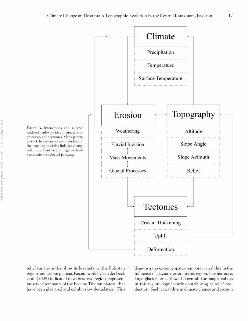
Figure 13. Interactions and selectedfeedback pathways for climate, erosionprocesses, and tectonics. Many param-eters of the system are not included andthe magnitudes of the linkages changewith time. Positive and negative feed-backs exist for selected pathways.
relief variations that show little relief over the Kohistanregion and Deosai plateau. Recent work by van der Beeket al. (2009) indicated that these two regions representpreserved remnants of the Eocene Tibetan plateau thathave been glaciated and exhibit slow denudation. This
demonstrates extreme spatio-temporal variability in theinfluence of glacier erosion in this region. Furthermore,large glaciers once flowed down all the major valleysin this region, significantly contributing to relief pro-duction. Such variability in climate change and erosion
Downloaded By: [Owen, Lewis A.] At: 10:57 20 August 2010
18 Bishop et al.
patterns indicates that the landscape is unlikely to reachequilibrium in terms of mass or topographic steady state.
Modern-day glaciological conditions indicate thatthe glaciers are highly active and responding to cli-mate forcing. The region is currently experiencing anincrease in precipitation according to European reanal-ysis and Tropical Rainfall Measuring Mission data, andthis appears to be associated with an increase in glaciersurging and an expansion of nonsurging glaciers, asobserved in satellite imagery. Furthermore, abundantmeltwater and high glacier ice velocities indicate thatglacier erosion potential might be increasing (Quinceyet al. 2009).
Our more recent regional climate modeling simula-tions suggest that future increases in precipitation mightbe related to the strength of the westerly winds thatare correlated with ENSO conditions. If this can beverified, these results would be in direct opposition tothe hypothesis of an enhanced monsoon due to globalwarming (Anderson, Overpeck, and Gupta 2002). It isyet unclear whether an intensification of ENSO precip-itation events or increases in atmospheric temperaturewill facilitate further glacier expansion or result in neg-ative mass balance that will regulate the magnitude ofglacier erosion. Our global climate simulation resultssuggest a future regional negative mass-balance trend.
Clearly, climate forcing has had a significant influ-ence on landscape evolution in the western Himalayaof Pakistan. Large glaciers and glacier fluctuations haveremoved significant mass, thereby causing isostatic andtectonic uplift. The climate-versus-tectonic forcing hy-potheses are difficult to relate directly, as numerousfeedback mechanisms are involved, and direct linkagesamong climate, erosion, and tectonics must be estab-lished to demonstrate a tectonic response to climatechange. Another important issue is whether active oro-genic zones are carbon sinks or sources. Silicate weath-ering and the drawdown of atmospheric CO2 couldcause global cooling; however, climate simulations andradiative forcing explain glacier fluctuations in the Qua-ternary. Furthermore, chemical analyses of hot springsin the Himalaya suggest that active orogenic zones aresources of CO2 caused by metamorphic reactions (Gail-lardet and Galy 2008).
Climate forcing would intensify the geomorphic in-fluence on crustal scale processes such that enhancederosion causes the upward flow of hot, low-viscositycrustal rock into areas or localized uplift zones (Koonset al. 2002; Whipple 2009). Rapid erosion gener-ates topographic stresses that reduce rock strengthand intensify erosion in a positive feedback, thereby
generating a strong crustal temperature and pressuregradient. Decompression melting and metamorphismis associated with rock flow along the gradient. Sucherosional–rheological coupling can explain the pres-ence of active metamorphic massifs (Koons et al. 2002).Metamorphic degassing of CO2 would increase at-mospheric concentrations. If this is the case, climateforcing and mountain building would inject CO2 andwarm Earth, resulting in limited glacier expansion anddeglaciation. The hypothesis of orogenic CO2 sourcecontradicts the tectonic-forcing hypothesis and is de-pendent on the thermal history of the orogenic zone(Gaillardet and Galy 2008). Consequently, the climate-forcing hypothesis is predicated on whether mountainranges are a net source or sink of atmospheric CO2,and we must account for different processes and timescales such as the consumption of CO2 by rock weath-ering (silicate and carbonate), the balance of organicmatter burial and oxidation, and the fluxes of CO2 de-gassing. It is also imperative that we better characterizethe topography with respect to erosional efficiency andtectonic response so that the patterns of erosion andtectonics can be more directly related to climate forc-ing parameters.
Conclusions
Mountain geodynamics represent highly scale-dependent interactions involving climate, tectonic, andsurface processes (Figure 13). The western Himalaya inPakistan potentially exhibits strong climate–tectonicfeedbacks, although the tectonic and topographic re-sponses to climate perturbations have not been sys-tematically explored. Nevertheless, the region exhibitsunique patterns of topographic complexity, erosion, andexhumation.
Our GCM and regional-climate simulations suggestthat the region has experienced extreme climate changedue to radiative forcing and regional system response(i.e., westerlies, southwestern monsoon) to ENSO con-ditions. Paleoclimate simulations support geomorpho-logical evidence of multiple glaciations and overallglacier retreat since the Holocene. High-magnitudeglacier erosion has resulted in extreme relief, U-shapedvalleys, high-altitude erosion surfaces, and extensivemass movements.
Our analysis of the topography indicates that reliefis not related linearly to mass removal and erosional ef-ficiency, as different surface processes and process cou-plings generate different topographic conditions that
Downloaded By: [Owen, Lewis A.] At: 10:57 20 August 2010
Climate Change and Mountain Topographic Evolution in the Central Karakoram, Pakistan 19
vary with altitude and geologic structure. Consequently,in some locations the topography contains overprint-ing patterns regarding the polygenetic evolution of thelandscape. This is not the case where high erosion anduplift rates generate threshold topography that mightnot sustain relief. Furthermore, mesocale relief patternsclearly depict erosion zones that are spatially coincidentwith precipitation anomalies, high peaks, and rapid ex-humation. Mesoscale relief patterns demonstrate ex-treme spatial and temporal variability in the influenceof glacier erosion in the topographic evolution of theregion. Collectively, our results demonstrate a stronglinkage between climate change and the topographicevolution of the central Karakoram in Pakistan. Never-theless, Figure 13 clearly depicts that although climateand erosion play a significant role, the system is com-plex, with multiple feedback pathways and mechanismsoperating at a multitude of spatio-temporal scales, suchthat the dominance of any particular component, pro-cess, or parameter of the system is likely to be highlyvariable and difficult to know with certainty. It is es-sential that we better characterize the topography withrespect to erosional efficiency and tectonic response, sothat the patterns of erosion and tectonics can be moredirectly related to climate forcing parameters.
Acknowledgments
We would especially like to acknowledge the long-term and highly fruitful relationship with the late SyedHamidullah, former Director of the Centre of Excel-lence at Peshawar University, who worked so much tohelp facilitate this project. We would also like to thankhis students, Faisal Khan and Mohammad Shahid, fortheir excellent assistance in the field. This research wassupported by funding from the National Geographic So-ciety and the U.S. National Science Foundation (GrantBCS-0242339) to the University of Nebraska–Omahaand the University of Cincinnati.
References
Anders, A. M., G. H. Roe, B. Hallet, D. R. Montgomery, N.J. Finnegan, and J. Putkonen. 2006. Spatial patterns ofprecipitation and topography in the Himalaya. In Tec-tonics, climate, and landscape evolution, ed. S. D. Willett,N. Hovius, M. T. Brandon, and D. M. Fisher, 39–53.Boulder, CO: Geological Society of America.
Anderson, D. M., J. T. Overpeck, and A. K. Gupta. 2002.Increase in the Asian southwest monsoon during the pastfour centuries. Science 297:596–99.
Barros, A. P., S. Chiao, T. J. Lang, D. Burbank, and J. Putko-nen. 2006. From weather to climate: Seasonal and inter-annual variability of storms and implications for erosionprocesses in the Himalaya. In Tectonics, climate, and land-scape evolution, ed. S. D. Willett, N. Hovius, M. T. Bran-don, and D. M. Fisher, 17–38. Boulder, CO: GeologicalSociety of America.
Beaumont, C., and G. Quinlan. 1994. A geodynamic frame-work for interpreting crustal-scale seismic-reflectivitypatterns in compressional orogens. Geophysics Journal In-ternational 116:754–83.
Bender, F. K., and H. A. Raza. 1995. Geology of Pakistan.Berlin, Germany: Borntraeger.
Berger, A. 1992. Orbital variations and insolation database.IGBP PAGES/World Data Center-A for Paleoclimatol-ogy Data Contribution Series # 92–007, NOAA/NGDCPaleoclimatology Program, Boulder, CO.
Bishop, M. P., and J. F. Shroder, Jr. 2000. Remote sensing andgeomorphometric assessment of topographic complexityand erosion dynamics in the Nanga Parbat massif. InTectonics of the Nanga Parbat syntaxis and the western Hi-malaya, ed. M. Khan, P. J. Treloar, M. P. Searle, and M.Q. Jan, 181–200. London: Geological Society London.
———. 2004. Geographic information science and mountaingeomorphology. Chichester, UK: Praxis-Springer.
Bishop, M. P., J. F. Shroder, Jr., R. Bonk, and J. Olsenholler.2002. Geomorphic change in high mountains: A west-ern Himalayan perspective. Global and Planetary Change32:311–29.
Bishop, M. P., J. F. Shroder, Jr., and J. D. Colby. 2003. Remotesensing and geomorphometry for studying relief produc-tion in high mountains. Geomorphology 55:345–61.
Bogorodsky, V. V., C. R. Bentley, and P. E. Gudmand-sen. 1985. Radioglaciology. Dordrecht, The Netherlands:Reidel.
Brozovic, N., D. W. Burbank, and A. J. Meigs. 1997. Climaticlimits on landscape development in the northwesternHimalaya. Science 276:571–74.
Burbank, D. W., J. Leland, E. Fielding, R. S. Anderson, N.Brozovic, M. R. Reid, and C. Duncan. 1996. Bedrock in-cision, rock uplift and threshold hillslopes in the north-western Himalayas. Nature 379:505–10.
Bush, A. B. G. 2001. Pacific sea surface temperature forcingdominates orbital forcing of the early Holocene mon-soon. Quaternary Research 55:25–32.
———. 2007. Extratropical influences on the El Nino South-ern Oscillation through the late Quaternary. Journal ofClimate 20:788–800.
Bush, A. B. G., and S. G. H. Philander. 1999. The climateof the Last Glacial Maximum: Results from a coupledatmosphere–ocean general circulation model. Journal ofGeophysical Research 104:509–25.
Caputo, M. 1964. Glaciology. In Geophysics of the Karakorum,ed. A. Marussi. Leiden, The Netherlands: E. J. Brill.
Cenderelli, D. A., and E. E. Wohl. 2003. Flow hydraulics andgeomorphic effects of glacial-lake outburst floods in theMount Everest region, Nepal. Earth Surface Processes andLandforms 28:385–407.
Christensen, J. H., J. Raisanen, T. Iversen, D. Bjorge, O. B.Christensen, and M. Rummukainen. 2001. A synthesisof regional climate change simulations: A Scandinavianperspective. Geophysical Research Letters 28:1003–6.
Downloaded By: [Owen, Lewis A.] At: 10:57 20 August 2010
20 Bishop et al.
Clift, P. D., L. Giosan, J. Blusztajn, I. H. Campbell, C. Allen,M. Pringle, A. R. Tabrez, et al. 2008. Holocene erosionof the Lesser Himalaya triggered by intensified summermonsoon. Geology 36:79–82.
Clift, P. D., K. V. Hodges, D. Heslop, R. Hannigan, H. V.Long, and G. Calves. 2008. Correlation of Himalayanexhumation rates and Asian monsoon intensity. NatureGeoscience 1:875–80.
Copland, L., S. Pope, M. P. Bishop, J. F. Shroder, Jr., P.Clendon, A. B. G. Bush, U. Kamp, Y. B. Seong, andL. A. Owen. 2009. Glacier velocities across the centralKarakoram. Annals of Glaciology 50:41–49.
Derbyshire, E. 1981. Glacier regime and glacial sediment fa-cies: A hypothetical framework for the Qinghai-XizangPlateau. In Proceedings of the Symposium on Qinghai-Xizang (Tibet) Plateau, vol. 2, 1649–56. Beijing: SciencePress.
Desio, A., A. Marussi, and M. Caputo. 1961. Glaciological re-search of the Italian Karakorum Expedition 1953–1955.IASH Publication 52:224–32.
Easterling, D. R. 1999. Development of regional climate sce-narios using a downscaling approach. Climatic Change41:615–34.
Egholm, D. L., S. B. Nielsen, V. K. Pedersen, and J. E. Lese-mann. 2009. Glacial effects limiting mountain height.Nature 460:884–88.
Finlayson, D. R., D. R. Montgomery, and B. Hallet. 2002.Spatial coincidence of rapid inferred erosion with youngmetamorphic massifs in the Himalayas. Geology 30:219–22.
Finnegan, N. J., B. Hallet, D. R. Montgomery, P. K. Zeitler, J.O. Stone, A. M. Anders, and L. Yuping. 2008. Couplingof rock uplift and river incision in the Namche Barwa–Gyala Peri massif, Tibet. Geological Society of AmericaBulletin 120:142–55.
Foster, D. A., A. J. W. Gleadow, and G. Mortimer. 1994.Rapid Pliocene exhumation in the Karakoram (Pak-istan), revealed by fission-track thermochronology of theK2 gneiss. Geology 22:19–22.
Gaillardet, J., and A. Galy. 2008. Himalaya: Carbon sink orsource? Science 320:1727–28.
Gerrad, A. J. 1990. Mountain environments. Cambridge, MA:MIT Press.
Gilchrist, A. R., M. A. Summerfield, and H. A. P. Cock-burn. 1994. Landscape dissection, isostatic uplift, and themorphologic development of orogens. Geology 22:963–66.
Hagg, W., C. Mayer, A. Lambrecht, and A. Helm. 2008. Sub-debris melt rates on Southern Inylchek Glacier, CentralTian Shan. Geografiska Annaler Series A: Physical Geog-raphy 90:55–63.
Hallet, B., L. Hunter, and J. Bogen. 1996. Rates of erosionand sediment evacuation by glaciers: A review of fielddata and their implications. Global and Planetary Change12:213–35.
Hancock, G. S., R. S. Anderson, and K. X. Whipple. 1998.Beyond power: Bedrock river incision process and form.In Rivers over rock: Fluvial processes in bedrock channels,ed. K. J. Tinkler and E. E. Wohl, 35–60. Washington,DC: American Geophysical Union.
Harbor, J., and J. Warburton. 1992. Glaciation and denuda-tion rates. Nature 356:751.
Hewitt, K. 1969. Glacier surges in the Karakoram Hi-malaya (Central Asia). Canadian Journal of Earth Sciences6:1009–18.
———. 1988. Catastrophic landslide deposits in the Karako-ram Himalaya. Science 242:64–77.
———. 1989. The altitudinal organisation of Karakoramgeomorphic processes and depositional environments.Zeitschrift fur Geomorphologie 76:9–32.
———. 1993. Altitudinal organization of Karakoram geo-morphic processes and depositional environments. InHimalaya to the sea, ed. J. F. Shroder, Jr., 159–83. Londonand New York: Routledge.
———. 1998a. Catastrophic landslides and their effects onthe Upper Indus streams, Karakoram Himalaya, northernPakistan. Geomorphology 26:47–80.
———. 1998b. Glaciers receive a surge of attention in theKarakoram Himalaya. Eos 79:104–5.
———. 1999. Quaternary moraines vs. catastrophicavalanches in the Karakoram Himalaya, northern Pak-istan. Quaternary Research 51:220–37.
———. 2005. The Karakoram anomaly? Glacier expansionand the “elevation effect,” Karakoram Himalaya. Moun-tain Research and Development 25:332–40.
———. 2007. Tributary glacier surges: An exceptional con-centration at Panmah Glacier, Karakoram Himalaya.Journal of Glaciology 53:181–88.
Hewitt, K., C. P. Wake, G. J. Young, and C. David.1989. Hydrological investigations at Biafo Glacier,Karakorum Range, Himalaya: An important source ofwater for the Indus River. Annals of Glaciology 13:103–8.
Howard, A. D. 1980. Thresholds in river regimes. In Thresh-olds in geomorphology, ed. D. R. Coates and J. D. Vitek,227–58. London: Allen and Unwin.
Koons, P. O., P. K. Zeitler, C. P. Chamberlain, D. Craw, andA. S. Meltzer. 2002. Mechanical links between erosionand metamorphism in Nanga Parbat, Pakistan Himalaya.American Journal of Science 302:749–73.
Koppes, M., and B. Hallet. 2006. Erosion rates during rapiddeglaciation in Icy Bay, Alaska. Journal of GeophysicalResearch 111:F02023.
Korup, O., and D. R. Montgomery. 2008. Tibetan plateauriver incision inhibited by glacial stabilization of theTsangpo gorge. Nature 455:786–90.
Macheret, Y. Y., M. Y. Moskalevsky, and E. V. Vasilenko.1993. Velocity of radio waves in glaciers as an indicatorof their hydrothermal state, structure and regime. Journalof Glaciology 39:373–84.
Maheo, G., A. Pecher, S. Guillot, Y. Rolland, and C.Delacourt. 2004. Exhumation of Neogene gneiss domesbetween oblique crustal boundaries in south Karako-rum (northwest Himalaya, Pakistan). In Gneiss domesin orogeny, ed. D. L. Whitney, C. Teyssier, and C. S.Siddoway, 141–54. Boulder, CO: Geological Society ofAmerica.
Mayer, C., A. Lambrecht, M. Belo, C. Smiraglia, and G. Dio-laiuti. 2006. Glaciological characteristics of the ablationzone of Baltoro Glacier, Karakoram, Pakistan. Annals ofGlaciology 43:123–31.
Mayewski, P. A., and P. A. Jeschke. 1979. Himalayan andTrans-Himalayan glacier fluctuations since AD 1812.Arctic and Alpine Research 11:267–87.
Downloaded By: [Owen, Lewis A.] At: 10:57 20 August 2010
Climate Change and Mountain Topographic Evolution in the Central Karakoram, Pakistan 21
Mihalcea, C., C. Mayer, G. Diolaiuti, A. Lambrecht, C. Smi-raglia, and G. Tartari. 2006. Ice ablation and meteo-rological conditions on the debris-covered area of Bal-toro Glacier, Karakoram, Pakistan. Annals of Glaciology43:292–300.
Minster, J. B., and T. H. Jordan. 1978. The present-dayplate motions. Journal of Geophysical Research 83:5331–54.
Molnar, P. 1988. A review of the geophysical constraintson the deep structure of the Tibetan Plateau, the Hi-malaya and the Karakoram, and their tectonic impli-cations. Philosophical Transactions of the Royal Society ofLondon, Series A 326:33–88.
Molnar, P., and P. England. 1990. Late Cenozoic uplift ofmountain ranges and global climatic change: Chickenor egg? Nature 46:29–34.
Montgomery, D. R. 1994. Valley incision and uplift of moun-tain peaks. Journal of Geophysical Research 99:913–21.
Montgomery, D. R., and M. T. Brandon. 2002. Topographiccontrols on erosion rates in tectonically active mountainranges. Earth and Planetary Science Letters 201:481–89.
Narod, B. B., and G. K. C. Clarke. 1994. Miniature high-power impulse transmitter for radio-echo sounding. Jour-nal of Glaciology 40:190–94.
Navarra, A., W. F. Stern, and K. Miyakoda. 1994. Reductionof the Gibbs oscillation in spectral model simulations.Journal of Climatology 7:1169–83.
Owen, L. A. 1988. Wet-sediment deformation of Quaternaryand recent sediments in the Skardu Basin, KarakoramMountains, Pakistan. In Glaciotectonics: Forms and Pro-cesses, ed. D. Croot, 123–48. Rotterdam, The Nether-lands: Balkema.
Owen, L. A., M. W. Caffee, K. Bovard, R. C. Finkel, and M.Sharma. 2006. Terrestrial cosmogenic surface exposuredating of the oldest glacial successions in the Himalayanorogen. Geological Society of America Bulletin 118:383–92.
Owen, L. A., M. W. Caffee, R. C. Finkel, and Y. B. Seong.2008. Quaternary glaciations of the Himalayan-Tibetanorogen. Journal of Quaternary Science 23:513–32.
Owen, L. A., R. C. Finkel, P. L. Barnard, M. Haizhhou, K.Asahi, M. W. Caffee, and E. Derbyshire. 2005. Climaticand topographic controls on the style and timing of LateQuaternary glaciations throughout Tibet and the Hi-malaya defined by 10Be cosmogenic radionuclide surfaceexposure dating. Quaternary Science Reviews 24:1391–1411.
Owen, L. A., R. C. Finkel, M. W. Caffee, and L. Gualtieri.2002. Timing of multiple glaciations during the LateQuaternary in the Hunza Valley, Karakoram Mountains,Northern Pakistan: Defined by cosmogenic radionuclidedating of moraines. Geological Society of America Bulletin114:593–604.
Owen, L. A., L. Gualtieri, R. C. Finkel, M. W. Caffee, D. I.Benn, and M. C. Sharma. 2001. Cosmogenic radionu-clide dating of glacial landforms in the Lahul Himalaya,Northern India: Defining the timing of Late Quaternaryglaciation. Journal of Quaternary Science 16:555–63.
Pant, G. B., and K. R. Kumar. 1997. Climates of South Asia.Chichester, UK: Wiley.
Pelletier, J. D. 2008. Glacial erosion and mountain building.Geology 36:591–92.
Peltier, W. R. 1994. Ice age paleotopography. Science265:195–201.
Pratt-Sitaula, B., B. N. Upreti, T. Melbourne, A. Miner, E.Parker, S. M. Rai, and T. N. Bhattarai. 2009. Applyinggeodesy and modeling to test the role of climate con-trolled erosion in shaping Himalayan morphology andevolution. Himalayan Geology 30:123–31.
Quincey, D. J., L. Copland, C. Mayer, M. P. Bishop, A.Luckman, and M. Belo. 2009. Ice velocity and climatevariations for the Baltoro Glacier, Pakistan. Journal ofGlaciology 55:1061–71.
Rahaman, W., S. K. Singh, R. Sinha, and S. K. Tandon.2009. Climate control on erosion distribution over theHimalaya during the past ∼100 ka. Geology 37:559–62.
Raisanen, J., M. Rummukainen, and A. Ullerstig. 2001.Downscaling of greenhouse gas induced climate changein two GCMs with the Rossby Centre regional climatemodel for northern Europe. Tellus Series A 53:168–91.
Raymo, M. E., and W. F. Ruddiman. 1992. Tectonic forcingof late Cenozoic climate. Nature 359:117–22.
Raymo, M. E., W. F. Ruddiman, and P. N. Froelich. 1988.Influence of late Cenozoic mountain building on oceangeochemical cycles. Geology 16:649–53.
Schmidt, K. M., and D. R. Montgomery. 1995. Limits torelief. Science 270:617–20.
Schoof, J. T., and S. C. Pryor. 2001. Downscaling tempera-ture and precipitation: A comparison of regression-basedmethods and artificial neural networks. International Jour-nal of Climatology 21:773–90.
Searle, M. P. 1991. Geology and tectonics of the KarakoramMountains. Chichester, UK: Wiley.
Searle, M. P., R. R. Parrish, R. Tirrul, and D. C. Rex. 1990.Age of crystallization and cooling of the K2 gneiss inthe Baltoro Karakoram. Journal of the Geological Societyof London 147:603–6.
Seong, Y. B., M. P. Bishop, A. B. G. Bush, P. Clendon, L.Copland, R. C. Finkel, U. Kamp, L. A. Owen, and J.F. Shroder, Jr. 2009. Landforms and landscape evolu-tion in the Skardu, Shigar and Braldu Valleys, CentralKarakoram. Geomorphology 103:251–67.
Seong, Y. B., L. A. Owen, M. P. Bishop, A. B. G. Bush, P.Clendon, L. Copland, R. C. Finkel, U. Kamp, and J. F.Shroder, Jr. 2007. Quaternary glacial history of the Cen-tral Karakoram. Quaternary Science Reviews 26:3384–405.
———. 2008. Rates of fluvial bedrock incision within an ac-tively uplifting orogen: Central Karakoram Mountains,northern Pakistan. Geomorphology 97:274–86.
Seong, Y. B., L. A. Owen, C. Yi, R. C. Finkel, and L.Schoenbohm. 2009. Geomorphology of anomalouslyhigh glaciated mountains at the northwestern end ofTibet: Muztag Ata and Kongur Shan. Geomorphology103:227–50.
Shi, Y. 2002. Characteristics of late Quaternary monsoonalglaciation on the Tibetan Plateau and in East Asia. Qua-ternary International 97–98:79–91.
Shroder, J. F., Jr. 1998. Slope failure and denuda-tion in the western Himalaya. Geomorphology 26:81–105.
Shroder, J. F., Jr., and M. P. Bishop. 2000. Unroofing of theNanga Parbat Himalaya. In Tectonics of the Nanga Parbatsyntaxis and the western Himalaya, ed. M. Khan, P. J.
Downloaded By: [Owen, Lewis A.] At: 10:57 20 August 2010
22 Bishop et al.
Treloar, M. P. Searle, and M. Q. Jan, 163–79. London:Geological Society of London.
Sklar, L. S., and W. E. Dietrich. 1998. River longitudinalprofiles and bedrock incision models: Stream power andthe influence of sediment supply. In Rivers over rock:Fluvial processes in bedrock channels, ed. K. J. Tinklerand E. E. Wohl, 237–60. Washington, DC: AmericanGeophysical Union.
———. 2001. Sediment and rock strength controls on riverincision into bedrock. Geology 29:1087–90.
Spotila, J. A., J. T. Buscher, A. J. Meigs, and P. W. Reiners.2004. Long-term glacial erosion of active mountain belts:Example of the Chugach-St. Elias Range, Alaska. Geol-ogy 32:501–04.
Tomkin, J. H., and J. Braun. 2002. The influence of alpineglaciations on the relief of tectonically active mountainbelts. American Journal of Science 302:169–90.
Turcotte, D. L., and G. Schubert. 2002. Geodynamics.Cambridge, UK: Cambridge University Press.
van der Beek, P., J. Van Melle, S. Guillot, A. Pecher, P.W. Reiners, S. Nicolescu, and M. Latif. 2009. EoceneTibetan plateau remnants preserved in the northwestHimalaya. Nature Geoscience 2:364–68.
von Storch, H., and A. Navarra. 1999. Analysis of climatevariability. New York: Springer.
Wake, C. P. 1989. Glaciochemical investigations as a tool fordetermining the spatial and seasonal variation of snowaccumulation in the central Karakoram, northern Pak-istan. Annals of Glaciology 13:279–84.
Whipple, K. X. 2009. The influence of climate on the tectonicevolution of mountain belts. Nature Geoscience 2:97–104.
Whipple, K. X., E. Kirby, and S. H. Brocklehurst. 1999. Ge-omorphic limits to climate-induced increases in topo-graphic relief. Nature 401:39–43.
Whipple, K. X., and G. E. Tucker. 1999. Dynamics ofthe stream-power river incision model: Implications forheight limits of mountain ranges, landscape responsetimescales, and research needs. Journal of Geophysical Re-search 104:17661–74.
Whittington, A. G. 1996. Exhumation overrated. Tectono-physics 206:215–26.
Wobus, C., K. X. Whipple, E. Kirby, N. Snyder, J. John-son, K. Spyropolou, B. Crosby, and D. Sheehan. 2006.Tectonics from topography: Procedures, promise andpitfalls. In Tectonics, climate, and landscape evolution,ed. S. D. Willett, N. Hovius, M. T. Brandon, and D.M. Fisher, 55–74. Boulder, CO: Geological Society ofAmerica.
Wohl, E. 2000. Mountain rivers. Water Resources Mono-graph 14, American Geophysical Union, Washington,DC.
Yokoyama, R., M. Shirasawa, and R. J. Pike. 2002. Vi-sualizing topography by openness: A new applicationof image processing to digital elevation models. Pho-togrammetric Engineering and Remote Sensing 68:257–65.
Zeitler, P. K. 1985. Cooling history of the NW Himalaya.Tectonics 4:127–51.
Zeitler, P. K., P. O. Koons, M. P. Bishop, C. P. Chamber-lain, D. Craw, M. A. Edwards, S. Hamidullah, et al.2001. Crustal reworking at Nanga Parbat, Pakistan:Metamorphic consequences of thermal-mechanicalcoupling facilitated by erosion. Tectonics 20:712–28.
Zeitler, P. K., A. S. Meltzer, P. O. Koons, D. Craw, B. Hallet,C. P. Chamberlain, W. S. F. Kidd, et al. 2001. Ero-sion, Himalayan geodynamics and the geomorphologyof metamorphism. Geological Society of America Today11:4–8.
Correspondence: Department of Geography and Geology, University of Nebraska–Omaha, Omaha, NE 68182-0199, e-mail: [email protected] (Bishop); [email protected] (Shroder); Department of Earth and Atmospheric Sciences, University ofAlberta, Edmonton, Alberta T6G 2E3, Canada, e-mail: [email protected] (Bush); Department of Geography, University of Ottawa,Ottawa, Ontario K1N 6N5, Canada, e-mail: [email protected] (Copland); Department of Geography, The University of Montana,Missoula, MT 59812-5040, e-mail: [email protected] (Kamp); Department of Geology, University of Cincinnati, Cincinnati, OH45221-0013, e-mail: [email protected] (Owen); Department of Earth and Environmental Sciences, Korea University, Seoul, 136–704,Korea, e-mail: [email protected] (Seong).
Downloaded By: [Owen, Lewis A.] At: 10:57 20 August 2010