Embed Size (px)
Citation preview
HAL Id: hal-03328368https://hal.archives-ouvertes.fr/hal-03328368v2
Submitted on 23 Sep 2021
HAL is a multi-disciplinary open accessarchive for the deposit and dissemination of sci-entific research documents, whether they are pub-lished or not. The documents may come fromteaching and research institutions in France orabroad, or from public or private research centers.
L’archive ouverte pluridisciplinaire HAL, estdestinée au dépôt et à la diffusion de documentsscientifiques de niveau recherche, publiés ou non,émanant des établissements d’enseignement et derecherche français ou étrangers, des laboratoirespublics ou privés.
CMEMS AND CYCOFOS ASSESSING THEPOLLUTION RISK FROM THE LEVIATHANOFFSHORE PLATFORM IN THE EASTERN
MEDITERRANEAN SEAGeorge Zodiatis, Svitlana Liubartseva, Loizos Loizides, Marco Pellegatta,
Giovanni Coppini, Robin Lardner, George Kallos, Christina Kalogeri, RobertoBonarelli, Antonio Augusto Sepp Neves, et al.
To cite this version:George Zodiatis, Svitlana Liubartseva, Loizos Loizides, Marco Pellegatta, Giovanni Coppini, etal.. CMEMS AND CYCOFOS ASSESSING THE POLLUTION RISK FROM THE LEVIATHANOFFSHORE PLATFORM IN THE EASTERN MEDITERRANEAN SEA. 9th EuroGOOS Interna-tional conference, Shom; Ifremer; EuroGOOS AISBL, May 2021, Brest, France. pp.169-177. �hal-03328368v2�
169ADVANCES IN OPERATIONAL OCEANOGRAPHY EXPANDING EUROPE’S OBSERVING AND FORECASTING CAPACITY
CMEMS AND CYCOFOS ASSESSING THE POLLUTION RISK FROM THE LEVIATHAN OFFSHORE PLATFORM IN THE EASTERN MEDITERRANEAN SEA George Zodiatis (1, 9), Svitlana Liubartseva (2), Loizos Loizides (1), Marco Pellegatta (3), Giovanni Coppini (2), Robin Lardner (1, 7), George Kallos (5), Christina Kalogeri (5), Roberto Bonarelli (2), Antonio Augusto Sepp Neves (4), Panicos Nikolaides (6) and Avigdor Brillant (8)
(1) ORION- Research Institution, Nicosia, Cyprus(2) CMCC Italia s.r.l - Centro Euro-Mediterraneo sui Cambiamenti Climatici, Bologna, Italy(3) HPC Italia s.r.l. - Harress Pickel Consult, Milano, Italy(4) UoB - University of Bologna, Bologna, Italy(5) We-Met - Weather Marine Engineering Technologies P.C, Athens, Greece(6) Nikolaides & Ass Associates ltd- Civil and Environmental Engineers & Scientists, Nicosia, Cyprus(7) Simon Fraser University, British Columbia, Canada(8) Council of ZichronYa’akov, ZichronYa’akov, Israel(9) CRL-IACM-FORTH- Coastal & Marine Research Laboratory, Institute of Applied and
Computational Mathematics, Foundation for Research and Technology, Heraklion Greece
Abstract This research is an assessment and risk analysis of the potential pollution from the Leviathan offshore platform operation and malfunction events and from a pipe rupture which connects the Leviathan offshore platform Pressure Reducing & Metering Stations (PRMS) output to the ‘Shore Reception Station’, located at 10 km and 1 km respectively from the Israeli shoreline. The research simulates spills of condensate and diesel fuel. For the spill simulations met-ocean data from the CMEMS Med MFC, CYCOFOS, SKIRON and ECMWF which are covering the time period of 2015-2018 were used. Robust statistics were estimated by performing 5,844 spill simulations for condensate leakage and by having additional 5,844 spill simulations for the diesel-oil, both spills are from the Leviathan offshore platform. For having the pipe line rupture the robust statistics was calculated from 104 spill simulations for the condensate. The main conclusions obtained from the spill simulations for the Leviathan offshore platform, show that the first oil arrival at the Israeli coast is predicted to be within 8 hours after start of the spillage in winter, and within 11 hours in summer. The first
170 ADVANCES IN OPERATIONAL OCEANOGRAPHY
impacted area is the coast between Zichron-Ya’akov/Dor and Atlit, located south of Haifa. In winter time, in average, it is predicted that 17% of the condensate spillage is beached, while in summer the amount of landed oil is doubled. Similarly, the pipe rupture condensate spillage shows that the first impact on the coast is predicted within 5−6 hours in winter, and within 3−4 hours in summer. The coast of Zichron-Ya’akov is estimated with the highest condensate deposition, up to a maximum of 15 tons/km, regardless the season. Due to the proximity of the pipe rupture to the shore, it is predicted that 38−40% of the condensate beached to the nearby shore without any significant seasonal or monthly variability. The condensate spillage from the Leviathan offshore platform will affect mostly the Hadera desalination plant. The results of the current study employing thousands of spill simulations is compared against results of a total of 12 spill simulations which were carried out in the frame of previous studies of the Leviathan energy project.
Keywords: oil spill modeling, condensate, CMEMS, CYCOFOS, Leviathan offshore platform
1. Introduction The risk for major potential oil leakages in the Eastern Mediterranean nowadays is high, due to the recent increase of the hydrocarbon exploration and exploitation activities in the Levantine Basin, the increase of the maritime traffic following the enlargement of the Suez Canal and the EC approval to proceed the East-Med gas pipeline crossing the region. The risks associated with the installation and operation of offshore platforms led the riparian Mediterranean countries to adopt the Protocol for the protection of the sea from potential pollution from the exploration and exploitation of the seabed, known as the Offshore Protocol, which constitute one of the Protocols of the Barcelona Convention1. The Barcelona Offshore Protocol encourages the parties to develop Impact Damage Assessments process taking into account the elements that can affect the marine and coastal environment, due to the deployment and operation of offshore platforms. In order to assess the consequences of oil leakage from existing or planned offshore platforms, the Impact Damage Assessment should be based on oil spill simulations too.
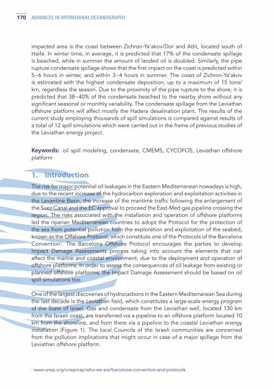
One of the largest discoveries of hydrocarbons in the Eastern Mediterranean Sea during the last decade is the Leviathan field, which constitutes a large-scale energy program of the State of Israel. Gas and condensate from the Leviathan well, located 130 km from the Israeli coast, are transferred via a pipeline to an offshore platform located 10 km from the shoreline, and from there via a pipeline to the coastal Leviathan energy installation (Figure 1). The local Councils of the Israeli communities are concerned from the pollution implications that might occur in case of a major spillage from the Leviathan offshore platform.
* www.unep.org/unepmap/who-we-are/barcelona-convention-and-protocols
171ADVANCES IN OPERATIONAL OCEANOGRAPHY EXPANDING EUROPE’S OBSERVING AND FORECASTING CAPACITY
Fig. 1. Map with the Leviathan field and the Leviathan offshore platform with their connecting pipeline in the EEZ of Israel.
Therefore, there was a request among other tasks to: a) perform spill simulations for condensate, diesel and grey water from the Leviathan offshore platform located at 10 km from the shoreline, b) perform spill simulations for condensate from a pipe rupture located 1 km from the shoreline, c) examine the spillages impact to the desalination plans and other sensitive infrastructure, d) review previous spill simulations for the same offshore platform and e) perform evaporation simulations that eventually generates a vapor cloud which is resulting from the condensate spillage.
Generally, the application of oil spill models for risk assessment of offshore platforms provides answers to the following key questions: where the oil spill will move, how soon it will create the first impact on the coast, duration of drift, time of arrival and location, which sensitive resources and installations will be threatened and what will be the state of the spilled oil when it arrives.
172 ADVANCES IN OPERATIONAL OCEANOGRAPHY
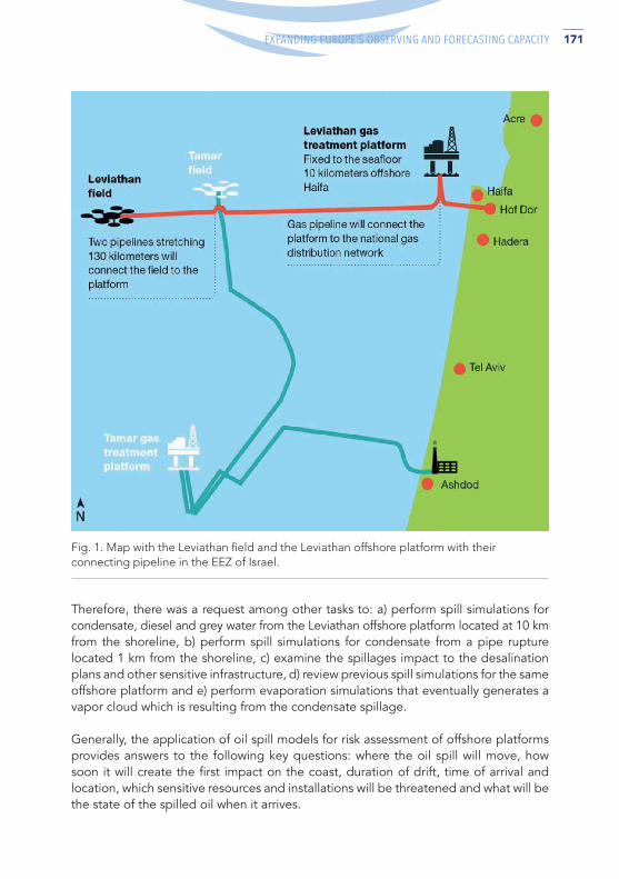
Fig. 2. The domains of CMEMS Med MFC and of the nested CYCOFOS downscaled models, the data of which were used in MEDSLIK and MEDSLIK-II spillages simulations for the Leviathan offshore platform in the EEZ of Israel.
The first 3 questions concerning the transport and the diffusion of the oil spillage are the most critical for having an effective support of the response agencies, and depend completely on reliable sea currents, winds, and wave’s data, while the 4th question depends on reliable fate algorithms concerning the evaporation, emulsification, dispersion, viscosity change, coastal impact.
The current paper presents only the condensate and diesel spill simulations from the Leviathan platform, attributes briefly the pipe rupture condensate spill simulations, and refer to the most high risk sensitive coastal infrastructure along the Israeli shoreline.
2. Methodology and data used The MEDSLIK-II oil spill model (De Dominicis et al., 2013) was applied to assess the potential pollution risk from the Leviathan offshore platform according to the following leakage scenarios for condensate and diesel spillages (Table I) by using the CMEMS Med MFC data, while for the pipe rupture, located 1km from the Israeli shore, the MEDSLIK oil spill model (Lardner et al., 1998; Zodiatis et al., 2017) was applied by using the downscaled CYCOFOS hydrodynamical and wave models (Figure 2) data and the high frequency SKIRON winds. Both models use the same fate and advection diffusion algorithms to address the risk assessment questions mentioned in the introduction. For the Leviathan offshore platform, 5,844 spill simulations were carried for condensate and another 5,844 for diesel, where each simulation is initiated every 6 hours for 10 days ahead during 2015-2018, using the CMEMS Med MFC hind-cast data. Similarly, for the pipe rupture with condensate located 1 km from the shore, 104 spill simulations were initiated every 15 days for 20 days ahead during 2015-2018, using the CYCOFOS hind cast data (Table I).
173ADVANCES IN OPERATIONAL OCEANOGRAPHY EXPANDING EUROPE’S OBSERVING AND FORECASTING CAPACITY
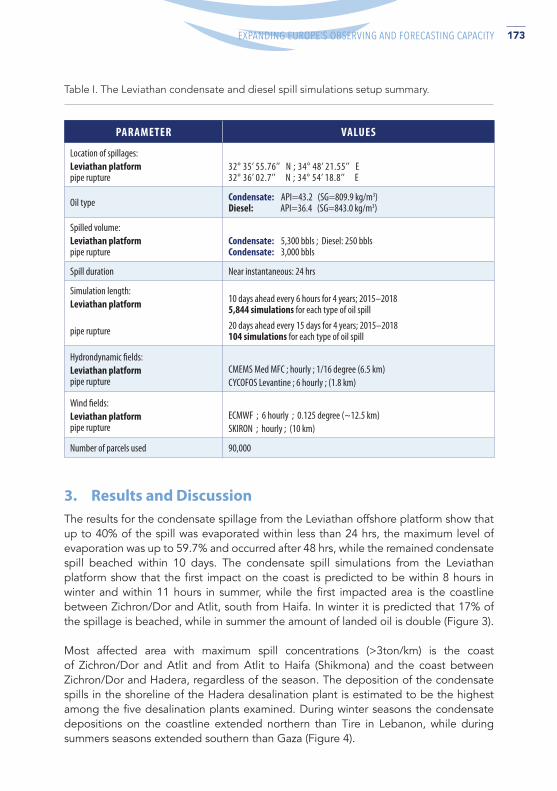
PARAMETER VALUES
Location of spillages: Leviathan platformpipe rupture
32° 35’ 55.76’’ N ; 34° 48’ 21.55’’ E32° 36’ 02.7’’ N ; 34° 54’ 18.8’’ E
Oil type Condensate: API=43.2 (SG=809.9 kg/m3)Diesel: API=36.4 (SG=843.0 kg/m3)
Spilled volume: Leviathan platformpipe rupture
Condensate: 5,300 bbls ; Diesel: 250 bblsCondensate: 3,000 bbls
Spill duration Near instantaneous: 24 hrs
Simulation length: Leviathan platform 10 days ahead every 6 hours for 4 years; 2015–2018
5,844 simulations for each type of oil spill
pipe rupture 20 days ahead every 15 days for 4 years; 2015–2018104 simulations for each type of oil spill
Hydrondynamic fields: Leviathan platformpipe rupture
CMEMS Med MFC ; hourly ; 1/16 degree (6.5 km)CYCOFOS Levantine ; 6 hourly ; (1.8 km)
Wind fields: Leviathan platformpipe rupture
ECMWF ; 6 hourly ; 0.125 degree (~12.5 km)SKIRON ; hourly ; (10 km)
Number of parcels used 90,000
Table I. The Leviathan condensate and diesel spill simulations setup summary.
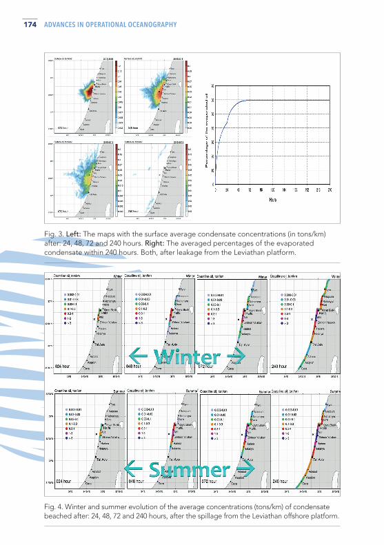
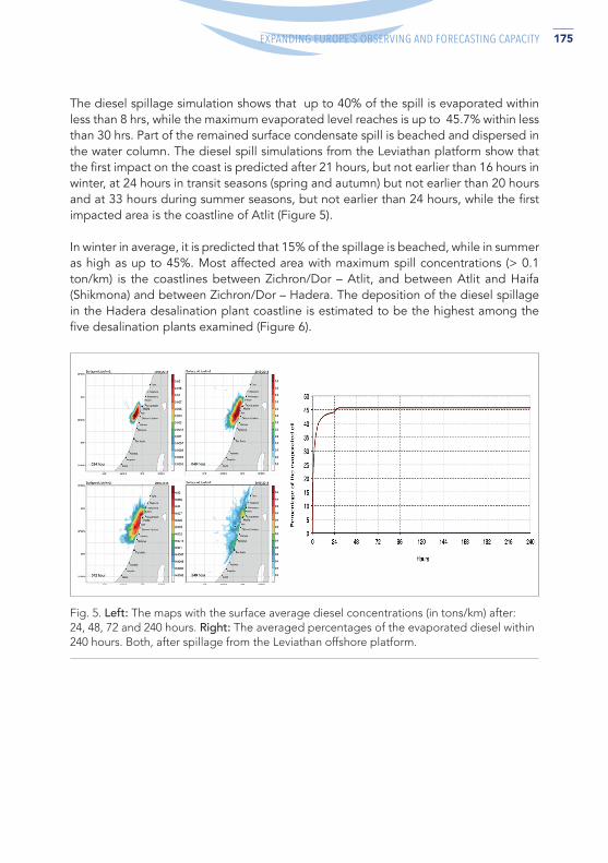
3. Results and Discussion The results for the condensate spillage from the Leviathan offshore platform show that up to 40% of the spill was evaporated within less than 24 hrs, the maximum level of evaporation was up to 59.7% and occurred after 48 hrs, while the remained condensate spill beached within 10 days. The condensate spill simulations from the Leviathan platform show that the first impact on the coast is predicted to be within 8 hours in winter and within 11 hours in summer, while the first impacted area is the coastline between Zichron/Dor and Atlit, south from Haifa. In winter it is predicted that 17% of the spillage is beached, while in summer the amount of landed oil is double (Figure 3). Most affected area with maximum spill concentrations (>3ton/km) is the coast of Zichron/Dor and Atlit and from Atlit to Haifa (Shikmona) and the coast between Zichron/Dor and Hadera, regardless of the season. The deposition of the condensate spills in the shoreline of the Hadera desalination plant is estimated to be the highest among the five desalination plants examined. During winter seasons the condensate depositions on the coastline extended northern than Tire in Lebanon, while during summers seasons extended southern than Gaza (Figure 4).
174 ADVANCES IN OPERATIONAL OCEANOGRAPHY
Fig. 3. Left: The maps with the surface average condensate concentrations (in tons/km) after: 24, 48, 72 and 240 hours. Right: The averaged percentages of the evaporated condensate within 240 hours. Both, after leakage from the Leviathan platform.
Fig. 4. Winter and summer evolution of the average concentrations (tons/km) of condensate beached after: 24, 48, 72 and 240 hours, after the spillage from the Leviathan offshore platform.
175ADVANCES IN OPERATIONAL OCEANOGRAPHY EXPANDING EUROPE’S OBSERVING AND FORECASTING CAPACITY
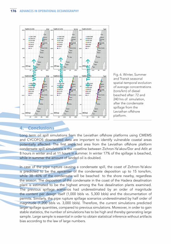
The diesel spillage simulation shows that up to 40% of the spill is evaporated within less than 8 hrs, while the maximum evaporated level reaches is up to 45.7% within less than 30 hrs. Part of the remained surface condensate spill is beached and dispersed in the water column. The diesel spill simulations from the Leviathan platform show that the first impact on the coast is predicted after 21 hours, but not earlier than 16 hours in winter, at 24 hours in transit seasons (spring and autumn) but not earlier than 20 hours and at 33 hours during summer seasons, but not earlier than 24 hours, while the first impacted area is the coastline of Atlit (Figure 5).
In winter in average, it is predicted that 15% of the spillage is beached, while in summer as high as up to 45%. Most affected area with maximum spill concentrations (> 0.1 ton/km) is the coastlines between Zichron/Dor – Atlit, and between Atlit and Haifa (Shikmona) and between Zichron/Dor – Hadera. The deposition of the diesel spillage in the Hadera desalination plant coastline is estimated to be the highest among the five desalination plants examined (Figure 6).
Fig. 5. Left: The maps with the surface average diesel concentrations (in tons/km) after: 24, 48, 72 and 240 hours. Right: The averaged percentages of the evaporated diesel within 240 hours. Both, after spillage from the Leviathan offshore platform.
176 ADVANCES IN OPERATIONAL OCEANOGRAPHY
Fig. 6. Winter, Summer and Transit seasonal spatial-temporal evolution of average concentrations (tons/km) of diesel beached after: 72 and 240 hrs of simulation, after the condensate spillage from the Leviathan offshore platform.
4. Conclusions Long term oil spill simulations from the Leviathan offshore platforms using CMEMS and CYCOFOS downscaled data are important to identify vulnerable coastal areas potentially affected. The first impacted area from the Leviathan offshore platform condensate spill simulations is the coastline between Zichron-Ya’akov/Dor and Atlit at 8 hours in winter and at 11 hours in summer. In winter 17% of the spillage is beached, while in summer the amount of landed oil is doubled.
In case of the pipe rupture causing a condensate spill, the coast of Zichron-Ya’akov is predicted to be the epicenter of the condensate deposition up to 15 tons/km, while 38−40% of the condensate will be beached to the shore nearby, regardless the season. The deposition of the condensate in the coast of the Hadera desalination plant is estimated to be the highest among the five desalination plants examined. The previous spillage scenarios had underestimated by an order of magnitude the content per design itself (1,000 bbls vs. 5,300 bbls) and the documentation of permits. Similarly, the pipe rupture spillage scenarios underestimated by half order of magnitude (1,200 bbls vs. 3,000 bbls). Therefore, the current simulations predicted larger spillage quantities, compared to previous simulations. Moreover, in order to gain stable statistics, the number of simulations has to be high and thereby generating large sample. Large sample is essential in order to obtain statistical inference without artifacts bias according to the law of large numbers.
177ADVANCES IN OPERATIONAL OCEANOGRAPHY EXPANDING EUROPE’S OBSERVING AND FORECASTING CAPACITY
References De Dominicis M., Pinardi N., Zodiatis G., and Lardner R. (2013). MEDSLIK-II, a Lagrangian marine surface oil spill model for short-term forecasting – Part 1: Theory. Geosci. Model Dev., 6, 1851-1869, doi:10.5194/gmd-6-1851-2013,
Lardner, R., Zodiatis, G., Loizides, L., Demetropoulos, A., (1998). An operational oil spill model for the Levantine Basin (Eastern Mediterranean Sea). In: International Symposium on Marine Pollution.
Zodiatis, G., Lardner, R., Alves, T., Krestenitis, Y., Perivoliotis, L., Sofianos, S., (2017). Oil spill forecasting (prediction) Journal of Marine Research 75 (6), 923-953.