Embed Size (px)
Citation preview
Copernicus Marine Environnement
Monitoring Service (CMEMS)
regional reanalyses
19/05/2016 C3S Regional Reanalysis Workshop, Reading 1
Jonathan Beuvier, Marie Drévillon, Karina von Schuckmann,
Gilles Garric, Yann Drillet, Pierre-Yves Le Traon
Mercator Océan, Ramonville Saint-Agne, France
OUTLINE
2
• CMEMS organisation
• CMEMS Multi-Year Products (MYP)
• Ocean State Report (OSR), Ocean Monitoring Indices (OMI)
• Data reprocessing, a pre-requisite input for reanalyses
• Status of regional reanalyses in CMEMS
• Requirements for regional reanalyses forcings
• Mercator Océan reanalyses
• Atmospheric forcings correction method for global reanalyses
• MEDRYS, a Mediterranean Sea regional reanalysis
19/05/2016 2C3S Regional Reanalysis Workshop
Cliquez et modifiez le titre
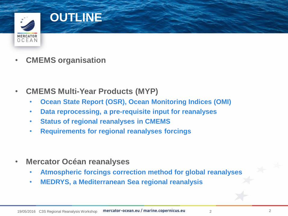
CMEMS technical « internal » Framework:
building blocks
Figure 1: System overview of Copernicus Marine Environment monitoring service chain as presented by the
European Commission to the GMES/Copernicus User Forum.
From the Technical Annex of the Delegation Agreement between the EU and Mercator Ocean
319/05/2016 C3S Regional Reanalysis Workshop
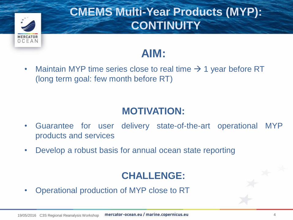
CMEMS Multi-Year Products (MYP):
CONTINUITY
AIM:
• Maintain MYP time series close to real time 1 year before RT
(long term goal: few month before RT)
MOTIVATION:
• Guarantee for user delivery state-of-the-art operational MYP
products and services
• Develop a robust basis for annual ocean state reporting
CHALLENGE:
• Operational production of MYP close to RT
419/05/2016 C3S Regional Reanalysis Workshop
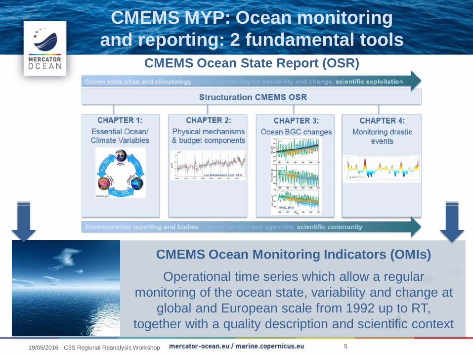
CMEMS MYP: Ocean monitoring
and reporting: 2 fundamental toolsCMEMS Ocean State Report (OSR)
CMEMS Ocean Monitoring Indicators (OMIs)
Operational time series which allow a regular
monitoring of the ocean state, variability and change at
global and European scale from 1992 up to RT,
together with a quality description and scientific context
519/05/2016 C3S Regional Reanalysis Workshop
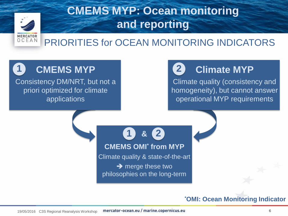
CMEMS MYPConsistency DM/NRT, but not a
priori optimized for climate
applications
Climate MYPClimate quality (consistency and
homogeneity), but cannot answer
operational MYP requirements
1 2
PRIORITIES for OCEAN MONITORING INDICATORS
CMEMS OMI* from MYP
Climate quality & state-of-the-art
merge these two
philosophies on the long-term
*OMI: Ocean Monitoring Indicator
&1 2
CMEMS MYP: Ocean monitoring
and reporting
6619/05/2016 C3S Regional Reanalysis Workshop
Cliquez et modifiez le titre
• In situ T(z), S(z) mainly for data assimilation (but also velocity
from drifters, elevations from tide gauges etc…)
• Sea level anomalies from satellite altimetry
• SST
• Sea ice concentration, drift, thickness
• Winds
Reprocessing of observations done by CMEMS TACs:
a pre-requisite
7719/05/2016 C3S Regional Reanalysis Workshop
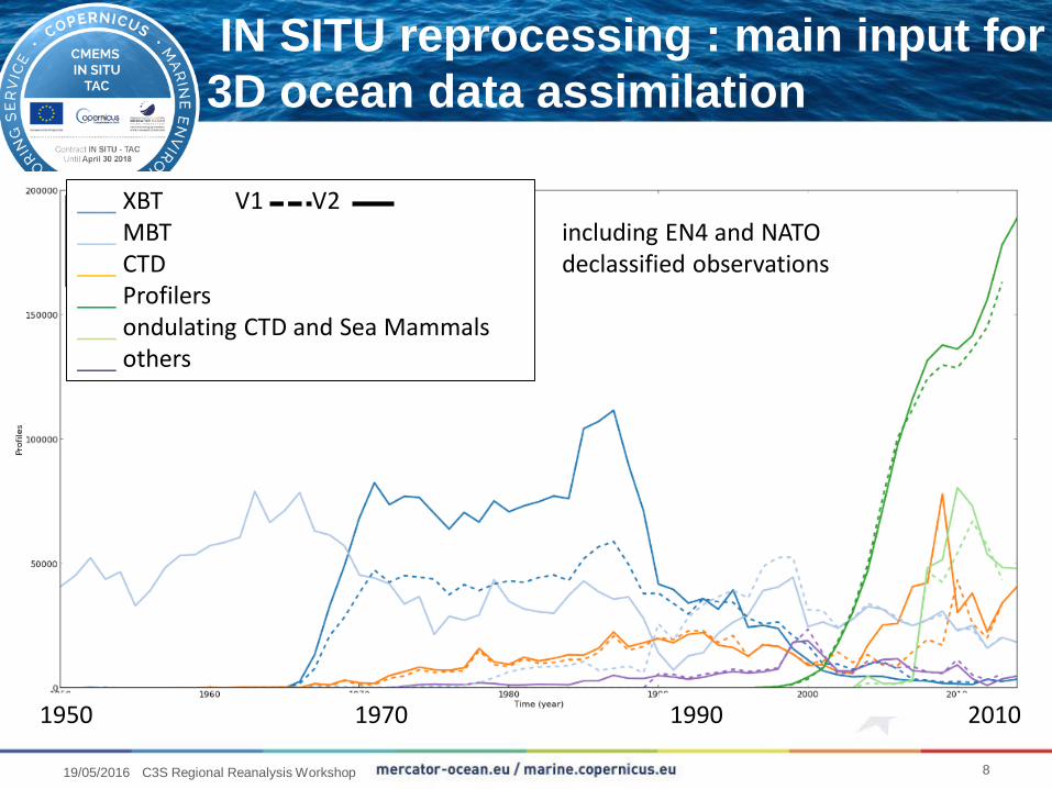
IN SITU reprocessing : main input for
3D ocean data assimilation
1950 1970 1990 2010
___ XBT V1 V2___ MBT___ CTD___ Profilers___ ondulating CTD and Sea Mammals___ others
including EN4 and NATO declassified observations
819/05/2016 C3S Regional Reanalysis Workshop
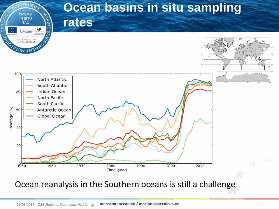
Ocean basins in situ sampling
rates
Ocean reanalysis in the Southern oceans is still a challenge
919/05/2016 C3S Regional Reanalysis Workshop
Cliquez et modifiez le titre
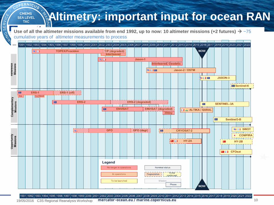
Altimetry: important input for ocean RANUse of all the altimeter missions available from end 1992, up to now: 10 altimeter missions (+2 futures) ~75
cumulative years of altimeter measurements to process
1019/05/2016 C3S Regional Reanalysis Workshop
Cliquez et modifiez le titre
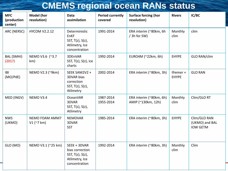
CMEMS regional ocean RANs statusMFC (productioncenter)
Model (horresolution)
Data assimilation
Period currentlycovered
Surface forcing (horresolution)
Rivers IC/BC
ARC (NERSC) HYCOM V2.2.12 DeterministicEnKFSST, T(z), S(z), Atlimetry, Iceconcentration
1991-2014 ERA interim (~80km, 6h / 3h for SW)
Monthlyclim
clim
BAL (SMHI)(2017)
NEMO V3.6 (~3.7 km)
3DEnVARSST, T(z), S(z), icecharts
1992-2014 EURO4M (~22km, 6h) EHYPE GLO RAN/clim
IBI (MO/PdE)
NEMO V2.3 (~9km) SEEK SAM2V2 + 3DVAR biascorrectionSST, T(z), S(z), Atlimetry
2002-2014 ERA interim (~80km, 3h) Ifremer + EHYPE
GLO RAN
MED (INGV) NEMO V3.4 OceanVAR3DVARSST, T(z), S(z), Atlimetry
1987-20141955-2014
ERA interim (~80km, 6h)AMIP (~130km, 12h)
Monthlyclim
Clim/GLO RT
NWS (UKMO)
NEMO FOAM AMM7 V1 (~7 km)
NEMOVAR 3DVARSST
1985-2014 ERA interim (~80km, 3h) EHYPE Clim/GLO RAN (UKMO) and BAL IOW GETM
GLO (MO) NEMO V3.1 (~25 km) SEEK + 3DVAR bias correctionSST, T(z), S(z), Atlimetry, Iceconcentration
1992-2014 ERA interim (~80km, 3h) Monthlyclim
Clim
Cliquez et modifiez le titre
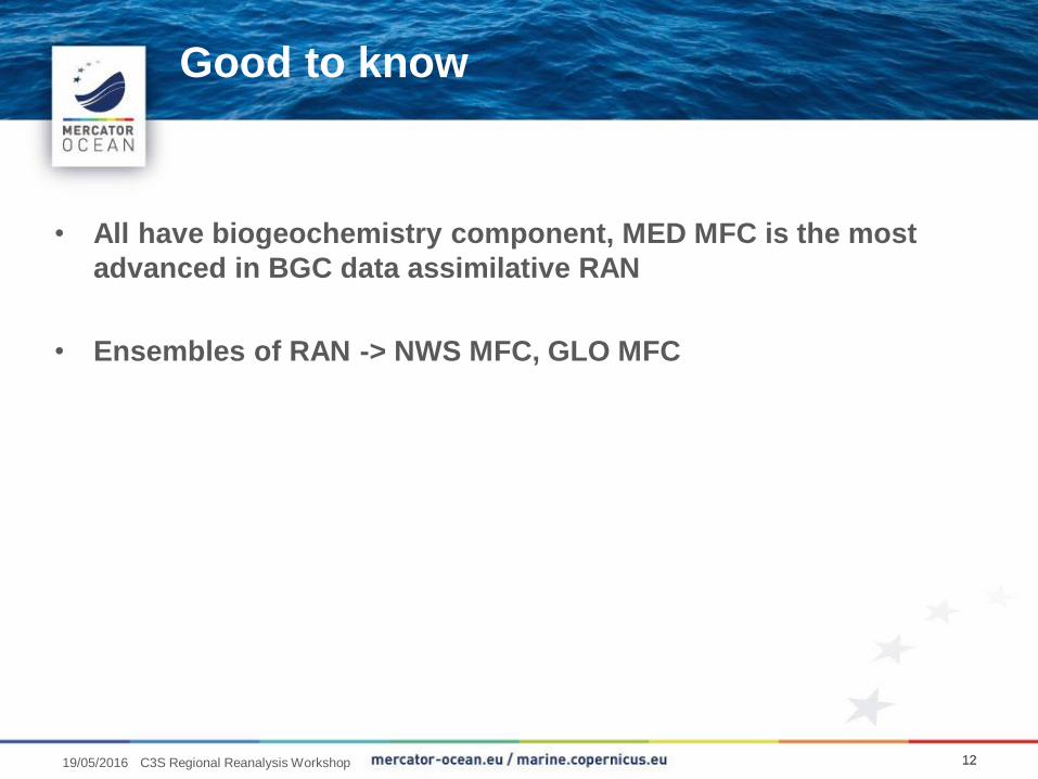
• All have biogeochemistry component, MED MFC is the most
advanced in BGC data assimilative RAN
• Ensembles of RAN -> NWS MFC, GLO MFC
Good to know
121219/05/2016 C3S Regional Reanalysis Workshop
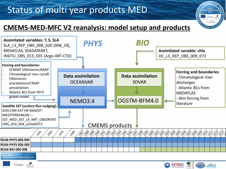
Status of multi year products MED
NEMO3.4
Data assimilationOCEANVAR
OGSTM-BFM4.0
Data assimilation3DVAR
Assimilated variable: chlaOC_L3_REP_OBS_009_073
Forcing and boundaries:- ECMWF ERAinterim/AMIP- Climatological river runoff- ERAInterim
precipitation/CMAP precipitation
- Atlantic BCs from PSY3 global model
Assimilated variables: T, S, SLASLA_L3_REP_OBS_008_020 [008_19], MEDATLAS, SEADATANET, INSITU_OBS_013_035 (Argo-XBT-CTD)
Forcing and boundaries- Climatological river discharges- Atlantic BCs from MEDATLAS- Atm forcing from literature
CMEMS products
CMEMS-MED-MFC V2 reanalysis: model setup and products
PHYS BIO
1955
1960
1970
1980
1987
1988
1989
1990
1991
1992
1993
1994
1995
1996
1997
1998
1999
2000
2001
2002
2003
2004
2005
2006
2007
2008
2009
2010
2011
2012
2013
2014
REAN-PHYS-006-004
REAN-PHYS-006-009
REAN-BIO-006-008
Satellite SST (surface flux nudging):GOS-CNR-SST-HR-RAN/DT-MEDITERRANEAN –SST_MED_SST_L4_NRT_OBSERVATIONS_010_004_a/HadSST1
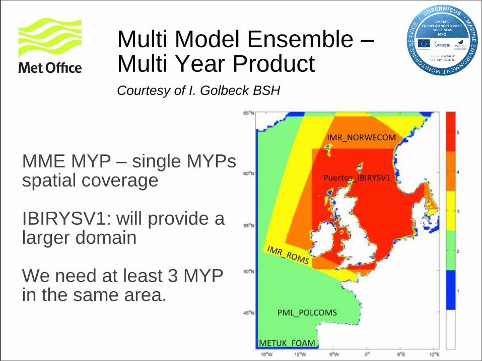
Multi Model Ensemble –Multi Year ProductCourtesy of I. Golbeck BSH
MME MYP – single MYPsspatial coverage
IBIRYSV1: will provide a larger domain
We need at least 3 MYP in the same area.
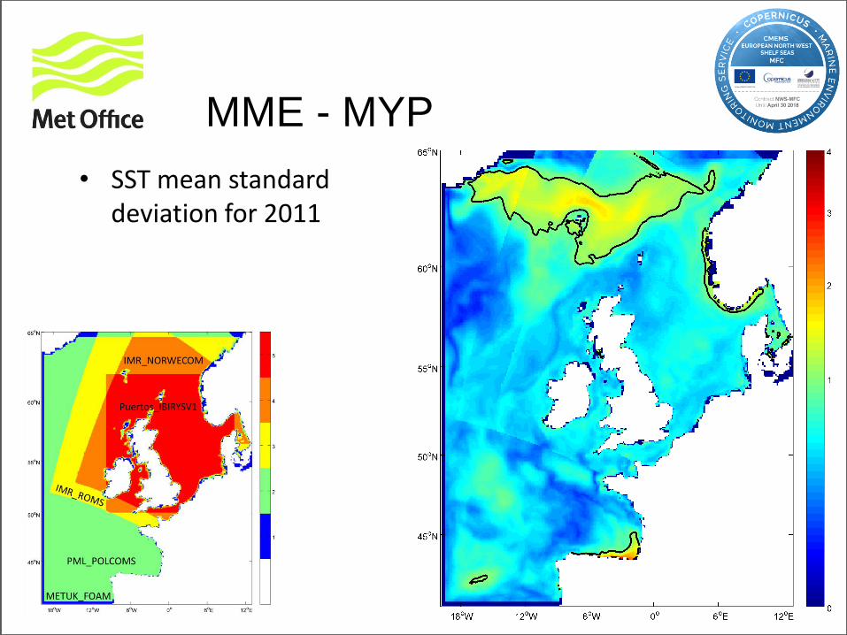
MME - MYP
• SST mean standarddeviation for 2011
Cliquez et modifiez le titre
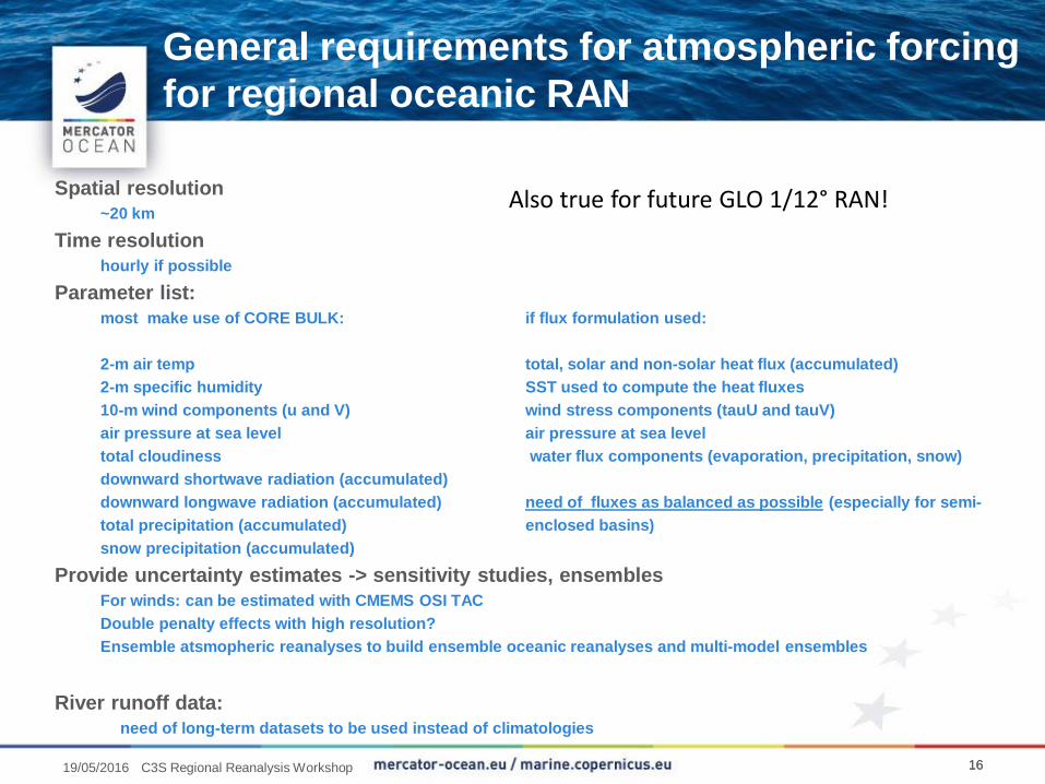
Spatial resolution
~20 km
Time resolution
hourly if possible
Parameter list:
most make use of CORE BULK: if flux formulation used:
2-m air temp total, solar and non-solar heat flux (accumulated)
2-m specific humidity SST used to compute the heat fluxes
10-m wind components (u and V) wind stress components (tauU and tauV)
air pressure at sea level air pressure at sea level
total cloudiness water flux components (evaporation, precipitation, snow)
downward shortwave radiation (accumulated)
downward longwave radiation (accumulated) need of fluxes as balanced as possible (especially for semi-
total precipitation (accumulated) enclosed basins)
snow precipitation (accumulated)
Provide uncertainty estimates -> sensitivity studies, ensembles
For winds: can be estimated with CMEMS OSI TAC
Double penalty effects with high resolution?
Ensemble atsmopheric reanalyses to build ensemble oceanic reanalyses and multi-model ensembles
River runoff data:
need of long-term datasets to be used instead of climatologies
General requirements for atmospheric forcing
for regional oceanic RAN
Also true for future GLO 1/12° RAN!
161619/05/2016 C3S Regional Reanalysis Workshop
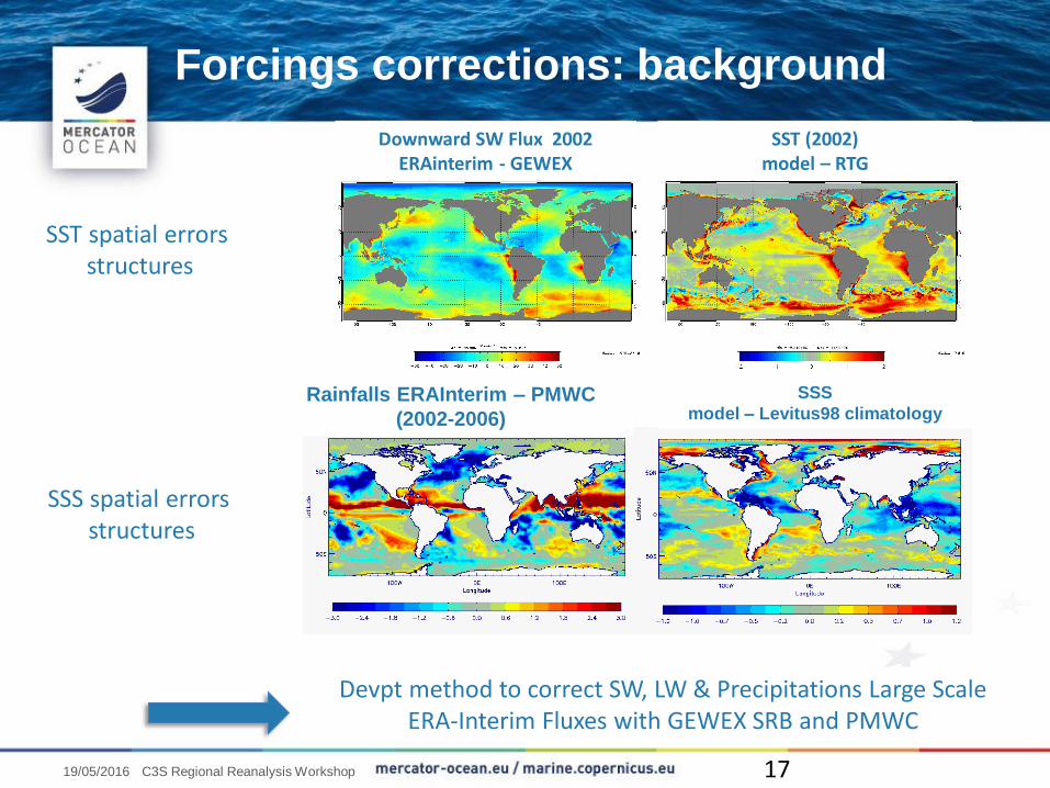
SSS
model – Levitus98 climatologyRainfalls ERAInterim – PMWC
(2002-2006)
SST spatial errors structures
SST (2002)model – RTG
Downward SW Flux 2002 ERAinterim - GEWEX
SSS spatial errors structures
Devpt method to correct SW, LW & Precipitations Large Scale ERA-Interim Fluxes with GEWEX SRB and PMWC
Forcings corrections: background
1719/05/2016 C3S Regional Reanalysis Workshop
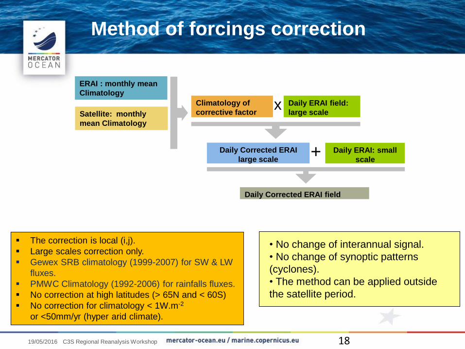
ERAI : monthly mean
Climatology
Satellite: monthly
mean Climatology
Climatology of
corrective factor
Daily ERAI field:
large scalex
Daily ERAI: small
scale
Daily Corrected ERAI
large scale+
Daily Corrected ERAI field
The correction is local (i,j).
Large scales correction only.
Gewex SRB climatology (1999-2007) for SW & LW
fluxes.
PMWC Climatology (1992-2006) for rainfalls fluxes.
No correction at high latitudes (> 65N and < 60S)
No correction for climatology < 1W.m-2
or <50mm/yr (hyper arid climate).
• No change of interannual signal.
• No change of synoptic patterns
(cyclones).
• The method can be applied outside
the satellite period.
Method of forcings correction
1819/05/2016 C3S Regional Reanalysis Workshop
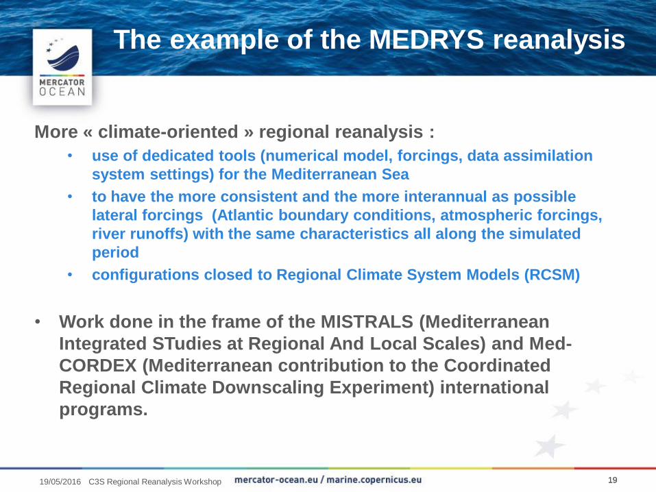
The example of the MEDRYS reanalysis
More « climate-oriented » regional reanalysis :
• use of dedicated tools (numerical model, forcings, data assimilation
system settings) for the Mediterranean Sea
• to have the more consistent and the more interannual as possible
lateral forcings (Atlantic boundary conditions, atmospheric forcings,
river runoffs) with the same characteristics all along the simulated
period
• configurations closed to Regional Climate System Models (RCSM)
• Work done in the frame of the MISTRALS (Mediterranean
Integrated STudies at Regional And Local Scales) and Med-
CORDEX (Mediterranean contribution to the Coordinated
Regional Climate Downscaling Experiment) international
programs.
191919/05/2016 C3S Regional Reanalysis Workshop
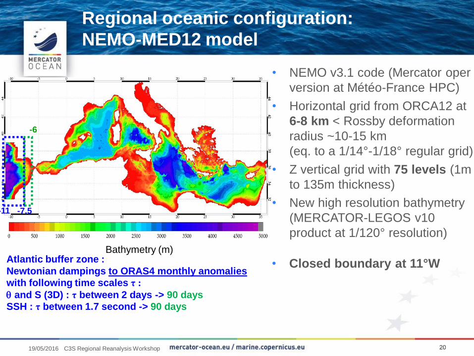
Regional oceanic configuration:
NEMO-MED12 model
20
• NEMO v3.1 code (Mercator oper
version at Météo-France HPC)
• Horizontal grid from ORCA12 at
6-8 km < Rossby deformation
radius ~10-15 km
(eq. to a 1/14°-1/18° regular grid)
• Z vertical grid with 75 levels (1m
to 135m thickness)
• New high resolution bathymetry
(MERCATOR-LEGOS v10
product at 1/120° resolution)
• Closed boundary at 11°W
-11 -7.5
-6
Atlantic buffer zone :
Newtonian dampings to ORAS4 monthly anomalies
with following time scales τ :
and S (3D) : τ between 2 days -> 90 days
SSH : τ between 1.7 second -> 90 days
Bathymetry (m)
2019/05/2016 C3S Regional Reanalysis Workshop
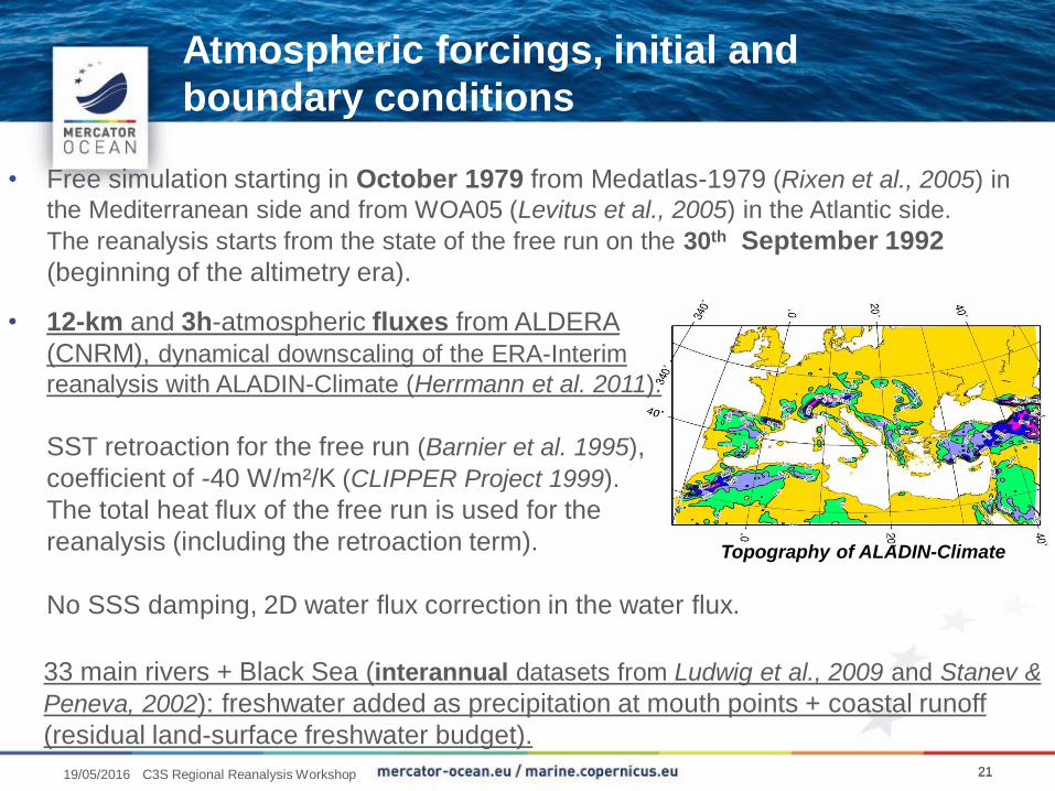
Atmospheric forcings, initial and
boundary conditions
21
• Free simulation starting in October 1979 from Medatlas-1979 (Rixen et al., 2005) in
the Mediterranean side and from WOA05 (Levitus et al., 2005) in the Atlantic side.
The reanalysis starts from the state of the free run on the 30th September 1992
(beginning of the altimetry era).
33 main rivers + Black Sea (interannual datasets from Ludwig et al., 2009 and Stanev &
Peneva, 2002): freshwater added as precipitation at mouth points + coastal runoff
(residual land-surface freshwater budget).
• 12-km and 3h-atmospheric fluxes from ALDERA
(CNRM), dynamical downscaling of the ERA-Interim
reanalysis with ALADIN-Climate (Herrmann et al. 2011).
SST retroaction for the free run (Barnier et al. 1995),
coefficient of -40 W/m²/K (CLIPPER Project 1999).
The total heat flux of the free run is used for the
reanalysis (including the retroaction term).
No SSS damping, 2D water flux correction in the water flux.
Topography of ALADIN-Climate
2119/05/2016 C3S Regional Reanalysis Workshop
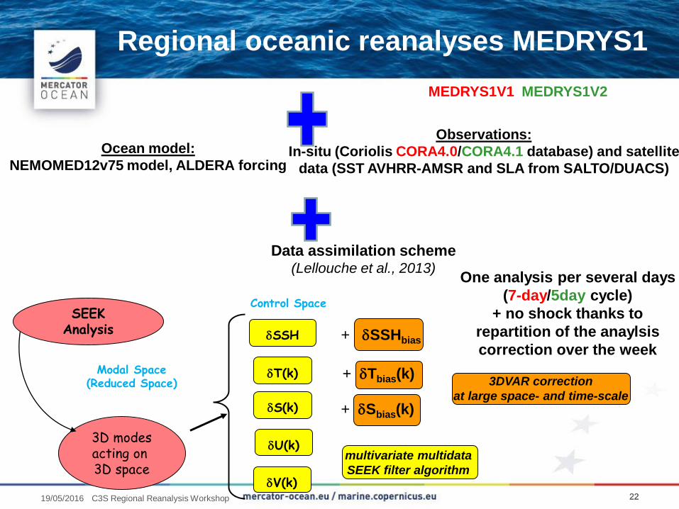
Regional oceanic reanalyses MEDRYS1
22
Ocean model:
NEMOMED12v75 model, ALDERA forcing
Observations:
In-situ (Coriolis CORA4.0/CORA4.1 database) and satellite
data (SST AVHRR-AMSR and SLA from SALTO/DUACS)
Data assimilation scheme(Lellouche et al., 2013)
3DVAR correction
at large space- and time-scale
multivariate multidata
SEEK filter algorithm
+ Tbias(k)
Control Space
SSH
T(k)
S(k)
Modal Space(Reduced Space)
3D modesacting on 3D space
SEEKAnalysis
U(k)
V(k)
+ SSHbias
+ Sbias(k)
One analysis per several days
(7-day/5day cycle)
+ no shock thanks to
repartition of the anaylsis
correction over the week
MEDRYS1V1 MEDRYS1V2
2219/05/2016 C3S Regional Reanalysis Workshop
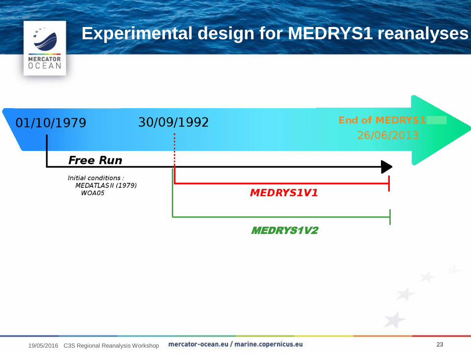
Experimental design for MEDRYS1 reanalyses
23
MEDRYS1V2
2319/05/2016 C3S Regional Reanalysis Workshop
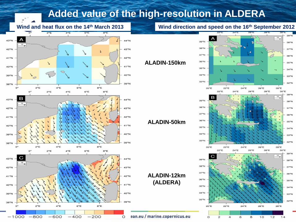
24
Added value of the high-resolution in ALDERA
ALADIN-150km
ALADIN-50km
ALADIN-12km
(ALDERA)
Wind and heat flux on the 14th March 2013 Wind direction and speed on the 16th September 2012
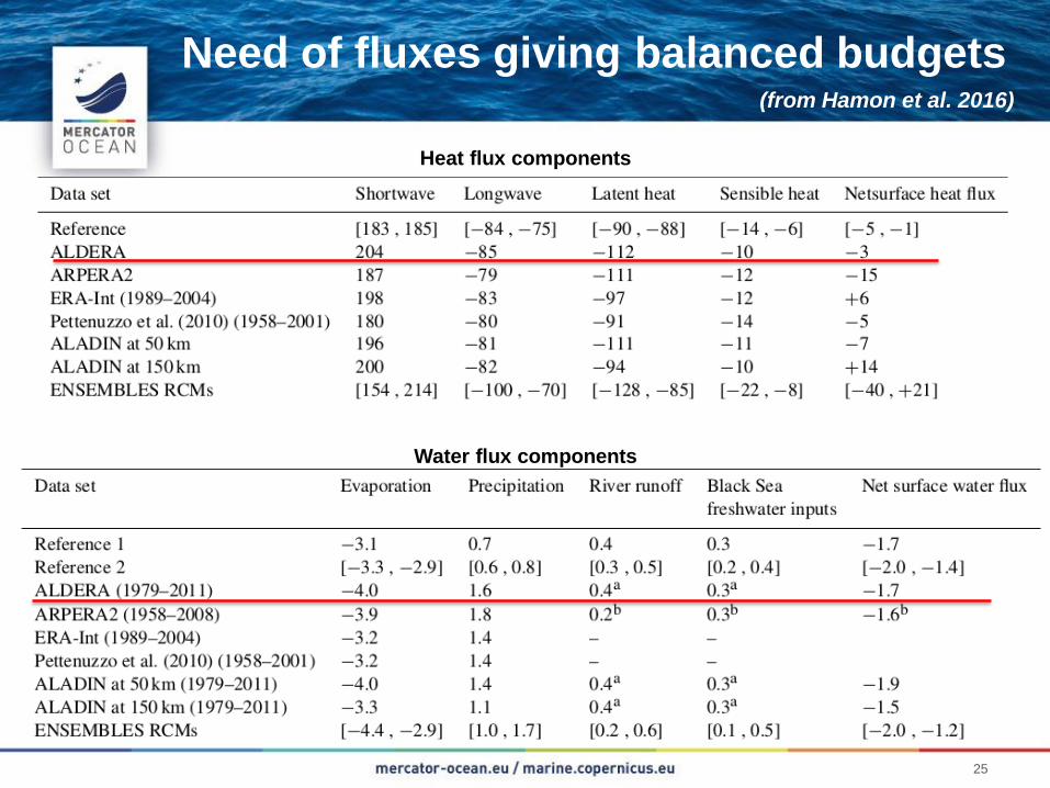
25
Need of fluxes giving balanced budgets(from Hamon et al. 2016)
Heat flux components
Water flux components
Any questions?
26
Thank you for your attention!
19/05/2016 C3S Regional Reanalysis Workshop, Reading
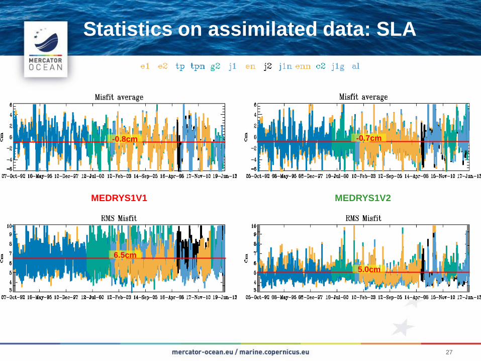
Statistics on assimilated data: SLA
27
MEDRYS1V1 MEDRYS1V2
6.5cm
5.0cm
-0.8cm -0.7cm
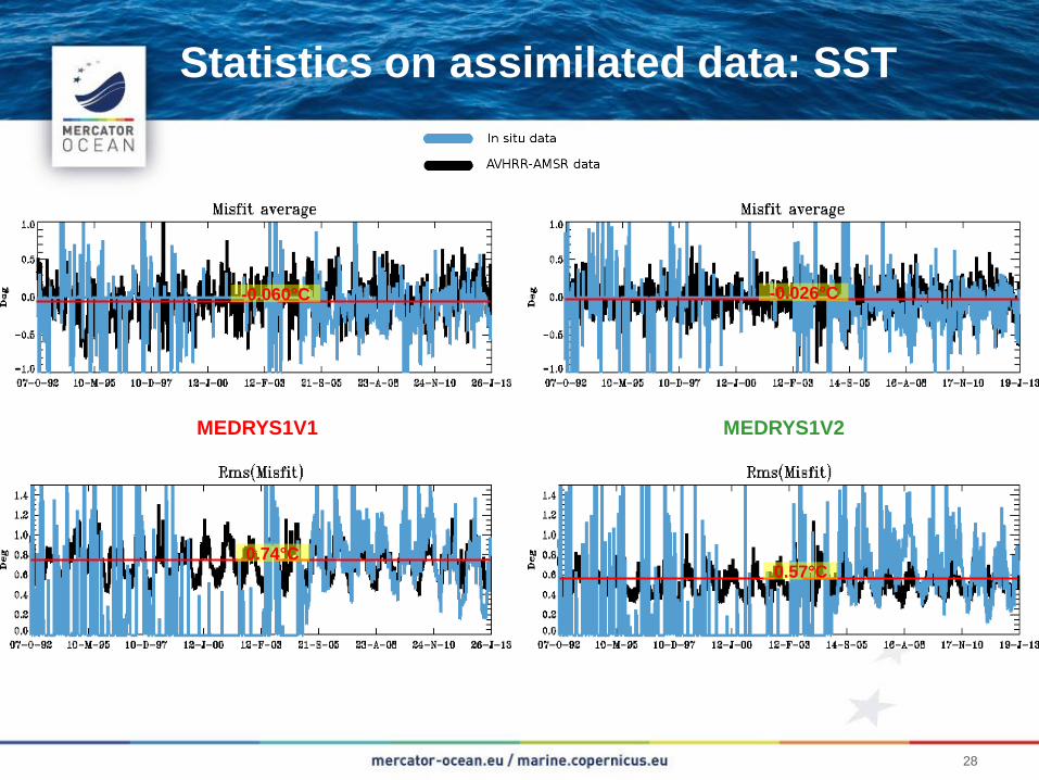
Statistics on assimilated data: SST
28
MEDRYS1V1 MEDRYS1V2
0.74°C0.57°C
-0.060°C -0.026°C
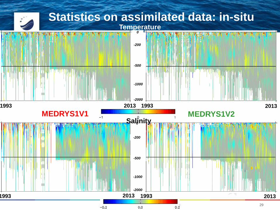
Statistics on assimilated data: in-situ
29
MEDRYS1V1 MEDRYS1V21993
-1000
-500
-200
-2000
2013
0
-1000
-500
-200
0
1993 2013
-2000
1993 2013
1993 2013
Temperature
Salinity
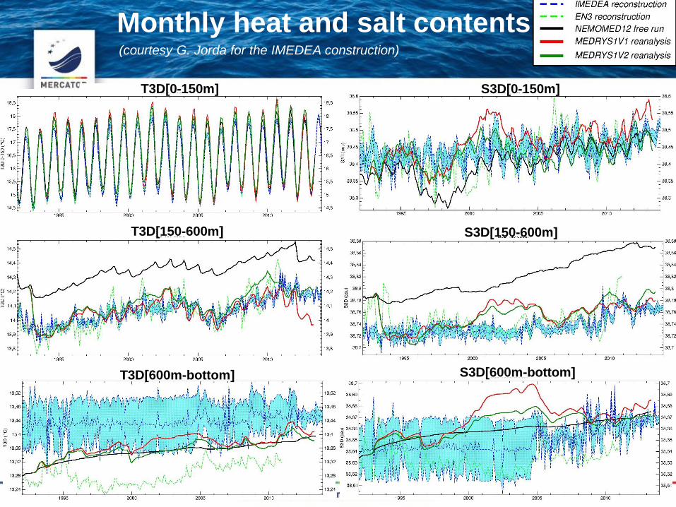
Monthly heat and salt contents
3010/02/2016
(courtesy G. Jorda for the IMEDEA construction)
S3D[600m-bottom]
T3D[0-150m] S3D[0-150m]
T3D[600m-bottom]
T3D[150-600m] S3D[150-600m]