Embed Size (px)
Citation preview
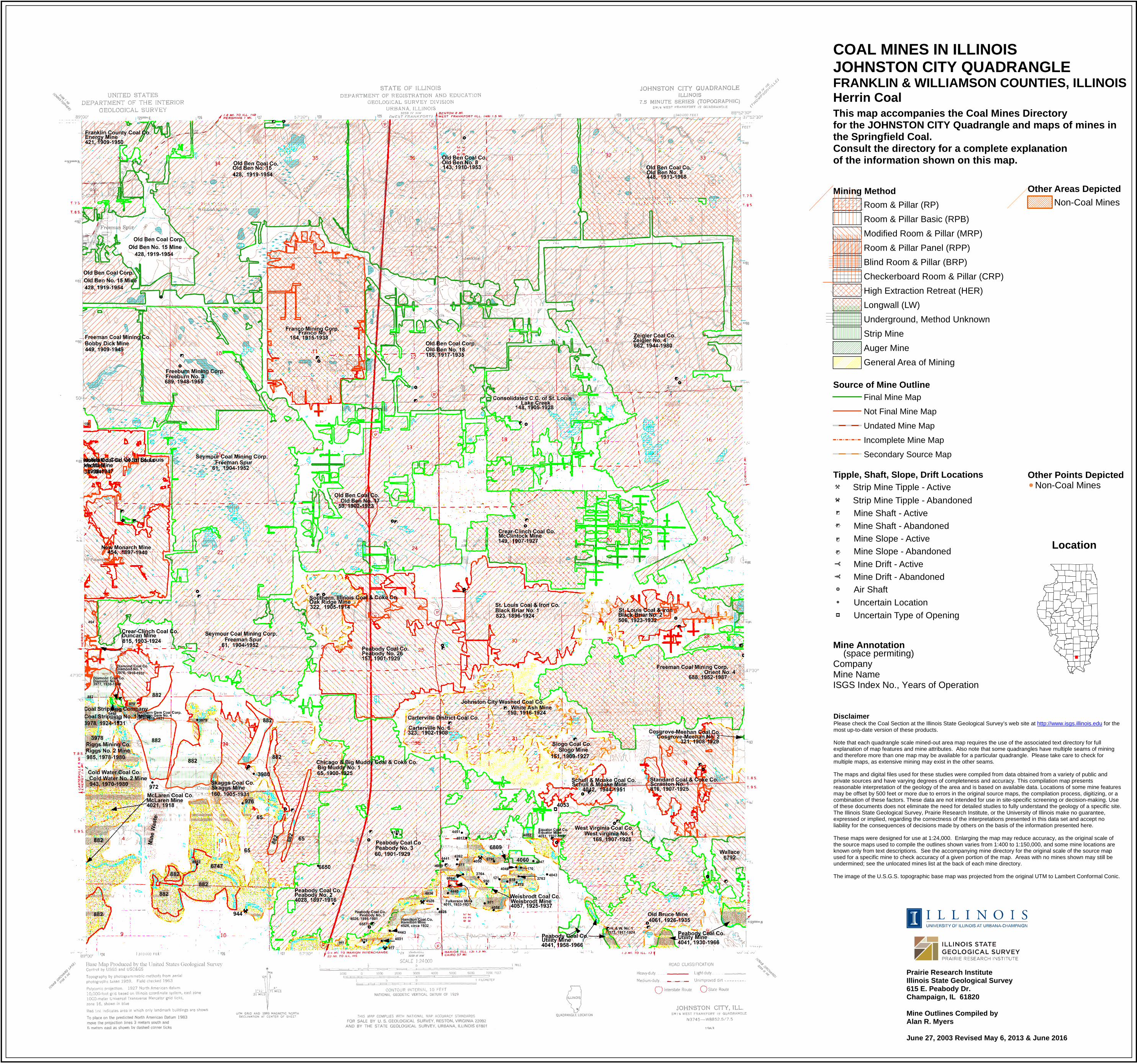
Disclaimer Please check the Coal Section at the Illinois State Geological Survey’s web site at http://www.isgs.illinois.edu for the most up-to-date version of these products. Note that each quadrangle scale mined-out area map requires the use of the associated text directory for full explanation of map features and mine attributes. Also note that some quadrangles have multiple seams of mining and therefore more than one map may be available for a particular quadrangle. Please take care to check for multiple maps, as extensive mining may exist in the other seams. The maps and digital files used for these studies were compiled from data obtained from a variety of public and private sources and have varying degrees of completeness and accuracy. This compilation map presents reasonable interpretation of the geology of the area and is based on available data. Locations of some mine features may be offset by 500 feet or more due to errors in the original source maps, the compilation process, digitizing, or a combination of these factors. These data are not intended for use in site-specific screening or decision-making. Use of these documents does not eliminate the need for detailed studies to fully understand the geology of a specific site. The Illinois State Geological Survey, Prairie Research Institute, or the University of Illinois make no guarantee, expressed or implied, regarding the correctness of the interpretations presented in this data set and accept no liability for the consequences of decisions made by others on the basis of the information presented here. These maps were designed for use at 1:24,000. Enlarging the map may reduce accuracy, as the original scale of the source maps used to compile the outlines shown varies from 1:400 to 1:150,000, and some mine locations are known only from text descriptions. See the accompanying mine directory for the original scale of the source map used for a specific mine to check accuracy of a given portion of the map. Areas with no mines shown may still be undermined; see the unlocated mines list at the back of each mine directory. The image of the U.S.G.S. topographic base map was projected from the original UTM to Lambert Conformal Conic.
Other Areas Depicted
Non-Coal Mines
Source of Mine OutlineFinal Mine Map
Not Final Mine Map
Undated Mine Map
Incomplete Mine Map
Secondary Source Map
Mine Annotation (space permiting)CompanyMine NameISGS Index No., Years of Operation
Mining Method
Room & Pillar (RP)
Room & Pillar Basic (RPB)
Modified Room & Pillar (MRP)
Room & Pillar Panel (RPP)
Blind Room & Pillar (BRP)
Checkerboard Room & Pillar (CRP)
High Extraction Retreat (HER)
Longwall (LW)
Underground, Method Unknown
Strip Mine
Auger Mine
General Area of Mining
Location
Other Points DepictedNon-Coal Mines
COAL MINES IN ILLINOISJOHNSTON CITY QUADRANGLE
This map accompanies the Coal Mines Directory for the JOHNSTON CITY Quadrangle and maps of mines in the Springfield Coal.Consult the directory for a complete explanation of the information shown on this map.
Prairie Research InstituteIllinois State Geological Survey615 E. Peabody Dr.Champaign, IL 61820
Mine Outlines Compiled byAlan R. Myers
June 27, 2003 Revised May 6, 2013 & June 2016
FRANKLIN & WILLIAMSON COUNTIES, ILLINOISHerrin Coal
Tipple, Shaft, Slope, Drift Locations
Strip Mine Tipple - Active
Strip Mine Tipple - Abandoned
Mine Shaft - Active
Mine Shaft - Abandoned
Mine Slope - Active
Mine Slope - Abandoned
Mine Drift - Active
Mine Drift - Abandoned
Air Shaft
Uncertain Location
Uncertain Type of Opening
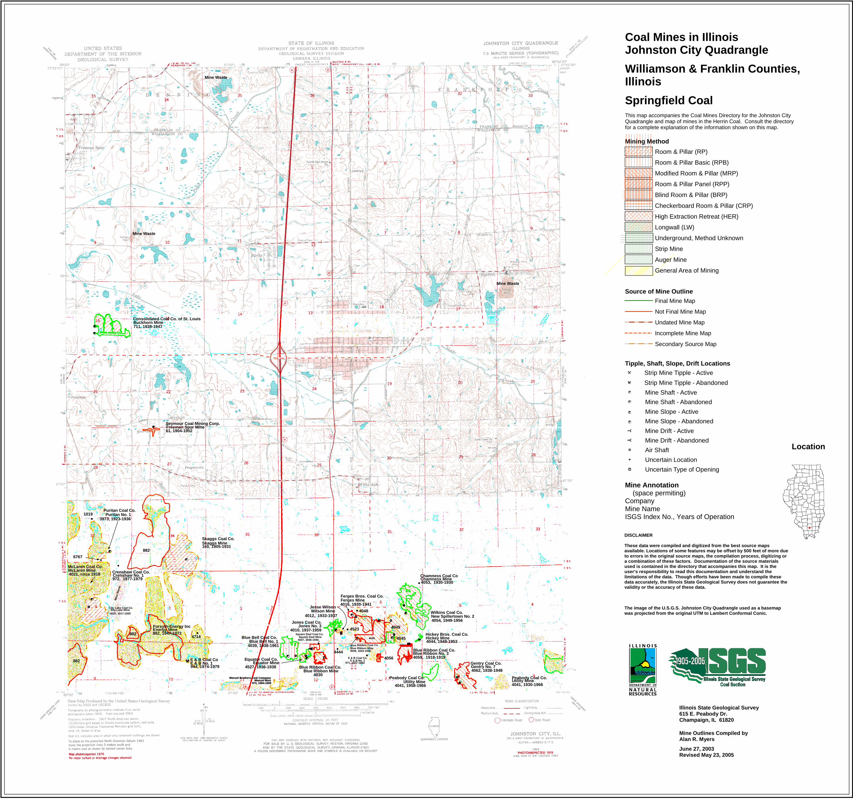
Coal Mines in IllinoisJohnston City Quadrangle
Williamson & Franklin Counties, Illinois
Springfield CoalThis map accompanies the Coal Mines Directory for the Johnston CityQuadrangle and map of mines in the Herrin Coal. Consult the directory for a complete explanation of the information shown on this map.
Consolidated Coal Co. of St. LouisBuckhorn Mine711, 1938-1947
882
882
882
Forsyth-Energy IncEnergy Mine882, 1947-1972
E & B Coal CoE & B No. 1944, 1974-1979
Crenshaw Coal Co.Crenshaw No. 1972, 1977-1979
Puritan Coal Co.Puritan No. 1
4016, 1930-1941Ferges MineFerges Bros. Coal Co.
McLaren Coal Co.McLaren Mine4021, circa 1918
4037, 1936-1940Square Deal Mine
Square Deal Coal Co. Hickey Bros. Coal Co.Hickey Mine4044, 1948-1953
Chamness Coal CoChamness Mine4053, 1930-1930
Wilkins Coal Co.New Spillertown No. 24054, 1949-1956
Gentry Coal Co.Gentry No. 74062, 1938-1948
Seymour Coal Mining Corp.Freeman Spur Mine61, 1904-1952
Skaggs Coal Co.Skaggs Mine160, 1905-1931
Blue Ribbon Coal Co.Blue Ribbon Mine
4030
Blue Ribbon Coal Co.
4045
4049
Blue Ribbon Mine4049, 1934-1946
Blue Ribbon No. 3Blue Ribbon Coal Co.
4059, 1918-1919
3973, 1923-1936
4523
4056
City Lake Coal Co.City Lake Mine
6767
4020, 1917-1935
1019
4049
4048
Min
e W
aste
Mine Waste
Mine Waste
Mine Waste
4714
4527, 1936-1938Equator Mine
Equator Coal Co.
Blue Bell Coal Co.Blue Bell No. 1
4444
4012, 1933-1937Wilson Mine
Jesse Wilson
Jones Coal Co.Jones No. 3
4010, 1937-1959
4039, 1938-1961
E & B Coal Co.E & B No. 2
971, 1977-1984
Peabody Coal Co.Utility Mine
4041, 1958-1966
Wenzel Brothers Coal CompanyWenzel Mine
970, 1964-1965
Wenzel Brothers Coal CompanyWenzel Mine
970, 1964-1965
Peabody Coal Co.Utility Mine4041, 1930-1966
Illinois State Geological Survey615 E. Peabody Dr. Champaign, IL 61820
Mine Outlines Compiled by Alan R. Myers
June 27, 2003 Revised May 23, 2005
DISCLAIMER These data were compiled and digitized from the best source maps available. Locations of some features may be offset by 500 feet of more due to errors in the original source maps, the compilation process, digitizing or a combination of these factors. Documentation of the source materials used is contained in the directory that accompanies this map. It is the user’s responsibility to read this documentation and understand the limitations of the data. Though efforts have been made to compile these data accurately, the Illinois State Geological Survey does not guarantee the validity or the accuracy of these data. The image of the U.S.G.S. Johnston City Quadrangle used as a basemap was projected from the original UTM to Lambert Conformal Conic.
Mine Annotation (space permiting)CompanyMine NameISGS Index No., Years of Operation
Location
Source of Mine Outline
Final Mine Map
Not Final Mine Map
Undated Mine Map
Incomplete Mine Map
Secondary Source Map
Tipple, Shaft, Slope, Drift Locations
Strip Mine Tipple - Active
Strip Mine Tipple - Abandoned
Mine Shaft - Active
Mine Shaft - Abandoned
Mine Slope - Active
Mine Slope - Abandoned
Mine Drift - Active
Mine Drift - Abandoned
Air Shaft
Uncertain Location
Uncertain Type of Opening
Mining Method
Room & Pillar (RP)
Room & Pillar Basic (RPB)
Modified Room & Pillar (MRP)
Room & Pillar Panel (RPP)
Blind Room & Pillar (BRP)
Checkerboard Room & Pillar (CRP)
High Extraction Retreat (HER)
Longwall (LW)
Underground, Method Unknown
Strip Mine
Auger Mine
General Area of Mining
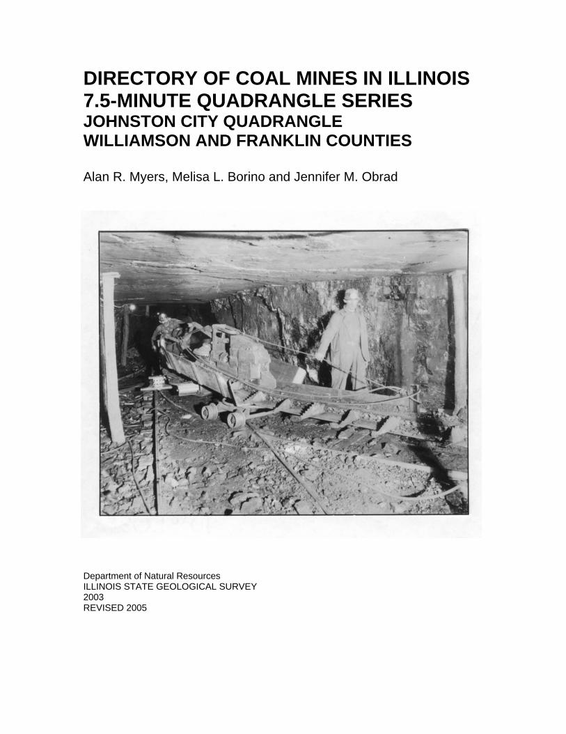
DIRECTORY OF COAL MINES IN ILLINOIS7.5-MINUTE QUADRANGLE SERIESJOHNSTON CITY QUADRANGLEWILLIAMSON AND FRANKLIN COUNTIES
Alan R. Myers, Melisa L. Borino and Jennifer M. Obrad
Department of Natural ResourcesILLINOIS STATE GEOLOGICAL SURVEY2003REVISED 2005

DIRECTORY OF COAL MINES IN ILLINOIS7.5-MINUTE QUADRANGLE SERIESJOHNSTON CITY QUADRANGLEWILLIAMSON AND FRANKLIN COUNTIES
2003REVISED 2005
ILLINOIS STATE GEOLOGICAL SURVEYWilliam Shilts, Chief
Natural Resources Building615 East Peabody DriveChampaign, Illinois 61820
Phone 1-217-244-4610Fax 1-217-333-2830
Cover photo Track-mounted duckbill loading machine at a Peabody Coal Company mine, ca. 1915.
DISCLAIMER: The accuracy and completeness of mine maps and directories vary with the availability ofreliable information. Maps and other information used to compile this mine map and directory were obtainedfrom a variety of sources and the accuracy of some of the original information cannot be verified. Consequently, the Illinois State Geological Survey (ISGS) cannot guarantee the mine maps are free of errorsand disclaims any responsibility for damages that may result from actions or decisions based on them.
The ISGS updates the maps and directories periodically, and welcomes any new information or corrections. Please contact the Coal Section of the ISGS at the address shown on the title page of this directory, ortelephone (217) 244-4610.
Printed by authority of the State of Illinois/2005
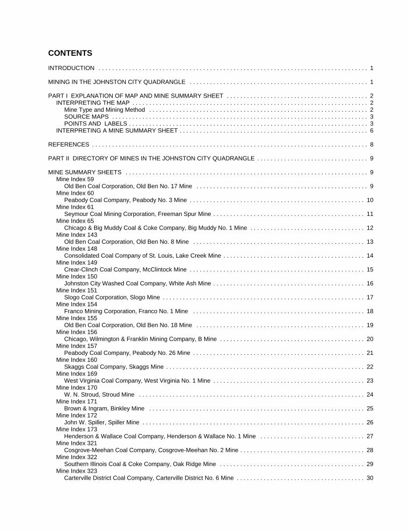
CONTENTS
INTRODUCTION . . . . . . . . . . . . . . . . . . . . . . . . . . . . . . . . . . . . . . . . . . . . . . . . . . . . . . . . . . . . . . . . . . . . . . . . . . . . . . . . 1
MINING IN THE JOHNSTON CITY QUADRANGLE . . . . . . . . . . . . . . . . . . . . . . . . . . . . . . . . . . . . . . . . . . . . . . . . . . . . . 1
PART I EXPLANATION OF MAP AND MINE SUMMARY SHEET . . . . . . . . . . . . . . . . . . . . . . . . . . . . . . . . . . . . . . . . . . 2INTERPRETING THE MAP . . . . . . . . . . . . . . . . . . . . . . . . . . . . . . . . . . . . . . . . . . . . . . . . . . . . . . . . . . . . . . . . . . . . . . 2
Mine Type and Mining Method . . . . . . . . . . . . . . . . . . . . . . . . . . . . . . . . . . . . . . . . . . . . . . . . . . . . . . . . . . . . . . . . . 2SOURCE MAPS . . . . . . . . . . . . . . . . . . . . . . . . . . . . . . . . . . . . . . . . . . . . . . . . . . . . . . . . . . . . . . . . . . . . . . . . . . . . 3POINTS AND LABELS . . . . . . . . . . . . . . . . . . . . . . . . . . . . . . . . . . . . . . . . . . . . . . . . . . . . . . . . . . . . . . . . . . . . . . . 3
INTERPRETING A MINE SUMMARY SHEET . . . . . . . . . . . . . . . . . . . . . . . . . . . . . . . . . . . . . . . . . . . . . . . . . . . . . . . . 6
REFERENCES . . . . . . . . . . . . . . . . . . . . . . . . . . . . . . . . . . . . . . . . . . . . . . . . . . . . . . . . . . . . . . . . . . . . . . . . . . . . . . . . . . 8
PART II DIRECTORY OF MINES IN THE JOHNSTON CITY QUADRANGLE . . . . . . . . . . . . . . . . . . . . . . . . . . . . . . . . . 9
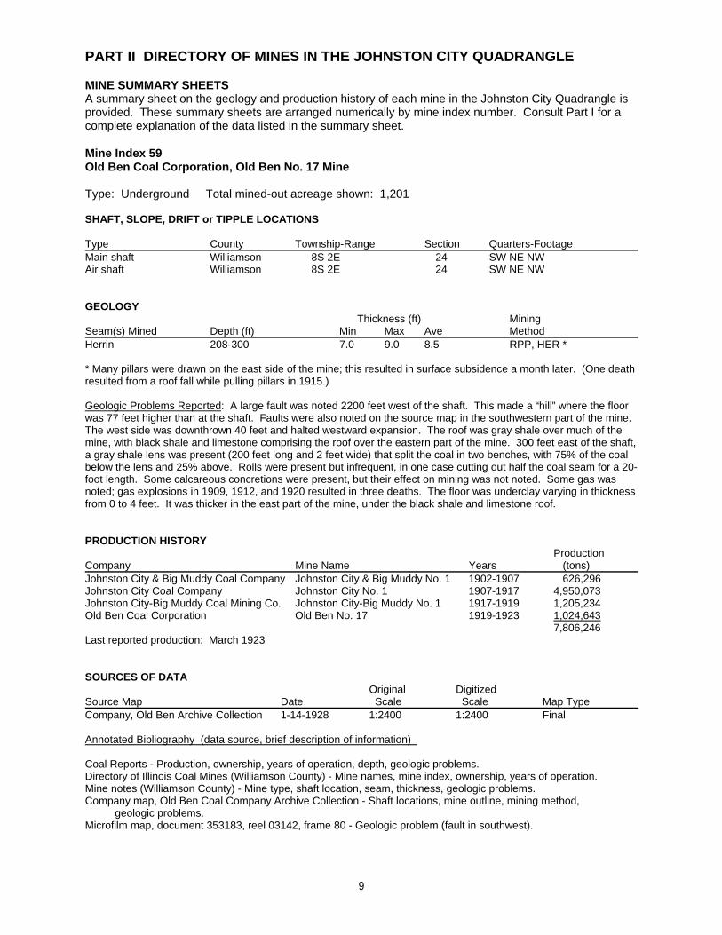
MINE SUMMARY SHEETS . . . . . . . . . . . . . . . . . . . . . . . . . . . . . . . . . . . . . . . . . . . . . . . . . . . . . . . . . . . . . . . . . . . . . . . . 9Mine Index 59
Old Ben Coal Corporation, Old Ben No. 17 Mine . . . . . . . . . . . . . . . . . . . . . . . . . . . . . . . . . . . . . . . . . . . . . . . . . . . 9Mine Index 60
Peabody Coal Company, Peabody No. 3 Mine . . . . . . . . . . . . . . . . . . . . . . . . . . . . . . . . . . . . . . . . . . . . . . . . . . . . 10Mine Index 61
Seymour Coal Mining Corporation, Freeman Spur Mine . . . . . . . . . . . . . . . . . . . . . . . . . . . . . . . . . . . . . . . . . . . . . 11Mine Index 65
Chicago & Big Muddy Coal & Coke Company, Big Muddy No. 1 Mine . . . . . . . . . . . . . . . . . . . . . . . . . . . . . . . . . . 12Mine Index 143
Old Ben Coal Corporation, Old Ben No. 8 Mine . . . . . . . . . . . . . . . . . . . . . . . . . . . . . . . . . . . . . . . . . . . . . . . . . . . 13Mine Index 148
Consolidated Coal Company of St. Louis, Lake Creek Mine . . . . . . . . . . . . . . . . . . . . . . . . . . . . . . . . . . . . . . . . . . 14Mine Index 149
Crear-Clinch Coal Company, McClintock Mine . . . . . . . . . . . . . . . . . . . . . . . . . . . . . . . . . . . . . . . . . . . . . . . . . . . . 15Mine Index 150
Johnston City Washed Coal Company, White Ash Mine . . . . . . . . . . . . . . . . . . . . . . . . . . . . . . . . . . . . . . . . . . . . . 16Mine Index 151
Slogo Coal Corporation, Slogo Mine . . . . . . . . . . . . . . . . . . . . . . . . . . . . . . . . . . . . . . . . . . . . . . . . . . . . . . . . . . . . 17Mine Index 154
Franco Mining Corporation, Franco No. 1 Mine . . . . . . . . . . . . . . . . . . . . . . . . . . . . . . . . . . . . . . . . . . . . . . . . . . . 18Mine Index 155
Old Ben Coal Corporation, Old Ben No. 18 Mine . . . . . . . . . . . . . . . . . . . . . . . . . . . . . . . . . . . . . . . . . . . . . . . . . . 19Mine Index 156
Chicago, Wilmington & Franklin Mining Company, B Mine . . . . . . . . . . . . . . . . . . . . . . . . . . . . . . . . . . . . . . . . . . . 20Mine Index 157
Peabody Coal Company, Peabody No. 26 Mine . . . . . . . . . . . . . . . . . . . . . . . . . . . . . . . . . . . . . . . . . . . . . . . . . . . 21Mine Index 160
Skaggs Coal Company, Skaggs Mine . . . . . . . . . . . . . . . . . . . . . . . . . . . . . . . . . . . . . . . . . . . . . . . . . . . . . . . . . . . 22Mine Index 169
West Virginia Coal Company, West Virginia No. 1 Mine . . . . . . . . . . . . . . . . . . . . . . . . . . . . . . . . . . . . . . . . . . . . . 23Mine Index 170
W. N. Stroud, Stroud Mine . . . . . . . . . . . . . . . . . . . . . . . . . . . . . . . . . . . . . . . . . . . . . . . . . . . . . . . . . . . . . . . . . . . 24Mine Index 171
Brown & Ingram, Binkley Mine . . . . . . . . . . . . . . . . . . . . . . . . . . . . . . . . . . . . . . . . . . . . . . . . . . . . . . . . . . . . . . . . 25Mine Index 172
John W. Spiller, Spiller Mine . . . . . . . . . . . . . . . . . . . . . . . . . . . . . . . . . . . . . . . . . . . . . . . . . . . . . . . . . . . . . . . . . . 26Mine Index 173
Henderson & Wallace Coal Company, Henderson & Wallace No. 1 Mine . . . . . . . . . . . . . . . . . . . . . . . . . . . . . . . 27Mine Index 321
Cosgrove-Meehan Coal Company, Cosgrove-Meehan No. 2 Mine . . . . . . . . . . . . . . . . . . . . . . . . . . . . . . . . . . . . . 28Mine Index 322
Southern Illinois Coal & Coke Company, Oak Ridge Mine . . . . . . . . . . . . . . . . . . . . . . . . . . . . . . . . . . . . . . . . . . . 29Mine Index 323
Carterville District Coal Company, Carterville District No. 6 Mine . . . . . . . . . . . . . . . . . . . . . . . . . . . . . . . . . . . . . . 30
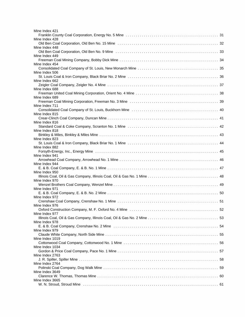
Mine Index 421Franklin County Coal Corporation, Energy No. 5 Mine . . . . . . . . . . . . . . . . . . . . . . . . . . . . . . . . . . . . . . . . . . . . . . 31
Mine Index 428Old Ben Coal Corporation, Old Ben No. 15 Mine . . . . . . . . . . . . . . . . . . . . . . . . . . . . . . . . . . . . . . . . . . . . . . . . . . 32
Mine Index 448Old Ben Coal Corporation, Old Ben No. 9 Mine . . . . . . . . . . . . . . . . . . . . . . . . . . . . . . . . . . . . . . . . . . . . . . . . . . . 33
Mine Index 449Freeman Coal Mining Company, Bobby Dick Mine . . . . . . . . . . . . . . . . . . . . . . . . . . . . . . . . . . . . . . . . . . . . . . . . . 34
Mine Index 454Consolidated Coal Company of St. Louis, New Monarch Mine . . . . . . . . . . . . . . . . . . . . . . . . . . . . . . . . . . . . . . . . 35
Mine Index 506St. Louis Coal & Iron Company, Black Briar No. 2 Mine . . . . . . . . . . . . . . . . . . . . . . . . . . . . . . . . . . . . . . . . . . . . . 36
Mine Index 662Zeigler Coal Company, Zeigler No. 4 Mine . . . . . . . . . . . . . . . . . . . . . . . . . . . . . . . . . . . . . . . . . . . . . . . . . . . . . . . 37
Mine Index 688Freeman United Coal Mining Corporation, Orient No. 4 Mine . . . . . . . . . . . . . . . . . . . . . . . . . . . . . . . . . . . . . . . . . 38
Mine Index 689Freeman Coal Mining Corporation, Freeman No. 3 Mine . . . . . . . . . . . . . . . . . . . . . . . . . . . . . . . . . . . . . . . . . . . . 39
Mine Index 711Consolidated Coal Company of St. Louis, Buckhorn Mine . . . . . . . . . . . . . . . . . . . . . . . . . . . . . . . . . . . . . . . . . . . 40
Mine Index 815Crear-Clinch Coal Company, Duncan Mine . . . . . . . . . . . . . . . . . . . . . . . . . . . . . . . . . . . . . . . . . . . . . . . . . . . . . . . 41
Mine Index 816Standard Coal & Coke Company, Scranton No. 1 Mine . . . . . . . . . . . . . . . . . . . . . . . . . . . . . . . . . . . . . . . . . . . . . 42
Mine Index 818Binkley & Miles, Binkley & Miles Mine . . . . . . . . . . . . . . . . . . . . . . . . . . . . . . . . . . . . . . . . . . . . . . . . . . . . . . . . . . . 43
Mine Index 823St. Louis Coal & Iron Company, Black Briar No. 1 Mine . . . . . . . . . . . . . . . . . . . . . . . . . . . . . . . . . . . . . . . . . . . . . 44
Mine Index 882Forsyth-Energy, Inc., Energy Mine . . . . . . . . . . . . . . . . . . . . . . . . . . . . . . . . . . . . . . . . . . . . . . . . . . . . . . . . . . . . . 45
Mine Index 941Arrowhead Coal Company, Arrowhead No. 1 Mine . . . . . . . . . . . . . . . . . . . . . . . . . . . . . . . . . . . . . . . . . . . . . . . . . 46
Mine Index 944E. & B. Coal Company, E. & B. No. 1 Mine . . . . . . . . . . . . . . . . . . . . . . . . . . . . . . . . . . . . . . . . . . . . . . . . . . . . . . . 47
Mine Index 950Illinois Coal, Oil & Gas Company, Illinois Coal, Oil & Gas No. 1 Mine . . . . . . . . . . . . . . . . . . . . . . . . . . . . . . . . . . . 48
Mine Index 970Wenzel Brothers Coal Company, Wenzel Mine . . . . . . . . . . . . . . . . . . . . . . . . . . . . . . . . . . . . . . . . . . . . . . . . . . . . 49
Mine Index 971E. & B. Coal Company, E. & B. No. 2 Mine . . . . . . . . . . . . . . . . . . . . . . . . . . . . . . . . . . . . . . . . . . . . . . . . . . . . . . . 50
Mine Index 972Crenshaw Coal Company, Crenshaw No. 1 Mine . . . . . . . . . . . . . . . . . . . . . . . . . . . . . . . . . . . . . . . . . . . . . . . . . . 51
Mine Index 976Oxford Construction Company, M. F. Oxford No. 4 Mine . . . . . . . . . . . . . . . . . . . . . . . . . . . . . . . . . . . . . . . . . . . . 52
Mine Index 977Illinois Coal, Oil & Gas Company, Illinois Coal, Oil & Gas No. 2 Mine . . . . . . . . . . . . . . . . . . . . . . . . . . . . . . . . . . . 53
Mine Index 978E. & B. Coal Company, Crenshaw No. 2 Mine . . . . . . . . . . . . . . . . . . . . . . . . . . . . . . . . . . . . . . . . . . . . . . . . . . . . 54
Mine Index 979Claude White Company, North Side Mine . . . . . . . . . . . . . . . . . . . . . . . . . . . . . . . . . . . . . . . . . . . . . . . . . . . . . . . . 55
Mine Index 1019Cottonwood Coal Company, Cottonwood No. 1 Mine . . . . . . . . . . . . . . . . . . . . . . . . . . . . . . . . . . . . . . . . . . . . . . . 56
Mine Index 1034Gordon & Price Coal Company, Pace No. 1 Mine . . . . . . . . . . . . . . . . . . . . . . . . . . . . . . . . . . . . . . . . . . . . . . . . . . 57
Mine Index 2763J. R. Spiller, Spiller Mine . . . . . . . . . . . . . . . . . . . . . . . . . . . . . . . . . . . . . . . . . . . . . . . . . . . . . . . . . . . . . . . . . . . . . 58
Mine Index 2764Polinski Coal Company, Dog Walk Mine . . . . . . . . . . . . . . . . . . . . . . . . . . . . . . . . . . . . . . . . . . . . . . . . . . . . . . . . . 59
Mine Index 3649Clarence W. Thomas, Thomas Mine . . . . . . . . . . . . . . . . . . . . . . . . . . . . . . . . . . . . . . . . . . . . . . . . . . . . . . . . . . . . 60
Mine Index 3665W. N. Stroud, Stroud Mine . . . . . . . . . . . . . . . . . . . . . . . . . . . . . . . . . . . . . . . . . . . . . . . . . . . . . . . . . . . . . . . . . . . 61
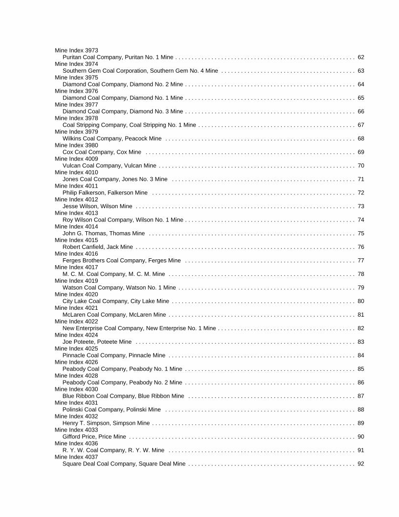
Mine Index 3973Puritan Coal Company, Puritan No. 1 Mine . . . . . . . . . . . . . . . . . . . . . . . . . . . . . . . . . . . . . . . . . . . . . . . . . . . . . . . 62
Mine Index 3974Southern Gem Coal Corporation, Southern Gem No. 4 Mine . . . . . . . . . . . . . . . . . . . . . . . . . . . . . . . . . . . . . . . . . 63
Mine Index 3975Diamond Coal Company, Diamond No. 2 Mine . . . . . . . . . . . . . . . . . . . . . . . . . . . . . . . . . . . . . . . . . . . . . . . . . . . . 64
Mine Index 3976Diamond Coal Company, Diamond No. 1 Mine . . . . . . . . . . . . . . . . . . . . . . . . . . . . . . . . . . . . . . . . . . . . . . . . . . . . 65
Mine Index 3977Diamond Coal Company, Diamond No. 3 Mine . . . . . . . . . . . . . . . . . . . . . . . . . . . . . . . . . . . . . . . . . . . . . . . . . . . . 66
Mine Index 3978Coal Stripping Company, Coal Stripping No. 1 Mine . . . . . . . . . . . . . . . . . . . . . . . . . . . . . . . . . . . . . . . . . . . . . . . . 67
Mine Index 3979Wilkins Coal Company, Peacock Mine . . . . . . . . . . . . . . . . . . . . . . . . . . . . . . . . . . . . . . . . . . . . . . . . . . . . . . . . . . 68
Mine Index 3980Cox Coal Company, Cox Mine . . . . . . . . . . . . . . . . . . . . . . . . . . . . . . . . . . . . . . . . . . . . . . . . . . . . . . . . . . . . . . . . 69
Mine Index 4009Vulcan Coal Company, Vulcan Mine . . . . . . . . . . . . . . . . . . . . . . . . . . . . . . . . . . . . . . . . . . . . . . . . . . . . . . . . . . . . 70
Mine Index 4010Jones Coal Company, Jones No. 3 Mine . . . . . . . . . . . . . . . . . . . . . . . . . . . . . . . . . . . . . . . . . . . . . . . . . . . . . . . . 71
Mine Index 4011Philip Falkerson, Falkerson Mine . . . . . . . . . . . . . . . . . . . . . . . . . . . . . . . . . . . . . . . . . . . . . . . . . . . . . . . . . . . . . . 72
Mine Index 4012Jesse Wilson, Wilson Mine . . . . . . . . . . . . . . . . . . . . . . . . . . . . . . . . . . . . . . . . . . . . . . . . . . . . . . . . . . . . . . . . . . . 73
Mine Index 4013Roy Wilson Coal Company, Wilson No. 1 Mine . . . . . . . . . . . . . . . . . . . . . . . . . . . . . . . . . . . . . . . . . . . . . . . . . . . . 74
Mine Index 4014John G. Thomas, Thomas Mine . . . . . . . . . . . . . . . . . . . . . . . . . . . . . . . . . . . . . . . . . . . . . . . . . . . . . . . . . . . . . . . 75
Mine Index 4015Robert Canfield, Jack Mine . . . . . . . . . . . . . . . . . . . . . . . . . . . . . . . . . . . . . . . . . . . . . . . . . . . . . . . . . . . . . . . . . . . 76
Mine Index 4016Ferges Brothers Coal Company, Ferges Mine . . . . . . . . . . . . . . . . . . . . . . . . . . . . . . . . . . . . . . . . . . . . . . . . . . . . 77
Mine Index 4017M. C. M. Coal Company, M. C. M. Mine . . . . . . . . . . . . . . . . . . . . . . . . . . . . . . . . . . . . . . . . . . . . . . . . . . . . . . . . . 78
Mine Index 4019Watson Coal Company, Watson No. 1 Mine . . . . . . . . . . . . . . . . . . . . . . . . . . . . . . . . . . . . . . . . . . . . . . . . . . . . . . 79
Mine Index 4020City Lake Coal Company, City Lake Mine . . . . . . . . . . . . . . . . . . . . . . . . . . . . . . . . . . . . . . . . . . . . . . . . . . . . . . . . 80
Mine Index 4021McLaren Coal Company, McLaren Mine . . . . . . . . . . . . . . . . . . . . . . . . . . . . . . . . . . . . . . . . . . . . . . . . . . . . . . . . . 81
Mine Index 4022New Enterprise Coal Company, New Enterprise No. 1 Mine . . . . . . . . . . . . . . . . . . . . . . . . . . . . . . . . . . . . . . . . . . 82
Mine Index 4024Joe Poteete, Poteete Mine . . . . . . . . . . . . . . . . . . . . . . . . . . . . . . . . . . . . . . . . . . . . . . . . . . . . . . . . . . . . . . . . . . . 83
Mine Index 4025Pinnacle Coal Company, Pinnacle Mine . . . . . . . . . . . . . . . . . . . . . . . . . . . . . . . . . . . . . . . . . . . . . . . . . . . . . . . . . 84
Mine Index 4026Peabody Coal Company, Peabody No. 1 Mine . . . . . . . . . . . . . . . . . . . . . . . . . . . . . . . . . . . . . . . . . . . . . . . . . . . . 85
Mine Index 4028Peabody Coal Company, Peabody No. 2 Mine . . . . . . . . . . . . . . . . . . . . . . . . . . . . . . . . . . . . . . . . . . . . . . . . . . . . 86
Mine Index 4030Blue Ribbon Coal Company, Blue Ribbon Mine . . . . . . . . . . . . . . . . . . . . . . . . . . . . . . . . . . . . . . . . . . . . . . . . . . . 87
Mine Index 4031Polinski Coal Company, Polinski Mine . . . . . . . . . . . . . . . . . . . . . . . . . . . . . . . . . . . . . . . . . . . . . . . . . . . . . . . . . . 88
Mine Index 4032Henry T. Simpson, Simpson Mine . . . . . . . . . . . . . . . . . . . . . . . . . . . . . . . . . . . . . . . . . . . . . . . . . . . . . . . . . . . . . . 89
Mine Index 4033Gifford Price, Price Mine . . . . . . . . . . . . . . . . . . . . . . . . . . . . . . . . . . . . . . . . . . . . . . . . . . . . . . . . . . . . . . . . . . . . . 90
Mine Index 4036R. Y. W. Coal Company, R. Y. W. Mine . . . . . . . . . . . . . . . . . . . . . . . . . . . . . . . . . . . . . . . . . . . . . . . . . . . . . . . . . 91
Mine Index 4037Square Deal Coal Company, Square Deal Mine . . . . . . . . . . . . . . . . . . . . . . . . . . . . . . . . . . . . . . . . . . . . . . . . . . . 92
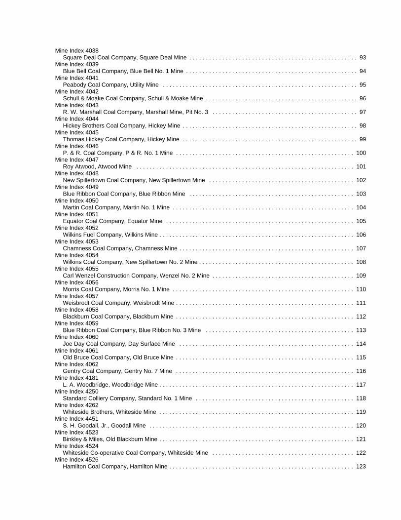
Mine Index 4038Square Deal Coal Company, Square Deal Mine . . . . . . . . . . . . . . . . . . . . . . . . . . . . . . . . . . . . . . . . . . . . . . . . . . . 93
Mine Index 4039Blue Bell Coal Company, Blue Bell No. 1 Mine . . . . . . . . . . . . . . . . . . . . . . . . . . . . . . . . . . . . . . . . . . . . . . . . . . . . 94
Mine Index 4041Peabody Coal Company, Utility Mine . . . . . . . . . . . . . . . . . . . . . . . . . . . . . . . . . . . . . . . . . . . . . . . . . . . . . . . . . . . 95
Mine Index 4042Schull & Moake Coal Company, Schull & Moake Mine . . . . . . . . . . . . . . . . . . . . . . . . . . . . . . . . . . . . . . . . . . . . . . 96
Mine Index 4043R. W. Marshall Coal Company, Marshall Mine, Pit No. 3 . . . . . . . . . . . . . . . . . . . . . . . . . . . . . . . . . . . . . . . . . . . . 97
Mine Index 4044Hickey Brothers Coal Company, Hickey Mine . . . . . . . . . . . . . . . . . . . . . . . . . . . . . . . . . . . . . . . . . . . . . . . . . . . . . 98
Mine Index 4045Thomas Hickey Coal Company, Hickey Mine . . . . . . . . . . . . . . . . . . . . . . . . . . . . . . . . . . . . . . . . . . . . . . . . . . . . . 99
Mine Index 4046P. & R. Coal Company, P & R. No. 1 Mine . . . . . . . . . . . . . . . . . . . . . . . . . . . . . . . . . . . . . . . . . . . . . . . . . . . . . . 100
Mine Index 4047Roy Atwood, Atwood Mine . . . . . . . . . . . . . . . . . . . . . . . . . . . . . . . . . . . . . . . . . . . . . . . . . . . . . . . . . . . . . . . . . . 101
Mine Index 4048New Spillertown Coal Company, New Spillertown Mine . . . . . . . . . . . . . . . . . . . . . . . . . . . . . . . . . . . . . . . . . . . . 102
Mine Index 4049Blue Ribbon Coal Company, Blue Ribbon Mine . . . . . . . . . . . . . . . . . . . . . . . . . . . . . . . . . . . . . . . . . . . . . . . . . . 103
Mine Index 4050Martin Coal Company, Martin No. 1 Mine . . . . . . . . . . . . . . . . . . . . . . . . . . . . . . . . . . . . . . . . . . . . . . . . . . . . . . . 104
Mine Index 4051Equator Coal Company, Equator Mine . . . . . . . . . . . . . . . . . . . . . . . . . . . . . . . . . . . . . . . . . . . . . . . . . . . . . . . . . 105
Mine Index 4052Wilkins Fuel Company, Wilkins Mine . . . . . . . . . . . . . . . . . . . . . . . . . . . . . . . . . . . . . . . . . . . . . . . . . . . . . . . . . . . 106
Mine Index 4053Chamness Coal Company, Chamness Mine . . . . . . . . . . . . . . . . . . . . . . . . . . . . . . . . . . . . . . . . . . . . . . . . . . . . . 107
Mine Index 4054Wilkins Coal Company, New Spillertown No. 2 Mine . . . . . . . . . . . . . . . . . . . . . . . . . . . . . . . . . . . . . . . . . . . . . . . 108
Mine Index 4055Carl Wenzel Construction Company, Wenzel No. 2 Mine . . . . . . . . . . . . . . . . . . . . . . . . . . . . . . . . . . . . . . . . . . . 109
Mine Index 4056Morris Coal Company, Morris No. 1 Mine . . . . . . . . . . . . . . . . . . . . . . . . . . . . . . . . . . . . . . . . . . . . . . . . . . . . . . . 110
Mine Index 4057Weisbrodt Coal Company, Weisbrodt Mine . . . . . . . . . . . . . . . . . . . . . . . . . . . . . . . . . . . . . . . . . . . . . . . . . . . . . . 111
Mine Index 4058Blackburn Coal Company, Blackburn Mine . . . . . . . . . . . . . . . . . . . . . . . . . . . . . . . . . . . . . . . . . . . . . . . . . . . . . . 112
Mine Index 4059Blue Ribbon Coal Company, Blue Ribbon No. 3 Mine . . . . . . . . . . . . . . . . . . . . . . . . . . . . . . . . . . . . . . . . . . . . . 113
Mine Index 4060Joe Day Coal Company, Day Surface Mine . . . . . . . . . . . . . . . . . . . . . . . . . . . . . . . . . . . . . . . . . . . . . . . . . . . . . 114
Mine Index 4061Old Bruce Coal Company, Old Bruce Mine . . . . . . . . . . . . . . . . . . . . . . . . . . . . . . . . . . . . . . . . . . . . . . . . . . . . . . 115
Mine Index 4062Gentry Coal Company, Gentry No. 7 Mine . . . . . . . . . . . . . . . . . . . . . . . . . . . . . . . . . . . . . . . . . . . . . . . . . . . . . . 116
Mine Index 4181L. A. Woodbridge, Woodbridge Mine . . . . . . . . . . . . . . . . . . . . . . . . . . . . . . . . . . . . . . . . . . . . . . . . . . . . . . . . . . . 117
Mine Index 4250Standard Colliery Company, Standard No. 1 Mine . . . . . . . . . . . . . . . . . . . . . . . . . . . . . . . . . . . . . . . . . . . . . . . . 118
Mine Index 4262Whiteside Brothers, Whiteside Mine . . . . . . . . . . . . . . . . . . . . . . . . . . . . . . . . . . . . . . . . . . . . . . . . . . . . . . . . . . . 119
Mine Index 4451S. H. Goodall, Jr., Goodall Mine . . . . . . . . . . . . . . . . . . . . . . . . . . . . . . . . . . . . . . . . . . . . . . . . . . . . . . . . . . . . . . 120
Mine Index 4523Binkley & Miles, Old Blackburn Mine . . . . . . . . . . . . . . . . . . . . . . . . . . . . . . . . . . . . . . . . . . . . . . . . . . . . . . . . . . . 121
Mine Index 4524Whiteside Co-operative Coal Company, Whiteside Mine . . . . . . . . . . . . . . . . . . . . . . . . . . . . . . . . . . . . . . . . . . . 122
Mine Index 4526Hamilton Coal Company, Hamilton Mine . . . . . . . . . . . . . . . . . . . . . . . . . . . . . . . . . . . . . . . . . . . . . . . . . . . . . . . . 123
Mine Index 4527Equator Coal Company, Equator Mine . . . . . . . . . . . . . . . . . . . . . . . . . . . . . . . . . . . . . . . . . . . . . . . . . . . . . . . . . 124
Mine Index 4959Spillertown Coal & Coke Company, Spillertown Mine . . . . . . . . . . . . . . . . . . . . . . . . . . . . . . . . . . . . . . . . . . . . . . 125
Mine Index 6496Red Ring Coal Company, Red Ring No. 2 Mine . . . . . . . . . . . . . . . . . . . . . . . . . . . . . . . . . . . . . . . . . . . . . . . . . . 126
Mine Index 6557L. L. Wilkinson Coal Company, Wilkinson Mine . . . . . . . . . . . . . . . . . . . . . . . . . . . . . . . . . . . . . . . . . . . . . . . . . . 127
Mine Index 6650M. Hampton, Hampton Mine . . . . . . . . . . . . . . . . . . . . . . . . . . . . . . . . . . . . . . . . . . . . . . . . . . . . . . . . . . . . . . . . . 128
Mine Index 6664Vulcan Coal Company, Vulcan Mine . . . . . . . . . . . . . . . . . . . . . . . . . . . . . . . . . . . . . . . . . . . . . . . . . . . . . . . . . . . 129
Mine Index 6747Mammoth Coal Company, Mammoth Mine . . . . . . . . . . . . . . . . . . . . . . . . . . . . . . . . . . . . . . . . . . . . . . . . . . . . . . 130
Mine Index 6767Rankin & Scott, Black Diamond Mine . . . . . . . . . . . . . . . . . . . . . . . . . . . . . . . . . . . . . . . . . . . . . . . . . . . . . . . . . . 131
Mine Index 6792Wallace Coal Company, Wallace Mine . . . . . . . . . . . . . . . . . . . . . . . . . . . . . . . . . . . . . . . . . . . . . . . . . . . . . . . . . 132
Mine Index 6793R. A. Canfield, Canfield Mine . . . . . . . . . . . . . . . . . . . . . . . . . . . . . . . . . . . . . . . . . . . . . . . . . . . . . . . . . . . . . . . . 133
Mine Index 6796C. H. Rumberg Coal Company, Rumberg Mine . . . . . . . . . . . . . . . . . . . . . . . . . . . . . . . . . . . . . . . . . . . . . . . . . . 134
Mine Index 6797Snyder Coal Company, Snyder Mine . . . . . . . . . . . . . . . . . . . . . . . . . . . . . . . . . . . . . . . . . . . . . . . . . . . . . . . . . . 135
Mine Index 6798Keller Coal Company, Keller Mine . . . . . . . . . . . . . . . . . . . . . . . . . . . . . . . . . . . . . . . . . . . . . . . . . . . . . . . . . . . . . 136
Mine Index 6799Davis Coal Company, Davis Mine . . . . . . . . . . . . . . . . . . . . . . . . . . . . . . . . . . . . . . . . . . . . . . . . . . . . . . . . . . . . . 137
Mine Index 6809Polinski Coal Company, Polinski Mine . . . . . . . . . . . . . . . . . . . . . . . . . . . . . . . . . . . . . . . . . . . . . . . . . . . . . . . . . 138
OTHER MINES SHOWN ON THE JOHNSTON CITY QUADRANGLE . . . . . . . . . . . . . . . . . . . . . . . . . . . . . . . . . . . . . 139Mine Index 4441 . . . . . . . . . . . . . . . . . . . . . . . . . . . . . . . . . . . . . . . . . . . . . . . . . . . . . . . . . . . . . . . . . . . . . . . . . . . . 139Mine Index 4443 . . . . . . . . . . . . . . . . . . . . . . . . . . . . . . . . . . . . . . . . . . . . . . . . . . . . . . . . . . . . . . . . . . . . . . . . . . . . 139Mine Index 4444 . . . . . . . . . . . . . . . . . . . . . . . . . . . . . . . . . . . . . . . . . . . . . . . . . . . . . . . . . . . . . . . . . . . . . . . . . . . . 139Mine Index 4445 . . . . . . . . . . . . . . . . . . . . . . . . . . . . . . . . . . . . . . . . . . . . . . . . . . . . . . . . . . . . . . . . . . . . . . . . . . . . 139Mine Index 4682 . . . . . . . . . . . . . . . . . . . . . . . . . . . . . . . . . . . . . . . . . . . . . . . . . . . . . . . . . . . . . . . . . . . . . . . . . . . . 139Mine Index 4714 . . . . . . . . . . . . . . . . . . . . . . . . . . . . . . . . . . . . . . . . . . . . . . . . . . . . . . . . . . . . . . . . . . . . . . . . . . . . 139
MINES WHOSE LOCATIONS ARE NOT KNOWN, JOHNSTON CITY QUADRANGLE . . . . . . . . . . . . . . . . . . . . . . . . 139
INDEX OF MINES IN THE JOHNSTON CITY QUADRANGLE . . . . . . . . . . . . . . . . . . . . . . . . . . . . . . . . . . . . . . . . . . . 147

INTRODUCTIONCoal has been mined in 76 counties of Illinois. More than 7,400 coal mines have operated sincecommercial mining began in Illinois about 1810; fewer than 30 are currently active. To detail the extentand location of coal mining in Illinois, the Illinois State Geological Survey (ISGS) has compiled maps anddirectories of known coal mines. The ISGS offers maps at a scale of 1:100,000 and accompanyingdirectories for each county in which coal mining is known to have occurred. Maps at a scale of 1:24,000and accompanying directories such as this are available for selected quadrangles. Contact the ISGS for alist of these quadrangles.
These larger scale maps show the approximate positions of mines in relation to surface features such asroads and water bodies, and indicate the mining method used and the accuracy of the mine boundaries. The maps are useful for locating mine boundaries relative to specific properties and for assessing thepotential for subsidence in an area. Mine boundaries compiled from final mine surveys are generallyshown within 200 feet of their true position. As a result of poor cartographic quality and inaccuracies in theoriginal mine surveys, boundaries of some older mines may be mislocated on the map by 500 feet ormore. Original mine maps should be consulted in situations that require precise delineation of mineboundaries or internal workings of mined areas.
The directory serves as a key to the accompanying mine map and provides basic information on the coalmines. The directory is composed of two parts. Part I explains the symbols and patterns used on theaccompanying map and the summary data presented for each mine. Part II numerically lists the mines inthe quadrangle and summarizes the geology and production history of each mine.
MINING IN THE JOHNSTON CITY QUADRANGLE
Two minable coal seams crop out in the Johnston City Quadrangle: the Herrin and Springfield Coals. Since both coals are close to the surface, both were surface mined as well as underground mined. TheHerrin Coal is quite thick in this area, in some rare cases up to 14 feet, but more commonly 8 to 10 feet. The roof was typically the Energy Shale, 40 feet or more thick. This massive, sandy shale created roofproblems for many mines. Top coal was often left to help support the roof, although that was sometimesmined on retreat from the rooms. The Cottage Grove Fault System and the White Ash Fault Zone bothhad an impact on mining in the quadrangle, but as the accompanying map shows, these faults did notprevent mining. Various geologic problems such as coal balls, rolls, and slips in the seam causedproblems, but none prevented mining.
1
2
PART I EXPLANATION OF MAP AND MINE SUMMARY SHEET
INTERPRETING THE MAP
The map accompanying this directory shows the location of coal mines known to be present in the quadrangle. Themap, corresponding to a U.S. Geological Survey (USGS) 7.5-minute quadrangle, covers an area bounded by lines oflatitude and longitude 7.5-minutes apart. In Illinois, a quadrangle is approximately 6.5 miles east to west and 8.5miles north to south, an area of about 56 square miles. The ISGS generally offers one map of mines per quadrangle. In some areas where extensive mining occurred in two or more overlapping seams, separate maps are compiled formines in each seam to maintain readability of the map.
Mine Type and Mining MethodThe mine type is indicated on the map by pattern color: green represents surface mines; red and yellow representunderground mines. The red patterns are used for areas of underground mining that are documented by a primary orsecondary source map. A yellow pattern is used for cases where no map of the mine workings is available, but ageneral area of mining can be inferred from property maps or production figures. The patterns indicate the mainmining methods used in underground mines. The methods are (1) room and pillar and (2) high extraction. Themethod used gives some indication of the amount and pattern of coal extraction within each mined area, and hassome influence on the timing and type of subsidence that can occur over a mine.
The following discussion and illustrations of mining methods are based on Guither et al. (1984).
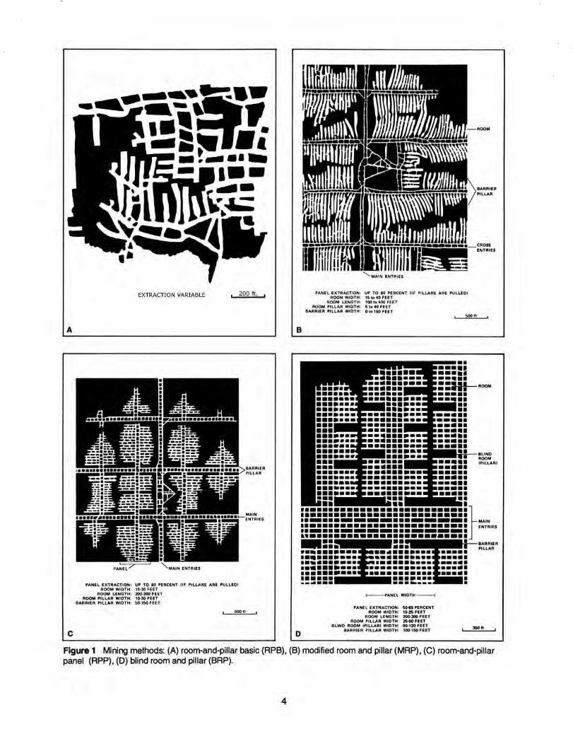
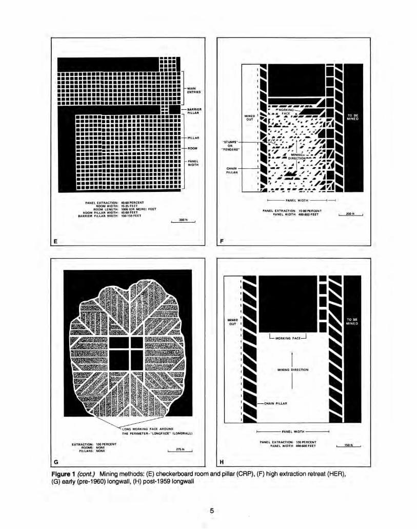
In room-and-pillar mines, coal is removed from haulage-ways (entries) and selected areas called rooms. Pillars ofunmined coal are left between the rooms to support the roof. Depending on the size of rooms and pillars, the amountof coal removed from the production areas will range from 40% to 70%.
Room and Pillar - mining is divided into six categories:• room-and-pillar basic (RPB, fig. 1A), an early method that did not follow a preset mining plan and therefore
resulted in very irregular designs;• modified room and pillar (MRP, fig. 1B);• room-and-pillar panel (RPP, fig. 1C);• blind room and pillar (BRP, fig. 1D);• checkerboard room and pillar (CRP, fig. 1E);• room and pillar (RP), a classification used when the specific type of room-and-pillar mining is unknown.
Blind and checkerboard are the most common types of room-and-pillar mining used in Illinois today. The knowledgeof room-and-pillar mining methods gives a trained engineer information on the nature of subsidence that may occur. A more extensive discussion of subsidence can be found in Bauer et al. (1993).
High-extraction These mining methods are subdivided into high-extraction retreat (HER, Fig 1F) and longwall (LW,Fig 1G, 1H). In these methods, much of the coal is removed within well defined areas of the mine. Subsidence of thesurface above these areas occurs within weeks. Once the subsidence activity ceases, the potential for furthermovement over these areas is low; however, subsidence may continue for several years after mining.
High-extraction retreat mining is a form of room-and-pillar mining that extracts most of the coal. Rooms and pillarsare developed in the panels, and the pillars are then systematically removed (fig. 1F).
In early (pre-1960) longwall mines, mining advanced in multiple directions from a central shaft (fig. 1G). Large pillars of coal were left around the shaft, but all coal was removed beyond these pillars. Minersplaced rock and wooden props and cribs in the mined-out areas to support the mine roof. The overlying rockgradually settled onto these supports, thus producing subsidence at the surface. In post-1959 longwall mines, room-and-pillar methods have been used to develop the main entries of the mine and panel areas. Modern longwallmethods extract 100 percent of the coal in the panel areas (fig. 1H).
3
SOURCE MAPS
Mine outlines depicted on the map are, whenever possible, based on maps made from original mine surveys. Theprocess of compiling and digitizing the quadrangle map may produce errors of less than 200 feet in the location ofmine boundaries. Larger errors of 500 feet or more are possible for mines that have incomplete or inaccurate sourcemaps.
Because of the extreme complexity of some mine maps, detailed features of mined areas have been omitted. Thedigitized mine boundary includes the exterior boundary of all rooms or entries that were at least 80 feet wide orprotruded 500 feet from the main mining area. Unmined areas between mines are shown if they are at least 80 feetwide; unmined blocks of coal within mines are shown if they are at least 400 feet on each side. Original source mapsshould be consulted when precise information on mine boundaries or interior features is needed.
The mine summary sheet lists the source maps used to determine each mine outline. The completeness of mapsources is indicated on the map by a line symbol at the mine boundary. Source maps are organized in fivecategories.
Final mine map The mine outline was digitized from an original map made from mine surveys conducted within afew months after production ceased. The date of the map and the last reported production are listed on the summarysheet.
Not a final map The mine is currently active or the mine outline was made from a map based on mine surveysconducted more than few months before production ceased. This implies the actual mined-out area is probably largerthan the outline on the map. The mine summary sheet indicated the dates of source maps and the last reportedproduction, as well as the approximate tonnage mined between these two dates (if the mine is abandoned). Thesummary sheet also lists the approximate acreage mined since the date of the map and, in some cases, indicates thearea where additional mining may have taken place. This latter information is determined by locating on the map theactive faces relative to probable boundaries of the mine property.
Undated map The source map was undated, so it may or may not be based on a final mine survey. Whensufficient data are available, the probable acreage of the mined area is estimated from reported production, averageseam thickness and a recovery rate comparable to other mines in the area. This information is listed in the summarysheet for the mine.
Incomplete map The source map did not show the entire mine. The summary sheet indicates the missing part ofthe mine map and the acreage of the unmapped area, which is estimated from the amount of coal known to havebeen produced from the mine.
Secondary source map The original mine map was not found so the outline shown was determined fromsecondary sources (e.g., outlines from small-scale regional maps published in other reports). The summary sheetdescribes the secondary sources.
POINTS AND LABELS
The locations of all known mine openings (shafts, slopes, and drifts) and surface mine tipples are plotted on the map. Tipples are areas where coal was cleaned, stockpiled, and loaded for shipping.
Only openings or tipples are plotted for mines without source maps. If the precise locations of these features areunknown, a special symbol is used to indicate the approximate location of the mine.
Each mine on the map is labeled with the names of the mine and operating company, ISGS mine index number, andyears of operation (if known) if space permits. A seam designation is given on maps where more than one seam wasmined. For a mine that operated under more than one name, only the most recent name is generally given. When amine changed names or ownership shortly before closing, an earlier name is listed. All company and mine names arelisted on the mine summary sheet in the directory, under the production history segment.
6
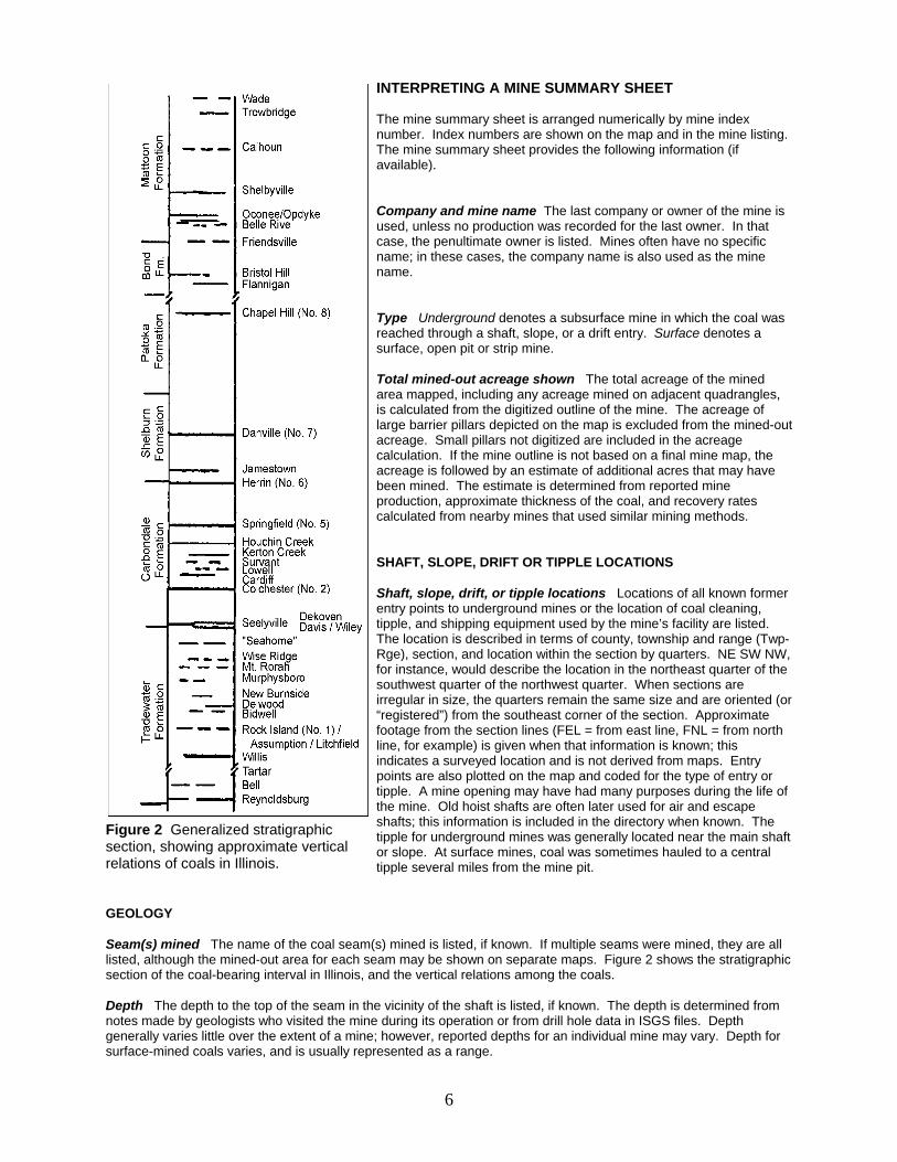
Figure 2 Generalized stratigraphicsection, showing approximate verticalrelations of coals in Illinois.
INTERPRETING A MINE SUMMARY SHEET
The mine summary sheet is arranged numerically by mine indexnumber. Index numbers are shown on the map and in the mine listing. The mine summary sheet provides the following information (ifavailable).
Company and mine name The last company or owner of the mine isused, unless no production was recorded for the last owner. In thatcase, the penultimate owner is listed. Mines often have no specificname; in these cases, the company name is also used as the minename.
Type Underground denotes a subsurface mine in which the coal wasreached through a shaft, slope, or a drift entry. Surface denotes asurface, open pit or strip mine.
Total mined-out acreage shown The total acreage of the minedarea mapped, including any acreage mined on adjacent quadrangles, is calculated from the digitized outline of the mine. The acreage oflarge barrier pillars depicted on the map is excluded from the mined-outacreage. Small pillars not digitized are included in the acreagecalculation. If the mine outline is not based on a final mine map, theacreage is followed by an estimate of additional acres that may havebeen mined. The estimate is determined from reported mineproduction, approximate thickness of the coal, and recovery ratescalculated from nearby mines that used similar mining methods.
SHAFT, SLOPE, DRIFT OR TIPPLE LOCATIONS
Shaft, slope, drift, or tipple locations Locations of all known formerentry points to underground mines or the location of coal cleaning,tipple, and shipping equipment used by the mine’s facility are listed. The location is described in terms of county, township and range (Twp-Rge), section, and location within the section by quarters. NE SW NW,for instance, would describe the location in the northeast quarter of thesouthwest quarter of the northwest quarter. When sections areirregular in size, the quarters remain the same size and are oriented (or“registered”) from the southeast corner of the section. Approximatefootage from the section lines (FEL = from east line, FNL = from northline, for example) is given when that information is known; thisindicates a surveyed location and is not derived from maps. Entrypoints are also plotted on the map and coded for the type of entry ortipple. A mine opening may have had many purposes during the life ofthe mine. Old hoist shafts are often later used for air and escapeshafts; this information is included in the directory when known. Thetipple for underground mines was generally located near the main shaftor slope. At surface mines, coal was sometimes hauled to a centraltipple several miles from the mine pit.
GEOLOGY
Seam(s) mined The name of the coal seam(s) mined is listed, if known. If multiple seams were mined, they are alllisted, although the mined-out area for each seam may be shown on separate maps. Figure 2 shows the stratigraphicsection of the coal-bearing interval in Illinois, and the vertical relations among the coals.
Depth The depth to the top of the seam in the vicinity of the shaft is listed, if known. The depth is determined fromnotes made by geologists who visited the mine during its operation or from drill hole data in ISGS files. Depthgenerally varies little over the extent of a mine; however, reported depths for an individual mine may vary. Depth forsurface-mined coals varies, and is usually represented as a range.
7
Thickness The approximate thickness of the mined seam is shown, if known. Thickness also comes from notes ofgeologists who visited the mine during its operation or from borehole data in ISGS files. Minimum, maximum, andaverage thicknesses are given when this information is available.
Mining method The principal mining method used at the mine (figs. 1A-H) is listed. See the mining methodssection at the beginning of this directory for a discussion of this parameter.
Geologic problems reported Any known geologic problems, such as faults, water seepage, floor heaving, andunstable roof, encountered in the mine are reported. This information is from notes made by ISGS geologists whovisited the mine, or from reports by mine inspectors published by the Illinois Department of Mines and Minerals, orfrom the source map(s). Geologic problems are not reported for active mines.
PRODUCTION HISTORY
Production history Tons of coal produced from the mine by each mine owner are totaled. When the source mapused for the mine outline is not a final mine map, the tonnage produced since the date of the map is identified. Formines that extend into adjacent quadrangles, the tonnage reported includes areas mined in adjacent quadrangles.
SOURCE OF DATA
Source map This section lists information about the map(s) used to compile the mine outline and the locations oftipples and mine openings. In some cases more than one source map was used. For example, a map drawn beforethe mine closed may provide better information on original areas of the mine than a later map. When more than onemap was used, the bibliography section explains what information was taken from each source.
Date The date of the most recent mine survey listed on the source map is reported.
Original scale The original scale of the source map is listed. Many maps are photo-reductions and are no longer attheir original scale. The original scale gives some indication of the level of detail of the mine outline and the accuracyof the mine boundary relative to surface features. Generally, the larger the scale, the greater the accuracy and detailof the mine map. Mine outlines taken from source maps at scales smaller than 1:24,000 may be highly generalizedand may well be inaccurately located with respect to surface features.
Digitized scale The scale of the digitized map is reported. The scale may be different from that of the originalsource map. In many cases the digitized map was made from a photo-reduction of the original source map, or thesource map was not in a condition suitable for digitizing and the mine boundaries were transferred to another basemap.
Map type Source maps are classified into five categories to indicate the probable completeness of the map. Seediscussion of source maps in the previous section.
Annotated bibliography Sources that provide information about the mine are listed, with the data taken from eachsource. Some commonly used sources are described below. Full bibliographic references are given for all othersources. Unless otherwise noted, all sources are available for public inspection at the ISGS.
Coal Reports Published since 1881, these reports contain tabular data on mine ownership, production, employment,and accidents. Some volumes include short descriptions made by mine inspectors of physical features andconditions in selected mines.
Directory of Illinois Coal Mines This source is a compilation of basic data about Illinois coal mines, originallygathered by ISGS staff in the early 1950s. Sources used for this directory are undocumented, but they are primarilyIllinois Department of Mines and Minerals annual reports, ISGS mine notes, and coal company officials.
ENR Document 85/01, Guither, H. D., J. K. Hines, and R. A. Bauer, 1985 The Economic Effect of UndergroundMining Upon Land Used for Illinois Agriculture: Illinois Department of Energy and Natural Resources Document 85/01,185 p.
Microfilm map The U.S. Bureau of Mines maintains a microfilm archive of mine maps. A microfilm file for Illinois isavailable for public viewing at the ISGS.
Mine notes ISGS geologists have visited mines or contacted mine officials throughout the state since the early1900s. Notes made during these visits range from brief descriptions of the mine location to long narratives (includingsketches) of mining conditions and geology.
Federal Land Bank of St. Louis, Preliminary Reports on Subsidence Investigations Mining engineers working for theFederal Land Bank of St. Louis mapped areas of subsidence due to coal mining in the early 1930s. These reportsoften include county maps of mine properties with mined-out areas including shaft locations, as well as subsidenceareas.
REFERENCESBauer, R. A., B. A. Trent, and P. B. Dumontelle, 1993, Mine Subsidence in Illinois: Facts for the Homeowner
Considering Insurance: Illinois State Geological Survey, Environmental Geology Note 144, 16p.
Guither, H. D., J. K. Hines, and R. A. Bauer, 1985, The Economic Effects of Underground Mining Upon Land Used forIllinois Agriculture: Illinois Department of Energy and Natural Resources Document 85/01, 185p.
8
PART II DIRECTORY OF MINES IN THE JOHNSTON CITY QUADRANGLE
MINE SUMMARY SHEETSA summary sheet on the geology and production history of each mine in the Johnston City Quadrangle isprovided. These summary sheets are arranged numerically by mine index number. Consult Part I for acomplete explanation of the data listed in the summary sheet.
Mine Index 59Old Ben Coal Corporation, Old Ben No. 17 Mine
Type: Underground Total mined-out acreage shown: 1,201
SHAFT, SLOPE, DRIFT or TIPPLE LOCATIONS
Type County Township-Range Section Quarters-FootageMain shaft Williamson 8S 2E 24 SW NE NWAir shaft Williamson 8S 2E 24 SW NE NW
GEOLOGY Thickness (ft) Mining
Seam(s) Mined Depth (ft) Min Max Ave MethodHerrin 208-300 7.0 9.0 8.5 RPP, HER *
* Many pillars were drawn on the east side of the mine; this resulted in surface subsidence a month later. (One deathresulted from a roof fall while pulling pillars in 1915.)
Geologic Problems Reported: A large fault was noted 2200 feet west of the shaft. This made a “hill” where the floorwas 77 feet higher than at the shaft. Faults were also noted on the source map in the southwestern part of the mine. The west side was downthrown 40 feet and halted westward expansion. The roof was gray shale over much of themine, with black shale and limestone comprising the roof over the eastern part of the mine. 300 feet east of the shaft,a gray shale lens was present (200 feet long and 2 feet wide) that split the coal in two benches, with 75% of the coalbelow the lens and 25% above. Rolls were present but infrequent, in one case cutting out half the coal seam for a 20-foot length. Some calcareous concretions were present, but their effect on mining was not noted. Some gas wasnoted; gas explosions in 1909, 1912, and 1920 resulted in three deaths. The floor was underclay varying in thicknessfrom 0 to 4 feet. It was thicker in the east part of the mine, under the black shale and limestone roof.
PRODUCTION HISTORY Production
Company Mine Name Years (tons) Johnston City & Big Muddy Coal Company Johnston City & Big Muddy No. 1 1902-1907 626,296Johnston City Coal Company Johnston City No. 1 1907-1917 4,950,073Johnston City-Big Muddy Coal Mining Co. Johnston City-Big Muddy No. 1 1917-1919 1,205,234Old Ben Coal Corporation Old Ben No. 17 1919-1923 1,024,643
7,806,246Last reported production: March 1923
SOURCES OF DATAOriginal Digitized
Source Map Date Scale Scale Map Type Company, Old Ben Archive Collection 1-14-1928 1:2400 1:2400 Final
Annotated Bibliography (data source, brief description of information)
Coal Reports - Production, ownership, years of operation, depth, geologic problems.Directory of Illinois Coal Mines (Williamson County) - Mine names, mine index, ownership, years of operation.Mine notes (Williamson County) - Mine type, shaft location, seam, thickness, geologic problems.Company map, Old Ben Coal Company Archive Collection - Shaft locations, mine outline, mining method, geologic problems.Microfilm map, document 353183, reel 03142, frame 80 - Geologic problem (fault in southwest).
9
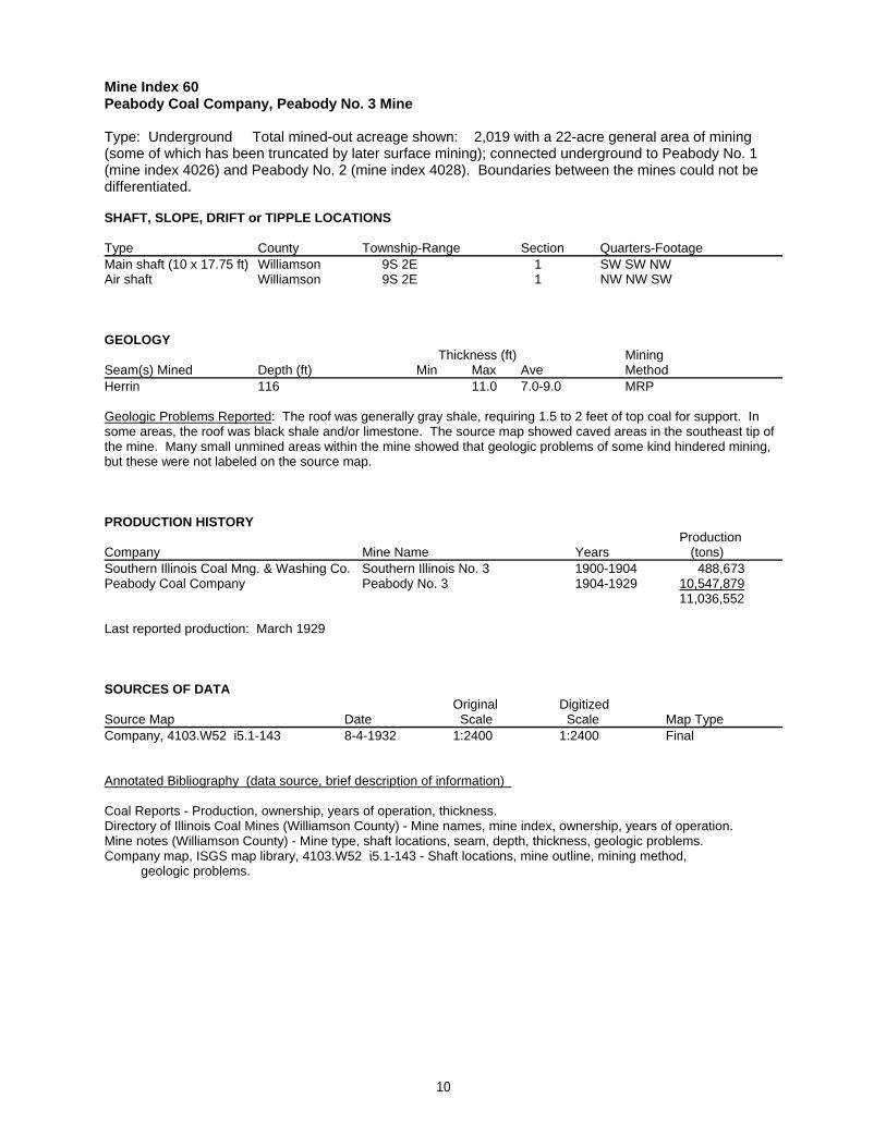
Mine Index 60Peabody Coal Company, Peabody No. 3 Mine
Type: Underground Total mined-out acreage shown: 2,019 with a 22-acre general area of mining(some of which has been truncated by later surface mining); connected underground to Peabody No. 1(mine index 4026) and Peabody No. 2 (mine index 4028). Boundaries between the mines could not bedifferentiated.
SHAFT, SLOPE, DRIFT or TIPPLE LOCATIONS
Type County Township-Range Section Quarters-FootageMain shaft (10 x 17.75 ft) Williamson 9S 2E 1 SW SW NWAir shaft Williamson 9S 2E 1 NW NW SW
GEOLOGY Thickness (ft) Mining
Seam(s) Mined Depth (ft) Min Max Ave MethodHerrin 116 11.0 7.0-9.0 MRP
Geologic Problems Reported: The roof was generally gray shale, requiring 1.5 to 2 feet of top coal for support. Insome areas, the roof was black shale and/or limestone. The source map showed caved areas in the southeast tip ofthe mine. Many small unmined areas within the mine showed that geologic problems of some kind hindered mining,but these were not labeled on the source map.
PRODUCTION HISTORY Production
Company Mine Name Years (tons) Southern Illinois Coal Mng. & Washing Co. Southern Illinois No. 3 1900-1904 488,673Peabody Coal Company Peabody No. 3 1904-1929 10,547,879
11,036,552
Last reported production: March 1929
SOURCES OF DATAOriginal Digitized
Source Map Date Scale Scale Map Type Company, 4103.W52 i5.1-143 8-4-1932 1:2400 1:2400 Final
Annotated Bibliography (data source, brief description of information)
Coal Reports - Production, ownership, years of operation, thickness.Directory of Illinois Coal Mines (Williamson County) - Mine names, mine index, ownership, years of operation.Mine notes (Williamson County) - Mine type, shaft locations, seam, depth, thickness, geologic problems.Company map, ISGS map library, 4103.W52 i5.1-143 - Shaft locations, mine outline, mining method, geologic problems.
10
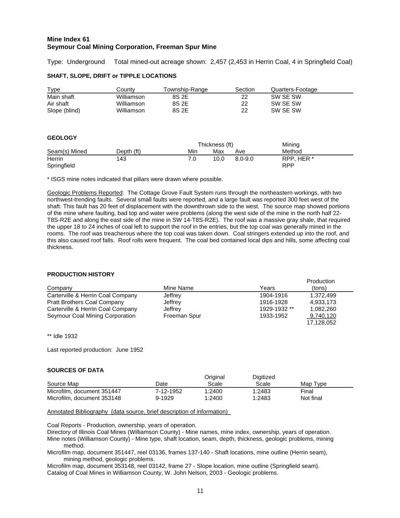
Mine Index 61Seymour Coal Mining Corporation, Freeman Spur Mine
Type: Underground Total mined-out acreage shown: 2,457 (2,453 in Herrin Coal, 4 in Springfield Coal)
SHAFT, SLOPE, DRIFT or TIPPLE LOCATIONS
Type County Township-Range Section Quarters-FootageMain shaft Williamson 8S 2E 22 SW SE SWAir shaft Williamson 8S 2E 22 SW SE SWSlope (blind) Williamson 8S 2E 22 SW SE SW
GEOLOGY Thickness (ft) Mining
Seam(s) Mined Depth (ft) Min Max Ave MethodHerrin 143 7.0 10.0 8.0-9.0 RPP, HER *Springfield RPP
* ISGS mine notes indicated that pillars were drawn where possible.
Geologic Problems Reported: The Cottage Grove Fault System runs through the northeastern workings, with twonorthwest-trending faults. Several small faults were reported, and a large fault was reported 300 feet west of theshaft. This fault has 20 feet of displacement with the downthrown side to the west. The source map showed portionsof the mine where faulting, bad top and water were problems (along the west side of the mine in the north half 22-T8S-R2E and along the east side of the mine in SW 14-T8S-R2E). The roof was a massive gray shale, that requiredthe upper 18 to 24 inches of coal left to support the roof in the entries, but the top coal was generally mined in therooms. The roof was treacherous where the top coal was taken down. Coal stringers extended up into the roof, andthis also caused roof falls. Roof rolls were frequent. The coal bed contained local dips and hills, some affecting coalthickness.
PRODUCTION HISTORY Production
Company Mine Name Years (tons) Carterville & Herrin Coal Company Jeffrey 1904-1916 1,372,499Pratt Brothers Coal Company Jeffrey 1916-1928 4,933,173Carterville & Herrin Coal Company Jeffrey 1929-1932 ** 1,082,260Seymour Coal Mining Corporation Freeman Spur 1933-1952 9,740,120
17,128,052
** Idle 1932
Last reported production: June 1952
SOURCES OF DATAOriginal Digitized
Source Map Date Scale Scale Map Type Microfilm, document 351447 7-12-1952 1:2400 1:2483 FinalMicrofilm, document 353148 9-1929 1:2400 1:2483 Not final
Annotated Bibliography (data source, brief description of information)
Coal Reports - Production, ownership, years of operation.Directory of Illinois Coal Mines (Williamson County) - Mine names, mine index, ownership, years of operation.Mine notes (Williamson County) - Mine type, shaft location, seam, depth, thickness, geologic problems, mining method.Microfilm map, document 351447, reel 03136, frames 137-140 - Shaft locations, mine outline (Herrin seam), mining method, geologic problems.Microfilm map, document 353148, reel 03142, frame 27 - Slope location, mine outline (Springfield seam).Catalog of Coal Mines in Williamson County, W. John Nelson, 2003 - Geologic problems.
11
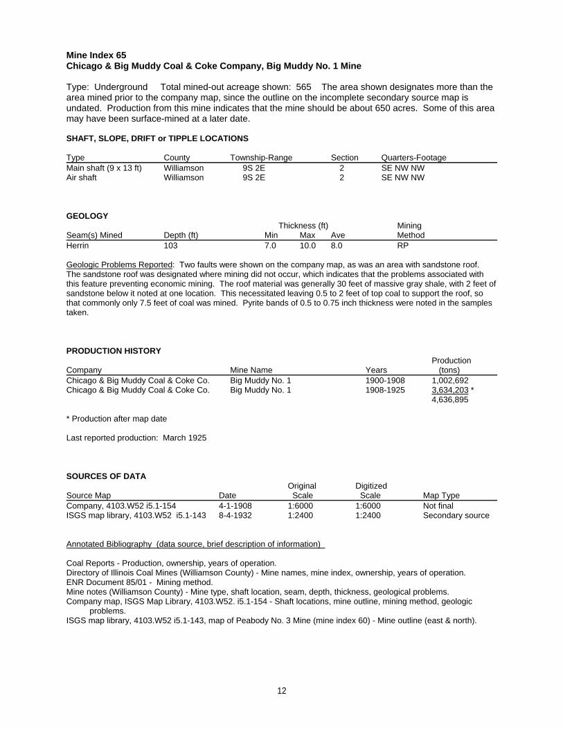
Mine Index 65Chicago & Big Muddy Coal & Coke Company, Big Muddy No. 1 Mine
Type: Underground Total mined-out acreage shown: 565 The area shown designates more than thearea mined prior to the company map, since the outline on the incomplete secondary source map isundated. Production from this mine indicates that the mine should be about 650 acres. Some of this areamay have been surface-mined at a later date.
SHAFT, SLOPE, DRIFT or TIPPLE LOCATIONS
Type County Township-Range Section Quarters-FootageMain shaft (9 x 13 ft) Williamson 9S 2E 2 SE NW NWAir shaft Williamson 9S 2E 2 SE NW NW
GEOLOGY Thickness (ft) Mining
Seam(s) Mined Depth (ft) Min Max Ave MethodHerrin 103 7.0 10.0 8.0 RP
Geologic Problems Reported: Two faults were shown on the company map, as was an area with sandstone roof. The sandstone roof was designated where mining did not occur, which indicates that the problems associated withthis feature preventing economic mining. The roof material was generally 30 feet of massive gray shale, with 2 feet ofsandstone below it noted at one location. This necessitated leaving 0.5 to 2 feet of top coal to support the roof, sothat commonly only 7.5 feet of coal was mined. Pyrite bands of 0.5 to 0.75 inch thickness were noted in the samplestaken.
PRODUCTION HISTORY Production
Company Mine Name Years (tons) Chicago & Big Muddy Coal & Coke Co. Big Muddy No. 1 1900-1908 1,002,692Chicago & Big Muddy Coal & Coke Co. Big Muddy No. 1 1908-1925 3,634,203 *
4,636,895
* Production after map date
Last reported production: March 1925
SOURCES OF DATAOriginal Digitized
Source Map Date Scale Scale Map Type Company, 4103.W52 i5.1-154 4-1-1908 1:6000 1:6000 Not finalISGS map library, 4103.W52 i5.1-143 8-4-1932 1:2400 1:2400 Secondary source
Annotated Bibliography (data source, brief description of information)
Coal Reports - Production, ownership, years of operation.Directory of Illinois Coal Mines (Williamson County) - Mine names, mine index, ownership, years of operation.ENR Document 85/01 - Mining method.Mine notes (Williamson County) - Mine type, shaft location, seam, depth, thickness, geological problems.Company map, ISGS Map Library, 4103.W52. i5.1-154 - Shaft locations, mine outline, mining method, geologic problems.ISGS map library, 4103.W52 i5.1-143, map of Peabody No. 3 Mine (mine index 60) - Mine outline (east & north).
12
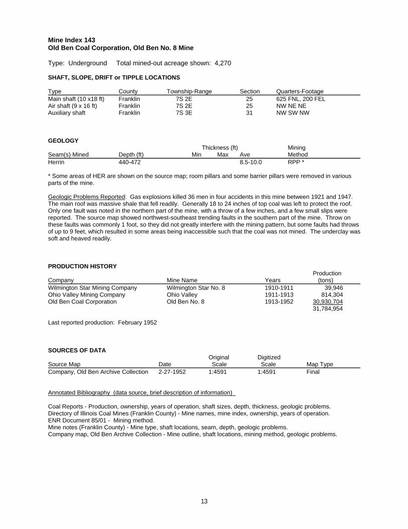
Mine Index 143Old Ben Coal Corporation, Old Ben No. 8 Mine
Type: Underground Total mined-out acreage shown: 4,270
SHAFT, SLOPE, DRIFT or TIPPLE LOCATIONS
Type County Township-Range Section Quarters-FootageMain shaft (10 x18 ft) Franklin 7S 2E 25 625 FNL, 200 FELAir shaft (9 x 16 ft) Franklin 7S 2E 25 NW NE NEAuxiliary shaft Franklin 7S 3E 31 NW SW NW
GEOLOGY Thickness (ft) Mining
Seam(s) Mined Depth (ft) Min Max Ave MethodHerrin 440-472 8.5-10.0 RPP *
* Some areas of HER are shown on the source map; room pillars and some barrier pillars were removed in variousparts of the mine.
Geologic Problems Reported: Gas explosions killed 36 men in four accidents in this mine between 1921 and 1947. The main roof was massive shale that fell readily. Generally 18 to 24 inches of top coal was left to protect the roof. Only one fault was noted in the northern part of the mine, with a throw of a few inches, and a few small slips werereported. The source map showed northwest-southeast trending faults in the southern part of the mine. Throw onthese faults was commonly 1 foot, so they did not greatly interfere with the mining pattern, but some faults had throwsof up to 9 feet, which resulted in some areas being inaccessible such that the coal was not mined. The underclay wassoft and heaved readily.
PRODUCTION HISTORY Production
Company Mine Name Years (tons) Wilmington Star Mining Company Wilmington Star No. 8 1910-1911 39,946Ohio Valley Mining Company Ohio Valley 1911-1913 814,304Old Ben Coal Corporation Old Ben No. 8 1913-1952 30,930,704
31,784,954
Last reported production: February 1952
SOURCES OF DATAOriginal Digitized
Source Map Date Scale Scale Map Type Company, Old Ben Archive Collection 2-27-1952 1:4591 1:4591 Final
Annotated Bibliography (data source, brief description of information)
Coal Reports - Production, ownership, years of operation, shaft sizes, depth, thickness, geologic problems.Directory of Illinois Coal Mines (Franklin County) - Mine names, mine index, ownership, years of operation.ENR Document 85/01 - Mining method.Mine notes (Franklin County) - Mine type, shaft locations, seam, depth, geologic problems.Company map, Old Ben Archive Collection - Mine outline, shaft locations, mining method, geologic problems.
13
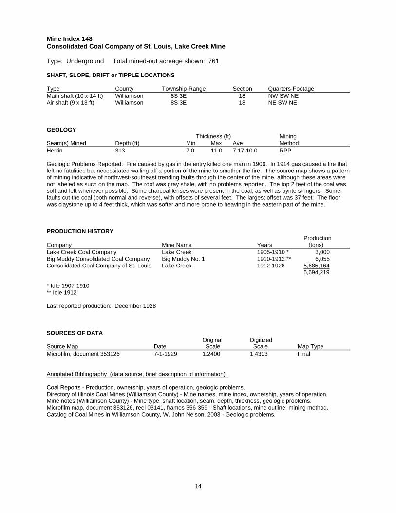
Mine Index 148Consolidated Coal Company of St. Louis, Lake Creek Mine
Type: Underground Total mined-out acreage shown: 761
SHAFT, SLOPE, DRIFT or TIPPLE LOCATIONS
Type County Township-Range Section Quarters-FootageMain shaft (10 x 14 ft) Williamson 8S 3E 18 NW SW NEAir shaft (9 x 13 ft) Williamson 8S 3E 18 NE SW NE
GEOLOGY Thickness (ft) Mining
Seam(s) Mined Depth (ft) Min Max Ave MethodHerrin 313 7.0 11.0 7.17-10.0 RPP
Geologic Problems Reported: Fire caused by gas in the entry killed one man in 1906. In 1914 gas caused a fire thatleft no fatalities but necessitated walling off a portion of the mine to smother the fire. The source map shows a patternof mining indicative of northwest-southeast trending faults through the center of the mine, although these areas werenot labeled as such on the map. The roof was gray shale, with no problems reported. The top 2 feet of the coal wassoft and left whenever possible. Some charcoal lenses were present in the coal, as well as pyrite stringers. Somefaults cut the coal (both normal and reverse), with offsets of several feet. The largest offset was 37 feet. The floorwas claystone up to 4 feet thick, which was softer and more prone to heaving in the eastern part of the mine.
PRODUCTION HISTORY Production
Company Mine Name Years (tons) Lake Creek Coal Company Lake Creek 1905-1910 * 3,000Big Muddy Consolidated Coal Company Big Muddy No. 1 1910-1912 ** 6,055Consolidated Coal Company of St. Louis Lake Creek 1912-1928 5,685,164
5,694,219
* Idle 1907-1910** Idle 1912
Last reported production: December 1928
SOURCES OF DATAOriginal Digitized
Source Map Date Scale Scale Map Type Microfilm, document 353126 7-1-1929 1:2400 1:4303 Final
Annotated Bibliography (data source, brief description of information)
Coal Reports - Production, ownership, years of operation, geologic problems.Directory of Illinois Coal Mines (Williamson County) - Mine names, mine index, ownership, years of operation.Mine notes (Williamson County) - Mine type, shaft location, seam, depth, thickness, geologic problems.Microfilm map, document 353126, reel 03141, frames 356-359 - Shaft locations, mine outline, mining method.Catalog of Coal Mines in Williamson County, W. John Nelson, 2003 - Geologic problems.
14
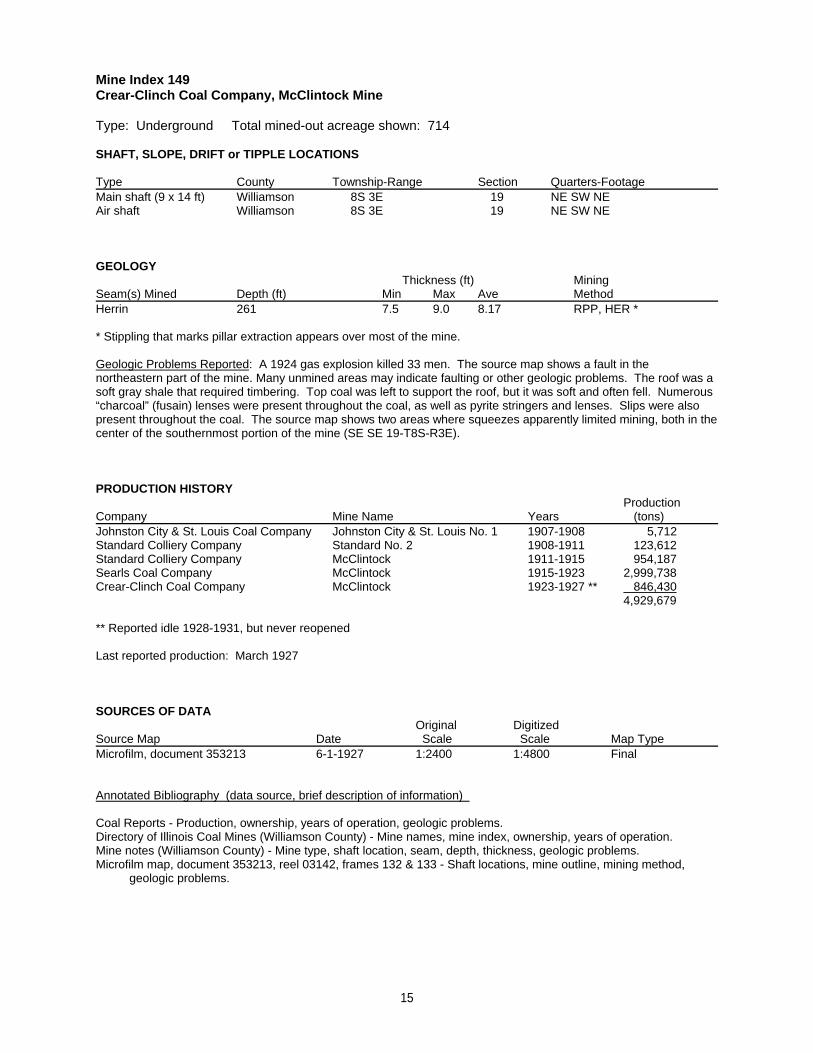
Mine Index 149Crear-Clinch Coal Company, McClintock Mine
Type: Underground Total mined-out acreage shown: 714
SHAFT, SLOPE, DRIFT or TIPPLE LOCATIONS
Type County Township-Range Section Quarters-FootageMain shaft (9 x 14 ft) Williamson 8S 3E 19 NE SW NE Air shaft Williamson 8S 3E 19 NE SW NE
GEOLOGY Thickness (ft) Mining
Seam(s) Mined Depth (ft) Min Max Ave MethodHerrin 261 7.5 9.0 8.17 RPP, HER *
* Stippling that marks pillar extraction appears over most of the mine.
Geologic Problems Reported: A 1924 gas explosion killed 33 men. The source map shows a fault in thenortheastern part of the mine. Many unmined areas may indicate faulting or other geologic problems. The roof was asoft gray shale that required timbering. Top coal was left to support the roof, but it was soft and often fell. Numerous“charcoal” (fusain) lenses were present throughout the coal, as well as pyrite stringers and lenses. Slips were alsopresent throughout the coal. The source map shows two areas where squeezes apparently limited mining, both in thecenter of the southernmost portion of the mine (SE SE 19-T8S-R3E).
PRODUCTION HISTORY Production
Company Mine Name Years (tons) Johnston City & St. Louis Coal Company Johnston City & St. Louis No. 1 1907-1908 5,712Standard Colliery Company Standard No. 2 1908-1911 123,612Standard Colliery Company McClintock 1911-1915 954,187Searls Coal Company McClintock 1915-1923 2,999,738Crear-Clinch Coal Company McClintock 1923-1927 ** 846,430
4,929,679
** Reported idle 1928-1931, but never reopened
Last reported production: March 1927
SOURCES OF DATAOriginal Digitized
Source Map Date Scale Scale Map Type Microfilm, document 353213 6-1-1927 1:2400 1:4800 Final
Annotated Bibliography (data source, brief description of information)
Coal Reports - Production, ownership, years of operation, geologic problems.Directory of Illinois Coal Mines (Williamson County) - Mine names, mine index, ownership, years of operation.Mine notes (Williamson County) - Mine type, shaft location, seam, depth, thickness, geologic problems.Microfilm map, document 353213, reel 03142, frames 132 & 133 - Shaft locations, mine outline, mining method, geologic problems.
15

Mine Index 150Johnston City Washed Coal Company, White Ash Mine
Type: Underground Total mined-out acreage shown: 377 The outline shown on the accompanyingmap shows the White Ash Mine contiguous to the Slogo Mine (mine index 151) and Carterville No. 6 Mine(mine index 323). The boundaries between these mines may be approximate; the area shown isapproximately what would have been mined by the combined production of the three mines. In addition, ageneral area of mining designates an area that could have been mined.
SHAFT, SLOPE, DRIFT or TIPPLE LOCATIONS
Type County Township-Range Section Quarters-FootageMain shaft Williamson 8S 3E 31 SE NE NW
GEOLOGY Thickness (ft) Mining
Seam(s) Mined Depth (ft) Min Max Ave MethodHerrin 98-107 4.0 9.0 7.0-7.5 RP
Geologic Problems Reported: A normal fault with 15 feet of displacement (downthrown side to the northwest) wasencountered 1500 feet east of the shaft bottom. A fault was found in the northeastern part of the mine and this faultallowed water to enter the mine. In some places the roof was limestone, which made for easy mining, but in otherareas, the roof was “draw slate”, a gray shale that tended to come down. The top coal was usually left to support theroof. In some areas the roof was black shale that contained coal balls. Rolls were present. Pyrite and calcitestringers were present throughout the coal. The floor heaved badly when wet.
PRODUCTION HISTORY Production
Company Mine Name Years (tons) Johnston City Washed Coal Company White Ash 1916-1924 1,768,934
1,768,934
Last reported production: June 1924
SOURCES OF DATAOriginal Digitized
Source Map Date Scale Scale Map Type ISGS map library, 4103.W52 i5.1-189 8-11-1934 1:63360 1:63360 Secondary sourceISGS map library, 4103.W52 i5.1-137 3-23-1929 1:2400 1:2400 Secondary sourceCoal Section files 5-15-1987 1:24000 1:24000 Secondary source
Annotated Bibliography (data source, brief description of information)
Coal Reports - Production, ownership, years of operation, mining method.Directory of Illinois Coal Mines (Williamson County) - Mine names, mine index, ownership, years of operation.ENR Document 85/01 - Mining method.Mine notes (Williamson County) - Mine type, shaft location, seam, depth, thickness, geologic problems.Composite map from J. C. Quade field notes, ISGS map library, 4103.W52 i5.1-189 - Shaft location, mine outline.ISGS map library, 4103.W52 i5.1-137, map of Peabody No. 26 Mine (mine index 157) - Mine outline (northwest).Coal Section files, map of Orient No. 4 Mine (mine index 688) - Mine outline (eastern).Catalog of Coal Mines in Williamson County, W. John Nelson, 2003 - Geologic problems.
16
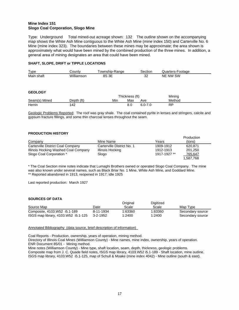
Mine Index 151Slogo Coal Corporation, Slogo Mine
Type: Underground Total mined-out acreage shown: 132 The outline shown on the accompanyingmap shows the White Ash Mine contiguous to the White Ash Mine (mine index 150) and Carterville No. 6Mine (mine index 323). The boundaries between these mines may be approximate; the area shown isapproximately what would have been mined by the combined production of the three mines. In addition, ageneral area of mining designates an area that could have been mined.
SHAFT, SLOPE, DRIFT or TIPPLE LOCATIONS
Type County Township-Range Section Quarters-FootageMain shaft Williamson 8S 3E 32 NE NW SW
GEOLOGY Thickness (ft) Mining
Seam(s) Mined Depth (ft) Min Max Ave MethodHerrin 142 8.0 6.0-7.0 RP
Geologic Problems Reported: The roof was gray shale. The coal contained pyrite in lenses and stringers, calcite andgypsum fracture fillings, and some thin charcoal lenses throughout the seam.
PRODUCTION HISTORY Production
Company Mine Name Years (tons) Carterville District Coal Company Carterville District No. 1 1909-1912 620,871Illinois Hocking Washed Coal Company Illinois Hocking 1912-1913 201,250Slogo Coal Corporation * Slogo 1917-1927 ** 765,647
1,587,768
* The Coal Section mine notes indicate that Lumaghi Brothers owned or operated Slogo Coal Company. The minewas also known under several names, such as Black Briar No. 1 Mine, White Ash Mine, and Goddard Mine.** Reported abandoned in 1913, reopened in 1917; idle 1925
Last reported production: March 1927
SOURCES OF DATAOriginal Digitized
Source Map Date Scale Scale Map Type Composite, 4103.W52 i5.1-189 8-11-1934 1:63360 1:63360 Secondary sourceISGS map library, 4103.W52 i5.1-125 3-2-1952 1:2400 1:2400 Secondary source
Annotated Bibliography (data source, brief description of information)
Coal Reports - Production, ownership, years of operation, mining method.Directory of Illinois Coal Mines (Williamson County) - Mine names, mine index, ownership, years of operation.ENR Document 85/01 - Mining method.Mine notes (Williamson County) - Mine type, shaft location, seam, depth, thickness, geologic problems.Composite map from J. C. Quade field notes, ISGS map library, 4103.W52 i5.1-189 - Shaft location, mine outline.ISGS map library, 4103.W52 i5.1-125, map of Schull & Moake (mine index 4042) - Mine outline (south & east).
17
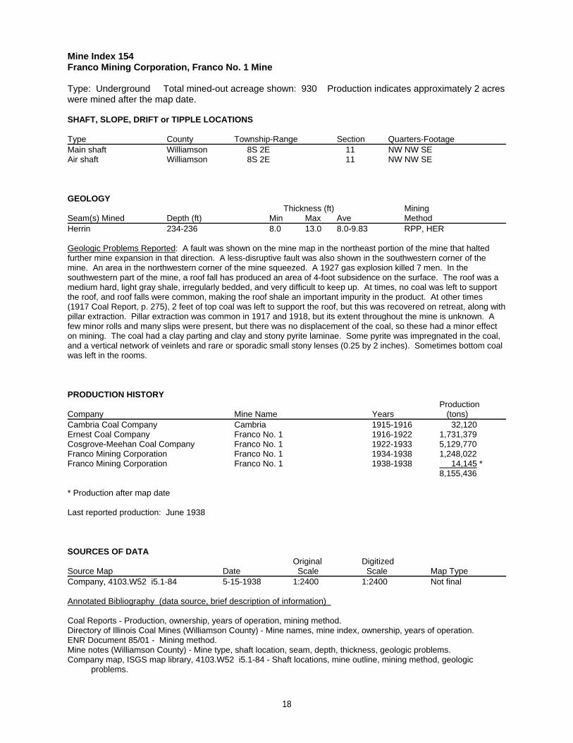
Mine Index 154Franco Mining Corporation, Franco No. 1 Mine
Type: Underground Total mined-out acreage shown: 930 Production indicates approximately 2 acreswere mined after the map date.
SHAFT, SLOPE, DRIFT or TIPPLE LOCATIONS
Type County Township-Range Section Quarters-FootageMain shaft Williamson 8S 2E 11 NW NW SEAir shaft Williamson 8S 2E 11 NW NW SE
GEOLOGY Thickness (ft) Mining
Seam(s) Mined Depth (ft) Min Max Ave MethodHerrin 234-236 8.0 13.0 8.0-9.83 RPP, HER
Geologic Problems Reported: A fault was shown on the mine map in the northeast portion of the mine that haltedfurther mine expansion in that direction. A less-disruptive fault was also shown in the southwestern corner of themine. An area in the northwestern corner of the mine squeezed. A 1927 gas explosion killed 7 men. In thesouthwestern part of the mine, a roof fall has produced an area of 4-foot subsidence on the surface. The roof was amedium hard, light gray shale, irregularly bedded, and very difficult to keep up. At times, no coal was left to supportthe roof, and roof falls were common, making the roof shale an important impurity in the product. At other times(1917 Coal Report, p. 275), 2 feet of top coal was left to support the roof, but this was recovered on retreat, along withpillar extraction. Pillar extraction was common in 1917 and 1918, but its extent throughout the mine is unknown. Afew minor rolls and many slips were present, but there was no displacement of the coal, so these had a minor effecton mining. The coal had a clay parting and clay and stony pyrite laminae. Some pyrite was impregnated in the coal,and a vertical network of veinlets and rare or sporadic small stony lenses (0.25 by 2 inches). Sometimes bottom coalwas left in the rooms.
PRODUCTION HISTORY Production
Company Mine Name Years (tons) Cambria Coal Company Cambria 1915-1916 32,120Ernest Coal Company Franco No. 1 1916-1922 1,731,379Cosgrove-Meehan Coal Company Franco No. 1 1922-1933 5,129,770Franco Mining Corporation Franco No. 1 1934-1938 1,248,022Franco Mining Corporation Franco No. 1 1938-1938 14,145 *
8,155,436
* Production after map date
Last reported production: June 1938
SOURCES OF DATAOriginal Digitized
Source Map Date Scale Scale Map Type Company, 4103.W52 i5.1-84 5-15-1938 1:2400 1:2400 Not final
Annotated Bibliography (data source, brief description of information)
Coal Reports - Production, ownership, years of operation, mining method.Directory of Illinois Coal Mines (Williamson County) - Mine names, mine index, ownership, years of operation.ENR Document 85/01 - Mining method.Mine notes (Williamson County) - Mine type, shaft location, seam, depth, thickness, geologic problems.Company map, ISGS map library, 4103.W52 i5.1-84 - Shaft locations, mine outline, mining method, geologic problems.
18
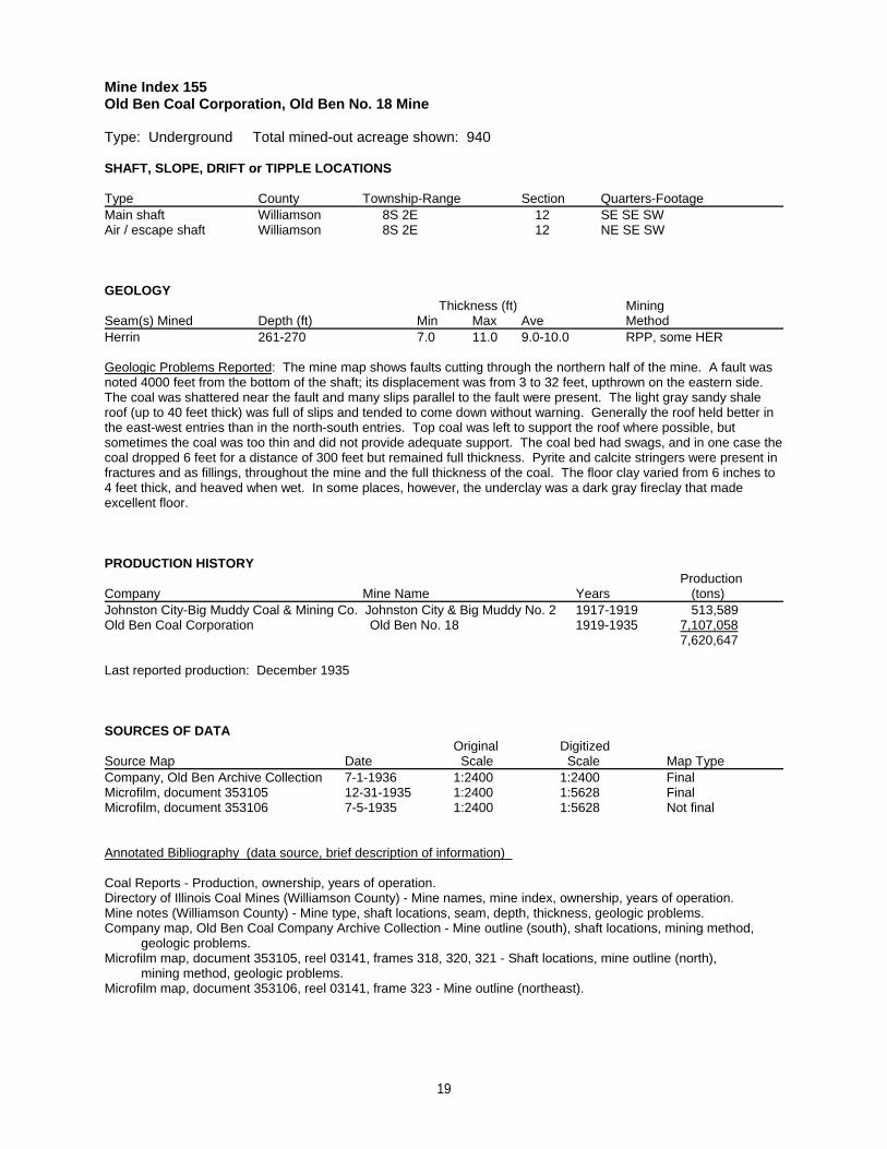
Mine Index 155Old Ben Coal Corporation, Old Ben No. 18 Mine
Type: Underground Total mined-out acreage shown: 940
SHAFT, SLOPE, DRIFT or TIPPLE LOCATIONS
Type County Township-Range Section Quarters-FootageMain shaft Williamson 8S 2E 12 SE SE SWAir / escape shaft Williamson 8S 2E 12 NE SE SW
GEOLOGY Thickness (ft) Mining
Seam(s) Mined Depth (ft) Min Max Ave MethodHerrin 261-270 7.0 11.0 9.0-10.0 RPP, some HER
Geologic Problems Reported: The mine map shows faults cutting through the northern half of the mine. A fault wasnoted 4000 feet from the bottom of the shaft; its displacement was from 3 to 32 feet, upthrown on the eastern side. The coal was shattered near the fault and many slips parallel to the fault were present. The light gray sandy shaleroof (up to 40 feet thick) was full of slips and tended to come down without warning. Generally the roof held better inthe east-west entries than in the north-south entries. Top coal was left to support the roof where possible, butsometimes the coal was too thin and did not provide adequate support. The coal bed had swags, and in one case thecoal dropped 6 feet for a distance of 300 feet but remained full thickness. Pyrite and calcite stringers were present infractures and as fillings, throughout the mine and the full thickness of the coal. The floor clay varied from 6 inches to4 feet thick, and heaved when wet. In some places, however, the underclay was a dark gray fireclay that madeexcellent floor.
PRODUCTION HISTORY Production
Company Mine Name Years (tons) Johnston City-Big Muddy Coal & Mining Co. Johnston City & Big Muddy No. 2 1917-1919 513,589Old Ben Coal Corporation Old Ben No. 18 1919-1935 7,107,058
7,620,647
Last reported production: December 1935
SOURCES OF DATAOriginal Digitized
Source Map Date Scale Scale Map Type Company, Old Ben Archive Collection 7-1-1936 1:2400 1:2400 FinalMicrofilm, document 353105 12-31-1935 1:2400 1:5628 FinalMicrofilm, document 353106 7-5-1935 1:2400 1:5628 Not final
Annotated Bibliography (data source, brief description of information)
Coal Reports - Production, ownership, years of operation.Directory of Illinois Coal Mines (Williamson County) - Mine names, mine index, ownership, years of operation.Mine notes (Williamson County) - Mine type, shaft locations, seam, depth, thickness, geologic problems.Company map, Old Ben Coal Company Archive Collection - Mine outline (south), shaft locations, mining method, geologic problems.Microfilm map, document 353105, reel 03141, frames 318, 320, 321 - Shaft locations, mine outline (north), mining method, geologic problems.Microfilm map, document 353106, reel 03141, frame 323 - Mine outline (northeast).
19
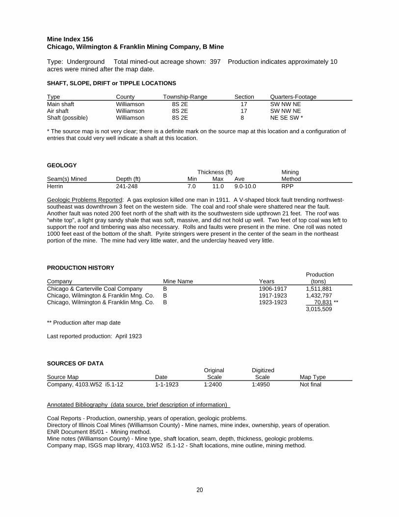
Mine Index 156Chicago, Wilmington & Franklin Mining Company, B Mine
Type: Underground Total mined-out acreage shown: 397 Production indicates approximately 10acres were mined after the map date.
SHAFT, SLOPE, DRIFT or TIPPLE LOCATIONS
Type County Township-Range Section Quarters-FootageMain shaft Williamson 8S 2E 17 SW NW NEAir shaft Williamson 8S 2E 17 SW NW NEShaft (possible) Williamson 8S 2E 8 NE SE SW *
* The source map is not very clear; there is a definite mark on the source map at this location and a configuration ofentries that could very well indicate a shaft at this location.
GEOLOGY Thickness (ft) Mining
Seam(s) Mined Depth (ft) Min Max Ave MethodHerrin 241-248 7.0 11.0 9.0-10.0 RPP
Geologic Problems Reported: A gas explosion killed one man in 1911. A V-shaped block fault trending northwest-southeast was downthrown 3 feet on the western side. The coal and roof shale were shattered near the fault. Another fault was noted 200 feet north of the shaft with its the southwestern side upthrown 21 feet. The roof was“white top”, a light gray sandy shale that was soft, massive, and did not hold up well. Two feet of top coal was left tosupport the roof and timbering was also necessary. Rolls and faults were present in the mine. One roll was noted1000 feet east of the bottom of the shaft. Pyrite stringers were present in the center of the seam in the northeastportion of the mine. The mine had very little water, and the underclay heaved very little.
PRODUCTION HISTORY Production
Company Mine Name Years (tons) Chicago & Carterville Coal Company B 1906-1917 1,511,881Chicago, Wilmington & Franklin Mng. Co. B 1917-1923 1,432,797Chicago, Wilmington & Franklin Mng. Co. B 1923-1923 70,831 **
3,015,509
** Production after map date
Last reported production: April 1923
SOURCES OF DATAOriginal Digitized
Source Map Date Scale Scale Map Type Company, 4103.W52 i5.1-12 1-1-1923 1:2400 1:4950 Not final
Annotated Bibliography (data source, brief description of information)
Coal Reports - Production, ownership, years of operation, geologic problems.Directory of Illinois Coal Mines (Williamson County) - Mine names, mine index, ownership, years of operation.ENR Document 85/01 - Mining method.Mine notes (Williamson County) - Mine type, shaft location, seam, depth, thickness, geologic problems.Company map, ISGS map library, 4103.W52 i5.1-12 - Shaft locations, mine outline, mining method.
20

Mine Index 157Peabody Coal Company, Peabody No. 26 Mine
Type: Underground Total mined-out acreage shown: 925 Production indicates approximately 27acres were mined after the map date. This mine is connected underground in numerous places to theworkings of the Oak Ridge Mine (mine index 322), in the northwest part of Peabody No. 26 Mine.
SHAFT, SLOPE, DRIFT or TIPPLE LOCATIONS
Type County Township-Range Section Quarters-FootageMain shaft (9 x 13 ft) Williamson 8S 2E 25 NW NE SEAir shaft Williamson 8S 2E 25 NW NE SE
GEOLOGY Thickness (ft) Mining
Seam(s) Mined Depth (ft) Min Max Ave MethodHerrin 125 6.0 9.0 8.0 MRP
Geologic Problems Reported: The northern part of the mine had northwest trending faults of the Cottage Grove FaultSystem and north-northwest-trending high-angle normal faults of the White Ash Fault Zone in the western part of themine. The roof was a massive gray shale over the entire mine, ranging from 2 inches to over 10 feet. In the easternpart of the mine, it ranged from 2 to 36 inches and came down readily. Where possible, 1 to 2 feet of coal were left tosupport the roof. The upper surface of the coal was very irregular. There were many slips in the roof, which allowedmuch water to come into the mine. Some slips and rolls were present in the coal. Slips also necessitated timbering. One roll came down into the coal 2 feet and was 50 feet long. The coal remained full thickness. Pyrite lenses andstringers, and calcite and gypsum fracture fillings were present in the coal. The floor was 2 inches to 4 feet of hardbrittle dark gray shale. Where this clay shale was thick and the rooms were cut too wide, the floor tended to heave ifit became wet, or else the roof came down.
PRODUCTION HISTORY Production
Company Mine Name Years (tons) New Virginia Coal Company New Virginia No. 1 1901-1906 545,221Consumer’s Coal Company Consumers No. 1 1906-1909 * 148,442Big Muddy Fuel Company New Virginia No. 26 1909-1920 2,192,177Big Muddy Coal Company Big Muddy No. 26 1920-1927 2,916,108Peabody Coal Company Peabody No. 26 1928-1929 269,354Peabody Coal Company Peabody No. 26 1929-1929 ** 181,629 ***
6,252,931* Idle 1909** Reported idle 1930-1933, but never reopened*** Production after map date
Last reported production: December 1929
SOURCES OF DATAOriginal Digitized
Source Map Date Scale Scale Map Type Company, 4103.W52 i5.1-137 3-23-1929 1:2400 1:2400 Not final
Annotated Bibliography (data source, brief description of information)
Coal Reports - Production, ownership, years of operation, shaft size (1901).Directory of Illinois Coal Mines (Williamson County) - Mine names, mine index, ownership, years of operation.Mine notes (Williamson County) - Mine type, shaft & air shaft locations, seam, depth, thickness, geologic problems.Company map, ISGS map library, 4103.W52 i5.1-137 - Shaft location, mine outline, mining method.Catalog of Coal Mines in Williamson County, W. John Nelson, 2003 - Geologic problems.
21
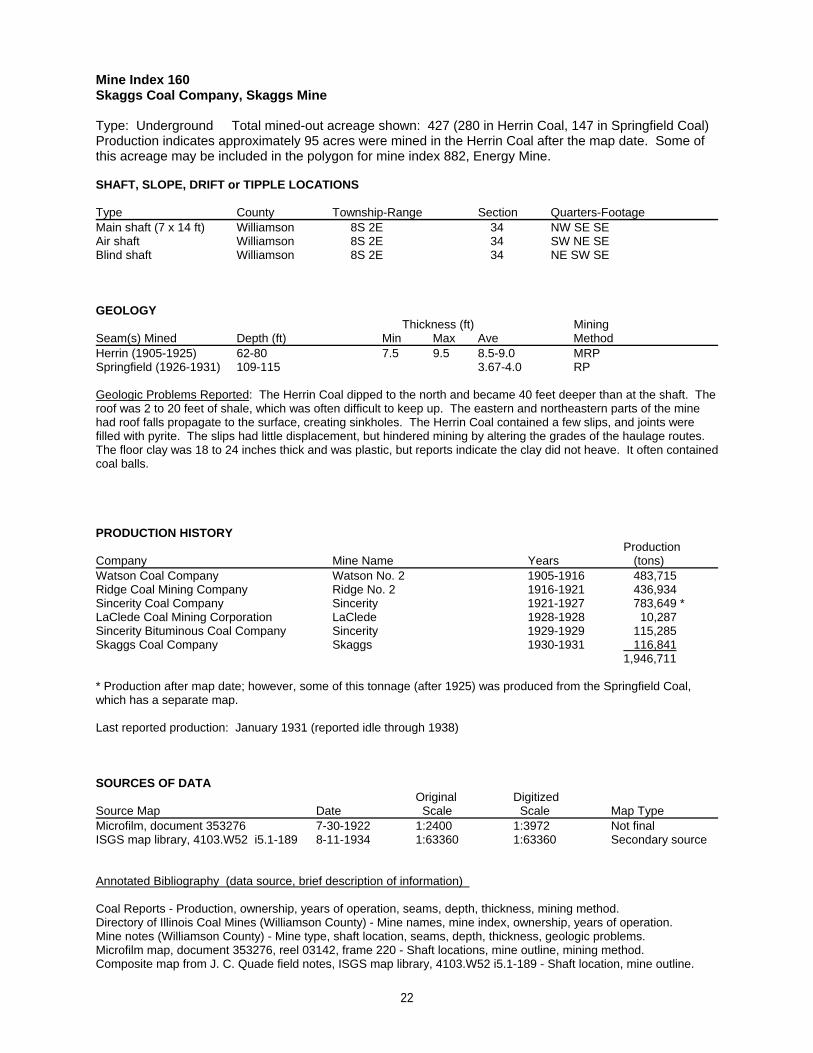
Mine Index 160Skaggs Coal Company, Skaggs Mine
Type: Underground Total mined-out acreage shown: 427 (280 in Herrin Coal, 147 in Springfield Coal)Production indicates approximately 95 acres were mined in the Herrin Coal after the map date. Some ofthis acreage may be included in the polygon for mine index 882, Energy Mine.
SHAFT, SLOPE, DRIFT or TIPPLE LOCATIONS
Type County Township-Range Section Quarters-FootageMain shaft (7 x 14 ft) Williamson 8S 2E 34 NW SE SEAir shaft Williamson 8S 2E 34 SW NE SEBlind shaft Williamson 8S 2E 34 NE SW SE
GEOLOGY Thickness (ft) Mining
Seam(s) Mined Depth (ft) Min Max Ave MethodHerrin (1905-1925) 62-80 7.5 9.5 8.5-9.0 MRPSpringfield (1926-1931) 109-115 3.67-4.0 RP
Geologic Problems Reported: The Herrin Coal dipped to the north and became 40 feet deeper than at the shaft. Theroof was 2 to 20 feet of shale, which was often difficult to keep up. The eastern and northeastern parts of the minehad roof falls propagate to the surface, creating sinkholes. The Herrin Coal contained a few slips, and joints werefilled with pyrite. The slips had little displacement, but hindered mining by altering the grades of the haulage routes. The floor clay was 18 to 24 inches thick and was plastic, but reports indicate the clay did not heave. It often containedcoal balls.
PRODUCTION HISTORY Production
Company Mine Name Years (tons) Watson Coal Company Watson No. 2 1905-1916 483,715Ridge Coal Mining Company Ridge No. 2 1916-1921 436,934Sincerity Coal Company Sincerity 1921-1927 783,649 *LaClede Coal Mining Corporation LaClede 1928-1928 10,287 Sincerity Bituminous Coal Company Sincerity 1929-1929 115,285 Skaggs Coal Company Skaggs 1930-1931 116,841
1,946,711
* Production after map date; however, some of this tonnage (after 1925) was produced from the Springfield Coal,which has a separate map.
Last reported production: January 1931 (reported idle through 1938)
SOURCES OF DATAOriginal Digitized
Source Map Date Scale Scale Map Type Microfilm, document 353276 7-30-1922 1:2400 1:3972 Not finalISGS map library, 4103.W52 i5.1-189 8-11-1934 1:63360 1:63360 Secondary source
Annotated Bibliography (data source, brief description of information)
Coal Reports - Production, ownership, years of operation, seams, depth, thickness, mining method.Directory of Illinois Coal Mines (Williamson County) - Mine names, mine index, ownership, years of operation.Mine notes (Williamson County) - Mine type, shaft location, seams, depth, thickness, geologic problems.Microfilm map, document 353276, reel 03142, frame 220 - Shaft locations, mine outline, mining method.Composite map from J. C. Quade field notes, ISGS map library, 4103.W52 i5.1-189 - Shaft location, mine outline.
22
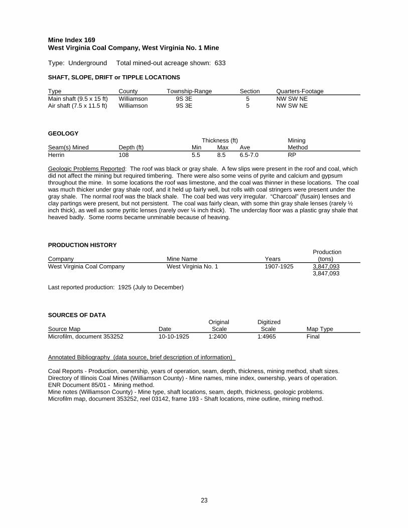
Mine Index 169West Virginia Coal Company, West Virginia No. 1 Mine
Type: Underground Total mined-out acreage shown: 633
SHAFT, SLOPE, DRIFT or TIPPLE LOCATIONS
Type County Township-Range Section Quarters-FootageMain shaft (9.5 x 15 ft) Williamson 9S 3E 5 NW SW NEAir shaft (7.5 x 11.5 ft) Williamson 9S 3E 5 NW SW NE
GEOLOGY Thickness (ft) Mining
Seam(s) Mined Depth (ft) Min Max Ave MethodHerrin 108 5.5 8.5 6.5-7.0 RP
Geologic Problems Reported: The roof was black or gray shale. A few slips were present in the roof and coal, whichdid not affect the mining but required timbering. There were also some veins of pyrite and calcium and gypsumthroughout the mine. In some locations the roof was limestone, and the coal was thinner in these locations. The coalwas much thicker under gray shale roof, and it held up fairly well, but rolls with coal stringers were present under thegray shale. The normal roof was the black shale. The coal bed was very irregular. “Charcoal” (fusain) lenses andclay partings were present, but not persistent. The coal was fairly clean, with some thin gray shale lenses (rarely ½inch thick), as well as some pyritic lenses (rarely over ¼ inch thick). The underclay floor was a plastic gray shale thatheaved badly. Some rooms became unminable because of heaving.
PRODUCTION HISTORY Production
Company Mine Name Years (tons) West Virginia Coal Company West Virginia No. 1 1907-1925 3,847,093
3,847,093
Last reported production: 1925 (July to December)
SOURCES OF DATAOriginal Digitized
Source Map Date Scale Scale Map Type Microfilm, document 353252 10-10-1925 1:2400 1:4965 Final
Annotated Bibliography (data source, brief description of information)
Coal Reports - Production, ownership, years of operation, seam, depth, thickness, mining method, shaft sizes.Directory of Illinois Coal Mines (Williamson County) - Mine names, mine index, ownership, years of operation.ENR Document 85/01 - Mining method.Mine notes (Williamson County) - Mine type, shaft locations, seam, depth, thickness, geologic problems.Microfilm map, document 353252, reel 03142, frame 193 - Shaft locations, mine outline, mining method.
23
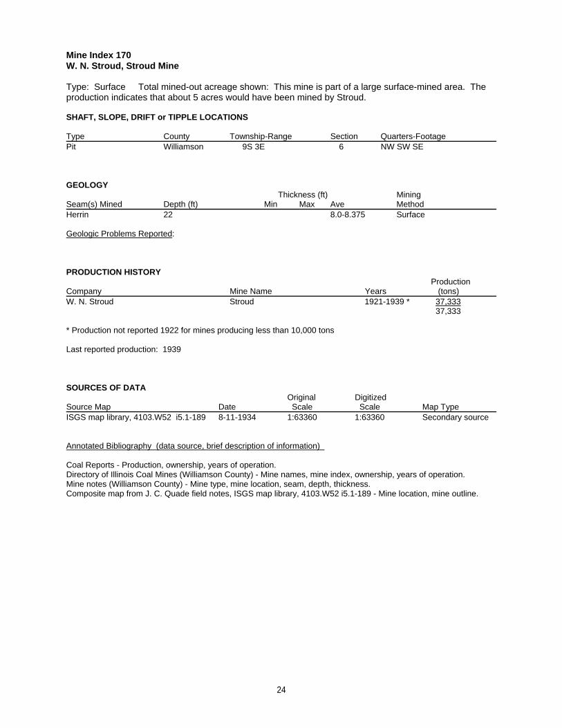
Mine Index 170W. N. Stroud, Stroud Mine
Type: Surface Total mined-out acreage shown: This mine is part of a large surface-mined area. Theproduction indicates that about 5 acres would have been mined by Stroud.
SHAFT, SLOPE, DRIFT or TIPPLE LOCATIONS
Type County Township-Range Section Quarters-FootagePit Williamson 9S 3E 6 NW SW SE
GEOLOGY Thickness (ft) Mining
Seam(s) Mined Depth (ft) Min Max Ave MethodHerrin 22 8.0-8.375 Surface
Geologic Problems Reported:
PRODUCTION HISTORY Production
Company Mine Name Years (tons) W. N. Stroud Stroud 1921-1939 * 37,333
37,333
* Production not reported 1922 for mines producing less than 10,000 tons
Last reported production: 1939
SOURCES OF DATAOriginal Digitized
Source Map Date Scale Scale Map Type ISGS map library, 4103.W52 i5.1-189 8-11-1934 1:63360 1:63360 Secondary source
Annotated Bibliography (data source, brief description of information)
Coal Reports - Production, ownership, years of operation.Directory of Illinois Coal Mines (Williamson County) - Mine names, mine index, ownership, years of operation.Mine notes (Williamson County) - Mine type, mine location, seam, depth, thickness.Composite map from J. C. Quade field notes, ISGS map library, 4103.W52 i5.1-189 - Mine location, mine outline.
24
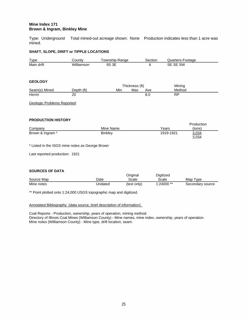
Mine Index 171Brown & Ingram, Binkley Mine
Type: Underground Total mined-out acreage shown: None Production indicates less than 1 acre wasmined.
SHAFT, SLOPE, DRIFT or TIPPLE LOCATIONS
Type County Township-Range Section Quarters-FootageMain drift Williamson 9S 3E 6 SE SE SW
GEOLOGY Thickness (ft) Mining
Seam(s) Mined Depth (ft) Min Max Ave MethodHerrin 20 8.0 RP
Geologic Problems Reported:
PRODUCTION HISTORY Production
Company Mine Name Years (tons) Brown & Ingram * Binkley 1919-1921 3,034
3,034
* Listed in the ISGS mine notes as George Brown
Last reported production: 1921
SOURCES OF DATAOriginal Digitized
Source Map Date Scale Scale Map Type Mine notes Undated (text only) 1:24000 ** Secondary source
** Point plotted onto 1:24,000 USGS topographic map and digitized.
Annotated Bibliography (data source, brief description of information)
Coal Reports - Production, ownership, years of operation, mining method.Directory of Illinois Coal Mines (Williamson County) - Mine names, mine index, ownership, years of operation.Mine notes (Williamson County) - Mine type, drift location, seam.
25
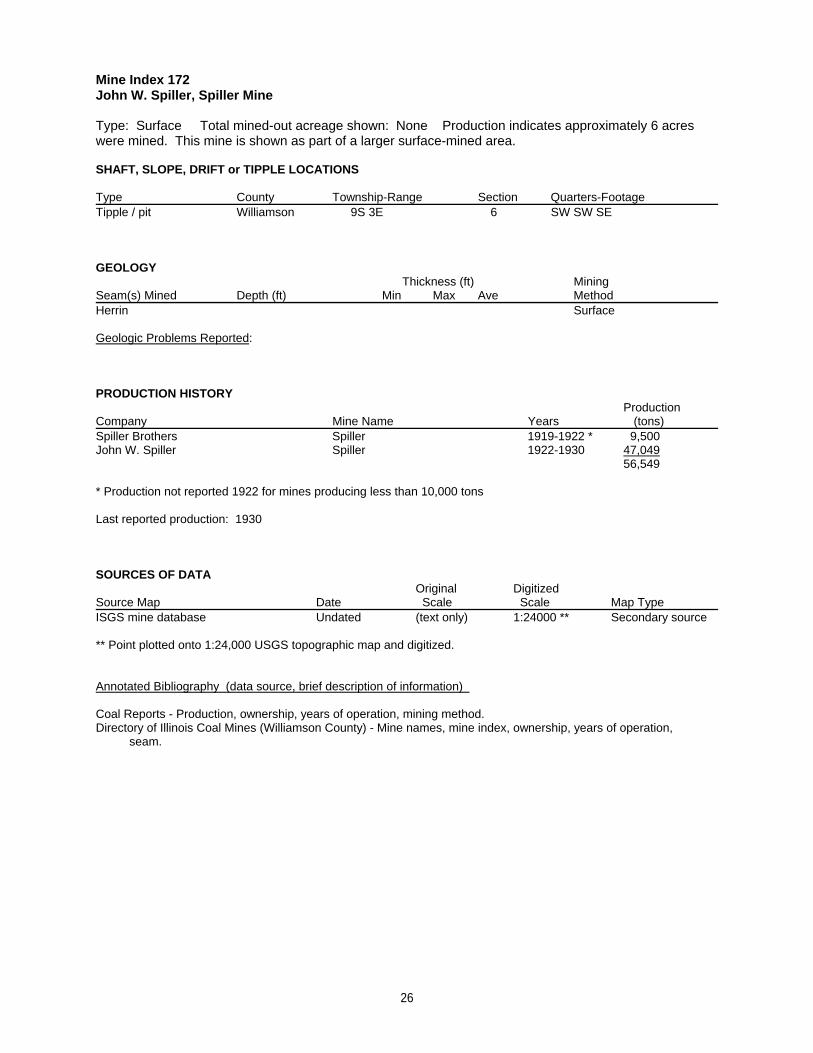
Mine Index 172John W. Spiller, Spiller Mine
Type: Surface Total mined-out acreage shown: None Production indicates approximately 6 acreswere mined. This mine is shown as part of a larger surface-mined area.
SHAFT, SLOPE, DRIFT or TIPPLE LOCATIONS
Type County Township-Range Section Quarters-FootageTipple / pit Williamson 9S 3E 6 SW SW SE
GEOLOGY Thickness (ft) Mining
Seam(s) Mined Depth (ft) Min Max Ave MethodHerrin Surface
Geologic Problems Reported:
PRODUCTION HISTORY Production
Company Mine Name Years (tons) Spiller Brothers Spiller 1919-1922 * 9,500John W. Spiller Spiller 1922-1930 47,049
56,549
* Production not reported 1922 for mines producing less than 10,000 tons
Last reported production: 1930
SOURCES OF DATAOriginal Digitized
Source Map Date Scale Scale Map Type ISGS mine database Undated (text only) 1:24000 ** Secondary source
** Point plotted onto 1:24,000 USGS topographic map and digitized.
Annotated Bibliography (data source, brief description of information)
Coal Reports - Production, ownership, years of operation, mining method.Directory of Illinois Coal Mines (Williamson County) - Mine names, mine index, ownership, years of operation, seam.
26
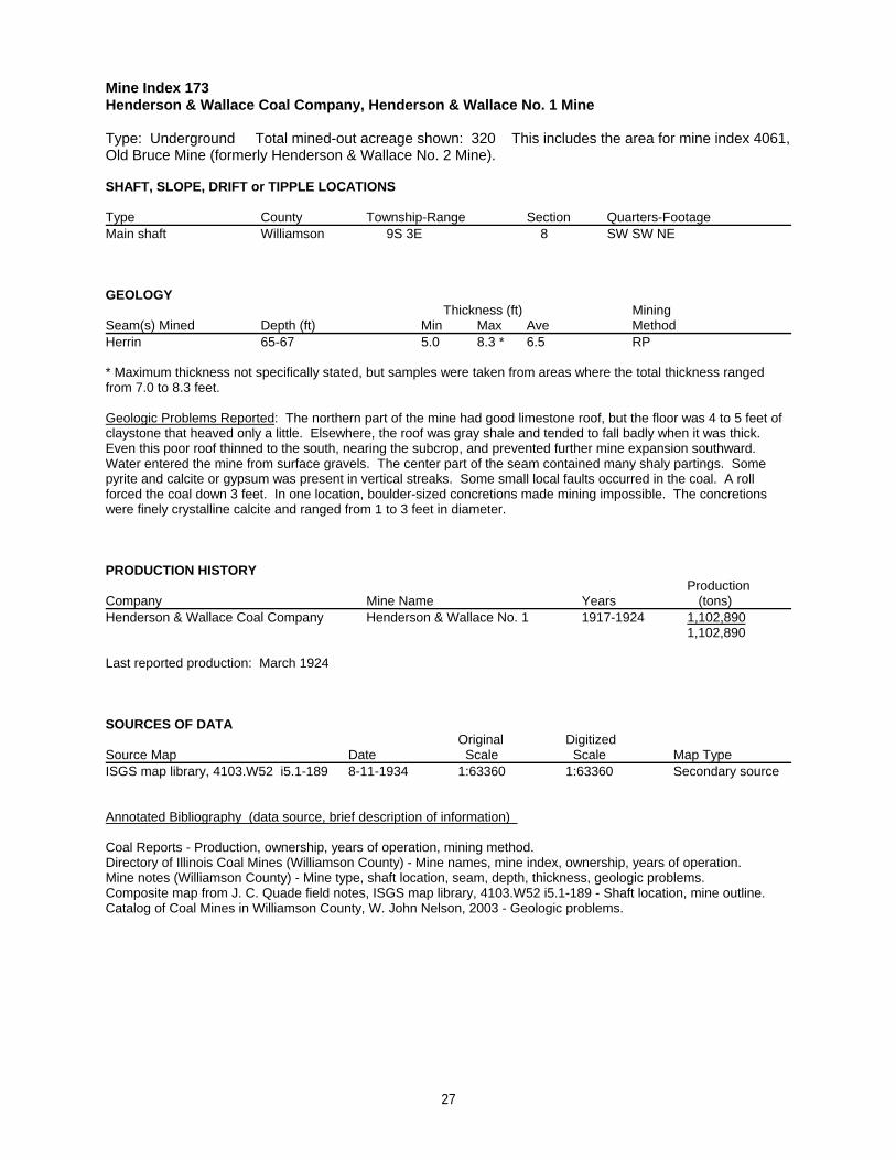
Mine Index 173Henderson & Wallace Coal Company, Henderson & Wallace No. 1 Mine
Type: Underground Total mined-out acreage shown: 320 This includes the area for mine index 4061,Old Bruce Mine (formerly Henderson & Wallace No. 2 Mine).
SHAFT, SLOPE, DRIFT or TIPPLE LOCATIONS
Type County Township-Range Section Quarters-FootageMain shaft Williamson 9S 3E 8 SW SW NE
GEOLOGY Thickness (ft) Mining
Seam(s) Mined Depth (ft) Min Max Ave MethodHerrin 65-67 5.0 8.3 * 6.5 RP
* Maximum thickness not specifically stated, but samples were taken from areas where the total thickness rangedfrom 7.0 to 8.3 feet.
Geologic Problems Reported: The northern part of the mine had good limestone roof, but the floor was 4 to 5 feet ofclaystone that heaved only a little. Elsewhere, the roof was gray shale and tended to fall badly when it was thick. Even this poor roof thinned to the south, nearing the subcrop, and prevented further mine expansion southward. Water entered the mine from surface gravels. The center part of the seam contained many shaly partings. Somepyrite and calcite or gypsum was present in vertical streaks. Some small local faults occurred in the coal. A rollforced the coal down 3 feet. In one location, boulder-sized concretions made mining impossible. The concretionswere finely crystalline calcite and ranged from 1 to 3 feet in diameter.
PRODUCTION HISTORY Production
Company Mine Name Years (tons) Henderson & Wallace Coal Company Henderson & Wallace No. 1 1917-1924 1,102,890
1,102,890
Last reported production: March 1924
SOURCES OF DATAOriginal Digitized
Source Map Date Scale Scale Map Type ISGS map library, 4103.W52 i5.1-189 8-11-1934 1:63360 1:63360 Secondary source
Annotated Bibliography (data source, brief description of information)
Coal Reports - Production, ownership, years of operation, mining method.Directory of Illinois Coal Mines (Williamson County) - Mine names, mine index, ownership, years of operation.Mine notes (Williamson County) - Mine type, shaft location, seam, depth, thickness, geologic problems.Composite map from J. C. Quade field notes, ISGS map library, 4103.W52 i5.1-189 - Shaft location, mine outline.Catalog of Coal Mines in Williamson County, W. John Nelson, 2003 - Geologic problems.
27
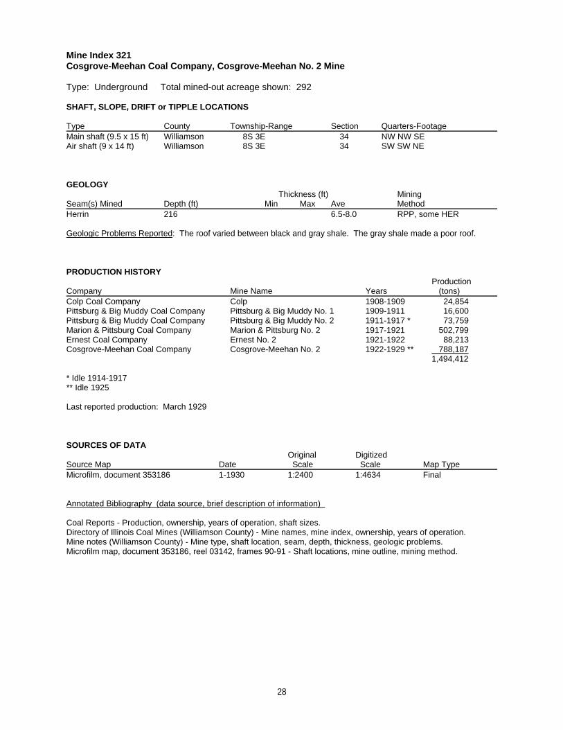
Mine Index 321Cosgrove-Meehan Coal Company, Cosgrove-Meehan No. 2 Mine
Type: Underground Total mined-out acreage shown: 292
SHAFT, SLOPE, DRIFT or TIPPLE LOCATIONS
Type County Township-Range Section Quarters-FootageMain shaft (9.5 x 15 ft) Williamson 8S 3E 34 NW NW SEAir shaft (9 x 14 ft) Williamson 8S 3E 34 SW SW NE
GEOLOGY Thickness (ft) Mining
Seam(s) Mined Depth (ft) Min Max Ave MethodHerrin 216 6.5-8.0 RPP, some HER
Geologic Problems Reported: The roof varied between black and gray shale. The gray shale made a poor roof.
PRODUCTION HISTORY Production
Company Mine Name Years (tons) Colp Coal Company Colp 1908-1909 24,854Pittsburg & Big Muddy Coal Company Pittsburg & Big Muddy No. 1 1909-1911 16,600Pittsburg & Big Muddy Coal Company Pittsburg & Big Muddy No. 2 1911-1917 * 73,759Marion & Pittsburg Coal Company Marion & Pittsburg No. 2 1917-1921 502,799Ernest Coal Company Ernest No. 2 1921-1922 88,213Cosgrove-Meehan Coal Company Cosgrove-Meehan No. 2 1922-1929 ** 788,187
1,494,412
* Idle 1914-1917** Idle 1925
Last reported production: March 1929
SOURCES OF DATAOriginal Digitized
Source Map Date Scale Scale Map Type Microfilm, document 353186 1-1930 1:2400 1:4634 Final
Annotated Bibliography (data source, brief description of information)
Coal Reports - Production, ownership, years of operation, shaft sizes.Directory of Illinois Coal Mines (Williamson County) - Mine names, mine index, ownership, years of operation.Mine notes (Williamson County) - Mine type, shaft location, seam, depth, thickness, geologic problems.Microfilm map, document 353186, reel 03142, frames 90-91 - Shaft locations, mine outline, mining method.
28
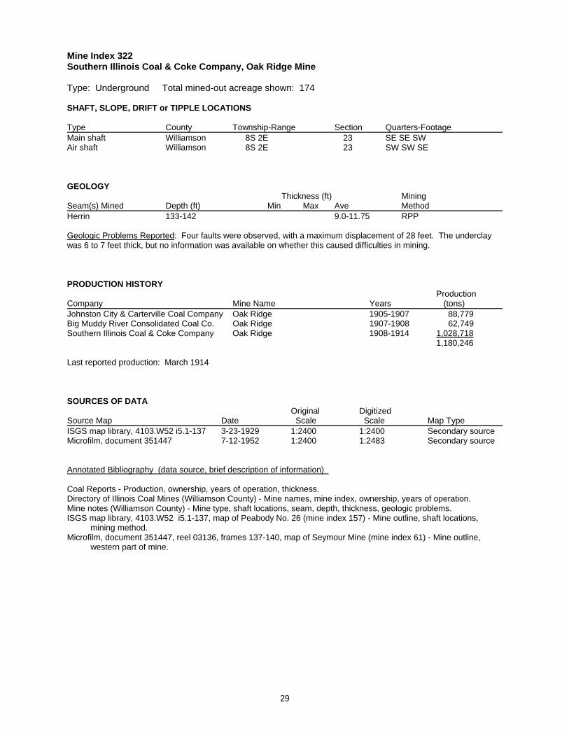
Mine Index 322Southern Illinois Coal & Coke Company, Oak Ridge Mine
Type: Underground Total mined-out acreage shown: 174
SHAFT, SLOPE, DRIFT or TIPPLE LOCATIONS
Type County Township-Range Section Quarters-FootageMain shaft Williamson 8S 2E 23 SE SE SWAir shaft Williamson 8S 2E 23 SW SW SE
GEOLOGY Thickness (ft) Mining
Seam(s) Mined Depth (ft) Min Max Ave MethodHerrin 133-142 9.0-11.75 RPP
Geologic Problems Reported: Four faults were observed, with a maximum displacement of 28 feet. The underclaywas 6 to 7 feet thick, but no information was available on whether this caused difficulties in mining.
PRODUCTION HISTORY Production
Company Mine Name Years (tons) Johnston City & Carterville Coal Company Oak Ridge 1905-1907 88,779Big Muddy River Consolidated Coal Co. Oak Ridge 1907-1908 62,749Southern Illinois Coal & Coke Company Oak Ridge 1908-1914 1,028,718
1,180,246
Last reported production: March 1914
SOURCES OF DATAOriginal Digitized
Source Map Date Scale Scale Map Type ISGS map library, 4103.W52 i5.1-137 3-23-1929 1:2400 1:2400 Secondary sourceMicrofilm, document 351447 7-12-1952 1:2400 1:2483 Secondary source
Annotated Bibliography (data source, brief description of information)
Coal Reports - Production, ownership, years of operation, thickness.Directory of Illinois Coal Mines (Williamson County) - Mine names, mine index, ownership, years of operation.Mine notes (Williamson County) - Mine type, shaft locations, seam, depth, thickness, geologic problems.ISGS map library, 4103.W52 i5.1-137, map of Peabody No. 26 (mine index 157) - Mine outline, shaft locations, mining method.Microfilm, document 351447, reel 03136, frames 137-140, map of Seymour Mine (mine index 61) - Mine outline, western part of mine.
29
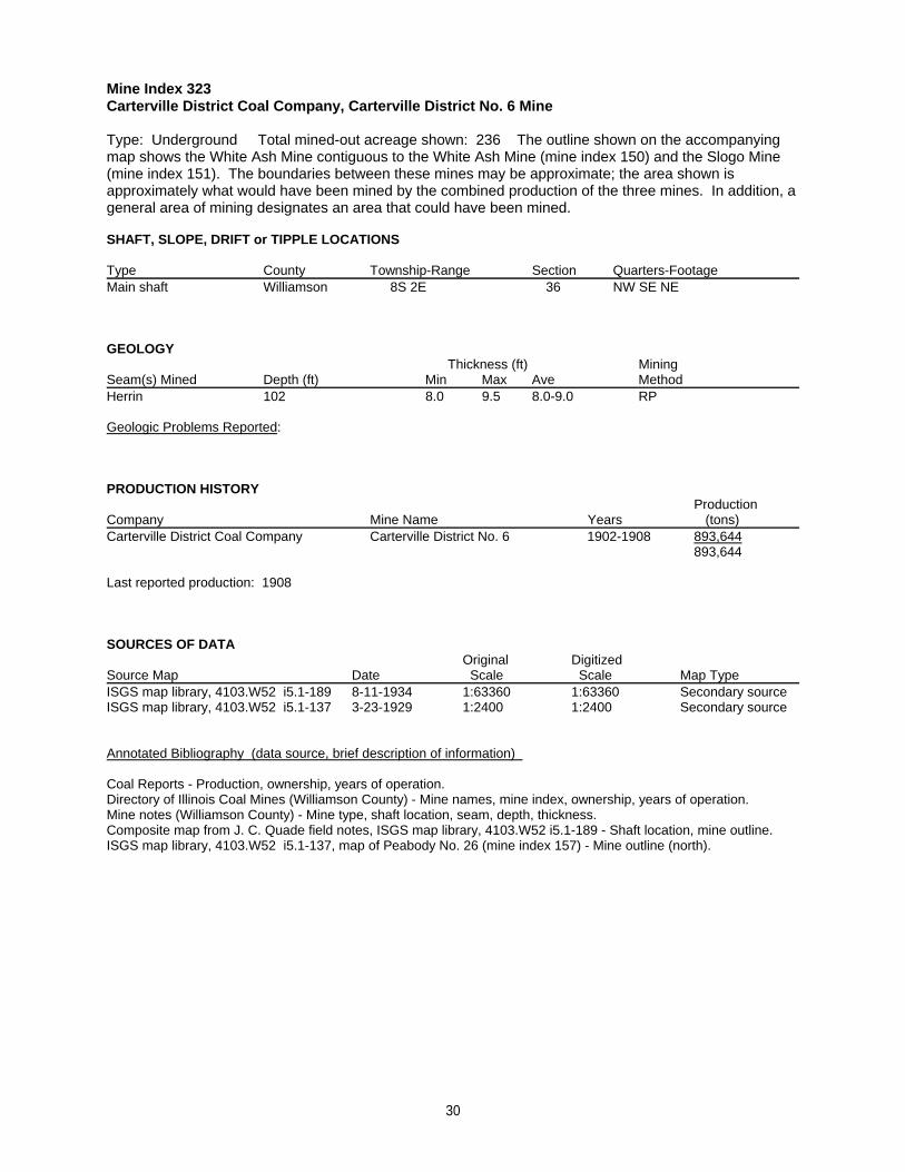
Mine Index 323Carterville District Coal Company, Carterville District No. 6 Mine
Type: Underground Total mined-out acreage shown: 236 The outline shown on the accompanyingmap shows the White Ash Mine contiguous to the White Ash Mine (mine index 150) and the Slogo Mine(mine index 151). The boundaries between these mines may be approximate; the area shown isapproximately what would have been mined by the combined production of the three mines. In addition, ageneral area of mining designates an area that could have been mined.
SHAFT, SLOPE, DRIFT or TIPPLE LOCATIONS
Type County Township-Range Section Quarters-FootageMain shaft Williamson 8S 2E 36 NW SE NE
GEOLOGY Thickness (ft) Mining
Seam(s) Mined Depth (ft) Min Max Ave MethodHerrin 102 8.0 9.5 8.0-9.0 RP
Geologic Problems Reported:
PRODUCTION HISTORY Production
Company Mine Name Years (tons) Carterville District Coal Company Carterville District No. 6 1902-1908 893,644
893,644
Last reported production: 1908
SOURCES OF DATAOriginal Digitized
Source Map Date Scale Scale Map Type ISGS map library, 4103.W52 i5.1-189 8-11-1934 1:63360 1:63360 Secondary sourceISGS map library, 4103.W52 i5.1-137 3-23-1929 1:2400 1:2400 Secondary source
Annotated Bibliography (data source, brief description of information)
Coal Reports - Production, ownership, years of operation.Directory of Illinois Coal Mines (Williamson County) - Mine names, mine index, ownership, years of operation.Mine notes (Williamson County) - Mine type, shaft location, seam, depth, thickness.Composite map from J. C. Quade field notes, ISGS map library, 4103.W52 i5.1-189 - Shaft location, mine outline.ISGS map library, 4103.W52 i5.1-137, map of Peabody No. 26 (mine index 157) - Mine outline (north).
30
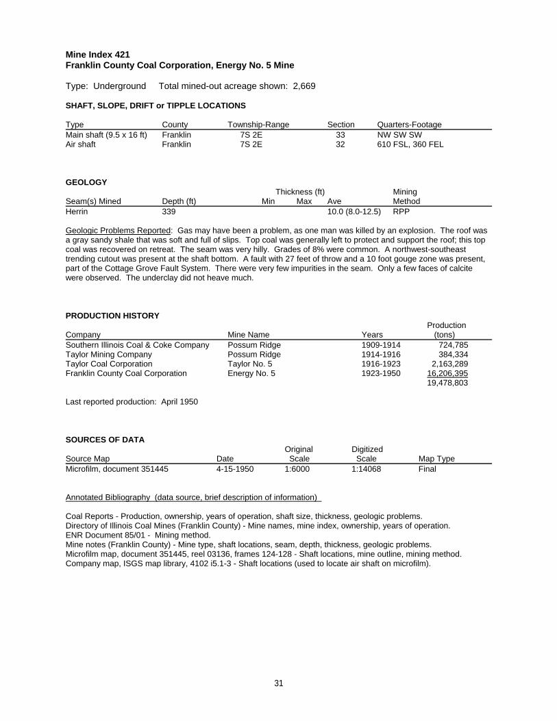
Mine Index 421Franklin County Coal Corporation, Energy No. 5 Mine
Type: Underground Total mined-out acreage shown: 2,669
SHAFT, SLOPE, DRIFT or TIPPLE LOCATIONS
Type County Township-Range Section Quarters-FootageMain shaft (9.5 x 16 ft) Franklin 7S 2E 33 NW SW SWAir shaft Franklin 7S 2E 32 610 FSL, 360 FEL
GEOLOGY Thickness (ft) Mining
Seam(s) Mined Depth (ft) Min Max Ave MethodHerrin 339 10.0 (8.0-12.5) RPP
Geologic Problems Reported: Gas may have been a problem, as one man was killed by an explosion. The roof wasa gray sandy shale that was soft and full of slips. Top coal was generally left to protect and support the roof; this topcoal was recovered on retreat. The seam was very hilly. Grades of 8% were common. A northwest-southeasttrending cutout was present at the shaft bottom. A fault with 27 feet of throw and a 10 foot gouge zone was present,part of the Cottage Grove Fault System. There were very few impurities in the seam. Only a few faces of calcitewere observed. The underclay did not heave much.
PRODUCTION HISTORY Production
Company Mine Name Years (tons) Southern Illinois Coal & Coke Company Possum Ridge 1909-1914 724,785Taylor Mining Company Possum Ridge 1914-1916 384,334Taylor Coal Corporation Taylor No. 5 1916-1923 2,163,289Franklin County Coal Corporation Energy No. 5 1923-1950 16,206,395
19,478,803
Last reported production: April 1950
SOURCES OF DATAOriginal Digitized
Source Map Date Scale Scale Map Type Microfilm, document 351445 4-15-1950 1:6000 1:14068 Final
Annotated Bibliography (data source, brief description of information)
Coal Reports - Production, ownership, years of operation, shaft size, thickness, geologic problems.Directory of Illinois Coal Mines (Franklin County) - Mine names, mine index, ownership, years of operation.ENR Document 85/01 - Mining method.Mine notes (Franklin County) - Mine type, shaft locations, seam, depth, thickness, geologic problems.Microfilm map, document 351445, reel 03136, frames 124-128 - Shaft locations, mine outline, mining method.Company map, ISGS map library, 4102 i5.1-3 - Shaft locations (used to locate air shaft on microfilm).
31
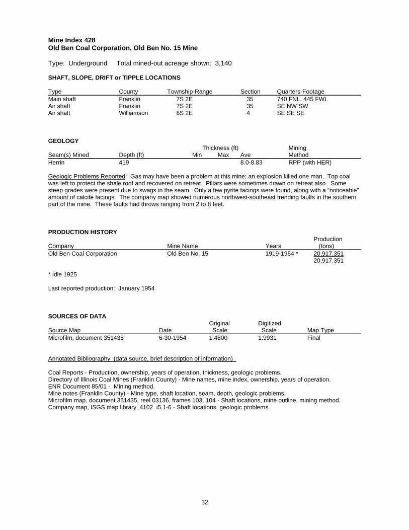
Mine Index 428Old Ben Coal Corporation, Old Ben No. 15 Mine
Type: Underground Total mined-out acreage shown: 3,140
SHAFT, SLOPE, DRIFT or TIPPLE LOCATIONS
Type County Township-Range Section Quarters-FootageMain shaft Franklin 7S 2E 35 740 FNL, 445 FWLAir shaft Franklin 7S 2E 35 SE NW SWAir shaft Williamson 8S 2E 4 SE SE SE
GEOLOGY Thickness (ft) Mining
Seam(s) Mined Depth (ft) Min Max Ave MethodHerrin 419 8.0-8.83 RPP (with HER)
Geologic Problems Reported: Gas may have been a problem at this mine; an explosion killed one man. Top coalwas left to protect the shale roof and recovered on retreat. Pillars were sometimes drawn on retreat also. Somesteep grades were present due to swags in the seam. Only a few pyrite facings were found, along with a “noticeable”amount of calcite facings. The company map showed numerous northwest-southeast trending faults in the southernpart of the mine. These faults had throws ranging from 2 to 8 feet.
PRODUCTION HISTORY Production
Company Mine Name Years (tons) Old Ben Coal Corporation Old Ben No. 15 1919-1954 * 20,917,351
20,917,351
* Idle 1925
Last reported production: January 1954
SOURCES OF DATAOriginal Digitized
Source Map Date Scale Scale Map Type Microfilm, document 351435 6-30-1954 1:4800 1:9931 Final
Annotated Bibliography (data source, brief description of information)
Coal Reports - Production, ownership, years of operation, thickness, geologic problems.Directory of Illinois Coal Mines (Franklin County) - Mine names, mine index, ownership, years of operation.ENR Document 85/01 - Mining method.Mine notes (Franklin County) - Mine type, shaft location, seam, depth, geologic problems.Microfilm map, document 351435, reel 03136, frames 103, 104 - Shaft locations, mine outline, mining method.Company map, ISGS map library, 4102 i5.1-6 - Shaft locations, geologic problems.
32
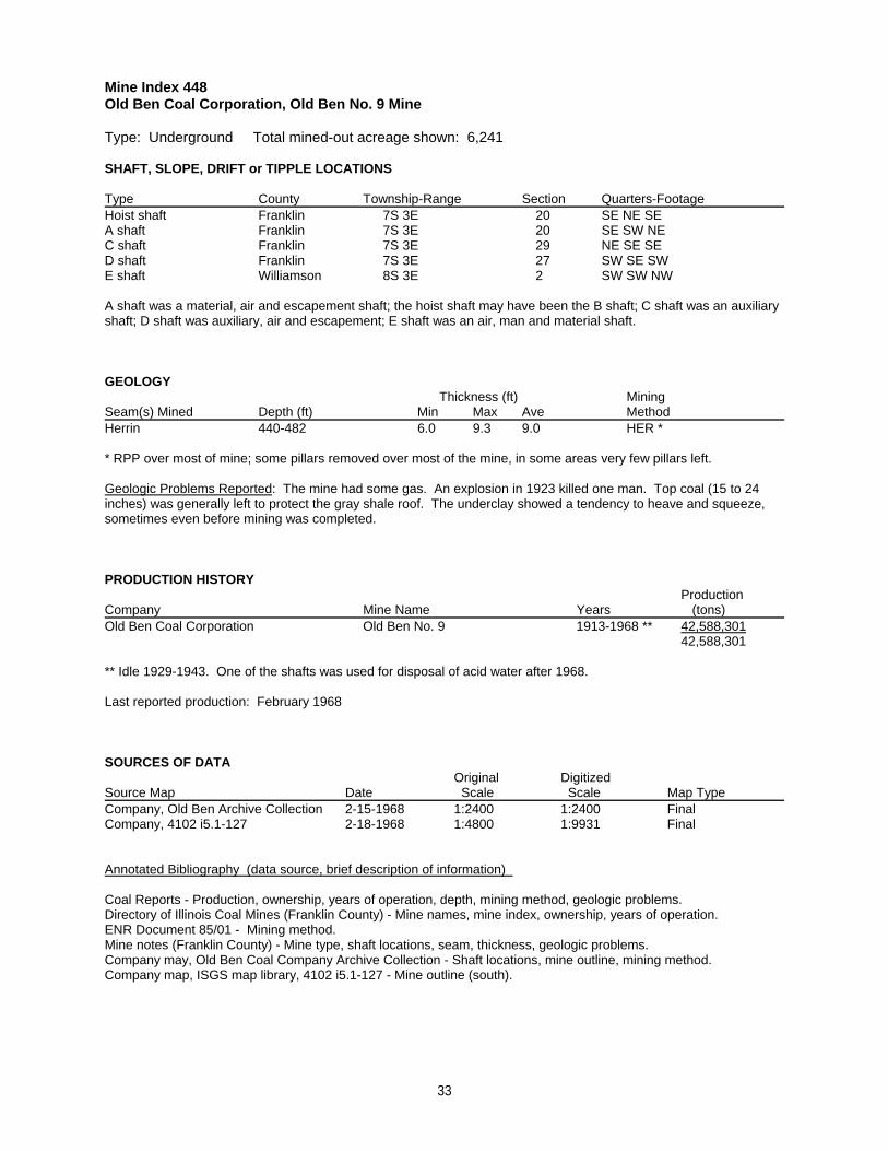
Mine Index 448Old Ben Coal Corporation, Old Ben No. 9 Mine
Type: Underground Total mined-out acreage shown: 6,241
SHAFT, SLOPE, DRIFT or TIPPLE LOCATIONS
Type County Township-Range Section Quarters-FootageHoist shaft Franklin 7S 3E 20 SE NE SEA shaft Franklin 7S 3E 20 SE SW NEC shaft Franklin 7S 3E 29 NE SE SED shaft Franklin 7S 3E 27 SW SE SWE shaft Williamson 8S 3E 2 SW SW NW
A shaft was a material, air and escapement shaft; the hoist shaft may have been the B shaft; C shaft was an auxiliaryshaft; D shaft was auxiliary, air and escapement; E shaft was an air, man and material shaft.
GEOLOGY Thickness (ft) Mining
Seam(s) Mined Depth (ft) Min Max Ave MethodHerrin 440-482 6.0 9.3 9.0 HER *
* RPP over most of mine; some pillars removed over most of the mine, in some areas very few pillars left.
Geologic Problems Reported: The mine had some gas. An explosion in 1923 killed one man. Top coal (15 to 24inches) was generally left to protect the gray shale roof. The underclay showed a tendency to heave and squeeze,sometimes even before mining was completed.
PRODUCTION HISTORY Production
Company Mine Name Years (tons) Old Ben Coal Corporation Old Ben No. 9 1913-1968 ** 42,588,301
42,588,301
** Idle 1929-1943. One of the shafts was used for disposal of acid water after 1968.
Last reported production: February 1968
SOURCES OF DATAOriginal Digitized
Source Map Date Scale Scale Map Type Company, Old Ben Archive Collection 2-15-1968 1:2400 1:2400 FinalCompany, 4102 i5.1-127 2-18-1968 1:4800 1:9931 Final
Annotated Bibliography (data source, brief description of information)
Coal Reports - Production, ownership, years of operation, depth, mining method, geologic problems.Directory of Illinois Coal Mines (Franklin County) - Mine names, mine index, ownership, years of operation.ENR Document 85/01 - Mining method.Mine notes (Franklin County) - Mine type, shaft locations, seam, thickness, geologic problems.Company may, Old Ben Coal Company Archive Collection - Shaft locations, mine outline, mining method.Company map, ISGS map library, 4102 i5.1-127 - Mine outline (south).
33
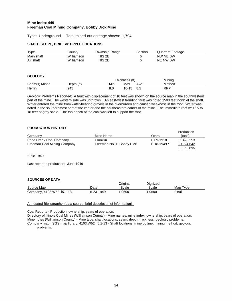
Mine Index 449Freeman Coal Mining Company, Bobby Dick Mine
Type: Underground Total mined-out acreage shown: 1,794
SHAFT, SLOPE, DRIFT or TIPPLE LOCATIONS
Type County Township-Range Section Quarters-FootageMain shaft Williamson 8S 2E 5 NW NE SWAir shaft Williamson 8S 2E 5 NE NW SW
GEOLOGY Thickness (ft) Mining
Seam(s) Mined Depth (ft) Min Max Ave MethodHerrin 245 8.0 10-15 8.5 RPP
Geologic Problems Reported: A fault with displacement of 10 feet was shown on the source map in the southwesternpart of the mine. The western side was upthrown. An east-west trending fault was noted 1500 feet north of the shaft. Water entered the mine from water-bearing gravels in the overburden and caused weakness in the roof. Water wasnoted in the southernmost part of the center and the southeastern corner of the mine. The immediate roof was 15 to18 feet of gray shale. The top bench of the coal was left to support the roof.
PRODUCTION HISTORY Production
Company Mine Name Years (tons) Pond Creek Coal Company Franklin 1909-1918 1,428,253Freeman Coal Mining Company Freeman No. 1, Bobby Dick 1918-1949 * 9,924,642
11,352,895
* Idle 1940
Last reported production: June 1949
SOURCES OF DATAOriginal Digitized
Source Map Date Scale Scale Map Type Company, 4103.W52 i5.1-13 6-23-1949 1:9600 1:9600 Final
Annotated Bibliography (data source, brief description of information)
Coal Reports - Production, ownership, years of operation.Directory of Illinois Coal Mines (Williamson County) - Mine names, mine index, ownership, years of operation.Mine notes (Williamson County) - Mine type, shaft locations, seam, depth, thickness, geologic problems.Company map, ISGS map library, 4103.W52 i5.1-13 - Shaft locations, mine outline, mining method, geologic problems.
34
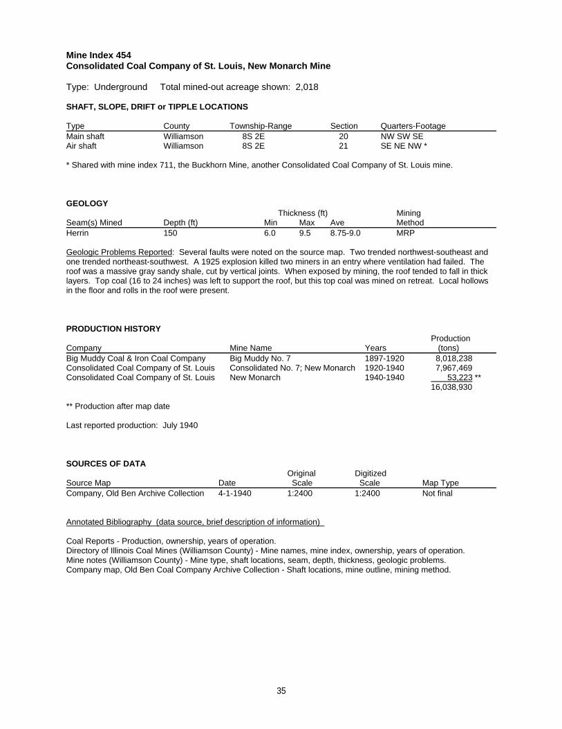
Mine Index 454Consolidated Coal Company of St. Louis, New Monarch Mine
Type: Underground Total mined-out acreage shown: 2,018
SHAFT, SLOPE, DRIFT or TIPPLE LOCATIONS
Type County Township-Range Section Quarters-FootageMain shaft Williamson 8S 2E 20 NW SW SEAir shaft Williamson 8S 2E 21 SE NE NW *
* Shared with mine index 711, the Buckhorn Mine, another Consolidated Coal Company of St. Louis mine.
GEOLOGY Thickness (ft) Mining
Seam(s) Mined Depth (ft) Min Max Ave MethodHerrin 150 6.0 9.5 8.75-9.0 MRP
Geologic Problems Reported: Several faults were noted on the source map. Two trended northwest-southeast andone trended northeast-southwest. A 1925 explosion killed two miners in an entry where ventilation had failed. Theroof was a massive gray sandy shale, cut by vertical joints. When exposed by mining, the roof tended to fall in thicklayers. Top coal (16 to 24 inches) was left to support the roof, but this top coal was mined on retreat. Local hollowsin the floor and rolls in the roof were present.
PRODUCTION HISTORY Production
Company Mine Name Years (tons) Big Muddy Coal & Iron Coal Company Big Muddy No. 7 1897-1920 8,018,238Consolidated Coal Company of St. Louis Consolidated No. 7; New Monarch 1920-1940 7,967,469Consolidated Coal Company of St. Louis New Monarch 1940-1940 53,223 **
16,038,930
** Production after map date
Last reported production: July 1940
SOURCES OF DATAOriginal Digitized
Source Map Date Scale Scale Map Type Company, Old Ben Archive Collection 4-1-1940 1:2400 1:2400 Not final
Annotated Bibliography (data source, brief description of information)
Coal Reports - Production, ownership, years of operation.Directory of Illinois Coal Mines (Williamson County) - Mine names, mine index, ownership, years of operation.Mine notes (Williamson County) - Mine type, shaft locations, seam, depth, thickness, geologic problems.Company map, Old Ben Coal Company Archive Collection - Shaft locations, mine outline, mining method.
35
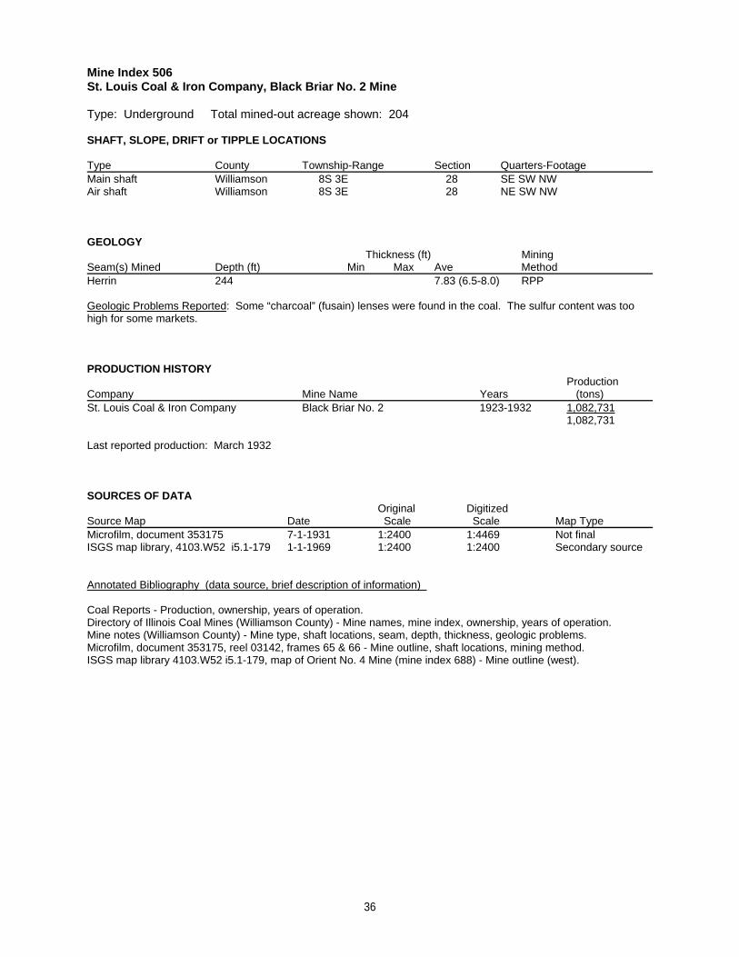
Mine Index 506St. Louis Coal & Iron Company, Black Briar No. 2 Mine
Type: Underground Total mined-out acreage shown: 204
SHAFT, SLOPE, DRIFT or TIPPLE LOCATIONS
Type County Township-Range Section Quarters-FootageMain shaft Williamson 8S 3E 28 SE SW NWAir shaft Williamson 8S 3E 28 NE SW NW
GEOLOGY Thickness (ft) Mining
Seam(s) Mined Depth (ft) Min Max Ave MethodHerrin 244 7.83 (6.5-8.0) RPP
Geologic Problems Reported: Some “charcoal” (fusain) lenses were found in the coal. The sulfur content was toohigh for some markets.
PRODUCTION HISTORY Production
Company Mine Name Years (tons) St. Louis Coal & Iron Company Black Briar No. 2 1923-1932 1,082,731
1,082,731
Last reported production: March 1932
SOURCES OF DATAOriginal Digitized
Source Map Date Scale Scale Map Type Microfilm, document 353175 7-1-1931 1:2400 1:4469 Not finalISGS map library, 4103.W52 i5.1-179 1-1-1969 1:2400 1:2400 Secondary source
Annotated Bibliography (data source, brief description of information)
Coal Reports - Production, ownership, years of operation.Directory of Illinois Coal Mines (Williamson County) - Mine names, mine index, ownership, years of operation.Mine notes (Williamson County) - Mine type, shaft locations, seam, depth, thickness, geologic problems.Microfilm, document 353175, reel 03142, frames 65 & 66 - Mine outline, shaft locations, mining method.ISGS map library 4103.W52 i5.1-179, map of Orient No. 4 Mine (mine index 688) - Mine outline (west).
36
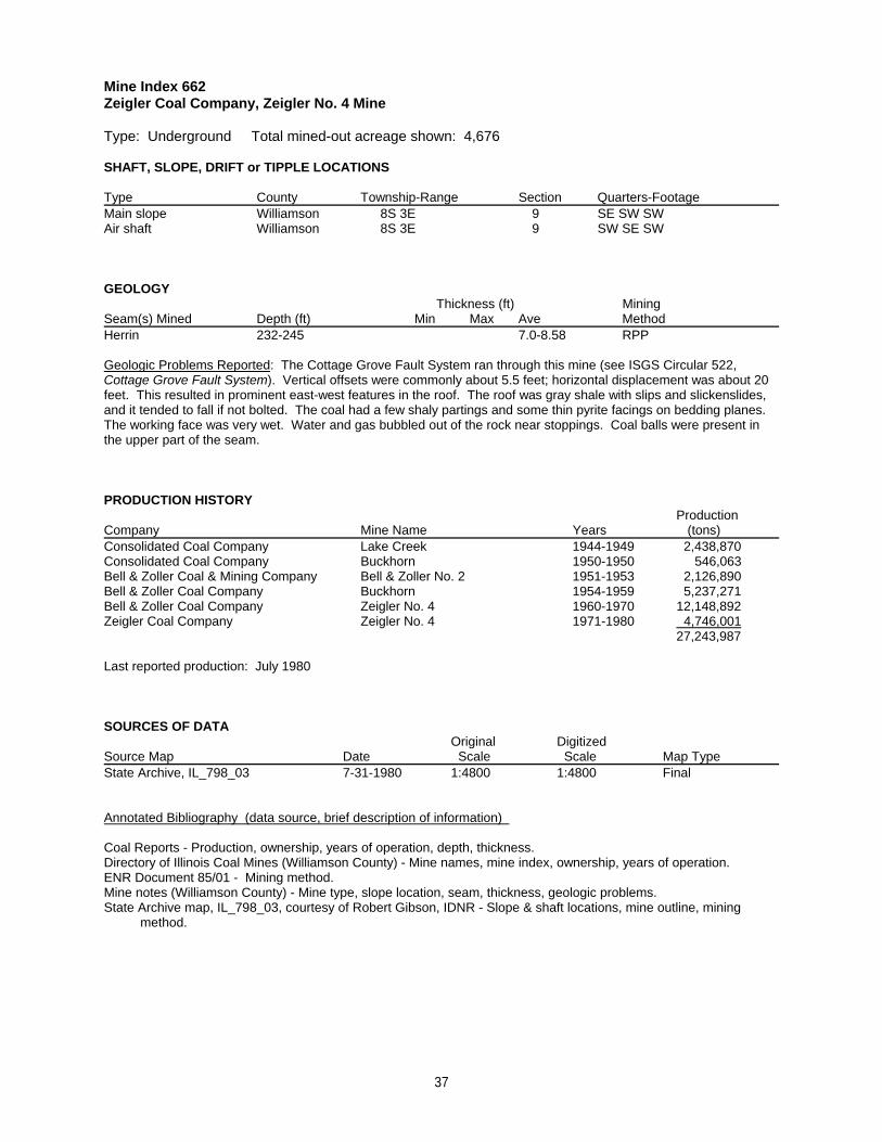
Mine Index 662Zeigler Coal Company, Zeigler No. 4 Mine
Type: Underground Total mined-out acreage shown: 4,676
SHAFT, SLOPE, DRIFT or TIPPLE LOCATIONS
Type County Township-Range Section Quarters-FootageMain slope Williamson 8S 3E 9 SE SW SWAir shaft Williamson 8S 3E 9 SW SE SW
GEOLOGY Thickness (ft) Mining
Seam(s) Mined Depth (ft) Min Max Ave MethodHerrin 232-245 7.0-8.58 RPP
Geologic Problems Reported: The Cottage Grove Fault System ran through this mine (see ISGS Circular 522,Cottage Grove Fault System). Vertical offsets were commonly about 5.5 feet; horizontal displacement was about 20feet. This resulted in prominent east-west features in the roof. The roof was gray shale with slips and slickenslides,and it tended to fall if not bolted. The coal had a few shaly partings and some thin pyrite facings on bedding planes. The working face was very wet. Water and gas bubbled out of the rock near stoppings. Coal balls were present inthe upper part of the seam.
PRODUCTION HISTORY Production
Company Mine Name Years (tons) Consolidated Coal Company Lake Creek 1944-1949 2,438,870Consolidated Coal Company Buckhorn 1950-1950 546,063Bell & Zoller Coal & Mining Company Bell & Zoller No. 2 1951-1953 2,126,890Bell & Zoller Coal Company Buckhorn 1954-1959 5,237,271Bell & Zoller Coal Company Zeigler No. 4 1960-1970 12,148,892Zeigler Coal Company Zeigler No. 4 1971-1980 4,746,001
27,243,987
Last reported production: July 1980
SOURCES OF DATAOriginal Digitized
Source Map Date Scale Scale Map Type State Archive, IL_798_03 7-31-1980 1:4800 1:4800 Final
Annotated Bibliography (data source, brief description of information)
Coal Reports - Production, ownership, years of operation, depth, thickness.Directory of Illinois Coal Mines (Williamson County) - Mine names, mine index, ownership, years of operation.ENR Document 85/01 - Mining method.Mine notes (Williamson County) - Mine type, slope location, seam, thickness, geologic problems.State Archive map, IL_798_03, courtesy of Robert Gibson, IDNR - Slope & shaft locations, mine outline, mining method.
37
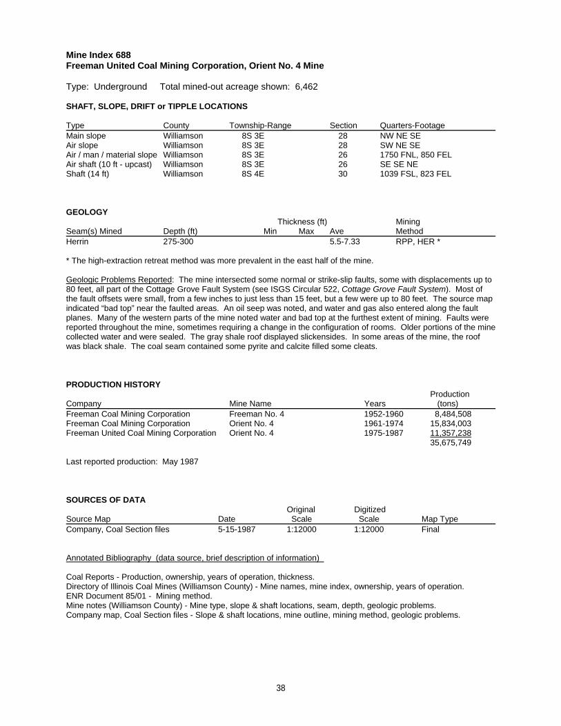
Mine Index 688Freeman United Coal Mining Corporation, Orient No. 4 Mine
Type: Underground Total mined-out acreage shown: 6,462
SHAFT, SLOPE, DRIFT or TIPPLE LOCATIONS
Type County Township-Range Section Quarters-FootageMain slope Williamson 8S 3E 28 NW NE SEAir slope Williamson 8S 3E 28 SW NE SEAir / man / material slope Williamson 8S 3E 26 1750 FNL, 850 FELAir shaft (10 ft - upcast) Williamson 8S 3E 26 SE SE NEShaft (14 ft) Williamson 8S 4E 30 1039 FSL, 823 FEL
GEOLOGY Thickness (ft) Mining
Seam(s) Mined Depth (ft) Min Max Ave MethodHerrin 275-300 5.5-7.33 RPP, HER *
* The high-extraction retreat method was more prevalent in the east half of the mine.
Geologic Problems Reported: The mine intersected some normal or strike-slip faults, some with displacements up to80 feet, all part of the Cottage Grove Fault System (see ISGS Circular 522, Cottage Grove Fault System). Most ofthe fault offsets were small, from a few inches to just less than 15 feet, but a few were up to 80 feet. The source mapindicated “bad top” near the faulted areas. An oil seep was noted, and water and gas also entered along the faultplanes. Many of the western parts of the mine noted water and bad top at the furthest extent of mining. Faults werereported throughout the mine, sometimes requiring a change in the configuration of rooms. Older portions of the minecollected water and were sealed. The gray shale roof displayed slickensides. In some areas of the mine, the roofwas black shale. The coal seam contained some pyrite and calcite filled some cleats.
PRODUCTION HISTORY Production
Company Mine Name Years (tons) Freeman Coal Mining Corporation Freeman No. 4 1952-1960 8,484,508Freeman Coal Mining Corporation Orient No. 4 1961-1974 15,834,003Freeman United Coal Mining Corporation Orient No. 4 1975-1987 11,357,238
35,675,749
Last reported production: May 1987
SOURCES OF DATAOriginal Digitized
Source Map Date Scale Scale Map Type Company, Coal Section files 5-15-1987 1:12000 1:12000 Final
Annotated Bibliography (data source, brief description of information)
Coal Reports - Production, ownership, years of operation, thickness.Directory of Illinois Coal Mines (Williamson County) - Mine names, mine index, ownership, years of operation.ENR Document 85/01 - Mining method.Mine notes (Williamson County) - Mine type, slope & shaft locations, seam, depth, geologic problems.Company map, Coal Section files - Slope & shaft locations, mine outline, mining method, geologic problems.
38
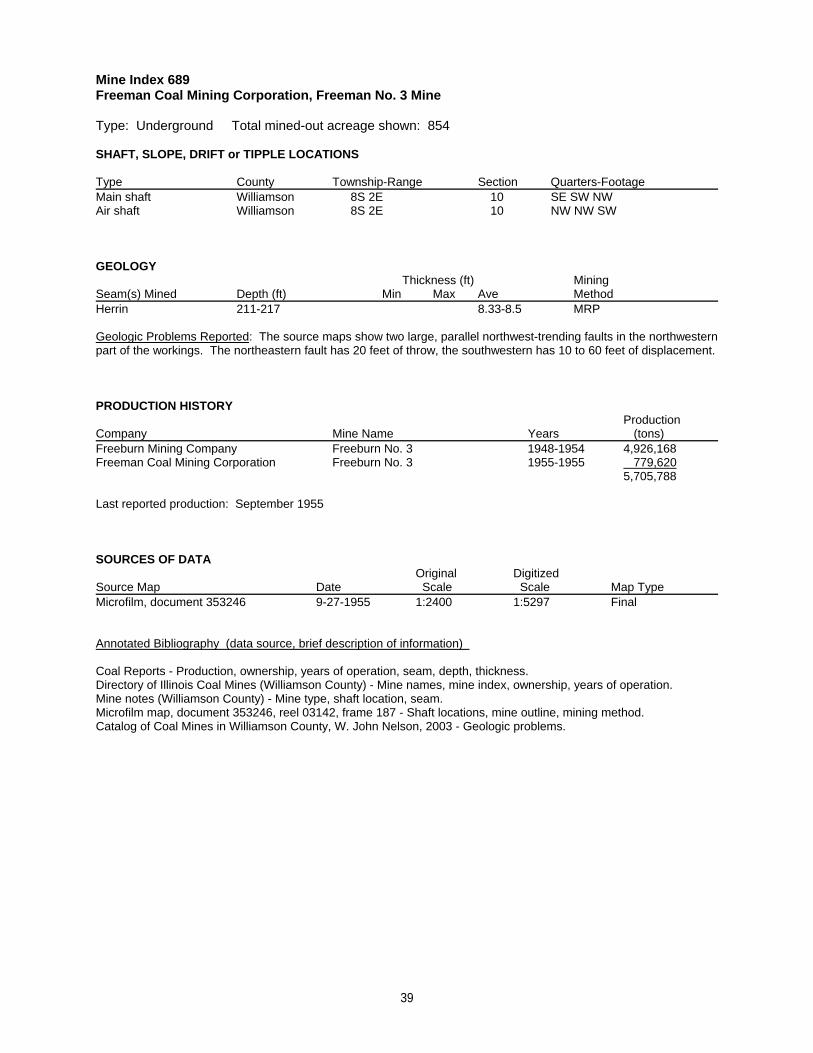
Mine Index 689Freeman Coal Mining Corporation, Freeman No. 3 Mine
Type: Underground Total mined-out acreage shown: 854
SHAFT, SLOPE, DRIFT or TIPPLE LOCATIONS
Type County Township-Range Section Quarters-FootageMain shaft Williamson 8S 2E 10 SE SW NWAir shaft Williamson 8S 2E 10 NW NW SW
GEOLOGY Thickness (ft) Mining
Seam(s) Mined Depth (ft) Min Max Ave MethodHerrin 211-217 8.33-8.5 MRP
Geologic Problems Reported: The source maps show two large, parallel northwest-trending faults in the northwesternpart of the workings. The northeastern fault has 20 feet of throw, the southwestern has 10 to 60 feet of displacement.
PRODUCTION HISTORY Production
Company Mine Name Years (tons) Freeburn Mining Company Freeburn No. 3 1948-1954 4,926,168Freeman Coal Mining Corporation Freeburn No. 3 1955-1955 779,620
5,705,788
Last reported production: September 1955
SOURCES OF DATAOriginal Digitized
Source Map Date Scale Scale Map Type Microfilm, document 353246 9-27-1955 1:2400 1:5297 Final
Annotated Bibliography (data source, brief description of information)
Coal Reports - Production, ownership, years of operation, seam, depth, thickness.Directory of Illinois Coal Mines (Williamson County) - Mine names, mine index, ownership, years of operation.Mine notes (Williamson County) - Mine type, shaft location, seam.Microfilm map, document 353246, reel 03142, frame 187 - Shaft locations, mine outline, mining method.Catalog of Coal Mines in Williamson County, W. John Nelson, 2003 - Geologic problems.
39
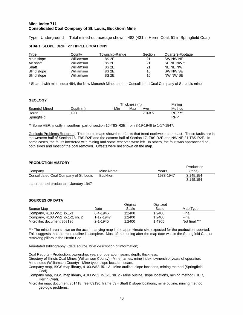
Mine Index 711Consolidated Coal Company of St. Louis, Buckhorn Mine
Type: Underground Total mined-out acreage shown: 482 (431 in Herrin Coal, 51 in Springfield Coal)
SHAFT, SLOPE, DRIFT or TIPPLE LOCATIONS
Type County Township-Range Section Quarters-FootageMain slope Williamson 8S 2E 21 SW NW NEAir shaft Williamson 8S 2E 21 SE NE NW *Shaft Williamson 8S 2E 21 NE NE NWBlind slope Williamson 8S 2E 16 SW NW SEBlind slope Williamson 8S 2E 16 NW NW SE
* Shared with mine index 454, the New Monarch Mine, another Consolidated Coal Company of St. Louis mine.
GEOLOGY Thickness (ft) Mining
Seam(s) Mined Depth (ft) Min Max Ave MethodHerrin 190 7.0-8.5 RPP **Springfield RPP
** Some HER, mostly in southern part of section 16-T8S-R2E, from 8-19-1946 to 1-17-1947.
Geologic Problems Reported: The source maps show three faults that trend northwest-southeast. These faults are inthe western half of Section 16, T8S-R2E and the eastern half of Section 17, T8S-R2E and NW NE 21-T8S-R2E. Insome cases, the faults interfered with mining and some reserves were left. In others, the fault was approached onboth sides and most of the coal removed. Offsets were not shown on the map.
PRODUCTION HISTORY Production
Company Mine Name Years (tons) Consolidated Coal Company of St. Louis Buckhorn 1938-1947 3,145,154
3,145,154Last reported production: January 1947
SOURCES OF DATAOriginal Digitized
Source Map Date Scale Scale Map Type Company, 4103.W52 i5.1-3 8-4-1946 1:2400 1:2400 Final Company, 4103.W52 i5.1-2, sh. 2 1-17-1947 1:2400 1:2400 FinalMicrofilm, document 353196 2-1-1945 1:2400 1:4965 Not final ***
*** The mined area shown on the accompanying map is the approximate size expected for the production reported. This suggests that the mine outline is complete. Most of the mining after the map date was in the Springfield Coal orremoving pillars in the Herrin Coal.
Annotated Bibliography (data source, brief description of information)
Coal Reports - Production, ownership, years of operation, seam, depth, thickness.Directory of Illinois Coal Mines (Williamson County) - Mine names, mine index, ownership, years of operation.Mine notes (Williamson County) - Mine type, slope location, seam.Company map, ISGS map library, 4103.W52 i5.1-3 - Mine outline, slope locations, mining method (Springfield Coal).Company map, ISGS map library, 4103.W52 i5.1-2, sh. 2 - Mine outline, slope locations, mining method (HER, Herrin Coal).Microfilm map, document 351418, reel 03136, frame 53 - Shaft & slope locations, mine outline, mining method, geologic problems.
40
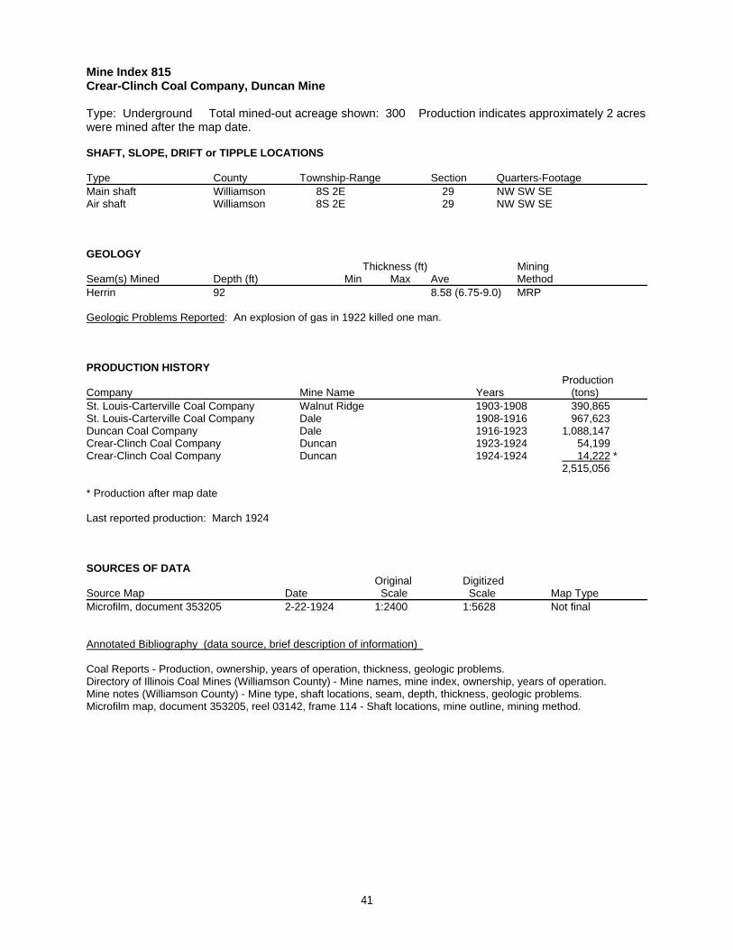
Mine Index 815Crear-Clinch Coal Company, Duncan Mine
Type: Underground Total mined-out acreage shown: 300 Production indicates approximately 2 acreswere mined after the map date.
SHAFT, SLOPE, DRIFT or TIPPLE LOCATIONS
Type County Township-Range Section Quarters-FootageMain shaft Williamson 8S 2E 29 NW SW SEAir shaft Williamson 8S 2E 29 NW SW SE
GEOLOGY Thickness (ft) Mining
Seam(s) Mined Depth (ft) Min Max Ave MethodHerrin 92 8.58 (6.75-9.0) MRP
Geologic Problems Reported: An explosion of gas in 1922 killed one man.
PRODUCTION HISTORY Production
Company Mine Name Years (tons) St. Louis-Carterville Coal Company Walnut Ridge 1903-1908 390,865St. Louis-Carterville Coal Company Dale 1908-1916 967,623Duncan Coal Company Dale 1916-1923 1,088,147Crear-Clinch Coal Company Duncan 1923-1924 54,199Crear-Clinch Coal Company Duncan 1924-1924 14,222 *
2,515,056
* Production after map date
Last reported production: March 1924
SOURCES OF DATAOriginal Digitized
Source Map Date Scale Scale Map Type Microfilm, document 353205 2-22-1924 1:2400 1:5628 Not final
Annotated Bibliography (data source, brief description of information)
Coal Reports - Production, ownership, years of operation, thickness, geologic problems.Directory of Illinois Coal Mines (Williamson County) - Mine names, mine index, ownership, years of operation.Mine notes (Williamson County) - Mine type, shaft locations, seam, depth, thickness, geologic problems.Microfilm map, document 353205, reel 03142, frame 114 - Shaft locations, mine outline, mining method.
41
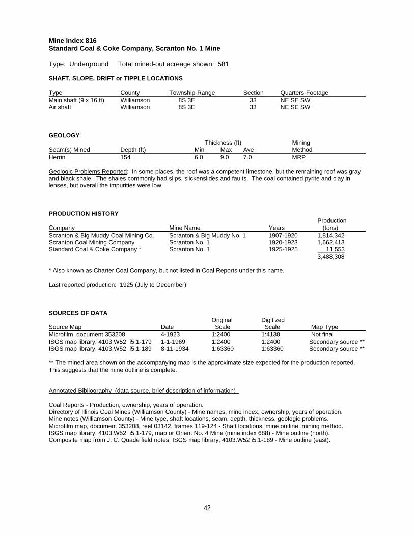
Mine Index 816Standard Coal & Coke Company, Scranton No. 1 Mine
Type: Underground Total mined-out acreage shown: 581
SHAFT, SLOPE, DRIFT or TIPPLE LOCATIONS
Type County Township-Range Section Quarters-FootageMain shaft (9 x 16 ft) Williamson 8S 3E 33 NE SE SWAir shaft Williamson 8S 3E 33 NE SE SW
GEOLOGY Thickness (ft) Mining
Seam(s) Mined Depth (ft) Min Max Ave MethodHerrin 154 6.0 9.0 7.0 MRP
Geologic Problems Reported: In some places, the roof was a competent limestone, but the remaining roof was grayand black shale. The shales commonly had slips, slickenslides and faults. The coal contained pyrite and clay inlenses, but overall the impurities were low.
PRODUCTION HISTORY Production
Company Mine Name Years (tons) Scranton & Big Muddy Coal Mining Co. Scranton & Big Muddy No. 1 1907-1920 1,814,342Scranton Coal Mining Company Scranton No. 1 1920-1923 1,662,413Standard Coal & Coke Company * Scranton No. 1 1925-1925 11,553
3,488,308
* Also known as Charter Coal Company, but not listed in Coal Reports under this name.
Last reported production: 1925 (July to December)
SOURCES OF DATAOriginal Digitized
Source Map Date Scale Scale Map Type Microfilm, document 353208 4-1923 1:2400 1:4138 Not finalISGS map library, 4103.W52 i5.1-179 1-1-1969 1:2400 1:2400 Secondary source **ISGS map library, 4103.W52 i5.1-189 8-11-1934 1:63360 1:63360 Secondary source **
** The mined area shown on the accompanying map is the approximate size expected for the production reported. This suggests that the mine outline is complete.
Annotated Bibliography (data source, brief description of information)
Coal Reports - Production, ownership, years of operation.Directory of Illinois Coal Mines (Williamson County) - Mine names, mine index, ownership, years of operation.Mine notes (Williamson County) - Mine type, shaft locations, seam, depth, thickness, geologic problems.Microfilm map, document 353208, reel 03142, frames 119-124 - Shaft locations, mine outline, mining method.ISGS map library, 4103.W52 i5.1-179, map or Orient No. 4 Mine (mine index 688) - Mine outline (north).Composite map from J. C. Quade field notes, ISGS map library, 4103.W52 i5.1-189 - Mine outline (east).
42

Mine Index 818Binkley & Miles, Binkley & Miles Mine
Type: Surface Total mined-out acreage shown: None This mine is part of a larger area of surfacemining. Production indicates approximately 4 acres were mined.
SHAFT, SLOPE, DRIFT or TIPPLE LOCATIONS
Type County Township-Range Section Quarters-FootagePit Williamson 9S 3E 6 SE SE SW
GEOLOGY Thickness (ft) Mining
Seam(s) Mined Depth (ft) Min Max Ave MethodHerrin 8-20 8.0-9.5 Surface
Geologic Problems Reported: The overburden was surficial materials: sticky yellow clay and a blue or black shale. Many slips were present in the coal seam, which broke easily into large blocks. The coal also contained some thinstringers of pyrite.
PRODUCTION HISTORY Production
Company Mine Name Years (tons) Binkley & Miles Binkley & Miles 1909-1914 * 30,000
30,000
* Idle 1911 & 1912
Last reported production: 1914
SOURCES OF DATAOriginal Digitized
Source Map Date Scale Scale Map Type Mine notes Undated (text only) 1:24000 ** Secondary source
** Point plotted onto 1:24,000 USGS topographic map and digitized.
Annotated Bibliography (data source, brief description of information)
Coal Reports - Production, ownership, years of operation.Directory of Illinois Coal Mines (Williamson County) - Mine names, mine index, ownership, years of operation.Mine notes (Williamson County) - Mine type, mine location, seam, depth, thickness, geologic problems.
43
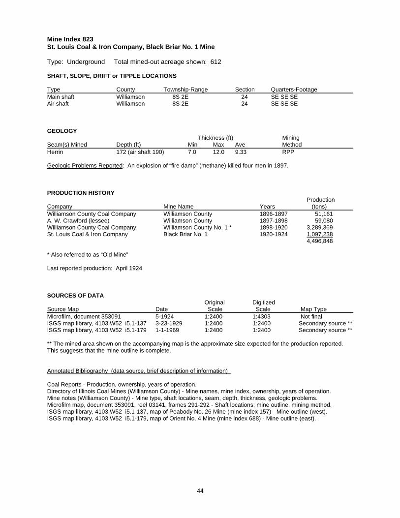
Mine Index 823St. Louis Coal & Iron Company, Black Briar No. 1 Mine
Type: Underground Total mined-out acreage shown: 612
SHAFT, SLOPE, DRIFT or TIPPLE LOCATIONS
Type County Township-Range Section Quarters-FootageMain shaft Williamson 8S 2E 24 SE SE SEAir shaft Williamson 8S 2E 24 SE SE SE
GEOLOGY Thickness (ft) Mining
Seam(s) Mined Depth (ft) Min Max Ave MethodHerrin 172 (air shaft 190) 7.0 12.0 9.33 RPP
Geologic Problems Reported: An explosion of “fire damp” (methane) killed four men in 1897.
PRODUCTION HISTORY Production
Company Mine Name Years (tons) Williamson County Coal Company Williamson County 1896-1897 51,161A. W. Crawford (lessee) Williamson County 1897-1898 59,080Williamson County Coal Company Williamson County No. 1 * 1898-1920 3,289,369St. Louis Coal & Iron Company Black Briar No. 1 1920-1924 1,097,238
4,496,848
* Also referred to as “Old Mine”
Last reported production: April 1924
SOURCES OF DATAOriginal Digitized
Source Map Date Scale Scale Map Type Microfilm, document 353091 5-1924 1:2400 1:4303 Not finalISGS map library, 4103.W52 i5.1-137 3-23-1929 1:2400 1:2400 Secondary source **ISGS map library, 4103.W52 i5.1-179 1-1-1969 1:2400 1:2400 Secondary source **
** The mined area shown on the accompanying map is the approximate size expected for the production reported. This suggests that the mine outline is complete.
Annotated Bibliography (data source, brief description of information)
Coal Reports - Production, ownership, years of operation.Directory of Illinois Coal Mines (Williamson County) - Mine names, mine index, ownership, years of operation.Mine notes (Williamson County) - Mine type, shaft locations, seam, depth, thickness, geologic problems.Microfilm map, document 353091, reel 03141, frames 291-292 - Shaft locations, mine outline, mining method.ISGS map library, 4103.W52 i5.1-137, map of Peabody No. 26 Mine (mine index 157) - Mine outline (west).ISGS map library, 4103.W52 i5.1-179, map of Orient No. 4 Mine (mine index 688) - Mine outline (east).
44
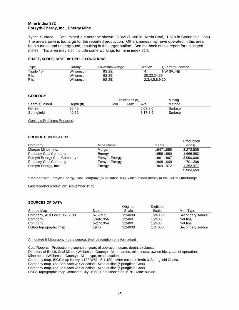
Mine Index 882Forsyth-Energy, Inc., Energy Mine
Type: Surface Total mined-out acreage shown: 3,365 (1,686 in Herrin Coal, 1,679 in Springfield Coal) The area shown is too large for the reported production. Others mines may have operated in this area,both surface and underground, resulting in the larger outline. See the back of this report for unlocatedmines. This area may also include some workings for mine index 814.
SHAFT, SLOPE, DRIFT or TIPPLE LOCATIONS
Type County Township-Range Section Quarters-FootageTipple / pit Williamson 9S 2E 4 NW SW NEPits Williamson 8S 2E 28,33,34,35Pits Williamson 9S 2E 2,3,4,5,8,9,10
GEOLOGY Thickness (ft) Mining
Seam(s) Mined Depth (ft) Min Max Ave MethodHerrin 20-42 5.08-8.0 SurfaceSpringfield 40-55 3.17-3.5 Surface
Geologic Problems Reported:
PRODUCTION HISTORY Production
Company Mine Name Years (tons) Morgan Mines, Inc. Morgan 1947-1956 3,272,505Peabody Coal Company Energy 1956-1960 1,666,963Forsyth-Energy Coal Company * Forsyth-Energy 1961-1967 3,090,006Peabody Coal Company Forsyth-Energy 1968-1969 701,208Forsyth-Energy, Inc. Energy 1969-1972 1,252,977
9,983,659
* Merged with Forsyth-Energy Coal Company (mine index 814), which mined mostly in the Herrin Quadrangle.
Last reported production: November 1972
SOURCES OF DATAOriginal Digitized
Source Map Date Scale Scale Map Type Company, 4103.W52 i5.1-180 5-1-1971 1:24000 1:24000 Secondary sourceCompany 10-8-1956 1:2400 1:2400 Not finalCompany 5-27-1954 1:2400 1:2400 Not finalUSGS topographic map 1976 1:24000 1:24000 Secondary source
Annotated Bibliography (data source, brief description of information)
Coal Reports - Production, ownership, years of operation, seam, depth, thickness.Directory of Illinois Coal Mines (Williamson County) - Mine names, mine index, ownership, years of operation.Mine notes (Williamson County) - Mine type, mine location.Company map, ISGS map library, 4103.W52 i5.1-180 - Mine outline (Herrin & Springfield Coals).Company map, Old Ben Archive Collection - Mine outline (Springfield Coal). Company map, Old Ben Archive Collection - Mine outline (Springfield Coal).USGS topographic map, Johnston City, 1963, Photoinspected 1976 - Mine outline.
45
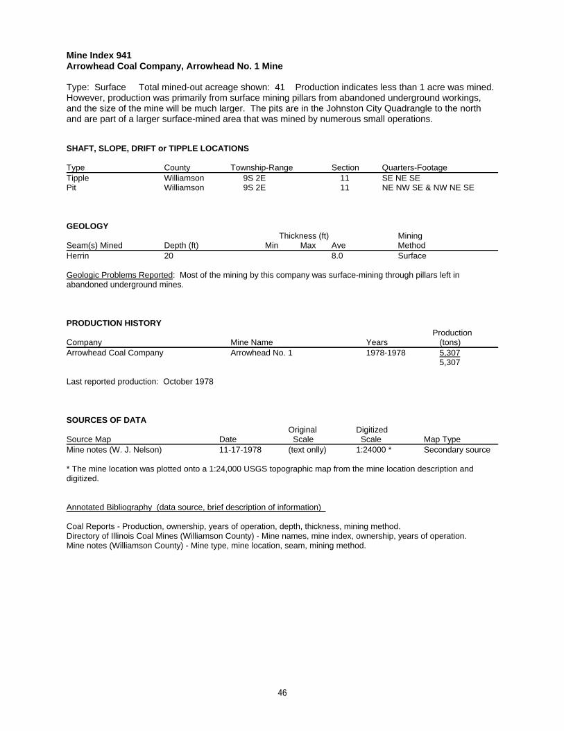
Mine Index 941Arrowhead Coal Company, Arrowhead No. 1 Mine
Type: Surface Total mined-out acreage shown: 41 Production indicates less than 1 acre was mined. However, production was primarily from surface mining pillars from abandoned underground workings,and the size of the mine will be much larger. The pits are in the Johnston City Quadrangle to the northand are part of a larger surface-mined area that was mined by numerous small operations.
SHAFT, SLOPE, DRIFT or TIPPLE LOCATIONS
Type County Township-Range Section Quarters-FootageTipple Williamson 9S 2E 11 SE NE SEPit Williamson 9S 2E 11 NE NW SE & NW NE SE
GEOLOGY Thickness (ft) Mining
Seam(s) Mined Depth (ft) Min Max Ave MethodHerrin 20 8.0 Surface
Geologic Problems Reported: Most of the mining by this company was surface-mining through pillars left inabandoned underground mines.
PRODUCTION HISTORY Production
Company Mine Name Years (tons) Arrowhead Coal Company Arrowhead No. 1 1978-1978 5,307
5,307
Last reported production: October 1978
SOURCES OF DATAOriginal Digitized
Source Map Date Scale Scale Map Type Mine notes (W. J. Nelson) 11-17-1978 (text onlly) 1:24000 * Secondary source
* The mine location was plotted onto a 1:24,000 USGS topographic map from the mine location description anddigitized.
Annotated Bibliography (data source, brief description of information)
Coal Reports - Production, ownership, years of operation, depth, thickness, mining method.Directory of Illinois Coal Mines (Williamson County) - Mine names, mine index, ownership, years of operation.Mine notes (Williamson County) - Mine type, mine location, seam, mining method.
46
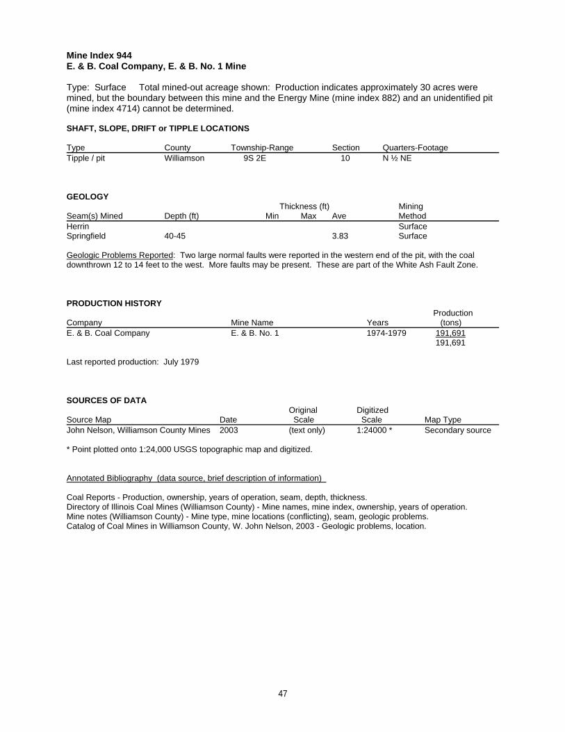
Mine Index 944E. & B. Coal Company, E. & B. No. 1 Mine
Type: Surface Total mined-out acreage shown: Production indicates approximately 30 acres weremined, but the boundary between this mine and the Energy Mine (mine index 882) and an unidentified pit(mine index 4714) cannot be determined.
SHAFT, SLOPE, DRIFT or TIPPLE LOCATIONS
Type County Township-Range Section Quarters-FootageTipple / pit Williamson 9S 2E 10 N ½ NE
GEOLOGY Thickness (ft) Mining
Seam(s) Mined Depth (ft) Min Max Ave MethodHerrin SurfaceSpringfield 40-45 3.83 Surface
Geologic Problems Reported: Two large normal faults were reported in the western end of the pit, with the coaldownthrown 12 to 14 feet to the west. More faults may be present. These are part of the White Ash Fault Zone.
PRODUCTION HISTORY Production
Company Mine Name Years (tons) E. & B. Coal Company E. & B. No. 1 1974-1979 191,691
191,691
Last reported production: July 1979
SOURCES OF DATAOriginal Digitized
Source Map Date Scale Scale Map Type John Nelson, Williamson County Mines 2003 (text only) 1:24000 * Secondary source
* Point plotted onto 1:24,000 USGS topographic map and digitized.
Annotated Bibliography (data source, brief description of information)
Coal Reports - Production, ownership, years of operation, seam, depth, thickness.Directory of Illinois Coal Mines (Williamson County) - Mine names, mine index, ownership, years of operation.Mine notes (Williamson County) - Mine type, mine locations (conflicting), seam, geologic problems.Catalog of Coal Mines in Williamson County, W. John Nelson, 2003 - Geologic problems, location.
47
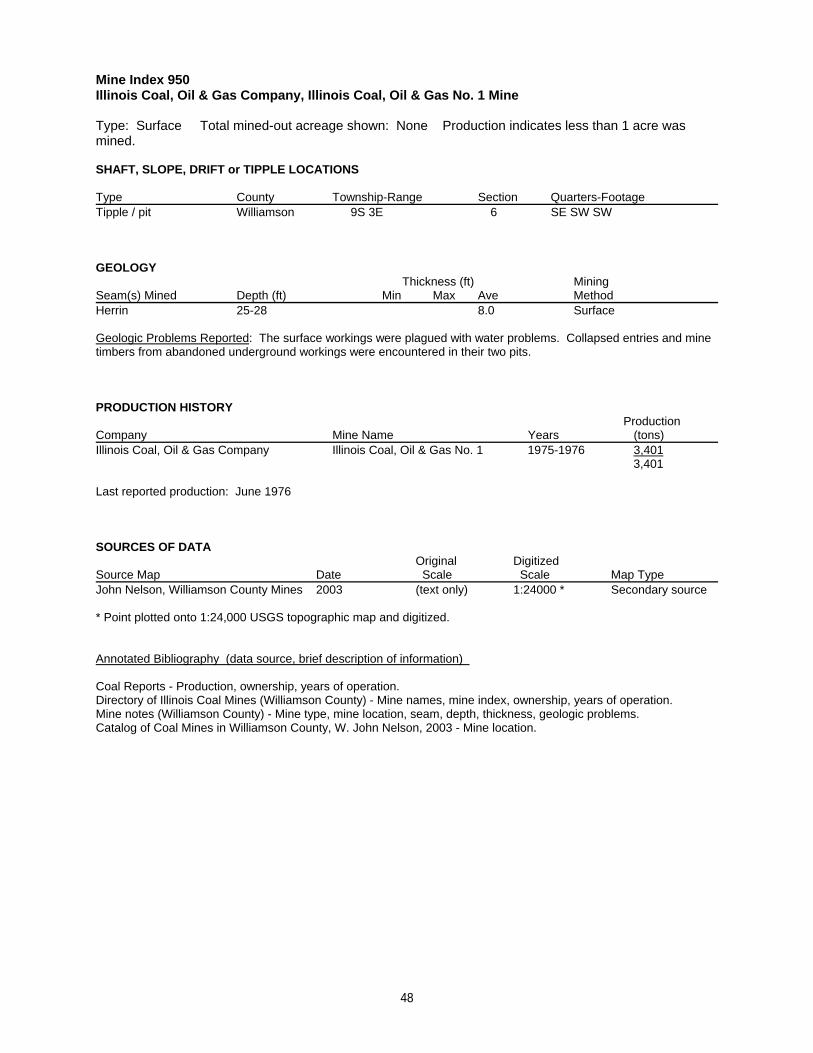
Mine Index 950Illinois Coal, Oil & Gas Company, Illinois Coal, Oil & Gas No. 1 Mine
Type: Surface Total mined-out acreage shown: None Production indicates less than 1 acre wasmined.
SHAFT, SLOPE, DRIFT or TIPPLE LOCATIONS
Type County Township-Range Section Quarters-FootageTipple / pit Williamson 9S 3E 6 SE SW SW
GEOLOGY Thickness (ft) Mining
Seam(s) Mined Depth (ft) Min Max Ave MethodHerrin 25-28 8.0 Surface
Geologic Problems Reported: The surface workings were plagued with water problems. Collapsed entries and minetimbers from abandoned underground workings were encountered in their two pits.
PRODUCTION HISTORY Production
Company Mine Name Years (tons) Illinois Coal, Oil & Gas Company Illinois Coal, Oil & Gas No. 1 1975-1976 3,401
3,401
Last reported production: June 1976
SOURCES OF DATAOriginal Digitized
Source Map Date Scale Scale Map Type John Nelson, Williamson County Mines 2003 (text only) 1:24000 * Secondary source
* Point plotted onto 1:24,000 USGS topographic map and digitized.
Annotated Bibliography (data source, brief description of information)
Coal Reports - Production, ownership, years of operation.Directory of Illinois Coal Mines (Williamson County) - Mine names, mine index, ownership, years of operation.Mine notes (Williamson County) - Mine type, mine location, seam, depth, thickness, geologic problems.Catalog of Coal Mines in Williamson County, W. John Nelson, 2003 - Mine location.
48
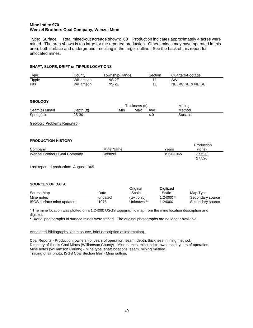
Mine Index 970Wenzel Brothers Coal Company, Wenzel Mine
Type: Surface Total mined-out acreage shown: 60 Production indicates approximately 4 acres weremined. The area shown is too large for the reported production. Others mines may have operated in thisarea, both surface and underground, resulting in the larger outline. See the back of this report forunlocated mines.
SHAFT, SLOPE, DRIFT or TIPPLE LOCATIONS
Type County Township-Range Section Quarters-FootageTipple Williamson 9S 2E 11 SWPits Williamson 9S 2E 11 NE SW SE & NE SE
GEOLOGY Thickness (ft) Mining
Seam(s) Mined Depth (ft) Min Max Ave MethodSpringfield 25-30 4.0 Surface
Geologic Problems Reported:
PRODUCTION HISTORY Production
Company Mine Name Years (tons) Wenzel Brothers Coal Company Wenzel 1964-1965 27,520
27,520
Last reported production: August 1965
SOURCES OF DATAOriginal Digitized
Source Map Date Scale Scale Map Type Mine notes undated (text only) 1:24000 * Secondary sourceISGS surface mine updates 1976 Unknown ** 1:24000 Secondary source
* The mine location was plotted on a 1:24000 USGS topographic map from the mine location description anddigitized.** Aerial photographs of surface mines were traced. The original photographs are no longer available.
Annotated Bibliography (data source, brief description of information)
Coal Reports - Production, ownership, years of operation, seam, depth, thickness, mining method.Directory of Illinois Coal Mines (Williamson County) - Mine names, mine index, ownership, years of operation.Mine notes (Williamson County) - Mine type, shaft locations, seam, mining method.Tracing of air photo, ISGS Coal Section files - Mine outline.
49
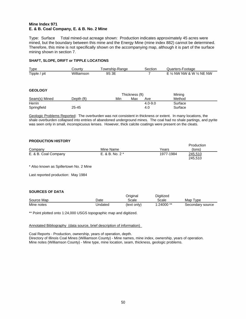
Mine Index 971E. & B. Coal Company, E. & B. No. 2 Mine
Type: Surface Total mined-out acreage shown: Production indicates approximately 45 acres weremined, but the boundary between this mine and the Energy Mine (mine index 882) cannot be determined. Therefore, this mine is not specifically shown on the accompanying map, although it is part of the surfacemining shown in section 7.
SHAFT, SLOPE, DRIFT or TIPPLE LOCATIONS
Type County Township-Range Section Quarters-FootageTipple / pit Williamson 9S 3E 7 E ½ NW NW & W ½ NE NW
GEOLOGY Thickness (ft) Mining
Seam(s) Mined Depth (ft) Min Max Ave MethodHerrin 4.0-9.0 SurfaceSpringfield 25-45 4.0 Surface
Geologic Problems Reported: The overburden was not consistent in thickness or extent. In many locations, theshale overburden collapsed into entries of abandoned underground mines. The coal had no shale partings, and pyritewas seen only in small, inconspicuous lenses. However, thick calcite coatings were present on the cleats.
PRODUCTION HISTORY Production
Company Mine Name Years (tons) E. & B. Coal Company E. & B. No. 2 * 1977-1984 245,510
245,510
* Also known as Spillertown No. 2 Mine
Last reported production: May 1984
SOURCES OF DATAOriginal Digitized
Source Map Date Scale Scale Map Type Mine notes Undated (text only) 1:24000 ** Secondary source
** Point plotted onto 1:24,000 USGS topographic map and digitized.
Annotated Bibliography (data source, brief description of information)
Coal Reports - Production, ownership, years of operation, depth.Directory of Illinois Coal Mines (Williamson County) - Mine names, mine index, ownership, years of operation.Mine notes (Williamson County) - Mine type, mine location, seam, thickness, geologic problems.
50
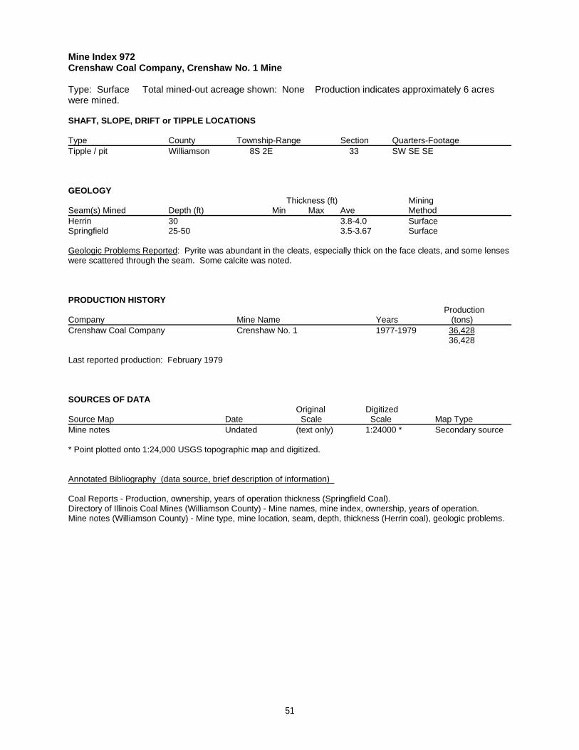
Mine Index 972Crenshaw Coal Company, Crenshaw No. 1 Mine
Type: Surface Total mined-out acreage shown: None Production indicates approximately 6 acreswere mined.
SHAFT, SLOPE, DRIFT or TIPPLE LOCATIONS
Type County Township-Range Section Quarters-FootageTipple / pit Williamson 8S 2E 33 SW SE SE
GEOLOGY Thickness (ft) Mining
Seam(s) Mined Depth (ft) Min Max Ave MethodHerrin 30 3.8-4.0 SurfaceSpringfield 25-50 3.5-3.67 Surface
Geologic Problems Reported: Pyrite was abundant in the cleats, especially thick on the face cleats, and some lenseswere scattered through the seam. Some calcite was noted.
PRODUCTION HISTORY Production
Company Mine Name Years (tons) Crenshaw Coal Company Crenshaw No. 1 1977-1979 36,428
36,428
Last reported production: February 1979
SOURCES OF DATAOriginal Digitized
Source Map Date Scale Scale Map Type Mine notes Undated (text only) 1:24000 * Secondary source
* Point plotted onto 1:24,000 USGS topographic map and digitized.
Annotated Bibliography (data source, brief description of information)
Coal Reports - Production, ownership, years of operation thickness (Springfield Coal).Directory of Illinois Coal Mines (Williamson County) - Mine names, mine index, ownership, years of operation.Mine notes (Williamson County) - Mine type, mine location, seam, depth, thickness (Herrin coal), geologic problems.
51
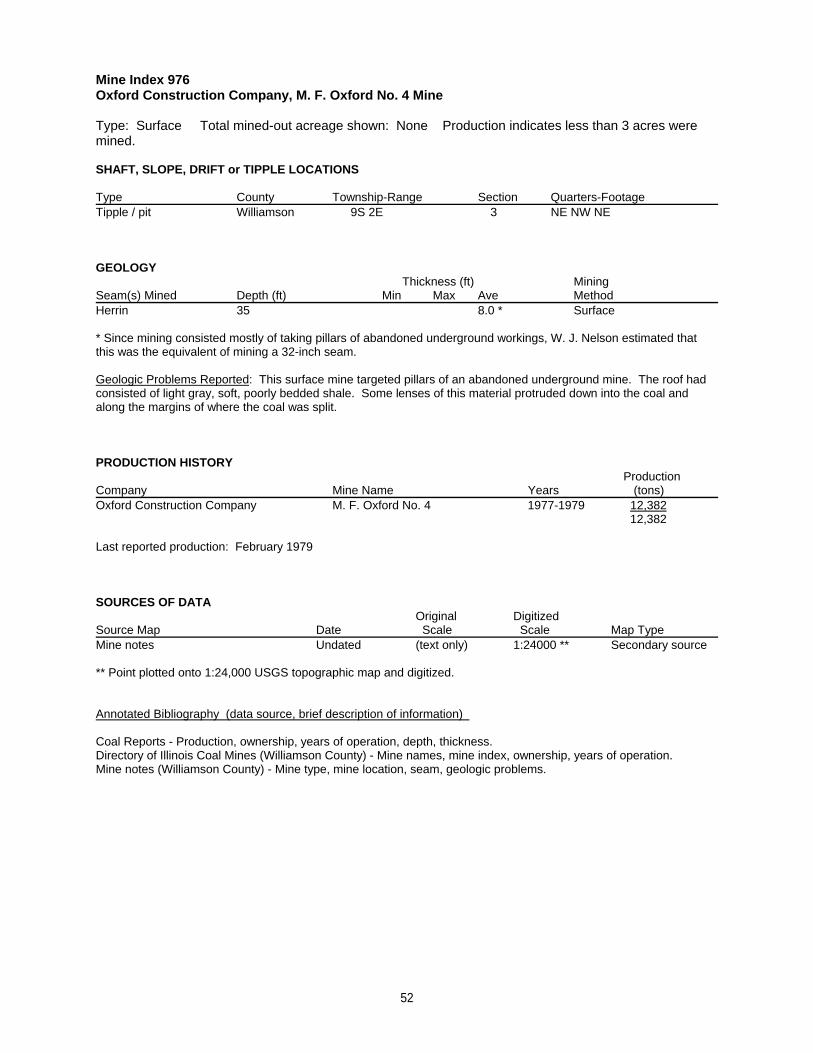
Mine Index 976Oxford Construction Company, M. F. Oxford No. 4 Mine
Type: Surface Total mined-out acreage shown: None Production indicates less than 3 acres weremined.
SHAFT, SLOPE, DRIFT or TIPPLE LOCATIONS
Type County Township-Range Section Quarters-FootageTipple / pit Williamson 9S 2E 3 NE NW NE
GEOLOGY Thickness (ft) Mining
Seam(s) Mined Depth (ft) Min Max Ave MethodHerrin 35 8.0 * Surface
* Since mining consisted mostly of taking pillars of abandoned underground workings, W. J. Nelson estimated thatthis was the equivalent of mining a 32-inch seam.
Geologic Problems Reported: This surface mine targeted pillars of an abandoned underground mine. The roof hadconsisted of light gray, soft, poorly bedded shale. Some lenses of this material protruded down into the coal andalong the margins of where the coal was split.
PRODUCTION HISTORY Production
Company Mine Name Years (tons) Oxford Construction Company M. F. Oxford No. 4 1977-1979 12,382
12,382
Last reported production: February 1979
SOURCES OF DATAOriginal Digitized
Source Map Date Scale Scale Map Type Mine notes Undated (text only) 1:24000 ** Secondary source
** Point plotted onto 1:24,000 USGS topographic map and digitized.
Annotated Bibliography (data source, brief description of information)
Coal Reports - Production, ownership, years of operation, depth, thickness.Directory of Illinois Coal Mines (Williamson County) - Mine names, mine index, ownership, years of operation.Mine notes (Williamson County) - Mine type, mine location, seam, geologic problems.
52
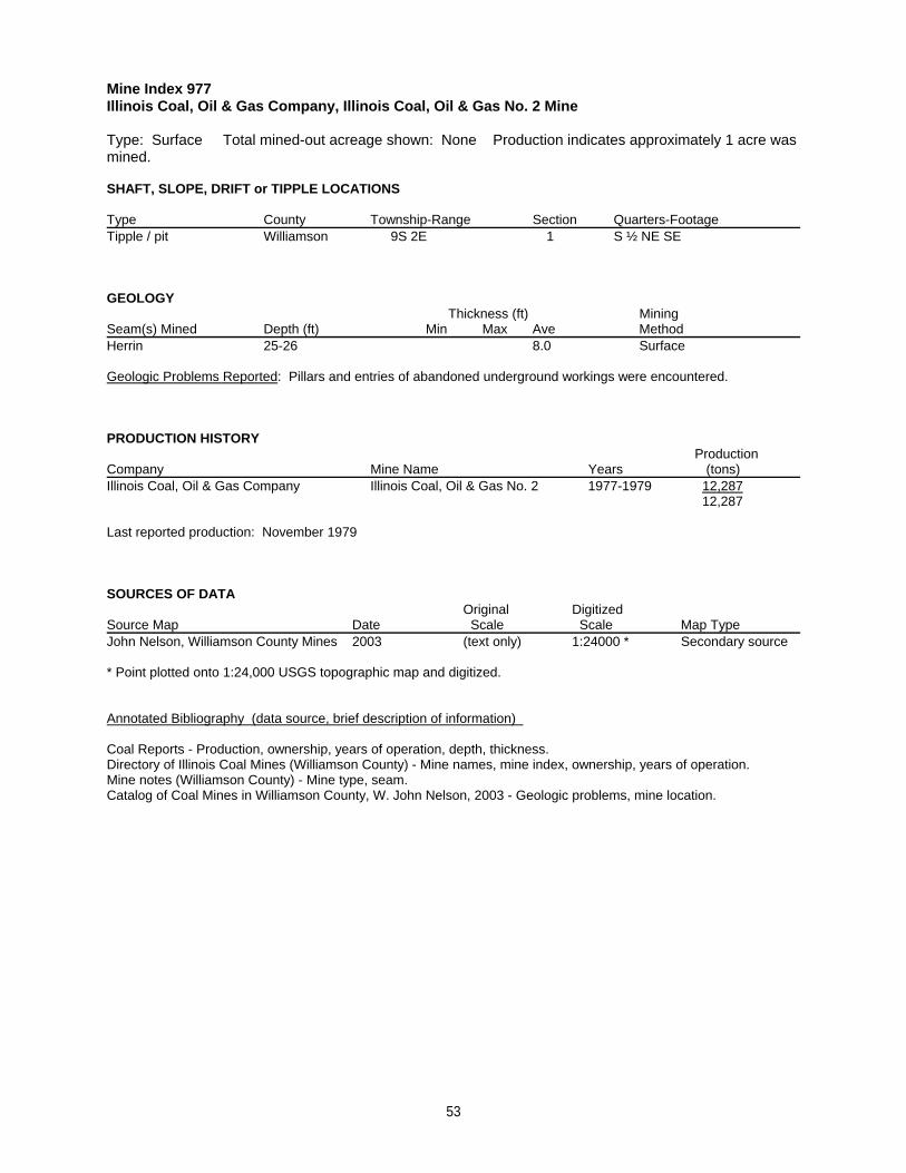
Mine Index 977Illinois Coal, Oil & Gas Company, Illinois Coal, Oil & Gas No. 2 Mine
Type: Surface Total mined-out acreage shown: None Production indicates approximately 1 acre wasmined.
SHAFT, SLOPE, DRIFT or TIPPLE LOCATIONS
Type County Township-Range Section Quarters-FootageTipple / pit Williamson 9S 2E 1 S ½ NE SE
GEOLOGY Thickness (ft) Mining
Seam(s) Mined Depth (ft) Min Max Ave MethodHerrin 25-26 8.0 Surface
Geologic Problems Reported: Pillars and entries of abandoned underground workings were encountered.
PRODUCTION HISTORY Production
Company Mine Name Years (tons) Illinois Coal, Oil & Gas Company Illinois Coal, Oil & Gas No. 2 1977-1979 12,287
12,287
Last reported production: November 1979
SOURCES OF DATAOriginal Digitized
Source Map Date Scale Scale Map Type John Nelson, Williamson County Mines 2003 (text only) 1:24000 * Secondary source
* Point plotted onto 1:24,000 USGS topographic map and digitized.
Annotated Bibliography (data source, brief description of information)
Coal Reports - Production, ownership, years of operation, depth, thickness.Directory of Illinois Coal Mines (Williamson County) - Mine names, mine index, ownership, years of operation.Mine notes (Williamson County) - Mine type, seam.Catalog of Coal Mines in Williamson County, W. John Nelson, 2003 - Geologic problems, mine location.
53
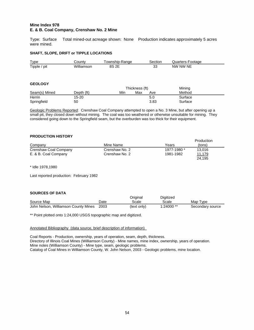
Mine Index 978E. & B. Coal Company, Crenshaw No. 2 Mine
Type: Surface Total mined-out acreage shown: None Production indicates approximately 5 acreswere mined.
SHAFT, SLOPE, DRIFT or TIPPLE LOCATIONS
Type County Township-Range Section Quarters-FootageTipple / pit Williamson 8S 2E 33 NW NW NE
GEOLOGY Thickness (ft) Mining
Seam(s) Mined Depth (ft) Min Max Ave MethodHerrin 15-20 5.0 SurfaceSpringfield 50 3.83 Surface
Geologic Problems Reported: Crenshaw Coal Company attempted to open a No. 3 Mine, but after opening up asmall pit, they closed down without mining. The coal was too weathered or otherwise unsuitable for mining. Theyconsidered going down to the Springfield seam, but the overburden was too thick for their equipment.
PRODUCTION HISTORY Production
Company Mine Name Years (tons) Crenshaw Coal Company Crenshaw No. 2 1977-1980 * 13,016E. & B. Coal Company Crenshaw No. 2 1981-1982 11,179
24,195
* Idle 1978,1980
Last reported production: February 1982
SOURCES OF DATAOriginal Digitized
Source Map Date Scale Scale Map Type John Nelson, Williamson County Mines 2003 (text only) 1:24000 ** Secondary source
** Point plotted onto 1:24,000 USGS topographic map and digitized.
Annotated Bibliography (data source, brief description of information)
Coal Reports - Production, ownership, years of operation, seam, depth, thickness.Directory of Illinois Coal Mines (Williamson County) - Mine names, mine index, ownership, years of operation.Mine notes (Williamson County) - Mine type, seam, geologic problems.Catalog of Coal Mines in Williamson County, W. John Nelson, 2003 - Geologic problems, mine location.
54
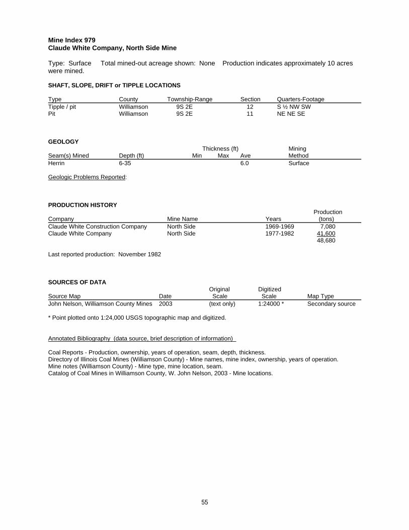
Mine Index 979Claude White Company, North Side Mine
Type: Surface Total mined-out acreage shown: None Production indicates approximately 10 acreswere mined.
SHAFT, SLOPE, DRIFT or TIPPLE LOCATIONS
Type County Township-Range Section Quarters-FootageTipple / pit Williamson 9S 2E 12 S ½ NW SWPit Williamson 9S 2E 11 NE NE SE
GEOLOGY Thickness (ft) Mining
Seam(s) Mined Depth (ft) Min Max Ave MethodHerrin 6-35 6.0 Surface
Geologic Problems Reported:
PRODUCTION HISTORY Production
Company Mine Name Years (tons) Claude White Construction Company North Side 1969-1969 7,080Claude White Company North Side 1977-1982 41,600
48,680
Last reported production: November 1982
SOURCES OF DATAOriginal Digitized
Source Map Date Scale Scale Map Type John Nelson, Williamson County Mines 2003 (text only) 1:24000 * Secondary source
* Point plotted onto 1:24,000 USGS topographic map and digitized.
Annotated Bibliography (data source, brief description of information)
Coal Reports - Production, ownership, years of operation, seam, depth, thickness.Directory of Illinois Coal Mines (Williamson County) - Mine names, mine index, ownership, years of operation.Mine notes (Williamson County) - Mine type, mine location, seam.Catalog of Coal Mines in Williamson County, W. John Nelson, 2003 - Mine locations.
55
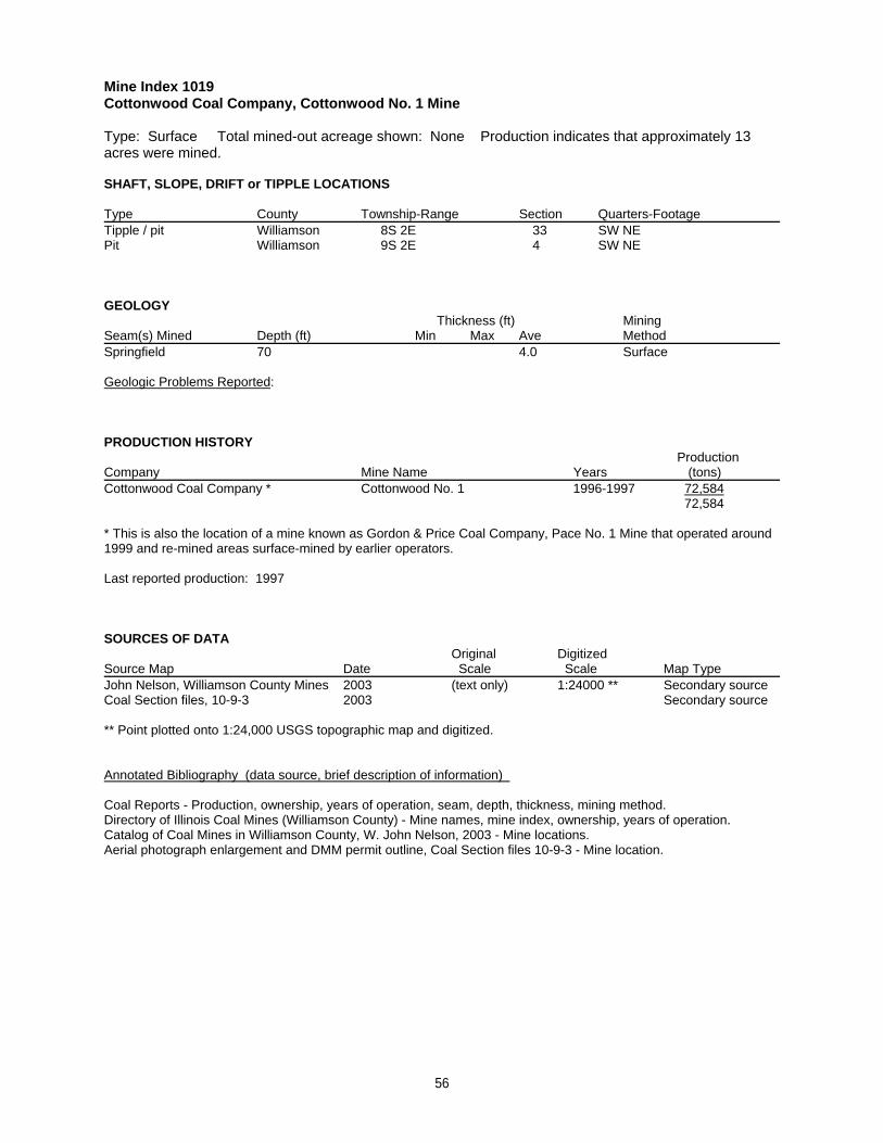
Mine Index 1019Cottonwood Coal Company, Cottonwood No. 1 Mine
Type: Surface Total mined-out acreage shown: None Production indicates that approximately 13acres were mined.
SHAFT, SLOPE, DRIFT or TIPPLE LOCATIONS
Type County Township-Range Section Quarters-FootageTipple / pit Williamson 8S 2E 33 SW NEPit Williamson 9S 2E 4 SW NE
GEOLOGY Thickness (ft) Mining
Seam(s) Mined Depth (ft) Min Max Ave MethodSpringfield 70 4.0 Surface
Geologic Problems Reported:
PRODUCTION HISTORY Production
Company Mine Name Years (tons) Cottonwood Coal Company * Cottonwood No. 1 1996-1997 72,584
72,584
* This is also the location of a mine known as Gordon & Price Coal Company, Pace No. 1 Mine that operated around1999 and re-mined areas surface-mined by earlier operators.
Last reported production: 1997
SOURCES OF DATAOriginal Digitized
Source Map Date Scale Scale Map Type John Nelson, Williamson County Mines 2003 (text only) 1:24000 ** Secondary sourceCoal Section files, 10-9-3 2003 Secondary source
** Point plotted onto 1:24,000 USGS topographic map and digitized.
Annotated Bibliography (data source, brief description of information)
Coal Reports - Production, ownership, years of operation, seam, depth, thickness, mining method.Directory of Illinois Coal Mines (Williamson County) - Mine names, mine index, ownership, years of operation.Catalog of Coal Mines in Williamson County, W. John Nelson, 2003 - Mine locations.Aerial photograph enlargement and DMM permit outline, Coal Section files 10-9-3 - Mine location.
56
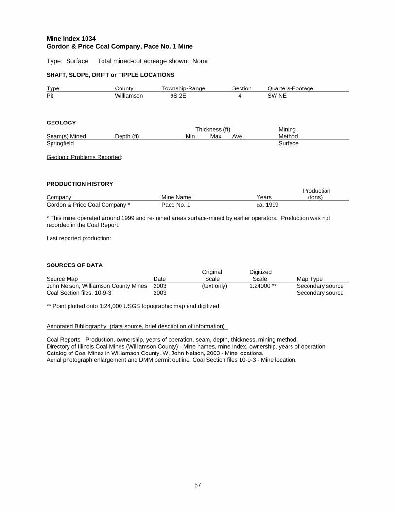
Mine Index 1034Gordon & Price Coal Company, Pace No. 1 Mine
Type: Surface Total mined-out acreage shown: None
SHAFT, SLOPE, DRIFT or TIPPLE LOCATIONS
Type County Township-Range Section Quarters-FootagePit Williamson 9S 2E 4 SW NE
GEOLOGY Thickness (ft) Mining
Seam(s) Mined Depth (ft) Min Max Ave MethodSpringfield Surface
Geologic Problems Reported:
PRODUCTION HISTORY Production
Company Mine Name Years (tons) Gordon & Price Coal Company * Pace No. 1 ca. 1999
* This mine operated around 1999 and re-mined areas surface-mined by earlier operators. Production was notrecorded in the Coal Report.
Last reported production:
SOURCES OF DATAOriginal Digitized
Source Map Date Scale Scale Map Type John Nelson, Williamson County Mines 2003 (text only) 1:24000 ** Secondary sourceCoal Section files, 10-9-3 2003 Secondary source
** Point plotted onto 1:24,000 USGS topographic map and digitized.
Annotated Bibliography (data source, brief description of information)
Coal Reports - Production, ownership, years of operation, seam, depth, thickness, mining method.Directory of Illinois Coal Mines (Williamson County) - Mine names, mine index, ownership, years of operation.Catalog of Coal Mines in Williamson County, W. John Nelson, 2003 - Mine locations.Aerial photograph enlargement and DMM permit outline, Coal Section files 10-9-3 - Mine location.
57
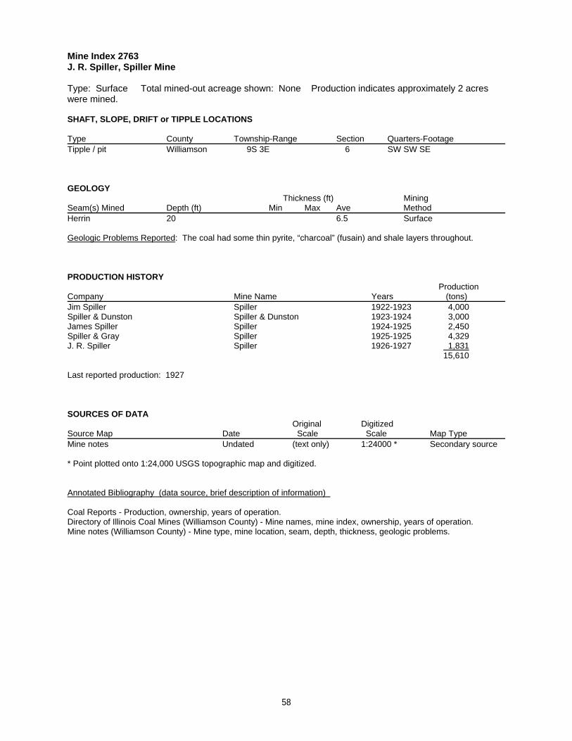
Mine Index 2763J. R. Spiller, Spiller Mine
Type: Surface Total mined-out acreage shown: None Production indicates approximately 2 acreswere mined.
SHAFT, SLOPE, DRIFT or TIPPLE LOCATIONS
Type County Township-Range Section Quarters-FootageTipple / pit Williamson 9S 3E 6 SW SW SE
GEOLOGY Thickness (ft) Mining
Seam(s) Mined Depth (ft) Min Max Ave MethodHerrin 20 6.5 Surface
Geologic Problems Reported: The coal had some thin pyrite, “charcoal” (fusain) and shale layers throughout.
PRODUCTION HISTORY Production
Company Mine Name Years (tons) Jim Spiller Spiller 1922-1923 4,000Spiller & Dunston Spiller & Dunston 1923-1924 3,000James Spiller Spiller 1924-1925 2,450Spiller & Gray Spiller 1925-1925 4,329J. R. Spiller Spiller 1926-1927 1,831
15,610
Last reported production: 1927
SOURCES OF DATAOriginal Digitized
Source Map Date Scale Scale Map Type Mine notes Undated (text only) 1:24000 * Secondary source
* Point plotted onto 1:24,000 USGS topographic map and digitized.
Annotated Bibliography (data source, brief description of information)
Coal Reports - Production, ownership, years of operation.Directory of Illinois Coal Mines (Williamson County) - Mine names, mine index, ownership, years of operation.Mine notes (Williamson County) - Mine type, mine location, seam, depth, thickness, geologic problems.
58
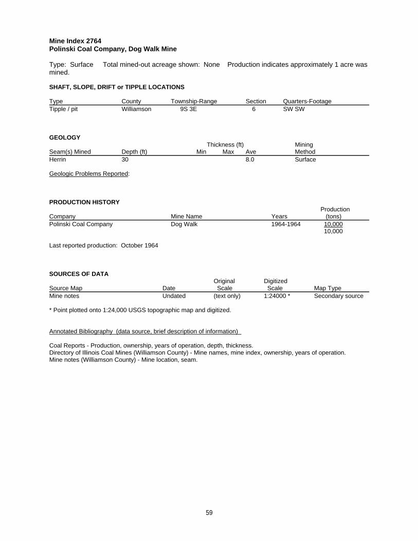
Mine Index 2764Polinski Coal Company, Dog Walk Mine
Type: Surface Total mined-out acreage shown: None Production indicates approximately 1 acre wasmined.
SHAFT, SLOPE, DRIFT or TIPPLE LOCATIONS
Type County Township-Range Section Quarters-FootageTipple / pit Williamson 9S 3E 6 SW SW
GEOLOGY Thickness (ft) Mining
Seam(s) Mined Depth (ft) Min Max Ave MethodHerrin 30 8.0 Surface
Geologic Problems Reported:
PRODUCTION HISTORY Production
Company Mine Name Years (tons) Polinski Coal Company Dog Walk 1964-1964 10,000
10,000
Last reported production: October 1964
SOURCES OF DATAOriginal Digitized
Source Map Date Scale Scale Map Type Mine notes Undated (text only) 1:24000 * Secondary source
* Point plotted onto 1:24,000 USGS topographic map and digitized.
Annotated Bibliography (data source, brief description of information)
Coal Reports - Production, ownership, years of operation, depth, thickness.Directory of Illinois Coal Mines (Williamson County) - Mine names, mine index, ownership, years of operation.Mine notes (Williamson County) - Mine location, seam.
59
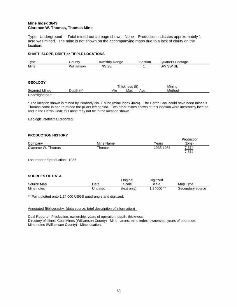
Mine Index 3649Clarence W. Thomas, Thomas Mine
Type: Underground Total mined-out acreage shown: None Production indicates approximately 1acre was mined. The mine is not shown on the accompanying maps due to a lack of clarity on thelocation.
SHAFT, SLOPE, DRIFT or TIPPLE LOCATIONS
Type County Township-Range Section Quarters-FootageMine Williamson 9S 2E 1 SW SW SE
GEOLOGY Thickness (ft) Mining
Seam(s) Mined Depth (ft) Min Max Ave MethodUndesignated *
* The location shown is mined by Peabody No. 1 Mine (mine index 4026). The Herrin Coal could have been mined ifThomas came in and re-mined the pillars left behind. Two other mines shown at this location were incorrectly locatedand in the Herrin Coal; this mine may not be in the location shown.
Geologic Problems Reported:
PRODUCTION HISTORY Production
Company Mine Name Years (tons) Clarence W. Thomas Thomas 1935-1936 7,674
7,674
Last reported production: 1936
SOURCES OF DATAOriginal Digitized
Source Map Date Scale Scale Map Type Mine notes Undated (text only) 1:24000 ** Secondary source
** Point plotted onto 1:24,000 USGS quadrangle and digitized.
Annotated Bibliography (data source, brief description of information)
Coal Reports - Production, ownership, years of operation, depth, thickness.Directory of Illinois Coal Mines (Williamson County) - Mine names, mine index, ownership, years of operation.Mine notes (Williamson County) - Mine location.
60
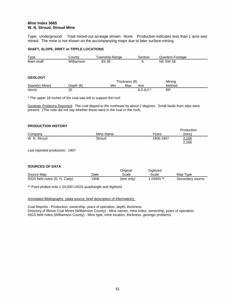
Mine Index 3665W. N. Stroud, Stroud Mine
Type: Underground Total mined-out acreage shown: None Production indicates less than 1 acre wasmined. The mine is not shown on the accompanying maps due to later surface-mining.
SHAFT, SLOPE, DRIFT or TIPPLE LOCATIONS
Type County Township-Range Section Quarters-FootageMain shaft Williamson 9S 3E 6 NE SW SE
GEOLOGY Thickness (ft) Mining
Seam(s) Mined Depth (ft) Min Max Ave MethodHerrin 25 8.0-9.0 * RP
* The upper 18 inches of the coal was left to support the roof.
Geologic Problems Reported: The coal dipped to the northeast by about 2 degrees. Small faults from slips werepresent. (The note did not say whether these were in the coal or the roof).
PRODUCTION HISTORY Production
Company Mine Name Years (tons) W. N. Stroud Stroud 1906-1907 2,168
2,168
Last reported production: 1907
SOURCES OF DATAOriginal Digitized
Source Map Date Scale Scale Map Type ISGS field notes (G. H. Cady) 1908 (text only) 1:24000 ** Secondary source
** Point plotted onto 1:24,000 USGS quadrangle and digitized.
Annotated Bibliography (data source, brief description of information)
Coal Reports - Production, ownership, years of operation, depth, thickness.Directory of Illinois Coal Mines (Williamson County) - Mine names, mine index, ownership, years of operation.ISGS field notes (Williamson County) - Mine type, mine location, thickness, geologic problems.
61
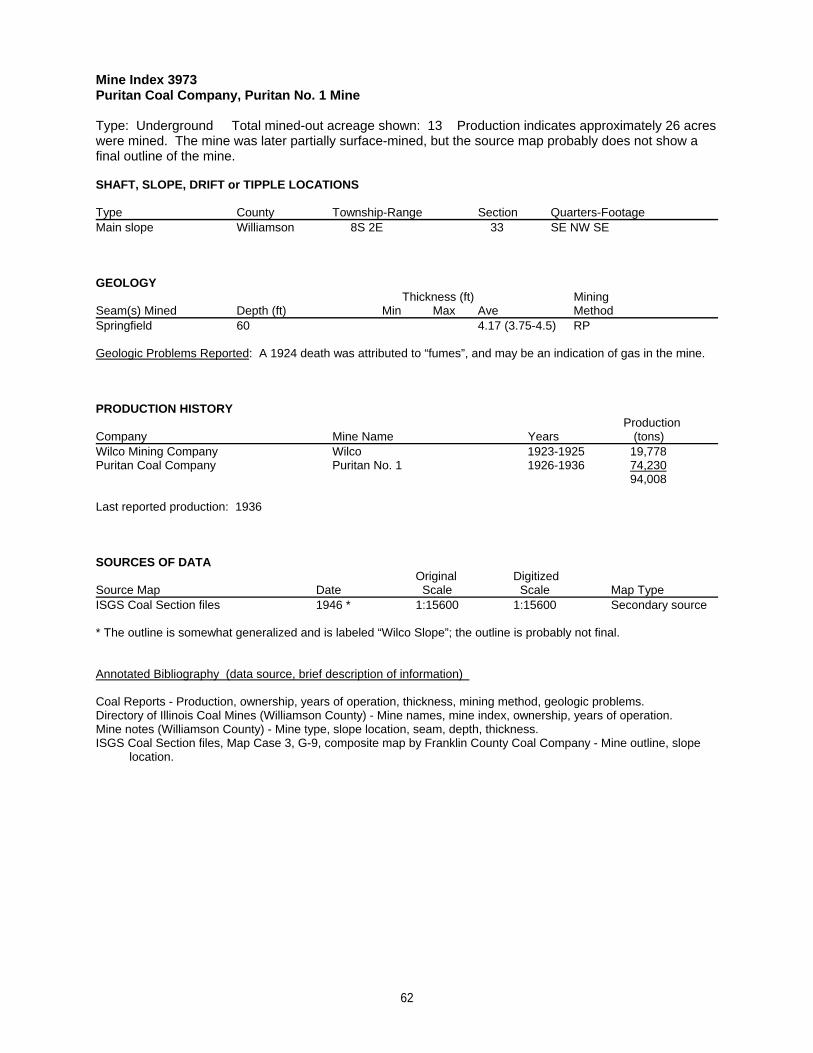
Mine Index 3973Puritan Coal Company, Puritan No. 1 Mine
Type: Underground Total mined-out acreage shown: 13 Production indicates approximately 26 acreswere mined. The mine was later partially surface-mined, but the source map probably does not show afinal outline of the mine.
SHAFT, SLOPE, DRIFT or TIPPLE LOCATIONS
Type County Township-Range Section Quarters-FootageMain slope Williamson 8S 2E 33 SE NW SE
GEOLOGY Thickness (ft) Mining
Seam(s) Mined Depth (ft) Min Max Ave MethodSpringfield 60 4.17 (3.75-4.5) RP
Geologic Problems Reported: A 1924 death was attributed to “fumes”, and may be an indication of gas in the mine.
PRODUCTION HISTORY Production
Company Mine Name Years (tons) Wilco Mining Company Wilco 1923-1925 19,778Puritan Coal Company Puritan No. 1 1926-1936 74,230
94,008
Last reported production: 1936
SOURCES OF DATAOriginal Digitized
Source Map Date Scale Scale Map Type ISGS Coal Section files 1946 * 1:15600 1:15600 Secondary source
* The outline is somewhat generalized and is labeled “Wilco Slope”; the outline is probably not final.
Annotated Bibliography (data source, brief description of information)
Coal Reports - Production, ownership, years of operation, thickness, mining method, geologic problems.Directory of Illinois Coal Mines (Williamson County) - Mine names, mine index, ownership, years of operation.Mine notes (Williamson County) - Mine type, slope location, seam, depth, thickness.ISGS Coal Section files, Map Case 3, G-9, composite map by Franklin County Coal Company - Mine outline, slope location.
62
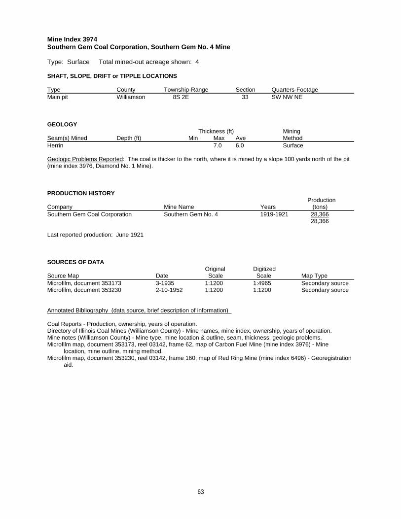
Mine Index 3974Southern Gem Coal Corporation, Southern Gem No. 4 Mine
Type: Surface Total mined-out acreage shown: 4
SHAFT, SLOPE, DRIFT or TIPPLE LOCATIONS
Type County Township-Range Section Quarters-FootageMain pit Williamson 8S 2E 33 SW NW NE
GEOLOGY Thickness (ft) Mining
Seam(s) Mined Depth (ft) Min Max Ave MethodHerrin 7.0 6.0 Surface
Geologic Problems Reported: The coal is thicker to the north, where it is mined by a slope 100 yards north of the pit(mine index 3976, Diamond No. 1 Mine).
PRODUCTION HISTORY Production
Company Mine Name Years (tons) Southern Gem Coal Corporation Southern Gem No. 4 1919-1921 28,366
28,366
Last reported production: June 1921
SOURCES OF DATAOriginal Digitized
Source Map Date Scale Scale Map Type Microfilm, document 353173 3-1935 1:1200 1:4965 Secondary sourceMicrofilm, document 353230 2-10-1952 1:1200 1:1200 Secondary source
Annotated Bibliography (data source, brief description of information)
Coal Reports - Production, ownership, years of operation.Directory of Illinois Coal Mines (Williamson County) - Mine names, mine index, ownership, years of operation.Mine notes (Williamson County) - Mine type, mine location & outline, seam, thickness, geologic problems.Microfilm map, document 353173, reel 03142, frame 62, map of Carbon Fuel Mine (mine index 3976) - Mine location, mine outline, mining method.Microfilm map, document 353230, reel 03142, frame 160, map of Red Ring Mine (mine index 6496) - Georegistration aid.
63
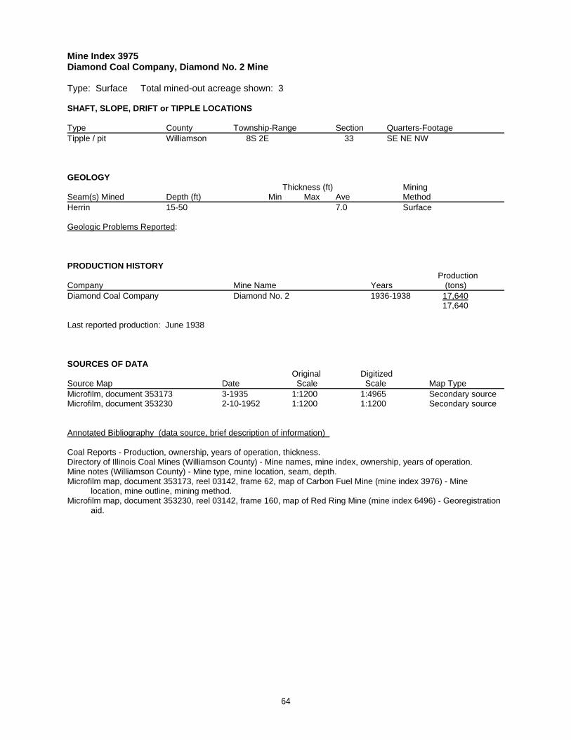
Mine Index 3975Diamond Coal Company, Diamond No. 2 Mine
Type: Surface Total mined-out acreage shown: 3
SHAFT, SLOPE, DRIFT or TIPPLE LOCATIONS
Type County Township-Range Section Quarters-FootageTipple / pit Williamson 8S 2E 33 SE NE NW
GEOLOGY Thickness (ft) Mining
Seam(s) Mined Depth (ft) Min Max Ave MethodHerrin 15-50 7.0 Surface
Geologic Problems Reported:
PRODUCTION HISTORY Production
Company Mine Name Years (tons) Diamond Coal Company Diamond No. 2 1936-1938 17,640
17,640
Last reported production: June 1938
SOURCES OF DATAOriginal Digitized
Source Map Date Scale Scale Map Type Microfilm, document 353173 3-1935 1:1200 1:4965 Secondary sourceMicrofilm, document 353230 2-10-1952 1:1200 1:1200 Secondary source
Annotated Bibliography (data source, brief description of information)
Coal Reports - Production, ownership, years of operation, thickness.Directory of Illinois Coal Mines (Williamson County) - Mine names, mine index, ownership, years of operation.Mine notes (Williamson County) - Mine type, mine location, seam, depth.Microfilm map, document 353173, reel 03142, frame 62, map of Carbon Fuel Mine (mine index 3976) - Mine location, mine outline, mining method.Microfilm map, document 353230, reel 03142, frame 160, map of Red Ring Mine (mine index 6496) - Georegistration aid.
64
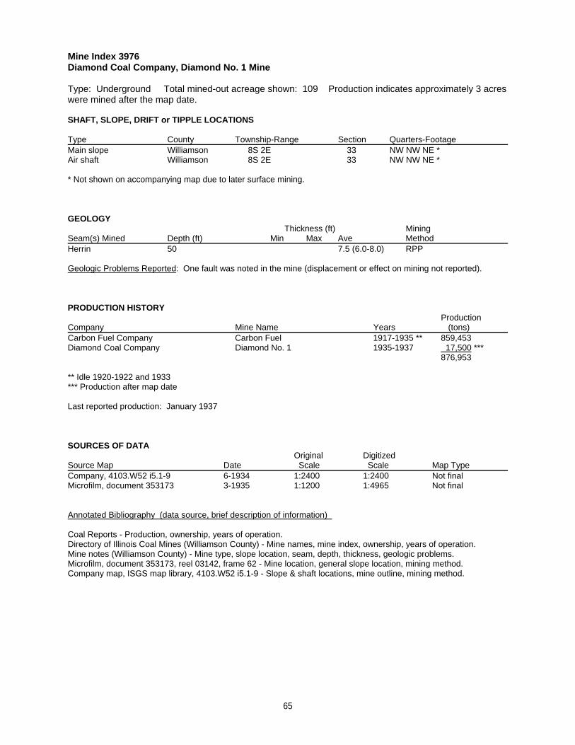
Mine Index 3976Diamond Coal Company, Diamond No. 1 Mine
Type: Underground Total mined-out acreage shown: 109 Production indicates approximately 3 acreswere mined after the map date.
SHAFT, SLOPE, DRIFT or TIPPLE LOCATIONS
Type County Township-Range Section Quarters-FootageMain slope Williamson 8S 2E 33 NW NW NE *Air shaft Williamson 8S 2E 33 NW NW NE *
* Not shown on accompanying map due to later surface mining.
GEOLOGY Thickness (ft) Mining
Seam(s) Mined Depth (ft) Min Max Ave MethodHerrin 50 7.5 (6.0-8.0) RPP
Geologic Problems Reported: One fault was noted in the mine (displacement or effect on mining not reported).
PRODUCTION HISTORY Production
Company Mine Name Years (tons) Carbon Fuel Company Carbon Fuel 1917-1935 ** 859,453Diamond Coal Company Diamond No. 1 1935-1937 17,500 ***
876,953
** Idle 1920-1922 and 1933*** Production after map date
Last reported production: January 1937
SOURCES OF DATAOriginal Digitized
Source Map Date Scale Scale Map Type Company, 4103.W52 i5.1-9 6-1934 1:2400 1:2400 Not finalMicrofilm, document 353173 3-1935 1:1200 1:4965 Not final
Annotated Bibliography (data source, brief description of information)
Coal Reports - Production, ownership, years of operation.Directory of Illinois Coal Mines (Williamson County) - Mine names, mine index, ownership, years of operation.Mine notes (Williamson County) - Mine type, slope location, seam, depth, thickness, geologic problems.Microfilm, document 353173, reel 03142, frame 62 - Mine location, general slope location, mining method.Company map, ISGS map library, 4103.W52 i5.1-9 - Slope & shaft locations, mine outline, mining method.
65
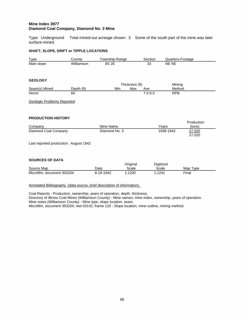
Mine Index 3977Diamond Coal Company, Diamond No. 3 Mine
Type: Underground Total mined-out acreage shown: 3 Some of the south part of the mine was latersurface-mined.
SHAFT, SLOPE, DRIFT or TIPPLE LOCATIONS
Type County Township-Range Section Quarters-FootageMain slope Williamson 8S 2E 33 NE NE
GEOLOGY Thickness (ft) Mining
Seam(s) Mined Depth (ft) Min Max Ave MethodHerrin 60 7.0-9.0 RPB
Geologic Problems Reported:
PRODUCTION HISTORY Production
Company Mine Name Years (tons) Diamond Coal Company Diamond No. 3 1938-1942 27,020
27,020
Last reported production: August 1942
SOURCES OF DATAOriginal Digitized
Source Map Date Scale Scale Map Type Microfilm, document 353204 8-19-1942 1:1200 1:1241 Final
Annotated Bibliography (data source, brief description of information)
Coal Reports - Production, ownership, years of operation, depth, thickness.Directory of Illinois Coal Mines (Williamson County) - Mine names, mine index, ownership, years of operation.Mine notes (Williamson County) - Mine type, slope location, seam.Microfilm, document 353204, reel 03142, frame 133 - Slope location, mine outline, mining method.
66
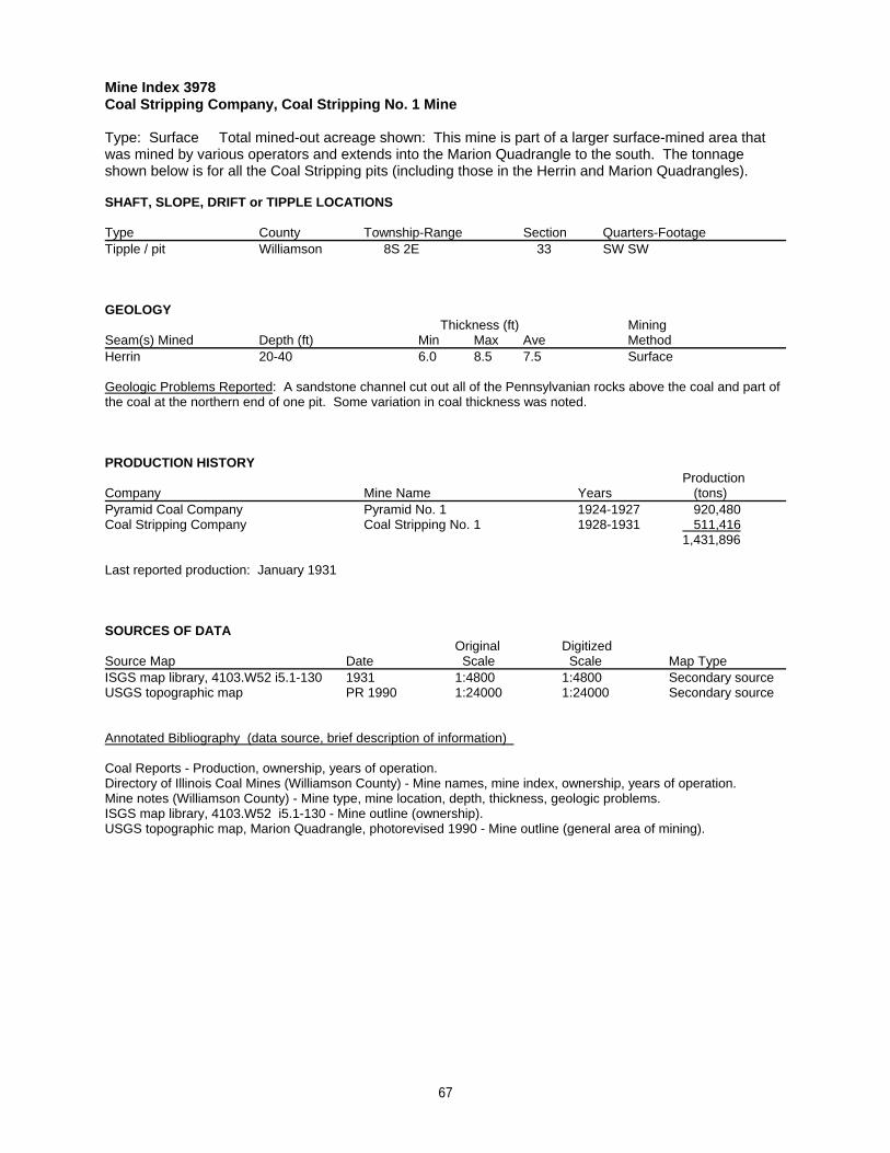
Mine Index 3978Coal Stripping Company, Coal Stripping No. 1 Mine
Type: Surface Total mined-out acreage shown: This mine is part of a larger surface-mined area thatwas mined by various operators and extends into the Marion Quadrangle to the south. The tonnageshown below is for all the Coal Stripping pits (including those in the Herrin and Marion Quadrangles).
SHAFT, SLOPE, DRIFT or TIPPLE LOCATIONS
Type County Township-Range Section Quarters-FootageTipple / pit Williamson 8S 2E 33 SW SW
GEOLOGY Thickness (ft) Mining
Seam(s) Mined Depth (ft) Min Max Ave MethodHerrin 20-40 6.0 8.5 7.5 Surface
Geologic Problems Reported: A sandstone channel cut out all of the Pennsylvanian rocks above the coal and part ofthe coal at the northern end of one pit. Some variation in coal thickness was noted.
PRODUCTION HISTORY Production
Company Mine Name Years (tons) Pyramid Coal Company Pyramid No. 1 1924-1927 920,480Coal Stripping Company Coal Stripping No. 1 1928-1931 511,416
1,431,896
Last reported production: January 1931
SOURCES OF DATAOriginal Digitized
Source Map Date Scale Scale Map Type ISGS map library, 4103.W52 i5.1-130 1931 1:4800 1:4800 Secondary sourceUSGS topographic map PR 1990 1:24000 1:24000 Secondary source
Annotated Bibliography (data source, brief description of information)
Coal Reports - Production, ownership, years of operation.Directory of Illinois Coal Mines (Williamson County) - Mine names, mine index, ownership, years of operation.Mine notes (Williamson County) - Mine type, mine location, depth, thickness, geologic problems.ISGS map library, 4103.W52 i5.1-130 - Mine outline (ownership).USGS topographic map, Marion Quadrangle, photorevised 1990 - Mine outline (general area of mining).
67
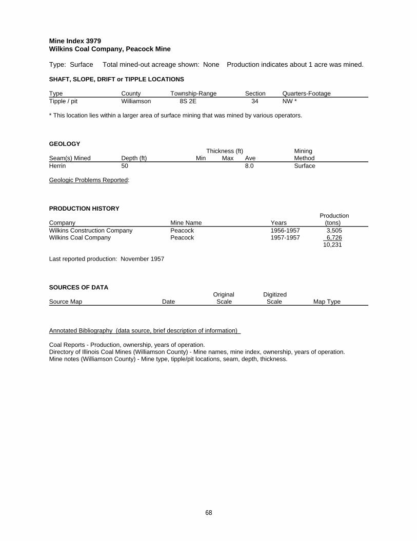
Mine Index 3979Wilkins Coal Company, Peacock Mine
Type: Surface Total mined-out acreage shown: None Production indicates about 1 acre was mined.
SHAFT, SLOPE, DRIFT or TIPPLE LOCATIONS
Type County Township-Range Section Quarters-FootageTipple / pit Williamson 8S 2E 34 NW *
* This location lies within a larger area of surface mining that was mined by various operators.
GEOLOGY Thickness (ft) Mining
Seam(s) Mined Depth (ft) Min Max Ave MethodHerrin 50 8.0 Surface
Geologic Problems Reported:
PRODUCTION HISTORY Production
Company Mine Name Years (tons) Wilkins Construction Company Peacock 1956-1957 3,505Wilkins Coal Company Peacock 1957-1957 6,726
10,231
Last reported production: November 1957
SOURCES OF DATAOriginal Digitized
Source Map Date Scale Scale Map Type
Annotated Bibliography (data source, brief description of information)
Coal Reports - Production, ownership, years of operation.Directory of Illinois Coal Mines (Williamson County) - Mine names, mine index, ownership, years of operation.Mine notes (Williamson County) - Mine type, tipple/pit locations, seam, depth, thickness.
68
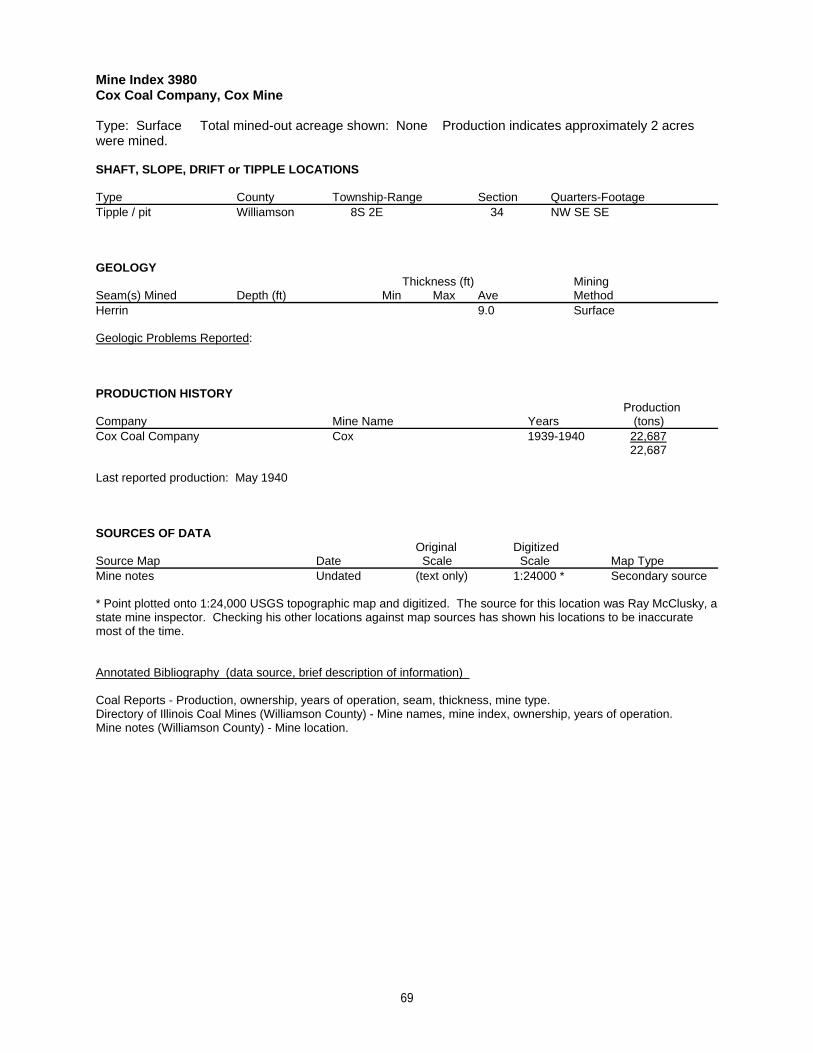
Mine Index 3980Cox Coal Company, Cox Mine
Type: Surface Total mined-out acreage shown: None Production indicates approximately 2 acreswere mined.
SHAFT, SLOPE, DRIFT or TIPPLE LOCATIONS
Type County Township-Range Section Quarters-FootageTipple / pit Williamson 8S 2E 34 NW SE SE
GEOLOGY Thickness (ft) Mining
Seam(s) Mined Depth (ft) Min Max Ave MethodHerrin 9.0 Surface
Geologic Problems Reported:
PRODUCTION HISTORY Production
Company Mine Name Years (tons) Cox Coal Company Cox 1939-1940 22,687
22,687
Last reported production: May 1940
SOURCES OF DATAOriginal Digitized
Source Map Date Scale Scale Map Type Mine notes Undated (text only) 1:24000 * Secondary source
* Point plotted onto 1:24,000 USGS topographic map and digitized. The source for this location was Ray McClusky, astate mine inspector. Checking his other locations against map sources has shown his locations to be inaccuratemost of the time.
Annotated Bibliography (data source, brief description of information)
Coal Reports - Production, ownership, years of operation, seam, thickness, mine type.Directory of Illinois Coal Mines (Williamson County) - Mine names, mine index, ownership, years of operation.Mine notes (Williamson County) - Mine location.
69
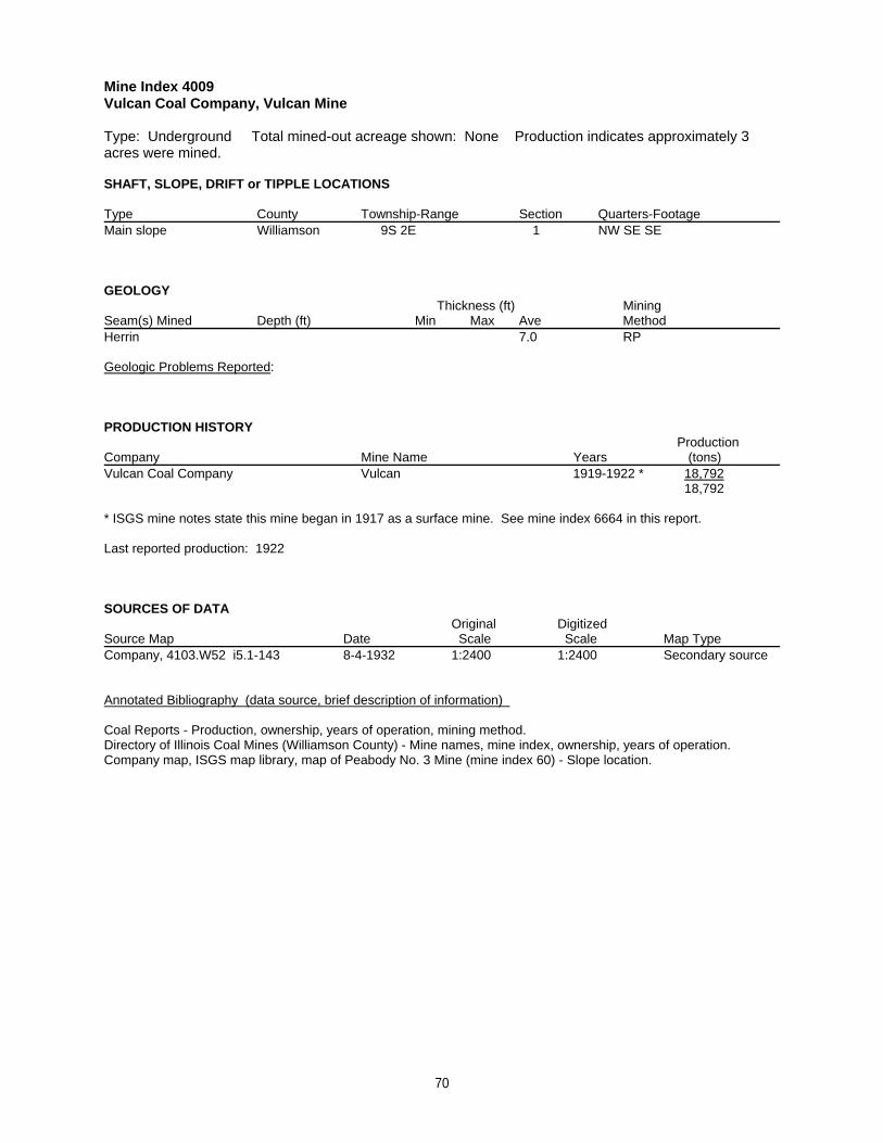
Mine Index 4009Vulcan Coal Company, Vulcan Mine
Type: Underground Total mined-out acreage shown: None Production indicates approximately 3acres were mined.
SHAFT, SLOPE, DRIFT or TIPPLE LOCATIONS
Type County Township-Range Section Quarters-FootageMain slope Williamson 9S 2E 1 NW SE SE
GEOLOGY Thickness (ft) Mining
Seam(s) Mined Depth (ft) Min Max Ave MethodHerrin 7.0 RP
Geologic Problems Reported:
PRODUCTION HISTORY Production
Company Mine Name Years (tons) Vulcan Coal Company Vulcan 1919-1922 * 18,792
18,792
* ISGS mine notes state this mine began in 1917 as a surface mine. See mine index 6664 in this report.
Last reported production: 1922
SOURCES OF DATAOriginal Digitized
Source Map Date Scale Scale Map Type Company, 4103.W52 i5.1-143 8-4-1932 1:2400 1:2400 Secondary source
Annotated Bibliography (data source, brief description of information)
Coal Reports - Production, ownership, years of operation, mining method.Directory of Illinois Coal Mines (Williamson County) - Mine names, mine index, ownership, years of operation.Company map, ISGS map library, map of Peabody No. 3 Mine (mine index 60) - Slope location.
70
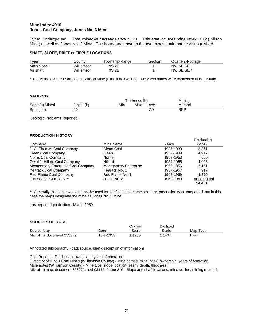
Mine Index 4010Jones Coal Company, Jones No. 3 Mine
Type: Underground Total mined-out acreage shown: 11 This area includes mine index 4012 (WilsonMine) as well as Jones No. 3 Mine. The boundary between the two mines could not be distinguished.
SHAFT, SLOPE, DRIFT or TIPPLE LOCATIONS
Type County Township-Range Section Quarters-FootageMain slope Williamson 9S 2E 1 NW SE SEAir shaft Williamson 9S 2E 1 NW SE SE *
* This is the old hoist shaft of the Wilson Mine (mine index 4012). These two mines were connected underground.
GEOLOGY Thickness (ft) Mining
Seam(s) Mined Depth (ft) Min Max Ave MethodSpringfield 20 7.0 RPP
Geologic Problems Reported:
PRODUCTION HISTORY Production
Company Mine Name Years (tons) J. G. Thomas Coal Company Clean Coal 1937-1939 8,371Klean Coal Company Klean 1939-1939 4,917Norris Coal Company Norris 1953-1953 660Orval J. Hillard Coal Company Hillard 1954-1955 4,025Montgomery Enterprise Coal Company Montgomery Enterprise 1955-1956 2,151Yearack Coal Company Yearack No. 1 1957-1957 917Red Flame Coal Company Red Flame No. 1 1958-1959 3,390Jones Coal Company ** Jones No. 3 1959-1959 not reported
24,431
** Generally this name would be not be used for the final mine name since the production was unreported, but in thiscase the maps designate the mine as Jones No. 3 Mine.
Last reported production: March 1959
SOURCES OF DATAOriginal Digitized
Source Map Date Scale Scale Map Type Microfilm, document 353272 12-9-1959 1:1200 1:1407 Final
Annotated Bibliography (data source, brief description of information)
Coal Reports - Production, ownership, years of operation.Directory of Illinois Coal Mines (Williamson County) - Mine names, mine index, ownership, years of operation.Mine notes (Williamson County) - Mine type, slope location, seam, depth, thickness.Microfilm map, document 353272, reel 03142, frame 216 - Slope and shaft locations, mine outline, mining method.
71
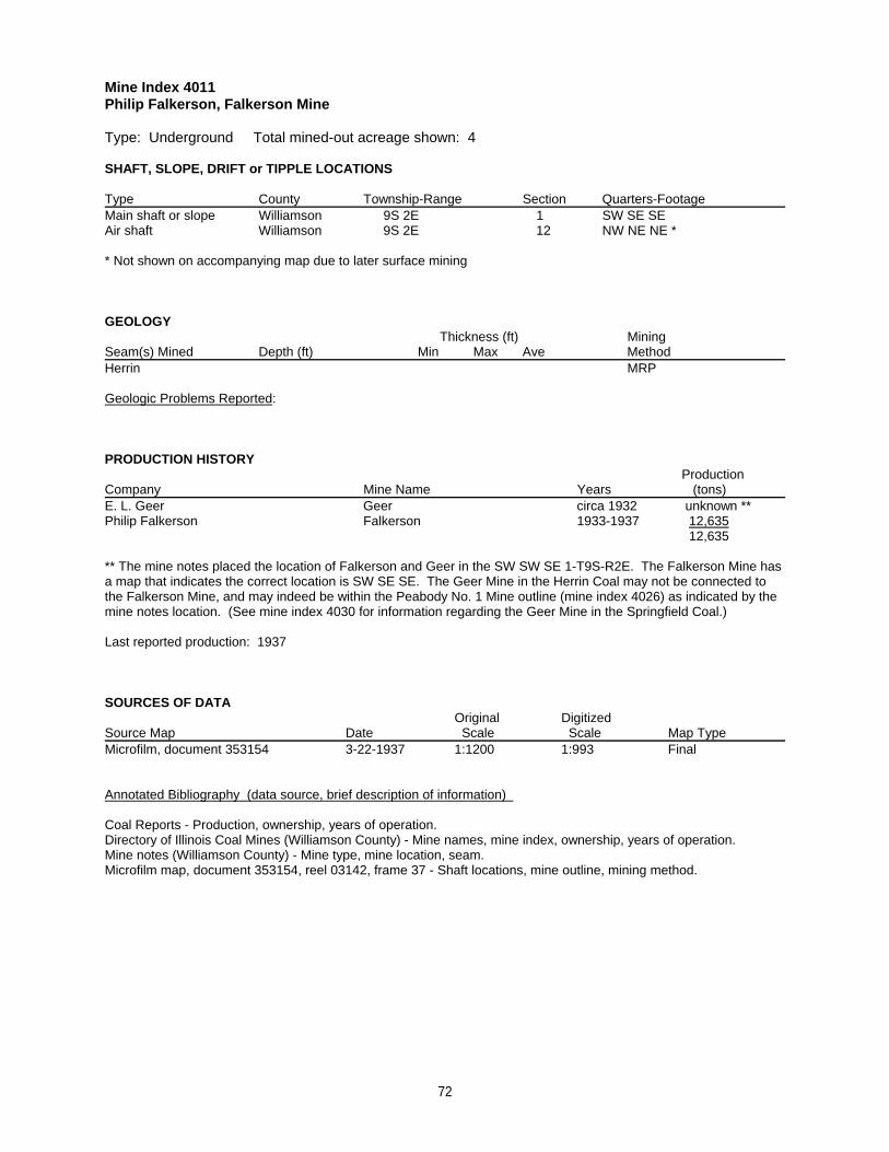
Mine Index 4011Philip Falkerson, Falkerson Mine
Type: Underground Total mined-out acreage shown: 4
SHAFT, SLOPE, DRIFT or TIPPLE LOCATIONS
Type County Township-Range Section Quarters-FootageMain shaft or slope Williamson 9S 2E 1 SW SE SEAir shaft Williamson 9S 2E 12 NW NE NE *
* Not shown on accompanying map due to later surface mining
GEOLOGY Thickness (ft) Mining
Seam(s) Mined Depth (ft) Min Max Ave MethodHerrin MRP
Geologic Problems Reported:
PRODUCTION HISTORY Production
Company Mine Name Years (tons) E. L. Geer Geer circa 1932 unknown **Philip Falkerson Falkerson 1933-1937 12,635
12,635
** The mine notes placed the location of Falkerson and Geer in the SW SW SE 1-T9S-R2E. The Falkerson Mine hasa map that indicates the correct location is SW SE SE. The Geer Mine in the Herrin Coal may not be connected tothe Falkerson Mine, and may indeed be within the Peabody No. 1 Mine outline (mine index 4026) as indicated by themine notes location. (See mine index 4030 for information regarding the Geer Mine in the Springfield Coal.)
Last reported production: 1937
SOURCES OF DATAOriginal Digitized
Source Map Date Scale Scale Map Type Microfilm, document 353154 3-22-1937 1:1200 1:993 Final
Annotated Bibliography (data source, brief description of information)
Coal Reports - Production, ownership, years of operation.Directory of Illinois Coal Mines (Williamson County) - Mine names, mine index, ownership, years of operation.Mine notes (Williamson County) - Mine type, mine location, seam.Microfilm map, document 353154, reel 03142, frame 37 - Shaft locations, mine outline, mining method.
72
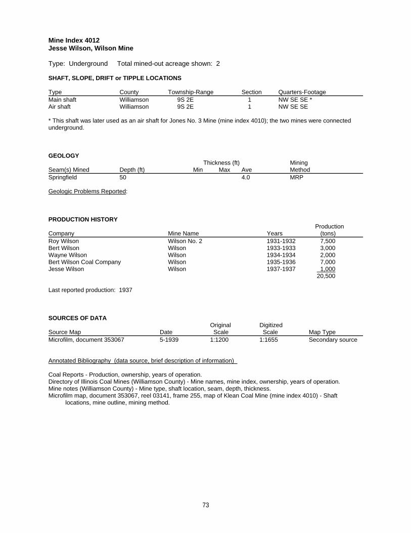
Mine Index 4012Jesse Wilson, Wilson Mine
Type: Underground Total mined-out acreage shown: 2
SHAFT, SLOPE, DRIFT or TIPPLE LOCATIONS
Type County Township-Range Section Quarters-FootageMain shaft Williamson 9S 2E 1 NW SE SE *Air shaft Williamson 9S 2E 1 NW SE SE
* This shaft was later used as an air shaft for Jones No. 3 Mine (mine index 4010); the two mines were connectedunderground.
GEOLOGY Thickness (ft) Mining
Seam(s) Mined Depth (ft) Min Max Ave MethodSpringfield 50 4.0 MRP
Geologic Problems Reported:
PRODUCTION HISTORY Production
Company Mine Name Years (tons) Roy Wilson Wilson No. 2 1931-1932 7,500Bert Wilson Wilson 1933-1933 3,000Wayne Wilson Wilson 1934-1934 2,000Bert Wilson Coal Company Wilson 1935-1936 7,000Jesse Wilson Wilson 1937-1937 1,000
20,500
Last reported production: 1937
SOURCES OF DATAOriginal Digitized
Source Map Date Scale Scale Map Type Microfilm, document 353067 5-1939 1:1200 1:1655 Secondary source
Annotated Bibliography (data source, brief description of information)
Coal Reports - Production, ownership, years of operation.Directory of Illinois Coal Mines (Williamson County) - Mine names, mine index, ownership, years of operation.Mine notes (Williamson County) - Mine type, shaft location, seam, depth, thickness.Microfilm map, document 353067, reel 03141, frame 255, map of Klean Coal Mine (mine index 4010) - Shaft locations, mine outline, mining method.
73
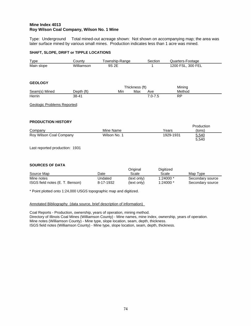
Mine Index 4013Roy Wilson Coal Company, Wilson No. 1 Mine
Type: Underground Total mined-out acreage shown: Not shown on accompanying map; the area waslater surface mined by various small mines. Production indicates less than 1 acre was mined.
SHAFT, SLOPE, DRIFT or TIPPLE LOCATIONS
Type County Township-Range Section Quarters-FootageMain slope Williamson 9S 2E 1 1200 FSL, 300 FEL
GEOLOGY Thickness (ft) Mining
Seam(s) Mined Depth (ft) Min Max Ave MethodHerrin 38-41 7.0-7.5 RP
Geologic Problems Reported:
PRODUCTION HISTORY Production
Company Mine Name Years (tons) Roy Wilson Coal Company Wilson No. 1 1929-1931 5,540
5,540
Last reported production: 1931
SOURCES OF DATAOriginal Digitized
Source Map Date Scale Scale Map Type Mine notes Undated (text only) 1:24000 * Secondary sourceISGS field notes (E. T. Benson) 8-17-1932 (text only) 1:24000 * Secondary source
* Point plotted onto 1:24,000 USGS topographic map and digitized.
Annotated Bibliography (data source, brief description of information)
Coal Reports - Production, ownership, years of operation, mining method.Directory of Illinois Coal Mines (Williamson County) - Mine names, mine index, ownership, years of operation.Mine notes (Williamson County) - Mine type, slope location, seam, depth, thickness.ISGS field notes (Williamson County) - Mine type, slope location, seam, depth, thickness.
74
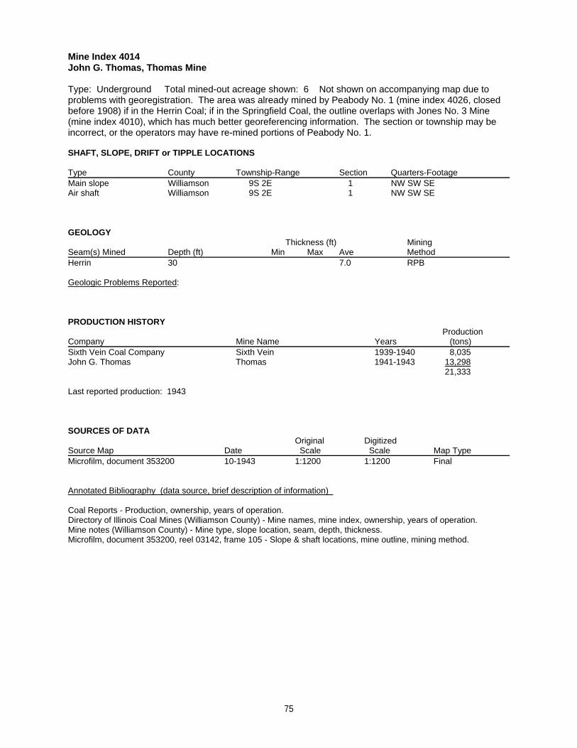
Mine Index 4014John G. Thomas, Thomas Mine
Type: Underground Total mined-out acreage shown: 6 Not shown on accompanying map due toproblems with georegistration. The area was already mined by Peabody No. 1 (mine index 4026, closedbefore 1908) if in the Herrin Coal; if in the Springfield Coal, the outline overlaps with Jones No. 3 Mine(mine index 4010), which has much better georeferencing information. The section or township may beincorrect, or the operators may have re-mined portions of Peabody No. 1.
SHAFT, SLOPE, DRIFT or TIPPLE LOCATIONS
Type County Township-Range Section Quarters-FootageMain slope Williamson 9S 2E 1 NW SW SEAir shaft Williamson 9S 2E 1 NW SW SE
GEOLOGY Thickness (ft) Mining
Seam(s) Mined Depth (ft) Min Max Ave MethodHerrin 30 7.0 RPB
Geologic Problems Reported:
PRODUCTION HISTORY Production
Company Mine Name Years (tons) Sixth Vein Coal Company Sixth Vein 1939-1940 8,035John G. Thomas Thomas 1941-1943 13,298
21,333
Last reported production: 1943
SOURCES OF DATAOriginal Digitized
Source Map Date Scale Scale Map Type Microfilm, document 353200 10-1943 1:1200 1:1200 Final
Annotated Bibliography (data source, brief description of information)
Coal Reports - Production, ownership, years of operation.Directory of Illinois Coal Mines (Williamson County) - Mine names, mine index, ownership, years of operation.Mine notes (Williamson County) - Mine type, slope location, seam, depth, thickness.Microfilm, document 353200, reel 03142, frame 105 - Slope & shaft locations, mine outline, mining method.
75
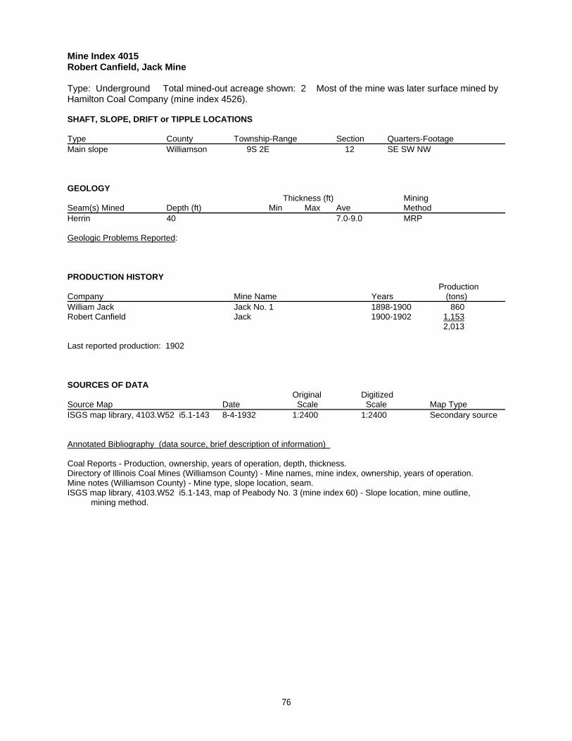
Mine Index 4015Robert Canfield, Jack Mine
Type: Underground Total mined-out acreage shown: 2 Most of the mine was later surface mined byHamilton Coal Company (mine index 4526).
SHAFT, SLOPE, DRIFT or TIPPLE LOCATIONS
Type County Township-Range Section Quarters-FootageMain slope Williamson 9S 2E 12 SE SW NW
GEOLOGY Thickness (ft) Mining
Seam(s) Mined Depth (ft) Min Max Ave MethodHerrin 40 7.0-9.0 MRP
Geologic Problems Reported:
PRODUCTION HISTORY Production
Company Mine Name Years (tons) William Jack Jack No. 1 1898-1900 860Robert Canfield Jack 1900-1902 1,153
2,013
Last reported production: 1902
SOURCES OF DATAOriginal Digitized
Source Map Date Scale Scale Map Type ISGS map library, 4103.W52 i5.1-143 8-4-1932 1:2400 1:2400 Secondary source
Annotated Bibliography (data source, brief description of information)
Coal Reports - Production, ownership, years of operation, depth, thickness.Directory of Illinois Coal Mines (Williamson County) - Mine names, mine index, ownership, years of operation.Mine notes (Williamson County) - Mine type, slope location, seam.ISGS map library, 4103.W52 i5.1-143, map of Peabody No. 3 (mine index 60) - Slope location, mine outline, mining method.
76
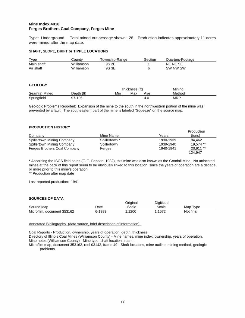
Mine Index 4016Ferges Brothers Coal Company, Ferges Mine
Type: Underground Total mined-out acreage shown: 28 Production indicates approximately 11 acreswere mined after the map date.
SHAFT, SLOPE, DRIFT or TIPPLE LOCATIONS
Type County Township-Range Section Quarters-FootageMain shaft Williamson 9S 2E 1 NE NE SEAir shaft Williamson 9S 3E 6 SW NW SW
GEOLOGY Thickness (ft) Mining
Seam(s) Mined Depth (ft) Min Max Ave MethodSpringfield 97-106 4.0 MRP
Geologic Problems Reported: Expansion of the mine to the south in the northwestern portion of the mine wasprevented by a fault. The southeastern part of the mine is labeled “Squeeze” on the source map.
PRODUCTION HISTORY Production
Company Mine Name Years (tons) Spillertown Mining Company Spillertown * 1930-1939 84,462Spillertown Mining Company Spillertown 1939-1940 19,574 **Ferges Brothers Coal Company Ferges 1940-1941 20,911 **
124,947
* According the ISGS field notes (E. T. Benson, 1932), this mine was also known as the Goodall Mine. No unlocatedmines at the back of this report seem to be obviously linked to this location, since the years of operation are a decadeor more prior to this mine’s operation.** Production after map date
Last reported production: 1941
SOURCES OF DATAOriginal Digitized
Source Map Date Scale Scale Map Type Microfilm, document 353162 6-1939 1:1200 1:1572 Not final
Annotated Bibliography (data source, brief description of information)
Coal Reports - Production, ownership, years of operation, depth, thickness.Directory of Illinois Coal Mines (Williamson County) - Mine names, mine index, ownership, years of operation.Mine notes (Williamson County) - Mine type, shaft location, seam.Microfilm map, document 353162, reel 03142, frame 49 - Shaft locations, mine outline, mining method, geologic problems.
77
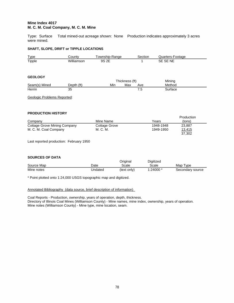
Mine Index 4017M. C. M. Coal Company, M. C. M. Mine
Type: Surface Total mined-out acreage shown: None Production indicates approximately 3 acreswere mined.
SHAFT, SLOPE, DRIFT or TIPPLE LOCATIONS
Type County Township-Range Section Quarters-FootageTipple Williamson 9S 2E 1 SE SE NE
GEOLOGY Thickness (ft) Mining
Seam(s) Mined Depth (ft) Min Max Ave MethodHerrin 35 7.5 Surface
Geologic Problems Reported:
PRODUCTION HISTORY Production
Company Mine Name Years (tons) Cottage Grove Mining Company Cottage Grove 1948-1948 23,887M. C. M. Coal Company M. C. M. 1949-1950 13,415
37,302
Last reported production: February 1950
SOURCES OF DATAOriginal Digitized
Source Map Date Scale Scale Map Type Mine notes Undated (text only) 1:24000 * Secondary source
* Point plotted onto 1:24,000 USGS topographic map and digitized.
Annotated Bibliography (data source, brief description of information)
Coal Reports - Production, ownership, years of operation, depth, thickness.Directory of Illinois Coal Mines (Williamson County) - Mine names, mine index, ownership, years of operation.Mine notes (Williamson County) - Mine type, mine location, seam.
78
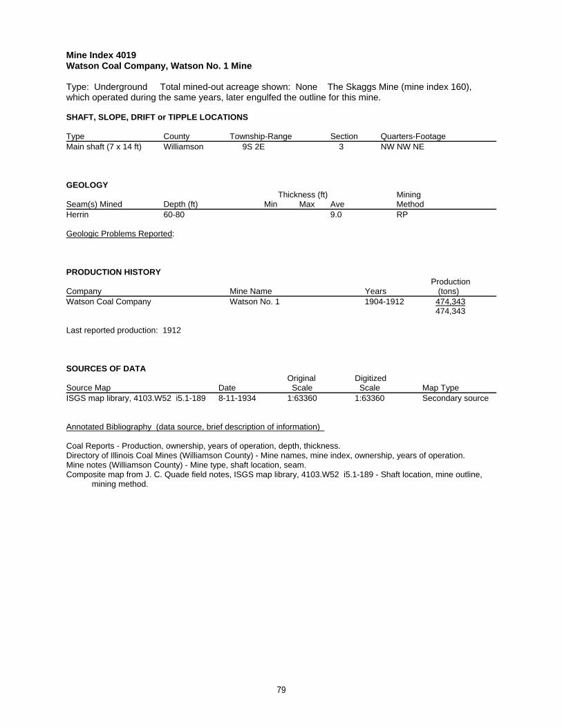
Mine Index 4019Watson Coal Company, Watson No. 1 Mine
Type: Underground Total mined-out acreage shown: None The Skaggs Mine (mine index 160),which operated during the same years, later engulfed the outline for this mine.
SHAFT, SLOPE, DRIFT or TIPPLE LOCATIONS
Type County Township-Range Section Quarters-FootageMain shaft (7 x 14 ft) Williamson 9S 2E 3 NW NW NE
GEOLOGY Thickness (ft) Mining
Seam(s) Mined Depth (ft) Min Max Ave MethodHerrin 60-80 9.0 RP
Geologic Problems Reported:
PRODUCTION HISTORY Production
Company Mine Name Years (tons) Watson Coal Company Watson No. 1 1904-1912 474,343
474,343
Last reported production: 1912
SOURCES OF DATAOriginal Digitized
Source Map Date Scale Scale Map Type ISGS map library, 4103.W52 i5.1-189 8-11-1934 1:63360 1:63360 Secondary source
Annotated Bibliography (data source, brief description of information)
Coal Reports - Production, ownership, years of operation, depth, thickness.Directory of Illinois Coal Mines (Williamson County) - Mine names, mine index, ownership, years of operation.Mine notes (Williamson County) - Mine type, shaft location, seam.Composite map from J. C. Quade field notes, ISGS map library, 4103.W52 i5.1-189 - Shaft location, mine outline, mining method.
79
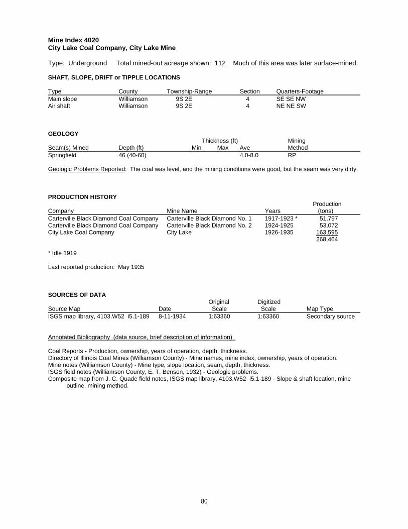
Mine Index 4020City Lake Coal Company, City Lake Mine
Type: Underground Total mined-out acreage shown: 112 Much of this area was later surface-mined.
SHAFT, SLOPE, DRIFT or TIPPLE LOCATIONS
Type County Township-Range Section Quarters-FootageMain slope Williamson 9S 2E 4 SE SE NWAir shaft Williamson 9S 2E 4 NE NE SW
GEOLOGY Thickness (ft) Mining
Seam(s) Mined Depth (ft) Min Max Ave MethodSpringfield 46 (40-60) 4.0-8.0 RP
Geologic Problems Reported: The coal was level, and the mining conditions were good, but the seam was very dirty.
PRODUCTION HISTORY Production
Company Mine Name Years (tons) Carterville Black Diamond Coal Company Carterville Black Diamond No. 1 1917-1923 * 51,797Carterville Black Diamond Coal Company Carterville Black Diamond No. 2 1924-1925 53,072City Lake Coal Company City Lake 1926-1935 163,595
268,464
* Idle 1919
Last reported production: May 1935
SOURCES OF DATAOriginal Digitized
Source Map Date Scale Scale Map Type ISGS map library, 4103.W52 i5.1-189 8-11-1934 1:63360 1:63360 Secondary source
Annotated Bibliography (data source, brief description of information)
Coal Reports - Production, ownership, years of operation, depth, thickness.Directory of Illinois Coal Mines (Williamson County) - Mine names, mine index, ownership, years of operation.Mine notes (Williamson County) - Mine type, slope location, seam, depth, thickness.ISGS field notes (Williamson County, E. T. Benson, 1932) - Geologic problems.Composite map from J. C. Quade field notes, ISGS map library, 4103.W52 i5.1-189 - Slope & shaft location, mine outline, mining method.
80
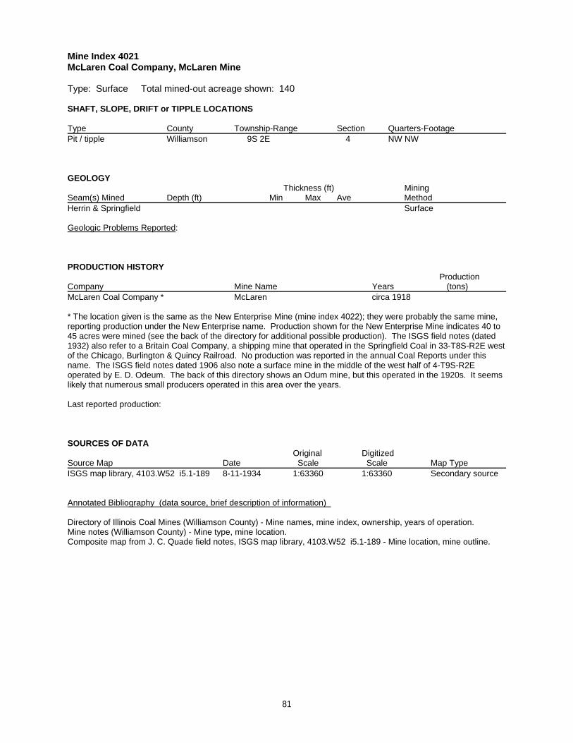
Mine Index 4021McLaren Coal Company, McLaren Mine
Type: Surface Total mined-out acreage shown: 140
SHAFT, SLOPE, DRIFT or TIPPLE LOCATIONS
Type County Township-Range Section Quarters-FootagePit / tipple Williamson 9S 2E 4 NW NW
GEOLOGY Thickness (ft) Mining
Seam(s) Mined Depth (ft) Min Max Ave MethodHerrin & Springfield Surface
Geologic Problems Reported:
PRODUCTION HISTORY Production
Company Mine Name Years (tons) McLaren Coal Company * McLaren circa 1918
* The location given is the same as the New Enterprise Mine (mine index 4022); they were probably the same mine,reporting production under the New Enterprise name. Production shown for the New Enterprise Mine indicates 40 to45 acres were mined (see the back of the directory for additional possible production). The ISGS field notes (dated1932) also refer to a Britain Coal Company, a shipping mine that operated in the Springfield Coal in 33-T8S-R2E westof the Chicago, Burlington & Quincy Railroad. No production was reported in the annual Coal Reports under thisname. The ISGS field notes dated 1906 also note a surface mine in the middle of the west half of 4-T9S-R2Eoperated by E. D. Odeum. The back of this directory shows an Odum mine, but this operated in the 1920s. It seemslikely that numerous small producers operated in this area over the years.
Last reported production:
SOURCES OF DATAOriginal Digitized
Source Map Date Scale Scale Map Type ISGS map library, 4103.W52 i5.1-189 8-11-1934 1:63360 1:63360 Secondary source
Annotated Bibliography (data source, brief description of information)
Directory of Illinois Coal Mines (Williamson County) - Mine names, mine index, ownership, years of operation.Mine notes (Williamson County) - Mine type, mine location.Composite map from J. C. Quade field notes, ISGS map library, 4103.W52 i5.1-189 - Mine location, mine outline.
81
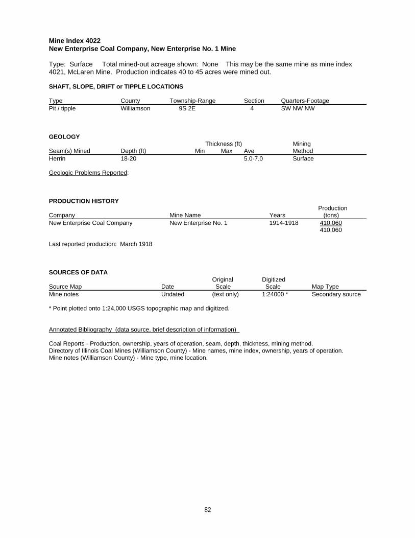
Mine Index 4022New Enterprise Coal Company, New Enterprise No. 1 Mine
Type: Surface Total mined-out acreage shown: None This may be the same mine as mine index4021, McLaren Mine. Production indicates 40 to 45 acres were mined out.
SHAFT, SLOPE, DRIFT or TIPPLE LOCATIONS
Type County Township-Range Section Quarters-FootagePit / tipple Williamson 9S 2E 4 SW NW NW
GEOLOGY Thickness (ft) Mining
Seam(s) Mined Depth (ft) Min Max Ave MethodHerrin 18-20 5.0-7.0 Surface
Geologic Problems Reported:
PRODUCTION HISTORY Production
Company Mine Name Years (tons) New Enterprise Coal Company New Enterprise No. 1 1914-1918 410,060
410,060
Last reported production: March 1918
SOURCES OF DATAOriginal Digitized
Source Map Date Scale Scale Map Type Mine notes Undated (text only) 1:24000 * Secondary source
* Point plotted onto 1:24,000 USGS topographic map and digitized.
Annotated Bibliography (data source, brief description of information)
Coal Reports - Production, ownership, years of operation, seam, depth, thickness, mining method.Directory of Illinois Coal Mines (Williamson County) - Mine names, mine index, ownership, years of operation.Mine notes (Williamson County) - Mine type, mine location.
82
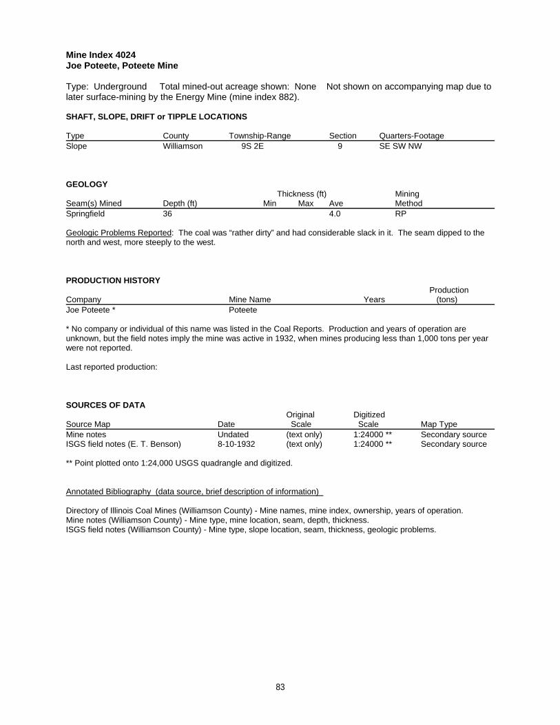
Mine Index 4024Joe Poteete, Poteete Mine
Type: Underground Total mined-out acreage shown: None Not shown on accompanying map due tolater surface-mining by the Energy Mine (mine index 882).
SHAFT, SLOPE, DRIFT or TIPPLE LOCATIONS
Type County Township-Range Section Quarters-FootageSlope Williamson 9S 2E 9 SE SW NW
GEOLOGY Thickness (ft) Mining
Seam(s) Mined Depth (ft) Min Max Ave MethodSpringfield 36 4.0 RP
Geologic Problems Reported: The coal was “rather dirty” and had considerable slack in it. The seam dipped to thenorth and west, more steeply to the west.
PRODUCTION HISTORY Production
Company Mine Name Years (tons) Joe Poteete * Poteete
* No company or individual of this name was listed in the Coal Reports. Production and years of operation areunknown, but the field notes imply the mine was active in 1932, when mines producing less than 1,000 tons per yearwere not reported.
Last reported production:
SOURCES OF DATAOriginal Digitized
Source Map Date Scale Scale Map Type Mine notes Undated (text only) 1:24000 ** Secondary sourceISGS field notes (E. T. Benson) 8-10-1932 (text only) 1:24000 ** Secondary source
** Point plotted onto 1:24,000 USGS quadrangle and digitized.
Annotated Bibliography (data source, brief description of information)
Directory of Illinois Coal Mines (Williamson County) - Mine names, mine index, ownership, years of operation.Mine notes (Williamson County) - Mine type, mine location, seam, depth, thickness.ISGS field notes (Williamson County) - Mine type, slope location, seam, thickness, geologic problems.
83
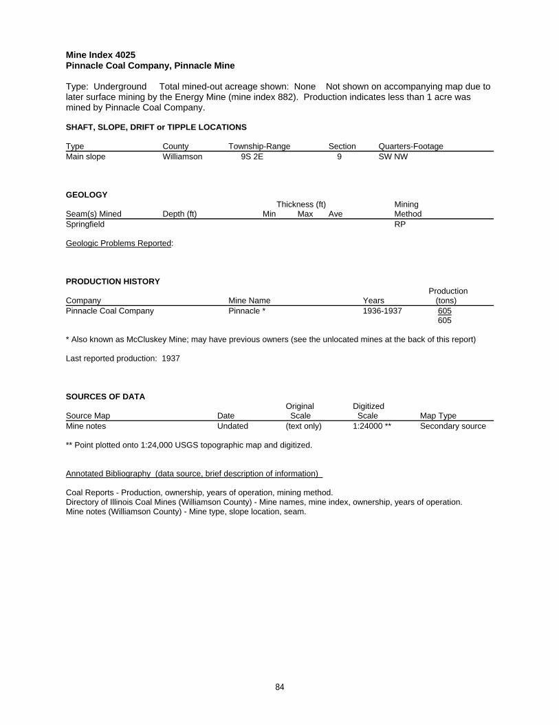
Mine Index 4025Pinnacle Coal Company, Pinnacle Mine
Type: Underground Total mined-out acreage shown: None Not shown on accompanying map due tolater surface mining by the Energy Mine (mine index 882). Production indicates less than 1 acre wasmined by Pinnacle Coal Company.
SHAFT, SLOPE, DRIFT or TIPPLE LOCATIONS
Type County Township-Range Section Quarters-FootageMain slope Williamson 9S 2E 9 SW NW
GEOLOGY Thickness (ft) Mining
Seam(s) Mined Depth (ft) Min Max Ave MethodSpringfield RP
Geologic Problems Reported:
PRODUCTION HISTORY Production
Company Mine Name Years (tons) Pinnacle Coal Company Pinnacle * 1936-1937 605
605
* Also known as McCluskey Mine; may have previous owners (see the unlocated mines at the back of this report)
Last reported production: 1937
SOURCES OF DATAOriginal Digitized
Source Map Date Scale Scale Map Type Mine notes Undated (text only) 1:24000 ** Secondary source
** Point plotted onto 1:24,000 USGS topographic map and digitized.
Annotated Bibliography (data source, brief description of information)
Coal Reports - Production, ownership, years of operation, mining method.Directory of Illinois Coal Mines (Williamson County) - Mine names, mine index, ownership, years of operation.Mine notes (Williamson County) - Mine type, slope location, seam.
84
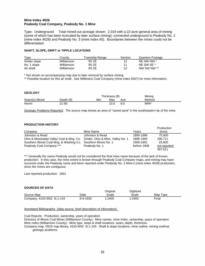
Mine Index 4026Peabody Coal Company, Peabody No. 1 Mine
Type: Underground Total mined-out acreage shown: 2,019 with a 22-acre general area of mining(some of which has been truncated by later surface mining); connected underground to Peabody No. 2(mine index 4028) and Peabody No. 3 (mine index 60). Boundaries between the mines could not bedifferentiated.
SHAFT, SLOPE, DRIFT or TIPPLE LOCATIONS
Type County Township-Range Section Quarters-FootageSnider slope Williamson 9S 2E 12 NE NW NW *No. 1 slope Williamson 9S 2E 11 NE SW SE *Air shaft Williamson 9S 2E 12 NW SW NW **
* Not shown on accompanying map due to later removal by surface mining.** Possible location for this air shaft. See Wilkinson Coal Company (mine index 6557) for more information.
GEOLOGY Thickness (ft) Mining
Seam(s) Mined Depth (ft) Min Max Ave MethodHerrin 21-90 10.0 9.0 MRP
Geologic Problems Reported: The source map shows an area of “caved sand” in the southeastern tip of the mine.
PRODUCTION HISTORY Production
Company Mine Name Years (tons) Johnston & Read Johnston & Read 1895-1896 75,000Ohio & Mississippi Valley Coal & Mng. Co. Snider; Ohio & Miss. Valley No. 1 1896-1900 296,711Southern Illinois Coal Mng. & Washing Co. Southern Illinois No. 1 1900-1901 25,900Peabody Coal Company *** Peabody No. 1 before 1908 not reported
397,611
*** Generally the name Peabody would not be considered the final mine name because of the lack of knownproduction. In this case, the mine extent is known through Peabody Coal Company maps, and mining may haveoccurred under the Peabody name and been reported under Peabody No. 2 Mine’s (mine index 4028) production,since the mines are contiguous.
Last reported production: 1901
SOURCES OF DATAOriginal Digitized
Source Map Date Scale Scale Map Type Company, 4103.W52 i5.1-143 8-4-1932 1:2400 1:2400 Final
Annotated Bibliography (data source, brief description of information)
Coal Reports - Production, ownership, years of operation.Directory of Illinois Coal Mines (Williamson County) - Mine names, mine index, ownership, years of operation.Mine notes (Williamson County) - Mine type, slope & shaft locations, seam, depth, thickness.Company map, ISGS map library, 4103.W52 i5.1-143 - Shaft & slope locations, mine outline, mining method, geologic problems.
85
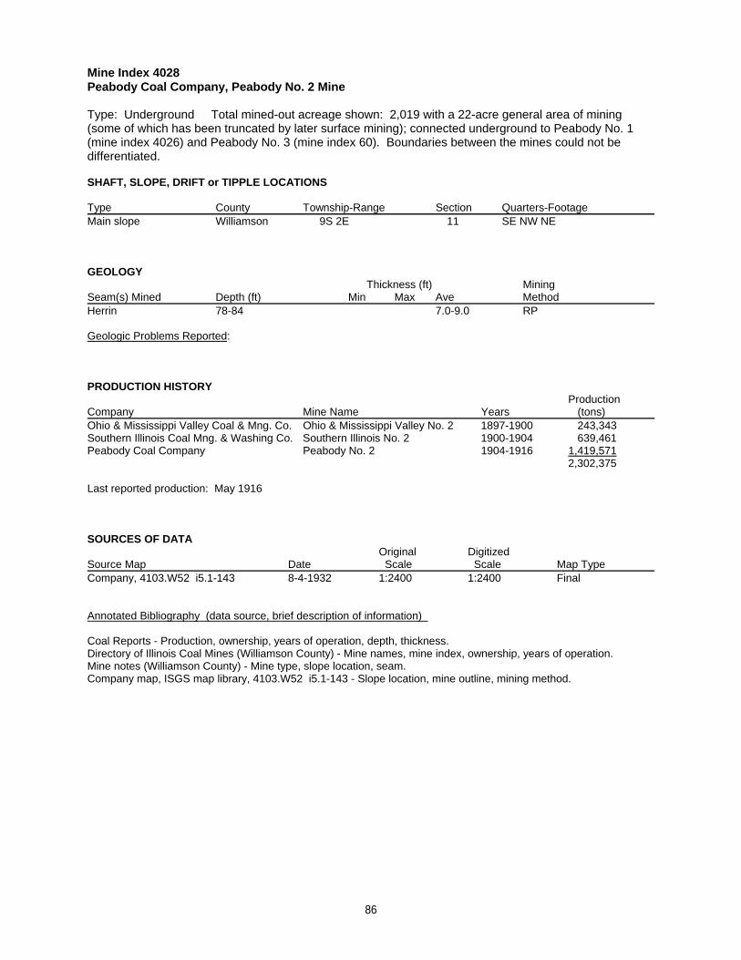
Mine Index 4028Peabody Coal Company, Peabody No. 2 Mine
Type: Underground Total mined-out acreage shown: 2,019 with a 22-acre general area of mining(some of which has been truncated by later surface mining); connected underground to Peabody No. 1(mine index 4026) and Peabody No. 3 (mine index 60). Boundaries between the mines could not bedifferentiated.
SHAFT, SLOPE, DRIFT or TIPPLE LOCATIONS
Type County Township-Range Section Quarters-FootageMain slope Williamson 9S 2E 11 SE NW NE
GEOLOGY Thickness (ft) Mining
Seam(s) Mined Depth (ft) Min Max Ave MethodHerrin 78-84 7.0-9.0 RP
Geologic Problems Reported:
PRODUCTION HISTORY Production
Company Mine Name Years (tons) Ohio & Mississippi Valley Coal & Mng. Co. Ohio & Mississippi Valley No. 2 1897-1900 243,343Southern Illinois Coal Mng. & Washing Co. Southern Illinois No. 2 1900-1904 639,461Peabody Coal Company Peabody No. 2 1904-1916 1,419,571
2,302,375
Last reported production: May 1916
SOURCES OF DATAOriginal Digitized
Source Map Date Scale Scale Map Type Company, 4103.W52 i5.1-143 8-4-1932 1:2400 1:2400 Final
Annotated Bibliography (data source, brief description of information)
Coal Reports - Production, ownership, years of operation, depth, thickness.Directory of Illinois Coal Mines (Williamson County) - Mine names, mine index, ownership, years of operation.Mine notes (Williamson County) - Mine type, slope location, seam.Company map, ISGS map library, 4103.W52 i5.1-143 - Slope location, mine outline, mining method.
86
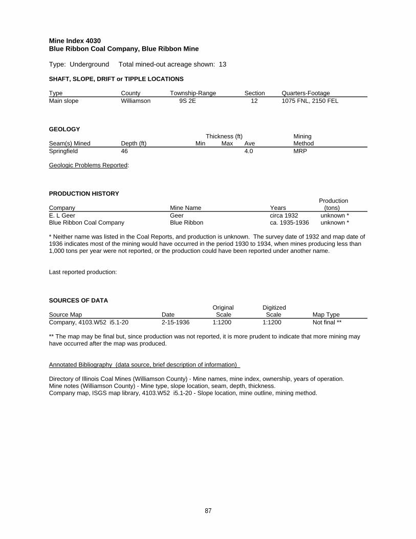
Mine Index 4030Blue Ribbon Coal Company, Blue Ribbon Mine
Type: Underground Total mined-out acreage shown: 13
SHAFT, SLOPE, DRIFT or TIPPLE LOCATIONS
Type County Township-Range Section Quarters-FootageMain slope Williamson 9S 2E 12 1075 FNL, 2150 FEL
GEOLOGY Thickness (ft) Mining
Seam(s) Mined Depth (ft) Min Max Ave MethodSpringfield 46 4.0 MRP
Geologic Problems Reported:
PRODUCTION HISTORY Production
Company Mine Name Years (tons) E. L Geer Geer circa 1932 unknown *Blue Ribbon Coal Company Blue Ribbon ca. 1935-1936 unknown *
* Neither name was listed in the Coal Reports, and production is unknown. The survey date of 1932 and map date of1936 indicates most of the mining would have occurred in the period 1930 to 1934, when mines producing less than1,000 tons per year were not reported, or the production could have been reported under another name.
Last reported production:
SOURCES OF DATAOriginal Digitized
Source Map Date Scale Scale Map Type Company, 4103.W52 i5.1-20 2-15-1936 1:1200 1:1200 Not final **
** The map may be final but, since production was not reported, it is more prudent to indicate that more mining mayhave occurred after the map was produced.
Annotated Bibliography (data source, brief description of information)
Directory of Illinois Coal Mines (Williamson County) - Mine names, mine index, ownership, years of operation.Mine notes (Williamson County) - Mine type, slope location, seam, depth, thickness. Company map, ISGS map library, 4103.W52 i5.1-20 - Slope location, mine outline, mining method.
87
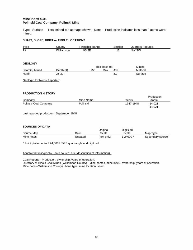
Mine Index 4031Polinski Coal Company, Polinski Mine
Type: Surface Total mined-out acreage shown: None Production indicates less than 2 acres weremined.
SHAFT, SLOPE, DRIFT or TIPPLE LOCATIONS
Type County Township-Range Section Quarters-FootagePit Williamson 9S 2E 12 NW SW
GEOLOGY Thickness (ft) Mining
Seam(s) Mined Depth (ft) Min Max Ave MethodHerrin 25-30 8.0 Surface
Geologic Problems Reported:
PRODUCTION HISTORY Production
Company Mine Name Years (tons) Polinski Coal Company Polinski 1947-1948 14,021
14,021
Last reported production: September 1948
SOURCES OF DATAOriginal Digitized
Source Map Date Scale Scale Map Type Mine notes Undated (text only) 1:24000 * Secondary source
* Point plotted onto 1:24,000 USGS quadrangle and digitized.
Annotated Bibliography (data source, brief description of information)
Coal Reports - Production, ownership, years of operation.Directory of Illinois Coal Mines (Williamson County) - Mine names, mine index, ownership, years of operation.Mine notes (Williamson County) - Mine type, mine location, seam.
88
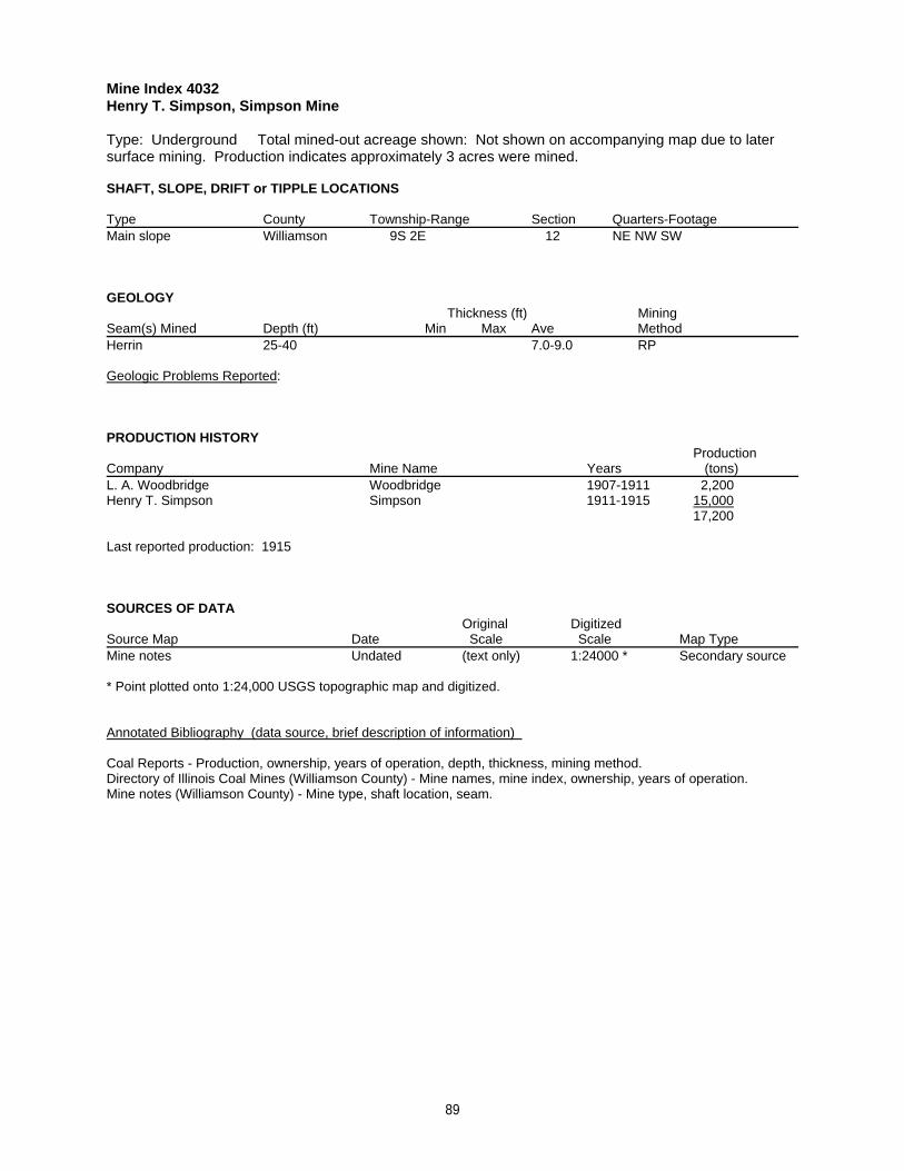
Mine Index 4032Henry T. Simpson, Simpson Mine
Type: Underground Total mined-out acreage shown: Not shown on accompanying map due to latersurface mining. Production indicates approximately 3 acres were mined.
SHAFT, SLOPE, DRIFT or TIPPLE LOCATIONS
Type County Township-Range Section Quarters-FootageMain slope Williamson 9S 2E 12 NE NW SW
GEOLOGY Thickness (ft) Mining
Seam(s) Mined Depth (ft) Min Max Ave MethodHerrin 25-40 7.0-9.0 RP
Geologic Problems Reported:
PRODUCTION HISTORY Production
Company Mine Name Years (tons) L. A. Woodbridge Woodbridge 1907-1911 2,200Henry T. Simpson Simpson 1911-1915 15,000
17,200
Last reported production: 1915
SOURCES OF DATAOriginal Digitized
Source Map Date Scale Scale Map Type Mine notes Undated (text only) 1:24000 * Secondary source
* Point plotted onto 1:24,000 USGS topographic map and digitized.
Annotated Bibliography (data source, brief description of information)
Coal Reports - Production, ownership, years of operation, depth, thickness, mining method.Directory of Illinois Coal Mines (Williamson County) - Mine names, mine index, ownership, years of operation.Mine notes (Williamson County) - Mine type, shaft location, seam.
89
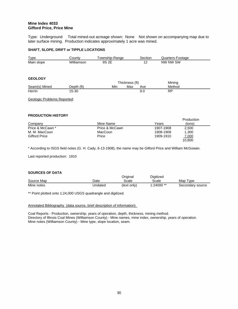
Mine Index 4033Gifford Price, Price Mine
Type: Underground Total mined-out acreage shown: None Not shown on accompanying map due tolater surface mining. Production indicates approximately 1 acre was mined.
SHAFT, SLOPE, DRIFT or TIPPLE LOCATIONS
Type County Township-Range Section Quarters-FootageMain slope Williamson 9S 2E 12 NW NW SW
GEOLOGY Thickness (ft) Mining
Seam(s) Mined Depth (ft) Min Max Ave MethodHerrin 15-30 9.0 RP
Geologic Problems Reported:
PRODUCTION HISTORY Production
Company Mine Name Years (tons) Price & McCawn * Price & McCawn 1907-1908 2,500M. M. MacCoun MacCoun 1908-1909 1,300Gifford Price Price 1909-1910 7,000
10,800
* According to ISGS field notes (G. H. Cady, 6-13-1908), the name may be Gilford Price and William McGowan.
Last reported production: 1910
SOURCES OF DATAOriginal Digitized
Source Map Date Scale Scale Map Type Mine notes Undated (text only) 1:24000 ** Secondary source
** Point plotted onto 1:24,000 USGS quadrangle and digitized.
Annotated Bibliography (data source, brief description of information)
Coal Reports - Production, ownership, years of operation, depth, thickness, mining method.Directory of Illinois Coal Mines (Williamson County) - Mine names, mine index, ownership, years of operation.Mine notes (Williamson County) - Mine type, slope location, seam.
90
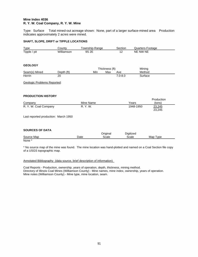
Mine Index 4036R. Y. W. Coal Company, R. Y. W. Mine
Type: Surface Total mined-out acreage shown: None, part of a larger surface-mined area Productionindicates approximately 2 acres were mined.
SHAFT, SLOPE, DRIFT or TIPPLE LOCATIONS
Type County Township-Range Section Quarters-FootageTipple / pit Williamson 9S 2E 12 NE NW NE
GEOLOGY Thickness (ft) Mining
Seam(s) Mined Depth (ft) Min Max Ave MethodHerrin 20 7.0-8.0 Surface
Geologic Problems Reported:
PRODUCTION HISTORY Production
Company Mine Name Years (tons) R. Y. W. Coal Company R. Y. W. 1948-1950 23,245
23,245
Last reported production: March 1950
SOURCES OF DATAOriginal Digitized
Source Map Date Scale Scale Map Type None *
* No source map of the mine was found. The mine location was hand-plotted and named on a Coal Section file copyof a USGS topographic map.
Annotated Bibliography (data source, brief description of information)
Coal Reports - Production, ownership, years of operation, depth, thickness, mining method.Directory of Illinois Coal Mines (Williamson County) - Mine names, mine index, ownership, years of operation.Mine notes (Williamson County) - Mine type, mine location, seam.
91
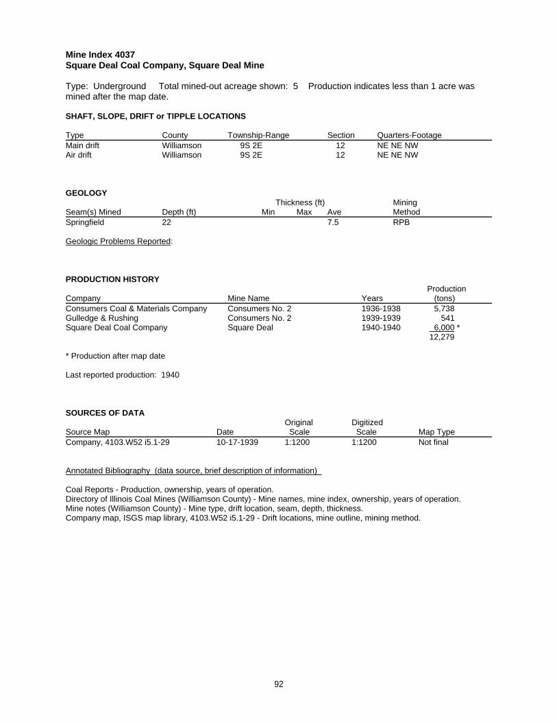
Mine Index 4037Square Deal Coal Company, Square Deal Mine
Type: Underground Total mined-out acreage shown: 5 Production indicates less than 1 acre wasmined after the map date.
SHAFT, SLOPE, DRIFT or TIPPLE LOCATIONS
Type County Township-Range Section Quarters-FootageMain drift Williamson 9S 2E 12 NE NE NWAir drift Williamson 9S 2E 12 NE NE NW
GEOLOGY Thickness (ft) Mining
Seam(s) Mined Depth (ft) Min Max Ave MethodSpringfield 22 7.5 RPB
Geologic Problems Reported:
PRODUCTION HISTORY Production
Company Mine Name Years (tons) Consumers Coal & Materials Company Consumers No. 2 1936-1938 5,738Gulledge & Rushing Consumers No. 2 1939-1939 541Square Deal Coal Company Square Deal 1940-1940 6,000 *
12,279
* Production after map date
Last reported production: 1940
SOURCES OF DATAOriginal Digitized
Source Map Date Scale Scale Map Type Company, 4103.W52 i5.1-29 10-17-1939 1:1200 1:1200 Not final
Annotated Bibliography (data source, brief description of information)
Coal Reports - Production, ownership, years of operation.Directory of Illinois Coal Mines (Williamson County) - Mine names, mine index, ownership, years of operation.Mine notes (Williamson County) - Mine type, drift location, seam, depth, thickness.Company map, ISGS map library, 4103.W52 i5.1-29 - Drift locations, mine outline, mining method.
92
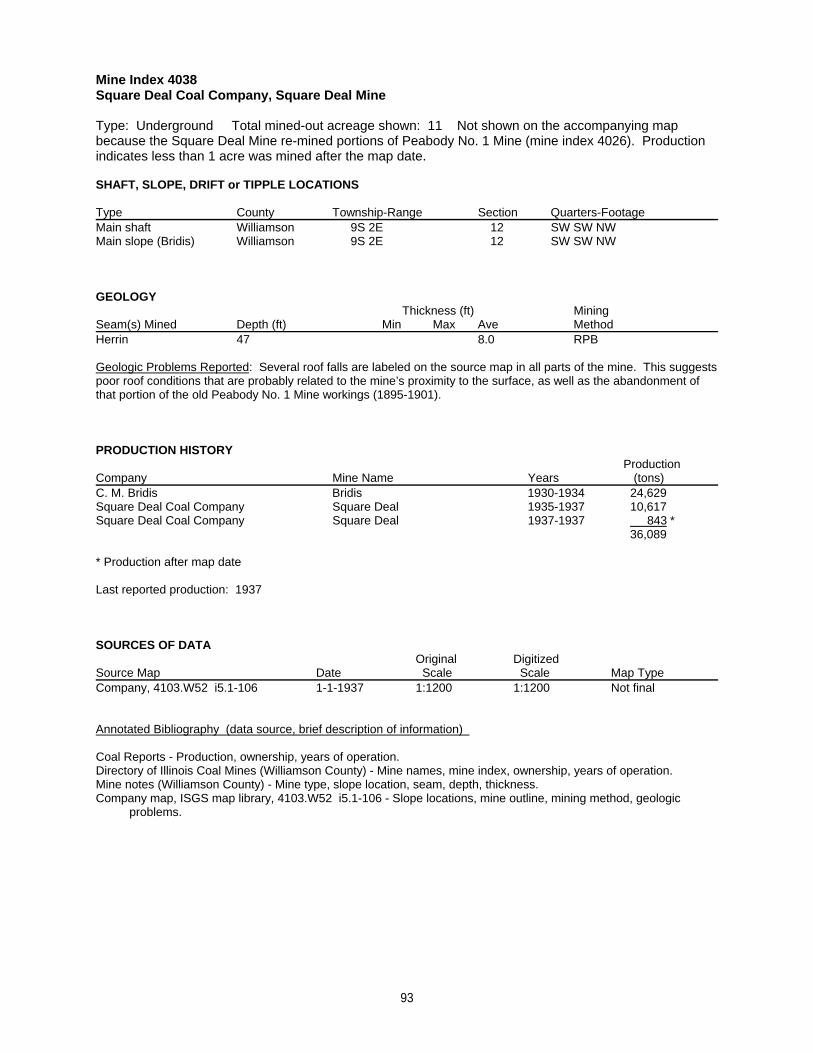
Mine Index 4038Square Deal Coal Company, Square Deal Mine
Type: Underground Total mined-out acreage shown: 11 Not shown on the accompanying mapbecause the Square Deal Mine re-mined portions of Peabody No. 1 Mine (mine index 4026). Productionindicates less than 1 acre was mined after the map date.
SHAFT, SLOPE, DRIFT or TIPPLE LOCATIONS
Type County Township-Range Section Quarters-FootageMain shaft Williamson 9S 2E 12 SW SW NWMain slope (Bridis) Williamson 9S 2E 12 SW SW NW
GEOLOGY Thickness (ft) Mining
Seam(s) Mined Depth (ft) Min Max Ave MethodHerrin 47 8.0 RPB
Geologic Problems Reported: Several roof falls are labeled on the source map in all parts of the mine. This suggestspoor roof conditions that are probably related to the mine’s proximity to the surface, as well as the abandonment ofthat portion of the old Peabody No. 1 Mine workings (1895-1901).
PRODUCTION HISTORY Production
Company Mine Name Years (tons) C. M. Bridis Bridis 1930-1934 24,629 Square Deal Coal Company Square Deal 1935-1937 10,617Square Deal Coal Company Square Deal 1937-1937 843 *
36,089
* Production after map date
Last reported production: 1937
SOURCES OF DATAOriginal Digitized
Source Map Date Scale Scale Map Type Company, 4103.W52 i5.1-106 1-1-1937 1:1200 1:1200 Not final
Annotated Bibliography (data source, brief description of information)
Coal Reports - Production, ownership, years of operation.Directory of Illinois Coal Mines (Williamson County) - Mine names, mine index, ownership, years of operation.Mine notes (Williamson County) - Mine type, slope location, seam, depth, thickness.Company map, ISGS map library, 4103.W52 i5.1-106 - Slope locations, mine outline, mining method, geologic problems.
93
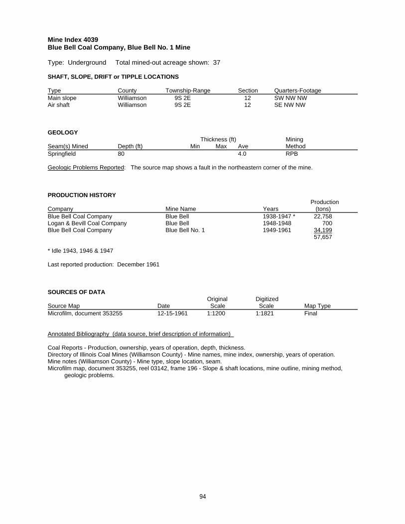
Mine Index 4039Blue Bell Coal Company, Blue Bell No. 1 Mine
Type: Underground Total mined-out acreage shown: 37
SHAFT, SLOPE, DRIFT or TIPPLE LOCATIONS
Type County Township-Range Section Quarters-FootageMain slope Williamson 9S 2E 12 SW NW NWAir shaft Williamson 9S 2E 12 SE NW NW
GEOLOGY Thickness (ft) Mining
Seam(s) Mined Depth (ft) Min Max Ave MethodSpringfield 80 4.0 RPB
Geologic Problems Reported: The source map shows a fault in the northeastern corner of the mine.
PRODUCTION HISTORY Production
Company Mine Name Years (tons) Blue Bell Coal Company Blue Bell 1938-1947 * 22,758Logan & Bevill Coal Company Blue Bell 1948-1948 700Blue Bell Coal Company Blue Bell No. 1 1949-1961 34,199
57,657
* Idle 1943, 1946 & 1947
Last reported production: December 1961
SOURCES OF DATAOriginal Digitized
Source Map Date Scale Scale Map Type Microfilm, document 353255 12-15-1961 1:1200 1:1821 Final
Annotated Bibliography (data source, brief description of information)
Coal Reports - Production, ownership, years of operation, depth, thickness.Directory of Illinois Coal Mines (Williamson County) - Mine names, mine index, ownership, years of operation.Mine notes (Williamson County) - Mine type, slope location, seam.Microfilm map, document 353255, reel 03142, frame 196 - Slope & shaft locations, mine outline, mining method, geologic problems.
94
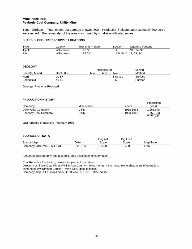
Mine Index 4041Peabody Coal Company, Utility Mine
Type: Surface Total mined-out acreage shown: 500 Production indicates approximately 200 acreswere mined. The remainder of the area was mined by smaller unaffiliated mines.
SHAFT, SLOPE, DRIFT or TIPPLE LOCATIONS
Type County Township-Range Section Quarters-FootageTipple Williamson 9S 3E 4 SE SW SEPits Williamson 9S 3E 8,9,10,11, 12, 13, 14
GEOLOGY Thickness (ft) Mining
Seam(s) Mined Depth (ft) Min Max Ave MethodHerrin 20-57 5.67-8.0 SurfaceSpringfield 40-65 3.58 Surface
Geologic Problems Reported:
PRODUCTION HISTORY Production
Company Mine Name Years (tons) Utility Coal Company Utility 1958-1963 1,266,648Peabody Coal Company Utility 1963-1966 759,763
2,026,411
Last reported production: February 1966
SOURCES OF DATAOriginal Digitized
Source Map Date Scale Scale Map Type Company, 4103.W52 i5.1-178 8-29-1969 1:24000 1:2400 Final
Annotated Bibliography (data source, brief description of information)
Coal Reports - Production, ownership, years of operation.Directory of Illinois Coal Mines (Williamson County) - Mine names, mine index, ownership, years of operation.Mine notes (Williamson County) - Mine type, tipple location.Company map, ISGS map library, 4103.W52 i5.1-178 - Mine outline
95
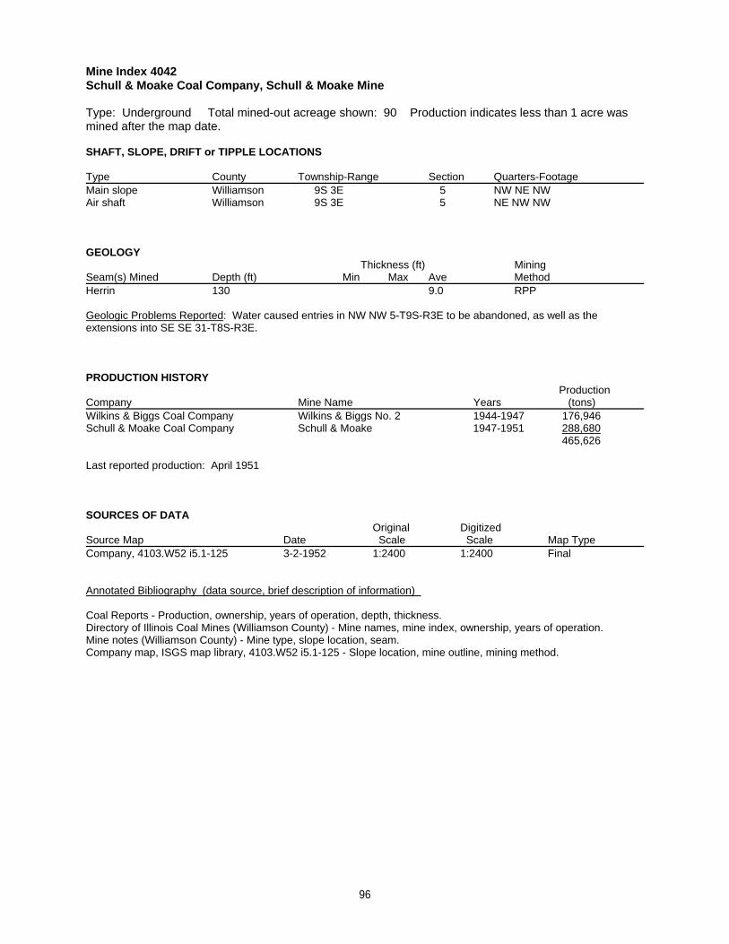
Mine Index 4042Schull & Moake Coal Company, Schull & Moake Mine
Type: Underground Total mined-out acreage shown: 90 Production indicates less than 1 acre wasmined after the map date.
SHAFT, SLOPE, DRIFT or TIPPLE LOCATIONS
Type County Township-Range Section Quarters-FootageMain slope Williamson 9S 3E 5 NW NE NWAir shaft Williamson 9S 3E 5 NE NW NW
GEOLOGY Thickness (ft) Mining
Seam(s) Mined Depth (ft) Min Max Ave MethodHerrin 130 9.0 RPP
Geologic Problems Reported: Water caused entries in NW NW 5-T9S-R3E to be abandoned, as well as theextensions into SE SE 31-T8S-R3E.
PRODUCTION HISTORY Production
Company Mine Name Years (tons) Wilkins & Biggs Coal Company Wilkins & Biggs No. 2 1944-1947 176,946Schull & Moake Coal Company Schull & Moake 1947-1951 288,680
465,626
Last reported production: April 1951
SOURCES OF DATAOriginal Digitized
Source Map Date Scale Scale Map Type Company, 4103.W52 i5.1-125 3-2-1952 1:2400 1:2400 Final
Annotated Bibliography (data source, brief description of information)
Coal Reports - Production, ownership, years of operation, depth, thickness.Directory of Illinois Coal Mines (Williamson County) - Mine names, mine index, ownership, years of operation.Mine notes (Williamson County) - Mine type, slope location, seam.Company map, ISGS map library, 4103.W52 i5.1-125 - Slope location, mine outline, mining method.
96
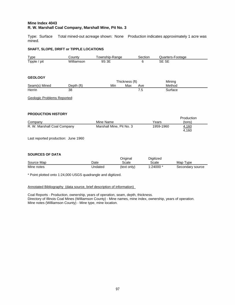
Mine Index 4043R. W. Marshall Coal Company, Marshall Mine, Pit No. 3
Type: Surface Total mined-out acreage shown: None Production indicates approximately 1 acre wasmined.
SHAFT, SLOPE, DRIFT or TIPPLE LOCATIONS
Type County Township-Range Section Quarters-FootageTipple / pit Williamson 9S 3E 6 SE SE
GEOLOGY Thickness (ft) Mining
Seam(s) Mined Depth (ft) Min Max Ave MethodHerrin 38 7.5 Surface
Geologic Problems Reported:
PRODUCTION HISTORY Production
Company Mine Name Years (tons) R. W. Marshall Coal Company Marshall Mine, Pit No. 3 1959-1960 4,160
4,160
Last reported production: June 1960
SOURCES OF DATAOriginal Digitized
Source Map Date Scale Scale Map Type Mine notes Undated (text only) 1:24000 * Secondary source
* Point plotted onto 1:24,000 USGS quadrangle and digitized.
Annotated Bibliography (data source, brief description of information)
Coal Reports - Production, ownership, years of operation, seam, depth, thickness.Directory of Illinois Coal Mines (Williamson County) - Mine names, mine index, ownership, years of operation.Mine notes (Williamson County) - Mine type, mine location.
97
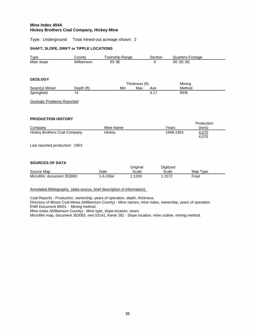
Mine Index 4044Hickey Brothers Coal Company, Hickey Mine
Type: Underground Total mined-out acreage shown: 2
SHAFT, SLOPE, DRIFT or TIPPLE LOCATIONS
Type County Township-Range Section Quarters-FootageMain slope Williamson 9S 3E 6 SE SE SE
GEOLOGY Thickness (ft) Mining
Seam(s) Mined Depth (ft) Min Max Ave MethodSpringfield 74 4.17 RPB
Geologic Problems Reported:
PRODUCTION HISTORY Production
Company Mine Name Years (tons) Hickey Brothers Coal Company Hickey 1948-1953 4,070
4,070
Last reported production: 1953
SOURCES OF DATAOriginal Digitized
Source Map Date Scale Scale Map Type Microfilm, document 353083 1-6-1954 1:1200 1:1572 Final
Annotated Bibliography (data source, brief description of information)
Coal Reports - Production, ownership, years of operation, depth, thickness.Directory of Illinois Coal Mines (Williamson County) - Mine names, mine index, ownership, years of operation.ENR Document 85/01 - Mining method.Mine notes (Williamson County) - Mine type, slope location, seam.Microfilm map, document 353083, reel 03141, frame 281 - Slope location, mine outline, mining method.
98
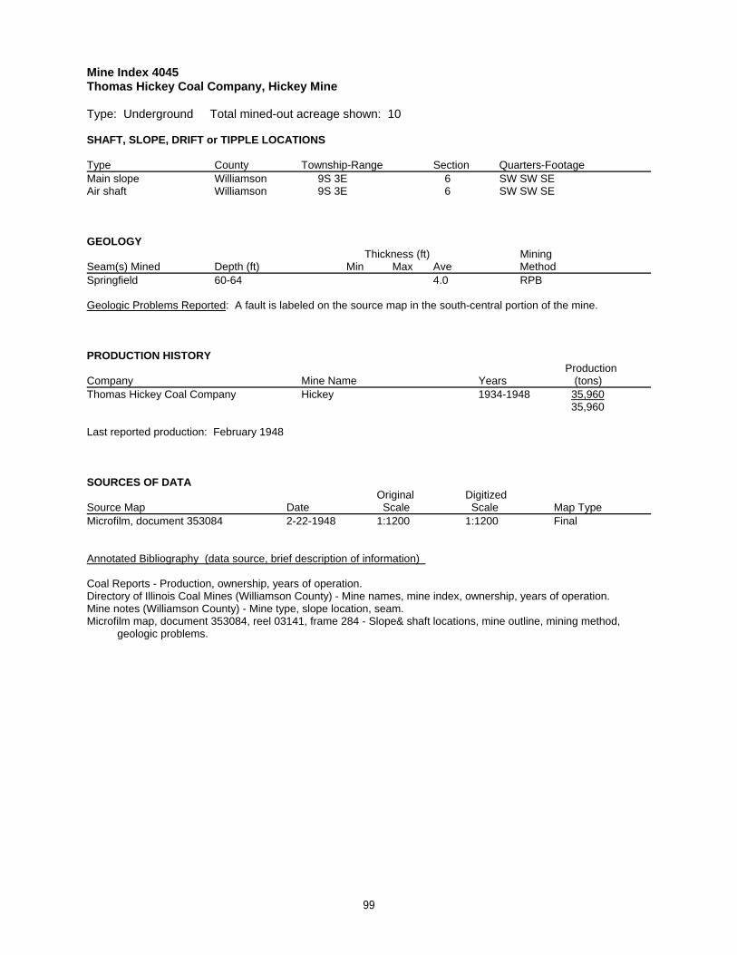
Mine Index 4045Thomas Hickey Coal Company, Hickey Mine
Type: Underground Total mined-out acreage shown: 10
SHAFT, SLOPE, DRIFT or TIPPLE LOCATIONS
Type County Township-Range Section Quarters-FootageMain slope Williamson 9S 3E 6 SW SW SEAir shaft Williamson 9S 3E 6 SW SW SE
GEOLOGY Thickness (ft) Mining
Seam(s) Mined Depth (ft) Min Max Ave MethodSpringfield 60-64 4.0 RPB
Geologic Problems Reported: A fault is labeled on the source map in the south-central portion of the mine.
PRODUCTION HISTORY Production
Company Mine Name Years (tons) Thomas Hickey Coal Company Hickey 1934-1948 35,960
35,960
Last reported production: February 1948
SOURCES OF DATAOriginal Digitized
Source Map Date Scale Scale Map Type Microfilm, document 353084 2-22-1948 1:1200 1:1200 Final
Annotated Bibliography (data source, brief description of information)
Coal Reports - Production, ownership, years of operation.Directory of Illinois Coal Mines (Williamson County) - Mine names, mine index, ownership, years of operation.Mine notes (Williamson County) - Mine type, slope location, seam.Microfilm map, document 353084, reel 03141, frame 284 - Slope& shaft locations, mine outline, mining method, geologic problems.
99
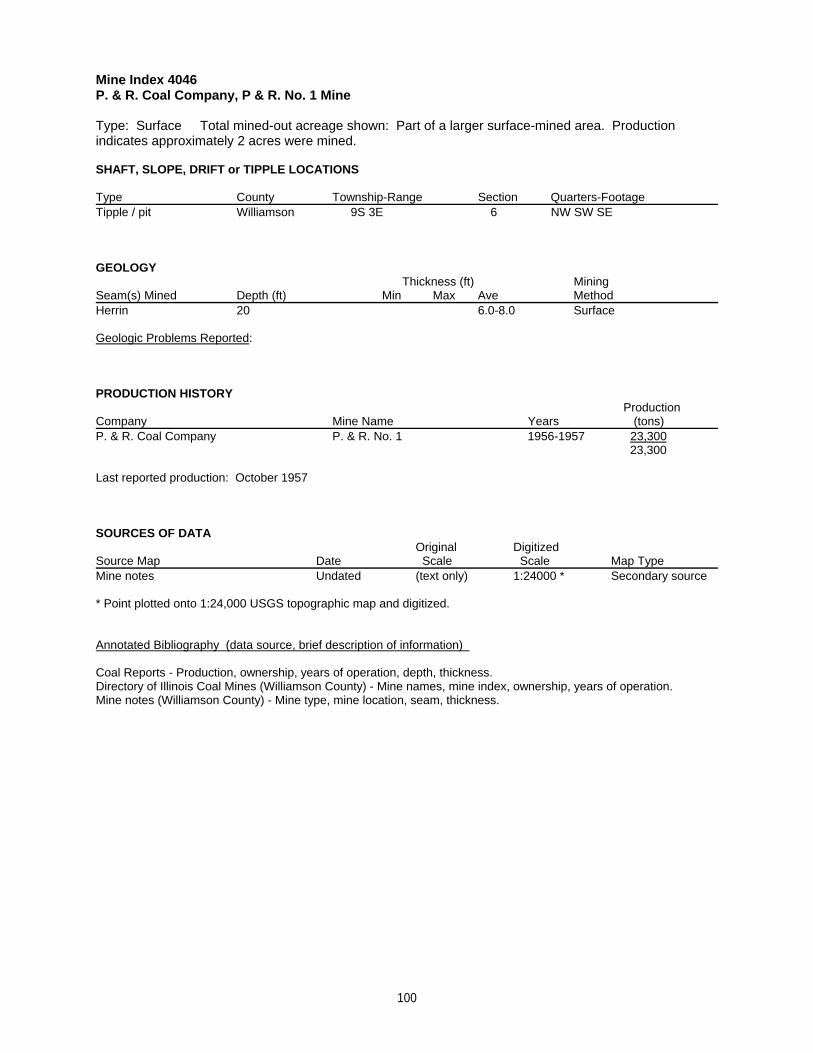
Mine Index 4046P. & R. Coal Company, P & R. No. 1 Mine
Type: Surface Total mined-out acreage shown: Part of a larger surface-mined area. Productionindicates approximately 2 acres were mined.
SHAFT, SLOPE, DRIFT or TIPPLE LOCATIONS
Type County Township-Range Section Quarters-FootageTipple / pit Williamson 9S 3E 6 NW SW SE
GEOLOGY Thickness (ft) Mining
Seam(s) Mined Depth (ft) Min Max Ave MethodHerrin 20 6.0-8.0 Surface
Geologic Problems Reported:
PRODUCTION HISTORY Production
Company Mine Name Years (tons) P. & R. Coal Company P. & R. No. 1 1956-1957 23,300
23,300
Last reported production: October 1957
SOURCES OF DATAOriginal Digitized
Source Map Date Scale Scale Map Type Mine notes Undated (text only) 1:24000 * Secondary source
* Point plotted onto 1:24,000 USGS topographic map and digitized.
Annotated Bibliography (data source, brief description of information)
Coal Reports - Production, ownership, years of operation, depth, thickness.Directory of Illinois Coal Mines (Williamson County) - Mine names, mine index, ownership, years of operation.Mine notes (Williamson County) - Mine type, mine location, seam, thickness.
100
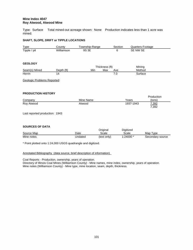
Mine Index 4047Roy Atwood, Atwood Mine
Type: Surface Total mined-out acreage shown: None Production indicates less than 1 acre wasmined.
SHAFT, SLOPE, DRIFT or TIPPLE LOCATIONS
Type County Township-Range Section Quarters-FootageTipple / pit Williamson 9S 3E 6 SE NW SE
GEOLOGY Thickness (ft) Mining
Seam(s) Mined Depth (ft) Min Max Ave MethodHerrin 14 7.0 Surface
Geologic Problems Reported:
PRODUCTION HISTORY Production
Company Mine Name Years (tons) Roy Atwood Atwood 1937-1943 7,392
7,392
Last reported production: 1943
SOURCES OF DATAOriginal Digitized
Source Map Date Scale Scale Map Type Mine notes Undated (text only) 1:24000 * Secondary source
* Point plotted onto 1:24,000 USGS quadrangle and digitized.
Annotated Bibliography (data source, brief description of information)
Coal Reports - Production, ownership, years of operation.Directory of Illinois Coal Mines (Williamson County) - Mine names, mine index, ownership, years of operation.Mine notes (Williamson County) - Mine type, mine location, seam, depth, thickness.
101
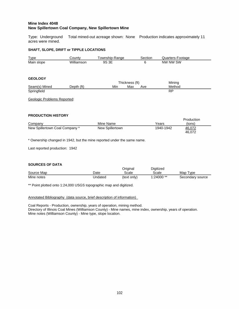
Mine Index 4048New Spillertown Coal Company, New Spillertown Mine
Type: Underground Total mined-out acreage shown: None Production indicates approximately 11acres were mined.
SHAFT, SLOPE, DRIFT or TIPPLE LOCATIONS
Type County Township-Range Section Quarters-FootageMain slope Williamson 9S 3E 6 NW NW SW
GEOLOGY Thickness (ft) Mining
Seam(s) Mined Depth (ft) Min Max Ave MethodSpringfield RP
Geologic Problems Reported:
PRODUCTION HISTORY Production
Company Mine Name Years (tons) New Spillertown Coal Company * New Spillertown 1940-1942 46,072
46,072
* Ownership changed in 1942, but the mine reported under the same name.
Last reported production: 1942
SOURCES OF DATAOriginal Digitized
Source Map Date Scale Scale Map Type Mine notes Undated (text only) 1:24000 ** Secondary source
** Point plotted onto 1:24,000 USGS topographic map and digitized.
Annotated Bibliography (data source, brief description of information)
Coal Reports - Production, ownership, years of operation, mining method.Directory of Illinois Coal Mines (Williamson County) - Mine names, mine index, ownership, years of operation.Mine notes (Williamson County) - Mine type, slope location.
102
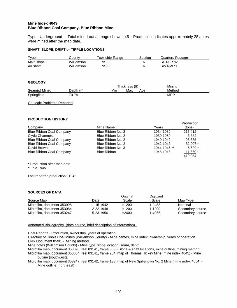
Mine Index 4049Blue Ribbon Coal Company, Blue Ribbon Mine
Type: Underground Total mined-out acreage shown: 45 Production indicates approximately 28 acreswere mined after the map date.
SHAFT, SLOPE, DRIFT or TIPPLE LOCATIONS
Type County Township-Range Section Quarters-FootageMain slope Williamson 9S 3E 6 SE NE SWAir shaft Williamson 9S 3E 6 SW NW SE
GEOLOGY Thickness (ft) Mining
Seam(s) Mined Depth (ft) Min Max Ave MethodSpringfield 70-74 MRP
Geologic Problems Reported:
PRODUCTION HISTORY Production
Company Mine Name Years (tons) Blue Ribbon Coal Company Blue Ribbon No. 2 1934-1939 216,412Clyde Chamness Blue Ribbon No. 2 1939-1939 6,652Blue Ribbon Coal Company Blue Ribbon No. 2 1940-1942 95,685Blue Ribbon Coal Company Blue Ribbon No. 2 1942-1943 82,007 *David Brown Blue Ribbon No. 3 1944-1945 ** 6,629 *Blue Ribbon Coal Company Blue Ribbon 1946-1946 11,669 *
419,054
* Production after map date** Idle 1945
Last reported production: 1946
SOURCES OF DATAOriginal Digitized
Source Map Date Scale Scale Map Type Microfilm, document 353098 1-15-1942 1:1200 1:2483 Not finalMicrofilm, document 353084 2-22-1948 1:1200 1:1200 Secondary sourceMicrofilm, document 353247 5-23-1956 1:2400 1:4966 Secondary source
Annotated Bibliography (data source, brief description of information)
Coal Reports - Production, ownership, years of operation.Directory of Illinois Coal Mines (Williamson County) - Mine names, mine index, ownership, years of operation.ENR Document 85/01 - Mining method.Mine notes (Williamson County) - Mine type, slope location, seam, depth.Microfilm map, document 353098, reel 03141, frame 303 - Slope & shaft locations, mine outline, mining method.Microfilm map, document 353084, reel 03141, frame 284, map of Thomas Hickey Mine (mine index 4045) - Mine outline (southwest).Microfilm map, document 353247, reel 03142, frame 188, map of New Spillertown No. 2 Mine (mine index 4054) - Mine outline (northeast).
103
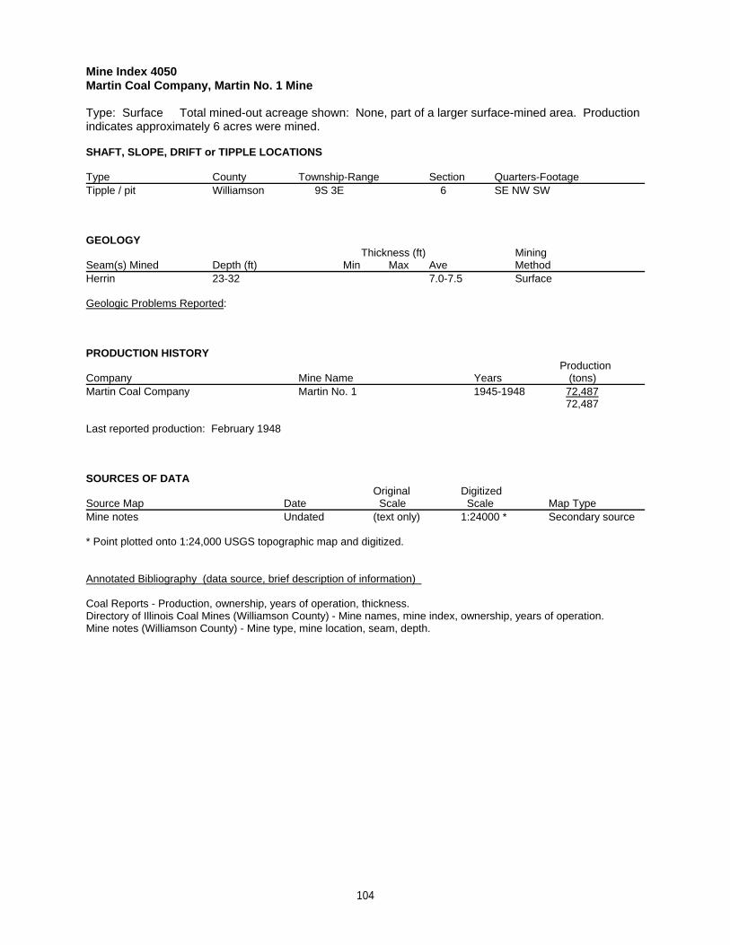
Mine Index 4050Martin Coal Company, Martin No. 1 Mine
Type: Surface Total mined-out acreage shown: None, part of a larger surface-mined area. Productionindicates approximately 6 acres were mined.
SHAFT, SLOPE, DRIFT or TIPPLE LOCATIONS
Type County Township-Range Section Quarters-FootageTipple / pit Williamson 9S 3E 6 SE NW SW
GEOLOGY Thickness (ft) Mining
Seam(s) Mined Depth (ft) Min Max Ave MethodHerrin 23-32 7.0-7.5 Surface
Geologic Problems Reported:
PRODUCTION HISTORY Production
Company Mine Name Years (tons) Martin Coal Company Martin No. 1 1945-1948 72,487
72,487
Last reported production: February 1948
SOURCES OF DATAOriginal Digitized
Source Map Date Scale Scale Map Type Mine notes Undated (text only) 1:24000 * Secondary source
* Point plotted onto 1:24,000 USGS topographic map and digitized.
Annotated Bibliography (data source, brief description of information)
Coal Reports - Production, ownership, years of operation, thickness.Directory of Illinois Coal Mines (Williamson County) - Mine names, mine index, ownership, years of operation.Mine notes (Williamson County) - Mine type, mine location, seam, depth.
104
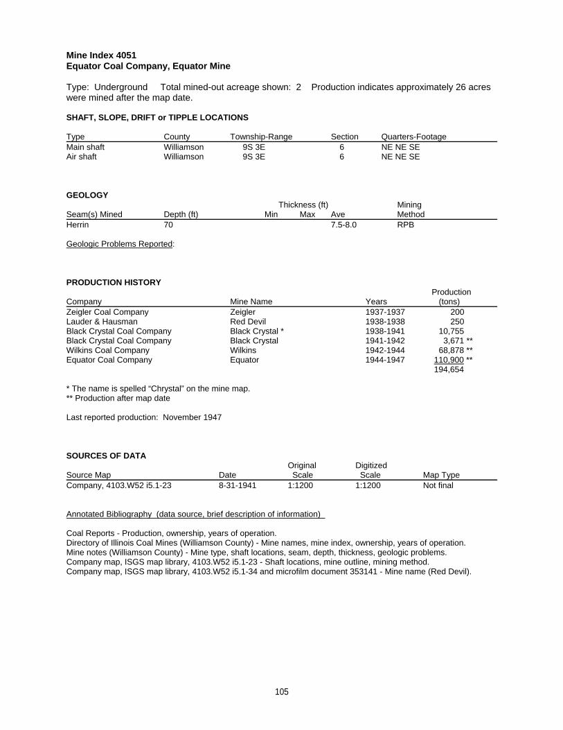
Mine Index 4051Equator Coal Company, Equator Mine
Type: Underground Total mined-out acreage shown: 2 Production indicates approximately 26 acreswere mined after the map date.
SHAFT, SLOPE, DRIFT or TIPPLE LOCATIONS
Type County Township-Range Section Quarters-FootageMain shaft Williamson 9S 3E 6 NE NE SEAir shaft Williamson 9S 3E 6 NE NE SE
GEOLOGY Thickness (ft) Mining
Seam(s) Mined Depth (ft) Min Max Ave MethodHerrin 70 7.5-8.0 RPB
Geologic Problems Reported:
PRODUCTION HISTORY Production
Company Mine Name Years (tons) Zeigler Coal Company Zeigler 1937-1937 200Lauder & Hausman Red Devil 1938-1938 250Black Crystal Coal Company Black Crystal * 1938-1941 10,755Black Crystal Coal Company Black Crystal 1941-1942 3,671 **Wilkins Coal Company Wilkins 1942-1944 68,878 **Equator Coal Company Equator 1944-1947 110,900 **
194,654
* The name is spelled “Chrystal” on the mine map. ** Production after map date
Last reported production: November 1947
SOURCES OF DATAOriginal Digitized
Source Map Date Scale Scale Map Type Company, 4103.W52 i5.1-23 8-31-1941 1:1200 1:1200 Not final
Annotated Bibliography (data source, brief description of information)
Coal Reports - Production, ownership, years of operation.Directory of Illinois Coal Mines (Williamson County) - Mine names, mine index, ownership, years of operation.Mine notes (Williamson County) - Mine type, shaft locations, seam, depth, thickness, geologic problems.Company map, ISGS map library, 4103.W52 i5.1-23 - Shaft locations, mine outline, mining method.Company map, ISGS map library, 4103.W52 i5.1-34 and microfilm document 353141 - Mine name (Red Devil).
105
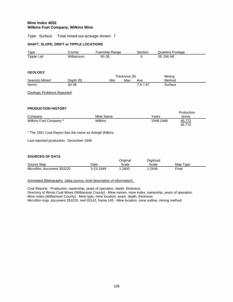
Mine Index 4052Wilkins Fuel Company, Wilkins Mine
Type: Surface Total mined-out acreage shown: 7
SHAFT, SLOPE, DRIFT or TIPPLE LOCATIONS
Type County Township-Range Section Quarters-FootageTipple / pit Williamson 9S 3E 6 SE SW NE
GEOLOGY Thickness (ft) Mining
Seam(s) Mined Depth (ft) Min Max Ave MethodHerrin 30-38 7.5-7.67 Surface
Geologic Problems Reported:
PRODUCTION HISTORY Production
Company Mine Name Years (tons) Wilkins Fuel Company * Wilkins 1948-1948 45,772
45,772
* The 1951 Coal Report lists the name as Arleigh Wilkins.
Last reported production: December 1948
SOURCES OF DATAOriginal Digitized
Source Map Date Scale Scale Map Type Microfilm, document 353220 3-23-1949 1:2400 1:2648 Final
Annotated Bibliography (data source, brief description of information)
Coal Reports - Production, ownership, years of operation, depth, thickness.Directory of Illinois Coal Mines (Williamson County) - Mine names, mine index, ownership, years of operation.Mine notes (Williamson County) - Mine type, mine location, seam, depth, thickness.Microfilm map, document 353220, reel 03142, frame 145 - Mine location, mine outline, mining method.
106

Mine Index 4053Chamness Coal Company, Chamness Mine
Type: Underground Total mined-out acreage shown: None Production indicates approximately 1acre was mined.
SHAFT, SLOPE, DRIFT or TIPPLE LOCATIONS
Type County Township-Range Section Quarters-FootageMain opening Williamson 9S 3E 6 SE NE NE
GEOLOGY Thickness (ft) Mining
Seam(s) Mined Depth (ft) Min Max Ave MethodRP
Geologic Problems Reported:
PRODUCTION HISTORY Production
Company Mine Name Years (tons) Chamness Coal Company * Chamness 1930-1930 3,800
3,800
* The mine notes indicate the owner was Clyde Chamness.
Last reported production: 1930
SOURCES OF DATAOriginal Digitized
Source Map Date Scale Scale Map Type Mine notes Undated (text only) 1:24000 ** Secondary source
** Point plotted onto 1:24,000 USGS topographic map and digitized.
Annotated Bibliography (data source, brief description of information)
Coal Reports - Production, ownership, years of operation, mining method.Directory of Illinois Coal Mines (Williamson County) - Mine names, mine index, ownership, years of operation.Mine notes (Williamson County) - Mine type, mine location.
107

Mine Index 4054Wilkins Coal Company, New Spillertown No. 2 Mine
Type: Underground Total mined-out acreage shown: 75
SHAFT, SLOPE, DRIFT or TIPPLE LOCATIONS
Type County Township-Range Section Quarters-FootageMain slope Williamson 9S 3E 6 NW NE SEAir shaft Williamson 9S 3E 6 SE SW NE
GEOLOGY Thickness (ft) Mining
Seam(s) Mined Depth (ft) Min Max Ave MethodSpringfield 86-100 4.0 MRP
Geologic Problems Reported: The source map shows water and bad top stopped expansion west and slightly northof the air shaft. (This could indicate that the surface mining in that area had already occurred.) Water and bad topwere also noted along the eastern side of the northern part of the mine, and along the southeast. There arenumerous large un-mined portions within the mine, indicating that poor mining conditions were probably presentthroughout the mine.
PRODUCTION HISTORY Production
Company Mine Name Years (tons) Wilkins Coal Company New Spillertown No. 2 1949-1956 242,696
242,696
Last reported production: May 1956
SOURCES OF DATAOriginal Digitized
Source Map Date Scale Scale Map Type Microfilm, document 353247 5-23-1956 1:2400 1:4966 Final
Annotated Bibliography (data source, brief description of information)
Coal Reports - Production, ownership, years of operation, depth, thickness.Directory of Illinois Coal Mines (Williamson County) - Mine names, mine index, ownership, years of operation.Mine notes (Williamson County) - Mine type, slope location, seam.Microfilm map, document 353247, reel 03142, frame 188 - Slope & shaft locations, mine outline, mining method, geologic problems.
108
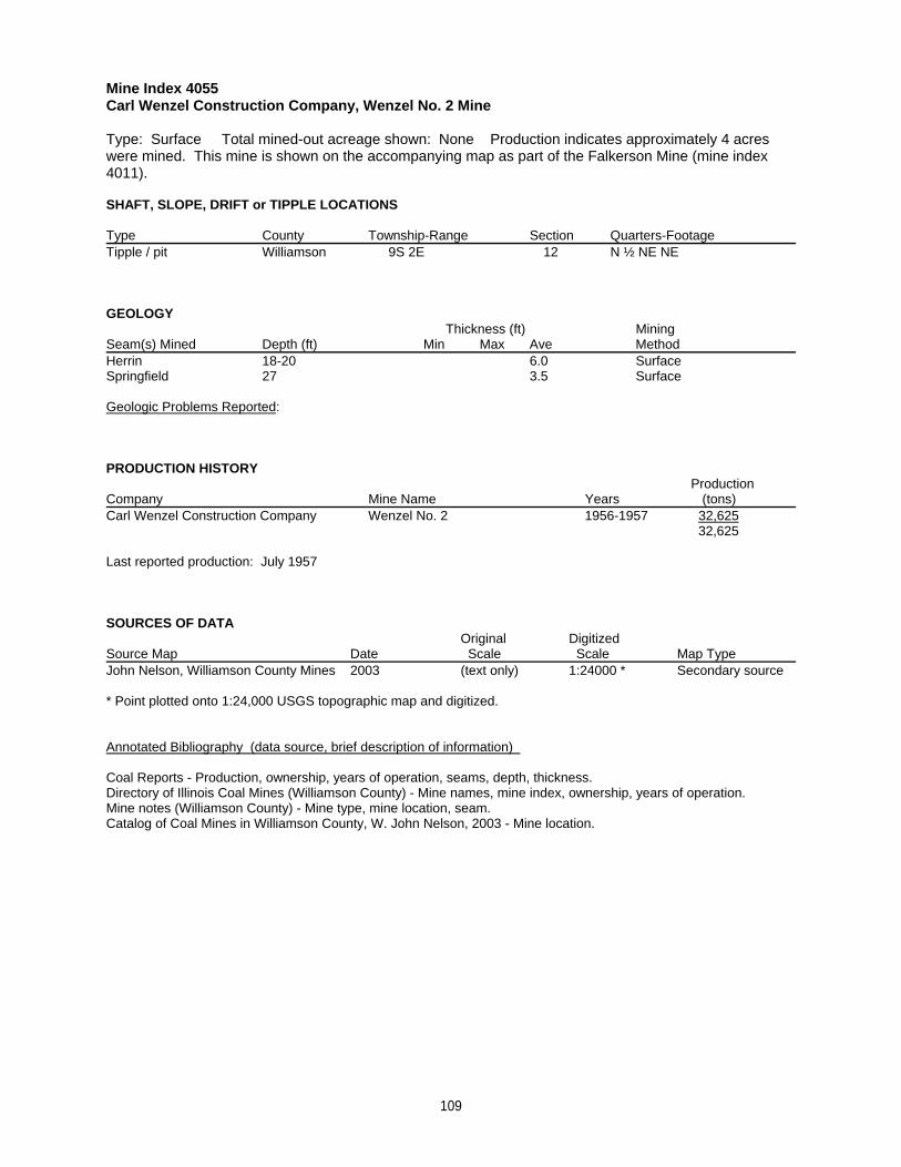
Mine Index 4055Carl Wenzel Construction Company, Wenzel No. 2 Mine
Type: Surface Total mined-out acreage shown: None Production indicates approximately 4 acreswere mined. This mine is shown on the accompanying map as part of the Falkerson Mine (mine index4011).
SHAFT, SLOPE, DRIFT or TIPPLE LOCATIONS
Type County Township-Range Section Quarters-FootageTipple / pit Williamson 9S 2E 12 N ½ NE NE
GEOLOGY Thickness (ft) Mining
Seam(s) Mined Depth (ft) Min Max Ave MethodHerrin 18-20 6.0 SurfaceSpringfield 27 3.5 Surface
Geologic Problems Reported:
PRODUCTION HISTORY Production
Company Mine Name Years (tons) Carl Wenzel Construction Company Wenzel No. 2 1956-1957 32,625
32,625
Last reported production: July 1957
SOURCES OF DATAOriginal Digitized
Source Map Date Scale Scale Map Type John Nelson, Williamson County Mines 2003 (text only) 1:24000 * Secondary source
* Point plotted onto 1:24,000 USGS topographic map and digitized.
Annotated Bibliography (data source, brief description of information)
Coal Reports - Production, ownership, years of operation, seams, depth, thickness.Directory of Illinois Coal Mines (Williamson County) - Mine names, mine index, ownership, years of operation.Mine notes (Williamson County) - Mine type, mine location, seam.Catalog of Coal Mines in Williamson County, W. John Nelson, 2003 - Mine location.
109
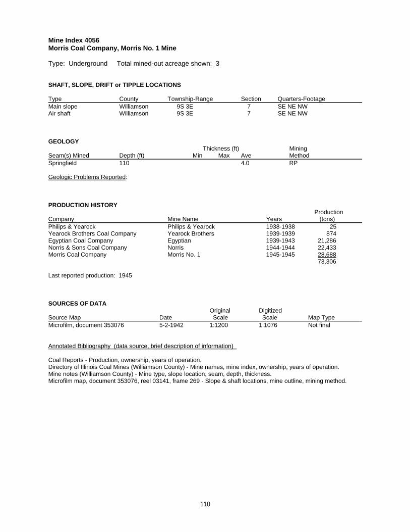
Mine Index 4056Morris Coal Company, Morris No. 1 Mine
Type: Underground Total mined-out acreage shown: 3
SHAFT, SLOPE, DRIFT or TIPPLE LOCATIONS
Type County Township-Range Section Quarters-FootageMain slope Williamson 9S 3E 7 SE NE NW Air shaft Williamson 9S 3E 7 SE NE NW
GEOLOGY Thickness (ft) Mining
Seam(s) Mined Depth (ft) Min Max Ave MethodSpringfield 110 4.0 RP
Geologic Problems Reported:
PRODUCTION HISTORY Production
Company Mine Name Years (tons) Philips & Yearock Philips & Yearock 1938-1938 25Yearock Brothers Coal Company Yearock Brothers 1939-1939 874Egyptian Coal Company Egyptian 1939-1943 21,286Norris & Sons Coal Company Norris 1944-1944 22,433Morris Coal Company Morris No. 1 1945-1945 28,688
73,306
Last reported production: 1945
SOURCES OF DATAOriginal Digitized
Source Map Date Scale Scale Map Type Microfilm, document 353076 5-2-1942 1:1200 1:1076 Not final
Annotated Bibliography (data source, brief description of information)
Coal Reports - Production, ownership, years of operation.Directory of Illinois Coal Mines (Williamson County) - Mine names, mine index, ownership, years of operation.Mine notes (Williamson County) - Mine type, slope location, seam, depth, thickness.Microfilm map, document 353076, reel 03141, frame 269 - Slope & shaft locations, mine outline, mining method.
110
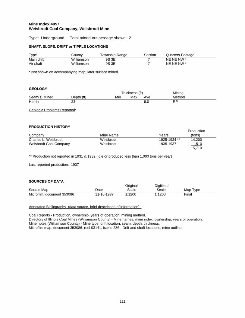
Mine Index 4057Weisbrodt Coal Company, Weisbrodt Mine
Type: Underground Total mined-out acreage shown: 2
SHAFT, SLOPE, DRIFT or TIPPLE LOCATIONS
Type County Township-Range Section Quarters-FootageMain drift Williamson 9S 3E 7 NE NE NW *Air shaft Williamson 9S 3E 7 NE NE NW *
* Not shown on accompanying map; later surface mined.
GEOLOGY Thickness (ft) Mining
Seam(s) Mined Depth (ft) Min Max Ave MethodHerrin 23 8.0 RP
Geologic Problems Reported:
PRODUCTION HISTORY Production
Company Mine Name Years (tons) Charles L. Weisbrodt Weisbrodt 1925-1934 ** 14,200Weisbrodt Coal Company Weisbrodt 1935-1937 1,510
15,710
** Production not reported in 1931 & 1932 (idle or produced less than 1,000 tons per year)
Last reported production: 1937
SOURCES OF DATAOriginal Digitized
Source Map Date Scale Scale Map Type Microfilm, document 353086 11-16-1937 1:1200 1:1200 Final
Annotated Bibliography (data source, brief description of information)
Coal Reports - Production, ownership, years of operation, mining method.Directory of Illinois Coal Mines (Williamson County) - Mine names, mine index, ownership, years of operation.Mine notes (Williamson County) - Mine type, drift location, seam, depth, thickness.Microfilm map, document 353086, reel 03141, frame 286 - Drift and shaft locations, mine outline.
111
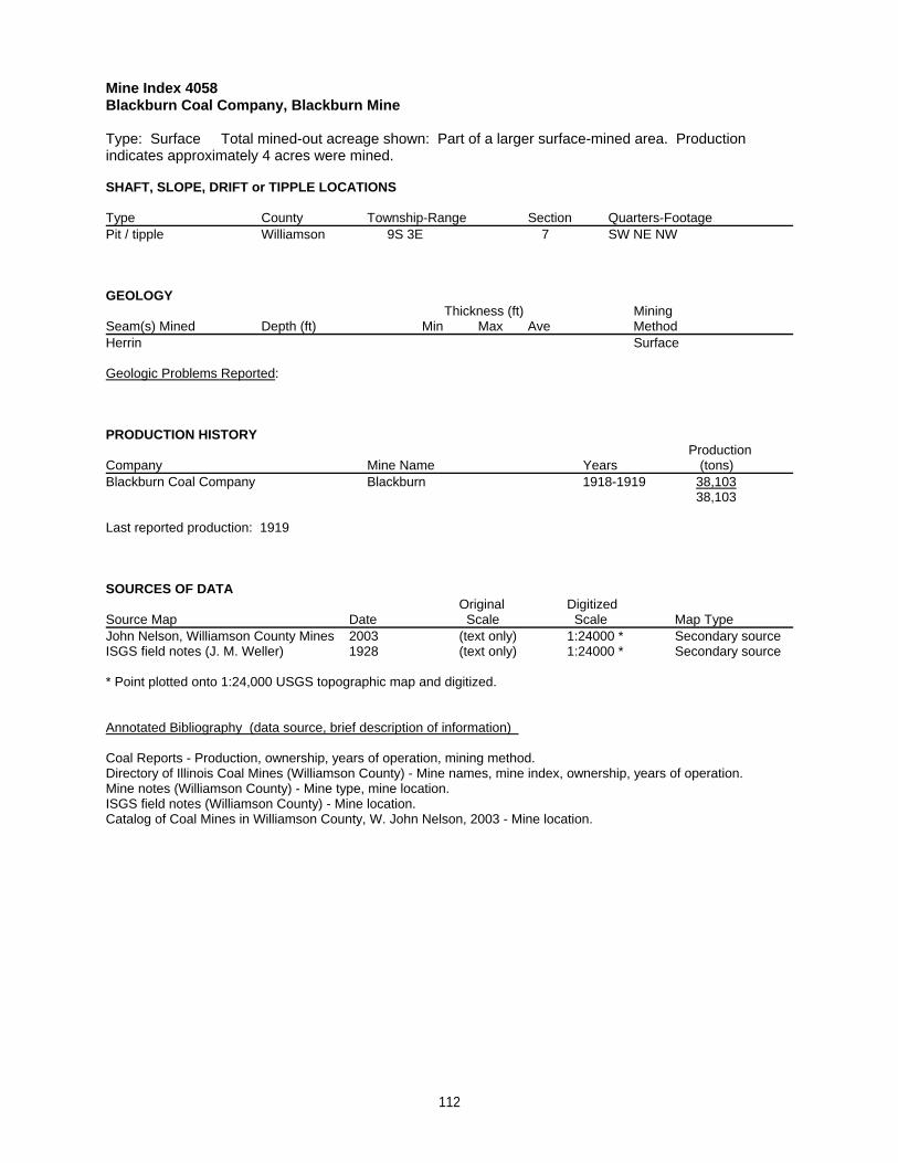
Mine Index 4058Blackburn Coal Company, Blackburn Mine
Type: Surface Total mined-out acreage shown: Part of a larger surface-mined area. Productionindicates approximately 4 acres were mined.
SHAFT, SLOPE, DRIFT or TIPPLE LOCATIONS
Type County Township-Range Section Quarters-FootagePit / tipple Williamson 9S 3E 7 SW NE NW
GEOLOGY Thickness (ft) Mining
Seam(s) Mined Depth (ft) Min Max Ave MethodHerrin Surface
Geologic Problems Reported:
PRODUCTION HISTORY Production
Company Mine Name Years (tons) Blackburn Coal Company Blackburn 1918-1919 38,103
38,103
Last reported production: 1919
SOURCES OF DATAOriginal Digitized
Source Map Date Scale Scale Map Type John Nelson, Williamson County Mines 2003 (text only) 1:24000 * Secondary sourceISGS field notes (J. M. Weller) 1928 (text only) 1:24000 * Secondary source
* Point plotted onto 1:24,000 USGS topographic map and digitized.
Annotated Bibliography (data source, brief description of information)
Coal Reports - Production, ownership, years of operation, mining method.Directory of Illinois Coal Mines (Williamson County) - Mine names, mine index, ownership, years of operation.Mine notes (Williamson County) - Mine type, mine location.ISGS field notes (Williamson County) - Mine location.Catalog of Coal Mines in Williamson County, W. John Nelson, 2003 - Mine location.
112
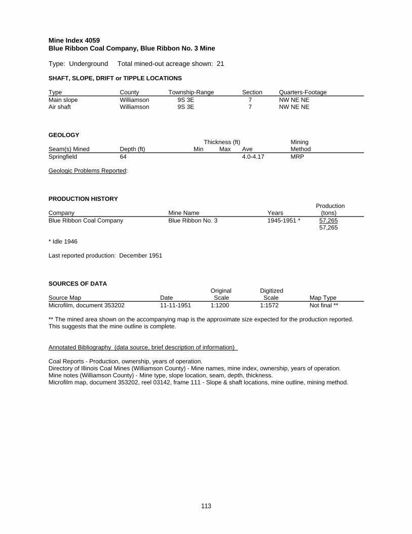
Mine Index 4059Blue Ribbon Coal Company, Blue Ribbon No. 3 Mine
Type: Underground Total mined-out acreage shown: 21
SHAFT, SLOPE, DRIFT or TIPPLE LOCATIONS
Type County Township-Range Section Quarters-FootageMain slope Williamson 9S 3E 7 NW NE NEAir shaft Williamson 9S 3E 7 NW NE NE
GEOLOGY Thickness (ft) Mining
Seam(s) Mined Depth (ft) Min Max Ave MethodSpringfield 64 4.0-4.17 MRP
Geologic Problems Reported:
PRODUCTION HISTORY Production
Company Mine Name Years (tons) Blue Ribbon Coal Company Blue Ribbon No. 3 1945-1951 * 57,265
57,265
* Idle 1946
Last reported production: December 1951
SOURCES OF DATAOriginal Digitized
Source Map Date Scale Scale Map Type Microfilm, document 353202 11-11-1951 1:1200 1:1572 Not final **
** The mined area shown on the accompanying map is the approximate size expected for the production reported. This suggests that the mine outline is complete.
Annotated Bibliography (data source, brief description of information)
Coal Reports - Production, ownership, years of operation.Directory of Illinois Coal Mines (Williamson County) - Mine names, mine index, ownership, years of operation.Mine notes (Williamson County) - Mine type, slope location, seam, depth, thickness.Microfilm map, document 353202, reel 03142, frame 111 - Slope & shaft locations, mine outline, mining method.
113
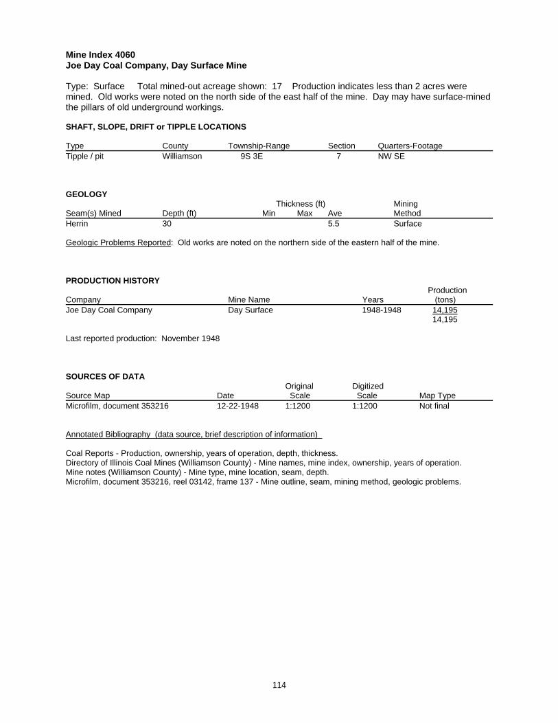
Mine Index 4060Joe Day Coal Company, Day Surface Mine
Type: Surface Total mined-out acreage shown: 17 Production indicates less than 2 acres weremined. Old works were noted on the north side of the east half of the mine. Day may have surface-minedthe pillars of old underground workings.
SHAFT, SLOPE, DRIFT or TIPPLE LOCATIONS
Type County Township-Range Section Quarters-FootageTipple / pit Williamson 9S 3E 7 NW SE
GEOLOGY Thickness (ft) Mining
Seam(s) Mined Depth (ft) Min Max Ave MethodHerrin 30 5.5 Surface
Geologic Problems Reported: Old works are noted on the northern side of the eastern half of the mine.
PRODUCTION HISTORY Production
Company Mine Name Years (tons) Joe Day Coal Company Day Surface 1948-1948 14,195
14,195
Last reported production: November 1948
SOURCES OF DATAOriginal Digitized
Source Map Date Scale Scale Map Type Microfilm, document 353216 12-22-1948 1:1200 1:1200 Not final
Annotated Bibliography (data source, brief description of information)
Coal Reports - Production, ownership, years of operation, depth, thickness.Directory of Illinois Coal Mines (Williamson County) - Mine names, mine index, ownership, years of operation.Mine notes (Williamson County) - Mine type, mine location, seam, depth.Microfilm, document 353216, reel 03142, frame 137 - Mine outline, seam, mining method, geologic problems.
114
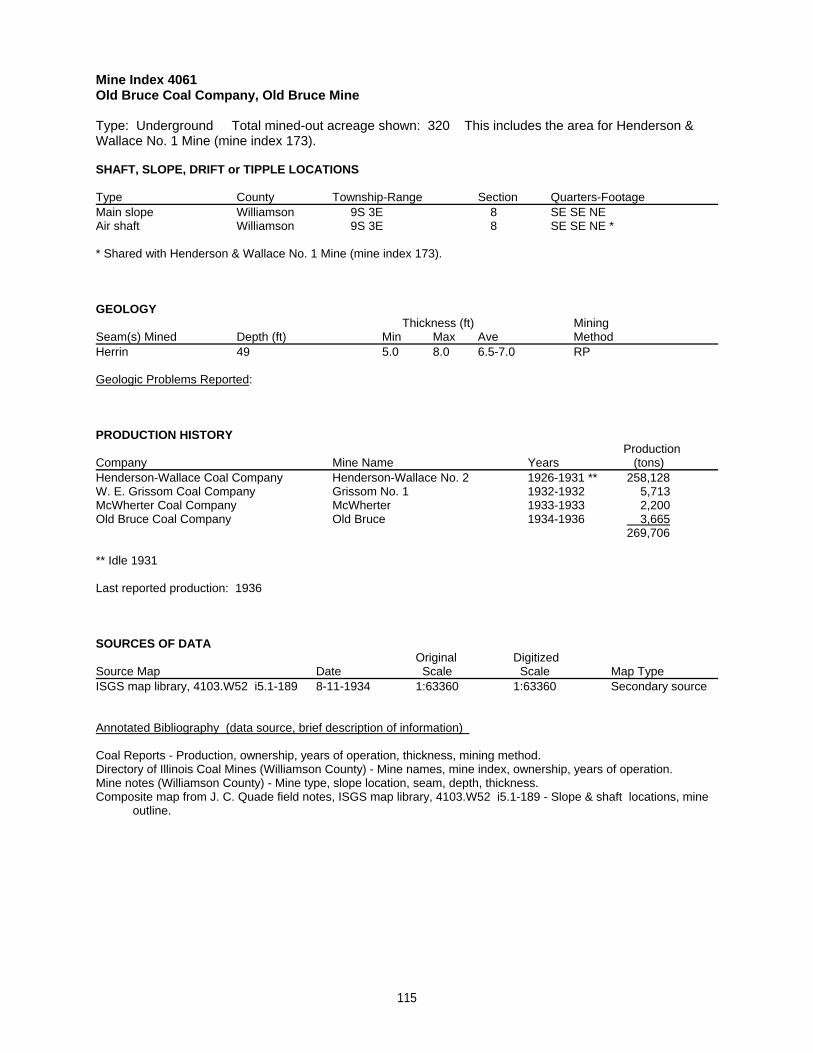
Mine Index 4061Old Bruce Coal Company, Old Bruce Mine
Type: Underground Total mined-out acreage shown: 320 This includes the area for Henderson &Wallace No. 1 Mine (mine index 173).
SHAFT, SLOPE, DRIFT or TIPPLE LOCATIONS
Type County Township-Range Section Quarters-FootageMain slope Williamson 9S 3E 8 SE SE NEAir shaft Williamson 9S 3E 8 SE SE NE *
* Shared with Henderson & Wallace No. 1 Mine (mine index 173).
GEOLOGY Thickness (ft) Mining
Seam(s) Mined Depth (ft) Min Max Ave MethodHerrin 49 5.0 8.0 6.5-7.0 RP
Geologic Problems Reported:
PRODUCTION HISTORY Production
Company Mine Name Years (tons) Henderson-Wallace Coal Company Henderson-Wallace No. 2 1926-1931 ** 258,128W. E. Grissom Coal Company Grissom No. 1 1932-1932 5,713McWherter Coal Company McWherter 1933-1933 2,200Old Bruce Coal Company Old Bruce 1934-1936 3,665
269,706
** Idle 1931
Last reported production: 1936
SOURCES OF DATAOriginal Digitized
Source Map Date Scale Scale Map Type ISGS map library, 4103.W52 i5.1-189 8-11-1934 1:63360 1:63360 Secondary source
Annotated Bibliography (data source, brief description of information)
Coal Reports - Production, ownership, years of operation, thickness, mining method.Directory of Illinois Coal Mines (Williamson County) - Mine names, mine index, ownership, years of operation.Mine notes (Williamson County) - Mine type, slope location, seam, depth, thickness.Composite map from J. C. Quade field notes, ISGS map library, 4103.W52 i5.1-189 - Slope & shaft locations, mine outline.
115
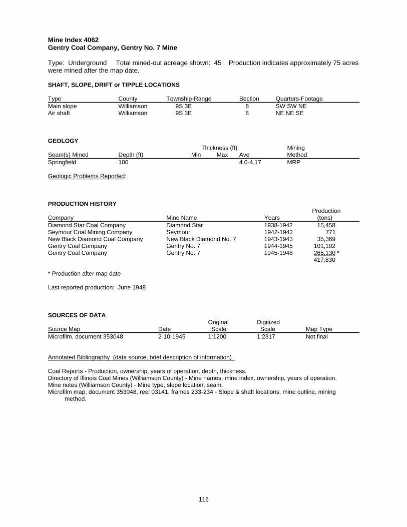
Mine Index 4062Gentry Coal Company, Gentry No. 7 Mine
Type: Underground Total mined-out acreage shown: 45 Production indicates approximately 75 acreswere mined after the map date.
SHAFT, SLOPE, DRIFT or TIPPLE LOCATIONS
Type County Township-Range Section Quarters-FootageMain slope Williamson 9S 3E 8 SW SW NEAir shaft Williamson 9S 3E 8 NE NE SE
GEOLOGY Thickness (ft) Mining
Seam(s) Mined Depth (ft) Min Max Ave MethodSpringfield 100 4.0-4.17 MRP
Geologic Problems Reported:
PRODUCTION HISTORY Production
Company Mine Name Years (tons) Diamond Star Coal Company Diamond Star 1938-1942 15,458Seymour Coal Mining Company Seymour 1942-1942 771New Black Diamond Coal Company New Black Diamond No. 7 1943-1943 35,369Gentry Coal Company Gentry No. 7 1944-1945 101,102Gentry Coal Company Gentry No. 7 1945-1948 265,130 *
417,830
* Production after map date
Last reported production: June 1948
SOURCES OF DATAOriginal Digitized
Source Map Date Scale Scale Map Type Microfilm, document 353048 2-10-1945 1:1200 1:2317 Not final
Annotated Bibliography (data source, brief description of information)
Coal Reports - Production, ownership, years of operation, depth, thickness.Directory of Illinois Coal Mines (Williamson County) - Mine names, mine index, ownership, years of operation.Mine notes (Williamson County) - Mine type, slope location, seam.Microfilm map, document 353048, reel 03141, frames 233-234 - Slope & shaft locations, mine outline, mining method.
116
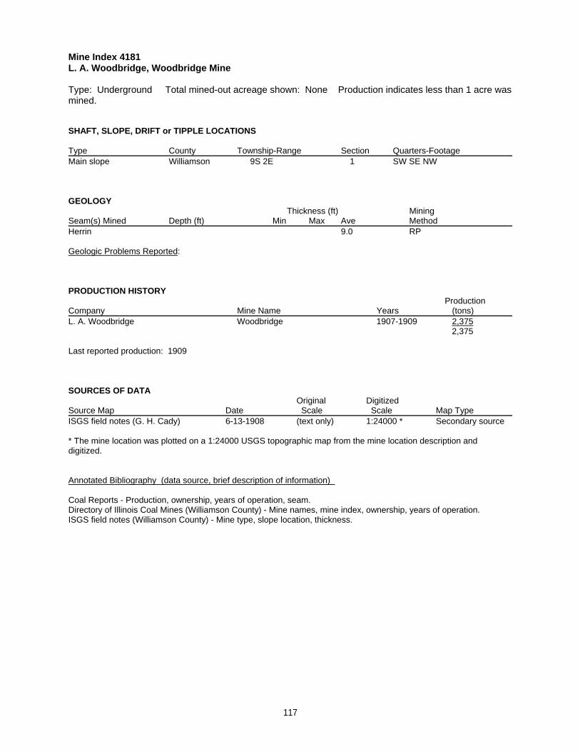
Mine Index 4181L. A. Woodbridge, Woodbridge Mine
Type: Underground Total mined-out acreage shown: None Production indicates less than 1 acre wasmined.
SHAFT, SLOPE, DRIFT or TIPPLE LOCATIONS
Type County Township-Range Section Quarters-FootageMain slope Williamson 9S 2E 1 SW SE NW
GEOLOGY Thickness (ft) Mining
Seam(s) Mined Depth (ft) Min Max Ave MethodHerrin 9.0 RP
Geologic Problems Reported:
PRODUCTION HISTORY Production
Company Mine Name Years (tons) L. A. Woodbridge Woodbridge 1907-1909 2,375
2,375
Last reported production: 1909
SOURCES OF DATAOriginal Digitized
Source Map Date Scale Scale Map Type ISGS field notes (G. H. Cady) 6-13-1908 (text only) 1:24000 * Secondary source
* The mine location was plotted on a 1:24000 USGS topographic map from the mine location description anddigitized.
Annotated Bibliography (data source, brief description of information)
Coal Reports - Production, ownership, years of operation, seam.Directory of Illinois Coal Mines (Williamson County) - Mine names, mine index, ownership, years of operation.ISGS field notes (Williamson County) - Mine type, slope location, thickness.
117
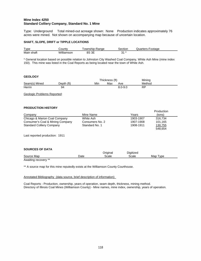
Mine Index 4250Standard Colliery Company, Standard No. 1 Mine
Type: Underground Total mined-out acreage shown: None Production indicates approximately 76acres were mined. Not shown on accompanying map because of uncertain location.
SHAFT, SLOPE, DRIFT or TIPPLE LOCATIONS
Type County Township-Range Section Quarters-FootageMain shaft Williamson 8S 3E 31 *
* General location based on possible relation to Johnston City Washed Coal Company, White Ash Mine (mine index150). This mine was listed in the Coal Reports as being located near the town of White Ash.
GEOLOGY Thickness (ft) Mining
Seam(s) Mined Depth (ft) Min Max Ave MethodHerrin 94 8.0-9.0 RP
Geologic Problems Reported:
PRODUCTION HISTORY Production
Company Mine Name Years (tons) Chicago & Marion Coal Company White Ash 1903-1907 316,734Consumer’s Coal & Mining Company Consumers No. 2 1907-1908 101,165Standard Colliery Company Standard No. 1 1908-1911 130,755
548,654
Last reported production: 1911
SOURCES OF DATAOriginal Digitized
Source Map Date Scale Scale Map Type Awaiting recovery **
** A source map for this mine reputedly exists at the Williamson County Courthouse.
Annotated Bibliography (data source, brief description of information)
Coal Reports - Production, ownership, years of operation, seam depth, thickness, mining method.Directory of Illinois Coal Mines (Williamson County) - Mine names, mine index, ownership, years of operation.
118
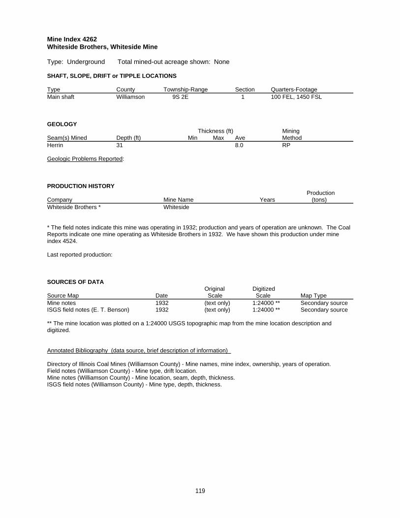
Mine Index 4262Whiteside Brothers, Whiteside Mine
Type: Underground Total mined-out acreage shown: None
SHAFT, SLOPE, DRIFT or TIPPLE LOCATIONS
Type County Township-Range Section Quarters-FootageMain shaft Williamson 9S 2E 1 100 FEL, 1450 FSL
GEOLOGY Thickness (ft) Mining
Seam(s) Mined Depth (ft) Min Max Ave MethodHerrin 31 8.0 RP
Geologic Problems Reported:
PRODUCTION HISTORY Production
Company Mine Name Years (tons) Whiteside Brothers * Whiteside
* The field notes indicate this mine was operating in 1932; production and years of operation are unknown. The CoalReports indicate one mine operating as Whiteside Brothers in 1932. We have shown this production under mineindex 4524.
Last reported production:
SOURCES OF DATAOriginal Digitized
Source Map Date Scale Scale Map Type Mine notes 1932 (text only) 1:24000 ** Secondary sourceISGS field notes (E. T. Benson) 1932 (text only) 1:24000 ** Secondary source
** The mine location was plotted on a 1:24000 USGS topographic map from the mine location description anddigitized.
Annotated Bibliography (data source, brief description of information)
Directory of Illinois Coal Mines (Williamson County) - Mine names, mine index, ownership, years of operation.Field notes (Williamson County) - Mine type, drift location.Mine notes (Williamson County) - Mine location, seam, depth, thickness.ISGS field notes (Williamson County) - Mine type, depth, thickness.
119
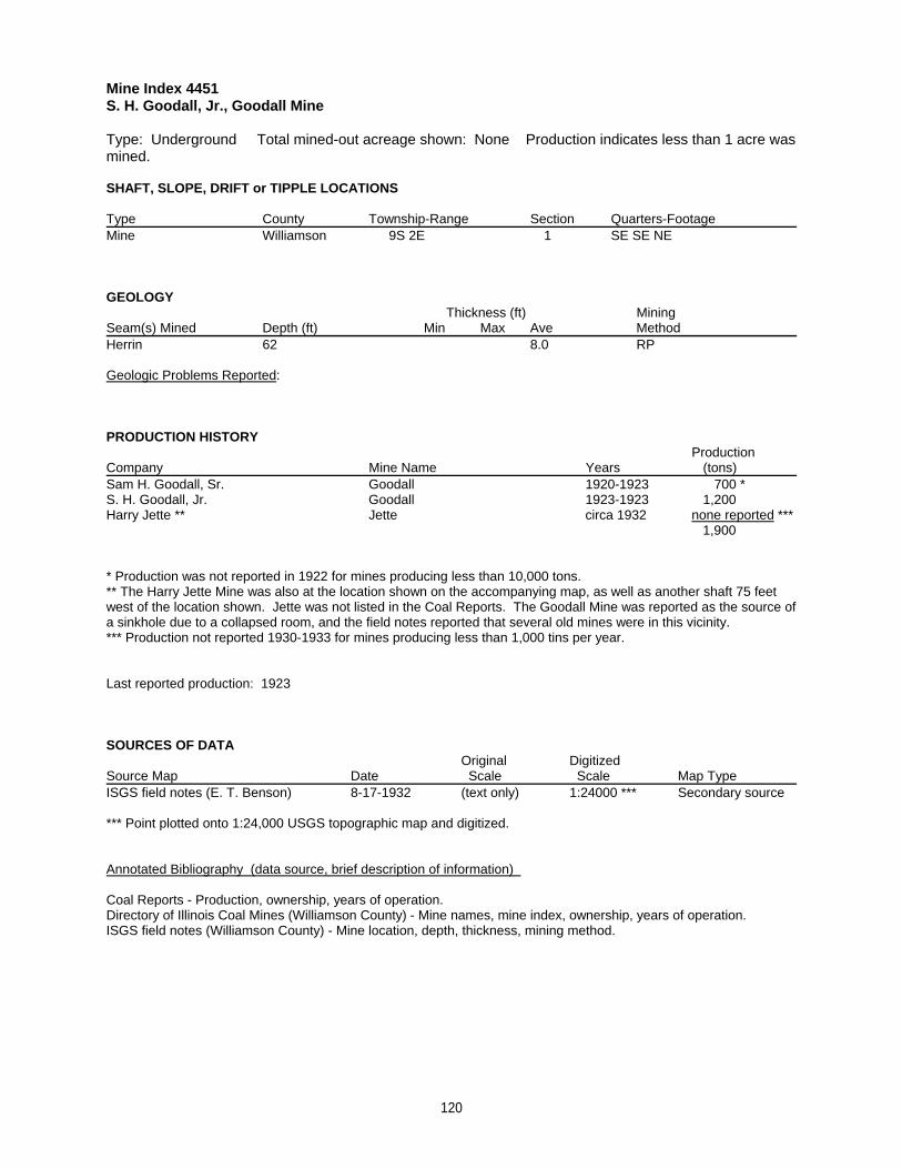
Mine Index 4451S. H. Goodall, Jr., Goodall Mine
Type: Underground Total mined-out acreage shown: None Production indicates less than 1 acre wasmined.
SHAFT, SLOPE, DRIFT or TIPPLE LOCATIONS
Type County Township-Range Section Quarters-FootageMine Williamson 9S 2E 1 SE SE NE
GEOLOGY Thickness (ft) Mining
Seam(s) Mined Depth (ft) Min Max Ave MethodHerrin 62 8.0 RP
Geologic Problems Reported:
PRODUCTION HISTORY Production
Company Mine Name Years (tons) Sam H. Goodall, Sr. Goodall 1920-1923 700 *S. H. Goodall, Jr. Goodall 1923-1923 1,200Harry Jette ** Jette circa 1932 none reported ***
1,900
* Production was not reported in 1922 for mines producing less than 10,000 tons.** The Harry Jette Mine was also at the location shown on the accompanying map, as well as another shaft 75 feetwest of the location shown. Jette was not listed in the Coal Reports. The Goodall Mine was reported as the source ofa sinkhole due to a collapsed room, and the field notes reported that several old mines were in this vicinity.*** Production not reported 1930-1933 for mines producing less than 1,000 tins per year.
Last reported production: 1923
SOURCES OF DATAOriginal Digitized
Source Map Date Scale Scale Map Type ISGS field notes (E. T. Benson) 8-17-1932 (text only) 1:24000 *** Secondary source
*** Point plotted onto 1:24,000 USGS topographic map and digitized.
Annotated Bibliography (data source, brief description of information)
Coal Reports - Production, ownership, years of operation. Directory of Illinois Coal Mines (Williamson County) - Mine names, mine index, ownership, years of operation.ISGS field notes (Williamson County) - Mine location, depth, thickness, mining method.
120
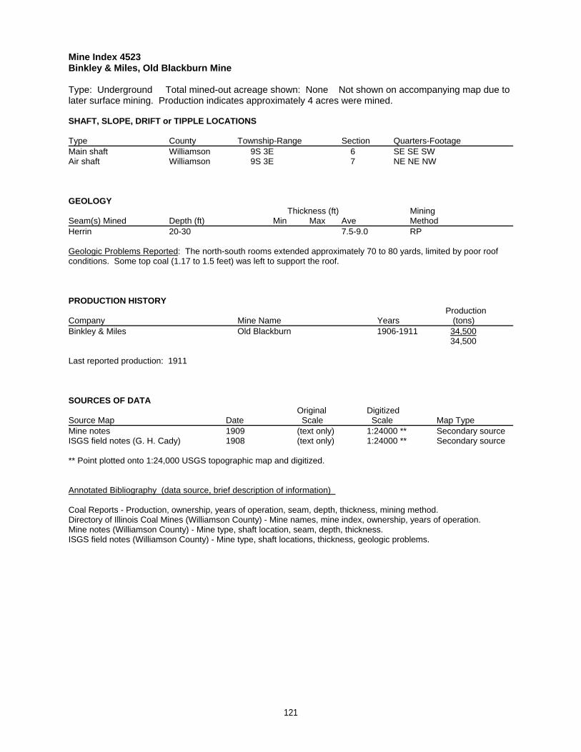
Mine Index 4523Binkley & Miles, Old Blackburn Mine
Type: Underground Total mined-out acreage shown: None Not shown on accompanying map due tolater surface mining. Production indicates approximately 4 acres were mined.
SHAFT, SLOPE, DRIFT or TIPPLE LOCATIONS
Type County Township-Range Section Quarters-FootageMain shaft Williamson 9S 3E 6 SE SE SWAir shaft Williamson 9S 3E 7 NE NE NW
GEOLOGY Thickness (ft) Mining
Seam(s) Mined Depth (ft) Min Max Ave MethodHerrin 20-30 7.5-9.0 RP
Geologic Problems Reported: The north-south rooms extended approximately 70 to 80 yards, limited by poor roofconditions. Some top coal (1.17 to 1.5 feet) was left to support the roof.
PRODUCTION HISTORY Production
Company Mine Name Years (tons) Binkley & Miles Old Blackburn 1906-1911 34,500
34,500
Last reported production: 1911
SOURCES OF DATAOriginal Digitized
Source Map Date Scale Scale Map Type Mine notes 1909 (text only) 1:24000 ** Secondary sourceISGS field notes (G. H. Cady) 1908 (text only) 1:24000 ** Secondary source
** Point plotted onto 1:24,000 USGS topographic map and digitized.
Annotated Bibliography (data source, brief description of information)
Coal Reports - Production, ownership, years of operation, seam, depth, thickness, mining method.Directory of Illinois Coal Mines (Williamson County) - Mine names, mine index, ownership, years of operation.Mine notes (Williamson County) - Mine type, shaft location, seam, depth, thickness.ISGS field notes (Williamson County) - Mine type, shaft locations, thickness, geologic problems.
121
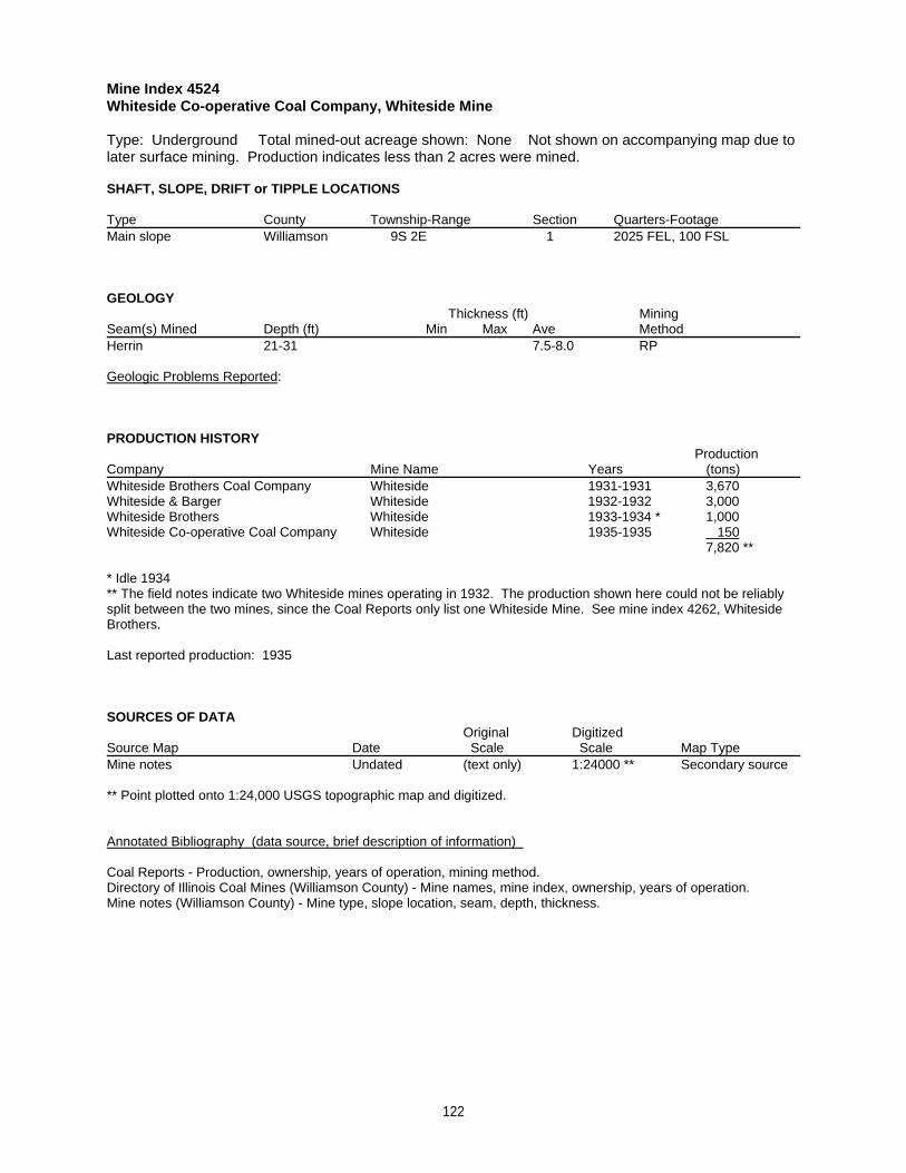
Mine Index 4524Whiteside Co-operative Coal Company, Whiteside Mine
Type: Underground Total mined-out acreage shown: None Not shown on accompanying map due tolater surface mining. Production indicates less than 2 acres were mined.
SHAFT, SLOPE, DRIFT or TIPPLE LOCATIONS
Type County Township-Range Section Quarters-FootageMain slope Williamson 9S 2E 1 2025 FEL, 100 FSL
GEOLOGY Thickness (ft) Mining
Seam(s) Mined Depth (ft) Min Max Ave MethodHerrin 21-31 7.5-8.0 RP
Geologic Problems Reported:
PRODUCTION HISTORY Production
Company Mine Name Years (tons) Whiteside Brothers Coal Company Whiteside 1931-1931 3,670Whiteside & Barger Whiteside 1932-1932 3,000Whiteside Brothers Whiteside 1933-1934 * 1,000Whiteside Co-operative Coal Company Whiteside 1935-1935 150
7,820 **
* Idle 1934** The field notes indicate two Whiteside mines operating in 1932. The production shown here could not be reliablysplit between the two mines, since the Coal Reports only list one Whiteside Mine. See mine index 4262, WhitesideBrothers.
Last reported production: 1935
SOURCES OF DATAOriginal Digitized
Source Map Date Scale Scale Map Type Mine notes Undated (text only) 1:24000 ** Secondary source
** Point plotted onto 1:24,000 USGS topographic map and digitized.
Annotated Bibliography (data source, brief description of information)
Coal Reports - Production, ownership, years of operation, mining method.Directory of Illinois Coal Mines (Williamson County) - Mine names, mine index, ownership, years of operation.Mine notes (Williamson County) - Mine type, slope location, seam, depth, thickness.
122
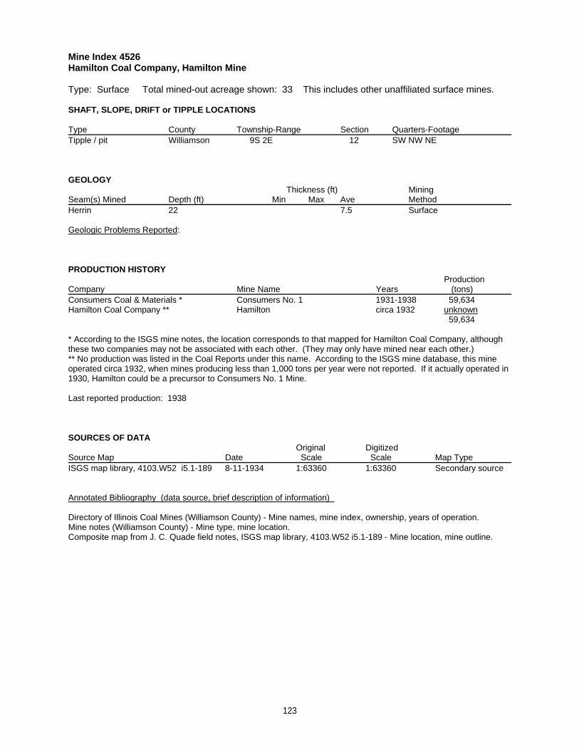
Mine Index 4526Hamilton Coal Company, Hamilton Mine
Type: Surface Total mined-out acreage shown: 33 This includes other unaffiliated surface mines.
SHAFT, SLOPE, DRIFT or TIPPLE LOCATIONS
Type County Township-Range Section Quarters-FootageTipple / pit Williamson 9S 2E 12 SW NW NE
GEOLOGY Thickness (ft) Mining
Seam(s) Mined Depth (ft) Min Max Ave MethodHerrin 22 7.5 Surface
Geologic Problems Reported:
PRODUCTION HISTORY Production
Company Mine Name Years (tons) Consumers Coal & Materials * Consumers No. 1 1931-1938 59,634Hamilton Coal Company ** Hamilton circa 1932 unknown
59,634
* According to the ISGS mine notes, the location corresponds to that mapped for Hamilton Coal Company, althoughthese two companies may not be associated with each other. (They may only have mined near each other.)** No production was listed in the Coal Reports under this name. According to the ISGS mine database, this mineoperated circa 1932, when mines producing less than 1,000 tons per year were not reported. If it actually operated in1930, Hamilton could be a precursor to Consumers No. 1 Mine.
Last reported production: 1938
SOURCES OF DATAOriginal Digitized
Source Map Date Scale Scale Map Type ISGS map library, 4103.W52 i5.1-189 8-11-1934 1:63360 1:63360 Secondary source
Annotated Bibliography (data source, brief description of information)
Directory of Illinois Coal Mines (Williamson County) - Mine names, mine index, ownership, years of operation.Mine notes (Williamson County) - Mine type, mine location.Composite map from J. C. Quade field notes, ISGS map library, 4103.W52 i5.1-189 - Mine location, mine outline.
123
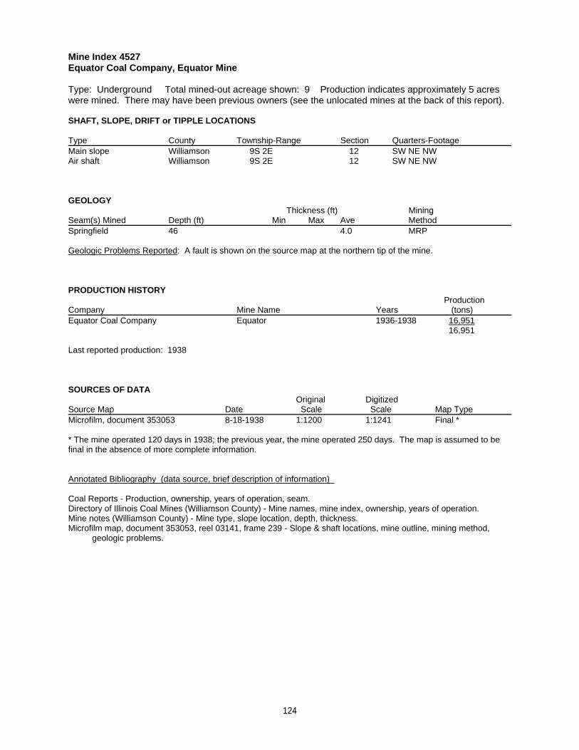
Mine Index 4527Equator Coal Company, Equator Mine
Type: Underground Total mined-out acreage shown: 9 Production indicates approximately 5 acreswere mined. There may have been previous owners (see the unlocated mines at the back of this report).
SHAFT, SLOPE, DRIFT or TIPPLE LOCATIONS
Type County Township-Range Section Quarters-FootageMain slope Williamson 9S 2E 12 SW NE NWAir shaft Williamson 9S 2E 12 SW NE NW
GEOLOGY Thickness (ft) Mining
Seam(s) Mined Depth (ft) Min Max Ave MethodSpringfield 46 4.0 MRP
Geologic Problems Reported: A fault is shown on the source map at the northern tip of the mine.
PRODUCTION HISTORY Production
Company Mine Name Years (tons) Equator Coal Company Equator 1936-1938 16,951
16,951
Last reported production: 1938
SOURCES OF DATAOriginal Digitized
Source Map Date Scale Scale Map Type Microfilm, document 353053 8-18-1938 1:1200 1:1241 Final *
* The mine operated 120 days in 1938; the previous year, the mine operated 250 days. The map is assumed to befinal in the absence of more complete information.
Annotated Bibliography (data source, brief description of information)
Coal Reports - Production, ownership, years of operation, seam.Directory of Illinois Coal Mines (Williamson County) - Mine names, mine index, ownership, years of operation.Mine notes (Williamson County) - Mine type, slope location, depth, thickness.Microfilm map, document 353053, reel 03141, frame 239 - Slope & shaft locations, mine outline, mining method, geologic problems.
124
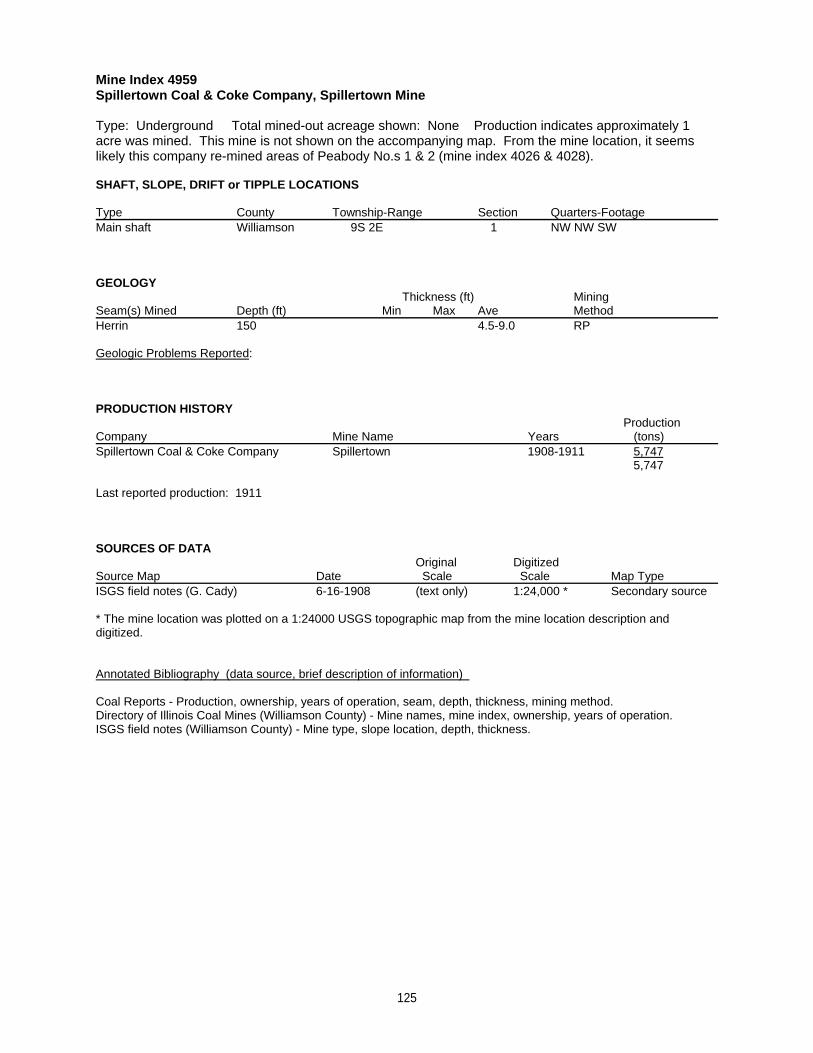
Mine Index 4959Spillertown Coal & Coke Company, Spillertown Mine
Type: Underground Total mined-out acreage shown: None Production indicates approximately 1acre was mined. This mine is not shown on the accompanying map. From the mine location, it seemslikely this company re-mined areas of Peabody No.s 1 & 2 (mine index 4026 & 4028).
SHAFT, SLOPE, DRIFT or TIPPLE LOCATIONS
Type County Township-Range Section Quarters-FootageMain shaft Williamson 9S 2E 1 NW NW SW
GEOLOGY Thickness (ft) Mining
Seam(s) Mined Depth (ft) Min Max Ave MethodHerrin 150 4.5-9.0 RP
Geologic Problems Reported:
PRODUCTION HISTORY Production
Company Mine Name Years (tons) Spillertown Coal & Coke Company Spillertown 1908-1911 5,747
5,747
Last reported production: 1911
SOURCES OF DATAOriginal Digitized
Source Map Date Scale Scale Map Type ISGS field notes (G. Cady) 6-16-1908 (text only) 1:24,000 * Secondary source
* The mine location was plotted on a 1:24000 USGS topographic map from the mine location description anddigitized.
Annotated Bibliography (data source, brief description of information)
Coal Reports - Production, ownership, years of operation, seam, depth, thickness, mining method.Directory of Illinois Coal Mines (Williamson County) - Mine names, mine index, ownership, years of operation.ISGS field notes (Williamson County) - Mine type, slope location, depth, thickness.
125
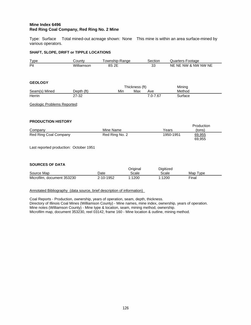
Mine Index 6496Red Ring Coal Company, Red Ring No. 2 Mine
Type: Surface Total mined-out acreage shown: None This mine is within an area surface-mined byvarious operators.
SHAFT, SLOPE, DRIFT or TIPPLE LOCATIONS
Type County Township-Range Section Quarters-FootagePit Williamson 8S 2E 33 NE NE NW & NW NW NE
GEOLOGY Thickness (ft) Mining
Seam(s) Mined Depth (ft) Min Max Ave MethodHerrin 27-32 7.0-7.67 Surface
Geologic Problems Reported:
PRODUCTION HISTORY Production
Company Mine Name Years (tons) Red Ring Coal Company Red Ring No. 2 1950-1951 69,955
69,955
Last reported production: October 1951
SOURCES OF DATAOriginal Digitized
Source Map Date Scale Scale Map Type Microfilm, document 353230 2-10-1952 1:1200 1:1200 Final
Annotated Bibliography (data source, brief description of information)
Coal Reports - Production, ownership, years of operation, seam, depth, thickness. Directory of Illinois Coal Mines (Williamson County) - Mine names, mine index, ownership, years of operation.Mine notes (Williamson County) - Mine type & location, seam, mining method, ownership.Microfilm map, document 353230, reel 03142, frame 160 - Mine location & outline, mining method.
126
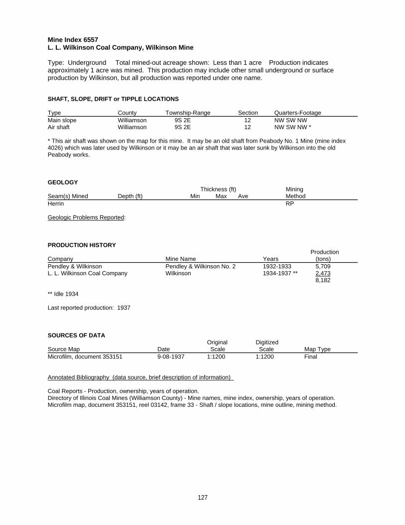
Mine Index 6557L. L. Wilkinson Coal Company, Wilkinson Mine
Type: Underground Total mined-out acreage shown: Less than 1 acre Production indicatesapproximately 1 acre was mined. This production may include other small underground or surfaceproduction by Wilkinson, but all production was reported under one name.
SHAFT, SLOPE, DRIFT or TIPPLE LOCATIONS
Type County Township-Range Section Quarters-FootageMain slope Williamson 9S 2E 12 NW SW NWAir shaft Williamson 9S 2E 12 NW SW NW *
* This air shaft was shown on the map for this mine. It may be an old shaft from Peabody No. 1 Mine (mine index4026) which was later used by Wilkinson or it may be an air shaft that was later sunk by Wilkinson into the oldPeabody works.
GEOLOGY Thickness (ft) Mining
Seam(s) Mined Depth (ft) Min Max Ave MethodHerrin RP
Geologic Problems Reported:
PRODUCTION HISTORY Production
Company Mine Name Years (tons) Pendley & Wilkinson Pendley & Wilkinson No. 2 1932-1933 5,709L. L. Wilkinson Coal Company Wilkinson 1934-1937 ** 2,473
8,182
** Idle 1934
Last reported production: 1937
SOURCES OF DATAOriginal Digitized
Source Map Date Scale Scale Map Type Microfilm, document 353151 9-08-1937 1:1200 1:1200 Final
Annotated Bibliography (data source, brief description of information)
Coal Reports - Production, ownership, years of operation.Directory of Illinois Coal Mines (Williamson County) - Mine names, mine index, ownership, years of operation.Microfilm map, document 353151, reel 03142, frame 33 - Shaft / slope locations, mine outline, mining method.
127
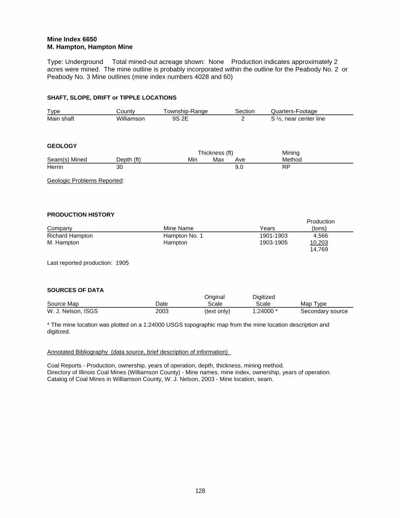
Mine Index 6650M. Hampton, Hampton Mine
Type: Underground Total mined-out acreage shown: None Production indicates approximately 2acres were mined. The mine outline is probably incorporated within the outline for the Peabody No. 2 orPeabody No. 3 Mine outlines (mine index numbers 4028 and 60)
SHAFT, SLOPE, DRIFT or TIPPLE LOCATIONS
Type County Township-Range Section Quarters-FootageMain shaft Williamson 9S 2E 2 S ½, near center line
GEOLOGY Thickness (ft) Mining
Seam(s) Mined Depth (ft) Min Max Ave MethodHerrin 30 9.0 RP
Geologic Problems Reported:
PRODUCTION HISTORY Production
Company Mine Name Years (tons) Richard Hampton Hampton No. 1 1901-1903 4,566M. Hampton Hampton 1903-1905 10,203
14,769
Last reported production: 1905
SOURCES OF DATAOriginal Digitized
Source Map Date Scale Scale Map Type W. J. Nelson, ISGS 2003 (text only) 1:24000 * Secondary source
* The mine location was plotted on a 1:24000 USGS topographic map from the mine location description anddigitized.
Annotated Bibliography (data source, brief description of information)
Coal Reports - Production, ownership, years of operation, depth, thickness, mining method.Directory of Illinois Coal Mines (Williamson County) - Mine names, mine index, ownership, years of operation.Catalog of Coal Mines in Williamson County, W. J. Nelson, 2003 - Mine location, seam.
128
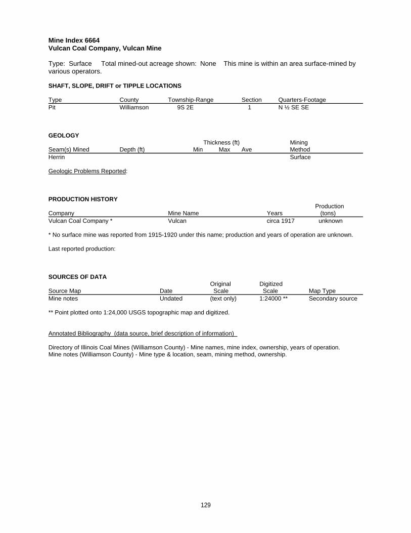
Mine Index 6664Vulcan Coal Company, Vulcan Mine
Type: Surface Total mined-out acreage shown: None This mine is within an area surface-mined byvarious operators.
SHAFT, SLOPE, DRIFT or TIPPLE LOCATIONS
Type County Township-Range Section Quarters-FootagePit Williamson 9S 2E 1 N ½ SE SE
GEOLOGY Thickness (ft) Mining
Seam(s) Mined Depth (ft) Min Max Ave MethodHerrin Surface
Geologic Problems Reported:
PRODUCTION HISTORY Production
Company Mine Name Years (tons) Vulcan Coal Company * Vulcan circa 1917 unknown
* No surface mine was reported from 1915-1920 under this name; production and years of operation are unknown.
Last reported production:
SOURCES OF DATAOriginal Digitized
Source Map Date Scale Scale Map Type Mine notes Undated (text only) 1:24000 ** Secondary source
** Point plotted onto 1:24,000 USGS topographic map and digitized.
Annotated Bibliography (data source, brief description of information)
Directory of Illinois Coal Mines (Williamson County) - Mine names, mine index, ownership, years of operation.Mine notes (Williamson County) - Mine type & location, seam, mining method, ownership.
129
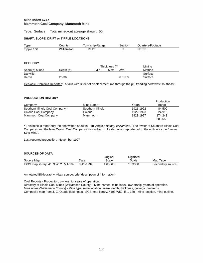
Mine Index 6747Mammoth Coal Company, Mammoth Mine
Type: Surface Total mined-out acreage shown: 50
SHAFT, SLOPE, DRIFT or TIPPLE LOCATIONS
Type County Township-Range Section Quarters-FootageTipple / pit Williamson 9S 2E 3 NE SE
GEOLOGY Thickness (ft) Mining
Seam(s) Mined Depth (ft) Min Max Ave MethodDanville SurfaceHerrin 26-36 6.0-8.0 Surface
Geologic Problems Reported: A fault with 3 feet of displacement ran through the pit, trending northwest-southeast.
PRODUCTION HISTORY Production
Company Mine Name Years (tons) Southern Illinois Coal Company * Southern Illinois 1921-1922 84,500Caloric Coal Company Caloric 1922-1923 24,915Mammoth Coal Company Mammoth 1923-1927 174,243
283,658
* This mine is reportedly the one written about in Paul Angle’s Bloody Williamson. The owner of Southern Illinois CoalCompany (and the later Caloric Coal Company) was William J. Lester; one map referred to the outline as the “LesterStrip Mine”.
Last reported production: November 1927
SOURCES OF DATAOriginal Digitized
Source Map Date Scale Scale Map Type ISGS map library, 4103.W52 i5.1-189 8-11-1934 1:63360 1:63360 Secondary source
Annotated Bibliography (data source, brief description of information)
Coal Reports - Production, ownership, years of operation.Directory of Illinois Coal Mines (Williamson County) - Mine names, mine index, ownership, years of operation.Mine notes (Williamson County) - Mine type, mine location, seam, depth, thickness, geologic problems.Composite map from J. C. Quade field notes, ISGS map library, 4103.W52 i5.1-189 - Mine location, mine outline.
130
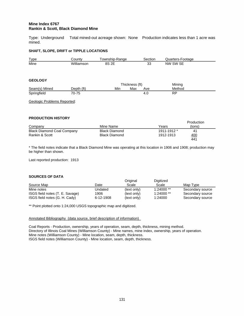
Mine Index 6767Rankin & Scott, Black Diamond Mine
Type: Underground Total mined-out acreage shown: None Production indicates less than 1 acre wasmined.
SHAFT, SLOPE, DRIFT or TIPPLE LOCATIONS
Type County Township-Range Section Quarters-FootageMine Williamson 8S 2E 33 NW SW SE
GEOLOGY Thickness (ft) Mining
Seam(s) Mined Depth (ft) Min Max Ave MethodSpringfield 70-75 4.0 RP
Geologic Problems Reported:
PRODUCTION HISTORY Production
Company Mine Name Years (tons) Black Diamond Coal Company Black Diamond 1911-1912 * 41Rankin & Scott Black Diamond 1912-1913 400
441
* The field notes indicate that a Black Diamond Mine was operating at this location in 1906 and 1908; production maybe higher than shown.
Last reported production: 1913
SOURCES OF DATAOriginal Digitized
Source Map Date Scale Scale Map Type Mine notes Undated (text only) 1:24000 ** Secondary sourceISGS field notes (T. E. Savage) 1906 (text only) 1:24000 ** Secondary sourceISGS field notes (G. H. Cady) 6-12-1908 (text only) 1:24000 Secondary source
** Point plotted onto 1:24,000 USGS topographic map and digitized.
Annotated Bibliography (data source, brief description of information)
Coal Reports - Production, ownership, years of operation, seam, depth, thickness, mining method. Directory of Illinois Coal Mines (Williamson County) - Mine names, mine index, ownership, years of operation.Mine notes (Williamson County) - Mine location, seam, depth, thickness.ISGS field notes (Williamson County) - Mine location, seam, depth, thickness.
131
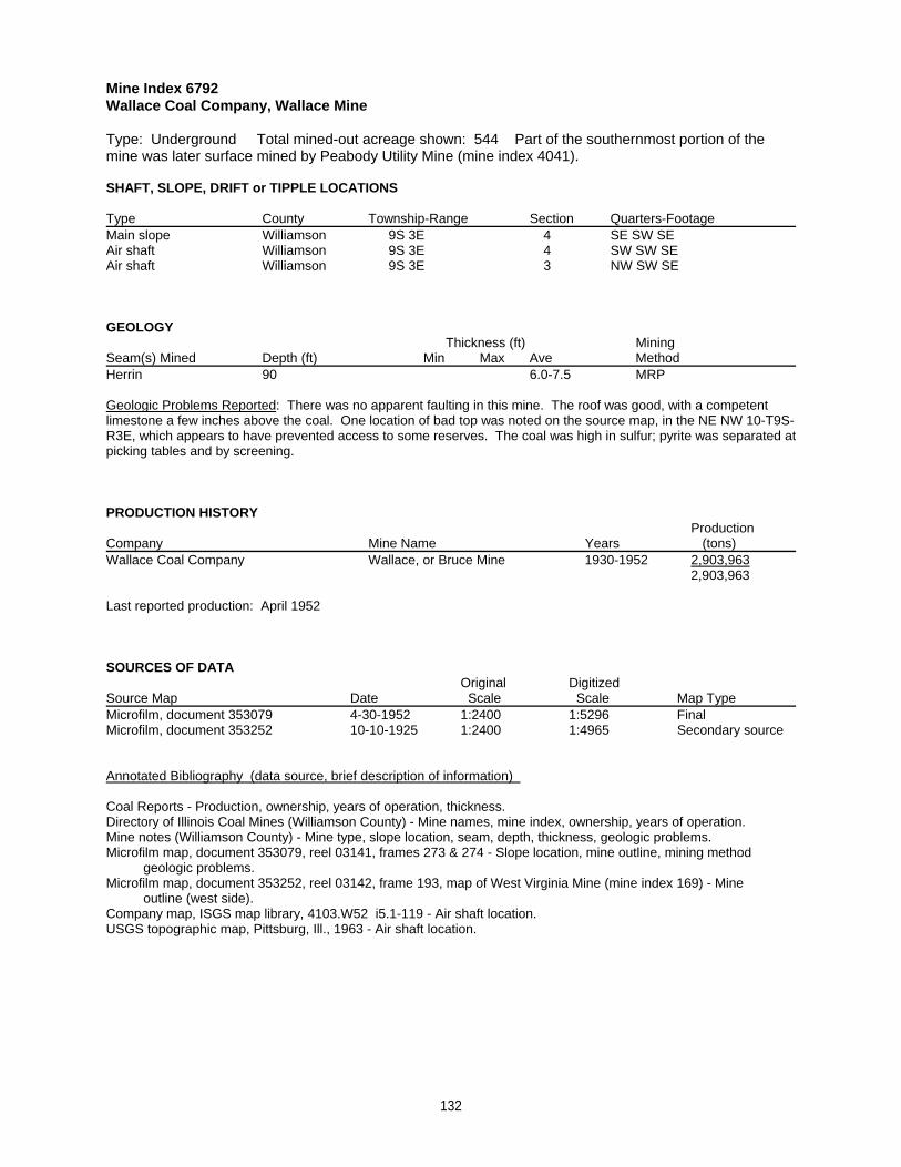
Mine Index 6792Wallace Coal Company, Wallace Mine
Type: Underground Total mined-out acreage shown: 544 Part of the southernmost portion of themine was later surface mined by Peabody Utility Mine (mine index 4041).
SHAFT, SLOPE, DRIFT or TIPPLE LOCATIONS
Type County Township-Range Section Quarters-FootageMain slope Williamson 9S 3E 4 SE SW SEAir shaft Williamson 9S 3E 4 SW SW SEAir shaft Williamson 9S 3E 3 NW SW SE
GEOLOGY Thickness (ft) Mining
Seam(s) Mined Depth (ft) Min Max Ave MethodHerrin 90 6.0-7.5 MRP
Geologic Problems Reported: There was no apparent faulting in this mine. The roof was good, with a competentlimestone a few inches above the coal. One location of bad top was noted on the source map, in the NE NW 10-T9S-R3E, which appears to have prevented access to some reserves. The coal was high in sulfur; pyrite was separated atpicking tables and by screening.
PRODUCTION HISTORY Production
Company Mine Name Years (tons) Wallace Coal Company Wallace, or Bruce Mine 1930-1952 2,903,963
2,903,963
Last reported production: April 1952
SOURCES OF DATAOriginal Digitized
Source Map Date Scale Scale Map Type Microfilm, document 353079 4-30-1952 1:2400 1:5296 FinalMicrofilm, document 353252 10-10-1925 1:2400 1:4965 Secondary source
Annotated Bibliography (data source, brief description of information)
Coal Reports - Production, ownership, years of operation, thickness.Directory of Illinois Coal Mines (Williamson County) - Mine names, mine index, ownership, years of operation.Mine notes (Williamson County) - Mine type, slope location, seam, depth, thickness, geologic problems.Microfilm map, document 353079, reel 03141, frames 273 & 274 - Slope location, mine outline, mining method geologic problems.Microfilm map, document 353252, reel 03142, frame 193, map of West Virginia Mine (mine index 169) - Mine outline (west side).Company map, ISGS map library, 4103.W52 i5.1-119 - Air shaft location.USGS topographic map, Pittsburg, Ill., 1963 - Air shaft location.
132
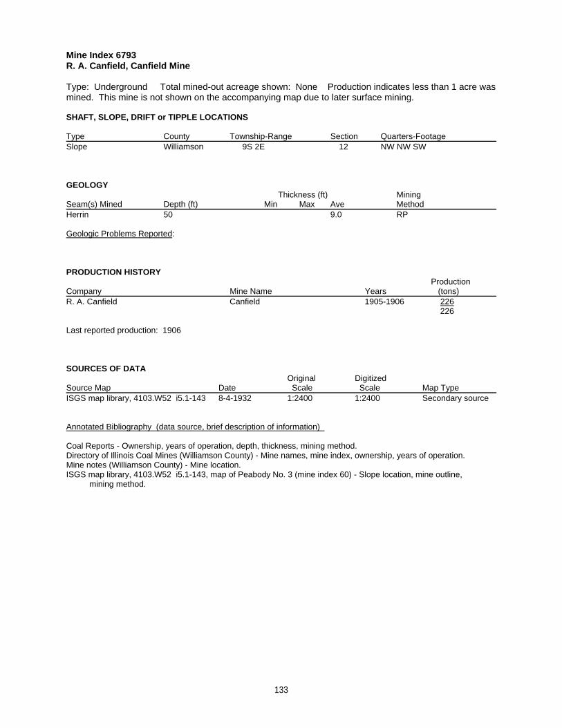
Mine Index 6793R. A. Canfield, Canfield Mine
Type: Underground Total mined-out acreage shown: None Production indicates less than 1 acre wasmined. This mine is not shown on the accompanying map due to later surface mining.
SHAFT, SLOPE, DRIFT or TIPPLE LOCATIONS
Type County Township-Range Section Quarters-FootageSlope Williamson 9S 2E 12 NW NW SW
GEOLOGY Thickness (ft) Mining
Seam(s) Mined Depth (ft) Min Max Ave MethodHerrin 50 9.0 RP
Geologic Problems Reported:
PRODUCTION HISTORY Production
Company Mine Name Years (tons) R. A. Canfield Canfield 1905-1906 226
226
Last reported production: 1906
SOURCES OF DATAOriginal Digitized
Source Map Date Scale Scale Map Type ISGS map library, 4103.W52 i5.1-143 8-4-1932 1:2400 1:2400 Secondary source
Annotated Bibliography (data source, brief description of information)
Coal Reports - Ownership, years of operation, depth, thickness, mining method. Directory of Illinois Coal Mines (Williamson County) - Mine names, mine index, ownership, years of operation.Mine notes (Williamson County) - Mine location.ISGS map library, 4103.W52 i5.1-143, map of Peabody No. 3 (mine index 60) - Slope location, mine outline, mining method.
133
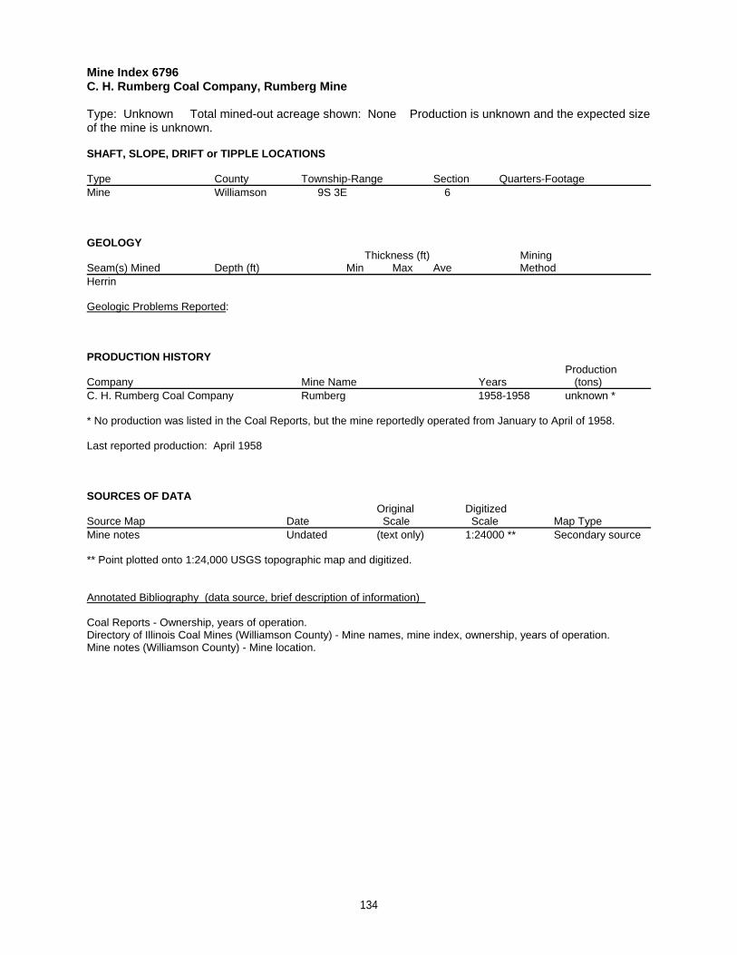
Mine Index 6796C. H. Rumberg Coal Company, Rumberg Mine
Type: Unknown Total mined-out acreage shown: None Production is unknown and the expected sizeof the mine is unknown.
SHAFT, SLOPE, DRIFT or TIPPLE LOCATIONS
Type County Township-Range Section Quarters-FootageMine Williamson 9S 3E 6
GEOLOGY Thickness (ft) Mining
Seam(s) Mined Depth (ft) Min Max Ave MethodHerrin
Geologic Problems Reported:
PRODUCTION HISTORY Production
Company Mine Name Years (tons) C. H. Rumberg Coal Company Rumberg 1958-1958 unknown *
* No production was listed in the Coal Reports, but the mine reportedly operated from January to April of 1958.
Last reported production: April 1958
SOURCES OF DATAOriginal Digitized
Source Map Date Scale Scale Map Type Mine notes Undated (text only) 1:24000 ** Secondary source
** Point plotted onto 1:24,000 USGS topographic map and digitized.
Annotated Bibliography (data source, brief description of information)
Coal Reports - Ownership, years of operation. Directory of Illinois Coal Mines (Williamson County) - Mine names, mine index, ownership, years of operation.Mine notes (Williamson County) - Mine location.
134
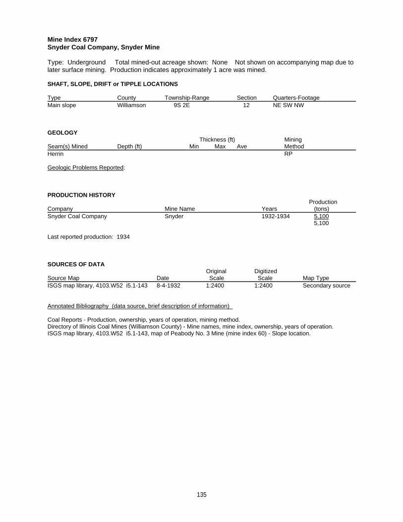
Mine Index 6797Snyder Coal Company, Snyder Mine
Type: Underground Total mined-out acreage shown: None Not shown on accompanying map due tolater surface mining. Production indicates approximately 1 acre was mined.
SHAFT, SLOPE, DRIFT or TIPPLE LOCATIONS
Type County Township-Range Section Quarters-FootageMain slope Williamson 9S 2E 12 NE SW NW
GEOLOGY Thickness (ft) Mining
Seam(s) Mined Depth (ft) Min Max Ave MethodHerrin RP
Geologic Problems Reported:
PRODUCTION HISTORY Production
Company Mine Name Years (tons) Snyder Coal Company Snyder 1932-1934 5,100
5,100
Last reported production: 1934
SOURCES OF DATAOriginal Digitized
Source Map Date Scale Scale Map Type ISGS map library, 4103.W52 i5.1-143 8-4-1932 1:2400 1:2400 Secondary source
Annotated Bibliography (data source, brief description of information)
Coal Reports - Production, ownership, years of operation, mining method.Directory of Illinois Coal Mines (Williamson County) - Mine names, mine index, ownership, years of operation.ISGS map library, 4103.W52 i5.1-143, map of Peabody No. 3 Mine (mine index 60) - Slope location.
135
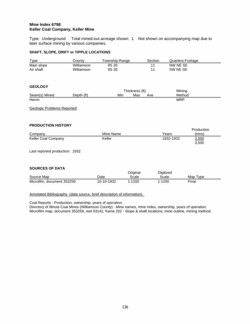
Mine Index 6798Keller Coal Company, Keller Mine
Type: Underground Total mined-out acreage shown: 1 Not shown on accompanying map due tolater surface mining by various companies.
SHAFT, SLOPE, DRIFT or TIPPLE LOCATIONS
Type County Township-Range Section Quarters-FootageMain slope Williamson 9S 2E 11 NW NE SEAir shaft Williamson 9S 2E 11 SW NE SE
GEOLOGY Thickness (ft) Mining
Seam(s) Mined Depth (ft) Min Max Ave MethodHerrin MRP
Geologic Problems Reported:
PRODUCTION HISTORY Production
Company Mine Name Years (tons) Keller Coal Company Keller 1932-1932 3,500
3,500
Last reported production: 1932
SOURCES OF DATAOriginal Digitized
Source Map Date Scale Scale Map Type Microfilm, document 353259 10-10-1932 1:1200 1:1200 Final
Annotated Bibliography (data source, brief description of information)
Coal Reports - Production, ownership, years of operation.Directory of Illinois Coal Mines (Williamson County) - Mine names, mine index, ownership, years of operation.Microfilm map, document 353259, reel 03142, frame 202 - Slope & shaft locations, mine outline, mining method.
136
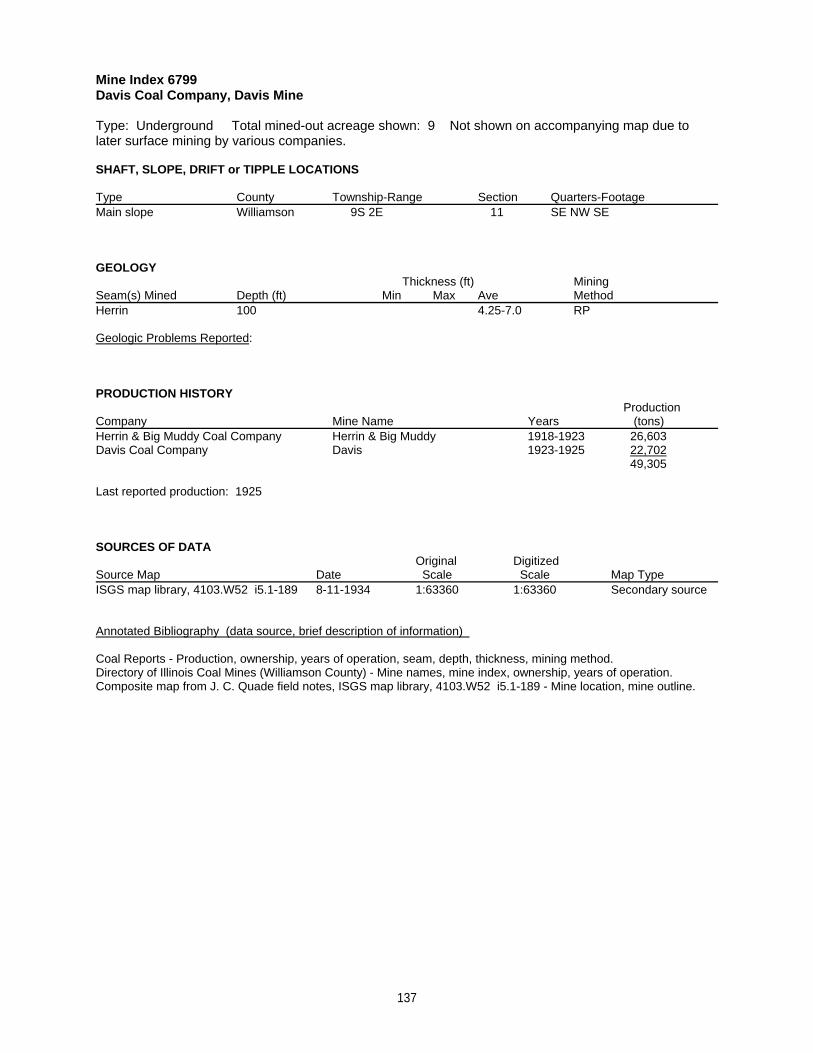
Mine Index 6799Davis Coal Company, Davis Mine
Type: Underground Total mined-out acreage shown: 9 Not shown on accompanying map due tolater surface mining by various companies.
SHAFT, SLOPE, DRIFT or TIPPLE LOCATIONS
Type County Township-Range Section Quarters-FootageMain slope Williamson 9S 2E 11 SE NW SE
GEOLOGY Thickness (ft) Mining
Seam(s) Mined Depth (ft) Min Max Ave MethodHerrin 100 4.25-7.0 RP
Geologic Problems Reported:
PRODUCTION HISTORY Production
Company Mine Name Years (tons) Herrin & Big Muddy Coal Company Herrin & Big Muddy 1918-1923 26,603Davis Coal Company Davis 1923-1925 22,702
49,305
Last reported production: 1925
SOURCES OF DATAOriginal Digitized
Source Map Date Scale Scale Map Type ISGS map library, 4103.W52 i5.1-189 8-11-1934 1:63360 1:63360 Secondary source
Annotated Bibliography (data source, brief description of information)
Coal Reports - Production, ownership, years of operation, seam, depth, thickness, mining method.Directory of Illinois Coal Mines (Williamson County) - Mine names, mine index, ownership, years of operation.Composite map from J. C. Quade field notes, ISGS map library, 4103.W52 i5.1-189 - Mine location, mine outline.
137
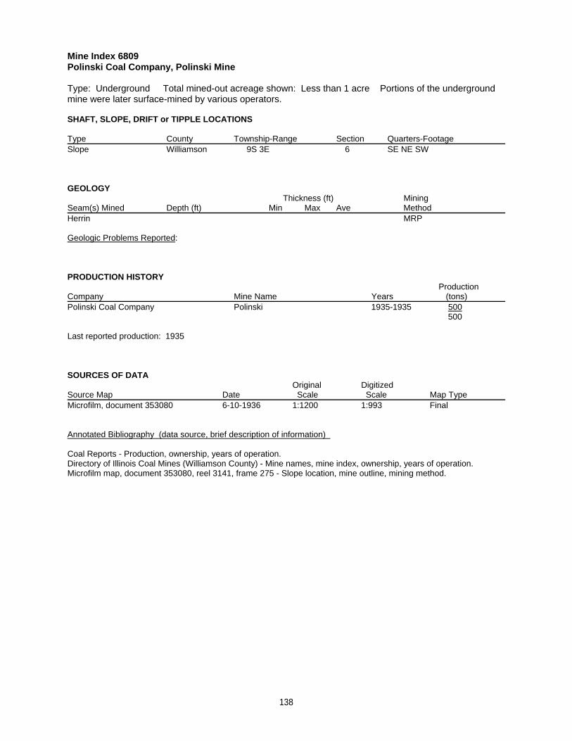
Mine Index 6809Polinski Coal Company, Polinski Mine
Type: Underground Total mined-out acreage shown: Less than 1 acre Portions of the undergroundmine were later surface-mined by various operators.
SHAFT, SLOPE, DRIFT or TIPPLE LOCATIONS
Type County Township-Range Section Quarters-FootageSlope Williamson 9S 3E 6 SE NE SW
GEOLOGY Thickness (ft) Mining
Seam(s) Mined Depth (ft) Min Max Ave MethodHerrin MRP
Geologic Problems Reported:
PRODUCTION HISTORY Production
Company Mine Name Years (tons) Polinski Coal Company Polinski 1935-1935 500
500
Last reported production: 1935
SOURCES OF DATAOriginal Digitized
Source Map Date Scale Scale Map Type Microfilm, document 353080 6-10-1936 1:1200 1:993 Final
Annotated Bibliography (data source, brief description of information)
Coal Reports - Production, ownership, years of operation.Directory of Illinois Coal Mines (Williamson County) - Mine names, mine index, ownership, years of operation.Microfilm map, document 353080, reel 3141, frame 275 - Slope location, mine outline, mining method.
138
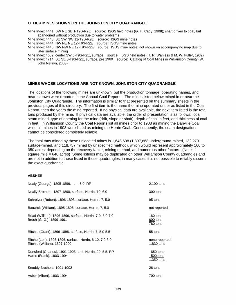
OTHER MINES SHOWN ON THE JOHNSTON CITY QUADRANGLE
Mine Index 4441 SW NE SE 1-T9S-R2E source: ISGS field notes (G. H. Cady, 1908); shaft driven to coal, but abandoned without production due to water problemsMine Index 4443 SE SW NW 12-T9S-R2E source: ISGS mine notesMine Index 4444 NW NE NE 12-T9S-R2E source: ISGS mine notesMine Index 4445 NW NW NE 12-T9S-R2E source: ISGS mine notes; not shown on accompanying map due to later surface miningMine Index 4682 center SW 3-T9S-R2E, surface source: ISGS field notes (H. R. Wanless & M. W. Fuller, 1932)Mine Index 4714 SE SE 3-T9S-R2E, surface, pre 1960 source: Catalog of Coal Mines in Williamson County (W. John Nelson, 2003)
MINES WHOSE LOCATIONS ARE NOT KNOWN, JOHNSTON CITY QUADRANGLE
The locations of the following mines are unknown, but the production tonnage, operating names, andnearest town were reported in the Annual Coal Reports. The mines listed below mined in or near theJohnston City Quadrangle. The information is similar to that presented on the summary sheets in theprevious pages of this directory. The first item is the name the mine operated under as listed in the CoalReport, then the years the mine reported. If no physical data are available, the next item listed is the totaltons produced by the mine. If physical data are available, the order of presentation is as follows: coalseam mined, type of opening for the mine (drift, slope or shaft), depth of coal in feet, and thickness of coalin feet. In Williamson County the Coal Reports list all mines prior to 1908 as mining the Danville Coalwhile all mines in 1908 were listed as mining the Herrin Coal. Consequently, the seam designationscannot be considered completely reliable.
The total tons mined by these unlocated mines is 1,648,698 (1,397,668 underground-mined, 132,273surface-mined, and 118,757 mined by unspecified method), which would represent approximately 160 to350 acres, depending on the recovery factor, mining method, and numerous other factors. (Note: 1square mile = 640 acres) Some listings may be duplicated on other Williamson County quadrangles andare not in addition to those listed in those quadrangles; in many cases it is not possible to reliably discernthe exact quadrangle.
ABSHER
Nealy (George), 1895-1896, –, –, 5.0, RP 2,100 tons
Neally Brothers, 1897-1898, surface, Herrin, 10, 6.0 300 tons
Schreiyer (Robert), 1896-1898, surface, Herrin, 7, 5.0 95 tons
Bauwick (William), 1895-1896, surface, Herrin, 7, 5.0 not reported
Read (William), 1896-1899, surface, Herrin, 7-9, 5.0-7.0 180 tonsBrush (G. G.), 1899-1901 600 tons
780 tons
Ritchie (Grant), 1896-1898, surface, Herrin, 7, 5.0-5.5 55 tons
Ritche (Len), 1896-1896, surface, Herrin, 8-10, 7.0-8.0 none reportedRitchie (William), 1897-1900 1,830 tons
Dunsford (Charles), 1901-1903, drift, Herrin, 20, 5.5, RP 850 tonsHarris (Frank), 1903-1904 500 tons
1,350 tons
Snoddy Brothers, 1901-1902 26 tons
Asber (Albert), 1903-1904 700 tons
139
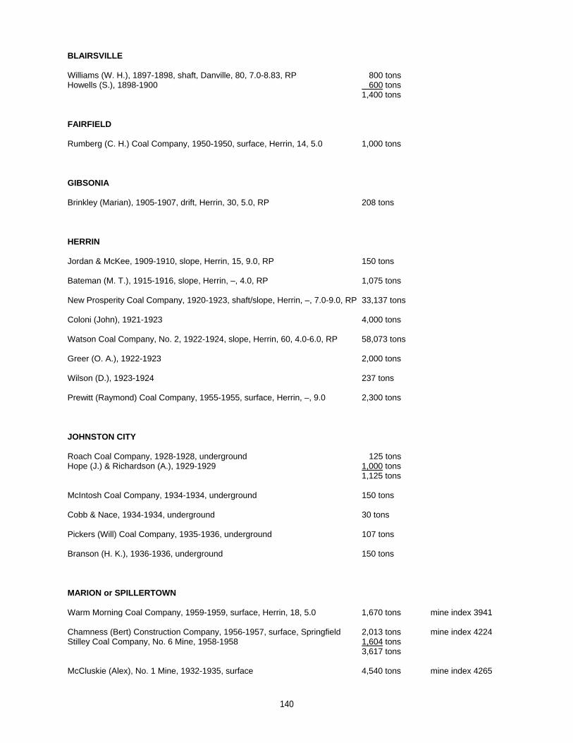
BLAIRSVILLE
Williams (W. H.), 1897-1898, shaft, Danville, 80, 7.0-8.83, RP 800 tonsHowells (S.), 1898-1900 600 tons
1,400 tons
FAIRFIELD
Rumberg (C. H.) Coal Company, 1950-1950, surface, Herrin, 14, 5.0 1,000 tons
GIBSONIA
Brinkley (Marian), 1905-1907, drift, Herrin, 30, 5.0, RP 208 tons
HERRIN
Jordan & McKee, 1909-1910, slope, Herrin, 15, 9.0, RP 150 tons
Bateman (M. T.), 1915-1916, slope, Herrin, –, 4.0, RP 1,075 tons
New Prosperity Coal Company, 1920-1923, shaft/slope, Herrin, –, 7.0-9.0, RP 33,137 tons
Coloni (John), 1921-1923 4,000 tons
Watson Coal Company, No. 2, 1922-1924, slope, Herrin, 60, 4.0-6.0, RP 58,073 tons
Greer (O. A.), 1922-1923 2,000 tons
Wilson (D.), 1923-1924 237 tons
Prewitt (Raymond) Coal Company, 1955-1955, surface, Herrin, –, 9.0 2,300 tons
JOHNSTON CITY
Roach Coal Company, 1928-1928, underground 125 tonsHope (J.) & Richardson (A.), 1929-1929 1,000 tons
1,125 tons
McIntosh Coal Company, 1934-1934, underground 150 tons
Cobb & Nace, 1934-1934, underground 30 tons
Pickers (Will) Coal Company, 1935-1936, underground 107 tons
Branson (H. K.), 1936-1936, underground 150 tons
MARION or SPILLERTOWN
Warm Morning Coal Company, 1959-1959, surface, Herrin, 18, 5.0 1,670 tons mine index 3941
Chamness (Bert) Construction Company, 1956-1957, surface, Springfield 2,013 tons mine index 4224Stilley Coal Company, No. 6 Mine, 1958-1958 1,604 tons
3,617 tons
McCluskie (Alex), No. 1 Mine, 1932-1935, surface 4,540 tons mine index 4265
140
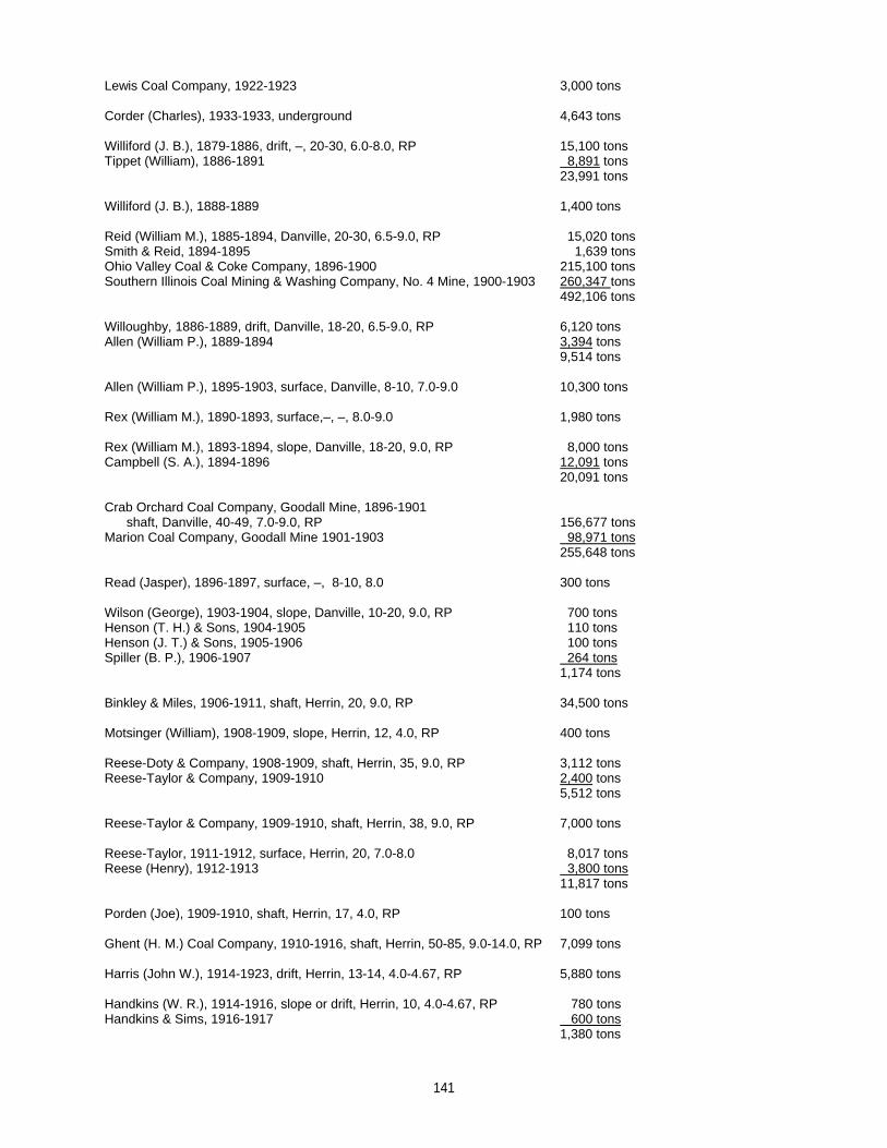
Lewis Coal Company, 1922-1923 3,000 tons
Corder (Charles), 1933-1933, underground 4,643 tons
Williford (J. B.), 1879-1886, drift, –, 20-30, 6.0-8.0, RP 15,100 tonsTippet (William), 1886-1891 8,891 tons
23,991 tons
Williford (J. B.), 1888-1889 1,400 tons
Reid (William M.), 1885-1894, Danville, 20-30, 6.5-9.0, RP 15,020 tonsSmith & Reid, 1894-1895 1,639 tonsOhio Valley Coal & Coke Company, 1896-1900 215,100 tonsSouthern Illinois Coal Mining & Washing Company, No. 4 Mine, 1900-1903 260,347 tons
492,106 tons
Willoughby, 1886-1889, drift, Danville, 18-20, 6.5-9.0, RP 6,120 tonsAllen (William P.), 1889-1894 3,394 tons
9,514 tons
Allen (William P.), 1895-1903, surface, Danville, 8-10, 7.0-9.0 10,300 tons
Rex (William M.), 1890-1893, surface,–, –, 8.0-9.0 1,980 tons
Rex (William M.), 1893-1894, slope, Danville, 18-20, 9.0, RP 8,000 tonsCampbell (S. A.), 1894-1896 12,091 tons
20,091 tons
Crab Orchard Coal Company, Goodall Mine, 1896-1901 shaft, Danville, 40-49, 7.0-9.0, RP 156,677 tonsMarion Coal Company, Goodall Mine 1901-1903 98,971 tons
255,648 tons
Read (Jasper), 1896-1897, surface, –, 8-10, 8.0 300 tons
Wilson (George), 1903-1904, slope, Danville, 10-20, 9.0, RP 700 tonsHenson (T. H.) & Sons, 1904-1905 110 tonsHenson (J. T.) & Sons, 1905-1906 100 tonsSpiller (B. P.), 1906-1907 264 tons
1,174 tons
Binkley & Miles, 1906-1911, shaft, Herrin, 20, 9.0, RP 34,500 tons
Motsinger (William), 1908-1909, slope, Herrin, 12, 4.0, RP 400 tons
Reese-Doty & Company, 1908-1909, shaft, Herrin, 35, 9.0, RP 3,112 tonsReese-Taylor & Company, 1909-1910 2,400 tons
5,512 tons
Reese-Taylor & Company, 1909-1910, shaft, Herrin, 38, 9.0, RP 7,000 tons
Reese-Taylor, 1911-1912, surface, Herrin, 20, 7.0-8.0 8,017 tonsReese (Henry), 1912-1913 3,800 tons
11,817 tons
Porden (Joe), 1909-1910, shaft, Herrin, 17, 4.0, RP 100 tons
Ghent (H. M.) Coal Company, 1910-1916, shaft, Herrin, 50-85, 9.0-14.0, RP 7,099 tons
Harris (John W.), 1914-1923, drift, Herrin, 13-14, 4.0-4.67, RP 5,880 tons
Handkins (W. R.), 1914-1916, slope or drift, Herrin, 10, 4.0-4.67, RP 780 tonsHandkins & Sims, 1916-1917 600 tons
1,380 tons
141
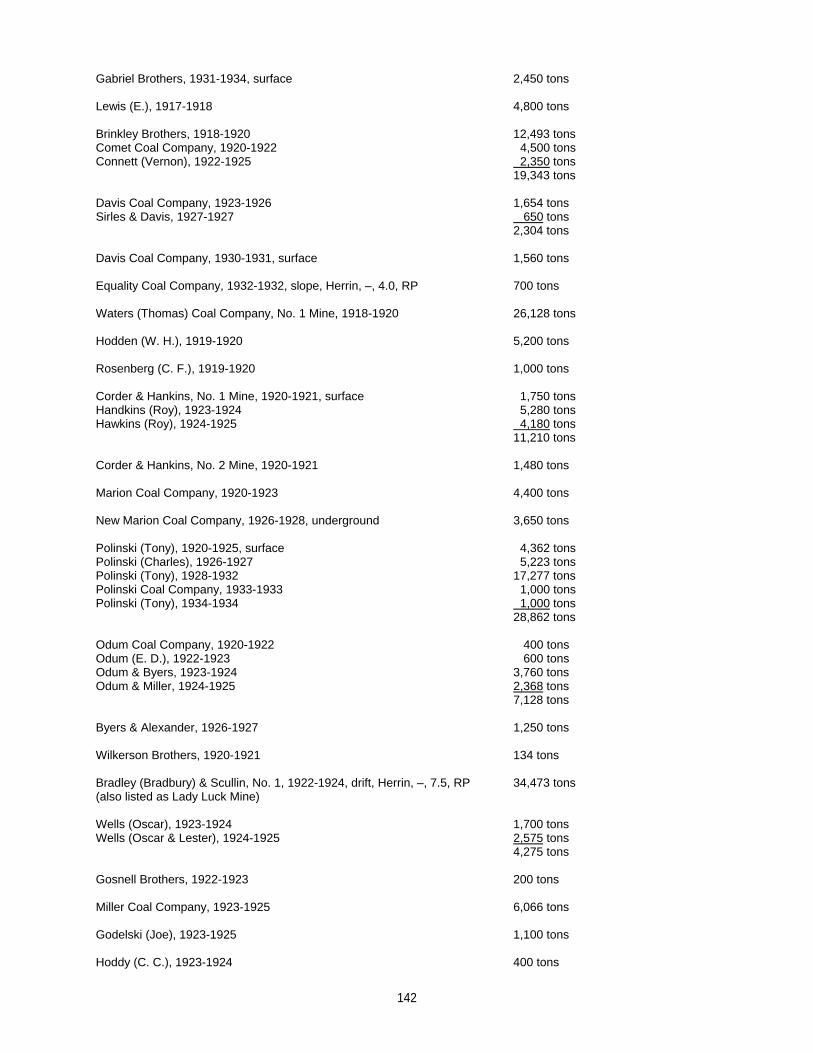
Gabriel Brothers, 1931-1934, surface 2,450 tons
Lewis (E.), 1917-1918 4,800 tons
Brinkley Brothers, 1918-1920 12,493 tonsComet Coal Company, 1920-1922 4,500 tonsConnett (Vernon), 1922-1925 2,350 tons
19,343 tons
Davis Coal Company, 1923-1926 1,654 tonsSirles & Davis, 1927-1927 650 tons
2,304 tons
Davis Coal Company, 1930-1931, surface 1,560 tons
Equality Coal Company, 1932-1932, slope, Herrin, –, 4.0, RP 700 tons
Waters (Thomas) Coal Company, No. 1 Mine, 1918-1920 26,128 tons
Hodden (W. H.), 1919-1920 5,200 tons
Rosenberg (C. F.), 1919-1920 1,000 tons
Corder & Hankins, No. 1 Mine, 1920-1921, surface 1,750 tonsHandkins (Roy), 1923-1924 5,280 tonsHawkins (Roy), 1924-1925 4,180 tons
11,210 tons
Corder & Hankins, No. 2 Mine, 1920-1921 1,480 tons
Marion Coal Company, 1920-1923 4,400 tons
New Marion Coal Company, 1926-1928, underground 3,650 tons
Polinski (Tony), 1920-1925, surface 4,362 tonsPolinski (Charles), 1926-1927 5,223 tonsPolinski (Tony), 1928-1932 17,277 tonsPolinski Coal Company, 1933-1933 1,000 tonsPolinski (Tony), 1934-1934 1,000 tons
28,862 tons
Odum Coal Company, 1920-1922 400 tonsOdum (E. D.), 1922-1923 600 tonsOdum & Byers, 1923-1924 3,760 tonsOdum & Miller, 1924-1925 2,368 tons
7,128 tons
Byers & Alexander, 1926-1927 1,250 tons
Wilkerson Brothers, 1920-1921 134 tons
Bradley (Bradbury) & Scullin, No. 1, 1922-1924, drift, Herrin, –, 7.5, RP 34,473 tons(also listed as Lady Luck Mine)
Wells (Oscar), 1923-1924 1,700 tonsWells (Oscar & Lester), 1924-1925 2,575 tons
4,275 tons
Gosnell Brothers, 1922-1923 200 tons
Miller Coal Company, 1923-1925 6,066 tons
Godelski (Joe), 1923-1925 1,100 tons
Hoddy (C. C.), 1923-1924 400 tons
142
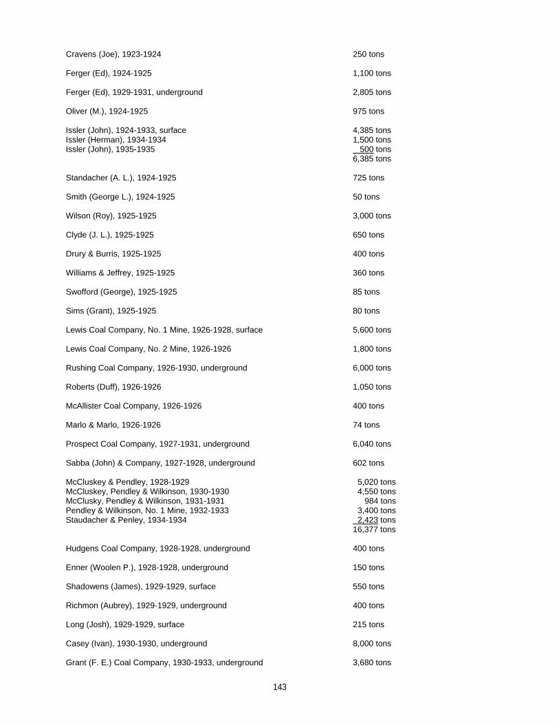
Cravens (Joe), 1923-1924 250 tons
Ferger (Ed), 1924-1925 1,100 tons
Ferger (Ed), 1929-1931, underground 2,805 tons
Oliver (M.), 1924-1925 975 tons
Issler (John), 1924-1933, surface 4,385 tonsIssler (Herman), 1934-1934 1,500 tonsIssler (John), 1935-1935 500 tons
6,385 tons
Standacher (A. L.), 1924-1925 725 tons
Smith (George L.), 1924-1925 50 tons
Wilson (Roy), 1925-1925 3,000 tons
Clyde (J. L.), 1925-1925 650 tons
Drury & Burris, 1925-1925 400 tons
Williams & Jeffrey, 1925-1925 360 tons
Swofford (George), 1925-1925 85 tons
Sims (Grant), 1925-1925 80 tons
Lewis Coal Company, No. 1 Mine, 1926-1928, surface 5,600 tons
Lewis Coal Company, No. 2 Mine, 1926-1926 1,800 tons
Rushing Coal Company, 1926-1930, underground 6,000 tons
Roberts (Duff), 1926-1926 1,050 tons
McAllister Coal Company, 1926-1926 400 tons
Marlo & Marlo, 1926-1926 74 tons
Prospect Coal Company, 1927-1931, underground 6,040 tons
Sabba (John) & Company, 1927-1928, underground 602 tons
McCluskey & Pendley, 1928-1929 5,020 tonsMcCluskey, Pendley & Wilkinson, 1930-1930 4,550 tonsMcClusky, Pendley & Wilkinson, 1931-1931 984 tonsPendley & Wilkinson, No. 1 Mine, 1932-1933 3,400 tonsStaudacher & Penley, 1934-1934 2,423 tons
16,377 tons
Hudgens Coal Company, 1928-1928, underground 400 tons
Enner (Woolen P.), 1928-1928, underground 150 tons
Shadowens (James), 1929-1929, surface 550 tons
Richmon (Aubrey), 1929-1929, underground 400 tons
Long (Josh), 1929-1929, surface 215 tons
Casey (Ivan), 1930-1930, underground 8,000 tons
Grant (F. E.) Coal Company, 1930-1933, underground 3,680 tons
143
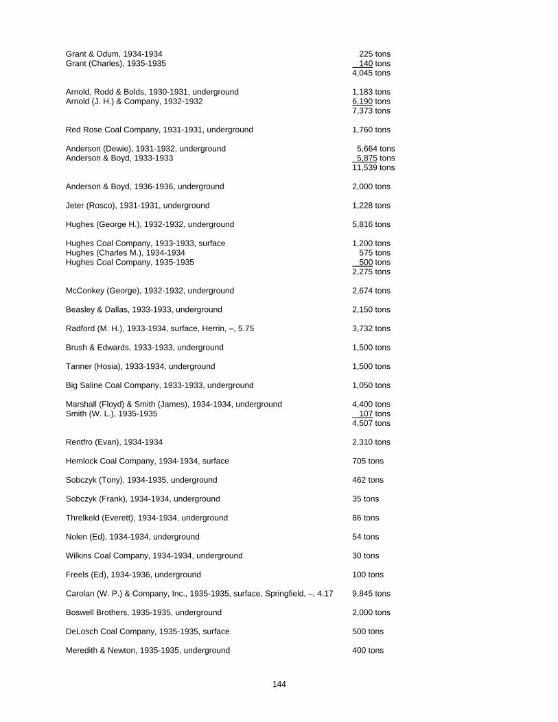
Grant & Odum, 1934-1934 225 tonsGrant (Charles), 1935-1935 140 tons
4,045 tons
Arnold, Rodd & Bolds, 1930-1931, underground 1,183 tonsArnold (J. H.) & Company, 1932-1932 6,190 tons
7,373 tons
Red Rose Coal Company, 1931-1931, underground 1,760 tons
Anderson (Dewie), 1931-1932, underground 5,664 tonsAnderson & Boyd, 1933-1933 5,875 tons
11,539 tons
Anderson & Boyd, 1936-1936, underground 2,000 tons
Jeter (Rosco), 1931-1931, underground 1,228 tons
Hughes (George H.), 1932-1932, underground 5,816 tons
Hughes Coal Company, 1933-1933, surface 1,200 tonsHughes (Charles M.), 1934-1934 575 tonsHughes Coal Company, 1935-1935 500 tons
2,275 tons
McConkey (George), 1932-1932, underground 2,674 tons
Beasley & Dallas, 1933-1933, underground 2,150 tons
Radford (M. H.), 1933-1934, surface, Herrin, –, 5.75 3,732 tons
Brush & Edwards, 1933-1933, underground 1,500 tons
Tanner (Hosia), 1933-1934, underground 1,500 tons
Big Saline Coal Company, 1933-1933, underground 1,050 tons
Marshall (Floyd) & Smith (James), 1934-1934, underground 4,400 tonsSmith (W. L.), 1935-1935 107 tons
4,507 tons
Rentfro (Evan), 1934-1934 2,310 tons
Hemlock Coal Company, 1934-1934, surface 705 tons
Sobczyk (Tony), 1934-1935, underground 462 tons
Sobczyk (Frank), 1934-1934, underground 35 tons
Threlkeld (Everett), 1934-1934, underground 86 tons
Nolen (Ed), 1934-1934, underground 54 tons
Wilkins Coal Company, 1934-1934, underground 30 tons
Freels (Ed), 1934-1936, underground 100 tons
Carolan (W. P.) & Company, Inc., 1935-1935, surface, Springfield, –, 4.17 9,845 tons
Boswell Brothers, 1935-1935, underground 2,000 tons
DeLosch Coal Company, 1935-1935, surface 500 tons
Meredith & Newton, 1935-1935, underground 400 tons
144
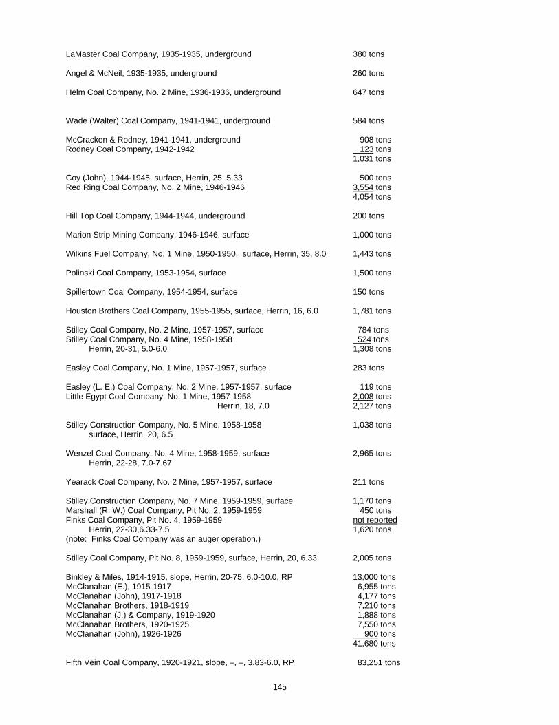
LaMaster Coal Company, 1935-1935, underground 380 tons
Angel & McNeil, 1935-1935, underground 260 tons
Helm Coal Company, No. 2 Mine, 1936-1936, underground 647 tons
Wade (Walter) Coal Company, 1941-1941, underground 584 tons
McCracken & Rodney, 1941-1941, underground 908 tonsRodney Coal Company, 1942-1942 123 tons
1,031 tons
Coy (John), 1944-1945, surface, Herrin, 25, 5.33 500 tonsRed Ring Coal Company, No. 2 Mine, 1946-1946 3,554 tons
4,054 tons
Hill Top Coal Company, 1944-1944, underground 200 tons
Marion Strip Mining Company, 1946-1946, surface 1,000 tons
Wilkins Fuel Company, No. 1 Mine, 1950-1950, surface, Herrin, 35, 8.0 1,443 tons
Polinski Coal Company, 1953-1954, surface 1,500 tons
Spillertown Coal Company, 1954-1954, surface 150 tons
Houston Brothers Coal Company, 1955-1955, surface, Herrin, 16, 6.0 1,781 tons
Stilley Coal Company, No. 2 Mine, 1957-1957, surface 784 tonsStilley Coal Company, No. 4 Mine, 1958-1958 524 tons Herrin, 20-31, 5.0-6.0 1,308 tons
Easley Coal Company, No. 1 Mine, 1957-1957, surface 283 tons
Easley (L. E.) Coal Company, No. 2 Mine, 1957-1957, surface 119 tonsLittle Egypt Coal Company, No. 1 Mine, 1957-1958 2,008 tons
Herrin, 18, 7.0 2,127 tons
Stilley Construction Company, No. 5 Mine, 1958-1958 1,038 tons surface, Herrin, 20, 6.5
Wenzel Coal Company, No. 4 Mine, 1958-1959, surface 2,965 tons Herrin, 22-28, 7.0-7.67
Yearack Coal Company, No. 2 Mine, 1957-1957, surface 211 tons
Stilley Construction Company, No. 7 Mine, 1959-1959, surface 1,170 tonsMarshall (R. W.) Coal Company, Pit No. 2, 1959-1959 450 tonsFinks Coal Company, Pit No. 4, 1959-1959 not reported Herrin, 22-30,6.33-7.5 1,620 tons(note: Finks Coal Company was an auger operation.)
Stilley Coal Company, Pit No. 8, 1959-1959, surface, Herrin, 20, 6.33 2,005 tons
Binkley & Miles, 1914-1915, slope, Herrin, 20-75, 6.0-10.0, RP 13,000 tonsMcClanahan (E.), 1915-1917 6,955 tonsMcClanahan (John), 1917-1918 4,177 tonsMcClanahan Brothers, 1918-1919 7,210 tonsMcClanahan (J.) & Company, 1919-1920 1,888 tonsMcClanahan Brothers, 1920-1925 7,550 tonsMcClanahan (John), 1926-1926 900 tons
41,680 tons
Fifth Vein Coal Company, 1920-1921, slope, –, –, 3.83-6.0, RP 83,251 tons
145
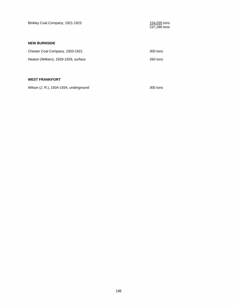
Binkley Coal Company, 1921-1923 154,035 tons237,286 tons
NEW BURNSIDE
Chester Coal Company, 1920-1921 300 tons
Heaton (William), 1929-1929, surface 260 tons
WEST FRANKFORT
Wilson (J. R.), 1934-1934, underground 300 tons
146
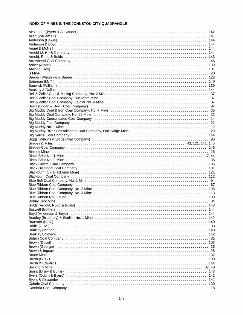
INDEX OF MINES IN THE JOHNSTON CITY QUADRANGLE
Alexander (Byers & Alexander) . . . . . . . . . . . . . . . . . . . . . . . . . . . . . . . . . . . . . . . . . . . . . . . . . . . . . . . . . . . . . . . . 142Allen (William P.) . . . . . . . . . . . . . . . . . . . . . . . . . . . . . . . . . . . . . . . . . . . . . . . . . . . . . . . . . . . . . . . . . . . . . . . . . . 141Anderson (Dewie) . . . . . . . . . . . . . . . . . . . . . . . . . . . . . . . . . . . . . . . . . . . . . . . . . . . . . . . . . . . . . . . . . . . . . . . . . . 144Anderson & Boyd . . . . . . . . . . . . . . . . . . . . . . . . . . . . . . . . . . . . . . . . . . . . . . . . . . . . . . . . . . . . . . . . . . . . . . . . . . 144Angel & McNeil . . . . . . . . . . . . . . . . . . . . . . . . . . . . . . . . . . . . . . . . . . . . . . . . . . . . . . . . . . . . . . . . . . . . . . . . . . . . 144Arnold (J. H.) & Company . . . . . . . . . . . . . . . . . . . . . . . . . . . . . . . . . . . . . . . . . . . . . . . . . . . . . . . . . . . . . . . . . . . . 144Arnold, Rodd & Bolds . . . . . . . . . . . . . . . . . . . . . . . . . . . . . . . . . . . . . . . . . . . . . . . . . . . . . . . . . . . . . . . . . . . . . . . 143Arrowhead Coal Company . . . . . . . . . . . . . . . . . . . . . . . . . . . . . . . . . . . . . . . . . . . . . . . . . . . . . . . . . . . . . . . . . . . . 46Asber (Albert) . . . . . . . . . . . . . . . . . . . . . . . . . . . . . . . . . . . . . . . . . . . . . . . . . . . . . . . . . . . . . . . . . . . . . . . . . . . . . 139Atwood (Roy) . . . . . . . . . . . . . . . . . . . . . . . . . . . . . . . . . . . . . . . . . . . . . . . . . . . . . . . . . . . . . . . . . . . . . . . . . . . . . 101B Mine . . . . . . . . . . . . . . . . . . . . . . . . . . . . . . . . . . . . . . . . . . . . . . . . . . . . . . . . . . . . . . . . . . . . . . . . . . . . . . . . . . . 20Barger (Whiteside & Barger) . . . . . . . . . . . . . . . . . . . . . . . . . . . . . . . . . . . . . . . . . . . . . . . . . . . . . . . . . . . . . . . . . . 122Bateman (M. T.) . . . . . . . . . . . . . . . . . . . . . . . . . . . . . . . . . . . . . . . . . . . . . . . . . . . . . . . . . . . . . . . . . . . . . . . . . . . 140Bauwick (William) . . . . . . . . . . . . . . . . . . . . . . . . . . . . . . . . . . . . . . . . . . . . . . . . . . . . . . . . . . . . . . . . . . . . . . . . . . 139Beasley & Dallas . . . . . . . . . . . . . . . . . . . . . . . . . . . . . . . . . . . . . . . . . . . . . . . . . . . . . . . . . . . . . . . . . . . . . . . . . . . 144Bell & Zoller Coal & Mining Company, No. 2 Mine . . . . . . . . . . . . . . . . . . . . . . . . . . . . . . . . . . . . . . . . . . . . . . . . . . 37Bell & Zoller Coal Company, Buckhorn Mine . . . . . . . . . . . . . . . . . . . . . . . . . . . . . . . . . . . . . . . . . . . . . . . . . . . . . . 37Bell & Zoller Coal Company, Zeigler No. 4 Mine . . . . . . . . . . . . . . . . . . . . . . . . . . . . . . . . . . . . . . . . . . . . . . . . . . . . 37Bevill (Logan & Bevill Coal Company) . . . . . . . . . . . . . . . . . . . . . . . . . . . . . . . . . . . . . . . . . . . . . . . . . . . . . . . . . . . 94Big Muddy Coal & Iron Coal Company, No. 7 Mine . . . . . . . . . . . . . . . . . . . . . . . . . . . . . . . . . . . . . . . . . . . . . . . . . 35Big Muddy Coal Company, No. 26 Mine . . . . . . . . . . . . . . . . . . . . . . . . . . . . . . . . . . . . . . . . . . . . . . . . . . . . . . . . . . 21Big Muddy Consolidated Coal Company . . . . . . . . . . . . . . . . . . . . . . . . . . . . . . . . . . . . . . . . . . . . . . . . . . . . . . . . . 14Big Muddy Fuel Company . . . . . . . . . . . . . . . . . . . . . . . . . . . . . . . . . . . . . . . . . . . . . . . . . . . . . . . . . . . . . . . . . . . . . 21Big Muddy No. 1 Mine . . . . . . . . . . . . . . . . . . . . . . . . . . . . . . . . . . . . . . . . . . . . . . . . . . . . . . . . . . . . . . . . . . . . . . . 12Big Muddy River Consolidated Coal Company, Oak Ridge Mine . . . . . . . . . . . . . . . . . . . . . . . . . . . . . . . . . . . . . . . 29Big Saline Coal Company . . . . . . . . . . . . . . . . . . . . . . . . . . . . . . . . . . . . . . . . . . . . . . . . . . . . . . . . . . . . . . . . . . . . 144Biggs (Wilkins & Biggs Coal Company) . . . . . . . . . . . . . . . . . . . . . . . . . . . . . . . . . . . . . . . . . . . . . . . . . . . . . . . . . . 96Binkley & Miles . . . . . . . . . . . . . . . . . . . . . . . . . . . . . . . . . . . . . . . . . . . . . . . . . . . . . . . . . . . . . . . . . 43, 121, 141, 145Binkley Coal Company . . . . . . . . . . . . . . . . . . . . . . . . . . . . . . . . . . . . . . . . . . . . . . . . . . . . . . . . . . . . . . . . . . . . . . 145Binkley Mine . . . . . . . . . . . . . . . . . . . . . . . . . . . . . . . . . . . . . . . . . . . . . . . . . . . . . . . . . . . . . . . . . . . . . . . . . . . . . . . 25Black Briar No. 1 Mine . . . . . . . . . . . . . . . . . . . . . . . . . . . . . . . . . . . . . . . . . . . . . . . . . . . . . . . . . . . . . . . . . . . . 17, 44Black Briar No. 2 Mine . . . . . . . . . . . . . . . . . . . . . . . . . . . . . . . . . . . . . . . . . . . . . . . . . . . . . . . . . . . . . . . . . . . . . . . 36Black Crystal Coal Company . . . . . . . . . . . . . . . . . . . . . . . . . . . . . . . . . . . . . . . . . . . . . . . . . . . . . . . . . . . . . . . . . 105Black Diamond Coal Company . . . . . . . . . . . . . . . . . . . . . . . . . . . . . . . . . . . . . . . . . . . . . . . . . . . . . . . . . . . . . . . . 131Blackburn (Old Blackburn Mine) . . . . . . . . . . . . . . . . . . . . . . . . . . . . . . . . . . . . . . . . . . . . . . . . . . . . . . . . . . . . . . . 121Blackburn Coal Company . . . . . . . . . . . . . . . . . . . . . . . . . . . . . . . . . . . . . . . . . . . . . . . . . . . . . . . . . . . . . . . . . . . . 112Blue Bell Coal Company, No. 1 Mine . . . . . . . . . . . . . . . . . . . . . . . . . . . . . . . . . . . . . . . . . . . . . . . . . . . . . . . . . . . . 94Blue Ribbon Coal Company . . . . . . . . . . . . . . . . . . . . . . . . . . . . . . . . . . . . . . . . . . . . . . . . . . . . . . . . . . . . . . . . . . . 87Blue Ribbon Coal Company, No. 2 Mine . . . . . . . . . . . . . . . . . . . . . . . . . . . . . . . . . . . . . . . . . . . . . . . . . . . . . . . . 103Blue Ribbon Coal Company, No. 3 Mine . . . . . . . . . . . . . . . . . . . . . . . . . . . . . . . . . . . . . . . . . . . . . . . . . . . . . . . . 113Blue Ribbon No. 3 Mine . . . . . . . . . . . . . . . . . . . . . . . . . . . . . . . . . . . . . . . . . . . . . . . . . . . . . . . . . . . . . . . . . . . . . 103Bobby Dick Mine . . . . . . . . . . . . . . . . . . . . . . . . . . . . . . . . . . . . . . . . . . . . . . . . . . . . . . . . . . . . . . . . . . . . . . . . . . . . 34Bolds (Arnold, Rodd & Bolds) . . . . . . . . . . . . . . . . . . . . . . . . . . . . . . . . . . . . . . . . . . . . . . . . . . . . . . . . . . . . . . . . . 143Boswell Brothers . . . . . . . . . . . . . . . . . . . . . . . . . . . . . . . . . . . . . . . . . . . . . . . . . . . . . . . . . . . . . . . . . . . . . . . . . . . 144Boyd (Anderson & Boyd) . . . . . . . . . . . . . . . . . . . . . . . . . . . . . . . . . . . . . . . . . . . . . . . . . . . . . . . . . . . . . . . . . . . . 144Bradley (Bradbury) & Scullin, No. 1 Mine . . . . . . . . . . . . . . . . . . . . . . . . . . . . . . . . . . . . . . . . . . . . . . . . . . . . . . . . 142Branson (H. K.) . . . . . . . . . . . . . . . . . . . . . . . . . . . . . . . . . . . . . . . . . . . . . . . . . . . . . . . . . . . . . . . . . . . . . . . . . . . . 140Bridis (C. M.) . . . . . . . . . . . . . . . . . . . . . . . . . . . . . . . . . . . . . . . . . . . . . . . . . . . . . . . . . . . . . . . . . . . . . . . . . . . . . . . 93Brinkley (Marian) . . . . . . . . . . . . . . . . . . . . . . . . . . . . . . . . . . . . . . . . . . . . . . . . . . . . . . . . . . . . . . . . . . . . . . . . . . . 140Brinkley Brothers . . . . . . . . . . . . . . . . . . . . . . . . . . . . . . . . . . . . . . . . . . . . . . . . . . . . . . . . . . . . . . . . . . . . . . . . . . 142Britain Coal Company . . . . . . . . . . . . . . . . . . . . . . . . . . . . . . . . . . . . . . . . . . . . . . . . . . . . . . . . . . . . . . . . . . . . . . . . 81Brown (David) . . . . . . . . . . . . . . . . . . . . . . . . . . . . . . . . . . . . . . . . . . . . . . . . . . . . . . . . . . . . . . . . . . . . . . . . . . . . . 103Brown (George) . . . . . . . . . . . . . . . . . . . . . . . . . . . . . . . . . . . . . . . . . . . . . . . . . . . . . . . . . . . . . . . . . . . . . . . . . . . . 25Brown & Ingram . . . . . . . . . . . . . . . . . . . . . . . . . . . . . . . . . . . . . . . . . . . . . . . . . . . . . . . . . . . . . . . . . . . . . . . . . . . . 25Bruce Mine . . . . . . . . . . . . . . . . . . . . . . . . . . . . . . . . . . . . . . . . . . . . . . . . . . . . . . . . . . . . . . . . . . . . . . . . . . . . . . . 132Brush (G. G.) . . . . . . . . . . . . . . . . . . . . . . . . . . . . . . . . . . . . . . . . . . . . . . . . . . . . . . . . . . . . . . . . . . . . . . . . . . . . . 139Brush & Edwards . . . . . . . . . . . . . . . . . . . . . . . . . . . . . . . . . . . . . . . . . . . . . . . . . . . . . . . . . . . . . . . . . . . . . . . . . . 144Buckhorn Mine . . . . . . . . . . . . . . . . . . . . . . . . . . . . . . . . . . . . . . . . . . . . . . . . . . . . . . . . . . . . . . . . . . . . . . . . . . 37, 40Burris (Drury & Burris) . . . . . . . . . . . . . . . . . . . . . . . . . . . . . . . . . . . . . . . . . . . . . . . . . . . . . . . . . . . . . . . . . . . . . . 143Byers (Odum & Byers) . . . . . . . . . . . . . . . . . . . . . . . . . . . . . . . . . . . . . . . . . . . . . . . . . . . . . . . . . . . . . . . . . . . . . . 142Byers & Alexander . . . . . . . . . . . . . . . . . . . . . . . . . . . . . . . . . . . . . . . . . . . . . . . . . . . . . . . . . . . . . . . . . . . . . . . . . 142Caloric Coal Company . . . . . . . . . . . . . . . . . . . . . . . . . . . . . . . . . . . . . . . . . . . . . . . . . . . . . . . . . . . . . . . . . . . . . . 130Cambria Coal Company . . . . . . . . . . . . . . . . . . . . . . . . . . . . . . . . . . . . . . . . . . . . . . . . . . . . . . . . . . . . . . . . . . . . . . 18
147
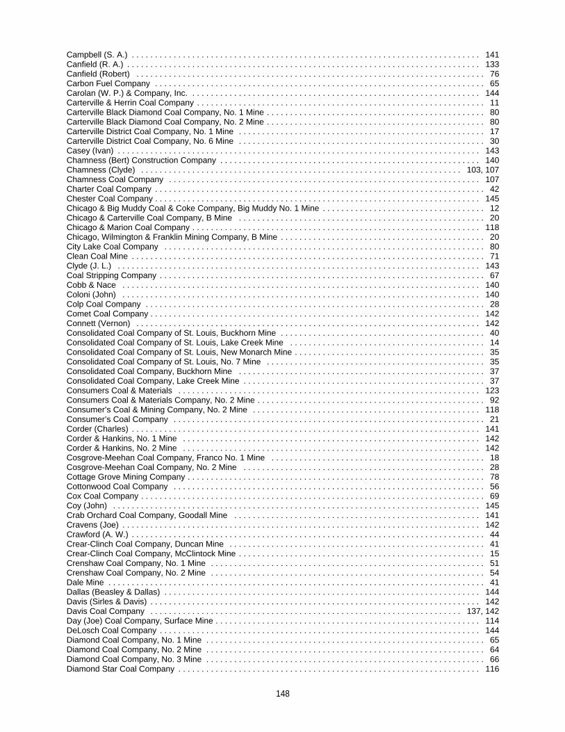
Campbell (S. A.) . . . . . . . . . . . . . . . . . . . . . . . . . . . . . . . . . . . . . . . . . . . . . . . . . . . . . . . . . . . . . . . . . . . . . . . . . . . 141Canfield (R. A.) . . . . . . . . . . . . . . . . . . . . . . . . . . . . . . . . . . . . . . . . . . . . . . . . . . . . . . . . . . . . . . . . . . . . . . . . . . . . 133Canfield (Robert) . . . . . . . . . . . . . . . . . . . . . . . . . . . . . . . . . . . . . . . . . . . . . . . . . . . . . . . . . . . . . . . . . . . . . . . . . . . 76Carbon Fuel Company . . . . . . . . . . . . . . . . . . . . . . . . . . . . . . . . . . . . . . . . . . . . . . . . . . . . . . . . . . . . . . . . . . . . . . . 65Carolan (W. P.) & Company, Inc. . . . . . . . . . . . . . . . . . . . . . . . . . . . . . . . . . . . . . . . . . . . . . . . . . . . . . . . . . . . . . . 144Carterville & Herrin Coal Company . . . . . . . . . . . . . . . . . . . . . . . . . . . . . . . . . . . . . . . . . . . . . . . . . . . . . . . . . . . . . . 11Carterville Black Diamond Coal Company, No. 1 Mine . . . . . . . . . . . . . . . . . . . . . . . . . . . . . . . . . . . . . . . . . . . . . . . 80Carterville Black Diamond Coal Company, No. 2 Mine . . . . . . . . . . . . . . . . . . . . . . . . . . . . . . . . . . . . . . . . . . . . . . . 80Carterville District Coal Company, No. 1 Mine . . . . . . . . . . . . . . . . . . . . . . . . . . . . . . . . . . . . . . . . . . . . . . . . . . . . . 17Carterville District Coal Company, No. 6 Mine . . . . . . . . . . . . . . . . . . . . . . . . . . . . . . . . . . . . . . . . . . . . . . . . . . . . . 30Casey (Ivan) . . . . . . . . . . . . . . . . . . . . . . . . . . . . . . . . . . . . . . . . . . . . . . . . . . . . . . . . . . . . . . . . . . . . . . . . . . . . . . 143Chamness (Bert) Construction Company . . . . . . . . . . . . . . . . . . . . . . . . . . . . . . . . . . . . . . . . . . . . . . . . . . . . . . . . 140Chamness (Clyde) . . . . . . . . . . . . . . . . . . . . . . . . . . . . . . . . . . . . . . . . . . . . . . . . . . . . . . . . . . . . . . . . . . . . . 103, 107Chamness Coal Company . . . . . . . . . . . . . . . . . . . . . . . . . . . . . . . . . . . . . . . . . . . . . . . . . . . . . . . . . . . . . . . . . . . 107Charter Coal Company . . . . . . . . . . . . . . . . . . . . . . . . . . . . . . . . . . . . . . . . . . . . . . . . . . . . . . . . . . . . . . . . . . . . . . . 42Chester Coal Company . . . . . . . . . . . . . . . . . . . . . . . . . . . . . . . . . . . . . . . . . . . . . . . . . . . . . . . . . . . . . . . . . . . . . . 145Chicago & Big Muddy Coal & Coke Company, Big Muddy No. 1 Mine . . . . . . . . . . . . . . . . . . . . . . . . . . . . . . . . . . . 12Chicago & Carterville Coal Company, B Mine . . . . . . . . . . . . . . . . . . . . . . . . . . . . . . . . . . . . . . . . . . . . . . . . . . . . . 20Chicago & Marion Coal Company . . . . . . . . . . . . . . . . . . . . . . . . . . . . . . . . . . . . . . . . . . . . . . . . . . . . . . . . . . . . . . 118Chicago, Wilmington & Franklin Mining Company, B Mine . . . . . . . . . . . . . . . . . . . . . . . . . . . . . . . . . . . . . . . . . . . . 20City Lake Coal Company . . . . . . . . . . . . . . . . . . . . . . . . . . . . . . . . . . . . . . . . . . . . . . . . . . . . . . . . . . . . . . . . . . . . . 80Clean Coal Mine . . . . . . . . . . . . . . . . . . . . . . . . . . . . . . . . . . . . . . . . . . . . . . . . . . . . . . . . . . . . . . . . . . . . . . . . . . . . 71Clyde (J. L.) . . . . . . . . . . . . . . . . . . . . . . . . . . . . . . . . . . . . . . . . . . . . . . . . . . . . . . . . . . . . . . . . . . . . . . . . . . . . . . 143Coal Stripping Company . . . . . . . . . . . . . . . . . . . . . . . . . . . . . . . . . . . . . . . . . . . . . . . . . . . . . . . . . . . . . . . . . . . . . . 67Cobb & Nace . . . . . . . . . . . . . . . . . . . . . . . . . . . . . . . . . . . . . . . . . . . . . . . . . . . . . . . . . . . . . . . . . . . . . . . . . . . . . 140Coloni (John) . . . . . . . . . . . . . . . . . . . . . . . . . . . . . . . . . . . . . . . . . . . . . . . . . . . . . . . . . . . . . . . . . . . . . . . . . . . . . 140Colp Coal Company . . . . . . . . . . . . . . . . . . . . . . . . . . . . . . . . . . . . . . . . . . . . . . . . . . . . . . . . . . . . . . . . . . . . . . . . . 28Comet Coal Company . . . . . . . . . . . . . . . . . . . . . . . . . . . . . . . . . . . . . . . . . . . . . . . . . . . . . . . . . . . . . . . . . . . . . . . 142Connett (Vernon) . . . . . . . . . . . . . . . . . . . . . . . . . . . . . . . . . . . . . . . . . . . . . . . . . . . . . . . . . . . . . . . . . . . . . . . . . . 142Consolidated Coal Company of St. Louis, Buckhorn Mine . . . . . . . . . . . . . . . . . . . . . . . . . . . . . . . . . . . . . . . . . . . . 40Consolidated Coal Company of St. Louis, Lake Creek Mine . . . . . . . . . . . . . . . . . . . . . . . . . . . . . . . . . . . . . . . . . . 14Consolidated Coal Company of St. Louis, New Monarch Mine . . . . . . . . . . . . . . . . . . . . . . . . . . . . . . . . . . . . . . . . . 35Consolidated Coal Company of St. Louis, No. 7 Mine . . . . . . . . . . . . . . . . . . . . . . . . . . . . . . . . . . . . . . . . . . . . . . . 35Consolidated Coal Company, Buckhorn Mine . . . . . . . . . . . . . . . . . . . . . . . . . . . . . . . . . . . . . . . . . . . . . . . . . . . . . 37Consolidated Coal Company, Lake Creek Mine . . . . . . . . . . . . . . . . . . . . . . . . . . . . . . . . . . . . . . . . . . . . . . . . . . . . 37Consumers Coal & Materials . . . . . . . . . . . . . . . . . . . . . . . . . . . . . . . . . . . . . . . . . . . . . . . . . . . . . . . . . . . . . . . . . 123Consumers Coal & Materials Company, No. 2 Mine . . . . . . . . . . . . . . . . . . . . . . . . . . . . . . . . . . . . . . . . . . . . . . . . . 92Consumer’s Coal & Mining Company, No. 2 Mine . . . . . . . . . . . . . . . . . . . . . . . . . . . . . . . . . . . . . . . . . . . . . . . . . 118Consumer’s Coal Company . . . . . . . . . . . . . . . . . . . . . . . . . . . . . . . . . . . . . . . . . . . . . . . . . . . . . . . . . . . . . . . . . . . 21Corder (Charles) . . . . . . . . . . . . . . . . . . . . . . . . . . . . . . . . . . . . . . . . . . . . . . . . . . . . . . . . . . . . . . . . . . . . . . . . . . . 141Corder & Hankins, No. 1 Mine . . . . . . . . . . . . . . . . . . . . . . . . . . . . . . . . . . . . . . . . . . . . . . . . . . . . . . . . . . . . . . . . 142Corder & Hankins, No. 2 Mine . . . . . . . . . . . . . . . . . . . . . . . . . . . . . . . . . . . . . . . . . . . . . . . . . . . . . . . . . . . . . . . . 142Cosgrove-Meehan Coal Company, Franco No. 1 Mine . . . . . . . . . . . . . . . . . . . . . . . . . . . . . . . . . . . . . . . . . . . . . . 18Cosgrove-Meehan Coal Company, No. 2 Mine . . . . . . . . . . . . . . . . . . . . . . . . . . . . . . . . . . . . . . . . . . . . . . . . . . . . 28Cottage Grove Mining Company . . . . . . . . . . . . . . . . . . . . . . . . . . . . . . . . . . . . . . . . . . . . . . . . . . . . . . . . . . . . . . . . 78Cottonwood Coal Company . . . . . . . . . . . . . . . . . . . . . . . . . . . . . . . . . . . . . . . . . . . . . . . . . . . . . . . . . . . . . . . . . . . 56Cox Coal Company . . . . . . . . . . . . . . . . . . . . . . . . . . . . . . . . . . . . . . . . . . . . . . . . . . . . . . . . . . . . . . . . . . . . . . . . . . 69Coy (John) . . . . . . . . . . . . . . . . . . . . . . . . . . . . . . . . . . . . . . . . . . . . . . . . . . . . . . . . . . . . . . . . . . . . . . . . . . . . . . . 145Crab Orchard Coal Company, Goodall Mine . . . . . . . . . . . . . . . . . . . . . . . . . . . . . . . . . . . . . . . . . . . . . . . . . . . . . 141Cravens (Joe) . . . . . . . . . . . . . . . . . . . . . . . . . . . . . . . . . . . . . . . . . . . . . . . . . . . . . . . . . . . . . . . . . . . . . . . . . . . . . 142Crawford (A. W.) . . . . . . . . . . . . . . . . . . . . . . . . . . . . . . . . . . . . . . . . . . . . . . . . . . . . . . . . . . . . . . . . . . . . . . . . . . . . 44Crear-Clinch Coal Company, Duncan Mine . . . . . . . . . . . . . . . . . . . . . . . . . . . . . . . . . . . . . . . . . . . . . . . . . . . . . . . 41Crear-Clinch Coal Company, McClintock Mine . . . . . . . . . . . . . . . . . . . . . . . . . . . . . . . . . . . . . . . . . . . . . . . . . . . . . 15Crenshaw Coal Company, No. 1 Mine . . . . . . . . . . . . . . . . . . . . . . . . . . . . . . . . . . . . . . . . . . . . . . . . . . . . . . . . . . . 51Crenshaw Coal Company, No. 2 Mine . . . . . . . . . . . . . . . . . . . . . . . . . . . . . . . . . . . . . . . . . . . . . . . . . . . . . . . . . . . 54Dale Mine . . . . . . . . . . . . . . . . . . . . . . . . . . . . . . . . . . . . . . . . . . . . . . . . . . . . . . . . . . . . . . . . . . . . . . . . . . . . . . . . . 41Dallas (Beasley & Dallas) . . . . . . . . . . . . . . . . . . . . . . . . . . . . . . . . . . . . . . . . . . . . . . . . . . . . . . . . . . . . . . . . . . . . 144Davis (Sirles & Davis) . . . . . . . . . . . . . . . . . . . . . . . . . . . . . . . . . . . . . . . . . . . . . . . . . . . . . . . . . . . . . . . . . . . . . . . 142Davis Coal Company . . . . . . . . . . . . . . . . . . . . . . . . . . . . . . . . . . . . . . . . . . . . . . . . . . . . . . . . . . . . . . . . . . . 137, 142Day (Joe) Coal Company, Surface Mine . . . . . . . . . . . . . . . . . . . . . . . . . . . . . . . . . . . . . . . . . . . . . . . . . . . . . . . . . 114DeLosch Coal Company . . . . . . . . . . . . . . . . . . . . . . . . . . . . . . . . . . . . . . . . . . . . . . . . . . . . . . . . . . . . . . . . . . . . . 144Diamond Coal Company, No. 1 Mine . . . . . . . . . . . . . . . . . . . . . . . . . . . . . . . . . . . . . . . . . . . . . . . . . . . . . . . . . . . . 65Diamond Coal Company, No. 2 Mine . . . . . . . . . . . . . . . . . . . . . . . . . . . . . . . . . . . . . . . . . . . . . . . . . . . . . . . . . . . . 64Diamond Coal Company, No. 3 Mine . . . . . . . . . . . . . . . . . . . . . . . . . . . . . . . . . . . . . . . . . . . . . . . . . . . . . . . . . . . . 66Diamond Star Coal Company . . . . . . . . . . . . . . . . . . . . . . . . . . . . . . . . . . . . . . . . . . . . . . . . . . . . . . . . . . . . . . . . . 116
148
Dog Walk Mine . . . . . . . . . . . . . . . . . . . . . . . . . . . . . . . . . . . . . . . . . . . . . . . . . . . . . . . . . . . . . . . . . . . . . . . . . . . . . 59Doty (Reese-Doty & Company) . . . . . . . . . . . . . . . . . . . . . . . . . . . . . . . . . . . . . . . . . . . . . . . . . . . . . . . . . . . . . . . . 141Drury & Burris . . . . . . . . . . . . . . . . . . . . . . . . . . . . . . . . . . . . . . . . . . . . . . . . . . . . . . . . . . . . . . . . . . . . . . . . . . . . . 143Duncan Coal Company, Dale Mine . . . . . . . . . . . . . . . . . . . . . . . . . . . . . . . . . . . . . . . . . . . . . . . . . . . . . . . . . . . . . . 41Dunsford (Charles) . . . . . . . . . . . . . . . . . . . . . . . . . . . . . . . . . . . . . . . . . . . . . . . . . . . . . . . . . . . . . . . . . . . . . . . . . 139Dunston (Spiller & Dunston) . . . . . . . . . . . . . . . . . . . . . . . . . . . . . . . . . . . . . . . . . . . . . . . . . . . . . . . . . . . . . . . . . . . 58E. & B. Coal Company, Crenshaw No. 2 Mine . . . . . . . . . . . . . . . . . . . . . . . . . . . . . . . . . . . . . . . . . . . . . . . . . . . . . 54E. & B. Coal Company, No. 1 Mine . . . . . . . . . . . . . . . . . . . . . . . . . . . . . . . . . . . . . . . . . . . . . . . . . . . . . . . . . . . . . . 47E. & B. Coal Company, No. 2 Mine . . . . . . . . . . . . . . . . . . . . . . . . . . . . . . . . . . . . . . . . . . . . . . . . . . . . . . . . . . . . . . 50Easley (L. E.) Coal Company, No. 2 Mine . . . . . . . . . . . . . . . . . . . . . . . . . . . . . . . . . . . . . . . . . . . . . . . . . . . . . . . 145Easley Coal Company, No. 1 Mine . . . . . . . . . . . . . . . . . . . . . . . . . . . . . . . . . . . . . . . . . . . . . . . . . . . . . . . . . . . . . 145Edwards (Brush & Edwards) . . . . . . . . . . . . . . . . . . . . . . . . . . . . . . . . . . . . . . . . . . . . . . . . . . . . . . . . . . . . . . . . . . 144Egyptian Coal Company . . . . . . . . . . . . . . . . . . . . . . . . . . . . . . . . . . . . . . . . . . . . . . . . . . . . . . . . . . . . . . . . . . . . . 110Energy Mine . . . . . . . . . . . . . . . . . . . . . . . . . . . . . . . . . . . . . . . . . . . . . . . . . . . . . . . . . . . . . . . . . . . . . . . . . . . . . . . 45Energy No. 5 Mine . . . . . . . . . . . . . . . . . . . . . . . . . . . . . . . . . . . . . . . . . . . . . . . . . . . . . . . . . . . . . . . . . . . . . . . . . . 31Enner (Woolen P.) . . . . . . . . . . . . . . . . . . . . . . . . . . . . . . . . . . . . . . . . . . . . . . . . . . . . . . . . . . . . . . . . . . . . . . . . . 143Equality Coal Company . . . . . . . . . . . . . . . . . . . . . . . . . . . . . . . . . . . . . . . . . . . . . . . . . . . . . . . . . . . . . . . . . . . . . 142Equator Coal Company . . . . . . . . . . . . . . . . . . . . . . . . . . . . . . . . . . . . . . . . . . . . . . . . . . . . . . . . . . . . . . . . . . 105, 124Ernest Coal Company, Franco No. 1 Mine . . . . . . . . . . . . . . . . . . . . . . . . . . . . . . . . . . . . . . . . . . . . . . . . . . . . . . . . 18Ernest Coal Company, No. 2 Mine . . . . . . . . . . . . . . . . . . . . . . . . . . . . . . . . . . . . . . . . . . . . . . . . . . . . . . . . . . . . . . 28Falkerson (Philip) . . . . . . . . . . . . . . . . . . . . . . . . . . . . . . . . . . . . . . . . . . . . . . . . . . . . . . . . . . . . . . . . . . . . . . . . . . . 72Ferger (Ed) . . . . . . . . . . . . . . . . . . . . . . . . . . . . . . . . . . . . . . . . . . . . . . . . . . . . . . . . . . . . . . . . . . . . . . . . . . . 142, 143Ferges Brothers Coal Company . . . . . . . . . . . . . . . . . . . . . . . . . . . . . . . . . . . . . . . . . . . . . . . . . . . . . . . . . . . . . . . . 77Fifth Vein Coal Company . . . . . . . . . . . . . . . . . . . . . . . . . . . . . . . . . . . . . . . . . . . . . . . . . . . . . . . . . . . . . . . . . . . . 145Finks Coal Company, Pit No. 4 . . . . . . . . . . . . . . . . . . . . . . . . . . . . . . . . . . . . . . . . . . . . . . . . . . . . . . . . . . . . . . . . 145Forsyth-Energy Coal Company . . . . . . . . . . . . . . . . . . . . . . . . . . . . . . . . . . . . . . . . . . . . . . . . . . . . . . . . . . . . . . . . . 45Forsyth-Energy, Inc. . . . . . . . . . . . . . . . . . . . . . . . . . . . . . . . . . . . . . . . . . . . . . . . . . . . . . . . . . . . . . . . . . . . . . . . . . 45Franco Mining Corporation . . . . . . . . . . . . . . . . . . . . . . . . . . . . . . . . . . . . . . . . . . . . . . . . . . . . . . . . . . . . . . . . . . . . 18Franklin County Coal Corporation, Energy No. 5 Mine . . . . . . . . . . . . . . . . . . . . . . . . . . . . . . . . . . . . . . . . . . . . . . . 31Franklin Mine . . . . . . . . . . . . . . . . . . . . . . . . . . . . . . . . . . . . . . . . . . . . . . . . . . . . . . . . . . . . . . . . . . . . . . . . . . . . . . 34Freeburn Mining Company, No. 3 Mine . . . . . . . . . . . . . . . . . . . . . . . . . . . . . . . . . . . . . . . . . . . . . . . . . . . . . . . . . . 39Freels (Ed) . . . . . . . . . . . . . . . . . . . . . . . . . . . . . . . . . . . . . . . . . . . . . . . . . . . . . . . . . . . . . . . . . . . . . . . . . . . . . . . 144Freeman Coal Mining Company, Bobby Dick Mine . . . . . . . . . . . . . . . . . . . . . . . . . . . . . . . . . . . . . . . . . . . . . . . . . . 34Freeman Coal Mining Company, No. 1 Mine . . . . . . . . . . . . . . . . . . . . . . . . . . . . . . . . . . . . . . . . . . . . . . . . . . . . . . 34Freeman Coal Mining Corporation, No. 3 Mine . . . . . . . . . . . . . . . . . . . . . . . . . . . . . . . . . . . . . . . . . . . . . . . . . . . . . 39Freeman Coal Mining Corporation, No. 4 Mine . . . . . . . . . . . . . . . . . . . . . . . . . . . . . . . . . . . . . . . . . . . . . . . . . . . . . 38Freeman Coal Mining Corporation, Orient No. 4 Mine . . . . . . . . . . . . . . . . . . . . . . . . . . . . . . . . . . . . . . . . . . . . . . . 38Freeman Spur Mine . . . . . . . . . . . . . . . . . . . . . . . . . . . . . . . . . . . . . . . . . . . . . . . . . . . . . . . . . . . . . . . . . . . . . . . . . 11Freeman United Coal Mining Corporation, Orient No. 4 Mine . . . . . . . . . . . . . . . . . . . . . . . . . . . . . . . . . . . . . . . . . . 38Gabriel Brothers . . . . . . . . . . . . . . . . . . . . . . . . . . . . . . . . . . . . . . . . . . . . . . . . . . . . . . . . . . . . . . . . . . . . . . . . . . . 141Geer (E. L.) . . . . . . . . . . . . . . . . . . . . . . . . . . . . . . . . . . . . . . . . . . . . . . . . . . . . . . . . . . . . . . . . . . . . . . . . . . . . . 72, 87Gentry Coal Company, No. 7 Mine . . . . . . . . . . . . . . . . . . . . . . . . . . . . . . . . . . . . . . . . . . . . . . . . . . . . . . . . . . . . . 116Ghent (H. M.) Coal Company . . . . . . . . . . . . . . . . . . . . . . . . . . . . . . . . . . . . . . . . . . . . . . . . . . . . . . . . . . . . . . . . . 141Goddard Mine . . . . . . . . . . . . . . . . . . . . . . . . . . . . . . . . . . . . . . . . . . . . . . . . . . . . . . . . . . . . . . . . . . . . . . . . . . . . . . 17Godelski (Joe) . . . . . . . . . . . . . . . . . . . . . . . . . . . . . . . . . . . . . . . . . . . . . . . . . . . . . . . . . . . . . . . . . . . . . . . . . . . . . 142Goodall (S. H., Jr.) . . . . . . . . . . . . . . . . . . . . . . . . . . . . . . . . . . . . . . . . . . . . . . . . . . . . . . . . . . . . . . . . . . . . . . . . . 120Goodall (Sam H., Sr.) . . . . . . . . . . . . . . . . . . . . . . . . . . . . . . . . . . . . . . . . . . . . . . . . . . . . . . . . . . . . . . . . . . . . . . . 120Goodall Mine . . . . . . . . . . . . . . . . . . . . . . . . . . . . . . . . . . . . . . . . . . . . . . . . . . . . . . . . . . . . . . . . . . . . . . . . . . . 77, 141Gordon & Price Coal Company . . . . . . . . . . . . . . . . . . . . . . . . . . . . . . . . . . . . . . . . . . . . . . . . . . . . . . . . . . . . . . . . . 56Gordon & Price Coal Company, Pace No. 1 Mine . . . . . . . . . . . . . . . . . . . . . . . . . . . . . . . . . . . . . . . . . . . . . . . . . . 57Gosnell Brothers . . . . . . . . . . . . . . . . . . . . . . . . . . . . . . . . . . . . . . . . . . . . . . . . . . . . . . . . . . . . . . . . . . . . . . . . . . . 142Grant (Charles) . . . . . . . . . . . . . . . . . . . . . . . . . . . . . . . . . . . . . . . . . . . . . . . . . . . . . . . . . . . . . . . . . . . . . . . . . . . . 143Grant (F. E.) Coal Company . . . . . . . . . . . . . . . . . . . . . . . . . . . . . . . . . . . . . . . . . . . . . . . . . . . . . . . . . . . . . . . . . . 143Grant & Odum . . . . . . . . . . . . . . . . . . . . . . . . . . . . . . . . . . . . . . . . . . . . . . . . . . . . . . . . . . . . . . . . . . . . . . . . . . . . 143Gray (Spiller & Gray) . . . . . . . . . . . . . . . . . . . . . . . . . . . . . . . . . . . . . . . . . . . . . . . . . . . . . . . . . . . . . . . . . . . . . . . . 58Greer (O. A.) . . . . . . . . . . . . . . . . . . . . . . . . . . . . . . . . . . . . . . . . . . . . . . . . . . . . . . . . . . . . . . . . . . . . . . . . . . . . . . 140Grissom (W. E.) Coal Company . . . . . . . . . . . . . . . . . . . . . . . . . . . . . . . . . . . . . . . . . . . . . . . . . . . . . . . . . . . . . . . 115Gulledge & Rushing . . . . . . . . . . . . . . . . . . . . . . . . . . . . . . . . . . . . . . . . . . . . . . . . . . . . . . . . . . . . . . . . . . . . . . . . . 92Hamilton Coal Company . . . . . . . . . . . . . . . . . . . . . . . . . . . . . . . . . . . . . . . . . . . . . . . . . . . . . . . . . . . . . . . . . . . . . 123Hampton (M.) . . . . . . . . . . . . . . . . . . . . . . . . . . . . . . . . . . . . . . . . . . . . . . . . . . . . . . . . . . . . . . . . . . . . . . . . . . . . . 128Hampton (Richard) . . . . . . . . . . . . . . . . . . . . . . . . . . . . . . . . . . . . . . . . . . . . . . . . . . . . . . . . . . . . . . . . . . . . . . . . . 128Handkins (Roy) . . . . . . . . . . . . . . . . . . . . . . . . . . . . . . . . . . . . . . . . . . . . . . . . . . . . . . . . . . . . . . . . . . . . . . . . . . . . 142Handkins (W. R.) . . . . . . . . . . . . . . . . . . . . . . . . . . . . . . . . . . . . . . . . . . . . . . . . . . . . . . . . . . . . . . . . . . . . . . . . . . 141Handkins & Sims . . . . . . . . . . . . . . . . . . . . . . . . . . . . . . . . . . . . . . . . . . . . . . . . . . . . . . . . . . . . . . . . . . . . . . . . . . 141Hankins (Corder & Hankins) . . . . . . . . . . . . . . . . . . . . . . . . . . . . . . . . . . . . . . . . . . . . . . . . . . . . . . . . . . . . . . . . . . 142
149
Harris (Frank) . . . . . . . . . . . . . . . . . . . . . . . . . . . . . . . . . . . . . . . . . . . . . . . . . . . . . . . . . . . . . . . . . . . . . . . . . . . . . 139Harris (John W.) . . . . . . . . . . . . . . . . . . . . . . . . . . . . . . . . . . . . . . . . . . . . . . . . . . . . . . . . . . . . . . . . . . . . . . . . . . . 141Hausman (Lauder & Hausman) . . . . . . . . . . . . . . . . . . . . . . . . . . . . . . . . . . . . . . . . . . . . . . . . . . . . . . . . . . . . . . . 105Hawkins (Roy) . . . . . . . . . . . . . . . . . . . . . . . . . . . . . . . . . . . . . . . . . . . . . . . . . . . . . . . . . . . . . . . . . . . . . . . . . . . . 142Heaton (William) . . . . . . . . . . . . . . . . . . . . . . . . . . . . . . . . . . . . . . . . . . . . . . . . . . . . . . . . . . . . . . . . . . . . . . . . . . . 146Helm Coal Company . . . . . . . . . . . . . . . . . . . . . . . . . . . . . . . . . . . . . . . . . . . . . . . . . . . . . . . . . . . . . . . . . . . . . . . . 144Hemlock Coal Company . . . . . . . . . . . . . . . . . . . . . . . . . . . . . . . . . . . . . . . . . . . . . . . . . . . . . . . . . . . . . . . . . . . . . 144Henderson & Wallace Coal Company, No. 1 Mine . . . . . . . . . . . . . . . . . . . . . . . . . . . . . . . . . . . . . . . . . . . . . . . . . . 27Henderson-Wallace Coal Company, No. 2 Mine . . . . . . . . . . . . . . . . . . . . . . . . . . . . . . . . . . . . . . . . . . . . . . . . . . . 115Henson (J. T.) & Sons . . . . . . . . . . . . . . . . . . . . . . . . . . . . . . . . . . . . . . . . . . . . . . . . . . . . . . . . . . . . . . . . . . . . . . 141Henson (T. H.) & Sons . . . . . . . . . . . . . . . . . . . . . . . . . . . . . . . . . . . . . . . . . . . . . . . . . . . . . . . . . . . . . . . . . . . . . . 141Herrin & Big Muddy Coal Company . . . . . . . . . . . . . . . . . . . . . . . . . . . . . . . . . . . . . . . . . . . . . . . . . . . . . . . . . . . . 137Hickey (Thomas) Coal Company . . . . . . . . . . . . . . . . . . . . . . . . . . . . . . . . . . . . . . . . . . . . . . . . . . . . . . . . . . . . . . . 99Hickey Brothers Coal Company . . . . . . . . . . . . . . . . . . . . . . . . . . . . . . . . . . . . . . . . . . . . . . . . . . . . . . . . . . . . . . . . 98Hill Top Coal Company . . . . . . . . . . . . . . . . . . . . . . . . . . . . . . . . . . . . . . . . . . . . . . . . . . . . . . . . . . . . . . . . . . . . . . 145Hillard (Orval J.) Coal Company . . . . . . . . . . . . . . . . . . . . . . . . . . . . . . . . . . . . . . . . . . . . . . . . . . . . . . . . . . . . . . . . 71Hodden (W. H.) . . . . . . . . . . . . . . . . . . . . . . . . . . . . . . . . . . . . . . . . . . . . . . . . . . . . . . . . . . . . . . . . . . . . . . . . . . . . 142Hoddy (C. C.) . . . . . . . . . . . . . . . . . . . . . . . . . . . . . . . . . . . . . . . . . . . . . . . . . . . . . . . . . . . . . . . . . . . . . . . . . . . . . 142Hope (J.) & Richardson (A.) . . . . . . . . . . . . . . . . . . . . . . . . . . . . . . . . . . . . . . . . . . . . . . . . . . . . . . . . . . . . . . . . . . 140Houston Brothers Coal Company . . . . . . . . . . . . . . . . . . . . . . . . . . . . . . . . . . . . . . . . . . . . . . . . . . . . . . . . . . . . . . 145Howells (S.) . . . . . . . . . . . . . . . . . . . . . . . . . . . . . . . . . . . . . . . . . . . . . . . . . . . . . . . . . . . . . . . . . . . . . . . . . . . . . . 140Hudgens Coal Company . . . . . . . . . . . . . . . . . . . . . . . . . . . . . . . . . . . . . . . . . . . . . . . . . . . . . . . . . . . . . . . . . . . . . 143Hughes (Charles M.) . . . . . . . . . . . . . . . . . . . . . . . . . . . . . . . . . . . . . . . . . . . . . . . . . . . . . . . . . . . . . . . . . . . . . . . . 144Hughes (George H.) . . . . . . . . . . . . . . . . . . . . . . . . . . . . . . . . . . . . . . . . . . . . . . . . . . . . . . . . . . . . . . . . . . . . . . . . 144Hughes Coal Company . . . . . . . . . . . . . . . . . . . . . . . . . . . . . . . . . . . . . . . . . . . . . . . . . . . . . . . . . . . . . . . . . . . . . . 144Illinois Coal, Oil & Gas Company, No. 1 Mine . . . . . . . . . . . . . . . . . . . . . . . . . . . . . . . . . . . . . . . . . . . . . . . . . . . . . . 48Illinois Coal, Oil & Gas Company, No. 2 Mine . . . . . . . . . . . . . . . . . . . . . . . . . . . . . . . . . . . . . . . . . . . . . . . . . . . . . . 53Illinois Hocking Washed Coal Company . . . . . . . . . . . . . . . . . . . . . . . . . . . . . . . . . . . . . . . . . . . . . . . . . . . . . . . . . . 17Ingram (Brown & Ingram) . . . . . . . . . . . . . . . . . . . . . . . . . . . . . . . . . . . . . . . . . . . . . . . . . . . . . . . . . . . . . . . . . . . . . 25Issler (Herman) . . . . . . . . . . . . . . . . . . . . . . . . . . . . . . . . . . . . . . . . . . . . . . . . . . . . . . . . . . . . . . . . . . . . . . . . . . . . 143Issler (John) . . . . . . . . . . . . . . . . . . . . . . . . . . . . . . . . . . . . . . . . . . . . . . . . . . . . . . . . . . . . . . . . . . . . . . . . . . . . . . 143Jack (William) . . . . . . . . . . . . . . . . . . . . . . . . . . . . . . . . . . . . . . . . . . . . . . . . . . . . . . . . . . . . . . . . . . . . . . . . . . . . . . 76Jeffrey (Williams & Jeffrey) . . . . . . . . . . . . . . . . . . . . . . . . . . . . . . . . . . . . . . . . . . . . . . . . . . . . . . . . . . . . . . . . . . . 143Jeffrey Mine . . . . . . . . . . . . . . . . . . . . . . . . . . . . . . . . . . . . . . . . . . . . . . . . . . . . . . . . . . . . . . . . . . . . . . . . . . . . . . . 11Jeter (Rosco) . . . . . . . . . . . . . . . . . . . . . . . . . . . . . . . . . . . . . . . . . . . . . . . . . . . . . . . . . . . . . . . . . . . . . . . . . . . . . 144Jette (Harry) . . . . . . . . . . . . . . . . . . . . . . . . . . . . . . . . . . . . . . . . . . . . . . . . . . . . . . . . . . . . . . . . . . . . . . . . . . . . . . 120Johnston & Read . . . . . . . . . . . . . . . . . . . . . . . . . . . . . . . . . . . . . . . . . . . . . . . . . . . . . . . . . . . . . . . . . . . . . . . . . . . 85Johnston City & Big Muddy Coal Company . . . . . . . . . . . . . . . . . . . . . . . . . . . . . . . . . . . . . . . . . . . . . . . . . . . . . . . . 9Johnston City & Carterville Coal Company, Oak Ridge Mine . . . . . . . . . . . . . . . . . . . . . . . . . . . . . . . . . . . . . . . . . . 29Johnston City & St. Louis Coal Company . . . . . . . . . . . . . . . . . . . . . . . . . . . . . . . . . . . . . . . . . . . . . . . . . . . . . . . . . 15Johnston City Coal Company, No. 1 Mine . . . . . . . . . . . . . . . . . . . . . . . . . . . . . . . . . . . . . . . . . . . . . . . . . . . . . . . . . 9Johnston City Washed Coal Company . . . . . . . . . . . . . . . . . . . . . . . . . . . . . . . . . . . . . . . . . . . . . . . . . . . . . . . . . . . 16Johnston City-Big Muddy Coal & Mining Co., No. 2 Mine . . . . . . . . . . . . . . . . . . . . . . . . . . . . . . . . . . . . . . . . . . . . . 19Jones Coal Company . . . . . . . . . . . . . . . . . . . . . . . . . . . . . . . . . . . . . . . . . . . . . . . . . . . . . . . . . . . . . . . . . . . . . . . . 71Jordan & McKee . . . . . . . . . . . . . . . . . . . . . . . . . . . . . . . . . . . . . . . . . . . . . . . . . . . . . . . . . . . . . . . . . . . . . . . . . . . 140Keller Coal Company . . . . . . . . . . . . . . . . . . . . . . . . . . . . . . . . . . . . . . . . . . . . . . . . . . . . . . . . . . . . . . . . . . . . . . . 136Klean Coal Company . . . . . . . . . . . . . . . . . . . . . . . . . . . . . . . . . . . . . . . . . . . . . . . . . . . . . . . . . . . . . . . . . . . . . . . . 71LaClede Coal Mining Corporation . . . . . . . . . . . . . . . . . . . . . . . . . . . . . . . . . . . . . . . . . . . . . . . . . . . . . . . . . . . . . . . 22Lady Luck Mine . . . . . . . . . . . . . . . . . . . . . . . . . . . . . . . . . . . . . . . . . . . . . . . . . . . . . . . . . . . . . . . . . . . . . . . . . . . . 142Lake Creek Coal Company . . . . . . . . . . . . . . . . . . . . . . . . . . . . . . . . . . . . . . . . . . . . . . . . . . . . . . . . . . . . . . . . . . . . 14Lake Creek Mine . . . . . . . . . . . . . . . . . . . . . . . . . . . . . . . . . . . . . . . . . . . . . . . . . . . . . . . . . . . . . . . . . . . . . . . . . . . . 37LaMaster Coal Company . . . . . . . . . . . . . . . . . . . . . . . . . . . . . . . . . . . . . . . . . . . . . . . . . . . . . . . . . . . . . . . . . . . . 144Lauder & Hausman . . . . . . . . . . . . . . . . . . . . . . . . . . . . . . . . . . . . . . . . . . . . . . . . . . . . . . . . . . . . . . . . . . . . . . . . . 105Lester (William J.) . . . . . . . . . . . . . . . . . . . . . . . . . . . . . . . . . . . . . . . . . . . . . . . . . . . . . . . . . . . . . . . . . . . . . . . . . . 130Lewis (E.) . . . . . . . . . . . . . . . . . . . . . . . . . . . . . . . . . . . . . . . . . . . . . . . . . . . . . . . . . . . . . . . . . . . . . . . . . . . . . . . . 141Lewis Coal Company . . . . . . . . . . . . . . . . . . . . . . . . . . . . . . . . . . . . . . . . . . . . . . . . . . . . . . . . . . . . . . . . . . . . . . . 140Lewis Coal Company, No. 1 Mine . . . . . . . . . . . . . . . . . . . . . . . . . . . . . . . . . . . . . . . . . . . . . . . . . . . . . . . . . . . . . . 143Lewis Coal Company, No. 2 Mine . . . . . . . . . . . . . . . . . . . . . . . . . . . . . . . . . . . . . . . . . . . . . . . . . . . . . . . . . . . . . . 143Little Egypt Coal Company, No. 1 Mine . . . . . . . . . . . . . . . . . . . . . . . . . . . . . . . . . . . . . . . . . . . . . . . . . . . . . . . . . 145Logan & Bevill Coal Company . . . . . . . . . . . . . . . . . . . . . . . . . . . . . . . . . . . . . . . . . . . . . . . . . . . . . . . . . . . . . . . . . 94Long (Josh) . . . . . . . . . . . . . . . . . . . . . . . . . . . . . . . . . . . . . . . . . . . . . . . . . . . . . . . . . . . . . . . . . . . . . . . . . . . . . . . 143Lumaghi Brothers . . . . . . . . . . . . . . . . . . . . . . . . . . . . . . . . . . . . . . . . . . . . . . . . . . . . . . . . . . . . . . . . . . . . . . . . . . . 17M. C. M. Coal Company . . . . . . . . . . . . . . . . . . . . . . . . . . . . . . . . . . . . . . . . . . . . . . . . . . . . . . . . . . . . . . . . . . . . . . 78MacCoun (M. M.) . . . . . . . . . . . . . . . . . . . . . . . . . . . . . . . . . . . . . . . . . . . . . . . . . . . . . . . . . . . . . . . . . . . . . . . . . . . 90Mammoth Coal Company . . . . . . . . . . . . . . . . . . . . . . . . . . . . . . . . . . . . . . . . . . . . . . . . . . . . . . . . . . . . . . . . . . . . 130
150
Marion & Pittsburg Coal Company, No. 2 Mine . . . . . . . . . . . . . . . . . . . . . . . . . . . . . . . . . . . . . . . . . . . . . . . . . . . . 28Marion Coal Company . . . . . . . . . . . . . . . . . . . . . . . . . . . . . . . . . . . . . . . . . . . . . . . . . . . . . . . . . . . . . . . . . . . . . . 142Marion Coal Company, Goodall Mine . . . . . . . . . . . . . . . . . . . . . . . . . . . . . . . . . . . . . . . . . . . . . . . . . . . . . . . . . . . 141Marion Strip Mining Company . . . . . . . . . . . . . . . . . . . . . . . . . . . . . . . . . . . . . . . . . . . . . . . . . . . . . . . . . . . . . . . . . 145Marlo & Marlo . . . . . . . . . . . . . . . . . . . . . . . . . . . . . . . . . . . . . . . . . . . . . . . . . . . . . . . . . . . . . . . . . . . . . . . . . . . . . 143Marshall (Floyd) & Smith (James) . . . . . . . . . . . . . . . . . . . . . . . . . . . . . . . . . . . . . . . . . . . . . . . . . . . . . . . . . . . . . . 144Marshall (R. W.) Coal Company, Pit No. 2 . . . . . . . . . . . . . . . . . . . . . . . . . . . . . . . . . . . . . . . . . . . . . . . . . . . . . . . 145Marshall (R. W.) Coal Company, Pit No. 3 . . . . . . . . . . . . . . . . . . . . . . . . . . . . . . . . . . . . . . . . . . . . . . . . . . . . . . . . 97Martin Coal Company . . . . . . . . . . . . . . . . . . . . . . . . . . . . . . . . . . . . . . . . . . . . . . . . . . . . . . . . . . . . . . . . . . . . . . . 104McAllister Coal Company . . . . . . . . . . . . . . . . . . . . . . . . . . . . . . . . . . . . . . . . . . . . . . . . . . . . . . . . . . . . . . . . . . . . 143McCawn (Price & McCawn) . . . . . . . . . . . . . . . . . . . . . . . . . . . . . . . . . . . . . . . . . . . . . . . . . . . . . . . . . . . . . . . . . . . 90McClanahan (E.) . . . . . . . . . . . . . . . . . . . . . . . . . . . . . . . . . . . . . . . . . . . . . . . . . . . . . . . . . . . . . . . . . . . . . . . . . . . 145McClanahan (J.) & Company . . . . . . . . . . . . . . . . . . . . . . . . . . . . . . . . . . . . . . . . . . . . . . . . . . . . . . . . . . . . . . . . . 145McClanahan (John) . . . . . . . . . . . . . . . . . . . . . . . . . . . . . . . . . . . . . . . . . . . . . . . . . . . . . . . . . . . . . . . . . . . . . . . . 145McClanahan Brothers . . . . . . . . . . . . . . . . . . . . . . . . . . . . . . . . . . . . . . . . . . . . . . . . . . . . . . . . . . . . . . . . . . . . . . . 145McClintock Mine . . . . . . . . . . . . . . . . . . . . . . . . . . . . . . . . . . . . . . . . . . . . . . . . . . . . . . . . . . . . . . . . . . . . . . . . . . . . 15McCluskey & Pendley . . . . . . . . . . . . . . . . . . . . . . . . . . . . . . . . . . . . . . . . . . . . . . . . . . . . . . . . . . . . . . . . . . . . . . . 143McCluskey Mine . . . . . . . . . . . . . . . . . . . . . . . . . . . . . . . . . . . . . . . . . . . . . . . . . . . . . . . . . . . . . . . . . . . . . . . . . . . . 84McCluskey, Pendley & Wilkinson . . . . . . . . . . . . . . . . . . . . . . . . . . . . . . . . . . . . . . . . . . . . . . . . . . . . . . . . . . . . . . 143McCluskie (Alex), No. 1 Mine . . . . . . . . . . . . . . . . . . . . . . . . . . . . . . . . . . . . . . . . . . . . . . . . . . . . . . . . . . . . . . . . . 140McConkey (George) . . . . . . . . . . . . . . . . . . . . . . . . . . . . . . . . . . . . . . . . . . . . . . . . . . . . . . . . . . . . . . . . . . . . . . . . 144McCracken & Rodney . . . . . . . . . . . . . . . . . . . . . . . . . . . . . . . . . . . . . . . . . . . . . . . . . . . . . . . . . . . . . . . . . . . . . . . 145McGowan (William) . . . . . . . . . . . . . . . . . . . . . . . . . . . . . . . . . . . . . . . . . . . . . . . . . . . . . . . . . . . . . . . . . . . . . . . . . . 90McIntosh Coal Company . . . . . . . . . . . . . . . . . . . . . . . . . . . . . . . . . . . . . . . . . . . . . . . . . . . . . . . . . . . . . . . . . . . . . 140McKee (Jordan & McKee) . . . . . . . . . . . . . . . . . . . . . . . . . . . . . . . . . . . . . . . . . . . . . . . . . . . . . . . . . . . . . . . . . . . . 140McLaren Coal Company . . . . . . . . . . . . . . . . . . . . . . . . . . . . . . . . . . . . . . . . . . . . . . . . . . . . . . . . . . . . . . . . . . . . . . 81McNeil (Angel & McNeil) . . . . . . . . . . . . . . . . . . . . . . . . . . . . . . . . . . . . . . . . . . . . . . . . . . . . . . . . . . . . . . . . . . . . . 144McWherter Coal Company . . . . . . . . . . . . . . . . . . . . . . . . . . . . . . . . . . . . . . . . . . . . . . . . . . . . . . . . . . . . . . . . . . . 115Meredith & Newton . . . . . . . . . . . . . . . . . . . . . . . . . . . . . . . . . . . . . . . . . . . . . . . . . . . . . . . . . . . . . . . . . . . . . . . . . 144Miles (Binkley & Miles) . . . . . . . . . . . . . . . . . . . . . . . . . . . . . . . . . . . . . . . . . . . . . . . . . . . . . . . . . . . 43, 121, 141, 145Miller (Odum & Miller) . . . . . . . . . . . . . . . . . . . . . . . . . . . . . . . . . . . . . . . . . . . . . . . . . . . . . . . . . . . . . . . . . . . . . . . 142Miller Coal Company . . . . . . . . . . . . . . . . . . . . . . . . . . . . . . . . . . . . . . . . . . . . . . . . . . . . . . . . . . . . . . . . . . . . . . . . 142Moake (Schull & Moake Coal Company) . . . . . . . . . . . . . . . . . . . . . . . . . . . . . . . . . . . . . . . . . . . . . . . . . . . . . . . . . 96Montgomery Enterprise Coal Company . . . . . . . . . . . . . . . . . . . . . . . . . . . . . . . . . . . . . . . . . . . . . . . . . . . . . . . . . . 71Morgan Mines, Inc. . . . . . . . . . . . . . . . . . . . . . . . . . . . . . . . . . . . . . . . . . . . . . . . . . . . . . . . . . . . . . . . . . . . . . . . . . . 45Morris Coal Company . . . . . . . . . . . . . . . . . . . . . . . . . . . . . . . . . . . . . . . . . . . . . . . . . . . . . . . . . . . . . . . . . . . . . . . 110Motsinger (William) . . . . . . . . . . . . . . . . . . . . . . . . . . . . . . . . . . . . . . . . . . . . . . . . . . . . . . . . . . . . . . . . . . . . . . . . . 141Nace (Cobb & Nace) . . . . . . . . . . . . . . . . . . . . . . . . . . . . . . . . . . . . . . . . . . . . . . . . . . . . . . . . . . . . . . . . . . . . . . . . 140Neally Brothers . . . . . . . . . . . . . . . . . . . . . . . . . . . . . . . . . . . . . . . . . . . . . . . . . . . . . . . . . . . . . . . . . . . . . . . . . . . . 139Nealy (George) . . . . . . . . . . . . . . . . . . . . . . . . . . . . . . . . . . . . . . . . . . . . . . . . . . . . . . . . . . . . . . . . . . . . . . . . . . . . 139New Black Diamond Coal Company, No. 7 Mine . . . . . . . . . . . . . . . . . . . . . . . . . . . . . . . . . . . . . . . . . . . . . . . . . . 116New Enterprise Coal Company, No. 1 Mine . . . . . . . . . . . . . . . . . . . . . . . . . . . . . . . . . . . . . . . . . . . . . . . . . . . . . . . 82New Marion Coal Company . . . . . . . . . . . . . . . . . . . . . . . . . . . . . . . . . . . . . . . . . . . . . . . . . . . . . . . . . . . . . . . . . . 142New Monarch Mine . . . . . . . . . . . . . . . . . . . . . . . . . . . . . . . . . . . . . . . . . . . . . . . . . . . . . . . . . . . . . . . . . . . . . . . . . . 35New Prosperity Coal Company . . . . . . . . . . . . . . . . . . . . . . . . . . . . . . . . . . . . . . . . . . . . . . . . . . . . . . . . . . . . . . . . 140New Spillertown Coal Company . . . . . . . . . . . . . . . . . . . . . . . . . . . . . . . . . . . . . . . . . . . . . . . . . . . . . . . . . . . . . . . 102New Spillertown No. 2 Mine . . . . . . . . . . . . . . . . . . . . . . . . . . . . . . . . . . . . . . . . . . . . . . . . . . . . . . . . . . . . . . . . . . 108New Virginia Coal Company . . . . . . . . . . . . . . . . . . . . . . . . . . . . . . . . . . . . . . . . . . . . . . . . . . . . . . . . . . . . . . . . . . . 21Newton (Meredith & Newton) . . . . . . . . . . . . . . . . . . . . . . . . . . . . . . . . . . . . . . . . . . . . . . . . . . . . . . . . . . . . . . . . . 144Nolen (Ed) . . . . . . . . . . . . . . . . . . . . . . . . . . . . . . . . . . . . . . . . . . . . . . . . . . . . . . . . . . . . . . . . . . . . . . . . . . . . . . . 144Norris & Sons Coal Company . . . . . . . . . . . . . . . . . . . . . . . . . . . . . . . . . . . . . . . . . . . . . . . . . . . . . . . . . . . . . . . . . 110Norris Coal Company . . . . . . . . . . . . . . . . . . . . . . . . . . . . . . . . . . . . . . . . . . . . . . . . . . . . . . . . . . . . . . . . . . . . . . . . 71North Side Mine . . . . . . . . . . . . . . . . . . . . . . . . . . . . . . . . . . . . . . . . . . . . . . . . . . . . . . . . . . . . . . . . . . . . . . . . . . . . 55Oak Ridge Mine . . . . . . . . . . . . . . . . . . . . . . . . . . . . . . . . . . . . . . . . . . . . . . . . . . . . . . . . . . . . . . . . . . . . . . . . . . . . 29Odeum (E. D.) . . . . . . . . . . . . . . . . . . . . . . . . . . . . . . . . . . . . . . . . . . . . . . . . . . . . . . . . . . . . . . . . . . . . . . . . . . . . . 81Odum (E. D.) . . . . . . . . . . . . . . . . . . . . . . . . . . . . . . . . . . . . . . . . . . . . . . . . . . . . . . . . . . . . . . . . . . . . . . . . . . . . . 142Odum (Grant & Odum) . . . . . . . . . . . . . . . . . . . . . . . . . . . . . . . . . . . . . . . . . . . . . . . . . . . . . . . . . . . . . . . . . . . . . . 143Odum & Byers . . . . . . . . . . . . . . . . . . . . . . . . . . . . . . . . . . . . . . . . . . . . . . . . . . . . . . . . . . . . . . . . . . . . . . . . . . . . 142Odum & Miller . . . . . . . . . . . . . . . . . . . . . . . . . . . . . . . . . . . . . . . . . . . . . . . . . . . . . . . . . . . . . . . . . . . . . . . . . . . . . 142Odum Coal Company . . . . . . . . . . . . . . . . . . . . . . . . . . . . . . . . . . . . . . . . . . . . . . . . . . . . . . . . . . . . . . . . . . . . . . . 142Ohio & Mississippi Valley Coal & Mining Company, No. 1 Mine . . . . . . . . . . . . . . . . . . . . . . . . . . . . . . . . . . . . . . . . 85Ohio & Mississippi Valley Coal & Mining Company, No. 2 Mine . . . . . . . . . . . . . . . . . . . . . . . . . . . . . . . . . . . . . . . . 86Ohio Valley Coal & Coke Company . . . . . . . . . . . . . . . . . . . . . . . . . . . . . . . . . . . . . . . . . . . . . . . . . . . . . . . . . . . . 141Ohio Valley Mining Company . . . . . . . . . . . . . . . . . . . . . . . . . . . . . . . . . . . . . . . . . . . . . . . . . . . . . . . . . . . . . . . . . . 13Old Ben Coal Corporation, No. 08 Mine . . . . . . . . . . . . . . . . . . . . . . . . . . . . . . . . . . . . . . . . . . . . . . . . . . . . . . . . . . 13
151
Old Ben Coal Corporation, No. 09 Mine . . . . . . . . . . . . . . . . . . . . . . . . . . . . . . . . . . . . . . . . . . . . . . . . . . . . . . . . . . 33Old Ben Coal Corporation, No. 15 Mine . . . . . . . . . . . . . . . . . . . . . . . . . . . . . . . . . . . . . . . . . . . . . . . . . . . . . . . . . . 32Old Ben Coal Corporation, No. 17 Mine . . . . . . . . . . . . . . . . . . . . . . . . . . . . . . . . . . . . . . . . . . . . . . . . . . . . . . . . . . . 9Old Ben Coal Corporation, No. 18 Mine . . . . . . . . . . . . . . . . . . . . . . . . . . . . . . . . . . . . . . . . . . . . . . . . . . . . . . . . . . 19Old Blackburn Mine . . . . . . . . . . . . . . . . . . . . . . . . . . . . . . . . . . . . . . . . . . . . . . . . . . . . . . . . . . . . . . . . . . . . . . . . 121Old Bruce Coal Company . . . . . . . . . . . . . . . . . . . . . . . . . . . . . . . . . . . . . . . . . . . . . . . . . . . . . . . . . . . . . . . . . . . . 115Oliver (M.) . . . . . . . . . . . . . . . . . . . . . . . . . . . . . . . . . . . . . . . . . . . . . . . . . . . . . . . . . . . . . . . . . . . . . . . . . . . . . . . . 143Orient No. 4 Mine . . . . . . . . . . . . . . . . . . . . . . . . . . . . . . . . . . . . . . . . . . . . . . . . . . . . . . . . . . . . . . . . . . . . . . . . . . . 38Oxford Construction Company, No. 4 Mine . . . . . . . . . . . . . . . . . . . . . . . . . . . . . . . . . . . . . . . . . . . . . . . . . . . . . . . 52P. & R. Coal Company . . . . . . . . . . . . . . . . . . . . . . . . . . . . . . . . . . . . . . . . . . . . . . . . . . . . . . . . . . . . . . . . . . . . . . 100Pace No. 1 Mine . . . . . . . . . . . . . . . . . . . . . . . . . . . . . . . . . . . . . . . . . . . . . . . . . . . . . . . . . . . . . . . . . . . . . . . . . 56, 57Peabody Coal Company, Energy Mine . . . . . . . . . . . . . . . . . . . . . . . . . . . . . . . . . . . . . . . . . . . . . . . . . . . . . . . . . . . 45Peabody Coal Company, Forsyth-Energy Mine . . . . . . . . . . . . . . . . . . . . . . . . . . . . . . . . . . . . . . . . . . . . . . . . . . . . 45Peabody Coal Company, No. 01 Mine . . . . . . . . . . . . . . . . . . . . . . . . . . . . . . . . . . . . . . . . . . . . . . . . . . . . . . . . . . . 85Peabody Coal Company, No. 02 Mine . . . . . . . . . . . . . . . . . . . . . . . . . . . . . . . . . . . . . . . . . . . . . . . . . . . . . . . . . . . 86Peabody Coal Company, No. 03 Mine . . . . . . . . . . . . . . . . . . . . . . . . . . . . . . . . . . . . . . . . . . . . . . . . . . . . . . . . . . . 10Peabody Coal Company, No. 26 Mine . . . . . . . . . . . . . . . . . . . . . . . . . . . . . . . . . . . . . . . . . . . . . . . . . . . . . . . . . . . 21Peabody Coal Company, Utility Mine . . . . . . . . . . . . . . . . . . . . . . . . . . . . . . . . . . . . . . . . . . . . . . . . . . . . . . . . . . . . 95Peacock Mine . . . . . . . . . . . . . . . . . . . . . . . . . . . . . . . . . . . . . . . . . . . . . . . . . . . . . . . . . . . . . . . . . . . . . . . . . . . . . . 68Pendley (McCluskey & Pendley) . . . . . . . . . . . . . . . . . . . . . . . . . . . . . . . . . . . . . . . . . . . . . . . . . . . . . . . . . . . . . . . 143Pendley (McCluskey, Pendley & Wilkinson) . . . . . . . . . . . . . . . . . . . . . . . . . . . . . . . . . . . . . . . . . . . . . . . . . . . . . . 143Pendley & Wilkinson . . . . . . . . . . . . . . . . . . . . . . . . . . . . . . . . . . . . . . . . . . . . . . . . . . . . . . . . . . . . . . . . . . . . . . . . 127Pendley & Wilkinson, No. 1 Mine . . . . . . . . . . . . . . . . . . . . . . . . . . . . . . . . . . . . . . . . . . . . . . . . . . . . . . . . . . . . . . 143Penley (Staudacher & Penley; see also Pendley) . . . . . . . . . . . . . . . . . . . . . . . . . . . . . . . . . . . . . . . . . . . . . . . . . . 143Philips & Yearock . . . . . . . . . . . . . . . . . . . . . . . . . . . . . . . . . . . . . . . . . . . . . . . . . . . . . . . . . . . . . . . . . . . . . . . . . . 110Pickers (Will) Coal Company . . . . . . . . . . . . . . . . . . . . . . . . . . . . . . . . . . . . . . . . . . . . . . . . . . . . . . . . . . . . . . . . . 140Pinnacle Coal Company . . . . . . . . . . . . . . . . . . . . . . . . . . . . . . . . . . . . . . . . . . . . . . . . . . . . . . . . . . . . . . . . . . . . . . 84Pittsburg & Big Muddy Coal Company . . . . . . . . . . . . . . . . . . . . . . . . . . . . . . . . . . . . . . . . . . . . . . . . . . . . . . . . . . . 28Polinski (Charles) . . . . . . . . . . . . . . . . . . . . . . . . . . . . . . . . . . . . . . . . . . . . . . . . . . . . . . . . . . . . . . . . . . . . . . . . . . 142Polinski (Tony) . . . . . . . . . . . . . . . . . . . . . . . . . . . . . . . . . . . . . . . . . . . . . . . . . . . . . . . . . . . . . . . . . . . . . . . . . . . . 142Polinski Coal Company . . . . . . . . . . . . . . . . . . . . . . . . . . . . . . . . . . . . . . . . . . . . . . . . . . . . . . . . . 59, 88, 138, 142, 145Pond Creek Coal Company . . . . . . . . . . . . . . . . . . . . . . . . . . . . . . . . . . . . . . . . . . . . . . . . . . . . . . . . . . . . . . . . . . . 34Porden (Joe) . . . . . . . . . . . . . . . . . . . . . . . . . . . . . . . . . . . . . . . . . . . . . . . . . . . . . . . . . . . . . . . . . . . . . . . . . . . . . . 141Possum Ridge Mine . . . . . . . . . . . . . . . . . . . . . . . . . . . . . . . . . . . . . . . . . . . . . . . . . . . . . . . . . . . . . . . . . . . . . . . . . 31Poteete (Joe) . . . . . . . . . . . . . . . . . . . . . . . . . . . . . . . . . . . . . . . . . . . . . . . . . . . . . . . . . . . . . . . . . . . . . . . . . . . . . . 83Pratt Brothers Coal Company . . . . . . . . . . . . . . . . . . . . . . . . . . . . . . . . . . . . . . . . . . . . . . . . . . . . . . . . . . . . . . . . . . 11Prewitt (Raymond) Coal Company . . . . . . . . . . . . . . . . . . . . . . . . . . . . . . . . . . . . . . . . . . . . . . . . . . . . . . . . . . . . . 140Price (Gifford) . . . . . . . . . . . . . . . . . . . . . . . . . . . . . . . . . . . . . . . . . . . . . . . . . . . . . . . . . . . . . . . . . . . . . . . . . . . . . . 90Price (Gilford) . . . . . . . . . . . . . . . . . . . . . . . . . . . . . . . . . . . . . . . . . . . . . . . . . . . . . . . . . . . . . . . . . . . . . . . . . . . . . . 90Price (Gordon & Price Coal Company) . . . . . . . . . . . . . . . . . . . . . . . . . . . . . . . . . . . . . . . . . . . . . . . . . . . . . . . . 56, 57Price & McCawn . . . . . . . . . . . . . . . . . . . . . . . . . . . . . . . . . . . . . . . . . . . . . . . . . . . . . . . . . . . . . . . . . . . . . . . . . . . . 90Prospect Coal Company . . . . . . . . . . . . . . . . . . . . . . . . . . . . . . . . . . . . . . . . . . . . . . . . . . . . . . . . . . . . . . . . . . . . . 143Puritan Coal Company . . . . . . . . . . . . . . . . . . . . . . . . . . . . . . . . . . . . . . . . . . . . . . . . . . . . . . . . . . . . . . . . . . . . . . . 62Pyramid Coal Company . . . . . . . . . . . . . . . . . . . . . . . . . . . . . . . . . . . . . . . . . . . . . . . . . . . . . . . . . . . . . . . . . . . . . . 67R. Y. W. Coal Company . . . . . . . . . . . . . . . . . . . . . . . . . . . . . . . . . . . . . . . . . . . . . . . . . . . . . . . . . . . . . . . . . . . . . . 91Radford (M. H.) . . . . . . . . . . . . . . . . . . . . . . . . . . . . . . . . . . . . . . . . . . . . . . . . . . . . . . . . . . . . . . . . . . . . . . . . . . . . 144Rankin & Scott . . . . . . . . . . . . . . . . . . . . . . . . . . . . . . . . . . . . . . . . . . . . . . . . . . . . . . . . . . . . . . . . . . . . . . . . . . . . 131Read (Jasper) . . . . . . . . . . . . . . . . . . . . . . . . . . . . . . . . . . . . . . . . . . . . . . . . . . . . . . . . . . . . . . . . . . . . . . . . . . . . . 141Read (Johnston & Read) . . . . . . . . . . . . . . . . . . . . . . . . . . . . . . . . . . . . . . . . . . . . . . . . . . . . . . . . . . . . . . . . . . . . . 85Read (William) . . . . . . . . . . . . . . . . . . . . . . . . . . . . . . . . . . . . . . . . . . . . . . . . . . . . . . . . . . . . . . . . . . . . . . . . . . . . 139Red Devil Mine . . . . . . . . . . . . . . . . . . . . . . . . . . . . . . . . . . . . . . . . . . . . . . . . . . . . . . . . . . . . . . . . . . . . . . . . . . . . 105Red Flame Coal Company . . . . . . . . . . . . . . . . . . . . . . . . . . . . . . . . . . . . . . . . . . . . . . . . . . . . . . . . . . . . . . . . . . . . 71Red Ring Coal Company, No. 2 Mine . . . . . . . . . . . . . . . . . . . . . . . . . . . . . . . . . . . . . . . . . . . . . . . . . . . . . . . 126, 145Red Rose Coal Company . . . . . . . . . . . . . . . . . . . . . . . . . . . . . . . . . . . . . . . . . . . . . . . . . . . . . . . . . . . . . . . . . . . . 144Reese (Henry) . . . . . . . . . . . . . . . . . . . . . . . . . . . . . . . . . . . . . . . . . . . . . . . . . . . . . . . . . . . . . . . . . . . . . . . . . . . . 141Reese-Doty & Company . . . . . . . . . . . . . . . . . . . . . . . . . . . . . . . . . . . . . . . . . . . . . . . . . . . . . . . . . . . . . . . . . . . . . 141Reese-Taylor . . . . . . . . . . . . . . . . . . . . . . . . . . . . . . . . . . . . . . . . . . . . . . . . . . . . . . . . . . . . . . . . . . . . . . . . . . . . . 141Reese-Taylor & Company . . . . . . . . . . . . . . . . . . . . . . . . . . . . . . . . . . . . . . . . . . . . . . . . . . . . . . . . . . . . . . . . . . . . 141Reid (Smith & Reid) . . . . . . . . . . . . . . . . . . . . . . . . . . . . . . . . . . . . . . . . . . . . . . . . . . . . . . . . . . . . . . . . . . . . . . . . 141Reid (William M.) . . . . . . . . . . . . . . . . . . . . . . . . . . . . . . . . . . . . . . . . . . . . . . . . . . . . . . . . . . . . . . . . . . . . . . . . . . 141Rentfro (Evan) . . . . . . . . . . . . . . . . . . . . . . . . . . . . . . . . . . . . . . . . . . . . . . . . . . . . . . . . . . . . . . . . . . . . . . . . . . . . 144Rex (William M.) . . . . . . . . . . . . . . . . . . . . . . . . . . . . . . . . . . . . . . . . . . . . . . . . . . . . . . . . . . . . . . . . . . . . . . . . . . . 141Richardson (Hope & Richardson) . . . . . . . . . . . . . . . . . . . . . . . . . . . . . . . . . . . . . . . . . . . . . . . . . . . . . . . . . . . . . . 140Richmon (Aubrey) . . . . . . . . . . . . . . . . . . . . . . . . . . . . . . . . . . . . . . . . . . . . . . . . . . . . . . . . . . . . . . . . . . . . . . . . . . 143Ridge Coal Mining Company . . . . . . . . . . . . . . . . . . . . . . . . . . . . . . . . . . . . . . . . . . . . . . . . . . . . . . . . . . . . . . . . . . 22
152
Ritche (Len) . . . . . . . . . . . . . . . . . . . . . . . . . . . . . . . . . . . . . . . . . . . . . . . . . . . . . . . . . . . . . . . . . . . . . . . . . . . . . . 139Ritchie (Grant) . . . . . . . . . . . . . . . . . . . . . . . . . . . . . . . . . . . . . . . . . . . . . . . . . . . . . . . . . . . . . . . . . . . . . . . . . . . . 139Ritchie (William) . . . . . . . . . . . . . . . . . . . . . . . . . . . . . . . . . . . . . . . . . . . . . . . . . . . . . . . . . . . . . . . . . . . . . . . . . . . 139Roach Coal Company . . . . . . . . . . . . . . . . . . . . . . . . . . . . . . . . . . . . . . . . . . . . . . . . . . . . . . . . . . . . . . . . . . . . . . . 140Roberts (Duff) . . . . . . . . . . . . . . . . . . . . . . . . . . . . . . . . . . . . . . . . . . . . . . . . . . . . . . . . . . . . . . . . . . . . . . . . . . . . . 143Rodd (Arnold, Rodd & Bolds) . . . . . . . . . . . . . . . . . . . . . . . . . . . . . . . . . . . . . . . . . . . . . . . . . . . . . . . . . . . . . . . . . 143Rodney (McCracken & Rodney) . . . . . . . . . . . . . . . . . . . . . . . . . . . . . . . . . . . . . . . . . . . . . . . . . . . . . . . . . . . . . . . 145Rodney Coal Company . . . . . . . . . . . . . . . . . . . . . . . . . . . . . . . . . . . . . . . . . . . . . . . . . . . . . . . . . . . . . . . . . . . . . . 145Rosenberg (C. F.) . . . . . . . . . . . . . . . . . . . . . . . . . . . . . . . . . . . . . . . . . . . . . . . . . . . . . . . . . . . . . . . . . . . . . . . . . . 142Rumberg (C. H.) Coal Company . . . . . . . . . . . . . . . . . . . . . . . . . . . . . . . . . . . . . . . . . . . . . . . . . . . . . . . . . . . 134, 140Rushing (Gulledge & Rushing) . . . . . . . . . . . . . . . . . . . . . . . . . . . . . . . . . . . . . . . . . . . . . . . . . . . . . . . . . . . . . . . . . 92Rushing Coal Company . . . . . . . . . . . . . . . . . . . . . . . . . . . . . . . . . . . . . . . . . . . . . . . . . . . . . . . . . . . . . . . . . . . . . 143Sabba (John) & Company . . . . . . . . . . . . . . . . . . . . . . . . . . . . . . . . . . . . . . . . . . . . . . . . . . . . . . . . . . . . . . . . . . . . 143Schreiyer (Robert) . . . . . . . . . . . . . . . . . . . . . . . . . . . . . . . . . . . . . . . . . . . . . . . . . . . . . . . . . . . . . . . . . . . . . . . . . 139Schull & Moake Coal Company . . . . . . . . . . . . . . . . . . . . . . . . . . . . . . . . . . . . . . . . . . . . . . . . . . . . . . . . . . . . . . . . 96Scott (Rankin & Scott) . . . . . . . . . . . . . . . . . . . . . . . . . . . . . . . . . . . . . . . . . . . . . . . . . . . . . . . . . . . . . . . . . . . . . . 131Scranton & Big Muddy Coal Mining Company . . . . . . . . . . . . . . . . . . . . . . . . . . . . . . . . . . . . . . . . . . . . . . . . . . . . . 42Scranton Coal Mining Company . . . . . . . . . . . . . . . . . . . . . . . . . . . . . . . . . . . . . . . . . . . . . . . . . . . . . . . . . . . . . . . . 42Scullin (Bradley or Bradbury & Scullin) . . . . . . . . . . . . . . . . . . . . . . . . . . . . . . . . . . . . . . . . . . . . . . . . . . . . . . . . . . 142Searls Coal Company . . . . . . . . . . . . . . . . . . . . . . . . . . . . . . . . . . . . . . . . . . . . . . . . . . . . . . . . . . . . . . . . . . . . . . . . 15Seymour Coal Mining Company . . . . . . . . . . . . . . . . . . . . . . . . . . . . . . . . . . . . . . . . . . . . . . . . . . . . . . . . . . . . . . . 116Seymour Coal Mining Corporation . . . . . . . . . . . . . . . . . . . . . . . . . . . . . . . . . . . . . . . . . . . . . . . . . . . . . . . . . . . . . . 11Shadowens (James) . . . . . . . . . . . . . . . . . . . . . . . . . . . . . . . . . . . . . . . . . . . . . . . . . . . . . . . . . . . . . . . . . . . . . . . . 143Simpson (Henry T.) . . . . . . . . . . . . . . . . . . . . . . . . . . . . . . . . . . . . . . . . . . . . . . . . . . . . . . . . . . . . . . . . . . . . . . . . . . 89Sims (Grant) . . . . . . . . . . . . . . . . . . . . . . . . . . . . . . . . . . . . . . . . . . . . . . . . . . . . . . . . . . . . . . . . . . . . . . . . . . . . . . 143Sims (Handkins & Sims) . . . . . . . . . . . . . . . . . . . . . . . . . . . . . . . . . . . . . . . . . . . . . . . . . . . . . . . . . . . . . . . . . . . . . 141Sincerity Bituminous Coal Company . . . . . . . . . . . . . . . . . . . . . . . . . . . . . . . . . . . . . . . . . . . . . . . . . . . . . . . . . . . . . 22Sincerity Coal Company . . . . . . . . . . . . . . . . . . . . . . . . . . . . . . . . . . . . . . . . . . . . . . . . . . . . . . . . . . . . . . . . . . . . . . 22Sirles & Davis . . . . . . . . . . . . . . . . . . . . . . . . . . . . . . . . . . . . . . . . . . . . . . . . . . . . . . . . . . . . . . . . . . . . . . . . . . . . . 142Sixth Vein Coal Company . . . . . . . . . . . . . . . . . . . . . . . . . . . . . . . . . . . . . . . . . . . . . . . . . . . . . . . . . . . . . . . . . . . . . 75Skaggs Coal Company . . . . . . . . . . . . . . . . . . . . . . . . . . . . . . . . . . . . . . . . . . . . . . . . . . . . . . . . . . . . . . . . . . . . . . . 22Slogo Coal Corporation . . . . . . . . . . . . . . . . . . . . . . . . . . . . . . . . . . . . . . . . . . . . . . . . . . . . . . . . . . . . . . . . . . . . . . . 17Smith (George L.) . . . . . . . . . . . . . . . . . . . . . . . . . . . . . . . . . . . . . . . . . . . . . . . . . . . . . . . . . . . . . . . . . . . . . . . . . . 143Smith (James) . . . . . . . . . . . . . . . . . . . . . . . . . . . . . . . . . . . . . . . . . . . . . . . . . . . . . . . . . . . . . . . . . . . . . . . . . . . . . 144Smith (W. L.) . . . . . . . . . . . . . . . . . . . . . . . . . . . . . . . . . . . . . . . . . . . . . . . . . . . . . . . . . . . . . . . . . . . . . . . . . . . . . . 144Smith & Reid . . . . . . . . . . . . . . . . . . . . . . . . . . . . . . . . . . . . . . . . . . . . . . . . . . . . . . . . . . . . . . . . . . . . . . . . . . . . . . 141Snider Mine . . . . . . . . . . . . . . . . . . . . . . . . . . . . . . . . . . . . . . . . . . . . . . . . . . . . . . . . . . . . . . . . . . . . . . . . . . . . . . . . 85Snoddy Brothers . . . . . . . . . . . . . . . . . . . . . . . . . . . . . . . . . . . . . . . . . . . . . . . . . . . . . . . . . . . . . . . . . . . . . . . . . . . 139Snyder Coal Company . . . . . . . . . . . . . . . . . . . . . . . . . . . . . . . . . . . . . . . . . . . . . . . . . . . . . . . . . . . . . . . . . . . . . . 135Sobczyk (Frank) . . . . . . . . . . . . . . . . . . . . . . . . . . . . . . . . . . . . . . . . . . . . . . . . . . . . . . . . . . . . . . . . . . . . . . . . . . . 144Sobczyk (Tony) . . . . . . . . . . . . . . . . . . . . . . . . . . . . . . . . . . . . . . . . . . . . . . . . . . . . . . . . . . . . . . . . . . . . . . . . . . . . 144Southern Gem Coal Corporation, No. 4 Mine . . . . . . . . . . . . . . . . . . . . . . . . . . . . . . . . . . . . . . . . . . . . . . . . . . . . . . 63Southern Illinois Coal & Coke Company, Oak Ridge Mine . . . . . . . . . . . . . . . . . . . . . . . . . . . . . . . . . . . . . . . . . . . . 29Southern Illinois Coal & Coke Company, Possum Ridge Mine . . . . . . . . . . . . . . . . . . . . . . . . . . . . . . . . . . . . . . . . . 31Southern Illinois Coal Company . . . . . . . . . . . . . . . . . . . . . . . . . . . . . . . . . . . . . . . . . . . . . . . . . . . . . . . . . . . . . . . 130Southern Illinois Coal Mining & Washing Company, No. 1 Mine . . . . . . . . . . . . . . . . . . . . . . . . . . . . . . . . . . . . . . . . 85Southern Illinois Coal Mining & Washing Company, No. 2 Mine . . . . . . . . . . . . . . . . . . . . . . . . . . . . . . . . . . . . . . . . 86Southern Illinois Coal Mining & Washing Company, No. 3 Mine . . . . . . . . . . . . . . . . . . . . . . . . . . . . . . . . . . . . . . . . 10Southern Illinois Coal Mining & Washing Company, No. 4 Mine . . . . . . . . . . . . . . . . . . . . . . . . . . . . . . . . . . . . . . . 141Spiller (B. P.) . . . . . . . . . . . . . . . . . . . . . . . . . . . . . . . . . . . . . . . . . . . . . . . . . . . . . . . . . . . . . . . . . . . . . . . . . . . . . 141Spiller (J. R.) . . . . . . . . . . . . . . . . . . . . . . . . . . . . . . . . . . . . . . . . . . . . . . . . . . . . . . . . . . . . . . . . . . . . . . . . . . . . . . . 58Spiller (James) . . . . . . . . . . . . . . . . . . . . . . . . . . . . . . . . . . . . . . . . . . . . . . . . . . . . . . . . . . . . . . . . . . . . . . . . . . . . . 58Spiller (Jim) . . . . . . . . . . . . . . . . . . . . . . . . . . . . . . . . . . . . . . . . . . . . . . . . . . . . . . . . . . . . . . . . . . . . . . . . . . . . . . . . 58Spiller (John W.) . . . . . . . . . . . . . . . . . . . . . . . . . . . . . . . . . . . . . . . . . . . . . . . . . . . . . . . . . . . . . . . . . . . . . . . . . . . . 26Spiller & Dunston . . . . . . . . . . . . . . . . . . . . . . . . . . . . . . . . . . . . . . . . . . . . . . . . . . . . . . . . . . . . . . . . . . . . . . . . . . . 58Spiller & Gray . . . . . . . . . . . . . . . . . . . . . . . . . . . . . . . . . . . . . . . . . . . . . . . . . . . . . . . . . . . . . . . . . . . . . . . . . . . . . . 58Spiller Brothers . . . . . . . . . . . . . . . . . . . . . . . . . . . . . . . . . . . . . . . . . . . . . . . . . . . . . . . . . . . . . . . . . . . . . . . . . . . . . 26Spillertown Coal & Coke Company . . . . . . . . . . . . . . . . . . . . . . . . . . . . . . . . . . . . . . . . . . . . . . . . . . . . . . . . . . . . . 125Spillertown Coal Company . . . . . . . . . . . . . . . . . . . . . . . . . . . . . . . . . . . . . . . . . . . . . . . . . . . . . . . . . . . . . . . . . . . 145Spillertown Mining Company . . . . . . . . . . . . . . . . . . . . . . . . . . . . . . . . . . . . . . . . . . . . . . . . . . . . . . . . . . . . . . . . . . . 77Spillertown No. 2 Mine . . . . . . . . . . . . . . . . . . . . . . . . . . . . . . . . . . . . . . . . . . . . . . . . . . . . . . . . . . . . . . . . . . . . . . . 50Square Deal Coal Company . . . . . . . . . . . . . . . . . . . . . . . . . . . . . . . . . . . . . . . . . . . . . . . . . . . . . . . . . . . . . . . . 92, 93St. Louis Coal & Iron Company, Black Briar No. 1 Mine . . . . . . . . . . . . . . . . . . . . . . . . . . . . . . . . . . . . . . . . . . . . . . 44St. Louis Coal & Iron Company, Black Briar No. 2 Mine . . . . . . . . . . . . . . . . . . . . . . . . . . . . . . . . . . . . . . . . . . . . . . 36St. Louis-Carterville Coal Company, Dale Mine . . . . . . . . . . . . . . . . . . . . . . . . . . . . . . . . . . . . . . . . . . . . . . . . . . . . 41
153
St. Louis-Carterville Coal Company, Walnut Ridge Mine . . . . . . . . . . . . . . . . . . . . . . . . . . . . . . . . . . . . . . . . . . . . . 41Standacher (A. L.) . . . . . . . . . . . . . . . . . . . . . . . . . . . . . . . . . . . . . . . . . . . . . . . . . . . . . . . . . . . . . . . . . . . . . . . . . . 143Standard Coal & Coke Company . . . . . . . . . . . . . . . . . . . . . . . . . . . . . . . . . . . . . . . . . . . . . . . . . . . . . . . . . . . . . . . 42Standard Colliery Company, McClintock Mine . . . . . . . . . . . . . . . . . . . . . . . . . . . . . . . . . . . . . . . . . . . . . . . . . . . . . 15Standard Colliery Company, No. 1 Mine . . . . . . . . . . . . . . . . . . . . . . . . . . . . . . . . . . . . . . . . . . . . . . . . . . . . . . . . . 118Standard Colliery Company, No. 2 Mine . . . . . . . . . . . . . . . . . . . . . . . . . . . . . . . . . . . . . . . . . . . . . . . . . . . . . . . . . . 15Staudacher (see also Standacher) . . . . . . . . . . . . . . . . . . . . . . . . . . . . . . . . . . . . . . . . . . . . . . . . . . . . . . . . . . . . . 143Staudacher & Penley . . . . . . . . . . . . . . . . . . . . . . . . . . . . . . . . . . . . . . . . . . . . . . . . . . . . . . . . . . . . . . . . . . . . . . . 143Stilley Coal Company, No. 2 Mine . . . . . . . . . . . . . . . . . . . . . . . . . . . . . . . . . . . . . . . . . . . . . . . . . . . . . . . . . . . . . 145Stilley Coal Company, No. 4 Mine . . . . . . . . . . . . . . . . . . . . . . . . . . . . . . . . . . . . . . . . . . . . . . . . . . . . . . . . . . . . . 145Stilley Coal Company, No. 6 Mine . . . . . . . . . . . . . . . . . . . . . . . . . . . . . . . . . . . . . . . . . . . . . . . . . . . . . . . . . . . . . 140Stilley Coal Company, Pit No. 8 . . . . . . . . . . . . . . . . . . . . . . . . . . . . . . . . . . . . . . . . . . . . . . . . . . . . . . . . . . . . . . . 145Stilley Construction Company, No. 5 Mine . . . . . . . . . . . . . . . . . . . . . . . . . . . . . . . . . . . . . . . . . . . . . . . . . . . . . . . 145Stilley Construction Company, No. 7 Mine . . . . . . . . . . . . . . . . . . . . . . . . . . . . . . . . . . . . . . . . . . . . . . . . . . . . . . . 145Stroud (W. N.) . . . . . . . . . . . . . . . . . . . . . . . . . . . . . . . . . . . . . . . . . . . . . . . . . . . . . . . . . . . . . . . . . . . . . . . . . . . 24, 61Swofford (George) . . . . . . . . . . . . . . . . . . . . . . . . . . . . . . . . . . . . . . . . . . . . . . . . . . . . . . . . . . . . . . . . . . . . . . . . . 143Tanner (Hosia) . . . . . . . . . . . . . . . . . . . . . . . . . . . . . . . . . . . . . . . . . . . . . . . . . . . . . . . . . . . . . . . . . . . . . . . . . . . . 144Taylor (Reese-Taylor & Company . . . . . . . . . . . . . . . . . . . . . . . . . . . . . . . . . . . . . . . . . . . . . . . . . . . . . . . . . . . . . . 141Taylor (Reese-Taylor & Company) . . . . . . . . . . . . . . . . . . . . . . . . . . . . . . . . . . . . . . . . . . . . . . . . . . . . . . . . . . . . . 141Taylor Coal Corporation, No. 5 Mine . . . . . . . . . . . . . . . . . . . . . . . . . . . . . . . . . . . . . . . . . . . . . . . . . . . . . . . . . . . . 31Taylor Mining Company, Possum Ridge Mine . . . . . . . . . . . . . . . . . . . . . . . . . . . . . . . . . . . . . . . . . . . . . . . . . . . . . 31Thomas (Clarence W.) . . . . . . . . . . . . . . . . . . . . . . . . . . . . . . . . . . . . . . . . . . . . . . . . . . . . . . . . . . . . . . . . . . . . . . . 60Thomas (J. G.) Coal Company . . . . . . . . . . . . . . . . . . . . . . . . . . . . . . . . . . . . . . . . . . . . . . . . . . . . . . . . . . . . . . . . . 71Thomas (John G.) . . . . . . . . . . . . . . . . . . . . . . . . . . . . . . . . . . . . . . . . . . . . . . . . . . . . . . . . . . . . . . . . . . . . . . . . . . . 75Threlkeld (Everett) . . . . . . . . . . . . . . . . . . . . . . . . . . . . . . . . . . . . . . . . . . . . . . . . . . . . . . . . . . . . . . . . . . . . . . . . . 144Tippet (William) . . . . . . . . . . . . . . . . . . . . . . . . . . . . . . . . . . . . . . . . . . . . . . . . . . . . . . . . . . . . . . . . . . . . . . . . . . . . 141Utility Coal Company . . . . . . . . . . . . . . . . . . . . . . . . . . . . . . . . . . . . . . . . . . . . . . . . . . . . . . . . . . . . . . . . . . . . . . . . 95Vulcan Coal Company . . . . . . . . . . . . . . . . . . . . . . . . . . . . . . . . . . . . . . . . . . . . . . . . . . . . . . . . . . . . . . . . . . . 70, 129Wade (Walter) Coal Company . . . . . . . . . . . . . . . . . . . . . . . . . . . . . . . . . . . . . . . . . . . . . . . . . . . . . . . . . . . . . . . . 145Wallace Coal Company . . . . . . . . . . . . . . . . . . . . . . . . . . . . . . . . . . . . . . . . . . . . . . . . . . . . . . . . . . . . . . . . . . . . . 132Walnut Ridge Mine . . . . . . . . . . . . . . . . . . . . . . . . . . . . . . . . . . . . . . . . . . . . . . . . . . . . . . . . . . . . . . . . . . . . . . . . . . 41Warm Morning Coal Company . . . . . . . . . . . . . . . . . . . . . . . . . . . . . . . . . . . . . . . . . . . . . . . . . . . . . . . . . . . . . . . . 140Waters (Thomas) Coal Company . . . . . . . . . . . . . . . . . . . . . . . . . . . . . . . . . . . . . . . . . . . . . . . . . . . . . . . . . . . . . . 142Watson Coal Company, No. 1 Mine . . . . . . . . . . . . . . . . . . . . . . . . . . . . . . . . . . . . . . . . . . . . . . . . . . . . . . . . . . . . . 79Watson Coal Company, No. 2 Mine . . . . . . . . . . . . . . . . . . . . . . . . . . . . . . . . . . . . . . . . . . . . . . . . . . . . . . . . . 22, 140Weisbrodt (Charles L.) . . . . . . . . . . . . . . . . . . . . . . . . . . . . . . . . . . . . . . . . . . . . . . . . . . . . . . . . . . . . . . . . . . . . . . 111Weisbrodt Coal Company . . . . . . . . . . . . . . . . . . . . . . . . . . . . . . . . . . . . . . . . . . . . . . . . . . . . . . . . . . . . . . . . . . . . 111Wells (Oscar & Lester) . . . . . . . . . . . . . . . . . . . . . . . . . . . . . . . . . . . . . . . . . . . . . . . . . . . . . . . . . . . . . . . . . . . . . . 142Wells (Oscar) . . . . . . . . . . . . . . . . . . . . . . . . . . . . . . . . . . . . . . . . . . . . . . . . . . . . . . . . . . . . . . . . . . . . . . . . . . . . . 142Wenzel (Carl) Construction Company, No. 2 Mine . . . . . . . . . . . . . . . . . . . . . . . . . . . . . . . . . . . . . . . . . . . . . . . . . 109Wenzel Brothers Coal Company . . . . . . . . . . . . . . . . . . . . . . . . . . . . . . . . . . . . . . . . . . . . . . . . . . . . . . . . . . . . . . . . 49Wenzel Coal Company, No. 4 Mine . . . . . . . . . . . . . . . . . . . . . . . . . . . . . . . . . . . . . . . . . . . . . . . . . . . . . . . . . . . . 145West Virginia Coal Company . . . . . . . . . . . . . . . . . . . . . . . . . . . . . . . . . . . . . . . . . . . . . . . . . . . . . . . . . . . . . . . . . . 23White (Claude) Company . . . . . . . . . . . . . . . . . . . . . . . . . . . . . . . . . . . . . . . . . . . . . . . . . . . . . . . . . . . . . . . . . . . . . 55White (Claude) Construction Company . . . . . . . . . . . . . . . . . . . . . . . . . . . . . . . . . . . . . . . . . . . . . . . . . . . . . . . . . . . 55White Ash Mine . . . . . . . . . . . . . . . . . . . . . . . . . . . . . . . . . . . . . . . . . . . . . . . . . . . . . . . . . . . . . . . . . . . . . . 16, 17, 118Whiteside & Barger . . . . . . . . . . . . . . . . . . . . . . . . . . . . . . . . . . . . . . . . . . . . . . . . . . . . . . . . . . . . . . . . . . . . . . . . . 122Whiteside Brothers . . . . . . . . . . . . . . . . . . . . . . . . . . . . . . . . . . . . . . . . . . . . . . . . . . . . . . . . . . . . . . . . . . . . . 119, 122Whiteside Co-operative Coal Company . . . . . . . . . . . . . . . . . . . . . . . . . . . . . . . . . . . . . . . . . . . . . . . . . . . . . . . . . 122Wilco Mining Company . . . . . . . . . . . . . . . . . . . . . . . . . . . . . . . . . . . . . . . . . . . . . . . . . . . . . . . . . . . . . . . . . . . . . . . 62Wilkerson Brothers . . . . . . . . . . . . . . . . . . . . . . . . . . . . . . . . . . . . . . . . . . . . . . . . . . . . . . . . . . . . . . . . . . . . . . . . . 142Wilkins (Arleigh) . . . . . . . . . . . . . . . . . . . . . . . . . . . . . . . . . . . . . . . . . . . . . . . . . . . . . . . . . . . . . . . . . . . . . . . . . . . 106Wilkins & Biggs Coal Company, No. 2 Mine . . . . . . . . . . . . . . . . . . . . . . . . . . . . . . . . . . . . . . . . . . . . . . . . . . . . . . . 96Wilkins Coal Company . . . . . . . . . . . . . . . . . . . . . . . . . . . . . . . . . . . . . . . . . . . . . . . . . . . . . . . . . . . . . . . . . . 105, 144Wilkins Coal Company, New Spillertown No. 2 Mine . . . . . . . . . . . . . . . . . . . . . . . . . . . . . . . . . . . . . . . . . . . . . . . 108Wilkins Coal Company, Peacock Mine . . . . . . . . . . . . . . . . . . . . . . . . . . . . . . . . . . . . . . . . . . . . . . . . . . . . . . . . . . . 68Wilkins Construction Company . . . . . . . . . . . . . . . . . . . . . . . . . . . . . . . . . . . . . . . . . . . . . . . . . . . . . . . . . . . . . . . . . 68Wilkins Fuel Company . . . . . . . . . . . . . . . . . . . . . . . . . . . . . . . . . . . . . . . . . . . . . . . . . . . . . . . . . . . . . . . . . . . . . . 106Wilkins Fuel Company, No. 1 Mine . . . . . . . . . . . . . . . . . . . . . . . . . . . . . . . . . . . . . . . . . . . . . . . . . . . . . . . . . . . . . 145Wilkinson (L. L.) Coal Company . . . . . . . . . . . . . . . . . . . . . . . . . . . . . . . . . . . . . . . . . . . . . . . . . . . . . . . . . . . . . . . 127Wilkinson (McCluskey, Pendley & Wilkinson) . . . . . . . . . . . . . . . . . . . . . . . . . . . . . . . . . . . . . . . . . . . . . . . . . . . . . 143Wilkinson (Pendley & Wilkinson No. 1 Mine) . . . . . . . . . . . . . . . . . . . . . . . . . . . . . . . . . . . . . . . . . . . . . . . . . . . . . 143Wilkinson (Pendley & Wilkinson) . . . . . . . . . . . . . . . . . . . . . . . . . . . . . . . . . . . . . . . . . . . . . . . . . . . . . . . . . . . . . . 127Williams (W. H.) . . . . . . . . . . . . . . . . . . . . . . . . . . . . . . . . . . . . . . . . . . . . . . . . . . . . . . . . . . . . . . . . . . . . . . . . . . . 140Williams & Jeffrey . . . . . . . . . . . . . . . . . . . . . . . . . . . . . . . . . . . . . . . . . . . . . . . . . . . . . . . . . . . . . . . . . . . . . . . . . . 143
154
Williamson County Coal Company . . . . . . . . . . . . . . . . . . . . . . . . . . . . . . . . . . . . . . . . . . . . . . . . . . . . . . . . . . . . . . 44Williford (J. B.) . . . . . . . . . . . . . . . . . . . . . . . . . . . . . . . . . . . . . . . . . . . . . . . . . . . . . . . . . . . . . . . . . . . . . . . . . . . . 141Willoughby . . . . . . . . . . . . . . . . . . . . . . . . . . . . . . . . . . . . . . . . . . . . . . . . . . . . . . . . . . . . . . . . . . . . . . . . . . . . . . . 141Wilmington Star Mining Company . . . . . . . . . . . . . . . . . . . . . . . . . . . . . . . . . . . . . . . . . . . . . . . . . . . . . . . . . . . . . . . 13Wilson (Bert) . . . . . . . . . . . . . . . . . . . . . . . . . . . . . . . . . . . . . . . . . . . . . . . . . . . . . . . . . . . . . . . . . . . . . . . . . . . . . . . 73Wilson (Bert) Coal Company . . . . . . . . . . . . . . . . . . . . . . . . . . . . . . . . . . . . . . . . . . . . . . . . . . . . . . . . . . . . . . . . . . 73Wilson (D.) . . . . . . . . . . . . . . . . . . . . . . . . . . . . . . . . . . . . . . . . . . . . . . . . . . . . . . . . . . . . . . . . . . . . . . . . . . . . . . . 140Wilson (George) . . . . . . . . . . . . . . . . . . . . . . . . . . . . . . . . . . . . . . . . . . . . . . . . . . . . . . . . . . . . . . . . . . . . . . . . . . . 141Wilson (J. R.) . . . . . . . . . . . . . . . . . . . . . . . . . . . . . . . . . . . . . . . . . . . . . . . . . . . . . . . . . . . . . . . . . . . . . . . . . . . . . 146Wilson (Jesse) . . . . . . . . . . . . . . . . . . . . . . . . . . . . . . . . . . . . . . . . . . . . . . . . . . . . . . . . . . . . . . . . . . . . . . . . . . . . . 73Wilson (Roy) . . . . . . . . . . . . . . . . . . . . . . . . . . . . . . . . . . . . . . . . . . . . . . . . . . . . . . . . . . . . . . . . . . . . . . . . . . . . . . 143Wilson (Roy) Coal Company, No. 1 Mine . . . . . . . . . . . . . . . . . . . . . . . . . . . . . . . . . . . . . . . . . . . . . . . . . . . . . . . . . 74Wilson (Roy), No. 2 Mine . . . . . . . . . . . . . . . . . . . . . . . . . . . . . . . . . . . . . . . . . . . . . . . . . . . . . . . . . . . . . . . . . . . . . 73Wilson (Wayne) . . . . . . . . . . . . . . . . . . . . . . . . . . . . . . . . . . . . . . . . . . . . . . . . . . . . . . . . . . . . . . . . . . . . . . . . . . . . 73Woodbridge (L. A.) . . . . . . . . . . . . . . . . . . . . . . . . . . . . . . . . . . . . . . . . . . . . . . . . . . . . . . . . . . . . . . . . . . . . . . 89, 117Yearack Coal Company, No. 1 Mine . . . . . . . . . . . . . . . . . . . . . . . . . . . . . . . . . . . . . . . . . . . . . . . . . . . . . . . . . . . . . 71Yearack Coal Company, No. 2 Mine . . . . . . . . . . . . . . . . . . . . . . . . . . . . . . . . . . . . . . . . . . . . . . . . . . . . . . . . . . . . 145Yearock (Philips & Yearock) . . . . . . . . . . . . . . . . . . . . . . . . . . . . . . . . . . . . . . . . . . . . . . . . . . . . . . . . . . . . . . . . . . 110Yearock Brothers Coal Company . . . . . . . . . . . . . . . . . . . . . . . . . . . . . . . . . . . . . . . . . . . . . . . . . . . . . . . . . . . . . . 110Zeigler Coal Company . . . . . . . . . . . . . . . . . . . . . . . . . . . . . . . . . . . . . . . . . . . . . . . . . . . . . . . . . . . . . . . . . . . . . . 105Zeigler Coal Company, No. 4 Mine . . . . . . . . . . . . . . . . . . . . . . . . . . . . . . . . . . . . . . . . . . . . . . . . . . . . . . . . . . . . . . 37
155

Funding for this project was supplied by the Illinois Department of Transportation.