Embed Size (px)
Citation preview
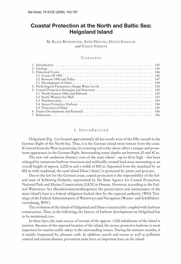
Coastal Protection at the North and Baltic Sea: Helgoland Island
By KLAUS BEDNARCZYK, ANNE HEELING, DETLEF SCHALLER and ULRICH VIERFUSS
C o n t e n t s
1. Introduction . . . . . . . . . . . . . . . . . . . . . . . . . . . . . . . . . . . . . . . . . 1432. Geology . . . . . . . . . . . . . . . . . . . . . . . . . . . . . . . . . . . . . . . . . . . . 1443. Historical Events . . . . . . . . . . . . . . . . . . . . . . . . . . . . . . . . . . . . . . . 146 3.1 Events till 1890 . . . . . . . . . . . . . . . . . . . . . . . . . . . . . . . . . . . . . . 146 3.2 Between 1890 and Today . . . . . . . . . . . . . . . . . . . . . . . . . . . . . . . . 147 3.3 Development of Düne . . . . . . . . . . . . . . . . . . . . . . . . . . . . . . . . . . 1494. Hydrological Parameters, Design Water Levels . . . . . . . . . . . . . . . . . . . . . . 1525. Coastal Protection Strategies and Structures . . . . . . . . . . . . . . . . . . . . . . . . 152 5.1 North-Eastern Dike and Bulwark . . . . . . . . . . . . . . . . . . . . . . . . . . . 152 5.2 South-Western Sea Wall . . . . . . . . . . . . . . . . . . . . . . . . . . . . . . . . . 153 5.3 Northern Jetty . . . . . . . . . . . . . . . . . . . . . . . . . . . . . . . . . . . . . . 154 5.4 Secure Protective Harbour . . . . . . . . . . . . . . . . . . . . . . . . . . . . . . . 154 5.5 Protection of Düne . . . . . . . . . . . . . . . . . . . . . . . . . . . . . . . . . . . 1556. Future Development and Research . . . . . . . . . . . . . . . . . . . . . . . . . . . . . 1567. References . . . . . . . . . . . . . . . . . . . . . . . . . . . . . . . . . . . . . . . . . . . 156
1. I n t r o d u c t i o n
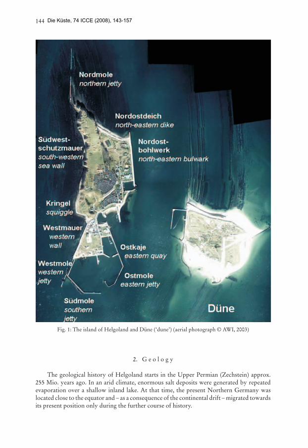
Helgoland (Fig. 1) is located approximately 60 km north-west of the Elbe mouth in the German Bight of the North Sea. Thus, it is the German island most remote from the coast. If viewed from the West in particular, its towering red rocky shore offers a unique and prom-inent appearance in the German Bight. Surrounding water depths are between 20 and 40 m.
The new red sandstone (bunter) core of the main island – up to 60 m high – has been enlarged by numerous harbour structures and artificially created land areas amounting to an overall length of approx. 2,200 m and a width of 800 m. Separated from the mainland by an 800 m wide roadstead, the sand island Düne (‘dune’) is protected by jetties and groynes.
Due to the law for the German coast, coastal protection is the responsibility of the fed-eral state of Schleswig-Holstein, represented by the State Agency for Coastal Protection, National Park and Marine Conservation (LKN) in Husum. However, according to the Fed-eral Waterways Act (Bundeswasserstraßengesetz) the preservation and maintenance of the main island’s base is a federal obligation looked after by the regional authority (WSA Tön-ning) of the Federal Administration of Waterways and Navigation (Wasser- und Schifffahrts-verwaltung, WSV).
The evolution of the island of Helgoland and Düne is inextricably coupled with harbour construction. Thus, in the following, the history of harbour development on Helgoland has to be mentioned, too.
In these days, the main source of income of the approx. 1,500 inhabitants of the island is tourism. Because of the exposed location of the island, the secure protective harbour is most important for marine traffic safety in the surrounding waters. During the summer months, it is mainly frequented by pleasure craft. In addition, search and rescue as well as pollution control and marine disaster prevention units have an important base on the island.
Die Küste, 74 ICCE (2008), 143-157
144
2. G e o l o g y
The geological history of Helgoland starts in the Upper Permian (Zechstein) approx. 255 Mio. years ago. In an arid climate, enormous salt deposits were generated by repeated evaporation over a shallow inland lake. At that time, the present Northern Germany was located close to the equator and – as a consequence of the continental drift – migrated towards its present position only during the further course of history.
Fig. 1: The island of Helgoland and Düne (‘dune’) (aerial photograph © AWI, 2003)
Die Küste, 74 ICCE (2008), 143-157
145
The intrinsic bedrock genesis started in the Upper Trias (Buntsandstein) some 250 Mio. years ago. Helgoland could be found at the western edge of the ‘Germanisches Becken’ (Germanic Basin), a long-stretched depression which extended to the present river Weichsel in the East. Coming from the southern elevated plains, immense quantities of debris (con-glomerates, sandstone and mudstone) were transported by rivers and deposited in the depres-sion. Today, these layers have a thickness of approx. 1,000 m. Fossils and fossil sediment structures (ripple marks, dry desiccation crevices, and rain drop impressions) indicate that layers were deposited while water depths varied. The red colouration of the Helgoland rock is typical for a desert-like climate and was created by iron oxide coating the sand grains as a matrix. In some locations this binding agent is missing, and white unconsolidated layers oc-cur. In former times, this material was used by the inhabitants of Helgoland to cover the floors of their houses (Katen). Thus, it was named ‘Katersand’.
During the middle Trias (Muschelkalk) the Germanische Becken turned into a shallow sea. The red desert sediments of the Buntsandstein were covered with a 300 m layer of fossil-rich grey limestone and gypsum. Even 250 years ago, the ‘Wittekliff’, made of Muschelkalk material, protruded about 60 m above the water surface in front of the Düne island. Muschel-kalk sediments are still the base of Düne.
No depositions of Keuper, i.e. the Upper Trias, of the entire Jurassic and of Tertiary can be found in the stratigraphic sequence of Helgoland. This is possibly already an indication of the beginning of salt tectonics. In Northern Germany, the Triassic sediments – overlaid by younger layers – can normally be found in depths of several thousand metres. Only at Helgo-land, they break the surface. During Cretaceous and Tertiary, the Permian salt was mobilized – due to its lesser density – under the weight of younger sediments. The salt layers became ductile, started to rise along weaker areas and lift and tilt the covering layers.
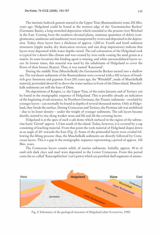
Helgoland is at the apex of such a salt dome which surfaced in the region of the subma-rine basin ‘Görtel’ approx. 1.5 km south of the island. Today, however, it is covered by a cap consisting of leaching material. From that point the rock material of Helgoland slopes down at an angle of 20o towards the East (Fig. 2). Some of the primordial layers were eroded fol-lowing the lifting process: thus, the Muschelkalk sediments are directly followed by Creta-ceous layers. This is a gap in the stratigraphic sequence representing a period of approx. 100 Mio. years.
The Cretaceous layers consist solely of marine sediments. Initially, approx. 40 m of ossil-rich dark clays and marl were deposited in the Lower Cretaceous. From this period come the so-called ‘Katzenpfötchen’ (cat’s paws) which are petrified shell segments of ammo-
Fig. 2: Schematics of the geological structure of Helgoland (after SCHMIDTKE, 1995)
Die Küste, 74 ICCE (2008), 143-157
146
nites as well as ‘Donnerkeile’ (thunderbolts) which are petrified internal shells of belemnites and can be found along the shores of the Düne. On top of this, a layer of 1 m dark bituminous marl, which is rich in fossil fish and ammonites, is found: in Helgoland dialect it is called ‘Kreide-Töck’ (chalk-mist). The 260 m layer of Upper Cretaceous Schreibkreide (chalkstone) with intermediate layers of flint stone (remnants of diatoms) constitutes the outer eastern cliff elbow. Its red flint stones cannot be found in any other place around the world.
1.8 Mio. years ago at the start of Pleistocene, the older Quaternary, the area of Helgoland consists of mainland mountains which were covered by glaciers during the Elster as well as the Saale glacial period. This is also indicated by till from the Saale glacial period on the island top. Between 1945 and 1947, this material was largely blasted away or moved by British bombs. Following the Elster and Saale glacial periods during the Eem interglacial, Helgoland was either part of the mainland or a large wooded island with a formation of peat and limnic sediments in small depressions – the so-called ‘Süßwasser-Töck’. After this period, the ice never reached Helgoland again.
The development towards the island as it is known today started with the melting of the glaciers some 10,000 years ago and the sea level in the North Sea region rising by approx. 100 m: Helgoland became an island. Today, the island is still subjected to erosion by wind and waves. The development of ledges (‘Hörner’) and promontories with bays (‘Slaps’) in be-tween is characteristic of Helgoland. Those promontories can be ruptured by surf action to form arcs (‘surf gates’). If these collapse rock towers (‘Stacks’) remain: the landmark of Helgoland ‘Lange Anna’ is such a Stack.
3. H i s t o r i c a l E v e n t s
3.1 E v e n t s t i l l 1 8 9 0
Earliest traces of civilization (burial mounds) on Helgoland date back to the New Stone Age or Neolithic. Contemporary documents prove that Helgoland was occupied by Frisians in the 7th century. Between the 12th and 15th century, the island was under the influence of the Danish crown and became part of the duchy of Schleswig.
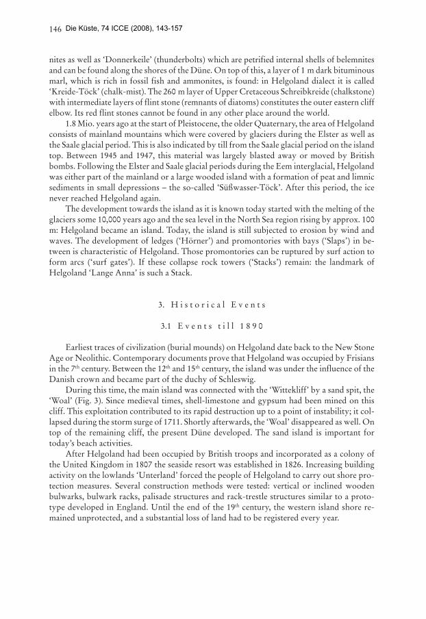
During this time, the main island was connected with the ‘Wittekliff’ by a sand spit, the ‘Woal’ (Fig. 3). Since medieval times, shell-limestone and gypsum had been mined on this cliff. This exploitation contributed to its rapid destruction up to a point of instability; it col-lapsed during the storm surge of 1711. Shortly afterwards, the ‘Woal’ disappeared as well. On top of the remaining cliff, the present Düne developed. The sand island is important for today’s beach activities.
After Helgoland had been occupied by British troops and incorporated as a colony of the United Kingdom in 1807 the seaside resort was established in 1826. Increasing building activity on the lowlands ‘Unterland’ forced the people of Helgoland to carry out shore pro-tection measures. Several construction methods were tested: vertical or inclined wooden bulwarks, bulwark racks, palisade structures and rack-trestle structures similar to a proto-type developed in England. Until the end of the 19th century, the western island shore re-mained unprotected, and a substantial loss of land had to be registered every year.
Die Küste, 74 ICCE (2008), 143-157
147
3.2 B e t w e e n 1 8 9 0 a n d T o d a y
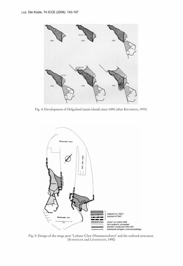
In 1890 Great Britain relinquished the ownership of the island to the German Empire in exchange of rights in Africa (so-called Helgoland – Zanzibar – Treaty). The emperor Wilhelm II had Helgoland turned into a navy base. Now, shore protection measures at the western part of the island were accelerated since in many places the unsecured rock cliffs threatened to collapse onto the gun emplacements, underground shelters and bunkers. Consequently, in 1903, the construction of the protective south-west beach wall began with the last gap closed in 1927. South of the rock island, the naval port with new harbour facilities and large jetties was established (Fig. 4).
During WWI, the island and the port were spared any destruction. Only due to the Versailles Treaty, military installations together with the jetties had to be blown up or stripped down. However, because of the insufficient shelter for marine traffic and for the sake of the island itself protection measures and the rebuilding of the western jetty started already in 1928.
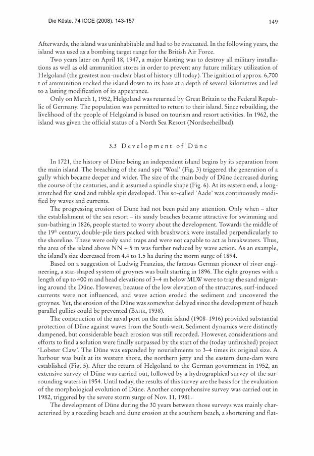
During WWII, the ‘fortress on the high seas’ was considered to be of great military importance. Planning reached a climax with the harbour project ‘lobster claw (Hummer-schere)’ triggering the construction of additional jetties and the present north-east area (Fig. 5). This project, including island and Düne, was to turn Helgoland into one of the largest ice-free harbours of Europe. Consequently, extensive beach nourishments for en-largement of the area of the Düne and the construction of embankments towards the North began. Within this project, the Düne harbour on the eastern shore of the Düne was built (1938–1941).
However, during WWII, the real military importance of the island proved to be mar-ginal. In spite of that, the British Air Force carried out a devastating air raid on the island on April 18, 1945: 1,000 British aircraft dropped approx. 7,000 bombs within a period of 2 hours.
Fig. 3: The island of Helgoland with the ‘Wittekliff’ and ‘Woal’ in the 17th century (map by Johannes Mejer, 1694)
Die Küste, 74 ICCE (2008), 143-157
148
Fig. 4: Development of Helgoland (main island) since 1890 (after KRUMBEIN, 1975)
Fig. 5: Design of the mega-port ‘Lobster Claw (Hummerschere)’ and the realized structures (SCHINDLER and LINDEMANN, 1990)
Die Küste, 74 ICCE (2008), 143-157
149
Afterwards, the island was uninhabitable and had to be evacuated. In the following years, the island was used as a bombing target range for the British Air Force.
Two years later on April 18, 1947, a major blasting was to destroy all military installa-tions as well as old ammunition stores in order to prevent any future military utilization of Helgoland (the greatest non-nuclear blast of history till today). The ignition of approx. 6,700 t of ammunition rocked the island down to its base at a depth of several kilometres and led to a lasting modification of its appearance.
Only on March 1, 1952, Helgoland was returned by Great Britain to the Federal Repub-lic of Germany. The population was permitted to return to their island. Since rebuilding, the livelihood of the people of Helgoland is based on tourism and resort activities. In 1962, the island was given the official status of a North Sea Resort (Nordseeheilbad).
3.3 D e v e l o p m e n t o f D ü n e
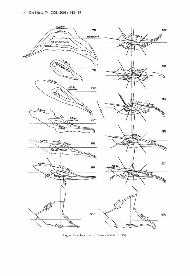
In 1721, the history of Düne being an independent island begins by its separation from the main island. The breaching of the sand spit ‘Woal’ (Fig. 3) triggered the generation of a gully which became deeper and wider. The size of the main body of Düne decreased during the course of the centuries, and it assumed a spindle shape (Fig. 6). At its eastern end, a long-stretched flat sand and rubble spit developed. This so-called ‘Aade’ was continuously modi-fied by waves and currents.
The progressing erosion of Düne had not been paid any attention. Only when – after the establishment of the sea resort – its sandy beaches became attractive for swimming and sun-bathing in 1826, people started to worry about the development. Towards the middle of the 19th century, double-pile tiers packed with brushwork were installed perpendicularly to the shoreline. These were only sand traps and were not capable to act as breakwaters. Thus, the area of the island above NN + 5 m was further reduced by wave action. As an example, the island’s size decreased from 4.4 to 1.5 ha during the storm surge of 1894.
Based on a suggestion of Ludwig Franzius, the famous German pioneer of river engi-neering, a star-shaped system of groynes was built starting in 1896. The eight groynes with a length of up to 400 m and head elevations of 3–4 m below MLW were to trap the sand migrat-ing around the Düne. However, because of the low elevation of the structures, surf-induced currents were not influenced, and wave action eroded the sediment and uncovered the groynes. Yet, the erosion of the Düne was somewhat delayed since the development of beach parallel gullies could be prevented (BAHR, 1938).
The construction of the naval port on the main island (1908–1916) provided substantial protection of Düne against waves from the South-west. Sediment dynamics were distinctly dampened, but considerable beach erosion was still recorded. However, considerations and efforts to find a solution were finally surpassed by the start of the (today unfinished) project ‘Lobster Claw’. The Düne was expanded by nourishments to 3–4 times its original size. A harbour was built at its western shore, the northern jetty and the eastern dune-dam were established (Fig. 5). After the return of Helgoland to the German government in 1952, an extensive survey of Düne was carried out, followed by a hydrographical survey of the sur-rounding waters in 1954. Until today, the results of this survey are the basis for the evaluation of the morphological evolution of Düne. Another comprehensive survey was carried out in 1982, triggered by the severe storm surge of Nov. 11, 1981.
The development of Düne during the 30 years between those surveys was mainly char-acterized by a receding beach and dune erosion at the southern beach, a shortening and flat-
Die Küste, 74 ICCE (2008), 143-157
150
Fig. 6: Development of Düne (SPAETH, 1990)
Die Küste, 74 ICCE (2008), 143-157
151
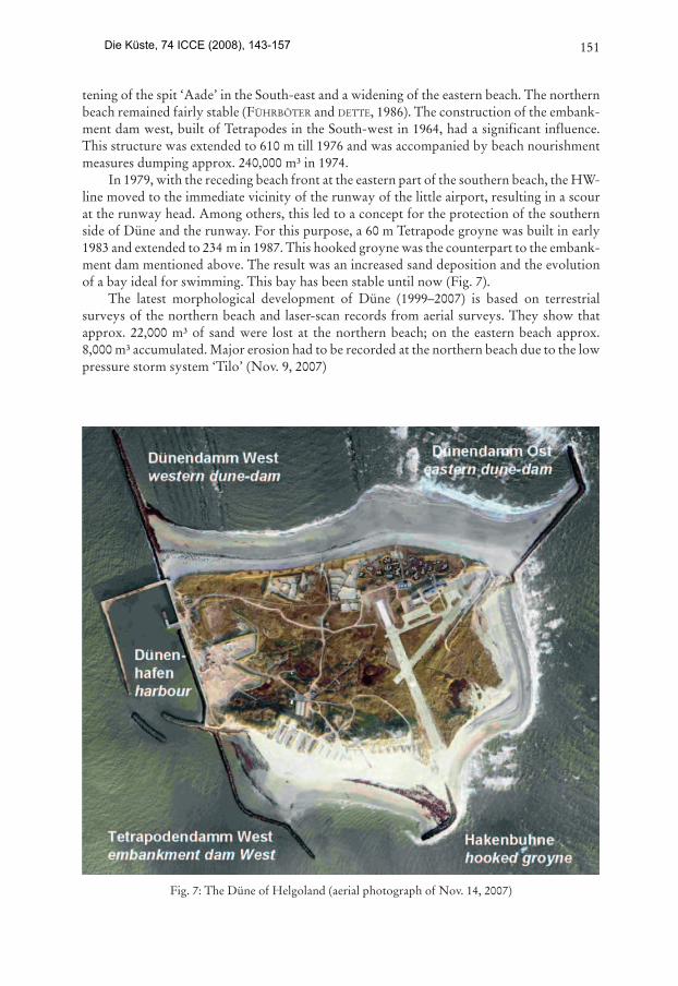
tening of the spit ‘Aade’ in the South-east and a widening of the eastern beach. The northern beach remained fairly stable (FÜHRBÖTER and DETTE, 1986). The construction of the embank-ment dam west, built of Tetrapodes in the South-west in 1964, had a significant influence. This structure was extended to 610 m till 1976 and was accompanied by beach nourishment measures dumping approx. 240,000 m³ in 1974.
In 1979, with the receding beach front at the eastern part of the southern beach, the HW-line moved to the immediate vicinity of the runway of the little airport, resulting in a scour at the runway head. Among others, this led to a concept for the protection of the southern side of Düne and the runway. For this purpose, a 60 m Tetrapode groyne was built in early 1983 and extended to 234 m in 1987. This hooked groyne was the counterpart to the embank-ment dam mentioned above. The result was an increased sand deposition and the evolution of a bay ideal for swimming. This bay has been stable until now (Fig. 7).
The latest morphological development of Düne (1999–2007) is based on terrestrial surveys of the northern beach and laser-scan records from aerial surveys. They show that approx. 22,000 m³ of sand were lost at the northern beach; on the eastern beach approx. 8,000 m³ accumulated. Major erosion had to be recorded at the northern beach due to the low pressure storm system ‘Tilo’ (Nov. 9, 2007)
Fig. 7: The Düne of Helgoland (aerial photograph of Nov. 14, 2007)
Die Küste, 74 ICCE (2008), 143-157
152
4. H y d r o l o g i c a l P a r a m e t e r s , D e s i g n W a t e r L e v e l s
Water level recordings and measurements of currents and waves are the basis for these parameters. The first water level measurements at the tide gauge on Helgoland were carried out and recorded in September 1880. After changing its location several times, the gauge has been at its current position (Fig. 1) since Nov. 1, 1961. Time series of water levels include gaps, particularly for HW, between 1911 and 1952 and during war times. Since 1952, water levels have been continuously recorded, analyzed and published in the Hydrological Year Book (Deutsches Gewässerkundliches Jahrbuch) for the North and Baltic Sea coast (ROHDE, 1990). While the annual means for the time series 1996 – 2005 show a HW = NN + 1.16 m, LW = NN – 1.23 m and a tidal range of 2.39 m the highest recorded storm surge at the gauge Helgoland was at NN + 3.87 m on Feb. 16, 1962. Other major storms occurred in Jan. 1976, Feb. 1990 and Nov. 1982.
Based on the ‘general arrangement plan for coastal protection in Schleswig-Holstein (Generalplan Küstenschutz S-H)’ of 2001, the reference water level for 2010 is at NN + 4.30 m, and the design water level 2100 is at NN + 4.50 m (MLR, 2001). In addition to the highest water level, the maximum wind set-up occurring with storm surges is important for the design of structures for coastal and flood protection. Investigations into storm surges and wind set-up in the German Bight show a maximum set-up of 3.30 m with a forward slope of 5.5 h/m. This characteristic curve can occur at HW and, therefore, be a component of a severe storm surge (GÖNNERT, 2003).
Due to its exposed location in the open North Sea, the island of Helgoland is particularly prone to wave action. During the storm surge of Jan. 28, 1994, significant wave heights of up to 6.8 m were recorded. In a research project conducted by the Federal Waterways Engineer-ing and Research Institute (Bundesanstalt für Wasserbau, BAW), the standard wave para-meters for the waters around Helgoland were determined (VIERFUSS, 2002) based on results of a comprehensive hind-cast (GKSS Research Centre) of the years 1955 to 1994. The highest significant waves can occur from WSW to NW with heights between 7 and 8 m (return in-terval 100 years). Wave dissipation on the rock base of the island (Felswatt) was taken into account according to the various locations of the considered structures. For the examination of the stability and structural safety of the jetties, design wave heights of up to 9.50 m with a return interval of 100 years were assumed. The functional design and dimensioning of the northern Düne embankments was carried out with the support of suitable model investiga-tions with boundary waves coming from NW. In addition, system analyses in a 2-D current model supported determining the optimal length of the dams.
5. C o a s t a l P r o t e c t i o n S t r a t e g i e s a n d S t r u c t u r e s
5.1 N o r t h - E a s t e r n D i k e a n d B u l w a r k
The obligatory coastal protection activities of Schleswig-Holstein cover the main island as well as the Düne if danger of flooding of populated areas is involved. Towards the end of the 1930s, the construction of the north-eastern bulwark made possible the raising of the north-eastern terrain by hydraulic deposition up to the rock base and the planned utilization of the newly established area. The 950 m long dike had been built from the cliff edge of the ‘Oberland’ to the north-eastern harbour to protect the rear area against flooding. On this terrain, important infrastructure installations such as the power station, the desalination
Die Küste, 74 ICCE (2008), 143-157
153
plant, the health resort treatment facilities, the seawater pool, the sports field and a student dormitory are located.
Based on the amendment of the water laws (Wassergesetz, 1992) of Schleswig-Holstein, the north-eastern dike behind the north-eastern bulwark and the adjacent stretch joining the ‘Oberland’ obtained the highest status of a flood protection structure (Landesschutzdeich). Now, its average crown elevation is at NN + 5.90 m on its entire length. The reference water level 2010 for safety inspection purposes is at NN + 4.30 m (MLR, 2001). Dimensioning of this dike was done based on small-scale physical model studies to obtain the run-up height for the complex slope profiles, which are being influenced by the north-eastern bulwark, a wide shore promenade and the dike itself (SCHÜTTRUMPF et al., 1997).
The north-eastern bulwark had been fundamentally renovated in the years from 1978 to 1980. In front of the old gabion construction, a new wall of steel girders with suspended pre-fabricated concrete elements had been erected. A curtain of concrete foundation piles drilled into the bunter was to prevent scouring and secure the sand filled in between the old and new structure. The northern sloped cofferdam adjacent to the bulwark was armoured with 8t Dolosse (SCHINDLER and LINDEMANN, 1990).
Following the upgrading of the north-eastern bulwark, the north-eastern harbour – ad-jacent towards the South – was improved. Its quay walls protect the near-harbour buildings and – to the North – safeguard the underground freshwater bubble. On top of the existing quay a flood retention wall with a crown elevation of NN + 4.85 m for the protection of the adjacent terrain was built.
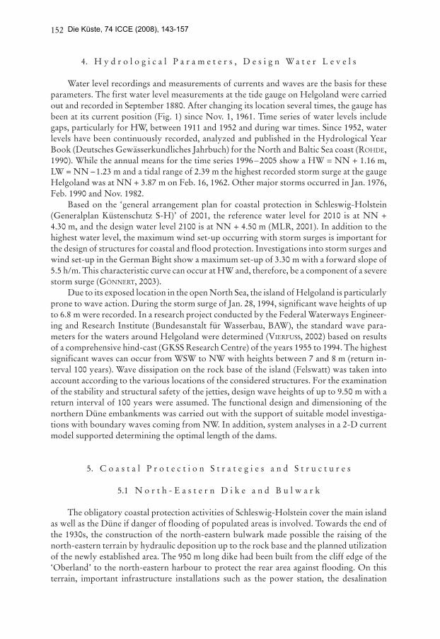
5.2 S o u t h - W e s t e r n S e a W a l l
The most vital structure to protect the island base is the south-western sea wall – also called the Prussian wall (Preußenmauer ) – which is being maintained by WSA Tönning. It protects the rock walls and prevents wave-induced erosion processes (generation of surf grooving, surf portals and ‘Stacks’) at the strongly attacked western shore of the island. Moreover, it is to collect debris which is continuously generated by rain, spray, frost and wind and drops from above. Initially, this material was thought to adjust itself to form a naturally flat slope which would eventually be covered by natural growth and protect the bunter against further erosion. However wave action prevented this. Particularly during storm surges the erosion by wave overtopping is so strong that rubble and debris are carried away. Thus, the south-western wall only protects against direct wave attack.
The sea wall was erected using a combination of concrete blocks, poured concrete and a covering of natural stone blocks between 1903 and 1913 and between 1926 and 1927. It was substantially damaged by bombs during and after WWII and reconstructed in concrete be-tween 1960 and 1963. The average crown elevation is at approx. HW + 3.50 m, and the toe of the rock slope in front of the wall is close to LW. Towards the North, the south-western sea wall merges into the northern jetty. South of the ‘Kringel’, which was generated by the blast-ing in 1947, it continues to cross over into the shore protection and jetty structures of the secure protective harbour.
Die Küste, 74 ICCE (2008), 143-157
154
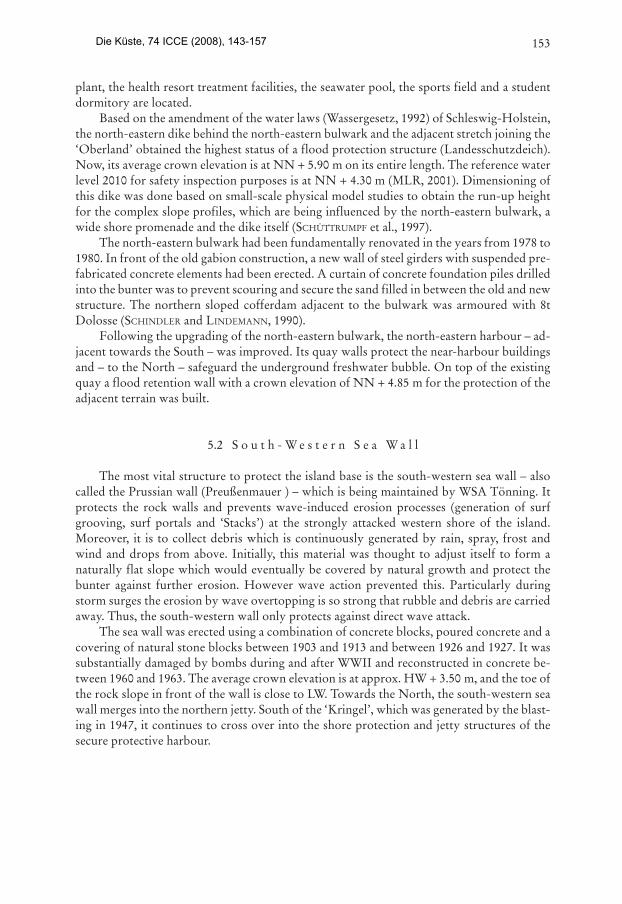
5.3 N o r t h e r n J e t t y
The northern jetty – also called the Island Dam North (Inseldamm Nord) – was built as part of the naval port project in 1940. As a continuation of the south-western beach wall, it extends into open water. Even though, the jetty remained a fragment. Today, the 550 m sec-tion connected with the south-western wall is followed by a gap – left for operational reasons – and another 350 m section. The jetty provides some protection for the rock terrace and the North shore against waves from westerly directions. However, the protected area is relatively small.
5.4 S e c u r e P r o t e c t i v e H a r b o u r
The former naval port serves as a secure protective harbour (harbour of refuge) today. Even though it was never intended to be a coastal protection structure, it contributes with its outer jetties and reinforced embankments that extend the island southward to the protection of main island and Düne. The outer protective ring of the harbour is composed of the west-ern wall, western and southern jetty, eastern jetty and quay (Fig. 1). Because of their ever-changing history of destruction and re-construction these are made up of partially very old building fabric needing substantial corrective maintenance today. Further information can be found in the relevant literature (e.g. THIEMANN, 1990; RÖBEN, 1990).
Fig. 8: View of the cliff coast and a part of the south-western sea wall (Photo: H. J. Bennöhr, 2005, Wikipedia Commons)
Die Küste, 74 ICCE (2008), 143-157
155
Fig. 9: View of the northern jetty and the rocky foreshore (Felswatt) north of the main island (Photo: TomCatX, 2007, Wikipedia Commons)
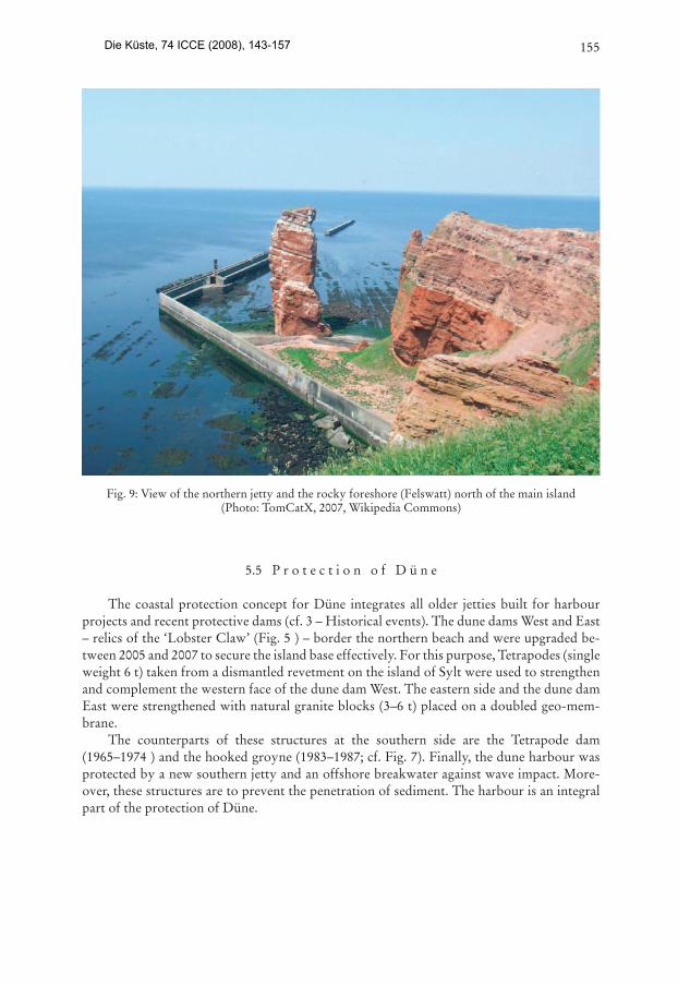
5.5 P r o t e c t i o n o f D ü n e
The coastal protection concept for Düne integrates all older jetties built for harbour projects and recent protective dams (cf. 3 – Historical events). The dune dams West and East – relics of the ‘Lobster Claw’ (Fig. 5 ) – border the northern beach and were upgraded be-tween 2005 and 2007 to secure the island base effectively. For this purpose, Tetrapodes (single weight 6 t) taken from a dismantled revetment on the island of Sylt were used to strengthen and complement the western face of the dune dam West. The eastern side and the dune dam East were strengthened with natural granite blocks (3–6 t) placed on a doubled geo-mem-brane.
The counterparts of these structures at the southern side are the Tetrapode dam (1965–1974 ) and the hooked groyne (1983–1987; cf. Fig. 7). Finally, the dune harbour was protected by a new southern jetty and an offshore breakwater against wave impact. More-over, these structures are to prevent the penetration of sediment. The harbour is an integral part of the protection of Düne.
Die Küste, 74 ICCE (2008), 143-157
156
6. F u t u r e D e v e l o p m e n t a n d R e s e a r c h
Coastal protection on the island of Helgoland is predominantly determined by the pres-ervation and maintenance of the sandy beaches of Düne. This requires a regular evaluation of the availability of sand at the beach, at the Düne itself and on the foreshore by means of a measurement and monitoring program. The external forces such as water levels, currents and waves are measured at representative points of a grid. The spatial distribution of these para-meters is calculated using empirical formulae or numerical models.
Morphological changes of the foreshore area and of the sandy coastlines are monitored based on hydrographical, terrestrial and laser-scanning surveys supported by aerial photo-graphs (Ortho-photos). Furthermore, terrestrial survey is used to record the actual status, changes or new additions of all coastal protection structures (dikes, revetments, bush dams etc.). The information is stored and made available in the Coastal Protection Information System (KIS) of Schleswig-Holstein.
While continuous water level data from the tidal gauge ‘Helgoland’ are at hand (chapter 4), measurements of waves close to the island are carried out by the Federal Maritime Agency (Bundesamt für Seeschifffahrt und Hydrographie, BSH) and data can be used as input to numerical models. These have been increasingly applied for preliminary investigations and planning during the past few years. Generally, the well-known wave model SWAN for wave investigations and various tidal 2D- or 3D-models are available to authorities or consultants. Even though several morphodynamic models have been applied to similar problems, there is still a considerable need for research and development concerning the evaluation of evolution of sandy coastlines.
7. R e f e r e n c e s
BAHR, M.: Die Veränderungen der Helgoländer Düne und des umgebenden Seegebiets. Jahrbuch der Hafenbautechnischen Gesellschaft, Bd. 17, 1938.
BAHR, M.: Der Wiederaufbau der Hafenanlagen von Helgoland. Handbuch für Hafenbau und Umschlagtechnik, Bd. II, 1955.
DVWK (Hrsg.): Historischer Küstenschutz. Verlag K. Wittwer, Stuttgart, 1992.FÜHRBÖTER, A. u. DETTE, H.-H.: Zur Entwicklung der Düne Helgoland. Die Küste, H. 43,
1986.GEOLOGISCH-PALÄONTOLOGISCHES INSTITUT DER UNIVERSITÄT HAMBURG (Hrsg., 1980): Helgo-
land, Portrait einer Felseninsel. Sonderausstellung vom 13.11.1979 bis 31.3.1980.GÖNNERT, G.: Sturmfluten und Windstau in der Deutschen Bucht, Charakter, Veränderungen
und Maximalwerte im 20. Jahrhundert. Die Küste, H. 67, 185–365, 2003.HARTKOPF, T.: Schutz- und Sicherheitshafen Helgoland. HANSA (138), Nr. 9, 2001.JAKOBY, G.: Helgoland bei Johannes Mejer und Adam von Bremen. Die Küste, H. 2, 1954.JANKE, K.: Die Lebensgemeinschaften im Felswatt von Helgoland: Einzigartige Vielfalt an
Deutschlands Nordseeküste. Die Küste, H. 49, 1990.KLEIN, H. u. MITTELSTAEDT, E.: Gezeitenströme und Tidekurven im Nahfeld von Helgoland,
Berichte des Bundesamtes für Seeschifffahrt und Hydrographie, Hamburg und Rostock, 2001.
KRUMBEIN, W. E.: Verwitterung, Abtragung und Küstenschutz auf der Insel Helgoland. Abhand-lungen und Verhandlungen des Naturwissenschaftlichen Vereins in Hamburg, Bd. 18/19, 1975.
LORENZEN, J. M.: Der Abschluß der Wiederaufbauarbeiten an den Hafen- und Küstenschutz-bauten auf der Insel Helgoland. Jahrbuch der Hafenbautechnischen Gesellschaft, Bd. 27/28, 1965, S. 208–218.
Die Küste, 74 ICCE (2008), 143-157
157
MLR (MINISTERIUM FÜR LÄNDLICHE RÄUME, LANDESPLANUNG, LANDWIRTSCHAFT UND TOURISMUS DES LANDES SCHLESWIG-HOLSTEIN) (Hg.): Generalplan Küstenschutz Integriertes Küsten-schutzmanagement in Schleswig-Holstein, Kiel, 2001.
OUMERACI, H.; SCHÜTTRUMPF, H. u. KOETHER, G.: Ermittlung der maßgebenden Wellenauflauf-höhe für das Nordost-Bohlwerk und den Nordabschnitt des Nordost-Deiches auf Hel-goland. Leichtweiß-Institut für Wasserbau der TU Braunschweig, Bericht Nr. 807, August 1996.
RICKMERS, H. P. u. WOOSNAM, F: Helgoland eine Insel auf dem Wege nach Europa, Nieder-elbeverlag, Otterndorf/Helgoland, 1992.
RÖBEN, J.: Hafenbau auf Helgoland nach dem 2. Weltkrieg. Die Küste, H. 49, 1990.ROSS, P.-H.: Beitrag zur Ingenieurgeologie Helgolands. Die Küste, H. 49, 1990.SCHINDLER, J. u. LINDEMANN, H.: Bau und Instandsetzung kommunaler Hafen- und Uferanlagen
der Insel Helgoland seit 1952. Die Küste, H. 49, 1990.SCHMIDT-THOMÉ, P.: Helgoland. Seine Dünen-Insel, die umgebenden Klippen und Meeres-
gründe. Sammlung geologischer Führer 82. Gebr. Borntraeger, Berlin, Stuttgart, 1987.SCHMIDTKE, K.-D.: Die Entstehung Schleswig-Holsteins. 3. Aufl., Wachholtz Verlag, Kiel,
1995.SCHÜTTRUMPF, H.; BIEMÜLLER, G. u. OUMERACI, H.: Maßgebende Wellenauflaufhöhe für die
Bemes sung des Landesschutzdeiches auf Helgoland. Wasser & Boden (49), S. 54–57, 12/1997.
SIEBS, B. E. u. WOHLENBERG, E.: Helgoland und die Helgoländer, Ferdinand Hirt in Kiel, 1953.SIEFERT, W.: Tide, Windstau, Seegang im Raume Helgoland. Die Küste, H. 49, 1990.SPAETH, CHR.: Zur Geologie der Insel Helgoland. Die Küste, H. 49, 1990.THIEMANN, J.: Die Geschichte der Hafenanlagen der Insel Helgoland bis 1952. Die Küste, H. 49,
1990. THIEMANN, J.: Die Südwest-Schutzmauer der Insel Helgoland. Die Küste, H. 49, 1990.VIERFUSS, U.: Ermittlung der Seegangsbelastung für Helgoländer Molenbauwerke. HANSA
139/1, S. 68–73, 2002.WEISSE, R.; FESER, F. u. GÜNTHER, H.: Wind und Seegangsklimatologie 1958–2001 für die südliche
Nordsee basierend auf Modellrechnungen. GKSS, Geesthacht, 2003.
Internet: http://wsa-toenning.wsv.de/Bauwerke/Hafen Helgoland/index.html
Die Küste, 74 ICCE (2008), 143-157