Embed Size (px)
Citation preview
1
Coastal Systems
Introduction
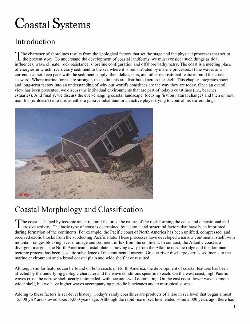
he character of shorelines results from the geological factors that set the stage and the physical processes that script the present story. To understand the development of coastal landforms, we must consider such things as tidal
influences, wave climate, rock resistance, shoreline configuration and offshore bathymetry. The coast is a meeting place of energies in which rivers carry sediment to the sea where it is redistributed by marine processes. If the waves and currents cannot keep pace with the sediment supply, then deltas, bars, and other depositional features build the coast seaward. Where marine forces are stronger, the sediments are distributed across the shelf. This chapter integrates short- and long-term factors into an understanding of why our world's coastlines are the way they are today. Once an overall view has been presented, we discuss the individual environments that are part of today's coastlines (i.e., beaches, estuaries). And finally, we discuss the ever-changing coastal landscape, focusing first on natural changes and then on how man fits (or doesn't) into this as either a passive inhabitant or an active player trying to control his surroundings.
Coastal Morphology and Classification
he coast is shaped by tectonic and structural features, the nature of the rock forming the coast and depositional and erosive activity. The basic type of coast is determined by tectonic and structural factors that have been imprinted
during formation of the continents. For example, the Pacific coast of North America has been uplifted, compressed, and received exotic blocks from the subducting Pacific Plate. These processes have developed a narrow continental shelf, with mountain ranges blocking river drainage and sediment influx from the continent. In contrast, the Atlantic coast is a divergent margin - the North American crustal plate is moving away from the Atlantic oceanic ridge and the dominant tectonic process has been isostatic subsidence of the continental margin. Greater river discharge carries sediments to the marine environment and a broad coastal plain and wide shelf have resulted. Although similar features can be found on both coasts of North America, the development of coastal features has been affected by the underlying geologic character and the wave conditions specific to each. On the west coast, high Pacific waves cross the narrow shelf nearly unimpeded, with oceanic swell dominating. On the east coast, lower waves cross a wider shelf, but we have higher waves accompanying periodic hurricanes and extratropical storms. Adding to these factors is sea-level history. Today's sandy coastlines are products of a rise in sea level that began almost 15,000 yBP and slowed about 5,000 years ago. Although the rapid rise of sea level ended some 5,000 years ago, there has
T
T
2
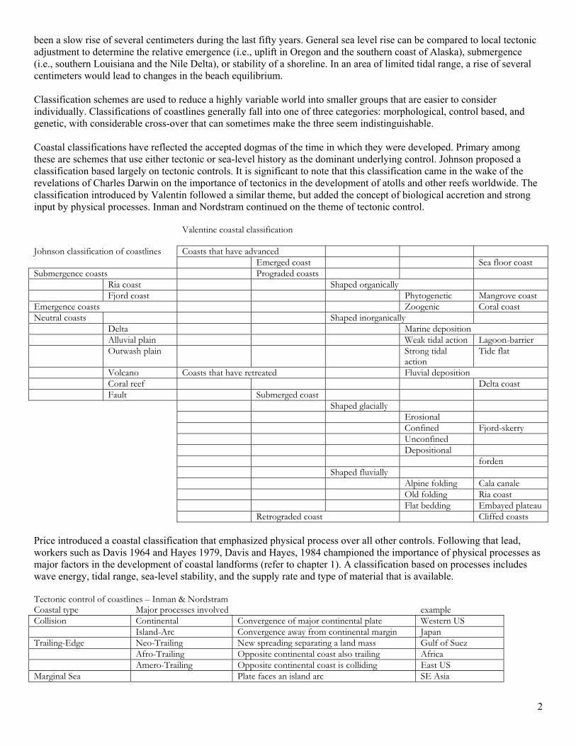
been a slow rise of several centimeters during the last fifty years. General sea level rise can be compared to local tectonic adjustment to determine the relative emergence (i.e., uplift in Oregon and the southern coast of Alaska), submergence (i.e., southern Louisiana and the Nile Delta), or stability of a shoreline. In an area of limited tidal range, a rise of several centimeters would lead to changes in the beach equilibrium. Classification schemes are used to reduce a highly variable world into smaller groups that are easier to consider individually. Classifications of coastlines generally fall into one of three categories: morphological, control based, and genetic, with considerable cross-over that can sometimes make the three seem indistinguishable. Coastal classifications have reflected the accepted dogmas of the time in which they were developed. Primary among these are schemes that use either tectonic or sea-level history as the dominant underlying control. Johnson proposed a classification based largely on tectonic controls. It is significant to note that this classification came in the wake of the revelations of Charles Darwin on the importance of tectonics in the development of atolls and other reefs worldwide. The classification introduced by Valentin followed a similar theme, but added the concept of biological accretion and strong input by physical processes. Inman and Nordstram continued on the theme of tectonic control. Valentine coastal classification Johnson classification of coastlines Coasts that have advanced Emerged coast Sea floor coast Submergence coasts Prograded coasts Ria coast Shaped organically Fjord coast Phytogenetic Mangrove coast Emergence coasts Zoogenic Coral coast Neutral coasts Shaped inorganically Delta Marine deposition Alluvial plain Weak tidal action Lagoon-barrier Outwash plain Strong tidal
action Tide flat
Volcano Coasts that have retreated Fluvial deposition Coral reef Delta coast Fault Submerged coast Shaped glacially Erosional Confined Fjord-skerry Unconfined Depositional forden Shaped fluvially Alpine folding Cala canale Old folding Ria coast Flat bedding Embayed plateau Retrograded coast Cliffed coasts Price introduced a coastal classification that emphasized physical process over all other controls. Following that lead, workers such as Davis 1964 and Hayes 1979, Davis and Hayes, 1984 championed the importance of physical processes as major factors in the development of coastal landforms (refer to chapter 1). A classification based on processes includes wave energy, tidal range, sea-level stability, and the supply rate and type of material that is available. Tectonic control of coastlines – Inman & Nordstram Coastal type Major processes involved example Collision Continental Convergence of major continental plate Western US Island-Arc Convergence away from continental margin Japan Trailing-Edge Neo-Trailing New spreading separating a land mass Gulf of Suez Afro-Trailing Opposite continental coast also trailing Africa Amero-Trailing Opposite continental coast is colliding East US Marginal Sea Plate faces an island arc SE Asia
3
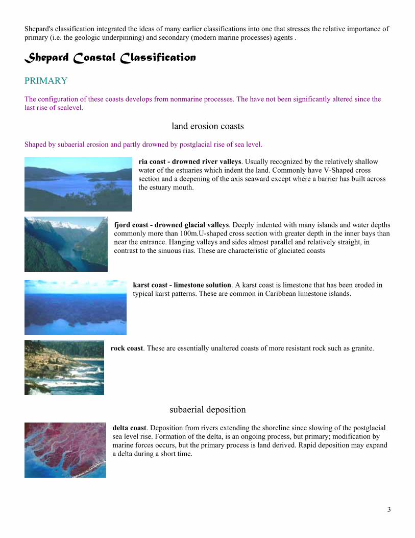
Shepard's classification integrated the ideas of many earlier classifications into one that stresses the relative importance of primary (i.e. the geologic underpinning) and secondary (modern marine processes) agents . Shepard Coastal Classification PRIMARY The configuration of these coasts develops from nonmarine processes. The have not been significantly altered since the last rise of sealevel.
land erosion coasts Shaped by subaerial erosion and partly drowned by postglacial rise of sea level.
ria coast - drowned river valleys. Usually recognized by the relatively shallow water of the estuaries which indent the land. Commonly have V-Shaped cross section and a deepening of the axis seaward except where a barrier has built across the estuary mouth.
fjord coast - drowned glacial valleys. Deeply indented with many islands and water depths commonly more than 100m.U-shaped cross section with greater depth in the inner bays than near the entrance. Hanging valleys and sides almost parallel and relatively straight, in contrast to the sinuous rias. These are characteristic of glaciated coasts
karst coast - limestone solution. A karst coast is limestone that has been eroded in typical karst patterns. These are common in Caribbean limestone islands.
rock coast. These are essentially unaltered coasts of more resistant rock such as granite.
subaerial deposition
delta coast. Deposition from rivers extending the shoreline since slowing of the postglacial sea level rise. Formation of the delta, is an ongoing process, but primary; modification by marine forces occurs, but the primary process is land derived. Rapid deposition may expand a delta during a short time.
4
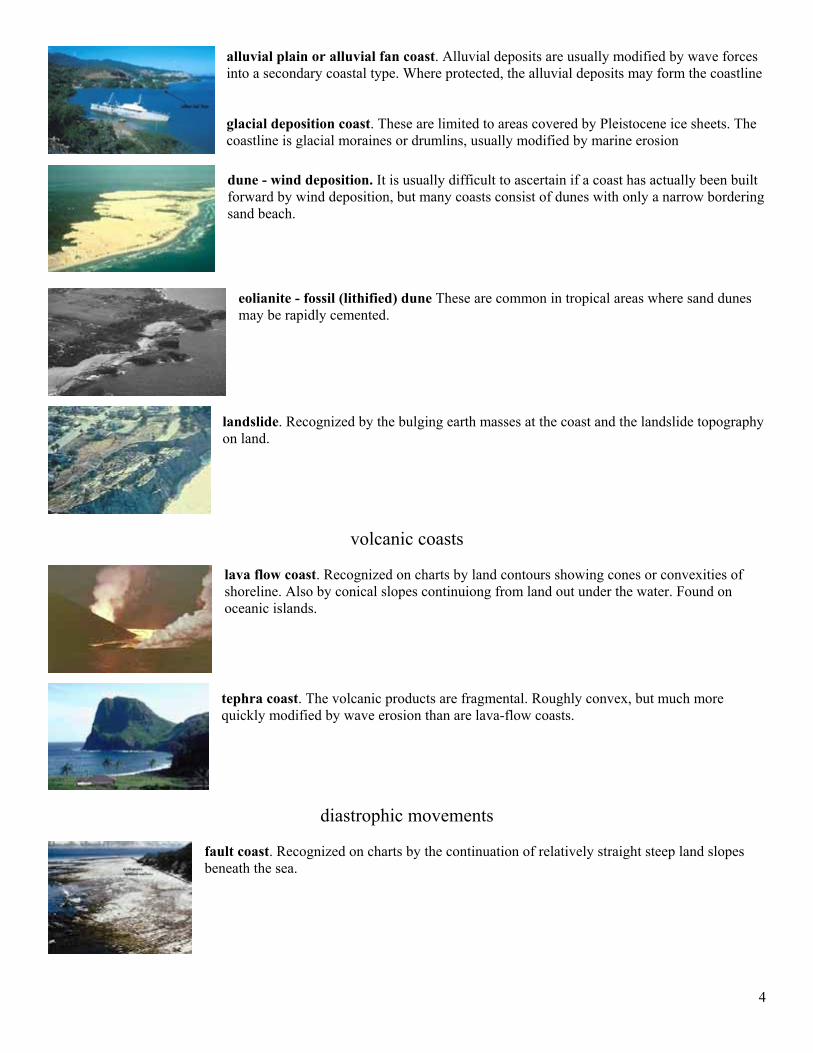
alluvial plain or alluvial fan coast. Alluvial deposits are usually modified by wave forces into a secondary coastal type. Where protected, the alluvial deposits may form the coastline glacial deposition coast. These are limited to areas covered by Pleistocene ice sheets. The coastline is glacial moraines or drumlins, usually modified by marine erosion dune - wind deposition. It is usually difficult to ascertain if a coast has actually been built forward by wind deposition, but many coasts consist of dunes with only a narrow bordering sand beach.
eolianite - fossil (lithified) dune These are common in tropical areas where sand dunes may be rapidly cemented.
landslide. Recognized by the bulging earth masses at the coast and the landslide topography on land.
volcanic coasts lava flow coast. Recognized on charts by land contours showing cones or convexities of shoreline. Also by conical slopes continuiong from land out under the water. Found on oceanic islands. tephra coast. The volcanic products are fragmental. Roughly convex, but much more quickly modified by wave erosion than are lava-flow coasts.
diastrophic movements fault coast. Recognized on charts by the continuation of relatively straight steep land slopes beneath the sea.
5
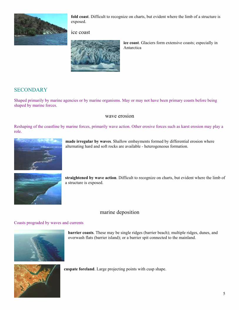
fold coast. Difficult to recognize on charts, but evident where the limb of a structure is exposed. ice coast
ice coast. Glaciers form extensive coasts; especially in Antarctica
SECONDARY Shaped primarily by marine agencies or by marine organisms. May or may not have been primary coasts before being shaped by marine forces.
wave erosion Reshaping of the coastline by marine forces, primarily wave action. Other erosive forces such as karst erosion may play a role.
made irregular by waves. Shallow embayments formed by differential erosion where alternating hard and soft rocks are available - heterogeneous formation. straightened by wave action. Difficult to recognize on charts, but evident where the limb of a structure is exposed.
marine deposition Coasts prograded by waves and currents
barrier coasts. These may be single ridges (barrier beach); multiple ridges, dunes, and overwash flats (barrier island); or a barrier spit connected to the mainland.
cuspate foreland. Large projecting points with cusp shape.
6
beach plain. Sand plains differing from barriers by having no lagoon inside.
mud flat. Formed along low coasts with mud sized sediments; usually in region of lower wave action. There may be an extensive system of channels across the flat.
beachrock. Beach sands, especially carbonate, cement rapidly in tropical areas forming a rocky buttress
built by plant or animal
The modification of the shoreline is the result of construction by organisms; either fauna or flora.
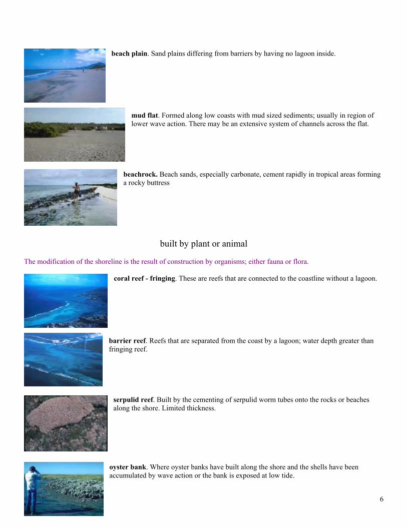
coral reef - fringing. These are reefs that are connected to the coastline without a lagoon.
barrier reef. Reefs that are separated from the coast by a lagoon; water depth greater than fringing reef.
serpulid reef. Built by the cementing of serpulid worm tubes onto the rocks or beaches along the shore. Limited thickness.
oyster bank. Where oyster banks have built along the shore and the shells have been accumulated by wave action or the bank is exposed at low tide.
7
reef terrace - fossil reef. The shoreline is an uplifted Pleistocene or older reef formation.
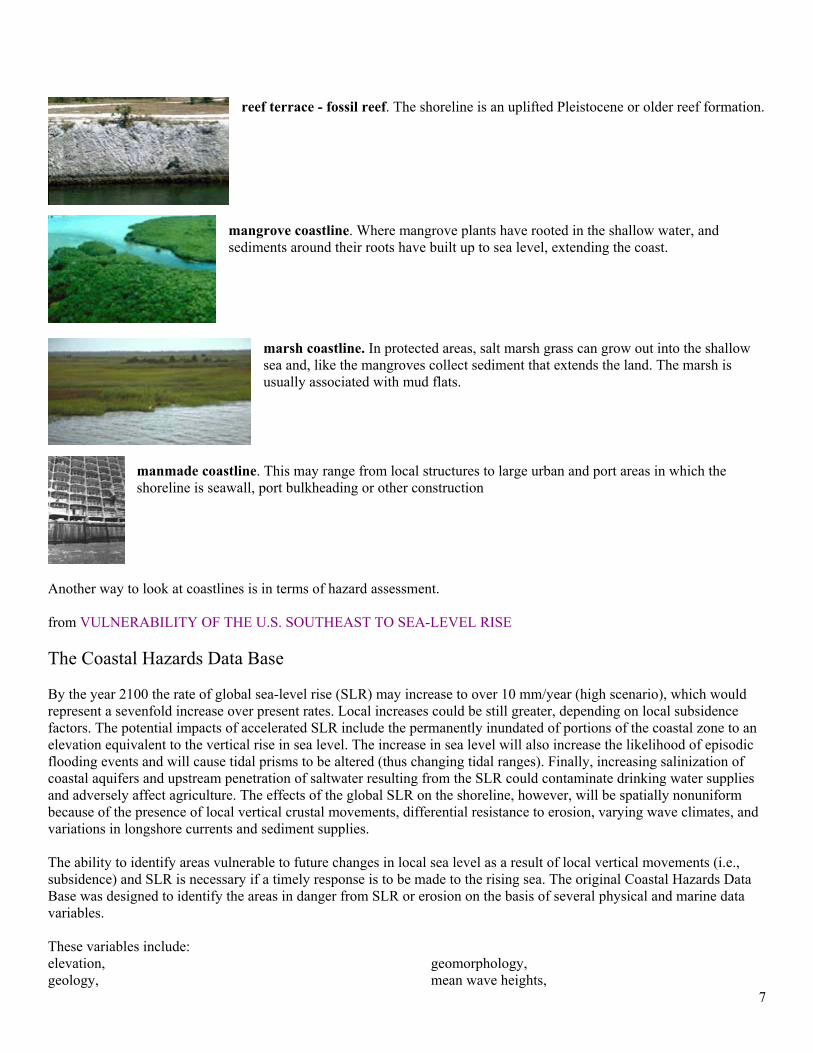
mangrove coastline. Where mangrove plants have rooted in the shallow water, and sediments around their roots have built up to sea level, extending the coast.
marsh coastline. In protected areas, salt marsh grass can grow out into the shallow sea and, like the mangroves collect sediment that extends the land. The marsh is usually associated with mud flats.
manmade coastline. This may range from local structures to large urban and port areas in which the shoreline is seawall, port bulkheading or other construction
Another way to look at coastlines is in terms of hazard assessment. from VULNERABILITY OF THE U.S. SOUTHEAST TO SEA-LEVEL RISE The Coastal Hazards Data Base By the year 2100 the rate of global sea-level rise (SLR) may increase to over 10 mm/year (high scenario), which would represent a sevenfold increase over present rates. Local increases could be still greater, depending on local subsidence factors. The potential impacts of accelerated SLR include the permanently inundated of portions of the coastal zone to an elevation equivalent to the vertical rise in sea level. The increase in sea level will also increase the likelihood of episodic flooding events and will cause tidal prisms to be altered (thus changing tidal ranges). Finally, increasing salinization of coastal aquifers and upstream penetration of saltwater resulting from the SLR could contaminate drinking water supplies and adversely affect agriculture. The effects of the global SLR on the shoreline, however, will be spatially nonuniform because of the presence of local vertical crustal movements, differential resistance to erosion, varying wave climates, and variations in longshore currents and sediment supplies. The ability to identify areas vulnerable to future changes in local sea level as a result of local vertical movements (i.e., subsidence) and SLR is necessary if a timely response is to be made to the rising sea. The original Coastal Hazards Data Base was designed to identify the areas in danger from SLR or erosion on the basis of several physical and marine data variables. These variables include: elevation, geology,
geomorphology, mean wave heights,
8
tide ranges, erosion/accretion rates, and
local vertical movements.
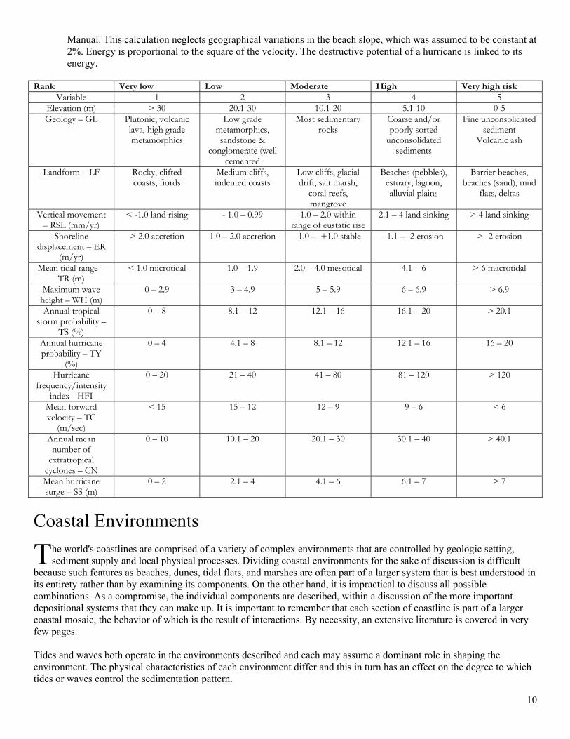
These variables have been obtained for each coastal segment along the U.S. East and Gulf coasts (mean length of a coastal segment is 4.5 km). The physical/marine variables have been evaluated and used in combination with climatological data to determine the differential vulnerability of coastlines to inundation and erosion and to classify and map the spatial distribution of high-risk areas in order to identify targets for future detailed case studies. A vulnerable coastline is characterized by low coastal elevations, an erodible substrate (i.e., sand or other unconsolidated sediments), present and past evidence of subsidence, history of extensive shoreline retreat, high wave/tide energies, and high probabilities of being hit by a extratropical storm, tropical storm, or hurricane. To map the variations in risk for each coastal segment, an index of vulnerability was developed based on the physical and marine variables in the original Coastal Hazards Data Base and several climatological variables in a data base. The variables within the expanded Coastal Hazards Data Base, for each coastal segment, were classified into one of five risk/hazard categories and saved in a new "risk" variable. This process was conducted for each data variable in the data base. These risk variables were then used to calculate a Coastal Vulnerability Index for each coastal segment. The index of each coastal segment was then grouped, based on the statistical distribution for all the segments, into a low, moderate, high, or very high risk class. Data Base Components and Risk Classes The original Coastal Hazards Data Base contained information on seven physical and marine variables, relating to permanent and episodic inundation (elevation, vertical land movements, relative sea-level changes) and erosion potential (geology, coastal landforms, erosion/accretion trends, wave heights and tidal ranges). Subsequently, six climate variables relating to storm frequency, storm intensity, and surge heights were added. The 13 risk variables in the expanded Coastal Hazards Data Base were ranked on a scale of 1 to 5, in order of increasing vulnerability. The rationale for the ranking scheme of the seven physical and marine variables have been described in detail and will be briefly reviewed here. The methods used to classify the six climatological variables will also be described.
• The elevation variable (EL) is a primary indicator of inundation risk. Coastal areas with elevations over 1 m above mean sea level face the highest probability of permanent inundation, while coastal areas with elevations over 5 m above mean sea level are at high risk to above-normal tides or severe storm surges. The hazards for each coastal area decreases progressively for higher average elevations
• The local vertical movement variable (SL) was deduced from a network of tide-gauge stations. The relative-
sea-level (RSL) change at each locality is a composite of the eustatic component (~-1.5 mm/year) and other vertical land motions. Subsiding areas, or those with RSL in excess of the eustatic range (more than 1.5 mm/year), regardless of the original cause, face greater inundation hazards and are ranked on the basis of this premise in the table.
• The geology (GL) and the coastal landforms (LF) variables are associated with the erosion risk of an area. A
generalized scale of the resistance of geologic and coastal landforms to erosion was used. Because of the difficulty in quantifying the relative resistance to erosion for each landform, or material type, these two variables were ranked into classes of increasing risk on the basis of the resistance of a given rock type or landform to erosion.
• The historical shoreline displacement (erosion) variable (ER) is a measure of the past tendency of a shoreline
to retreat/advance in the face of SLR. In this variable changes of + 1.0 m/year lie within the measurement error and are not considered significant. Shores with rates of erosion of - 1 m/year or less (more negative) are eroding, and thus are at relatively higher risk. Conversely, shores with rates more than 1 m/year are accreting and are correspondingly at low risk.
9
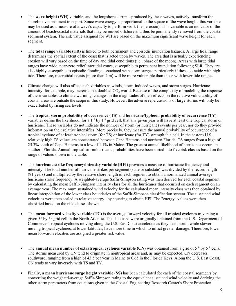
• The wave height (WH) variable, and the longshore currents produced by these waves, actively transform the shoreline via sediment transport. Since wave energy is proportional to the square of the wave height, this variable may be used as a measure of a wave's capacity to perform work (i.e., erosion). This variable is an indicator of the amount of beach/coastal materials that may be moved offshore and thus be permanently removed from the coastal sediment system. The risk value assigned for WH are based on the maximum significant wave height for each segment.
• The tidal range variable (TR) is linked to both permanent and episodic inundation hazards. A large tidal range
determines the spatial extent of the coast that is acted upon by waves. The area that is actually experiencing erosion will vary based on the time of day and tidal conditions (i.e., phase of the moon). Areas with large tidal ranges have wide, near-zero relief intertidal zones, susceptible to permanent inundation following SLR. They are also highly susceptible to episodic flooding, associated with storm surges, particularly if these coincide with high tide. Therefore, macrotidal coasts (more than 4 m) will be more vulnerable than those with lower tide ranges.
• Climate change will also affect such variables as winds, storm-induced waves, and storm surges. Hurricane
intensity, for example, may increase in a doubled CO2 world. Because of the complexity of modeling the response of these variables to climate warming, changes in the magnitudes of their effects on the relative vulnerability of coastal areas are outside the scope of this study. However, the adverse repercussions of large storms will only be exacerbated by rising sea levels
• The tropical storm probability of occurrence (TS) and hurricane/typhoon probability of occurrence (TY)
variables define the likelihood, for a 1 o by 1 o grid cell, that any given year will have at least one tropical storm or hurricane. These variables do not indicate the number of storm (or hurricane) events per year, nor do they provide information on their relative intensifies. More precisely, they measure the annual probability of occurrence of a tropical cyclone of at least tropical storm (for TS) or hurricane (for TY) strength in a cell. In the eastern U.S., relatively high TS values are concentrated between Cape Hatteras and northern Florida. TS ranges from a high of 25.3% south of Cape Hatteras to a low of 1.1% in Maine. The greatest annual likelihood of hurricanes occurs in southern Florida. Annual tropical storm/hurricane probabilities have been sorted into five risk classes based on the range of values shown in the table.
• The hurricane strike frequency/intensity variable (HFI) provides a measure of hurricane frequency and
intensity. The total number of hurricane strikes per segment (state or substate) was divided by the record length (91 years) and multiplied by the relative shore length of each segment to obtain a normalized annual average hurricane strike frequency. A weighted-average Saffir-Simpson rating was then derived for each coastal segment by calculating the mean Saffir-Simpson intensity class for all the hurricanes that occurred on each segment on an average year. The maximum sustained wind velocity for the calculated mean intensity class was then obtained by linear interpolation of the lower class boundaries of the Saffir-Simpson classification system. The sustained wind velocities were then scaled to relative energy~ by squaring to obtain HFI. The "energy" values were then classified based on the risk classes shown.
• The mean forward velocity variable (TC) is the average forward velocity for all tropical cyclones traversing a
given 5° by 5° grid cell in the North Atlantic. The data used were originally obtained from the U.S. Department of Commerce. Tropical cyclones moving along the U.S. East Coast accelerate as they head north, while slower moving tropical cyclones, at lower latitudes, have more time in which to inflict greater damage. Therefore, lower mean forward velocities are assigned a greater risk value.
• The annual mean number of extratropical cyclones variable (CN) was obtained from a grid of 5 o by 5 o cells.
The storms measured by CN tend to originate in nontropical areas and, as may be expected, CN decreases southward, ranging from a high of 43.5 per year in Maine to 0.65 in the Florida Keys. Along the U.S. East Coast, CN tends to vary inversely with TS and TY.
• Finally, a mean hurricane surge height variable (SS) has been calculated for each of the coastal segments by
converting the weighted-average Saffir-Simpson rating to the equivalent sustained wind velocity and deriving the other storm parameters from equations given in the Coastal Engineering Research Center's Shore Protection
10
Manual. This calculation neglects geographical variations in the beach slope, which was assumed to be constant at 2%. Energy is proportional to the square of the velocity. The destructive potential of a hurricane is linked to its energy.
Rank Very low Low Moderate High Very high risk
Variable 1 2 3 4 5 Elevation (m) > 30 20.1-30 10.1-20 5.1-10 0-5 Geology – GL Plutonic, volcanic
lava, high grade metamorphics
Low grade metamorphics, sandstone &
conglomerate (well cemented
Most sedimentary rocks
Coarse and/or poorly sorted
unconsolidated sediments
Fine unconsolidated sediment
Volcanic ash
Landform – LF Rocky, clifted coasts, fiords
Medium cliffs, indented coasts
Low cliffs, glacial drift, salt marsh,
coral reefs, mangrove
Beaches (pebbles), estuary, lagoon, alluvial plains
Barrier beaches, beaches (sand), mud
flats, deltas
Vertical movement – RSL (mm/yr)
< -1.0 land rising - 1.0 – 0.99
1.0 – 2.0 within range of eustatic rise
2.1 – 4 land sinking > 4 land sinking
Shoreline displacement – ER
(m/yr)
> 2.0 accretion 1.0 – 2.0 accretion -1.0 – +1.0 stable -1.1 – -2 erosion > -2 erosion
Mean tidal range – TR (m)
< 1.0 microtidal 1.0 – 1.9 2.0 – 4.0 mesotidal 4.1 – 6 > 6 macrotidal
Maximum wave height – WH (m)
0 – 2.9 3 – 4.9 5 – 5.9 6 – 6.9 > 6.9
Annual tropical storm probability –
TS (%)
0 – 8 8.1 – 12 12.1 – 16 16.1 – 20 > 20.1
Annual hurricane probability – TY
(%)
0 – 4 4.1 – 8 8.1 – 12 12.1 – 16 16 – 20
Hurricane frequency/intensity
index - HFI
0 – 20 21 – 40 41 – 80 81 – 120 > 120
Mean forward velocity – TC
(m/sec)
< 15 15 – 12 12 – 9 9 – 6 < 6
Annual mean number of
extratropical cyclones – CN
0 – 10 10.1 – 20 20.1 – 30 30.1 – 40 > 40.1
Mean hurricane surge – SS (m)
0 – 2 2.1 – 4 4.1 – 6 6.1 – 7 > 7
Coastal Environments
he world's coastlines are comprised of a variety of complex environments that are controlled by geologic setting, sediment supply and local physical processes. Dividing coastal environments for the sake of discussion is difficult
because such features as beaches, dunes, tidal flats, and marshes are often part of a larger system that is best understood in its entirety rather than by examining its components. On the other hand, it is impractical to discuss all possible combinations. As a compromise, the individual components are described, within a discussion of the more important depositional systems that they can make up. It is important to remember that each section of coastline is part of a larger coastal mosaic, the behavior of which is the result of interactions. By necessity, an extensive literature is covered in very few pages. Tides and waves both operate in the environments described and each may assume a dominant role in shaping the environment. The physical characteristics of each environment differ and this in turn has an effect on the degree to which tides or waves control the sedimentation pattern.
T
11
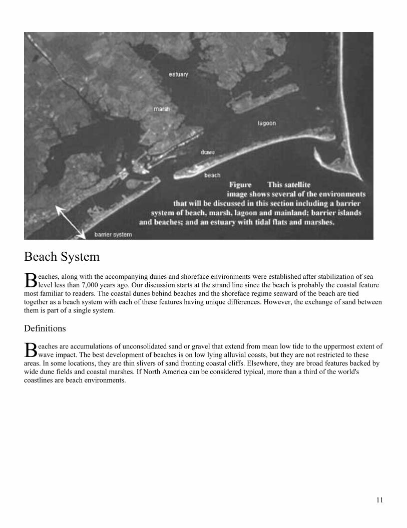
Beach System
eaches, along with the accompanying dunes and shoreface environments were established after stabilization of sea level less than 7,000 years ago. Our discussion starts at the strand line since the beach is probably the coastal feature
most familiar to readers. The coastal dunes behind beaches and the shoreface regime seaward of the beach are tied together as a beach system with each of these features having unique differences. However, the exchange of sand between them is part of a single system. Definitions
eaches are accumulations of unconsolidated sand or gravel that extend from mean low tide to the uppermost extent of wave impact. The best development of beaches is on low lying alluvial coasts, but they are not restricted to these
areas. In some locations, they are thin slivers of sand fronting coastal cliffs. Elsewhere, they are broad features backed by wide dune fields and coastal marshes. If North America can be considered typical, more than a third of the world's coastlines are beach environments.
B
B
12
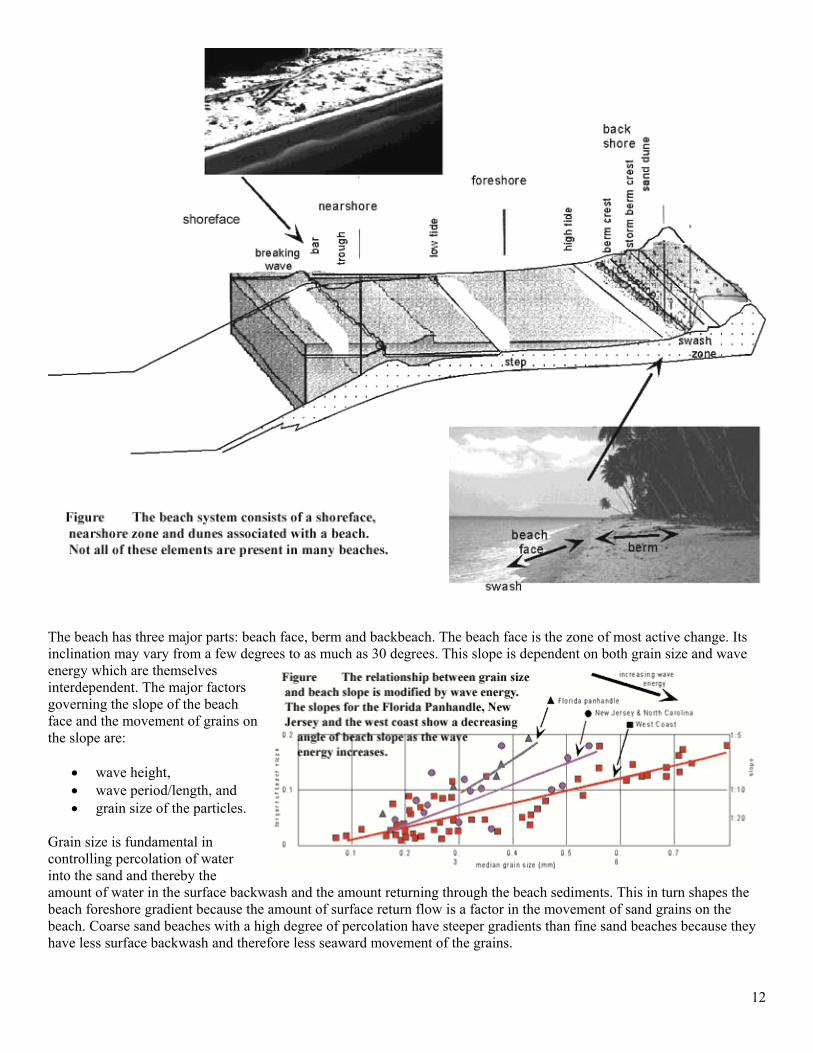
The beach has three major parts: beach face, berm and backbeach. The beach face is the zone of most active change. Its inclination may vary from a few degrees to as much as 30 degrees. This slope is dependent on both grain size and wave energy which are themselves interdependent. The major factors governing the slope of the beach face and the movement of grains on the slope are:
• wave height, • wave period/length, and • grain size of the particles.
Grain size is fundamental in controlling percolation of water into the sand and thereby the amount of water in the surface backwash and the amount returning through the beach sediments. This in turn shapes the beach foreshore gradient because the amount of surface return flow is a factor in the movement of sand grains on the beach. Coarse sand beaches with a high degree of percolation have steeper gradients than fine sand beaches because they have less surface backwash and therefore less seaward movement of the grains.
13
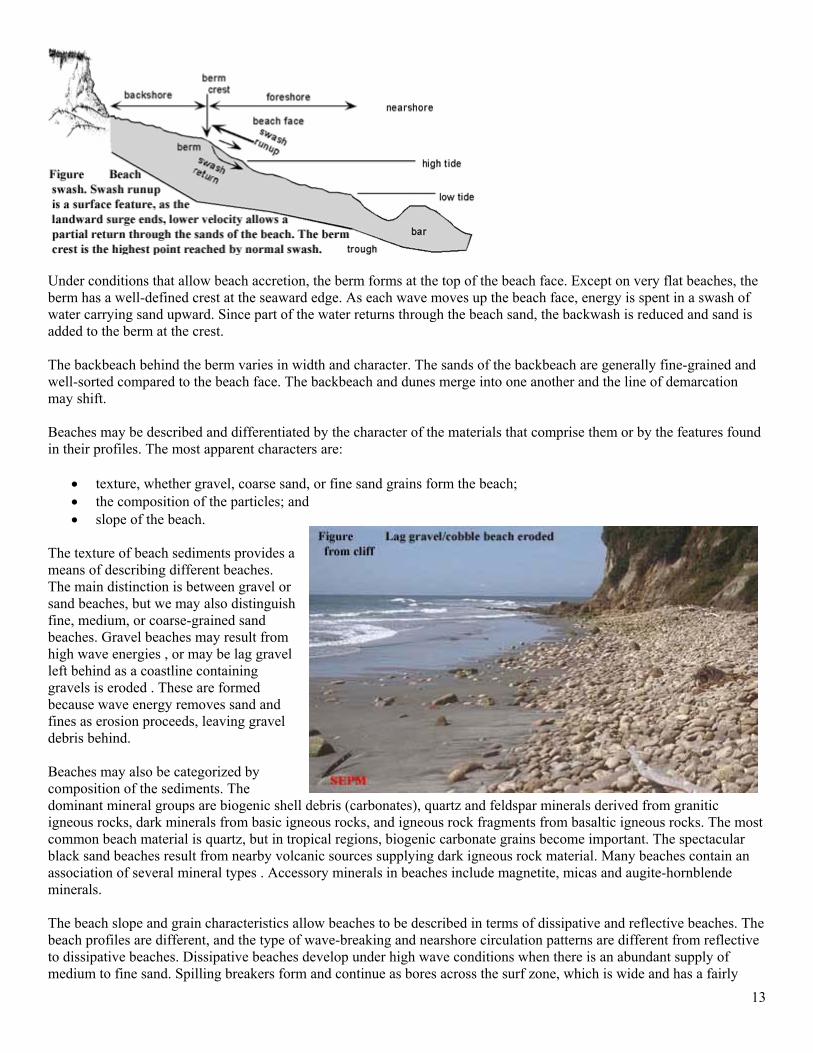
Under conditions that allow beach accretion, the berm forms at the top of the beach face. Except on very flat beaches, the berm has a well-defined crest at the seaward edge. As each wave moves up the beach face, energy is spent in a swash of water carrying sand upward. Since part of the water returns through the beach sand, the backwash is reduced and sand is added to the berm at the crest. The backbeach behind the berm varies in width and character. The sands of the backbeach are generally fine-grained and well-sorted compared to the beach face. The backbeach and dunes merge into one another and the line of demarcation may shift. Beaches may be described and differentiated by the character of the materials that comprise them or by the features found in their profiles. The most apparent characters are:
• texture, whether gravel, coarse sand, or fine sand grains form the beach; • the composition of the particles; and • slope of the beach.
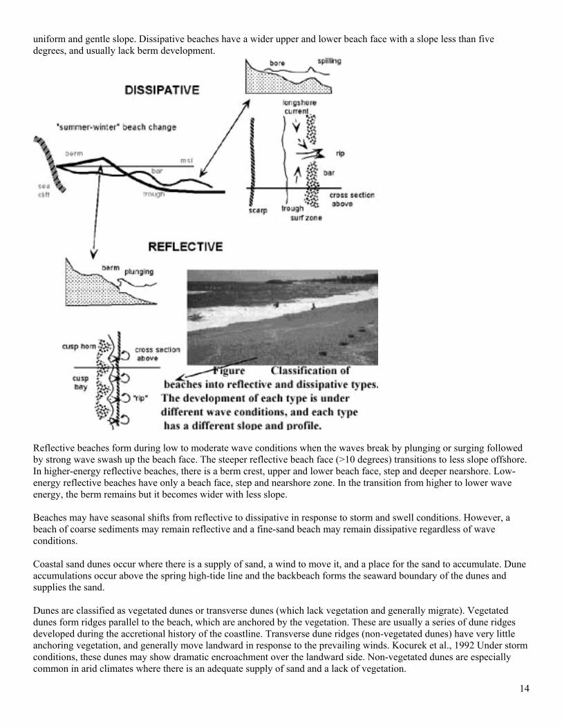
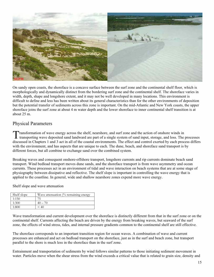
The texture of beach sediments provides a means of describing different beaches. The main distinction is between gravel or sand beaches, but we may also distinguish fine, medium, or coarse-grained sand beaches. Gravel beaches may result from high wave energies , or may be lag gravel left behind as a coastline containing gravels is eroded . These are formed because wave energy removes sand and fines as erosion proceeds, leaving gravel debris behind. Beaches may also be categorized by composition of the sediments. The dominant mineral groups are biogenic shell debris (carbonates), quartz and feldspar minerals derived from granitic igneous rocks, dark minerals from basic igneous rocks, and igneous rock fragments from basaltic igneous rocks. The most common beach material is quartz, but in tropical regions, biogenic carbonate grains become important. The spectacular black sand beaches result from nearby volcanic sources supplying dark igneous rock material. Many beaches contain an association of several mineral types . Accessory minerals in beaches include magnetite, micas and augite-hornblende minerals. The beach slope and grain characteristics allow beaches to be described in terms of dissipative and reflective beaches. The beach profiles are different, and the type of wave-breaking and nearshore circulation patterns are different from reflective to dissipative beaches. Dissipative beaches develop under high wave conditions when there is an abundant supply of medium to fine sand. Spilling breakers form and continue as bores across the surf zone, which is wide and has a fairly
14
uniform and gentle slope. Dissipative beaches have a wider upper and lower beach face with a slope less than five degrees, and usually lack berm development.
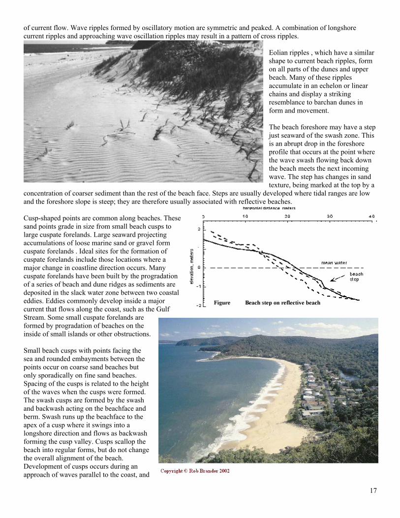
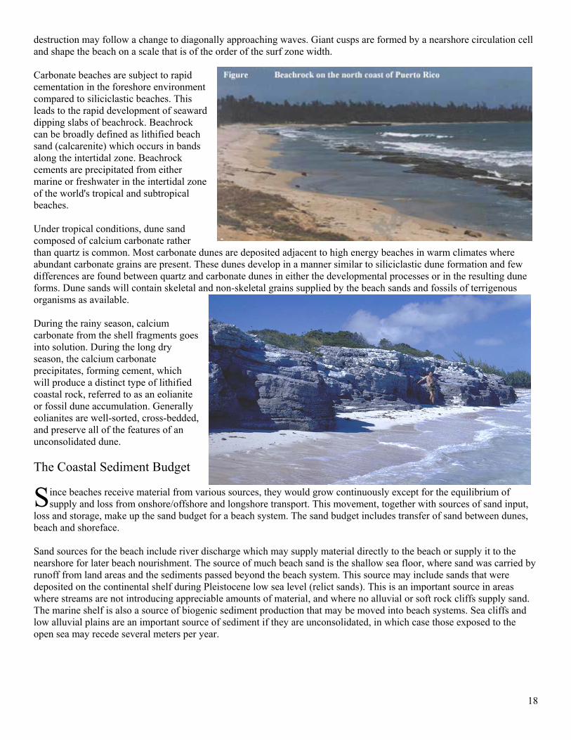
Reflective beaches form during low to moderate wave conditions when the waves break by plunging or surging followed by strong wave swash up the beach face. The steeper reflective beach face (>10 degrees) transitions to less slope offshore. In higher-energy reflective beaches, there is a berm crest, upper and lower beach face, step and deeper nearshore. Low-energy reflective beaches have only a beach face, step and nearshore zone. In the transition from higher to lower wave energy, the berm remains but it becomes wider with less slope. Beaches may have seasonal shifts from reflective to dissipative in response to storm and swell conditions. However, a beach of coarse sediments may remain reflective and a fine-sand beach may remain dissipative regardless of wave conditions. Coastal sand dunes occur where there is a supply of sand, a wind to move it, and a place for the sand to accumulate. Dune accumulations occur above the spring high-tide line and the backbeach forms the seaward boundary of the dunes and supplies the sand. Dunes are classified as vegetated dunes or transverse dunes (which lack vegetation and generally migrate). Vegetated dunes form ridges parallel to the beach, which are anchored by the vegetation. These are usually a series of dune ridges developed during the accretional history of the coastline. Transverse dune ridges (non-vegetated dunes) have very little anchoring vegetation, and generally move landward in response to the prevailing winds. Kocurek et al., 1992 Under storm conditions, these dunes may show dramatic encroachment over the landward side. Non-vegetated dunes are especially common in arid climates where there is an adequate supply of sand and a lack of vegetation.
15
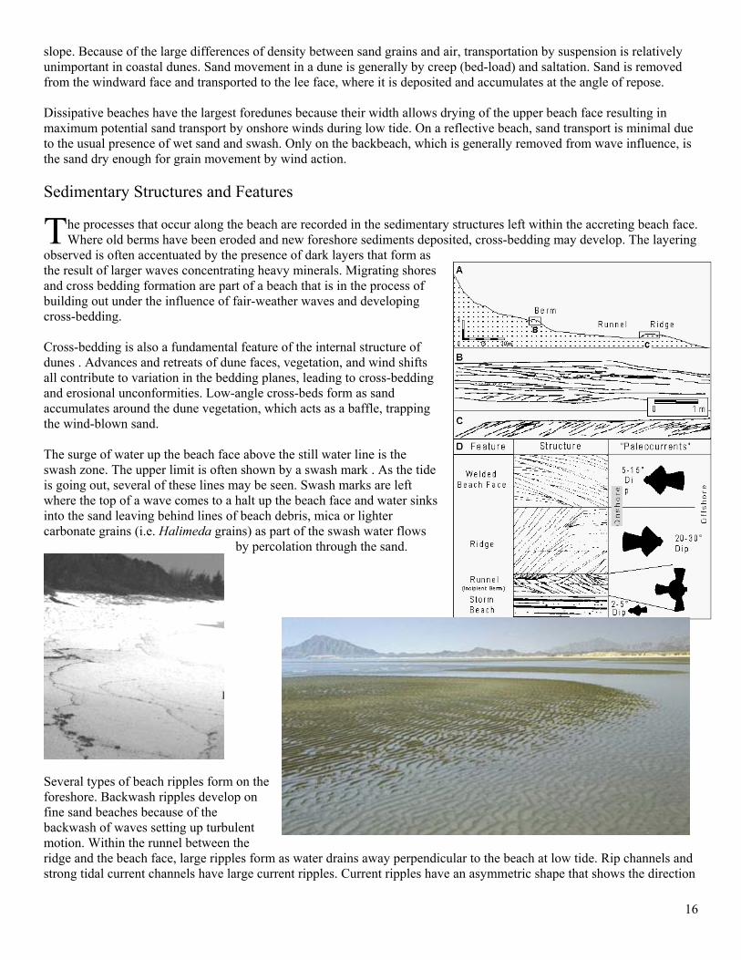
On sandy open coasts, the shoreface is a concave surface between the surf zone and the continental shelf floor, which is morphologically and dynamically distinct from the bordering surf zone and the continental shelf. The shoreface varies in width, depth, shape and longshore extent, and it may not be well developed in many locations. This environment is difficult to define and less has been written about its general characteristics than for the other environments of deposition but the potential transfer of sediments across this zone is important. On the mid-Atlantic and New York coasts, the upper shoreface joins the surf zone at about 4 m water depth and the lower shoreface to inner continental shelf transition is at about 25 m. Physical Parameters
ransformation of wave energy across the shelf, nearshore, and surf zone and the action of onshore winds in transporting wave deposited sand landward are part of a single system of sand input, storage, and loss. The processes
discussed in Chapters 1 and 3 act in all of the coastal environments. The effect and control exerted by each process differs with the environment, and has aspects that are unique to each. The dune, beach, and shoreface sand transport is by different forces, but all combine to exchange sand over the combined system. Breaking waves and consequent onshore-offshore transport, longshore currents and rip currents dominate beach sand transport. Wind bedload transport moves dune sands, and the shoreface transport is from wave asymmetry and ocean currents. These processes act in an environment of tidal and wave interaction on beach systems that are at some stage of physiography between dissipative and reflective. The shelf slope is important in controlling the wave energy that is applied to the coastline. In general, wide and shallow nearshore zones expend more wave energy. Shelf slope and wave attenuation Shelf slope Wave attenuation (% remaining energy 1:150 75 1:300 40 – 70 1:800 < 40 Wave transformation and current development over the shoreface is distinctly different from that in the surf zone or on the continental shelf. Currents affecting the beach are driven by the energy from breaking waves, but seaward of the surf zone, the effects of wind stress, tides, and internal pressure gradients common to the continental shelf are still effective. The shoreface corresponds to an important transition region for ocean waves. A combination of wave and current processes are enhanced and act on bedload transport on the shoreface, just as in the surf and beach zone, but transport parallel to the shore is much less in the shoreface than in the surf zone. Entrainment and transportation of sediments by wind follows similar patterns to those initiating sediment movement in water. Particles move when the shear stress from the wind exceeds a critical value that is related to grain size, density and
T
16
slope. Because of the large differences of density between sand grains and air, transportation by suspension is relatively unimportant in coastal dunes. Sand movement in a dune is generally by creep (bed-load) and saltation. Sand is removed from the windward face and transported to the lee face, where it is deposited and accumulates at the angle of repose. Dissipative beaches have the largest foredunes because their width allows drying of the upper beach face resulting in maximum potential sand transport by onshore winds during low tide. On a reflective beach, sand transport is minimal due to the usual presence of wet sand and swash. Only on the backbeach, which is generally removed from wave influence, is the sand dry enough for grain movement by wind action. Sedimentary Structures and Features
he processes that occur along the beach are recorded in the sedimentary structures left within the accreting beach face. Where old berms have been eroded and new foreshore sediments deposited, cross-bedding may develop. The layering
observed is often accentuated by the presence of dark layers that form as the result of larger waves concentrating heavy minerals. Migrating shores and cross bedding formation are part of a beach that is in the process of building out under the influence of fair-weather waves and developing cross-bedding. Cross-bedding is also a fundamental feature of the internal structure of dunes . Advances and retreats of dune faces, vegetation, and wind shifts all contribute to variation in the bedding planes, leading to cross-bedding and erosional unconformities. Low-angle cross-beds form as sand accumulates around the dune vegetation, which acts as a baffle, trapping the wind-blown sand. The surge of water up the beach face above the still water line is the swash zone. The upper limit is often shown by a swash mark . As the tide is going out, several of these lines may be seen. Swash marks are left where the top of a wave comes to a halt up the beach face and water sinks into the sand leaving behind lines of beach debris, mica or lighter carbonate grains (i.e. Halimeda grains) as part of the swash water flows
by percolation through the sand.
Several types of beach ripples form on the foreshore. Backwash ripples develop on fine sand beaches because of the backwash of waves setting up turbulent motion. Within the runnel between the ridge and the beach face, large ripples form as water drains away perpendicular to the beach at low tide. Rip channels and strong tidal current channels have large current ripples. Current ripples have an asymmetric shape that shows the direction
T
17
of current flow. Wave ripples formed by oscillatory motion are symmetric and peaked. A combination of longshore current ripples and approaching wave oscillation ripples may result in a pattern of cross ripples.
Eolian ripples , which have a similar shape to current beach ripples, form on all parts of the dunes and upper beach. Many of these ripples accumulate in an echelon or linear chains and display a striking resemblance to barchan dunes in form and movement. The beach foreshore may have a step just seaward of the swash zone. This is an abrupt drop in the foreshore profile that occurs at the point where the wave swash flowing back down the beach meets the next incoming wave. The step has changes in sand texture, being marked at the top by a
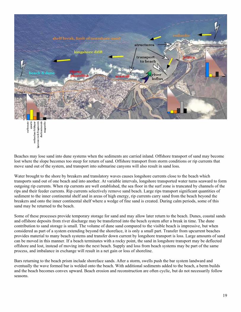
concentration of coarser sediment than the rest of the beach face. Steps are usually developed where tidal ranges are low and the foreshore slope is steep; they are therefore usually associated with reflective beaches. Cusp-shaped points are common along beaches. These sand points grade in size from small beach cusps to large cuspate forelands. Large seaward projecting accumulations of loose marine sand or gravel form cuspate forelands . Ideal sites for the formation of cuspate forelands include those locations where a major change in coastline direction occurs. Many cuspate forelands have been built by the progradation of a series of beach and dune ridges as sediments are deposited in the slack water zone between two coastal eddies. Eddies commonly develop inside a major current that flows along the coast, such as the Gulf Stream. Some small cuspate forelands are formed by progradation of beaches on the inside of small islands or other obstructions. Small beach cusps with points facing the sea and rounded embayments between the points occur on coarse sand beaches but only sporadically on fine sand beaches. Spacing of the cusps is related to the height of the waves when the cusps were formed. The swash cusps are formed by the swash and backwash acting on the beachface and berm. Swash runs up the beachface to the apex of a cusp where it swings into a longshore direction and flows as backwash forming the cusp valley. Cusps scallop the beach into regular forms, but do not change the overall alignment of the beach. Development of cusps occurs during an approach of waves parallel to the coast, and
18
destruction may follow a change to diagonally approaching waves. Giant cusps are formed by a nearshore circulation cell and shape the beach on a scale that is of the order of the surf zone width. Carbonate beaches are subject to rapid cementation in the foreshore environment compared to siliciclastic beaches. This leads to the rapid development of seaward dipping slabs of beachrock. Beachrock can be broadly defined as lithified beach sand (calcarenite) which occurs in bands along the intertidal zone. Beachrock cements are precipitated from either marine or freshwater in the intertidal zone of the world's tropical and subtropical beaches. Under tropical conditions, dune sand composed of calcium carbonate rather than quartz is common. Most carbonate dunes are deposited adjacent to high energy beaches in warm climates where abundant carbonate grains are present. These dunes develop in a manner similar to siliciclastic dune formation and few differences are found between quartz and carbonate dunes in either the developmental processes or in the resulting dune forms. Dune sands will contain skeletal and non-skeletal grains supplied by the beach sands and fossils of terrigenous organisms as available. During the rainy season, calcium carbonate from the shell fragments goes into solution. During the long dry season, the calcium carbonate precipitates, forming cement, which will produce a distinct type of lithified coastal rock, referred to as an eolianite or fossil dune accumulation. Generally eolianites are well-sorted, cross-bedded, and preserve all of the features of an unconsolidated dune. The Coastal Sediment Budget
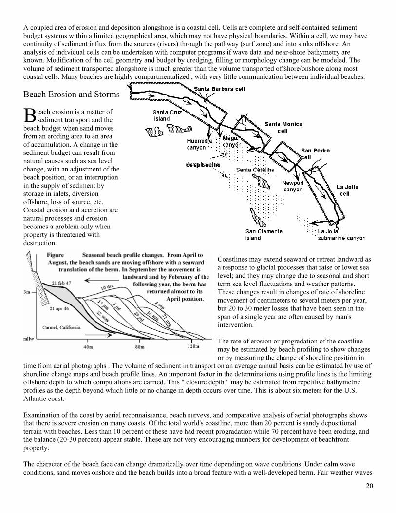
ince beaches receive material from various sources, they would grow continuously except for the equilibrium of supply and loss from onshore/offshore and longshore transport. This movement, together with sources of sand input,
loss and storage, make up the sand budget for a beach system. The sand budget includes transfer of sand between dunes, beach and shoreface. Sand sources for the beach include river discharge which may supply material directly to the beach or supply it to the nearshore for later beach nourishment. The source of much beach sand is the shallow sea floor, where sand was carried by runoff from land areas and the sediments passed beyond the beach system. This source may include sands that were deposited on the continental shelf during Pleistocene low sea level (relict sands). This is an important source in areas where streams are not introducing appreciable amounts of material, and where no alluvial or soft rock cliffs supply sand. The marine shelf is also a source of biogenic sediment production that may be moved into beach systems. Sea cliffs and low alluvial plains are an important source of sediment if they are unconsolidated, in which case those exposed to the open sea may recede several meters per year.
S
19
Beaches may lose sand into dune systems when the sediments are carried inland. Offshore transport of sand may become lost where the slope becomes too steep for return of sand. Offshore transport from storm conditions or rip currents that move sand out of the system, and transport into submarine canyons will also result in sand loss. Water brought to the shore by breakers and translatory waves causes longshore currents close to the beach which transports sand out of one beach and into another. At variable intervals, longshore transported water turns seaward to form outgoing rip currents. When rip currents are well established, the sea floor in the surf zone is truncated by channels of the rips and their feeder currents. Rip currents selectively remove sand beach. Large rips transport significant quantities of sediment to the inner continental shelf and in areas of high energy, rip currents carry sand from the beach beyond the breakers and onto the inner continental shelf where a wedge of fine sand is created. During calm periods, some of this sand may be returned to the beach. Some of these processes provide temporary storage for sand and may allow later return to the beach. Dunes, coastal sands and offshore deposits from river discharge may be transferred into the beach system after a break in time. The dune contribution to sand storage is small. The volume of dune sand compared to the visible beach is impressive, but when considered as part of a system extending beyond the shoreface, it is only a small part. Transfer from upcurrent beaches provides material to many beach systems and transfer down current by longshore transport is loss. Large amounts of sand can be moved in this manner. If a beach terminates with a rocky point, the sand in longshore transport may be deflected offshore and lost, instead of moving into the next beach. Supply and loss from beach systems may be part of the same process, and imbalance in exchange will result in a net gain or loss of shoreline. Bars returning to the beach prism include shoreface sands. After a storm, swells push the bar system landward and eventually the wave formed bar is welded onto the beach. With additional sediments added to the beach, a berm builds and the beach becomes convex upward. Beach erosion and reconstruction are often cyclic, but do not necessarily follow seasons.
20
A coupled area of erosion and deposition alongshore is a coastal cell. Cells are complete and self-contained sediment budget systems within a limited geographical area, which may not have physical boundaries. Within a cell, we may have continuity of sediment influx from the sources (rivers) through the pathway (surf zone) and into sinks offshore. An analysis of individual cells can be undertaken with computer programs if wave data and near-shore bathymetry are known. Modification of the cell geometry and budget by dredging, filling or morphology change can be modeled. The volume of sediment transported alongshore is much greater than the volume transported offshore/onshore along most coastal cells. Many beaches are highly compartmentalized , with very little communication between individual beaches. Beach Erosion and Storms
each erosion is a matter of sediment transport and the
beach budget when sand moves from an eroding area to an area of accumulation. A change in the sediment budget can result from natural causes such as sea level change, with an adjustment of the beach position, or an interruption in the supply of sediment by storage in inlets, diversion offshore, loss of source, etc. Coastal erosion and accretion are natural processes and erosion becomes a problem only when property is threatened with destruction.
Coastlines may extend seaward or retreat landward as a response to glacial processes that raise or lower sea level; and they may change due to seasonal and short term sea level fluctuations and weather patterns. These changes result in changes of rate of shoreline movement of centimeters to several meters per year, but 20 to 30 meter losses that have been seen in the span of a single year are often caused by man's intervention. The rate of erosion or progradation of the coastline may be estimated by beach profiling to show changes or by measuring the change of shoreline position in
time from aerial photographs . The volume of sediment in transport on an average annual basis can be estimated by use of shoreline change maps and beach profile lines. An important factor in the determinations using profile lines is the limiting offshore depth to which computations are carried. This " closure depth " may be estimated from repetitive bathymetric profiles as the depth beyond which little or no change in depth occurs over time. This is about six meters for the U.S. Atlantic coast. Examination of the coast by aerial reconnaissance, beach surveys, and comparative analysis of aerial photographs shows that there is severe erosion on many coasts. Of the total world's coastline, more than 20 percent is sandy depositional terrain with beaches. Less than 10 percent of these have had recent progradation while 70 percent have been eroding, and the balance (20-30 percent) appear stable. These are not very encouraging numbers for development of beachfront property. The character of the beach face can change dramatically over time depending on wave conditions. Under calm wave conditions, sand moves onshore and the beach builds into a broad feature with a well-developed berm. Fair weather waves
B
21
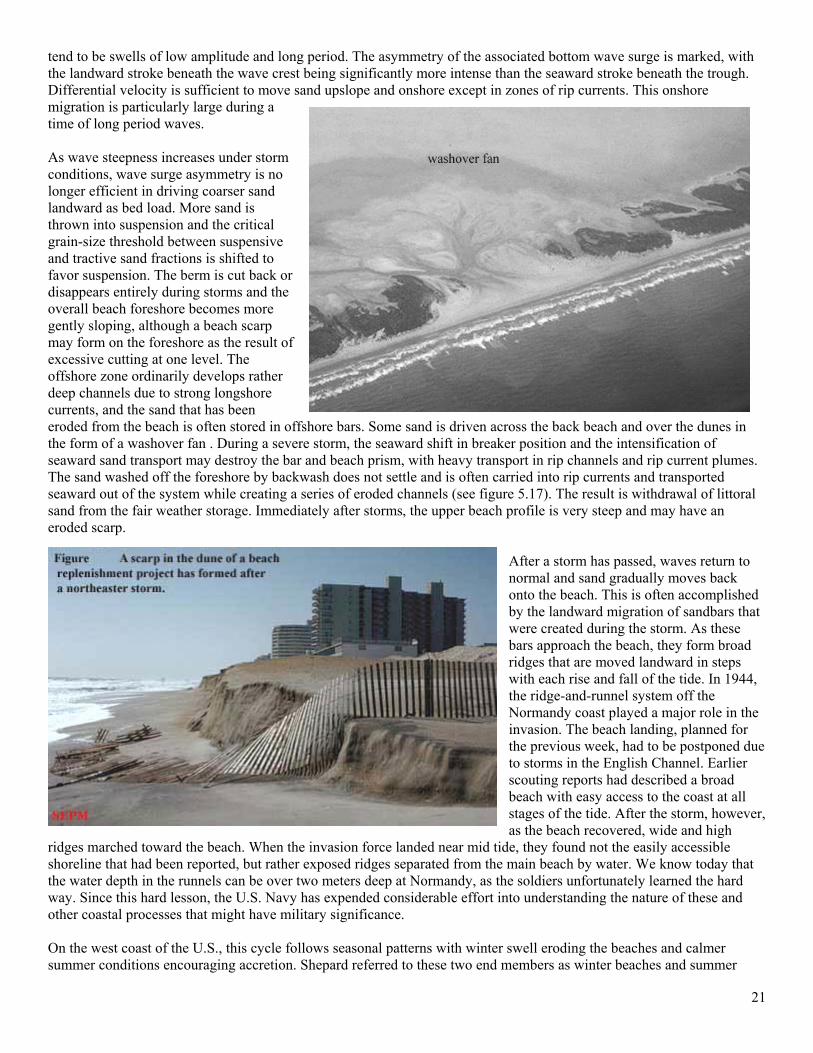
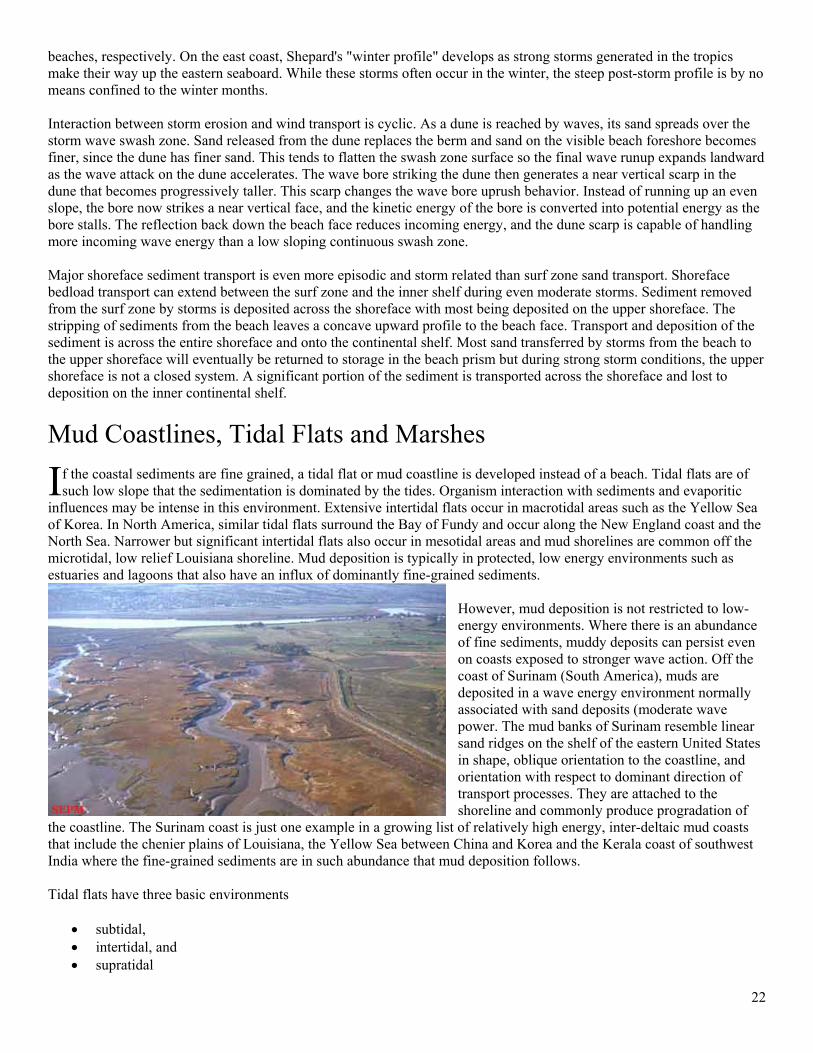
tend to be swells of low amplitude and long period. The asymmetry of the associated bottom wave surge is marked, with the landward stroke beneath the wave crest being significantly more intense than the seaward stroke beneath the trough. Differential velocity is sufficient to move sand upslope and onshore except in zones of rip currents. This onshore migration is particularly large during a time of long period waves. As wave steepness increases under storm conditions, wave surge asymmetry is no longer efficient in driving coarser sand landward as bed load. More sand is thrown into suspension and the critical grain-size threshold between suspensive and tractive sand fractions is shifted to favor suspension. The berm is cut back or disappears entirely during storms and the overall beach foreshore becomes more gently sloping, although a beach scarp may form on the foreshore as the result of excessive cutting at one level. The offshore zone ordinarily develops rather deep channels due to strong longshore currents, and the sand that has been eroded from the beach is often stored in offshore bars. Some sand is driven across the back beach and over the dunes in the form of a washover fan . During a severe storm, the seaward shift in breaker position and the intensification of seaward sand transport may destroy the bar and beach prism, with heavy transport in rip channels and rip current plumes. The sand washed off the foreshore by backwash does not settle and is often carried into rip currents and transported seaward out of the system while creating a series of eroded channels (see figure 5.17). The result is withdrawal of littoral sand from the fair weather storage. Immediately after storms, the upper beach profile is very steep and may have an eroded scarp.
After a storm has passed, waves return to normal and sand gradually moves back onto the beach. This is often accomplished by the landward migration of sandbars that were created during the storm. As these bars approach the beach, they form broad ridges that are moved landward in steps with each rise and fall of the tide. In 1944, the ridge-and-runnel system off the Normandy coast played a major role in the invasion. The beach landing, planned for the previous week, had to be postponed due to storms in the English Channel. Earlier scouting reports had described a broad beach with easy access to the coast at all stages of the tide. After the storm, however, as the beach recovered, wide and high
ridges marched toward the beach. When the invasion force landed near mid tide, they found not the easily accessible shoreline that had been reported, but rather exposed ridges separated from the main beach by water. We know today that the water depth in the runnels can be over two meters deep at Normandy, as the soldiers unfortunately learned the hard way. Since this hard lesson, the U.S. Navy has expended considerable effort into understanding the nature of these and other coastal processes that might have military significance. On the west coast of the U.S., this cycle follows seasonal patterns with winter swell eroding the beaches and calmer summer conditions encouraging accretion. Shepard referred to these two end members as winter beaches and summer
22
beaches, respectively. On the east coast, Shepard's "winter profile" develops as strong storms generated in the tropics make their way up the eastern seaboard. While these storms often occur in the winter, the steep post-storm profile is by no means confined to the winter months. Interaction between storm erosion and wind transport is cyclic. As a dune is reached by waves, its sand spreads over the storm wave swash zone. Sand released from the dune replaces the berm and sand on the visible beach foreshore becomes finer, since the dune has finer sand. This tends to flatten the swash zone surface so the final wave runup expands landward as the wave attack on the dune accelerates. The wave bore striking the dune then generates a near vertical scarp in the dune that becomes progressively taller. This scarp changes the wave bore uprush behavior. Instead of running up an even slope, the bore now strikes a near vertical face, and the kinetic energy of the bore is converted into potential energy as the bore stalls. The reflection back down the beach face reduces incoming energy, and the dune scarp is capable of handling more incoming wave energy than a low sloping continuous swash zone. Major shoreface sediment transport is even more episodic and storm related than surf zone sand transport. Shoreface bedload transport can extend between the surf zone and the inner shelf during even moderate storms. Sediment removed from the surf zone by storms is deposited across the shoreface with most being deposited on the upper shoreface. The stripping of sediments from the beach leaves a concave upward profile to the beach face. Transport and deposition of the sediment is across the entire shoreface and onto the continental shelf. Most sand transferred by storms from the beach to the upper shoreface will eventually be returned to storage in the beach prism but during strong storm conditions, the upper shoreface is not a closed system. A significant portion of the sediment is transported across the shoreface and lost to deposition on the inner continental shelf.
Mud Coastlines, Tidal Flats and Marshes
f the coastal sediments are fine grained, a tidal flat or mud coastline is developed instead of a beach. Tidal flats are of such low slope that the sedimentation is dominated by the tides. Organism interaction with sediments and evaporitic
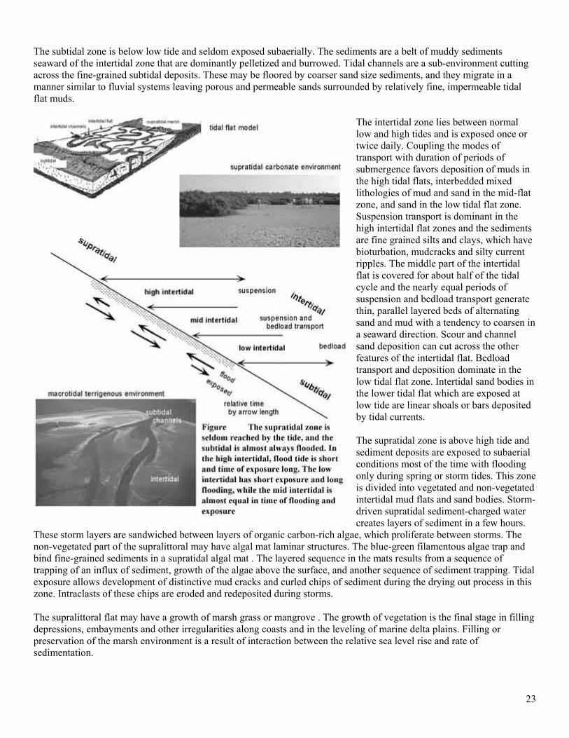
influences may be intense in this environment. Extensive intertidal flats occur in macrotidal areas such as the Yellow Sea of Korea. In North America, similar tidal flats surround the Bay of Fundy and occur along the New England coast and the North Sea. Narrower but significant intertidal flats also occur in mesotidal areas and mud shorelines are common off the microtidal, low relief Louisiana shoreline. Mud deposition is typically in protected, low energy environments such as estuaries and lagoons that also have an influx of dominantly fine-grained sediments.
However, mud deposition is not restricted to low-energy environments. Where there is an abundance of fine sediments, muddy deposits can persist even on coasts exposed to stronger wave action. Off the coast of Surinam (South America), muds are deposited in a wave energy environment normally associated with sand deposits (moderate wave power. The mud banks of Surinam resemble linear sand ridges on the shelf of the eastern United States in shape, oblique orientation to the coastline, and orientation with respect to dominant direction of transport processes. They are attached to the shoreline and commonly produce progradation of
the coastline. The Surinam coast is just one example in a growing list of relatively high energy, inter-deltaic mud coasts that include the chenier plains of Louisiana, the Yellow Sea between China and Korea and the Kerala coast of southwest India where the fine-grained sediments are in such abundance that mud deposition follows. Tidal flats have three basic environments
• subtidal, • intertidal, and • supratidal
I
23
The subtidal zone is below low tide and seldom exposed subaerially. The sediments are a belt of muddy sediments seaward of the intertidal zone that are dominantly pelletized and burrowed. Tidal channels are a sub-environment cutting across the fine-grained subtidal deposits. These may be floored by coarser sand size sediments, and they migrate in a manner similar to fluvial systems leaving porous and permeable sands surrounded by relatively fine, impermeable tidal flat muds.
The intertidal zone lies between normal low and high tides and is exposed once or twice daily. Coupling the modes of transport with duration of periods of submergence favors deposition of muds in the high tidal flats, interbedded mixed lithologies of mud and sand in the mid-flat zone, and sand in the low tidal flat zone. Suspension transport is dominant in the high intertidal flat zones and the sediments are fine grained silts and clays, which have bioturbation, mudcracks and silty current ripples. The middle part of the intertidal flat is covered for about half of the tidal cycle and the nearly equal periods of suspension and bedload transport generate thin, parallel layered beds of alternating sand and mud with a tendency to coarsen in a seaward direction. Scour and channel sand deposition can cut across the other features of the intertidal flat. Bedload transport and deposition dominate in the low tidal flat zone. Intertidal sand bodies in the lower tidal flat which are exposed at low tide are linear shoals or bars deposited by tidal currents. The supratidal zone is above high tide and sediment deposits are exposed to subaerial conditions most of the time with flooding only during spring or storm tides. This zone is divided into vegetated and non-vegetated intertidal mud flats and sand bodies. Storm-driven supratidal sediment-charged water creates layers of sediment in a few hours.
These storm layers are sandwiched between layers of organic carbon-rich algae, which proliferate between storms. The non-vegetated part of the supralittoral may have algal mat laminar structures. The blue-green filamentous algae trap and bind fine-grained sediments in a supratidal algal mat . The layered sequence in the mats results from a sequence of trapping of an influx of sediment, growth of the algae above the surface, and another sequence of sediment trapping. Tidal exposure allows development of distinctive mud cracks and curled chips of sediment during the drying out process in this zone. Intraclasts of these chips are eroded and redeposited during storms. The supralittoral flat may have a growth of marsh grass or mangrove . The growth of vegetation is the final stage in filling depressions, embayments and other irregularities along coasts and in the leveling of marine delta plains. Filling or preservation of the marsh environment is a result of interaction between the relative sea level rise and rate of sedimentation.
24
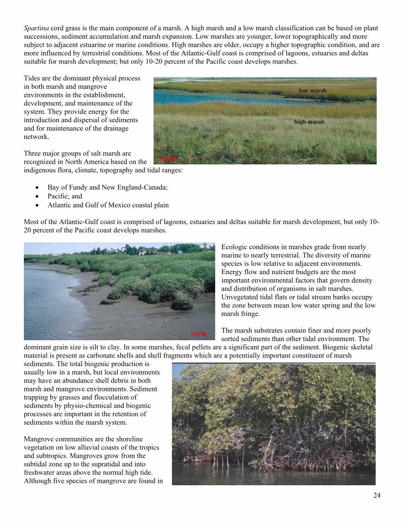
Spartina cord grass is the main component of a marsh. A high marsh and a low marsh classification can be based on plant successions, sediment accumulation and marsh expansion. Low marshes are younger, lower topographically and more subject to adjacent estuarine or marine conditions. High marshes are older, occupy a higher topographic condition, and are more influenced by terrestrial conditions. Most of the Atlantic-Gulf coast is comprised of lagoons, estuaries and deltas suitable for marsh development; but only 10-20 percent of the Pacific coast develops marshes. Tides are the dominant physical process in both marsh and mangrove environments in the establishment, development, and maintenance of the system. They provide energy for the introduction and dispersal of sediments and for maintenance of the drainage network. Three major groups of salt marsh are recognized in North America based on the indigenous flora, climate, topography and tidal ranges:
• Bay of Fundy and New England-Canada; • Pacific; and • Atlantic and Gulf of Mexico coastal plain
Most of the Atlantic-Gulf coast is comprised of lagoons, estuaries and deltas suitable for marsh development, but only 10-20 percent of the Pacific coast develops marshes.
Ecologic conditions in marshes grade from nearly marine to nearly terrestrial. The diversity of marine species is low relative to adjacent environments. Energy flow and nutrient budgets are the most important environmental factors that govern density and distribution of organisms in salt marshes. Unvegetated tidal flats or tidal stream banks occupy the zone between mean low water spring and the low marsh fringe. The marsh substrates contain finer and more poorly sorted sediments than other tidal environment. The
dominant grain size is silt to clay. In some marshes, fecal pellets are a significant part of the sediment. Biogenic skeletal material is present as carbonate shells and shell fragments which are a potentially important constituent of marsh sediments. The total biogenic production is usually low in a marsh, but local environments may have an abundance shell debris in both marsh and mangrove environments. Sediment trapping by grasses and flocculation of sediments by physio-chemical and biogenic processes are important in the retention of sediments within the marsh system. Mangrove communities are the shoreline vegetation on low alluvial coasts of the tropics and subtropics. Mangroves grow from the subtidal zone up to the supratidal and into freshwater areas above the normal high tide. Although five species of mangrove are found in
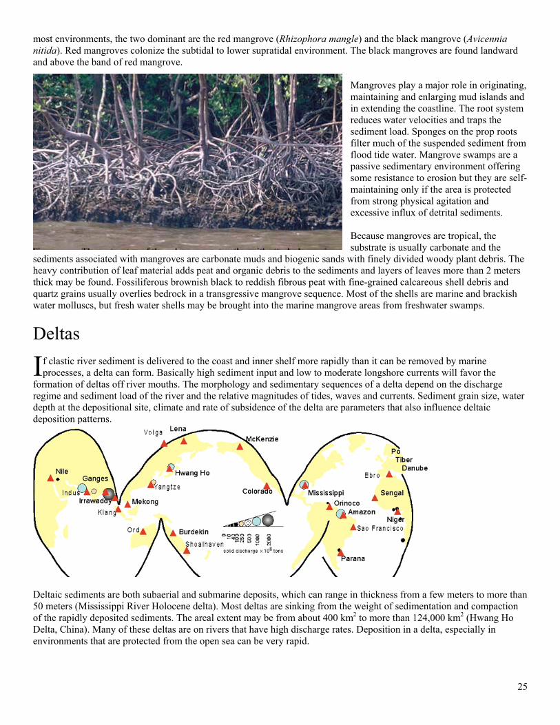
25
most environments, the two dominant are the red mangrove (Rhizophora mangle) and the black mangrove (Avicennia nitida). Red mangroves colonize the subtidal to lower supratidal environment. The black mangroves are found landward and above the band of red mangrove.
Mangroves play a major role in originating, maintaining and enlarging mud islands and in extending the coastline. The root system reduces water velocities and traps the sediment load. Sponges on the prop roots filter much of the suspended sediment from flood tide water. Mangrove swamps are a passive sedimentary environment offering some resistance to erosion but they are self-maintaining only if the area is protected from strong physical agitation and excessive influx of detrital sediments. Because mangroves are tropical, the substrate is usually carbonate and the
sediments associated with mangroves are carbonate muds and biogenic sands with finely divided woody plant debris. The heavy contribution of leaf material adds peat and organic debris to the sediments and layers of leaves more than 2 meters thick may be found. Fossiliferous brownish black to reddish fibrous peat with fine-grained calcareous shell debris and quartz grains usually overlies bedrock in a transgressive mangrove sequence. Most of the shells are marine and brackish water molluscs, but fresh water shells may be brought into the marine mangrove areas from freshwater swamps.
Deltas
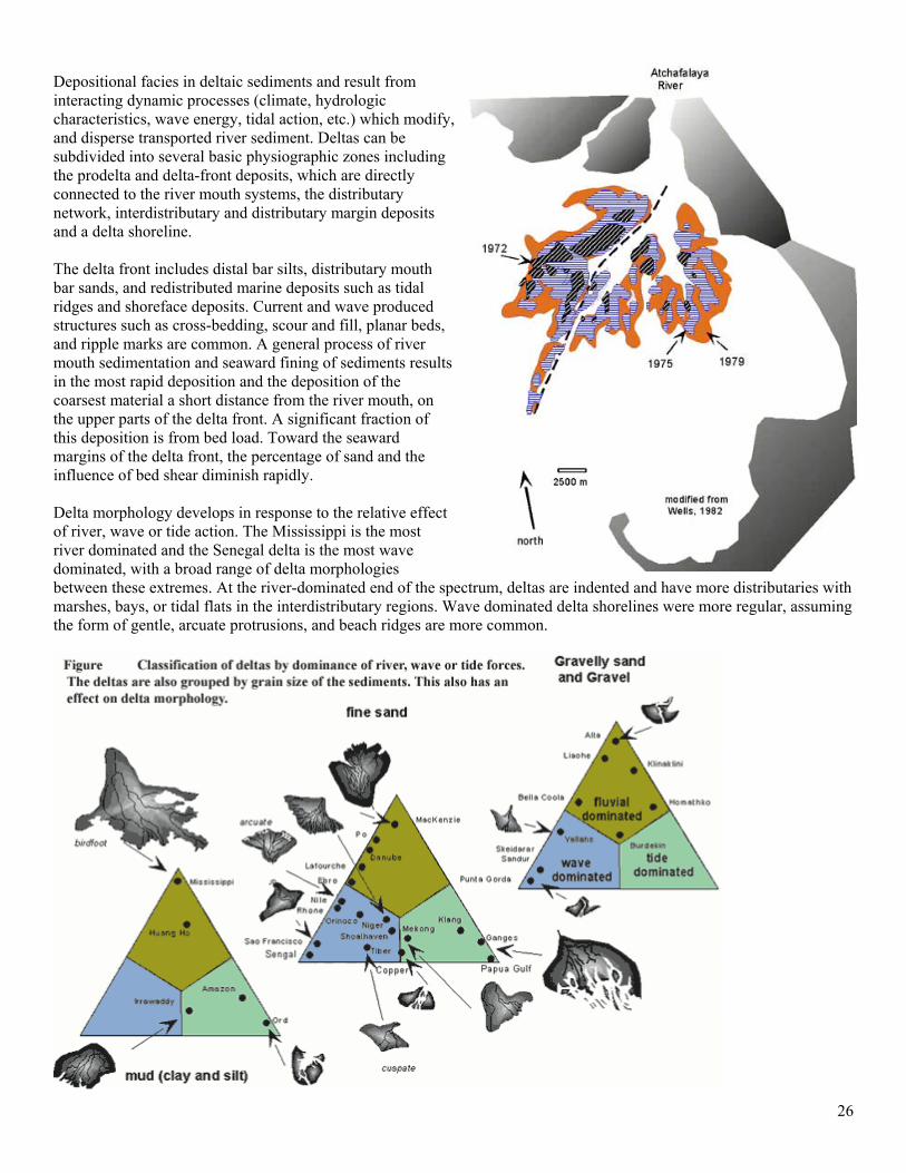
f clastic river sediment is delivered to the coast and inner shelf more rapidly than it can be removed by marine processes, a delta can form. Basically high sediment input and low to moderate longshore currents will favor the
formation of deltas off river mouths. The morphology and sedimentary sequences of a delta depend on the discharge regime and sediment load of the river and the relative magnitudes of tides, waves and currents. Sediment grain size, water depth at the depositional site, climate and rate of subsidence of the delta are parameters that also influence deltaic deposition patterns.
Deltaic sediments are both subaerial and submarine deposits, which can range in thickness from a few meters to more than 50 meters (Mississippi River Holocene delta). Most deltas are sinking from the weight of sedimentation and compaction of the rapidly deposited sediments. The areal extent may be from about 400 km2 to more than 124,000 km2 (Hwang Ho Delta, China). Many of these deltas are on rivers that have high discharge rates. Deposition in a delta, especially in environments that are protected from the open sea can be very rapid.
I
26
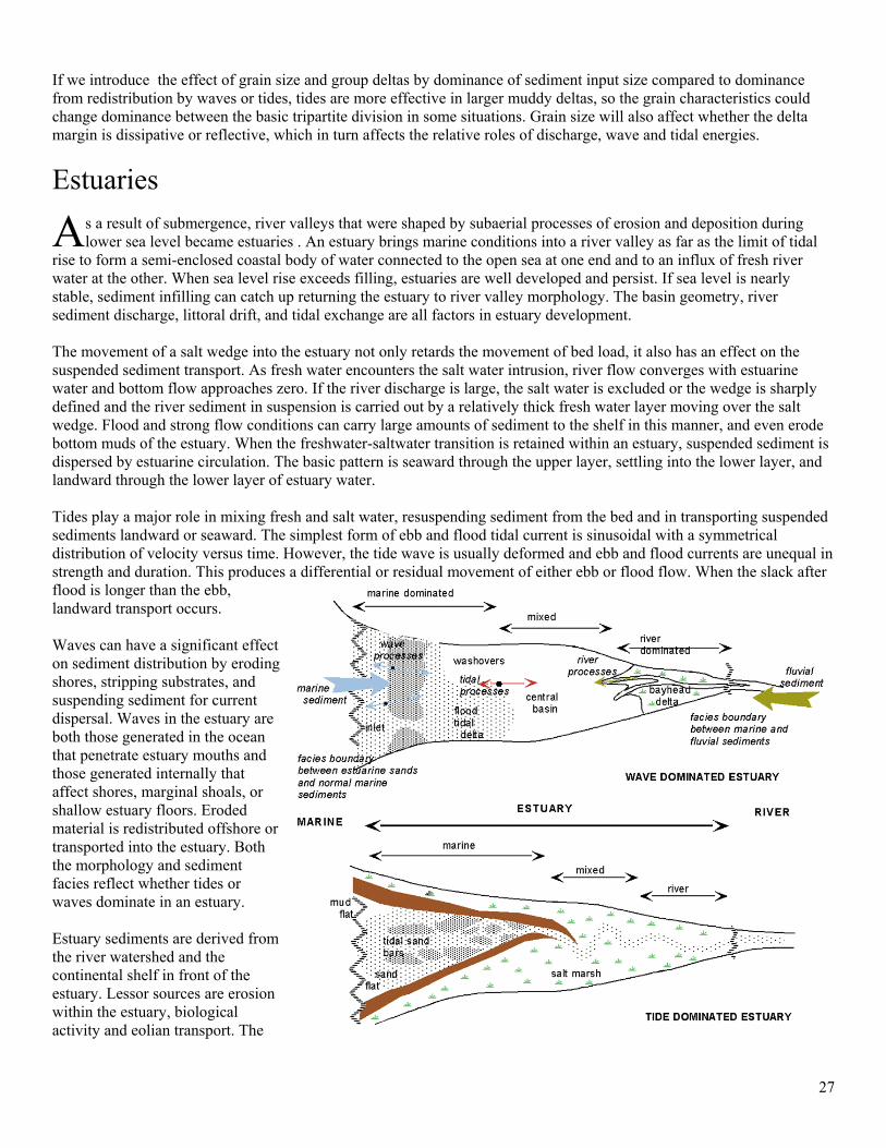
Depositional facies in deltaic sediments and result from interacting dynamic processes (climate, hydrologic characteristics, wave energy, tidal action, etc.) which modify, and disperse transported river sediment. Deltas can be subdivided into several basic physiographic zones including the prodelta and delta-front deposits, which are directly connected to the river mouth systems, the distributary network, interdistributary and distributary margin deposits and a delta shoreline. The delta front includes distal bar silts, distributary mouth bar sands, and redistributed marine deposits such as tidal ridges and shoreface deposits. Current and wave produced structures such as cross-bedding, scour and fill, planar beds, and ripple marks are common. A general process of river mouth sedimentation and seaward fining of sediments results in the most rapid deposition and the deposition of the coarsest material a short distance from the river mouth, on the upper parts of the delta front. A significant fraction of this deposition is from bed load. Toward the seaward margins of the delta front, the percentage of sand and the influence of bed shear diminish rapidly. Delta morphology develops in response to the relative effect of river, wave or tide action. The Mississippi is the most river dominated and the Senegal delta is the most wave dominated, with a broad range of delta morphologies between these extremes. At the river-dominated end of the spectrum, deltas are indented and have more distributaries with marshes, bays, or tidal flats in the interdistributary regions. Wave dominated delta shorelines were more regular, assuming the form of gentle, arcuate protrusions, and beach ridges are more common.
27
If we introduce the effect of grain size and group deltas by dominance of sediment input size compared to dominance from redistribution by waves or tides, tides are more effective in larger muddy deltas, so the grain characteristics could change dominance between the basic tripartite division in some situations. Grain size will also affect whether the delta margin is dissipative or reflective, which in turn affects the relative roles of discharge, wave and tidal energies.
Estuaries
s a result of submergence, river valleys that were shaped by subaerial processes of erosion and deposition during lower sea level became estuaries . An estuary brings marine conditions into a river valley as far as the limit of tidal
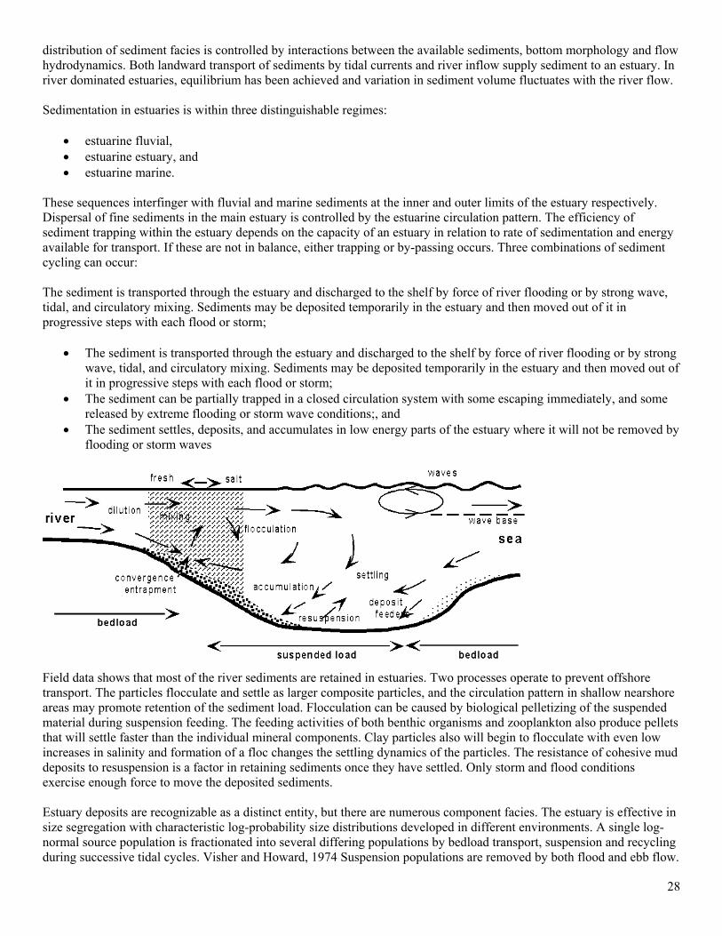
rise to form a semi-enclosed coastal body of water connected to the open sea at one end and to an influx of fresh river water at the other. When sea level rise exceeds filling, estuaries are well developed and persist. If sea level is nearly stable, sediment infilling can catch up returning the estuary to river valley morphology. The basin geometry, river sediment discharge, littoral drift, and tidal exchange are all factors in estuary development. The movement of a salt wedge into the estuary not only retards the movement of bed load, it also has an effect on the suspended sediment transport. As fresh water encounters the salt water intrusion, river flow converges with estuarine water and bottom flow approaches zero. If the river discharge is large, the salt water is excluded or the wedge is sharply defined and the river sediment in suspension is carried out by a relatively thick fresh water layer moving over the salt wedge. Flood and strong flow conditions can carry large amounts of sediment to the shelf in this manner, and even erode bottom muds of the estuary. When the freshwater-saltwater transition is retained within an estuary, suspended sediment is dispersed by estuarine circulation. The basic pattern is seaward through the upper layer, settling into the lower layer, and landward through the lower layer of estuary water. Tides play a major role in mixing fresh and salt water, resuspending sediment from the bed and in transporting suspended sediments landward or seaward. The simplest form of ebb and flood tidal current is sinusoidal with a symmetrical distribution of velocity versus time. However, the tide wave is usually deformed and ebb and flood currents are unequal in strength and duration. This produces a differential or residual movement of either ebb or flood flow. When the slack after flood is longer than the ebb, landward transport occurs. Waves can have a significant effect on sediment distribution by eroding shores, stripping substrates, and suspending sediment for current dispersal. Waves in the estuary are both those generated in the ocean that penetrate estuary mouths and those generated internally that affect shores, marginal shoals, or shallow estuary floors. Eroded material is redistributed offshore or transported into the estuary. Both the morphology and sediment facies reflect whether tides or waves dominate in an estuary. Estuary sediments are derived from the river watershed and the continental shelf in front of the estuary. Lessor sources are erosion within the estuary, biological activity and eolian transport. The
A
28
distribution of sediment facies is controlled by interactions between the available sediments, bottom morphology and flow hydrodynamics. Both landward transport of sediments by tidal currents and river inflow supply sediment to an estuary. In river dominated estuaries, equilibrium has been achieved and variation in sediment volume fluctuates with the river flow. Sedimentation in estuaries is within three distinguishable regimes:
• estuarine fluvial, • estuarine estuary, and • estuarine marine.
These sequences interfinger with fluvial and marine sediments at the inner and outer limits of the estuary respectively. Dispersal of fine sediments in the main estuary is controlled by the estuarine circulation pattern. The efficiency of sediment trapping within the estuary depends on the capacity of an estuary in relation to rate of sedimentation and energy available for transport. If these are not in balance, either trapping or by-passing occurs. Three combinations of sediment cycling can occur: The sediment is transported through the estuary and discharged to the shelf by force of river flooding or by strong wave, tidal, and circulatory mixing. Sediments may be deposited temporarily in the estuary and then moved out of it in progressive steps with each flood or storm;
• The sediment is transported through the estuary and discharged to the shelf by force of river flooding or by strong wave, tidal, and circulatory mixing. Sediments may be deposited temporarily in the estuary and then moved out of it in progressive steps with each flood or storm;
• The sediment can be partially trapped in a closed circulation system with some escaping immediately, and some released by extreme flooding or storm wave conditions;, and
• The sediment settles, deposits, and accumulates in low energy parts of the estuary where it will not be removed by flooding or storm waves
Field data shows that most of the river sediments are retained in estuaries. Two processes operate to prevent offshore transport. The particles flocculate and settle as larger composite particles, and the circulation pattern in shallow nearshore areas may promote retention of the sediment load. Flocculation can be caused by biological pelletizing of the suspended material during suspension feeding. The feeding activities of both benthic organisms and zooplankton also produce pellets that will settle faster than the individual mineral components. Clay particles also will begin to flocculate with even low increases in salinity and formation of a floc changes the settling dynamics of the particles. The resistance of cohesive mud deposits to resuspension is a factor in retaining sediments once they have settled. Only storm and flood conditions exercise enough force to move the deposited sediments. Estuary deposits are recognizable as a distinct entity, but there are numerous component facies. The estuary is effective in size segregation with characteristic log-probability size distributions developed in different environments. A single log-normal source population is fractionated into several differing populations by bedload transport, suspension and recycling during successive tidal cycles. Visher and Howard, 1974 Suspension populations are removed by both flood and ebb flow.
29
There is a net inland transport of suspended sediment with deposition on tidal flats and marshes. Sand deposits are present sporadically in the otherwise monotonous sequences of silts and clays. Shell and plant fragments are common components. These are usually lenticular layers developed by concentration and reworking of the sands by currents.
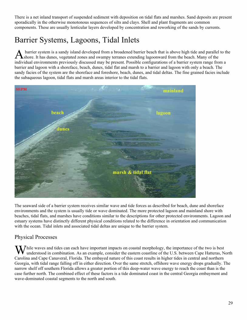
Barrier Systems, Lagoons, Tidal Inlets
barrier system is a sandy island developed from a broadened barrier beach that is above high tide and parallel to the shore. It has dunes, vegetated zones and swampy terranes extending lagoonward from the beach. Many of the
individual environments previously discussed may be present. Possible configurations of a barrier system range from a barrier and lagoon with a shoreface, beach, dunes, tidal flat and marsh to a barrier and lagoon with only a beach. The sandy facies of the system are the shoreface and foreshore, beach, dunes, and tidal deltas. The fine grained facies include the subaqueous lagoon, tidal flats and marsh areas interior to the tidal flats.
The seaward side of a barrier system receives similar wave and tide forces as described for beach, dune and shoreface environments and the system is usually tide or wave dominated. The more protected lagoon and mainland shore with beaches, tidal flats, and marshes have conditions similar to the descriptions for other protected environments. Lagoon and estuary systems have distinctly different physical conditions related to the difference in orientation and communication with the ocean. Tidal inlets and associated tidal deltas are unique to the barrier system. Physical Processes
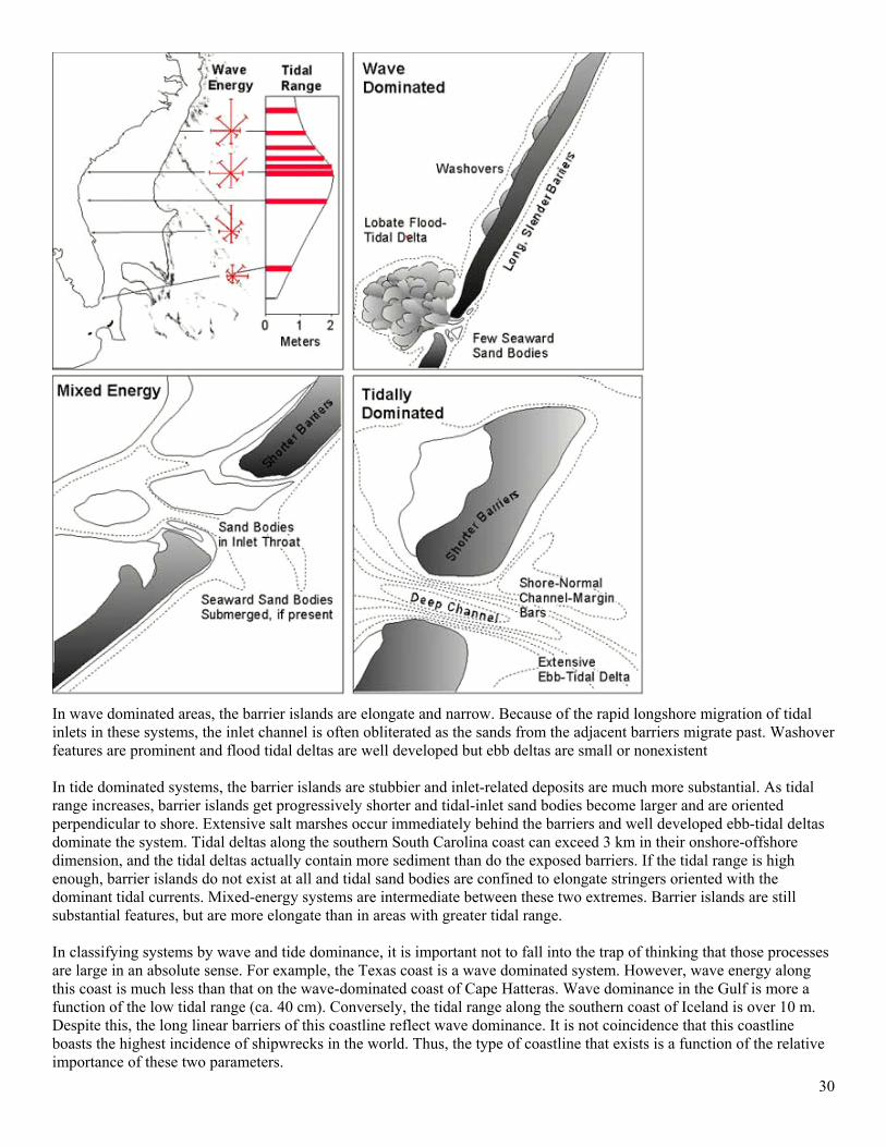
hile waves and tides can each have important impacts on coastal morphology, the importance of the two is best understood in combination. As an example, consider the eastern coastline of the U.S. between Cape Hatteras, North
Carolina and Cape Canaveral, Florida. The embayed nature of this coast results in higher tides in central and northern Georgia, with tidal range falling off in either direction. Over the same stretch, offshore wave energy drops gradually. The narrow shelf off southern Florida allows a greater portion of this deep-water wave energy to reach the coast than is the case further north. The combined effect of these factors is a tide dominated coast in the central Georgia embayment and wave-dominated coastal segments to the north and south.
A
W
30
In wave dominated areas, the barrier islands are elongate and narrow. Because of the rapid longshore migration of tidal inlets in these systems, the inlet channel is often obliterated as the sands from the adjacent barriers migrate past. Washover features are prominent and flood tidal deltas are well developed but ebb deltas are small or nonexistent In tide dominated systems, the barrier islands are stubbier and inlet-related deposits are much more substantial. As tidal range increases, barrier islands get progressively shorter and tidal-inlet sand bodies become larger and are oriented perpendicular to shore. Extensive salt marshes occur immediately behind the barriers and well developed ebb-tidal deltas dominate the system. Tidal deltas along the southern South Carolina coast can exceed 3 km in their onshore-offshore dimension, and the tidal deltas actually contain more sediment than do the exposed barriers. If the tidal range is high enough, barrier islands do not exist at all and tidal sand bodies are confined to elongate stringers oriented with the dominant tidal currents. Mixed-energy systems are intermediate between these two extremes. Barrier islands are still substantial features, but are more elongate than in areas with greater tidal range. In classifying systems by wave and tide dominance, it is important not to fall into the trap of thinking that those processes are large in an absolute sense. For example, the Texas coast is a wave dominated system. However, wave energy along this coast is much less than that on the wave-dominated coast of Cape Hatteras. Wave dominance in the Gulf is more a function of the low tidal range (ca. 40 cm). Conversely, the tidal range along the southern coast of Iceland is over 10 m. Despite this, the long linear barriers of this coastline reflect wave dominance. It is not coincidence that this coastline boasts the highest incidence of shipwrecks in the world. Thus, the type of coastline that exists is a function of the relative importance of these two parameters.
31
In addition to tide and wave, other parameters have an influence on coastal development; in descending order of importance, these are: coastal physiography, tidal prism, availability of sediment, and river input. Tidal prisms can be an important factor in developing the morphology of barrier island types of coast. Large tidal prisms in areas of low wave energy can explain large, well developed ebb tidal deltas and development of drumstick barriers. Barrier System Elements
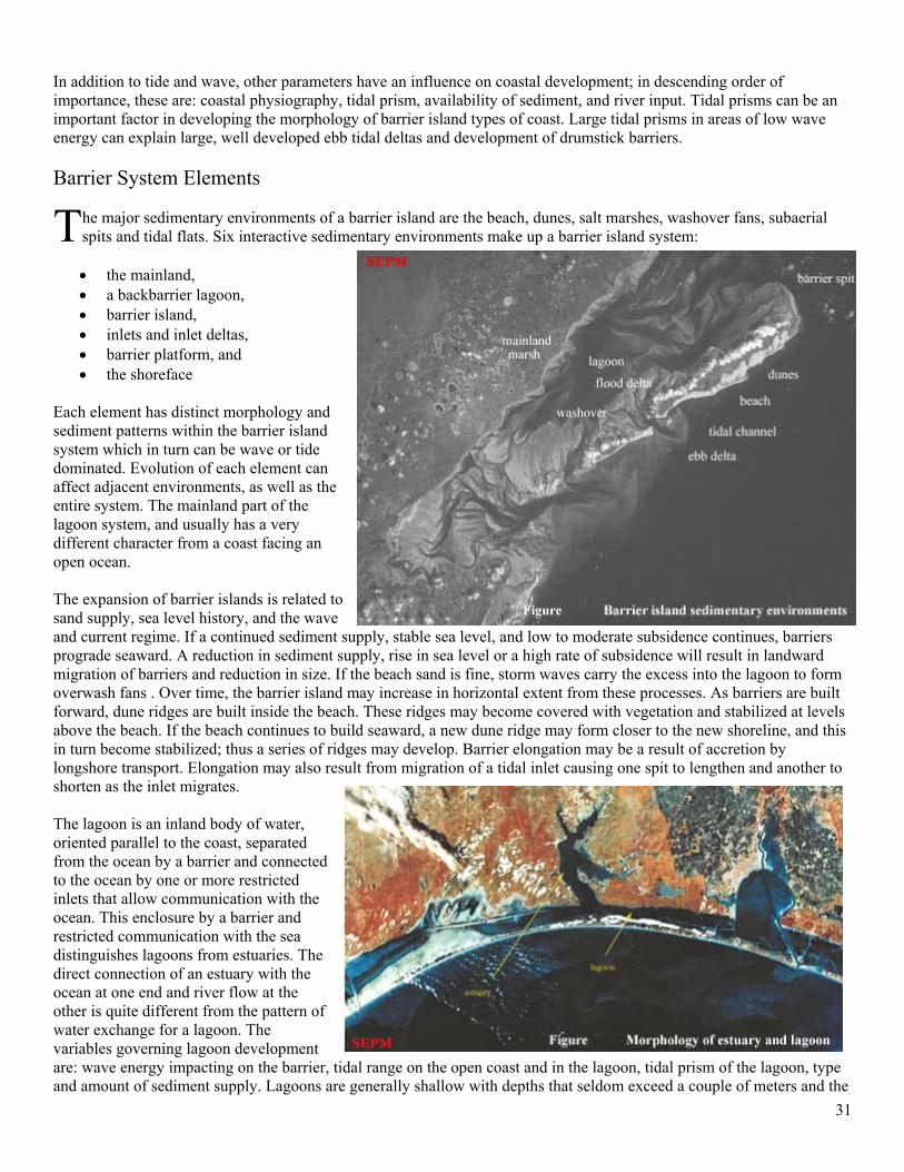
he major sedimentary environments of a barrier island are the beach, dunes, salt marshes, washover fans, subaerial spits and tidal flats. Six interactive sedimentary environments make up a barrier island system:
• the mainland, • a backbarrier lagoon, • barrier island, • inlets and inlet deltas, • barrier platform, and • the shoreface
Each element has distinct morphology and sediment patterns within the barrier island system which in turn can be wave or tide dominated. Evolution of each element can affect adjacent environments, as well as the entire system. The mainland part of the lagoon system, and usually has a very different character from a coast facing an open ocean. The expansion of barrier islands is related to sand supply, sea level history, and the wave and current regime. If a continued sediment supply, stable sea level, and low to moderate subsidence continues, barriers prograde seaward. A reduction in sediment supply, rise in sea level or a high rate of subsidence will result in landward migration of barriers and reduction in size. If the beach sand is fine, storm waves carry the excess into the lagoon to form overwash fans . Over time, the barrier island may increase in horizontal extent from these processes. As barriers are built forward, dune ridges are built inside the beach. These ridges may become covered with vegetation and stabilized at levels above the beach. If the beach continues to build seaward, a new dune ridge may form closer to the new shoreline, and this in turn become stabilized; thus a series of ridges may develop. Barrier elongation may be a result of accretion by longshore transport. Elongation may also result from migration of a tidal inlet causing one spit to lengthen and another to shorten as the inlet migrates. The lagoon is an inland body of water, oriented parallel to the coast, separated from the ocean by a barrier and connected to the ocean by one or more restricted inlets that allow communication with the ocean. This enclosure by a barrier and restricted communication with the sea distinguishes lagoons from estuaries. The direct connection of an estuary with the ocean at one end and river flow at the other is quite different from the pattern of water exchange for a lagoon. The variables governing lagoon development are: wave energy impacting on the barrier, tidal range on the open coast and in the lagoon, tidal prism of the lagoon, type and amount of sediment supply. Lagoons are generally shallow with depths that seldom exceed a couple of meters and the
T
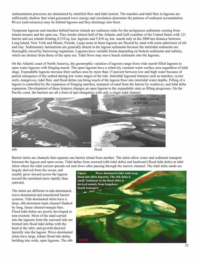
32
sedimentation processes are dominated by stratified flow and tidal motion. The marshes and tidal flats in lagoons are sufficiently shallow that wind-generated wave energy and circulation determine the patterns of sediment accumulation. Rivers (and estuaries) may lie behind lagoons and they discharge into them. Temperate lagoons and marshes behind barrier islands are sediment sinks for the terrigenous sediments coming from inland streams and the open sea. They border almost half of the Atlantic and Gulf coastline of the United States with 121 barrier and sea islands fronting 8,510 sq. km. lagoons and 5,810 sq. km. marsh only in the 2000 km distance between Long Island, New York and Miami, Florida. Large areas in these lagoons are floored by sand with some admixture of silt and clay. Sedimentary laminations are generally absent in the lagoon sediments because the intertidal sediments are thoroughly mixed by burrowing organisms. Lagoons have variable biotas depending on bottom sediments and salinity, which are distinct from those of the open sea. Tidal flows may move beach sediments into the lagoons. On the Atlantic coast of North America, the geomorphic variation of lagoons range from wide marsh-filled lagoons to open water lagoons with fringing marsh. The open lagoons have a relatively constant water surface area regardless of tidal stage. Expandable lagoons increase their surface area by more than 15 percent between low and high water because of partial emergence of the seabed during low water stages of the tide. Intertidal lagoonal features such as marshes, oyster reefs, mangroves, tidal flats, and flood deltas can bring much of the lagoon floor into intertidal water depths. Filling of a lagoon is controlled by the expansion of fringing marshes, transport of sand from the barrier by washover, and tidal delta expansion. Development of these features changes an open lagoon to the expandable state as filling progresses. On the Pacific coast, the barriers are all a form of spit elongation with only a single tidal channel.
ebb flood Barrier inlets are channels that separate one barrier island from another. The inlets allow water and sediment transport between the lagoon and open ocean. Tidal deltas form seaward (ebb tidal delta) and landward (flood tidal delta) at tidal inlets where the tidal current spreads out and slows after passing through the narrow channel. The tidal delta sands are largely derived from the ocean, and usually grow inward across the lagoon toward the mainland more rapidly than outward. The inlets are different in tide-dominated, wave-dominated and transitional barrier systems. Tide-dominated inlets have a deep, ebb-dominant main channel flanked by long, linear channel-margin bars. Flood tidal deltas are poorly developed or non-existent. Most of the sand carried into the lagoons from the seaward side are formed into flood tidal deltas with the head at the inlet, and growth directed laterally into the lagoon. Wave-dominated inlets have large, lobate flood-tide deltas building into wide, open lagoons. The ebb
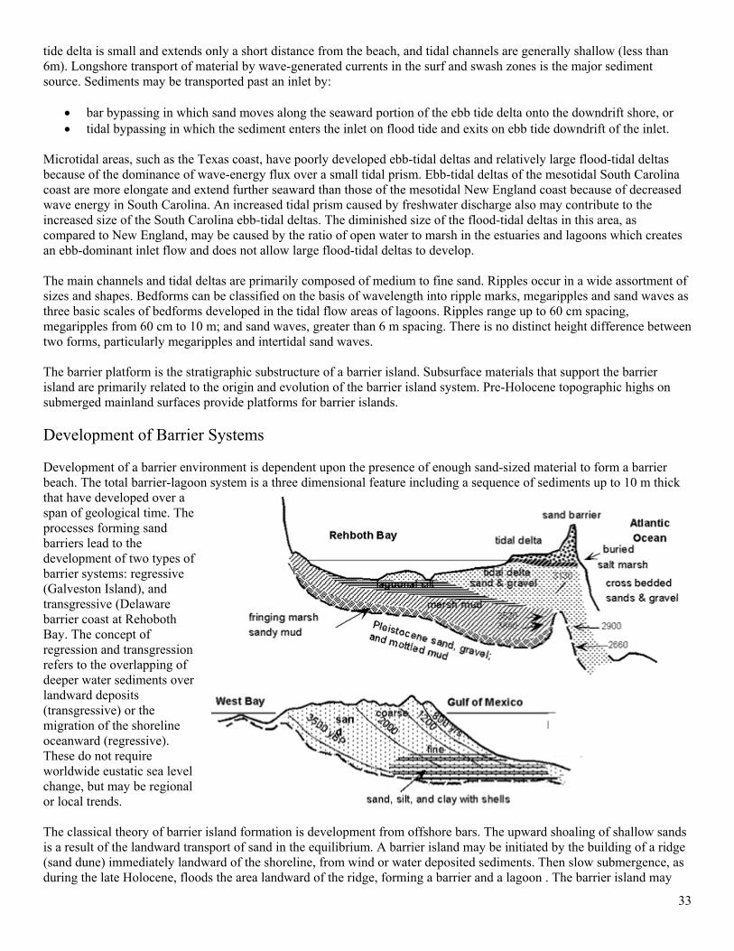
33
tide delta is small and extends only a short distance from the beach, and tidal channels are generally shallow (less than 6m). Longshore transport of material by wave-generated currents in the surf and swash zones is the major sediment source. Sediments may be transported past an inlet by:
• bar bypassing in which sand moves along the seaward portion of the ebb tide delta onto the downdrift shore, or • tidal bypassing in which the sediment enters the inlet on flood tide and exits on ebb tide downdrift of the inlet.
Microtidal areas, such as the Texas coast, have poorly developed ebb-tidal deltas and relatively large flood-tidal deltas because of the dominance of wave-energy flux over a small tidal prism. Ebb-tidal deltas of the mesotidal South Carolina coast are more elongate and extend further seaward than those of the mesotidal New England coast because of decreased wave energy in South Carolina. An increased tidal prism caused by freshwater discharge also may contribute to the increased size of the South Carolina ebb-tidal deltas. The diminished size of the flood-tidal deltas in this area, as compared to New England, may be caused by the ratio of open water to marsh in the estuaries and lagoons which creates an ebb-dominant inlet flow and does not allow large flood-tidal deltas to develop. The main channels and tidal deltas are primarily composed of medium to fine sand. Ripples occur in a wide assortment of sizes and shapes. Bedforms can be classified on the basis of wavelength into ripple marks, megaripples and sand waves as three basic scales of bedforms developed in the tidal flow areas of lagoons. Ripples range up to 60 cm spacing, megaripples from 60 cm to 10 m; and sand waves, greater than 6 m spacing. There is no distinct height difference between two forms, particularly megaripples and intertidal sand waves. The barrier platform is the stratigraphic substructure of a barrier island. Subsurface materials that support the barrier island are primarily related to the origin and evolution of the barrier island system. Pre-Holocene topographic highs on submerged mainland surfaces provide platforms for barrier islands. Development of Barrier Systems Development of a barrier environment is dependent upon the presence of enough sand-sized material to form a barrier beach. The total barrier-lagoon system is a three dimensional feature including a sequence of sediments up to 10 m thick that have developed over a span of geological time. The processes forming sand barriers lead to the development of two types of barrier systems: regressive (Galveston Island), and transgressive (Delaware barrier coast at Rehoboth Bay. The concept of regression and transgression refers to the overlapping of deeper water sediments over landward deposits (transgressive) or the migration of the shoreline oceanward (regressive). These do not require worldwide eustatic sea level change, but may be regional or local trends. The classical theory of barrier island formation is development from offshore bars. The upward shoaling of shallow sands is a result of the landward transport of sand in the equilibrium. A barrier island may be initiated by the building of a ridge (sand dune) immediately landward of the shoreline, from wind or water deposited sediments. Then slow submergence, as during the late Holocene, floods the area landward of the ridge, forming a barrier and a lagoon . The barrier island may
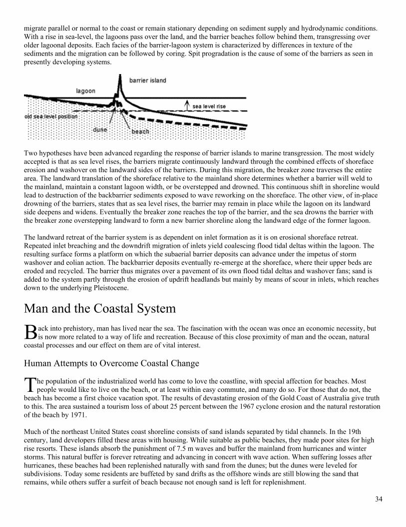
34
migrate parallel or normal to the coast or remain stationary depending on sediment supply and hydrodynamic conditions. With a rise in sea-level, the lagoons pass over the land, and the barrier beaches follow behind them, transgressing over older lagoonal deposits. Each facies of the barrier-lagoon system is characterized by differences in texture of the sediments and the migration can be followed by coring. Spit progradation is the cause of some of the barriers as seen in presently developing systems.
Two hypotheses have been advanced regarding the response of barrier islands to marine transgression. The most widely accepted is that as sea level rises, the barriers migrate continuously landward through the combined effects of shoreface erosion and washover on the landward sides of the barriers. During this migration, the breaker zone traverses the entire area. The landward translation of the shoreface relative to the mainland shore determines whether a barrier will weld to the mainland, maintain a constant lagoon width, or be overstepped and drowned. This continuous shift in shoreline would lead to destruction of the backbarrier sediments exposed to wave reworking on the shoreface. The other view, of in-place drowning of the barriers, states that as sea level rises, the barrier may remain in place while the lagoon on its landward side deepens and widens. Eventually the breaker zone reaches the top of the barrier, and the sea drowns the barrier with the breaker zone overstepping landward to form a new barrier shoreline along the landward edge of the former lagoon. The landward retreat of the barrier system is as dependent on inlet formation as it is on erosional shoreface retreat. Repeated inlet breaching and the downdrift migration of inlets yield coalescing flood tidal deltas within the lagoon. The resulting surface forms a platform on which the subaerial barrier deposits can advance under the impetus of storm washover and eolian action. The backbarrier deposits eventually re-emerge at the shoreface, where their upper beds are eroded and recycled. The barrier thus migrates over a pavement of its own flood tidal deltas and washover fans; sand is added to the system partly through the erosion of updrift headlands but mainly by means of scour in inlets, which reaches down to the underlying Pleistocene.
Man and the Coastal System
ack into prehistory, man has lived near the sea. The fascination with the ocean was once an economic necessity, but is now more related to a way of life and recreation. Because of this close proximity of man and the ocean, natural
coastal processes and our effect on them are of vital interest. Human Attempts to Overcome Coastal Change
he population of the industrialized world has come to love the coastline, with special affection for beaches. Most people would like to live on the beach, or at least within easy commute, and many do so. For those that do not, the
beach has become a first choice vacation spot. The results of devastating erosion of the Gold Coast of Australia give truth to this. The area sustained a tourism loss of about 25 percent between the 1967 cyclone erosion and the natural restoration of the beach by 1971. Much of the northeast United States coast shoreline consists of sand islands separated by tidal channels. In the 19th century, land developers filled these areas with housing. While suitable as public beaches, they made poor sites for high rise resorts. These islands absorb the punishment of 7.5 m waves and buffer the mainland from hurricanes and winter storms. This natural buffer is forever retreating and advancing in concert with wave action. When suffering losses after hurricanes, these beaches had been replenished naturally with sand from the dunes; but the dunes were leveled for subdivisions. Today some residents are buffeted by sand drifts as the offshore winds are still blowing the sand that remains, while others suffer a surfeit of beach because not enough sand is left for replenishment.
B
T
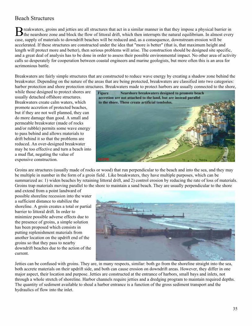
35
Beach Structures
reakwaters, groins and jetties are all structures that act in a similar manner in that they impose a physical barrier in the nearshore zone and block the flow of littoral drift, which then interrupts the natural equilibrium. In almost every
case, supply of materials to downdrift beaches will be reduced and, as a consequence, downstream erosion will be accelerated. If these structures are constructed under the idea that "more is better" (that is, that maximum height and length will protect more and better), then serious problems will arise. The construction should be designed site specific, and a great deal of analysis has to be done in order to assess their possible environmental impact. No other area of activity calls so desperately for cooperation between coastal engineers and marine geologists, but more often this is an area for acrimonious battle. Breakwaters are fairly simple structures that are constructed to reduce wave energy by creating a shadow zone behind the breakwater. Depending on the nature of the areas that are being protected, breakwaters are classified into two categories: harbor protection and shore protection structures. Breakwaters made to protect harbors are usually connected to the shore, while those designed to protect shores are usually detached offshore structures. Breakwaters create calm waters, which promote accretion of protected beaches, but if they are not well planned, they can do more damage than good. A small and permeable breakwater (made of rocks and/or rubble) permits some wave energy to pass behind and allows materials to drift behind it so that the problems are reduced. An over-designed breakwater may be too effective and turn a beach into a mud flat, negating the value of expensive construction. Groins are structures (usually made of rocks or wood) that run perpendicular to the beach and into the sea, and they may be multiple in number in the form of a groin field . Like breakwaters, they have multiple purposes, which can be summarized as: 1) widen beaches by retaining littoral drift, and 2) control erosion by reducing the rate of loss of materials. Groins trap materials moving parallel to the shore to maintain a sand beach. They are usually perpendicular to the shore and extend from a point landward of possible shoreline recession into the water a sufficient distance to stabilize the shoreline. A groin creates a total or partial barrier to littoral drift. In order to minimize possible adverse effects due to the presence of groins, a simple solution has been proposed which consists in putting replenishment materials from another location on the updrift end of the groins so that they pass to nearby downdrift beaches due to the action of the current. Jetties can be confused with groins. They are, in many respects, similar: both go from the shoreline straight into the sea, both accrete materials on their updrift side, and both can cause erosion on downdrift areas. However, they differ in one major aspect, their location and purpose. Jetties are constructed at the entrance of harbors, small bays and inlets, not through a whole stretch of shoreline. Harbor channels require jetties and a dredging program to maintain required depths. The quantity of sediment available to shoal a harbor entrance is a function of the gross sediment transport and the hydraulics of flow into the inlet.
B
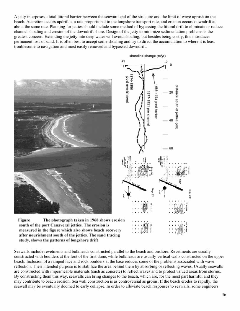
36
A jetty interposes a total littoral barrier between the seaward end of the structure and the limit of wave uprush on the beach. Accretion occurs updrift at a rate proportional to the longshore transport rate, and erosion occurs downdrift at about the same rate. Planning for jetties should include some method of bypassing the littoral drift to eliminate or reduce channel shoaling and erosion of the downdrift shore. Design of the jetty to minimize sedimentation problems is the greatest concern. Extending the jetty into deep water will avoid shoaling, but besides being costly, this introduces permanent loss of sand. It is often best to accept some shoaling and try to direct the accumulation to where it is least troublesome to navigation and most easily removed and bypassed downdrift.
Seawalls include revetments and bulkheads constructed parallel to the beach and onshore. Revetments are usually constructed with boulders at the foot of the first dune, while bulkheads are usually vertical walls constructed on the upper beach. Inclusion of a ramped face and rock boulders at the base reduces some of the problems associated with wave reflection. Their intended purpose is to stabilize the area behind them by absorbing or reflecting waves. Usually seawalls are constructed with impermeable materials (such as concrete) to reflect waves and to protect valued areas from storms. By constructing them this way, seawalls can bring changes to the beach, which are, for the most part harmful and they may contribute to beach erosion. Sea wall construction is as controversial as groins. If the beach erodes to rapidly, the seawall may be eventually doomed to early collapse. In order to alleviate beach responses to seawalls, some engineers
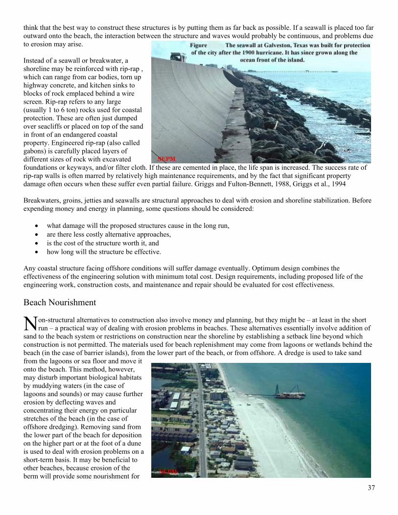
37
think that the best way to construct these structures is by putting them as far back as possible. If a seawall is placed too far outward onto the beach, the interaction between the structure and waves would probably be continuous, and problems due to erosion may arise. Instead of a seawall or breakwater, a shoreline may be reinforced with rip-rap , which can range from car bodies, torn up highway concrete, and kitchen sinks to blocks of rock emplaced behind a wire screen. Rip-rap refers to any large (usually 1 to 6 ton) rocks used for coastal protection. These are often just dumped over seacliffs or placed on top of the sand in front of an endangered coastal property. Engineered rip-rap (also called gabons) is carefully placed layers of different sizes of rock with excavated foundations or keyways, and/or filter cloth. If these are cemented in place, the life span is increased. The success rate of rip-rap walls is often marred by relatively high maintenance requirements, and by the fact that significant property damage often occurs when these suffer even partial failure. Griggs and Fulton-Bennett, 1988, Griggs et al., 1994 Breakwaters, groins, jetties and seawalls are structural approaches to deal with erosion and shoreline stabilization. Before expending money and energy in planning, some questions should be considered:
• what damage will the proposed structures cause in the long run, • are there less costly alternative approaches, • is the cost of the structure worth it, and • how long will the structure be effective.
Any coastal structure facing offshore conditions will suffer damage eventually. Optimum design combines the effectiveness of the engineering solution with minimum total cost. Design requirements, including proposed life of the engineering work, construction costs, and maintenance and repair should be evaluated for cost effectiveness. Beach Nourishment
on-structural alternatives to construction also involve money and planning, but they might be – at least in the short run – a practical way of dealing with erosion problems in beaches. These alternatives essentially involve addition of
sand to the beach system or restrictions on construction near the shoreline by establishing a setback line beyond which construction is not permitted. The materials used for beach replenishment may come from lagoons or wetlands behind the beach (in the case of barrier islands), from the lower part of the beach, or from offshore. A dredge is used to take sand from the lagoons or sea floor and move it onto the beach. This method, however, may disturb important biological habitats by muddying waters (in the case of lagoons and sounds) or may cause further erosion by deflecting waves and concentrating their energy on particular stretches of the beach (in the case of offshore dredging). Removing sand from the lower part of the beach for deposition on the higher part or at the foot of a dune is used to deal with erosion problems on a short-term basis. It may be beneficial to other beaches, because erosion of the berm will provide some nourishment for
N
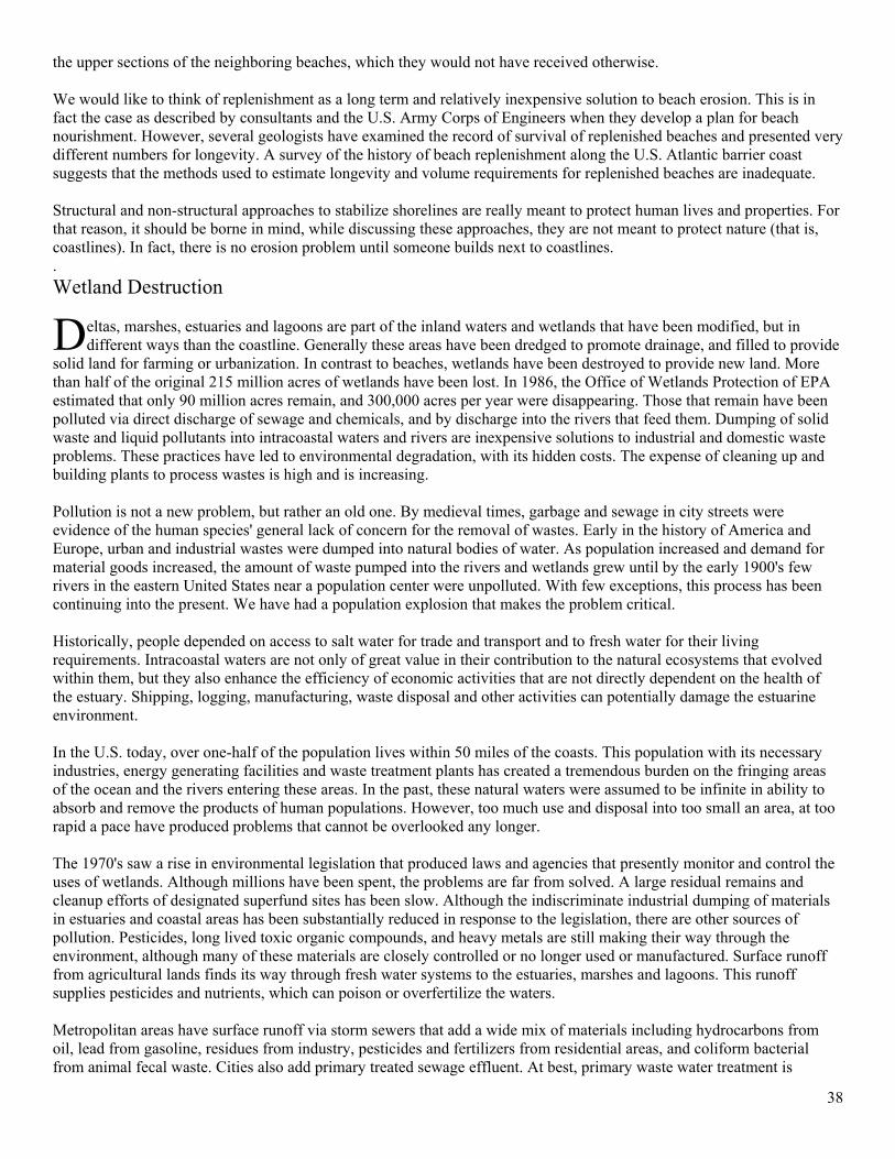
38
the upper sections of the neighboring beaches, which they would not have received otherwise. We would like to think of replenishment as a long term and relatively inexpensive solution to beach erosion. This is in fact the case as described by consultants and the U.S. Army Corps of Engineers when they develop a plan for beach nourishment. However, several geologists have examined the record of survival of replenished beaches and presented very different numbers for longevity. A survey of the history of beach replenishment along the U.S. Atlantic barrier coast suggests that the methods used to estimate longevity and volume requirements for replenished beaches are inadequate. Structural and non-structural approaches to stabilize shorelines are really meant to protect human lives and properties. For that reason, it should be borne in mind, while discussing these approaches, they are not meant to protect nature (that is, coastlines). In fact, there is no erosion problem until someone builds next to coastlines. . Wetland Destruction
eltas, marshes, estuaries and lagoons are part of the inland waters and wetlands that have been modified, but in different ways than the coastline. Generally these areas have been dredged to promote drainage, and filled to provide
solid land for farming or urbanization. In contrast to beaches, wetlands have been destroyed to provide new land. More than half of the original 215 million acres of wetlands have been lost. In 1986, the Office of Wetlands Protection of EPA estimated that only 90 million acres remain, and 300,000 acres per year were disappearing. Those that remain have been polluted via direct discharge of sewage and chemicals, and by discharge into the rivers that feed them. Dumping of solid waste and liquid pollutants into intracoastal waters and rivers are inexpensive solutions to industrial and domestic waste problems. These practices have led to environmental degradation, with its hidden costs. The expense of cleaning up and building plants to process wastes is high and is increasing. Pollution is not a new problem, but rather an old one. By medieval times, garbage and sewage in city streets were evidence of the human species' general lack of concern for the removal of wastes. Early in the history of America and Europe, urban and industrial wastes were dumped into natural bodies of water. As population increased and demand for material goods increased, the amount of waste pumped into the rivers and wetlands grew until by the early 1900's few rivers in the eastern United States near a population center were unpolluted. With few exceptions, this process has been continuing into the present. We have had a population explosion that makes the problem critical. Historically, people depended on access to salt water for trade and transport and to fresh water for their living requirements. Intracoastal waters are not only of great value in their contribution to the natural ecosystems that evolved within them, but they also enhance the efficiency of economic activities that are not directly dependent on the health of the estuary. Shipping, logging, manufacturing, waste disposal and other activities can potentially damage the estuarine environment. In the U.S. today, over one-half of the population lives within 50 miles of the coasts. This population with its necessary industries, energy generating facilities and waste treatment plants has created a tremendous burden on the fringing areas of the ocean and the rivers entering these areas. In the past, these natural waters were assumed to be infinite in ability to absorb and remove the products of human populations. However, too much use and disposal into too small an area, at too rapid a pace have produced problems that cannot be overlooked any longer. The 1970's saw a rise in environmental legislation that produced laws and agencies that presently monitor and control the uses of wetlands. Although millions have been spent, the problems are far from solved. A large residual remains and cleanup efforts of designated superfund sites has been slow. Although the indiscriminate industrial dumping of materials in estuaries and coastal areas has been substantially reduced in response to the legislation, there are other sources of pollution. Pesticides, long lived toxic organic compounds, and heavy metals are still making their way through the environment, although many of these materials are closely controlled or no longer used or manufactured. Surface runoff from agricultural lands finds its way through fresh water systems to the estuaries, marshes and lagoons. This runoff supplies pesticides and nutrients, which can poison or overfertilize the waters. Metropolitan areas have surface runoff via storm sewers that add a wide mix of materials including hydrocarbons from oil, lead from gasoline, residues from industry, pesticides and fertilizers from residential areas, and coliform bacterial from animal fecal waste. Cities also add primary treated sewage effluent. At best, primary waste water treatment is
D
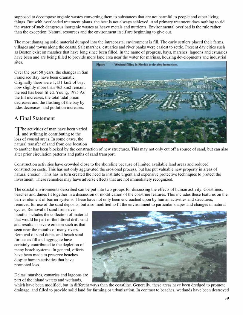
39
supposed to decompose organic wastes converting them to substances that are not harmful to people and other living things. But with overloaded treatment plants, the best is not always achieved. And primary treatment does nothing to rid the water of such dangerous inorganic wastes as heavy metals and nutrients. Environmental overload is the rule rather than the exception. Natural resources and the environment itself are beginning to give out. The most damaging solid material dumped into the intracoastal environment is fill. The early settlers placed their farms, villages and towns along the coasts. Salt marshes, estuaries and river banks were easiest to settle. Present day cities such as Boston exist on marshes that have long since been filled. In the name of progress, bays, marshes, lagoons and estuaries have been and are being filled to provide more land area near the water for marinas, housing developments and industrial sites. Over the past 50 years, the changes in San Francisco Bay have been dramatic. Originally there were 1,131 km2 of bay, now slightly more than 463 km2 remain; the rest has been filled. Young, 1975 As the fill increases, the total tidal prism decreases and the flushing of the bay by tides decreases, and pollution increases. A Final Statement
he activities of man have been varied and striking in contributing to the
loss of coastal areas. In some cases, the natural transfer of sand from one location to another has been blocked by the construction of new structures. This may not only cut off a source of sand, but can also alter prior circulation patterns and paths of sand transport. Construction activities have crowded close to the shoreline because of limited available land areas and reduced construction costs. This has not only aggravated the erosional process, but has put valuable new property in areas of natural erosion . This has in turn created the need to institute urgent and expensive protective techniques to protect the investment. These remedies may have adverse effects that are not immediately recognized. The coastal environments described can be put into two groups for discussing the effects of human activity. Coastlines, beaches and dunes fit together in a discussion of modification of the coastline features. This includes these features on the barrier element of barrier systems. These have not only been encroached upon by human activities and structures, removed for use of the sand deposits, but also modified to fit the environment to particular shapes and changes in natural cycles. Removal of sand from river mouths includes the collection of material that would be part of the littoral drift sand and results in severe erosion such as that seen near the mouths of many rivers. Removal of sand dunes and beach sand for use as fill and aggregate have certainly contributed to the depletion of many beach systems. In general, efforts have been made to preserve beaches despite human activities that have promoted loss. Deltas, marshes, estuaries and lagoons are part of the inland waters and wetlands, which have been modified, but in different ways than the coastline. Generally, these areas have been dredged to promote drainage, and filled to provide solid land for farming or urbanization. In contrast to beaches, wetlands have been destroyed
T
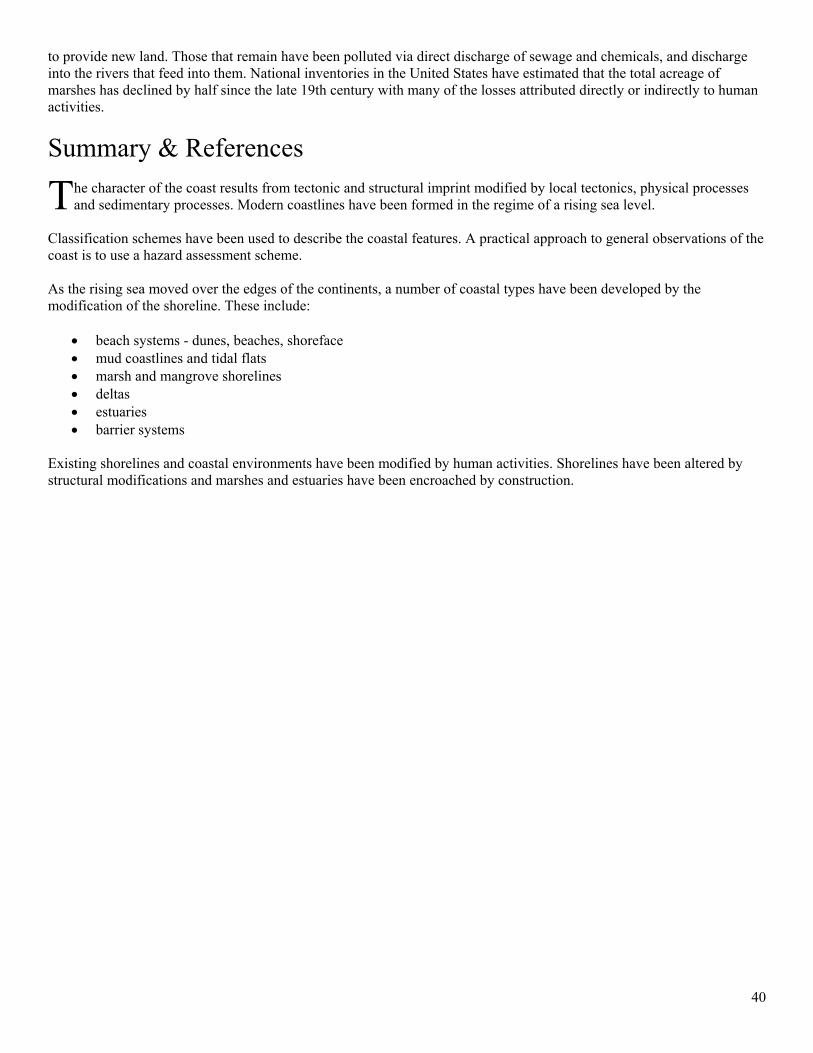
40
to provide new land. Those that remain have been polluted via direct discharge of sewage and chemicals, and discharge into the rivers that feed into them. National inventories in the United States have estimated that the total acreage of marshes has declined by half since the late 19th century with many of the losses attributed directly or indirectly to human activities.
Summary & References
he character of the coast results from tectonic and structural imprint modified by local tectonics, physical processes and sedimentary processes. Modern coastlines have been formed in the regime of a rising sea level.
Classification schemes have been used to describe the coastal features. A practical approach to general observations of the coast is to use a hazard assessment scheme. As the rising sea moved over the edges of the continents, a number of coastal types have been developed by the modification of the shoreline. These include:
• beach systems - dunes, beaches, shoreface • mud coastlines and tidal flats • marsh and mangrove shorelines • deltas • estuaries • barrier systems
Existing shorelines and coastal environments have been modified by human activities. Shorelines have been altered by structural modifications and marshes and estuaries have been encroached by construction.
T