Embed Size (px)
Citation preview
Page 1 of 43
Draft-6-15-2015: SOME MAPS AND FIGURES REMOVED FOR PUBLICATION DUE
TO WEB SIZE LIMITS
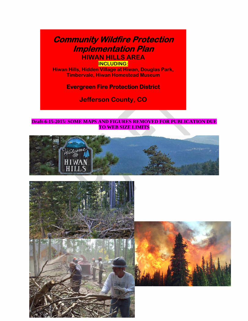
Community Wildfire Protection Implementation Plan
HIWAN HILLS AREA INCLUDING:
Hiwan Hills, Hidden Village at Hiwan, Douglas Park, Timbervale, Hiwan Homestead Museum
Evergreen Fire Protection District
Jefferson County, CO

Page 2 of 43
THIS PAGE INTENTIONALLY LEFT BLANK
Page 3 of 43
CWPIP Certification
The Hiwan Hills Area Community Wildfire Protection Implementation Plan (CWPIP) was
developed in accordance with the guidelines set forth by the Healthy Forests Restoration Act
(2003) and the Colorado State Forest Service’s Minimum Standards for Community Wildfire
Protection Plans (CWPP) (Revised 2010).
This Plan is under the umbrella of the Evergreen Fire Protection District CWPP. As such it
provides local analysis and implementation recommendations for the Hiwan Hills area. The
plan:
• Was collaboratively developed – residents, interested parties, and stakeholders. State,
county and federal agencies managing land in the region were consulted as appropriate.
•Identifies and prioritizes areas for hazardous fuels reduction treatments and recommends
the types and methods of treatment to reduce the wildfire threat to values at risk in the
area;
• Presents measures to reduce the ignitability of structures throughout the plan area.
The following entities mutually agree with the contents of this Community Wildfire Protection
Implementation Plan:
______________________________________________________________________________
Eric Wilhelm (For the Team) Date
______________________________________________________________________________
Evergreen Fire Protection District Date

Page 4 of 43
THIS PAGE INTENTIONALLY LEFT BLANK
Page 5 of 43
TABLE OF CONTENTS
Section 1: Community Wildfire Protection Planning………………………………….P 7
Section 2: The Hiwan Hills Area & Community Risk Analysis……………………....P 9
Section 3: Wildland Fire Response Infrastructure and Capabilities…………………...P 16
Section 4: Implementation Actions & Recommendations……………...……………...P 17
4.1 Mitigation techniques to be applied
4.2 Fuels mitigation Projects
Section 5: Plan Implementation and Follow up ……………….………………………P 29
Section 6: Appendices………………………….………………………………………P 31

Page 6 of 43
THIS PAGE INENTIONALLY LEFT BLANK
Page 7 of 43
Section 1: COMMUNITY WILDFIRE PROTECTION PLANNING
This Hiwan Hills Area Community Wildfire Protection Implementation Plan
(CWPIP) is a plan for all of us as residents of the community. It has been developed
by your neighbors with advice and assistance from the Evergreen Fire Protection
District (EFPD).
It provides an assessment of wildfire risks and hazards and outlines specific mitigation treatment
recommendations designed to make our community a safer place to live, work and play. It will
enable us to live with fire as a natural part of the landscape ecosystem.
It informs and encourages all of us as home owners to create defensible space and achieve fire
resistant structural integrity, and makes priority recommendations to (EFPD) regarding road
corridor and fuels treatment mitigation actions.
It is recognized that much of the community land involved is private land. That is why
communities nationwide do such plans. It is extremely important for land owners to take
action to create Defensible Space on their land. A land owner does not have to clear cut
their property to achieve defensible space against wildfire. But without collaborative,
neighborhood action the damage to homes or other buildings can be significant.
Once the CWPIP is finalized and adopted, it is the responsibility of the team and
community…that’s US, to move forward and implement the action items in collaboration
with the EFPD. This will require further planning at the project level, acquisition of funds and
assistance through grants or other means, or simply motivating individual homeowners. It should
be emphasized that the CWPIP is a living document to be revisited on a regular basis and revised
as needed… THIS IS OUR PROCESS, NOT A SHELF DOCUMENT!!
The Team – Local residents and agencies involved in developing this plan:
Residents of the Hiwan Hills Area
o Eric Wilhelm-Team lead; Stephen Colella, Joe Gerlach, Doug Jenner, Jeff and
Stacy Peters, Nan Rickey, Rachel Saylor, Shane Smith
Frank Dearborn: Fire Marshal, Evergreen Fire Protection District
John Chapman; Team Facilitator
Contacts and Input:
o Evergreen Fire Rescue: Frank Dearborn, Fire Marshal; Mike Weege, Chief
There is no legal requirement to implement the recommendations in this CWPIP. This is
also the case for CWPPs. Treatments on private land may require compliance with county
land use codes, building codes, and local covenants. Treatments on public lands are carried
out by appropriate agencies and may be subject to federal, state, and county policies and
procedures such as the National Environmental Policy Act (NEPA).
Page 8 of 43
The Challenge Decades of aggressive fire suppression in fire-dependent ecosystems, coupled with persistent
drought, disease and insect infestation, have all converged to create a threat commanding both
national attention and substantial resources. Following a particularly bad fire season in 2000,
Congress put forth The National Fire Plan and the Collaborative Approach for Reducing
Wildland Fire Risks to Communities and the Environment 10-Year Comprehensive Strategy. The
intent of these programs was to enable effective response to severe wildland fires and to better
address their impact on communities.
In the Healthy Forest Restoration Act (HFRA) of 2003, Congress directed communities in
the Wildland/Urban Interface (WUI) to prepare a Community Wildfire Protection Plan
(CWPP). That was done for the Evergreen Fire Protection District.
Hiwan Hills is located within Evergreen Fire Protection District. The Community Wildfire
Protection Implementation Plan (CWPIP) for Hiwan Hills is under the umbrella guidance
of the Evergreen Fire Protection District (EFPD) CWPP. This CWPIP references data in the
Evergreen plan as appropriate. The Evergreen plan contains detailed information on the area,
wildfire history, characteristics and hazards, and evaluations of areas with recommended actions.
Residents should become familiar with the EFPD CWPP as well as this CWPIP.
Inclusion of the Hiwan Hills area in the EFPD CWPP enables residents to qualify for the CO
state tax advantage for defensible space work on their individual properties (see Appendix D).
Page 9 of 43
Section 2: THE HIWAN HILLS AREA & COMMUNITY RISK ANALYSIS
2.1 The Plan Area: Topography and Vegetation
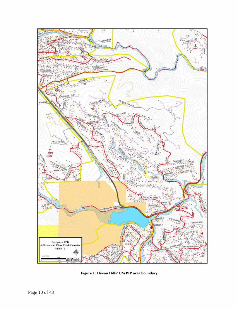
The CWPIP area (See following map) encompasses the Hiwan Hills Area as identified in the
EFPD CWPP. It occupies an ecosystem niche in the Foothills Life Zone. The Hiwan Hills
community is situated between 6900 and 7700 feet elevation north and east of Evergreen, CO. It
is bounded on the south by Bear Creek Road, the west by Evergreen Parkway and on the north
by Stagecoach Road. The neighborhood’s areas are comprised of private properties, a number of
which are shown as “vacant land” on the Jefferson County land map. To the east across Bear
Creek Road are some lands under management of Denver Mountain Parks. The life zone
involved is described in: “Colorado Life Zones: Seasons, Plants, & Animals.”
“The foothills life zone's elevation is anywhere from 6,000 or 7000 ft. above sea level to around
8,000 ft. above sea level. The pinyon & juniper woodlands live in the lower parts of the foothills
on the western and south central part of the state. The open ponderosa pine woodlands grow on
the eastern foothills of the Rocky Mountains. On both sides of the Rocky Mountains, the
montane shrublands grow at the higher elevations of the foothills. The foothills are made up of
many different landforms, like steep hillsides, cliffs, canyons, mesas, and plateaus…”.
The Evergreen FPD CWPP describes the area’s vegetation: Vegetation: 60% light, 40%
medium; vegetation type is controlled largely by slope aspect with grass, brush and
Ponderosa pine stands…predominant on most south facing aspects; heavier stands of mixed
conifer…are more common on most north facing slopes; approximately 75% of the area is
forested but high density of structures and associated irrigated and groomed ground cover alter
natural surface fuel conditions…especially in the north and south sections, the central section has
lower housing density and larger expanses of unmanaged forest with needle and timber litter.
“Fire is very important for the montane forests. Over time, the forests can be taken over by
dense forests of pine trees. Branches and needles fall to the forest floor and pile up into dry,
crispy fire hazards. Smaller forest fires help clear the forests of old dying trees and clear the
forest floor for new plants to grow. If we prevent all forest fires, all the dry dead trees, branches,
and needles get even thicker. When a fire starts, it can quickly become an enormous super-hot
firestorm like the Hayman Fire in 2002. Usually fire is helpful for the next generation of seeds to
grow...”
Page 10 of 43
Figure 1: Hiwan Hills’ CWPIP area boundary
Page 11 of 43
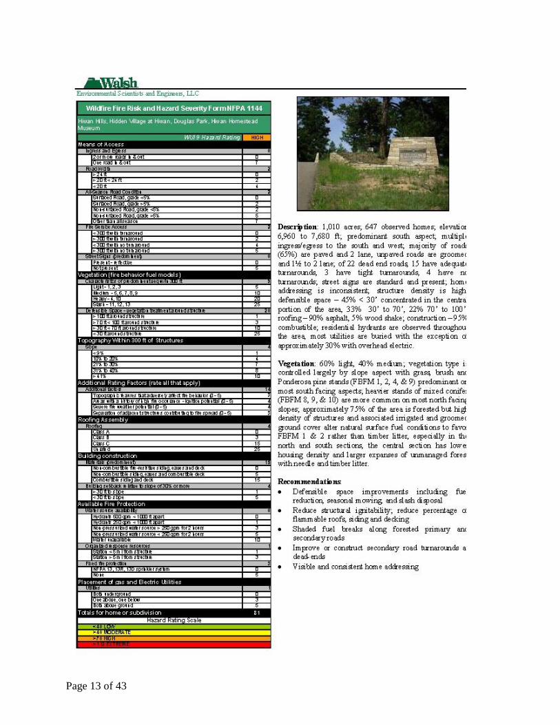
2.2 Neighborhoods and Hazard Assessments
Community Risk Analysis
Following are the physical descriptions and fire hazard assessments for the Hiwan Hills Area
CWPIP (including Hiwan Hills, Hidden Village at Hiwan, Douglas Park, Hiwan Homestead
Museum, and Timbervale). These descriptions are from the Community Assessment Surveys in
the Jefferson County CWPP and the Evergreen FPD CWPP. The Hiwan Hills Area
neighborhoods fire hazard rating is high.
Values at Risk (TEAM TO MAKE DECISION ON THESE VALUES-MAY NOT NEED
ALL)
The Evergreen CWPP listed the following as area Values at Risk for the entire district.
The EFPD is characterized by dense suburban development within a forested setting.
Resources at risk include the following:
� Homes
� Businesses
� Local economy
� Municipal water supply
� Community infrastructure
� Wildlife and aquatic habitat
� Watersheds
� Water quality
� Air quality
� Natural vegetation communities
� Viewshed
� Historic structures
Page 12 of 43
Catastrophic wildfire can have a severe and long-term impact on all natural resource and
ecological values that people take for granted. The actions recommended in this CWPP are
geared toward lowering the wildfire risk to neighborhoods, as well as economic and ecological
resources.
Team determines priorities from above list
The team considered values at risk and, in order, selected: life and property; transportation and
power line corridors; water supply infrastructure, area setting (wildlife and vegetation).
Life & Property: Protection of life is first in consideration by residents and by
emergency services. Protection of property, both personal and business, is the second
most important concern to maintain the integrity and stability of the community.
Water Supply Infrastructure: XXXX.
Roadways and Transportation: Hiwan Hills is accessed via Evergreen Parkway, Bear
Creek Road, and Stagecoach Road. The roadways within the area itself may not all be
maintained by the county.
o Regarding maintenance, the county has stated: “The roads the County Does not
Maintain are: If any meet this criteria they will be listed
Wildlife: The area has important mountain wildlife species needing adequate habitat and
protection.
The following pages contain the neighborhood hazard ratings and recommendations
developed in the Evergreen FPD CWPP, P155, and maps detailing Wildfire Ignition Risk
& Rate of Spread at the 90th
percentile of weather danger from the Jefferson County
CWPP.
Page 13 of 43

Page 14 of 43
Figure 2: Ignition Risk Map; Jefferson County
REMOVED FOR WEB SIZE LIMITS

Page 15 of 43
Figure 3: Rate of Spread; 90
th Percentile Weather Conditions
REMOVED FOR WEB SIZE LIMITS
Page 16 of 43
Section 3: WILDLAND FIRE RESPONSE: INFRASTRUCTURE AND
CAPABILITIES
A Community Wildfire Protection Implementation Plan addresses existing protection capabilities
and resources on hand for wildfire suppression and protection of life and property.
Evergreen Fire Protection District:
By agreement, wildland firefighting operations on Hiwan Hills’ private lands within the CWPIP
area are the responsibility of the Evergreen FPD. The EFPD is responsible for initial attack on
any wildland fire within its response jurisdiction. Refer to the Evergreen CWPP or the
Evergreen FPD website for details (http://evergreenfirerescue.com/).
Emergency Evacuation for Animals:
The Jefferson County Animal Response Team (J-CART) is the overall management entity for
emergency evacuation. It operates under the Sheriff’s office. Responders include:
Jefferson County Horse Evacuation Assistance Team (Jeffco Heat):
While residents are primarily responsible for evacuation of their animals there is an important
emergency service available.
For pre-evacuation tips and overall knowledge of how HEAT works go to:
www.jeffcoheat.org, facebook.com/jeffcoheat, or 303-674-4669.
Another site to visit for information is: Colorado State Animal Response
Team/Community Animal Response Team (http://www.petaidcolorado.org/?60) On
the site is a link to a presentation on “Emergency Preparedness for You and Your
Animals”.
Ready-Set-Go
Jefferson County endorses the Ready-Set-Go program (RSG) of wildfire action planning
for residents and other property owners. This program assists firefighters to teach
individuals who live in high risk wildfire areas and the wildland-urban-interface (WUI) how to
best prepare themselves and their properties against fire threats.
The RSG Program stresses that when firefighters encourage residents to take personal
responsibility for preparing their property and family for wildland fire, residents become an
active part of the solution to the problem of increasing fire losses.
The RSG Program is a three step process that can significantly increase the safety of residents
and the safety of responding firefighters. The three steps are:
1) Ready – Preparing for the Fire Threat; Be Ready, Be Firewise. Take personal responsibility
and prepare long before the threat of a wildfire so your home is ready in case of a fire.
2) Set – Situational Awareness When a Fire Starts: Pack your vehicle with your emergency
items.
3) Go – Leave early! Comply with any evacuation orders and follow evacuation plans early!
The RSG Program provides tools through its website, www.wildlandfireRSG.org. A more
complete description of the program is in Appendix C.
Page 17 of 43
Section 4: IMPLEMENTATION ACTIONS AND
RECOMMENDATIONS
An important and required part of a Community Wildfire Protection Implementation Plan is the
recommendation of mitigation projects detailing actions that should be undertaken by the
community, landowners, and adjacent land management agencies (county, state and/or federal).
Public land projects, when combined with home owner defensible space and structural
protection, collaborate to provide area wide protection.
To quote the Jefferson County CWPP:
“Wildfire mitigation can be defined as those actions taken to reduce the likelihood of
loss of life and property due to wildfire. The intent of mitigation is not to completely
eliminate the risk of loss nor does it reduce the risk of a wildfire occurring. Effective
wildfire mitigation enables residents to evacuate safely, homes to withstand the
occurrence of wildfire, and firefighters to safely defend structures and suppress fires
where possible...”
In the coming pages are sections detailing priority mitigation projects selected for the Hiwan
Hills Area Implementation Plan. They are collaborative in nature as to priority projects and areas
in which to carry out work.
As much as possible, projects were established to include areas with common features.
Among the features considered were forest types, fuel loads, ingress and egress routes,
and values. Consideration was given to a number of factors. These are:
1. Values at risk: Life and property are always the first values. Other values as
mentioned earlier are: transportation and utility corridors and the natural values of
vegetation and wildlife.
2. Current level of activity: Experience has shown that wildfire mitigation efforts are
most effective when the community is involved.
3. The important actions that residents should take: A major component of a
Community Wildfire Protection Implementation Plan is the actions private land
owners can take to provide protection to life and property.
4. Proximity to public lands priority zone: The Healthy Forest Restoration Act builds
on efforts to restore healthy forest conditions near communities and essential
community infrastructure. The Act emphasizes the need for federal agencies to work
collaboratively with communities.
Page 18 of 43
4.1 Mitigation Techniques to be applied
The Evergreen CWPP States, “Wildfire mitigation can be defined as those actions
taken to reduce the likelihood of loss due to wildfire. Effective wildfire mitigation can be
accomplished through a variety of methods including reducing hazardous fuels,
managing vegetation, creating defensible space around individual homes and
subdivisions, utilizing fire-resistant building materials, … and developing programs that
foster community awareness and neighborhood activism. Once implemented, these
actions will significantly reduce the risk of loss due to wildfire…”
4.1a Structure Defensible Space – The Land owner Defensible space is an area around a structure where fuels and vegetation are
treated, cleared or reduced to slow the spread of wildfire towards the structure. It
also reduces the chance of a structure fire moving from the building to the surrounding
forest. Defensible space provides room for firefighters to do their jobs.
To quote the Colorado State Forest Service, "Fire is capricious. It can find the weak
link in your home’s fire protection scheme and gain the upper hand because of a
small, overlooked or seemingly inconsequential factor” CSFS publication: “Protecting
Your Home from Wildfire: Creating Wildfire-Defensible Zones”, on the CSFS website at:
http://csfs.colostate.edu/pdfs/FIRE2012_1_DspaceQuickGuide.pdf.
You, as residents of the Hiwan Hills area, are the most important
component of this plan! Homeowners are often discouraged from completing
defensible space because they believe their lot sizes are too small for effective fuel
mitigation. But your actions are truly meaningful in protecting life, property, and the
beauty of the area.
You do not have to clear cut your property! Defensible space can be created in an
esthetically pleasing manner that maintains privacy and the natural character of the
community, and restores forest health.
It is recommended that defensible space be developed around all structures in the
planning area. The CWPIP cannot mandate a property owner take any action. It is
hoped residents in the area will see how defensible space can be attractively created
and realize when everyone takes action the broader neighborhood landscape is
protected.
Research indicates homes with fire resistant roofs and defensible space have an 85
percent chance of surviving a wildfire while homes with neither of these characteristics
have a 15 percent survival rate. An effective defensible space consists of flame resistant
vegetation (aspen or large diameter trees without lower limbs), low flammability
landscaping plants, mowed grass, lack of firewood stacks, and absence of fuel tanks
immediately adjacent to structures. Structural ignitability is the fire resistance of
materials used in the buildings themselves, and the design of the structure.
Page 19 of 43
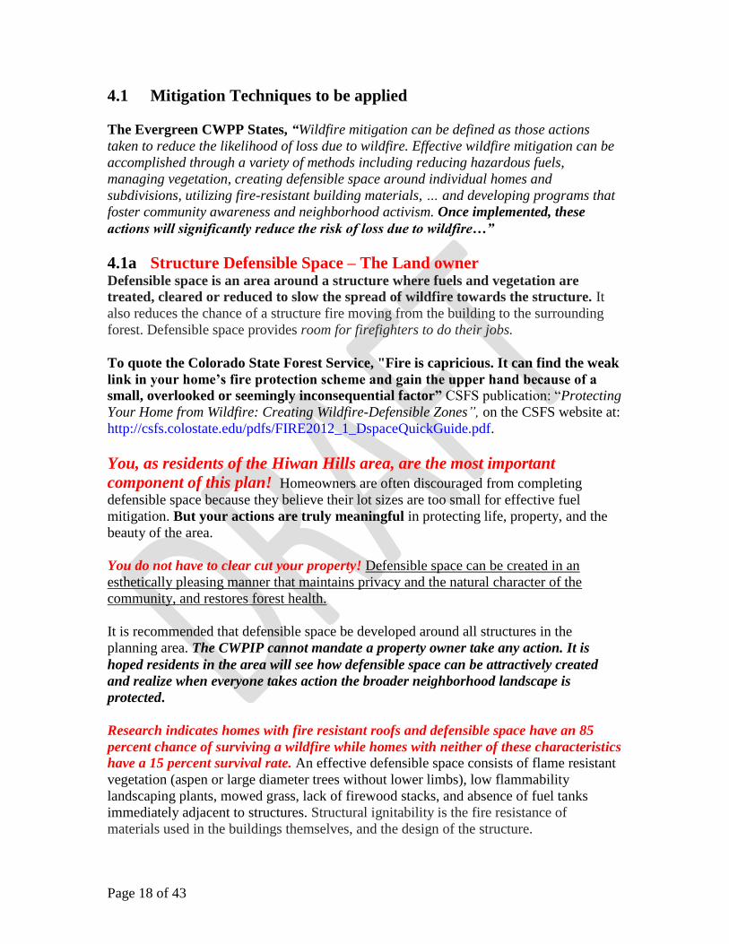
Figure 4: CSFS Defensible Space Standards (Dennis 2003)
The creation of defensible space consists of three zones that can be adapted to specific
building lot situations (See above).
Zone 1 extends from 30 to 100 feet from a structure in which 3 to 5 feet are a non-
combustible zone consisting of such things as decorative rock. The lower branches of
trees will be pruned 5 to 10 feet above the ground (not to exceed one-third of the tree
height). Woody and herbaceous plant debris, tall grass, and ladder fuels (low limbs, small
trees, and shrubs that may carry fire into tree crowns) will be removed from this area.
Leaves and overhanging branches will be removed from roofs. Leaves will be removed
from under porches. Woodpiles will be removed and stored uphill in Zone 2.
Zone 2 width (typically 30 to 110 feet from Zone 1) depends upon the steepness of the
slope. Zone 2 should be considerable larger if the dwelling occurs on steep slopes than if
it occurs on level ground. Treatment of ground fuels and ladder fuels will be the same as
Zone 1. Trees (or small groups of trees) and shrubs will be thinned to provide 10 feet of
clearance among crowns on level ground. The distance between tree crowns needs to
increase as slope increases. Herbaceous plants will be mowed as they dry in late summer.
Zone 3 occurs beyond Zone 2 and extends to the property line. Zone 3 will be managed
for the appropriate land use objectives, such as aesthetics, recreation, and/or wildlife
habitat.
Zones 1, 2, and 3 will be maintained annually. Two publications that provide
information on appropriate plants to use for defensible space landscaping have been
prepared by CSFS: Grass Seed Mixes to Reduce Wildfire Hazard, Bulletin No. 6.306
(Dennis, not dated), and FireWise Plant Materials, Bulletin 6.305 (Dennis, not dated
Mitigation of Structural Ignitability: CSFS publication FireWise Construction; Site
Design and Building Materials
http://static.colostate.edu/client-files/csfs/pdfs/firewise-construction2012.pdf
Page 20 of 43
1. Most structures DON'T ignite from direct flame contact, but from radiant heat
(heat that doesn't warm the intervening air but does warm objects). As a fire burns the
heat passes through air and windows to objects inside the home that warm to the point
of ignition then smolder for hours. You have an important role making the house
less resistant to radiant heat. Use non-combustible roofing material and non-
combustible siding (Class C or better), and spark arresters on chimneys.
2. Embers or fire brands also ignite house fires. During fires the air contains embers
and tosses them anywhere, including onto unburned fuels. A wildfire can create spot
fires miles downwind. Embers can get stuck in "traps" on roofing, such as beside
chimneys or in gutters and start new fires. Clean pine needles out of gutters and off
roofing. Screen attic and foundation vents with fine mesh screening.
3. Large windows are a threat to homes because they allow radiant heat to enter the
structure. Remove lacey and other decorative curtains when a fire approaches to
prevent radiant heat from igniting them through the glass. Large windows, especially
single-pane windows, are vulnerable. Double and triple pane windows are more
resistant to heat transfer.
Signing and Evacuation; all Properties:
1. Homes need visible address signing which are non-flammable and reflective at
the ends of their driveways. Emergency personnel respond based on street addresses.
The standard for site address signage is: “…plainly legible and visible from the
street or road fronting the property. …numbers shall contrast with their
background. Address numbers shall be Arabic numbers or alphabetical letters.
Numbers shall be a minimum of 4 inches…high with a minimum stroke width of ½
inch… Where access is by means of a private road and the building address cannot
be viewed from the public was, a monument, pole or other sign or means shall be
used…”
2. Create an evacuation plan – in advance. Include a meeting place outside your area,
and a family member or friend outside of your area who can be a point of contact.
Think of the Four Ps: Pets, Pills, Papers, and Photos. You may have only a short
time to evacuate. If you do leave the house, set a ladder in the driveway and connect
garden hoses to spigots so firefighters can use your equipment to help defend your
home.
4.1b Fuel Break Shaded Fuelbreaks: The Evergreen CWPP states that, “All forested access roads should
be maintained as shaded fuelbreaks zones where possible. Reducing the forest canopy
along access roads enhances the effectiveness of the physical canopy break the road
provides… This creates a safer emergency ingress/egress scenario while greatly aiding
potential tactical suppression efforts.”
A fuel break is an area where the vegetation structure and/or composition are altered to
reduce severe fire behavior to provide firefighters a chance for control. Vegetation
treatments could include such things as reducing biomass, thinning trees and shrubs,
Page 21 of 43
and/or removing ladder fuels. Breaking up vertical and horizontal fuel continuity affords
better opportunities to control fire rate of spread. For mitigation actions under this plan
the CSFS publications, Fuelbreak Guidelines for Forested Subdivisions and
Communities, (Dennis, not dated) and Lodgepole Pine Management Guidelines for
Land Managers in the Wildland -Urban Interface (Dennis et al) should be followed.
Stand Densities As noted in CSFS publications, crown separation is a more critical factor for fuel breaks
than a fixed tree density level. A minimum 10-foot spacing between the edges of tree
crowns is recommended on level ground. As slope increases, crown spacing should also
increase. However, small, isolated groups of trees may be retained for visual diversity.
Increase crown spacing around any groups of trees left for aesthetic reasons and to reduce
fire intensities and torching potential.
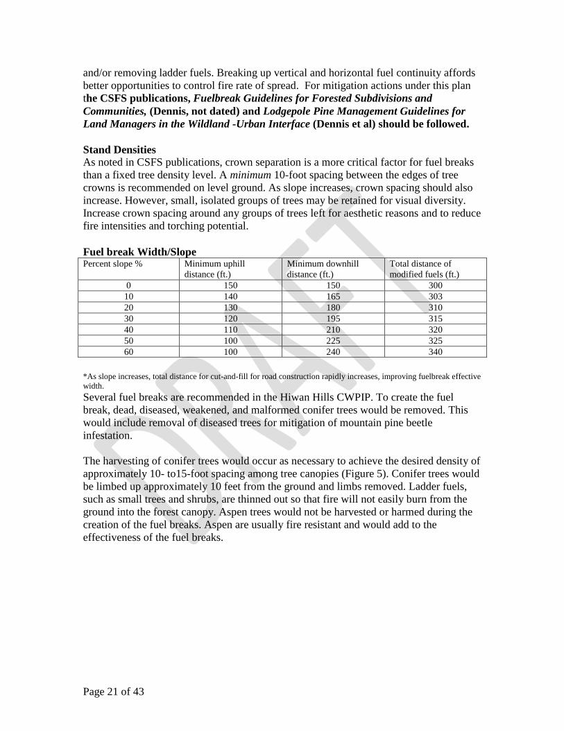
Fuel break Width/Slope Percent slope % Minimum uphill
distance (ft.)
Minimum downhill
distance (ft.)
Total distance of
modified fuels (ft.)
0 150 150 300
10 140 165 303
20 130 180 310
30 120 195 315
40 110 210 320
50 100 225 325
60 100 240 340
*As slope increases, total distance for cut-and-fill for road construction rapidly increases, improving fuelbreak effective
width. Several fuel breaks are recommended in the Hiwan Hills CWPIP. To create the fuel
break, dead, diseased, weakened, and malformed conifer trees would be removed. This
would include removal of diseased trees for mitigation of mountain pine beetle
infestation.
The harvesting of conifer trees would occur as necessary to achieve the desired density of
approximately 10- to15-foot spacing among tree canopies (Figure 5). Conifer trees would
be limbed up approximately 10 feet from the ground and limbs removed. Ladder fuels,
such as small trees and shrubs, are thinned out so that fire will not easily burn from the
ground into the forest canopy. Aspen trees would not be harvested or harmed during the
creation of the fuel breaks. Aspen are usually fire resistant and would add to the
effectiveness of the fuel breaks.
Page 22 of 43
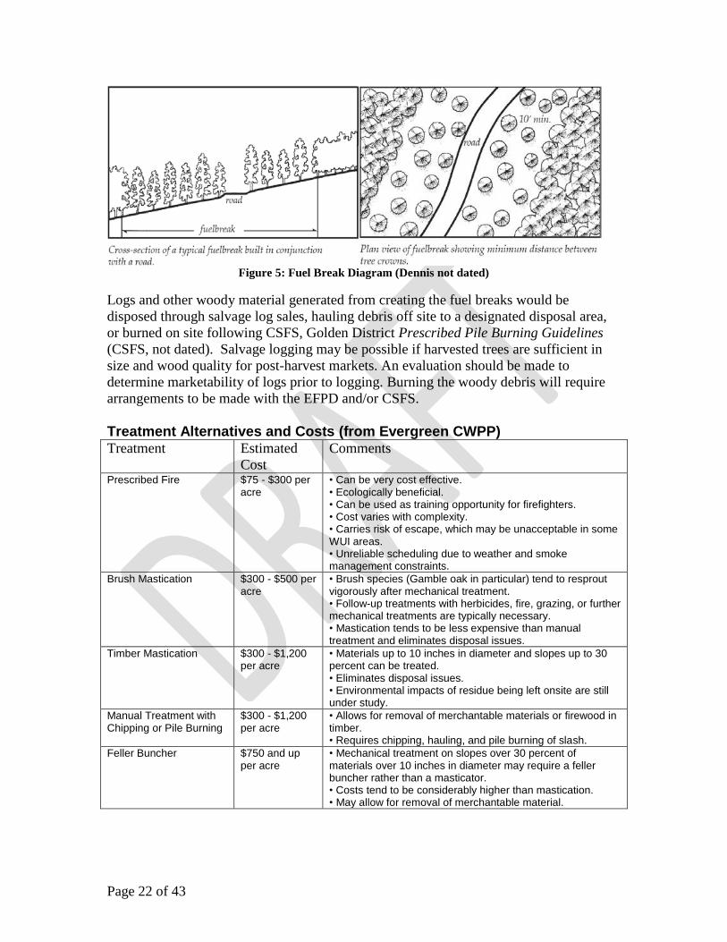
Figure 5: Fuel Break Diagram (Dennis not dated)
Logs and other woody material generated from creating the fuel breaks would be
disposed through salvage log sales, hauling debris off site to a designated disposal area,
or burned on site following CSFS, Golden District Prescribed Pile Burning Guidelines
(CSFS, not dated). Salvage logging may be possible if harvested trees are sufficient in
size and wood quality for post-harvest markets. An evaluation should be made to
determine marketability of logs prior to logging. Burning the woody debris will require
arrangements to be made with the EFPD and/or CSFS.
Treatment Alternatives and Costs (from Evergreen CWPP) Treatment Estimated
Cost
Comments
Prescribed Fire $75 - $300 per acre
• Can be very cost effective. • Ecologically beneficial. • Can be used as training opportunity for firefighters. • Cost varies with complexity. • Carries risk of escape, which may be unacceptable in some WUI areas. • Unreliable scheduling due to weather and smoke management constraints.
Brush Mastication $300 - $500 per acre
• Brush species (Gamble oak in particular) tend to resprout vigorously after mechanical treatment. • Follow-up treatments with herbicides, fire, grazing, or further mechanical treatments are typically necessary. • Mastication tends to be less expensive than manual treatment and eliminates disposal issues.
Timber Mastication $300 - $1,200 per acre
• Materials up to 10 inches in diameter and slopes up to 30 percent can be treated. • Eliminates disposal issues. • Environmental impacts of residue being left onsite are still under study.
Manual Treatment with Chipping or Pile Burning
$300 - $1,200 per acre
• Allows for removal of merchantable materials or firewood in timber. • Requires chipping, hauling, and pile burning of slash.
Feller Buncher $750 and up per acre
• Mechanical treatment on slopes over 30 percent of materials over 10 inches in diameter may require a feller buncher rather than a masticator. • Costs tend to be considerably higher than mastication. • May allow for removal of merchantable material.
Page 23 of 43
The above cost estimates are several years old. The community CWPIP team
should consult with the Golden District of the Colorado State Forest Service for
guidance on getting cost estimates.
4.1c Fire Break A fire break is an area where vegetation has been removed to bare ground or replaced
with non-flammable surface such as asphalt. The purpose of the fire break is to hopefully
stop fire progression and improve fire suppression efforts. This plan does not call for any
fire breaks at present.
4.1d Slash Management Removal of slash is an important action to protect your property. The Jefferson County
website http://jeffco.us/slash/ states, “Slash is debris, from nature, such as tree limbs,
pruning and pine needles. If not removed, slash can add to potential fire hazards on your
property. Wildfires have become more common, especially in dry years, and it is critical
that homeowners clear debris from their properties to help prevent fire damage to their
own and their neighbors’ properties.”
Keeping debris cleared and thinned helps maintain a healthy forest environment and good
wildlife habitat. Jefferson County has expanded its slash collection program. For
additional information and collection places and dates see the above website. Additional
information may also be found at: http://jeffco.us/public-information/news/2015/slash--
keep-your-property-safe-and-our-forests-healthy/.
Page 24 of 43
4.2 Fuels Mitigation Projects
The Evergreen CWPP contains a map of the Hiwan Hills area, and the hazard analysis
page lists suggested areas for fuels mitigation treatments. The areas contain private
property and are located in terrain where mechanical treatment would be possible in
selected areas. The CWPIP team has reviewed these recommendations and determined
priorities for initial mitigation efforts.
4.2a Private Land
Community Recommendations o CWPIP team works with county and fire authority to provide information and
education on wildfire hazards and behavior, defensible space and reduction of
structural ignitability and other actions; use materials from FireWise, State
Forest Service, and other available materials.
o Team and community continue to hold work days (chipping and land owner
assistance), demonstration days, and other community events to further
project accomplishment.
Land Owner Recommendations:
o Land owners will be encouraged to create defensible space and reduce structural
ignitability
o Work to make driveways and approach roads better for ingress/egress (need to
meet standards allowing access by fire personnel and equipment).
o Form community work groups or seek other forms of more advanced assistance to
complete projects.
o Become involved in community CWPP efforts.
4.2b Community Evacuation and Project Considerations Given the nature of the terrain the team identified action to mitigate fire effects
along roadways as a critical component of implementation. Creation and
maintenance of ingress/egress will enable residents to move and/or evacuate safely
in the event of an emergency and also enable emergency vehicles and fire engines
access to take action on wildfire to save lives, property, and the area itself. The
Evergreen CWPP states an objective for Hiwan Hills to, “Develop shaded fuelbreaks
along all forested secondary community access routes.”
General criteria to be applied: 1) steep, timbered slopes adjacent to the road; 2) close
proximity of timber to the roadway itself (e.g. within 50 feet); 3) roads with only one way
in and out.
The CWPIP team will collaborate with Evergreen Fire Rescue to develop a priority
listing of roadways for thinning. Some are already in the priority recommendations.

Page 25 of 43
4.2d Priority Mitigation Projects: Hiwan Hills Area
The following pages contain the priority projects and their descriptions as
determined by the Hiwan Hills Area CWPIP team.
Page 26 of 43
Recommended Priority 1
Work with officials and neighborhoods to facilitate creation of Defensible
Space
Creation of personal defensible space is critical to area protection. The team recommends
active collaboration between itself, the Evergreen Fire Protection District, and the
Colorado State Forest Service Golden District HOA and neighborhood/community events
to educate residents and promote their efforts to create Defensible Space on residential
lands within the plan area. See Section 4.1, pp.15-18, and CSFS publication: “Protecting Your
Home from Wildfire: Creating Wildfire-Defensible Zones”, on the CSFS website in the
Defensible Space section at: http://csfs.colostate.edu/pdfs/FIRE2012_1_DspaceQuickGuide.pdf.
and to accomplish structural ignitability mitigation; p.18 and CSFS the publication:
FireWise Construction; Site Design and Building Materials:
http://static.colostate.edu/client-files/csfs/pdfs/firewise-construction2012.pdf
The team also recommends it work with the Evergreen Fire Protection District and the CSFS to
develop submittals for various grant opportunities to gain funding for contractors who can work
to carry out forestry actions on properties where the land owners wish to create defensible space
but are unable to personally carry out more advanced actions. Such actions would include
removal of larger trees to create recommended crown spacing, and chipping or other methods of
removal of downed timber.
This recommendation would require: community events to promote and inform residents on
accomplishing defensible space; developing a listing of those land owners desiring to move
ahead with defensible space and what mitigation services are needed; and working with county
and state fire officials to develop opportunities for their action and/or grant opportunities. The
Colorado State Forest Service has capability to evaluate individual properties and recommend
actions.
Jefferson County has requirements for Defensible Space and has contracted foresters who
will evaluate defensible space actions. For information on requirements and contractors go
to:
http://jeffco.us/planning-and-zoning/faqs/wildfire-faqs/do-i-need-to-meet-the-wildfire-
regulation-/.
For current contracted foresters link to “Defensible Space Contact Form”.
Page 27 of 43
Recommended Priority 2
Roadside Fuels Thinning within the Hiwan Hills area:
The Evergreen CWPP calls for “Shaded fuel breaks along forested primary, secondary, and
designated emergency access roads.”
The Jefferson County CWPP states: “All access roads flanked by heavy vegetation in WUI
communities should be targeted for thinning or seasonal mowing. Treatments may be
coordinated with property owners along private roads and with county and state transportation
departments for public roads. Conifer regeneration along road margins should be controlled. A
qualified forester or fire professional should evaluate the effectiveness and periodic maintenance
of roadside mitigation.”
Roadways: The team evaluated the recommendations and its knowledge of the area and
recommends the following priorities:
A general drive around for the team and Evergreen Fire to evaluate all roadways.
Fuels mitigation treatment along the following roadways selected by the team in
priority:
BASED ON TEAM STUDY OF AREA ROADWAYS SELECTED ROAD PRIORITIES
WILL BE PLACED INTO THIS PROJECT IN ADDITION TO THE GENERAL DRIVE
AROUND RECOMMENDATION.
The recommendation is to perform thinning along selected main roadways. Thin (mostly
dead fall) on either side of the road, following guidelines listed below. While encroachment is
not along the full lengths of these routes or secondary neighborhood routes, the roads will be
evaluated for mitigation thinning.
It is noted that there is private property involved along roadways recommended for
mitigation. This will require working with property owners to gain understanding and
agreement to treatment. While recommended thinning distances may not be achievable in
all areas it will be important to educate and work with residents in achieving the best
possible thinning results.
The mitigation would include, “… fuel break clearing of dead standing and dead-fall coniferous
growth and dead low growth with only moderate live-ground growth removal, then seeding with
appropriate mixes to encourage grass cover and prevent soil erosion. …removal of standing
and downed dead timber growth could accomplish the majority of the “shading”. If up to 100
feet would be involved on either side of the road the acreage would be approximately 24 acres
per mile.
Treatment would be in accordance with three main standards as determined by the team and
Evergreen Fire/Rescue:
The USFS standard for roadside mitigation/hazard tree removal: “… implement hazard
tree removal activities within a distance equal to 110% of the height of the tallest hazard
tree from the edge of: 1) National Forest System (NFS) roads open to motorized travel
Page 28 of 43
(maintenance levels two through five); 2) federal, state, county, or other permitted
roads…” In this case the height of the tallest tree within the treatment zone would be
used.
Colorado State Forest Service: “Fuelbreak Guidelines for Forested Subdivisions and
Communities” by Frank Dennis
Colorado State Forest Service: “Lodgepole Pine Management Guidelines for Land
Managers in the Wildland -Urban Interface” (Dennis et al)
Fuelbreaks
As noted in the publications, “Road systems are important to fuel break construction…crown
separation is a more critical factor for fuelbreaks than a fixed tree density level. Connected
with county-specified roads within subdivisions, they provide good access and defensive
positions for firefighting equipment and support vehicles. Cut-and fill slopes of roads are an
integral part of a fuelbreak as they add to the effective width of modified fuels.”
Minimum 10-foot spacing between the edges of tree crowns is recommended on level ground.
“The minimum recommended fuelbreak width is approximately 300 feet for level ground (150
feet either side of the roadway). Since fire activity intensifies as slope increases, the overall
fuelbreak width must also increase…” The recommended distances are from the toe of the fill
for downslope distances, and above the edge of the cut for uphill distances. Widths are increased
when severe topographic conditions are encountered. Guidelines for fuelbreak widths are given
on page 20. Small, isolated groups of trees may be retained for visual diversity. “…Increase
crown spacing around any groups of trees for aesthetic reasons and to reduce fire intensities and
torching potential.”
Where stands of lodgepole pine exist there is potential for wind throw if fuelbreak thinning
creates “wind” corridors in the forest. It is recommended that thinning be accomplished by
leaving groups of 7 to 10 trees separated from adjacent groups of trees to create the desired
spacing effect. This will assist these stands to be self-supportive in wind events.
Treatment would be primarily hand thinning with some mechanical, and with slash pile and
treatment of material or some use of wood for biomass business purposes. Cost would be
approximately $2000/acre. The community team should consult with the Golden District of
the Colorado State Forest Service for advice on getting an up-to-date cost estimate when it
begins the process to accomplish this project.
Page 29 of 43
Section 5: IMPLEMENTATION AND FOLLOW UP
Creating and implementing this CWPIP has the potential to significantly reduce the effects of
wildfire. This will require the efforts of a committed Hiwan Hills Area CWPIP team with the
assistance and cooperation of Evergreen Fire Rescue.and the citizens of the area. The
effectiveness of this plan will be the result of actions taken over time; completion of the plan is
only the beginning.
Maintenance and administration of the Community Wildfire Protection Implementation
Plan are critical. To again quote the Evergreen CWPP, “The most effective means to initiate
local action is through community education and public outreach…An annual community
meeting in the spring can spur action on the part of neighborhoods and individuals. This can
be a forum for presentations by experts in the field and low for coordination of “cleanup”
efforts within the community. Firewise materials and postings should be made available to the
public at each fire station, post office, HOA, and elementary school on a regular basis. A
disposal method for yard waste should be coordinated every spring. This may be coordinated
with HOA spring cleanup activities and may include the coordination of a central disposal
site, mobile chipping services or a hauling service…An example would be continuance of the
district’s annual “Slash Day…”
Accomplishing property defensible space, retrofitting of structures to defensible standards, fuels
mitigation projects, and other goals require time, funding and resources. Ongoing community
education and demonstration events are needed to demonstrate the necessity of taking personal
action. Grant funding, contract crews, and volunteer projects will be spread out over a number of
years.
Maintenance of the Plan
The CWPIP is meant to be a “living document” which is updated annually to pursue priority
concerns in wildfire hazard mitigation throughout the Hiwan Hills Area. The overall goal of
maintaining the CWPIP is accomplished through:
1) Ongoing monitoring of plan accomplishments and effectiveness;
2) Adjusting the plan to account for changes in wildfire hazard conditions, response capabilities,
technologies and other circumstances;
3) Setting goals and selecting projects for the coming year;
4) Seeking funding and other project assistance; and
5) Facilitating community project days and other events.
The CWPIP team should be an ongoing team as long as the community and planning
efforts have need of such direction. The team should operate in collaboration with Evergreen Fire Rescue. The CWPIP team should
sustain itself through recruitment of new members as needed, and selection of a team chair
person from among its members. If direction or assistance is needed to maintain operations the
team chair should consult with the Evergreen Fire Rescue Chief, to assist with evaluation of the
continuing need and assistance in reconstituting a CWPIP management team.
Page 30 of 43
The Hiwan Hills area CWPIP committee should establish guidelines for representation and
ongoing operation at its first meeting following county and state acceptance of this plan.
Following are some guidelines to be considered by the team:
The composition of the CWPIP team should retain professional representation from the the
Evergreen Fire Protection District. Representation from the area neighborhoods is very important
and the team should strive for membership from these areas.
Team meetings should be held at least quarterly (it may be desirable to meet more often as
summer approaches each year) to review plan goals, actions and public response. Each year the
CWPIP team will conduct a performance review to evaluate accomplishments and problems over
the past year. The team should also consider any proposed changes to the CWPIP for the
upcoming year and select new or reselect ongoing project goals. The team should consult with
Evergreen Fire Rescue, and reach out to neighborhood stakeholders during plan review and
project development. Timing should be guided by grant submission dates.
The overall CWPIP evaluation, recommended changes, and upcoming project goals should be
presented to the residents through community meetings; local informational outreach methods,
and Community Wildfire days and forums.
The CWPIP team contact list should be made available to residents so they can make contact for
information or to offer suggestions for the team to consider.
The CWPIP team, in conjunction with the fire authority, the county and/or other groups, should
organize or take part in an annual community open house each spring to keep the public
continuously aware of healthy forest restoration and wildfire mitigation needs and opportunities.
The team should develop or participate in demonstration days, chipping days, and other
opportunities in area neighborhoods to showcase projects, techniques, and new ideas. Such
events contribute greatly to public education and encourage people to become involved.
The CWPIP team should follow up on completed projects, using a monitoring and evaluation
format which addresses the following issues:
1) Implementation: Track the CWPIP project(s) as laid-out for the year and assess the success
level of execution;
2) Execution of project: What issues occurred that either aided or impeded the project?
3) Maintenance Needs and Monitoring: Evaluates, determines and prioritizes areas that have
been treated in the past, but are in need of maintenance treatments to maintain effectiveness as
originally intended. Lessons learned from monitoring and data collection will be useful for
modifying project plans to better meet CWPP goals and objectives.
The CWPIP should be available to residents on various websites, such as an HOA site or the
Evergreen Fire Protection District site.
Page 31 of 43
Section 6: APPENDICES
APPENDIX A: Publications and Websites
APPENDIX B: Tips on insurance coverage from a United Policyholders handout.
APPENDIX C: Wildfire Action Planning - The Ready, Set, Go! Program (RSG)
Colorado State Forest Service Defensible Space pamphlet
APPENDIX D: Colorado State Income Tax Deduction for Mitigation
Page 32 of 43
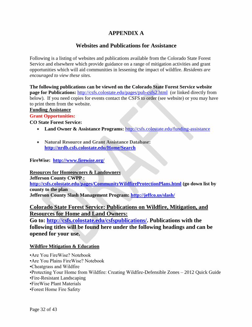
APPENDIX A
Websites and Publications for Assistance
Following is a listing of websites and publications available from the Colorado State Forest
Service and elsewhere which provide guidance on a range of mitigation activities and grant
opportunities which will aid communities in lessening the impact of wildfire. Residents are
encouraged to view these sites.
The following publications can be viewed on the Colorado State Forest Service website
page for Publications: http://csfs.colostate.edu/pages/pub-csfs2.html (or linked directly from
below). If you need copies for events contact the CSFS to order (see website) or you may have
to print them from the website.
Funding Assistance
Grant Opportunities:
CO State Forest Service:
Land Owner & Assistance Programs: http://csfs.colostate.edu/funding-assistance
Natural Resource and Grant Assistance Database:
http://nrdb.csfs.colostate.edu/Home/Search
FireWise: http://www.firewise.org/
Resources for Homeowners & Landowners
Jefferson County CWPP :
http://csfs.colostate.edu/pages/CommunityWildfireProtectionPlans.html (go down list by
county to the plan
Jefferson County Slash Management Program: http://jeffco.us/slash/
Colorado State Forest Service: Publications on Wildfire, Mitigation, and
Resources for Home and Land Owners:
Go to: http://csfs.colostate.edu/csfspublications/. Publications with the
following titles will be found here under the following headings and can be
opened for your use.
Wildfire Mitigation & Education
•Are You FireWise? Notebook
•Are You Plains FireWise? Notebook
•Cheatgrass and Wildfire
•Protecting Your Home from Wildfire: Creating Wildfire-Defensible Zones – 2012 Quick Guide
•Fire-Resistant Landscaping
•FireWise Plant Materials
•Forest Home Fire Safety
Page 33 of 43
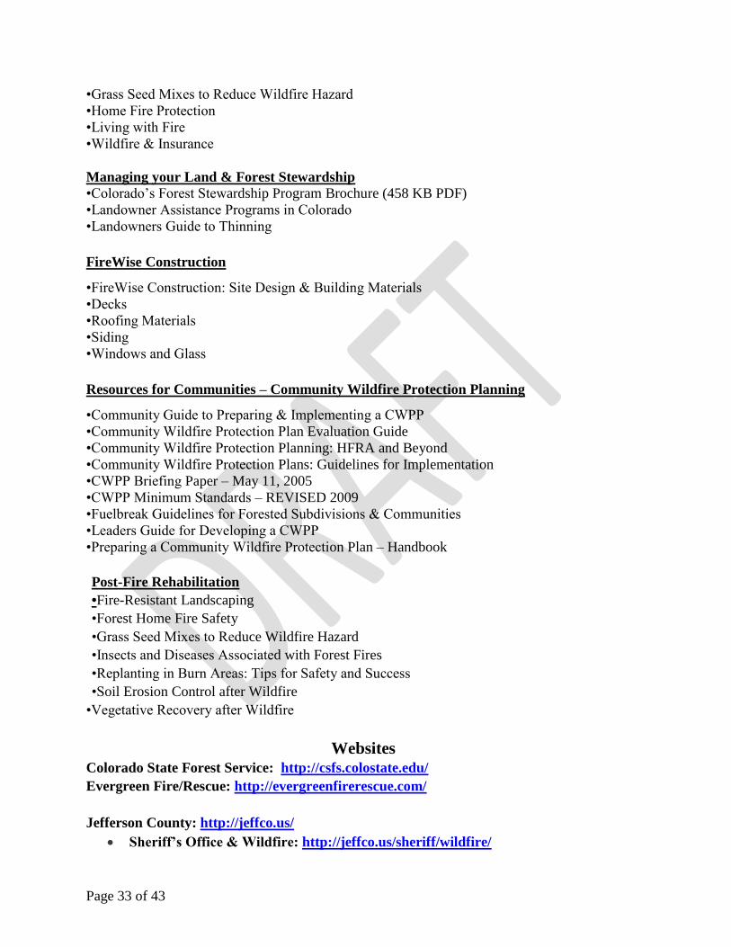
•Grass Seed Mixes to Reduce Wildfire Hazard
•Home Fire Protection
•Living with Fire
•Wildfire & Insurance
Managing your Land & Forest Stewardship
•Colorado’s Forest Stewardship Program Brochure (458 KB PDF)
•Landowner Assistance Programs in Colorado
•Landowners Guide to Thinning
FireWise Construction
•FireWise Construction: Site Design & Building Materials
•Decks
•Roofing Materials
•Siding
•Windows and Glass
Resources for Communities – Community Wildfire Protection Planning
•Community Guide to Preparing & Implementing a CWPP
•Community Wildfire Protection Plan Evaluation Guide
•Community Wildfire Protection Planning: HFRA and Beyond
•Community Wildfire Protection Plans: Guidelines for Implementation
•CWPP Briefing Paper – May 11, 2005
•CWPP Minimum Standards – REVISED 2009
•Fuelbreak Guidelines for Forested Subdivisions & Communities
•Leaders Guide for Developing a CWPP
•Preparing a Community Wildfire Protection Plan – Handbook
Post-Fire Rehabilitation
•Fire-Resistant Landscaping
•Forest Home Fire Safety
•Grass Seed Mixes to Reduce Wildfire Hazard
•Insects and Diseases Associated with Forest Fires
•Replanting in Burn Areas: Tips for Safety and Success
•Soil Erosion Control after Wildfire
•Vegetative Recovery after Wildfire
Websites
Colorado State Forest Service: http://csfs.colostate.edu/
Evergreen Fire/Rescue: http://evergreenfirerescue.com/
Jefferson County: http://jeffco.us/
Sheriff’s Office & Wildfire: http://jeffco.us/sheriff/wildfire/

Page 34 of 43
Agency/Front Range Group/Healthy Forest Restoration Act (HFRA)
Arapahoe & Roosevelt National Forest: http://www.fs.fed.us/r2/arnf/index.shtml
Front Range Roundtable: http://frontrangeroundtable.org/Home_Page.php
Healthy Forest Restoration Act –background and information:
http://en.wikipedia.org/wiki/Healthy_Forests_Initiative
Healthy Forest Restoration Act – official website: http://www.forestsandrangelands.gov/
Page 35 of 43
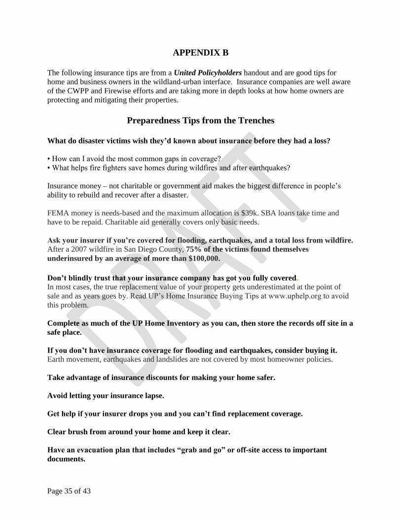
APPENDIX B
The following insurance tips are from a United Policyholders handout and are good tips for
home and business owners in the wildland-urban interface. Insurance companies are well aware
of the CWPP and Firewise efforts and are taking more in depth looks at how home owners are
protecting and mitigating their properties.
Preparedness Tips from the Trenches
What do disaster victims wish they’d known about insurance before they had a loss?
• How can I avoid the most common gaps in coverage?
• What helps fire fighters save homes during wildfires and after earthquakes?
Insurance money – not charitable or government aid makes the biggest difference in people’s
ability to rebuild and recover after a disaster.
FEMA money is needs-based and the maximum allocation is $39k. SBA loans take time and
have to be repaid. Charitable aid generally covers only basic needs.
Ask your insurer if you’re covered for flooding, earthquakes, and a total loss from wildfire. After a 2007 wildfire in San Diego County, 75% of the victims found themselves
underinsured by an average of more than $100,000.
Don’t blindly trust that your insurance company has got you fully covered.
In most cases, the true replacement value of your property gets underestimated at the point of
sale and as years goes by. Read UP’s Home Insurance Buying Tips at www.uphelp.org to avoid
this problem.
Complete as much of the UP Home Inventory as you can, then store the records off site in a
safe place.
If you don’t have insurance coverage for flooding and earthquakes, consider buying it.
Earth movement, earthquakes and landslides are not covered by most homeowner policies.
Take advantage of insurance discounts for making your home safer.
Avoid letting your insurance lapse.
Get help if your insurer drops you and you can’t find replacement coverage.
Clear brush from around your home and keep it clear.
Have an evacuation plan that includes “grab and go” or off-site access to important
documents.
Page 36 of 43
Shop around to find which company offers the best discounts for “mitigation” and/or
“retrofitting”. If you install a seismic shut-off valve on your gas line, a premium discount will
cover most of the cost. Strapping your water heater and installing plywood shear panels won’t
cost a fortune but will make your home safer and more insurable.
If money’s tight, raise your deductible to keep premium costs down.
Read “Dropped by your insurer?” at www.uphelp.org/pdfs/Wheretogoforhelp.pdf
Ask your local Fire Department if they’ll inspect and certify for an insurance company that
you’ve cleared brush adequately.
The #1 thing that helps fire fighters save homes is brush clearance. Clean out gutters and roof
drains regularly. Install screens on all your roof vents to keep embers from flying in. Install spark
arrestors in chimneys and get the chimney professionally cleaned periodically.
Keep a copy of your policy in a safe place away from your home and better yet, scan the
complete document onto your computer or onto a UP Roadmap to Preparedness Flash Drive. 2011 United Policyholders, All rights reserved. http://www.uphelp.org | 381 Bush Street, 8th Floor | San Francisco, CA 94104 Tel.: (415) 393-9990 | Fax: (415) 677-4170 | Email: [email protected] | Federal Tax ID: 94-3162024
information presented in this publication is for general informational purposes, and should not be taken as legal
advice. If you have a specific legal issue or problem, United Policyholders recommends that you consult with an
attorney. Guidance on hiring professional help can be found in the “Find Help” section of http://www.uphelp.org.
United Policyholders does not sell insurance or certify, endorse or warrant any of the insurance products, vendors
or professionals identified at our website. United Policyholders respects and protects the privacy of all individuals
who communicate with us. We do not sell or share our membership or mailing lists.
Page 37 of 43
APPENDIX C Wildfire Action Planning
Code Red
Smart 911 The Ready, Set, Go! Program (RSG): www.wildlandfireRSG.org
CodeRed:
CodeRED: Why the county would be Calling You in an Emergency
The Jefferson County Sheriff's Office Communications Center has contracted for "CodeRed™"
high-speed telephone emergency notification services sometimes referred to as "reverse 911 ® ".
The CodeRed system allows emergency dispatchers the ability to deliver public safety messages
to targeted areas or the entire county at a rate of up to 60,000 calls per hour. This service
includes those residents and businesses in the municipalities of Evergreen, Aspen Park, and
Conifer as well as unincorporated areas of the county such as North Turkey Creek..
These calls warn citizens of danger. Multiple phones within a designated area can be called
simultaneously to warn residents of flood, fire, tornadoes, chemical spills, or dangerous suspects.
If you receive a CodeRED call, the voice on the line will let you know it's a message from the
Sheriff's Office. Also, your caller ID should display the agency's name and a call-back number.
The e911 system works with all phones that have a TDD line (for the hearing impaired). If you
have a telephone zapper used to block out telemarketers, or if your phone is blocked to unknown
callers, you will not receive e911 calls.
Opt In to CodeRED
The CodeRED system calls numbers from two databases. One is the county’s 911 database, with
all listed and unlisted land lines. If you have a land line, it is automatically included in this
database.
The second is a new database of mobile phone and VoIP numbers — established in 2009 —
whose owners have opted in to receive the calls. If you don’t have a traditional land line phone,
or would like to receive a cell phone call in addition to the call on your land line phone, consider
registering for this free service. To register go to:
https://cne.coderedweb.com/Default.aspx?groupid=qxl9iUOfYVZj2Oy9A12syQ%3d%3d.
Smart 911:
Smart911 is a free service that allows citizens across the U.S. to create a Safety Profile for their
household that includes any information they want 9-1-1 to have in the event of an emergency.
Then, when anyone in that household dials 9-1-1 from a phone associated with their Safety
Profile, their profile is immediately displayed to the 9-1-1 call taker providing additional
information that can be used to facilitate the proper response to the proper location. At a time
when seconds count, being about to provide 9-1-1 with all details that could impact response the
second an emergency call is placed could be the difference between life and death. It is on the
internet at: https://www.smart911.com/. This program assists firefighters to teach individuals
Page 38 of 43
who live in high risk wildfire areas and the wildland-urban-interface (WUI) how to best prepare
themselves and their properties against fire threats.
The RSG Program stresses that when firefighters encourage residents to take personal
responsibility for preparing their property and family for wildland fire, residents become an
active part of the solution to the problem of increasing fire losses.
Ready-Set-Go!
The RSG Program is a three step process that can significantly increase the safety of residents
and the safety of responding firefighters. The RSG Program provides the implementation
guidance; background knowledge; and presentation tools to assist fire departments in delivering
the program message.
It is easy to remember and is easy to implement:
• Ready – Preparing for the Fire Threat: Be Ready, Be Firewise. Take personal responsibility
and prepare long before the threat of a wildfire so your home is ready in case of a fire. Create
defensible space by clearing brush away from your home. Use fire-resistant landscaping and
harden your home with fire-safe construction measures. Assemble emergency supplies and
belongings in a safe spot. Make sure all residents residing within the home are on the same page,
plan escape routes. For more information about how to be Ready for wildland fires, go to
Firewise.org.
• Set – Situational Awareness When a Fire Starts: Pack your vehicle with your emergency items.
Stay aware of the latest news from local media and your local fire department for updated
information on the fire.
• Go – Leave early! Comply with any evacuation orders and follow evacuation plans early! Your
Action Plan makes you prepared and firefighters are now able to maneuver and ensure you and
your family’s safety.
The RSG Program provides tools through its website, www.wildlandfireRSG.org for fire
departments that join the program to better understand preparedness techniques; help in
identifying local partners and audiences; useful outreach models and presentation tools; and
general background on wildland fire activity.
Following are two important defensible space documents: 1) a Ready, Set, Go
brochure designed specifically for this area by Einar Jensen, formerly with
CCC Fire Authority and now with South Metro; and 2) the Colorado State
Forest Service guideline on Creating Wildfire Defensible Zones. These are
both very good guides for home owners.
Page 39 of 43
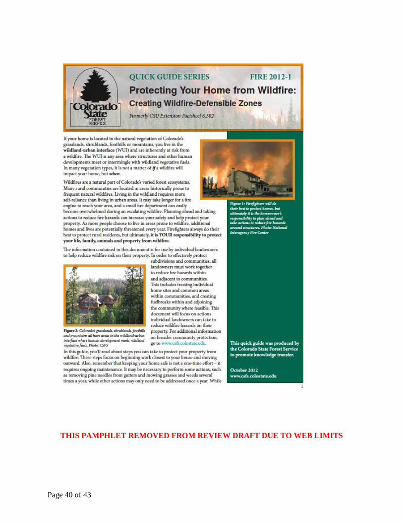
THIS PAMPHLET REMOVED FROM REVIEW DRAFT DUE TO WEB LIMITS
Page 40 of 43
THIS PAMPHLET REMOVED FROM REVIEW DRAFT DUE TO WEB LIMITS
Page 41 of 43
APPENDIX D Colorado State Income Tax Deduction for Mitigation
Colorado landowners with property located in a wildland-urban interface area may qualify
to receive a tax subtraction for the costs of wildfire mitigation work. As authorized by §39-
22-104(4)(n)(ll)), C.R.S., for income tax years 2009 through 2024 individuals, estates and
trusts may subtract from federal taxable income certain costs incurred in performing wildfire
mitigation measures.
Following is a summary from the Colorado Department of Revenue.
Colorado Department of Revenue Taxpayer Service Division
07/14 Income 65 Wildfire Mitigation Measures Subtraction
GENERAL INFORMATION Individuals, estates and trusts may subtract from their federal taxable income certain costs
incurred while performing wildfire mitigation measures on their property.
LIMITATIONS • The taxpayer must own the property upon which the wildfire mitigation measures are
performed.
• The property must be located in Colorado and within a wild land-urban interface area.
• For tax years 2009 through 2012 only, the wildfire mitigation measures must be authorized by a
community wildfire protection plan adopted by a local government within the interface area.
• The total amount of the subtraction cannot exceed 50% of the landowner’s out-of-pocket
expenses, $2,500 or the owner’s federal taxable income, whichever is less.
• The deduction is available for tax years 2009 through 2024.
Jointly Filed Returns In the case of two individuals filing a joint return, the amount subtracted from federal taxable
income shall not exceed $2,500 in any taxable year. In the case of a married individual who files
a separate return, only one individual in the marriage may claim the deduction.
Tenants in Common In the case of real property owned by tenants in common, the subtraction can be taken only by
one of the individuals in the ownership group.
SUPPORTING DOCUMENTATION The department may request documentation to support the claim. Correspondence from the
department should specify what is required; however, the examples are as follows:
• Proof of property ownership,
• Receipts of costs incurred,
• Approved Wildfire Protection Plan (tax years 2009 through 2012 only). See
www.csfs.colostate.edu
Page 42 of 43
DEFINITIONS
Community Wildfire Protection Plan Community wildfire protection plan must meet the following requirements:
• It must be approved by a local government entity, local fire department and the Colorado State
Forest Service in accordance with guidance established by the Wildland Fire Leadership
Council.
• It must identify and prioritize areas for hazardous fuel reduction treatments and recommend the
types and methods of treatments.
• It must recommend measures to reduce structural ignitability.
Additional information regarding community wildfire protection plans can be found online at
www.csfs.colostate.edu
Costs Costs means any actual out-of-pocket expense incurred and paid by the landowner and
documented by receipt for performing wildfire mitigation measures. The following expenses are
specifically excluded within statute and do not qualify for this subtraction:
• Inspection or certification fees;
• In-kind contributions;
• Donations;
• Incentives;
• Cost sharing;
• Expenses paid by the landowner from any grants awarded to the landowner for performing
wildfire mitigation measures.
Landowner Landowner means any owner of record of private land located within the state, including any
easement, right-of-way or estate in the land and includes the heirs, successors and assignees of
such land and shall not include any partnership, S-corporation or other similar entity that owns
private land as an entity.
Wildfire Mitigation Measures Wildfire mitigation measures mean the following activities to the extent that they meet or exceed
any Colorado State Forest Service standards or any other applicable state rules:
• Creating and maintaining a defensible space around structures;
• Establishing fuel breaks;
• Thinning of woody vegetation for the primary purpose of reducing risk to structures from
wildland fire;
• Secondary treatment of woody fuels by lopping and scattering, piling, chipping, removing from
the site or prescribed burning.
Additional information regarding wildfire mitigation measures can be found online at
www.csfs.colostate.edu
COMMON QUESTIONS Does the community wildfire protection plan (CWPP) have to be approved before the fire
mitigation activities take place? (For example: landowner performed work in the summer of
2011, but the CWPP was not approved until Dec. 2011.)
Page 43 of 43
Yes, the CWPP must be approved before the mitigation measures are performed. The mitigation
measures must be performed in a wild urban interface area and authorized by an existing CWPP.
[§39-22-104(4)(n)(II), C.R.S.] If the measures were performed on the land before it was
designated and the CWPP approved, then the expenses would not qualify for the subtraction.
Can a person who leases real property claim the credit if the lessee performs wildfire mitigation
measures?
No. The credit is limited to the owner of the property. However, if the owner/lessor reimburses
the lessee for the cost of the mitigation effort, then the owner/lessor can claim the credit.