Embed Size (px)
Citation preview
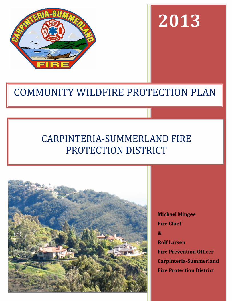
2013
Michael Mingee
Fire Chief
&
Rolf Larsen
Fire Prevention Officer
Carpinteria-Summerland
Fire Protection District
CARPINTERIA-SUMMERLAND FIRE
PROTECTION DISTRICT
COMMUNITY WILDFIRE PROTECTION PLAN
TABLE OF CONTENTS
1.0 INTRODUCTION……………………………………………………………............. 1
1.1. EXECUTIVE SUMMARY…………………………………………….………. 1
1.2. PURPOSE……………………………………………………………………..... 2
1.3 COLLABORATIVE EFFORT………………………………………………… 2
1.4 BASIS, POLICIES, INITIATIVES, REGULATIONS……………………… 3
2.0 COMMUNITY PROFILE…………………………………………………….……… 5
2.1 COMMUNITY PROFILE………………………………………. 5
2.2 CWPP BOUNDARY AND FUEL MANAGEMENT ZONES – (Map 1)
2.3 COMMUNITIES AT RISK………………………………………………... 8
2.4 COMMUNITIES AT RISK (Map 2)
2.5 WILDLAND URBAN INTERFACE (WUI)………………….................. 8
2.6 WILDLAND URBAN INTERFACE (WUI) – (Map 3)
2.7 APPLIED CONSERVATION PRINCIPLES THE WUI………………… 9
3.0 COMMUNITY WILDFIRE RISK ASSESSMENT………………………… 11
3.1 CARPINTERIA-SUMMERLAND FIRE DISTRICT’S WILDFIRE
ENVIRONMENT...... 11
3.2 FIRE HAZARD SEVERITY ZONES (Map 4)
3.3 RISK OF WILDFIRE OCCURANCE……………….............................. 15
3.4 WILDFIRE HISTORY IN SANTA BARBARA 1912-2012 –(Map 5)
3.5 FUEL HAZARDS…………………………………….………………… 17
3.6 STRUCTURES, INFRASTRUCTURE, OTHER COMMUNITY VALUES 18
3.7 CRITICAL INFRASTRUCTURE AND HABITAT – (Map 6)
3.8 FIREFIGHTING CAPABILITIES AND LOCAL PREPAREDNESS… 22
4.0 GENERAL WILDFIRE HAZARD MITIGATION MEASURE 30
4.1 FUEL REDUCTION……………………. 30
4.2 REDUCING STRUCTURAL IGNITABILITY……………………………. 32
4.3 FIRE SAFETY OBJECTIVES……………..…... 34
4.4 FUNDING SOURCES……………………………………………………….. 36
4.5 PARTNERSHIPS…………………………………………………………….. 36
5.0 IMPLEMENTATION AND MAINTENANCE……………………………………..... 37
5.1 RESPONSIBILITIES……………………………... 37
5.2 UPDATING THE CARPINTERIA-SUMMERLAND COMMUNITY
WILDFIRE PROTECTION PLAN………………………………………... 37
6.0 FINALIZATION / APPROVALS……………………………………………………... 38
7.0 REFERENCES…………………………………………………………………………. 39
8.0 APPENDICES………………………………………………………………………...... 40
1
1.0 INTRODUCTION
1.1 Executive Summary
The development of a Community Wildfire Protection Plan (CWPP) is the process whereby a
community collaboratively seeks to clarify and prioritizes actions that will protect life,
property and infrastructure from wildfire. It seeks to identify the community’s values and
develop strategies regarding what type of wildfire mitigation measures are desirable, thus
leading the community through an evaluation process that examines the best options to protect
community assets. The planning process includes local citizens, interested parties and
stakeholders who have social, ecological or economic interests in the community who are
invited to participate in CWPP discussion forums. Participation in a collaborative planning
process with local fire agency officials in developing a comprehensive wildfire mitigation
strategy for the Wildland Urban Interface community defines the ultimate goal. Community
stakeholders, interested parties and local agencies within the Carpinteria-Summerland Fire
Protection District have participated in development of this Community Wildfire Protection
Plan.
Through community meetings the CWPP has defined a collaboratively based community
action plan that assesses current wildfire risk and documents the community’s desired
mitigation measures for reducing the loss of resources cause by wildfires.
This CWPP has been developed as a collaborative effort of many agencies, groups and
stakeholders in Santa Barbara County and was developed in consideration of and consistent
with the objectives and policies set forth in Santa Barbara County’s Wildfire Plan. It is a
continuation of and builds upon the Fire District’s evolving and successful community wildfire
prevention program by encouraging residents to evaluate the fuel hazards, structural
vulnerabilities and critical infrastructure that exists in our community.
Advertisements were sent to local newspapers advising locals of the opportunity to participate
in the process, flyers were hand delivered to the residents in the high fire hazard area and
numerous meetings were held throughout the community to discuss and educate stakeholders
on how they would be the driving force behind a wildfire mitigation plan. Those represented at
meetings or through written, face-to-face and/or telephone communications included:
City of Carpinteria Los Padres Forest Watch
Santa Barbara County Fire Department Land Trust for Santa Barbara County
Montecito Fire Protection District Santa Barbara County Fire Safe Council
Ventura County Fire Department Summerland Citizens Association
United States Forest Service Local Ranchers
Environmental Defense Council Local WUI Residents
This CWPP delineates proposed wildfire mitigation measures using the principle of best practices,
and contains suggestions that residents, the fire district and local community leaders have indicated
are the preferred hazardous fuel mitigation measures chosen to protect their community from the
risk of wildfire.
2
The CWPP helps to increase awareness of the possible ecological consequences of fuel
management practices by including the CEQA evaluation process so that any proposed fuel
reduction projects will avoid or minimize any significant impact to the environment whenever
feasible.
1.2 Purpose of a Community Wildfire Protection Plan
The purpose of the Carpinteria-Summerland Community Wildfire Protection Plan is to:
a) Protect lives and property from wildfire.
b) Identify communities and individuals that will collaborate in forming an action
plan to mitigate wildfire risk in the Wildland Urban Interface communities.
c) Conduct an assessment of wildfire risks that will allow community members to
establish a viable risk Management Plan for our residential communities,
infrastructure and ecological resources.
d) Increase the community’s ability to prepare for, respond to and recover from
Wildland fires.
e) Improve the resilience of our fire adapted landscape while also protecting
economic, social and ecological resources by utilizing sound “best practices” for fuel
reduction and structural ignitability improvements.
1.3 Collaborative Effort
1.3.1 Collaboration The Carpinteria-Summerland Community Wildfire Protection Plan outlines the methodology
used in establishing a community based Wildland Fire Risk reduction plan, and will use the
input from the Community in identifying and prioritizing areas in need of hazardous fuels
treatment projects. The impetus for the Community Wildfire Protection Plan (CWPP) was
congressional legislation passed as the Healthy Forests Restoration Act 2003 (HFRA) that
directs federal agencies to work collaboratively with communities to reduce the risk of large-
scale Wildland fires by developing risk reduction strategies as agreed upon in a CWPP. The
HFRA will provide a community that has developed a CWPP with an opportunity to influence
how federal agencies implement fuel reduction projects on federal lands and how federal
funding may be distributed for projects in local communities. Carpinteria-Summerland Fire
Protection District, as the local fire authority, worked to help develop the collaborative process
that includes Public Agency decision makers and local interested parties wishing to engage in
identifying areas within their community that may be at risk from wildland fires. The planning
process encourages local interested parties, generally residents in the community who have
social, economic and environmental interests, to collaborate with the government decision
makers in formulating a “best practices” community fuel management strategy.
The objective for the “Communities at Risk” is to identify and promote a program that will
reduce wildfire risk, and will improve civilian and firefighter safety, structural survivability,
forest health and local fire protection capabilities. Prioritization will play the key role.
Projects, not communities, should be prioritized based on probability of success, efficiency
through community involvement and collaboration, and on sustainability. However, wildfire
3
risk will be the key principle used in identifying projects from the outset. The Plan will serve
as a guide for wildfire risk reduction that should be reviewed and modified over time as the
communities and the potential wildfire risks change.
1.3.2 Convene Decision Makers [The Core Group]
Decision makers refers to a body of representatives from regulatory agencies who have the
responsibility to monitor the process, review the progress and approve the documents
produced as the plan is developed. Once this “Core Group” has been satisfied that a complete
document exemplifies the consensus formed by the participants, this group will approve by
signature.
Carpinteria-Summerland Fire District
Santa Barbara County Fire
Los Padres National Forest (USFS)
Carpinteria City
The Fire District took the lead role in developing the basic elements of the plan, including a
community risk assessment, and planned meetings with local stakeholders.
1.3.3 Convene Community Stakeholders / Interested Parties Members of the community including, Homeowners Associations, Road Associations,
Community Groups, Water Purveyors, Utility providers, governmental oversight agencies, and
most importantly residence of the Wildland Urban Interface should be active participants and
contributors to the content of this CWPP. Several opportunities including scheduled meetings,
communications letters, and stakeholder surveys were the mainstay of brainstorming, data
collection and documentation of the desires and forecasts of the actions necessary to produce a
viable action plan.
During four CWPP planning meetings stakeholders discussed wildfire risks in their
communities and mitigation measures to address the associated hazards. Local stakeholders
were surveyed about how the community could best be protected from wildfire. Alternative
wildfire mitigation measures were discussed and preferences for fuel reduction were compiled
from stakeholders. Stakeholders/ Interested parties from Gobernador and Shepard Mesa on
the east to Summerland and Ladera Lane / Toro Canyon on the west attended these meetings.
A listing of meetings and contributors is contained in Appendix C. The results of the
community input are described more thoroughly later in this Plan in Section 3- Fire Safety
Objectives and Section 4 - Prioritized Treatments and Goals for Fuel Reduction.
1.4 Basis, Policies, Initiatives, Regulations
1.4.1 Federal Policy and Initiatives
1.4.1.1 Disaster Mitigation Act (2000)
The Disaster Mitigation Act of 2000 directed Federal Emergency Management Agency
(FEMA), as amended in the Robert T. Stafford Disaster Relief and Emergency Assistance Act,
to create incentives for local and state agencies to work together to plan and enact disaster
mitigation strategies. This act is an important funding resource for hazardous fuel mitigation
programs.
4
1.4.1.2 National Fire Plan (2000)
As a result of destructive wildfire events in the Western United States during the summer of
2000, Congress appropriated funding and directed federal agencies to come up with strategies
to mitigate the destructive effects of wildfires on our communities. These actions lead to what
became known as the National Fire Plan (2000) that would place priority on a collaborative
effort to seek community-driven solutions to reducing the risks of fire in the wildland urban
interface.
1.4.1.3 Healthy Forest Initiative (2002)
As wildfires continued to ravage public and private lands across the nation, Congress launched
the Healthy Forest Initiative (2002) that seeks to protect people, communities and the
environment from the destructive effects of wildfires. To support the Healthy Forest Initiative
(HFI), Congress passed the Healthy Forests Restoration Act (2003) that gave additional policy
directive to support the HFI. The Act emphasizes the need for federal, state agencies and
“communities at risk” to work collaboratively to develop community based hazardous fuel
mitigation projects that would be identified and prioritized in the process of developing a
Community Wildfire Protection Plan
1.4.2 State Policy and Regulation
1.4.2.1 State Multi-Hazard Mitigation Plan (updated 2010)
To be eligible for disaster recovery assistance and mitigation funding in consideration of the
ever present potential for economic losses from all types of natural disasters, including
wildfires, the State has formulated a multi‐hazard mitigation plan that has been approved by
the Federal Emergency Management Agency (FEMA). The 2010 “State Multi-Hazard
Mitigation Plan” can be found at,
http://hazardmitigation.calema.ca.gov/docs/2010_SHMP_Final.pdf
1.4.2.2 California Fire Plan
The California Fire Plan is the state's road map for reducing the risk of wildfire. The Fire Plan
is a cooperative effort between the State Board of Forestry and Fire Protection and the
California Department of Forestry and Fire Protection. It sets the goals of identifying and
evaluating wildland fire hazards and recognizing life, property and natural resource assets at
risk. Promotes locally based initiatives to identify pre fire mitigation strategies based on local
conditions. By placing the emphasis on what needs to be done long before a fire starts, the Fire
Plan looks to reduce firefighting costs and property losses, increase firefighter safety, and to
contribute to ecosystem health.
1.4.2.3 Public Resources Code – Division 4, Part 2, Chapter 3
The State Board of Forestry and Fire Protection has authority to develop and implement
standards for defensible space around structures on State Responsibility Area lands, and gives
building standards direction on all new development in the Wildland Urban Interface.
PRC-4291, effective in 2005, gives fire agencies authority to extend defensible space from 30
feet to 100 feet for wildfire protection on State Responsibility Lands. See also General Guide-
Lines for Creating Defensible Space,www.fire.ca.gov/cdfbofdb/PDFS/4291finalguidelines2_23_06
1.4.2.4 Government Code – Division 1, Part 1, Chapter 6.8
The California Legislature under Senate Bill 1595 effective in 2009 gives local fire agencies
authority to require defensible space up to 100 feet for wildfire protection in Very High Fire
Hazard Severity Zones on Local Responsibility Area Lands.
5
1.4.2.5 California Fire Code 2010 - California Code of Regulations, Title 24, Part 9
This code established local authority affecting and regulating building standards and various
hazards related of fire and all conditions hazardous to life, property and environment. The
Carpinteria-Summerland Fire Protection District has adopted the parts of the 2009
International Fire Code and the 2010 California Fire Code, with local amendments.
1.4.2.6 Fire Agency Authority The Carpinteria-Summerland Fire District derives its authority from California State Law
under the Health and Safety Code §13800, et seq. Special districts can be formed to provide
fire protection and other emergency services in that community. Fire protection districts are
formed under the Fire Protection District Law of 1987, streamlined by SB 515 from 1987.
Additionally, the California Health and Safety Code, Section 13100 establishes the authority
of the State Fire Marshal, and also directs that office to foster, promote and develop ways and
means of protecting life and property against fire and panic. Health and Safety Code, Section
13869 establishes the authority of the local Fire District, and California Fire Code, Section
104.1 authorizes the local Fire Chief to enforce the provisions of the Fire Code. These state
laws and regulations give local fire agencies considerable authority, to secure the safety of
their citizens, infrastructure and the environment.
1.4.2.7 California Environmental Quality Act (CEQA Guidelines)
Natural Resources Code; Division 6, Chapter 3, Section 15000-15387; contains the State CEQA
Guidelines and the Public Resource Code – Division 13, Chapter 2.6, Section 21083 contains the
Environmental Review guidelines.
Approval of the Carpinteria-Summerland Community Wildfire Protection Plan does not:
• Commit any signing party or other entity to carrying out, funding, or issuing a permit for
any specific hazardous fuel reduction project;
• Require implementation of any of the recommendations presented herein;
• Remove any permit requirement, environmental review requirement, or other legal
requirement applicable to hazardous fuel reduction on either private lands or public
lands.
Any necessary environmental reviews required by the California Environmental Quality Act
(CEQA) and/or the National Environmental Policy Act (NEPA) shall be completed prior to
commencement of any recommended hazardous fuel reduction. Implementation of any “best
practice” or recommended actions towards hazardous fuel reduction found within this CWPP may
be modified, or not implemented at all, depending on a number of factors, including:
environmental review; permit actions; and the availability of funding.
1.4.3 Local Ordinances
1.4.3.1 Santa Barbara County Code of Ordinances - Chapter 9A
Santa Barbara County Code Chapter 9A regulates brush removal in the southeasterly coastal area
of the unincorporated area of Santa Barbara County. Unless subject to an exception through
County Code Section 9A-6, no person may remove natural vegetation within that area without
approval from the Building and Safety Division of the Planning and Development Department.
Exceptions that County Code Section 9A-6 provides from that permit requirement include: (a)
removal of not more than five acres of vegetation from a parcel within any 12-month period; (b)
removal performed by or required by the fire prevention agency; (c) removal on certain rights-of-
6
way; (e) controlled burns by the fire prevention agency; (f) certain agricultural preparation
methods; (g) and removal in connection with certain grading permits.
Fuel reduction projects requiring a brush removal permit under Chapter 9A will be subject to
CEQA review, unless exempted from CEQA by the State’s Guidelines. Examples of exempted
projects include fuel management activities within 30 feet of structures and under certain adverse
conditions, out to 100 feet to reduce the volume of flammable vegetation, provided that the
activities will not result in the taking of endangered, rare, or threatened plant or animal species or
significant erosion and sedimentation of surface waters and maintenance programs to reduce
wildfire hazards, if previously approved, and consistent with the guideline under CEQA may be
permitted. The Fire District has completed numerous hazardous fuel mitigation projects that have
been approved under the CEQA guidelines.
1.4.3.2 Carpinteria-Summerland Fire District Ordinance
The CSFPD Ordinance 2010-01 adopts the 2010 California Fire Code with amendments that
address local conditions. In particular, requirements relating to vegetation clearance on roadways
and “defensible space” have been modified.
2.0 COMMUNITY PROFILE
2.1 Community Profile
The Carpinteria-Summerland Fire District (CSFD) comprised of the City of Carpinteria, the
community of Summerland and unincorporated lands within Santa Barbara County is located
between the coastal Santa Ynez Mountain Range and the Pacific Ocean, 10 miles south of
Santa Barbara, and approximately 90 miles northwest of Los Angeles. Highway 101, a major
north-south state transportation artery runs through the Fire District along the Coastal Plain.
The District’s jurisdictional area incorporates approximately 40 square miles of urban and
rural communities. This includes the environs of an urban coastal city, an unincorporated
beach community, vibrant light industrial and agriculture businesses, and an expanding
wildland urban interface. The Fire Districts’ population as of 2010 is estimated at 20,000 with
the City of Carpinteria having about 13,000 inhabitants. The City of Carpinteria and the
unincorporated areas of the Fire District offer a wide variety of opportunities for businesses,
recreational visitors and people wishing to establish permanent residency in the area. Many
homes within the Fire District, especially in foothills of the Wildland Urban Interface, are
valued in the multi-million dollar range. The median price for homes in the Fire District is
estimated at $850,000.
The Fire District provides a full range of fire protection services to the community. These
Services include emergency medical response, structural firefighting, water rescue, wildfire
response and mitigation strategies for fire prevention such as training, pre-planning, and public
education. Carpinteria and Summerland are communities identified as “Communities at Risk”
from Wildfire. Our communities at risk are also within or adjacent to lands designated by Cal-
Fire as High Fire Hazard Severity Zones.
Geographically, the Santa Ynez Mountain Range dominates our area. The mountain range is
arranged in an east-west traverse that is parallel to the coast. Beyond the coastal plain the
landscape rises on more than a gradual gradient into the Santa Ynez range foothills. Rocky
7
terrain and narrow canyons dominate this landscape, located north of the more developed areas
on the coastal plain, with a predominant native vegetative cover consisting of Oak Woodlands
and numerous Chaparral species. Beyond the lower slopes, to the crest of the Santa Ynez
Range are federal lands of the Los Padres National Forest with native brush covered
topography of steep slopes and narrow canyons.
This area has a history of having been impacted by major wildfire incidents. The greater part
of the Fire District’s jurisdiction is at a risk from Wildland fires, this area is generally
described as the Wildland Urban Interface, where structures and other human development
meet or intermingle with undeveloped wildland and vegetative fuels. The City of Carpinteria
and the community of Summerland are listed as communities at high risk from wildfire
(http://www.cafirealliance.org/communities_at_risk). Also, these areas are shown in the Cal-
Fire Hazard Assessment map to be High Hazard Value (an aggregate of Hazard, Risk and
Values Layers).
2.2 CWPP Boundary and Fuel Management Zones: Map 1 (see following page)
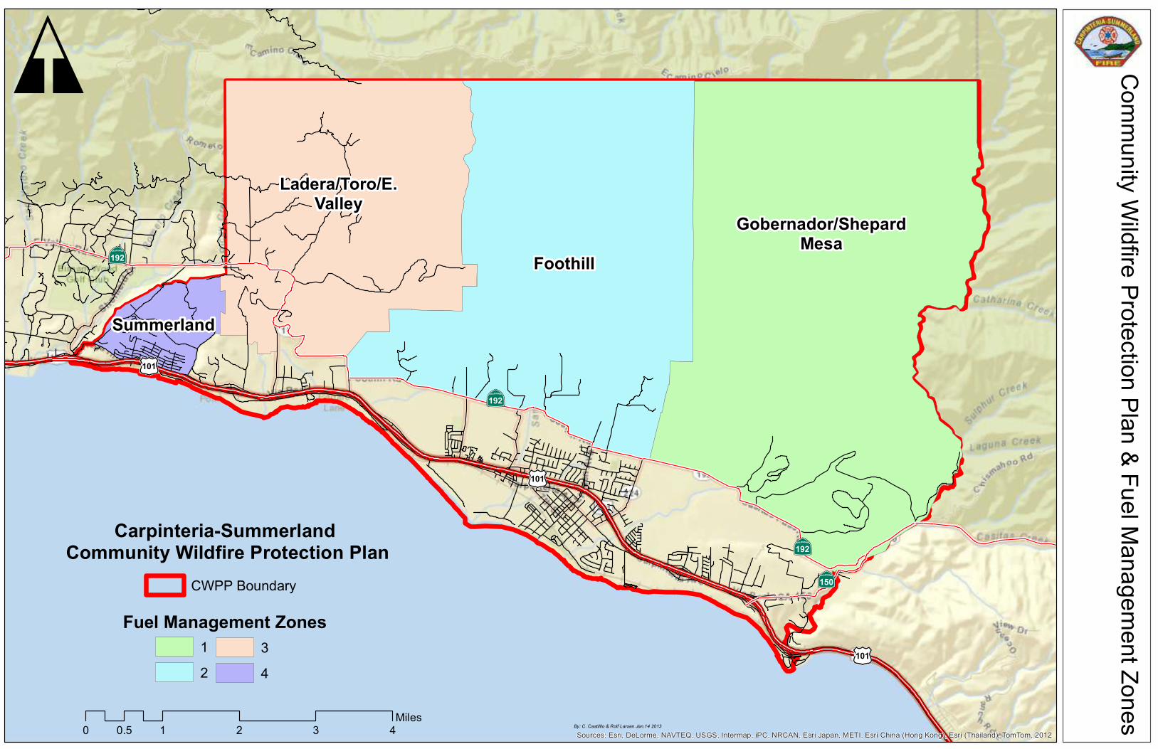
·|}þ192
·|}þ192
·|}þ192
·|}þ150
(/101
(/101
(/101
Summerland
Ladera/Toro/E.Valley
Foothill
Gobernador/ShepardMesa
Sources: Esri, DeLorme, NAVTEQ, USGS, Intermap, iPC, NRCAN, Esri Japan, METI, Esri China (Hong Kong), Esri (Thailand), TomTom, 2012
Co
mm
un
ity W
ildfire
Pro
tectio
n P
lan
& F
ue
l Ma
na
ge
me
nt Z
on
es
\
By: C. Castilllo & Rolf Larsen Jan.14 2013
0 1 2 3 40.5Miles
Carpinteria-Summerland Community Wildfire Protection Plan
CWPP Boundary
Fuel Management Zones
1
2
3
4
8
2.3 Communities at Risk
The National Fire Plan directed the States to identify “communities at risk” from catastrophic
wildfire. “Communities at Risk” are identified as being located in a Wildland Urban Interface
(WUI) setting where structures and other valuable community infrastructure are at high risk
from wildfire. Carpinteria and Summerland and the smaller surrounding neighborhoods /
communities are part of the wildland intermix identified in the National Fire Plan deemed to
being at high risk of damage from wildfire. Carpinteria and Summerland, and the outlying
communities have historically been impacted by wildfire and were listed in Federal and State
registers as being at risk from wildfire.
Locally, smaller inhabited neighborhoods within each of the designated fuel management
zones are identified as at risk communities from wildfire. For the CWPP the Fire District is
broken into Fuel Management Zones that are based primarily on a geographic location. The
following 4 geographic areas, designated hereafter as Fuel Management Zones, are within the
boundaries of the Carpinteria-Summerland Community Wildfire Protection Plan and contain
smaller neighborhoods that are at risk from wildfire.
1. Zone 1 – Designated as the “Shepard Mesa and Gobernador Zone” is located in the eastern
part of the Fire District and is an intermix of rural home-sites, ranch sites and agriculture
businesses close to the city of Carpinteria. The lands lying within the Wildland Urban
Interface and identified as inhabited areas at risk include the rural areas of Gobernador
Canyon, Shepard Mesa, and Lillingston Canyon.
The topography immediately north of Highway 192 is a changing terrain from the coastal
plain to low hills with numerous small mesas approximately ½ to1 mile from the ocean.
The transition from the relatively flat coastal plain gives way to the lower foothills that are
dominated by north-south running canyons and creeks, and ridges that become increasingly
steep further north into the Santa Ynez range. The remainder of the lands north of the state
highway is by in large part of the Los Padres National Forest covered with largely
unbroken native vegetation and steep rocky terrain.
2. Zone 2 – Called the “Foothill Zone”, stretches east along the lower coastal plain and
foothills of the Santa Ynez Range, and incorporates lands north of Foothill Road also
known as State Highway 192, and continues west along this route to Nidever Road at the
Santa Barbara Polo Fields. Many of these residential and agricultural communities extend
just ½ mile north of the state highway. Beyond the narrow strip of residential
neighborhoods and agriculture parcels are narrow canyons and steeper topography leading
into the lower foothills of the Santa Ynez Mountains. Access to some of these small
communities is by way of narrow, single lane roadways or residential driveways.
Carpinteria High School is located north of Foothill Road. Local communities that are
designated as at risk communities include the inhabited areas of Montvalmar Ranch,
Cravens Lane and the La Mirada neighborhood.
The back country area within this zone can only be accessed via Toro Canyon Park Road
and Santa Monica Canyon. There is little to no developed property in the back country or
upper foothills. Again these areas present a unique challenge for the Fire Agency due to
the heavy native vegetative fuel load and a generally longer response times.
3. Zone 3 - the “Ladera / Toro Canyon / East Valley Zone” an area in the western part of the
Fire District is located further north and into the foothills and canyons than any of the other
Fuel Management Zones. Local communities such as Toro Canyon on the western end of
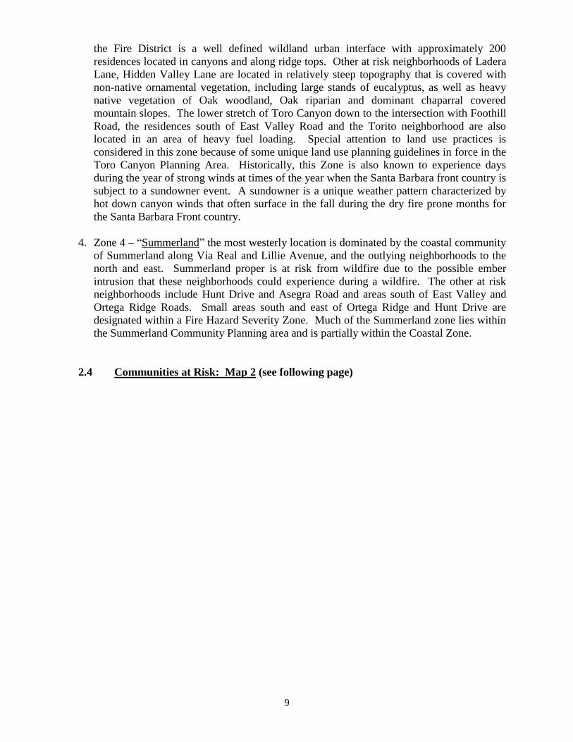
9
the Fire District is a well defined wildland urban interface with approximately 200
residences located in canyons and along ridge tops. Other at risk neighborhoods of Ladera
Lane, Hidden Valley Lane are located in relatively steep topography that is covered with
non-native ornamental vegetation, including large stands of eucalyptus, as well as heavy
native vegetation of Oak woodland, Oak riparian and dominant chaparral covered
mountain slopes. The lower stretch of Toro Canyon down to the intersection with Foothill
Road, the residences south of East Valley Road and the Torito neighborhood are also
located in an area of heavy fuel loading. Special attention to land use practices is
considered in this zone because of some unique land use planning guidelines in force in the
Toro Canyon Planning Area. Historically, this Zone is also known to experience days
during the year of strong winds at times of the year when the Santa Barbara front country is
subject to a sundowner event. A sundowner is a unique weather pattern characterized by
hot down canyon winds that often surface in the fall during the dry fire prone months for
the Santa Barbara Front country.
4. Zone 4 – “Summerland” the most westerly location is dominated by the coastal community
of Summerland along Via Real and Lillie Avenue, and the outlying neighborhoods to the
north and east. Summerland proper is at risk from wildfire due to the possible ember
intrusion that these neighborhoods could experience during a wildfire. The other at risk
neighborhoods include Hunt Drive and Asegra Road and areas south of East Valley and
Ortega Ridge Roads. Small areas south and east of Ortega Ridge and Hunt Drive are
designated within a Fire Hazard Severity Zone. Much of the Summerland zone lies within
the Summerland Community Planning area and is partially within the Coastal Zone.
2.4 Communities at Risk: Map 2 (see following page)
Gobernador
ShepardMesa
Lillingston
MontvalmarCravens
La Mirada
ToroCanyon
ParkHunt/
Asegra E. Valley/Torito
Ladera/Toro Cyn
Summerland
Community Wildfire Protection Plan & Communities At Risk\
By: C. Castilllo & Rolf Larsen Jan.14 2013
0 1 2 3 40.5Miles
Fuel Management Zones12
34
Communities At RiskName
CravensE. Valley/ ToritoGobernadorHunt/ AsegraLa MiradaLadera/ Toro Cyn
LillingstonMontvalmarShepard MesaSummerlandToro Canyon Park
10
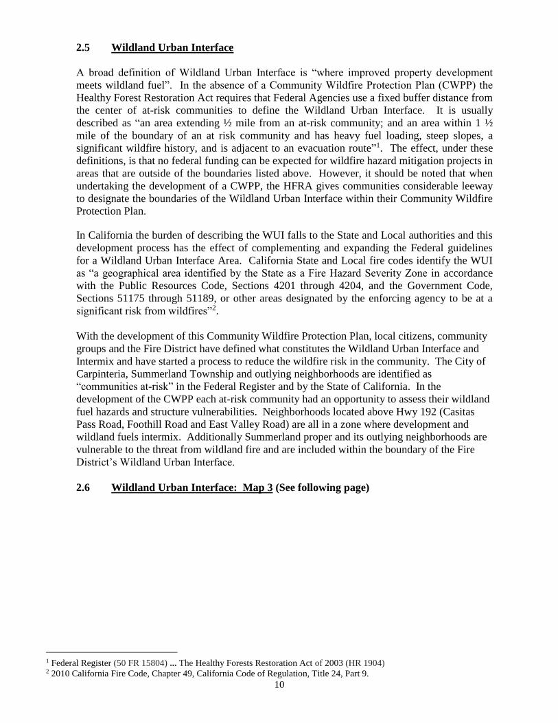
2.5 Wildland Urban Interface
A broad definition of Wildland Urban Interface is “where improved property development
meets wildland fuel”. In the absence of a Community Wildfire Protection Plan (CWPP) the
Healthy Forest Restoration Act requires that Federal Agencies use a fixed buffer distance from
the center of at-risk communities to define the Wildland Urban Interface. It is usually
described as “an area extending ½ mile from an at-risk community; and an area within 1 ½
mile of the boundary of an at risk community and has heavy fuel loading, steep slopes, a
significant wildfire history, and is adjacent to an evacuation route”1. The effect, under these
definitions, is that no federal funding can be expected for wildfire hazard mitigation projects in
areas that are outside of the boundaries listed above. However, it should be noted that when
undertaking the development of a CWPP, the HFRA gives communities considerable leeway
to designate the boundaries of the Wildland Urban Interface within their Community Wildfire
Protection Plan.
In California the burden of describing the WUI falls to the State and Local authorities and this
development process has the effect of complementing and expanding the Federal guidelines
for a Wildland Urban Interface Area. California State and Local fire codes identify the WUI
as “a geographical area identified by the State as a Fire Hazard Severity Zone in accordance
with the Public Resources Code, Sections 4201 through 4204, and the Government Code,
Sections 51175 through 51189, or other areas designated by the enforcing agency to be at a
significant risk from wildfires”2.
With the development of this Community Wildfire Protection Plan, local citizens, community
groups and the Fire District have defined what constitutes the Wildland Urban Interface and
Intermix and have started a process to reduce the wildfire risk in the community. The City of
Carpinteria, Summerland Township and outlying neighborhoods are identified as
“communities at-risk” in the Federal Register and by the State of California. In the
development of the CWPP each at-risk community had an opportunity to assess their wildland
fuel hazards and structure vulnerabilities. Neighborhoods located above Hwy 192 (Casitas
Pass Road, Foothill Road and East Valley Road) are all in a zone where development and
wildland fuels intermix. Additionally Summerland proper and its outlying neighborhoods are
vulnerable to the threat from wildland fire and are included within the boundary of the Fire
District’s Wildland Urban Interface.
2.6 Wildland Urban Interface: Map 3 (See following page)
1 Federal Register (50 FR 15804) ... The Healthy Forests Restoration Act of 2003 (HR 1904) 2 2010 California Fire Code, Chapter 49, California Code of Regulation, Title 24, Part 9.
Foothill Rd.
Casitas Pass Rd.
Foothill Rd.Toro
Cyn R
d.
E. Valley Rd.
Toro
Cyn R
d.
Gobernador C
yn R
d.
Summerland
City
Of
Carpinteria
·|}þ192
·|}þ192
·|}þ192
·|}þ192
·|}þ150
(/101
(/101
(/101
Com
mun
ity W
ildfire
Pro
tectio
n P
lan - W
ildla
nd U
rban
Inte
rface
\
By: C. Castilllo & Rolf Larsen Feb.1 2013
0 1 2 3 40.5
Miles
Carpinteria Summerland
Fire Protection District
Creeks
CWPP Boundary
Wildland Urban Interface
Carpinteria City
11
2.7 Applied Conservation Principles to the Wildland Urban Interface
People have chosen to live in this area for various reasons, but certainly the area’s proximity to
both the ocean and the natural setting offered by our coastal mountains are a determining
factor. Residents of Carpinteria – Summerland choose to live in the Santa Barbara area
because of all the opportunities it offers for business, residency and recreation. As our
residents and visitors take advantage of these many opportunities, our community is impacted
in many ways. Of particular concern is the potential impact of wildfire and the associate
responsibilities on public safety agencies and people who choose to live within the Wildland
Urban Interface. Residents are aware that by law, for health and safety reasons, public
agencies do require certain constraints on development and rely on state and local ordinances
to try to mitigate the risk of wildfires.
As human populations grow, so do the resource demands imposed on ecosystems and the
impacts of our global footprint. Natural resources are vulnerable and not infinitely available;
therefore society charges public agencies with applying the proper planning principles and
policies that will achieve a desired balance between being good environmental stewards, and
applying laws and guidelines, including wildfire mitigation measures that will be effective in
protecting our citizens, firefighters, infrastructure and natural environment. All individuals
must be good stewards of the land, learning to live in balance with the natural world, of which
fire is a significant part. Considerations to the maintenance and protection of riparian areas,
sensitive habitat as well as appreciation for the visual aesthetics of the natural environment
must be taken into account as plans for mitigation actions are proposed.
This CWPP is the tool by which the Fire District’s residents have defined and prioritized the
effective wildfire loss mitigation measures they recommend in order to coexist with the threat
of wildfire and still giving due consideration to environmental balance. The community has in
the most proactive sense achieved a positive balance between fire prevention, fire suppression,
conservation, and environmental protection. A collaborative effort of fire risk management
(managed and developed cooperatively with local agencies and landowners) to protect the
communities’ resources is the preference as opposed to reactive actions when a fire is burning
in your community.
3.0 COMMUNITY WILDFIRE RISK ASSESSMENT
The Wildfire Risk Assessment describes the Carpinteria-Summerland Wildfire Environment
and is developed on the basis of consideration of wildfire risk factors that are identified as
having an impact on the community. The assessment considers the impact of the risk of
wildfire occurrence, fuel hazards, structure ignitability, firefighting capability, local
preparedness and the overall risk.
3.1 Carpinteria-Summerland Fire District’s Wildfire Environment
As noted above, many outlying neighborhoods within the Carpinteria-Summerland Fire
District (CSFD) are located in a natural environment that has a significant history of wildfire.
In most of coastal California residents reside in a Mediterranean type eco-region where many
native plants are fire adaptive and depend on fire for reproduction, recycling of nutrients, and
the removal of decaying or dead vegetation. However, since early in the 20th century land and
12
forest management practices for this same region have been designed around a simple
protocol, “Prevent Wildfires”. This mission for all Fire Departments has required quick
suppression of all fire starts that has the consequences of fire exclusion in a fire dependent
eco-system. This has resulted in an accumulation of hazardous fuels in may areas.
Increasing population, building expansion and greater human activity in fire prone areas has
increased the likelihood that wildfire will burn in or near the Fire District’s Wildland Urban
Interface. The main contributor to wildland fire ignition is the increased human activity, be it
residentially related, recreational, transit or in some cases arson. Residential activity, transit
or recreation activities, including arson, are the main contributors to wildland fire ignition.
In the State of California, the Department of Forestry and Fire Protection (Cal-Fire) is charged
with determining the potential risk for wildfire on lands covered wholly or in part by
vegetation. The Public Resource Code and Government Code directs Cal-Fire to map areas of
significant fire hazards based on fuel loading, slope, fire weather, and other relevant factors
present, including areas where winds have been identified by the department as a major cause
of wildfire spread. These zones, referred to as Fire Hazard Severity Zones (FHSZ), help
define the application of various mitigation strategies to reduce risk associated with wildland
fires.
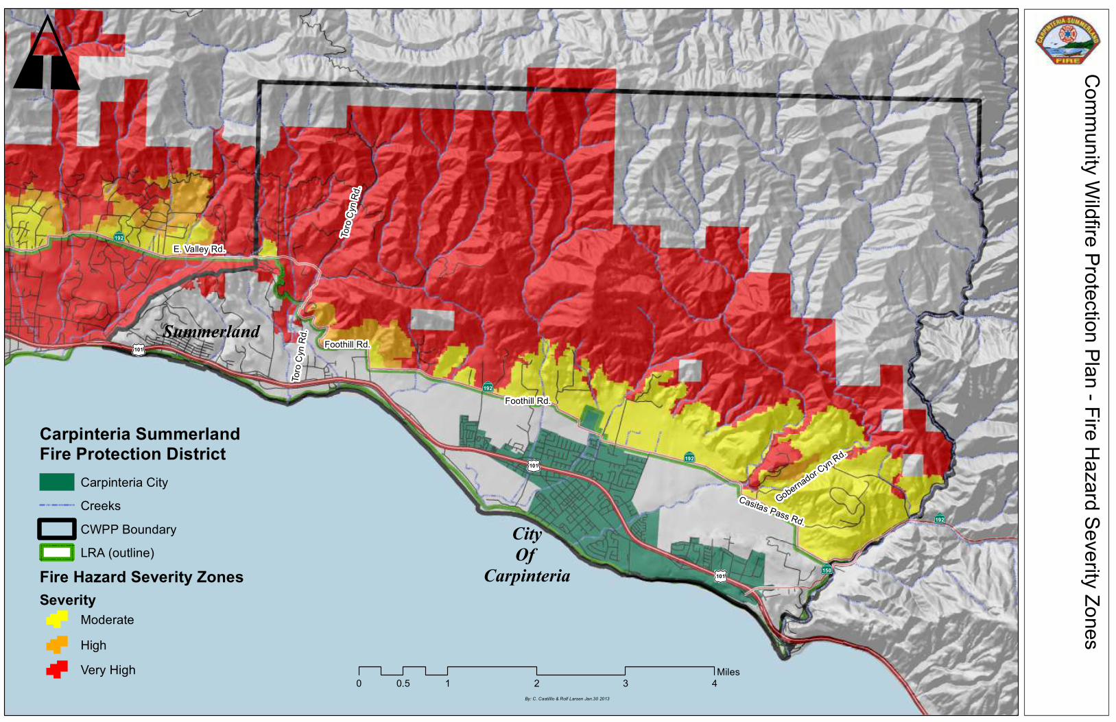
The Fire District has Fire Hazard Severity Zone designations rated from Moderate to Very
High. The greater part of lands in the Fire District that are identified as being at significant
risk to wildfire are mapped within a “Fire Hazard Severity Zone”. There are other areas such
as Summerland with similar wildfire threat characteristics that not designated a FHSZ but lie
within that area considered the Wildland Urban Interface. The mapped FHSZ’s in the Fire
District are mostly north of State Highway 192 (East Valley Road, Foothill Road and Casitas
Pass). A small area north of Summerland, in the area of Ortega Ridge, Asegra, Hunt, Lambert
Torito Roads and lower Toro Canyon Road is also designated a fire hazard severity zone and
considered within the Wildland Urban Interface.
3.1.2 Fire Behavior and Wildfire Potential
A basic understanding of fire behavior is important in order to communicate the various threats
from any fire and the benefits to be had by employing timely and effective pre-fire mitigation
measures. The value of trying to understand fire behavior is important to the development of fire
suppression strategies and tactics, particularly in terms of the difficulty of control and
effectiveness of suppression resources, and the development of fuel treatment strategies.
Fire behavior is influenced by a set of 3 elemental factors: Fuel, Weather and Topography. Fuel is
essentially the only one of these three elements upon which a community can make an impact on
the potential risk of wildfire. Pre-fire planning to reduce heavy hazardous fuel loading in and
around homes / communities is essential to reduce wildfire risk. However, the equally important
influence of weather and topography on fire behavior is always an input to fire modeling
influencing fire intensity, fire suppression strategies and how a fire will burn across the landscape.
All three elements do have an impact on how to effectively employ finite resources to wildfire
mitigation strategies on the Fire District.
Fuel models related to fire frequency in California chaparral ecosystems suggests that fire
occurrences that could have a destructive effect on the environment may be in many instances
system-regulated in association with internal fuel build-up and successional processes
13
(Riggin, et al. 1988). For the California chaparral, it has been hypothesized that chaparral fire
regimes are driven by fuel dynamics (Minnich, 1989). Because “fires remove fuels
responsible for combustion, a time lag exists between fuel accumulation and burning, making
fire biologically controlled, self-limiting, and thereby time dependent. At the landscape scale,
fire pattern is shaped by previous fire history and because there exists a spatially unequal
probability of fire depending upon previous fire history and differential fuel build-up in the
vegetation mosaic”.3
In effect, periodic fires move across the landscape and remove fuels responsible for large
wildfires by removing and thereby reducing the fuel loading and fire intensity. Over a
relatively short period of time there may not be sufficient fuel build up to sustain a larger fire
conflagration. This, in theory, may explain the occurrence of larger wildfires during 2004 thru
2009 along the South Central Coast and on the Federal Forest lands north of the Fire District
that burned uncontrolled in a fuel bed estimated to be, on average, about 50 years old. In
many areas of the Santa Barbara front country there was an accumulated buildup of available
fuel for this type of major wildfire incident. It is important to recognize these potential
wildfire patterns and note that there have been no major wildfire incidents within the
Carpinteria-Summerland Fire District since the 1970’s. Therefore it can be assumed based on
historical fire records that the fuel bed on the Fire District has the potential to become a large
wildfire.
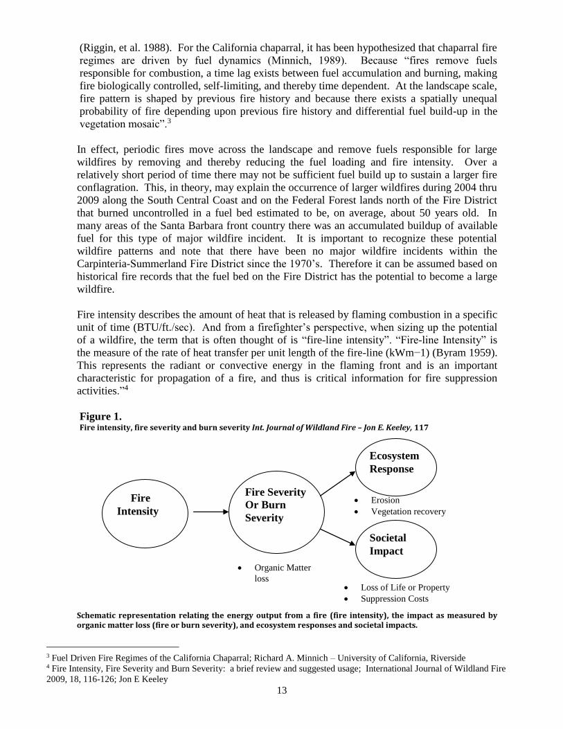
Fire intensity describes the amount of heat that is released by flaming combustion in a specific
unit of time (BTU/ft./sec). And from a firefighter’s perspective, when sizing up the potential
of a wildfire, the term that is often thought of is “fire-line intensity”. “Fire-line Intensity” is
the measure of the rate of heat transfer per unit length of the fire-line (kWm−1) (Byram 1959).
This represents the radiant or convective energy in the flaming front and is an important
characteristic for propagation of a fire, and thus is critical information for fire suppression
activities.”4
Figure 1. Fire intensity, fire severity and burn severity Int. Journal of Wildland Fire – Jon E. Keeley, 117
Schematic representation relating the energy output from a fire (fire intensity), the impact as measured by organic matter loss (fire or burn severity), and ecosystem responses and societal impacts.
3 Fuel Driven Fire Regimes of the California Chaparral; Richard A. Minnich – University of California, Riverside 4 Fire Intensity, Fire Severity and Burn Severity: a brief review and suggested usage; International Journal of Wildland Fire
2009, 18, 116-126; Jon E Keeley
Fire
Intensity
Fire Severity
Or Burn
Severity
Societal
Impact
Ecosystem
Response
Organic Matter
loss
Erosion
Vegetation recovery
Loss of Life or Property
Suppression Costs
14
Flame lengths, fire intensity, heat output, rate of spread, residence time, and whether the fire
burns on the surface or in the crowns of the vegetation are all ways to describe fire behavior,
and to relate its resistance to control, potential to damage or positive impacts. All of these
elements that affect fire behavior are components of wildfires that burn in the typical native
and ornamental vegetation found on the South Central Coast.
Cal-Fire statistics, wildfire history and fire behavior potential in Carpinteria-Summerland
indicate that a wildfire will impact the area as has happened in other communities of Santa
Barbara. Extreme fire behavior can be expected as weather and topography act upon a fire,
but the available heavy fuel loading, partially attributable to a century of fire exclusion in
many inhabited areas in the Fire District’s High Fire Hazard Zones has the potential to
increase home losses to wildfires.
The risk of fire occurrence at various locations in the Fire District is relative to influences of
location, human activity, weather and topography and the incidence of historical fire patterns.
While the overall risk is determined to be medium to high risk depending on location there are
factors influencing ignition and potential fire behavior such as fuel loading, weather and
topography that modify these risks anywhere from low to high. An example is based on local
historical fire data for the greater Toro Canyon area that suggests this area is particularly
vulnerable to large fires while locations along Highway 192 (Foothill and Casitas Pass Roads)
on the coastal plain are at much lower risk. These assumptions are based on the amount of
fuel loading and higher incidence of strong wind patterns in the Toro Canyon area as opposed
to the lower fuel loading and moderated weather influence found along Foothill Road.
Historical fire data indicates fire occurrence and the incidence of larger fires, burning at high
intensity, can be directly related to the buildup of older age class fuels that have had some
negative impact on a community. So fire intensity and potential economic and ecological
losses will be more dramatically dependent on how residents and the community at large have
planned to mitigate the high risk factors that will impact the community. Considering how
past wildfire patterns can influence successive fire threats as a result of reduced fuel loading,
so too can a well-planned vegetation management program. This Community Wildfire
Protection Plan applies a collaboratively based assessment and prioritized vegetation
management program that will significantly reduce the potential for loss of resources from
wildfire.
3.2 Fire Hazard Severity Zones: Map 4 (see following page)
Foothill Rd.
Casitas Pass Rd.
Foothill Rd.Toro
Cyn R
d.
E. Valley Rd.
Toro
Cyn R
d.
Gobernador C
yn R
d.
Summerland
City
Of
Carpinteria
·|}þ192
·|}þ192
·|}þ192
·|}þ192
·|}þ150
(/101
(/101
(/101
Com
mun
ity W
ildfire
Pro
tectio
n P
lan - F
ire H
azard
Seve
rity Z
ones
\
By: C. Castilllo & Rolf Larsen Jan.30 2013
0 1 2 3 40.5
Miles
Carpinteria SummerlandFire Protection District
Carpinteria City
Creeks
CWPP Boundary
Fire Hazard Severity Zones
Severity
High
Moderate
Very High
LRA (outline)
15
3.3 Risk of Wildfire Occurrence
This CWPP, a collaborative effort with the Fire District, Santa Barbara County Fire, local
residents and other interested parties lead to the development of a Risk List that prioritizes risk
factors including the Risk of Wildfire Occurrence in order to identify the highest priority for
allocation of resources.
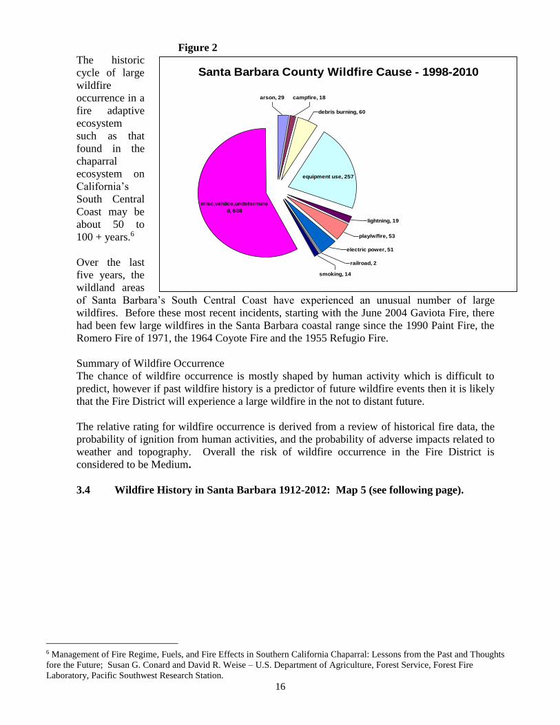
Historically, large wildfires such as the Refugio (1955), Coyote (1964), Polo (1964), Romero
(1971), Sycamore (1977), Wheeler Gorge (1985), Zaca (2007), Tea (2008) and Jesusita (2009)
fires have burned near or within the Fire District, threatening the lives and resources of the
Carpinteria −Summerland community. Annually, a number of smaller vegetation or structure
fires that have spread to vegetation, posed a threat of becoming a major incident. However,
most of these fires were suppressed before there were any significant losses or infrastructure
damage.
Inquiries as to what impact wildfires play in California can reference the 5-year study
“Monitoring Land Cover Changes in California” (1992-1997) by USDA Forest Service and
California Department of Forestry and Fire Protection. This study summarized vegetation
changes to land cover on the South Coast from Monterey County to San Diego County. The
results of the assessment of land cover changes on 16.9 million acres found that “wildfire is
the largest identified cause, affecting 184,995 acres and accounting for 78% of all change, and
93% of the vegetation decrease.”5
Map 5 is a record of large wildland fires that have burned in the Santa Barbara front country
area from 1912 to 2009. In the Wildland Urban Interface wildland fuels pose the greatest risk
for a destructive life-threatening incident. Studies of recent wildfires in the Santa Barbara area
and elsewhere in California recognize that local wildland fuels that are in a fire dependent
ecosystem, have an historic fire return interval, and thus are known to be a significant
contributor to disastrous losses.
Historic wildfire occurrences and patterns across the Fire District’s landscape make a case for
the inevitable return of a potentially large wildfire in this area. It is important to note that even
relatively small fires can have a significant impact on a community.
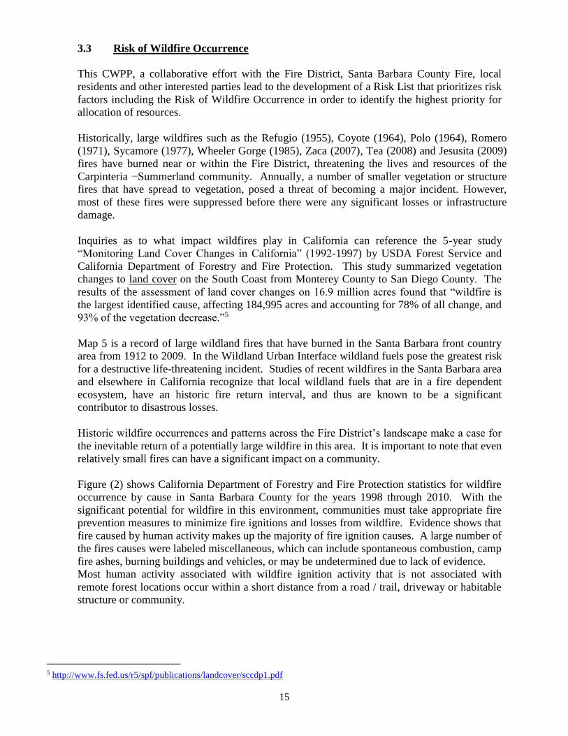
Figure (2) shows California Department of Forestry and Fire Protection statistics for wildfire
occurrence by cause in Santa Barbara County for the years 1998 through 2010. With the
significant potential for wildfire in this environment, communities must take appropriate fire
prevention measures to minimize fire ignitions and losses from wildfire. Evidence shows that
fire caused by human activity makes up the majority of fire ignition causes. A large number of
the fires causes were labeled miscellaneous, which can include spontaneous combustion, camp
fire ashes, burning buildings and vehicles, or may be undetermined due to lack of evidence.
Most human activity associated with wildfire ignition activity that is not associated with
remote forest locations occur within a short distance from a road / trail, driveway or habitable
structure or community.
5 http://www.fs.fed.us/r5/spf/publications/landcover/sccdp1.pdf
16
Santa Barbara County Wildfire Cause - 1998-2010
equipment use, 257
arson, 29 campfire, 18
debris burning, 60
lightning, 19
play/w/fire, 53
railroad, 2
electric power, 51
smoking, 14
misc,vehilce,undetermine
d, 688
Figure 2 The historic
cycle of large
wildfire
occurrence in a
fire adaptive
ecosystem
such as that
found in the
chaparral
ecosystem on
California’s
South Central
Coast may be
about 50 to
100 + years.6
Over the last
five years, the
wildland areas
of Santa Barbara’s South Central Coast have experienced an unusual number of large
wildfires. Before these most recent incidents, starting with the June 2004 Gaviota Fire, there
had been few large wildfires in the Santa Barbara coastal range since the 1990 Paint Fire, the
Romero Fire of 1971, the 1964 Coyote Fire and the 1955 Refugio Fire.
Summary of Wildfire Occurrence
The chance of wildfire occurrence is mostly shaped by human activity which is difficult to
predict, however if past wildfire history is a predictor of future wildfire events then it is likely
that the Fire District will experience a large wildfire in the not to distant future.
The relative rating for wildfire occurrence is derived from a review of historical fire data, the
probability of ignition from human activities, and the probability of adverse impacts related to
weather and topography. Overall the risk of wildfire occurrence in the Fire District is
considered to be Medium.
3.4 Wildfire History in Santa Barbara 1912-2012: Map 5 (see following page).
6 Management of Fire Regime, Fuels, and Fire Effects in Southern California Chaparral: Lessons from the Past and Thoughts
fore the Future; Susan G. Conard and David R. Weise – U.S. Department of Agriculture, Forest Service, Forest Fire
Laboratory, Pacific Southwest Research Station.
TOROPARK1980
1923
1917
1925
1939
COYOTE1964
1964
ROMERO1971
MATILIJA1932
WHEELER#2 1985
1925
RINCONCREEK
1913
1917
1924
1914
1921
1914
1920 1920
193919311914
1913
1922
1915
1928
1918
1971
1990
POLO1964
COYOTE(SYCAMORE)
1977
TEA 2008
JESUSITA2009
Sources: Esri, DeLorme, NAVTEQ, TomTom, Intermap, iPC, USGS, FAO, NPS, NRCAN, GeoBase, IGN, Kadaster NL, Ordnance Survey, Esri Japan, METI,
Esri China (Hong Kong), and the GIS User Community
Com
mun
ity W
ildfire
Pro
tectio
n P
lan
& 1
91
2-2
012
Fire
His
tory
\
Carpinteria-Summerland Community Wilfire Protection Plan
CWPP Boundary
By: C. Castilllo & Rolf Larsen Jan.14 2013
0 1 2 3 40.5Miles
Data Source: fire10_1_SBC.gdb
Legend
SBC Fire History
Date & Range
CITIES
1950-
-
1991
1990
-
1912
1951
2012
17
3.5 Fuel Hazards
All fires need the basic elements of heat, fuel and an oxidizing agent (usually oxygen) in order
to ignite and propagate. These three essential elements of the Fire Triangle must be present
for a fire to burn, and a by removing any one of these elements the fire will diminish and
eventually extinguish. Once there is fire ignition the Wildfire Fire Behavior Model, which
defines Fuel, Topography and Weather as the primary elements influencing wildland fire
spread, comes in to effect. A history of large wildfires in the Santa Barbara area indicates that
weather, notably strong Santa Ana type winds known locally as Sundowner winds is the main
driver of large conflagrations along the Santa Ynez Range. There is however no way to
influence the weather patterns that contribute to wildfire spread. Likewise, topography,
dominated by the Santa Ynez Range, does play a significant role in how fires burn, but is not
an element that can be easily altered. Wildfire spread is based not only on weather factors but
also on the type and quantity of fuel that surrounds it. As postulated by Minnich and others,
fuel loading or the amount of fuel available to burn determines fire intensity and how wildfire
burns across the landscape. Fuel is the only element that can be modified easily to change the
behavior of a wildland fire and under certain conditions prevent a wildfire.
Data for fuel conditions in the Carpinteria-Summerland High Fire Hazard Zones is derived
from the Standard Fire Behavior Fuel Models: A Comprehensive Set for Use with Rothermel’s
Surface Fire Spread Model (June 2005). Using this data the fuel bed found within the
Carpinteria-Summerland Community Wildfire Protection Plan boundaries is predominantly in
the category of a High Load, Dry Climate Shrub SH5 (145) and Very High Fuel Load, Dry
Climate Shrub SH7 (147). These categories are used to determine spread rate, flame length,
and moisture of extinction. Both SH5 and SH7 are characterized as woody shrub and shrub
litter with a heavy shrub load at 4 to 6 feet which would indicate a spread rate that is very
high, flame lengths very high, and the moisture of extension high, meaning that even with a
high fuel moisture content (amount of moisture/water in the fuel), it does not take much to
make it burn.
Chaparral and other native shrub species are the predominant native species found in the
foothills and coastal region of Southern California. The Fire District’s local fuel conditions
are a complex of shrubby vegetation types, notable for its intense fire behavior that has been
classified as having an intermediate fire return interval system (FRI of 20-100 years) that
typically burns in stand-replacing crown fires. Conrad and Weise found that our native brush
species contribute to regular intervals of destructive wildfires have the potential to cause
considerable economic loss to our community.
Summary of Fuel Hazard
The risk associated with Fuel Hazard on the Fire District is derived from historical fire
incident data and the California Department of Forestry and Fire Protection's Fire and
Resource Assessment Program (FRAP) Fuel Rank analysis.7 Since fuel is the only element
that can be easily modified the Fire District has promoted an aggressive hazardous fuel
reduction program in the Wildland Urban Interface for decades. Nevertheless the fuel hazards
remain the single most important element that will determine the level of risk to our
stakeholders.
7 http://frap.cdf.ca.gov/
18
Higher rankings are given in Zones with higher concentration of homes, areas with heavier
fuel loading, steeper topography and areas that may experience more severe fire weather
patterns. In the Foothill Zone the highest wildfire threat is to Sensitive Habitat while threats to
other values is much less. Generally, the entire Ladera / Toro / East Valley Zone is ranked
High relative to the values at risk from fuel hazards. Summerland and Gobernador / Shepard
Mesa are found to be at a lesser risk from fuel hazards based on fuel loading and historical
wildfire patterns in this area of the Fire District. The Overall Risk to the community from Fuel
Hazards is considered High.
3.6 Structures, Infrastructure and Other Community Values
Several hundred homes, some commercial enterprises, and a number of special use
occupancies are all subject to the risk of the spread of a wildfire because they are located
within the Wildland Urban Interface. Most of the infrastructure at risk from wildfire is located
north of Highway 192 in the area designated as a High Fire Hazard Severity Zone. Although a
specific area may not be designated as a High Fire Hazard Zone there is still significant threat
to community resources due to the potential for embers to ignite flammable fuels including
homes. The community of Summerland and areas north and west of Toro Canyon Road in the
vicinity of Torito Road are examples of such areas that are vulnerable to wildfire because of
the abundance of natural vegetation and the risk from ember ignition. Values for residential
structures, ranches and agricultural enterprises and their associated infrastructure are estimated
to be in the millions of dollars.
3.6.1 Structures
There are three primary considerations related to threat of structural ignition. They are direct
flame impingement, convected heat and embers. Distance or proximity are variables that will
determine the time to ignition as well as the likelihood of ignition. Direct Flame contact will
cause ignition relatively quickly while convected heat transfer will occur after some latent
time period. So, as the proximity of a fire to a structure decreases, the risk of structural
ignition increases. As has been mentioned, the prudent clearing of flammable vegetation,
increasing the defensible space around a structure will reduce the risk associated with such
hazards.
Embers pose an even greater risk to structures since they can travel significant distances
through the air column ahead of a wildfire. Embers are recognized as a significant threat to
structures as they can accumulate in roofing corners, in vegetation proximate to the structure,
or enter a structure at vents or other vulnerable points. The risk of ignition to existing
structures from flying embers can be reduced by implementing recommended building
improvements designed to prevent ember intrusion thereby minimizing the probability of
structural ignition. The risk of ignition in newly constructed homes will be reduced by the
mandatory implementation of newly adopted building codes requiring measures that address
the likelihood of ignition from wildfire.
The Fire District completed a structure risk assessment survey in High Fire Hazard Zones
early in the process of the CWPP development (see Appendix B). The initial evaluation
focused on gathering data to define the wildfire risk at randomly chosen structures that were
representative of a larger area. Structures were evaluated in relation to the risk factors 1
through 5, listed below. The survey looked at individual homes in several neighborhoods and
19
gave each a ranking according to factors that would have the greatest influence on
survivability of the structure.
The important factors looked at were:
(1) the fuel hazards present in the immediate area and in proximity to the structure;
(2) the structure itself including the roof, construction materials, and attached
structures such as decks;
(3) access for fire apparatus, also counted as ability to evacuate residents;
(4) infrastructure such as water resources, power supply and main roadways;
(5) wildfire occurrence: homes located in historic fire areas; and topography,
homes located close to edge of slope or in a narrow canyon.
Structural survivability was then rated Very Good, Good, Average, Poor or Very Poor based
on the numerical score value assigned to the factors listed above. Past studies suggest that
area surveys are not good predictors of the survivability of individual structures but they can
be used as a general indicator of the wildfire risk that exist in each community. Consequently
this survey presents a limited snapshot of the area risk by assessing structural ignition features
at individual home sites.
The indications resulting from this survey were that factors for structural survival were poor
in areas of heavy fuel loads, narrower canyons, access difficulties, past wildfire history and
under conditions where many structures were deficient in meeting current wildfire protection
standards. The western part of the Fire District, in the Toro Canyon, Ladera, Torito, East
Valley and Hidden Valley areas, showed results that suggest more attention to risk
management is needed in hazardous fuel treatment and structure ignitability. Most of the
highest at risk structures are located in areas with a higher Cal-Fire Fire Hazard Zones rating.
3.6.2 Infrastructure and Other Community Value
Zone 1, The eastern portion of the Fire District contains the larger rural communities of
Shepard Mesa and Gobernador Canyon, as well as ranches and agriculture enterprises
scattered throughout the area. Native chaparral, Oak Woodland and Oak Riparian zones are
located at the edge of these communities and at the boundary of the Los Padres National
Forest. The overall risk to residents located in these hazardous wildfire areas is medium risk
due to the lower potential for extreme fire behavior. Fuel hazards are a medium risk based on
fuel loading, the historical wildfire history, and the local weather patterns that would dictate
the relative risk from wildfire in this Zone. Access routes to these rural areas are at medium
risk, but must be maintained for evacuation purposes and fire service operations. Residents
adjacent to wildland fuels or non-native species such as eucalyptus must prepare their
properties through defensible space measures and must harden their structures to withstand a
wildfire.
Infrastructure included within this Zone are Cate School, a large private primary education
facility; Southern California Edison’s large electric utility transmission towers that service the
whole South Coast which are at a high threat level. The Carpinteria Valley Water District
water pumping facilities and a large covered water reservoir are at medium risk due to
location and lower fuel hazard.
Other Community Values include the scenic value of the foothill and the Los Padres
National Forest. Watershed is one of the primary values of the upper slopes of the Santa
20
Ynez Range. Several large streams have their source in the front country foothills. Some of
these streams are particularly significant because they are habitat for steelhead and support a
variety of flora and fauna. The overall risk to these values is at a medium level.
Zone 2. The Foothill Corridor is made up of small enclaves of residential structures, a few
larger ranches, some small ranchettes, vacant lands, and agriculture businesses such as
avocado, flower and vegetable farms. State Highway 192, that runs east to west across most
of the Fire District, is at the edge of the coastal plain and lower foothills and is the southern
boundary of this zone. The majority of structures in this zone are found in a narrow corridor
along Highway 192. Above this highway are the brush covered sparsely populated foothills
where residences, ranches and avocado orchards are considerably larger. The maximum
northern expanse of many of these residential and agricultural communities extends
approximately ½ to 1 mile north of the state highway. This Wildland Urban Interface area is
unique from a firefighting and logistical standpoint in that a greater number of structures and
other values are accessed by way of narrow, single lane roadways or residential driveways.
The back country area is located in and around Toro Canyon Park Road and Santa Monica
Canyon.
The overall wildfire risk rating for this area is medium due to a lower fuel load, historical
wildfire occurrence and the minimal effects of potential extreme wildfire weather patterns at
the lower elevations along Highway 192. Fuel hazards and other factors affecting wildfire
spread are a much higher risk in the higher elevations of the foothills and within the Los
Padres National Forest.
Infrastructure in this Zone includes Carpinteria Valley High School and other school
facilities located just on the line between urban city environment and a more rural Wildland
Urban Interface. Electric utility resources, including an electrical sub-station, are located
along Highway 192 and transmission towers run into the foothills and higher elevation ridges
north of the High School. Water utilities consist of a pump station and a larger 1 million
gallon underground storage tank. Flood control infrastructure consists of the drainage
channels that regulate sedimentation flows out of the Santa Ynez Mountains. The invaluable
watershed, an ecologic resource for the whole region of the Santa Ynez Mountains, is fed by a
number of streams, the most prominent being Santa Monica Creek.
Other Community Values consist mainly of the recreational and scenic values offered by the
foothills and mountains. Watershed for the Carpinteria Valley is an essential community
resource.
Zone 3. The Ladera Lane, Toro Canyon and East Valley Zone and the rural/urban
neighborhoods around Torito Road and lower Lower Toro Canyon area is located on the
western edge of the Fire District adjacent to the neighboring community of Montecito. All of
this area is Wildland Urban Interface and all is within a designated Fire Hazard Severity
Zone. It is located in the foothills and canyons, further north than any of the other CWPP
planning areas, and is dominated by steep terrain and narrow canyons lush with heavy native
fuels. Oak Riparian, Oak Woodland are located throughout the area and are dominant in most
stream fed canyon bottoms, beyond these location the majority of the landscape is covered in
native chaparrals. Residential parcels in this area are generally larger than those in other areas
of the Fire District. Because of its topography, fire weather patterns and abundant wildland
fuels this zone is at High Risk form wildfire.
21
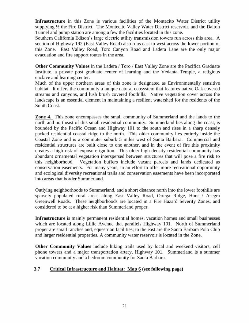
Infrastructure in this Zone is various facilities of the Montecito Water District utility
supplying ½ the Fire District. The Montecito Valley Water District reservoir, and the Dalton
Tunnel and pump station are among a few the facilities located in this zone.
Southern California Edison’s large electric utility transmission towers run across this area. A
section of Highway 192 (East Valley Road) also runs east to west across the lower portion of
this Zone. East Valley Road, Toro Canyon Road and Ladera Lane are the only major
evacuation and fire support routes in the area.
Other Community Values in the Ladera / Toro / East Valley Zone are the Pacifica Graduate
Institute, a private post graduate center of learning and the Vedanta Temple, a religious
enclave and learning center.
Much of the upper northern areas of this zone is designated as Environmentally sensitive
habitat. It offers the community a unique natural ecosystem that features native Oak covered
streams and canyons, and lush brush covered foothills. Native vegetation cover across the
landscape is an essential element in maintaining a resilient watershed for the residents of the
South Coast.
Zone 4. This zone encompasses the small community of Summerland and the lands to the
north and northeast of this small residential community. Summerland lies along the coast, is
bounded by the Pacific Ocean and Highway 101 to the south and rises in a sharp densely
packed residential coastal ridge to the north. This older community lies entirely inside the
Coastal Zone and is a commuter suburb 5 miles west of Santa Barbara. Commercial and
residential structures are built close to one another, and in the event of fire this proximity
creates a high risk of exposure ignition. This older high density residential community has
abundant ornamental vegetation interspersed between structures that will pose a fire risk to
this neighborhood. Vegetation buffers include vacant parcels and lands dedicated as
conservation easements. For many years, in an effort to offer more recreational opportunity
and ecological diversity recreational trails and conservation easements have been incorporated
into areas that border Summerland.
Outlying neighborhoods to Summerland, and a short distance north into the lower foothills are
sparsely populated rural areas along East Valley Road, Ortega Ridge, Hunt / Asegra
Greenwell Roads. These neighborhoods are located in a Fire Hazard Severity Zones, and
considered to be at a higher risk than Summerland proper.
Infrastructure is mainly permanent residential homes, vacation homes and small businesses
which are located along Lillie Avenue that parallels Highway 101. North of Summerland
proper are small ranches and, equestrian facilities; to the east are the Santa Barbara Polo Club
and larger residential properties. A community water reservoir is located in the Zone.
Other Community Values include hiking trails used by local and weekend visitors, cell
phone towers and a major transportation artery, Highway 101. Summerland is a summer
vacation community and a bedroom community for Santa Barbara.
3.7 Critical Infrastructure and Habitat: Map 6 (see following page)
!Z
!Z !Z
!Z
!Z
!Z
!Z
!Z !Z
!Z !Z!Z!Z!Z!Z
!Z
!Z !Z !Z!Z
!Z!Z
!Z!Z!Z !Z!Z
!Z!Z
!Z
!Z!Z
!Z
!Z!Z!Z!Z!Z!Z !Z
!Z!Z!Z!Z
!Z
!Z !Z!Z
!Z
!Z !Z!Z
!Z
!Z
!Z!Z
!Z
!Z!Z!Z
!Z
!Z!Z!Z!Z
!Z
!Z!Z
!Z !Z!Z
!Z
!Z!Z!Z!Z!Z!Z!Z!Z!Z!Z!Z!Z!Z!Z!Z!Z!Z!Z
!Z
!Z
!Z
!Z!Z
!Z
!Z!Z !Z!Z!Z !Z!Z
!Z!Z
!Z
!Z
!Z!Z
!Z
!Z
!Z
!Z!Z!Z!Z!Z
!Z
!Z
!Z
!Z
!Z
!Z
!Z
ââ
ââ
ââ
ââ
ââ
ââ
ââââ ââ ââ ââ ââ ââ ââ ââ ââ ââ ââ ââ ââ ââ ââ ââ ââ ââ ââ ââ ââ ââ ââ ââ ââ ââ ââ ââ ââ ââ ââ
ââââ
ââââ
ââ ââ ââ ââ ââ ââ ââ
ââââ
ââââ
ââ
ââ ââ ââ ââ ââ ââ ââ ââ ââ
ââââ
ââ
ââ ââ ââ ââ ââ ââ ââ ââ ââââ
ââââ
ââââ
ââââ
ââ ââ ââ ââ ââ ââ ââ ââ ââ ââââ
ââ ââââ
ââââ
ââââ
ââââ ââ ââ ââ ââ ââ ââ ââ ââ ââ ââ ââ ââ
ââ
ââ
ââ
ââ
ââ
ââ
ââ
ââ
ââ
ââ
ââ
ââ
ââ
ââââ
ââââ
ââ
ââââ
ââââ
ââ ââ ââ ââ
ââââââââââââââ
ââ
ââ
ââ
ââ
ââ
ââââ
ââ
ââ
ââââ
ââ
ââââ
ââ
ââââââââââââââ
ââ
ââââ
ââââââââââââ
ââââââââââ
ââââ
ââââ
ââ
ââââ
ââââ
ââââ
ââââ
ââ
ÚW
ÚW
ÚW
ÚWÚW
ÚW
Community Wildfire Protection Plan - Critical Infrastructure and Habitat
\
By: C. Castilllo & Rolf Larsen Jan.14 2013
0 1 2 3 40.5Miles
LegendCWPP Boundary
ââ Power LinesMonarch Sites
!Z Historic Resources PointsEnvironmentally Sensitive HabitatWildland Urban InterfaceWater Utility InfrastructureÚW
22
3.8 Firefighting Capabilities and Local Preparedness
3.8.1 Fire Agency Preparedness
The Carpinteria-Summerland Fire District is an all risk emergency service provider for the
communities of Carpinteria and Summerland. The district covers 40 square miles from the
Pacific Ocean to higher elevations in the Los Padres National Forest and the area from the
Ventura County Boundary on the east to the Montecito Fire District on the west.
The district has 28 safety suppression personnel, 3 fire prevention personnel and 2
administrative assistants. In addition to the traditional responsibilities of firefighting,
personnel are trained as paramedics or emergency medical technicians, CPR instructors,
prevention officers, hazardous materials specialist, arson investigators, advanced rescue
specialists, ocean water rescue specialist, wildland fire abatement experts. The Fire District is
responsible for Initial response to all fire, medical, and associated emergencies.
The Fire District operates out of two fire stations with daily staffing of nine (9) personnel per
shift. The minimum staffing is four (4) firefighters and one Battalion Chief at Fire Station #1
in Carpinteria and three (3) firefighters at Fire Station #2 in Summerland. The vehicle assets
consists of a fleet of three (3) structural fire engines (one is a State OES fire engine), one (1)
brush fire engine, one (1) squad/rescue vehicle, one (1) water rescue craft with a tow vehicle,
two (2) command vehicles and five (5) staff/utility vehicles. The administrative offices are
operated out a separate facility from the fire stations.
CSFD has a partnership with the community to provide a comprehensive public education and
fire prevention program for the protection of life and property. A Fire Prevention Officer that
specializes in a vegetation management program works with property owners for reduction of
fuel hazards and structure improvements in high fire hazard areas. The program targets
increasing defensible space around homes, and a reduction of fuels on access routes in the
wildland fire environment.
The Fire District has local automatic aid agreements with the adjoining fire agencies of
Montecito Fire Protection District and Ventura County Fire Department to provide initial first
alarm resources on fires and vehicle accidents. The automatic aid agreements are also utilized
to provide station coverage as needed for the requesting agency. The Fire District is an active
participant in the Santa Barbara County Mutual Aid Plan which allows the district to provide
or receive immediate assistant to and from local fire agencies. As a participant in the
California Mutual Aid System, CSFD may request assistance from all other fire agencies in
the state that are signatory to the agreement. Because the district boundaries also extend
through state responsibility area (SRA) lands, the Santa Barbara County Fire Department,
(contracted to cover state lands) will provide a response with access to their resources and
indirect access to state resources from CAL-FIRE. The fire district boundaries also extend
into the Los Padres National Forest and will receive a full wildland fire brush response from
the Forest Service with access to all National Forest resources.
Wildland fire responsibilities of the local fire departments, Santa Barbara County, California
Department of Forestry & Fire and the U.S. Forest Service are described in the current Santa
Barbara County Wildfire Plan. A 1st Alarm Wildfire alarm within the Fire Protection District
would involve the Districts local assets which initially would be made up of two (2) Engine
Companies and one (1) Chief Officer and an automatic mutual aid response from adjoining
fire agencies. A quick assessment of the wildfire potential will initiate a call for additional
23
resources, including but not limited to resources dispatched on a “Second Alarm”. The
additional alarm and Mutual Aid from outside cooperating fire agencies would include
suppression resources as follows, per the County Wildfire Plan.
At the initiation of a Mutual Aid wildfire response, the Fire District will supplement its
resources with fire suppression and operational Chief Officers from adjoining agencies. The
local agencies covered in the Mutual Aid plan include Montecito Fire Protection District,
Santa Barbara County Fire Department, Santa Barbara City Fire Department, the Ventura
County Fire Authority and the United States Forest Service (Los Padres National Forest).
First Alarm resources to supplement local suppression forces expected from the Fire District’s
Mutual cooperators include 5 Engine Companies, 3 Chief Officers, 1 Hand Crew, 1 Water
Tender, 1 Dozer and 1 Air Attack (Aerial Observation platform).A First Alarm response
would number approximately 56 firefighting personnel.
3.8.2 Local Community Preparedness
The Fire District participates in emergency planning and preparedness with City of Carpinteria
Emergency Services Department, the Summerland Citizens Community Group and the local
unit of the Santa Barbara County Sheriff’s Department. The district participates in the
development and updating of the City of Carpinteria Multi-Hazard Functional Plan and Local
Hazard Mitigation Plan. In addition, the district works with the Santa Barbara County
Emergency Management Office (CAL-EMA) for any fire division related disaster planning
drills or events. The district administrative office or headquarters houses the EOC
(Emergency Operations Center) for the City of Carpinteria that is activated during large scale
emergencies and will also serve as a Fire DOC (Department Operations Center) for a large
scale fire.
The Santa Barbara County Sheriff’s Department has responsibility for ensuring the safe and
orderly evacuation of citizens within our district in the event of a major emergency. The
Sheriff’s Department has pre-established evacuation plans/routes and can provide notification
utilizing reverse 9-1-1 system, radio and television emergency alert system, CERT volunteers,
public address systems and direct door to door contact.
Local citizens’ organizations – homeowners’ groups, road associations, business
organizations, and service organizations, are well established collaborators with the various
area public agencies, including the Fire District.
Along with other local public service agencies CSFD supports and encourages local citizens to
participate in and learn essential emergency procedures through the Community Emergency
Response Team Program (CERT). This program is essential to enhance the emergency
response by local public agencies through citizen preparedness.
The CSFD engages residents living in the Wildland Urban Interface in discussions about their
local wildfire safety issues. Annually, each homeowner is sent a wildfire safety and
“defensible space” message advising of the need to meet state and local fire safety regulations.
This annual fire safety notice is intended both as an instrument to educate, and as notice that
fire safety regulations must be followed. Residents who receive their annual notices and those
residents who want additional wildfire safety information are directed to the Fire District’s
“Ready! Set! Go!” publication. This brochure offers residents living in or near wildfire prone
areas a California State Emergency Management Agency wildfire safety message. It also
24
contains mandatory requirements for vegetation management practices and building code
standards. From a fire prevention loss scenario this document is an invaluable tool for
educating the public about responsibilities that come with living in a Fire Hazard Severity
Zone.
It is imperative that stakeholders in the “Communities At-Risk” take a proactive approach to
reducing the risk of unwanted, adverse consequences to human life, health, property or the
environment from a wildfire by adopting mitigation measures that are proven to address that
risk, as well as reducing the potential that such an incident would occur.
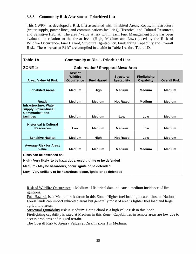
25
3.8.3 Community Risk Assessment - Prioritized List
This CWPP has developed a Risk List associated with Inhabited Areas, Roads, Infrastructure
(water supply, power-lines, and communications facilities), Historical and Cultural Resources
and Sensitive Habitat. The area / value at risk within each Fuel Management Zone has been
evaluated in relation to the threat level (High, Medium and Low) posed by the Risk of
Wildfire Occurrence, Fuel Hazard, Structural Ignitability, Firefighting Capability and Overall
Risk. These “Areas at Risk” are compiled in a table in Table 1A. thru Table 1D.
Table 1A Community at Risk - Prioritized List
ZONE 1: Gobernador / Sheppard Mesa Area
Area / Value At Risk
Risk of Wildfire
Occurrence Fuel Hazard Structural Ignitability
Firefighting Capability Overall Risk
Inhabited Areas Medium High Medium Medium Medium
Roads Medium Medium Not Rated Medium Medium
Infrastructure: Water supply; Power-lines; Communications facilities Medium Medium Low Low Medium
Historical & Cultural Resources Low Medium Medium Low Medium
Sensitive Habitat Medium High Not Rated Low Medium
Average Risk for Area / Value Medium Medium Medium Medium Medium
Risks can be assessed as:
High - Very likely to be hazardous, occur, ignite or be defended
Medium - May be hazardous, occur, ignite or be defended
Low - Very unlikely to be hazardous, occur, ignite or be defended
Risk of Wildfire Occurrence is Medium. Historical data indicate a medium incidence of fire
ignitions.
Fuel Hazards is at Medium risk factor in this Zone. Higher fuel loading located close to National
Forest lands can impact inhabited areas but generally most of area is lighter fuel load and large
agriculture areas.
Structural Ignitability risk is Medium. Cate School is a high value risk in this Zone.
Firefighting capability is rated at Medium in this Zone. Capabilities in remote areas are low due to
access problems and rugged terrain.
The Overall Risk to Areas / Values at Risk in Zone 1 is Medium.
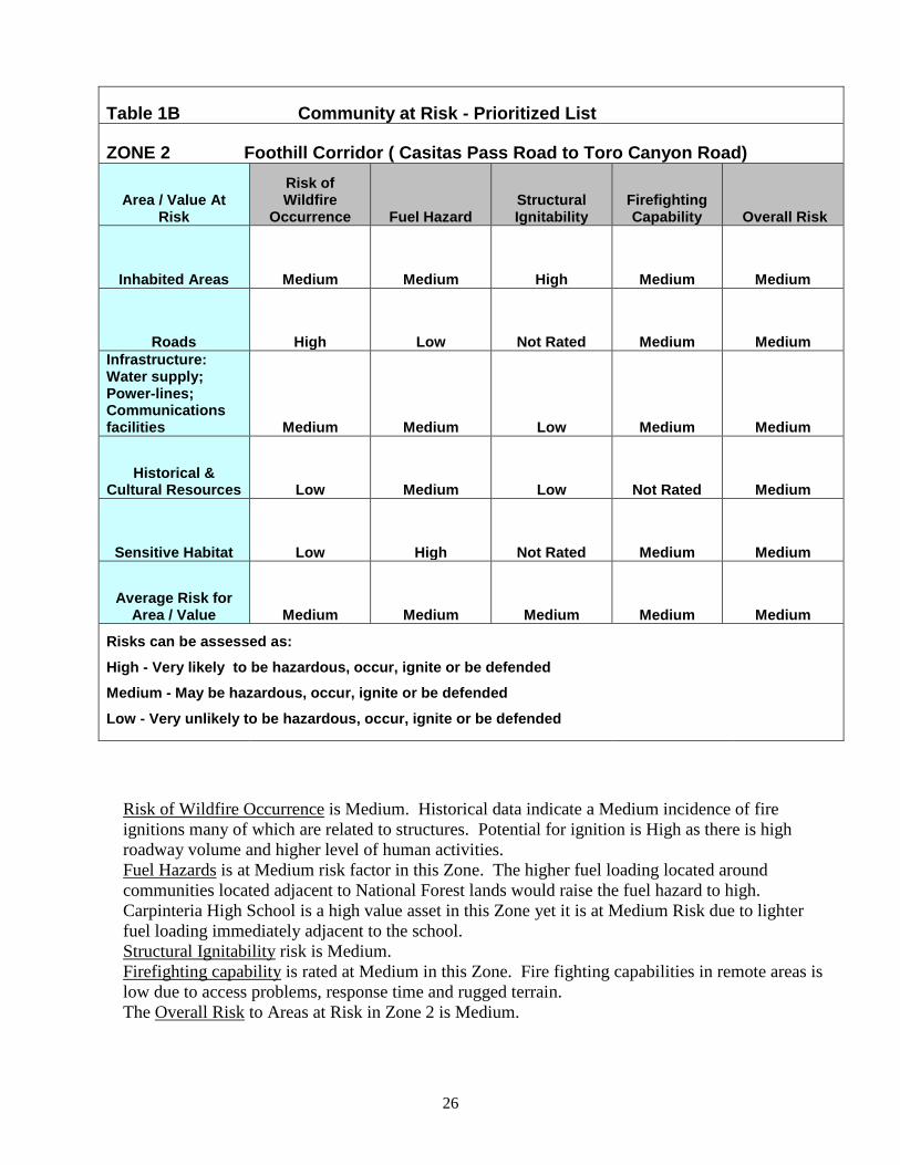
26
Table 1B Community at Risk - Prioritized List
ZONE 2 Foothill Corridor ( Casitas Pass Road to Toro Canyon Road)
Area / Value At Risk
Risk of Wildfire
Occurrence Fuel Hazard Structural Ignitability
Firefighting Capability Overall Risk
Inhabited Areas Medium Medium High Medium Medium
Roads High Low Not Rated Medium Medium
Infrastructure: Water supply; Power-lines; Communications facilities Medium Medium Low Medium Medium
Historical & Cultural Resources Low Medium Low Not Rated Medium
Sensitive Habitat Low High Not Rated Medium Medium
Average Risk for Area / Value Medium Medium Medium Medium Medium
Risks can be assessed as:
High - Very likely to be hazardous, occur, ignite or be defended
Medium - May be hazardous, occur, ignite or be defended
Low - Very unlikely to be hazardous, occur, ignite or be defended
Risk of Wildfire Occurrence is Medium. Historical data indicate a Medium incidence of fire
ignitions many of which are related to structures. Potential for ignition is High as there is high
roadway volume and higher level of human activities.
Fuel Hazards is at Medium risk factor in this Zone. The higher fuel loading located around
communities located adjacent to National Forest lands would raise the fuel hazard to high.
Carpinteria High School is a high value asset in this Zone yet it is at Medium Risk due to lighter
fuel loading immediately adjacent to the school.
Structural Ignitability risk is Medium.
Firefighting capability is rated at Medium in this Zone. Fire fighting capabilities in remote areas is
low due to access problems, response time and rugged terrain.
The Overall Risk to Areas at Risk in Zone 2 is Medium.
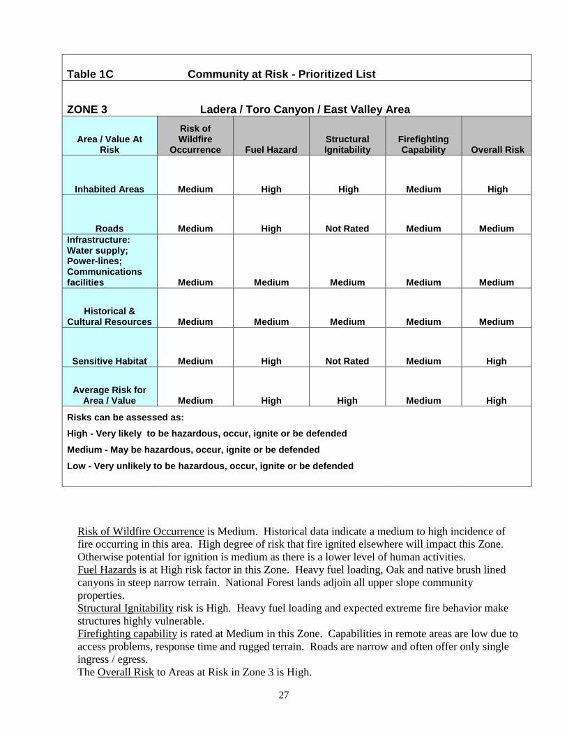
27
Table 1C Community at Risk - Prioritized List
ZONE 3 Ladera / Toro Canyon / East Valley Area
Area / Value At Risk
Risk of Wildfire
Occurrence Fuel Hazard Structural Ignitability
Firefighting Capability Overall Risk
Inhabited Areas Medium High High Medium High
Roads Medium High Not Rated Medium Medium
Infrastructure: Water supply; Power-lines; Communications facilities Medium Medium Medium Medium Medium
Historical & Cultural Resources Medium Medium Medium Medium Medium
Sensitive Habitat Medium High Not Rated Medium High
Average Risk for Area / Value Medium High High Medium High
Risks can be assessed as:
High - Very likely to be hazardous, occur, ignite or be defended
Medium - May be hazardous, occur, ignite or be defended
Low - Very unlikely to be hazardous, occur, ignite or be defended
Risk of Wildfire Occurrence is Medium. Historical data indicate a medium to high incidence of
fire occurring in this area. High degree of risk that fire ignited elsewhere will impact this Zone.
Otherwise potential for ignition is medium as there is a lower level of human activities.
Fuel Hazards is at High risk factor in this Zone. Heavy fuel loading, Oak and native brush lined
canyons in steep narrow terrain. National Forest lands adjoin all upper slope community
properties.
Structural Ignitability risk is High. Heavy fuel loading and expected extreme fire behavior make
structures highly vulnerable.
Firefighting capability is rated at Medium in this Zone. Capabilities in remote areas are low due to
access problems, response time and rugged terrain. Roads are narrow and often offer only single
ingress / egress.
The Overall Risk to Areas at Risk in Zone 3 is High.
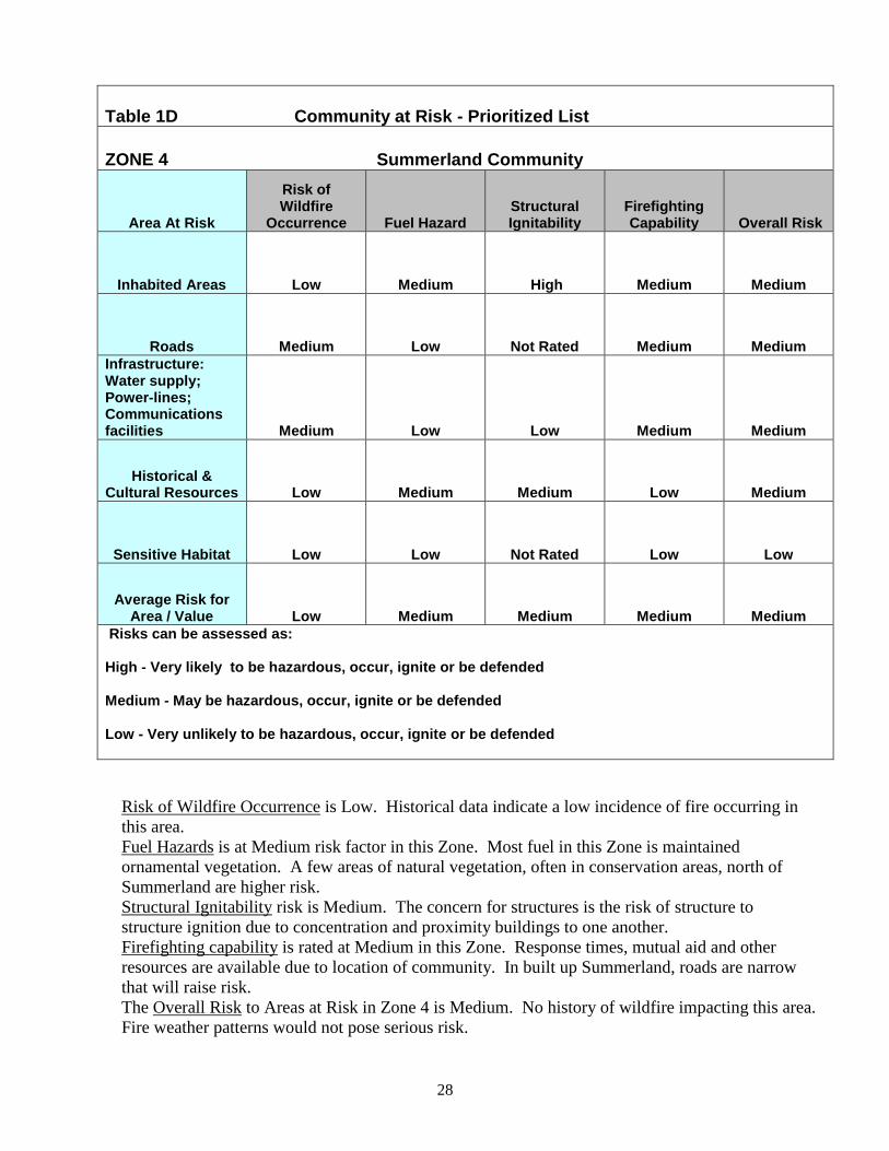
28
Table 1D Community at Risk - Prioritized List
ZONE 4 Summerland Community
Area At Risk
Risk of Wildfire
Occurrence Fuel Hazard Structural Ignitability
Firefighting Capability Overall Risk
Inhabited Areas Low Medium High Medium Medium
Roads Medium Low Not Rated Medium Medium
Infrastructure: Water supply; Power-lines; Communications facilities Medium Low Low Medium Medium
Historical & Cultural Resources Low Medium Medium Low Medium
Sensitive Habitat Low Low Not Rated Low Low
Average Risk for Area / Value Low Medium Medium Medium Medium
Risks can be assessed as:
High - Very likely to be hazardous, occur, ignite or be defended
Medium - May be hazardous, occur, ignite or be defended
Low - Very unlikely to be hazardous, occur, ignite or be defended
Risk of Wildfire Occurrence is Low. Historical data indicate a low incidence of fire occurring in
this area.
Fuel Hazards is at Medium risk factor in this Zone. Most fuel in this Zone is maintained
ornamental vegetation. A few areas of natural vegetation, often in conservation areas, north of
Summerland are higher risk.
Structural Ignitability risk is Medium. The concern for structures is the risk of structure to
structure ignition due to concentration and proximity buildings to one another.
Firefighting capability is rated at Medium in this Zone. Response times, mutual aid and other
resources are available due to location of community. In built up Summerland, roads are narrow
that will raise risk.
The Overall Risk to Areas at Risk in Zone 4 is Medium. No history of wildfire impacting this area.
Fire weather patterns would not pose serious risk.
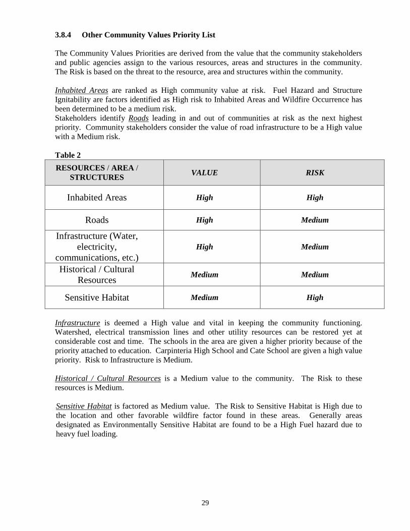
29
3.8.4 Other Community Values Priority List
The Community Values Priorities are derived from the value that the community stakeholders
and public agencies assign to the various resources, areas and structures in the community.
The Risk is based on the threat to the resource, area and structures within the community.
Inhabited Areas are ranked as High community value at risk. Fuel Hazard and Structure
Ignitability are factors identified as High risk to Inhabited Areas and Wildfire Occurrence has
been determined to be a medium risk.
Stakeholders identify Roads leading in and out of communities at risk as the next highest
priority. Community stakeholders consider the value of road infrastructure to be a High value
with a Medium risk.
Table 2
RESOURCES / AREA /
STRUCTURES VALUE RISK
Inhabited Areas High High
Roads High Medium
Infrastructure (Water,
electricity,
communications, etc.)
High Medium
Historical / Cultural
Resources Medium Medium
Sensitive Habitat Medium High
Infrastructure is deemed a High value and vital in keeping the community functioning.
Watershed, electrical transmission lines and other utility resources can be restored yet at
considerable cost and time. The schools in the area are given a higher priority because of the
priority attached to education. Carpinteria High School and Cate School are given a high value
priority. Risk to Infrastructure is Medium.
Historical / Cultural Resources is a Medium value to the community. The Risk to these
resources is Medium.
Sensitive Habitat is factored as Medium value. The Risk to Sensitive Habitat is High due to
the location and other favorable wildfire factor found in these areas. Generally areas
designated as Environmentally Sensitive Habitat are found to be a High Fuel hazard due to
heavy fuel loading.
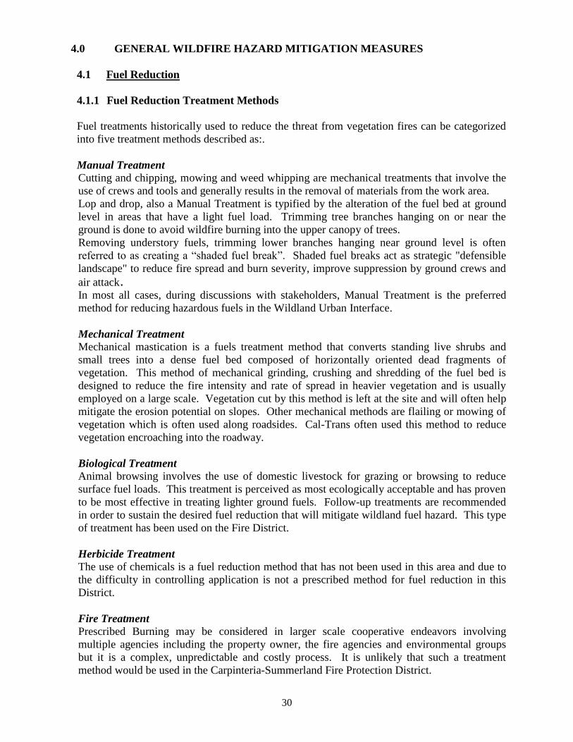
30
4.0 GENERAL WILDFIRE HAZARD MITIGATION MEASURES
4.1 Fuel Reduction
4.1.1 Fuel Reduction Treatment Methods
Fuel treatments historically used to reduce the threat from vegetation fires can be categorized
into five treatment methods described as:.
Manual Treatment
Cutting and chipping, mowing and weed whipping are mechanical treatments that involve the
use of crews and tools and generally results in the removal of materials from the work area.
Lop and drop, also a Manual Treatment is typified by the alteration of the fuel bed at ground
level in areas that have a light fuel load. Trimming tree branches hanging on or near the
ground is done to avoid wildfire burning into the upper canopy of trees.
Removing understory fuels, trimming lower branches hanging near ground level is often
referred to as creating a “shaded fuel break”. Shaded fuel breaks act as strategic "defensible
landscape" to reduce fire spread and burn severity, improve suppression by ground crews and
air attack. In most all cases, during discussions with stakeholders, Manual Treatment is the preferred
method for reducing hazardous fuels in the Wildland Urban Interface.
Mechanical Treatment
Mechanical mastication is a fuels treatment method that converts standing live shrubs and
small trees into a dense fuel bed composed of horizontally oriented dead fragments of
vegetation. This method of mechanical grinding, crushing and shredding of the fuel bed is
designed to reduce the fire intensity and rate of spread in heavier vegetation and is usually
employed on a large scale. Vegetation cut by this method is left at the site and will often help
mitigate the erosion potential on slopes. Other mechanical methods are flailing or mowing of
vegetation which is often used along roadsides. Cal-Trans often used this method to reduce
vegetation encroaching into the roadway.
Biological Treatment
Animal browsing involves the use of domestic livestock for grazing or browsing to reduce
surface fuel loads. This treatment is perceived as most ecologically acceptable and has proven
to be most effective in treating lighter ground fuels. Follow-up treatments are recommended
in order to sustain the desired fuel reduction that will mitigate wildland fuel hazard. This type
of treatment has been used on the Fire District.
Herbicide Treatment
The use of chemicals is a fuel reduction method that has not been used in this area and due to
the difficulty in controlling application is not a prescribed method for fuel reduction in this
District.
Fire Treatment
Prescribed Burning may be considered in larger scale cooperative endeavors involving
multiple agencies including the property owner, the fire agencies and environmental groups
but it is a complex, unpredictable and costly process. It is unlikely that such a treatment
method would be used in the Carpinteria-Summerland Fire Protection District.
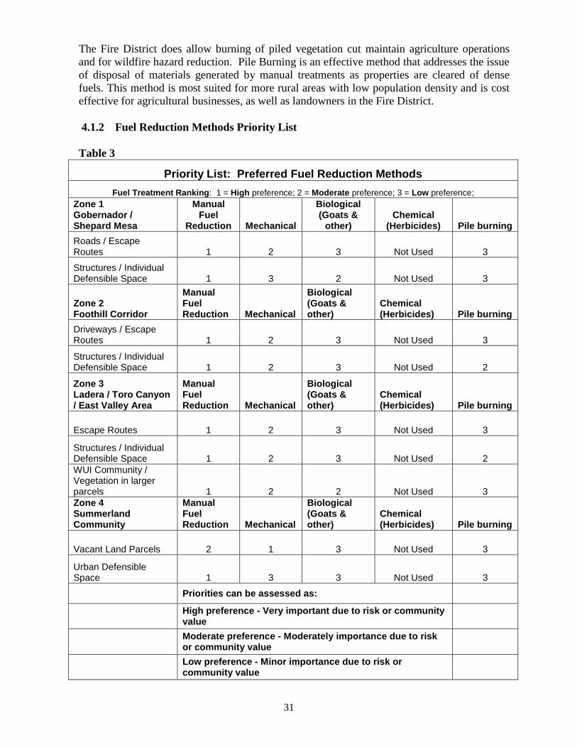
31
The Fire District does allow burning of piled vegetation cut maintain agriculture operations
and for wildfire hazard reduction. Pile Burning is an effective method that addresses the issue
of disposal of materials generated by manual treatments as properties are cleared of dense
fuels. This method is most suited for more rural areas with low population density and is cost
effective for agricultural businesses, as well as landowners in the Fire District.
4.1.2 Fuel Reduction Methods Priority List
Table 3
Priority List: Preferred Fuel Reduction Methods
Fuel Treatment Ranking: 1 = High preference; 2 = Moderate preference; 3 = Low preference;
Zone 1 Gobernador / Shepard Mesa
Manual Fuel
Reduction Mechanical
Biological (Goats &
other) Chemical
(Herbicides) Pile burning
Roads / Escape Routes 1 2 3 Not Used 3
Structures / Individual Defensible Space 1 3 2 Not Used 3
Zone 2 Foothill Corridor
Manual Fuel Reduction Mechanical
Biological (Goats & other)
Chemical (Herbicides) Pile burning
Driveways / Escape Routes 1 2 3 Not Used 3
Structures / Individual Defensible Space 1 2 3 Not Used 2
Zone 3 Ladera / Toro Canyon / East Valley Area
Manual Fuel Reduction Mechanical
Biological (Goats & other)
Chemical (Herbicides) Pile burning
Escape Routes 1 2 3 Not Used 3
Structures / Individual Defensible Space 1 2 3 Not Used 2
WUI Community / Vegetation in larger parcels 1 2 2 Not Used 3
Zone 4 Summerland Community
Manual Fuel Reduction Mechanical
Biological (Goats & other)
Chemical (Herbicides) Pile burning
Vacant Land Parcels 2 1 3 Not Used 3
Urban Defensible Space 1 3 3 Not Used 3
Priorities can be assessed as:
High preference - Very important due to risk or community value
Moderate preference - Moderately importance due to risk or community value
Low preference - Minor importance due to risk or community value
32
Table 3 is provided as a means of displaying the preferred reduction methods available with
the Fire District. During discussions with stakeholders the manual fuel reduction treatments
were the preferred method to mitigate hazardous fuel conditions on the Fire District.
Manual Fuel reduction treatments cuts and removes vegetation from the property by various
methods. It often includes the use of Crew labor and some method to reduce or haul away the
vegetation. By using this type of treatment the stakeholder is better able to manage project
goals and utilize “best practices” to meet any environmental requirements. This method is
labor intensive and often is a higher cost than other available treatments.
Mechanical Fuel treatments using a Masticator are best utilized for larger project areas due to
the chance that cuttings from the operation can be lofted over a long distance. It is usually the
most efficient and least costly of the fuel reduction treatments in those areas suitable for this
type of treatment. An alternative is flailing, mowing or disking. The latter of these methods
can be used in lighter fuels such as grass or lighter scrubs but may require mitigation
measures that lessen the impact on the environment. Mowing tends to be a benign method of
reducing lighter grass fuels.
Biological Fuel treatment involves the use of living organisms to selectively suppress, inhibit,
or remove herbaceous and woody vegetation. Most often associated with this type of
treatment are grazing animals such as goats, sheep and cows. The vegetation manager can be
selective as to where and how much vegetation is removed. Goats can work in heavy
chaparral but they are usually more effective in lighter native brush, forbs or grasses. Goats
will eat poison oak and will eat some invasive species such as Cape Ivy – German Ivy.
Chemicals or Herbicides is a treatment method that is not likely to be used on the Fire
District. Some small use of weed suppressants may be used by landowners but larger
applications of chemicals are too expensive and restrictive to be of value in fuel reduction.
Pile Burning is an effective means to dispose of vegetation that needs to be discarded. This
method is an effective and inexpensive method that a landowner can use to dispose of
vegetation that has already been cut. Manual labor can cut and stack vegetation into a pile so
it can be burned. Clean air quality regulations must be met in order to burn vegetation.
4.2 Reducing Structural Ignitibility
4.2.1 Roof Assemblies
Replacement of wood shake or shingle roofs with a rated Class A fire resistive roof has
proven to be effective in the reduction of wildfire spread to the structure. Other
recommendations would include the installation of newly designed ember resistant attic vents,
and fire resistant sky-light assemblies, and windows that are equipped with double pane
glazed and tempered glass and include fire resistive frames that are designed to withstand
radiant heat encountered during a wildfire incident.
Rain gutters should be made of material that is the least susceptible to radiant heat and embers
that could cause such materials to ignite.
4.2.2 Porches, Decks and other wood attachments
Build decks of non-combustible or large dimension wood components that can resist heat and
embers. Attached accessory structures and wood fences are contributors to fire spread to the
main structure. The use of fire rated materials should be considered for wooden attachments.
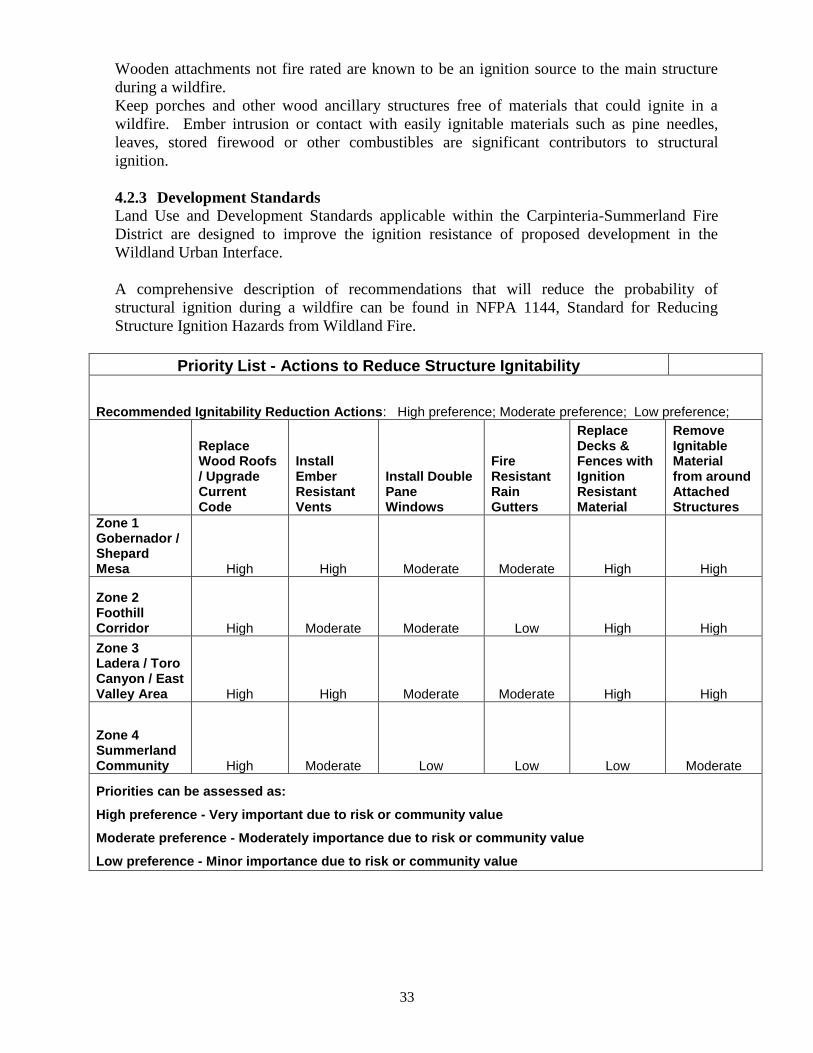
33
Wooden attachments not fire rated are known to be an ignition source to the main structure
during a wildfire.
Keep porches and other wood ancillary structures free of materials that could ignite in a
wildfire. Ember intrusion or contact with easily ignitable materials such as pine needles,
leaves, stored firewood or other combustibles are significant contributors to structural
ignition.
4.2.3 Development Standards
Land Use and Development Standards applicable within the Carpinteria-Summerland Fire
District are designed to improve the ignition resistance of proposed development in the
Wildland Urban Interface.
A comprehensive description of recommendations that will reduce the probability of
structural ignition during a wildfire can be found in NFPA 1144, Standard for Reducing
Structure Ignition Hazards from Wildland Fire.
Priority List - Actions to Reduce Structure Ignitability
Recommended Ignitability Reduction Actions: High preference; Moderate preference; Low preference;
Replace Wood Roofs / Upgrade Current Code
Install Ember Resistant Vents
Install Double Pane Windows
Fire Resistant Rain Gutters
Replace Decks & Fences with Ignition Resistant Material
Remove Ignitable Material from around Attached Structures
Zone 1 Gobernador / Shepard Mesa High High Moderate Moderate High High
Zone 2 Foothill Corridor High Moderate Moderate Low High High
Zone 3 Ladera / Toro Canyon / East Valley Area High High Moderate Moderate High High
Zone 4 Summerland Community High Moderate Low Low Low Moderate
Priorities can be assessed as:
High preference - Very important due to risk or community value
Moderate preference - Moderately importance due to risk or community value
Low preference - Minor importance due to risk or community value
34
4.3 Fire Safety Objectives
4.3.1 Program Priorities Identified by Residents and Interested Parties within each
Fuel Management Zone (see Appendix C).
Residents, interested parties, stakeholders and representatives from the environmental
community were contacted either by mail, email or through media outreach to encourage
attendance at a wildfire safety (CWPP) forum. Four (4) meetings were attended by a number
of Fire District residents and Fire Protection District personnel. During several meetings with
residents the Fire District and interested parties were given the opportunity to identify what
type of fire safety programs should be implemented in their community that would offer a
high level of success to reducing wildfire risk.
The information gathered during the initial survey was used as the framework of the
presentations made to the community participants. Their input concerning threat, risk, and
identifiable loss mitigation measures was essential in developing the information for the
prioritization of wildfire mitigation measures. As discussions continue with homeowners and
interested parties over time, goals can be changed as the public agencies and the communities
at risk define what actions are most likely to achieve success and long range benefits for our
community.
The first priority voiced by the entire community was to provide and maintain effective usable
emergency evacuation and access routes. The following paragraphs will describe the issues
and priorities voiced by the interested parties within the four zones identified by CSFD.
Zone 1 (Gobernador / Shepard Mesa Zone) – The areas of concern that were identified in
meeting residents from this area of the Fire District were the identification of Escape Routes,
Establishing Secondary Escape Routes, Effective Methods of maintaining cleared access and
Vegetation Removal after clearing for property Defensible Space. Residents expressed a
preference for having Annual Fire Prevention Day Community events in which Residential
lots, driveways and community roadways would be cleared of hazardous vegetation that
posed a risk to their community. Individual residents recognize that it is their responsibility to
adhere to Wildland Urban Interface vegetation clearance regulations and that a community
sponsored fuel mitigation program would enhance the wildfire safety of their neighborhood.
Zone 2 (Foothill Corridor Zone) – The areas of concern that were identified were wildfire
spread from the abundant native brush lands directly adjacent to their agricultural properties
and the existing narrow driveways that are critical to residence evacuation and firefighting
resources access. Residents suggested clearing hazardous fuel from their structures to create
defensible space.
Zone 3 (Ladera/Toro / East Valley Zone) – The areas of concern included, on a large scale,
the dense vegetation in Forest lands and the heavy fuel loading surrounding the community.
Preferences among stakeholders are for clearing of hazardous vegetation in a manner that
creates a defensible fuel zone around their homes and along roadways. A number of local
neighborhoods, in partnership with the Fire District, have developed a sustainable and
proactive hazardous fuel reduction program designed to maintain viable escape routes and
emergency vehicle access in the event of a wildland fire.
35
Zone 4 (Summerland Zone) – Residents of this area expressed concern about the possibility of
fire spread from vegetation covered parcels (the open space and conservation areas in and
around the Summerland community) impacting this residential neighborhood in the event of a
wildfire start in the native vegetation. The residents are concerned about the possibility of a
fire starting as a result of human activity on trails that run through the community.
Community stakeholders, the Fire District and a local trails foundation have used hand crews
to mitigate the fuel build-up along the trails. The Summerland neighborhoods identified the
increasing growth of vegetation vegetation around structures and encroaching on roadways
making for difficult access. A solution to the issue of the increasing growth of vegetation
supported by the Summerland Citizens’ Association is to have an annual vegetation clearance
day where hazardous vegetation would be removed to dumpsters or chipped by contract crews
employed by the community. Community leaders and the Fire District have used such a “Fire
Prevention Day” hazardous fuels project to reduce flammable fuels close to structures.
The preference of residence in the northern section of Summerland would be to establish a
buffer of cleared vegetation that separates the urban residential district from the larger native
vegetation covered parcels on the periphery of the community. Santa Barbara county
Agricultural Commissioner’s office currently has a program that targets the removal of non-
native plants -Arundo donax.
4.3.2 Community Risk Reduction
Recognizing that fire suppression actions are post ignition and are a response to an active fire,
communities can act to mitigate fire ignition by actions that will prevent the incident. Fire
education, fire code enforcement and hazardous fuel reduction programs are effective
programs that will prevent fires.
Before an incident, before a fire starts, the desired prevention model for a community is to
engage residents in a fire loss prevention planning processes, and then recommend a course of
action that will either prevent fires or minimize the risk of losses. Fire Agencies use the Fire
Prevention Triangle (Education, Engineering, and Enforcement) to chart a course of actions
that will achieve the desired results. Fire Prevention is the series of actions taken with the
goal of preventing unacceptable loss.
Fire Prevention Education perhaps the least expensive, is the most effective way to alter
human behavior that will lessen the probability that some act will cause the ignition of a fire.
Posters, fire safety mailing, web pages, community meeting and such are effective tools used
to educate the public about fire safety actions that are desired and safety regulations that are
required.
Enforcement comes from the Fire Agencies’ authority to promote fire safety throughout the
community they are charged to protect. It usually involves the demand that the community or
individuals adhere to the minimum fire and life safety standards as described in regulation.
Engineering is the remaining leg of the Fire Prevention Triangle. It is related to the acts that
would physically change the elements of the fire triangle, and in wildland fires that element is
fuel, either in the form of native vegetation or in a structure. Communities are required by
law to adhere to certain safety regulations in building design and vegetation management that
increases survivability in a wildfire. Building codes engineer the components of a structure.
Among the earliest changes in our area was the elimination of wood shakes and shingles as
roofing material, more recent requirements that include the use of pressure treated fire
36
resistive siding, double pane windows, fire resistive window frames, enclosed eaves and
redesigned vent opening and smaller vent screens, and as of the last code development cycle
the introduction of performance based materials that have been proven to meet new ignition
resistance standards.
Vegetation management seeks to engineer the landscape in order to minimize the risk of
wildfire loss. The fuel element is the immediate hazard upon which we can act to minimize
the probability of fire ignition and lessen fire intensity. And as noted earlier in Section 3.2
there is an established body of literature and lessons from historical wildfires that Fuel
Hazards are linked to fire intensity in wildland fires and the resultant impact on our
communities (see Figure 1).
Adhering to both sound vegetation management practices and fire and life safety building
practices, designed for living in a wildfire prone interface, will increase the community’s
ability to prepare for, respond to and recover from wildfires.
4.4 Funding Sources
Grant Funds are available for both public service agencies and private citizens’ groups. Any
number of Federal, State or Private Corporation grants will provide money for the
implementation of fire safety programs that focus on mitigation of the wildfire threat. Some
examples of funding sources include the US Forest Service’s funding for fuel reduction
project managed through Fire Safe Councils, state agencies such as California Fish and Game
or Cal-Fire, as well as, Private Foundations and Insurance agencies.
Locally, the Carpinteria-Summerland Fire District allocates vegetation management funds to
support a part time prevention officer whose duties include communicating with those who
reside in the Wildland-Urban Interface, managing vegetation clearance activities and
developing instruction materials focused on methods of reducing the risk of a communities’
exposure to Wildland fire.
Community / Homeowner Association may be willing to expend financial resources as they
collaborate with public agencies and private businesses to implement those actions they
believe will support the continuing efforts defined as priorities in this CWPP.
Individual financial contributions and individual work completed on private property may
well be the most significant factor that would lead to increased structure survivability and
minimal fire losses in the Wildland Urban Interface.
4.5 Participants
The Core Group, which consists of Federal, State and Local Public Service Agencies, is
identified as the decision makers.
Homeowner and road associations, neighborhood groups, resource advisory groups, and other
interested parties that display a commitment to fire protection and resource management
contributed to the development of this document. (See Appendix D)
37
5.0 IMPLEMENTATION AND MAINTENANCE
5.1 Responsibilities
5.1.1 Governmental Agencies
Technical expertise and enforcement authority regarding regulations addressing vegetation
clearance for defensible space, access and egress route clearance, and new construction serve
only as a foundation to stakeholder involvement.
The Fire District uses California State the Public Resource and the Government Codes;
California Code of Regulations, Title 24, Part 9 California Fire code, and Part 2 California
Building Code and Part 2A the California Residential Code. These state regulations are
supplemented by Santa Barbara County’s and the Fire District’s local ordinances.
5.1.2 Community Members (Stakeholders)
Individuals and neighbor groups must assume the responsibility to implement initial and
follow-on actions directed at sustaining the reduction of overgrowth and reducing the
accumulation of dead and decadent vegetation; both of which will increase structural
survivability. Focused, locally initiated fuel treatment programs will be an added benefit to
the local neighborhoods engaged in such programs and serve to enhance the goals of the
CWPP.
Maintaining clearance of vegetation that will obstruct emergency evacuation routes will
enhance evacuation ability and minimize the risk to residents of exposure to wildland fire.
These practices will ensure that firefighting forces have good access to, and safer working
conditions as they engage in suppression actions.
5.1.3 Sustaining Community Vegetation Management Projects
The efforts of previous years have provided a base, in terms of both methodology and
practical vegetation density reduction, upon which the community members can launch new
means of addressing the ever-persistent natural vegetation cycles. Utilization of sound “best
practices” for fuel reduction will protect economic, social and ecological resources while
improving survivability of our At Risk Communities.
The Fire District’s emphasis on sustaining gains in fire and life safety has already shown to
benefit our Wildland Urban Interface stakeholders. The Ready! Set! Go! Program gives
residents an opportunity to view what is known to be a successful strategy for protecting their
homes from wildfire. Targeted “Prevention Day Hazardous Fuel Reduction” programs are
currently used throughout the Fire District and have proven to be very successful and accepted
across the Wildland Urban Interface communities. Stakeholders and the Fire District will seek
to sustain and expand this program to reduce the wildfire risk to the community.
5.2 Updating the Carpinteria-Summerland Community Wildfire Protection Plan
Local Fire and Public Service Agencies should review the components of the established
CWPP on a regular basis. Additional reviews will take place when community stakeholders
make recommendations that could call for a review and possible revision to the initial CWPP.
When there are significant events or changes in services, population and/or infrastructure that
impact the status of the main components and goals of the CWPP a review will be conducted
and revisions will be implemented.
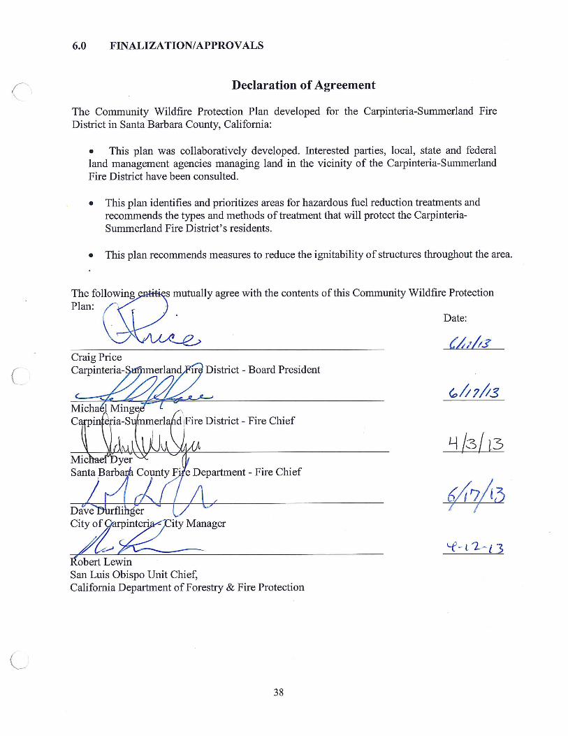
39
7.0 REFERENCES
Fire intensity, fire severity and burn severity: a brief review and suggested usage;
Jon E. Keeley
International Journal of Wildland Fire 2009, 18, 116–126 www.publish.csiro.au/journals/ijwf http://www.cnr.uidaho.edu/for435/2012%20PDFs/Readings/Keeley%202009.pdf
Preparing a Community Wildfire Protection Plan – A Handbook for Wildland - Urban Interface
Communities. Communities Committee • National Association of Counties • National Association of State Foresters Society of American Foresters • Western Governors’ Association; March 2004
http://www.communitiescommittee.org/pdfs/cwpphandbook.pdf
Federal Register (50 FR 15804) ... The Healthy Forests Restoration Act of 2003 (HR 1904)
California Public Resources Code
www.leginfo.ca.gov/cgi-bin/displaycode?section=prc...file...
2010 California Fire Code, Chapter 49, California Code of Regulation, Title 24, Part 9.
California Fire Alliance; http://www.cafirealliance.org/
California Department of Forestry and Fire Protection (CAL-FIRE), Characterizing the Fire
Threat to Wildland Urban Interface Areas in California,
http://frap.cdf.ca.gov/projects/wui/525_CA_wui_analysis.pdf
MANAGEMENT OF FIRE REGIME, FUELS, AND FIRE EFFECTS IN SOUTHERN
CALIFORNIA CHAPARRAL: LESSONS FROM THE PAST AND THOUGHTS FOR THE
FUTURE; Susan G. Conard1 and David R. Weise - U.S. Department of Agriculture, Forest
Service, Forest Fire Laboratory, Pacific Southwest Research Station
Fuel Driven Fire Regimes of the California Chaparral; Richard A. Minnich – University of
California, Riverside
Fire intensity, fire severity and burn severity: a brief review and suggested usage; International
Journal of Wildland Fire 2009, 18, 116–126; Jon E. Keeley
Identifying Communities at risk and Prioritizing Risk-Reduction Projects;
Briefing Paper, July 2010; National Association of State Foresters; www.stateforesters.org
City of Goleta Community Wildfire Protection Plan, March 20, 2012,
130 Cremora Drive, Suite 100 Goleta, California 93117
Prepared by: GEO ELEMENTS, LLC, PO Box 955 Cedar City, Utah 84721
National Wildfire Coordinating Group; http://www.nwcg.gov/
40
8.0 APPENDICES
APPENDIX A
Glossary of Wildland Fire Terminology
Ecosystem: A community of organisms and their physical environment interacting as an ecological
unit.
Fire Behavior: The manner in which a fire reacts to the influences of fuel, weather, and topography.
Fire Intensity: A general term relating to the heat energy released by a fire.
Fire Potential: The likelihood of a wildland fire event measured in terms of anticipated occurrence of
fire(s) and management’s capability to respond. Fire potential is influenced by a sum of factors that
includes fuel conditions (fuel dryness and/or other inputs), ignition triggers, significant weather
triggers, and resource capability.
Fire Regime: The characterization of fire’s role in a particular ecosystem, usually
characteristic of particular vegetation and climatic regime, and typically a combination of fire return
interval and fire intensity (i.e., high frequency, low intensity/low frequency, high intensity).
Fire Return Interval: The length of time between fires on a particular area of land Fire Weather:
Fuel: Any combustible material, which includes but is not limited to living or dead vegetation, human-
built structures, and chemicals that will ignite and burn.
Fuel Bed: An array of fuels usually constructed with specific loading, depth, and particle size to meet
experimental requirements; also, commonly used to describe the fuel composition.
Fuelbreak: A natural or constructed discontinuity in a fuel profile that is used to isolate, stop, or reduce
the spread of fire. Fuelbreaks may also make retardant lines more effective and serve as control lines
for fire suppression actions.
Fuel Loading: The amount of fuel present expressed quantitatively in terms of weight of fuel per unit
area.
Fuel Type: An identifiable association of fuel elements of a distinctive plant species, form, size,
arrangement, or other characteristics that will cause a predictable rate of fire spread or difficulty of
control under specified weather conditions.
Ground Fire: Fire that consumes the organic material beneath the surface litter ground, such as a peat
fire.
Hazard: A condition, an object or an activity with the potential of causing personal injury, equipment
damage, loss of material, or reduction of the ability to accomplish the mission.
Intensity: The level of heat radiated from the active flaming front of a fire, measured in British thermal
units (BTUs) per foot.
41
Ladder Fuels: Fuels that provide vertical continuity between strata, thereby allowing fire to carry from
surface fuels into the crowns of trees or shrubs with relative ease. Ladder fuels help initiate and ensure
the continuation of crowning.
Live Fuels: Living plants, such as trees, grasses, and shrubs, in which the seasonal moisture content
cycle is controlled largely by internal physiological mechanisms, rather than by external weather
influences.
Mediterranean Climate: The climate characteristic of the Mediterranean region and much of California.
Typically hot, dry summers and cool, wet winters.
Risk: The potential for realization of unwanted, adverse consequences to human life, property or the
environment.
Riparian: Situated or taking place along or near the bank of a watercourse.
Surface Fire: Fire that burns loose debris on the surface, which includes dead branches, leaves, and low
vegetation.
Surface Fuels: Fuels lying on or near the surface of the ground, consisting of leaf and needle litter,
dead branch material, downed logs, bark, tree cones, and low stature living plants.
Topography: Main elements are slope (in percent), aspect (the direction a slope faces), elevation, and
other unique land features such as canyons, saddles, “chimneys,” and chutes.
Understory: Term for the area of a forest which grows at the lowest height level below the forest
canopy. Plants in the understory consist of a mixture of seedlings and saplings of canopy trees together
with understory shrubs and herbs.
Values at Risk: People, property, ecological elements, and other human and other intrinsic values
within the City. Values at Risk are identified by stakeholders as important to the way of life in the City,
and are particularly susceptible to damage from undesirable fire outcomes.
Wildland Fire Environment: The surrounding conditions, influences, and modifying forces of fuels,
topography, and weather that determine wildfire behavior.
Wildfire Risk: The potential for a wildfire to adversely affect things that humans value – lives,
homes or ecological functions and attribute.
42
APPENDIX B
Table 1
Community Risk Assessment
NEIGHBORHOOD RISK ASSESSMENT SURVEY *
Community at Risk
Fire Hazard Severity Zone
Fire Threat Survivability -
Very Good Survivability -
Good Survivability -
Average Survivability
- Poor Survivability - Very Poor
Cal-Fire Data Cal-Fire Data
* This data was derived from results of Risk Assessment survey completed by fire deaprtment college intern giving a numerical ranking to fuel hazards, structure, access (ingress & egress), infrastructure, and wildfire occurrence and topography as the evaluation criteria. Note: the small number of sample assumes a standard deviation of error between 6% - 10% .
West District - Toro / Ladera /
Hidden Valley, etc Very High
Moderate to Very High
6.70% 33.30% 20,00% 40.00% 0.00%
Toro Canyon - Torito, Toro Cyn
Park Very High
Very High to Extreme
6.30% 31.30% 31.30% 25.00% 6.30%
Foothill Corridor - Santa Monica,
Cravens, Arriba, Montvalmar, etc
Moderate to Very High
Moderate to High 20.00% 60.00% 20.00% 0.00% 0.00%
Shepard Mesa / Gobernador - East
of Foothill, Lillingston, Casitas
Pass Rd. etc
Moderate to High Non-fuel (Ag.) to
Very High 25.00% 55.00% 5.05% 10.00% 5.00%
Fire Hazard Severity - Wildfire hazard has two key components: Probability and Fire Behavior. The FHSZ modeling employed in Cal-Fire mapping uses these two components to describe hazard, but has no information regarding asset or resource characterization nor their relative vulnerability to damage as based on the hazard score. See Cal-Fire at: http://frap.fire.ca.gov/projects/hazard/fhz.html
Fire Threat - A rating of wildland fire threat based on the combination of potential fire behavior (Fuel Rank) and expected fire frequency (Fire Rotation - the likelyhood of a given area burning) to created a 4-class index for risk assessment. See Cal-Fire at: http://frap.cdf.ca.gov/data/frapgisdata/output/fthrt.txt
43
APPENDIX C
COMMUNITY MEETINGS RESPONSE RECORDS
MARCH 23, 2011 AT Girl’s Inc.
CARPINTERIA-SUMMERLAND COMMUNITY WILDFIRE PROETCTION PLAN
COMMUNITY MEETINGS
SURVEY QUESTION RATING Strong Agree Agree Disagree Strong
disagree
No
Opinion
March 23, 2011 ( No stakeholders
in attendance) Core Group
members
Girls’ Inc. in Carpinteria
No Response; Core Group worked on Outreach process.
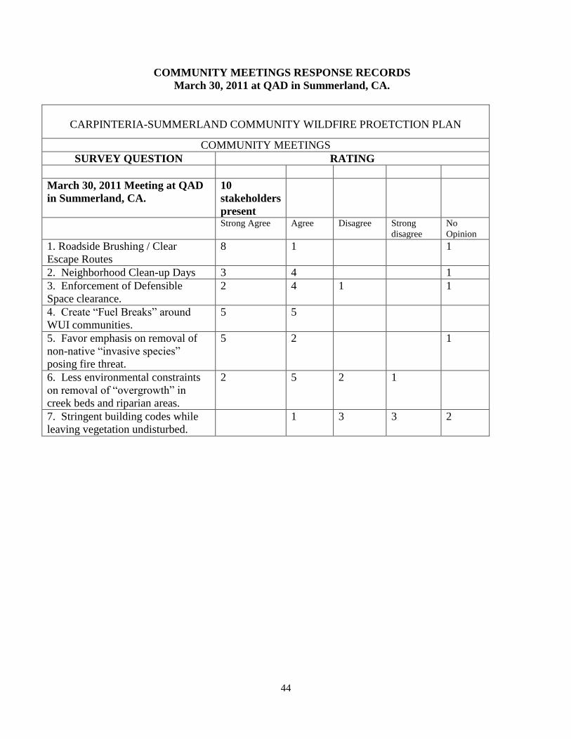
44
COMMUNITY MEETINGS RESPONSE RECORDS
March 30, 2011 at QAD in Summerland, CA.
CARPINTERIA-SUMMERLAND COMMUNITY WILDFIRE PROETCTION PLAN
COMMUNITY MEETINGS
SURVEY QUESTION RATING
March 30, 2011 Meeting at QAD
in Summerland, CA.
10
stakeholders
present
Strong Agree Agree Disagree Strong
disagree
No
Opinion
1. Roadside Brushing / Clear
Escape Routes
8 1 1
2. Neighborhood Clean-up Days 3 4 1
3. Enforcement of Defensible
Space clearance.
2 4 1 1
4. Create “Fuel Breaks” around
WUI communities.
5 5
5. Favor emphasis on removal of
non-native “invasive species”
posing fire threat.
5 2 1
6. Less environmental constraints
on removal of “overgrowth” in
creek beds and riparian areas.
2 5 2 1
7. Stringent building codes while
leaving vegetation undisturbed.
1 3 3 2
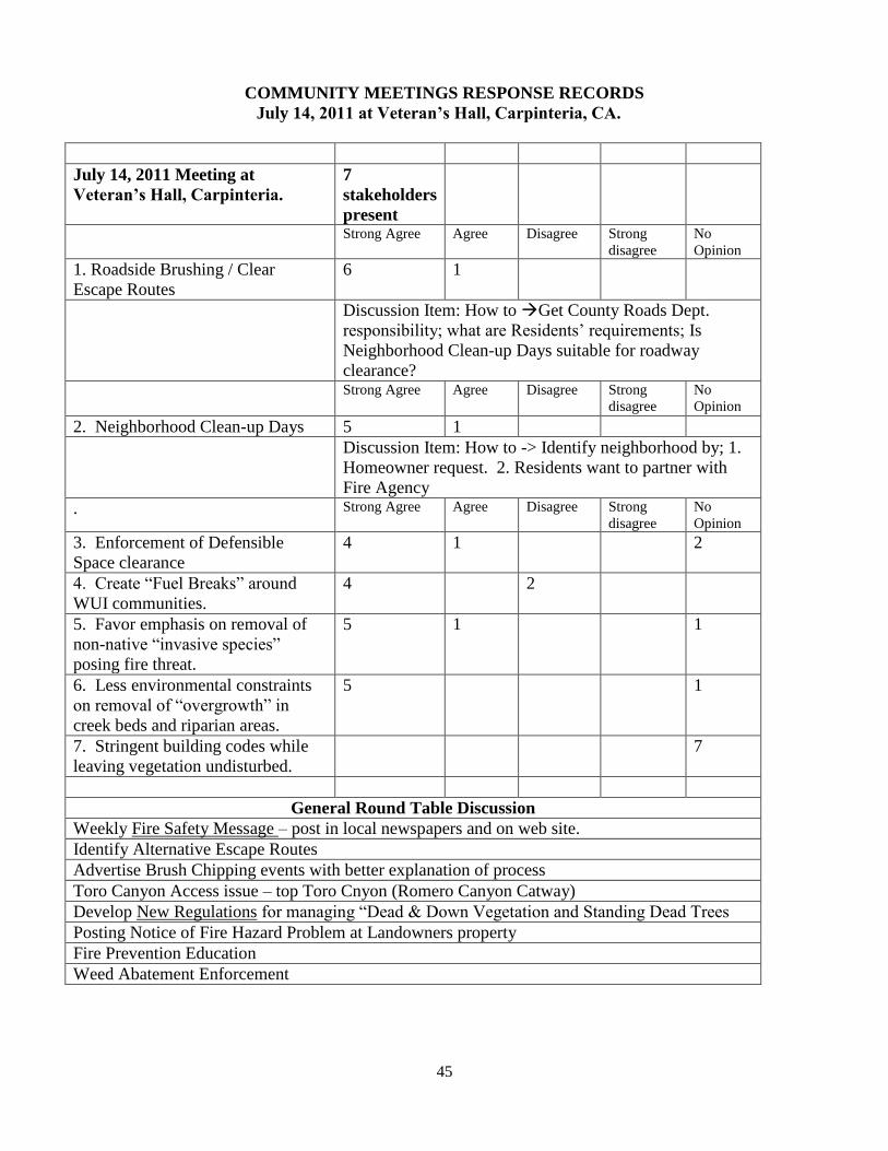
45
COMMUNITY MEETINGS RESPONSE RECORDS
July 14, 2011 at Veteran’s Hall, Carpinteria, CA.
July 14, 2011 Meeting at
Veteran’s Hall, Carpinteria.
7
stakeholders
present
Strong Agree Agree Disagree Strong
disagree
No
Opinion
1. Roadside Brushing / Clear
Escape Routes
6 1
Discussion Item: How to Get County Roads Dept.
responsibility; what are Residents’ requirements; Is
Neighborhood Clean-up Days suitable for roadway
clearance?
Strong Agree Agree Disagree Strong
disagree
No
Opinion
2. Neighborhood Clean-up Days 5 1
Discussion Item: How to -> Identify neighborhood by; 1.
Homeowner request. 2. Residents want to partner with
Fire Agency
. Strong Agree Agree Disagree Strong
disagree
No
Opinion
3. Enforcement of Defensible
Space clearance
4 1 2
4. Create “Fuel Breaks” around
WUI communities.
4 2
5. Favor emphasis on removal of
non-native “invasive species”
posing fire threat.
5 1 1
6. Less environmental constraints
on removal of “overgrowth” in
creek beds and riparian areas.
5 1
7. Stringent building codes while
leaving vegetation undisturbed.
7
General Round Table Discussion
Weekly Fire Safety Message – post in local newspapers and on web site.
Identify Alternative Escape Routes
Advertise Brush Chipping events with better explanation of process
Toro Canyon Access issue – top Toro Cnyon (Romero Canyon Catway)
Develop New Regulations for managing “Dead & Down Vegetation and Standing Dead Trees
Posting Notice of Fire Hazard Problem at Landowners property
Fire Prevention Education
Weed Abatement Enforcement
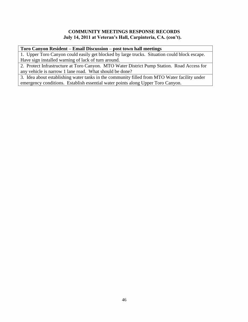
46
COMMUNITY MEETINGS RESPONSE RECORDS
July 14, 2011 at Veteran’s Hall, Carpinteria, CA. (con’t).
Toro Canyon Resident – Email Discussion – post town hall meetings
1. Upper Toro Canyon could easily get blocked by large trucks. Situation could block escape.
Have sign installed warning of lack of turn around.
2. Protect Infrastructure at Toro Canyon. MTO Water District Pump Station. Road Access for
any vehicle is narrow 1 lane road. What should be done?
3. Idea about establishing water tanks in the community filled from MTO Water facility under
emergency conditions. Establish essential water points along Upper Toro Canyon.
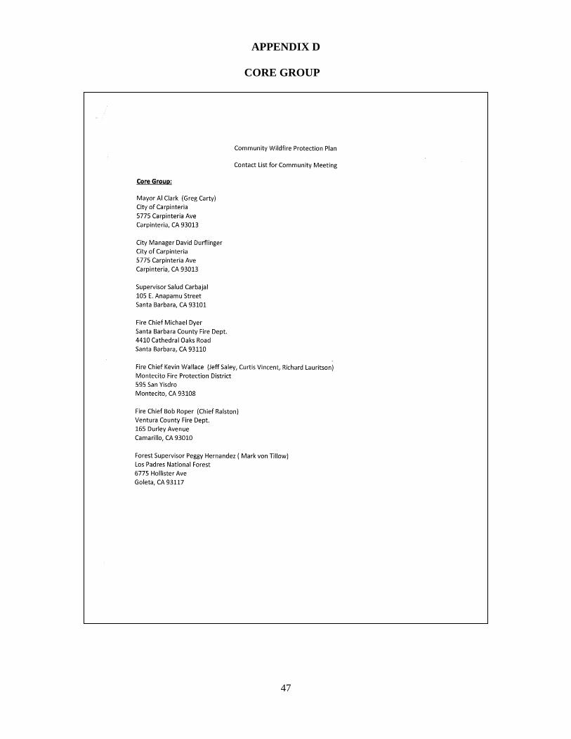
47
APPENDIX D
CORE GROUP
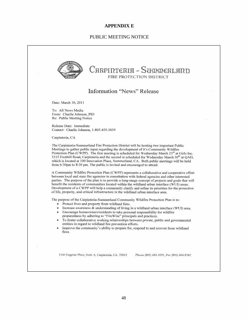
48
APPENDIX E
PUBLIC MEETING NOTICE
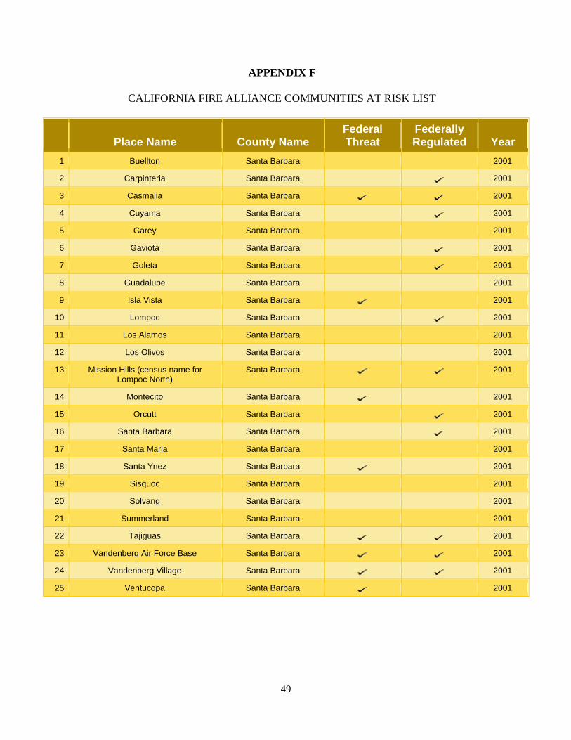
49
APPENDIX F
CALIFORNIA FIRE ALLIANCE COMMUNITIES AT RISK LIST
Place Name County Name
Federal Threat
Federally Regulated Year
1 Buellton Santa Barbara 2001
2 Carpinteria Santa Barbara 2001
3 Casmalia Santa Barbara 2001
4 Cuyama Santa Barbara 2001
5 Garey Santa Barbara 2001
6 Gaviota Santa Barbara 2001
7 Goleta Santa Barbara 2001
8 Guadalupe Santa Barbara 2001
9 Isla Vista Santa Barbara 2001
10 Lompoc Santa Barbara 2001
11 Los Alamos Santa Barbara 2001
12 Los Olivos Santa Barbara 2001
13 Mission Hills (census name for Lompoc North)
Santa Barbara 2001
14 Montecito Santa Barbara 2001
15 Orcutt Santa Barbara 2001
16 Santa Barbara Santa Barbara 2001
17 Santa Maria Santa Barbara 2001
18 Santa Ynez Santa Barbara 2001
19 Sisquoc Santa Barbara 2001
20 Solvang Santa Barbara 2001
21 Summerland Santa Barbara 2001
22 Tajiguas Santa Barbara 2001
23 Vandenberg Air Force Base Santa Barbara 2001
24 Vandenberg Village Santa Barbara 2001
25 Ventucopa Santa Barbara 2001
50
APPENDIX G
MAPS LIST
1. CWPP Boundary and Fuel Management Zones
2. Communities at Risk
3. Wildland Urban Interface (WUI)
4. Fire Hazard Severity Zones
5. Wildfire History in Santa Barbara 1912-2009.
6. Critical Infrastructure and Habitat
FIGURES LIST
1. Fire intensity, Fire Severity and Burn Severity Int. J.Wildland Fire 13
2. Santa Barbara County Wildfire Causes 1998-2010 16