Embed Size (px)
Citation preview
Cornwall Council Local Development Framework Strategic Flood Risk Assessment Level 1
November 2009

61. HOW TO USE THIS DOCUMENT6How to use this document6Use of data viewer (Interactive web based tool)
82. INTRODUCTION8What is a Strategic Flood Risk Assessment?8Why do we need an SFRA?9Purpose and main benefits of the SFRA10Types of flood risk in the county10Previously produced SFRAs in Cornwall
11Responsibilities for flood water/flood riskmanagement
143. POLICY CONTEXT FOR STRATEGIC FLOOD RISKASSESSMENT
14PPS2515PPS25 Practice Guide15Pitt Review/Government Response
15Regional Spatial Strategy and the Regional Flood RiskAppraisal
16Water Framework Directive and South West RiverBasement Management Plan
16The EU Water Framework Directive16River Basin Management Plans17Catchment Flood Management Plans17Shoreline Management Plan
18Major Incident Plan flooding policy / EmergencyManagement Data
19South West Water (SWW) policy on flooding20Floods and Water Management Bill20Surface Water Management Plans
Cornwall LDF SFRA
21Water Cycle Studies
234. METHODOLOGY
23Stages of SFRA and outputs of Level 1 CoarseAssessment
23Partnership approach24Data analysis24Outputs
265. FLOOD RISK IN CORNWALL26Description of Flooding in Cornwall26Fluvial Flooding26Tidal Flooding27Groundwater Flooding27Surface Water Flooding28Sewerage Flooding
306. DESCRIPTION OF FLOOD RISK DATA USED IN THESFRA.
30Flood Risk zones30Functional Floodplain30Areas Susceptible to Surface Water Flooding31Critical Drainage Areas31Climate Change
347. FLOOD RISK AND DEVELOPMENT PLANNING34Link between the SFRA and LDF34Site allocations - potential development sites35Site allocations – the sequential and exception tests35Locations for further investigation – SFRA level 236Flood Risk by Communities36Developing flood risk management policies in the
Cornwall LDF SFRA
Cornwall Local Development Framework
38Implications for new development in flood zones 3aand 3b
39Implications for existing development in flood zones3a and 3b
39SFRA Level 1 use for Development Management
40Balance of flood risk and other material planningconsiderations in Cornwall
40Developer Advice for Site Specific Flood RiskAssessments
40Integrating Surface Water Management and GreenInfrastructure from New Development
41What is ‘Safe’ Guidance
438. REVIEW AND UPDATE43Data Viewer update process43Report review and update process
459. CONCLUSIONS AND RECOMMENDATIONS45Local Development Framework45Allocation of sites46Development Management
48APPENDIX A. CLIMATE CHANGE AND SEA LEVEL RISE
50APPENDIX B. FLOOD RISK ROLES ANDRESPONSIBILITIES
50Environment Agency50South West Water51Local Authority51Highways Authority51Emergency Management52Landowners (owning land adjacent to a watercourse)
Cornwall LDF SFRA
54Regional Flood Defence Committees54Role of Developers
56APPENDIX C. IDENTIFICATION OF THE FUNCTIONALFLOODPLAIN IN CORNWALL
56Cornwall Area Description of Functional Floodplain56Urban Areas57Rural Areas57Estuaries57Existing Buildings in the Functional Floodplain
59APPENDIX D. FLOOD RISK BY COMMUNITIES
62APPENDIX E. DEVELOPER INFORMATION PACK62Flood Risk Assessment – Data Collection62Tidal Level Data62Surface Water Drainage Guidance62Flood Defence Database63Flood Risk Assessment – Data Analysis63Flood Estimation in Cornwall63Failure and Blockage of Structures63What is ‘Safe’ Guidance65Reservoir Inundation Risk
67APPENDIX F. SUSTAINABLE DRAINAGE SYSTEMS(SUDS)
71APPENDIX G. DATA IN THE DATA VIEWER
74APPENDIX H. GLOSSARY
Cornwall LDF SFRA

5
1. How to use this document
1. How to use this document
How to use this document
This document forms the written part of the Cornwall Strategic Flood Risk Assessment –level 1. It should be read in conjunction with the maps showing strategic flood riskinformation for Cornwall, as provided in a Data Viewer on the Cornwall SFRA website (seealso below). The SFRA is a ‘living document’ and will be regularly updated; the website willgive the latest information on any changes to this report.
Use of data viewer (Interactive web based tool)
A Data Viewer is provided in the form of an interactive internet mapping site to supportthis SFRA. The Data Viewer allows access to mapped data on flood risk and policy acrossCornwall, such as maps showing location of the different flood zones, critical drainageareas, main rivers and flood defences. The Data Viewer also gives historic flood informationfor the main settlements in the county. The Data Viewer can be accessed from the CornwallSFRA website: http://mapping.cornwall.gov.uk/website/sfra. Further information on theData Viewer is provided in Appendix G.
Cornwall LDF SFRA6

7
2. Introduction
2. Introduction
What is a Strategic Flood Risk Assessment?
A Strategic Flood Risk Assessment (SFRA) is a tool for planning authorities to identify andevaluate the flood risk in their area. Information from the SFRA will form the basis forapplying the sequential test to the selection of sites for development, with the aim ofdirecting development to areas at lowest risk of flooding.
This SFRA forms part of the evidence base for the emerging Cornwall Local DevelopmentFramework (LDF) and will help form the basis for preparing appropriate policies for floodrisk management. The SFRA covers the county of Cornwall and has a planning time horizonextending to 2026.
Why do we need an SFRA?
Planning Policy Statement 25 (PPS25) – Development and flood risk (2006) – sets outGovernment policy on development and flood risk. Its key aims are:
1. to ensure that flood risk is taken into account at all stages in the planning process,2. to avoid inappropriate development in areas at risk of flooding; and3. to direct development away from areas of highest risk.
PPS25 states that local planning authorities should apply a precautionary approach to floodrisk, to avoid flood risk where possible and to manage flood risk elsewhere. Paragraph 17of PPS25 explains that planning authorities should give priority to allocating alternativesites for development in descending order of flood risk (the sequential test).
The sequential test requires a clear understanding of flood risk in the area and of the extentand nature of flooding in the different flood zones as described in PPS25.
Where new development is exceptionally necessary in a flood area, the policy aim is tomake the development safe, without increasing flood risk elsewhere. Wherever possible,flood risk should be reduced overall.
Cornwall LDF SFRA8
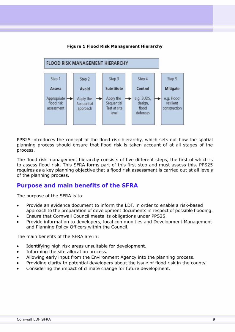
Figure 1 Flood Risk Management Hierarchy
PPS25 introduces the concept of the flood risk hierarchy, which sets out how the spatialplanning process should ensure that flood risk is taken account of at all stages of theprocess.
The flood risk management hierarchy consists of five different steps, the first of which isto assess flood risk. This SFRA forms part of this first step and must assess this. PPS25requires as a key planning objective that a flood risk assessment is carried out at all levelsof the planning process.
Purpose and main benefits of the SFRA
The purpose of the SFRA is to:
Provide an evidence document to inform the LDF, in order to enable a risk-basedapproach to the preparation of development documents in respect of possible flooding.Ensure that Cornwall Council meets its obligations under PPS25.Provide information to developers, local communities and Development Managementand Planning Policy Officers within the Council.
The main benefits of the SFRA are in:
Identifying high risk areas unsuitable for development.Informing the site allocation process.Allowing early input from the Environment Agency into the planning process.Providing clarity to potential developers about the issue of flood risk in the county.Considering the impact of climate change for future development.
9Cornwall LDF SFRA
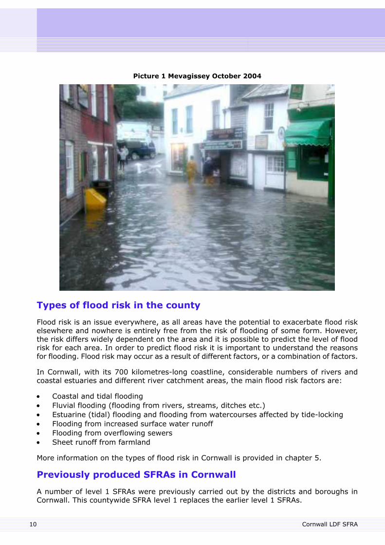
Picture 1 Mevagissey October 2004
Types of flood risk in the county
Flood risk is an issue everywhere, as all areas have the potential to exacerbate flood riskelsewhere and nowhere is entirely free from the risk of flooding of some form. However,the risk differs widely dependent on the area and it is possible to predict the level of floodrisk for each area. In order to predict flood risk it is important to understand the reasonsfor flooding. Flood risk may occur as a result of different factors, or a combination of factors.
In Cornwall, with its 700 kilometres-long coastline, considerable numbers of rivers andcoastal estuaries and different river catchment areas, the main flood risk factors are:
Coastal and tidal floodingFluvial flooding (flooding from rivers, streams, ditches etc.)Estuarine (tidal) flooding and flooding from watercourses affected by tide-lockingFlooding from increased surface water runoffFlooding from overflowing sewersSheet runoff from farmland
More information on the types of flood risk in Cornwall is provided in chapter 5.
Previously produced SFRAs in Cornwall
A number of level 1 SFRAs were previously carried out by the districts and boroughs inCornwall. This countywide SFRA level 1 replaces the earlier level 1 SFRAs.
Cornwall LDF SFRA10
Level 2 SFRAs were produced for the Truro and Threemilestone Area Action Plan and forWadebridge and Launceston. These level 2 SFRAs will in due course be incorporated in theCornwall-wide level 2 SFRA.
Responsibilities for flood water/flood risk management
It is expected that property owners and owners of watercourses take the responsibility formanaging flood risk. Property owners should take appropriate steps to protect themselves,owners of watercourses should ensure that water can freely flow. Their responsibilities arefurther detailed in Appendix B.
The roles and responsibilities of key organisations with respect to flood risk in Cornwall arealso provided in Appendix B. The main statutory responsibilities lie with Cornwall Council,the Environment Agency and South West Water (the sewerage provider).
The overall responsibility for the management of fluvial flood risk depends upon whetherthe watercourse is designated as a Main River or as an ordinary watercourse. TheEnvironment Agency has powers for managing those watercourses designated as MainRiver whilst Cornwall Council has powers for managing ordinary watercourses. Main Riversare indicated in the Data Viewer.
Cornwall Council also has the responsibility over the highway drainage system, except forthe A30 and A38 trunk roads for which the Highways Agency have responsibility.
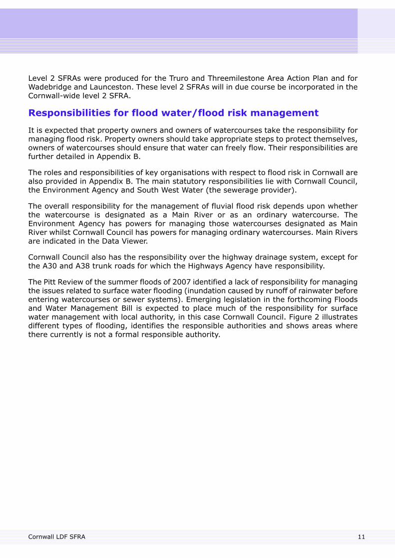
The Pitt Review of the summer floods of 2007 identified a lack of responsibility for managingthe issues related to surface water flooding (inundation caused by runoff of rainwater beforeentering watercourses or sewer systems). Emerging legislation in the forthcoming Floodsand Water Management Bill is expected to place much of the responsibility for surfacewater management with local authority, in this case Cornwall Council. Figure 2 illustratesdifferent types of flooding, identifies the responsible authorities and shows areas wherethere currently is not a formal responsible authority.
11Cornwall LDF SFRA
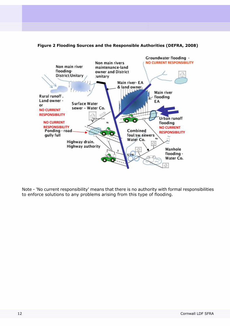
Figure 2 Flooding Sources and the Responsible Authorities (DEFRA, 2008)
Note - 'No current responsibility' means that there is no authority with formal responsibilitiesto enforce solutions to any problems arising from this type of flooding.
Cornwall LDF SFRA12

13
3. Policy Context for Strategic Flood Risk Assessment
3. Policy Context for Strategic Flood Risk Assessment
Strategic Flood Risk Assessment (SFRA) informs and is informed by national, regional andlocal planning policy, as well as other plans such as the Catchment Flood ManagementPlans and Shoreline Management Plans. The policy context for SFRA is illustrated in Figure3 below, which shows the position of the SFRA within the planning policy framework. Italso shows the relationship between SFRA and catchment and shoreline management plansand between regional, strategic and site specific flood risk assessment. The following sectionprovides an overview of the relevant policy documents for the SFRA.
Figure 3 Flood Risk Assesment within the Development Process (DCLG 2008 PPS25Practice Guide)
PPS25
Planning Policy Statement 25 (PPS25) – Development and Flood Risk (2006) – sets outGovernment policy on planning in the context of flood risk. It aims to ensure that flood riskis taken into account at all stages in the planning process, to avoid inappropriatedevelopment in areas at risk of flooding, and to direct development away from areas ofhighest risk. Where in exceptional circumstances new development is necessary in higherflood risk areas, policy aims to make the development safe without increasing flood riskelsewhere and to reduce overall flood risk wherever possible.
Cornwall LDF SFRA14
PPS25 Practice Guide
The practice guide that complements PPS25 provides guidelines on how to implementdevelopment and flood risk policies by the land use planning system. The guide also includesworking examples through case studies.
Pitt Review/Government Response
The Pitt Review is a comprehensive examination of the 2007 summer floods and evaluatedthe lessons learned from those events. The final outcome, published in June 2008, contains92 recommendations addressed to the Government, local authorities, essential serviceproviders and others. These cover the areas of managing flood risk, local and nationalplanning for and response to flooding, public information, and public preparedness.
The Government’s response to the Pitt Review was published in December 2008. It supportsall of the recommendations and sets out approaches to the implementation of these. Manyof the recommendations are intended to be implemented through the forthcoming Floodsand Water Management Bill, which was released for consultation in the Spring of 2009 (seebelow).
Regional Spatial Strategy and the Regional Flood Risk Appraisal
The South West Regional Spatial Strategy (RSS) will provide policies for the South Westregion. Proposed changes by the Secretary of State have been published and consultationon this document has taken place. It is anticipated that the RSS will be adopted in early2010.
A South West Regional Flood Risk Appraisal (SWRFRA) was prepared by the South WestRegional Assembly in February 2007 to provide a broad regional understanding of the riskthat flooding creates in South West England. The SWRFRA was prepared before thepublication of the latest update of PPS25, and does not inform the preparation of the RSS,but instead assesses how flood risk was taken into account during the preparation of theRSS. It provides supplementary guidance and help to strategic and local authorities bypresenting the strategic areas significantly at risk.
Two sub-regions considered within the SWRFRA are relevant to Cornwall:
(i) Plymouth, South East Cornwall and West Devon, and
(ii) Cornwall Towns.
Under (i), Saltash and Torpoint are identified as benefiting from fluvial and tidal flooddefence schemes, with further defences planned for Saltash following from the tidal floodevent of 2004.
Under (ii), the SWRFRA identified that there are significant flood risks in Truro, arising fromthe Rivers Kenwyn, Allen and Tinney as well as from tidal flooding. In Pool, Camborne andRedruth there is concern over land contamination, which requires particular approaches todrainage. There are also concerns expressed over capacity within the existing sewer network.
15Cornwall LDF SFRA
The effect of climate change and sea level rise is identified as being of particular concernin Truro and Penryn and climate change is also an issue for Looe, Mevagissey, Pentewan,Fowey and Flushing.
The SWRFRA concludes that Truro is at significant risk from fluvial and tidal flooding. Sealevel rise is of concern, with the frequency of severe tidal flooding events increasingsignificantly.
Water Framework Directive and South West River BasementManagement Plan
The EU Water Framework Directive
The EU Water Framework Directive (WFD) is a statutory plan that requires all inland andcoastal waters within defined river basin districts to reach at least ‘good’ status by 2015.The WFD defines how this should be achieved through the establishment of environmentalobjectives and ecological targets for surface waters. The main aims of the WFD are to:
enhance the status of aquatic ecosystems and associated wetlands and prevent theirfurther deterioration;promote the sustainable use of water;reduce pollution of water.
As well as considering chemical water quality it also considers flora and fauna andgeomorphology (including channel modifications from defences and built development).
To comply with the WFD, flood risk management needs to consider its potential impact onnatural river channels, connectivity between floodplains and river channels, and on qualityand quantity of surface water flowing from proposed development. For instance drainagemeasures could degrade water bodies (through pollution or erosion) or could contribute toimproving their quality (through environmentally favourable Sustainable Drainage Systems(SUDS) - more information on SUDS is provided in Appendix F). Directing developmentaway from floodplains can ensure that buffer zones are preserved and connectivity increased,whilst developing in floodplains and close to channels may lead to a reduction in quality ofwater bodies through their increased modification.
Groundwater is also within the scope of the WFD, as are estuaries and the open coast.
River Basin Management Plans
River Basin Management Plans (RBMPs) are prepared to implement the Water FrameworkDirective (WFD). The Environment Agency published a draft South West RBMP forconsultation in December 2008. It sets out the current chemical, biological and ecologicalstatus of water bodies in the South West river basin district and sets objectives for individualcatchments, to be met by 2015 and beyond. It divides the SW RBMP district into nine inlandplanning catchment groups that are broadly similar to the Catchment Flood ManagementPlan districts (see section below). The RBPM districts in Cornwall are: West Cornwall, EastCornwall and Tamar.
Cornwall LDF SFRA16
LDFs should ensure that they support an improvement in status of local water bodies. Thiswill require addressing issues such as sewage treatment and discharge as well as surfacewater management.
Catchment Flood Management Plans
A Catchment Flood Management Plan (CFMP) is a strategic planning tool issued by theEnvironment Agency to explore and define sustainable policies for flood risk management(Figure 3, page 14).
The main aims of CFMPs are to:
understand the factors that contribute to flood risk within a catchment both now andin the future;recommend the best ways of managing the risk of flooding within the catchment overthe next 50 to 100 years.
Three CFMP documents are currently under preparation to cover the area of Cornwall (andwest Devon): West Cornwall, East Cornwall and Tamar and will be published during 2009.
The CFMPs use ‘Policy Units’ to describe the proposed approach to flood risk managementfor groups of individual river catchments. Cornwall is covered by 22 Policy Units.
The relationship between CFMPs and SFRAs is illustrated in Figure 4 (page 21).
The Policy Options available to each Policy Unit are:
1. No active intervention2. Reduce existing flood risk management actions3. Continue with existing or alternative actions to manage flood risk at the current level4. Take further action to sustain the current level of flood risk into the future5. Take further action to reduce flood risk6. Take positive action to increase the frequency of flooding to deliver benefits locally or
elsewhere
Within the 22 Policy Units in Cornwall, only Policy Options 4, 5 and 6 apply (as shown withinthe Data Viewer).
Shoreline Management Plan
A Shoreline Management Plan (SMP) is a large-scale assessment of the risks associatedwith coastal processes and aims to help reduce these risks to people and the built andnatural environment. SMPs form an important part of Defra's strategy for managing floodingand coastal erosion. The strategy aims to manage risks by using a range of methods whichreflect both national and local priorities, to:
17Cornwall LDF SFRA
reduce the threat of flooding and erosion to people and their property; andbenefit the environment, society and the economy as far as possible, in line with theGovernment’s sustainable development principles.
The first round of SMPs were completed around the coastline of England and Wales andthey are currently being reviewed.
The two SMP reviews relevant to Cornwall are: the Cornwall and Isles of Scilly SMP(extending from Rame Head to Hartland Point), and South Devon and Dorset SMP (extendingeast from Rame Head including the Tamar estuary). The new SMPs will be published byMarch 2010.
There are the four SMP policies available to shoreline managers:
Hold the existing defence line by maintaining or changing the standard of protection.Advance the existing defence line by building new defences on the seaward sideof the original defences.Managed realignment by allowing the shoreline to move backwards or forwards.No active intervention.
Where SMP policies have already been allocated to stretches of coastline, these are indicatedon the Data Viewer, which will be updated as the SMP develops.
A SMP should provide information for planners and others involved in the planning process,on coastal risks and the preferred approaches for managing the shoreline. This informationwill help to make sure that:
future development does not take place in unsuitable areas at risk from flooding,coastal erosion and cliff instability;development is restricted in possible areas of managed realignment;development does not affect the natural balance of the coastline, to the extent thaterosion is caused elsewhere or that further or improved coastal defences have to bebuilt and maintained.
Major Incident Plan flooding policy / Emergency ManagementData
The Cornwall Council Emergency Management Service has a Multi-Agency Flood Warningand Response Plan. The Plan contains arrangements for flood warnings and a multi-agencyresponse on matters such as health and safety, response priorities, identification ofvulnerable people, evacuation routes, transport, damage limitation and information duringa major flooding incident.
The Emergency Management service obtains information from the Meteorological Officeand Environment Agency on weather patterns. This is to ensure that the service can predictthe potential for major weather-related incidents and plan their response accordingly.
The current Multi-Agency Flood Warning and Response Plan was issued in 2007, and isregularly updated, further detail is in Appendix B.
Cornwall LDF SFRA18
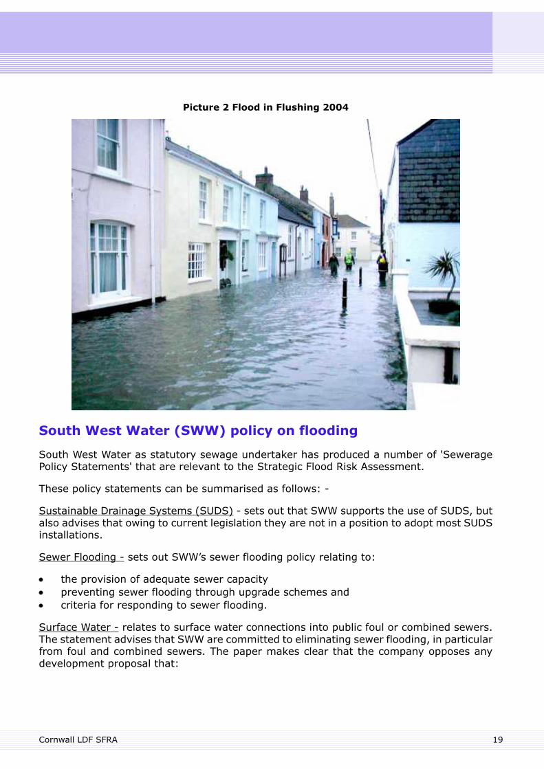
Picture 2 Flood in Flushing 2004
South West Water (SWW) policy on flooding
South West Water as statutory sewage undertaker has produced a number of 'SeweragePolicy Statements' that are relevant to the Strategic Flood Risk Assessment.
These policy statements can be summarised as follows: -
Sustainable Drainage Systems (SUDS) - sets out that SWW supports the use of SUDS, butalso advises that owing to current legislation they are not in a position to adopt most SUDSinstallations.
Sewer Flooding - sets out SWW’s sewer flooding policy relating to:
the provision of adequate sewer capacitypreventing sewer flooding through upgrade schemes andcriteria for responding to sewer flooding.
Surface Water - relates to surface water connections into public foul or combined sewers.The statement advises that SWW are committed to eliminating sewer flooding, in particularfrom foul and combined sewers. The paper makes clear that the company opposes anydevelopment proposal that:
19Cornwall LDF SFRA
does not provide for separate foul and surface water drains and sewerswould result in surface water, including highway runoff, being discharged into publicfoul or combined sewers.
Management of Highway Drainage - reiterates that SWW will not permit new highwaydrainage connections to foul or combined sewers.
Floods and Water Management Bill
Under the Draft Floods and Water Management Bill (FWMB), flooding and water legislationwill be updated and streamlined. The Bill will address all sources of flooding, clarifyresponsibilities and facilitate flood risk management. The Bill will strengthen and extendexisting flood and water legislation including implementing appropriate recommendationsfrom the Pitt Review and the Government’s Water Strategy 2008. The FWMB alsoincorporates the European Floods Directive (1) into UK law.
Whist, at the time of writing, the FWMB is in the form of a draft for consultation the mainelements of the Bill are likely to be agreed, though details may vary.
With respect to flood risk management, the draft FWMB introduces a greater coordinatingrole and new regulatory powers for the Environment Agency and greater responsibilitiesfor local authorities, such as for the production of Surface Water Management Plans (SWMPs)and a responsibility for the adoption and maintenance of sustainable drainage systems(SUDS). In addition, the automatic right to connect surface water drainage of newdevelopments to the sewerage system is likely to be removed.
Surface Water Management Plans
One of the recommendations from the Pitt Review is that Local Surface Water ManagementPlans should provide the basis for managing all local flood risk, as coordinated by localauthorities and in accordance with the PPS25 Practice Guide and latest Defra guidance.
The PPS25 Practice Guide states that SWMPs will build on SFRAs and provide the vehiclefor local organisations to develop a shared understanding of local flood risk, includingsetting out priorities for action, maintenance needs and links into LDFs and emergencyplans.
Emerging guidance on the requirements of SWMPs indicates that the need to undertakean SWMP is largely dependant on local needs. However there are some common criteriawhich may help to identify the need for a SWMP:
Identification of critical drainage areas – SFRAs identify critical drainage areas andthus inform the need for a SWMP. Critical drainage areas in Cornwall are shown withinthe Data Viewer.Future urbanisation/redevelopment – new home building in urban extensions or aspart of regeneration presents a challenge to existing drainage systems but can alsobe an opportunity to address long-standing drainage problems.
1 The European Directive on the Assessment and Management of Flood Risks (2007/60/EC of 23 October 2007)(the Floods Directive) is designed to help Member States prevent and limit floods and their damaging effects on humanhealth, the environment, infrastructure and property. The Floods Directive came into force on 26 November, 2007and Member States have 2 years in which to transpose the Directive into domestic law.
Cornwall LDF SFRA20
Evidence of surface water flooding history – this is one of the most reliable indicatorsof high risk for future flooding. Information on previous flooding events is availablefrom Cornwall Council, SWW, the Environment Agency and the local community.Interactions between drainage systems – where local drainage is known to becomplicated by the interactions between different drainage systems, solutions haveto involve partnership working.
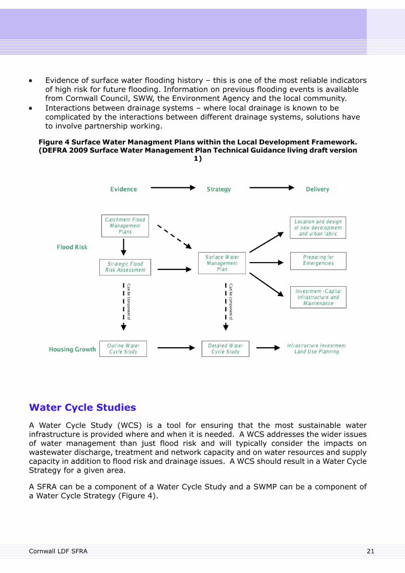
Figure 4 Surface Water Managment Plans within the Local Development Framework.(DEFRA 2009 SurfaceWater Management Plan Technical Guidance living draft version
1)
Water Cycle Studies
A Water Cycle Study (WCS) is a tool for ensuring that the most sustainable waterinfrastructure is provided where and when it is needed. A WCS addresses the wider issuesof water management than just flood risk and will typically consider the impacts onwastewater discharge, treatment and network capacity and on water resources and supplycapacity in addition to flood risk and drainage issues. A WCS should result in a Water CycleStrategy for a given area.
A SFRA can be a component of a Water Cycle Study and a SWMP can be a component ofa Water Cycle Strategy (Figure 4).
21Cornwall LDF SFRA

22
4. Methodology
4. Methodology
Stages of SFRA and outputs of Level 1 Coarse Assessment
This Level 1 Coarse Assessment forms part of a staged approach to the flood risk assessmentprocess of the county and is the first part of the SFRA. The Level 1 assessment gives anoverview of the significance of flood risk in Cornwall and identifies the locations where floodrisk is an issue.
Based on the findings of the Level 1 assessment more detailed assessments will then beundertaken for areas of identified flood risk, as set out in the table below. Wheredevelopment pressures are identified as part of the LDF process, a SFRA2 scoping documentwill be drawn up which will identify the locations and extent of the Level 2 SFRA workrequired.
Table 1
Level 3Level 2Level 1Level ofassessment
Areas of high flood riskwhere developmentcannot be locatedoutside flood risk area
Areas experiencingdevelopment pressureand identified in Level1 as having flood riskissue
Entire countyWhere
Actual flood risk,similar to site specificFlood Risk
Degree of developmentof area, existing floodprotection, level of
How and where floodrisk affects thecounty
What Assessed
Assessments andmeasures to mitigatethis risk
flood hazard, artificialdrainage systems,flood managementstrategies and optionsfor flood riskmanagement
Partnership approach
Key stakeholders for the SFRA1 project were identified at an early stage and invited toparticipate. The stakeholders that have been involved in and contributed to the SFRA projectare:
Cornwall Council -Strategic Policy TeamNatural Resources TeamHydrologyHighwaysEmergency Management
Environment AgencySouth West Water
23Cornwall LDF SFRA
Monthly partnership meetings were held to steer the project, and partners have workedtogether to produce this Level 1 SFRA, each contributing their particular expertise andinformation.
Data analysis
The methodology for this Level 1 assessment includes the following:
A review of existing planning policy on development and flood risk.A review of other plans and strategies concerned with flood risk in Cornwall.Compilation of Cornwall wide flood risk data from the stakeholders to identify thelocation of flood risks. Data sets used are detailed in Appendix G.A descriptive assessment of flood issues affecting the main settlements in the county,including the river network and historic flooding at these settlements.
Outputs
The outputs of this Level 1 Coarse Assessment are:
The SFRA Level 1 reportThe Data Viewer, which presents mapped flood risk data and tables, showing the floodrisk issues affecting each main settlement.
Cornwall LDF SFRA24

25
5. Flood Risk in Cornwall
5. Flood Risk in Cornwall
Description of Flooding in Cornwall
A general overview of types of flooding is provided in Annex C of PPS25. How these typesof flooding affect Cornwall is explained below.
An overview of historic major flooding events in Cornwall is provided on the websitewww.cornwall.gov.uk/flooding.
Fluvial Flooding
The majority of Cornwall is characterised by small steep river catchments. These createsmall watercourses that respond rapidly to rainfall, resulting in rapid, short duration floodevents which can occur with little warning.
Larger rivers such as the River Tamar, Fowey and Camel are generally slower to respondto rainfall and remain in flood for longer durations.
Fluvial flooding can be exacerbated in areas where watercourses meet tidal water as hightides can cause these watercourses to back up.
Tidal Flooding
Tidal flooding is generally caused by a combination of meteorological conditions (lowbarometric pressure/storms) and high spring tides. This results in a rise in the predictedtidal levels causing flooding to prone areas such as harbours. Wave action in exposedlocations (notably north and west Cornwall) can also cause severe damage to beaches,man made defences and properties.
Estuaries and coves can alter the nature of tidal flooding by channelling water into a smallerarea, thus elevating local water levels.
Cornwall LDF SFRA26
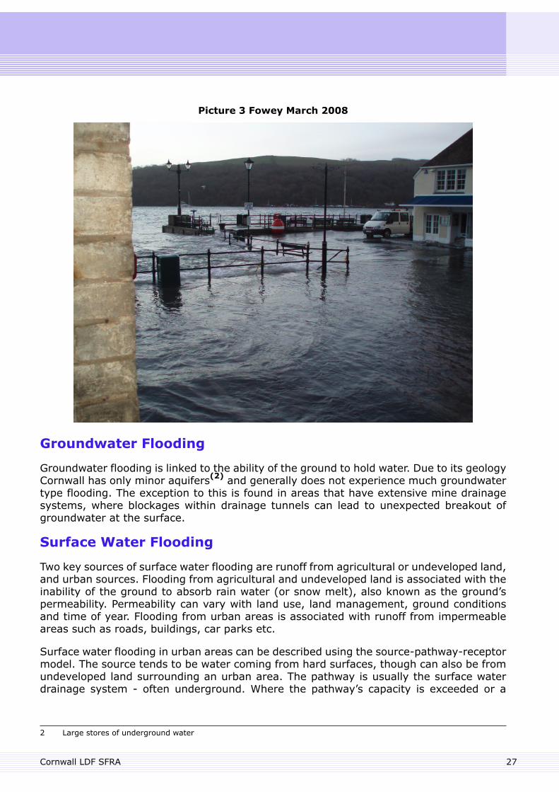
Picture 3 Fowey March 2008
Groundwater Flooding
Groundwater flooding is linked to the ability of the ground to hold water. Due to its geologyCornwall has only minor aquifers(2) and generally does not experience much groundwatertype flooding. The exception to this is found in areas that have extensive mine drainagesystems, where blockages within drainage tunnels can lead to unexpected breakout ofgroundwater at the surface.
Surface Water Flooding
Two key sources of surface water flooding are runoff from agricultural or undeveloped land,and urban sources. Flooding from agricultural and undeveloped land is associated with theinability of the ground to absorb rain water (or snow melt), also known as the ground’spermeability. Permeability can vary with land use, land management, ground conditionsand time of year. Flooding from urban areas is associated with runoff from impermeableareas such as roads, buildings, car parks etc.
Surface water flooding in urban areas can be described using the source-pathway-receptormodel. The source tends to be water coming from hard surfaces, though can also be fromundeveloped land surrounding an urban area. The pathway is usually the surface waterdrainage system - often underground. Where the pathway’s capacity is exceeded or a
2 Large stores of underground water
27Cornwall LDF SFRA
blockage occurs, flooding can occur above ground and the new pathway will be determinedby the ground levels in the area and may be along roads or walkways. The receptor canbe flooded buildings, highways and services.
Highways are often perceived as sources of surface water; though they often operate aspathways collecting and conveying water from other areas.
In tidal areas surface water flooding can occur during high tides, where surface watercannot freely discharge to coastal waters or an estuary.
Sewerage Flooding
Sewerage flooding typically occurs when sewer systems taking surface water becomeoverwhelmed due to excessive flows. Sewer blockages can also cause this type of floodingto occur.
Cornwall LDF SFRA28

29
6. Description of flood risk data used in the SFRA.
6. Description of flood risk data used in the SFRA.
The SFRA Level 1 is a desk based study using existing data sources. A comprehensive listof datasets in the SFRA is presented in Appendix G. This section provides a greater levelof detail for the key datasets.
Flood Risk zones
The Environment Agency mapped flood risk zones indicating the probability of tidal or riverflooding in any location(3). These Flood Zones are the starting point for applying thesequential test and are shown on the Data Viewer and the Environment Agency website.
Flood Zone 3a is the land that has a 1% or greater (1 in a 100) yearly probability of riverflooding, or a 0.5% or greater (1 in 200) yearly probability of sea flooding, assuming thereare no flood defences.
Flood Zone 2 is the land that has a yearly probability between 1% and 0.1% (between 1in 100 and 1 in 1000) yearly probability of river flooding, or between 0.5% and 0.1%(between 1 in 200 and 1 in 1000) yearly probability of sea flooding, assuming there areno flood defences.
Land not in Flood Zones 2 and 3, i.e. in Flood Zone 1 is at little risk of sea or river flooding(less than 0.1 % yearly probability of flooding) but may however still be at risk of surfacewater flooding. Development in this zone may impact on downstream locations within thecatchment.
Functional Floodplain
The functional floodplain, also known as Flood Zone 3b is defined as the area where waterhas to flow or be stored at times of flood.
The functional floodplain has been identified across Cornwall by agreement between CornwallCouncil and the Environment Agency. A detailed description of how functional floodplainswere defined in Cornwall is provided in Appendix C.
Areas Susceptible to Surface Water Flooding
The Environment Agency holds a map indicating areas susceptible to surface water floodingand consider this appropriate for use in the SFRA following validation of the map at a locallevel. As to date the map has not yet undergone comprehensive local validation, it is notpresented in the Data Viewer. A copy of the map can however be obtained from theEnvironment Agency’s External Relations Team on request([email protected] or 01208 265086). There may be a charge forthis information.
Cornwall Council does have access to the map showing areas susceptible to surface waterflooding, but this will only be used in conjunction with local validation, considering floodhistory, local knowledge and with advice from the Environment Agency.
3 The flood risk zones are not definitive and do not typically include watercourses with a catchment of less that 3km2.
Cornwall LDF SFRA30
The mapped extent shows areas that are susceptible to flooding from surface water basedon a 1 in 200 year rainfall event (0.5% probability). The map shows three distinct zones,outlining areas that are 'less' to 'more' at risk of flooding from surface water. The 'moresusceptible' zone will help identify areas that are naturally most likely to flood first, or floodto the greatest depth. These areas are also most likely to flood during relatively frequentand less extreme rain events. The mapping was produced using a simple method thatassumes that underground sewerage and drainage systems, and smaller overgrounddrainage systems are full to capacity (which affects the speed at which water is taken awayfrom the surface). The impacts of buildings are excluded (buildings can affect how watermoves) and it uses a single rainfall event.
The map thus only provides a general indication of areas which may be more likely to sufferfrom surface water flooding; it does not show the susceptibility of individual properties tosurface water flooding.
Critical Drainage Areas
The Environment Agency has developed guidance on surface water drainage standards andmethods for Cornwall which has been agreed with Cornwall Council. The document setsout the expectations for surface water drainage from new development in Cornwall, basedon good practice and other relevant guidance documents.
The Drainage Guidance for Cornwall identifies Critical Drainage Areas, which are areas thathave critical drainage problems and where surface water should be restricted to reducethe risk of flooding. Critical Drainage Areas are shown in the Data Viewer.
These areas have been identified using criteria such as evidence of existing flooding problemsand future development pressure. In Critical Drainage Areas the requirements for thecontrol of surface water drainage from new development are more onerous than elsewhere.
The Drainage Guidance for Cornwall document is available from Cornwall Council and viathe internet (www.cornwall.gov.uk/flooding).
Climate Change
It is now widely accepted that the global climate is changing and that climate change willincrease flood risk. An increase in flood risk necessitates long term planning, to avoidlocating development in areas of medium to high flood risk, taking into account anyforeseeable changes in flood risk that may occur.
In fluvial flood risk areas it is considered that Flood Zone 2 gives a reasonable representationof a climate change Flood Zone for fluvial zone 3, with at least 16 years of climate changeallowance. Therefore for the purpose of this SFRA, Flood Zone 2 should be considered torepresent the extent of Flood Zone 3 including an allowance for climate change.
The impact of climate change on tidal flood risk has been mapped in a layer called 'tidalextremes including projected sea level rise'. This has been based on the tidal Flood Zone2 adding 100 years of tidal sea level rise, based on the levels provided in Annex B of PPS25.100 years has been selected as this is the expected lifetime of residential development asstated in the PPS25 Practice Guidance and equates to approximately a 1m increase in sealevels.
31Cornwall LDF SFRA
The Environment Agency holds a separate dataset which shows the impact of climatechange on Tidal Flood Risk. The Environment Agency data is a fine grid analysis(4) and isprovided for a number of coastal communities. Details of this can be obtained form theEnvironment Agency.
4 The extent of inundation by the extreme 1 in 200 year probability still water tide in 2008 and extrapolated to includeanticipated sea level rise for the years 2028, 2058 and 2108
Cornwall LDF SFRA32

33
7. Flood Risk and Development Planning
7. Flood Risk and Development Planning
Link between the SFRA and LDF
The SFRA is considered to be a key element of the evidence base that underpins the CornwallLDF. As directed by PPS25, the LDF will set out policies for the allocation of sites as wellas for the management of development, which is specific to Cornwall, yet in line with PPS25and policy relating to flooding in the South West RSS. Site allocations will be made toidentify areas of land allocated for specific uses, including housing and employment land.These allocations will be set out in development plan documents (DPDs) such as the CoreStrategy and Area Action Plans. Flood risk is an important material consideration in siteallocation and the SFRA forms part of a robust and informed assessment of the suitabilityor otherwise of land for particular uses. The LDF will set out policies for addressing floodrisk issues throughout the plan area and on specific allocation sites.
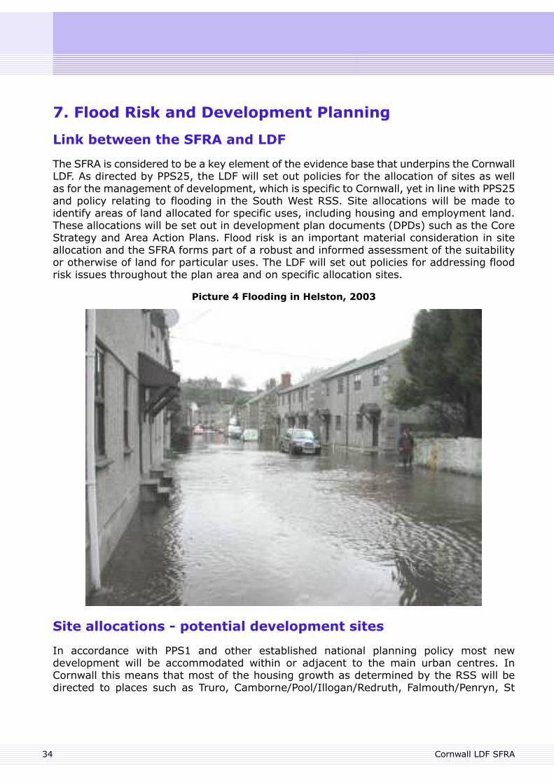
Picture 4 Flooding in Helston, 2003
Site allocations - potential development sites
In accordance with PPS1 and other established national planning policy most newdevelopment will be accommodated within or adjacent to the main urban centres. InCornwall this means that most of the housing growth as determined by the RSS will bedirected to places such as Truro, Camborne/Pool/Illogan/Redruth, Falmouth/Penryn, St
Cornwall LDF SFRA34
Austell, Newquay, Bodmin, Penzance, as well as the smaller Cornish towns. Additionally anew eco town is proposed near St Austell, which will require major new development sitesin the china clay area.
Based on the evidence as shown on the SFRA1 mapping, it should be possible to delivergrowth outside Flood Zones 2 and 3. Where regeneration is required within Flood Zones 2and 3, the SFRA will inform how this will be achieved safely and in a sustainable manner.
Site allocations – the sequential and exception tests
To ensure that new development is guided towards areas at the lowest risk of flooding,potential allocation sites should be subjected to the sequential test, as described in PPS25(5) . This means that allocating new development sites in the higher flood risk zones shouldonly be considered where no alternative sites in Flood Zone 1 are reasonably available.Where allocation of development in the higher risk Flood Zones is considered, thevulnerability of the development and its users to flood risk should be examined and theexception test as set out in Annex D of PPS25 may be required. The exception test willrequire greater understanding of the exact flood risks to an area, necessitating theundertaking of the more detailed SFRA level 2 (see also below). Once the detail of allpotential allocation sites in Cornwall is identified, such as through the Strategic HousingLand Assessment (SHLAA) process, the sequential test, and where necessary the exceptiontest, will be applied to the proposed sites. These tests will then be described in a separatedocument: ‘Flood Risk and Potential Allocation Sites’.
Locations for further investigation – SFRA level 2
This SFRA1 presents existing Cornwall wide flood risk data. However, in areas wheredevelopment pressures conflict with flood risk, it is necessary to undertake more detailedflood risk assessment, to ensure that the forward planning process has sufficient flood riskinformation on which to base the exception test and decisions about development in theseareas. This more detailed study is undertaken within the SFRA level 2, a separate documentthat follows on from this SFRA level 1.
A number of indicators have been developed which will be used to assess the data presentedin the SFRA1 and the need for further detailed flood risk assessment. These indicators willidentify the areas of study for the SFRA2 and include:
Growth/Redevelopment area at flood risk (current/future risk).Town centre required to serve a growth/regeneration area at flood risk (current/futurerisk).Critical infrastructure at flood risk serving a growth/regeneration area (current/futurerisk).Opportunity to recreate functional floodplain through redevelopment.Growth/Redevelopment proposed in an area where there is little or no spare surfacewater sewer capacity.Areas where the cumulative impact of extensions could significantly increase flood risk.
The data produced in the SFRA2 may typically include:
5 The sequential test guides development to land at the lowest risk of flooding: to Flood Zone 1 first, then to Flood Zone2 (if location in Flood Zone 1 is shown not to be a reasonably available option), then to Flood Zone 3a and lastly toFlood Zone 3b. All proposed development in Flood Zones 2 and 3 should be subjected to the sequential test.
35Cornwall LDF SFRA
Flood hazard maps: maps showing colour coded zones which indicate the risk to lifeof a flood event, based on calculated flood depths and velocity.An assessment of the standard of existing flood defence schemes.An assessment of where new development in flood risk areas could contribute toincreasing the standard of defence.Coastal erosion mapping, based on an assessment of coastal erosion rates.Surface Water Management Plans for existing urban areas: an assessment of existingproblems with sewers and watercourses in light of redevelopment and growth pressures.These plans should propose a strategy for surface water drainage to allow newdevelopment to progress without increasing flood risk to others.Surface Water Management Plans for greenfield growth areas: the development of astrategy to allow new developments to maximise the sustainability of a new surfacewater drainage system and ensuring flood risk to others is not increased.Settlement Strategies regarding future flood risk including climate changes predictions.
Flood Risk by Communities
Table 1 in Appendix D lists the main communities in Cornwall that are at risk of floodingand provides information on the type of flooding creating that risk and other relevantinformation. Further information is also shown for each main settlement in the Data Viewer.
Developing flood risk management policies in the Cornwall LocalDevelopment Framework
PPS25 sets out the key planning objectives relating to flood risk and requires LPAs toprepare planning strategies based on the appraisal of flood risk, management of flood riskand reduction of flood risk in the plan area. It also requires LPAs to work in partnershipwith others to ensure that plans are mutually supportive.
At the heart of PPS25 is the flood risk management hierarchy, which is shown and explainedon page 9.
The flood risk hierarchy should be used in forward planning as well as developmentmanagement:
• Forward planning - Planning policies should reflect Cornwall Council’s approach to floodrisk, based on the flood risk hierarchy. The allocation of sites for different types of landuse should thus be based on the sequential test, which in turn will be informed by theSFRA.
• Development management - Planning applications should be assessed on their impacton, and vulnerability to, flood risk. The SFRA will provide an indication of flood risk issuesat this stage. Where flood risk is considered an issue, the flood risk hierarchy and floodrisk policies will be applied. A detailed flood risk assessment will be required, on which thesequential test, design and mitigation measures should be based.
As a basis for flood risk management policy PPS25 annex D sets out the broad policy aimsfor the four identified Flood Zones (zones 1, 2, 3a and 3b):
Cornwall LDF SFRA36
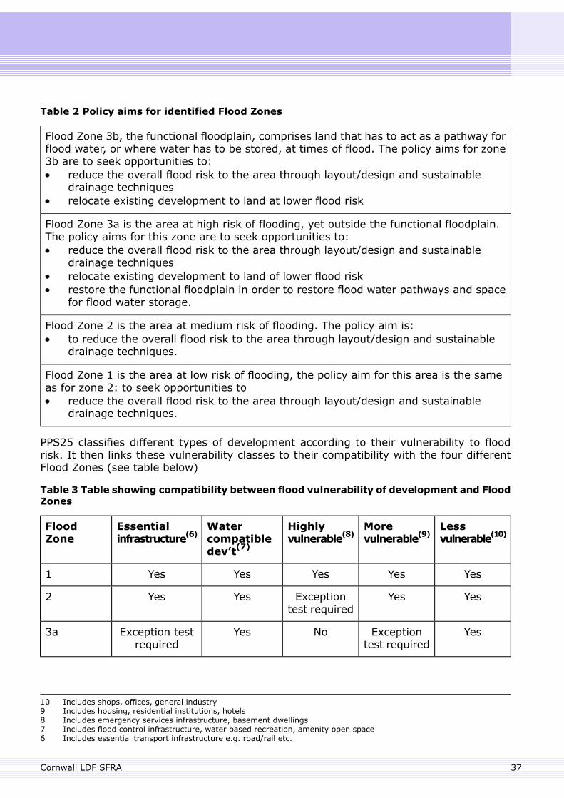
Table 2 Policy aims for identified Flood Zones
Flood Zone 3b, the functional floodplain, comprises land that has to act as a pathway forflood water, or where water has to be stored, at times of flood. The policy aims for zone3b are to seek opportunities to:
reduce the overall flood risk to the area through layout/design and sustainabledrainage techniquesrelocate existing development to land at lower flood risk
Flood Zone 3a is the area at high risk of flooding, yet outside the functional floodplain.The policy aims for this zone are to seek opportunities to:
reduce the overall flood risk to the area through layout/design and sustainabledrainage techniquesrelocate existing development to land of lower flood riskrestore the functional floodplain in order to restore flood water pathways and spacefor flood water storage.
Flood Zone 2 is the area at medium risk of flooding. The policy aim is:to reduce the overall flood risk to the area through layout/design and sustainabledrainage techniques.
Flood Zone 1 is the area at low risk of flooding, the policy aim for this area is the sameas for zone 2: to seek opportunities to
reduce the overall flood risk to the area through layout/design and sustainabledrainage techniques.
PPS25 classifies different types of development according to their vulnerability to floodrisk. It then links these vulnerability classes to their compatibility with the four differentFlood Zones (see table below)
Table 3 Table showing compatibility between flood vulnerability of development and FloodZones
Lessvulnerable(10)
Morevulnerable(9)
Highlyvulnerable(8)
Watercompatibledev’t(7)
Essentialinfrastructure(6)
FloodZone
YesYesYesYesYes1
YesYesExceptiontest required
YesYes2
YesExceptiontest required
NoYesException testrequired
3a
10 Includes shops, offices, general industry9 Includes housing, residential institutions, hotels8 Includes emergency services infrastructure, basement dwellings7 Includes flood control infrastructure, water based recreation, amenity open space6 Includes essential transport infrastructure e.g. road/rail etc.
37Cornwall LDF SFRA
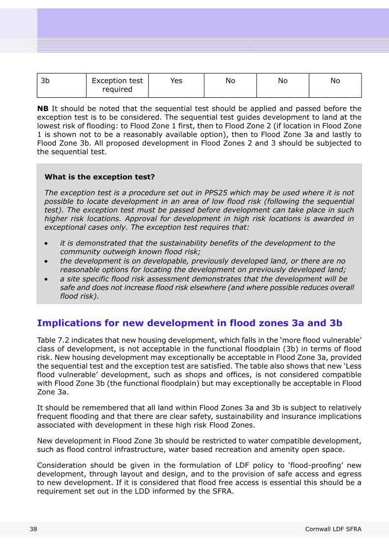
NoNoNoYesException testrequired
3b
NB It should be noted that the sequential test should be applied and passed before theexception test is to be considered. The sequential test guides development to land at thelowest risk of flooding: to Flood Zone 1 first, then to Flood Zone 2 (if location in Flood Zone1 is shown not to be a reasonably available option), then to Flood Zone 3a and lastly toFlood Zone 3b. All proposed development in Flood Zones 2 and 3 should be subjected tothe sequential test.
What is the exception test?
The exception test is a procedure set out in PPS25 which may be used where it is notpossible to locate development in an area of low flood risk (following the sequentialtest). The exception test must be passed before development can take place in suchhigher risk locations. Approval for development in high risk locations is awarded inexceptional cases only. The exception test requires that:
it is demonstrated that the sustainability benefits of the development to thecommunity outweigh known flood risk;the development is on developable, previously developed land, or there are noreasonable options for locating the development on previously developed land;a site specific flood risk assessment demonstrates that the development will besafe and does not increase flood risk elsewhere (and where possible reduces overallflood risk).
Implications for new development in flood zones 3a and 3b
Table 7.2 indicates that new housing development, which falls in the ‘more flood vulnerable’class of development, is not acceptable in the functional floodplain (3b) in terms of floodrisk. New housing development may exceptionally be acceptable in Flood Zone 3a, providedthe sequential test and the exception test are satisfied. The table also shows that new ‘Lessflood vulnerable’ development, such as shops and offices, is not considered compatiblewith Flood Zone 3b (the functional floodplain) but may exceptionally be acceptable in FloodZone 3a.
It should be remembered that all land within Flood Zones 3a and 3b is subject to relativelyfrequent flooding and that there are clear safety, sustainability and insurance implicationsassociated with development in these high risk Flood Zones.
New development in Flood Zone 3b should be restricted to water compatible development,such as flood control infrastructure, water based recreation and amenity open space.
Consideration should be given in the formulation of LDF policy to ‘flood-proofing’ newdevelopment, through layout and design, and to the provision of safe access and egressto new development. If it is considered that flood free access is essential this should be arequirement set out in the LDD informed by the SFRA.
Cornwall LDF SFRA38
Consideration should also be given to the safeguarding of land from development for futureflood storage, flood defences and flood water conveyance.
Implications for existing development in flood zones 3a and 3b
Where existing development is concerned, PPS25 states that where located within FloodZones 3a and 3b, opportunities should be sought to relocate the development to locationsat lower risk of flooding and restore the functional floodplain in the original location of thedevelopment.
Redevelopment of existing development in Flood Zones 3a and 3b should be examinedfor all available options for relocating outside high risk Flood Zones and freeing up thearea to function as flood plain. Options may include relocation or repositioning of thedevelopment. The LDF should consider policies to guide the relocation of existingdevelopment in higher flood risk locations to areas at lesser flood risk.
In Flood Zone 3a redevelopment of existing development should in addition seek toincorporate measures to restore and recreate pathways for flood water and areas forflood water storage (restoration of the functional floodplain). The LDF should considerpolicies to guide the restoration of the functional floodplain.
In some cases (minor) extensions may fall within the thresholds as set out in the Townand Country (General Permitted Development Order (1995)) and would not requireplanning permission, regardless of their location.
Other issues to be considered to be incorporated or taken account of in the formulation ofLDF planning policy are the policies from the SMP, the CFMP, SWW, emergency planningas well as the improvement of flood awareness.
SFRA Level 1 use for Development Management
The information provided in the SFRA Level 1 is appropriate for developers preparingplanning applications and for the Cornwall Council Development Management teams whenconsidering flood risk for individual planning applications, especially for windfall sites orsites that have not been appraised in the Local Development Framework.
Currently developers and Development Management officers rely on the EnvironmentAgency Flood Map, which contains Flood Zones 2 and 3a. While this provides informationon current tidal and fluvial flood risk, it does not provide information on areas susceptibleto other types of flooding, areas vulnerable to climate change or the functional floodplain.
This SFRA Level 1 seeks to address this lack and it is recommended that the data containedin this Level 1 assessment is utilised in the Development Management process to ensurethat flood risks from all types of flooding are considered when preparing and determiningplanning applications. The data sets from the SFRA level 1 most appropriate to theDevelopment Management process are listed in Table 4 below.
Table 4 - SFRA Level 1 data sets appropriate for Development Management
Data DescriptionData Set
Functional floodplainFlood Zone 3b
39Cornwall LDF SFRA
The 1 in 200 year tidal Flood Zone 2 including an allowance of 50and 100 years for sea level rise. Further detail for certain towns,major villages and minor villages may be obtained from theEnvironment Agency.
Tidal extremesincluding projectedsea level rise
Location of the Environment Agency’s critical drainage areasCritical DrainageAreas
This SFRA does not recommend how these data sets should be used in DevelopmentManagement, this should instead be considered in consultation with the originator of thedata to ensure that information is used appropriately.
Balance of flood risk and other material planning considerationsin Cornwall
Flood risk is an important material consideration in planning decisions, in planningapplications as well as site allocations. There is however a range of material considerationsto be taken into account in planning decisions, such as visual impact, access, need for thedevelopment etc. Although local planning authorities (LPAs) will direct new developmentto sites at the lowest probability of flooding, in exceptional cases the LPA may concludethat other material considerations outweigh flood risk. In such cases the exception test,as described in PPS25 will need to be passed. If an LPA is minded to approve a majorplanning application contrary to EA objections, it must inform the Secretary of State beforea decision is made. The Secretary of State will then consider whether to ‘call in’ theapplication and override the local planning authority by determining the application.
Developer Advice for Site Specific Flood Risk Assessments
The scope of a site specific FRA is introduced in Annex E of PPS25 and explained in furtherdetail in Appendix E of this document.
Integrating SurfaceWater Management and Green Infrastructurefrom New Development
Allocations for potential development in the Local Development Framework should take astrategic, rather than piecemeal approach to surface water drainage. All new developmentshould have due regard to the Drainage Guidance for Cornwall Council (August 2009) (11),and any Surface Water Management Plans (SWMPs) that are emerging or published.
Sustainable Drainage Systems (SUDS) are methods/systems for managing rainwater runoffthat aims to mimic natural processes as far as possible. More information on the use anddesign of SUDS is provided in Appendix F.
11 The Drainage Guidance for Cornwall Council (August 2009) contains information on existing and emerging SurfaceWater Management Plans. It can be accessed via www.cornwall.gov.uk/flooding
Cornwall LDF SFRA40

SWMPs should make maximum use of SUDS and especially Strategic SUDS that areintegrated into the areas Green Infrastructure and provide added value through access,ecological, biodiversity, landscape and educational benefits in addition to their drainagefunctions. The use of SUDS should be a requirement for all new development sites whereapplicable and feasible.
Surface water in new development should be managed to minimise flood risk and tosafeguard local water quality. Surface water drainage in new developments should takefull advantage of sustainable drainage techniques.
A comprehensive council wide-policy on SUDS should be considered, both for the LDF andfor other relevant council activities.
What is ‘Safe’ Guidance
The Environment Agency have internal guidance to clarify the term ‘safe’ in relation toflood risk, as used in PPS25. The key parts of this guidance are presented within AppendixE.
41Cornwall LDF SFRA

42
8. Review and update
8. Review and update
Data Viewer update process
The Data Viewer provides access to Environment Agency maps of the PPS25 Flood Zonesand other relevant GIS based information. These maps are updated on a 3-monthly cycle.
Report review and update process
The SFRA is a ‘living’ document and will be reviewed on a regular basis in light of betterflood risk information and emerging policy guidance. Significant changes that maynecessitate an SFRA update include:
publication of the CFMPspublication of SWMPsfuture flood risk mapping studiesfuture flood risk management studieschanges to legislation and planning policy
43Cornwall LDF SFRA

44
9. Conclusions and Recommendations
9. Conclusions and Recommendations
This level 1 coarse assessment is the first part of the SFRA that gives an overview of thesignificance of flood risk in Cornwall and identifies locations where flood risk is an issue.
Based on the findings of this report a further more detailed level 2 assessment should beundertaken for areas where development pressures conflict with flood risk. The areas ofstudy for the level 2 assessment should be determined using the data provided within thisSFRA and indicators within chapter 7 against areas of development, growth and regeneration.This will be undertaken in the SFRA2 scoping study.
Local Development Framework
The SFRA is considered to be a key element of the evidence base that underpins the CornwallLocal Development Framework. The LDF should set out policies for addressing flood riskissues throughout the plan area and on specific allocation sites.
A catchment wide approach is recommended and the following should be considered whenformulating policy related to flood risk:
The LDF should consider policies to guide greenfield development away from areassusceptible to surface water flooding and to increased flooding as a consequence ofclimate change.The consideration of SUDS as part of an area’s green infrastructure strategy will helpachieve more sustainable development and drainage patterns. A comprehensive councilwide-policy on SUDS should be considered, both for the LDF and for other relevantcouncil activities.Consideration should be given to the safeguarding of land from development for futureflood storage, flood defences and flood water conveyance.The LDF should consider policies to guide the relocation of existing development inhigher flood risk locations to areas at lesser flood risk.The LDF should consider policies to guide the restoration of the functional flood plain.Consideration should be given in the formulation of LDF policy to ‘flood-proofing’ newdevelopment, through layout and design, and to the provision of safe access and egressto new development.The LDF should consider policies to ensure that safe access/egress remains fordevelopment during a flood event. If it is considered that flood free access is essential,then this should be a requirement set out in the LDD, informed by the SFRA.
Allocation of sites
In accordance with planning policy and guidance most new development will be sited withinor adjacent to existing urban centres. In Cornwall most of the housing growth is determinedby the RSS and its location will be based on the sequential test, with the aim to delivergrowth outside Flood Zones 2 and 3. Based on the evidence as shown on the SFRA 1mapping, it should be possible to deliver growth outside Flood Zones 2 and 3. Greenfielddevelopment should also avoid areas shown to be susceptible to surface water floodingand to increased flooding owing to climate change. Where regeneration is required withinthe higher risk Flood Zones, a strategic approach should be taken to flood risk to achieveflood risk reduction for the community. The SFRA should inform how this will be realised
45Cornwall LDF SFRA
safely and in a sustainable manner. As there may be substantial other sustainability benefitsarising from development that override the flood risk issue in these locations, a furtherlevel 2 strategic flood risk assessment covering these individual sites would be requiredwhich would inform decisions regarding the development of these sites.
Development Management
The SFRA should be used by developers and development management officers to identifyflooding and drainage issues and to inform the sequential test, on a site specific basis,including development management decisions regarding windfall sites within settlementboundaries. The information in this SFRA will guide the requirements for further site specificflood risk assessments, together with guidance as set out in The Environment Agency’sStanding Advice which can be found at http://www.environment-agency.gov.uk/research/planning/82584.aspx
Development management officers should use the information in the SFRA to help identifyopportunities for the reduction of flood risk to the area, through surface water drainage,layout/design and relocation, wherever appropriate. Surface water drainage for individualdevelopment proposals should use the SUDS approach, which can be integrated within thegreen infrastructure of the site and wider area.
Cornwall LDF SFRA46

47
Appendix A. Climate Change and Sea Level Rise
Appendix A. Climate Change and Sea Level Rise
The topic of climate change is covered in detail in Annex B of PPS25 in relation todevelopment and flood risk. This provides increases to be applied to design river flowsand rainfall to account for potential climate change impacts. Over a 100 year planninghorizon, river flows of 20% greater than present, or rainfall intensities of 30% greater thanpresent, should be applied for the purposes of flood estimation and drainage capacityspecifications.
In tidal areas, sea levels are expected to rise due to the general increase in oceantemperatures and melting of ice caps caused by global warming. Over a 100 year planninghorizon an allowance of around 1 m should be applied to the present extreme tidal levelsused to define Flood Zones 2 and 3.
Climate change is also expected to induce larger and more frequent storm surges andincreased wave heights and wind speeds, potentially increasing coastal flood risk. Theseare not incorporated within the sea level rise allowance and should be taken into accountin addition to sea level rise.
Coastal fringes that are susceptible to the impacts of sea level rise using current bestestimates can be identified within the Data Viewer. Advice on applying sea level rise toexisting extreme tidal levels may be obtained from the Environment Agency.
The science of global warming induced climate change and sea level rise is an evolvingdiscipline and predictions of the likely impacts are liable to change as it becomes betterunderstood. Any changes in recommended allowances incorporated into PPS25 orsupplementary reports will need to be reflected in updated planning policies.
Cornwall LDF SFRA48

49
Appendix B. Flood risk roles and responsibilities
Appendix B. Flood risk roles and responsibilities
Environment Agency
The Environment Agency has permissive powers to undertake works on Main Rivers.Watercourses designated as Main Rivers are identified on the Data Viewer, whichaccompanies this SFRA. The powers and duties bestowed on the Environment Agency aredetailed in the Water Resources Act 1991.
The Environment Agency is also a statutory consultee in the planning process and will beconsulted on applications in flood risk areas, in critical drainage areas and on anydevelopment exceeding 1 hectare.
The Environment Agency determines Flood Defence Consents on Main Rivers and OrdinaryWatercourses and has bylaws associated with works within 7m of a Main River or associatedflood defence. If works are undertaken without consent being granted the EnvironmentAgency have powers to undertake enforcement action.
The Environment Agency is the responsible organisation for producing Catchment FloodManagement Plans and River Basement Management Plans.
Historically the local authorities have been the lead authority on Shoreline ManagementPlans (SMP) but in recent times the EA has taken a practical and financial lead, followinga decision by Defra that the EA is to be responsible for the production and quality of theSMP and has the overall funding role.
South West Water
South West Water is a limited company, licensed to:
Develop and maintain an efficient and economical system of water supply;Provide, improve,extend and maintain a system of public sewers;Make provision for effectually dealing with the contents of public sewers (treatmentand disposal).
Assets provided for the provision of water and sewerage services are subject to considerationof their resilience with respect to the level of disruption to services in times of flood.
Foul sewers are provided for the purposes of removing waste water from lavatories andthat which has been used for cooking or washing. By agreement, they may also be usedfor the removal of trade effluent from appropriate premises.
Surface water sewers are provided for the removal of surface water from roofs and hardstandings associated with buildings.
Combined sewers were historically provided to convey both waste water and surface waterbut these are no longer considered to be sustainable in the long term and no new publiccombined sewers are provided other than in the context of replacement or diversion. Thecompany has a policy of refusing new surface water connections to public combined sewersother than under circumstances where a refusal might be unlawful.
Cornwall LDF SFRA50
In the context of this document it is important to note that public sewers are not providedto act as a system for flood relief or to convey watercourses, land drainage, groundwater,highway drainage or other forms of non-sewage water or material, even though these mayactually be present in sewers for a number of reasons. As such, there is no duty on SouthWest Water, as the licensed Sewerage Undertaker, to provide capacity or services for thesepurposes.
South West Water is tasked with keeping a register of all properties that are 'at risk' offlooding due to water escaping from public sewers, under certain criteria, and to undertakeimprovements to reduce this risk in accordance with the regulatory regime in which itoperates.
Local Authority
Local Authorities have permissive powers on Ordinary Watercourses (all watercourses notdesignated as Main River) and operate under the Land Drainage Act 1991.
The Local Authority may have bylaws to ensure efficient works of the drainage system inits area. In Cornwall only the area previously covered by Caradon District Council hasbylaws.
Cornwall Council is the responsible organisation for producing the Level 1 and Level 2Strategic Flood Risk Assessments and Surface Water Management Plans.
Highways Authority
Cornwall Council, is the Highway Authority for all roads in the County except for the A30and A38 Trunk roads, which are the responsibility of the Government’s Highways Agency.In fulfilling its legal duties and responsibilities, the Council is obliged to set and implementstandards for maintenance, which are relevant to the character and classification of thehighway, and are achievable within funding allocations. Policies are regularly reviewed toensure compliance with latest legislation and national guidance, and applicability to localcircumstances.
In relation to flooding, the Council undertakes the management and maintenance of roadsand highway bridges and culverts. It carries out regular inspections, arranges routinemaintenance activities, and plans investment to preserve the life of the asset with theprinciple to provide a highway which is as safe as practicably possible for traffic. Theprevention and management of flooding on the highway is therefore a key aspect of highwaymaintenance.
Details of the specific duties, responsibilities and standards are contained with the followingCouncil approved policies which can be found on the Cornwall Councils website;http://www.cornwall.gov.uk/default.aspx?page=4595.
Highway Maintenance PlanCode of Practice for the Management of Highway Structures
Emergency Management
The Cornwall Council Emergency Management Service works in partnership with theEnvironment Agency in a number of ways related to flood planning and response.
51Cornwall LDF SFRA
The Emergency Management Service acts as the secretariat for the Multi-Agency FloodPlan for Cornwall. The Emergency Management officer with the lead for flood planning isworking closely with colleagues in the Environment Agency to revise the Plan, which waslast issued in June 2007, to conform to guidelines issued by Defra. Once this revision, whichwill involve full consultation with other relevant parts of the Local Authority, the EmergencyServices, including Coastguard, the Environment Agency and the utility companies, iscomplete, there will be one generic countywide tactical plan and 14 operational plans: onefor each community which is vulnerable to flooding. The 14 plans relate to communitieswhere more than 100 properties are at risk. This does not mean other communities arenot at risk, but are covered by the countywide plan.
In addition, when there is the risk or threat of flooding, Emergency Management staff willconsult with the Environment Agency to decide whether the Multi-Agency Flood Plan shouldbe activated. This will result in either the initiation of a conference call to discuss subsequentaction or, in extreme circumstances, the immediate activation of a Multi-Agency CornwallCounty Co-ordination Centre. The emergency management service is likely to chair at leastthe initial conference call.
Other roles performed by the Cornwall Council emergency management service, once theMulti-Agency Flood Plan has been activated, are to:
Co-ordinate the County Local Authority response;Liaise with emergency services and other organisations;Support the provision of a Cornwall County Co-ordination Centre;Co-ordinate the collection of information on vulnerable people who may be affectedby the emergency;Co-ordinate the provision of humanitarian assistance;Act as the lead agency to co-ordinate voluntary agency response to the emergency;Manage the provision of emergency mortuary facilities;Assist with the rehabilitation of non-commercial areas following an incident.
Landowners (owning land adjacent to a watercourse)
Landowners owning land adjoining a watercourse have certain rights and responsibilities.In legal terms they are a ‘riparian owner’. They have the responsibility to pass on flowwithout obstruction, pollution or diversion affecting the rights of others.
Cornwall LDF SFRA52
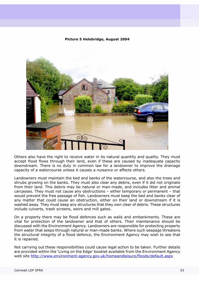
Picture 5 Helebridge, August 2004
Others also have the right to receive water in its natural quantity and quality. They mustaccept flood flows through their land, even if these are caused by inadequate capacitydownstream. There is no duty in common law for a landowner to improve the drainagecapacity of a watercourse unless it causes a nuisance or affects others.
Landowners must maintain the bed and banks of the watercourse, and also the trees andshrubs growing on the banks. They must also clear any debris, even if it did not originatefrom their land. This debris may be natural or man-made, and includes litter and animalcarcasses. They must not cause any obstructions – either temporary or permanent – thatwould prevent the free passage of fish. Landowners must keep the bed and banks clear ofany matter that could cause an obstruction, either on their land or downstream if it iswashed away. They must keep any structures that they own clear of debris. These structuresinclude culverts, trash screens, weirs and mill gates.
On a property there may be flood defences such as walls and embankments. These arevital for protection of the landowner and that of others. Their maintenance should bediscussed with the Environment Agency. Landowners are responsible for protecting propertyfrom water that seeps through natural or man-made banks. Where such seepage threatensthe structural integrity of a flood defence, the Environment Agency may wish to see thatit is repaired.
Not carrying out these responsibilities could cause legal action to be taken. Further detailsare provided within the ‘Living on the Edge’ booklet available from the Environment Agencyweb site http://www.environment-agency.gov.uk/homeandleisure/floods/default.aspx
53Cornwall LDF SFRA
Regional Flood Defence Committees
Regional Flood Defence Committees (RFDC) help to deliver Flood Risk Management inEngland and Wales. There are eleven committees across England and Cornwall is coveredby the Southwest RFDC. They meet quarterly and are made up of local authorityrepresentatives and members appointed by the Department for Environment, Food andRural Affairs (Defra) and the Environment Agency.
All meetings are locally advertised and the public is welcome to attend.
The Committees are responsible for:
Determining Environment Agency flood defence policy within their area of jurisdiction.Preparing and approving medium and long-term business needs plans for their area.The annual programme of flood defence maintenance and improvement works.Recommending the funds local authorities will contribute to flood defence works anddetermining the local levy on council tax for work that cannot be funded from theEnvironment Agency's central government grant in aid.Monitoring the Environment Agency's performance.
Role of Developers
Those proposing new development have a responsibility to prevent risk of flooding to theproposed development and to prevent the increase risk of flooding to third parties. Newdevelopment should not:
Occupy areas required to store flood waters.Block flood flow routes directly of indirectly.
Surface water from the development sites should be managed, in accordance withsustainable drainage principles.
Cornwall LDF SFRA54

55
Appendix C. Identification of the Functional Floodplain inCornwall
Appendix C. Identification of the Functional Floodplainin Cornwall
The functional floodplain (Flood Zone 3b) has been identified as a result of partnershipworking between the Local Planning Authority (LPA) and the Environment Agency (EA),based on the description of this flood zone provided in PPS25 and its associated practiceguide. Maps showing the functional flood plains are presented within the data viewer.
The methodology used to identify Flood Zone 3b varies, based on geographic location. Themethodology, as set out below, distinguishes the following geographic areas which eachhave their own particular constraints.
Urban areas (city, towns and major villages – see Appendix D)Rural areasEstuaries
Flood Zone 3b, as agreed by the Cornwall Council and EA is indicative of where flood watershould flow or be stored and may in some cases be contested by the public. Any challengewould however need to be supported by sufficient evidence, based on PPS25 and theCornwall area description.
Cornwall Area Description of Functional Floodplain
In addition to the description of functional floodplain as set out in PPS25 and the PPS25practice guide, the following provides an explanation of how the delineation of this FloodZone is arrived at in Cornwall.
In fluvial flood risk areas, Flood Zone 3b is land which is required to convey or storeflood water at times of flood, based on a return period of up to 1 in 100 years (1%probability).In tidal areas Flood Zone 3b is land which has one or more of the following functionsor characteristics:
A flood defence benefitA flood storage functionLand liable to erosionLand liable to provide flood defence benefit based on the predicted impact ofclimate change (based on 100 years of climate change)Land required to convey flood waterLand subject to significant wave action
Surface water has not currently been considered within the mapped functional floodplainclassification. However, overland flow routes necessary to prevent flooding areconsidered as functional floodplain.
Urban Areas
In towns and major villages the developed areas are generally not identified as functionalflood plain. The reason for this is that identification of the developed areas within suchsettlements as Flood Zone 3a will encourage future development to improve the existing
Cornwall LDF SFRA56
situation, through appropriate redevelopment that would incorporate restoration of thefunctional flood plain. This approach accords with the policy aims for Flood Zone 3a as setout in PPS25
On this basis Flood Zone 3b only details key conveyance routes and storage areas in urbanareas.
The Flood Zone 3b areas identified are key to the functioning of the floodplain and havebeen drawn assuming that the flood defences operate as they should. Where flood defencesare at risk of failure, or do not meet the 1 in 100 year standard, the areas where floodwater would flow and/or could be stored in case these defences fail are included in FloodZone 3b.
Buildings have typically been excluded from Flood Zone 3b. Where buildings have beenincluded, please refer to the “existing buildings in functional floodplain” section below.
Coastal areas within urban locations, such as beaches, have been classified as functionalfloodplain where the land provides a flood defence benefit, or is regarded as being at highrisk of erosion.
Rural Areas
In rural areas, the approach was taken to identify the full extent of Flood Zone 3 asfunctional floodplain. This includes both fluvial and tidal areas. The reason for this is thatmost development is located in, and will in future be directed to, the main settlements andrelatively little development is present in rural areas. Cornwall's smaller villages have beentreated as rural areas in this respect. This approach is considered acceptable in the contextof the policy guidance and the areas for growth in Cornwall.
Estuaries
The foreshore area in estuaries, up to Mean High Water Springs (MHWS), has been classifiedas functional floodplain. Estuaries can be complex areas with respect to flood risk and floodstorage, erosion and flood flows can be critical in these environments. Therefore theclassification of these areas as functional floodplain is considered precautionary and canbe challenged on a case by case basis if evidence can be provided as to why it is notfunctional.
Existing Buildings in the Functional Floodplain
Existing buildings should not be constrained by the functional floodplain classification.Redevelopment of buildings within the functional floodplain will generally be permissibleproviding these reduce overall flood risk. Where possible these should aim to be relocatedoutside of the functional floodplain.
57Cornwall LDF SFRA

58
Appendix D. Flood Risk by Communities
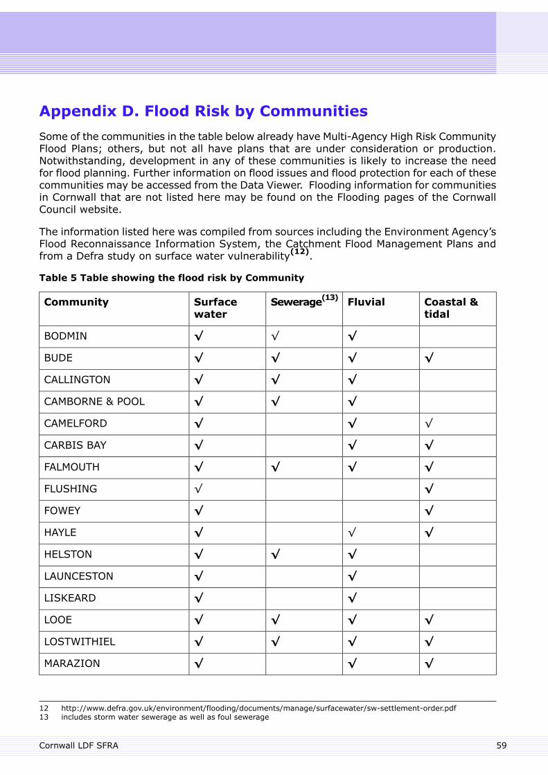
Appendix D. Flood Risk by Communities
Some of the communities in the table below already have Multi-Agency High Risk CommunityFlood Plans; others, but not all have plans that are under consideration or production.Notwithstanding, development in any of these communities is likely to increase the needfor flood planning. Further information on flood issues and flood protection for each of thesecommunities may be accessed from the Data Viewer. Flooding information for communitiesin Cornwall that are not listed here may be found on the Flooding pages of the CornwallCouncil website.
The information listed here was compiled from sources including the Environment Agency’sFlood Reconnaissance Information System, the Catchment Flood Management Plans andfrom a Defra study on surface water vulnerability(12).
Table 5 Table showing the flood risk by Community
Coastal &tidal
FluvialSewerage(13)Surfacewater
Community
√√√BODMIN
√√√√BUDE
√√√CALLINGTON
√√√CAMBORNE & POOL
√√√CAMELFORD
√√√CARBIS BAY
√√√√FALMOUTH
√√FLUSHING
√√FOWEY
√√√HAYLE
√√√HELSTON
√√LAUNCESTON
√√LISKEARD
√√√√LOOE
√√√√LOSTWITHIEL
√√√MARAZION
12 http://www.defra.gov.uk/environment/flooding/documents/manage/surfacewater/sw-settlement-order.pdf13 includes storm water sewerage as well as foul sewerage
59Cornwall LDF SFRA
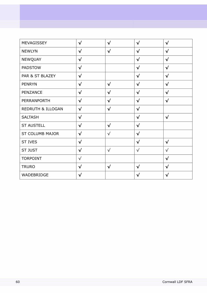
√√√√MEVAGISSEY
√√√√NEWLYN
√√√NEWQUAY
√√√PADSTOW
√√√PAR & ST BLAZEY
√√√√PENRYN
√√√√PENZANCE
√√√√PERRANPORTH
√√√REDRUTH & ILLOGAN
√√√SALTASH
√√√ST AUSTELL
√√√ST COLUMB MAJOR
√√√ST IVES
√√√√ST JUST
√√TORPOINT
√√√√TRURO
√√√WADEBRIDGE
Cornwall LDF SFRA60

61
Appendix E. Developer Information Pack
Appendix E. Developer Information Pack
Flood Risk Assessment – Data Collection
Flood Risk Assessments should be based on the requirements of PPS25 and a descriptionof the requirements are summarised in Annex E of PPS25.
The need for a FRA can be determined by consulting the Environment Agency’s Standingadvice web page, in which a matrix details these requirements.http://www.environment-agency.gov.uk/research/planning/82584.aspx
The Environment Agency can provide information to inform a FRA, such as flood history,details of flood defences, hydrometric data and flood risk modelling data. To check whetherthis information is available in an area, contact the Customer Services Line by telephoneon 08708 506506 or by email [email protected]
Following the production of a FRA for all non minor development the Environment Agencyencourages pre planning discussions and further details and a pre planning check list isavailable at – http://www.environment-agency.gov.uk/research/planning/33580.aspx
Tidal Level Data
The Environment Agency holds estimates of extreme tidal flood level data from 1 year to1000 year return period, which can be obtained on request. These levels are suitable fordevelopment planning purposes, however it should be noted that these are still water levelsand do not account for wave action or storminess. These levels may be obtained from theEnvironment Agency.
Surface Water Drainage Guidance
The Environment Agency has prepared drainage guidance for Cornwall which should beconsulted to determine whether a development site is located in a critical drainage area.The guidance is available via the SFRA website. The map showing Critical Drainage Areasin Cornwall is available in the Data Viewer. The drainage guidance applies to all areas.
Flood Defence Database
The Environment Agency holds a comprehensive database of all flood defences it hasresponsibility for and also basic details of private and local authority defences on MainRivers. This database, termed NFCDD (National Flood and Coastal Defence Database)includes detailed information on Environment Agency assets including their condition.Information on defences is available on request, from the Environment Agency.
Cornwall LDF SFRA62
Flood Risk Assessment – Data Analysis
Flood Estimation in Cornwall
Estimation of flood flows in small steep catchments, so typical for Cornwall, using industrystandard tools can provide unreliable results. Therefore in Cornwall the Environment Agencyexpect that for FRAs in catchments of less than 10km2 a sensitivity test is undertaken,through adding an additional 20% on flood flows. Therefore, when assessing the impactof climate change and flow uncertainty, 40% should be added to the calculated flow.
In catchments of less than 10km² the Flood Estimation Handbook Rainfall Runoff methodshould be used as a starting point for flow estimation. The ReFH should also be checkedhowever this relatively new technique is still to be proven in catchments of this size.
Failure and Blockage of Structures
When undertaking hydraulic modelling of structures, failure and blockage of the structuremust be considered. The degree of blockage will be a judgement based on:
the size of the feature, relative to the size of the watercourse;the risk of matter causing a blockage (i.e. in an urban environment, heavily vegetatedetc); andwhether there are any measures to decrease risk of blockage such as trash screens.
FRAs for development planning should take a precautionary approach to blockage, whendetermining flood zone extents and floor levels of buildings. The risk of blockage may betaken into account in assessing the residual risks at a site.
What is ‘Safe’ Guidance
PPS25 requires all new developments to be safe in terms of flood risk (Paragraph E2 andPart C of Exception Test) and the Environment Agency has internal guidance to clarify thispoint. The information below is a summary of the key parts of this guidance and should beused for information purposes only. This should only be considered where the sequentialtest has been passed.
Flood risk to people in buildings
In new buildings in the ‘highly vulnerable’ classification, people should remain safe duringa 1 in 100 year fluvial flood and a 1 in 200 year tidal flood; they should not need to moveto a higher floor; and the inside of such buildings should not flood: internal services shouldremain capable of operation and people should remain safe with dry floors. Basementsshould have unimpeded internal access to higher floors above flood level. Caravans, mobilehomes and park homes should have internal floor levels above flood level.
In new buildings in the ‘more vulnerable’ classification on a single floor level (such asbungalows), floors should remain dry during a 1 in 100 year fluvial flood and 1 in 200 yeartidal flood.
63Cornwall LDF SFRA
Where the lower floor of any multi storey building floods, a safe route to a floor level orsafety refuge above flooding should be available for all people, including those with restrictedmobility, accessible and acceptable to the emergency services. Where people are unableto reach a higher floor or safety refuge, the lower floor should remain dry.
People should remain ‘safe’ inside buildings in the ‘ less vulnerable ’ classification, up tothe 1 in 1000 year fluvial/tidal event. This may be by unaided movement to a higher floorlevel or other refuge above flood level or by other arrangements acceptable to theemergency services and the local authority’s emergency planning officer. Up to the 5%annual probability (1 in 20 year) event people should not need to move to a higher floorand the inside of all new buildings in the ‘less vulnerable’ classification should not flood,internal services should remain capable of operation. If this requirement cannot be metdue to operational needs of the building (for example, access to a warehouse floor for forklift trucks), then the building should be constructed using flood resilient or flood resistanttechniques and include a safe route to a floor level or refuge above flood level, for all peopleusing the building, including those with restricted mobility. Where such buildings are on asingle floor and there is neither a safe refuge available above flood level nor an approvedevacuation strategy in place, the inside of such buildings should not flood up to the 0.1%(1 in 1000 year) annual probability event.
Floor levels should be set at least 300 mm above precisely, or 600 mm above less preciselycomputed future flood levels [1% (1 in 100 year) fluvial and 0.5% (1 in 200 year) tidallevels allowing for climate change] and, wherever possible, 300 mm above the surroundingground level. In buildings on a single floor level or in a multi storey building, where it isnot possible to guarantee that all people including those with restricted mobility are ableto access a refuge above flood level, the above should apply for the computed future 0.1%(1 in 1000 year) flood level. This more stringent requirement is based on the uncertaintyof modelling and wave and vehicle wash considerations. This requirement may be relaxedfor ‘water compatible’ development provided it is demonstrated as being otherwise safe.Flood resilience and resistance measures may be incorporated instead where agreed asappropriate with the LPA, but should not be used to justify development in inappropriatelocations.
Access and egress, evacuation and rescue
Access/egress routes should aim to remain flood free during a 1 in 100 year fluvial and 1in 200 year tidal flood. Where this cannot be achieved Cornwall Council will need to besatisfied that there is a satisfactory plan for evacuation, based, where necessary, onconsultation with the emergency planners and services. This is not a matter of theEnvironment Agency formally approving plans. Cornwall Council will need to be satisfiedthat people (including those with restricted mobility), will be able to reach places of safety(either safe refuges within buildings or safe access) and that emergency services can accessbuildings to rescue and evacuate people.
Cornwall LDF SFRA64
Buildings in the ‘highly’, ‘more’ and ‘less vulnerable’ classifications should provideunaided safe access from, and egress to the site boundary and local facilities(14). Thisshould only present a very low flood hazard(15) unless otherwise advised by the emergencyservices and Cornwall Council's emergency planning officer and should be suitable forpersons with restricted mobility.
Safe access to, and egress from, ‘essential infrastructure’ should remain operational tothe satisfaction of the emergency services, local authority emergency planners and theparticular authorities, operators, utilities and regulators as appropriate.
While it may be acceptable for access and egress routes to and from new buildings in the‘water compatible’ vulnerability classification to flood, warning and evacuation plans mustbe in place to enable Cornwall Council to satisfy themselves of the safety of all people - inconsultation as appropriate with the emergency services and the Cornwall Council'semergency planning officer.
Further information on flood risk to people can be found in the document FD2320 - FloodRisk Assessment Guidance for New Development (HR Wallingford) can be downloaded:http://sciencesearch.defra.gov.uk/Default.aspx?Menu=Menu&Module=FJPProjectView&Location=None&ProjectID=12015.
Information on flood resilient building techniques is available from:http://www.communities.gov.uk/publications/planningandbuilding/improvingflood
Reservoir Inundation Risk
The Government has committed to producing maps showing areas at risk from reservoirdam break by the end of 2009. The Environment Agency have been tasked with managingthe development of these maps and it is likely that outputs will be available to inform theSFRA process. The maps that will be available to the public will indicate the extent offlooding should a reservoir dam be breached. The scenario selected for the dam breaks isreferred to as the worst credible case. When the information is available it will beincorporated into the SFRA through the update process.
14 including shops, schools and doctors’ surgeries and likely places of assembly/refuge during flood15 A very low flood hazard is satisfied by a flood hazard rating of <0.75 from the equation in paragraph 13.7.2 of FD
2320 where the debris factor is 0.5 for flood depths up to and including 0.25 metres and 1.0 for greater depths. Theserequirements are satisfied for a depth of flooding not exceeding: 250 mm with flow velocity not exceeding 0.5 m/sec;100 mm with flow velocity not exceeding 1.5 m/sec; 50 mm with flow velocity not exceeding 4 m/sec.
65Cornwall LDF SFRA

66
Appendix F. Sustainable Drainage Systems (SUDS)
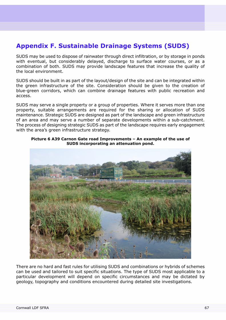
Appendix F. Sustainable Drainage Systems (SUDS)
SUDS may be used to dispose of rainwater through direct infiltration, or by storage in pondswith eventual, but considerably delayed, discharge to surface water courses, or as acombination of both. SUDS may provide landscape features that increase the quality ofthe local environment.
SUDS should be built in as part of the layout/design of the site and can be integrated withinthe green infrastructure of the site. Consideration should be given to the creation ofblue-green corridors, which can combine drainage features with public recreation andaccess.
SUDS may serve a single property or a group of properties. Where it serves more than oneproperty, suitable arrangements are required for the sharing or allocation of SUDSmaintenance. Strategic SUDS are designed as part of the landscape and green infrastructureof an area and may serve a number of separate developments within a sub-catchment.The process of designing strategic SUDS as part of the landscape requires early engagementwith the area’s green infrastructure strategy.
Picture 6 A39 Carnon Gate road Improvements – An example of the use ofSUDS incorporating an attenuation pond.
There are no hard and fast rules for utilising SUDS and combinations or hybrids of schemescan be used and tailored to suit specific situations. The type of SUDS most applicable to aparticular development will depend on specific circumstances and may be dictated bygeology, topography and conditions encountered during detailed site investigations.
67Cornwall LDF SFRA
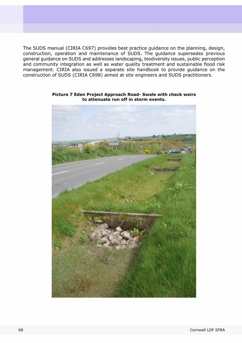
The SUDS manual (CIRIA C697) provides best practice guidance on the planning, design,construction, operation and maintenance of SUDS. The guidance supersedes previousgeneral guidance on SUDS and addresses landscaping, biodiversity issues, public perceptionand community integration as well as water quality treatment and sustainable flood riskmanagement. CIRIA also issued a separate site handbook to provide guidance on theconstruction of SUDS (CIRIA C698) aimed at site engineers and SUDS practitioners.
Picture 7 Eden Project Approach Road- Swale with check weirsto attenuate run off in storm events.
Cornwall LDF SFRA68
In the past, a specific barrier to the use of SUDS has been the allocation of responsibilityfor maintenance or adoption by a particular organisation; this is especially so for strategicSUDS. This issue is addressed within the draft Flood and Water Management Bill. It is likelythat local authorities (e.g. Cornwall Council) will be expected to adopt SUDS and beresponsible for their maintenance, provided that appropriate agreements and funding canbe put in place. It is therefore anticipated that SUDS, and in particular strategic SUDS thatmay be landscaped and integrated into green infrastructure, will form a greater role indrainage designs in the future. Encouraging the consideration of SUDS as part of an area’sgreen infrastructure strategy will help achieve more sustainable development and drainagepatterns.
69Cornwall LDF SFRA

70
Appendix G. Data in the Data Viewer
Appendix G. Data in the Data Viewer
The Data Viewer is a web-based mapping tool provided to support the SFRA and to providepublic access to the data that are used to assess flood risk and management.
The information available in the Data Viewer can be used by prospective applicants anddevelopers to assess the flood risk issues in a given location. It is also used to guide therequirements of SFRAs at level 2.
Many of the data sets are taken from national maps kindly provided by the EnvironmentAgency. These data are based on best available estimates and should not be taken asdefinitive assessments. They should be taken as a guide as to where further assessmentmay be required. Cornwall Council and the Environment Agency do not accept liability fordecisions made as a result of information provided within the Data Viewer.
Below is a list of data presented in the Data Viewer. The Data Viewer may be accessed from https://map.cornwall.gov.uk/website/ccmap/.
Table 6
Rivers
Location of all rivers in CornwallRivers Map
Location of Main Rivers in CornwallMain River Map
Flood defences
Locations of Environment Agency and private flood defencesFlood Defences
Flood risk zones
Planning constraint 1 in 100 year fluvial, 1 in 200 year tidalflood zone
Flood Zone 3a
Functional floodplainFlood Zone 3b
Planning constraint 1 in 1000 year fluvial and tidal flood zoneFlood Zone 2
Tidal extremes including projected sea level rise
This indicates the approximate extent of the 1 in 1000 yearprobability extreme still-water tide in 50 years time, based ona fairly coarse analysis of ground levels and projected sea levelrise.
50 year projection
This shows the same information as above but projected 100years into the future.
100 year projection
Catchments
Location of sub-catchments considered by the EnvironmentAgency to be critical drainage areas.
Critical Drainage Areas
71Cornwall LDF SFRA
Areas of catchment groups covered by CFMP policies 4, 5 and6.
CFMP Policy Units
Shoreline Management
Stretches of coastline covered by SMP1 policy units.Shoreline ManagementUnits
Flood Warning
Coverage of the Environment Agency flood warning systemEA flood warning areas
River reaches covered by the Environment Agency flood watchsystem
EA flood watchboundaries
Towns
PDF files which outline the main flooding issues and link toavailable flood assessments/reports for each of the mainsettlements in the county listed in Appendix E.
Flood ‘portrait’ of mainsettlements
Cornwall LDF SFRA72

73
Appendix H. Glossary
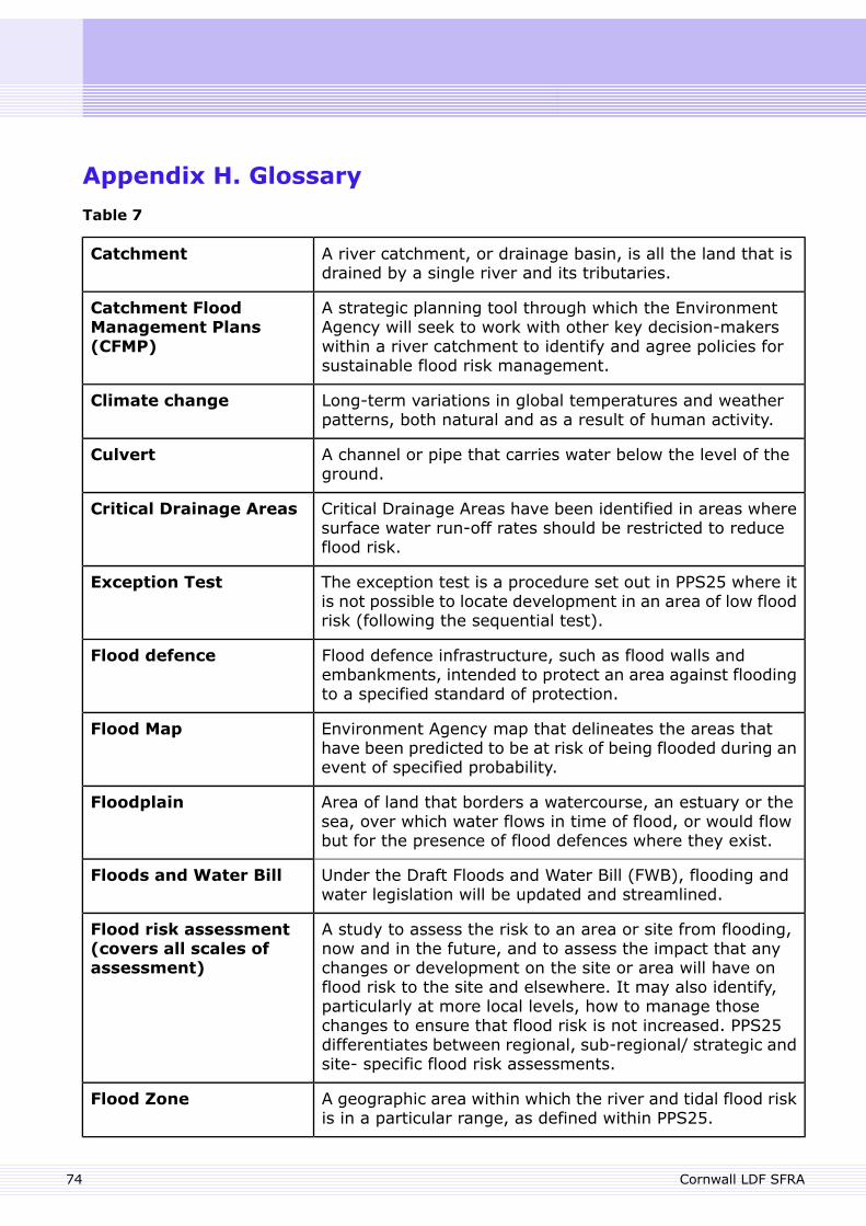
Appendix H. Glossary
Table 7
A river catchment, or drainage basin, is all the land that isdrained by a single river and its tributaries.
Catchment
A strategic planning tool through which the EnvironmentAgency will seek to work with other key decision-makerswithin a river catchment to identify and agree policies forsustainable flood risk management.
Catchment FloodManagement Plans(CFMP)
Long-term variations in global temperatures and weatherpatterns, both natural and as a result of human activity.
Climate change
A channel or pipe that carries water below the level of theground.
Culvert
Critical Drainage Areas have been identified in areas wheresurface water run-off rates should be restricted to reduceflood risk.
Critical Drainage Areas
The exception test is a procedure set out in PPS25 where itis not possible to locate development in an area of low floodrisk (following the sequential test).
Exception Test
Flood defence infrastructure, such as flood walls andembankments, intended to protect an area against floodingto a specified standard of protection.
Flood defence
Environment Agency map that delineates the areas thathave been predicted to be at risk of being flooded during anevent of specified probability.
Flood Map
Area of land that borders a watercourse, an estuary or thesea, over which water flows in time of flood, or would flowbut for the presence of flood defences where they exist.
Floodplain
Under the Draft Floods and Water Bill (FWB), flooding andwater legislation will be updated and streamlined.
Floods and Water Bill
A study to assess the risk to an area or site from flooding,now and in the future, and to assess the impact that anychanges or development on the site or area will have on
Flood risk assessment(covers all scales ofassessment)
flood risk to the site and elsewhere. It may also identify,particularly at more local levels, how to manage thosechanges to ensure that flood risk is not increased. PPS25differentiates between regional, sub-regional/ strategic andsite- specific flood risk assessments.
A geographic area within which the river and tidal flood riskis in a particular range, as defined within PPS25.
Flood Zone
Cornwall LDF SFRA74
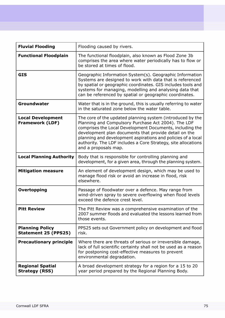
Flooding caused by rivers.Fluvial Flooding
The functional floodplain, also known as Flood Zone 3bcomprises the area where water periodically has to flow orbe stored at times of flood.
Functional Floodplain
Geographic Information System(s). Geographic InformationSystems are designed to work with data that is referencedby spatial or geographic coordinates. GIS includes tools andsystems for managing, modelling and analysing data thatcan be referenced by spatial or geographic coordinates.
GIS
Water that is in the ground, this is usually referring to waterin the saturated zone below the water table.
Groundwater
The core of the updated planning system (introduced by thePlanning and Compulsory Purchase Act 2004). The LDFcomprises the Local Development Documents, including the
Local DevelopmentFramework (LDF)
development plan documents that provide detail on theplanning and development aspirations and policies of a localauthority. The LDF includes a Core Strategy, site allocationsand a proposals map.
Body that is responsible for controlling planning anddevelopment, for a given area, through the planning system.
Local Planning Authority
An element of development design, which may be used tomanage flood risk or avoid an increase in flood, riskelsewhere.
Mitigation measure
Passage of floodwater over a defence. May range fromwind-driven spray to severe overflowing when flood levelsexceed the defence crest level.
Overtopping
The Pitt Review was a comprehensive examination of the2007 summer floods and evaluated the lessons learned fromthose events.
Pitt Review
PPS25 sets out Government policy on development and floodrisk.
Planning PolicyStatement 25 (PPS25)
Where there are threats of serious or irreversible damage,lack of full scientific certainty shall not be used as a reasonfor postponing cost-effective measures to preventenvironmental degradation.
Precautionary principle
A broad development strategy for a region for a 15 to 20year period prepared by the Regional Planning Body.
Regional SpatialStrategy (RSS)
75Cornwall LDF SFRA
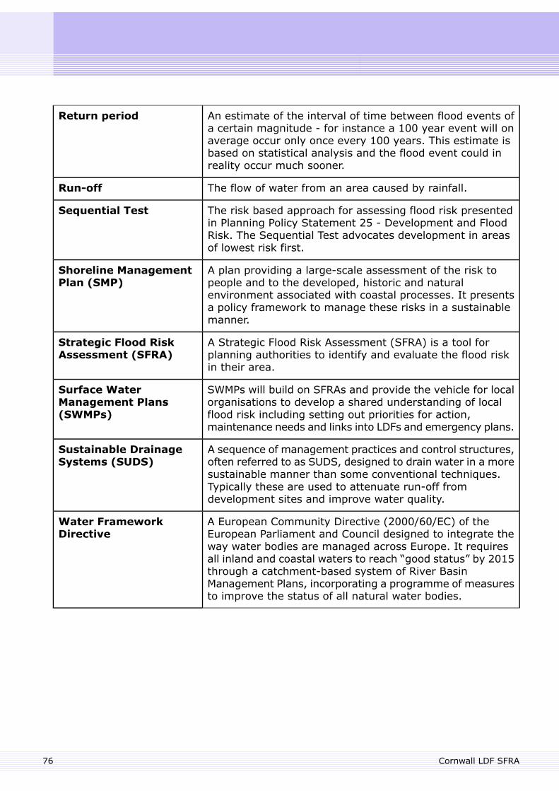
An estimate of the interval of time between flood events ofa certain magnitude - for instance a 100 year event will onaverage occur only once every 100 years. This estimate isbased on statistical analysis and the flood event could inreality occur much sooner.
Return period
The flow of water from an area caused by rainfall.Run-off
The risk based approach for assessing flood risk presentedin Planning Policy Statement 25 - Development and FloodRisk. The Sequential Test advocates development in areasof lowest risk first.
Sequential Test
A plan providing a large-scale assessment of the risk topeople and to the developed, historic and naturalenvironment associated with coastal processes. It presentsa policy framework to manage these risks in a sustainablemanner.
Shoreline ManagementPlan (SMP)
A Strategic Flood Risk Assessment (SFRA) is a tool forplanning authorities to identify and evaluate the flood riskin their area.
Strategic Flood RiskAssessment (SFRA)
SWMPs will build on SFRAs and provide the vehicle for localorganisations to develop a shared understanding of localflood risk including setting out priorities for action,maintenance needs and links into LDFs and emergency plans.
Surface WaterManagement Plans(SWMPs)
A sequence of management practices and control structures,often referred to as SUDS, designed to drain water in a moresustainable manner than some conventional techniques.Typically these are used to attenuate run-off fromdevelopment sites and improve water quality.
Sustainable DrainageSystems (SUDS)
A European Community Directive (2000/60/EC) of theEuropean Parliament and Council designed to integrate theway water bodies are managed across Europe. It requires
Water FrameworkDirective
all inland and coastal waters to reach “good status” by 2015through a catchment-based system of River BasinManagement Plans, incorporating a programme of measuresto improve the status of all natural water bodies.
Cornwall LDF SFRA76