Embed Size (px)
Citation preview
County of Santa Clara Department of Planning and Development County Government Center, East Wing 70 West Hedding Street, 7th Floor San Jose, California 95110
Administration
Ph: (408) 299-6740 Fax: (408) 299-6757
Affordable Housing
(408) 299-5750 ( 408) 299-6709
Building Inspection
( 408) 299-5700 (408) 279-8537
Fire Marshal
( 408) 299-5760 (408) 299-6757
Land Development Engineering (408) 299-5730 ( 408) 279-853 7
Planning
(408) 299-5770 (408) 288-9198
NOTICE OF PREPARATION OF A PROGRAM ENVIRONMENTAL IMPACT REPORT FOR THE SANTA CLARA COUNTY GENERAL PLAN CIRCULATION AND MOBILITY ELEMENT UPDATE
PROJECT PROPONENT AND LEAD AGENCY: COUNTY OF SANTA CLARA
As the Lead Agency, the County of Santa Clara will prepare a Program Environmental Impact Report (Program EIR) for the above-referenced project and would like your views regarding
the scope and content of the environmental information to be discussed in the Program EIR. The project location and description, and a brief summary of potential environmental impacts
are attached.
A Public Scoping Session to solicit comments for the Notice of Preparation will be held at the Isaac Newton Senter Auditorium, County Government Center, 70 West Hedding Street, San Jose, CA on Thursday, June i9 from 6 p.m. to 7:30 p.m. Per State law and in accordance with the California Environmental Quality Act (CEQA), comments on the Notice of Preparation
are due within 30 days of receipt of this notice; however, we would appreciate an earlier response, if possible. Please identify a contact person, and send your response to:
County of Santa Clara Department of Planning and Development Attention: David Rader, Planner III
70 W. Hedding Street, East Wing, 7th Floor
San Jose, CA 95110 E-mail: [email protected]
Phone: 299-5779
Rob Eastwood, Principal Planner Date
Board of Supervisors: Mike Wasserman, Cindy Chavez, Dave Cortese, Ken Yeager, S. Joseph Simitian County Executive: Jeffrey V. Smith
NOTICE OF PREPARATION OF A PROGRAM ENVIRONMENTAL IMPACT REPORT
SANTA CLARA COUNTY GENERAL PLAN
CIRCULATION AND MOBILITY ELEMENT UPDATE
County of Santa Clara, California May 27, 2014
1. Introduction The purpose of an Environmental Impact Report (EIR) is to inform decision makers and the general public of the environmental effects of a proposed project. The EIR process is intended to provide public agencies with the environmental information required to evaluate a proposed project, establish methods for reducing adverse environmental impacts, and consider alternatives to a project, prior to the approval of the project. The Program EIR for the proposed Circulation and Mobility Element Update will be prepared and processed in accordance with the California Environmental Quality Act (CEQA) of 1970, as amended. Per Section 15168 of the CEQA Guidelines, a Program EIR will be prepared, which is appropriate for projects, such as a general plan element, that include a series of related actions that can be characterized as one project and in connection with the issuance of rules, regulations, plans and other policies that govern a continuing program. A Program EIR allows a lead agency to consider broad policy alternatives and program-wide “first tier” mitigation strategies that help guide the analysis of subsequent individual projects. In accordance with the requirements of CEQA, the EIR will include: • A project summary. • A project description. • A description of the existing environmental setting. • The significant environmental effects of the proposed project. • The significant environmental effects that cannot be avoided if the proposed project is
implemented. • The significant irreversible environmental changes caused by the proposed project. • The growth-inducing impact of the proposed project. • The mitigation measures proposed to minimize the significant effects. • The alternatives to the proposed project. 2. Project Location The Santa Clara County General Plan Circulation and Mobility Element Update will identify objectives, policies, and strategies for multimodal transportation networks, airports, and utilities within the County of Santa Clara, California. The County, which encompasses approximately 1,300
2
square miles, is located at the southern end of the San Francisco Bay Area and includes 15 incorporated cities and towns (San Jose, Campbell, Cupertino, Gilroy, Los Altos, Los Altos Hills, Los Gatos, Milpitas, Monte Sereno, Morgan Hill, Mountain View, Palo Alto, Santa Clara, Saratoga, and Sunnyvale) (refer to Figure 1). 3. Description of the Project The proposed project is an update to the County of Santa Clara’s Circulation and Mobility Element, one of the State-mandated elements of the General Plan. The draft update is designed to be consistent with the requirements of the California Complete Streets Act and the Governor’s Office of Planning and Research Update to the General Plan Guidelines: Complete Streets and the Circulation Element. Circulation includes all systems that move people, goods, energy, water, sewage, storm drainage, and communications. Issues addressed in the Circulation and Mobility Element include Countywide Issues and Policies, the County Roads System, Private Roads in Unincorporated Areas, Airports, and Utilities. The Circulation and Mobility Element identifies the transportation network under the County’s jurisdiction to support existing and future land use patterns in the County in 2025 and through 2040, based on projected growth in adopted General Plans of the incorporated cities and towns within the County. It also contains policies to support and implement improvements to the transportation network, including bicycle, pedestrian and transit systems. The 1995 Countywide Trails Master Plan and multimodal policies are addressed in the Countywide Transportation Issues and Policies section. Bicycle routes and trails are also considered in the County Roads System section where bicycle routes/trails occur within County roads rights-of-way. The County of Santa Clara is unique in that it is the only county in the State of California that maintains and operates a regional expressway system within incorporated areas, in addition to roads in unincorporated areas. The Circulation and Mobility Element Update will identify possible future modifications to the County roads and expressway systems, based upon transportation modeling and a consideration of complete streets in conformance with State law. The list of improvements for County expressways is derived from input from local cities, the existing County Expressway Plan and the draft Expressway Plan 2040, which is currently being prepared by the County. A summary of possible transportation improvements that may be included in the future transportation network are provided in Table 1 (County Roads) and Table 2 (County Expressways). Most of the roadways identified on the Tables 1 and 2 are currently identified for future improvements in existing plans (e.g., County Expressway Plan, Countywide Trails Master Plan, and Santa Clara County General Plan). The Update proposes to modify some of the planned roadway improvements in existing plans, based upon updated transportation modeling and new standards for multimodal design of bike lanes, pedestrian paths, and vehicular turning pockets on two-lane arterial roadways. The location of the County roads and expressway improvements are shown in Figure 2 and 3, respectively.
3
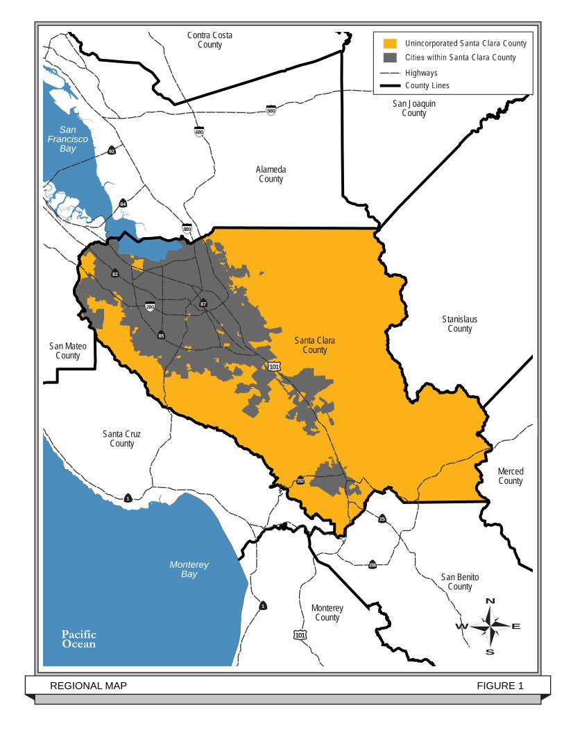
REGIONAL MAP FIGURE 1
85
87
84
92
Contra CostaCounty
AlamedaCounty
Santa ClaraCountySan Mateo
County
Santa CruzCounty
MontereyCounty
StanislausCounty
San JoaquinCounty
MercedCounty
San BenitoCounty
MontereyBay
SanFrancisco
Bay
PacificOcean
280
880
680
580
N
W E
S
N
W E
S
1
1
101
101
156
152
25
82
Cities within Santa Clara County
Highways County Lines
Unincorporated Santa Clara County
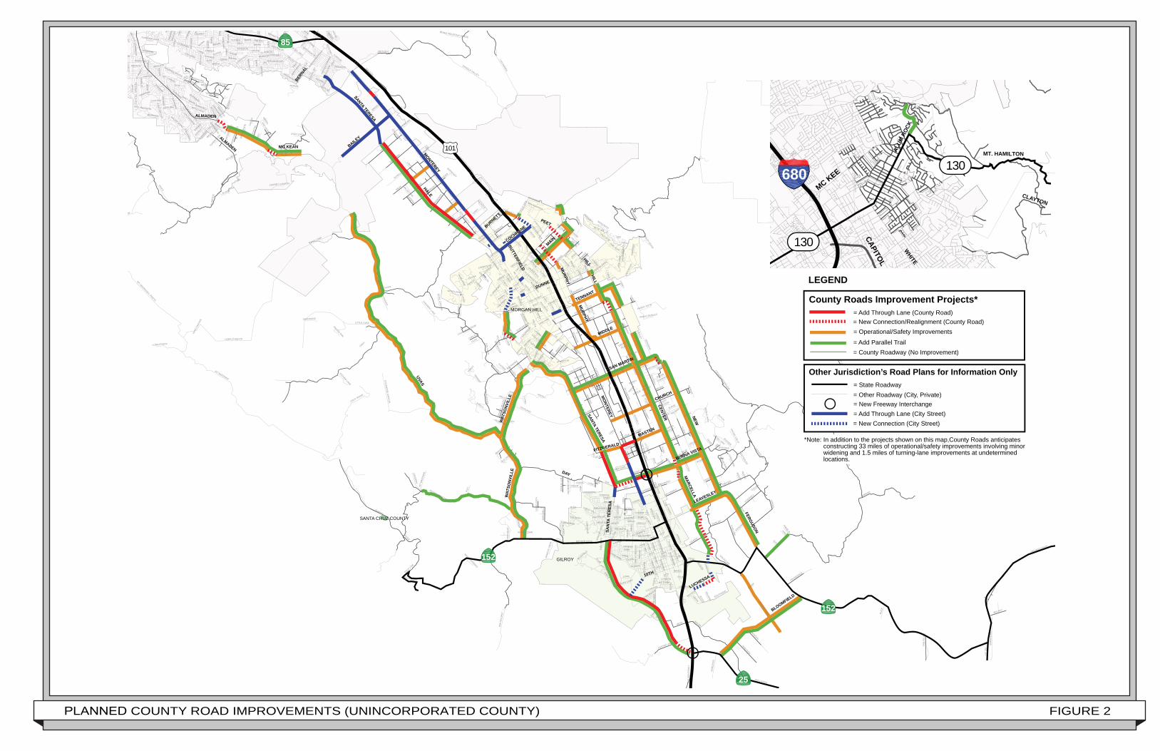
PLANNED COUNTY ROAD IMPROVEMENTS (UNINCORPORATED COUNTY) FIGURE 2
UVAS
PACHECO PASS
NEW
HALE
HICKS
DAY
SUMMIT
CROY
CENTER FOO
THILL
DUNNE
CANADA
HECKER PASS
METCALF
LLAGAS
CASA LOMA
BOLSA
PAR
K B
OU
ND
AR
Y
MAPLE
COLUM
BET
WR
EN
GU
IBAL
SN
ELL
ROOP
MURPHY
LAS ANIMAS
06TH
MIL
LER
CALERO
HIGHLAND
SYCAMO
RE
CONDIT
MT MADONNA
OAK GLEN
DOUGHERTY
MALECH
HALF
CR
EWS
WH
ITEH
UR
ST
HAN
NA
MANTELLI
DIANA
FISHER
REDMOND
HAYES
HOLIDAY
DE
WIT
T
LAGUNA
LITTLE UVAS
BU
RC
HE
LL
CROY RIDGE
MESA
GILRO
Y HOT SPRING
S
SHINGLE VALLEY
REDWOOD RETREAT
HARDING
WELBURN
ALAM
ITO
S
COYOTE RESERVOIR
RAILROAD
KALANA
JAMISON
FRAZIER LAKE
HOLSCLAWCAM
ERO
N
UM
CASTRO VALLEY
EDMUNDSON
MT UMUNHUM-L PRIETA
05TH
FUR
LON
G
HOLLISTER
CHES
BR
GILMAN
OLIVE
HAR
RY
RO
SANN
A
CAH
DRYDEN
AL
CURIE
DUKE
TURLOCK
DU
NN
COO
LIDGE
RICHMOND
PEAK
CH
ESTNU
T
UVAS PARK
DUNLAP
PRIN
CEVALLE
SCHELLER
ALARM
COLLEEN
BARRETT
ARMSBY
COLO
NYPOLE
LINE
HERSMAN
ELW
OO
D
CLUB
LOMA CHIQUITA
MIDDLE
BA
RN
HE
ISE
L
CREE
SHELDON
RUCKER
FOR
TIN
I
SHEILA
FOR
EST
ARROYO
SAN BRUNO
DAVIDSON
DENIO
EAGLE RIDGE
PALM
GODFREY
HY
156
IOOF
LENA
PEEBLES
NO
NAM
E UN
O
GLEN
VIEW
ELM
LANTZ
BREM
HAMPTON
SUNRISE
SAN PEDRO
OLD
MO
NTE
RE
Y
RIDGE
SOUTHSIDE
JAI
SUNNYSIDE
SAN IGNACIO
EIGLEBER
RY
ESTATES
CO
YOTE
BUC
K
LOS PINOS
WILLOW
BRET HARTE
LITTL
CHESBRO LAKE
LILAC
DO
WD
Y
MU
RR
AY
CLAREMONT
FRO
NTAG
E
KIRBY
MADRONE
NAR
CIS
SO
GWINN
SUTTER
PRUNEDALE
EL
MAT
AD
OR
JEANIE
LIVE OAK
GE
RI
MIRAM
ONTE
CA
ME
LIA
DEPOT
EASY
TRAIL
POLI
LAKEVIEW
COHANSEY
A
BOWDEN
GRAYSTONE
LANE B
ALEXAND
ER
JARVIS
BRID
LE PATH
HERLONG
RENZ
CREST
SUISSE
TRINIDAD
BLUE OAKS
RONAN
BERTRAM
DIAS
PASEO VISTA
FIR
EFL
Y
EL PORTALMADISON
MAR
TINVA
LE
SEYMO
UR
BIRCH
RIC
E
FORSUM
BO
SE
CHERRY CANYON
IVAN
KELT
ON
AYER
BAY
SAN YSIDRO
SAND
ERS
SYCAM
OR
E CAN
YON
SALEM
OGIER
OAK LEAF
LEYLAND PARK
PHINNEY
GREAT OAKS
REA
AVEN
IDA
ESPA
NA
KOR
N
GOLDEN GATE
CALCATERRA
BELLA VISTA
WALLACE
KICKHAM
EMADO
LOMA
BARNARD
SPR
ING
VAL
LEY
TATUM
KANNELY
KEITH
OMAR
EL P
ASEO
OBATA
OAK
BAYLISS
SAN ANSELMO
PASEO ROBLES
KELL
VEGAS
LAUREL
GAN
CI
MAZZONE
SUGAR BABE
BARNHART
M
UVAS
CAN
YON
ALKIRE
GIL
LIS
LA C
ROSSE
ENCINO
ROYALW
OO
D
VINEYARD
VAL
CR
YS
TAL
SP
RIN
GS
FARM
AN FR
ON
TAGE
GRAND PRIX
SAN VICENTE
SURBER
MAHAN
BANES
MISSION VIEWTILT
ON
KE
RN
YVONNE
VIA DEL CIELO
LEON
A
RIMROCK
FARRELL
GLEN AYRE
HOUSE
BUTCH
SABINI
BLACK MOUNTAIN GRADE
BURNSIDE
FOUNTAIN OAKS
PHAR
MER
ROSALIND
VINCENT
MALAG
A
JEA
N E
LLE
N
BLUEBELL
AR
IE
CORY
VICTO
RY
MANFRE
VALE
FALLEN OAK
MAYO
SERENE
LASS
EN
GRIMLE
Y
JEAN
ALPET
MAYAN
GAU
NT
ALLE
Y
CAPUTO
BU
FKIN
COSMO
SIENA
WATER
BLUE JAY
HEATON MOOR
C
LA MAR
SILACCI
LIS
KA
SANDY
SPODE
PEGASUS
SHANNONS
MOUNTAIN
TIMO
THY
VIEW OAKS
CIELITO
HARDY
DEL MONTE
BRIAN
ESTHER LAKE
VIEW
TAN
DER
A
HIR
AS
AK
I
MAYOCK
LA ALAMEDA
SA
NTA
TH
ER
ES
A
PINECREST
PARTRIDGE
DAWN
LOTUS
MALO
RY
PHEASANT
CHAPARRAL
JASMINE
CURRY
PIAZZA
WILSON
MACHADO
MUIRFIELD
MINDY
WOODLAND
GU
NTE
R
ARNOLD
OLEA
PFEIFFER RANCH
GIAMPAOLI
HERITAGE
WALNUT
MT CARMEL
CORTESE
ANGELO
BERLIN
NINA
BROADWAY
ROSSI
CASEY
MARTW
OOD
OB
ER
LIN
AVEN
IDA
ROTELL
A
N
OSCAR
CASTILLON
ARIZONA
LIBERATA
BUCHER
ARAPAHO
DWYER
WILFO
RD
FINLEY RIDGE
OAK
RID
GE
HOPI
OR
IND
A
DAISYGAR
CES
HENZI
CAYUGA
SAFARI
OAK BROOK
ST LOUISE
CALLE MAZATAN
SHAFER
VIA DEL ORO
KISER
APPI
AN
SUSIE
BODEGA
OAK
WO
OD
AKIO
BARNELL
ELMSDALEANJOU CREEK
SATTERLEE
CARLSON
STEFFS
CHATEAU
PAR
RIS
H V
IEW
SUNFLOWER
CREST HILL
PRATT
MAST
OLD CREEK
MALAGUERRA
DONDERO
VALLEY QUAIL
LOMA ALTA
SORREL
TOVAR
JUST
INO
BRYSON
FREN
CH
INDIAN CAMP
DA
HLB
ER
G
CASTLER
OC
K
WOODVIEW
SPRING HILL
DUBANSKI
ATHERTON
RANCHERO
VISTA DE LOMAS
MOJAVE
RIC
CHRISTEPH
CAREY
ALESSI
LANCIA
SILVA
DIGITAL
JAC
QU
ES
DOVERTAIL
CLO
VE
RH
ILL
GRANDWOOD
OAK
VIE
W
REALM
CHAN
TILL
EY
COUNTRY
ARLIA
MIW
OK
CARLS
LOST VIEW
CARLA
BARNES
QU
AIL CAN
YON
EAG
LE V
IEW
NATI
VE D
ANCE
R
RO
YAL
STARR
CULLEN
MARKET
SPRIG
KROHN
PITLOCHRY
MORENO
ROSEMARY
CALLE ENRIQUE
VIOLET
LIN
DA
VIS
TA
CHILANIAN
LESLEY
BISHOP
JACOBS
RO
DLIN
G
PINELAN
D
TERESA
NICHOLS
LAGO VISTA
REN
EE
PAR
ISH
STUTZ
NOB HILL
LUCHESSA
MAGIC SPRINGS
MAM
MINI
ANNI
E
TEN
TAR
YN
DOWNS
RAN
CH
O V
ISTA
HANK
MU
RAO
KA
LINDO
DE PAU
L
CHRIS
EBERTS
DEANA
TANNAHILL
STARW
OO
D
REG
GIO
MEI
EL CERRITO
CAMILLE
MARY JO
WOEHL
ONEIDA
SEAWOOD
K
ORTEGA
WALIZER
FITZ
DORAL
BREWSTER
CROWNER
THYME
ROSETTA
MURPHY SPRINGS
NICOLE
GOULD
STRO
TMAN
BRAVO
HAGERLLA
NO
AUTOETCH
LAR
KS
PU
R
JENNIFER
HONEYCOMB
OAK PARK
PERINO
DE BRUIN
WH
ITE
OA
K
MARIE
HOUL
TON
MOCKINGBIR
D HILL
FILB
RO
STARSW
EPT
CALLE V
IENTO
PINOT
NCE
LONDON
RAN
CH
O R
EAL
RE
WH
ISPE
RIN
G O
AKS
CLARKE
LOPEZ
VALLEY OAK
DEEVA
MOSS
GARZA
ARLINE
HOXETT
ALMADEN LAKE
TRAVIS
LA CO
RTE
NIGUEL
ANTIGUA
SEWELL
VIEWCREST
LOUIS HOLSTROM
ENDERSON
JUNIPER
PALMIA
TWO
OA
KS
PIET
Z
LAUREDO
BRIANA
TRUMAR
TOPA
M GLE
N
HU
NTE
RN
S H
ILL
MALBEC
CAPISTRANO
NIKULINA
CH
ON
A
HOGUEANN MARIE
FOR
EST
MC LAUGHLIN
HILL
MURPHY
HICKS
CHURCH
LAS ANIMAS
05TH
MU
RPH
Y
SANCHEZ
CAR
MEL
01ST
WOODVIEW
11TH
BRUCE
SA
N F
ELI
PE
SOUTH
PINE
HALF
CALIFORNIA
SCHELLER
05TH
CLARK08TH
SYCAMORE
03RD
LILLY
SAN
VIC
ENTE
MADRONE
OR
CH
AR
D
SAN PEDRO
DU
VALL
BARRETT
BERNAL
07TH
VICTORIA
MT
MAD
ON
NA
THO
MA
S
WRIGHT
01ST
HILL
LLAGAS
LEAVESLEY
02ND
EAST
KENT
06TH
KIOWA
BARRETT
DEPOT
OAK
03RD
PALOMINO
MURPHY
RUCKER
COHANSEY
PARK BOUNDARY
COX
SUNSET
ALMADEN
LOMA PRIETA
CAREY
B
CHERRY
SYCAMORE
CO
TRACY
PERIMETER
REYNOLDS
01ST
OAK
OAK G
LEN
PARK
LUCHESSA
LENA
HILLVIEW
MU
RR
AY
MANZANITA
SYCAM
OR
E
DENIO
CENTRAL
PIAZZA
RAMONA
09TH
DOUGHERTY
01ST
VIA DEL ORO
ROGERS
DAY
HILL
GILROY
MORGAN HILL
SANTA CRUZ COUNTY
HIGHLAND
LLAGAS
SPRING
SYCAMORE
101
85
25
152
152
County Roads Improvement Projects*= Add Through Lane (County Road) = New Connection/Realignment (County Road)= Operational/Safety Improvements
= Add Parallel Trail
County Roads Improvement Proje
Other Jurisdiction’s Road Plans for Information Only
= County Roadway (No Improvement)
= Other Roadway (City, Private)= State Roadway
= New Freeway Interchange
LEGEND
= Add Through Lane (City Street)= New Connection (City Street)
*Note: In addition to the projects shown on this map,County Roads anticipates constructing 33 miles of operational/safety improvements involving minor widening and 1.5 miles of turning-lane improvements at undetermined locations.
LEAVESLEY
BLOOMFIELD
LUCHESSA10TH
MARCELLA
BUENA VISTA
SAN MARTIN
MASTEN
FITZGERALD
SANTA TERESAM
ONTEREY
UVAS
DAY
WAT
SONV
ILLE
WAT
SON
VILL
E
DUNNE
MIDDLE
TENNANT
BUTTERFIELD
PEET
MURPHY
MAIN
HILL
MC KEAN
ALMADEN
ALMADEN
BERNAL
NEW
FERGUSON
CENTER
HILL
SAN
TA T
ERES
A
MURPHY
BURNETT
MONTEREY
BAILEY
SANTA TERESA
COCHRANE
COCHRANE
COCHRANE
CHURCH
HALE
PAR
K B
OU
ND
AR
Y
680
130
130
CAPITOL
CLAYTON
MC KEE
WHITE
MT. HAMILTONALUM
ROC
K
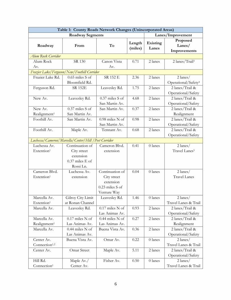
Table 1: County Roads Network Changes (Unincorporated Areas) Roadway Segments Lanes/Improvement
Roadway From To Length (miles)
Existing Lanes
Proposed Lanes/
Improvements Alum Rock Corridor
Alum Rock Av.
SR 130 Canon Vista Av.
0.71
2 lanes 2 lanes/Trail3
Frazier Lake/Ferguson/New/Foothill Corridor Frazier Lake Rd. 0.65 miles S of
Bloomfield Rd. SR 152 E 2.36 2 lanes 2 lanes/
Operational/Safety4 Ferguson Rd. SR 152E Leavesley Rd. 1.75 2 lanes 2 lanes/Trail &
Operational/Safety New Av. Leavesley Rd. 0.37 miles S of
San Martin Av. 4.68 2 lanes 2 lanes/Trail &
Operational/Safety
New Av. Realignment1
0.37 miles S of San Martin Av.
San Martin Av. 0.37 2 lanes 2 lanes/Trail & Realignment
Foothill Av. San Martin Av. 0.98 miles N of San Martin Av.
0.98 2 lanes 2 lanes/Trail & Operational/Safety
Foothill Av. Maple Av. Tennant Av. 0.68 2 lanes 2 lanes/Trail & Operational/Safety
Luchessa/Cameron/Marcella/Center/Hill /Peet Corridor Luchessa Av. Extention1
Continuation of City street extension
0.37 miles E of Rossi Ln.
Cameron Blvd. extension
0.41 0 lanes 2 lanes/ Travel Lanes5
Cameron Blvd. Extention1
Luchessa Av. extension
Continuation of City street extension
0.23 miles S of Venture Way
0.04 0 lanes 2 lanes/ Travel Lanes
Marcella Av. Extention1
Gilroy City Limit at Ronan Channel
Leavesley Rd. 1.46 0 lanes 2 lanes/ Travel Lanes & Trail
Marcella Av. Leavesley Rd. 0.17 miles N of Las Animas Av.
0.93 2 lanes 2 lanes/Trail & Operational/Safety
Marcella Av. Realignment1
0.17 miles N of Las Animas Av.
0.44 miles N of Las Animas Av.
0.27 2 lanes 2 lanes/Trail & Realignment
Marcella Av. 0.44 miles N of Las Animas Av.
Buena Vista Av. 0.36 2 lanes 2 lanes/Trail & Operational/Safety
Center Av. Connection1,2
Buena Vista Av. Omar Av. 0.22 0 lanes 2 lanes/ Travel Lanes & Trail
Center Av. Omar Street Maple Av. 5.11 2 lanes 2 lanes/Trail & Operational/Safety
Hill Rd. Connection1
Maple Av./ Center Av.
Fisher Av. 0.50 0 lanes 2 lanes/ Travel Lanes & Trail
6
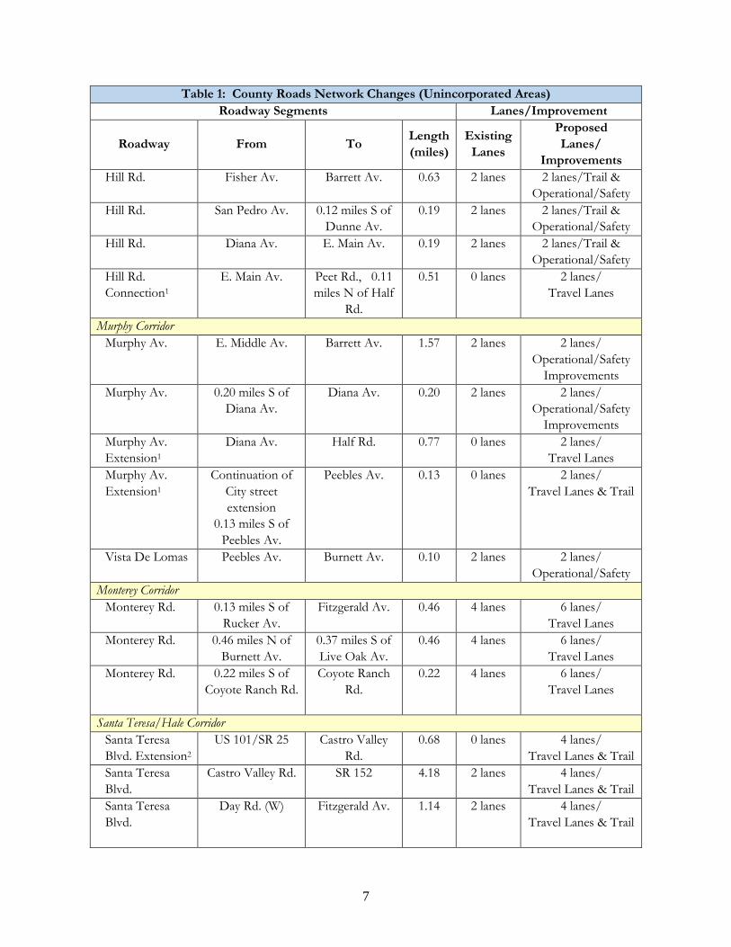
Table 1: County Roads Network Changes (Unincorporated Areas) Roadway Segments Lanes/Improvement
Roadway From To Length (miles)
Existing Lanes
Proposed Lanes/
Improvements Hill Rd. Fisher Av. Barrett Av. 0.63 2 lanes 2 lanes/Trail &
Operational/Safety Hill Rd. San Pedro Av. 0.12 miles S of
Dunne Av. 0.19 2 lanes 2 lanes/Trail &
Operational/Safety Hill Rd. Diana Av. E. Main Av. 0.19 2 lanes 2 lanes/Trail &
Operational/Safety Hill Rd. Connection1
E. Main Av.
Peet Rd., 0.11 miles N of Half
Rd.
0.51 0 lanes 2 lanes/ Travel Lanes
Murphy Corridor Murphy Av. E. Middle Av. Barrett Av. 1.57 2 lanes 2 lanes/
Operational/Safety Improvements
Murphy Av. 0.20 miles S of Diana Av.
Diana Av. 0.20 2 lanes 2 lanes/ Operational/Safety
Improvements Murphy Av. Extension1
Diana Av. Half Rd. 0.77 0 lanes 2 lanes/ Travel Lanes
Murphy Av. Extension1
Continuation of City street extension
0.13 miles S of Peebles Av.
Peebles Av. 0.13 0 lanes 2 lanes/ Travel Lanes & Trail
Vista De Lomas Peebles Av. Burnett Av. 0.10 2 lanes 2 lanes/ Operational/Safety
Monterey Corridor Monterey Rd. 0.13 miles S of
Rucker Av. Fitzgerald Av. 0.46 4 lanes 6 lanes/
Travel Lanes Monterey Rd. 0.46 miles N of
Burnett Av. 0.37 miles S of Live Oak Av.
0.46 4 lanes 6 lanes/ Travel Lanes
Monterey Rd. 0.22 miles S of Coyote Ranch Rd.
Coyote Ranch Rd.
0.22 4 lanes 6 lanes/ Travel Lanes
Santa Teresa/Hale Corridor Santa Teresa Blvd. Extension2
US 101/SR 25 Castro Valley Rd.
0.68 0 lanes 4 lanes/ Travel Lanes & Trail
Santa Teresa Blvd.
Castro Valley Rd. SR 152 4.18 2 lanes 4 lanes/ Travel Lanes & Trail
Santa Teresa Blvd.
Day Rd. (W) Fitzgerald Av. 1.14 2 lanes 4 lanes/ Travel Lanes & Trail
7
Table 1: County Roads Network Changes (Unincorporated Areas) Roadway Segments Lanes/Improvement
Roadway From To Length (miles)
Existing Lanes
Proposed Lanes/
Improvements Santa Teresa Blvd.
Fitzgerald Av. Watsonville Rd. 3.87 2 lanes 2 lanes/Trail & Operational/Safety
DeWitt Av. Connection1
Sunnyside Av. 0.05 miles S of W. Edmundson Av.
DeWitt Av. 0.18 miles N of W. Edmundson
Av.
0.33 0 lanes 2 lanes/ Travel Lanes & Trail
DeWitt Av. 0.18 miles N of W. Edmundson
Av.
Spring Av. 0.67 2 lanes 2 lanes/Trail & Operational/Safety
Hale Av. Tilton Av. Palm Av. 2.60 2 lanes 4 lanes/ Travel Lanes & Trail
Santa Teresa Blvd.
Palm Av. 0.19 miles N of Laguna Av.
1.48 2 lanes 4 lanes/ Travel Lanes & Trail
Watsonville/Uvas/McKean Corridor Watsonville Rd. SR 152 Uvas Rd. 3.66 2 lanes 2 lanes/Trail &
Operational/Safety Watsonville Rd. Uvas Rd. 0.18 miles S of
Santa Teresa Blvd.
2.67 2 lanes 2 lanes/Trail & Operational/Safety
Watsonville Rd. 0.13 miles S of Olive Av.
Monterey Rd. 0.64 2 lanes 2 lanes/Trail & Operational/Safety
Uvas Rd. Watsonville Rd. McKean Rd. 9.76 2 lanes 2 lanes/Trail & Operational/Safety
McKean Rd. 0.75 miles N of Uvas Rd.
Uvas Rd. 0.75 2 lanes 2 lanes/Trail & Operational/Safety
McKean Rd. Realignment1
0.16 miles S of Cherry Canyon
Rd.
0.21 miles N of Cherry Canyon
Rd.
0.32 0 lanes 2 lanes/ Travel Lanes & Trail
McKean Rd. 2.99 miles SE of Harry Rd.
0.48 miles SE of Harry Rd.
2.51 2 lanes 2 lanes/Trail & Operational/Safety
McKean Rd. Realignment1
0.48 miles SE of Harry Rd.
Almaden Expwy.
0.5 0 lanes 2 lanes/ Travel Lanes
East-West Corridors Palm Av. Hale Av. SP Railroad 0.76 2 lanes 2 lanes/
Operational/Safety Live Oak Av. Hale Av. SP Railroad 0.67 2 lanes 2 lanes/
Operational/Safety Cochrane Rd. E Main Av. Half Rd. 0.38 2 lanes 2 lanes/Trail &
Operational/Safety Cochrane Rd. 0.25 miles N of
Half Rd.
0.59 miles N of Half Rd.
0.34 2 lanes 2 lanes/Trail & Operational/Safety
8
Table 1: County Roads Network Changes (Unincorporated Areas) Roadway Segments Lanes/Improvement
Roadway From To Length (miles)
Existing Lanes
Proposed Lanes/
Improvements E. Main Av. 0.03 miles E of
Laurel Rd. Cochrane Rd. 1.36 2 lanes 2 lanes/Trail &
Operational/Safety Tennant Av. Condit Rd. Foothill Av. 1.35 2 lanes 2 lanes/
Operational/Safety E. Middle Av. 0.32 miles W of
Llagas Av. Center Av. 1.52 2 lanes 2 lanes/
Operational/Safety San Martin Av. Santa Teresa Blvd. New Av. 2.88 2 lanes 2 lanes/Trail &
Operational/Safety Church Av. Monterey Rd. Center Av. 1.39 2 lanes 2 lanes/
Operational/Safety Fitzgerald Av. Turlock Av. Monterey Rd. 0.83 2 lanes 2 lanes/
Operational/Safety Masten Av. Monterey Rd. US 101 0.69 2 lanes 4 lanes/
Travel Lanes Masten Av. US 101 Center Av. 0.38 2 lanes 2 lanes/
Operational/Safety Buena Vista Av. Extension1
Santa Teresa Blvd. Monterey Rd. 0.69 0 lanes 4 lanes/ Travel Lanes & Trail
Buena Vista Av. Monterey Rd. US 101
0.61 2 lanes 4 lanes/ Travel Lanes & Trail
Buena Vista Av. US 101
New Av.
0.61 2 lanes 2 lanes/ Trail &
Operational/Safety Redwood Retreat Rd.
Mt. Madonna Rd. Watsonville Rd. 3.23 2 lanes 2 lanes/Trail
Leavesley Rd. 0.10 miles W of Marcella Av.
Marcella Av. 0.10 2 lanes 2 lanes/ Operational/Safety
Leavesley Rd. Marcella Av. Ferguson Rd. 1.43 2 lanes 2 lanes/Trail & Operational/Safety
Canada Rd. SR 152 Angelo Ln. 1.02 2 lanes 2 lanes/Trail Bloomfield Rd. SR 25 SR 152 3.25 2 lanes 2 lanes/Trail &
Operational/Safety Notes: 1 New road extension/connection or realignment. 2 Includes new bridge/creek crossing. 3 Multi-purpose trail improvements may also include bike routes and landscaping. 4 “Operational/Safety” improvements may include turn-lanes, medians, increased lane widths, shoulder
improvements, or other similar vehicular improvements. 5 “Travel Lanes” improvements include additional vehicular travel lanes to increase roadway vehicle capacity.
9
COUNTY EXPRESSWAY IMPROVEMENTS FIGURE 3
2802828
88088888888
28028028000
171717
68068068066
68068068
237237237
Legend
Full or Partial Grade Separation/Interchange
Intersection Improvement for LOS
Intersection Improvements for Safety/Operations
Expressway Widening for Capacity/LOS
Expressway Widening for Safety/Operations
Freeway Interchange Improvements
Close Median/Remove Signal
Trail Improvements
Convert HOV to mixed use
Notes:
1) Intersection improvements include addition and/or extension of turn lanes, signalization changes, and/or intersection recon gurations to improve level of service (LOS) or operations/safety.
2) Bicycle, pedestrian, signal and sound wall improvements will be planned for various segments and intersections in addition to the improvement locations shown on the map.
HOV to HOV Connections
Expressway Improvements Map
Notes:1) Intersection improvements include addition and/or extension of turn lanes, signalization changes, and/or intersection reconfigurations to improve level of service (LOS) or operations/safety.2) Bicycle, pedestrian, signal and sound wall improvements will be planned for various segments and intersections in addition to the improvement locations shown on the map.
Alma
El Camino Real
Hanover
Pruneridge
Walsh
Monroe
El Camino
Homestead
Stevens Creek
Moorpark
Hamilton
Campbell
Rengstorff
Ferguson
Bowers
Scott Lafayette
LRT
North Mary
De La Cruz
Moffett
Castro
McCarthyO’Toole
Main
Great Mall Capitol
PectenNorth First
Trimble
Trade ZoneOakland
Park Victoria
Zanker
MissionCollege
I-280 Ramps
San Antonio
El Monte
Springer
Magdalena
Arastr
adero
Homestead
Capitol
Story
Silver Creek
Senter
Snell
Canoas Garden
Foxworthy
Coleman
Camden
Blossom Hill
Kifer
Reed
Benton
HomesteadLochinvar
Pruneridge
Tasman
Duane
Arques
WildwoodUS 101
MoorparkBollinger
Cabrillo
Oakmead
Monroe
Stevens Creek
ALM
ADEN
CAPITOL
FOOTHILL
OREG
ON -
PAGE
MIL
L
LAW
REN
CE
CENTRAL
SAN
TO
MAS
MONTAGUE
Table 2: County Expressway Modifications Expressway Location Description
Expressway Location Modification Purpose/Type Almaden Camden Intersection improvements Operations/Safety
Coleman to Blossom Hill
Widen from 6 to 8 lanes Capacity/Level of Service (LOS)
Blossom Hill Grade separation Capacity/LOS SB 85 Off-Ramp Add flyover direct connection to
expressway Operations/Safety
Foxworthy Intersection improvements Capacity/LOS Canoas Garden Add at-grade pedestrian crossing Operations/Safety
Capitol I-680 to Capitol Avenue
Widen from 6 to 8 lanes Capacity/LOS
Capitol Avenue to Story
Maintain 8 lanes after Light Rail Transit (LRT) construction
Capacity/LOS
Story Intersection improvements Capacity/LOS Silver Creek Grade separation Operations/Safety
US 101 Interchange HOV to HOV Connection Operations/Safety Senter Grade separation Capacity/LOS Snell Intersection improvements Capacity/LOS
Central De La Cruz to Bowers Convert WB HOV lane to mixed use lane; start EB HOV lane east of Bowers
Capacity/LOS
Lafayette Grade separation Capacity/LOS Scott Grade separation Capacity/LOS
Bowers Grade separation Capacity/LOS San Tomas
Expressway to Lawrence Expressway
Widen from 4 to 6 lanes Capacity/LOS
Lawrence to Mary Add EB and WB auxiliary lanes Operations/Safety Mary Intersection improvements Capacity/LOS
Mary to Ferguson Widen from 4 to 6 lanes Capacity/LOS LRT crossing near
Whisman Depress Central under LRT tracks Operations/Safety
Moffett/Castro Grade separate Caltrain tracks from Moffett/Castro with corresponding grade changes for Central
Capacity/LOS
Rengstorff Grade separate Caltrain tracks and expressway intersection
Capacity/LOS
Foothill SB 280 Off-Ramp Intersection improvements Operations/Safety SB 280 Off-Ramp to
Homestead Stevens Creek Trail along EB Foothill Operations/Safety
NB 280 Off-Ramp Extend WB right turn lane and add WB auxiliary lane to Homestead
Capacity/LOS
Magdalena/Springer Intersection improvements Operations/Safety
11
Table 2: County Expressway Modifications Expressway Location Description
Expressway Location Modification Purpose/Type El Monte to San
Antonio Widen from 4 to 6 lanes by extending right turn lanes and intersection improvements at El Monte and San Antonio
Capacity/LOS
Arastradero Grade separation Capacity/LOS Lawrence Moorpark/Bollinger Intersection improvements Capacity/LOS
Moorpark to I-280 Widen from 6 to 8 lanes Capacity/LOS Lawrence/Stevens
Creek/I-280 Interchange
Provide direct connections between Lawrence and I-280
Capacity/LOS
I-280 Interchange HOV to HOV Connection Operations/Safety Stevens Creek to
Cabrillo Close right-in and right-out access points Operations/Safety
Pruneridge Grade separation Capacity/LOS Homestead Grade separation Capacity/LOS Lochinvar Close median/remove signal Capacity/LOS
Benton Grade separation Capacity/LOS Cabrillo Grade separation Capacity/LOS
Reed/Monroe to Arques
Grade separate per Lawrence Expressway Concept Plan
Capacity/LOS
Oakmead/Duane to US 101
Convert SB HOV lane to mixed use Capacity/LOS
US 101 Interchange HOV to HOV Connection Operations/Safety Wildwood Intersection improvements Operations/Safety Tasman Grade separate LRT from intersection Capacity/LOS SR 237 Widen overpass and add auxiliary lane Operations/Safety
Montague Dempsey to Pectin Widen from 4 to 6 lanes including modifications to I-680 interchange for widening
Capacity/LOS
Great Mall to Trade Zone
Widen from 6 to 8 lanes (HOV lanes) Capacity/LOS
Trade Zone to Main/Oakland
Add EB auxiliary lane Capacity/LOS
Main/Oakland to McCarthy/O’Toole
Widen from 6 to 8 lanes (HOV lane in WB only) including modifications to I-880 interchange for widening
Capacity/LOS
I-880 Interchange HOV to HOV Connection Operations/Safety McCarthy-O’Toole Grade separation Capacity/LOS
Trimble Partial grade separation Capacity/LOS Zanker Partial grade separation Capacity/LOS
North First Grade separate LRT/North First from Montague
Capacity/LOS
Mission College Partial grade separation Capacity/LOS
12
Table 2: County Expressway Modifications Expressway Location Description
Expressway Location Modification Purpose/Type US 101 Interchange Interchange reconfiguration Capacity/LOS US 101 Interchange HOV to HOV Connection Operations/Safety
Oregon- Page Mill
I-280 Interchange Interchange modifications Operations/Safety I-280 to El Camino
Real Widen from 4 to 6 lanes Capacity/LOS
Foothill/Junipero Serra Blvd
Grade separation Capacity/LOS
Hanover Intersection improvements Capacity/LOS El Camino Real Intersection improvements Operations/Safety
Alma Bridge Structures
Reconstruct and modify Operations/Safety
US 101/ Embarcadero/
Oregon Interchange
Interchange modification Capacity/LOS
San Tomas SR 17 Interchange Interchange modifications Capacity/LOS Campbell to Homestead
Widen from 6 to 8 lanes Capacity/LOS
Hamilton Grade separation Capacity/LOS Moorpark Intersection improvements Capacity/LOS
I-280 HOV to HOV Connection Operations/Safety Stevens Creek Grade separation Capacity/LOS
Stevens Creek to Homestead
Extend San Tomas Aquino Spur Trail on west side of expressway
Operations/Safety
Pruneridge Intersection improvements Capacity/LOS El Camino Real Grade separation Capacity/LOS
Monroe Intersection improvements Capacity/LOS Walsh Grade separation Capacity/LOS
Expressway System
Various locations along expressways and various intersections
Bicycle, pedestrian, signal, and sound wall improvements
Operations/Safety
Notes: SB = Southbound, NB = Northbound, WB = Westbound, EB = Eastbound: HOV = High Occupancy Vehicle “Intersection improvements” include addition and/or extension of turning lanes, signalization changes, and/or intersection reconfigurations to improve level of service or operations/safety. Possible projects listed include larger-scale improvements that could result in substantial physical disturbance and/or otherwise change the capacity of an expressway. Modifications or changes to expressways (major and minor) identified at a program-level in the Circulation and Mobility Element would require project-level environmental review prior to construction.
13
The strategies and policies in the Circulation and Mobility Element Update will address right-of-way dedication and street improvements as part of new development, funding, timing, and private roads. The Santa Clara County Complete Streets Policy (November 2012) will be integrated into the Circulation and Mobility Element Update. Utilities policies and information in the Circulation and Mobility Element Update will consider the location and extent of sewer, water and drainage line and facilities, fuel and natural gas pipelines, power plants, transmission lines and corridors, telecommunication cables and corridors, proposed or state identified transmission line corridors, renewable and non-renewable energy and energy storage. Development, improvement, and current and future locations of these facilities and any conflicts will be addressed. Policies for airports under Santa Clara County’s jurisdiction (Reid-Hillview, Palo Alto, and South County Airports) will be included in the Circulation and Mobility Element Update. The focus of these policies will be development and improvement of aviation facilities as considered in each airport’s Master Plan, and consistency with the provisions of each airport’s Comprehensive Land Use Plan (addressing compatibility of land uses around each airport), and access to and from aviation facilities. Consistency with plans for other airports within the County (e.g., Norman Y. Mineta San José International Airport and Moffett Federal Airfield) will also be addressed. 4. Potential Environmental Impacts of the Project The potential physical environmental impacts of implementing the Circulation and Mobility Element Update will fall into two main categories: 1) the impacts associated with future construction of new or expanded roadway or circulation facilities; and 2) the anticipated impacts associated with implementation of circulation and mobility policies. As a program-level planning document, the Circulation and Mobility Element provides generalized locations for new transportation or utility facility modifications. The level of analysis in the Program EIR will be commensurate with the level of detail available. Project-level environmental review would be required prior to construction of the planned roadway modifications identified in the Circulation and Mobility Element. Implementation of the Circulation and Mobility Element Update and associated individual projects over time may result in the following impacts: Aesthetics, including the visual change resulting from new facilities in the context of existing rural landscapes, visually sensitive locations, and existing scenic resources. Agricultural and Forestry Resources, including the potential for planned facilities to develop or otherwise adversely affect farmland or forestry resources. Air Quality, including project consistency with the Clean Air Plan, the potential for increased vehicle miles traveled (VMT) and associated criteria air pollutant emissions, and temporary air quality impacts during construction.
14
Biological Resources, including the potential for planned facilities to affect protected plants, animals, and habitats, and project consistency with the Santa Clara Valley Habitat Plan (VHP). Cultural Resources, including the potential for the construction of planned facilities to disturb archaeological, paleontological, and/or historic resources. Energy, including the potential for increased VMT and associated increase in energy use and energy use during the construction and maintenance of planned roadway facilities. Geology and Soils, including the potential for planned facilities to be affected by seismic, soil, or geology constraints. Greenhouse Gas Emissions, including project consistency with the County of Santa Clara Climate Action Plan and State and regional plans, the potential for increased VMT and associated greenhouse gas emissions, and the vulnerabilities of existing and planned infrastructure to the effects of climate change (e.g., rising sea levels). Hazards and Hazardous Materials, including the transport of hazardous materials on the existing and planned roadway network, consistency with adopted airport land use plans related to safety, the ability of the existing and planned roadway network to support emergency response, and the potential for hazardous materials to be encountered during construction of planned facilities. Hydrology and Water Quality, including the potential for planned facilities to increase runoff or adversely affect water quality, groundwater, drainage patterns, or be affected by flooding. Land Use, including the potential for planned facilities or facility modifications to disrupt or divide communities, conflict with adopted plans or policies, or adversely affect adjacent land uses. Noise, including noise increases from new or expanded facilities and construction noise. Population and Housing, including the potential for inducing population growth in an area through the expansion or extension of roadway facilities and/or utility infrastructure. Public Services and Recreation, including the potential for new or expanded facilities to result in significant environmental effects on public services or recreational facilities. Transportation, including the effects of the Circulation and Mobility Element Update on vehicular, bicycle, and pedestrian circulation and safety based on forecasted changes to County-wide circulation patterns, and project consistency with applicable adopted transportation plans, policies, and programs taking into account all modes of transportation. Utilities and Service Systems, including construction of new or expanded facilities that could result in significant environmental effects.
15

Alternatives to the Project The EIR will evaluate possible alternatives to the proposed project, based on the results of the environmental analysis. The alternative discussion will focus on those alternatives that could feasibly accomplish most of the basic purposes of the project and could avoid or substantially lessen one or more of the significant environmental impacts of the project (CEQA Guidelines Section 15126.6). Alternatives to the project as proposed, including “No Project” will be discussed. Other alternatives to be evaluated may include Modified Project Components Alternatives (e.g., modified Circulation and Mobility Element policies) or Location Alternatives of planned improvements that result in significant impacts. Cumulative Impacts The EIR will include a Cumulative Impacts section which will address the significant cumulative impacts of the Circulation and Mobility Element Update when considered with other past, present and reasonably foreseeable future general plan amendments in the area.
Growth Inducing Impacts The EIR will discuss the ways in which the project could foster economic or population growth, or the construction of additional housing, either directly or indirectly, in the surrounding area. Other CEQA Sections The EIR will include other sections required by CEQA, including Significant Unavoidable Impacts, Significant Irreversible Environmental Changes, Lead Agency and Consultants, and References. Relevant technical reports (e.g., traffic, air quality, and noise analyses) will be attached as appendices to the EIR.
16