Embed Size (px)
Citation preview
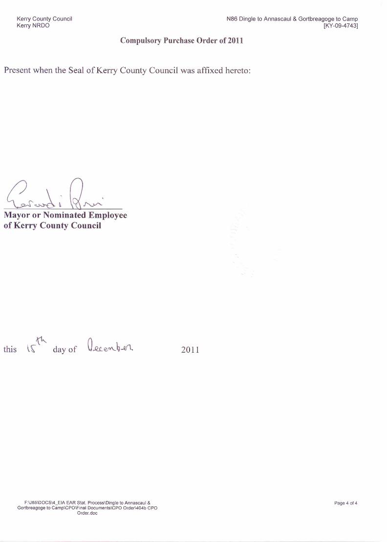
Kerry County Council Kerry NRDO
N86 Dingle to Annascaul & Gortbreagoge to Camp [KY-09-4743]
F:\J65\DOCS\4_EIA EAR Stat. Process\Dingle to Annascaul & Gortbreagoge to Camp\CPO\Final Documents\404b Schedule.docx
Page 1 of 88
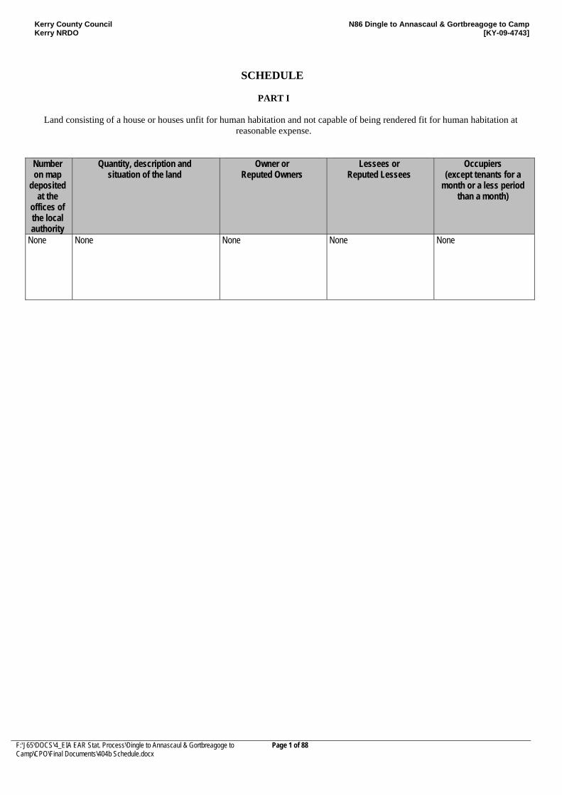
SCHEDULE
PART I
Land consisting of a house or houses unfit for human habitation and not capable of being rendered fit for human habitation at reasonable expense.
Number on map
deposited at the
offices of the local authority
Quantity, description and situation of the land
Owner or Reputed Owners
Lessees or Reputed Lessees
Occupiers (except tenants for a
month or a less period than a month)
None None
None
None
None
Kerry County Council Kerry NRDO
N86 Dingle to Annascaul & Gortbreagoge to Camp [KY-09-4743]
F:\J65\DOCS\4_EIA EAR Stat. Process\Dingle to Annascaul & Gortbreagoge to Camp\CPO\Final Documents\404b Schedule.docx
Page 2 of 88
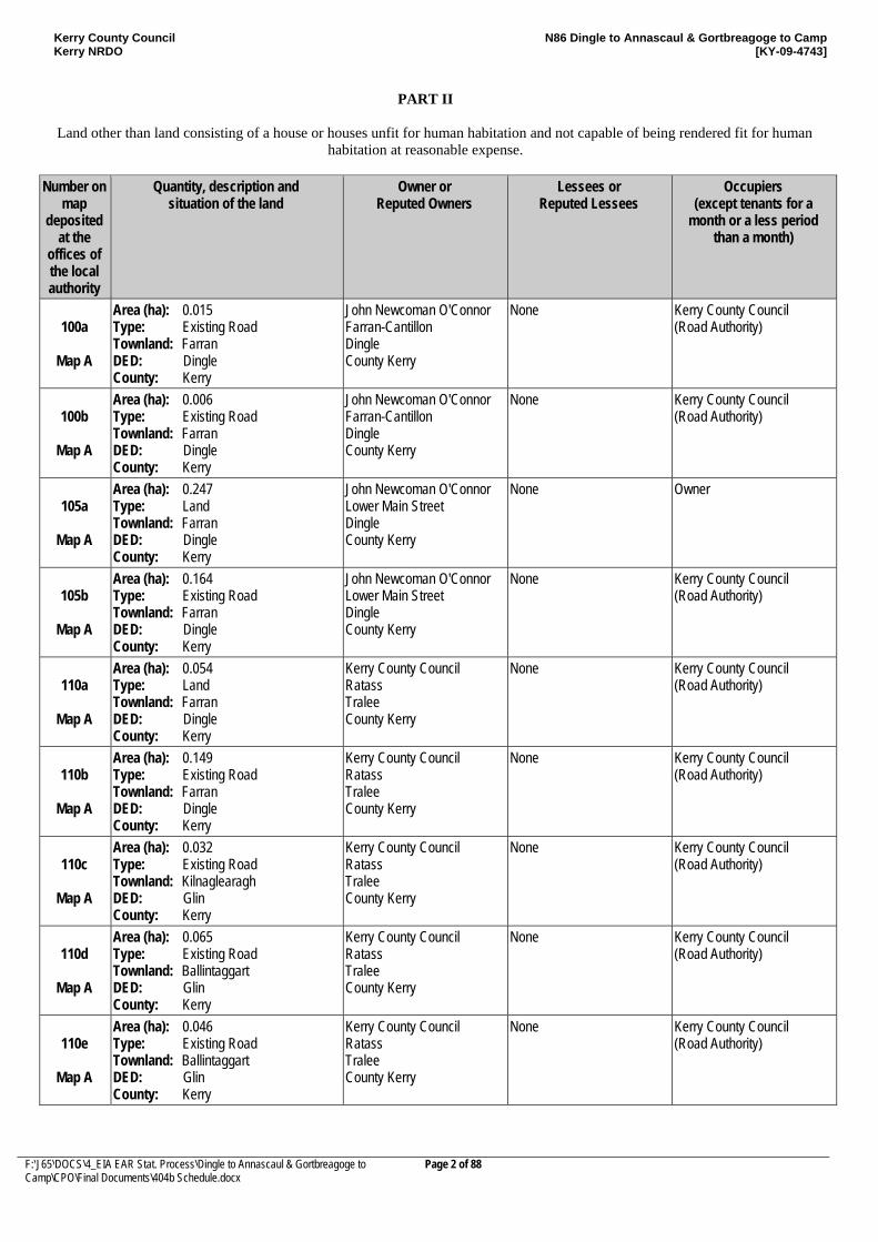
PART II
Land other than land consisting of a house or houses unfit for human habitation and not capable of being rendered fit for human
habitation at reasonable expense.
Number on map
deposited at the
offices of the local authority
Quantity, description and situation of the land
Owner or Reputed Owners
Lessees or Reputed Lessees
Occupiers (except tenants for a
month or a less period than a month)
100a
Map A
Area (ha): 0.015 Type: Existing Road Townland: Farran DED: Dingle County: Kerry
John Newcoman O'Connor Farran-Cantillon Dingle County Kerry
None Kerry County Council (Road Authority)
100b
Map A
Area (ha): 0.006 Type: Existing Road Townland: Farran DED: Dingle County: Kerry
John Newcoman O'Connor Farran-Cantillon Dingle County Kerry
None Kerry County Council (Road Authority)
105a
Map A
Area (ha): 0.247 Type: Land Townland: Farran DED: Dingle County: Kerry
John Newcoman O'Connor Lower Main Street Dingle County Kerry
None Owner
105b
Map A
Area (ha): 0.164 Type: Existing Road Townland: Farran DED: Dingle County: Kerry
John Newcoman O'Connor Lower Main Street Dingle County Kerry
None Kerry County Council (Road Authority)
110a
Map A
Area (ha): 0.054 Type: Land Townland: Farran DED: Dingle County: Kerry
Kerry County Council Ratass Tralee County Kerry
None Kerry County Council (Road Authority)
110b
Map A
Area (ha): 0.149 Type: Existing Road Townland: Farran DED: Dingle County: Kerry
Kerry County Council Ratass Tralee County Kerry
None Kerry County Council (Road Authority)
110c
Map A
Area (ha): 0.032 Type: Existing Road Townland: Kilnaglearagh DED: Glin County: Kerry
Kerry County Council Ratass Tralee County Kerry
None Kerry County Council (Road Authority)
110d
Map A
Area (ha): 0.065 Type: Existing Road Townland: Ballintaggart DED: Glin County: Kerry
Kerry County Council Ratass Tralee County Kerry
None Kerry County Council (Road Authority)
110e
Map A
Area (ha): 0.046 Type: Existing Road Townland: Ballintaggart DED: Glin County: Kerry
Kerry County Council Ratass Tralee County Kerry
None Kerry County Council (Road Authority)
Kerry County Council Kerry NRDO
N86 Dingle to Annascaul & Gortbreagoge to Camp [KY-09-4743]
F:\J65\DOCS\4_EIA EAR Stat. Process\Dingle to Annascaul & Gortbreagoge to Camp\CPO\Final Documents\404b Schedule.docx
Page 3 of 88
Number on map
deposited at the
offices of the local authority
Quantity, description and situation of the land
Owner or Reputed Owners
Lessees or Reputed Lessees
Occupiers (except tenants for a
month or a less period than a month)
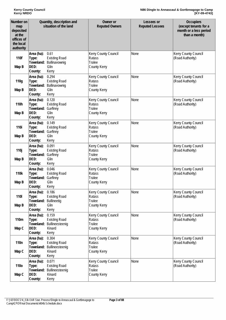
110f
Map B
Area (ha): 0.61 Type: Existing Road Townland: Ballinavownig DED: Glin County: Kerry
Kerry County Council Ratass Tralee County Kerry
None Kerry County Council (Road Authority)
110g
Map B
Area (ha): 0.294 Type: Existing Road Townland: Ballinavownig DED: Glin County: Kerry
Kerry County Council Ratass Tralee County Kerry
None Kerry County Council (Road Authority)
110h
Map B
Area (ha): 0.120 Type: Existing Road Townland: Garfinny DED: Glin County: Kerry
Kerry County Council Ratass Tralee County Kerry
None Kerry County Council (Road Authority)
110i
Map B
Area (ha): 0.149 Type: Existing Road Townland: Garfinny DED: Glin County: Kerry
Kerry County Council Ratass Tralee County Kerry
None Kerry County Council (Road Authority)
110j
Map B
Area (ha): 0.091 Type: Existing Road Townland: Garfinny DED: Glin County: Kerry
Kerry County Council Ratass Tralee County Kerry
None Kerry County Council (Road Authority)
110k
Map B
Area (ha): 0.046 Type: Existing Road Townland: Garfinny DED: Glin County: Kerry
Kerry County Council Ratass Tralee County Kerry
None Kerry County Council (Road Authority)
110l
Map B
Area (ha): 0.186 Type: Existing Road Townland: Ballineetig DED: Glin County: Kerry
Kerry County Council Ratass Tralee County Kerry
None Kerry County Council (Road Authority)
110m
Map C
Area (ha): 0.159 Type: Existing Road Townland: Ballineesteenig DED: Kinard County: Kerry
Kerry County Council Ratass Tralee County Kerry
None Kerry County Council (Road Authority)
110n
Map C
Area (ha): 0.304 Type: Existing Road Townland: Ballineesteenig DED: Kinard County: Kerry
Kerry County Council Ratass Tralee County Kerry
None Kerry County Council (Road Authority)
110o
Map C
Area (ha): 0.071 Type: Existing Road Townland: Ballineesteenig DED: Kinard County: Kerry
Kerry County Council Ratass Tralee County Kerry
None Kerry County Council (Road Authority)
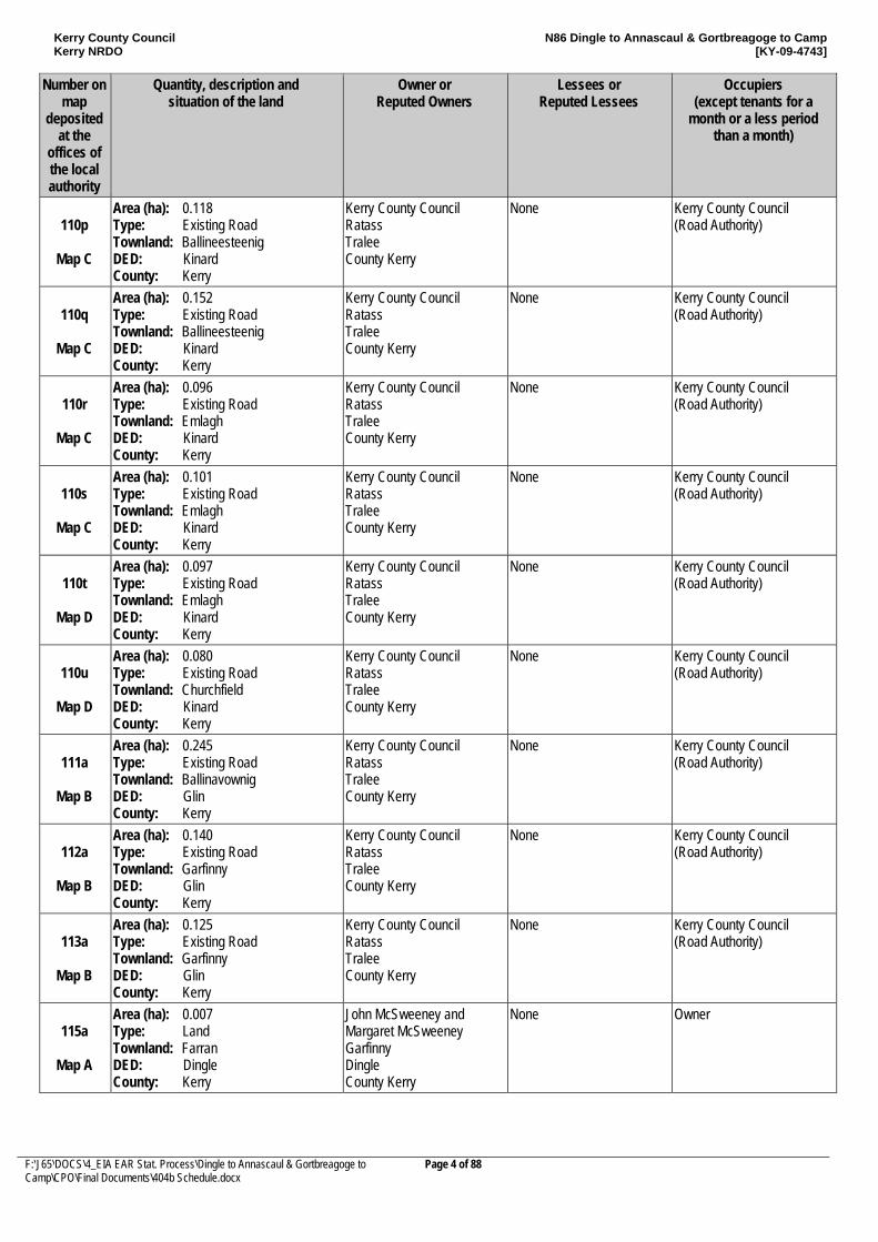
Kerry County Council Kerry NRDO
N86 Dingle to Annascaul & Gortbreagoge to Camp [KY-09-4743]
F:\J65\DOCS\4_EIA EAR Stat. Process\Dingle to Annascaul & Gortbreagoge to Camp\CPO\Final Documents\404b Schedule.docx
Page 4 of 88
Number on map
deposited at the
offices of the local authority
Quantity, description and situation of the land
Owner or Reputed Owners
Lessees or Reputed Lessees
Occupiers (except tenants for a
month or a less period than a month)
110p
Map C
Area (ha): 0.118 Type: Existing Road Townland: Ballineesteenig DED: Kinard County: Kerry
Kerry County Council Ratass Tralee County Kerry
None Kerry County Council (Road Authority)
110q
Map C
Area (ha): 0.152 Type: Existing Road Townland: Ballineesteenig DED: Kinard County: Kerry
Kerry County Council Ratass Tralee County Kerry
None Kerry County Council (Road Authority)
110r
Map C
Area (ha): 0.096 Type: Existing Road Townland: Emlagh DED: Kinard County: Kerry
Kerry County Council Ratass Tralee County Kerry
None Kerry County Council (Road Authority)
110s
Map C
Area (ha): 0.101 Type: Existing Road Townland: Emlagh DED: Kinard County: Kerry
Kerry County Council Ratass Tralee County Kerry
None Kerry County Council (Road Authority)
110t
Map D
Area (ha): 0.097 Type: Existing Road Townland: Emlagh DED: Kinard County: Kerry
Kerry County Council Ratass Tralee County Kerry
None Kerry County Council (Road Authority)
110u
Map D
Area (ha): 0.080 Type: Existing Road Townland: Churchfield DED: Kinard County: Kerry
Kerry County Council Ratass Tralee County Kerry
None Kerry County Council (Road Authority)
111a
Map B
Area (ha): 0.245 Type: Existing Road Townland: Ballinavownig DED: Glin County: Kerry
Kerry County Council Ratass Tralee County Kerry
None Kerry County Council (Road Authority)
112a
Map B
Area (ha): 0.140 Type: Existing Road Townland: Garfinny DED: Glin County: Kerry
Kerry County Council Ratass Tralee County Kerry
None Kerry County Council (Road Authority)
113a
Map B
Area (ha): 0.125 Type: Existing Road Townland: Garfinny DED: Glin County: Kerry
Kerry County Council Ratass Tralee County Kerry
None Kerry County Council (Road Authority)
115a
Map A
Area (ha): 0.007 Type: Land Townland: Farran DED: Dingle County: Kerry
John McSweeney and Margaret McSweeney Garfinny Dingle County Kerry
None Owner
Kerry County Council Kerry NRDO
N86 Dingle to Annascaul & Gortbreagoge to Camp [KY-09-4743]
F:\J65\DOCS\4_EIA EAR Stat. Process\Dingle to Annascaul & Gortbreagoge to Camp\CPO\Final Documents\404b Schedule.docx
Page 5 of 88
Number on map
deposited at the
offices of the local authority
Quantity, description and situation of the land
Owner or Reputed Owners
Lessees or Reputed Lessees
Occupiers (except tenants for a
month or a less period than a month)
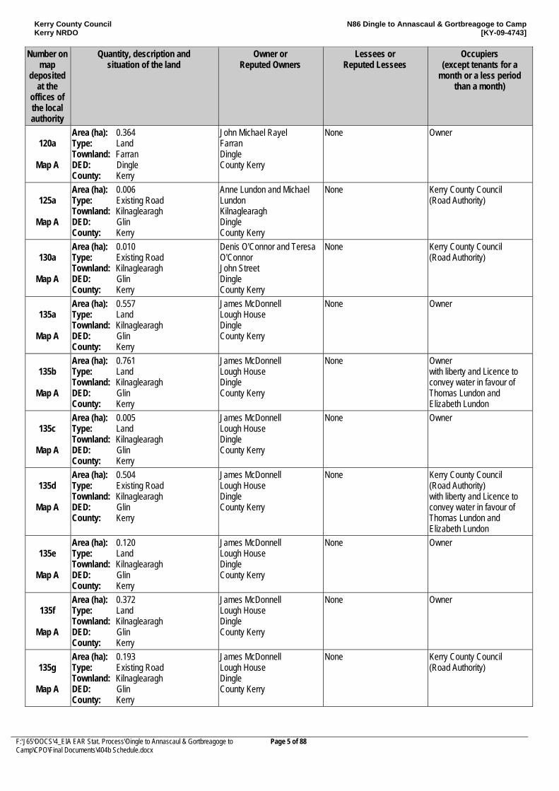
120a
Map A
Area (ha): 0.364 Type: Land Townland: Farran DED: Dingle County: Kerry
John Michael Rayel Farran Dingle County Kerry
None Owner
125a
Map A
Area (ha): 0.006 Type: Existing Road Townland: Kilnaglearagh DED: Glin County: Kerry
Anne Lundon and Michael Lundon Kilnaglearagh Dingle County Kerry
None Kerry County Council (Road Authority)
130a
Map A
Area (ha): 0.010 Type: Existing Road Townland: Kilnaglearagh DED: Glin County: Kerry
Denis O'Connor and Teresa O'Connor John Street Dingle County Kerry
None Kerry County Council (Road Authority)
135a
Map A
Area (ha): 0.557 Type: Land Townland: Kilnaglearagh DED: Glin County: Kerry
James McDonnell Lough House Dingle County Kerry
None Owner
135b
Map A
Area (ha): 0.761 Type: Land Townland: Kilnaglearagh DED: Glin County: Kerry
James McDonnell Lough House Dingle County Kerry
None Owner with liberty and Licence to convey water in favour of Thomas Lundon and Elizabeth Lundon
135c
Map A
Area (ha): 0.005 Type: Land Townland: Kilnaglearagh DED: Glin County: Kerry
James McDonnell Lough House Dingle County Kerry
None Owner
135d
Map A
Area (ha): 0.504 Type: Existing Road Townland: Kilnaglearagh DED: Glin County: Kerry
James McDonnell Lough House Dingle County Kerry
None Kerry County Council (Road Authority) with liberty and Licence to convey water in favour of Thomas Lundon and Elizabeth Lundon
135e
Map A
Area (ha): 0.120 Type: Land Townland: Kilnaglearagh DED: Glin County: Kerry
James McDonnell Lough House Dingle County Kerry
None Owner
135f
Map A
Area (ha): 0.372 Type: Land Townland: Kilnaglearagh DED: Glin County: Kerry
James McDonnell Lough House Dingle County Kerry
None Owner
135g
Map A
Area (ha): 0.193 Type: Existing Road Townland: Kilnaglearagh DED: Glin County: Kerry
James McDonnell Lough House Dingle County Kerry
None Kerry County Council (Road Authority)
Kerry County Council Kerry NRDO
N86 Dingle to Annascaul & Gortbreagoge to Camp [KY-09-4743]
F:\J65\DOCS\4_EIA EAR Stat. Process\Dingle to Annascaul & Gortbreagoge to Camp\CPO\Final Documents\404b Schedule.docx
Page 6 of 88
Number on map
deposited at the
offices of the local authority
Quantity, description and situation of the land
Owner or Reputed Owners
Lessees or Reputed Lessees
Occupiers (except tenants for a
month or a less period than a month)
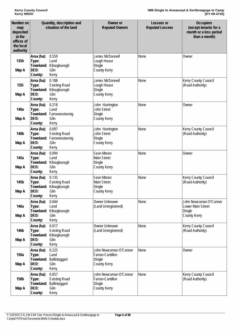
135h
Map A
Area (ha): 0.559 Type: Land Townland: Kilnaglearagh DED: Glin County: Kerry
James McDonnell Lough House Dingle County Kerry
None Owner
135i
Map A
Area (ha): 0.188 Type: Existing Road Townland: Kilnaglearagh DED: Glin County: Kerry
James McDonnell Lough House Dingle County Kerry
None Kerry County Council (Road Authority)
140a
Map A
Area (ha): 0.218 Type: Land Townland: Farraneesteenig DED: Glin County: Kerry
John Harrington John Street Dingle County Kerry
None Owner
140b
Map A
Area (ha): 0.097 Type: Existing Road Townland: Farraneesteenig DED: Glin County: Kerry
John Harrington John Street Dingle County Kerry
None Kerry County Council (Road Authority)
145a
Map A
Area (ha): 0.094 Type: Land Townland: Kilnaglearagh DED: Glin County: Kerry
Sean Moran Main Street Dingle County Kerry
None Owner
145b
Map A
Area (ha): 0.135 Type: Existing Road Townland: Kilnaglearagh DED: Glin County: Kerry
Sean Moran Main Street Dingle County Kerry
None Kerry County Council (Road Authority)
146a
Map A
Area (ha): 0.044 Type: Land Townland: Kilnaglearagh DED: Glin County: Kerry
Owner Unknown (Land Unregistered)
None John Newcoman O'Connor Lower Main Street Dingle County Kerry
146b
Map A
Area (ha): 0.017 Type: Existing Road Townland: Kilnaglearagh DED: Glin County: Kerry
Owner Unknown (Land Unregistered)
None Kerry County Council (Road Authority)
150a
Map A
Area (ha): 0.225 Type: Land Townland: Ballintaggart DED: Glin County: Kerry
John Newcoman O'Connor Farran-Cantillon Dingle County Kerry
None Owner
150b
Map A
Area (ha): 0.057 Type: Existing Road Townland: Ballintaggart DED: Glin County: Kerry
John Newcoman O'Connor Farran-Cantillon Dingle County Kerry
None Kerry County Council (Road Authority)
Kerry County Council Kerry NRDO
N86 Dingle to Annascaul & Gortbreagoge to Camp [KY-09-4743]
F:\J65\DOCS\4_EIA EAR Stat. Process\Dingle to Annascaul & Gortbreagoge to Camp\CPO\Final Documents\404b Schedule.docx
Page 7 of 88
Number on map
deposited at the
offices of the local authority
Quantity, description and situation of the land
Owner or Reputed Owners
Lessees or Reputed Lessees
Occupiers (except tenants for a
month or a less period than a month)
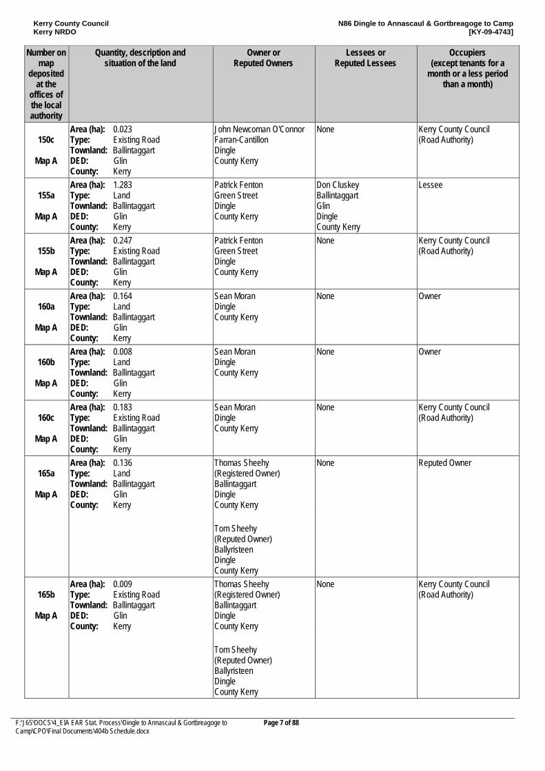
150c
Map A
Area (ha): 0.023 Type: Existing Road Townland: Ballintaggart DED: Glin County: Kerry
John Newcoman O'Connor Farran-Cantillon Dingle County Kerry
None Kerry County Council (Road Authority)
155a
Map A
Area (ha): 1.283 Type: Land Townland: Ballintaggart DED: Glin County: Kerry
Patrick Fenton Green Street Dingle County Kerry
Don Cluskey Ballintaggart Glin Dingle County Kerry
Lessee
155b
Map A
Area (ha): 0.247 Type: Existing Road Townland: Ballintaggart DED: Glin County: Kerry
Patrick Fenton Green Street Dingle County Kerry
None Kerry County Council (Road Authority)
160a
Map A
Area (ha): 0.164 Type: Land Townland: Ballintaggart DED: Glin County: Kerry
Sean Moran Dingle County Kerry
None Owner
160b
Map A
Area (ha): 0.008 Type: Land Townland: Ballintaggart DED: Glin County: Kerry
Sean Moran Dingle County Kerry
None Owner
160c
Map A
Area (ha): 0.183 Type: Existing Road Townland: Ballintaggart DED: Glin County: Kerry
Sean Moran Dingle County Kerry
None Kerry County Council (Road Authority)
165a
Map A
Area (ha): 0.136 Type: Land Townland: Ballintaggart DED: Glin County: Kerry
Thomas Sheehy (Registered Owner) Ballintaggart Dingle County Kerry
None Reputed Owner
Tom Sheehy (Reputed Owner) Ballyristeen Dingle County Kerry
165b
Map A
Area (ha): 0.009 Type: Existing Road Townland: Ballintaggart DED: Glin County: Kerry
Thomas Sheehy (Registered Owner) Ballintaggart Dingle County Kerry
None Kerry County Council (Road Authority)
Tom Sheehy (Reputed Owner) Ballyristeen Dingle County Kerry
Kerry County Council Kerry NRDO
N86 Dingle to Annascaul & Gortbreagoge to Camp [KY-09-4743]
F:\J65\DOCS\4_EIA EAR Stat. Process\Dingle to Annascaul & Gortbreagoge to Camp\CPO\Final Documents\404b Schedule.docx
Page 8 of 88
Number on map
deposited at the
offices of the local authority
Quantity, description and situation of the land
Owner or Reputed Owners
Lessees or Reputed Lessees
Occupiers (except tenants for a
month or a less period than a month)
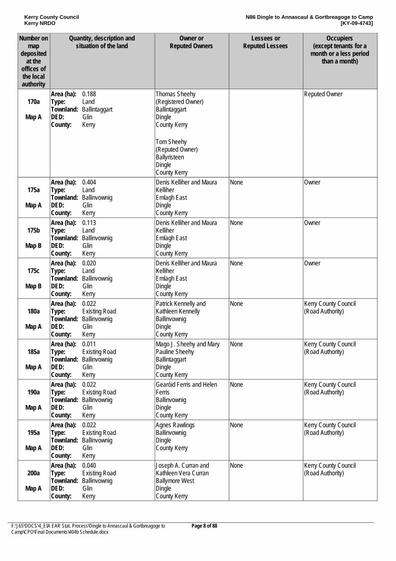
170a
Map A
Area (ha): 0.188 Type: Land Townland: Ballintaggart DED: Glin County: Kerry
Thomas Sheehy (Registered Owner) Ballintaggart Dingle County Kerry
Reputed Owner
Tom Sheehy (Reputed Owner) Ballyristeen Dingle County Kerry
175a
Map A
Area (ha): 0.404 Type: Land Townland: Ballinvownig DED: Glin County: Kerry
Denis Kelliher and Maura Kelliher Emlagh East Dingle County Kerry
None Owner
175b
Map B
Area (ha): 0.113 Type: Land Townland: Ballinvownig DED: Glin County: Kerry
Denis Kelliher and Maura Kelliher Emlagh East Dingle County Kerry
None Owner
175c
Map B
Area (ha): 0.020 Type: Land Townland: Ballinvownig DED: Glin County: Kerry
Denis Kelliher and Maura Kelliher Emlagh East Dingle County Kerry
None Owner
180a
Map A
Area (ha): 0.022 Type: Existing Road Townland: Ballinvownig DED: Glin County: Kerry
Patrick Kennelly and Kathleen Kennelly Ballinvownig Dingle County Kerry
None Kerry County Council (Road Authority)
185a
Map A
Area (ha): 0.011 Type: Existing Road Townland: Ballinvownig DED: Glin County: Kerry
Mago J. Sheehy and Mary Pauline Sheehy Ballintaggart Dingle County Kerry
None Kerry County Council (Road Authority)
190a
Map A
Area (ha): 0.022 Type: Existing Road Townland: Ballinvownig DED: Glin County: Kerry
Gearóid Ferris and Helen Ferris Ballinvownig Dingle County Kerry
None Kerry County Council (Road Authority)
195a
Map A
Area (ha): 0.022 Type: Existing Road Townland: Ballinvownig DED: Glin County: Kerry
Agnes Rawlings Ballinvownig Dingle County Kerry
None Kerry County Council (Road Authority)
200a
Map A
Area (ha): 0.040 Type: Existing Road Townland: Ballinvownig DED: Glin County: Kerry
Joseph A. Curran and Kathleen Vera Curran Ballymore West Dingle County Kerry
None Kerry County Council (Road Authority)
Kerry County Council Kerry NRDO
N86 Dingle to Annascaul & Gortbreagoge to Camp [KY-09-4743]
F:\J65\DOCS\4_EIA EAR Stat. Process\Dingle to Annascaul & Gortbreagoge to Camp\CPO\Final Documents\404b Schedule.docx
Page 9 of 88
Number on map
deposited at the
offices of the local authority
Quantity, description and situation of the land
Owner or Reputed Owners
Lessees or Reputed Lessees
Occupiers (except tenants for a
month or a less period than a month)
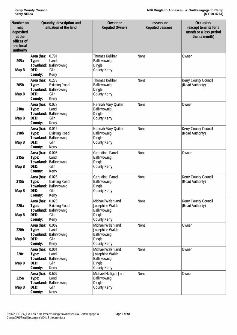
205a
Map B
Area (ha): 0.791 Type: Land Townland: Ballinvownig DED: Glin County: Kerry
Thomas Kelliher Ballinvownig Dingle County Kerry
None Owner
205b
Map B
Area (ha): 0.273 Type: Existing Road Townland: Ballinvownig DED: Glin County: Kerry
Thomas Kelliher Ballinvownig Dingle County Kerry
None Kerry County Council (Road Authority)
210a
Map B
Area (ha): 0.028 Type: Land Townland: Ballinvownig DED: Glin County: Kerry
Hannah Mary Quilter Ballinvownig Dingle County Kerry
None Owner
210b
Map B
Area (ha): 0.019 Type: Existing Road Townland: Ballinvownig DED: Glin County: Kerry
Hannah Mary Quilter Ballinvownig Dingle County Kerry
None Kerry County Council (Road Authority)
215a
Map B
Area (ha): 0.005 Type: Land Townland: Ballinvownig DED: Glin County: Kerry
Geraldine Farrell Ballinvownig Dingle County Kerry
None Owner
215b
Map B
Area (ha): 0.026 Type: Existing Road Townland: Ballinvownig DED: Glin County: Kerry
Geraldine Farrell Ballinvownig Dingle County Kerry
None Kerry County Council (Road Authority)
220a
Map B
Area (ha): 0.025 Type: Existing Road Townland: Ballinvownig DED: Glin County: Kerry
Michael Walsh and Josephine Walsh Ballinvownig Dingle County Kerry
None Kerry County Council (Road Authority)
220b
Map B
Area (ha): 0.002 Type: Land Townland: Ballinvownig DED: Glin County: Kerry
Michael Walsh and Josephine Walsh Ballinvownig Dingle County Kerry
None Owner
220c
Map B
Area (ha): 0.001 Type: Land Townland: Ballinvownig DED: Glin County: Kerry
Michael Walsh and Josephine Walsh Ballinvownig Dingle County Kerry
None Owner
225a
Map B
Area (ha): 0.607 Type: Land Townland: Ballinvownig DED: Glin County: Kerry
Michael Nelligan Jnr. Ballinvownig Dingle County Kerry
None Owner
Kerry County Council Kerry NRDO
N86 Dingle to Annascaul & Gortbreagoge to Camp [KY-09-4743]
F:\J65\DOCS\4_EIA EAR Stat. Process\Dingle to Annascaul & Gortbreagoge to Camp\CPO\Final Documents\404b Schedule.docx
Page 10 of 88
Number on map
deposited at the
offices of the local authority
Quantity, description and situation of the land
Owner or Reputed Owners
Lessees or Reputed Lessees
Occupiers (except tenants for a
month or a less period than a month)
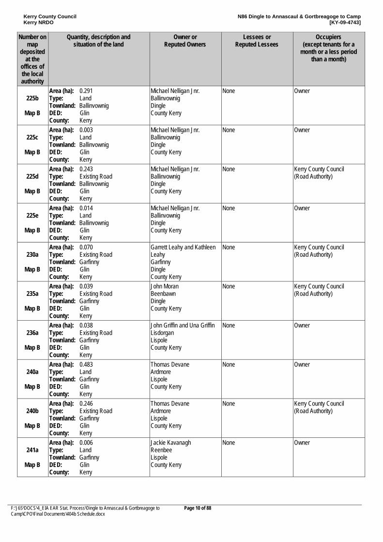
225b
Map B
Area (ha): 0.291 Type: Land Townland: Ballinvownig DED: Glin County: Kerry
Michael Nelligan Jnr. Ballinvownig Dingle County Kerry
None Owner
225c
Map B
Area (ha): 0.003 Type: Land Townland: Ballinvownig DED: Glin County: Kerry
Michael Nelligan Jnr. Ballinvownig Dingle County Kerry
None Owner
225d
Map B
Area (ha): 0.243 Type: Existing Road Townland: Ballinvownig DED: Glin County: Kerry
Michael Nelligan Jnr. Ballinvownig Dingle County Kerry
None Kerry County Council (Road Authority)
225e
Map B
Area (ha): 0.014 Type: Land Townland: Ballinvownig DED: Glin County: Kerry
Michael Nelligan Jnr. Ballinvownig Dingle County Kerry
None Owner
230a
Map B
Area (ha): 0.070 Type: Existing Road Townland: Garfinny DED: Glin County: Kerry
Garrett Leahy and Kathleen Leahy Garfinny Dingle County Kerry
None Kerry County Council (Road Authority)
235a
Map B
Area (ha): 0.039 Type: Existing Road Townland: Garfinny DED: Glin County: Kerry
John Moran Beenbawn Dingle County Kerry
None Kerry County Council (Road Authority)
236a
Map B
Area (ha): 0.038 Type: Existing Road Townland: Garfinny DED: Glin County: Kerry
John Griffin and Una Griffin Lisdorgan Lispole County Kerry
None Owner
240a
Map B
Area (ha): 0.483 Type: Land Townland: Garfinny DED: Glin County: Kerry
Thomas Devane Ardmore Lispole County Kerry
None Owner
240b
Map B
Area (ha): 0.246 Type: Existing Road Townland: Garfinny DED: Glin County: Kerry
Thomas Devane Ardmore Lispole County Kerry
None Kerry County Council (Road Authority)
241a
Map B
Area (ha): 0.006 Type: Land Townland: Garfinny DED: Glin County: Kerry
Jackie Kavanagh Reenbee Lispole County Kerry
None Owner
Kerry County Council Kerry NRDO
N86 Dingle to Annascaul & Gortbreagoge to Camp [KY-09-4743]
F:\J65\DOCS\4_EIA EAR Stat. Process\Dingle to Annascaul & Gortbreagoge to Camp\CPO\Final Documents\404b Schedule.docx
Page 11 of 88
Number on map
deposited at the
offices of the local authority
Quantity, description and situation of the land
Owner or Reputed Owners
Lessees or Reputed Lessees
Occupiers (except tenants for a
month or a less period than a month)
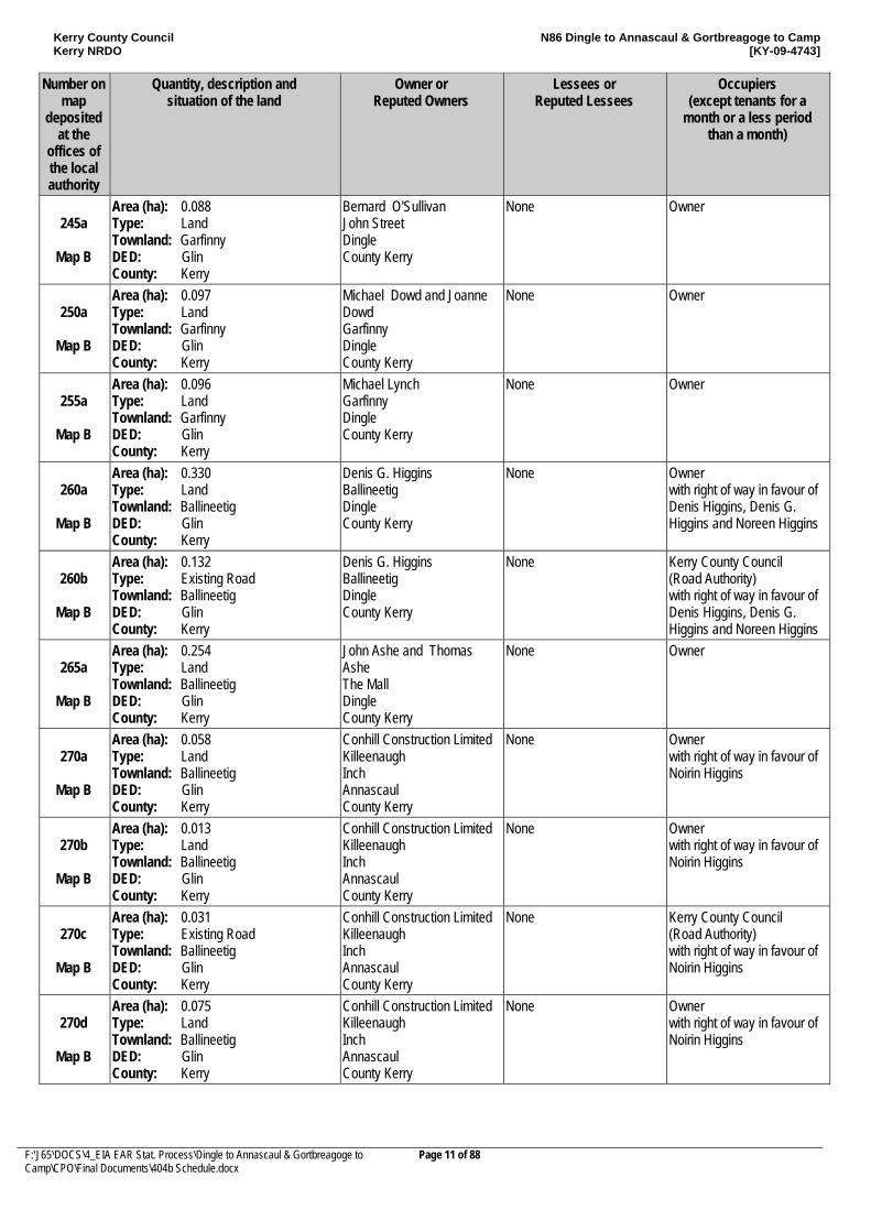
245a
Map B
Area (ha): 0.088 Type: Land Townland: Garfinny DED: Glin County: Kerry
Bernard O'Sullivan John Street Dingle County Kerry
None Owner
250a
Map B
Area (ha): 0.097 Type: Land Townland: Garfinny DED: Glin County: Kerry
Michael Dowd and Joanne Dowd Garfinny Dingle County Kerry
None Owner
255a
Map B
Area (ha): 0.096 Type: Land Townland: Garfinny DED: Glin County: Kerry
Michael Lynch Garfinny Dingle County Kerry
None Owner
260a
Map B
Area (ha): 0.330 Type: Land Townland: Ballineetig DED: Glin County: Kerry
Denis G. Higgins Ballineetig Dingle County Kerry
None Owner with right of way in favour of Denis Higgins, Denis G. Higgins and Noreen Higgins
260b
Map B
Area (ha): 0.132 Type: Existing Road Townland: Ballineetig DED: Glin County: Kerry
Denis G. Higgins Ballineetig Dingle County Kerry
None Kerry County Council (Road Authority) with right of way in favour of Denis Higgins, Denis G. Higgins and Noreen Higgins
265a
Map B
Area (ha): 0.254 Type: Land Townland: Ballineetig DED: Glin County: Kerry
John Ashe and Thomas Ashe The Mall Dingle County Kerry
None Owner
270a
Map B
Area (ha): 0.058 Type: Land Townland: Ballineetig DED: Glin County: Kerry
Conhill Construction Limited Killeenaugh Inch Annascaul County Kerry
None Owner with right of way in favour of Noirin Higgins
270b
Map B
Area (ha): 0.013 Type: Land Townland: Ballineetig DED: Glin County: Kerry
Conhill Construction Limited Killeenaugh Inch Annascaul County Kerry
None Owner with right of way in favour of Noirin Higgins
270c
Map B
Area (ha): 0.031 Type: Existing Road Townland: Ballineetig DED: Glin County: Kerry
Conhill Construction Limited Killeenaugh Inch Annascaul County Kerry
None Kerry County Council (Road Authority) with right of way in favour of Noirin Higgins
270d
Map B
Area (ha): 0.075 Type: Land Townland: Ballineetig DED: Glin County: Kerry
Conhill Construction Limited Killeenaugh Inch Annascaul County Kerry
None Owner with right of way in favour of Noirin Higgins
Kerry County Council Kerry NRDO
N86 Dingle to Annascaul & Gortbreagoge to Camp [KY-09-4743]
F:\J65\DOCS\4_EIA EAR Stat. Process\Dingle to Annascaul & Gortbreagoge to Camp\CPO\Final Documents\404b Schedule.docx
Page 12 of 88
Number on map
deposited at the
offices of the local authority
Quantity, description and situation of the land
Owner or Reputed Owners
Lessees or Reputed Lessees
Occupiers (except tenants for a
month or a less period than a month)
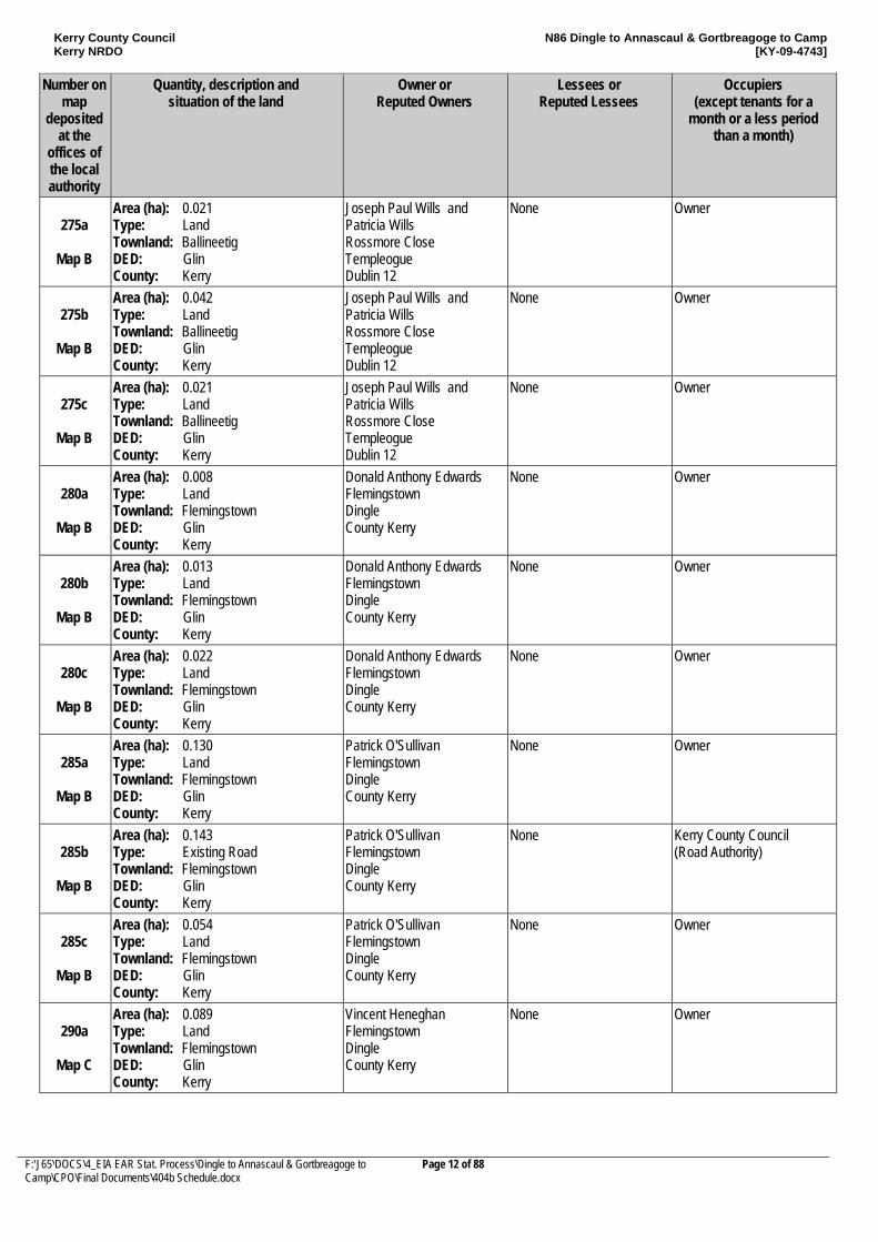
275a
Map B
Area (ha): 0.021 Type: Land Townland: Ballineetig DED: Glin County: Kerry
Joseph Paul Wills and Patricia Wills Rossmore Close Templeogue Dublin 12
None Owner
275b
Map B
Area (ha): 0.042 Type: Land Townland: Ballineetig DED: Glin County: Kerry
Joseph Paul Wills and Patricia Wills Rossmore Close Templeogue Dublin 12
None Owner
275c
Map B
Area (ha): 0.021 Type: Land Townland: Ballineetig DED: Glin County: Kerry
Joseph Paul Wills and Patricia Wills Rossmore Close Templeogue Dublin 12
None Owner
280a
Map B
Area (ha): 0.008 Type: Land Townland: Flemingstown DED: Glin County: Kerry
Donald Anthony Edwards Flemingstown Dingle County Kerry
None Owner
280b
Map B
Area (ha): 0.013 Type: Land Townland: Flemingstown DED: Glin County: Kerry
Donald Anthony Edwards Flemingstown Dingle County Kerry
None Owner
280c
Map B
Area (ha): 0.022 Type: Land Townland: Flemingstown DED: Glin County: Kerry
Donald Anthony Edwards Flemingstown Dingle County Kerry
None Owner
285a
Map B
Area (ha): 0.130 Type: Land Townland: Flemingstown DED: Glin County: Kerry
Patrick O'Sullivan Flemingstown Dingle County Kerry
None Owner
285b
Map B
Area (ha): 0.143 Type: Existing Road Townland: Flemingstown DED: Glin County: Kerry
Patrick O'Sullivan Flemingstown Dingle County Kerry
None Kerry County Council (Road Authority)
285c
Map B
Area (ha): 0.054 Type: Land Townland: Flemingstown DED: Glin County: Kerry
Patrick O'Sullivan Flemingstown Dingle County Kerry
None Owner
290a
Map C
Area (ha): 0.089 Type: Land Townland: Flemingstown DED: Glin County: Kerry
Vincent Heneghan Flemingstown Dingle County Kerry
None Owner
Kerry County Council Kerry NRDO
N86 Dingle to Annascaul & Gortbreagoge to Camp [KY-09-4743]
F:\J65\DOCS\4_EIA EAR Stat. Process\Dingle to Annascaul & Gortbreagoge to Camp\CPO\Final Documents\404b Schedule.docx
Page 13 of 88
Number on map
deposited at the
offices of the local authority
Quantity, description and situation of the land
Owner or Reputed Owners
Lessees or Reputed Lessees
Occupiers (except tenants for a
month or a less period than a month)
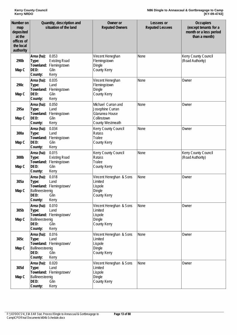
290b
Map C
Area (ha): 0.053 Type: Existing Road Townland: Flemingstown DED: Glin County: Kerry
Vincent Heneghan Flemingstown Dingle County Kerry
None Kerry County Council (Road Authority)
290c
Map C
Area (ha): 0.035 Type: Land Townland: Flemingstown DED: Glin County: Kerry
Vincent Heneghan Flemingstown Dingle County Kerry
None Owner
295a
Map C
Area (ha): 0.050 Type: Land Townland: Flemingstown DED: Glin County: Kerry
Michael Curran and Josephine Curran Glananea House Collinstown County Westmeath
None Owner
300a
Map C
Area (ha): 0.034 Type: Land Townland: Flemingstown DED: Glin County: Kerry
Kerry County Council Ratass Tralee County Kerry
None Owner
300b
Map C
Area (ha): 0.015 Type: Existing Road Townland: Flemingstown DED: Glin County: Kerry
Kerry County Council Ratass Tralee County Kerry
None Kerry County Council (Road Authority)
305a
Map C
Area (ha): 0.018 Type: Land Townland: Flemingstown/ Ballineesteenig DED: Glin County: Kerry
Vincent Heneghan & Sons Limited Lispole Dingle County Kerry
None Owner
305b
Map C
Area (ha): 0.010 Type: Land Townland: Flemingstown/ Ballineesteenig DED: Glin County: Kerry
Vincent Heneghan & Sons Limited Lispole Dingle County Kerry
None Owner
305c
Map C
Area (ha): 0.016 Type: Land Townland: Flemingstown/ Ballineesteenig DED: Glin County: Kerry
Vincent Heneghan & Sons Limited Lispole Dingle County Kerry
None Owner
305d
Map C
Area (ha): 0.020 Type: Land Townland: Flemingstown/ Ballineesteenig DED: Glin County: Kerry
Vincent Heneghan & Sons Limited Lispole Dingle County Kerry
None Owner
Kerry County Council Kerry NRDO
N86 Dingle to Annascaul & Gortbreagoge to Camp [KY-09-4743]
F:\J65\DOCS\4_EIA EAR Stat. Process\Dingle to Annascaul & Gortbreagoge to Camp\CPO\Final Documents\404b Schedule.docx
Page 14 of 88
Number on map
deposited at the
offices of the local authority
Quantity, description and situation of the land
Owner or Reputed Owners
Lessees or Reputed Lessees
Occupiers (except tenants for a
month or a less period than a month)
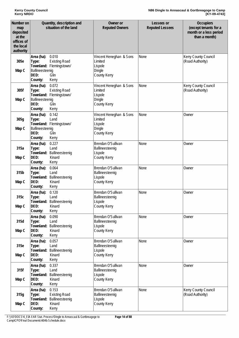
305e
Map C
Area (ha): 0.010 Type: Existing Road Townland: Flemingstown/ Ballineesteenig DED: Glin County: Kerry
Vincent Heneghan & Sons Limited Lispole Dingle County Kerry
None Kerry County Council (Road Authority)
305f
Map C
Area (ha): 0.072 Type: Existing Road Townland: Flemingstown/ Ballineesteenig DED: Glin County: Kerry
Vincent Heneghan & Sons Limited Lispole Dingle County Kerry
None Kerry County Council (Road Authority)
305g
Map C
Area (ha): 0.142 Type: Land Townland: Flemingstown/ Ballineesteenig DED: Glin County: Kerry
Vincent Heneghan & Sons Limited Lispole Dingle County Kerry
None Owner
315a
Map C
Area (ha): 0.227 Type: Land Townland: Ballineesteenig DED: Kinard County: Kerry
Brendan O'Sullivan Ballineesteenig Lispole County Kerry
None Owner
315b
Map C
Area (ha): 0.064 Type: Land Townland: Ballineesteenig DED: Kinard County: Kerry
Brendan O'Sullivan Ballineesteenig Lispole County Kerry
None Owner
315c
Map C
Area (ha): 0.120 Type: Land Townland: Ballineesteenig DED: Kinard County: Kerry
Brendan O'Sullivan Ballineesteenig Lispole County Kerry
None Owner
315d
Map C
Area (ha): 0.090 Type: Land Townland: Ballineesteenig DED: Kinard County: Kerry
Brendan O'Sullivan Ballineesteenig Lispole County Kerry
None Owner
315e
Map C
Area (ha): 0.057 Type: Land Townland: Ballineesteenig DED: Kinard County: Kerry
Brendan O'Sullivan Ballineesteenig Lispole County Kerry
None Owner
315f
Map C
Area (ha): 0.337 Type: Land Townland: Ballineesteenig DED: Kinard County: Kerry
Brendan O'Sullivan Ballineesteenig Lispole County Kerry
None Owner
315g
Map C
Area (ha): 0.153 Type: Existing Road Townland: Ballineesteenig DED: Kinard County: Kerry
Brendan O'Sullivan Ballineesteenig Lispole County Kerry
None Kerry County Council (Road Authority)
Kerry County Council Kerry NRDO
N86 Dingle to Annascaul & Gortbreagoge to Camp [KY-09-4743]
F:\J65\DOCS\4_EIA EAR Stat. Process\Dingle to Annascaul & Gortbreagoge to Camp\CPO\Final Documents\404b Schedule.docx
Page 15 of 88
Number on map
deposited at the
offices of the local authority
Quantity, description and situation of the land
Owner or Reputed Owners
Lessees or Reputed Lessees
Occupiers (except tenants for a
month or a less period than a month)
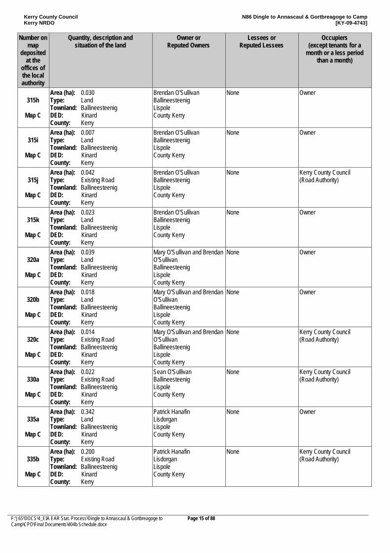
315h
Map C
Area (ha): 0.030 Type: Land Townland: Ballineesteenig DED: Kinard County: Kerry
Brendan O'Sullivan Ballineesteenig Lispole County Kerry
None Owner
315i
Map C
Area (ha): 0.007 Type: Land Townland: Ballineesteenig DED: Kinard County: Kerry
Brendan O'Sullivan Ballineesteenig Lispole County Kerry
None Owner
315j
Map C
Area (ha): 0.042 Type: Existing Road Townland: Ballineesteenig DED: Kinard County: Kerry
Brendan O'Sullivan Ballineesteenig Lispole County Kerry
None Kerry County Council (Road Authority)
315k
Map C
Area (ha): 0.023 Type: Land Townland: Ballineesteenig DED: Kinard County: Kerry
Brendan O'Sullivan Ballineesteenig Lispole County Kerry
None Owner
320a
Map C
Area (ha): 0.039 Type: Land Townland: Ballineesteenig DED: Kinard County: Kerry
Mary O'Sullivan and Brendan O'Sullivan Ballineesteenig Lispole County Kerry
None Owner
320b
Map C
Area (ha): 0.018 Type: Land Townland: Ballineesteenig DED: Kinard County: Kerry
Mary O'Sullivan and Brendan O'Sullivan Ballineesteenig Lispole County Kerry
None Owner
320c
Map C
Area (ha): 0.014 Type: Existing Road Townland: Ballineesteenig DED: Kinard County: Kerry
Mary O'Sullivan and Brendan O'Sullivan Ballineesteenig Lispole County Kerry
None Kerry County Council (Road Authority)
330a
Map C
Area (ha): 0.022 Type: Existing Road Townland: Ballineesteenig DED: Kinard County: Kerry
Sean O'Sullivan Ballineesteenig Lispole County Kerry
None Kerry County Council (Road Authority)
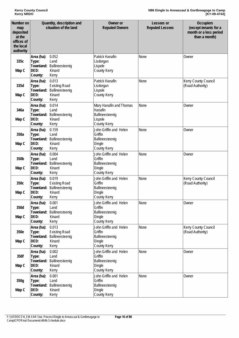
335a
Map C
Area (ha): 0.342 Type: Land Townland: Ballineesteenig DED: Kinard County: Kerry
Patrick Hanafin Lisdorgan Lispole County Kerry
None Owner
335b
Map C
Area (ha): 0.200 Type: Existing Road Townland: Ballineesteenig DED: Kinard County: Kerry
Patrick Hanafin Lisdorgan Lispole County Kerry
None Kerry County Council (Road Authority)
Kerry County Council Kerry NRDO
N86 Dingle to Annascaul & Gortbreagoge to Camp [KY-09-4743]
F:\J65\DOCS\4_EIA EAR Stat. Process\Dingle to Annascaul & Gortbreagoge to Camp\CPO\Final Documents\404b Schedule.docx
Page 16 of 88
Number on map
deposited at the
offices of the local authority
Quantity, description and situation of the land
Owner or Reputed Owners
Lessees or Reputed Lessees
Occupiers (except tenants for a
month or a less period than a month)
335c
Map C
Area (ha): 0.052 Type: Land Townland: Ballineesteenig DED: Kinard County: Kerry
Patrick Hanafin Lisdorgan Lispole County Kerry
None Owner
335d
Map C
Area (ha): 0.013 Type: Existing Road Townland: Ballineesteenig DED: Kinard County: Kerry
Patrick Hanafin Lisdorgan Lispole County Kerry
None Kerry County Council (Road Authority)
346a
Map C
Area (ha): 0.014 Type: Land Townland: Ballineesteenig DED: Kinard County: Kerry
Mary Hanafin and Thomas Hanafin Ballineesteenig Lispole County Kerry
None Owner
350a
Map C
Area (ha): 0.159 Type: Land Townland: Ballineesteenig DED: Kinard County: Kerry
John Griffin and Helen Griffin Ballineesteenig Dingle County Kerry
None Owner
350b
Map C
Area (ha): 0.004 Type: Land Townland: Ballineesteenig DED: Kinard County: Kerry
John Griffin and Helen Griffin Ballineesteenig Dingle County Kerry
None Owner
350c
Map C
Area (ha): 0.019 Type: Existing Road Townland: Ballineesteenig DED: Kinard County: Kerry
John Griffin and Helen Griffin Ballineesteenig Dingle County Kerry
None Kerry County Council (Road Authority)
350d
Map C
Area (ha): 0.001 Type: Land Townland: Ballineesteenig DED: Kinard County: Kerry
John Griffin and Helen Griffin Ballineesteenig Dingle County Kerry
None Owner
350e
Map C
Area (ha): 0.013 Type: Existing Road Townland: Ballineesteenig DED: Kinard County: Kerry
John Griffin and Helen Griffin Ballineesteenig Dingle County Kerry
None Kerry County Council (Road Authority)
350f
Map C
Area (ha): 0.002 Type: Land Townland: Ballineesteenig DED: Kinard County: Kerry
John Griffin and Helen Griffin Ballineesteenig Dingle County Kerry
None Owner
350g
Map C
Area (ha): 0.001 Type: Land Townland: Ballineesteenig DED: Kinard County: Kerry
John Griffin and Helen Griffin Ballineesteenig Dingle County Kerry
None Owner
Kerry County Council Kerry NRDO
N86 Dingle to Annascaul & Gortbreagoge to Camp [KY-09-4743]
F:\J65\DOCS\4_EIA EAR Stat. Process\Dingle to Annascaul & Gortbreagoge to Camp\CPO\Final Documents\404b Schedule.docx
Page 17 of 88
Number on map
deposited at the
offices of the local authority
Quantity, description and situation of the land
Owner or Reputed Owners
Lessees or Reputed Lessees
Occupiers (except tenants for a
month or a less period than a month)
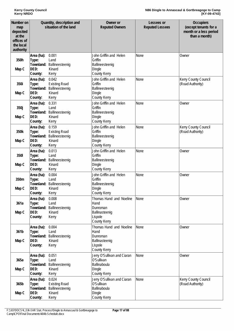
350h
Map C
Area (ha): 0.001 Type: Land Townland: Ballineesteenig DED: Kinard County: Kerry
John Griffin and Helen Griffin Ballineesteenig Dingle County Kerry
None Owner
350i
Map C
Area (ha): 0.042 Type: Existing Road Townland: Ballineesteenig DED: Kinard County: Kerry
John Griffin and Helen Griffin Ballineesteenig Dingle County Kerry
None Kerry County Council (Road Authority)
350j
Map C
Area (ha): 0.331 Type: Land Townland: Ballineesteenig DED: Kinard County: Kerry
John Griffin and Helen Griffin Ballineesteenig Dingle County Kerry
None Owner
350k
Map C
Area (ha): 0.159 Type: Existing Road Townland: Ballineesteenig DED: Kinard County: Kerry
John Griffin and Helen Griffin Ballineesteenig Dingle County Kerry
None Kerry County Council (Road Authority)
350l
Map C
Area (ha): 0.013 Type: Land Townland: Ballineesteenig DED: Kinard County: Kerry
John Griffin and Helen Griffin Ballineesteenig Dingle County Kerry
None Owner
350m
Map C
Area (ha): 0.004 Type: Land Townland: Ballineesteenig DED: Kinard County: Kerry
John Griffin and Helen Griffin Ballineesteenig Dingle County Kerry
None Owner
361a
Map C
Area (ha): 0.008 Type: Land Townland: Ballineesteenig DED: Kinard County: Kerry
Thomas Hand and Noeline Hand Dunroman Ballinasteenig Lispole County Kerry
None Owner
361b
Map C
Area (ha): 0.004 Type: Land Townland: Ballineesteenig DED: Kinard County: Kerry
Thomas Hand and Noeline Hand Dunroman Ballinasteenig Lispole County Kerry
None Owner
365a
Map C
Area (ha): 0.051 Type: Land Townland: Ballineesteenig DED: Kinard County: Kerry
Jerry O'Sullivan and Ciaran O'Sullivan Ballinaboula Dingle County Kerry
None Owner
365b
Map C
Area (ha): 0.024 Type: Existing Road Townland: Ballineesteenig DED: Kinard County: Kerry
Jerry O'Sullivan and Ciaran O'Sullivan Ballinaboula Dingle County Kerry
None Kerry County Council (Road Authority)
Kerry County Council Kerry NRDO
N86 Dingle to Annascaul & Gortbreagoge to Camp [KY-09-4743]
F:\J65\DOCS\4_EIA EAR Stat. Process\Dingle to Annascaul & Gortbreagoge to Camp\CPO\Final Documents\404b Schedule.docx
Page 18 of 88
Number on map
deposited at the
offices of the local authority
Quantity, description and situation of the land
Owner or Reputed Owners
Lessees or Reputed Lessees
Occupiers (except tenants for a
month or a less period than a month)
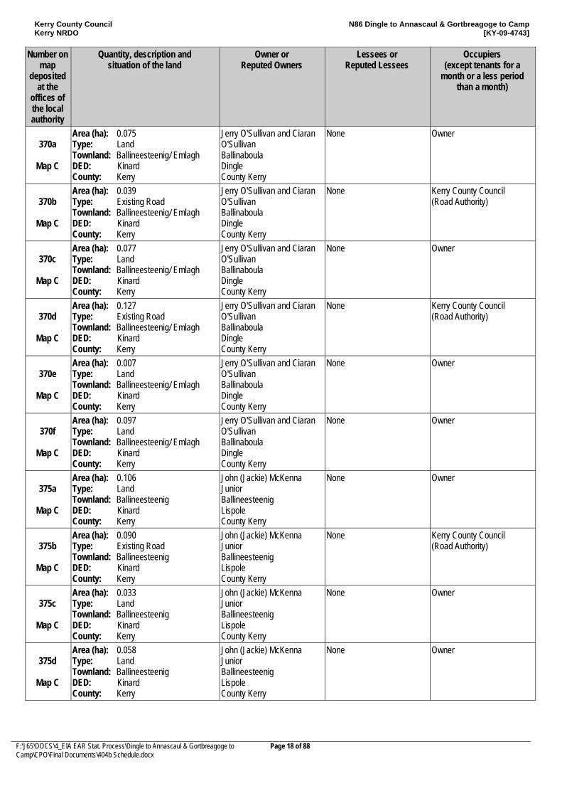
370a
Map C
Area (ha): 0.075 Type: Land Townland: Ballineesteenig/ Emlagh DED: Kinard County: Kerry
Jerry O'Sullivan and Ciaran O'Sullivan Ballinaboula Dingle County Kerry
None Owner
370b
Map C
Area (ha): 0.039 Type: Existing Road Townland: Ballineesteenig/ Emlagh DED: Kinard County: Kerry
Jerry O'Sullivan and Ciaran O'Sullivan Ballinaboula Dingle County Kerry
None Kerry County Council (Road Authority)
370c
Map C
Area (ha): 0.077 Type: Land Townland: Ballineesteenig/ Emlagh DED: Kinard County: Kerry
Jerry O'Sullivan and Ciaran O'Sullivan Ballinaboula Dingle County Kerry
None Owner
370d
Map C
Area (ha): 0.127 Type: Existing Road Townland: Ballineesteenig/ Emlagh DED: Kinard County: Kerry
Jerry O'Sullivan and Ciaran O'Sullivan Ballinaboula Dingle County Kerry
None Kerry County Council (Road Authority)
370e
Map C
Area (ha): 0.007 Type: Land Townland: Ballineesteenig/ Emlagh DED: Kinard County: Kerry
Jerry O'Sullivan and Ciaran O'Sullivan Ballinaboula Dingle County Kerry
None Owner
370f
Map C
Area (ha): 0.097 Type: Land Townland: Ballineesteenig/ Emlagh DED: Kinard County: Kerry
Jerry O'Sullivan and Ciaran O'Sullivan Ballinaboula Dingle County Kerry
None Owner
375a
Map C
Area (ha): 0.106 Type: Land Townland: Ballineesteenig DED: Kinard County: Kerry
John (Jackie) McKenna Junior Ballineesteenig Lispole County Kerry
None Owner
375b
Map C
Area (ha): 0.090 Type: Existing Road Townland: Ballineesteenig DED: Kinard County: Kerry
John (Jackie) McKenna Junior Ballineesteenig Lispole County Kerry
None Kerry County Council (Road Authority)
375c
Map C
Area (ha): 0.033 Type: Land Townland: Ballineesteenig DED: Kinard County: Kerry
John (Jackie) McKenna Junior Ballineesteenig Lispole County Kerry
None Owner
375d
Map C
Area (ha): 0.058 Type: Land Townland: Ballineesteenig DED: Kinard County: Kerry
John (Jackie) McKenna Junior Ballineesteenig Lispole County Kerry
None Owner
Kerry County Council Kerry NRDO
N86 Dingle to Annascaul & Gortbreagoge to Camp [KY-09-4743]
F:\J65\DOCS\4_EIA EAR Stat. Process\Dingle to Annascaul & Gortbreagoge to Camp\CPO\Final Documents\404b Schedule.docx
Page 19 of 88
Number on map
deposited at the
offices of the local authority
Quantity, description and situation of the land
Owner or Reputed Owners
Lessees or Reputed Lessees
Occupiers (except tenants for a
month or a less period than a month)
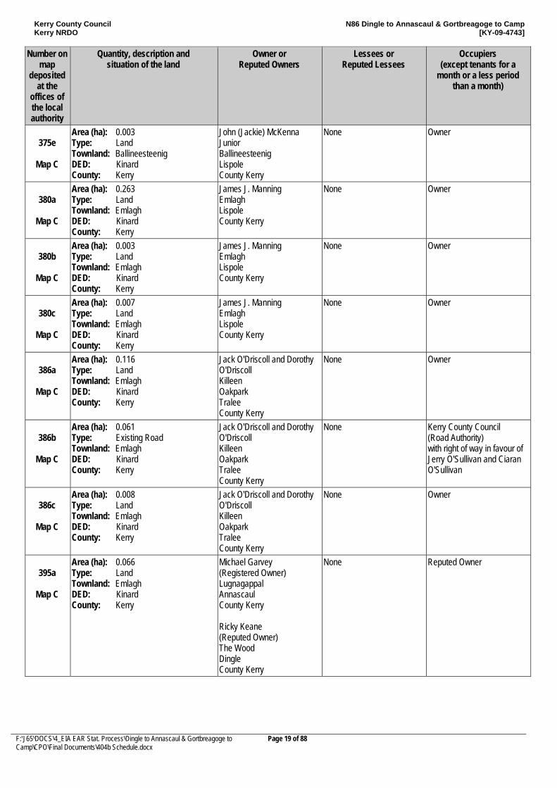
375e
Map C
Area (ha): 0.003 Type: Land Townland: Ballineesteenig DED: Kinard County: Kerry
John (Jackie) McKenna Junior Ballineesteenig Lispole County Kerry
None Owner
380a
Map C
Area (ha): 0.263 Type: Land Townland: Emlagh DED: Kinard County: Kerry
James J. Manning Emlagh Lispole County Kerry
None Owner
380b
Map C
Area (ha): 0.003 Type: Land Townland: Emlagh DED: Kinard County: Kerry
James J. Manning Emlagh Lispole County Kerry
None Owner
380c
Map C
Area (ha): 0.007 Type: Land Townland: Emlagh DED: Kinard County: Kerry
James J. Manning Emlagh Lispole County Kerry
None Owner
386a
Map C
Area (ha): 0.116 Type: Land Townland: Emlagh DED: Kinard County: Kerry
Jack O'Driscoll and Dorothy O'Driscoll Killeen Oakpark Tralee County Kerry
None Owner
386b
Map C
Area (ha): 0.061 Type: Existing Road Townland: Emlagh DED: Kinard County: Kerry
Jack O'Driscoll and Dorothy O'Driscoll Killeen Oakpark Tralee County Kerry
None Kerry County Council (Road Authority) with right of way in favour of Jerry O'Sullivan and Ciaran O'Sullivan
386c
Map C
Area (ha): 0.008 Type: Land Townland: Emlagh DED: Kinard County: Kerry
Jack O'Driscoll and Dorothy O'Driscoll Killeen Oakpark Tralee County Kerry
None Owner
395a
Map C
Area (ha): 0.066 Type: Land Townland: Emlagh DED: Kinard County: Kerry
Michael Garvey (Registered Owner) Lugnagappal Annascaul County Kerry Ricky Keane (Reputed Owner) The Wood Dingle County Kerry
None Reputed Owner
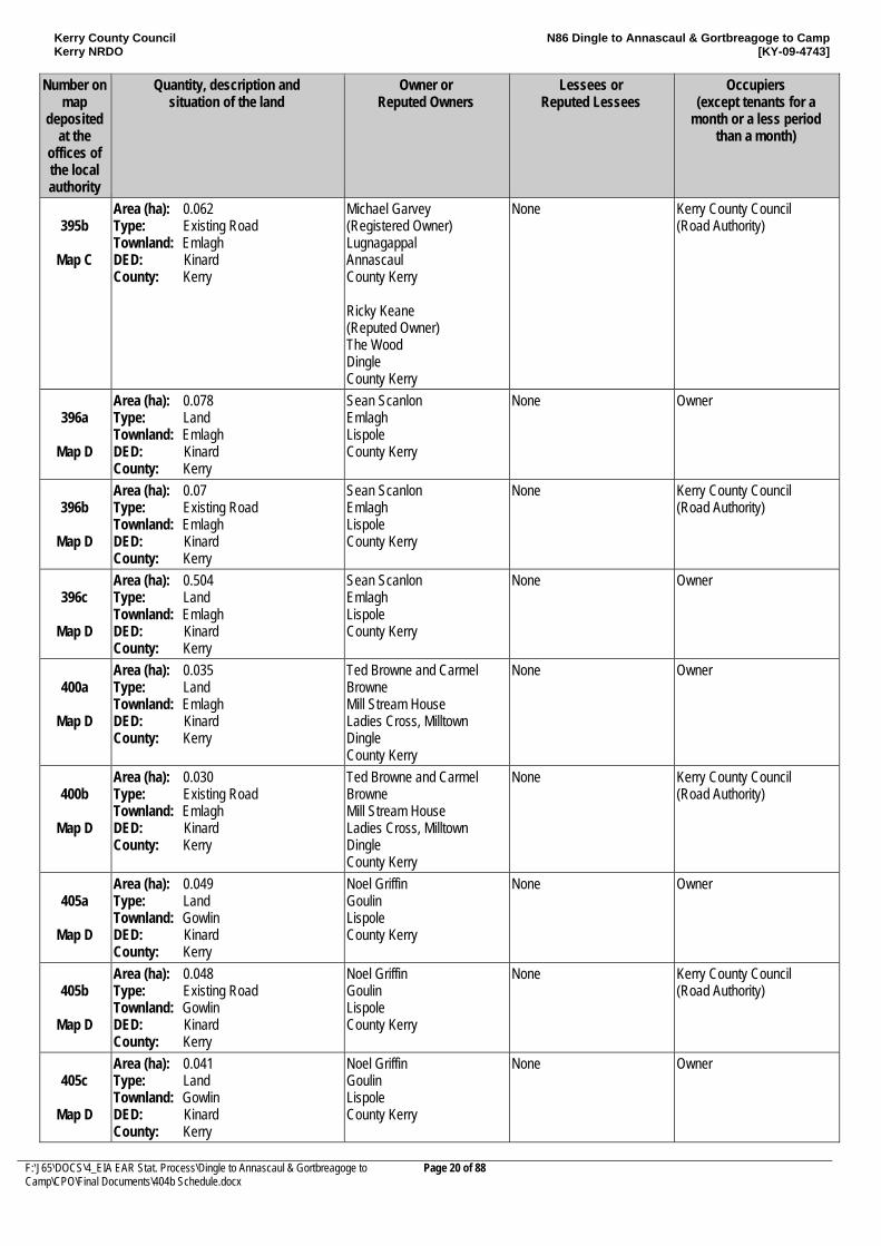
Kerry County Council Kerry NRDO
N86 Dingle to Annascaul & Gortbreagoge to Camp [KY-09-4743]
F:\J65\DOCS\4_EIA EAR Stat. Process\Dingle to Annascaul & Gortbreagoge to Camp\CPO\Final Documents\404b Schedule.docx
Page 20 of 88
Number on map
deposited at the
offices of the local authority
Quantity, description and situation of the land
Owner or Reputed Owners
Lessees or Reputed Lessees
Occupiers (except tenants for a
month or a less period than a month)
395b
Map C
Area (ha): 0.062 Type: Existing Road Townland: Emlagh DED: Kinard County: Kerry
Michael Garvey (Registered Owner) Lugnagappal Annascaul County Kerry Ricky Keane (Reputed Owner) The Wood Dingle County Kerry
None Kerry County Council (Road Authority)
396a
Map D
Area (ha): 0.078 Type: Land Townland: Emlagh DED: Kinard County: Kerry
Sean Scanlon Emlagh Lispole County Kerry
None Owner
396b
Map D
Area (ha): 0.07 Type: Existing Road Townland: Emlagh DED: Kinard County: Kerry
Sean Scanlon Emlagh Lispole County Kerry
None Kerry County Council (Road Authority)
396c
Map D
Area (ha): 0.504 Type: Land Townland: Emlagh DED: Kinard County: Kerry
Sean Scanlon Emlagh Lispole County Kerry
None Owner
400a
Map D
Area (ha): 0.035 Type: Land Townland: Emlagh DED: Kinard County: Kerry
Ted Browne and Carmel Browne Mill Stream House Ladies Cross, Milltown Dingle County Kerry
None Owner
400b
Map D
Area (ha): 0.030 Type: Existing Road Townland: Emlagh DED: Kinard County: Kerry
Ted Browne and Carmel Browne Mill Stream House Ladies Cross, Milltown Dingle County Kerry
None Kerry County Council (Road Authority)
405a
Map D
Area (ha): 0.049 Type: Land Townland: Gowlin DED: Kinard County: Kerry
Noel Griffin Goulin Lispole County Kerry
None Owner
405b
Map D
Area (ha): 0.048 Type: Existing Road Townland: Gowlin DED: Kinard County: Kerry
Noel Griffin Goulin Lispole County Kerry
None Kerry County Council (Road Authority)
405c
Map D
Area (ha): 0.041 Type: Land Townland: Gowlin DED: Kinard County: Kerry
Noel Griffin Goulin Lispole County Kerry
None Owner
Kerry County Council Kerry NRDO
N86 Dingle to Annascaul & Gortbreagoge to Camp [KY-09-4743]
F:\J65\DOCS\4_EIA EAR Stat. Process\Dingle to Annascaul & Gortbreagoge to Camp\CPO\Final Documents\404b Schedule.docx
Page 21 of 88
Number on map
deposited at the
offices of the local authority
Quantity, description and situation of the land
Owner or Reputed Owners
Lessees or Reputed Lessees
Occupiers (except tenants for a
month or a less period than a month)
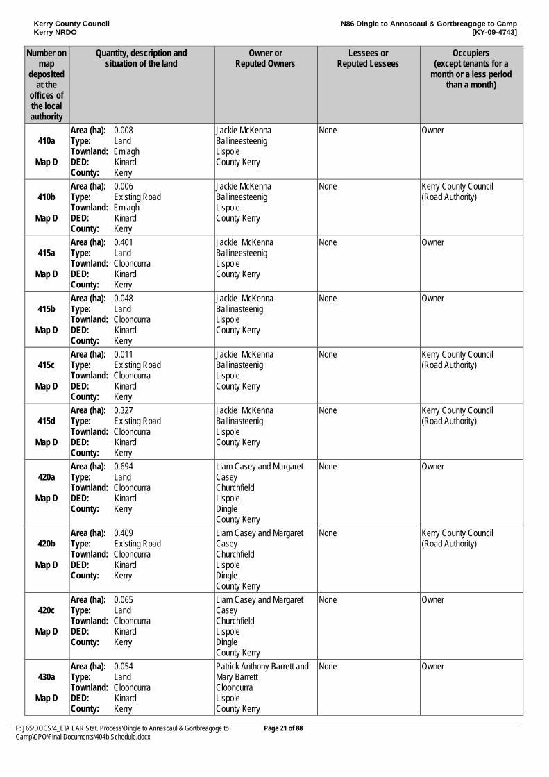
410a
Map D
Area (ha): 0.008 Type: Land Townland: Emlagh DED: Kinard County: Kerry
Jackie McKenna Ballineesteenig Lispole County Kerry
None Owner
410b
Map D
Area (ha): 0.006 Type: Existing Road Townland: Emlagh DED: Kinard County: Kerry
Jackie McKenna Ballineesteenig Lispole County Kerry
None Kerry County Council (Road Authority)
415a
Map D
Area (ha): 0.401 Type: Land Townland: Clooncurra DED: Kinard County: Kerry
Jackie McKenna Ballineesteenig Lispole County Kerry
None Owner
415b
Map D
Area (ha): 0.048 Type: Land Townland: Clooncurra DED: Kinard County: Kerry
Jackie McKenna Ballinasteenig Lispole County Kerry
None Owner
415c
Map D
Area (ha): 0.011 Type: Existing Road Townland: Clooncurra DED: Kinard County: Kerry
Jackie McKenna Ballinasteenig Lispole County Kerry
None Kerry County Council (Road Authority)
415d
Map D
Area (ha): 0.327 Type: Existing Road Townland: Clooncurra DED: Kinard County: Kerry
Jackie McKenna Ballinasteenig Lispole County Kerry
None Kerry County Council (Road Authority)
420a
Map D
Area (ha): 0.694 Type: Land Townland: Clooncurra DED: Kinard County: Kerry
Liam Casey and Margaret Casey Churchfield Lispole Dingle County Kerry
None Owner
420b
Map D
Area (ha): 0.409 Type: Existing Road Townland: Clooncurra DED: Kinard County: Kerry
Liam Casey and Margaret Casey Churchfield Lispole Dingle County Kerry
None Kerry County Council (Road Authority)
420c
Map D
Area (ha): 0.065 Type: Land Townland: Clooncurra DED: Kinard County: Kerry
Liam Casey and Margaret Casey Churchfield Lispole Dingle County Kerry
None Owner
430a
Map D
Area (ha): 0.054 Type: Land Townland: Clooncurra DED: Kinard County: Kerry
Patrick Anthony Barrett and Mary Barrett Clooncurra Lispole County Kerry
None Owner
Kerry County Council Kerry NRDO
N86 Dingle to Annascaul & Gortbreagoge to Camp [KY-09-4743]
F:\J65\DOCS\4_EIA EAR Stat. Process\Dingle to Annascaul & Gortbreagoge to Camp\CPO\Final Documents\404b Schedule.docx
Page 22 of 88
Number on map
deposited at the
offices of the local authority
Quantity, description and situation of the land
Owner or Reputed Owners
Lessees or Reputed Lessees
Occupiers (except tenants for a
month or a less period than a month)
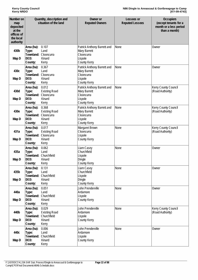
430b
Map D
Area (ha): 0.107 Type: Land Townland: Clooncurra DED: Kinard County: Kerry
Patrick Anthony Barrett and Mary Barrett Clooncurra Lispole County Kerry
None Owner
430c
Map D
Area (ha): 0.367 Type: Land Townland: Clooncurra DED: Kinard County: Kerry
Patrick Anthony Barrett and Mary Barrett Clooncurra Lispole County Kerry
None Owner
430d
Map D
Area (ha): 0.012 Type: Existing Road Townland: Clooncurra DED: Kinard County: Kerry
Patrick Anthony Barrett and Mary Barrett Clooncurra Lispole County Kerry
None Kerry County Council (Road Authority)
430e
Map D
Area (ha): 0.368 Type: Existing Road Townland: Clooncurra DED: Kinard County: Kerry
Patrick Anthony Barrett and Mary Barrett Clooncurra Lispole County Kerry
None Kerry County Council (Road Authority)
431a
Map D
Area (ha): 0.017 Type: Existing Road Townland: Clooncurra DED: Kinard County: Kerry
Margaret Brown Clooncurra Lispole County Kerry
None Kerry County Council (Road Authority)
435a
Map D
Area (ha): 0.062 Type: Land Townland: Churchfield DED: Kinard County: Kerry
Liam Casey Churchfield Lispole Dingle County Kerry
None Owner
435b
Map D
Area (ha): 0.131 Type: Land Townland: Churchfield DED: Kinard County: Kerry
Liam Casey Churchfield Lispole Dingle County Kerry
None Owner
440a
Map D
Area (ha): 0.051 Type: Land Townland: Churchfield DED: Kinard County: Kerry
John Prenderville Ardamore Lispole County Kerry
None Owner
440b
Map D
Area (ha): 0.029 Type: Existing Road Townland: Churchfield DED: Kinard County: Kerry
John Prenderville Ardamore Lispole County Kerry
None Kerry County Council (Road Authority)
440c
Map D
Area (ha): 0.006 Type: Land Townland: Churchfield DED: Kinard County: Kerry
John Prenderville Ardamore Lispole County Kerry
None Owner
Kerry County Council Kerry NRDO
N86 Dingle to Annascaul & Gortbreagoge to Camp [KY-09-4743]
F:\J65\DOCS\4_EIA EAR Stat. Process\Dingle to Annascaul & Gortbreagoge to Camp\CPO\Final Documents\404b Schedule.docx
Page 23 of 88
Number on map
deposited at the
offices of the local authority
Quantity, description and situation of the land
Owner or Reputed Owners
Lessees or Reputed Lessees
Occupiers (except tenants for a
month or a less period than a month)
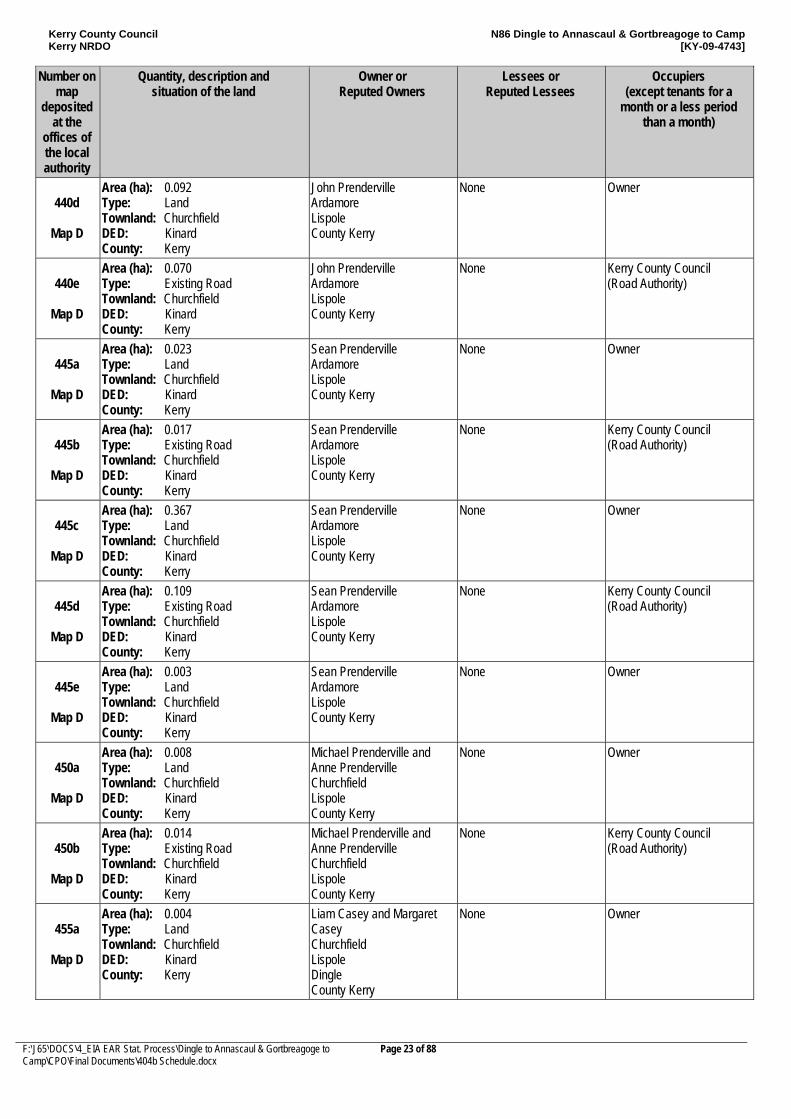
440d
Map D
Area (ha): 0.092 Type: Land Townland: Churchfield DED: Kinard County: Kerry
John Prenderville Ardamore Lispole County Kerry
None Owner
440e
Map D
Area (ha): 0.070 Type: Existing Road Townland: Churchfield DED: Kinard County: Kerry
John Prenderville Ardamore Lispole County Kerry
None Kerry County Council (Road Authority)
445a
Map D
Area (ha): 0.023 Type: Land Townland: Churchfield DED: Kinard County: Kerry
Sean Prenderville Ardamore Lispole County Kerry
None Owner
445b
Map D
Area (ha): 0.017 Type: Existing Road Townland: Churchfield DED: Kinard County: Kerry
Sean Prenderville Ardamore Lispole County Kerry
None Kerry County Council (Road Authority)
445c
Map D
Area (ha): 0.367 Type: Land Townland: Churchfield DED: Kinard County: Kerry
Sean Prenderville Ardamore Lispole County Kerry
None Owner
445d
Map D
Area (ha): 0.109 Type: Existing Road Townland: Churchfield DED: Kinard County: Kerry
Sean Prenderville Ardamore Lispole County Kerry
None Kerry County Council (Road Authority)
445e
Map D
Area (ha): 0.003 Type: Land Townland: Churchfield DED: Kinard County: Kerry
Sean Prenderville Ardamore Lispole County Kerry
None Owner
450a
Map D
Area (ha): 0.008 Type: Land Townland: Churchfield DED: Kinard County: Kerry
Michael Prenderville and Anne Prenderville Churchfield Lispole County Kerry
None Owner
450b
Map D
Area (ha): 0.014 Type: Existing Road Townland: Churchfield DED: Kinard County: Kerry
Michael Prenderville and Anne Prenderville Churchfield Lispole County Kerry
None Kerry County Council (Road Authority)
455a
Map D
Area (ha): 0.004 Type: Land Townland: Churchfield DED: Kinard County: Kerry
Liam Casey and Margaret Casey Churchfield Lispole Dingle County Kerry
None Owner
Kerry County Council Kerry NRDO
N86 Dingle to Annascaul & Gortbreagoge to Camp [KY-09-4743]
F:\J65\DOCS\4_EIA EAR Stat. Process\Dingle to Annascaul & Gortbreagoge to Camp\CPO\Final Documents\404b Schedule.docx
Page 24 of 88
Number on map
deposited at the
offices of the local authority
Quantity, description and situation of the land
Owner or Reputed Owners
Lessees or Reputed Lessees
Occupiers (except tenants for a
month or a less period than a month)
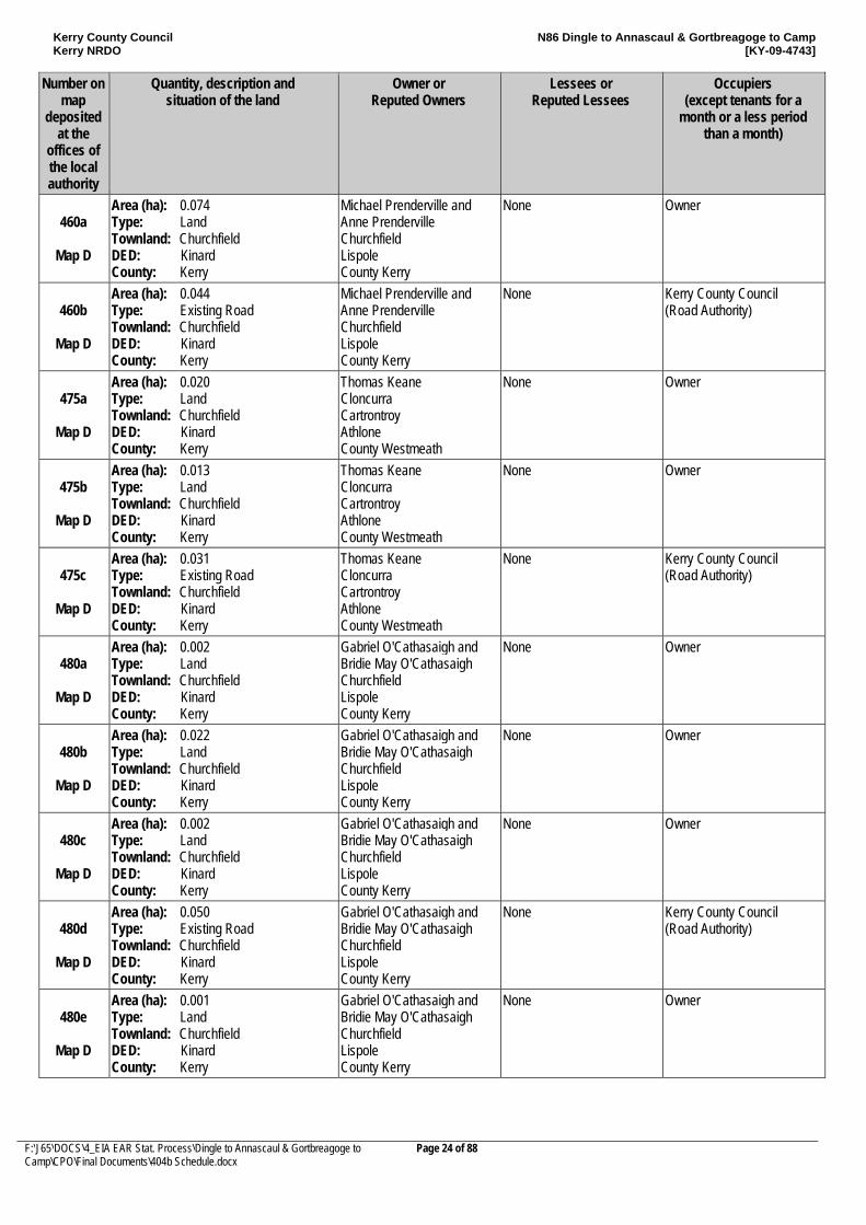
460a
Map D
Area (ha): 0.074 Type: Land Townland: Churchfield DED: Kinard County: Kerry
Michael Prenderville and Anne Prenderville Churchfield Lispole County Kerry
None Owner
460b
Map D
Area (ha): 0.044 Type: Existing Road Townland: Churchfield DED: Kinard County: Kerry
Michael Prenderville and Anne Prenderville Churchfield Lispole County Kerry
None Kerry County Council (Road Authority)
475a
Map D
Area (ha): 0.020 Type: Land Townland: Churchfield DED: Kinard County: Kerry
Thomas Keane Cloncurra Cartrontroy Athlone County Westmeath
None Owner
475b
Map D
Area (ha): 0.013 Type: Land Townland: Churchfield DED: Kinard County: Kerry
Thomas Keane Cloncurra Cartrontroy Athlone County Westmeath
None Owner
475c
Map D
Area (ha): 0.031 Type: Existing Road Townland: Churchfield DED: Kinard County: Kerry
Thomas Keane Cloncurra Cartrontroy Athlone County Westmeath
None Kerry County Council (Road Authority)
480a
Map D
Area (ha): 0.002 Type: Land Townland: Churchfield DED: Kinard County: Kerry
Gabriel O'Cathasaigh and Bridie May O'Cathasaigh Churchfield Lispole County Kerry
None Owner
480b
Map D
Area (ha): 0.022 Type: Land Townland: Churchfield DED: Kinard County: Kerry
Gabriel O'Cathasaigh and Bridie May O'Cathasaigh Churchfield Lispole County Kerry
None Owner
480c
Map D
Area (ha): 0.002 Type: Land Townland: Churchfield DED: Kinard County: Kerry
Gabriel O'Cathasaigh and Bridie May O'Cathasaigh Churchfield Lispole County Kerry
None Owner
480d
Map D
Area (ha): 0.050 Type: Existing Road Townland: Churchfield DED: Kinard County: Kerry
Gabriel O'Cathasaigh and Bridie May O'Cathasaigh Churchfield Lispole County Kerry
None Kerry County Council (Road Authority)
480e
Map D
Area (ha): 0.001 Type: Land Townland: Churchfield DED: Kinard County: Kerry
Gabriel O'Cathasaigh and Bridie May O'Cathasaigh Churchfield Lispole County Kerry
None Owner
Kerry County Council Kerry NRDO
N86 Dingle to Annascaul & Gortbreagoge to Camp [KY-09-4743]
F:\J65\DOCS\4_EIA EAR Stat. Process\Dingle to Annascaul & Gortbreagoge to Camp\CPO\Final Documents\404b Schedule.docx
Page 25 of 88
Number on map
deposited at the
offices of the local authority
Quantity, description and situation of the land
Owner or Reputed Owners
Lessees or Reputed Lessees
Occupiers (except tenants for a
month or a less period than a month)
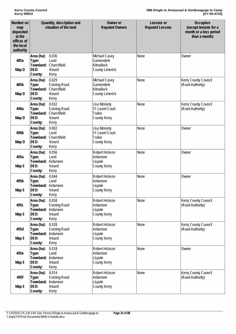
485a
Map D
Area (ha): 0.036 Type: Land Townland: Churchfield DED: Kinard County: Kerry
Michael Casey Garrienderk Kilmallock County Limerick
None Owner
485b
Map D
Area (ha): 0.029 Type: Existing Road Townland: Churchfield DED: Kinard County: Kerry
Michael Casey Garrienderk Kilmallock County Limerick
None Kerry County Council (Road Authority)
490a
Map D
Area (ha): 0.032 Type: Existing Road Townland: Churchfield DED: Kinard County: Kerry
Lisa Moriarty 51 Laurel Court Tralee County Kerry
None Kerry County Council (Road Authority)
490b
Map D
Area (ha): 0.002 Type: Land Townland: Churchfield DED: Kinard County: Kerry
Lisa Moriarty 51 Laurel Court Tralee County Kerry
None Owner
495a
Map E
Area (ha): 0.056 Type: Land Townland: Ardamore DED: Kinard County: Kerry
Robert Hickson Ardamore Lispole County Kerry
None Owner
495b
Map E
Area (ha): 0.044 Type: Land Townland: Ardamore DED: Kinard County: Kerry
Robert Hickson Ardamore Lispole County Kerry
None Owner
495c
Map E
Area (ha): 0.058 Type: Existing Road Townland: Ardamore DED: Kinard County: Kerry
Robert Hickson Ardamore Lispole County Kerry
None Kerry County Council (Road Authority)
495d
Map E
Area (ha): 0.028 Type: Existing Road Townland: Ardamore DED: Kinard County: Kerry
Robert Hickson Ardamore Lispole County Kerry
None Kerry County Council (Road Authority)
495e
Map E
Area (ha): 0.018 Type: Land Townland: Ardamore DED: Kinard County: Kerry
Robert Hickson Ardamore Lispole County Kerry
None Owner
495f
Map E
Area (ha): 0.014 Type: Existing Road Townland: Ardamore DED: Kinard County: Kerry
Robert Hickson Ardamore Lispole County Kerry
None Kerry County Council (Road Authority)
Kerry County Council Kerry NRDO
N86 Dingle to Annascaul & Gortbreagoge to Camp [KY-09-4743]
F:\J65\DOCS\4_EIA EAR Stat. Process\Dingle to Annascaul & Gortbreagoge to Camp\CPO\Final Documents\404b Schedule.docx
Page 26 of 88
Number on map
deposited at the
offices of the local authority
Quantity, description and situation of the land
Owner or Reputed Owners
Lessees or Reputed Lessees
Occupiers (except tenants for a
month or a less period than a month)
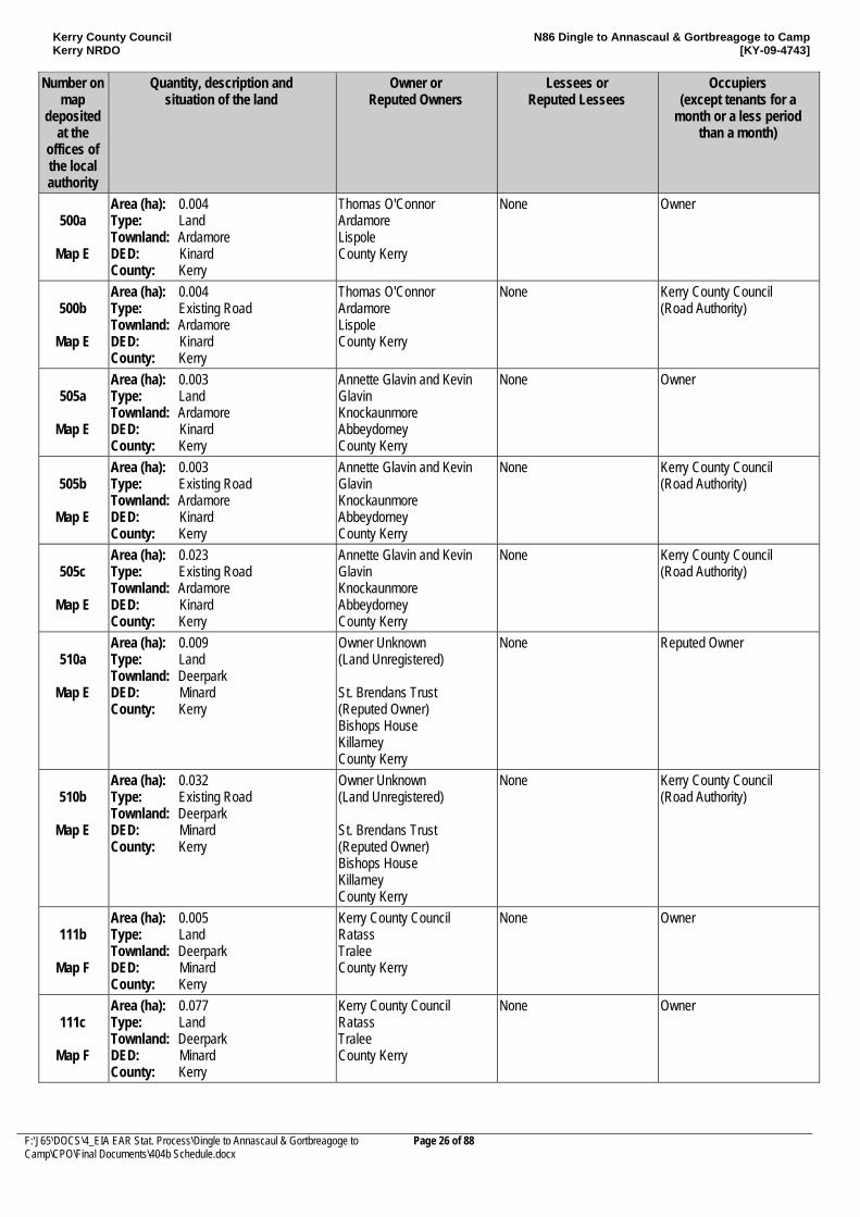
500a
Map E
Area (ha): 0.004 Type: Land Townland: Ardamore DED: Kinard County: Kerry
Thomas O'Connor Ardamore Lispole County Kerry
None Owner
500b
Map E
Area (ha): 0.004 Type: Existing Road Townland: Ardamore DED: Kinard County: Kerry
Thomas O'Connor Ardamore Lispole County Kerry
None Kerry County Council (Road Authority)
505a
Map E
Area (ha): 0.003 Type: Land Townland: Ardamore DED: Kinard County: Kerry
Annette Glavin and Kevin Glavin Knockaunmore Abbeydorney County Kerry
None Owner
505b
Map E
Area (ha): 0.003 Type: Existing Road Townland: Ardamore DED: Kinard County: Kerry
Annette Glavin and Kevin Glavin Knockaunmore Abbeydorney County Kerry
None Kerry County Council (Road Authority)
505c
Map E
Area (ha): 0.023 Type: Existing Road Townland: Ardamore DED: Kinard County: Kerry
Annette Glavin and Kevin Glavin Knockaunmore Abbeydorney County Kerry
None Kerry County Council (Road Authority)
510a
Map E
Area (ha): 0.009 Type: Land Townland: Deerpark DED: Minard County: Kerry
Owner Unknown (Land Unregistered) St. Brendans Trust (Reputed Owner) Bishops House Killarney County Kerry
None Reputed Owner
510b
Map E
Area (ha): 0.032 Type: Existing Road Townland: Deerpark DED: Minard County: Kerry
Owner Unknown (Land Unregistered) St. Brendans Trust (Reputed Owner) Bishops House Killarney County Kerry
None Kerry County Council (Road Authority)
111b
Map F
Area (ha): 0.005 Type: Land Townland: Deerpark DED: Minard County: Kerry
Kerry County Council Ratass Tralee County Kerry
None Owner
111c
Map F
Area (ha): 0.077 Type: Land Townland: Deerpark DED: Minard County: Kerry
Kerry County Council Ratass Tralee County Kerry
None Owner
Kerry County Council Kerry NRDO
N86 Dingle to Annascaul & Gortbreagoge to Camp [KY-09-4743]
F:\J65\DOCS\4_EIA EAR Stat. Process\Dingle to Annascaul & Gortbreagoge to Camp\CPO\Final Documents\404b Schedule.docx
Page 27 of 88
Number on map
deposited at the
offices of the local authority
Quantity, description and situation of the land
Owner or Reputed Owners
Lessees or Reputed Lessees
Occupiers (except tenants for a
month or a less period than a month)
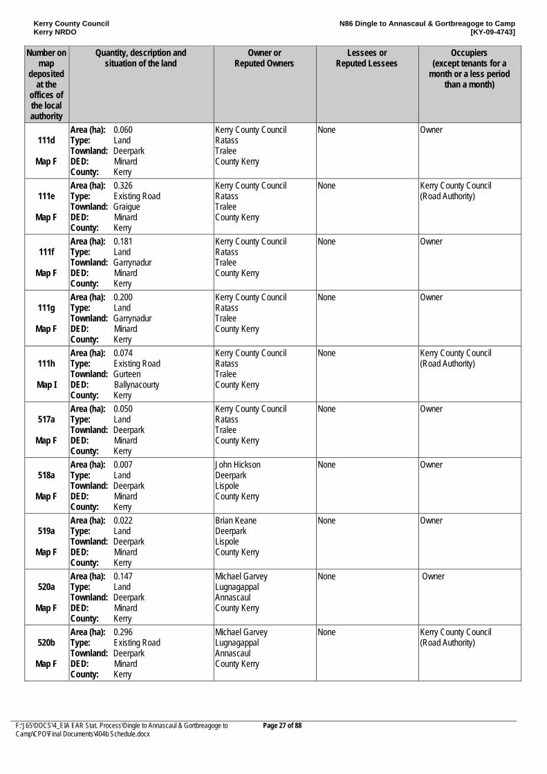
111d
Map F
Area (ha): 0.060 Type: Land Townland: Deerpark DED: Minard County: Kerry
Kerry County Council Ratass Tralee County Kerry
None Owner
111e
Map F
Area (ha): 0.326 Type: Existing Road Townland: Graigue DED: Minard County: Kerry
Kerry County Council Ratass Tralee County Kerry
None Kerry County Council (Road Authority)
111f
Map F
Area (ha): 0.181 Type: Land Townland: Garrynadur DED: Minard County: Kerry
Kerry County Council Ratass Tralee County Kerry
None Owner
111g
Map F
Area (ha): 0.200 Type: Land Townland: Garrynadur DED: Minard County: Kerry
Kerry County Council Ratass Tralee County Kerry
None Owner
111h
Map I
Area (ha): 0.074 Type: Existing Road Townland: Gurteen DED: Ballynacourty County: Kerry
Kerry County Council Ratass Tralee County Kerry
None Kerry County Council (Road Authority)
517a
Map F
Area (ha): 0.050 Type: Land Townland: Deerpark DED: Minard County: Kerry
Kerry County Council Ratass Tralee County Kerry
None Owner
518a
Map F
Area (ha): 0.007 Type: Land Townland: Deerpark DED: Minard County: Kerry
John Hickson Deerpark Lispole County Kerry
None Owner
519a
Map F
Area (ha): 0.022 Type: Land Townland: Deerpark DED: Minard County: Kerry
Brian Keane Deerpark Lispole County Kerry
None Owner
520a
Map F
Area (ha): 0.147 Type: Land Townland: Deerpark DED: Minard County: Kerry
Michael Garvey Lugnagappal Annascaul County Kerry
None Owner
520b
Map F
Area (ha): 0.296 Type: Existing Road Townland: Deerpark DED: Minard County: Kerry
Michael Garvey Lugnagappal Annascaul County Kerry
None Kerry County Council (Road Authority)
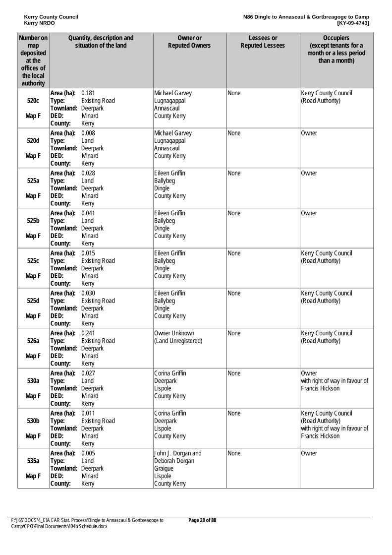
Kerry County Council Kerry NRDO
N86 Dingle to Annascaul & Gortbreagoge to Camp [KY-09-4743]
F:\J65\DOCS\4_EIA EAR Stat. Process\Dingle to Annascaul & Gortbreagoge to Camp\CPO\Final Documents\404b Schedule.docx
Page 28 of 88
Number on map
deposited at the
offices of the local authority
Quantity, description and situation of the land
Owner or Reputed Owners
Lessees or Reputed Lessees
Occupiers (except tenants for a
month or a less period than a month)
520c
Map F
Area (ha): 0.181 Type: Existing Road Townland: Deerpark DED: Minard County: Kerry
Michael Garvey Lugnagappal Annascaul County Kerry
None Kerry County Council (Road Authority)
520d
Map F
Area (ha): 0.008 Type: Land Townland: Deerpark DED: Minard County: Kerry
Michael Garvey Lugnagappal Annascaul County Kerry
None Owner
525a
Map F
Area (ha): 0.028 Type: Land Townland: Deerpark DED: Minard County: Kerry
Eileen Griffin Ballybeg Dingle County Kerry
None Owner
525b
Map F
Area (ha): 0.041 Type: Land Townland: Deerpark DED: Minard County: Kerry
Eileen Griffin Ballybeg Dingle County Kerry
None Owner
525c
Map F
Area (ha): 0.015 Type: Existing Road Townland: Deerpark DED: Minard County: Kerry
Eileen Griffin Ballybeg Dingle County Kerry
None Kerry County Council (Road Authority)
525d
Map F
Area (ha): 0.030 Type: Existing Road Townland: Deerpark DED: Minard County: Kerry
Eileen Griffin Ballybeg Dingle County Kerry
None Kerry County Council (Road Authority)
526a
Map F
Area (ha): 0.241 Type: Existing Road Townland: Deerpark DED: Minard County: Kerry
Owner Unknown (Land Unregistered)
None Kerry County Council (Road Authority)
530a
Map F
Area (ha): 0.027 Type: Land Townland: Deerpark DED: Minard County: Kerry
Corina Griffin Deerpark Lispole County Kerry
None Owner with right of way in favour of Francis Hickson
530b
Map F
Area (ha): 0.011 Type: Existing Road Townland: Deerpark DED: Minard County: Kerry
Corina Griffin Deerpark Lispole County Kerry
None Kerry County Council (Road Authority) with right of way in favour of Francis Hickson
535a
Map F
Area (ha): 0.005 Type: Land Townland: Deerpark DED: Minard County: Kerry
John J. Dorgan and Deborah Dorgan Graigue Lispole County Kerry
None Owner
Kerry County Council Kerry NRDO
N86 Dingle to Annascaul & Gortbreagoge to Camp [KY-09-4743]
F:\J65\DOCS\4_EIA EAR Stat. Process\Dingle to Annascaul & Gortbreagoge to Camp\CPO\Final Documents\404b Schedule.docx
Page 29 of 88
Number on map
deposited at the
offices of the local authority
Quantity, description and situation of the land
Owner or Reputed Owners
Lessees or Reputed Lessees
Occupiers (except tenants for a
month or a less period than a month)
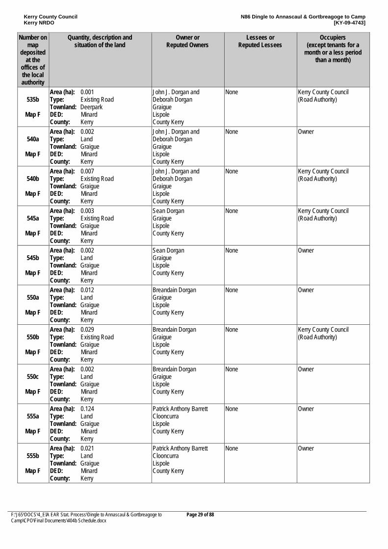
535b
Map F
Area (ha): 0.001 Type: Existing Road Townland: Deerpark DED: Minard County: Kerry
John J. Dorgan and Deborah Dorgan Graigue Lispole County Kerry
None Kerry County Council (Road Authority)
540a
Map F
Area (ha): 0.002 Type: Land Townland: Graigue DED: Minard County: Kerry
John J. Dorgan and Deborah Dorgan Graigue Lispole County Kerry
None Owner
540b
Map F
Area (ha): 0.007 Type: Existing Road Townland: Graigue DED: Minard County: Kerry
John J. Dorgan and Deborah Dorgan Graigue Lispole County Kerry
None Kerry County Council (Road Authority)
545a
Map F
Area (ha): 0.003 Type: Existing Road Townland: Graigue DED: Minard County: Kerry
Sean Dorgan Graigue Lispole County Kerry
None Kerry County Council (Road Authority)
545b
Map F
Area (ha): 0.002 Type: Land Townland: Graigue DED: Minard County: Kerry
Sean Dorgan Graigue Lispole County Kerry
None Owner
550a
Map F
Area (ha): 0.012 Type: Land Townland: Graigue DED: Minard County: Kerry
Breandain Dorgan Graigue Lispole County Kerry
None Owner
550b
Map F
Area (ha): 0.029 Type: Existing Road Townland: Graigue DED: Minard County: Kerry
Breandain Dorgan Graigue Lispole County Kerry
None Kerry County Council (Road Authority)
550c
Map F
Area (ha): 0.002 Type: Land Townland: Graigue DED: Minard County: Kerry
Breandain Dorgan Graigue Lispole County Kerry
None Owner
555a
Map F
Area (ha): 0.124 Type: Land Townland: Graigue DED: Minard County: Kerry
Patrick Anthony Barrett Clooncurra Lispole County Kerry
None Owner
555b
Map F
Area (ha): 0.021 Type: Land Townland: Graigue DED: Minard County: Kerry
Patrick Anthony Barrett Clooncurra Lispole County Kerry
None Owner
Kerry County Council Kerry NRDO
N86 Dingle to Annascaul & Gortbreagoge to Camp [KY-09-4743]
F:\J65\DOCS\4_EIA EAR Stat. Process\Dingle to Annascaul & Gortbreagoge to Camp\CPO\Final Documents\404b Schedule.docx
Page 30 of 88
Number on map
deposited at the
offices of the local authority
Quantity, description and situation of the land
Owner or Reputed Owners
Lessees or Reputed Lessees
Occupiers (except tenants for a
month or a less period than a month)
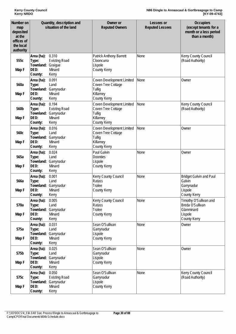
555c
Map F
Area (ha): 0.310 Type: Existing Road Townland: Graigue DED: Minard County: Kerry
Patrick Anthony Barrett Clooncurra Lispole County Kerry
None Kerry County Council (Road Authority)
560a
Map F
Area (ha): 0.091 Type: Land Townland: Garrynadur DED: Minard County: Kerry
Coven Development Limited Coven Tree Cottage Tullig Killarney County Kerry
None Owner
560b
Map F
Area (ha): 0.194 Type: Existing Road Townland: Garrynadur DED: Minard County: Kerry
Coven Development Limited Coven Tree Cottage Tullig Killarney County Kerry
None Kerry County Council (Road Authority)
560c
Map F
Area (ha): 0.016 Type: Land Townland: Garrynadur DED: Minard County: Kerry
Coven Development Limited Coven Tree Cottage Tullig Killarney County Kerry
None Owner
565a
Map F
Area (ha): 0.024 Type: Land Townland: Garrynadur DED: Minard County: Kerry
Paul Galvin Doonties Lispole County Kerry
None Owner
566a
Map F
Area (ha): 0.001 Type: Land Townland: Garrynadur DED: Minard County: Kerry
Kerry County Council Ratass Tralee County Kerry
None Bridget Galvin and Paul Galvin Garrynadur Lispole County Kerry
570a
Map F
Area (ha): 0.005 Type: Land Townland: Garrynadur DED: Minard County: Kerry
Kerry County Council Ratass Tralee County Kerry
None Timothy O'Sullivan and Breda O'Sullivan Glanminard Lispole County Kerry
575a
Map F
Area (ha): 0.031 Type: Land Townland: Garrynadur DED: Minard County: Kerry
Sean O'Sullivan Garrynadur Lispole County Kerry
None Owner
575b
Map F
Area (ha): 0.025 Type: Land Townland: Garrynadur DED: Minard County: Kerry
Sean O'Sullivan Garrynadur Lispole County Kerry
None Owner
575c
Map F
Area (ha): 0.050 Type: Existing Road Townland: Garrynadur DED: Minard County: Kerry
Sean O'Sullivan Garrynadur Lispole County Kerry
None Kerry County Council (Road Authority)
Kerry County Council Kerry NRDO
N86 Dingle to Annascaul & Gortbreagoge to Camp [KY-09-4743]
F:\J65\DOCS\4_EIA EAR Stat. Process\Dingle to Annascaul & Gortbreagoge to Camp\CPO\Final Documents\404b Schedule.docx
Page 31 of 88
Number on map
deposited at the
offices of the local authority
Quantity, description and situation of the land
Owner or Reputed Owners
Lessees or Reputed Lessees
Occupiers (except tenants for a
month or a less period than a month)
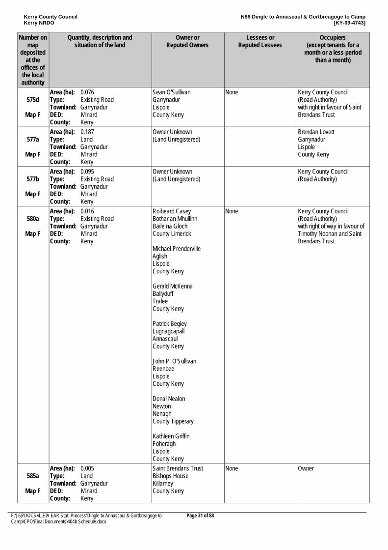
575d
Map F
Area (ha): 0.076 Type: Existing Road Townland: Garrynadur DED: Minard County: Kerry
Sean O'Sullivan Garrynadur Lispole County Kerry
None Kerry County Council (Road Authority) with right in favour of Saint Brendans Trust
577a
Map F
Area (ha): 0.187 Type: Land Townland: Garrynadur DED: Minard County: Kerry
Owner Unknown (Land Unregistered)
Brendan Lovett Garrynadur Lispole County Kerry
577b
Map F
Area (ha): 0.095 Type: Existing Road Townland: Garrynadur DED: Minard County: Kerry
Owner Unknown (Land Unregistered)
Kerry County Council (Road Authority)
580a
Map F
Area (ha): 0.016 Type: Existing Road Townland: Garrynadur DED: Minard County: Kerry
Roibeard Casey Bothar an Mhuilinn Baile na Gloch County Limerick Michael Prenderville Aglish Lispole County Kerry Gerald McKenna Ballyduff Tralee County Kerry Patrick Begley Lugnagcapall Annascaul County Kerry John P. O'Sullivan Reenbee Lispole County Kerry Donal Nealon Newton Nenagh County Tipperary Kathleen Griffin Foheragh Lispole County Kerry
None Kerry County Council (Road Authority) with right of way in favour of Timothy Noonan and Saint Brendans Trust
585a
Map F
Area (ha): 0.005 Type: Land Townland: Garrynadur DED: Minard County: Kerry
Saint Brendans Trust Bishops House Killarney County Kerry
None Owner
Kerry County Council Kerry NRDO
N86 Dingle to Annascaul & Gortbreagoge to Camp [KY-09-4743]
F:\J65\DOCS\4_EIA EAR Stat. Process\Dingle to Annascaul & Gortbreagoge to Camp\CPO\Final Documents\404b Schedule.docx
Page 32 of 88
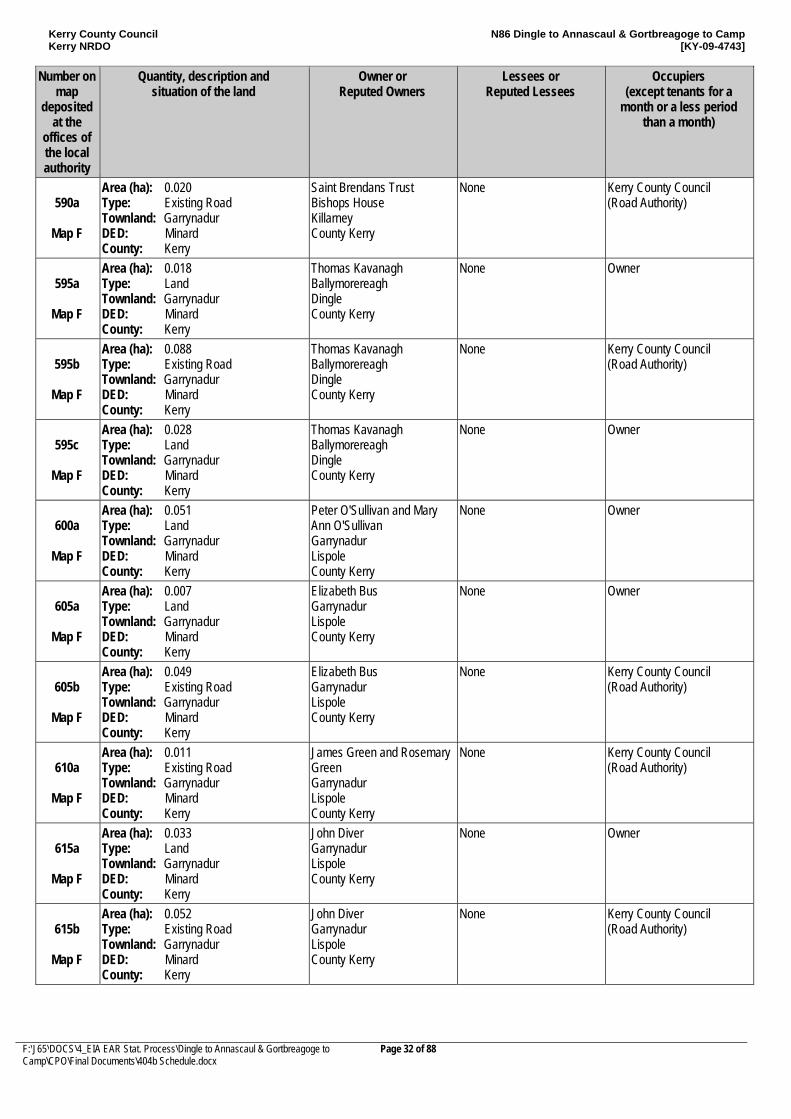
Number on map
deposited at the
offices of the local authority
Quantity, description and situation of the land
Owner or Reputed Owners
Lessees or Reputed Lessees
Occupiers (except tenants for a
month or a less period than a month)
590a
Map F
Area (ha): 0.020 Type: Existing Road Townland: Garrynadur DED: Minard County: Kerry
Saint Brendans Trust Bishops House Killarney County Kerry
None Kerry County Council (Road Authority)
595a
Map F
Area (ha): 0.018 Type: Land Townland: Garrynadur DED: Minard County: Kerry
Thomas Kavanagh Ballymorereagh Dingle County Kerry
None Owner
595b
Map F
Area (ha): 0.088 Type: Existing Road Townland: Garrynadur DED: Minard County: Kerry
Thomas Kavanagh Ballymorereagh Dingle County Kerry
None Kerry County Council (Road Authority)
595c
Map F
Area (ha): 0.028 Type: Land Townland: Garrynadur DED: Minard County: Kerry
Thomas Kavanagh Ballymorereagh Dingle County Kerry
None Owner
600a
Map F
Area (ha): 0.051 Type: Land Townland: Garrynadur DED: Minard County: Kerry
Peter O'Sullivan and Mary Ann O'Sullivan Garrynadur Lispole County Kerry
None Owner
605a
Map F
Area (ha): 0.007 Type: Land Townland: Garrynadur DED: Minard County: Kerry
Elizabeth Bus Garrynadur Lispole County Kerry
None Owner
605b
Map F
Area (ha): 0.049 Type: Existing Road Townland: Garrynadur DED: Minard County: Kerry
Elizabeth Bus Garrynadur Lispole County Kerry
None Kerry County Council (Road Authority)
610a
Map F
Area (ha): 0.011 Type: Existing Road Townland: Garrynadur DED: Minard County: Kerry
James Green and Rosemary Green Garrynadur Lispole County Kerry
None Kerry County Council (Road Authority)
615a
Map F
Area (ha): 0.033 Type: Land Townland: Garrynadur DED: Minard County: Kerry
John Diver Garrynadur Lispole County Kerry
None Owner
615b
Map F
Area (ha): 0.052 Type: Existing Road Townland: Garrynadur DED: Minard County: Kerry
John Diver Garrynadur Lispole County Kerry
None Kerry County Council (Road Authority)
Kerry County Council Kerry NRDO
N86 Dingle to Annascaul & Gortbreagoge to Camp [KY-09-4743]
F:\J65\DOCS\4_EIA EAR Stat. Process\Dingle to Annascaul & Gortbreagoge to Camp\CPO\Final Documents\404b Schedule.docx
Page 33 of 88
Number on map
deposited at the
offices of the local authority
Quantity, description and situation of the land
Owner or Reputed Owners
Lessees or Reputed Lessees
Occupiers (except tenants for a
month or a less period than a month)
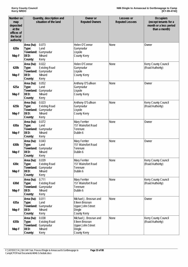
620a
Map F
Area (ha): 0.073 Type: Land Townland: Garrynadur DED: Minard County: Kerry
Helen O'Connor Garrynadur Lispole County Kerry
None Owner
620b
Map F
Area (ha): 0.022 Type: Existing Road Townland: Garrynadur DED: Minard County: Kerry
Helen O'Connor Garrynadur Lispole County Kerry
None Kerry County Council (Road Authority)
625a
Map F
Area (ha): 0.052 Type: Land Townland: Garrynadur DED: Minard County: Kerry
Anthony O'Sullivan Garrynadur Lispole County Kerry
None Owner
625b
Map F
Area (ha): 0.023 Type: Existing Road Townland: Garrynadur DED: Minard County: Kerry
Anthony O'Sullivan Garrynadur Lispole County Kerry
None Kerry County Council (Road Authority)
630a
Map F
Area (ha): 0.072 Type: Land Townland: Garrynadur DED: Minard County: Kerry
Mary Ferriter 151 Wainsfort Road Terenure Dublin 6
None Owner
630b
Map F
Area (ha): 0.043 Type: Land Townland: Garrynadur DED: Minard County: Kerry
Mary Ferriter 151 Wainsfort Road Terenure Dublin 6
None Owner
630c
Map F
Area (ha): 0.039 Type: Existing Road Townland: Garrynadur DED: Minard County: Kerry
Mary Ferriter 151 Wainsfort Road Terenure Dublin 6
None Kerry County Council (Road Authority)
630d
Map F
Area (ha): 0.711 Type: Existing Road Townland: Garrynadur DED: Minard County: Kerry
Mary Ferriter 151 Wainsfort Road Terenure Dublin 6
None Kerry County Council (Road Authority)
635a
Map F
Area (ha): 0.011 Type: Land Townland: Garrynadur DED: Minard County: Kerry
Michael J. Brosnan and Eileen Brosnan Upper John Street Dingle County Kerry
None Owner
635b
Map F
Area (ha): 0.038 Type: Existing Road Townland: Garrynadur DED: Minard County: Kerry
Michael J. Brosnan and Eileen Brosnan Upper John Street Dingle County Kerry
None Kerry County Council (Road Authority)
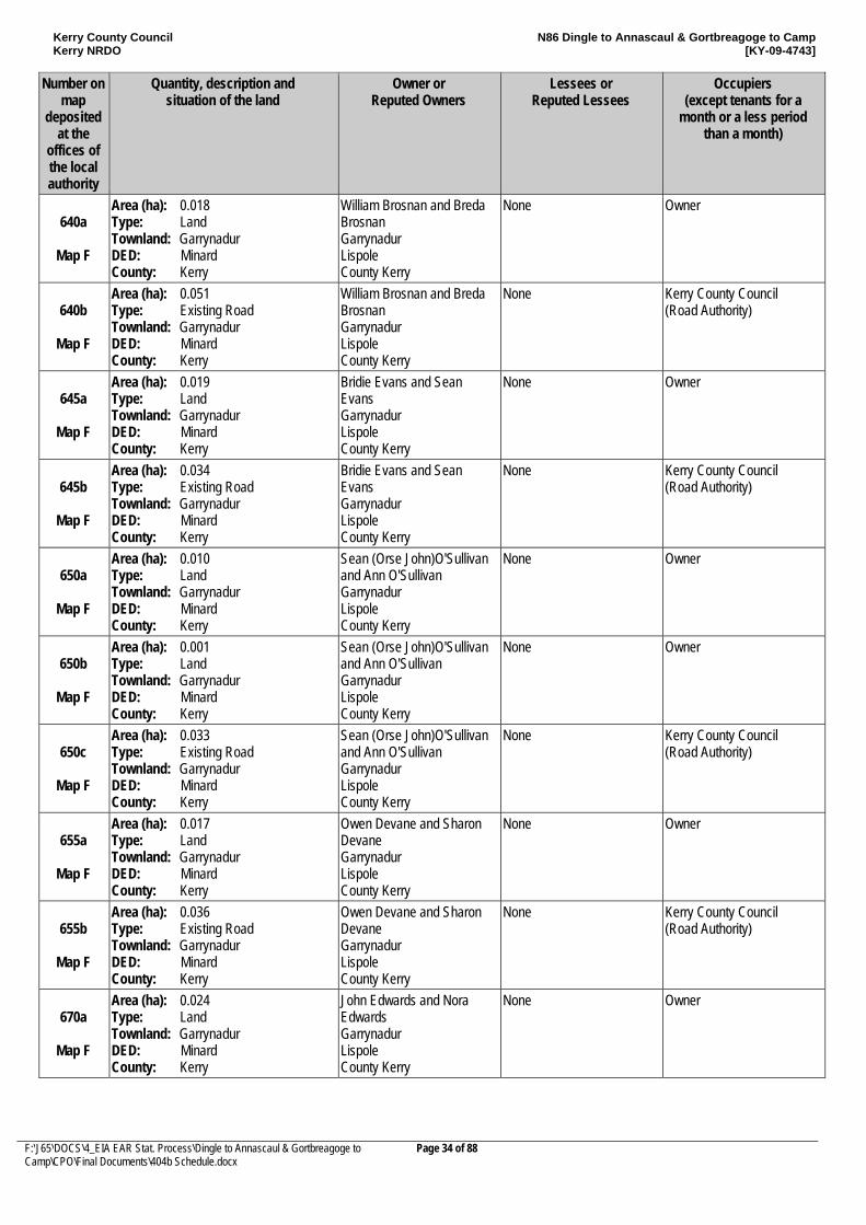
Kerry County Council Kerry NRDO
N86 Dingle to Annascaul & Gortbreagoge to Camp [KY-09-4743]
F:\J65\DOCS\4_EIA EAR Stat. Process\Dingle to Annascaul & Gortbreagoge to Camp\CPO\Final Documents\404b Schedule.docx
Page 34 of 88
Number on map
deposited at the
offices of the local authority
Quantity, description and situation of the land
Owner or Reputed Owners
Lessees or Reputed Lessees
Occupiers (except tenants for a
month or a less period than a month)
640a
Map F
Area (ha): 0.018 Type: Land Townland: Garrynadur DED: Minard County: Kerry
William Brosnan and Breda Brosnan Garrynadur Lispole County Kerry
None Owner
640b
Map F
Area (ha): 0.051 Type: Existing Road Townland: Garrynadur DED: Minard County: Kerry
William Brosnan and Breda Brosnan Garrynadur Lispole County Kerry
None Kerry County Council (Road Authority)
645a
Map F
Area (ha): 0.019 Type: Land Townland: Garrynadur DED: Minard County: Kerry
Bridie Evans and Sean Evans Garrynadur Lispole County Kerry
None Owner
645b
Map F
Area (ha): 0.034 Type: Existing Road Townland: Garrynadur DED: Minard County: Kerry
Bridie Evans and Sean Evans Garrynadur Lispole County Kerry
None Kerry County Council (Road Authority)
650a
Map F
Area (ha): 0.010 Type: Land Townland: Garrynadur DED: Minard County: Kerry
Sean (Orse John)O'Sullivan and Ann O'Sullivan Garrynadur Lispole County Kerry
None Owner
650b
Map F
Area (ha): 0.001 Type: Land Townland: Garrynadur DED: Minard County: Kerry
Sean (Orse John)O'Sullivan and Ann O'Sullivan Garrynadur Lispole County Kerry
None Owner
650c
Map F
Area (ha): 0.033 Type: Existing Road Townland: Garrynadur DED: Minard County: Kerry
Sean (Orse John)O'Sullivan and Ann O'Sullivan Garrynadur Lispole County Kerry
None Kerry County Council (Road Authority)
655a
Map F
Area (ha): 0.017 Type: Land Townland: Garrynadur DED: Minard County: Kerry
Owen Devane and Sharon Devane Garrynadur Lispole County Kerry
None Owner
655b
Map F
Area (ha): 0.036 Type: Existing Road Townland: Garrynadur DED: Minard County: Kerry
Owen Devane and Sharon Devane Garrynadur Lispole County Kerry
None Kerry County Council (Road Authority)
670a
Map F
Area (ha): 0.024 Type: Land Townland: Garrynadur DED: Minard County: Kerry
John Edwards and Nora Edwards Garrynadur Lispole County Kerry
None Owner
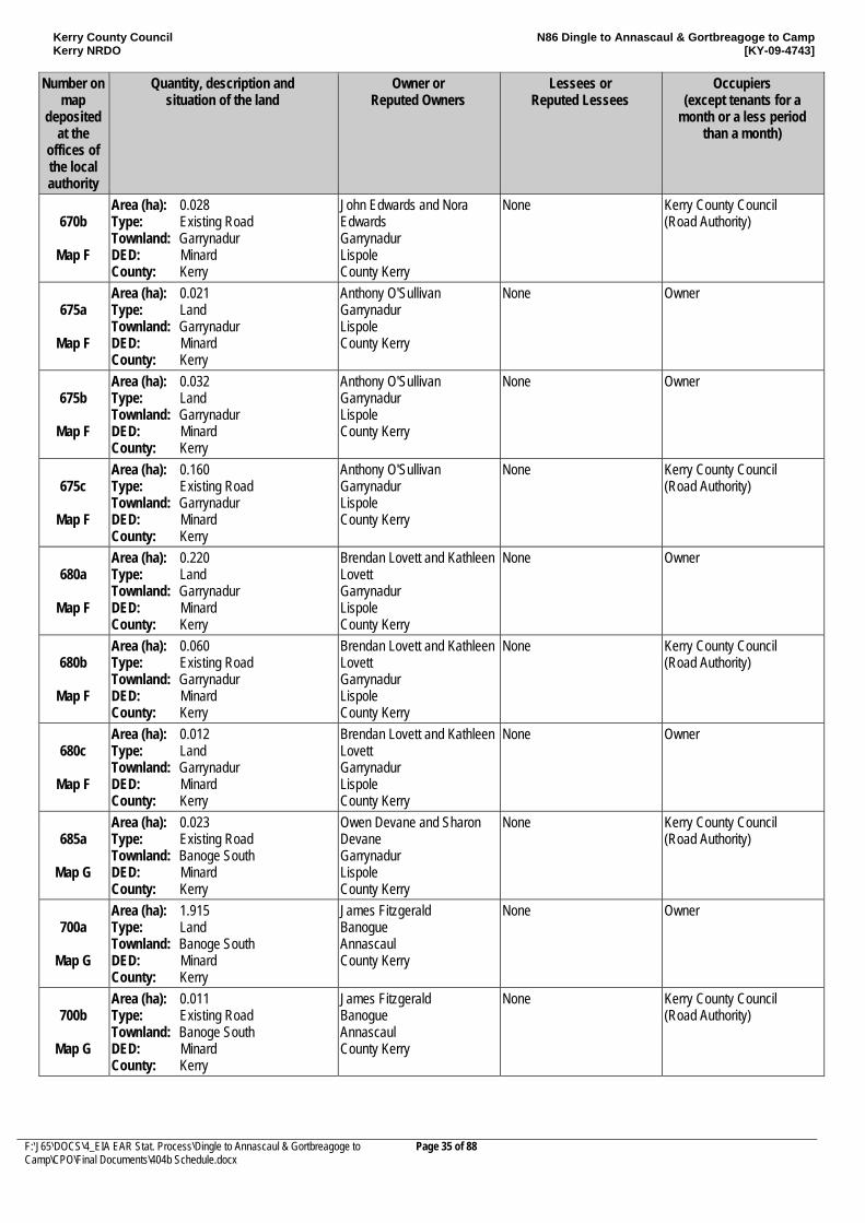
Kerry County Council Kerry NRDO
N86 Dingle to Annascaul & Gortbreagoge to Camp [KY-09-4743]
F:\J65\DOCS\4_EIA EAR Stat. Process\Dingle to Annascaul & Gortbreagoge to Camp\CPO\Final Documents\404b Schedule.docx
Page 35 of 88
Number on map
deposited at the
offices of the local authority
Quantity, description and situation of the land
Owner or Reputed Owners
Lessees or Reputed Lessees
Occupiers (except tenants for a
month or a less period than a month)
670b
Map F
Area (ha): 0.028 Type: Existing Road Townland: Garrynadur DED: Minard County: Kerry
John Edwards and Nora Edwards Garrynadur Lispole County Kerry
None Kerry County Council (Road Authority)
675a
Map F
Area (ha): 0.021 Type: Land Townland: Garrynadur DED: Minard County: Kerry
Anthony O'Sullivan Garrynadur Lispole County Kerry
None Owner
675b
Map F
Area (ha): 0.032 Type: Land Townland: Garrynadur DED: Minard County: Kerry
Anthony O'Sullivan Garrynadur Lispole County Kerry
None Owner
675c
Map F
Area (ha): 0.160 Type: Existing Road Townland: Garrynadur DED: Minard County: Kerry
Anthony O'Sullivan Garrynadur Lispole County Kerry
None Kerry County Council (Road Authority)
680a
Map F
Area (ha): 0.220 Type: Land Townland: Garrynadur DED: Minard County: Kerry
Brendan Lovett and Kathleen Lovett Garrynadur Lispole County Kerry
None Owner
680b
Map F
Area (ha): 0.060 Type: Existing Road Townland: Garrynadur DED: Minard County: Kerry
Brendan Lovett and Kathleen Lovett Garrynadur Lispole County Kerry
None Kerry County Council (Road Authority)
680c
Map F
Area (ha): 0.012 Type: Land Townland: Garrynadur DED: Minard County: Kerry
Brendan Lovett and Kathleen Lovett Garrynadur Lispole County Kerry
None Owner
685a
Map G
Area (ha): 0.023 Type: Existing Road Townland: Banoge South DED: Minard County: Kerry
Owen Devane and Sharon Devane Garrynadur Lispole County Kerry
None Kerry County Council (Road Authority)
700a
Map G
Area (ha): 1.915 Type: Land Townland: Banoge South DED: Minard County: Kerry
James Fitzgerald Banogue Annascaul County Kerry
None Owner
700b
Map G
Area (ha): 0.011 Type: Existing Road Townland: Banoge South DED: Minard County: Kerry
James Fitzgerald Banogue Annascaul County Kerry
None Kerry County Council (Road Authority)
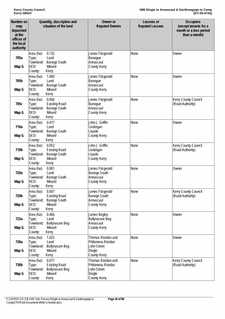
Kerry County Council Kerry NRDO
N86 Dingle to Annascaul & Gortbreagoge to Camp [KY-09-4743]
F:\J65\DOCS\4_EIA EAR Stat. Process\Dingle to Annascaul & Gortbreagoge to Camp\CPO\Final Documents\404b Schedule.docx
Page 36 of 88
Number on map
deposited at the
offices of the local authority
Quantity, description and situation of the land
Owner or Reputed Owners
Lessees or Reputed Lessees
Occupiers (except tenants for a
month or a less period than a month)
705a
Map G
Area (ha): 0.132 Type: Land Townland: Banoge South DED: Minard County: Kerry
James Fitzgerald Banogue Annascaul County Kerry
None Owner
705b
Map G
Area (ha): 1.069 Type: Land Townland: Banoge South DED: Minard County: Kerry
James Fitzgerald Banogue Annascaul County Kerry
None Owner
705c
Map G
Area (ha): 0.066 Type: Existing Road Townland: Banoge South DED: Minard County: Kerry
James Fitzgerald Banogue Annascaul County Kerry
None Kerry County Council (Road Authority)
710a
Map G
Area (ha): 0.417 Type: Land Townland: Banoge South DED: Minard County: Kerry
John J. Griffin Lisdorgan Lispole County Kerry
None Owner
710b
Map G
Area (ha): 0.052 Type: Existing Road Townland: Banoge South DED: Minard County: Kerry
John J. Griffin Lisdorgan Lispole County Kerry
None Kerry County Council (Road Authority)
720a
Map G
Area (ha): 0.001 Type: Land Townland: Banoge South DED: Minard County: Kerry
James Fitzgerald Banoge South Annascaul County Kerry
None Owner
720b
Map G
Area (ha): 0.007 Type: Existing Road Townland: Banoge South DED: Minard County: Kerry
James Fitzgerald Banoge South Annascaul County Kerry
None Kerry County Council (Road Authority)
725a
Map G
Area (ha): 0.466 Type: Land Townland: Ballynasare Beg DED: Minard County: Kerry
James Begley Ballynasare Beg Annascaul County Kerry
None Owner
730a
Map G
Area (ha): 1.625 Type: Land Townland: Ballynasare Beg DED: Minard County: Kerry
Thomas Riordan and Philomena Riordan John Street Dingle County Kerry
None Owner
730b
Map G
Area (ha): 0.071 Type: Existing Road Townland: Ballynasare Beg DED: Minard County: Kerry
Thomas Riordan and Philomena Riordan John Street Dingle County Kerry
None Kerry County Council (Road Authority)
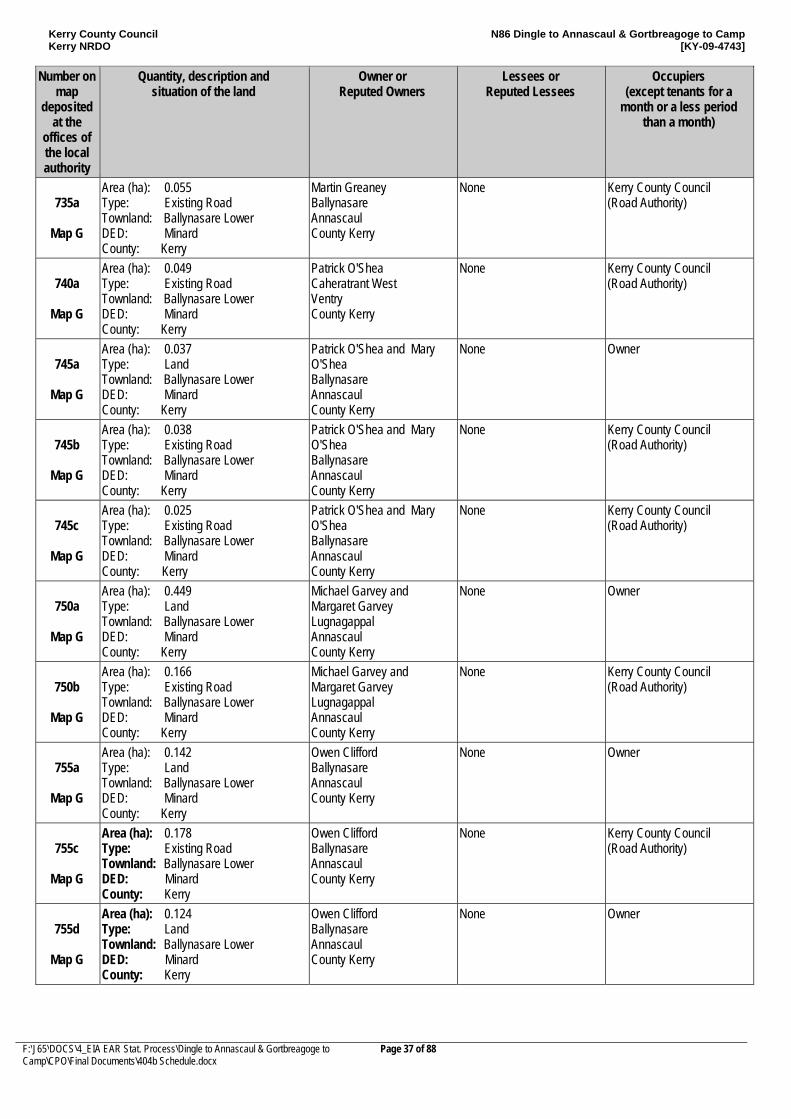
Kerry County Council Kerry NRDO
N86 Dingle to Annascaul & Gortbreagoge to Camp [KY-09-4743]
F:\J65\DOCS\4_EIA EAR Stat. Process\Dingle to Annascaul & Gortbreagoge to Camp\CPO\Final Documents\404b Schedule.docx
Page 37 of 88
Number on map
deposited at the
offices of the local authority
Quantity, description and situation of the land
Owner or Reputed Owners
Lessees or Reputed Lessees
Occupiers (except tenants for a
month or a less period than a month)
735a
Map G
Area (ha): 0.055 Type: Existing Road Townland: Ballynasare Lower DED: Minard County: Kerry
Martin Greaney Ballynasare Annascaul County Kerry
None Kerry County Council (Road Authority)
740a
Map G
Area (ha): 0.049 Type: Existing Road Townland: Ballynasare Lower DED: Minard County: Kerry
Patrick O'Shea Caheratrant West Ventry County Kerry
None Kerry County Council (Road Authority)
745a
Map G
Area (ha): 0.037 Type: Land Townland: Ballynasare Lower DED: Minard County: Kerry
Patrick O'Shea and Mary O'Shea Ballynasare Annascaul County Kerry
None Owner
745b
Map G
Area (ha): 0.038 Type: Existing Road Townland: Ballynasare Lower DED: Minard County: Kerry
Patrick O'Shea and Mary O'Shea Ballynasare Annascaul County Kerry
None Kerry County Council (Road Authority)
745c
Map G
Area (ha): 0.025 Type: Existing Road Townland: Ballynasare Lower DED: Minard County: Kerry
Patrick O'Shea and Mary O'Shea Ballynasare Annascaul County Kerry
None Kerry County Council (Road Authority)
750a
Map G
Area (ha): 0.449 Type: Land Townland: Ballynasare Lower DED: Minard County: Kerry
Michael Garvey and Margaret Garvey Lugnagappal Annascaul County Kerry
None Owner
750b
Map G
Area (ha): 0.166 Type: Existing Road Townland: Ballynasare Lower DED: Minard County: Kerry
Michael Garvey and Margaret Garvey Lugnagappal Annascaul County Kerry
None Kerry County Council (Road Authority)
755a
Map G
Area (ha): 0.142 Type: Land Townland: Ballynasare Lower DED: Minard County: Kerry
Owen Clifford Ballynasare Annascaul County Kerry
None Owner
755c
Map G
Area (ha): 0.178 Type: Existing Road Townland: Ballynasare Lower DED: Minard County: Kerry
Owen Clifford Ballynasare Annascaul County Kerry
None Kerry County Council (Road Authority)
755d
Map G
Area (ha): 0.124 Type: Land Townland: Ballynasare Lower DED: Minard County: Kerry
Owen Clifford Ballynasare Annascaul County Kerry
None Owner
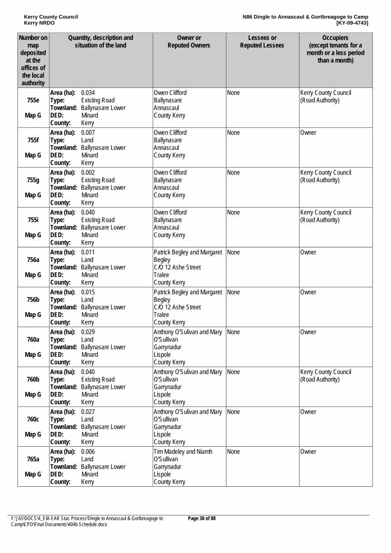
Kerry County Council Kerry NRDO
N86 Dingle to Annascaul & Gortbreagoge to Camp [KY-09-4743]
F:\J65\DOCS\4_EIA EAR Stat. Process\Dingle to Annascaul & Gortbreagoge to Camp\CPO\Final Documents\404b Schedule.docx
Page 38 of 88
Number on map
deposited at the
offices of the local authority
Quantity, description and situation of the land
Owner or Reputed Owners
Lessees or Reputed Lessees
Occupiers (except tenants for a
month or a less period than a month)
755e
Map G
Area (ha): 0.034 Type: Existing Road Townland: Ballynasare Lower DED: Minard County: Kerry
Owen Clifford Ballynasare Annascaul County Kerry
None Kerry County Council (Road Authority)
755f
Map G
Area (ha): 0.007 Type: Land Townland: Ballynasare Lower DED: Minard County: Kerry
Owen Clifford Ballynasare Annascaul County Kerry
None Owner
755g
Map G
Area (ha): 0.002 Type: Existing Road Townland: Ballynasare Lower DED: Minard County: Kerry
Owen Clifford Ballynasare Annascaul County Kerry
None Kerry County Council (Road Authority)
755i
Map G
Area (ha): 0.040 Type: Existing Road Townland: Ballynasare Lower DED: Minard County: Kerry
Owen Clifford Ballynasare Annascaul County Kerry
None Kerry County Council (Road Authority)
756a
Map G
Area (ha): 0.011 Type: Land Townland: Ballynasare Lower DED: Minard County: Kerry
Patrick Begley and Margaret Begley C/O 12 Ashe Street Tralee County Kerry
None Owner
756b
Map G
Area (ha): 0.015 Type: Land Townland: Ballynasare Lower DED: Minard County: Kerry
Patrick Begley and Margaret Begley C/O 12 Ashe Street Tralee County Kerry
None Owner
760a
Map G
Area (ha): 0.029 Type: Land Townland: Ballynasare Lower DED: Minard County: Kerry
Anthony O'Sulivan and Mary O'Sullivan Garrynadur Lispole County Kerry
None Owner
760b
Map G
Area (ha): 0.040 Type: Existing Road Townland: Ballynasare Lower DED: Minard County: Kerry
Anthony O'Sulivan and Mary O'Sullivan Garrynadur Lispole County Kerry
None Kerry County Council (Road Authority)
760c
Map G
Area (ha): 0.027 Type: Land Townland: Ballynasare Lower DED: Minard County: Kerry
Anthony O'Sulivan and Mary O'Sullivan Garrynadur Lispole County Kerry
None Owner
765a
Map G
Area (ha): 0.006 Type: Land Townland: Ballynasare Lower DED: Minard County: Kerry
Tim Madeley and Niamh O'Sullivan Garrynadur Lispole County Kerry
None Owner
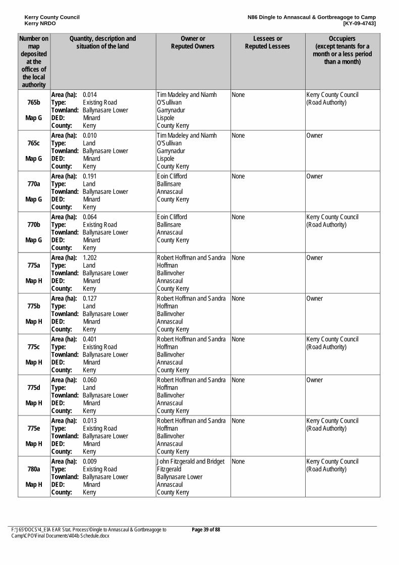
Kerry County Council Kerry NRDO
N86 Dingle to Annascaul & Gortbreagoge to Camp [KY-09-4743]
F:\J65\DOCS\4_EIA EAR Stat. Process\Dingle to Annascaul & Gortbreagoge to Camp\CPO\Final Documents\404b Schedule.docx
Page 39 of 88
Number on map
deposited at the
offices of the local authority
Quantity, description and situation of the land
Owner or Reputed Owners
Lessees or Reputed Lessees
Occupiers (except tenants for a
month or a less period than a month)
765b
Map G
Area (ha): 0.014 Type: Existing Road Townland: Ballynasare Lower DED: Minard County: Kerry
Tim Madeley and Niamh O'Sullivan Garrynadur Lispole County Kerry
None Kerry County Council (Road Authority)
765c
Map G
Area (ha): 0.010 Type: Land Townland: Ballynasare Lower DED: Minard County: Kerry
Tim Madeley and Niamh O'Sullivan Garrynadur Lispole County Kerry
None Owner
770a
Map G
Area (ha): 0.191 Type: Land Townland: Ballynasare Lower DED: Minard County: Kerry
Eoin Clifford Ballinsare Annascaul County Kerry
None Owner
770b
Map G
Area (ha): 0.064 Type: Existing Road Townland: Ballynasare Lower DED: Minard County: Kerry
Eoin Clifford Ballinsare Annascaul County Kerry
None Kerry County Council (Road Authority)
775a
Map H
Area (ha): 1.202 Type: Land Townland: Ballynasare Lower DED: Minard County: Kerry
Robert Hoffman and Sandra Hoffman Ballinvoher Annascaul County Kerry
None Owner
775b
Map H
Area (ha): 0.127 Type: Land Townland: Ballynasare Lower DED: Minard County: Kerry
Robert Hoffman and Sandra Hoffman Ballinvoher Annascaul County Kerry
None Owner
775c
Map H
Area (ha): 0.401 Type: Existing Road Townland: Ballynasare Lower DED: Minard County: Kerry
Robert Hoffman and Sandra Hoffman Ballinvoher Annascaul County Kerry
None Kerry County Council (Road Authority)
775d
Map H
Area (ha): 0.060 Type: Land Townland: Ballynasare Lower DED: Minard County: Kerry
Robert Hoffman and Sandra Hoffman Ballinvoher Annascaul County Kerry
None Owner
775e
Map H
Area (ha): 0.013 Type: Existing Road Townland: Ballynasare Lower DED: Minard County: Kerry
Robert Hoffman and Sandra Hoffman Ballinvoher Annascaul County Kerry
None Kerry County Council (Road Authority)
780a
Map H
Area (ha): 0.009 Type: Existing Road Townland: Ballynasare Lower DED: Minard County: Kerry
John Fitzgerald and Bridget Fitzgerald Ballynasare Lower Annascaul County Kerry
None Kerry County Council (Road Authority)
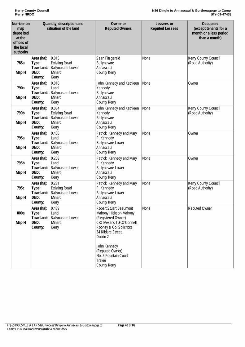
Kerry County Council Kerry NRDO
N86 Dingle to Annascaul & Gortbreagoge to Camp [KY-09-4743]
F:\J65\DOCS\4_EIA EAR Stat. Process\Dingle to Annascaul & Gortbreagoge to Camp\CPO\Final Documents\404b Schedule.docx
Page 40 of 88
Number on map
deposited at the
offices of the local authority
Quantity, description and situation of the land
Owner or Reputed Owners
Lessees or Reputed Lessees
Occupiers (except tenants for a
month or a less period than a month)
785a
Map H
Area (ha): 0.015 Type: Existing Road Townland: Ballynasare Lower DED: Minard County: Kerry
Sean Fitzgerald Ballynasare Annascaul County Kerry
None Kerry County Council (Road Authority)
790a
Map H
Area (ha): 0.016 Type: Land Townland: Ballynasare Lower DED: Minard County: Kerry
John Kennedy and Kathleen Kennedy Ballynasare Annascaul County Kerry
None Owner
790b
Map H
Area (ha): 0.034 Type: Existing Road Townland: Ballynasare Lower DED: Minard County: Kerry
John Kennedy and Kathleen Kennedy Ballynasare Annascaul County Kerry
None Kerry County Council (Road Authority)
795a
Map H
Area (ha): 0.405 Type: Land Townland: Ballynasare Lower DED: Minard County: Kerry
Patrick Kennedy and Mary P. Kennedy Ballynasare Lower Annascaul County Kerry
None Owner
795b
Map H
Area (ha): 0.258 Type: Land Townland: Ballynasare Lower DED: Minard County: Kerry
Patrick Kennedy and Mary P. Kennedy Ballynasare Lower Annascaul County Kerry
None Owner
795c
Map H
Area (ha): 0.281 Type: Existing Road Townland: Ballynasare Lower DED: Minard County: Kerry
Patrick Kennedy and Mary P. Kennedy Ballynasare Lower Annascaul County Kerry
None Kerry County Council (Road Authority)
800a
Map H
Area (ha): 0.489 Type: Land Townland: Ballynasare Lower DED: Minard County: Kerry
Robert Stuart Beaumont Mahony Hickson-Mahony (Registered Owner) C/O Messr's T.F.O'Connell, Rooney & Co. Solicitors 34 Kildare Street Dublin 2 John Kennedy (Reputed Owner) No. 5 Fountain Court Tralee County Kerry
None Reputed Owner
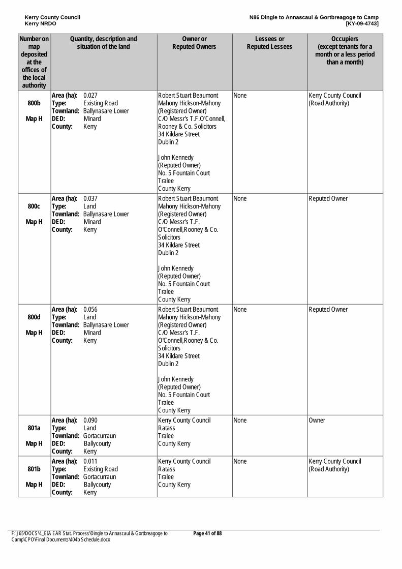
Kerry County Council Kerry NRDO
N86 Dingle to Annascaul & Gortbreagoge to Camp [KY-09-4743]
F:\J65\DOCS\4_EIA EAR Stat. Process\Dingle to Annascaul & Gortbreagoge to Camp\CPO\Final Documents\404b Schedule.docx
Page 41 of 88
Number on map
deposited at the
offices of the local authority
Quantity, description and situation of the land
Owner or Reputed Owners
Lessees or Reputed Lessees
Occupiers (except tenants for a
month or a less period than a month)
800b
Map H
Area (ha): 0.027 Type: Existing Road Townland: Ballynasare Lower DED: Minard County: Kerry
Robert Stuart Beaumont Mahony Hickson-Mahony (Registered Owner) C/O Messr's T.F.O'Connell, Rooney & Co. Solicitors 34 Kildare Street Dublin 2 John Kennedy (Reputed Owner) No. 5 Fountain Court Tralee County Kerry
None Kerry County Council (Road Authority)
800c
Map H
Area (ha): 0.037 Type: Land Townland: Ballynasare Lower DED: Minard County: Kerry
Robert Stuart Beaumont Mahony Hickson-Mahony (Registered Owner) C/O Messr's T.F. O'Connell,Rooney & Co. Solicitors 34 Kildare Street Dublin 2 John Kennedy (Reputed Owner) No. 5 Fountain Court Tralee County Kerry
None Reputed Owner
800d
Map H
Area (ha): 0.056 Type: Land Townland: Ballynasare Lower DED: Minard County: Kerry
Robert Stuart Beaumont Mahony Hickson-Mahony (Registered Owner) C/O Messr's T.F. O'Connell,Rooney & Co. Solicitors 34 Kildare Street Dublin 2 John Kennedy (Reputed Owner) No. 5 Fountain Court Tralee County Kerry
None Reputed Owner
801a
Map H
Area (ha): 0.090 Type: Land Townland: Gortacurraun DED: Ballycourty County: Kerry
Kerry County Council Ratass Tralee County Kerry
None Owner
801b
Map H
Area (ha): 0.011 Type: Existing Road Townland: Gortacurraun DED: Ballycourty County: Kerry
Kerry County Council Ratass Tralee County Kerry
None Kerry County Council (Road Authority)
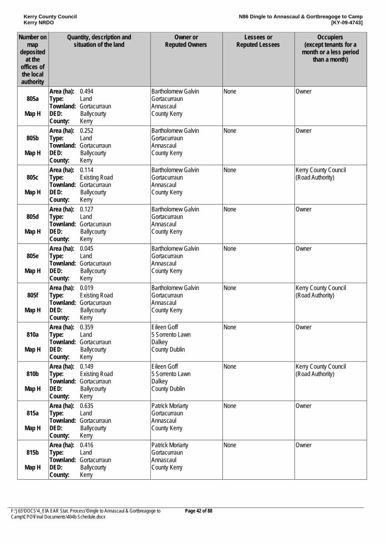
Kerry County Council Kerry NRDO
N86 Dingle to Annascaul & Gortbreagoge to Camp [KY-09-4743]
F:\J65\DOCS\4_EIA EAR Stat. Process\Dingle to Annascaul & Gortbreagoge to Camp\CPO\Final Documents\404b Schedule.docx
Page 42 of 88
Number on map
deposited at the
offices of the local authority
Quantity, description and situation of the land
Owner or Reputed Owners
Lessees or Reputed Lessees
Occupiers (except tenants for a
month or a less period than a month)
805a
Map H
Area (ha): 0.494 Type: Land Townland: Gortacurraun DED: Ballycourty County: Kerry
Bartholomew Galvin Gortacurraun Annascaul County Kerry
None Owner
805b
Map H
Area (ha): 0.252 Type: Land Townland: Gortacurraun DED: Ballycourty County: Kerry
Bartholomew Galvin Gortacurraun Annascaul County Kerry
None Owner
805c
Map H
Area (ha): 0.114 Type: Existing Road Townland: Gortacurraun DED: Ballycourty County: Kerry
Bartholomew Galvin Gortacurraun Annascaul County Kerry
None Kerry County Council (Road Authority)
805d
Map H
Area (ha): 0.127 Type: Land Townland: Gortacurraun DED: Ballycourty County: Kerry
Bartholomew Galvin Gortacurraun Annascaul County Kerry
None Owner
805e
Map H
Area (ha): 0.045 Type: Land Townland: Gortacurraun DED: Ballycourty County: Kerry
Bartholomew Galvin Gortacurraun Annascaul County Kerry
None Owner
805f
Map H
Area (ha): 0.019 Type: Existing Road Townland: Gortacurraun DED: Ballycourty County: Kerry
Bartholomew Galvin Gortacurraun Annascaul County Kerry
None Kerry County Council (Road Authority)
810a
Map H
Area (ha): 0.359 Type: Land Townland: Gortacurraun DED: Ballycourty County: Kerry
Eileen Goff 5 Sorrento Lawn Dalkey County Dublin
None Owner
810b
Map H
Area (ha): 0.149 Type: Existing Road Townland: Gortacurraun DED: Ballycourty County: Kerry
Eileen Goff 5 Sorrento Lawn Dalkey County Dublin
None Kerry County Council (Road Authority)
815a
Map H
Area (ha): 0.635 Type: Land Townland: Gortacurraun DED: Ballycourty County: Kerry
Patrick Moriarty Gortacurraun Annascaul County Kerry
None Owner
815b
Map H
Area (ha): 0.416 Type: Land Townland: Gortacurraun DED: Ballycourty County: Kerry
Patrick Moriarty Gortacurraun Annascaul County Kerry
None Owner
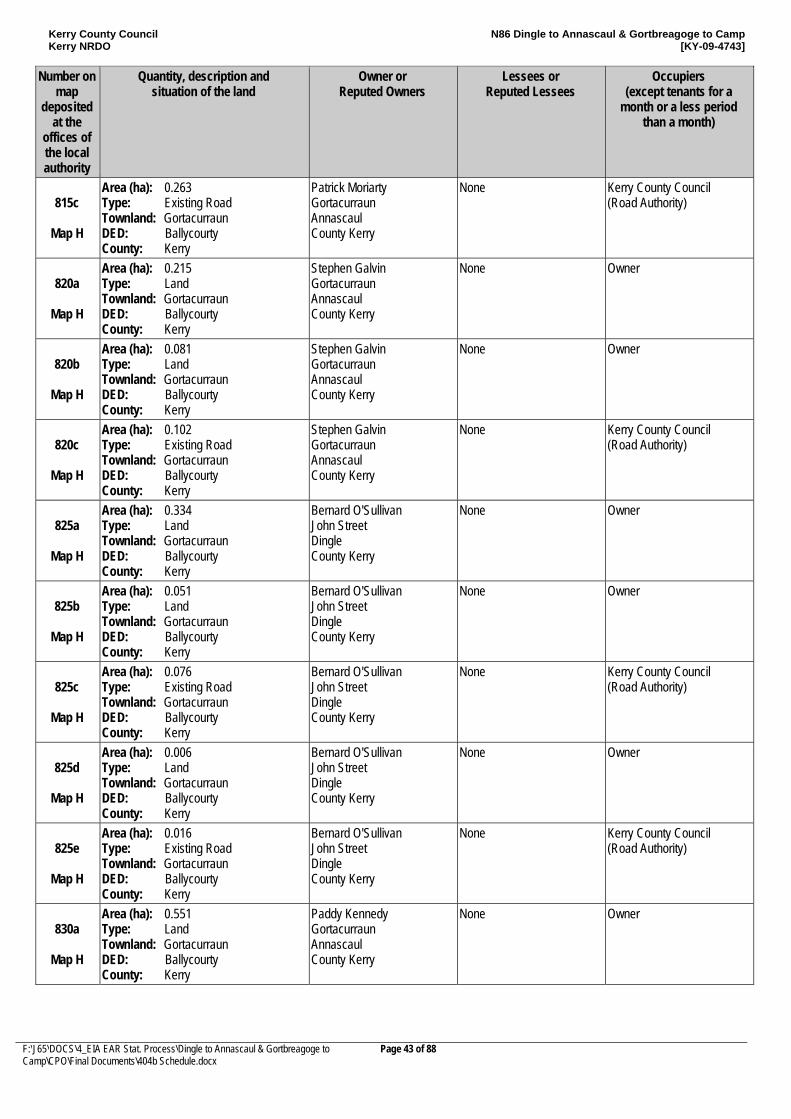
Kerry County Council Kerry NRDO
N86 Dingle to Annascaul & Gortbreagoge to Camp [KY-09-4743]
F:\J65\DOCS\4_EIA EAR Stat. Process\Dingle to Annascaul & Gortbreagoge to Camp\CPO\Final Documents\404b Schedule.docx
Page 43 of 88
Number on map
deposited at the
offices of the local authority
Quantity, description and situation of the land
Owner or Reputed Owners
Lessees or Reputed Lessees
Occupiers (except tenants for a
month or a less period than a month)
815c
Map H
Area (ha): 0.263 Type: Existing Road Townland: Gortacurraun DED: Ballycourty County: Kerry
Patrick Moriarty Gortacurraun Annascaul County Kerry
None Kerry County Council (Road Authority)
820a
Map H
Area (ha): 0.215 Type: Land Townland: Gortacurraun DED: Ballycourty County: Kerry
Stephen Galvin Gortacurraun Annascaul County Kerry
None Owner
820b
Map H
Area (ha): 0.081 Type: Land Townland: Gortacurraun DED: Ballycourty County: Kerry
Stephen Galvin Gortacurraun Annascaul County Kerry
None Owner
820c
Map H
Area (ha): 0.102 Type: Existing Road Townland: Gortacurraun DED: Ballycourty County: Kerry
Stephen Galvin Gortacurraun Annascaul County Kerry
None Kerry County Council (Road Authority)
825a
Map H
Area (ha): 0.334 Type: Land Townland: Gortacurraun DED: Ballycourty County: Kerry
Bernard O'Sullivan John Street Dingle County Kerry
None Owner
825b
Map H
Area (ha): 0.051 Type: Land Townland: Gortacurraun DED: Ballycourty County: Kerry
Bernard O'Sullivan John Street Dingle County Kerry
None Owner
825c
Map H
Area (ha): 0.076 Type: Existing Road Townland: Gortacurraun DED: Ballycourty County: Kerry
Bernard O'Sullivan John Street Dingle County Kerry
None Kerry County Council (Road Authority)
825d
Map H
Area (ha): 0.006 Type: Land Townland: Gortacurraun DED: Ballycourty County: Kerry
Bernard O'Sullivan John Street Dingle County Kerry
None Owner
825e
Map H
Area (ha): 0.016 Type: Existing Road Townland: Gortacurraun DED: Ballycourty County: Kerry
Bernard O'Sullivan John Street Dingle County Kerry
None Kerry County Council (Road Authority)
830a
Map H
Area (ha): 0.551 Type: Land Townland: Gortacurraun DED: Ballycourty County: Kerry
Paddy Kennedy Gortacurraun Annascaul County Kerry
None Owner
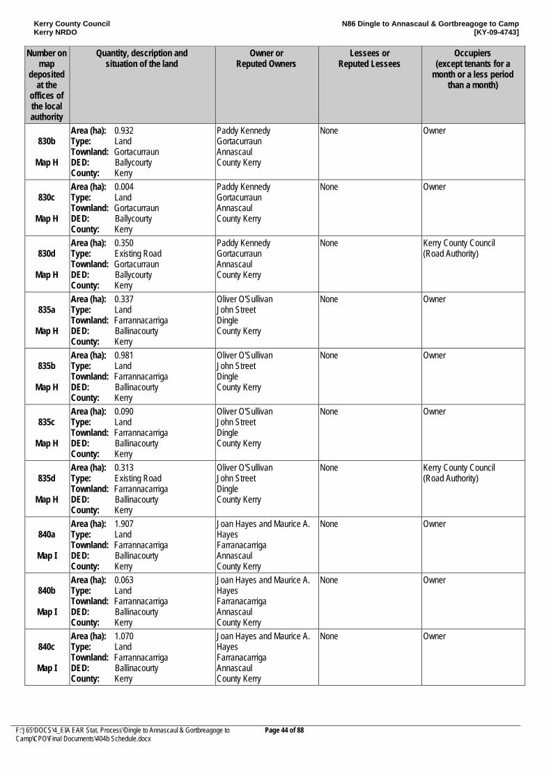
Kerry County Council Kerry NRDO
N86 Dingle to Annascaul & Gortbreagoge to Camp [KY-09-4743]
F:\J65\DOCS\4_EIA EAR Stat. Process\Dingle to Annascaul & Gortbreagoge to Camp\CPO\Final Documents\404b Schedule.docx
Page 44 of 88
Number on map
deposited at the
offices of the local authority
Quantity, description and situation of the land
Owner or Reputed Owners
Lessees or Reputed Lessees
Occupiers (except tenants for a
month or a less period than a month)
830b
Map H
Area (ha): 0.932 Type: Land Townland: Gortacurraun DED: Ballycourty County: Kerry
Paddy Kennedy Gortacurraun Annascaul County Kerry
None Owner
830c
Map H
Area (ha): 0.004 Type: Land Townland: Gortacurraun DED: Ballycourty County: Kerry
Paddy Kennedy Gortacurraun Annascaul County Kerry
None Owner
830d
Map H
Area (ha): 0.350 Type: Existing Road Townland: Gortacurraun DED: Ballycourty County: Kerry
Paddy Kennedy Gortacurraun Annascaul County Kerry
None Kerry County Council (Road Authority)
835a
Map H
Area (ha): 0.337 Type: Land Townland: Farrannacarriga DED: Ballinacourty County: Kerry
Oliver O'Sullivan John Street Dingle County Kerry
None Owner
835b
Map H
Area (ha): 0.981 Type: Land Townland: Farrannacarriga DED: Ballinacourty County: Kerry
Oliver O'Sullivan John Street Dingle County Kerry
None Owner
835c
Map H
Area (ha): 0.090 Type: Land Townland: Farrannacarriga DED: Ballinacourty County: Kerry
Oliver O'Sullivan John Street Dingle County Kerry
None Owner
835d
Map H
Area (ha): 0.313 Type: Existing Road Townland: Farrannacarriga DED: Ballinacourty County: Kerry
Oliver O'Sullivan John Street Dingle County Kerry
None Kerry County Council (Road Authority)
840a
Map I
Area (ha): 1.907 Type: Land Townland: Farrannacarriga DED: Ballinacourty County: Kerry
Joan Hayes and Maurice A. Hayes Farranacarriga Annascaul County Kerry
None Owner
840b
Map I
Area (ha): 0.063 Type: Land Townland: Farrannacarriga DED: Ballinacourty County: Kerry
Joan Hayes and Maurice A. Hayes Farranacarriga Annascaul County Kerry
None Owner
840c
Map I
Area (ha): 1.070 Type: Land Townland: Farrannacarriga DED: Ballinacourty County: Kerry
Joan Hayes and Maurice A. Hayes Farranacarriga Annascaul County Kerry
None Owner
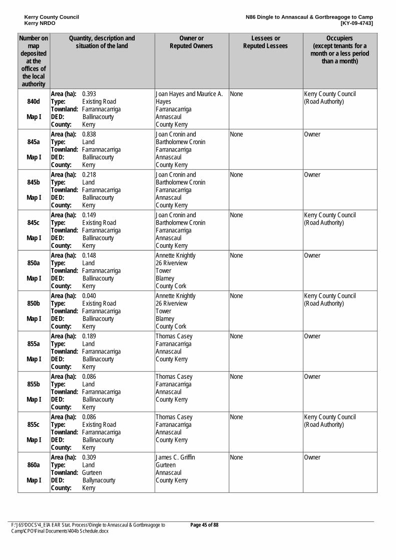
Kerry County Council Kerry NRDO
N86 Dingle to Annascaul & Gortbreagoge to Camp [KY-09-4743]
F:\J65\DOCS\4_EIA EAR Stat. Process\Dingle to Annascaul & Gortbreagoge to Camp\CPO\Final Documents\404b Schedule.docx
Page 45 of 88
Number on map
deposited at the
offices of the local authority
Quantity, description and situation of the land
Owner or Reputed Owners
Lessees or Reputed Lessees
Occupiers (except tenants for a
month or a less period than a month)
840d
Map I
Area (ha): 0.393 Type: Existing Road Townland: Farrannacarriga DED: Ballinacourty County: Kerry
Joan Hayes and Maurice A. Hayes Farranacarriga Annascaul County Kerry
None Kerry County Council (Road Authority)
845a
Map I
Area (ha): 0.838 Type: Land Townland: Farrannacarriga DED: Ballinacourty County: Kerry
Joan Cronin and Bartholomew Cronin Farranacarriga Annascaul County Kerry
None Owner
845b
Map I
Area (ha): 0.218 Type: Land Townland: Farrannacarriga DED: Ballinacourty County: Kerry
Joan Cronin and Bartholomew Cronin Farranacarriga Annascaul County Kerry
None Owner
845c
Map I
Area (ha): 0.149 Type: Existing Road Townland: Farrannacarriga DED: Ballinacourty County: Kerry
Joan Cronin and Bartholomew Cronin Farranacarriga Annascaul County Kerry
None Kerry County Council (Road Authority)
850a
Map I
Area (ha): 0.148 Type: Land Townland: Farrannacarriga DED: Ballinacourty County: Kerry
Annette Knightly 26 Riverview Tower Blarney County Cork
None Owner
850b
Map I
Area (ha): 0.040 Type: Existing Road Townland: Farrannacarriga DED: Ballinacourty County: Kerry
Annette Knightly 26 Riverview Tower Blarney County Cork
None Kerry County Council (Road Authority)
855a
Map I
Area (ha): 0.189 Type: Land Townland: Farrannacarriga DED: Ballinacourty County: Kerry
Thomas Casey Farranacarriga Annascaul County Kerry
None Owner
855b
Map I
Area (ha): 0.086 Type: Land Townland: Farrannacarriga DED: Ballinacourty County: Kerry
Thomas Casey Farranacarriga Annascaul County Kerry
None Owner
855c
Map I
Area (ha): 0.086 Type: Existing Road Townland: Farrannacarriga DED: Ballinacourty County: Kerry
Thomas Casey Farranacarriga Annascaul County Kerry
None Kerry County Council (Road Authority)
860a
Map I
Area (ha): 0.309 Type: Land Townland: Gurteen DED: Ballynacourty County: Kerry
James C. Griffin Gurteen Annascaul County Kerry
None Owner
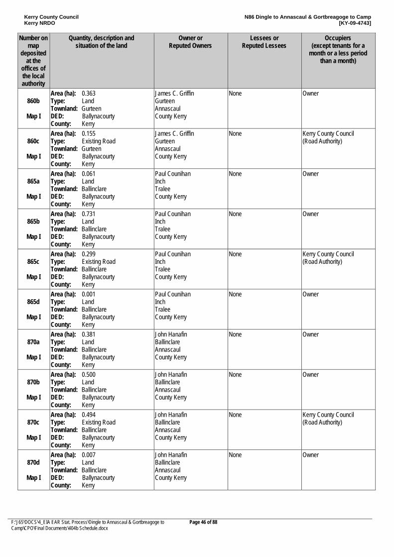
Kerry County Council Kerry NRDO
N86 Dingle to Annascaul & Gortbreagoge to Camp [KY-09-4743]
F:\J65\DOCS\4_EIA EAR Stat. Process\Dingle to Annascaul & Gortbreagoge to Camp\CPO\Final Documents\404b Schedule.docx
Page 46 of 88
Number on map
deposited at the
offices of the local authority
Quantity, description and situation of the land
Owner or Reputed Owners
Lessees or Reputed Lessees
Occupiers (except tenants for a
month or a less period than a month)
860b
Map I
Area (ha): 0.363 Type: Land Townland: Gurteen DED: Ballynacourty County: Kerry
James C. Griffin Gurteen Annascaul County Kerry
None Owner
860c
Map I
Area (ha): 0.155 Type: Existing Road Townland: Gurteen DED: Ballynacourty County: Kerry
James C. Griffin Gurteen Annascaul County Kerry
None Kerry County Council (Road Authority)
865a
Map I
Area (ha): 0.061 Type: Land Townland: Ballinclare DED: Ballynacourty County: Kerry
Paul Counihan Inch Tralee County Kerry
None Owner
865b
Map I
Area (ha): 0.731 Type: Land Townland: Ballinclare DED: Ballynacourty County: Kerry
Paul Counihan Inch Tralee County Kerry
None Owner
865c
Map I
Area (ha): 0.299 Type: Existing Road Townland: Ballinclare DED: Ballynacourty County: Kerry
Paul Counihan Inch Tralee County Kerry
None Kerry County Council (Road Authority)
865d
Map I
Area (ha): 0.001 Type: Land Townland: Ballinclare DED: Ballynacourty County: Kerry
Paul Counihan Inch Tralee County Kerry
None Owner
870a
Map I
Area (ha): 0.381 Type: Land Townland: Ballinclare DED: Ballynacourty County: Kerry
John Hanafin Ballinclare Annascaul County Kerry
None Owner
870b
Map I
Area (ha): 0.500 Type: Land Townland: Ballinclare DED: Ballynacourty County: Kerry
John Hanafin Ballinclare Annascaul County Kerry
None Owner
870c
Map I
Area (ha): 0.494 Type: Existing Road Townland: Ballinclare DED: Ballynacourty County: Kerry
John Hanafin Ballinclare Annascaul County Kerry
None Kerry County Council (Road Authority)
870d
Map I
Area (ha): 0.007 Type: Land Townland: Ballinclare DED: Ballynacourty County: Kerry
John Hanafin Ballinclare Annascaul County Kerry
None Owner
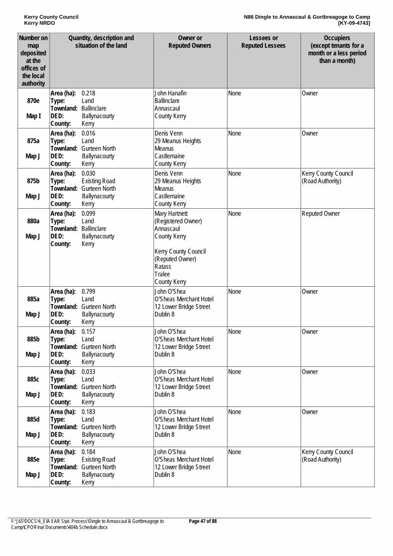
Kerry County Council Kerry NRDO
N86 Dingle to Annascaul & Gortbreagoge to Camp [KY-09-4743]
F:\J65\DOCS\4_EIA EAR Stat. Process\Dingle to Annascaul & Gortbreagoge to Camp\CPO\Final Documents\404b Schedule.docx
Page 47 of 88
Number on map
deposited at the
offices of the local authority
Quantity, description and situation of the land
Owner or Reputed Owners
Lessees or Reputed Lessees
Occupiers (except tenants for a
month or a less period than a month)
870e
Map I
Area (ha): 0.218 Type: Land Townland: Ballinclare DED: Ballynacourty County: Kerry
John Hanafin Ballinclare Annascaul County Kerry
None Owner
875a
Map J
Area (ha): 0.016 Type: Land Townland: Gurteen North DED: Ballynacourty County: Kerry
Denis Venn 29 Meanus Heights Meanus Castlemaine County Kerry
None Owner
875b
Map J
Area (ha): 0.030 Type: Existing Road Townland: Gurteen North DED: Ballynacourty County: Kerry
Denis Venn 29 Meanus Heights Meanus Castlemaine County Kerry
None Kerry County Council (Road Authority)
880a
Map J
Area (ha): 0.099 Type: Land Townland: Ballinclare DED: Ballynacourty County: Kerry
Mary Hartnett (Registered Owner) Annascaul County Kerry Kerry County Council (Reputed Owner) Ratass Tralee County Kerry
None Reputed Owner
885a
Map J
Area (ha): 0.799 Type: Land Townland: Gurteen North DED: Ballynacourty County: Kerry
John O'Shea O'Sheas Merchant Hotel 12 Lower Bridge Street Dublin 8
None Owner
885b
Map J
Area (ha): 0.157 Type: Land Townland: Gurteen North DED: Ballynacourty County: Kerry
John O'Shea O'Sheas Merchant Hotel 12 Lower Bridge Street Dublin 8
None Owner
885c
Map J
Area (ha): 0.033 Type: Land Townland: Gurteen North DED: Ballynacourty County: Kerry
John O'Shea O'Sheas Merchant Hotel 12 Lower Bridge Street Dublin 8
None Owner
885d
Map J
Area (ha): 0.183 Type: Land Townland: Gurteen North DED: Ballynacourty County: Kerry
John O'Shea O'Sheas Merchant Hotel 12 Lower Bridge Street Dublin 8
None Owner
885e
Map J
Area (ha): 0.184 Type: Existing Road Townland: Gurteen North DED: Ballynacourty County: Kerry
John O'Shea O'Sheas Merchant Hotel 12 Lower Bridge Street Dublin 8
None Kerry County Council (Road Authority)
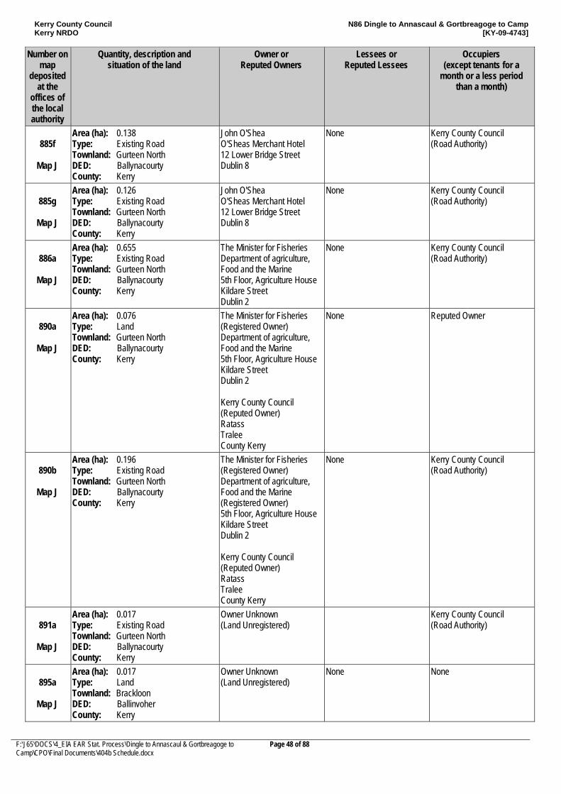
Kerry County Council Kerry NRDO
N86 Dingle to Annascaul & Gortbreagoge to Camp [KY-09-4743]
F:\J65\DOCS\4_EIA EAR Stat. Process\Dingle to Annascaul & Gortbreagoge to Camp\CPO\Final Documents\404b Schedule.docx
Page 48 of 88
Number on map
deposited at the
offices of the local authority
Quantity, description and situation of the land
Owner or Reputed Owners
Lessees or Reputed Lessees
Occupiers (except tenants for a
month or a less period than a month)
885f
Map J
Area (ha): 0.138 Type: Existing Road Townland: Gurteen North DED: Ballynacourty County: Kerry
John O'Shea O'Sheas Merchant Hotel 12 Lower Bridge Street Dublin 8
None Kerry County Council (Road Authority)
885g
Map J
Area (ha): 0.126 Type: Existing Road Townland: Gurteen North DED: Ballynacourty County: Kerry
John O'Shea O'Sheas Merchant Hotel 12 Lower Bridge Street Dublin 8
None Kerry County Council (Road Authority)
886a
Map J
Area (ha): 0.655 Type: Existing Road Townland: Gurteen North DED: Ballynacourty County: Kerry
The Minister for Fisheries Department of agriculture, Food and the Marine 5th Floor, Agriculture House Kildare Street Dublin 2
None Kerry County Council (Road Authority)
890a
Map J
Area (ha): 0.076 Type: Land Townland: Gurteen North DED: Ballynacourty County: Kerry
The Minister for Fisheries (Registered Owner) Department of agriculture, Food and the Marine 5th Floor, Agriculture House Kildare Street Dublin 2 Kerry County Council (Reputed Owner) Ratass Tralee County Kerry
None Reputed Owner
890b
Map J
Area (ha): 0.196 Type: Existing Road Townland: Gurteen North DED: Ballynacourty County: Kerry
The Minister for Fisheries (Registered Owner) Department of agriculture, Food and the Marine (Registered Owner) 5th Floor, Agriculture House Kildare Street Dublin 2 Kerry County Council (Reputed Owner) Ratass Tralee County Kerry
None Kerry County Council (Road Authority)
891a
Map J
Area (ha): 0.017 Type: Existing Road Townland: Gurteen North DED: Ballynacourty County: Kerry
Owner Unknown (Land Unregistered)
Kerry County Council (Road Authority)
895a
Map J
Area (ha): 0.017 Type: Land Townland: Brackloon DED: Ballinvoher County: Kerry
Owner Unknown (Land Unregistered)
None None
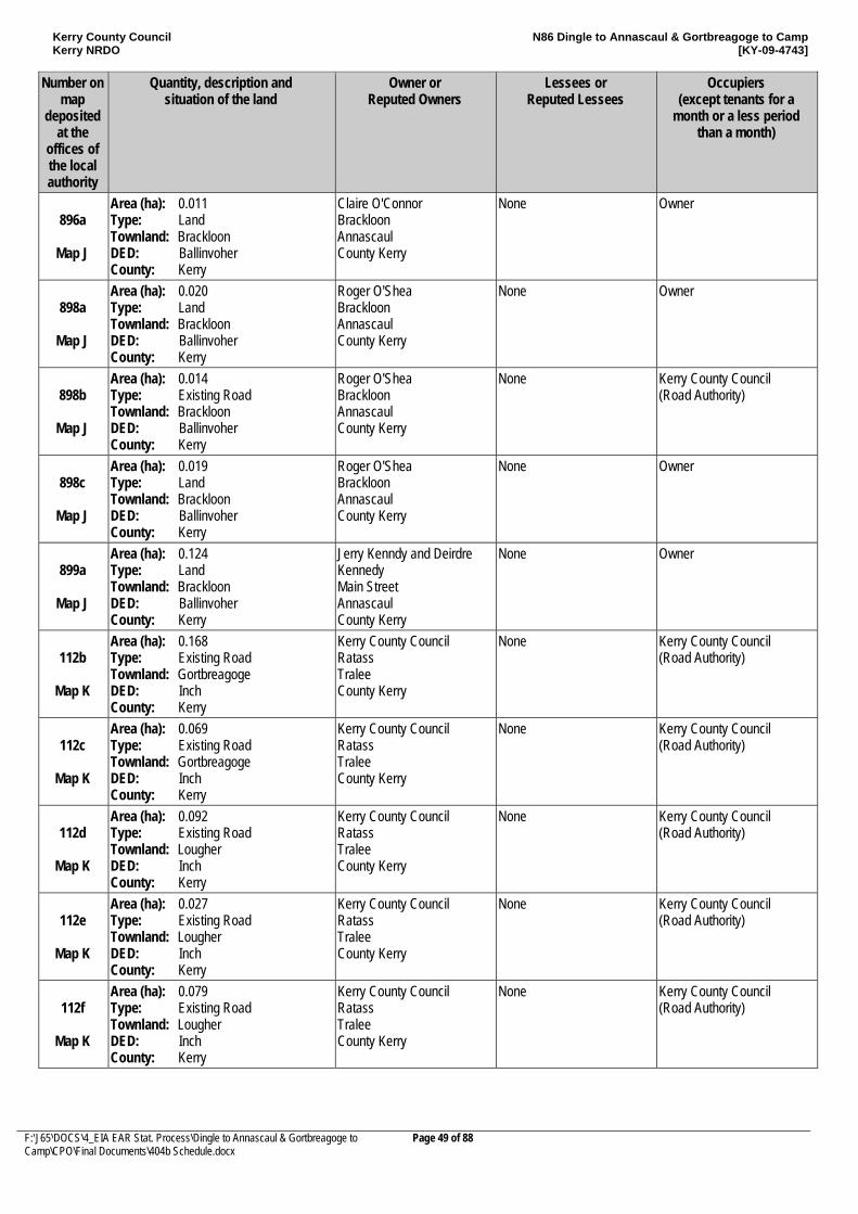
Kerry County Council Kerry NRDO
N86 Dingle to Annascaul & Gortbreagoge to Camp [KY-09-4743]
F:\J65\DOCS\4_EIA EAR Stat. Process\Dingle to Annascaul & Gortbreagoge to Camp\CPO\Final Documents\404b Schedule.docx
Page 49 of 88
Number on map
deposited at the
offices of the local authority
Quantity, description and situation of the land
Owner or Reputed Owners
Lessees or Reputed Lessees
Occupiers (except tenants for a
month or a less period than a month)
896a
Map J
Area (ha): 0.011 Type: Land Townland: Brackloon DED: Ballinvoher County: Kerry
Claire O'Connor Brackloon Annascaul County Kerry
None Owner
898a
Map J
Area (ha): 0.020 Type: Land Townland: Brackloon DED: Ballinvoher County: Kerry
Roger O'Shea Brackloon Annascaul County Kerry
None Owner
898b
Map J
Area (ha): 0.014 Type: Existing Road Townland: Brackloon DED: Ballinvoher County: Kerry
Roger O'Shea Brackloon Annascaul County Kerry
None Kerry County Council (Road Authority)
898c
Map J
Area (ha): 0.019 Type: Land Townland: Brackloon DED: Ballinvoher County: Kerry
Roger O'Shea Brackloon Annascaul County Kerry
None Owner
899a
Map J
Area (ha): 0.124 Type: Land Townland: Brackloon DED: Ballinvoher County: Kerry
Jerry Kenndy and Deirdre Kennedy Main Street Annascaul County Kerry
None Owner
112b
Map K
Area (ha): 0.168 Type: Existing Road Townland: Gortbreagoge DED: Inch County: Kerry
Kerry County Council Ratass Tralee County Kerry
None Kerry County Council (Road Authority)
112c
Map K
Area (ha): 0.069 Type: Existing Road Townland: Gortbreagoge DED: Inch County: Kerry
Kerry County Council Ratass Tralee County Kerry
None Kerry County Council (Road Authority)
112d
Map K
Area (ha): 0.092 Type: Existing Road Townland: Lougher DED: Inch County: Kerry
Kerry County Council Ratass Tralee County Kerry
None Kerry County Council (Road Authority)
112e
Map K
Area (ha): 0.027 Type: Existing Road Townland: Lougher DED: Inch County: Kerry
Kerry County Council Ratass Tralee County Kerry
None Kerry County Council (Road Authority)
112f
Map K
Area (ha): 0.079 Type: Existing Road Townland: Lougher DED: Inch County: Kerry
Kerry County Council Ratass Tralee County Kerry
None Kerry County Council (Road Authority)
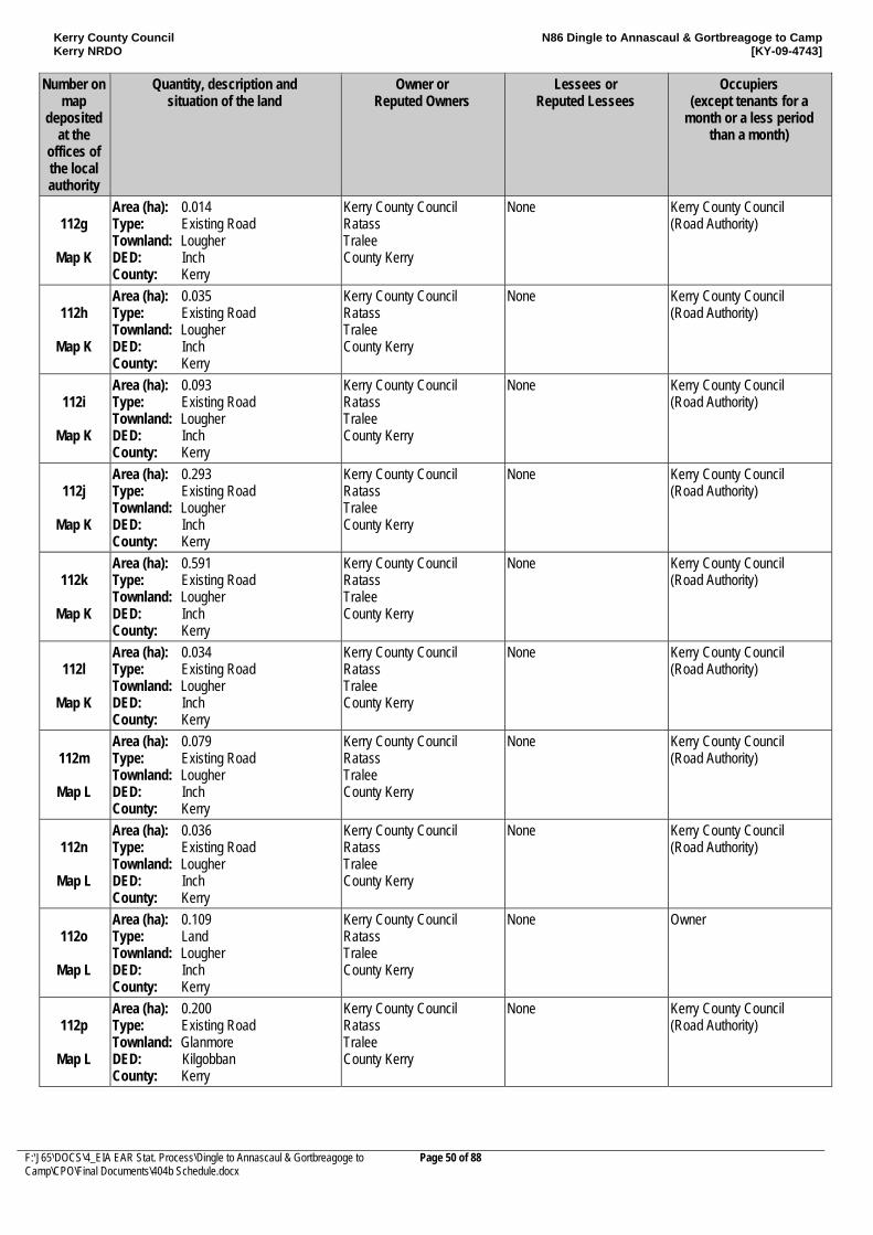
Kerry County Council Kerry NRDO
N86 Dingle to Annascaul & Gortbreagoge to Camp [KY-09-4743]
F:\J65\DOCS\4_EIA EAR Stat. Process\Dingle to Annascaul & Gortbreagoge to Camp\CPO\Final Documents\404b Schedule.docx
Page 50 of 88
Number on map
deposited at the
offices of the local authority
Quantity, description and situation of the land
Owner or Reputed Owners
Lessees or Reputed Lessees
Occupiers (except tenants for a
month or a less period than a month)
112g
Map K
Area (ha): 0.014 Type: Existing Road Townland: Lougher DED: Inch County: Kerry
Kerry County Council Ratass Tralee County Kerry
None Kerry County Council (Road Authority)
112h
Map K
Area (ha): 0.035 Type: Existing Road Townland: Lougher DED: Inch County: Kerry
Kerry County Council Ratass Tralee County Kerry
None Kerry County Council (Road Authority)
112i
Map K
Area (ha): 0.093 Type: Existing Road Townland: Lougher DED: Inch County: Kerry
Kerry County Council Ratass Tralee County Kerry
None Kerry County Council (Road Authority)
112j
Map K
Area (ha): 0.293 Type: Existing Road Townland: Lougher DED: Inch County: Kerry
Kerry County Council Ratass Tralee County Kerry
None Kerry County Council (Road Authority)
112k
Map K
Area (ha): 0.591 Type: Existing Road Townland: Lougher DED: Inch County: Kerry
Kerry County Council Ratass Tralee County Kerry
None Kerry County Council (Road Authority)
112l
Map K
Area (ha): 0.034 Type: Existing Road Townland: Lougher DED: Inch County: Kerry
Kerry County Council Ratass Tralee County Kerry
None Kerry County Council (Road Authority)
112m
Map L
Area (ha): 0.079 Type: Existing Road Townland: Lougher DED: Inch County: Kerry
Kerry County Council Ratass Tralee County Kerry
None Kerry County Council (Road Authority)
112n
Map L
Area (ha): 0.036 Type: Existing Road Townland: Lougher DED: Inch County: Kerry
Kerry County Council Ratass Tralee County Kerry
None Kerry County Council (Road Authority)
112o
Map L
Area (ha): 0.109 Type: Land Townland: Lougher DED: Inch County: Kerry
Kerry County Council Ratass Tralee County Kerry
None Owner
112p
Map L
Area (ha): 0.200 Type: Existing Road Townland: Glanmore DED: Kilgobban County: Kerry
Kerry County Council Ratass Tralee County Kerry
None Kerry County Council (Road Authority)
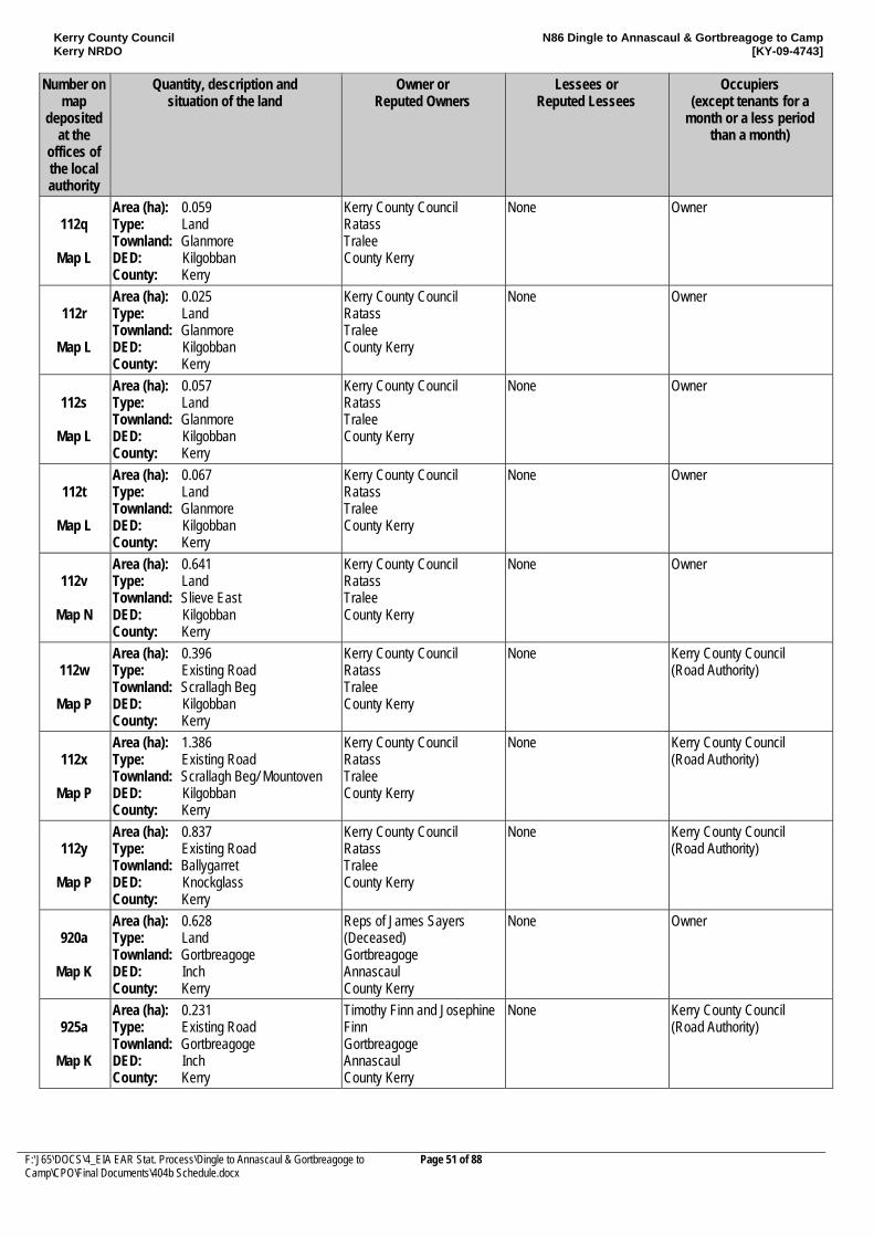
Kerry County Council Kerry NRDO
N86 Dingle to Annascaul & Gortbreagoge to Camp [KY-09-4743]
F:\J65\DOCS\4_EIA EAR Stat. Process\Dingle to Annascaul & Gortbreagoge to Camp\CPO\Final Documents\404b Schedule.docx
Page 51 of 88
Number on map
deposited at the
offices of the local authority
Quantity, description and situation of the land
Owner or Reputed Owners
Lessees or Reputed Lessees
Occupiers (except tenants for a
month or a less period than a month)
112q
Map L
Area (ha): 0.059 Type: Land Townland: Glanmore DED: Kilgobban County: Kerry
Kerry County Council Ratass Tralee County Kerry
None Owner
112r
Map L
Area (ha): 0.025 Type: Land Townland: Glanmore DED: Kilgobban County: Kerry
Kerry County Council Ratass Tralee County Kerry
None Owner
112s
Map L
Area (ha): 0.057 Type: Land Townland: Glanmore DED: Kilgobban County: Kerry
Kerry County Council Ratass Tralee County Kerry
None Owner
112t
Map L
Area (ha): 0.067 Type: Land Townland: Glanmore DED: Kilgobban County: Kerry
Kerry County Council Ratass Tralee County Kerry
None Owner
112v
Map N
Area (ha): 0.641 Type: Land Townland: Slieve East DED: Kilgobban County: Kerry
Kerry County Council Ratass Tralee County Kerry
None Owner
112w
Map P
Area (ha): 0.396 Type: Existing Road Townland: Scrallagh Beg DED: Kilgobban County: Kerry
Kerry County Council Ratass Tralee County Kerry
None Kerry County Council (Road Authority)
112x
Map P
Area (ha): 1.386 Type: Existing Road Townland: Scrallagh Beg/ Mountoven DED: Kilgobban County: Kerry
Kerry County Council Ratass Tralee County Kerry
None Kerry County Council (Road Authority)
112y
Map P
Area (ha): 0.837 Type: Existing Road Townland: Ballygarret DED: Knockglass County: Kerry
Kerry County Council Ratass Tralee County Kerry
None Kerry County Council (Road Authority)
920a
Map K
Area (ha): 0.628 Type: Land Townland: Gortbreagoge DED: Inch County: Kerry
Reps of James Sayers (Deceased) Gortbreagoge Annascaul County Kerry
None Owner
925a
Map K
Area (ha): 0.231 Type: Existing Road Townland: Gortbreagoge DED: Inch County: Kerry
Timothy Finn and Josephine Finn Gortbreagoge Annascaul County Kerry
None Kerry County Council (Road Authority)
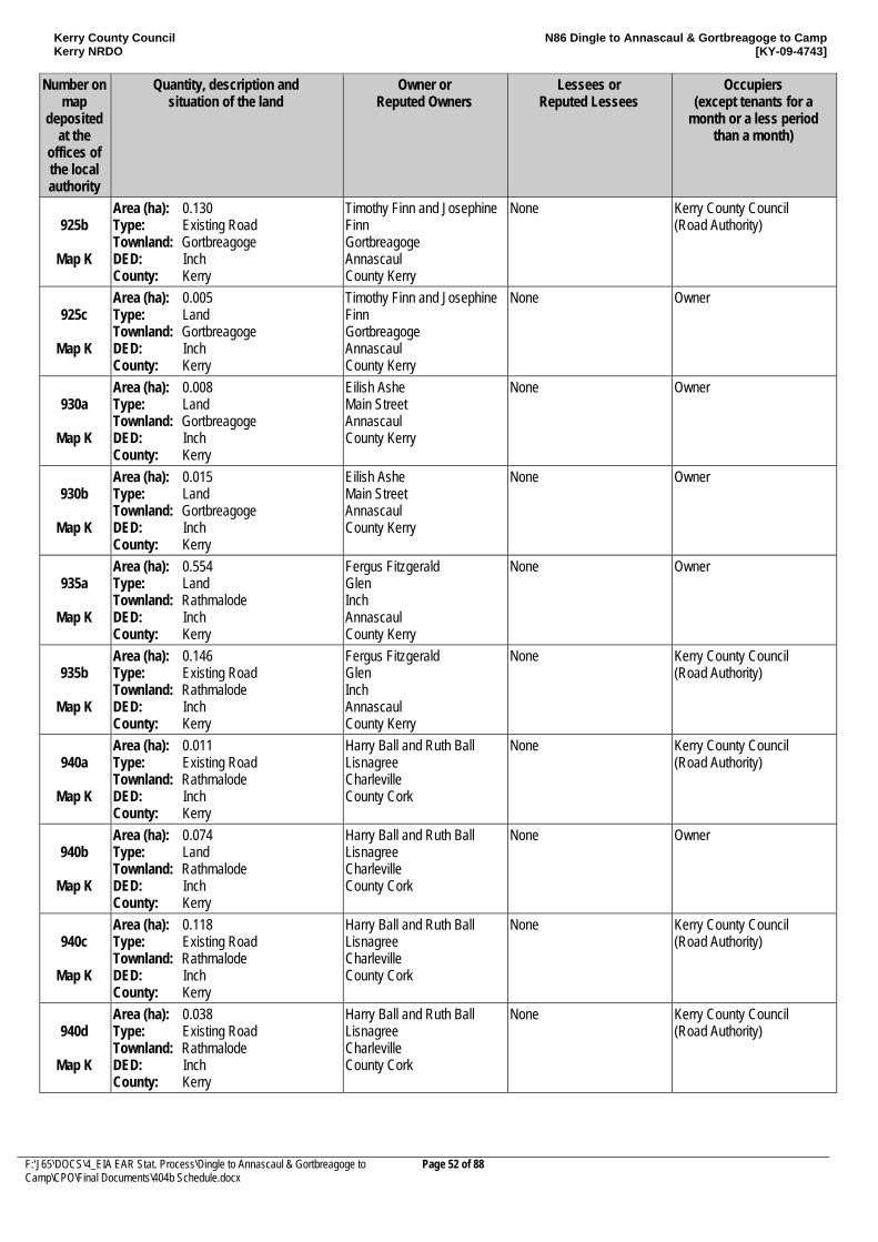
Kerry County Council Kerry NRDO
N86 Dingle to Annascaul & Gortbreagoge to Camp [KY-09-4743]
F:\J65\DOCS\4_EIA EAR Stat. Process\Dingle to Annascaul & Gortbreagoge to Camp\CPO\Final Documents\404b Schedule.docx
Page 52 of 88
Number on map
deposited at the
offices of the local authority
Quantity, description and situation of the land
Owner or Reputed Owners
Lessees or Reputed Lessees
Occupiers (except tenants for a
month or a less period than a month)
925b
Map K
Area (ha): 0.130 Type: Existing Road Townland: Gortbreagoge DED: Inch County: Kerry
Timothy Finn and Josephine Finn Gortbreagoge Annascaul County Kerry
None Kerry County Council (Road Authority)
925c
Map K
Area (ha): 0.005 Type: Land Townland: Gortbreagoge DED: Inch County: Kerry
Timothy Finn and Josephine Finn Gortbreagoge Annascaul County Kerry
None Owner
930a
Map K
Area (ha): 0.008 Type: Land Townland: Gortbreagoge DED: Inch County: Kerry
Eilish Ashe Main Street Annascaul County Kerry
None Owner
930b
Map K
Area (ha): 0.015 Type: Land Townland: Gortbreagoge DED: Inch County: Kerry
Eilish Ashe Main Street Annascaul County Kerry
None Owner
935a
Map K
Area (ha): 0.554 Type: Land Townland: Rathmalode DED: Inch County: Kerry
Fergus Fitzgerald Glen Inch Annascaul County Kerry
None Owner
935b
Map K
Area (ha): 0.146 Type: Existing Road Townland: Rathmalode DED: Inch County: Kerry
Fergus Fitzgerald Glen Inch Annascaul County Kerry
None Kerry County Council (Road Authority)
940a
Map K
Area (ha): 0.011 Type: Existing Road Townland: Rathmalode DED: Inch County: Kerry
Harry Ball and Ruth Ball Lisnagree Charleville County Cork
None Kerry County Council (Road Authority)
940b
Map K
Area (ha): 0.074 Type: Land Townland: Rathmalode DED: Inch County: Kerry
Harry Ball and Ruth Ball Lisnagree Charleville County Cork
None Owner
940c
Map K
Area (ha): 0.118 Type: Existing Road Townland: Rathmalode DED: Inch County: Kerry
Harry Ball and Ruth Ball Lisnagree Charleville County Cork
None Kerry County Council (Road Authority)
940d
Map K
Area (ha): 0.038 Type: Existing Road Townland: Rathmalode DED: Inch County: Kerry
Harry Ball and Ruth Ball Lisnagree Charleville County Cork
None Kerry County Council (Road Authority)
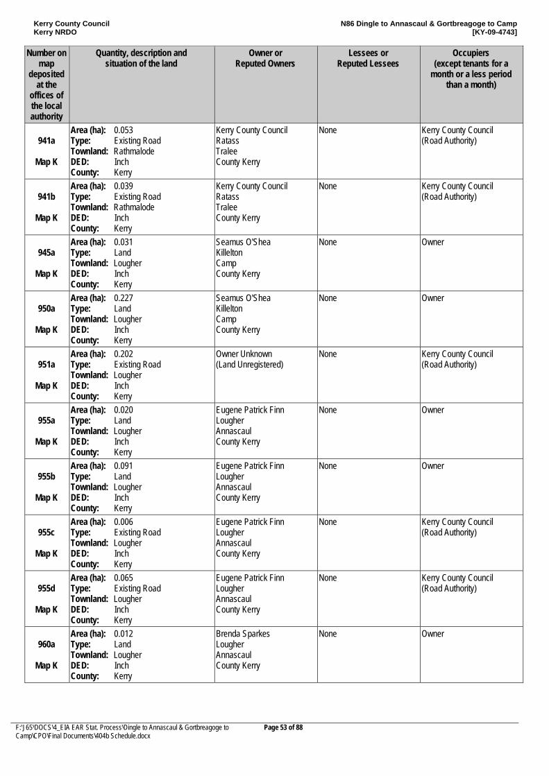
Kerry County Council Kerry NRDO
N86 Dingle to Annascaul & Gortbreagoge to Camp [KY-09-4743]
F:\J65\DOCS\4_EIA EAR Stat. Process\Dingle to Annascaul & Gortbreagoge to Camp\CPO\Final Documents\404b Schedule.docx
Page 53 of 88
Number on map
deposited at the
offices of the local authority
Quantity, description and situation of the land
Owner or Reputed Owners
Lessees or Reputed Lessees
Occupiers (except tenants for a
month or a less period than a month)
941a
Map K
Area (ha): 0.053 Type: Existing Road Townland: Rathmalode DED: Inch County: Kerry
Kerry County Council Ratass Tralee County Kerry
None Kerry County Council (Road Authority)
941b
Map K
Area (ha): 0.039 Type: Existing Road Townland: Rathmalode DED: Inch County: Kerry
Kerry County Council Ratass Tralee County Kerry
None Kerry County Council (Road Authority)
945a
Map K
Area (ha): 0.031 Type: Land Townland: Lougher DED: Inch County: Kerry
Seamus O'Shea Killelton Camp County Kerry
None Owner
950a
Map K
Area (ha): 0.227 Type: Land Townland: Lougher DED: Inch County: Kerry
Seamus O'Shea Killelton Camp County Kerry
None Owner
951a
Map K
Area (ha): 0.202 Type: Existing Road Townland: Lougher DED: Inch County: Kerry
Owner Unknown (Land Unregistered)
None Kerry County Council (Road Authority)
955a
Map K
Area (ha): 0.020 Type: Land Townland: Lougher DED: Inch County: Kerry
Eugene Patrick Finn Lougher Annascaul County Kerry
None Owner
955b
Map K
Area (ha): 0.091 Type: Land Townland: Lougher DED: Inch County: Kerry
Eugene Patrick Finn Lougher Annascaul County Kerry
None Owner
955c
Map K
Area (ha): 0.006 Type: Existing Road Townland: Lougher DED: Inch County: Kerry
Eugene Patrick Finn Lougher Annascaul County Kerry
None Kerry County Council (Road Authority)
955d
Map K
Area (ha): 0.065 Type: Existing Road Townland: Lougher DED: Inch County: Kerry
Eugene Patrick Finn Lougher Annascaul County Kerry
None Kerry County Council (Road Authority)
960a
Map K
Area (ha): 0.012 Type: Land Townland: Lougher DED: Inch County: Kerry
Brenda Sparkes Lougher Annascaul County Kerry
None Owner
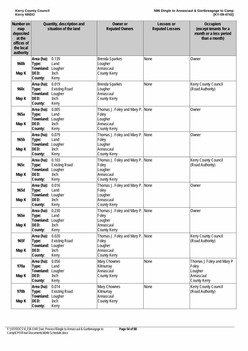
Kerry County Council Kerry NRDO
N86 Dingle to Annascaul & Gortbreagoge to Camp [KY-09-4743]
F:\J65\DOCS\4_EIA EAR Stat. Process\Dingle to Annascaul & Gortbreagoge to Camp\CPO\Final Documents\404b Schedule.docx
Page 54 of 88
Number on map
deposited at the
offices of the local authority
Quantity, description and situation of the land
Owner or Reputed Owners
Lessees or Reputed Lessees
Occupiers (except tenants for a
month or a less period than a month)
960b
Map K
Area (ha): 0.139 Type: Land Townland: Lougher DED: Inch County: Kerry
Brenda Sparkes Lougher Annascaul County Kerry
None Owner
960c
Map K
Area (ha): 0.019 Type: Existing Road Townland: Lougher DED: Inch County: Kerry
Brenda Sparkes Lougher Annascaul County Kerry
None Kerry County Council (Road Authority)
965a
Map K
Area (ha): 0.005 Type: Land Townland: Lougher DED: Inch County: Kerry
Thomas J. Foley and Mary P. Foley Lougher Annascaul County Kerry
None Owner
965b
Map K
Area (ha): 0.079 Type: Land Townland: Lougher DED: Inch County: Kerry
Thomas J. Foley and Mary P. Foley Lougher Annascaul County Kerry
None Owner
965c
Map K
Area (ha): 0.103 Type: Existing Road Townland: Lougher DED: Inch County: Kerry
Thomas J. Foley and Mary P. Foley Lougher Annascaul County Kerry
None Kerry County Council (Road Authority)
965d
Map K
Area (ha): 0.016 Type: Land Townland: Lougher DED: Inch County: Kerry
Thomas J. Foley and Mary P. Foley Lougher Annascaul County Kerry
None Owner
965e
Map K
Area (ha): 0.230 Type: Land Townland: Lougher DED: Inch County: Kerry
Thomas J. Foley and Mary P. Foley Lougher Annascaul County Kerry
None Owner
965f
Map K
Area (ha): 0.020 Type: Existing Road Townland: Lougher DED: Inch County: Kerry
Thomas J. Foley and Mary P. Foley Lougher Annascaul County Kerry
None Kerry County Council (Road Authority)
970a
Map K
Area (ha): 0.056 Type: Land Townland: Lougher DED: Inch County: Kerry
Mary Chownes Kilmurray Annascaul County Kerry
None Thomas J Foley and Mary P Foley Lougher Annascaul County Kerry
970b
Map K
Area (ha): 0.014 Type: Existing Road Townland: Lougher DED: Inch County: Kerry
Mary Chownes Kilmurray Annascaul County Kerry
None Kerry County Council (Road Authority)
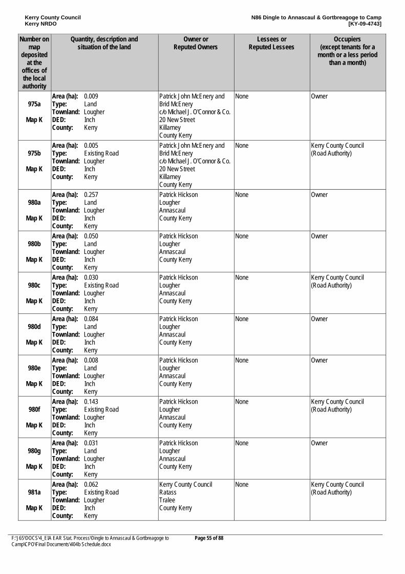
Kerry County Council Kerry NRDO
N86 Dingle to Annascaul & Gortbreagoge to Camp [KY-09-4743]
F:\J65\DOCS\4_EIA EAR Stat. Process\Dingle to Annascaul & Gortbreagoge to Camp\CPO\Final Documents\404b Schedule.docx
Page 55 of 88
Number on map
deposited at the
offices of the local authority
Quantity, description and situation of the land
Owner or Reputed Owners
Lessees or Reputed Lessees
Occupiers (except tenants for a
month or a less period than a month)
975a
Map K
Area (ha): 0.009 Type: Land Townland: Lougher DED: Inch County: Kerry
Patrick John McEnery and Brid McEnery c/o Michael J. O'Connor & Co. 20 New Street Killarney County Kerry
None Owner
975b
Map K
Area (ha): 0.005 Type: Existing Road Townland: Lougher DED: Inch County: Kerry
Patrick John McEnery and Brid McEnery c/o Michael J. O'Connor & Co. 20 New Street Killarney County Kerry
None Kerry County Council (Road Authority)
980a
Map K
Area (ha): 0.257 Type: Land Townland: Lougher DED: Inch County: Kerry
Patrick Hickson Lougher Annascaul County Kerry
None Owner
980b
Map K
Area (ha): 0.050 Type: Land Townland: Lougher DED: Inch County: Kerry
Patrick Hickson Lougher Annascaul County Kerry
None Owner
980c
Map K
Area (ha): 0.030 Type: Existing Road Townland: Lougher DED: Inch County: Kerry
Patrick Hickson Lougher Annascaul County Kerry
None Kerry County Council (Road Authority)
980d
Map K
Area (ha): 0.084 Type: Land Townland: Lougher DED: Inch County: Kerry
Patrick Hickson Lougher Annascaul County Kerry
None Owner
980e
Map K
Area (ha): 0.008 Type: Land Townland: Lougher DED: Inch County: Kerry
Patrick Hickson Lougher Annascaul County Kerry
None Owner
980f
Map K
Area (ha): 0.143 Type: Existing Road Townland: Lougher DED: Inch County: Kerry
Patrick Hickson Lougher Annascaul County Kerry
None Kerry County Council (Road Authority)
980g
Map K
Area (ha): 0.031 Type: Land Townland: Lougher DED: Inch County: Kerry
Patrick Hickson Lougher Annascaul County Kerry
None Owner
981a
Map K
Area (ha): 0.062 Type: Existing Road Townland: Lougher DED: Inch County: Kerry
Kerry County Council Ratass Tralee County Kerry
None Kerry County Council (Road Authority)
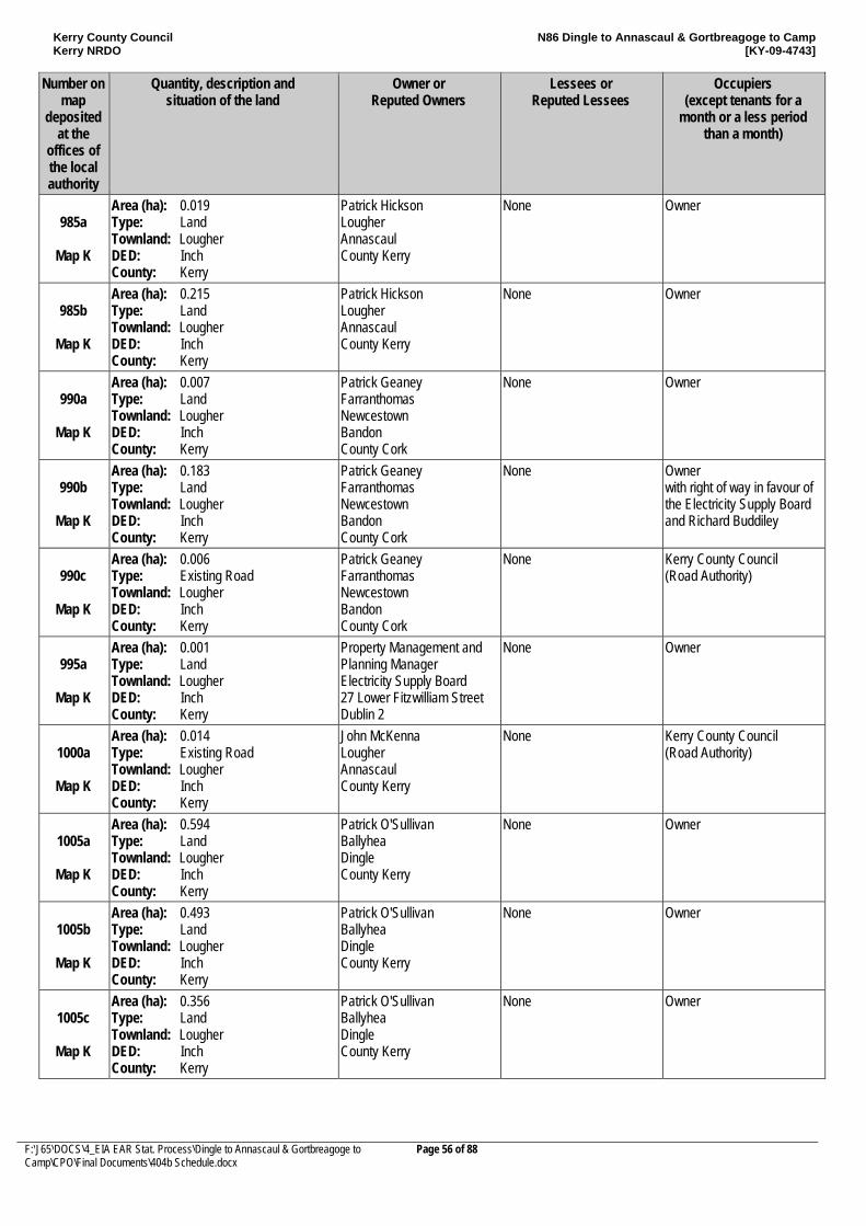
Kerry County Council Kerry NRDO
N86 Dingle to Annascaul & Gortbreagoge to Camp [KY-09-4743]
F:\J65\DOCS\4_EIA EAR Stat. Process\Dingle to Annascaul & Gortbreagoge to Camp\CPO\Final Documents\404b Schedule.docx
Page 56 of 88
Number on map
deposited at the
offices of the local authority
Quantity, description and situation of the land
Owner or Reputed Owners
Lessees or Reputed Lessees
Occupiers (except tenants for a
month or a less period than a month)
985a
Map K
Area (ha): 0.019 Type: Land Townland: Lougher DED: Inch County: Kerry
Patrick Hickson Lougher Annascaul County Kerry
None Owner
985b
Map K
Area (ha): 0.215 Type: Land Townland: Lougher DED: Inch County: Kerry
Patrick Hickson Lougher Annascaul County Kerry
None Owner
990a
Map K
Area (ha): 0.007 Type: Land Townland: Lougher DED: Inch County: Kerry
Patrick Geaney Farranthomas Newcestown Bandon County Cork
None Owner
990b
Map K
Area (ha): 0.183 Type: Land Townland: Lougher DED: Inch County: Kerry
Patrick Geaney Farranthomas Newcestown Bandon County Cork
None Owner with right of way in favour of the Electricity Supply Board and Richard Buddiley
990c
Map K
Area (ha): 0.006 Type: Existing Road Townland: Lougher DED: Inch County: Kerry
Patrick Geaney Farranthomas Newcestown Bandon County Cork
None Kerry County Council (Road Authority)
995a
Map K
Area (ha): 0.001 Type: Land Townland: Lougher DED: Inch County: Kerry
Property Management and Planning Manager Electricity Supply Board 27 Lower Fitzwilliam Street Dublin 2
None Owner
1000a
Map K
Area (ha): 0.014 Type: Existing Road Townland: Lougher DED: Inch County: Kerry
John McKenna Lougher Annascaul County Kerry
None Kerry County Council (Road Authority)
1005a
Map K
Area (ha): 0.594 Type: Land Townland: Lougher DED: Inch County: Kerry
Patrick O'Sullivan Ballyhea Dingle County Kerry
None Owner
1005b
Map K
Area (ha): 0.493 Type: Land Townland: Lougher DED: Inch County: Kerry
Patrick O'Sullivan Ballyhea Dingle County Kerry
None Owner
1005c
Map K
Area (ha): 0.356 Type: Land Townland: Lougher DED: Inch County: Kerry
Patrick O'Sullivan Ballyhea Dingle County Kerry
None Owner
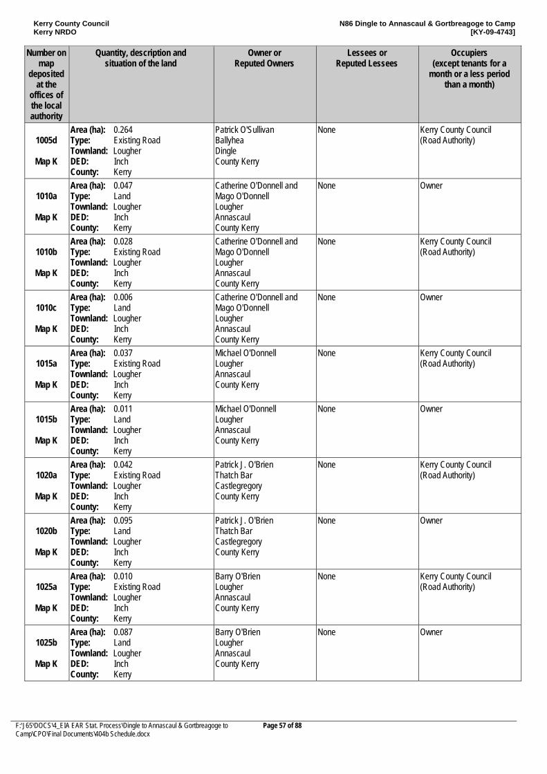
Kerry County Council Kerry NRDO
N86 Dingle to Annascaul & Gortbreagoge to Camp [KY-09-4743]
F:\J65\DOCS\4_EIA EAR Stat. Process\Dingle to Annascaul & Gortbreagoge to Camp\CPO\Final Documents\404b Schedule.docx
Page 57 of 88
Number on map
deposited at the
offices of the local authority
Quantity, description and situation of the land
Owner or Reputed Owners
Lessees or Reputed Lessees
Occupiers (except tenants for a
month or a less period than a month)
1005d
Map K
Area (ha): 0.264 Type: Existing Road Townland: Lougher DED: Inch County: Kerry
Patrick O'Sullivan Ballyhea Dingle County Kerry
None Kerry County Council (Road Authority)
1010a
Map K
Area (ha): 0.047 Type: Land Townland: Lougher DED: Inch County: Kerry
Catherine O'Donnell and Mago O'Donnell Lougher Annascaul County Kerry
None Owner
1010b
Map K
Area (ha): 0.028 Type: Existing Road Townland: Lougher DED: Inch County: Kerry
Catherine O'Donnell and Mago O'Donnell Lougher Annascaul County Kerry
None Kerry County Council (Road Authority)
1010c
Map K
Area (ha): 0.006 Type: Land Townland: Lougher DED: Inch County: Kerry
Catherine O'Donnell and Mago O'Donnell Lougher Annascaul County Kerry
None Owner
1015a
Map K
Area (ha): 0.037 Type: Existing Road Townland: Lougher DED: Inch County: Kerry
Michael O'Donnell Lougher Annascaul County Kerry
None Kerry County Council (Road Authority)
1015b
Map K
Area (ha): 0.011 Type: Land Townland: Lougher DED: Inch County: Kerry
Michael O'Donnell Lougher Annascaul County Kerry
None Owner
1020a
Map K
Area (ha): 0.042 Type: Existing Road Townland: Lougher DED: Inch County: Kerry
Patrick J. O'Brien Thatch Bar Castlegregory County Kerry
None Kerry County Council (Road Authority)
1020b
Map K
Area (ha): 0.095 Type: Land Townland: Lougher DED: Inch County: Kerry
Patrick J. O'Brien Thatch Bar Castlegregory County Kerry
None Owner
1025a
Map K
Area (ha): 0.010 Type: Existing Road Townland: Lougher DED: Inch County: Kerry
Barry O'Brien Lougher Annascaul County Kerry
None Kerry County Council (Road Authority)
1025b
Map K
Area (ha): 0.087 Type: Land Townland: Lougher DED: Inch County: Kerry
Barry O'Brien Lougher Annascaul County Kerry
None Owner
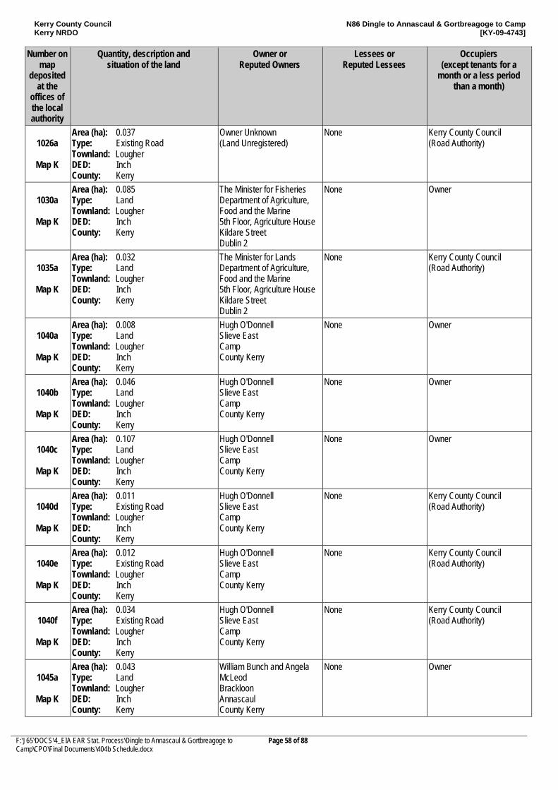
Kerry County Council Kerry NRDO
N86 Dingle to Annascaul & Gortbreagoge to Camp [KY-09-4743]
F:\J65\DOCS\4_EIA EAR Stat. Process\Dingle to Annascaul & Gortbreagoge to Camp\CPO\Final Documents\404b Schedule.docx
Page 58 of 88
Number on map
deposited at the
offices of the local authority
Quantity, description and situation of the land
Owner or Reputed Owners
Lessees or Reputed Lessees
Occupiers (except tenants for a
month or a less period than a month)
1026a
Map K
Area (ha): 0.037 Type: Existing Road Townland: Lougher DED: Inch County: Kerry
Owner Unknown (Land Unregistered)
None Kerry County Council (Road Authority)
1030a
Map K
Area (ha): 0.085 Type: Land Townland: Lougher DED: Inch County: Kerry
The Minister for Fisheries Department of Agriculture, Food and the Marine 5th Floor, Agriculture House Kildare Street Dublin 2
None Owner
1035a
Map K
Area (ha): 0.032 Type: Land Townland: Lougher DED: Inch County: Kerry
The Minister for Lands Department of Agriculture, Food and the Marine 5th Floor, Agriculture House Kildare Street Dublin 2
None Kerry County Council (Road Authority)
1040a
Map K
Area (ha): 0.008 Type: Land Townland: Lougher DED: Inch County: Kerry
Hugh O'Donnell Slieve East Camp County Kerry
None Owner
1040b
Map K
Area (ha): 0.046 Type: Land Townland: Lougher DED: Inch County: Kerry
Hugh O'Donnell Slieve East Camp County Kerry
None Owner
1040c
Map K
Area (ha): 0.107 Type: Land Townland: Lougher DED: Inch County: Kerry
Hugh O'Donnell Slieve East Camp County Kerry
None Owner
1040d
Map K
Area (ha): 0.011 Type: Existing Road Townland: Lougher DED: Inch County: Kerry
Hugh O'Donnell Slieve East Camp County Kerry
None Kerry County Council (Road Authority)
1040e
Map K
Area (ha): 0.012 Type: Existing Road Townland: Lougher DED: Inch County: Kerry
Hugh O'Donnell Slieve East Camp County Kerry
None Kerry County Council (Road Authority)
1040f
Map K
Area (ha): 0.034 Type: Existing Road Townland: Lougher DED: Inch County: Kerry
Hugh O'Donnell Slieve East Camp County Kerry
None Kerry County Council (Road Authority)
1045a
Map K
Area (ha): 0.043 Type: Land Townland: Lougher DED: Inch County: Kerry
William Bunch and Angela McLeod Brackloon Annascaul County Kerry
None Owner
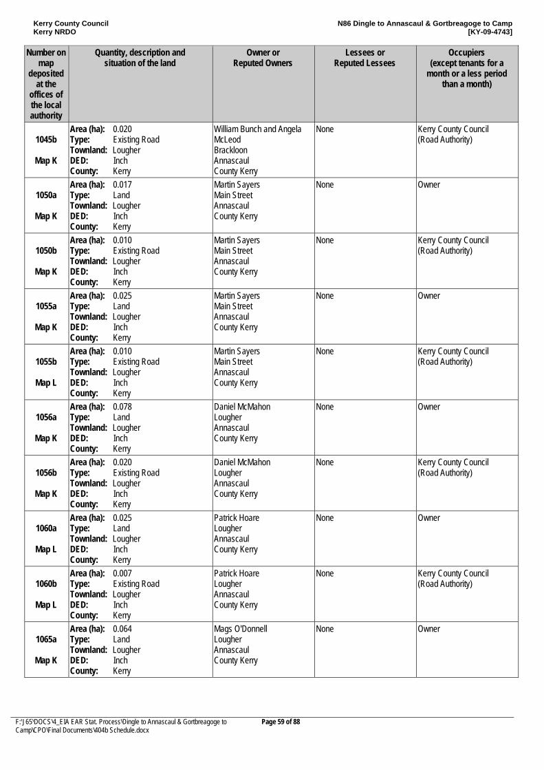
Kerry County Council Kerry NRDO
N86 Dingle to Annascaul & Gortbreagoge to Camp [KY-09-4743]
F:\J65\DOCS\4_EIA EAR Stat. Process\Dingle to Annascaul & Gortbreagoge to Camp\CPO\Final Documents\404b Schedule.docx
Page 59 of 88
Number on map
deposited at the
offices of the local authority
Quantity, description and situation of the land
Owner or Reputed Owners
Lessees or Reputed Lessees
Occupiers (except tenants for a
month or a less period than a month)
1045b
Map K
Area (ha): 0.020 Type: Existing Road Townland: Lougher DED: Inch County: Kerry
William Bunch and Angela McLeod Brackloon Annascaul County Kerry
None Kerry County Council (Road Authority)
1050a
Map K
Area (ha): 0.017 Type: Land Townland: Lougher DED: Inch County: Kerry
Martin Sayers Main Street Annascaul County Kerry
None Owner
1050b
Map K
Area (ha): 0.010 Type: Existing Road Townland: Lougher DED: Inch County: Kerry
Martin Sayers Main Street Annascaul County Kerry
None Kerry County Council (Road Authority)
1055a
Map K
Area (ha): 0.025 Type: Land Townland: Lougher DED: Inch County: Kerry
Martin Sayers Main Street Annascaul County Kerry
None Owner
1055b
Map L
Area (ha): 0.010 Type: Existing Road Townland: Lougher DED: Inch County: Kerry
Martin Sayers Main Street Annascaul County Kerry
None Kerry County Council (Road Authority)
1056a
Map K
Area (ha): 0.078 Type: Land Townland: Lougher DED: Inch County: Kerry
Daniel McMahon Lougher Annascaul County Kerry
None Owner
1056b
Map K
Area (ha): 0.020 Type: Existing Road Townland: Lougher DED: Inch County: Kerry
Daniel McMahon Lougher Annascaul County Kerry
None Kerry County Council (Road Authority)
1060a
Map L
Area (ha): 0.025 Type: Land Townland: Lougher DED: Inch County: Kerry
Patrick Hoare Lougher Annascaul County Kerry
None Owner
1060b
Map L
Area (ha): 0.007 Type: Existing Road Townland: Lougher DED: Inch County: Kerry
Patrick Hoare Lougher Annascaul County Kerry
None Kerry County Council (Road Authority)
1065a
Map K
Area (ha): 0.064 Type: Land Townland: Lougher DED: Inch County: Kerry
Mags O'Donnell Lougher Annascaul County Kerry
None Owner
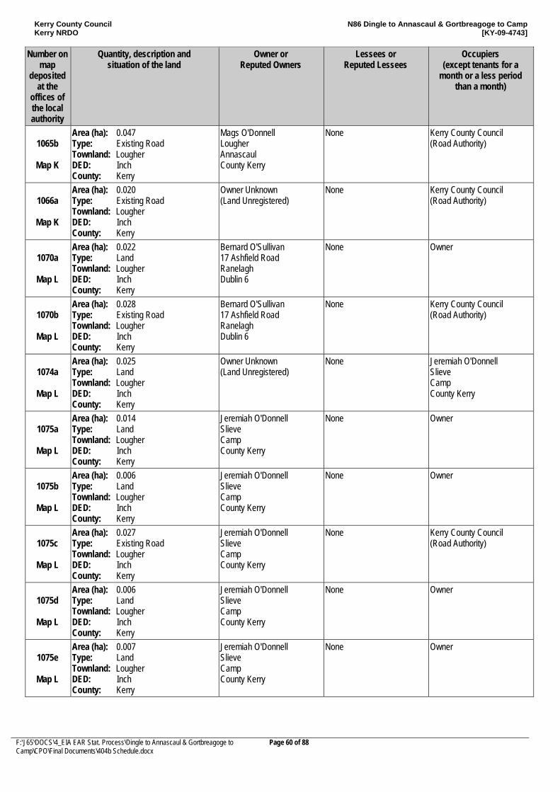
Kerry County Council Kerry NRDO
N86 Dingle to Annascaul & Gortbreagoge to Camp [KY-09-4743]
F:\J65\DOCS\4_EIA EAR Stat. Process\Dingle to Annascaul & Gortbreagoge to Camp\CPO\Final Documents\404b Schedule.docx
Page 60 of 88
Number on map
deposited at the
offices of the local authority
Quantity, description and situation of the land
Owner or Reputed Owners
Lessees or Reputed Lessees
Occupiers (except tenants for a
month or a less period than a month)
1065b
Map K
Area (ha): 0.047 Type: Existing Road Townland: Lougher DED: Inch County: Kerry
Mags O'Donnell Lougher Annascaul County Kerry
None Kerry County Council (Road Authority)
1066a
Map K
Area (ha): 0.020 Type: Existing Road Townland: Lougher DED: Inch County: Kerry
Owner Unknown (Land Unregistered)
None Kerry County Council (Road Authority)
1070a
Map L
Area (ha): 0.022 Type: Land Townland: Lougher DED: Inch County: Kerry
Bernard O'Sullivan 17 Ashfield Road Ranelagh Dublin 6
None Owner
1070b
Map L
Area (ha): 0.028 Type: Existing Road Townland: Lougher DED: Inch County: Kerry
Bernard O'Sullivan 17 Ashfield Road Ranelagh Dublin 6
None Kerry County Council (Road Authority)
1074a
Map L
Area (ha): 0.025 Type: Land Townland: Lougher DED: Inch County: Kerry
Owner Unknown (Land Unregistered)
None Jeremiah O'Donnell Slieve Camp County Kerry
1075a
Map L
Area (ha): 0.014 Type: Land Townland: Lougher DED: Inch County: Kerry
Jeremiah O'Donnell Slieve Camp County Kerry
None Owner
1075b
Map L
Area (ha): 0.006 Type: Land Townland: Lougher DED: Inch County: Kerry
Jeremiah O'Donnell Slieve Camp County Kerry
None Owner
1075c
Map L
Area (ha): 0.027 Type: Existing Road Townland: Lougher DED: Inch County: Kerry
Jeremiah O'Donnell Slieve Camp County Kerry
None Kerry County Council (Road Authority)
1075d
Map L
Area (ha): 0.006 Type: Land Townland: Lougher DED: Inch County: Kerry
Jeremiah O'Donnell Slieve Camp County Kerry
None Owner
1075e
Map L
Area (ha): 0.007 Type: Land Townland: Lougher DED: Inch County: Kerry
Jeremiah O'Donnell Slieve Camp County Kerry
None Owner
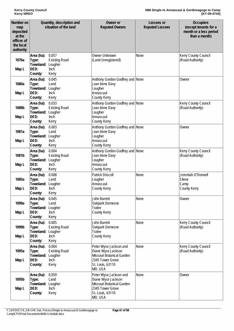
Kerry County Council Kerry NRDO
N86 Dingle to Annascaul & Gortbreagoge to Camp [KY-09-4743]
F:\J65\DOCS\4_EIA EAR Stat. Process\Dingle to Annascaul & Gortbreagoge to Camp\CPO\Final Documents\404b Schedule.docx
Page 61 of 88
Number on map
deposited at the
offices of the local authority
Quantity, description and situation of the land
Owner or Reputed Owners
Lessees or Reputed Lessees
Occupiers (except tenants for a
month or a less period than a month)
1076a
Map L
Area (ha): 0.057 Type: Existing Road Townland: Lougher DED: Inch County: Kerry
Owner Unknown (Land Unregistered)
None Kerry County Council (Road Authority)
1080a
Map L
Area (ha): 0.045 Type: Land Townland: Lougher DED: Inch County: Kerry
Anthony Gordon Godfrey and Joan Irene Davy Lougher Annascaul County Kerry
None Owner
1080b
Map L
Area (ha): 0.033 Type: Existing Road Townland: Lougher DED: Inch County: Kerry
Anthony Gordon Godfrey and Joan Irene Davy Lougher Annascaul County Kerry
None Kerry County Council (Road Authority)
1081a
Map L
Area (ha): 0.003 Type: Land Townland: Lougher DED: Inch County: Kerry
Anthony Gordon Godfrey and Joan Irene Davy Lougher Annascaul County Kerry
None Owner
1081b
Map L
Area (ha): 0.004 Type: Existing Road Townland: Lougher DED: Inch County: Kerry
Anthony Gordon Godfrey and Joan Irene Davy Lougher Annascaul County Kerry
None Kerry County Council (Road Authority)
1085a
Map L
Area (ha): 0.008 Type: Land Townland: Lougher DED: Inch County: Kerry
Patrick Driscoll Lougher Annascaul County Kerry
None Jeremiah O’Donnell Slieve Camp County Kerry
1090a
Map L
Area (ha): 0.045 Type: Land Townland: Lougher DED: Inch County: Kerry
John Barrett Oakpark Demesne Tralee County Kerry
None Owner
1090b
Map L
Area (ha): 0.005 Type: Existing Road Townland: Lougher DED: Inch County: Kerry
John Barrett Oakpark Demesne Tralee County Kerry
None Kerry County Council (Road Authority)
1095a
Map L
Area (ha): 0.004 Type: Existing Road Townland: Lougher DED: Inch County: Kerry
Peter Wyse Jackson and Diane Wyse Jackson Missouri Botanical Garden 2345 Tower Grove St. Louis, 63110 MO. USA
None Kerry County Council (Road Authority)
1095b
Map L
Area (ha): 0.059 Type: Land Townland: Lougher DED: Inch County: Kerry
Peter Wyse Jackson and Diane Wyse Jackson Missouri Botanical Garden 2345 Tower Grove St. Louis, 63110 MO. USA
None Owner
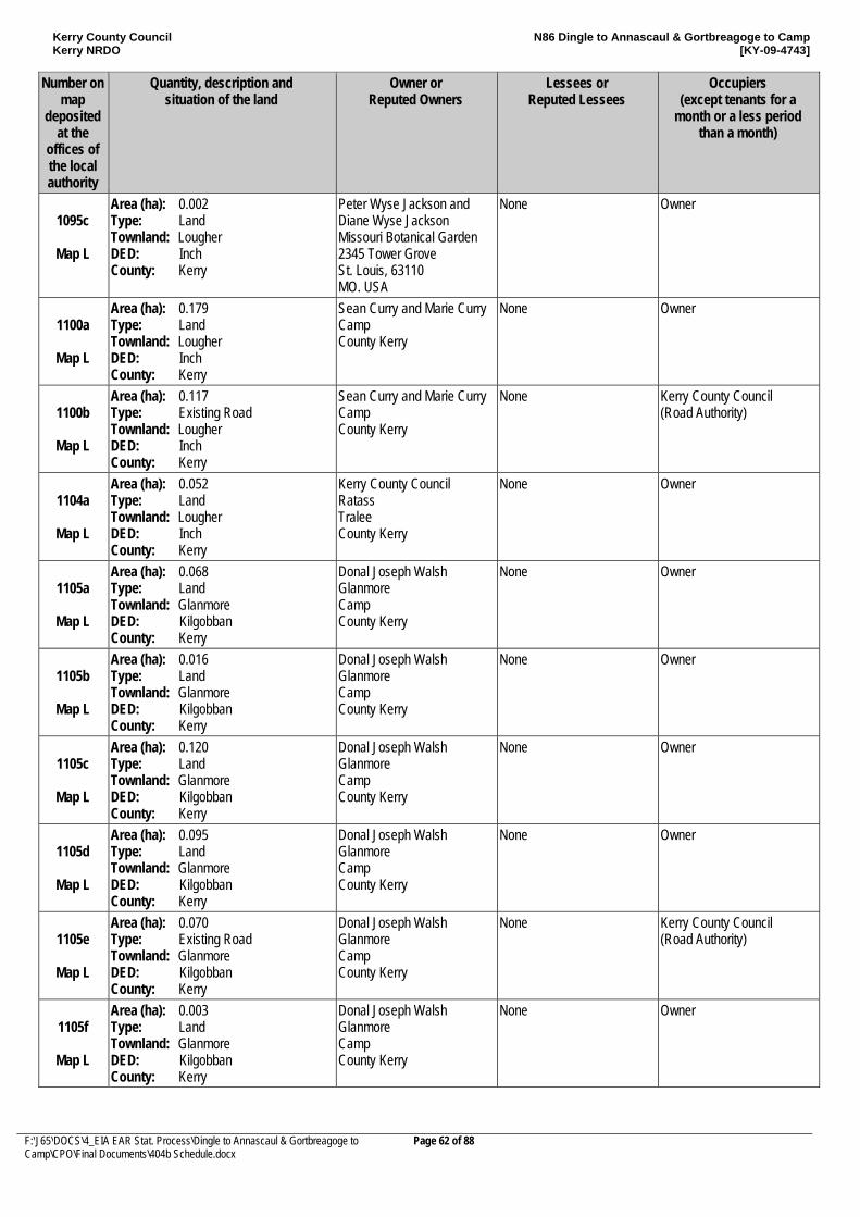
Kerry County Council Kerry NRDO
N86 Dingle to Annascaul & Gortbreagoge to Camp [KY-09-4743]
F:\J65\DOCS\4_EIA EAR Stat. Process\Dingle to Annascaul & Gortbreagoge to Camp\CPO\Final Documents\404b Schedule.docx
Page 62 of 88
Number on map
deposited at the
offices of the local authority
Quantity, description and situation of the land
Owner or Reputed Owners
Lessees or Reputed Lessees
Occupiers (except tenants for a
month or a less period than a month)
1095c
Map L
Area (ha): 0.002 Type: Land Townland: Lougher DED: Inch County: Kerry
Peter Wyse Jackson and Diane Wyse Jackson Missouri Botanical Garden 2345 Tower Grove St. Louis, 63110 MO. USA
None Owner
1100a
Map L
Area (ha): 0.179 Type: Land Townland: Lougher DED: Inch County: Kerry
Sean Curry and Marie Curry Camp County Kerry
None Owner
1100b
Map L
Area (ha): 0.117 Type: Existing Road Townland: Lougher DED: Inch County: Kerry
Sean Curry and Marie Curry Camp County Kerry
None Kerry County Council (Road Authority)
1104a
Map L
Area (ha): 0.052 Type: Land Townland: Lougher DED: Inch County: Kerry
Kerry County Council Ratass Tralee County Kerry
None Owner
1105a
Map L
Area (ha): 0.068 Type: Land Townland: Glanmore DED: Kilgobban County: Kerry
Donal Joseph Walsh Glanmore Camp County Kerry
None Owner
1105b
Map L
Area (ha): 0.016 Type: Land Townland: Glanmore DED: Kilgobban County: Kerry
Donal Joseph Walsh Glanmore Camp County Kerry
None Owner
1105c
Map L
Area (ha): 0.120 Type: Land Townland: Glanmore DED: Kilgobban County: Kerry
Donal Joseph Walsh Glanmore Camp County Kerry
None Owner
1105d
Map L
Area (ha): 0.095 Type: Land Townland: Glanmore DED: Kilgobban County: Kerry
Donal Joseph Walsh Glanmore Camp County Kerry
None Owner
1105e
Map L
Area (ha): 0.070 Type: Existing Road Townland: Glanmore DED: Kilgobban County: Kerry
Donal Joseph Walsh Glanmore Camp County Kerry
None Kerry County Council (Road Authority)
1105f
Map L
Area (ha): 0.003 Type: Land Townland: Glanmore DED: Kilgobban County: Kerry
Donal Joseph Walsh Glanmore Camp County Kerry
None Owner
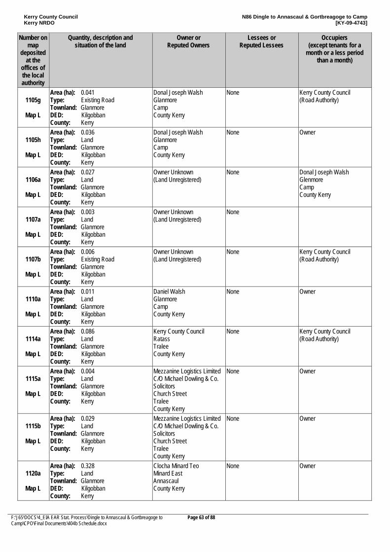
Kerry County Council Kerry NRDO
N86 Dingle to Annascaul & Gortbreagoge to Camp [KY-09-4743]
F:\J65\DOCS\4_EIA EAR Stat. Process\Dingle to Annascaul & Gortbreagoge to Camp\CPO\Final Documents\404b Schedule.docx
Page 63 of 88
Number on map
deposited at the
offices of the local authority
Quantity, description and situation of the land
Owner or Reputed Owners
Lessees or Reputed Lessees
Occupiers (except tenants for a
month or a less period than a month)
1105g
Map L
Area (ha): 0.041 Type: Existing Road Townland: Glanmore DED: Kilgobban County: Kerry
Donal Joseph Walsh Glanmore Camp County Kerry
None Kerry County Council (Road Authority)
1105h
Map L
Area (ha): 0.036 Type: Land Townland: Glanmore DED: Kilgobban County: Kerry
Donal Joseph Walsh Glanmore Camp County Kerry
None Owner
1106a
Map L
Area (ha): 0.027 Type: Land Townland: Glanmore DED: Kilgobban County: Kerry
Owner Unknown (Land Unregistered)
None Donal Joseph Walsh Glenmore Camp County Kerry
1107a
Map L
Area (ha): 0.003 Type: Land Townland: Glanmore DED: Kilgobban County: Kerry
Owner Unknown (Land Unregistered)
None
1107b
Map L
Area (ha): 0.006 Type: Existing Road Townland: Glanmore DED: Kilgobban County: Kerry
Owner Unknown (Land Unregistered)
None Kerry County Council (Road Authority)
1110a
Map L
Area (ha): 0.011 Type: Land Townland: Glanmore DED: Kilgobban County: Kerry
Daniel Walsh Glanmore Camp County Kerry
None Owner
1114a
Map L
Area (ha): 0.086 Type: Land Townland: Glanmore DED: Kilgobban County: Kerry
Kerry County Council Ratass Tralee County Kerry
None Kerry County Council (Road Authority)
1115a
Map L
Area (ha): 0.004 Type: Land Townland: Glanmore DED: Kilgobban County: Kerry
Mezzanine Logistics Limited C/O Michael Dowling & Co. Solicitors Church Street Tralee County Kerry
None Owner
1115b
Map L
Area (ha): 0.029 Type: Land Townland: Glanmore DED: Kilgobban County: Kerry
Mezzanine Logistics Limited C/O Michael Dowling & Co. Solicitors Church Street Tralee County Kerry
None Owner
1120a
Map L
Area (ha): 0.328 Type: Land Townland: Glanmore DED: Kilgobban County: Kerry
Clocha Minard Teo Minard East Annascaul County Kerry
None Owner
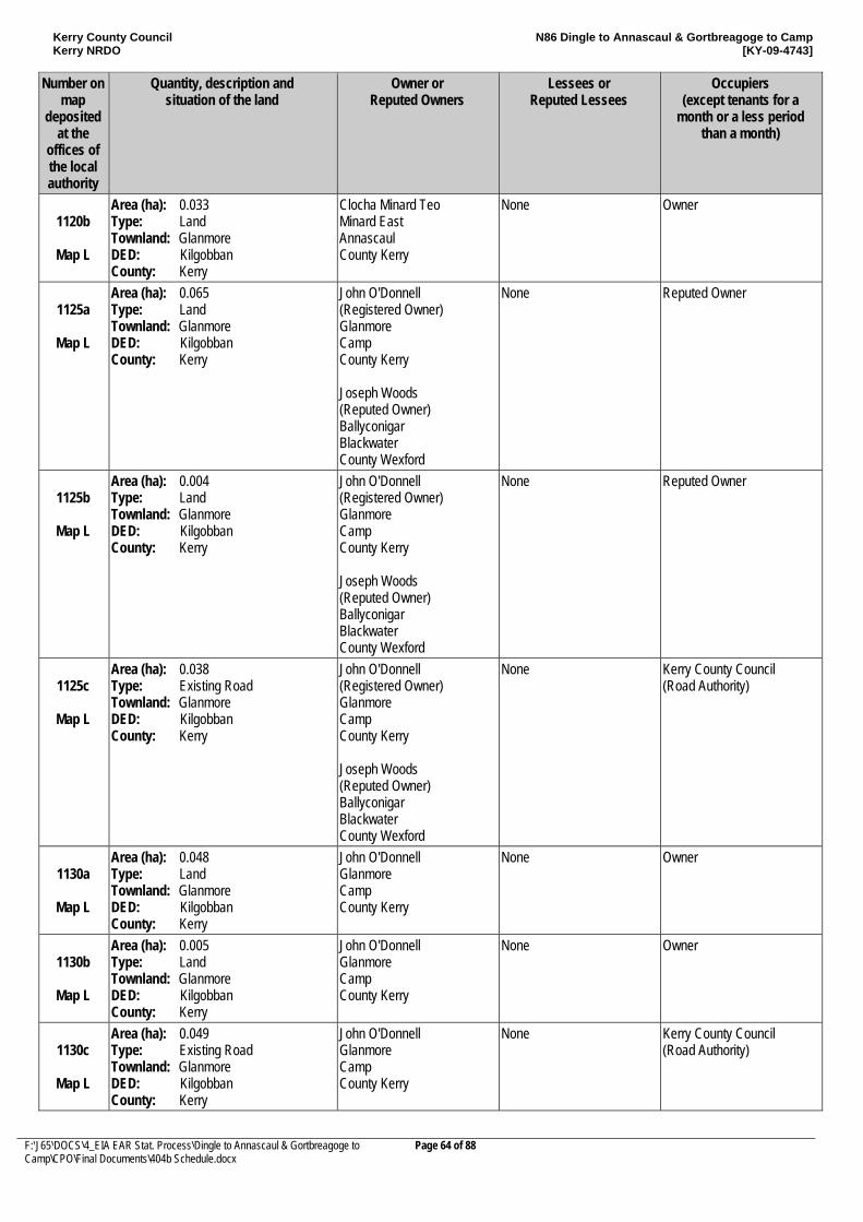
Kerry County Council Kerry NRDO
N86 Dingle to Annascaul & Gortbreagoge to Camp [KY-09-4743]
F:\J65\DOCS\4_EIA EAR Stat. Process\Dingle to Annascaul & Gortbreagoge to Camp\CPO\Final Documents\404b Schedule.docx
Page 64 of 88
Number on map
deposited at the
offices of the local authority
Quantity, description and situation of the land
Owner or Reputed Owners
Lessees or Reputed Lessees
Occupiers (except tenants for a
month or a less period than a month)
1120b
Map L
Area (ha): 0.033 Type: Land Townland: Glanmore DED: Kilgobban County: Kerry
Clocha Minard Teo Minard East Annascaul County Kerry
None Owner
1125a
Map L
Area (ha): 0.065 Type: Land Townland: Glanmore DED: Kilgobban County: Kerry
John O'Donnell (Registered Owner) Glanmore Camp County Kerry Joseph Woods (Reputed Owner) Ballyconigar Blackwater County Wexford
None Reputed Owner
1125b
Map L
Area (ha): 0.004 Type: Land Townland: Glanmore DED: Kilgobban County: Kerry
John O'Donnell (Registered Owner) Glanmore Camp County Kerry Joseph Woods (Reputed Owner) Ballyconigar Blackwater County Wexford
None Reputed Owner
1125c
Map L
Area (ha): 0.038 Type: Existing Road Townland: Glanmore DED: Kilgobban County: Kerry
John O'Donnell (Registered Owner) Glanmore Camp County Kerry Joseph Woods (Reputed Owner) Ballyconigar Blackwater County Wexford
None Kerry County Council (Road Authority)
1130a
Map L
Area (ha): 0.048 Type: Land Townland: Glanmore DED: Kilgobban County: Kerry
John O'Donnell Glanmore Camp County Kerry
None Owner
1130b
Map L
Area (ha): 0.005 Type: Land Townland: Glanmore DED: Kilgobban County: Kerry
John O'Donnell Glanmore Camp County Kerry
None Owner
1130c
Map L
Area (ha): 0.049 Type: Existing Road Townland: Glanmore DED: Kilgobban County: Kerry
John O'Donnell Glanmore Camp County Kerry
None Kerry County Council (Road Authority)
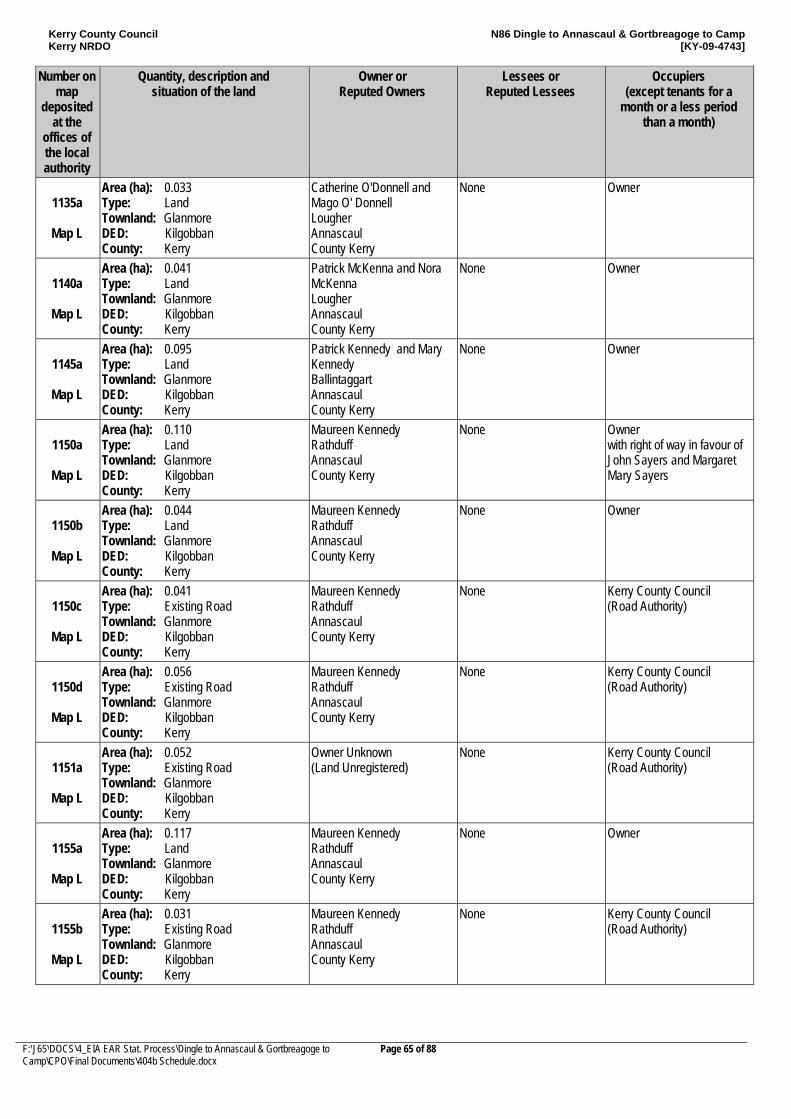
Kerry County Council Kerry NRDO
N86 Dingle to Annascaul & Gortbreagoge to Camp [KY-09-4743]
F:\J65\DOCS\4_EIA EAR Stat. Process\Dingle to Annascaul & Gortbreagoge to Camp\CPO\Final Documents\404b Schedule.docx
Page 65 of 88
Number on map
deposited at the
offices of the local authority
Quantity, description and situation of the land
Owner or Reputed Owners
Lessees or Reputed Lessees
Occupiers (except tenants for a
month or a less period than a month)
1135a
Map L
Area (ha): 0.033 Type: Land Townland: Glanmore DED: Kilgobban County: Kerry
Catherine O'Donnell and Mago O' Donnell Lougher Annascaul County Kerry
None Owner
1140a
Map L
Area (ha): 0.041 Type: Land Townland: Glanmore DED: Kilgobban County: Kerry
Patrick McKenna and Nora McKenna Lougher Annascaul County Kerry
None Owner
1145a
Map L
Area (ha): 0.095 Type: Land Townland: Glanmore DED: Kilgobban County: Kerry
Patrick Kennedy and Mary Kennedy Ballintaggart Annascaul County Kerry
None Owner
1150a
Map L
Area (ha): 0.110 Type: Land Townland: Glanmore DED: Kilgobban County: Kerry
Maureen Kennedy Rathduff Annascaul County Kerry
None Owner with right of way in favour of John Sayers and Margaret Mary Sayers
1150b
Map L
Area (ha): 0.044 Type: Land Townland: Glanmore DED: Kilgobban County: Kerry
Maureen Kennedy Rathduff Annascaul County Kerry
None Owner
1150c
Map L
Area (ha): 0.041 Type: Existing Road Townland: Glanmore DED: Kilgobban County: Kerry
Maureen Kennedy Rathduff Annascaul County Kerry
None Kerry County Council (Road Authority)
1150d
Map L
Area (ha): 0.056 Type: Existing Road Townland: Glanmore DED: Kilgobban County: Kerry
Maureen Kennedy Rathduff Annascaul County Kerry
None Kerry County Council (Road Authority)
1151a
Map L
Area (ha): 0.052 Type: Existing Road Townland: Glanmore DED: Kilgobban County: Kerry
Owner Unknown (Land Unregistered)
None Kerry County Council (Road Authority)
1155a
Map L
Area (ha): 0.117 Type: Land Townland: Glanmore DED: Kilgobban County: Kerry
Maureen Kennedy Rathduff Annascaul County Kerry
None Owner
1155b
Map L
Area (ha): 0.031 Type: Existing Road Townland: Glanmore DED: Kilgobban County: Kerry
Maureen Kennedy Rathduff Annascaul County Kerry
None Kerry County Council (Road Authority)
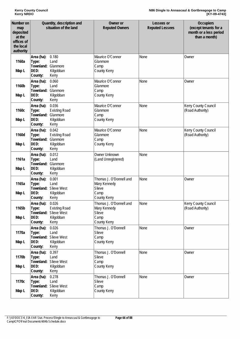
Kerry County Council Kerry NRDO
N86 Dingle to Annascaul & Gortbreagoge to Camp [KY-09-4743]
F:\J65\DOCS\4_EIA EAR Stat. Process\Dingle to Annascaul & Gortbreagoge to Camp\CPO\Final Documents\404b Schedule.docx
Page 66 of 88
Number on map
deposited at the
offices of the local authority
Quantity, description and situation of the land
Owner or Reputed Owners
Lessees or Reputed Lessees
Occupiers (except tenants for a
month or a less period than a month)
1160a
Map L
Area (ha): 0.180 Type: Land Townland: Glanmore DED: Kilgobban County: Kerry
Maurice O'Connor Glanmore Camp County Kerry
None Owner
1160b
Map L
Area (ha): 0.060 Type: Land Townland: Glanmore DED: Kilgobban County: Kerry
Maurice O'Connor Glanmore Camp County Kerry
None Owner
1160c
Map L
Area (ha): 0.036 Type: Existing Road Townland: Glanmore DED: Kilgobban County: Kerry
Maurice O'Connor Glanmore Camp County Kerry
None Kerry County Council (Road Authority)
1160d
Map L
Area (ha): 0.042 Type: Existing Road Townland: Glanmore DED: Kilgobban County: Kerry
Maurice O'Connor Glanmore Camp County Kerry
None Kerry County Council (Road Authority)
1161a
Map L
Area (ha): 0.012 Type: Land Townland: Glanmore DED: Kilgobban County: Kerry
Owner Unknown (Land Unregistered)
None
1165a
Map L
Area (ha): 0.001 Type: Land Townland: Slieve West DED: Kilgobban County: Kerry
Thomas J. O'Donnell and Mary Kennedy Slieve Camp County Kerry
None Owner
1165b
Map L
Area (ha): 0.026 Type: Existing Road Townland: Slieve West DED: Kilgobban County: Kerry
Thomas J. O'Donnell and Mary Kennedy Slieve Camp County Kerry
None Kerry County Council (Road Authority)
1170a
Map L
Area (ha): 0.026 Type: Land Townland: Slieve West DED: Kilgobban County: Kerry
Thomas J. O'Donnell Slieve Camp County Kerry
None Owner
1170b
Map L
Area (ha): 0.397 Type: Land Townland: Slieve West DED: Kilgobban County: Kerry
Thomas J. O'Donnell Slieve Camp County Kerry
None Owner
1170c
Map L
Area (ha): 0.278 Type: Land Townland: Slieve West DED: Kilgobban County: Kerry
Thomas J. O'Donnell Slieve Camp County Kerry
None Owner
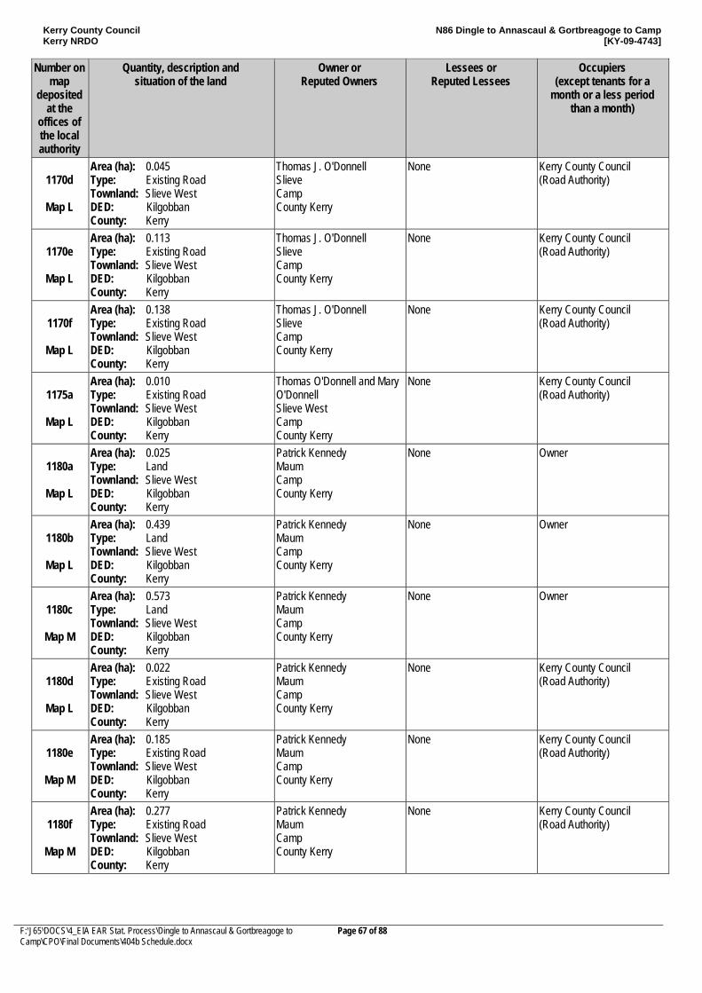
Kerry County Council Kerry NRDO
N86 Dingle to Annascaul & Gortbreagoge to Camp [KY-09-4743]
F:\J65\DOCS\4_EIA EAR Stat. Process\Dingle to Annascaul & Gortbreagoge to Camp\CPO\Final Documents\404b Schedule.docx
Page 67 of 88
Number on map
deposited at the
offices of the local authority
Quantity, description and situation of the land
Owner or Reputed Owners
Lessees or Reputed Lessees
Occupiers (except tenants for a
month or a less period than a month)
1170d
Map L
Area (ha): 0.045 Type: Existing Road Townland: Slieve West DED: Kilgobban County: Kerry
Thomas J. O'Donnell Slieve Camp County Kerry
None Kerry County Council (Road Authority)
1170e
Map L
Area (ha): 0.113 Type: Existing Road Townland: Slieve West DED: Kilgobban County: Kerry
Thomas J. O'Donnell Slieve Camp County Kerry
None Kerry County Council (Road Authority)
1170f
Map L
Area (ha): 0.138 Type: Existing Road Townland: Slieve West DED: Kilgobban County: Kerry
Thomas J. O'Donnell Slieve Camp County Kerry
None Kerry County Council (Road Authority)
1175a
Map L
Area (ha): 0.010 Type: Existing Road Townland: Slieve West DED: Kilgobban County: Kerry
Thomas O'Donnell and Mary O'Donnell Slieve West Camp County Kerry
None Kerry County Council (Road Authority)
1180a
Map L
Area (ha): 0.025 Type: Land Townland: Slieve West DED: Kilgobban County: Kerry
Patrick Kennedy Maum Camp County Kerry
None Owner
1180b
Map L
Area (ha): 0.439 Type: Land Townland: Slieve West DED: Kilgobban County: Kerry
Patrick Kennedy Maum Camp County Kerry
None Owner
1180c
Map M
Area (ha): 0.573 Type: Land Townland: Slieve West DED: Kilgobban County: Kerry
Patrick Kennedy Maum Camp County Kerry
None Owner
1180d
Map L
Area (ha): 0.022 Type: Existing Road Townland: Slieve West DED: Kilgobban County: Kerry
Patrick Kennedy Maum Camp County Kerry
None Kerry County Council (Road Authority)
1180e
Map M
Area (ha): 0.185 Type: Existing Road Townland: Slieve West DED: Kilgobban County: Kerry
Patrick Kennedy Maum Camp County Kerry
None Kerry County Council (Road Authority)
1180f
Map M
Area (ha): 0.277 Type: Existing Road Townland: Slieve West DED: Kilgobban County: Kerry
Patrick Kennedy Maum Camp County Kerry
None Kerry County Council (Road Authority)
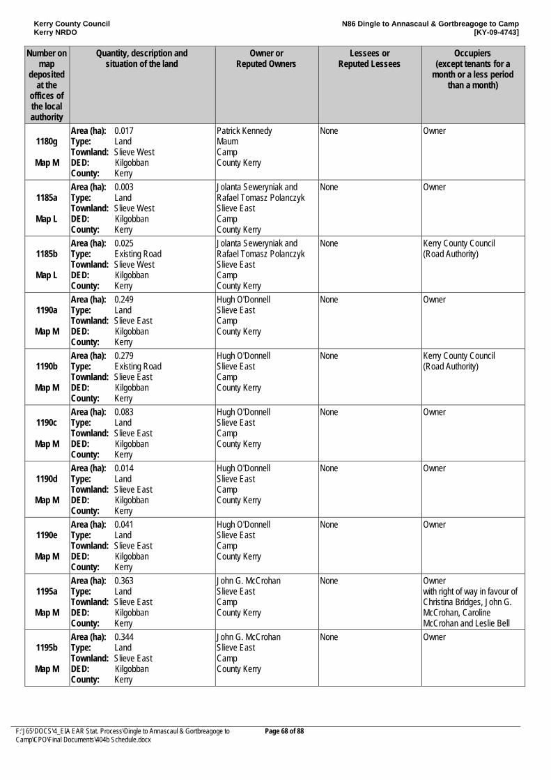
Kerry County Council Kerry NRDO
N86 Dingle to Annascaul & Gortbreagoge to Camp [KY-09-4743]
F:\J65\DOCS\4_EIA EAR Stat. Process\Dingle to Annascaul & Gortbreagoge to Camp\CPO\Final Documents\404b Schedule.docx
Page 68 of 88
Number on map
deposited at the
offices of the local authority
Quantity, description and situation of the land
Owner or Reputed Owners
Lessees or Reputed Lessees
Occupiers (except tenants for a
month or a less period than a month)
1180g
Map M
Area (ha): 0.017 Type: Land Townland: Slieve West DED: Kilgobban County: Kerry
Patrick Kennedy Maum Camp County Kerry
None Owner
1185a
Map L
Area (ha): 0.003 Type: Land Townland: Slieve West DED: Kilgobban County: Kerry
Jolanta Seweryniak and Rafael Tomasz Polanczyk Slieve East Camp County Kerry
None Owner
1185b
Map L
Area (ha): 0.025 Type: Existing Road Townland: Slieve West DED: Kilgobban County: Kerry
Jolanta Seweryniak and Rafael Tomasz Polanczyk Slieve East Camp County Kerry
None Kerry County Council (Road Authority)
1190a
Map M
Area (ha): 0.249 Type: Land Townland: Slieve East DED: Kilgobban County: Kerry
Hugh O'Donnell Slieve East Camp County Kerry
None Owner
1190b
Map M
Area (ha): 0.279 Type: Existing Road Townland: Slieve East DED: Kilgobban County: Kerry
Hugh O'Donnell Slieve East Camp County Kerry
None Kerry County Council (Road Authority)
1190c
Map M
Area (ha): 0.083 Type: Land Townland: Slieve East DED: Kilgobban County: Kerry
Hugh O'Donnell Slieve East Camp County Kerry
None Owner
1190d
Map M
Area (ha): 0.014 Type: Land Townland: Slieve East DED: Kilgobban County: Kerry
Hugh O'Donnell Slieve East Camp County Kerry
None Owner
1190e
Map M
Area (ha): 0.041 Type: Land Townland: Slieve East DED: Kilgobban County: Kerry
Hugh O'Donnell Slieve East Camp County Kerry
None Owner
1195a
Map M
Area (ha): 0.363 Type: Land Townland: Slieve East DED: Kilgobban County: Kerry
John G. McCrohan Slieve East Camp County Kerry
None Owner with right of way in favour of Christina Bridges, John G. McCrohan, Caroline McCrohan and Leslie Bell
1195b
Map M
Area (ha): 0.344 Type: Land Townland: Slieve East DED: Kilgobban County: Kerry
John G. McCrohan Slieve East Camp County Kerry
None Owner
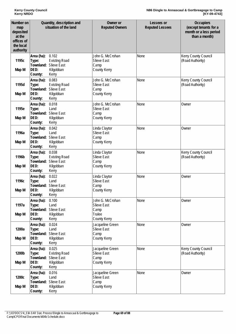
Kerry County Council Kerry NRDO
N86 Dingle to Annascaul & Gortbreagoge to Camp [KY-09-4743]
F:\J65\DOCS\4_EIA EAR Stat. Process\Dingle to Annascaul & Gortbreagoge to Camp\CPO\Final Documents\404b Schedule.docx
Page 69 of 88
Number on map
deposited at the
offices of the local authority
Quantity, description and situation of the land
Owner or Reputed Owners
Lessees or Reputed Lessees
Occupiers (except tenants for a
month or a less period than a month)
1195c
Map M
Area (ha): 0.102 Type: Existing Road Townland: Slieve East DED: Kilgobban County: Kerry
John G. McCrohan Slieve East Camp County Kerry
None Kerry County Council (Road Authority)
1195d
Map M
Area (ha): 0.083 Type: Existing Road Townland: Slieve East DED: Kilgobban County: Kerry
John G. McCrohan Slieve East Camp County Kerry
None Kerry County Council (Road Authority)
1195e
Map M
Area (ha): 0.018 Type: Land Townland: Slieve East DED: Kilgobban County: Kerry
John G. McCrohan Slieve East Camp County Kerry
None Owner
1196a
Map M
Area (ha): 0.042 Type: Land Townland: Slieve East DED: Kilgobban County: Kerry
Linda Claytor Slieve East Camp County Kerry
None Owner
1196b
Map M
Area (ha): 0.038 Type: Existing Road Townland: Slieve East DED: Kilgobban County: Kerry
Linda Claytor Slieve East Camp County Kerry
None Kerry County Council (Road Authority)
1196c
Map M
Area (ha): 0.022 Type: Land Townland: Slieve East DED: Kilgobban County: Kerry
Linda Claytor Slieve East Camp County Kerry
None Owner
1197a
Map M
Area (ha): 0.100 Type: Land Townland: Slieve East DED: Kilgobban County: Kerry
John G. McCrohan Slieve East Camp Tralee County Kerry
None Owner
1200a
Map M
Area (ha): 0.024 Type: Land Townland: Slieve East DED: Kilgobban County: Kerry
Jacqueline Green Slieve East Camp County Kerry
None Owner
1200b
Map M
Area (ha): 0.025 Type: Existing Road Townland: Slieve East DED: Kilgobban County: Kerry
Jacqueline Green Slieve East Camp County Kerry
None Kerry County Council (Road Authority)
1200c
Map M
Area (ha): 0.016 Type: Land Townland: Slieve East DED: Kilgobban County: Kerry
Jacqueline Green Slieve East Camp County Kerry
None Owner
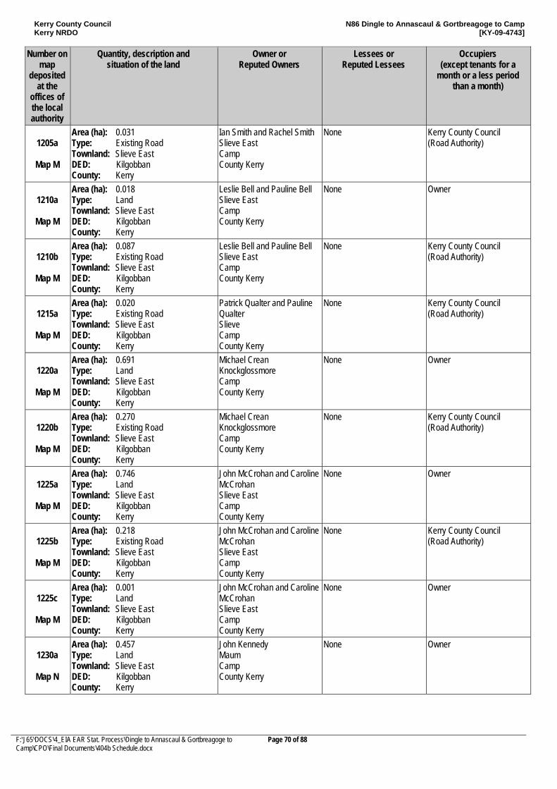
Kerry County Council Kerry NRDO
N86 Dingle to Annascaul & Gortbreagoge to Camp [KY-09-4743]
F:\J65\DOCS\4_EIA EAR Stat. Process\Dingle to Annascaul & Gortbreagoge to Camp\CPO\Final Documents\404b Schedule.docx
Page 70 of 88
Number on map
deposited at the
offices of the local authority
Quantity, description and situation of the land
Owner or Reputed Owners
Lessees or Reputed Lessees
Occupiers (except tenants for a
month or a less period than a month)
1205a
Map M
Area (ha): 0.031 Type: Existing Road Townland: Slieve East DED: Kilgobban County: Kerry
Ian Smith and Rachel Smith Slieve East Camp County Kerry
None Kerry County Council (Road Authority)
1210a
Map M
Area (ha): 0.018 Type: Land Townland: Slieve East DED: Kilgobban County: Kerry
Leslie Bell and Pauline Bell Slieve East Camp County Kerry
None Owner
1210b
Map M
Area (ha): 0.087 Type: Existing Road Townland: Slieve East DED: Kilgobban County: Kerry
Leslie Bell and Pauline Bell Slieve East Camp County Kerry
None Kerry County Council (Road Authority)
1215a
Map M
Area (ha): 0.020 Type: Existing Road Townland: Slieve East DED: Kilgobban County: Kerry
Patrick Qualter and Pauline Qualter Slieve Camp County Kerry
None Kerry County Council (Road Authority)
1220a
Map M
Area (ha): 0.691 Type: Land Townland: Slieve East DED: Kilgobban County: Kerry
Michael Crean Knockglossmore Camp County Kerry
None Owner
1220b
Map M
Area (ha): 0.270 Type: Existing Road Townland: Slieve East DED: Kilgobban County: Kerry
Michael Crean Knockglossmore Camp County Kerry
None Kerry County Council (Road Authority)
1225a
Map M
Area (ha): 0.746 Type: Land Townland: Slieve East DED: Kilgobban County: Kerry
John McCrohan and Caroline McCrohan Slieve East Camp County Kerry
None Owner
1225b
Map M
Area (ha): 0.218 Type: Existing Road Townland: Slieve East DED: Kilgobban County: Kerry
John McCrohan and Caroline McCrohan Slieve East Camp County Kerry
None Kerry County Council (Road Authority)
1225c
Map M
Area (ha): 0.001 Type: Land Townland: Slieve East DED: Kilgobban County: Kerry
John McCrohan and Caroline McCrohan Slieve East Camp County Kerry
None Owner
1230a
Map N
Area (ha): 0.457 Type: Land Townland: Slieve East DED: Kilgobban County: Kerry
John Kennedy Maum Camp County Kerry
None Owner
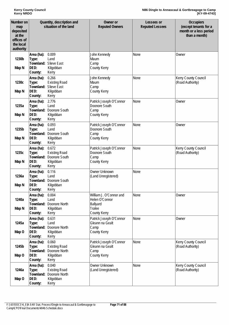
Kerry County Council Kerry NRDO
N86 Dingle to Annascaul & Gortbreagoge to Camp [KY-09-4743]
F:\J65\DOCS\4_EIA EAR Stat. Process\Dingle to Annascaul & Gortbreagoge to Camp\CPO\Final Documents\404b Schedule.docx
Page 71 of 88
Number on map
deposited at the
offices of the local authority
Quantity, description and situation of the land
Owner or Reputed Owners
Lessees or Reputed Lessees
Occupiers (except tenants for a
month or a less period than a month)
1230b
Map N
Area (ha): 0.009 Type: Land Townland: Slieve East DED: Kilgobban County: Kerry
John Kennedy Maum Camp County Kerry
None Owner
1230c
Map N
Area (ha): 0.266 Type: Existing Road Townland: Slieve East DED: Kilgobban County: Kerry
John Kennedy Maum Camp County Kerry
None Kerry County Council (Road Authority)
1235a
Map N
Area (ha): 2.776 Type: Land Townland: Doonore South DED: Kilgobban County: Kerry
Patrick Joseph O'Connor Doonore South Camp County Kerry
None Owner
1235b
Map N
Area (ha): 0.093 Type: Land Townland: Doonore South DED: Kilgobban County: Kerry
Patrick Joseph O'Connor Doonore South Camp County Kerry
None Owner
1235c
Map N
Area (ha): 0.672 Type: Existing Road Townland: Doonore South DED: Kilgobban County: Kerry
Patrick Joseph O'Connor Doonore South Camp County Kerry
None Kerry County Council (Road Authority)
1236a
Map N
Area (ha): 0.116 Type: Land Townland: Doonore South DED: Kilgobban County: Kerry
Owner Unknown (Land Unregistered)
None
1240a
Map N
Area (ha): 0.004 Type: Land Townland: Doonore North DED: Kilgobban County: Kerry
William J. O'Connor and Helen O'Connor Ballyard Tralee County Kerry
None Owner
1245a
Map O
Area (ha): 0.631 Type: Land Townland: Doonore North DED: Kilgobban County: Kerry
Patrick Joseph O'Connor Gleann na Gealt Camp County Kerry
None Owner
1245b
Map O
Area (ha): 0.060 Type: Existing Road Townland: Doonore North DED: Kilgobban County: Kerry
Patrick Joseph O'Connor Gleann na Gealt Camp County Kerry
None Kerry County Council (Road Authority)
1246a
Map O
Area (ha): 0.040 Type: Existing Road Townland: Doonore North DED: Kilgobban County: Kerry
Owner Unknown (Land Unregistered)
None Kerry County Council (Road Authority)
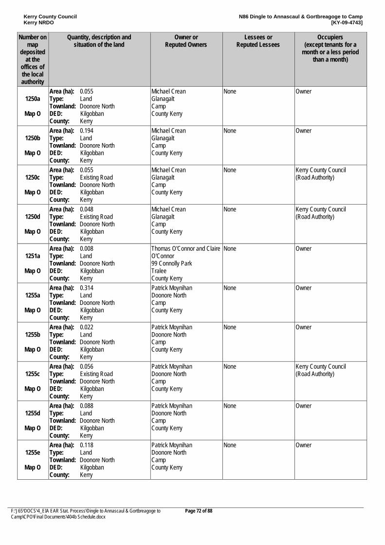
Kerry County Council Kerry NRDO
N86 Dingle to Annascaul & Gortbreagoge to Camp [KY-09-4743]
F:\J65\DOCS\4_EIA EAR Stat. Process\Dingle to Annascaul & Gortbreagoge to Camp\CPO\Final Documents\404b Schedule.docx
Page 72 of 88
Number on map
deposited at the
offices of the local authority
Quantity, description and situation of the land
Owner or Reputed Owners
Lessees or Reputed Lessees
Occupiers (except tenants for a
month or a less period than a month)
1250a
Map O
Area (ha): 0.055 Type: Land Townland: Doonore North DED: Kilgobban County: Kerry
Michael Crean Glanagalt Camp County Kerry
None Owner
1250b
Map O
Area (ha): 0.194 Type: Land Townland: Doonore North DED: Kilgobban County: Kerry
Michael Crean Glanagalt Camp County Kerry
None Owner
1250c
Map O
Area (ha): 0.055 Type: Existing Road Townland: Doonore North DED: Kilgobban County: Kerry
Michael Crean Glanagalt Camp County Kerry
None Kerry County Council (Road Authority)
1250d
Map O
Area (ha): 0.048 Type: Existing Road Townland: Doonore North DED: Kilgobban County: Kerry
Michael Crean Glanagalt Camp County Kerry
None Kerry County Council (Road Authority)
1251a
Map O
Area (ha): 0.008 Type: Land Townland: Doonore North DED: Kilgobban County: Kerry
Thomas O'Connor and Claire O'Connor 99 Connolly Park Tralee County Kerry
None Owner
1255a
Map O
Area (ha): 0.314 Type: Land Townland: Doonore North DED: Kilgobban County: Kerry
Patrick Moynihan Doonore North Camp County Kerry
None Owner
1255b
Map O
Area (ha): 0.022 Type: Land Townland: Doonore North DED: Kilgobban County: Kerry
Patrick Moynihan Doonore North Camp County Kerry
None Owner
1255c
Map O
Area (ha): 0.056 Type: Existing Road Townland: Doonore North DED: Kilgobban County: Kerry
Patrick Moynihan Doonore North Camp County Kerry
None Kerry County Council (Road Authority)
1255d
Map O
Area (ha): 0.088 Type: Land Townland: Doonore North DED: Kilgobban County: Kerry
Patrick Moynihan Doonore North Camp County Kerry
None Owner
1255e
Map O
Area (ha): 0.118 Type: Land Townland: Doonore North DED: Kilgobban County: Kerry
Patrick Moynihan Doonore North Camp County Kerry
None Owner
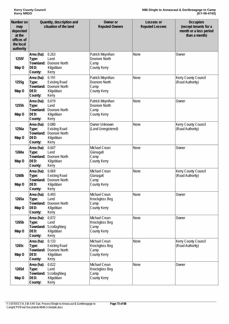
Kerry County Council Kerry NRDO
N86 Dingle to Annascaul & Gortbreagoge to Camp [KY-09-4743]
F:\J65\DOCS\4_EIA EAR Stat. Process\Dingle to Annascaul & Gortbreagoge to Camp\CPO\Final Documents\404b Schedule.docx
Page 73 of 88
Number on map
deposited at the
offices of the local authority
Quantity, description and situation of the land
Owner or Reputed Owners
Lessees or Reputed Lessees
Occupiers (except tenants for a
month or a less period than a month)
1255f
Map O
Area (ha): 0.263 Type: Land Townland: Doonore North DED: Kilgobban County: Kerry
Patrick Moynihan Doonore North Camp County Kerry
None Owner
1255g
Map O
Area (ha): 0.191 Type: Existing Road Townland: Doonore North DED: Kilgobban County: Kerry
Patrick Moynihan Doonore North Camp County Kerry
None Kerry County Council (Road Authority)
1255h
Map O
Area (ha): 0.019 Type: Land Townland: Doonore North DED: Kilgobban County: Kerry
Patrick Moynihan Doonore North Camp County Kerry
None Owner
1256a
Map O
Area (ha): 0.080 Type: Existing Road Townland: Doonore North DED: Kilgobban County: Kerry
Owner Unknown (Land Unregistered)
None Kerry County Council (Road Authority)
1260a
Map O
Area (ha): 0.607 Type: Land Townland: Doonore North DED: Kilgobban County: Kerry
Michael Crean Glanagalt Camp County Kerry
None Owner
1260b
Map O
Area (ha): 0.069 Type: Existing Road Townland: Doonore North DED: Kilgobban County: Kerry
Michael Crean Glanagalt Camp County Kerry
None Kerry County Council (Road Authority)
1265a
Map O
Area (ha): 0.493 Type: Land Townland: Doonore North DED: Kilgobban County: Kerry
Michael Crean Knockgloss Beg Camp County Kerry
None Owner
1265b
Map O
Area (ha): 0.072 Type: Land Townland: Scrallaghbeg DED: Kilgobban County: Kerry
Michael Crean Knockgloss Beg Camp County Kerry
None Owner
1265c
Map O
Area (ha): 0.133 Type: Existing Road Townland: Doonore North DED: Kilgobban County: Kerry
Michael Crean Knockgloss Beg Camp County Kerry
None Kerry County Council (Road Authority)
1265d
Map O
Area (ha): 0.022 Type: Land Townland: Scrallaghbeg DED: Kilgobban County: Kerry
Michael Crean Knockgloss Beg Camp County Kerry
None Owner
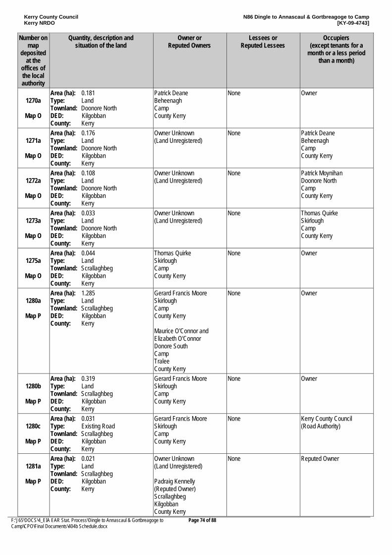
Kerry County Council Kerry NRDO
N86 Dingle to Annascaul & Gortbreagoge to Camp [KY-09-4743]
F:\J65\DOCS\4_EIA EAR Stat. Process\Dingle to Annascaul & Gortbreagoge to Camp\CPO\Final Documents\404b Schedule.docx
Page 74 of 88
Number on map
deposited at the
offices of the local authority
Quantity, description and situation of the land
Owner or Reputed Owners
Lessees or Reputed Lessees
Occupiers (except tenants for a
month or a less period than a month)
1270a
Map O
Area (ha): 0.181 Type: Land Townland: Doonore North DED: Kilgobban County: Kerry
Patrick Deane Beheenagh Camp County Kerry
None Owner
1271a
Map O
Area (ha): 0.176 Type: Land Townland: Doonore North DED: Kilgobban County: Kerry
Owner Unknown (Land Unregistered)
None Patrick Deane Beheenagh Camp County Kerry
1272a
Map O
Area (ha): 0.108 Type: Land Townland: Doonore North DED: Kilgobban County: Kerry
Owner Unknown (Land Unregistered)
None Patrick Moynihan Doonore North Camp County Kerry
1273a
Map O
Area (ha): 0.033 Type: Land Townland: Doonore North DED: Kilgobban County: Kerry
Owner Unknown (Land Unregistered)
None Thomas Quirke Skirlough Camp County Kerry
1275a
Map O
Area (ha): 0.044 Type: Land Townland: Scrallaghbeg DED: Kilgobban County: Kerry
Thomas Quirke Skirlough Camp County Kerry
None Owner
1280a
Map P
Area (ha): 1.285 Type: Land Townland: Scrallaghbeg DED: Kilgobban County: Kerry
Gerard Francis Moore Skirlough Camp County Kerry Maurice O'Connor and Elizabeth O'Connor Donore South Camp Tralee County Kerry
None Owner
1280b
Map P
Area (ha): 0.319 Type: Land Townland: Scrallaghbeg DED: Kilgobban County: Kerry
Gerard Francis Moore Skirlough Camp County Kerry
None Owner
1280c
Map P
Area (ha): 0.031 Type: Existing Road Townland: Scrallaghbeg DED: Kilgobban County: Kerry
Gerard Francis Moore Skirlough Camp County Kerry
None Kerry County Council (Road Authority)
1281a
Map P
Area (ha): 0.021 Type: Land Townland: Scrallaghbeg DED: Kilgobban County: Kerry
Owner Unknown (Land Unregistered) Padraig Kennelly (Reputed Owner) Scrallaghbeg Kilgobban County Kerry
None Reputed Owner
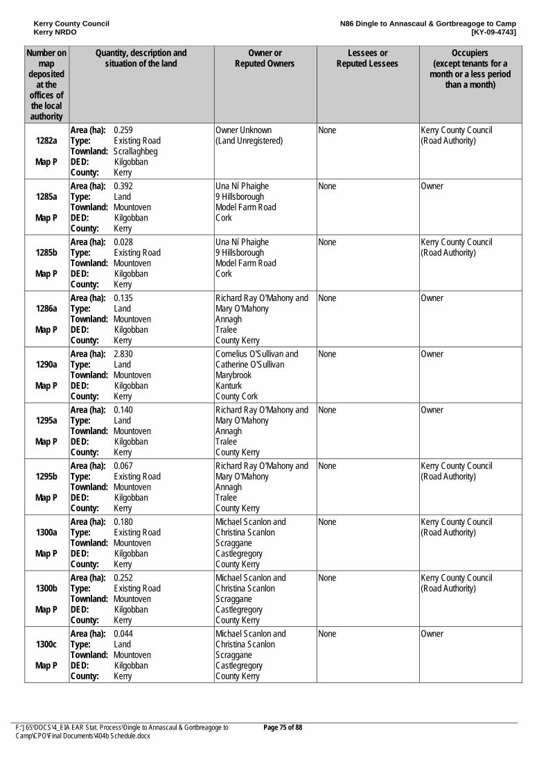
Kerry County Council Kerry NRDO
N86 Dingle to Annascaul & Gortbreagoge to Camp [KY-09-4743]
F:\J65\DOCS\4_EIA EAR Stat. Process\Dingle to Annascaul & Gortbreagoge to Camp\CPO\Final Documents\404b Schedule.docx
Page 75 of 88
Number on map
deposited at the
offices of the local authority
Quantity, description and situation of the land
Owner or Reputed Owners
Lessees or Reputed Lessees
Occupiers (except tenants for a
month or a less period than a month)
1282a
Map P
Area (ha): 0.259 Type: Existing Road Townland: Scrallaghbeg DED: Kilgobban County: Kerry
Owner Unknown (Land Unregistered)
None Kerry County Council (Road Authority)
1285a
Map P
Area (ha): 0.392 Type: Land Townland: Mountoven DED: Kilgobban County: Kerry
Una Ní Phaighe 9 Hillsborough Model Farm Road Cork
None Owner
1285b
Map P
Area (ha): 0.028 Type: Existing Road Townland: Mountoven DED: Kilgobban County: Kerry
Una Ní Phaighe 9 Hillsborough Model Farm Road Cork
None Kerry County Council (Road Authority)
1286a
Map P
Area (ha): 0.135 Type: Land Townland: Mountoven DED: Kilgobban County: Kerry
Richard Ray O'Mahony and Mary O'Mahony Annagh Tralee County Kerry
None Owner
1290a
Map P
Area (ha): 2.830 Type: Land Townland: Mountoven DED: Kilgobban County: Kerry
Cornelius O'Sullivan and Catherine O'Sullivan Marybrook Kanturk County Cork
None Owner
1295a
Map P
Area (ha): 0.140 Type: Land Townland: Mountoven DED: Kilgobban County: Kerry
Richard Ray O'Mahony and Mary O'Mahony Annagh Tralee County Kerry
None Owner
1295b
Map P
Area (ha): 0.067 Type: Existing Road Townland: Mountoven DED: Kilgobban County: Kerry
Richard Ray O'Mahony and Mary O'Mahony Annagh Tralee County Kerry
None Kerry County Council (Road Authority)
1300a
Map P
Area (ha): 0.180 Type: Existing Road Townland: Mountoven DED: Kilgobban County: Kerry
Michael Scanlon and Christina Scanlon Scraggane Castlegregory County Kerry
None Kerry County Council (Road Authority)
1300b
Map P
Area (ha): 0.252 Type: Existing Road Townland: Mountoven DED: Kilgobban County: Kerry
Michael Scanlon and Christina Scanlon Scraggane Castlegregory County Kerry
None Kerry County Council (Road Authority)
1300c
Map P
Area (ha): 0.044 Type: Land Townland: Mountoven DED: Kilgobban County: Kerry
Michael Scanlon and Christina Scanlon Scraggane Castlegregory County Kerry
None Owner
Kerry County Council Kerry NRDO
N86 Dingle to Annascaul & Gortbreagoge to Camp [KY-09-4743]
F:\J65\DOCS\4_EIA EAR Stat. Process\Dingle to Annascaul & Gortbreagoge to Camp\CPO\Final Documents\404b Schedule.docx
Page 76 of 88
Number on map
deposited at the
offices of the local authority
Quantity, description and situation of the land
Owner or Reputed Owners
Lessees or Reputed Lessees
Occupiers (except tenants for a
month or a less period than a month)
1305a
Map P
Area (ha): 0.025 Type: Existing Road Townland: Mountoven DED: Kilgobban County: Kerry
John Joseph Walsh Mountoven Camp County Kerry
None Kerry County Council (Road Authority)
1310a
Map P
Area (ha): 0.142 Type: Existing Road Townland: Ballygarret DED: Knockglass County: Kerry
Maureen Cronin Clahane Ballyard Tralee County Kerry
None Owner
1310b
Map P
Area (ha): 0.007 Type: Land Townland: Ballygarret DED: Knockglass County: Kerry
Maureen Cronin Clahane Ballyard Tralee County Kerry
None Owner
1310c
Map P
Area (ha): 1.380 Type: Land Townland: Ballygarret DED: Knockglass County: Kerry
Maureen Cronin Clahane Ballyard Tralee County Kerry
None Owner
1310d
Map P
Area (ha): 0.033 Type: Land Townland: Ballygarret DED: Knockglass County: Kerry
Maureen Cronin Clahane Ballyard Tralee County Kerry
None Owner
1315a
Map P
Area (ha): 0.418 Type: Land Townland: Ballygarret DED: Knockglass County: Kerry
Maureen Crean (Registered Owner) Knockglass Beg Camp County Kerry Martin Crean (Reputed Owner) Upper Camp Tralee County Kerry
None Reputed Owner
1315b
Map P
Area (ha): 0.029 Type: Land Townland: Ballygarret DED: Knockglass County: Kerry
Maureen Crean (Registered Owner) Knockglass Beg Camp County Kerry Martin Crean (Reputed Owner) Upper Camp Tralee County Kerry
None Reputed Owner
Kerry County Council Kerry NRDO
N86 Dingle to Annascaul & Gortbreagoge to Camp [KY-09-4743]
F:\J65\DOCS\4_EIA EAR Stat. Process\Dingle to Annascaul & Gortbreagoge to Camp\CPO\Final Documents\404b Schedule.docx
Page 77 of 88
Number on
map deposited
at the offices of the local authority
Quantity, description and situation of the land
Owner or Reputed Owners
Lessees or Reputed Lessees
Occupiers (except tenants for a
month or a less period than a month)
1315c
Map P
Area (ha): 0.004 Type: Existing Road Townland: Ballygarret DED: Knockglass County: Kerry
Maureen Crean (Registered Owner) Knockglass Beg Camp County Kerry Martin Crean (Reputed Owner) Upper Camp Tralee County Kerry
None Kerry County Council (Road Authority) with right of way in favour of Maurice O'Connor, Michael Foley, Michael Herlihy, Patrick Moore, Elizabeth Moore, Litz Neumann, Gloria Neumann, Thomas O'Sullivan, Sheila O'Sullivan, Andrew Hennessy and Matilda Hennessy
1320a
Map P
Area (ha): 1.122 Type: Land Townland: Ballygarret DED: Knockglass County: Kerry
Alexander N. O'Neill 5 Eagle Valley Enniskerry County Wicklow
None Owner
1325a
Map Q
Area (ha): 0.250 Type: Land Townland: Ballinknockane DED: Knockglass County: Kerry
Michael O'Shea and Mary Anne O'Shea Curraduff Camp County Kerry Patrick Spillane Ballinknockane Camp
None Owner
1325b
Map Q
Area (ha): 0.027 Type: Existing Road Townland: Ballinknockane DED: Knockglass County: Kerry
Michael O'Shea and Mary Anne O'Shea Curraduff Camp County Kerry Patrick Spillane Ballinknockane Camp
None Kerry County Council (Road Authority)
1330a
Map Q
Area (ha): 0.222 Type: Land Townland: Ballinknockane DED: Knockglass County: Kerry
Patrick Murphy 8 Racecourse Lawn Tralee County Kerry
None Owner
1330b
Map Q
Area (ha): 0.081 Type: Existing Road Townland: Ballinknockane DED: Knockglass County: Kerry
Patrick Murphy 8 Racecourse Lawn Tralee County Kerry
None Kerry County Council (Road Authority)
1335a
Map Q
Area (ha): 0.153 Type: Land Townland: Ballinknockane DED: Knockglass County: Kerry
Kitty Deane Glenfield Camp County Kerry
None Owner
Kerry County Council Kerry NRDO
N86 Dingle to Annascaul & Gortbreagoge to Camp [KY-09-4743]
F:\J65\DOCS\4_EIA EAR Stat. Process\Dingle to Annascaul & Gortbreagoge to Camp\CPO\Final Documents\404b Schedule.docx
Page 78 of 88
Number on map
deposited at the
offices of the local authority
Quantity, description and situation of the land
Owner or Reputed Owners
Lessees or Reputed Lessees
Occupiers (except tenants for a
month or a less period than a month)
1340a
Map Q
Area (ha): 0.047 Type: Land Townland: Ballinknockane DED: Knockglass County: Kerry
Catherine Scannell Ballyknockane Camp P.O. County Kerry
None Owner
1345a
Map Q
Area (ha): 0.051 Type: Land Townland: Ballinknockane DED: Knockglass County: Kerry
Joseph O' Dwyer Camp Tralee County Kerry
None Owner
1350a
Map Q
Area (ha): 0.211 Type: Land Townland: Ballinknockane DED: Knockglass County: Kerry
Timothy O'Connor and Kathleen O'Connor (Registered Owner) Holy Ground Dingle County Kerry Michael Tracy and Mary Tracy (Reputed Owner) Holy Ground Dingle County Kerry
None Owner
1350b
Map Q
Area (ha): 0.253 Type: Existing Road Townland: Ballinknockane DED: Knockglass County: Kerry
Timothy O'Connor and Kathleen O'Connor (Registered Owner) Holy Ground Dingle County Kerry Michael Tracy and Mary Tracy (Reputed Owner) Holy Ground Dingle County Kerry
None Kerry County Council (Road Authority)
1355a
Map Q
Area (ha): 0.012 Type: Existing Road Townland: Ballinknockane DED: Knockglass County: Kerry
Frank Vansteenkiste and Adrienne Dowd Ballygarrett Camp County Kerry
None Kerry County Council (Road Authority)
1360a
Map Q
Area (ha): 0.013 Type: Existing Road Townland: Ballinknockane DED: Knockglass County: Kerry
Andrew Hennessy and Matilda Hennessy 25 Hillside Drive Sallins Road Naas County Kildare
None Kerry County Council (Road Authority)
1365a
Map Q
Area (ha): 0.011 Type: Existing Road Townland: Ballinknockane DED: Knockglass County: Kerry
Ulrick Wasels and Klaus Schmidtke and Elizabeth Charlott Schmidtke and Barbara Schmidtke Wasels Ballygarrett Camp County Kerry
None Kerry County Council (Road Authority)
Kerry County Council Kerry NRDO
N86 Dingle to Annascaul & Gortbreagoge to Camp [KY-09-4743]
F:\J65\DOCS\4_EIA EAR Stat. Process\Dingle to Annascaul & Gortbreagoge to Camp\CPO\Final Documents\404b Schedule.docx
Page 79 of 88
Number on map
deposited at the
offices of the local authority
Quantity, description and situation of the land
Owner or Reputed Owners
Lessees or Reputed Lessees
Occupiers (except tenants for a
month or a less period than a month)
1370a
Map Q
Area (ha): 0.010 Type: Existing Road Townland: Ballinknockane DED: Knockglass County: Kerry
Ulrick Wasels and Klaus Schmidtke and Elizabeth Charlott Schmidtke and Barbara Schmidtke Wasels Ballygarrett Camp County Kerry
None Kerry County Council (Road Authority)
1375a
Map Q
Area (ha): 0.033 Type: Existing Road Townland: Ballinknockane DED: Knockglass County: Kerry
Patricia Foley Ballygarrett House Camp County Kerry
None Kerry County Council (Road Authority)
113b
Map R
Area (ha): 0.050 Type: Existing Road Townland: Knockglass More DED: Kilgobban County: Kerry
Kerry County Council Ratass Tralee County Kerry
None Kerry County Council (Road Authority)
113c
Map R
Area (ha): 0.049 Type: Existing Road Townland: Knockglass More DED: Kilgobban County: Kerry
Kerry County Council Ratass Tralee County Kerry
None Kerry County Council (Road Authority)
1400a
Map R
Area (ha): 0.037 Type: Land Townland: Ballinknockane DED: Knockglass County: Kerry
Sean O'Morain Ballinknockane Camp Tralee County Kerry
None Owner
1400b
Map R
Area (ha): 0.026 Type: Existing Road Townland: Ballinknockane DED: Knockglass County: Kerry
Sean O'Morain Ballinknockane Camp Tralee County Kerry
None Kerry County Council (Road Authority)
1405a
Map R
Area (ha): 0.003 Type: Land Townland: Ballinknockane DED: Knockglass County: Kerry
Pauline Duffy Knockane Camp County Kerry
None Owner
1405b
Map R
Area (ha): 0.014 Type: Existing Road Townland: Ballinknockane DED: Knockglass County: Kerry
Pauline Duffy Knockane Camp County Kerry
None Kerry County Council (Road Authority)
1410a
Map R
Area (ha): 0.131 Type: Land Townland: Ballinknockane DED: Knockglass County: Kerry
Sean Barry and Ellen Barry Ballinknockane Camp Tralee County Kerry
None Owner
1410b
Map R
Area (ha): 0.091 Type: Existing Road Townland: Ballinknockane DED: Knockglass County: Kerry
Sean Barry and Ellen Barry Ballinknockane Camp Tralee County Kerry
None Kerry County Council (Road Authority)
Kerry County Council Kerry NRDO
N86 Dingle to Annascaul & Gortbreagoge to Camp [KY-09-4743]
F:\J65\DOCS\4_EIA EAR Stat. Process\Dingle to Annascaul & Gortbreagoge to Camp\CPO\Final Documents\404b Schedule.docx
Page 80 of 88
Number on map
deposited at the
offices of the local authority
Quantity, description and situation of the land
Owner or Reputed Owners
Lessees or Reputed Lessees
Occupiers (except tenants for a
month or a less period than a month)
1415a
Map R
Area (ha): 0.059 Type: Land Townland: Ballinknockane DED: Knockglass County: Kerry
Patrick Murphy 8 Racecourse Lawn Tralee County Kerry
None Owner
1415b
Map R
Area (ha): 0.047 Type: Existing Road Townland: Ballinknockane DED: Knockglass County: Kerry
Patrick Murphy 8 Racecourse Lawn Tralee County Kerry
None Kerry County Council (Road Authority)
1420a
Map R
Area (ha): 0.005 Type: Land Townland: Ballinknockane DED: Knockglass County: Kerry
James Ashe Ballinknockane Camp County Kerry
None Owner
1420b
Map R
Area (ha): 0.036 Type: Existing Road Townland: Ballinknockane DED: Knockglass County: Kerry
James Ashe Ballinknockane Camp County Kerry
None Kerry County Council (Road Authority)
1450a
Map R
Area (ha): 0.001 Type: Land Townland: Ballinknockane DED: Knockglass County: Kerry
Joseph O'Dwyer Camp Cross Camp County Kerry
None Owner
1465a
Map R
Area (ha): 0.018 Type: Existing Road Townland: Ballinknockane DED: Knockglass County: Kerry
Michael Farrell and Mary Farrell Camp Post Office Tralee County Kerry
None Kerry County Council (Road Authority)
1470a
Map R
Area (ha): 0.017 Type: Existing Road Townland: Ballinknockane DED: Knockglass County: Kerry
Patrick Moore Ballinknockane Camp County Kerry
None Kerry County Council (Road Authority) with right of way in favour of Jane Scannell
1475a
Map R
Area (ha): 0.041 Type: Existing Road Townland: Ballinknockane DED: Knockglass County: Kerry
Patrick Spillane Ballinknockane Camp County Kerry
None Kerry County Council (Road Authority)
1480a
Map R
Area (ha): 0.014 Type: Existing Road Townland: Ballinknockane DED: Knockglass County: Kerry
The Office of Public Works The Demesne Killarney County Kerry
None Kerry County Council (Road Authority)
1485a
Map R
Area (ha): 0.013 Type: Existing Road Townland: Ballinknockane DED: Knockglass County: Kerry
Michael O'Shea and Mary Anne O'Shea Curraduff Camp County Kerry
None Kerry County Council (Road Authority)
Kerry County Council Kerry NRDO
N86 Dingle to Annascaul & Gortbreagoge to Camp [KY-09-4743]
F:\J65\DOCS\4_EIA EAR Stat. Process\Dingle to Annascaul & Gortbreagoge to Camp\CPO\Final Documents\404b Schedule.docx
Page 81 of 88
Number on map
deposited at the
offices of the local authority
Quantity, description and situation of the land
Owner or Reputed Owners
Lessees or Reputed Lessees
Occupiers (except tenants for a
month or a less period than a month)
1490a
Map R
Area (ha): 0.004 Type: Existing Road Townland: Ballinknockane DED: Knockglass County: Kerry
Joan Mulcaire Ballyroe Tralee County Kerry
None Kerry County Council (Road Authority) with right of way in favour of Michael Quirke and Mary Quirke
1495a
Map R
Area (ha): 0.013 Type: Land Townland: Ballinknockane DED: Knockglass County: Kerry
Mary Fanning Camp Post Office Tralee County Kerry
None Owner
1495b
Map R
Area (ha): 0.041 Type: Existing Road Townland: Ballinknockane DED: Knockglass County: Kerry
Mary Fanning Camp Post Office Tralee County Kerry
None Kerry County Council (Road Authority)
1495c
Map R
Area (ha): 0.025 Type: Land Townland: Ballinknockane DED: Knockglass County: Kerry
Mary Fanning Camp Post Office Tralee County Kerry
None Owner
1495d
Map R
Area (ha): 0.073 Type: Land Townland: Ballinknockane DED: Knockglass County: Kerry
Mary Fanning Camp Post Office Tralee County Kerry
None Owner
1495e
Map R
Area (ha): 0.030 Type: Land Townland: Ballinknockane DED: Knockglass County: Kerry
Mary Fanning Camp Post Office Tralee County Kerry
None Owner
1500a
Map R
Area (ha): 0.010 Type: Land Townland: Ballinknockane DED: Knockglass County: Kerry
Owner Unknown (Land Unregistered)
None Mary Fanning Camp Post Office Tralee County Kerry
1500b
Map R
Area (ha): 0.017 Type: Land Townland: Ballinknockane DED: Knockglass County: Kerry
Owner Unknown (Land Unregistered)
None Mary Fanning Camp Post Office Tralee County Kerry
1505a
Map R
Area (ha): 0.079 Type: Existing Road Townland: Ballinknockane DED: Knockglass County: Kerry
Owner Unknown (Land Unregistered)
None Kerry County Council (Road Authority)
1510a
Map R
Area (ha): 0.019 Type: Existing Road Townland: Ballinknockane DED: Knockglass County: Kerry
Eugene O'Driscoll Ballinknockane Camp County Kerry
None Kerry County Council (Road Authority)
Kerry County Council Kerry NRDO
N86 Dingle to Annascaul & Gortbreagoge to Camp [KY-09-4743]
F:\J65\DOCS\4_EIA EAR Stat. Process\Dingle to Annascaul & Gortbreagoge to Camp\CPO\Final Documents\404b Schedule.docx
Page 82 of 88
Number on map
deposited at the
offices of the local authority
Quantity, description and situation of the land
Owner or Reputed Owners
Lessees or Reputed Lessees
Occupiers (except tenants for a
month or a less period than a month)
1510b
Map R
Area (ha): 0.028 Type: Land Townland: Ballinknockane DED: Knockglass County: Kerry
Eugene O'Driscoll Ballinknockane Camp County Kerry
None Owner
1510c
Map R
Area (ha): 0.056 Type: Existing Road Townland: Ballinknockane DED: Knockglass County: Kerry
Eugene O'Driscoll Ballinknockane Camp County Kerry
None Kerry County Council (Road Authority)
1515a
Map R
Area (ha): 0.011 Type: Land Townland: Ballinknockane DED: Knockglass County: Kerry
Eugene John O'Driscoll and Sheila O'Driscoll Ballinknockane Camp County Kerry
None Owner
1515b
Map R
Area (ha): 0.020 Type: Existing Road Townland: Ballinknockane DED: Knockglass County: Kerry
Eugene John O'Driscoll and Sheila O'Driscoll Ballinknockane Camp County Kerry
None Kerry County Council (Road Authority)
1520a
Map R
Area (ha): 0.002 Type: Land Townland: Ballinknockane DED: Knockglass County: Kerry
John O'Driscoll Ballinknockane Camp County Kerry
None Owner
1520b
Map R
Area (ha): 0.012 Type: Existing Road Townland: Ballinknockane DED: Knockglass County: Kerry
John O'Driscoll Ballinknockane Camp County Kerry
None Kerry County Council (Road Authority)
1525a
Map R
Area (ha): 0.187 Type: Land Townland: Camp DED: Knockglass County: Kerry
Joseph O'Dwyer Camp Tralee County Kerry
None Owner
1525b
Map R
Area (ha): 0.152 Type: Existing Road Townland: Camp DED: Knockglass County: Kerry
Joseph O'Dwyer Camp Tralee County Kerry
None Kerry County Council (Road Authority)
1530a
Map R
Area (ha): 0.089 Type: Land Townland: Camp DED: Knockglass County: Kerry
Maureen Crean (Registered Owner) Knockglassbeg Camp County Kerry Martin Crean (Reputed Owner) Upper Camp Camp Tralee County Kerry
None Reputed Owner
Kerry County Council Kerry NRDO
N86 Dingle to Annascaul & Gortbreagoge to Camp [KY-09-4743]
F:\J65\DOCS\4_EIA EAR Stat. Process\Dingle to Annascaul & Gortbreagoge to Camp\CPO\Final Documents\404b Schedule.docx
Page 83 of 88
Number on map
deposited at the
offices of the local authority
Quantity, description and situation of the land
Owner or Reputed Owners
Lessees or Reputed Lessees
Occupiers (except tenants for a
month or a less period than a month)
1530b
Map R
Area (ha): 0.018 Type: Existing Road Townland: Camp DED: Knockglass County: Kerry
Maureen Crean (Registered Owner) Knockglassbeg Camp County Kerry Martin Crean (Reputed Owner) Upper Camp Camp Tralee County Kerry
None Kerry County Council (Road Authority)
1535a
Map R
Area (ha): 0.026 Type: Land Townland: Camp DED: Knockglass County: Kerry
Owner Unknown (Land Unregistered)
None
1535b
Map R
Area (ha): 0.008 Type: Existing Road Townland: Camp DED: Knockglass County: Kerry
Owner Unknown (Land Unregistered)
None Kerry County Council (Road Authority)
1540a
Map R
Area (ha): 0.064 Type: Land Townland: Curraduff DED: Kilgobban County: Kerry
Owner Unknown (Land Unregistered)
None Michael O'Shea and Mary Anne O'Shea Curraduff Camp County Kerry
1540b
Map R
Area (ha): 0.020 Type: Existing Road Townland: Curraduff DED: Kilgobban County: Kerry
Owner Unknown (Land Unregistered)
None Kerry County Council (Road Authority)
1545a
Map R
Area (ha): 0.030 Type: Existing Road Townland: Curraduff DED: Kilgobban County: Kerry
Michael O'Shea and Mary Anne O'Shea Curraduff Camp County Kerry
None Kerry County Council (Road Authority)
1550a
Map R
Area (ha): 0.010 Type: Land Townland: Curraduff DED: Kilgobban County: Kerry
Owner Unknown (Land Unregistered)
None
1550b
Map R
Area (ha): 0.001 Type: Existing Road Townland: Curraduff DED: Kilgobban County: Kerry
Owner Unknown (Land Unregistered)
None Kerry County Council (Road Authority)
1555a
Map R
Area (ha): 0.179 Type: Land Townland: Curraduff DED: Kilgobban County: Kerry
Michael Smith Curraduff Camp County Kerry
None Owner
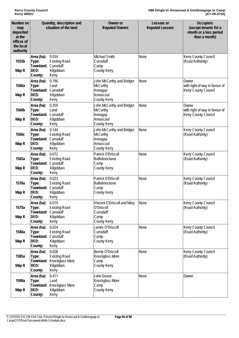
Kerry County Council Kerry NRDO
N86 Dingle to Annascaul & Gortbreagoge to Camp [KY-09-4743]
F:\J65\DOCS\4_EIA EAR Stat. Process\Dingle to Annascaul & Gortbreagoge to Camp\CPO\Final Documents\404b Schedule.docx
Page 84 of 88
Number on map
deposited at the
offices of the local authority
Quantity, description and situation of the land
Owner or Reputed Owners
Lessees or Reputed Lessees
Occupiers (except tenants for a
month or a less period than a month)
1555b
Map R
Area (ha): 0.034 Type: Existing Road Townland: Curraduff DED: Kilgobban County: Kerry
Michael Smith Curraduff Camp County Kerry
None Kerry County Council (Road Authority)
1560a
Map R
Area (ha): 0.196 Type: Land Townland: Curraduff DED: Kilgobban County: Kerry
John McCarthy and Bridget McCarthy Annagap Annascaul County Kerry
None Owner with right of way in favour of Kerry County Council
1560b
Map R
Area (ha): 0.359 Type: Land Townland: Curraduff DED: Kilgobban County: Kerry
John McCarthy and Bridget McCarthy Annagap Annascaul County Kerry
None Owner with right of way in favour of Kerry County Council
1560c
Map R
Area (ha): 0.144 Type: Existing Road Townland: Curraduff DED: Kilgobban County: Kerry
John McCarthy and Bridget McCarthy Annagap Annascaul County Kerry
None Kerry County Council (Road Authority)
1565a
Map R
Area (ha): 0.072 Type: Existing Road Townland: Curraduff DED: Kilgobban County: Kerry
Patrick O'Driscoll Ballinknockane Camp County Kerry
None Kerry County Council (Road Authority)
1570a
Map R
Area (ha): 0.023 Type: Existing Road Townland: Curraduff DED: Kilgobban County: Kerry
Patrick O'Driscoll Ballinknockane Camp County Kerry
None Kerry County Council (Road Authority)
1575a
Map R
Area (ha): 0.019 Type: Existing Road Townland: Curraduff DED: Kilgobban County: Kerry
Vincent O'Driscoll and Mary O'Driscoll Curraduff Camp County Kerry
None Kerry County Council (Road Authority)
1580a
Map R
Area (ha): 0.024 Type: Existing Road Townland: Curraduff DED: Kilgobban County: Kerry
James O'Driscoll Curraduff Camp County Kerry
None Kerry County Council (Road Authority)
1585a
Map R
Area (ha): 0.028 Type: Existing Road Townland: Knockglass More DED: Kilgobban County: Kerry
Bernie O'Driscoll Knockgloss More Camp County Kerry
None Kerry County Council (Road Authority)
1590a
Map R
Area (ha): 0.411 Type: Land Townland: Knockglass More DED: Kilgobban County: Kerry
John Deane Knockgloss More Camp County Kerry
None Owner
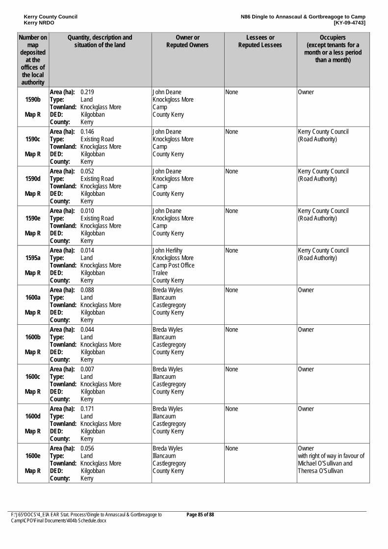
Kerry County Council Kerry NRDO
N86 Dingle to Annascaul & Gortbreagoge to Camp [KY-09-4743]
F:\J65\DOCS\4_EIA EAR Stat. Process\Dingle to Annascaul & Gortbreagoge to Camp\CPO\Final Documents\404b Schedule.docx
Page 85 of 88
Number on map
deposited at the
offices of the local authority
Quantity, description and situation of the land
Owner or Reputed Owners
Lessees or Reputed Lessees
Occupiers (except tenants for a
month or a less period than a month)
1590b
Map R
Area (ha): 0.219 Type: Land Townland: Knockglass More DED: Kilgobban County: Kerry
John Deane Knockgloss More Camp County Kerry
None Owner
1590c
Map R
Area (ha): 0.146 Type: Existing Road Townland: Knockglass More DED: Kilgobban County: Kerry
John Deane Knockgloss More Camp County Kerry
None Kerry County Council (Road Authority)
1590d
Map R
Area (ha): 0.052 Type: Existing Road Townland: Knockglass More DED: Kilgobban County: Kerry
John Deane Knockgloss More Camp County Kerry
None Kerry County Council (Road Authority)
1590e
Map R
Area (ha): 0.010 Type: Existing Road Townland: Knockglass More DED: Kilgobban County: Kerry
John Deane Knockgloss More Camp County Kerry
None Kerry County Council (Road Authority)
1595a
Map R
Area (ha): 0.014 Type: Land Townland: Knockglass More DED: Kilgobban County: Kerry
John Herlihy Knockgloss More Camp Post Office Tralee County Kerry
None Kerry County Council (Road Authority)
1600a
Map R
Area (ha): 0.088 Type: Land Townland: Knockglass More DED: Kilgobban County: Kerry
Breda Wyles Illancaum Castlegregory County Kerry
None Owner
1600b
Map R
Area (ha): 0.044 Type: Land Townland: Knockglass More DED: Kilgobban County: Kerry
Breda Wyles Illancaum Castlegregory County Kerry
None Owner
1600c
Map R
Area (ha): 0.007 Type: Land Townland: Knockglass More DED: Kilgobban County: Kerry
Breda Wyles Illancaum Castlegregory County Kerry
None Owner
1600d
Map R
Area (ha): 0.171 Type: Land Townland: Knockglass More DED: Kilgobban County: Kerry
Breda Wyles Illancaum Castlegregory County Kerry
None Owner
1600e
Map R
Area (ha): 0.056 Type: Land Townland: Knockglass More DED: Kilgobban County: Kerry
Breda Wyles Illancaum Castlegregory County Kerry
None Owner with right of way in favour of Michael O'Sullivan and Theresa O'Sullivan
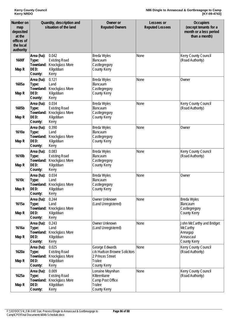
Kerry County Council Kerry NRDO
N86 Dingle to Annascaul & Gortbreagoge to Camp [KY-09-4743]
F:\J65\DOCS\4_EIA EAR Stat. Process\Dingle to Annascaul & Gortbreagoge to Camp\CPO\Final Documents\404b Schedule.docx
Page 86 of 88
Number on map
deposited at the
offices of the local authority
Quantity, description and situation of the land
Owner or Reputed Owners
Lessees or Reputed Lessees
Occupiers (except tenants for a
month or a less period than a month)
1600f
Map R
Area (ha): 0.042 Type: Existing Road Townland: Knockglass More DED: Kilgobban County: Kerry
Breda Wyles Illancaum Castlegregory County Kerry
None Kerry County Council (Road Authority)
1605a
Map R
Area (ha): 0.121 Type: Land Townland: Knockglass More DED: Kilgobban County: Kerry
Breda Wyles Illancaum Castlegregory County Kerry
None Owner
1605b
Map R
Area (ha): 0.034 Type: Existing Road Townland: Knockglass More DED: Kilgobban County: Kerry
Breda Wyles Illancaum Castlegregory County Kerry
None Kerry County Council (Road Authority)
1610a
Map R
Area (ha): 0.390 Type: Land Townland: Knockglass More DED: Kilgobban County: Kerry
Breda Wyles Illancaum Castlegregory County Kerry
None Owner
1610b
Map R
Area (ha): 0.083 Type: Existing Road Townland: Knockglass More DED: Kilgobban County: Kerry
Breda Wyles Illancaum Castlegregory County Kerry
None Kerry County Council (Road Authority)
1610c
Map R
Area (ha): 0.034 Type: Land Townland: Knockglass More DED: Kilgobban County: Kerry
Breda Wyles Illancaum Castlegregory County Kerry
None Owner
1615a
Map R
Area (ha): 0.244 Type: Land Townland: Knockglass More DED: Kilgobban County: Kerry
Owner Unknown (Land Unregistered)
None Breda Wyles Illancaum Castlegregory County Kerry
1616a
Map R
Area (ha): 0.243 Type: Land Townland: Knockglass More DED: Kilgobban County: Kerry
Owner Unknown (Land Unregistered)
None John McCarthy and Bridget McCarthy Annagap Annascaul County Kerry
1620a
Map R
Area (ha): 0.025 Type: Existing Road Townland: Knockglass More DED: Kilgobban County: Kerry
George Edwards c/o Hudson Browne Solicitors 2 Princes Street Tralee County Kerry
None Kerry County Council (Road Authority)
1625a
Map R
Area (ha): 0.009 Type: Existing Road Townland: Knockglass More DED: Kilgobban County: Kerry
Lorraine Moynihan Kilteenbane Camp Post Office Tralee County Kerry
None Kerry County Council (Road Authority)
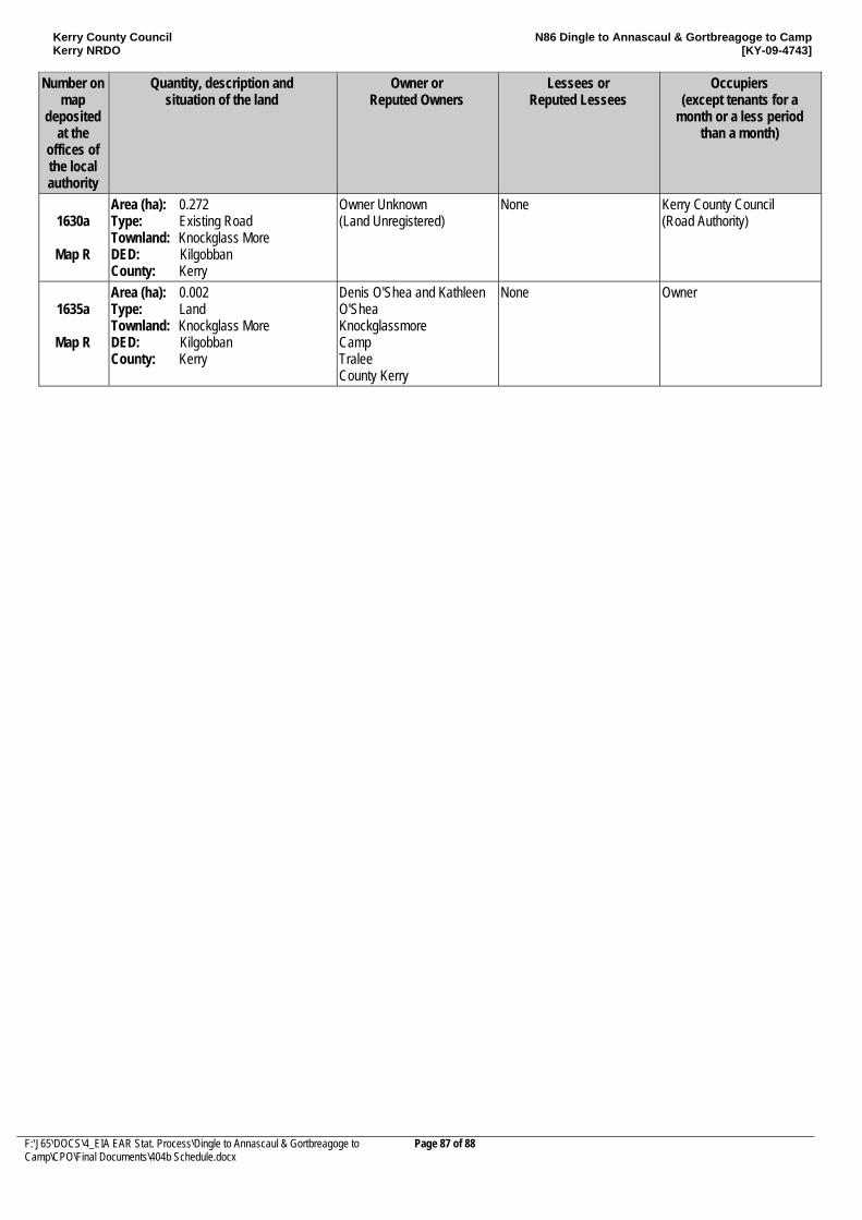
Kerry County Council Kerry NRDO
N86 Dingle to Annascaul & Gortbreagoge to Camp [KY-09-4743]
F:\J65\DOCS\4_EIA EAR Stat. Process\Dingle to Annascaul & Gortbreagoge to Camp\CPO\Final Documents\404b Schedule.docx
Page 87 of 88
Number on map
deposited at the
offices of the local authority
Quantity, description and situation of the land
Owner or Reputed Owners
Lessees or Reputed Lessees
Occupiers (except tenants for a
month or a less period than a month)
1630a
Map R
Area (ha): 0.272 Type: Existing Road Townland: Knockglass More DED: Kilgobban County: Kerry
Owner Unknown (Land Unregistered)
None Kerry County Council (Road Authority)
1635a
Map R
Area (ha): 0.002 Type: Land Townland: Knockglass More DED: Kilgobban County: Kerry
Denis O'Shea and Kathleen O'Shea Knockglassmore Camp Tralee County Kerry
None Owner
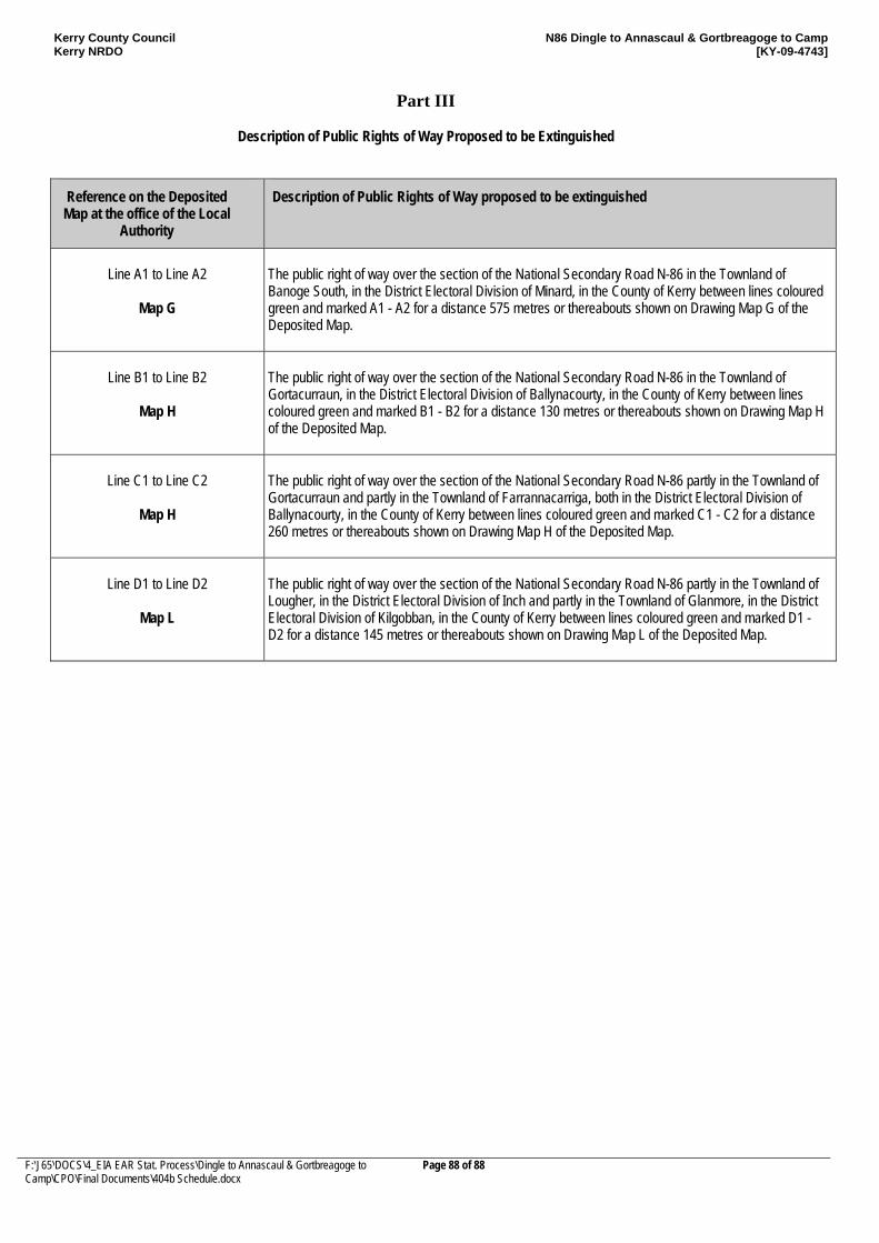
Kerry County Council Kerry NRDO
N86 Dingle to Annascaul & Gortbreagoge to Camp [KY-09-4743]
F:\J65\DOCS\4_EIA EAR Stat. Process\Dingle to Annascaul & Gortbreagoge to Camp\CPO\Final Documents\404b Schedule.docx
Page 88 of 88
Part III
Description of Public Rights of Way Proposed to be Extinguished
Reference on the Deposited Map at the office of the Local
Authority
Description of Public Rights of Way proposed to be extinguished
Line A1 to Line A2
Map G
The public right of way over the section of the National Secondary Road N-86 in the Townland of Banoge South, in the District Electoral Division of Minard, in the County of Kerry between lines coloured green and marked A1 - A2 for a distance 575 metres or thereabouts shown on Drawing Map G of the Deposited Map.
Line B1 to Line B2
Map H
The public right of way over the section of the National Secondary Road N-86 in the Townland of Gortacurraun, in the District Electoral Division of Ballynacourty, in the County of Kerry between lines coloured green and marked B1 - B2 for a distance 130 metres or thereabouts shown on Drawing Map H of the Deposited Map.
Line C1 to Line C2
Map H
The public right of way over the section of the National Secondary Road N-86 partly in the Townland of Gortacurraun and partly in the Townland of Farrannacarriga, both in the District Electoral Division of Ballynacourty, in the County of Kerry between lines coloured green and marked C1 - C2 for a distance 260 metres or thereabouts shown on Drawing Map H of the Deposited Map.
Line D1 to Line D2
Map L
The public right of way over the section of the National Secondary Road N-86 partly in the Townland of Lougher, in the District Electoral Division of Inch and partly in the Townland of Glanmore, in the District Electoral Division of Kilgobban, in the County of Kerry between lines coloured green and marked D1 - D2 for a distance 145 metres or thereabouts shown on Drawing Map L of the Deposited Map.