Embed Size (px)
Citation preview
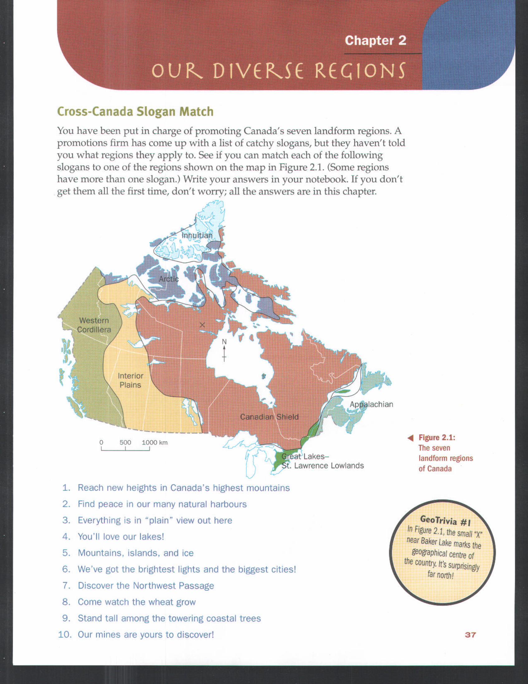
Cross-Canada Slogan Match
You have been put in charge of promoting Canada's seven landform regions. Apromotions firm has come up with a list of catchy slogans, but they haven't toldyou what regions they apply to. See if you can match each of The followingslogans Lo one of the regions shown on the map in Figure 2.1. (Some regionshave more than one slogan.) Write your answers in your notebook. If you don'tget them all the first time, don't worry; all the answers are in this chapter.
InteriorPlains
0 500 1000 kmL 1 I
1. Reach new heights in Canada's highest mountains
2. Fred peace in our many natural harbours
3. Everything s n "plain" view out here
4. You'll love our lakes!
5. Mountains, islands, and ice
6. We've got the brightest lights and the biggest cities!
7. Dscover the Northwest Passage
8. Come watch the wheat grow
9. Stand tall among the towering coastal trees
10. Our mines are yours to discover!
Appalachian
,at Lakes-Lawrence Lowlands
Figure 2.1:The sevenlandform regionsof Canada
GeoTrivia #1In Figure 2.1, thesmall"X"near Baker Lake marksthe
geographical centre ofthe country. It's surprisingly
far north!
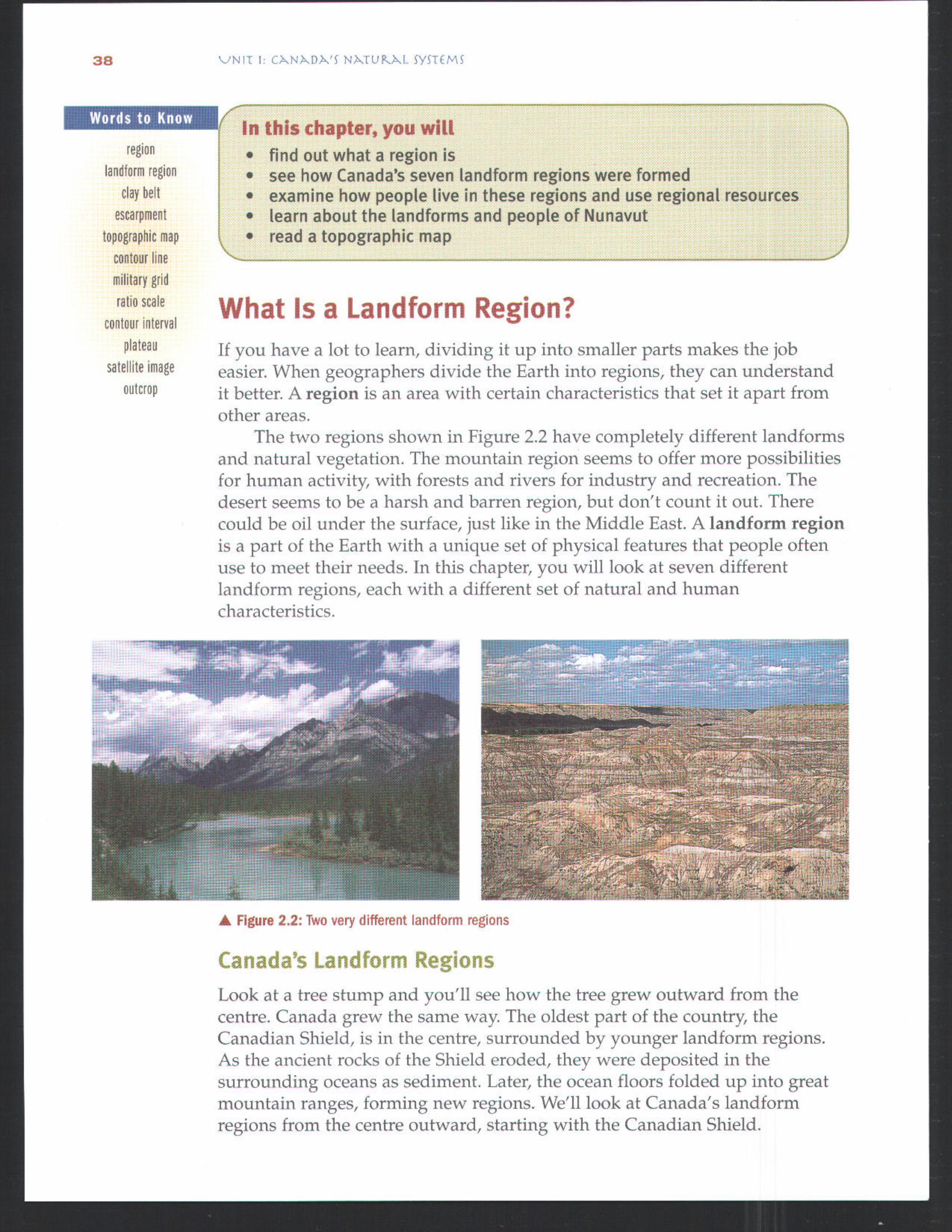
Words to Know
regionlandform region
clay belt
escarpment
topographic map
contour linemilitary gridratio scale
contour intervalplateau
satelli[e imageoutcrop
In this chapter, you willfind out what a region issee how Eanada's seven landform regions were formedexamine how people live in these regions and use regional resourceslearn about the landforms and people of Hunavutread a topographic map
What Is a Landform Region?If you have a lot to learn, dividing it up into smaller parts makes the jobeasier. When geographers divide the Earth into regions, they can understandit better. A region is an area with certain characteristics that set it apart fromother areas.
The two regions shown in Figure 2.2 have completely different landformsand natural vegetation. The mountain region seems to offer more possibilitiesfor human activity, with forests and rivers for industry and recreation. Thedesert seems to be a harsh and barren region, but don't count it out. Therecould be oil under the surface, just like in the Middle East. A landform regionis a part of the Earth with a unique set of physical features that people oftenuse to meet their needs. In this chapter, you will look at seven differentlandform regions, each with a different set of natural and humancharacteristics.
Figure 2.2: Two very different landform regions
Canada's Landform Regions
Look at a tree stump and you'll see how the tree grew outward from thecentre. Canada grew the same way. The oldest part of the country, theCanadian Shield, is in the centre, surrounded by younger landform regions.As the ancient rocks of the Shield eroded, they were deposited in thesurrounding oceans as sediment. Later, the ocean floors folded up into greatmountain ranges, forming new regions. We'll look at Canada's landformregions from the centre outward, starting with the Canadian Shield.
1. Explain how Canada's basic structure can be compared to a tree. How is itdifferent?
2. Describe the features of the Earth's surface in your area. How have peoplemade use of them?
3. Make a map to name the seven major landform regions of Canada. Locateand name your community on the map.
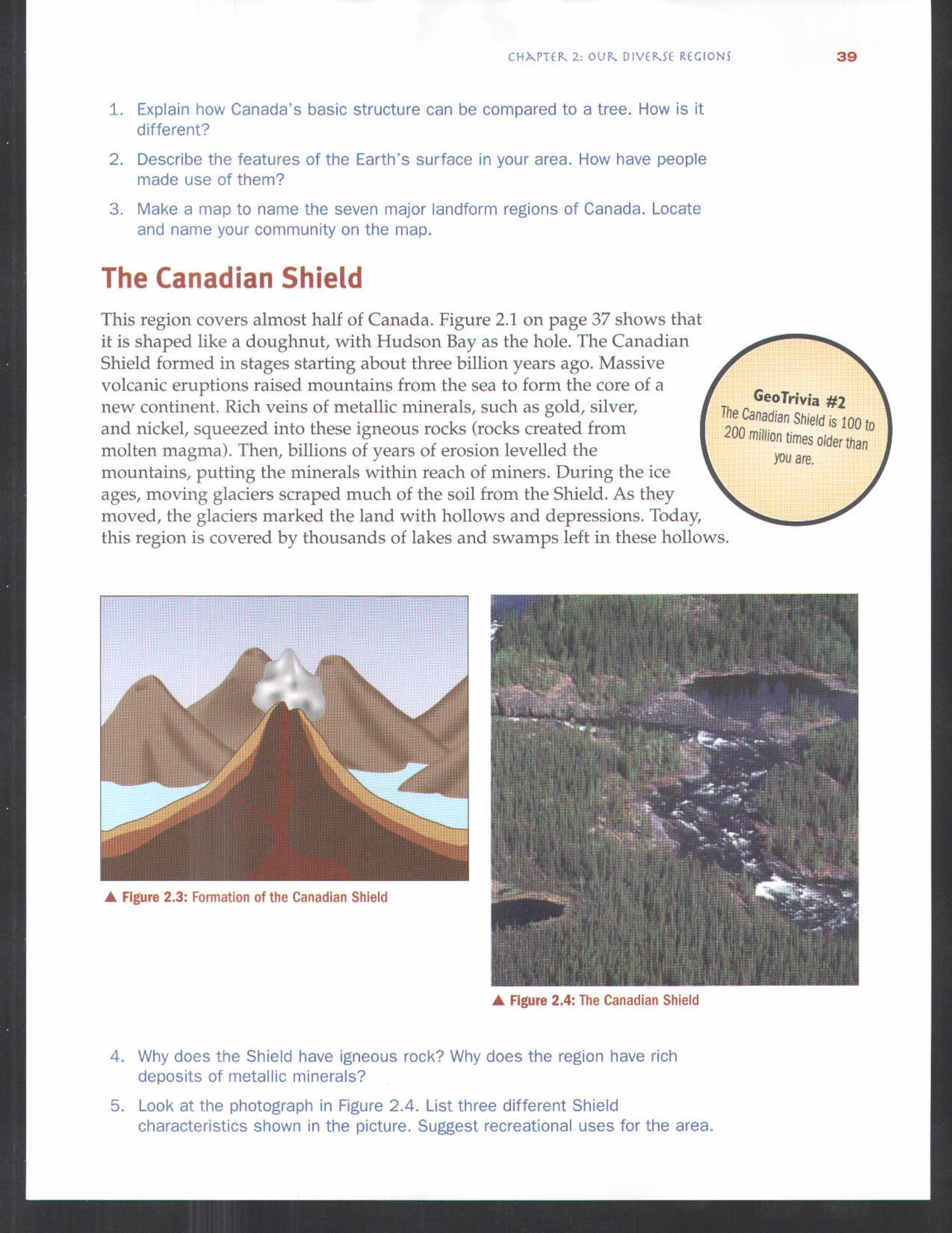
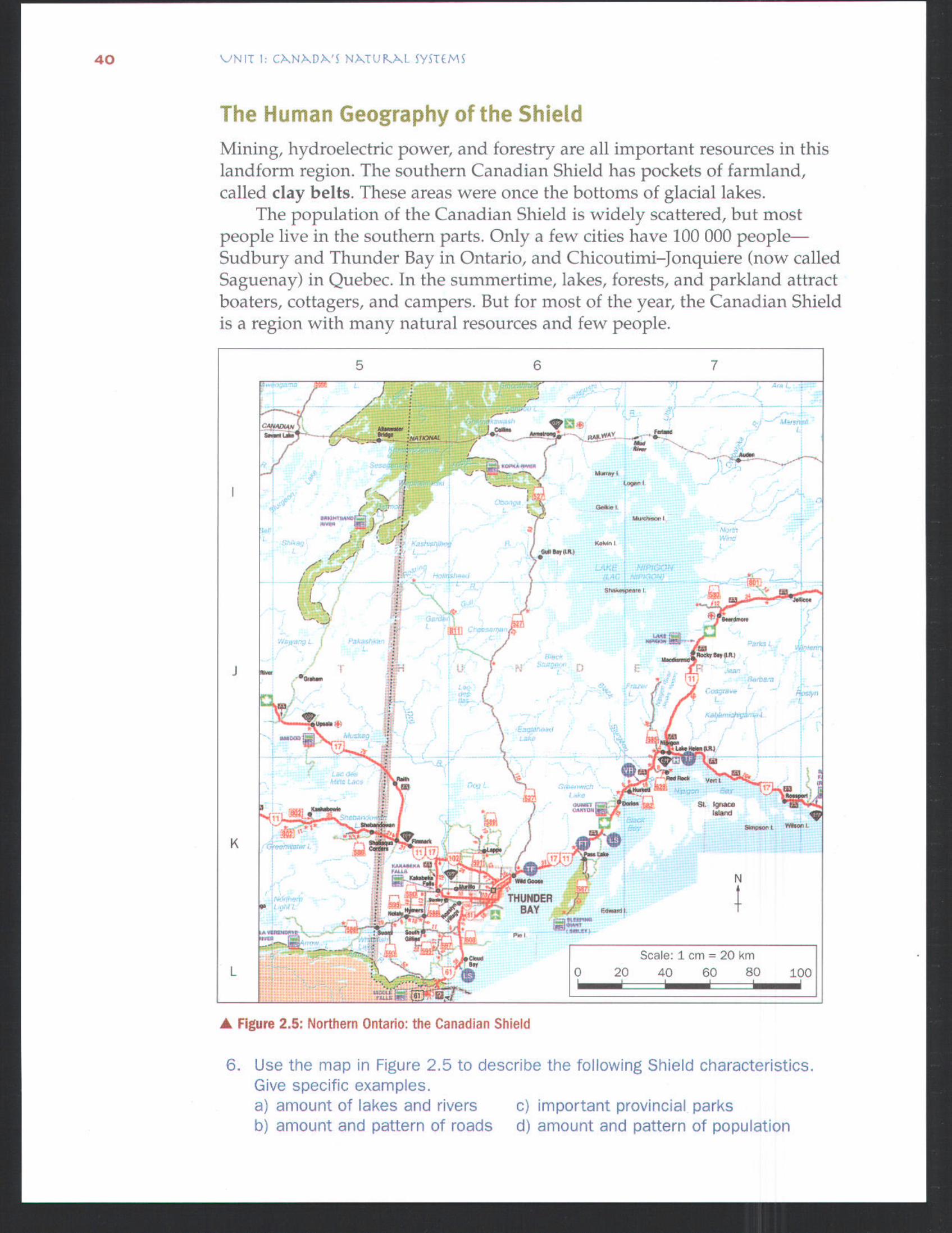
The Canadian ShieldThis region covers almost half of Canada. Figure 2.1 on page 37 shows thatit is shaped like a doughnut, with Hudson Bay as the hole. The CanadianShield formed in stages starting about three billion years ago. Massivevolcanic eruptions raised mountains from the sea to form the core of anew continent. Rich veins of metallic minerals, such as gold, silver,and nickel, squeezed into these igneous rocks (rocks created frommolten magma). Then, billions of years of erosion levelled themountains, putting the minerals within reach of miners. During the iceages, moving glaciers scraped much of the soil from the Shield. As theymoved, the glaciers marked the land with hollows and depressions. Today,this region is covered by thousands of lakes and swamps left in these hollows.
GeoTrivia #2The Canadian Shield is 100 to200 million Limes older than
you are.
Figure 2.3: Formation of the Canadian Shield
Figure 2.4: The Canadian Shield
Why does the Shield have igneous rock? Why does the region have richdeposits of metallic minerals?
Look at the photograph n Figure 2.4. List three different Shieldcharacterishcs shown in the picture, Suggest recreational uses for the area.
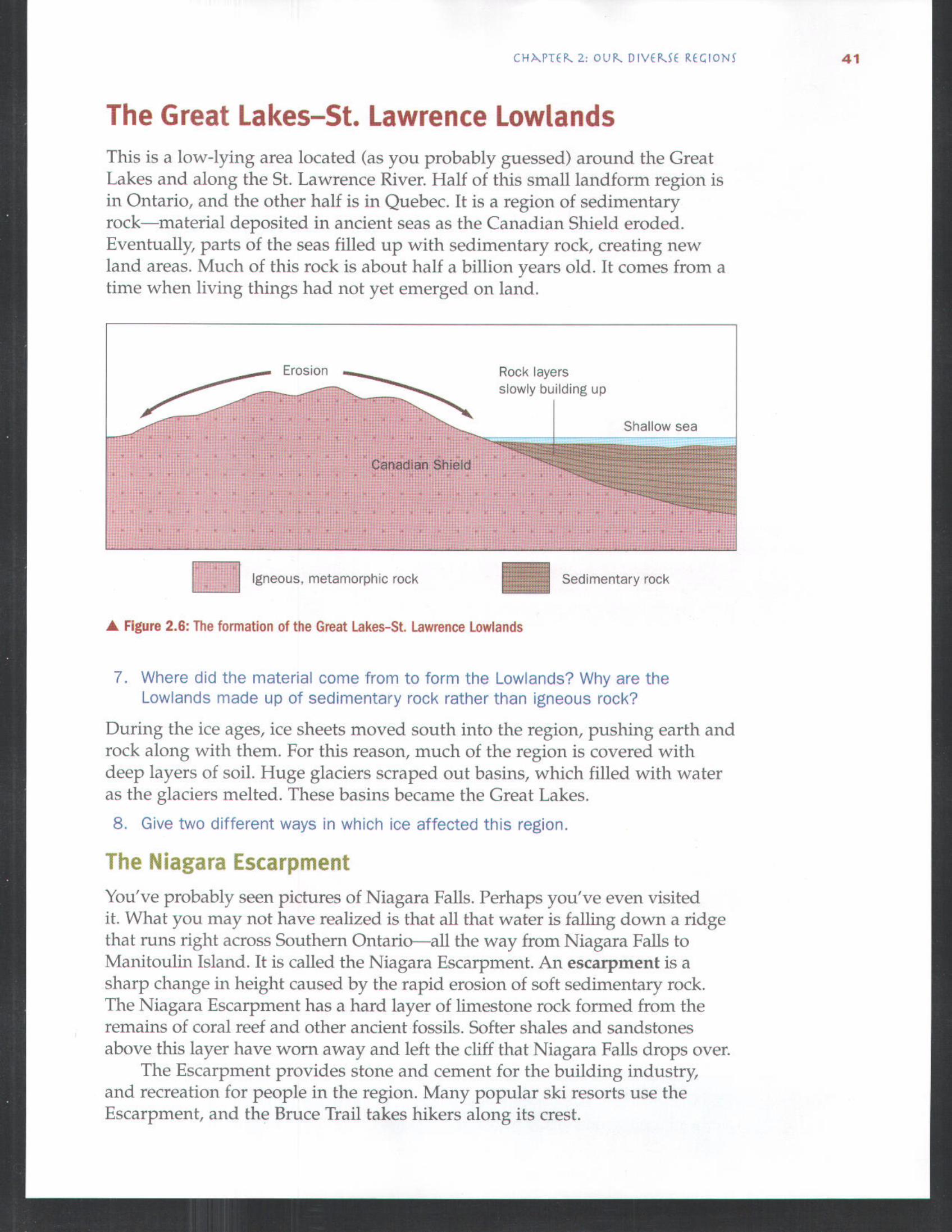
The Human Geography of the ShieldMining, hydroelectric power, and forestry are all inportant resources in thislandform region. The southern Canadian Shield has pockets of farmland,called clay belts. These areas were once the bottoms of glacial lakes.
The population of the Canadian Shield is widely scattered, but mostpeople live in the southern parts. Only a few cities have 100 000 people--Sudbury and Thunder Bay in Ontario, and Chicoutimi-Jonquiere (now calledSaguenay) in Quebec. In the summertime, lakes, forests, and parkland attractboaters, cottagers, and campers. But for most of the year, the Canadian Shieldis a region with many natural resources and few people.
5 6 7
,j-....,-7 - " "l ;.-.7 ' t'",---.......... .,,, i "* ....
t {x + ";:" " "
G- -- ?,.. : :' " ' Scale: 1 cm = 20 km0 20 40 60 80 100
igare 2.5: Northern Ontario: the Canadian Shield
Use the map in Figure 2.5 to describe the following Shield characteristics.Gve specific examples.
a) amount of lakes and rivers c) important provincial parksb) amount and pattern of roads d) amount and pattern of population
The Great Lakes-St. Lawrence LowlandsThis is a low-lying area located (as you probably guessed) around the GreatLakes and along the St. Lawrence River. Half of this small landform region isin Ontario, and the other half is in Quebec. It is a region of sedimentaryrock--material deposited in ancient seas as the Canadian Shield eroded.Eventually, parts of the seas filled up with sedimentary rock, creating newland areas. Much of this rock is about half a billion years old. It comes from atime when living things had not yet emerged on land.
/ErosionRock layersslowly building up
Shallow sea
Igneous, metamorphic rock
Figure 2.6: The formation of the Great Lakes-St. Lawrence Lowlands
Sedimentary rock
7. Where did the material come from to form the Lowlands? Why are theLowlands made up of sedimentary rock rather than igneous rock?
During the ice ages, ice sheets moved south into the region, pushing earth androck along with them. For this reason, much of the region is covered withdeep layers of soil. Huge glaciers scraped out basins, which filled with wateras the glaciers melted. These basins became the Great Lakes.
8. Give two dfferent ways in which ice affected this region.
The Niagara Escarpment
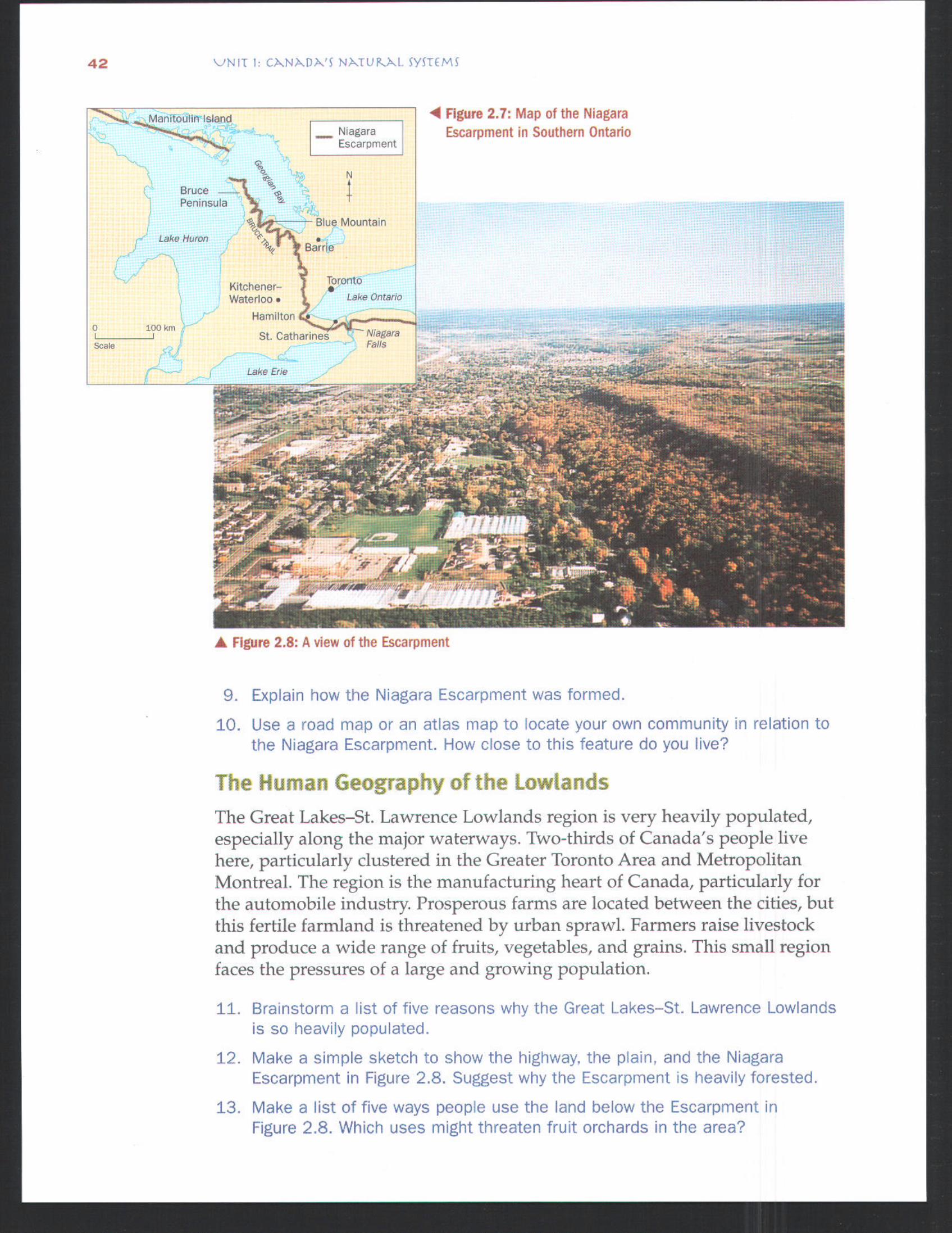
You've probably seen pictures of Niagara Falls. Perhaps you've even visitedit. What you may not have realized is that all that water is falling down a ridgethat runs right across Southern Ontarioall the way from Niagara Falls toManitoulin Island. It is called the Niagara Escarpment. An escarpment is asharp change in height caused by the rapid erosion of soft sedimentary rock.The Niagara Escarpment has a hard layer of limestone rock formed from theremains of coral reef and other ancient fossils. Softer shales and sandstonesabove this layer have worn away and left the cliff that Niagara Falls drops over.
The Escarpment provides stone and cement for the building industry,and recreation for people in the region. Many popular ski resorts use theEscarpment, and the Bruce Trail takes hikers along its crest.
BrucePemnsula
Lake Huron
0 100 km
Scale
Nagara]Escarpment
N
Blue Mountain
-°'G%Barie"Kltchener- orontoWate.doo
Lake Ontar,o
Hamilton o
St. Catharines "Falls
Lake Erie
Figure 2.7: Map of the NiagaraEscarpment in Southern Ontario
Figure 2.8: A view of the Escarpment
9. Explain how the Niagara Escarpment was formed.
10. Use a road map or an atlas map to locate your own community n relation tothe Niagara Escarpment, How close to this feature do you live?
The Human Geography of the LowlandsThe Great Lakes-St. Lawrence Lowlands region is very heavily populated,especially along the major waterways. Two-thirds of Canada's people livehere, particularly clustered in the Greater Toronto Area and MetropolitanMontreal. The region is the manufacturing heart of Canada, particularly forthe automobile industry. Prosperous farms are located between the cities, butthis fertile farmland is threatened by urban sprawl. Farmers raise livestockand produce a wide range of fruits, vegetables, and grains. This small regionfaces the pressures of a large and growing population.
$1. Brainstorm a list of five reasons why the Great Lakes-St. Lawrence Lowlandsis so heavily populated.
12. Make a simple sketch to show the hghway, the plain, and the NiagaraEscarpment in Figure 2.8. Suggest why the Escarpment is heavily forested.
13. Make a list of five ways people use the land below the Escarpment inFigure 2.8. Which uses might threaten fruit orchards in the area?
CH,N.PT(g. 2. OUR. DIV(P--.5( R(:GION5 4
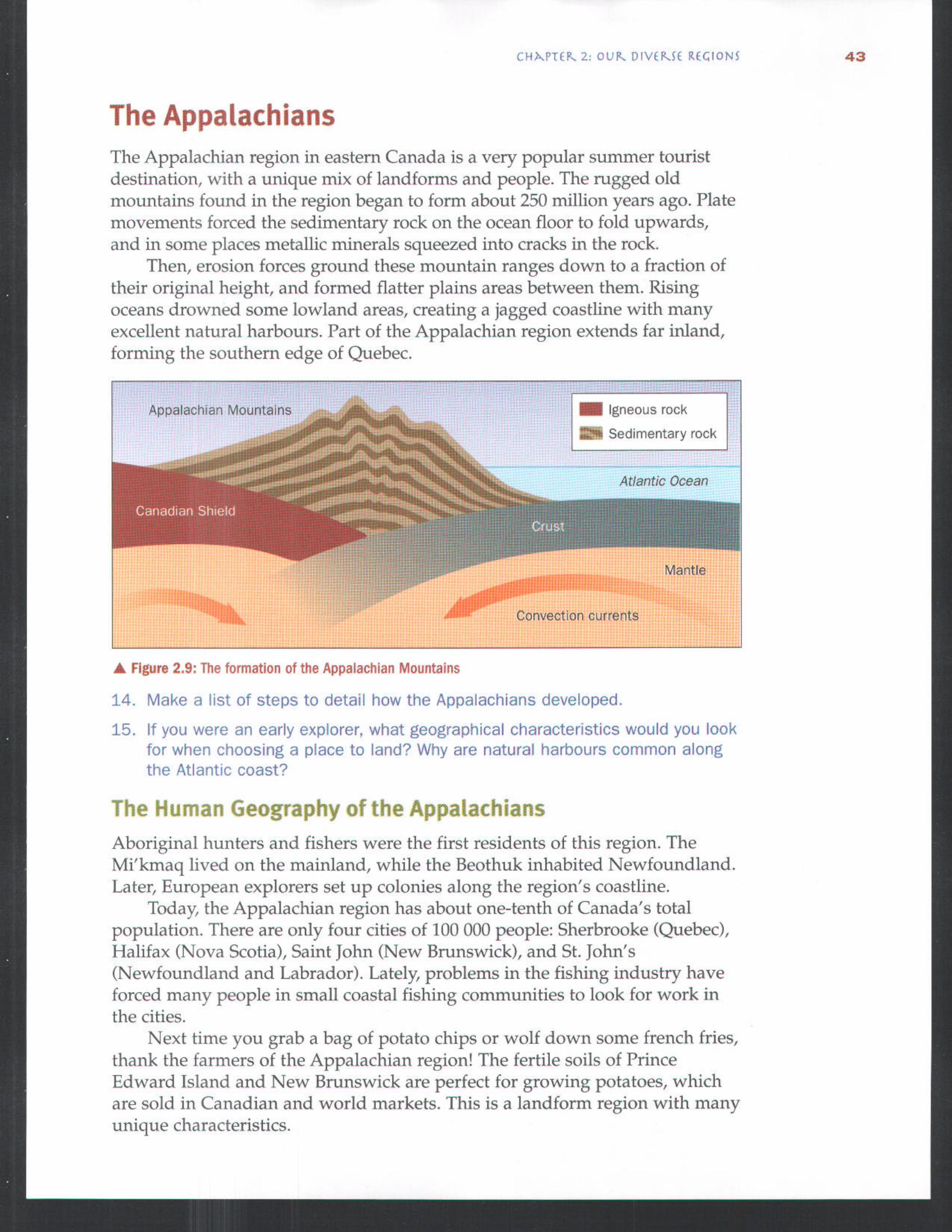
The Appa|achiansThe Appalachian region in eastern Canada is a very popular summer touristdestination, with a unique mix of landforms and people. The rugged oldmountains found in the region began to form about 250 million years ago. Platemovements forced the sedimentary rock on the ocean floor to fold upwards,and in some places metallic minerals squeezed into cracks in the rock.
Then, erosion forces ground these mountain ranges down to a fraction oftheir original height, and formed flatter plains areas between them. Risingoceans drowned some lowland areas, creating a jagged coastline with manyexcellent natural harbours. Part of the Appalachian region extends far inland,forming the southern edge of Quebec.
Appalachian Mountains Igneous rock
Sedimentary rock
Atlantic Ocean
Mantle
Figure 2.9: The formation of the Appalachian Mountains
14. Make a Ist of steps to detail how the Appalachians developed.
15. If you were an early explorer, what geographical characteristics would you lookfor when choosing a place to land? Why are natural harbours common alongthe Atlanhc coast?
The Human Geography of the AppalachiansAboriginal hunters and fishers were the first residents of this region. TheMi'kmaq lived on the mainland, while the Beothuk inhabited Newfoundland.Later, European explorers set up colonies along the region's coastline.
Today, the Appalachian region has about one-tenth of Canada's totalpopulation. There are only four cities of 100 000 people: Sherbrooke (Quebec),Halifax (Nova Scotia), Saint John (New Brunswick), and St. John's(Newfoundland and Labrador). Lately, problems in the fishing industry haveforced many people in small coastal fishing communities to look for work inthe cities.
Next time you grab a bag of potato chips or wolf down some french fries,thank the farmers of the Appalachian region! The fertile soils of PrinceEdward Island and New Brunswick are perfect for growing potatoes, whichare sold in Canadian and world markets. This is a landform region with manyunique characteristics.

a) Landforms,Appalachian Region
Low mountains, hillsUplands
Lowlands, plains
b) Agricultural Lands
Land n agricultural useD Dairy H HogsC Ca[tie P PoultryF Feld crops V Vegetables
(potatoes) M MixedS Specialty (crops and
(greenhouse hvestock)vegetables)
11VMD
DSVP
" VMD
c) Population Distribution
Settled area:';: One dot: 1000 persons
© C@es over 20 000
C=t=es over 100 000 are labelled
Figure 2.10: The Appalachian region, showing a) physical features, b) agricultural land, and c) population distribution
16. Examine the maps in Figures 2.10a and 2.10b. Which types of landform havemost of the Appalachian region's farmland? Which type of agriculture is mostcommon in the region?
17. Examine the maps in Figures 2.10a and 2.10c. Is the Appalachian region'spopulation pattern caused by landforms or by the sea? Explain your answerwith map ewdence.
18. Compare the maps in Figures 2.10b and 2.10c. Where do you find populatedareas wthout agriculture in the region? What other jobs would supportcommunities in these areas?
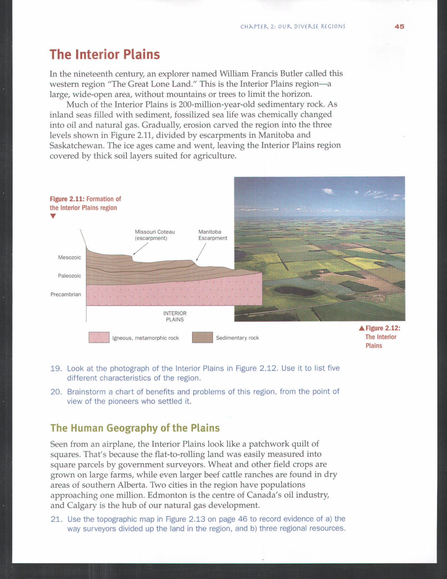
The Interior P|ainsIn the nineteenth century, an explorer named William Francis Butler called thiswestern region "The Great Lone Land." This is the Interior Plains region--alarge, wide-open area, without mountains or trees to limit the horizon.
Much of the Interior Plains is 200-million-year-old sedimentary rock. Asinland seas filled with sediment, fossilized sea life was chemically changedinto oil and natural gas. Gradually, erosion carved the region into the threelevels shown in Figure 2.11, divided by escarpments in Manitoba andSaskatchewan. The ice ages came and went, leaving the Interior Plains regioncovered by thick soil layers suited for agriculture.
Figure 2.11: Formation ofthe Interior Plains region
Mesozoic
Mssoun Coteau Mamtoba(escarpment) Escarpment
Paleozolc
Precambrlan
INTERIORPLAINS
----- Igneous, metamorphic rock Sedimentary rock, Figure 2.12:The InteriorPlains
19. Look at the photograph of the Interior Plains n Fgure 2.12. Use it to list fivedifferent characteristics of the region.
20. Brainstorm a chart of benefits and problems of this region, from the point ofview of the pioneers who settled it.
The Human Geography of the PlainsSeen from an airplane, the Interior Plains look like a patchwork quilt ofsquares. That's because the flat-to-rolling land was easily measured intosquare parcels by government surveyors. Wheat and other field crops aregrown on large farms, while even larger beef cattle ranches are found in dryareas of southern Alberta. Two cities in the region have populationsapproaching one million. Edmonton is the centre of Canada's oil industry,and Calgary is the hub of our natural gas development.
21. Use the topographic map in Figure 2.13 on page 46 to record evidence of a) theway surveyors divided up the land in the region, and b) three reDonal resources,
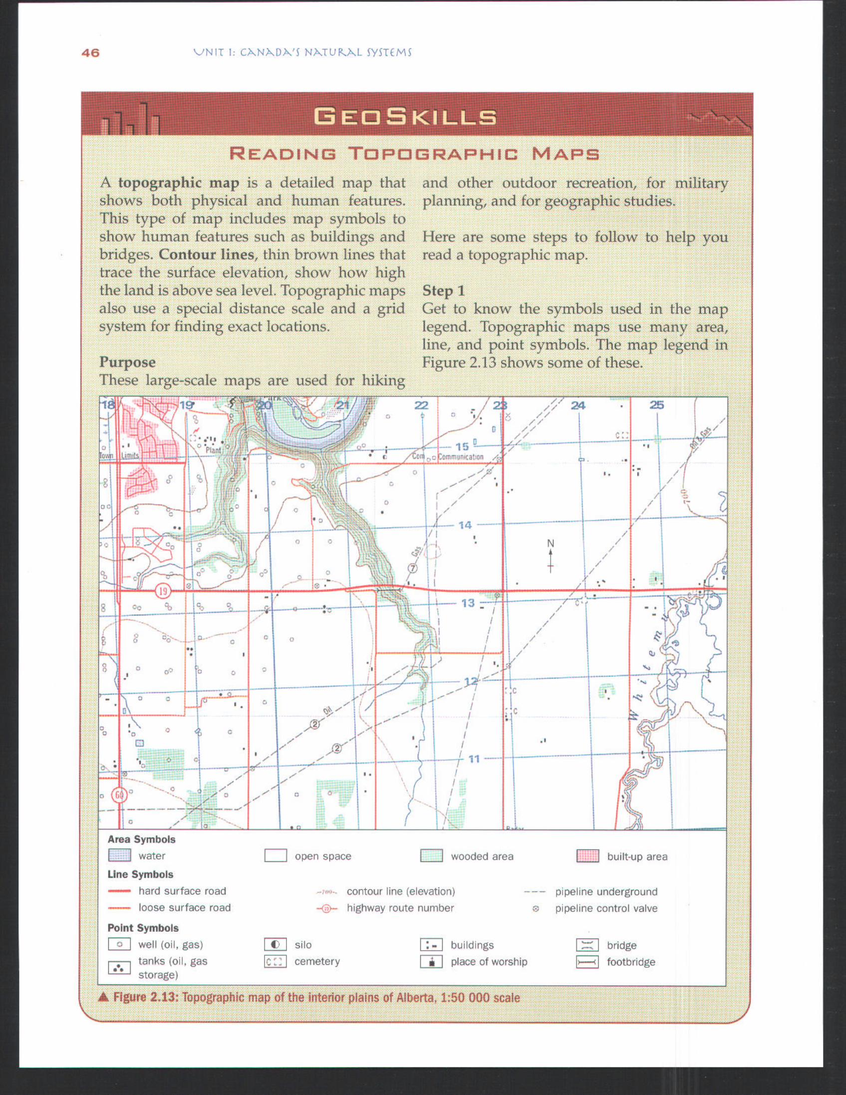
READING TOPOGRAPHIC MAPS
A topographic nap is a detailed map thatshows both physical and human features.This type of map includes map symbols toshow human features such as buildings andbridges. Contour lines, thin brown lines thattrace the surface elevation, show how highthe land is above sea level. Topographic mapsalso use a special distance scale and a gridsystem for finding exact locations.
PurposeThese large-scale ma
. - J T].... v t o.O
and other outdoor recreation, for militaryplanning, and for geographic studies.
Here are some steps to follow to help youread a topographic map.
Step 1Get to know the symbols used in the maplegend. Topographic maps use many area,line, and point symbols. The map legend inFigure 2.13 shows some of these.
are used for hiking
' , ,,,"....],, 2 ,, ..
open space
Area Symbols
I----] water
Line Symbols
hard surface road
loose surface road
Point Symbols
well (o1, gas)tanks (of, gasstorage)
i---'-] wooded area F----I built-up area
,,, contour hne (elevation)
.... hghway route number
.... ppehne underground
s ppehne control valve
silo buildings bridgecemetery I place of worship F footbndge
Figure 213: Topographic map of the interior plains of Alberta, 1:50 000 scale
560 123456789
55 !f i-0123456789
80 81 82123456789
- 9876
4C[] 3
21
1 5 98765
3
1234567890
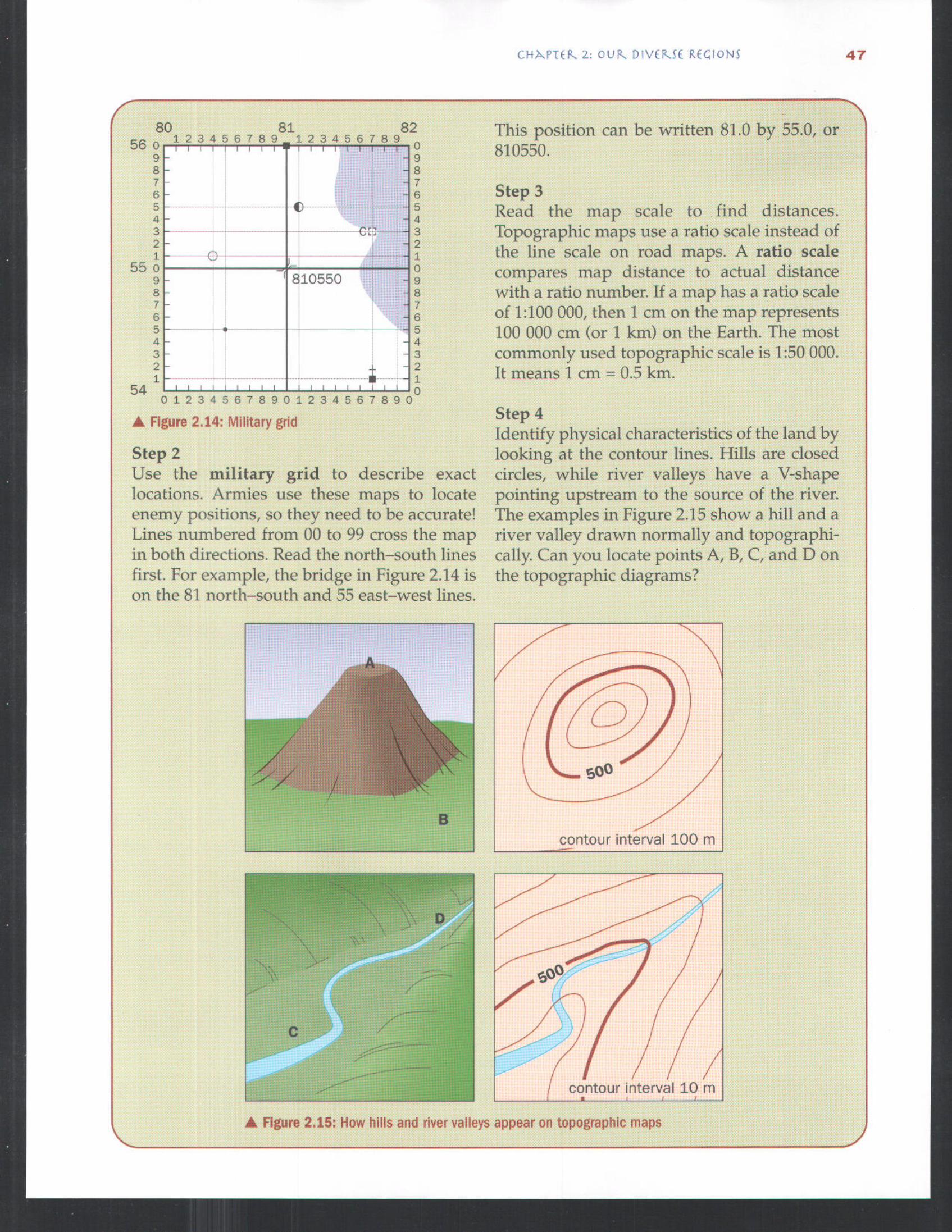
Figure 2.14: Military grid
Step 2Use the military grid to describe exactlocations. Armies use these maps to locateenemy positions, so they need to be accurate!Lines numbered from 00 to 99 cross the mapin both directions. Read the north-south linesfirst. For example, the bridge in Figure 2.14 ison the 81 north-south and 55 east-west lines.
This position can be written 81.0 by 55.0, or810550.
Step 3Read the map scale to find distances.Topographic maps use a ratio scale instead ofthe line scale on road maps. A ratio scalecompares map distance to actual distancewith a ratio number. If a map has a ratio scaleof 1:100 000, then I cm on the map represents100 000 cm (or 1 km) on the Earth. The mostcommonly used topographic scale is 1:50 000.It means 1 cm = 0.5 km.
Step 4Identify physical characteristics of the land bylooking at the contour lines. Hills are closedcircles, while river valleys have a V-shapepointing upstream to the source of the river.The examples in Figure 2.15 show a hill and ariver valley drawn normally and topographi-cally. Can you locate points A, B, C, and D onthe topographic diagrams?
contour interval 100 m
,intour interva110Figure 2.15: How hills and river valleys appear on topographic maps
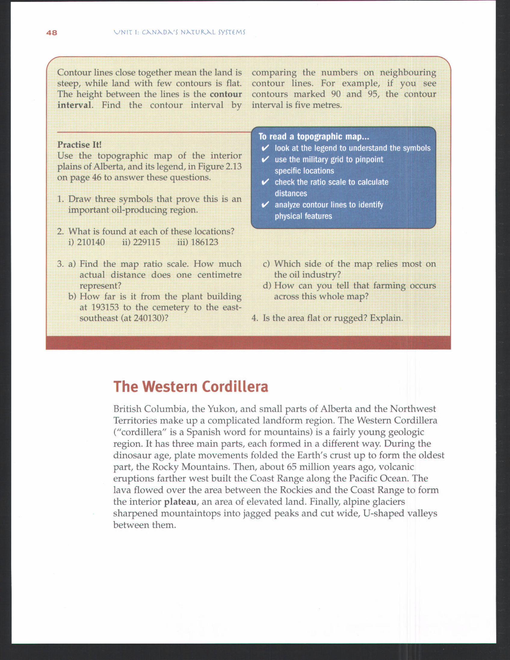
Contour lines close together mean the land issteep, while land with few contours is flat.The height between the lines is the contourinterval. Find the contour interval by
comparing the numbers on neighbouringcontour lines. For example, if you seecontours marked 90 and 95, the contourinterval is five metres.
Te read a topographic map...v' look at the legend to understand the symbolsV' use the military grid to pinpoint
specific locationsv' check the ratio scale to calculate
distancesv analyze contour lines to identify
physical features
Practise It!Use the topographic map of the interiorplains of Alberta, and its legend, in Figure 2.13on page 46 to answer these questions.
1. Draw three symbols that prove this is animportant oil-producing region.
2. What is found at each of these locations?i) 210140 ii) 229115 iii) 186123
3. a) Find the map ratio scale. How muchactual distance does one centimetrerepresent?
b) How far is it from the plant buildingat 193153 to the cemetery to the east-southeast (at 240130)?
c) Which side of the map relies most onthe oil industry?
d) How can you tell that farming occursacross this whole map?
4. Is the area flat or rugged? Explain.
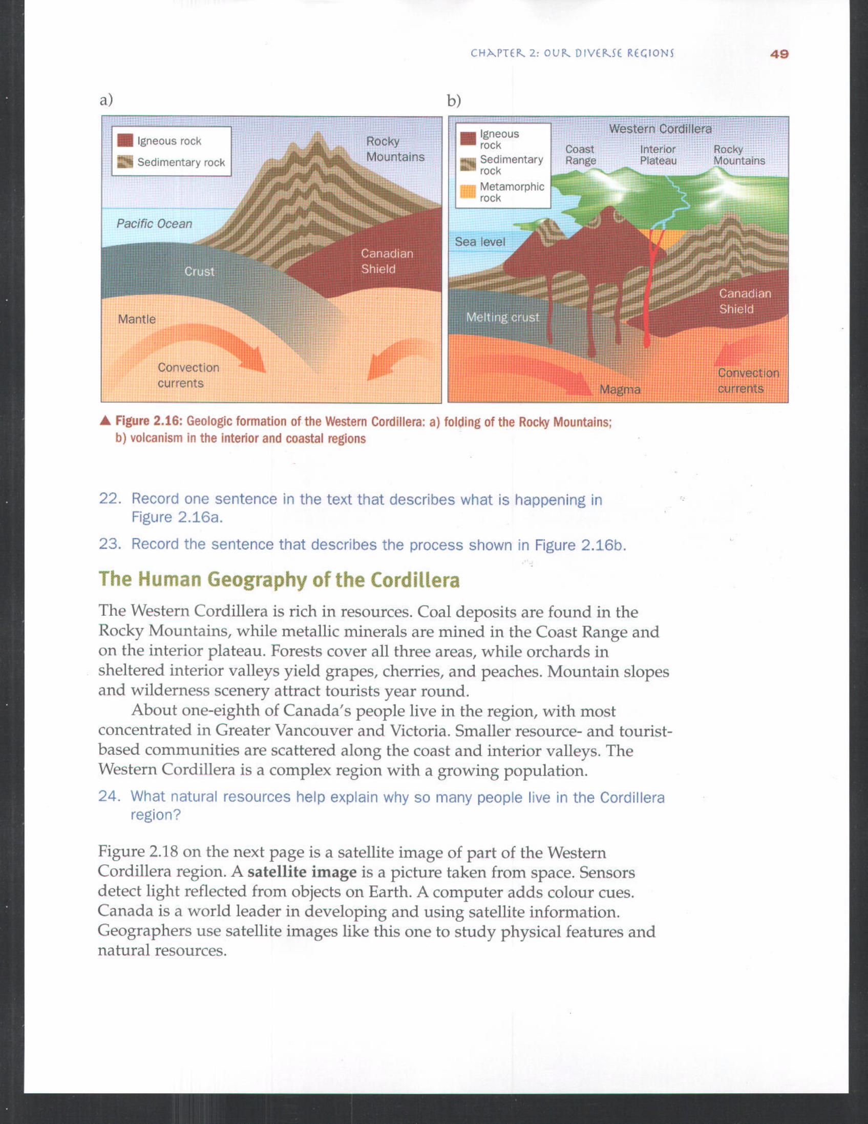
The Western CordilleraBritish Columbia, the Yukon, and small parts of Alberta and the NorthwestTerritories make up a complicated landform region. The Western Cordillera("cordillera" is a Spanish word for mountains) is a fairly young geologicregion. It has three main parts, each formed in a different way. During thedinosaur age, plate movements folded the Earth's crust up to form the oldestpart, the Rocky Mountains. Then, about 65 million years ago, volcaniceruptions farther west built the Coast Range along the Pacific Ocean. Thelava flowed over the area between the Rockies and the Coast Range to formthe interior plateau, an area of elevated land. Finally, alpine glacierssharpened mountaintops into jagged peaks and cut wide, U-shaped valleysbetween them.
a)
Igneous rock
Sedimentary rock
Pacific Ocean
Mantle
Convection:currents
b)
RockyMountains
IgneousrockSedimentaryrockMetamorphicrock
Sea level
CoastRange
Western Cordillera
Interior RockyPlateau Mountains
Figure 2.16: Geologic formation of the Western Cordillera: a) folding of the Rocky Mountains;b) volcanism in the interior and coastal regions
22. Record one sentence in the text that describes what is happening inFigure 2,16a.
23. Record the sentence that descnbes the process shown in Figure 2.16b.
The Human Geography of the CordilleraThe Western Cordillera is rich in resources. Coal deposits are found in theRocky Mountains, while metallic minerals are mined in the Coast Range andon the interior plateau. Forests cover all three areas, while orchards insheltered interior valleys yield grapes, cherries, and peaches. Mountain slopesand wilderness scenery attract tourists year round.
About one-eighth of Canada's people live in the region, with mostconcentrated in Greater Vancouver and Victoria. Smaller resource- and tourist-based communities are scattered along the coast and interior valleys. TheWestern Cordillera is a complex region with a growing population.24. What natural resources help explain why so many people Ive n the Cordillera
region?
Figure 2.18 on the next page is a satellite image of part of the WesternCordillera region. A satellite image is a picture taken from space. Sensorsdetect light reflected from objects on Earth. A computer adds colour cues.Canada is a world leader in developing and using satellite information.Geographers use satellite images like this one to study physical features andnatural resources.
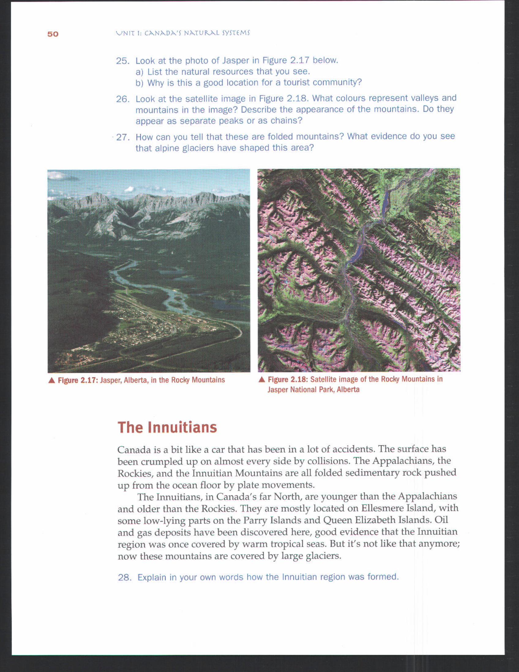
25. Look at the photo of Jasper in Figure 2.17 below.a) List the natural resources that you see.b) Why s this a good location for a tourist community?
26, Look at the satellite image n Fgure 2._8, What colours represent valleys andmountains in the image? Describe the appearance of the mountains. Do theyappear as separate peaks or as chains?
27. How can you tell that these are folded mountains? What evidence do you seethat alpine glaciers have shaped this area?
Figure 2.17: Jasper, Alberta, in the Rocky Mountains Figure 2.18: Satellite image of the Rocky Mountains inJasper National Park, Alberta
The InnuitiansCanada is a bit like a car that has been in a lot of accidents. The surface hasbeen crumpled up on almost every side by collisions. The Appalachians, theRockies, and the Innuitian Mountains are all folded sedimentary rock pushedup from the ocean floor by plate movements.
The lnnuitians, in Canada's far North, are younger than the Appalachiansand older than the Rockies. They are mostly located on Ellesmere Island, withsome low-lying parts on the Parry Islands and Queen Elizabeth lslands. Oiland gas deposits have been discovered here, good evidence that the lnnuitianregion was once covered by warm tropical seas. But it's not like that anymore;now these mountains are covered by large glaciers.
28, Explain in your own words how the Innutian region was formed.

The ArcticIt would be very easy to get lost in a blizzard in the Arctic region. In fact,many Arctic explorers died this way while searching for the NorthwestPassage to the Pacific Ocean. The Inuit, who have lived here forthousands of years, have a deep respect for the power of nature.
The Arctic region is largely made up of islands formed fromsedimentary rock. Most of the region was first scraped bare by movingice, then drowned by rising sea levels as the ice melted. The surface isvery stony, with outcrops of bare rock and very little vegetation. Oil andnatural-gas deposits have been found near Inuvik. Both the lnnuitian andArctic regions are part of the new territory of Nunavut.
GeoTrivia #3coldest day ever re
in Canada was a "windchill"reading of-91 °C, at thecommunity of Pelly Bay,
Nunavut, on 13 January1975.Now, that's coldt
National parks
@ Oil and gas
Mineralso Mare communities (1000+ people)
ARCTIC OCEAN
\
, "%v.. vL0 400 800 km
I I I ',-Scale ,,
Beaufort Sea Ehz_etl,
Inuvik , ", ' - "
Figure 2.19: The Arctic region
2000 m
1000 m500 m300 m200 m100 mFrom
( Iqalut (Capital)
NunavutGovernmentCentres
Pangnirtung
( Pond Inlet
( Igloohk
() Cape Dorset
( Arwat
( Rankn Inlet
( Baker Lake
( Gjoa Haven
( Cambridge Bay
( Kugluktuk
29. Look at Figure 2.19. Compare the elevahons of the eastern and westernArctic. What challenges to survival do each of these regions present?
30. Why do both the Innuitian and Arctic regions have small populations?
31. Describe the map distribution of each of the following.a) Arctic communities b) oil and gas deposits c) national parks
NUNAVUT:MEETING REGIONAL
Nunavut became Canada's third territory on 1 April1999. The name means "our land" in Inuktitut, thelanguage of the Inuit. The Inuit have always seenthis northeastern Arctic region as a part ofthemselves, even after European traders of theHudson Bay Company claimed it. After almost 15years of negotiations with Canada, Inuitnegotiators succeeded in getting direct ownershipof about 350 000 km2 (or 18 per cent) of theterritory in 1993. They agreed to work with Canadato manage the resources in the rest of Nunavut.
The territorial government is faced with someunique challenges. Although Nunavut coversaround 1 600 000 km2, it contains only about27 000 people (about the same as the number ofpeople living in Stratford, Ontario). As a result,government officials have had to find ways toserve small, isolated communities that are farfrom Iqaluit, the capital city.
Delivering government services, such ashealth care and education, is difficult. Even
NEEDSdelivering the mail can be a challenge! Wintertemperatures of-50°C and frequent blizzardsmean there are few roads to connect communities.In fact, Nunavut has a total of only 21 kilometresof highway! What's more, many settlements in theregion are on large islands, cut off from themainland. Any bridges would be torn apart by theannual movement of ice in the sea.
Air service is the best way to solve theproblems of landforms, distance, and climate inNunavut. First Air, the regional airline, connectssixteen communities to one another, to the capitalcity Iqaluit, and to the rest of Canada. Thisnorthern airline is owned by the Inuit of northernQuebec. A regular schedule is followed during thepeak Arctic flying season from March to October.Doctors, nurses, and midwives, for example, canmake regular visits to isolated communities.During the rest of the year, though, bitter cold,blizzards, and long periods of darkness makeflights more hazardous and less irequent.
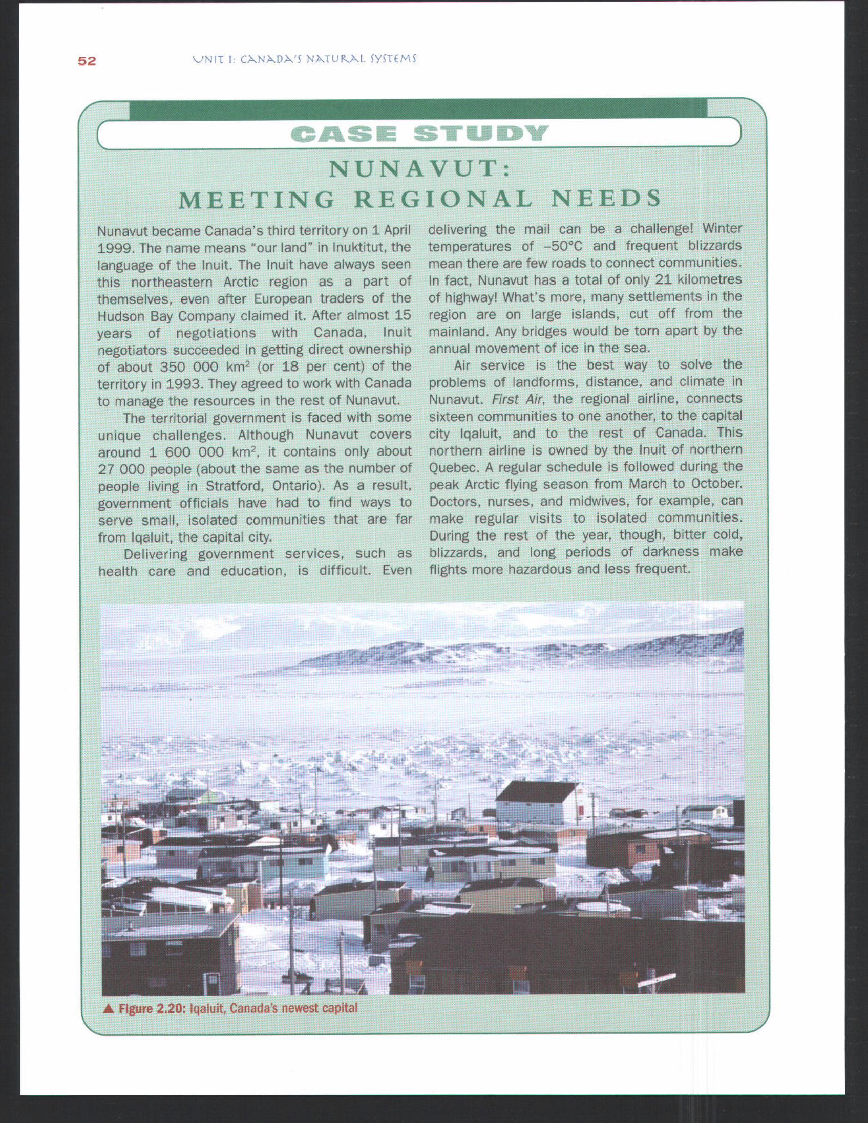
Figure 2.20: Iqaluit, Canada's newest capital
These transportation problems led Nunavutofficials to use a very decentralized form ofgovernment. This means that local governmentdepartments and agencies are being set up in tencommunities besides Iqaluit. You can see these onthe map in Rgure 2.19 on page 51. This decentraliz-ation will help create jobs in all areas of the territory.It also makes sense because smaller, isolatedcommunities know best how to meet their own needs.
Local government makes sense in anotherway. The Inuit have always had a very strong senseof responsibility to the community. For example,according to the Inuit concept of Innuqatigiinniq(community ties), the raising and education ofchildren is everyone's responsibility. Therefore,local control over services such as education
make perfect sense both because of the land'sdaunting features and because of Inuit culture.
Summarize the reasons why transportation isdifficult in Nunavut.Brainstorm lists of advantages and disadvan-tages for Nunavut's type of government.Suppose you lead the territorial government ofNunavut. Use the map in Figure 2.19 on page51 to plan the following.a) locations for airports to distribute supplies
from Iqaluitb) places that tourists might like to visit, and
ways to get them therec) ways to get the territory's oil, natural gas,
and minerals to the rest of Canada
ConclusionIn this chapter, you learned that many different landform processes haveshaped our country during its long history. Searing volcanoes and slow,grinding plates built mountains. Water, ice, and wind continually wore downthe surface and carried it to the sea. Four factors--size, time, mountain-building, and erosion--have created a country with seven different landformregions. People have populated each of these regions and used the resourcesto develop unique communities.
Wrap It Up
Make a chart with the headings shownbelow. Fill it in with brief point-form notesabout each of the seven landform regionsyou have studied in this chapter.
Explain the meaning of each of thefollowing ideas used in the chapter.a) Canada's land surface grew like a tree.b) Canada is like a car that has been in a
lot of accidents.c) Nunavut is a new kind of territory.
Find out what types of landforms are locatedin your community and area. How have they
affected the economy and population of yourarea? Prepare a short report, illustrated witha map, pictures, or both.
Look at the map of Canada's climate regionson page 33. Compare it to the map ofCanada's landform regions in Figure 2.1 onpage 37. Describe the climate patterns ineach of the seven landform regions.
Look at an atlas map of Canada's popula-tion. Compare it to the map of Canada'slandform regions. Record how population isdistributed in each landform region.
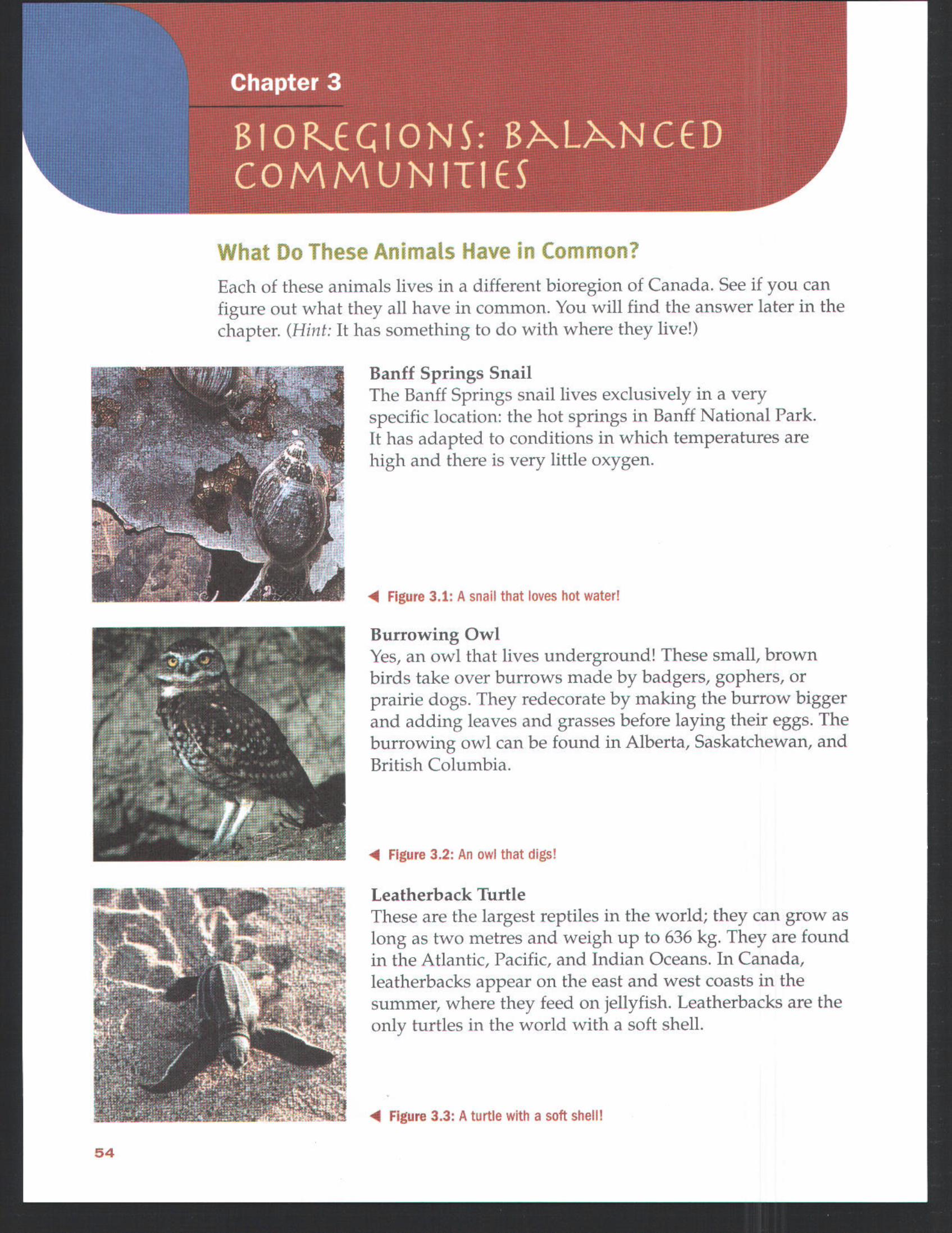
What Do These Anima|s Have in Common?Each of these animals lives in a different bioregion of Canada. See if you canfigure out what they all have in common. You will find the answer later in thechapter. (Hint: It has something to do with where they live!)
Banff Springs SnailThe Banff Springs snail lives exclusively in a veryspecific location: the hot springs in Banff National Park.It has adapted to conditions in which temperatures arehigh and there is very little oxygen.
Figure 3.1: A snail that loves hot water!
Burrowing OwlYes, an owl that lives underground! These small, brownbirds take over burrows made by badgers, gophers, orprairie dogs. They redecorate by making the burrow biggerand adding leaves and grasses before laying their eggs. Theburrowing owl can be found in Alberta, Saskatchewan, andBritish Columbia.
Figure 3.2: An owl that digs!
Leatherback TurtleThese are the largest reptiles in the world; they can grow aslong as two metres and weigh up to 636 kgo They are foundin the Atlantic, Pacific, and Indian Oceans. In Canada,leatherbacks appear on the east and west coasts in thesummer, where they feed on jellyfish. Leatherbacks are theonly turtles in the world with a soft shell.
Figure 3.3: A turtle with a soft. shell!
54