Embed Size (px)
Citation preview
CROWDSOURCING TRANSPORTATION
SYSTEMS DATA
February 2015
MICHIGAN DEPARTMENT OF TRANSPORTATION AND THE CENTER FOR AUTOMOTIVE RESEARCH ii
CROWDSOURCING TRANSPORTATION SYSTEMS DATA FEBRUARY 2015
MICHIGAN DEPARTMENT OF TRANSPORTATION AND THE CENTER FOR AUTOMOTIVE RESEARCH iii
Sponsoring Organization:
Michigan Department of Transportation (MDOT)
425 Ottawa Street
P.O. Box 30050
Lansing, MI 48909
Performing Organization(s):
Center for Automotive Research (CAR)
3005 Boardwalk, Ste. 200
Ann Arbor, MI 48108
Parsons Brinkerhoff (PB)
100 S. Charles Street
Baltimore, MD 21201
Report Title: Crowdsourcing Transportation Systems Data
MDOT REQ. NO. 1259, Connected and Automated Industry Coordination
Sequence D 02 Crowd Sourced Mobile Applications
February 11, 2015
Author(s):
Eric Paul Dennis, P.E. (CAR)
Richard Wallace, M.S. (Director, Transportation Systems Analysis, CAR)
Brian Reed, MCSE, CCNP/CCNA, CISSP (PB)
Managing Editor(s):
Matt Smith, P.E., PTOE (Statewide ITS Program Manager, MDOT)
Collin Castle, P.E. (MDOT)
Bill Tansil (MDOT)
Additional Contributor(s):
Josh Cregger, M.S. (CAR)
MICHIGAN DEPARTMENT OF TRANSPORTATION AND THE CENTER FOR AUTOMOTIVE RESEARCH iv
ACKNOWLEDGMENTS
This document is a product of the Center for Automotive Research and
Parsons Brinkerhoff, Inc. under a State Planning and Research Grant
administered by the Michigan Department of Transportation.
This document benefited significantly from the participation of representatives
at transportation operations centers (TOCs). The authors thank the following
individuals for their valuable contributions:
Lee Nederveld from the MDOT Statewide TOC (STOC)
John Abraham, Adam Merchant, and Jon Coleman from the Macomb
County Department of Roads (MCDR)
Suzette Peplinski and Paul Arends from the MDOT West Michigan TOC
(WMTOC)
Ahmad Jawad of the Road Commission for Oakland County (RCOC)
Dayo Akinyemi, Sarah Gill, Marjorie Zabel, Walter Ison, and Aaron
Raymond of the MDOT Southeast Michigan TOC (SEMTOC)
Meghan Butler of the MDOT Bluewater Bridge TOC (BWBTOC)
CROWDSOURCING TRANSPORTATION SYSTEMS DATA FEBRUARY 2015
MICHIGAN DEPARTMENT OF TRANSPORTATION AND THE CENTER FOR AUTOMOTIVE RESEARCH v
EXECUTIVE SUMMARY
Crowdsourcing involves leveraging the combined intelligence, knowledge, or
experience of a group of people to answer a question, solve a problem, or
manage a process. Opportunities for crowdsourcing have greatly increased
with the broad adoption of internet-connected devices, especially
smartphones. Leveraging this network of connected people and devices for
transportation system management is an important opportunity.
The term crowdsourcing is applied in common usage to several dissimilar
processes. To establish a clear scope for this report, we have organized
crowdsourced transportation data applications into four categories:
1. Third-party Aggregated Crowdsourced Data
2. Social Media for Public Engagement
3. The Internet as a Sensor
4. Dedicated Platforms for Transportation System Management
THIRD-PARTY AGGREGATED CROWDSOURCED DATA
Many transportation agencies already obtain aggregated crowdsourced data
through contracted third-party commercial providers, most often for traffic
speed and vehicle-count information. Commercial providers offer clearly
defined products and services, customer support, and professional expertise.
Such arrangements allow agencies access to proprietary data that would be
otherwise difficult to obtain. Agencies may also use third-party data to avoid
tedious data cleaning and management tasks. Purchasing additional types of
third-party data is a future possibility.
SOCIAL MEDIA FOR PUBLIC ENGAGEMENT
Many agencies have experimented with leveraging internet-based social
networks to obtain public feedback regarding the condition of the
transportation system and performance of the agency. Americans spend more
online time using social networks than any other online activity. The number
of people a transportation agency could potentially reach through existing
social media platforms is substantial. Agencies can simultaneously
disseminate information, gather additional information from system users, and
take advantage of instantaneous unmediated information sharing on the
platform.
MICHIGAN DEPARTMENT OF TRANSPORTATION AND THE CENTER FOR AUTOMOTIVE RESEARCH vi
THE INTERNET AS A SENSOR
Broadly defined, a sensor is any device that takes a measurement and converts
it into readable data. Recent research in transportation demand modeling has
investigated the concept of using of the internet itself as a virtual sensor
capable of providing valuable, actionable data. Research has suggested that
open traffic data can be used to obtain network traffic speed estimations that
are equal to or better than traditional sensors. Additionally, internet-as-a-
sensor methods may be able to predict the impact of special events, such as
festivals and sporting events, on the transportation system.
DEDICATED PLATFORMS FOR TRANSPORTATION SYSTEM
MANAGEMENT
Crowdsourced data collection using purpose-built dedicated applications is
rapidly gaining momentum within multiple industries. Transportation agencies
and others have already deployed a wide range of custom-built applications to
collect transportation system information. The potential applications of
crowdsourcing will continue to diversify in the future as applications, wireless
networks, and other technologies continue to evolve.
INTEGRATING CROWDSOURCED DATA INTO EXISTING AGENCY
PRACTICES
Crowdsourced data comes in a large number of formats, which presents a
challenge for integrating such data with legacy systems. Agencies wishing to
leverage crowdsourced data must establish data-intake processes that interpret
and distribute the data appropriately. An efficient data-intake process will
allow agencies to use crowdsourced data in real-time for operations and
maintenance, as well as to store data for future uses such as research and
planning activities. Agencies will select and employ specific approaches for
data integration based on the format of the raw data that an agency obtains,
and the goals that the agency has in using data. Clearly stated goals are critical
when designing a data-integration strategy.
CROWDSOURCING TRANSPORTATION SYSTEMS DATA FEBRUARY 2015
MICHIGAN DEPARTMENT OF TRANSPORTATION AND THE CENTER FOR AUTOMOTIVE RESEARCH vii
TABLE OF CONTENTS
1 Introduction ........................................................................................................................... 1
1.1 Scope of this Report (What is Crowdsourcing?) ................................................................ 2
2 Third-party Aggregated Crowdsourced Data .................................................................... 5
2.1 Historical and Real-time Traffic Data ................................................................................. 5
2.2 Cellular Geo-positioning Data ............................................................................................ 5
3 Social Media for Public Engagement ................................................................................... 7
3.1 Collection and Dissemination of System Status Information ............................................. 8
3.2 Planning and Project Prioritization ................................................................................... 10
4 The Internet as a Sensor ..................................................................................................... 12
4.1 Mining Social Media Data to Supplement Public Participation ....................................... 12
4.2 Using Open Traffic Data ................................................................................................... 13
4.3 Predicting Traffic Spikes from Special Events ................................................................. 21
5 Dedicated Platforms for Transportation System Management ...................................... 23
5.1 Automated Vehicle Location for Public Transit ............................................................... 23
5.2 Pavement Condition Data Collection................................................................................ 25
5.3 Bicycle Travel and Infrastructure Data ............................................................................. 26
5.4 Parking Management ........................................................................................................ 27
5.5 Origin-Destination Studies................................................................................................ 28
5.6 Environmental Data Collection ......................................................................................... 28
5.7 Planning and Project Prioritization ................................................................................... 28
6 Integrating Crowdsourced Data into Existing Agency Practices ................................... 30
6.1 Obtaining Raw Data .......................................................................................................... 31
6.2 Data Intake Process ........................................................................................................... 31
6.3 Data Storage and Archiving .............................................................................................. 33
6.4 Transportation Operations Centers ................................................................................... 34
6.5 Maintenance ...................................................................................................................... 36
6.6 Reporting, Planning, and Research ................................................................................... 37
MICHIGAN DEPARTMENT OF TRANSPORTATION AND THE CENTER FOR AUTOMOTIVE RESEARCH viii
7 Summary and Conclusions ................................................................................................. 38
References .................................................................................................................................... 43
Appendix A: Transportation-Related Crowdsourcing Platforms ........................................ A.1
Appendix B: Transportation Operations Center Interview Notes ....................................... A.4
Appendix C: List of Abbreviations ......................................................................................... A.9
CROWDSOURCING TRANSPORTATION SYSTEMS DATA FEBRUARY 2015
MICHIGAN DEPARTMENT OF TRANSPORTATION AND THE CENTER FOR AUTOMOTIVE RESEARCH 1
CROWDSOURCING: LEVERAGING THE
COMBINED INTELLIGENCE, KNOWLEDGE,
OR EXPERIENCE OF A GROUP OF PEOPLE
TO ANSWER A QUESTION, SOLVE A
PROBLEM, OR MANAGE A PROCESS.
1 INTRODUCTION
Crowdsourcing involves leveraging the combined intelligence, knowledge, or
experience of a group of people to answer a question, solve a problem, or
manage a process. The term, ‘crowdsourcing,’ is relatively new, but the basic
idea is not.1 Crowdsourcing is a natural solution to problems inherent in the
management of complex systems.2 As social, political, technological, and
other dimensions of society have grown increasingly complex and connected,
crowdsourcing has emerged as a powerful tool in the management of various
systems and has the potential to become even more useful in the future.
The range of problems that can be addressed through crowdsourcing has
greatly increased in recent years with the broad adoption of internet-connected
devices, especially smartphones. Over half of all adults in the United States
now own a smartphone.3 By 2018, the figure
will exceed 75%.4 Smartphones combine
cellular communication with a computer
processer and customizable software.
Today’s smartphones include multiple
communication and data transfer methods,
an array of built-in sensors, adaptable
architecture, and a powerful processor.
Thousands of software applications are available to smartphone users.
The combination of personal computers, smartphones, and other mobile
devices has led to pervasive and frequent connectivity for much of the
population. Leveraging this network of connected devices for transportation
system management is an important opportunity. This report discusses several
1 Galton 1907.
2 Most modern political scientists would agree that democracy (crowdsourced political will) is
superior to oligarchy (centrally managed political will). Also, most modern economists
would agree that capitalism (crowdsourced market pricing) is superior to centrally managed
economies. Modern socioeconomic systems are more complex than described in any pure
idealized form, but the systems that have proven to be most stable over the last few
centuries have generally involved a significant degree of crowdsourcing. 3 58% of American adults own a smartphone as of January 2014.
http://www.pewinternet.org/fact-sheets/mobile-technology-fact-sheet/, accessed January
2015. 4 Additionally, about 15% of smartphone users are under 18, implying that well over 75% of
drivers will likely be smartphone users by 2018. http://www.emarketer.com/Article/US-
Smartphone-Usage-Nears-UK-Levels/1010730, accessed June 2014.
INTRODUCTION
MICHIGAN DEPARTMENT OF TRANSPORTATION AND THE CENTER FOR AUTOMOTIVE RESEARCH 2
approaches that transportation agencies can use to leverage crowdsourcing
techniques for transportation system planning, management, and operation.
1.1 SCOPE OF THIS REPORT (WHAT IS CROWDSOURCING?)
For purposes of this report, crowdsourcing is defined as, “leveraging the
combined intelligence, knowledge, or experience of a group of people to
answer a question, solve a problem, or manage a process.” This definition
must be further refined to clearly establish the scope of this report.
Establishing a working definition of crowdsourcing is complicated because
the word is applied in common usage to a wide variety of activities and
processes. Yet many activities that would seem to meet any definition of
crowdsourcing are often not thought of as such. For example, any research
project that includes a literature review leverages the combined intelligence of
the authors of previous works; however, literature review is not generally
thought of as crowdsourcing. Presumably, literature review and similar
research tasks are not considered crowdsourcing because the contributors of
knowledge are passive in the process. Nonetheless, many activities that are
commonly considered crowdsourcing also involve extracting data from
passive providers. For example, using connected vehicle technology (probe
vehicle data) to estimate traffic speeds is a commonly cited example of
crowdsourced transportation data. However, submitting traffic speed data
from probe vehicles is usually a passive activity for the person generating the
data. Furthermore, that person might not even be aware that he or she is
generating data.
A logical justification for considering use of probe vehicle data as
crowdsourcing while omitting the literature review process is not obvious.
CAR’s research makes it clear that it is very difficult to develop a definition
for crowdsourcing that is both internally consistent and consistent with
common usage of the term. In short, what is and what is not included within
the scope of crowdsourcing, as popularly conceived, appears to be somewhat
arbitrary.
For purposes of this report, we have attempted to limit the scope to data that
transportation industry practitioners popularly consider to be ‘crowdsourced
transportation data’ in common usage. We have also included novel or
innovative approaches to acquiring useful data for transportation agencies that
meet our original definition.
CROWDSOURCING TRANSPORTATION SYSTEMS DATA FEBRUARY 2015
MICHIGAN DEPARTMENT OF TRANSPORTATION AND THE CENTER FOR AUTOMOTIVE RESEARCH 3
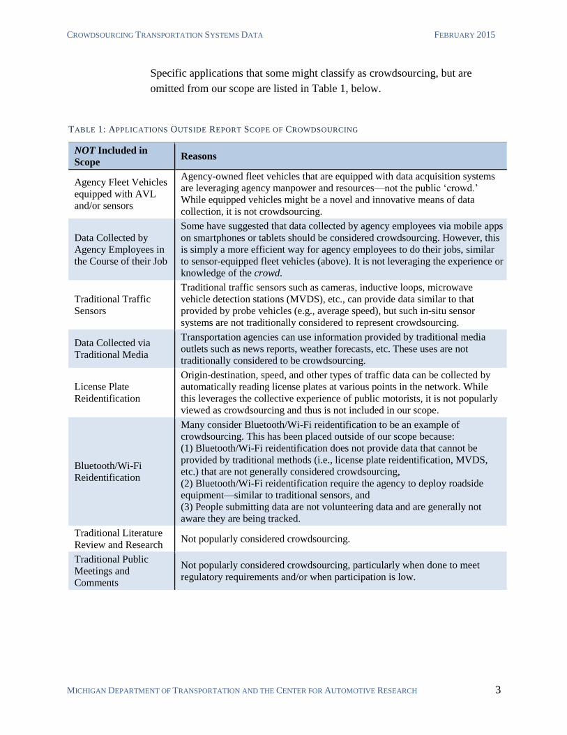
Specific applications that some might classify as crowdsourcing, but are
omitted from our scope are listed in Table 1, below.
TABLE 1: APPLICATIONS OUTSIDE REPORT SCOPE OF CROWDSOURCING
NOT Included in
Scope Reasons
Agency Fleet Vehicles
equipped with AVL
and/or sensors
Agency-owned fleet vehicles that are equipped with data acquisition systems
are leveraging agency manpower and resources—not the public ‘crowd.’
While equipped vehicles might be a novel and innovative means of data
collection, it is not crowdsourcing.
Data Collected by
Agency Employees in
the Course of their Job
Some have suggested that data collected by agency employees via mobile apps
on smartphones or tablets should be considered crowdsourcing. However, this
is simply a more efficient way for agency employees to do their jobs, similar
to sensor-equipped fleet vehicles (above). It is not leveraging the experience or
knowledge of the crowd.
Traditional Traffic
Sensors
Traditional traffic sensors such as cameras, inductive loops, microwave
vehicle detection stations (MVDS), etc., can provide data similar to that
provided by probe vehicles (e.g., average speed), but such in-situ sensor
systems are not traditionally considered to represent crowdsourcing.
Data Collected via
Traditional Media
Transportation agencies can use information provided by traditional media
outlets such as news reports, weather forecasts, etc. These uses are not
traditionally considered to be crowdsourcing.
License Plate
Reidentification
Origin-destination, speed, and other types of traffic data can be collected by
automatically reading license plates at various points in the network. While
this leverages the collective experience of public motorists, it is not popularly
viewed as crowdsourcing and thus is not included in our scope.
Bluetooth/Wi-Fi
Reidentification
Many consider Bluetooth/Wi-Fi reidentification to be an example of
crowdsourcing. This has been placed outside of our scope because:
(1) Bluetooth/Wi-Fi reidentification does not provide data that cannot be
provided by traditional methods (i.e., license plate reidentification, MVDS,
etc.) that are not generally considered crowdsourcing,
(2) Bluetooth/Wi-Fi reidentification require the agency to deploy roadside
equipment—similar to traditional sensors, and
(3) People submitting data are not volunteering data and are generally not
aware they are being tracked.
Traditional Literature
Review and Research Not popularly considered crowdsourcing.
Traditional Public
Meetings and
Comments
Not popularly considered crowdsourcing, particularly when done to meet
regulatory requirements and/or when participation is low.
INTRODUCTION
MICHIGAN DEPARTMENT OF TRANSPORTATION AND THE CENTER FOR AUTOMOTIVE RESEARCH 4
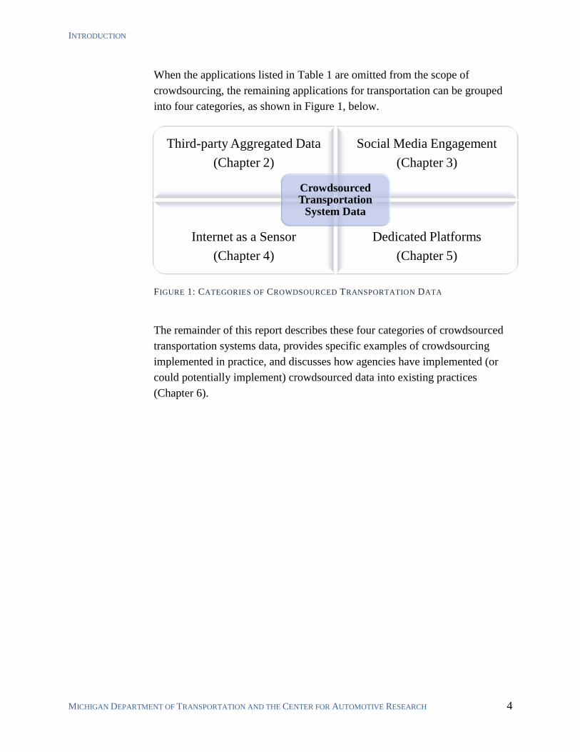
When the applications listed in Table 1 are omitted from the scope of
crowdsourcing, the remaining applications for transportation can be grouped
into four categories, as shown in Figure 1, below.
FIGURE 1: CATEGORIES OF CROWDSOURCED TRANSPORTATION DATA
The remainder of this report describes these four categories of crowdsourced
transportation systems data, provides specific examples of crowdsourcing
implemented in practice, and discusses how agencies have implemented (or
could potentially implement) crowdsourced data into existing practices
(Chapter 6).
Third-party Aggregated Data
(Chapter 2)
Social Media Engagement
(Chapter 3)
Internet as a Sensor
(Chapter 4)
Dedicated Platforms
(Chapter 5)
Crowdsourced Transportation
System Data
CROWDSOURCING TRANSPORTATION SYSTEMS DATA FEBRUARY 2015
MICHIGAN DEPARTMENT OF TRANSPORTATION AND THE CENTER FOR AUTOMOTIVE RESEARCH 5
2 THIRD-PARTY AGGREGATED CROWDSOURCED
DATA
Many transportation agencies already obtain crowdsourced data through
contracted commercial providers. Commercial providers offer clearly defined
products and services, as well as customer support and professional expertise.
Such arrangements allow agencies access to proprietary data that would be
otherwise difficult to obtain and allow them to avoid tedious data cleaning and
management tasks. Agencies can also avoid dealing with sensitive personally
identifiable information by receiving only aggregated data from providers.5
2.1 HISTORICAL AND REAL-TIME TRAFFIC DATA
Transportation agencies often contract third-party vendors to obtain data for
historical and live traffic conditions. This often includes average speed and
vehicle counts. MDOT currently obtains traffic data for planning and
management purposes through a third-party vendor, HERE (a traffic data and
mapping service offered by Nokia). Most traffic-information vendors use
some combination of proprietary probe-vehicle data, proprietary sensor data,
public sensor data, and other publically available information.6 While third-
party traffic data is an example of transportation agency use of crowdsourced
data, such contractual arrangements are an established practice and need not
be discussed further here.
2.2 CELLULAR GEO-POSITIONING DATA
Transportation planners often use multi-day travel data to understand use of
the transportation system and develop long-term planning priorities.
Traditionally, this is done by utilizing citizen-volunteers to answer surveys,
keep a travel journal, or carry a GPS tracking device. These methods are
generally expensive, have a limited sample size, and are prone to errors.7
The broad adoption of cell phones and connected devices provides an
opportunity for objective measurements of peoples’ movements and use of the
transportation system. Aggregated location data provides a potential source of
travel behavior data. Even at the cell level (i.e., geographic data identifying a
5 Dennis, Cregger, and Hong 2014.
6 Liou et al. 2013; Cambridge Systematics 2012; Thiagarajan et al. 2009.
7 Wang, Chen, and Ma 2013; Abdulazim et al. 2011; Lee and Williams 2013.
THIRD-PARTY AGGREGATED CROWDSOURCED DATA
MICHIGAN DEPARTMENT OF TRANSPORTATION AND THE CENTER FOR AUTOMOTIVE RESEARCH 6
connected device at a particular cell tower), planners may use cell data to gain
insight into broad mobility patterns throughout a population.
Another advantage of this method is that cellular travel studies can continue
long-term or indefinitely, allowing researchers to investigate evolving patterns
of mobility trends in an area.8 Datasets available through emerging
technologies, such as connected vehicles, might further improve the quality
and level of detail that is readily accessible by agencies through third-party
providers.9 Any partnerships with traffic data or cellular service providers
must consider the privacy rights of consumers/citizens.10
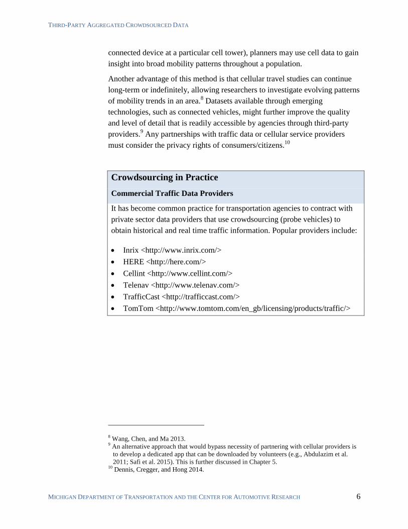
Crowdsourcing in Practice
Commercial Traffic Data Providers
It has become common practice for transportation agencies to contract with
private sector data providers that use crowdsourcing (probe vehicles) to
obtain historical and real time traffic information. Popular providers include:
Inrix <http://www.inrix.com/>
HERE <http://here.com/>
Cellint <http://www.cellint.com/>
Telenav <http://www.telenav.com/>
TrafficCast <http://trafficcast.com/>
TomTom <http://www.tomtom.com/en_gb/licensing/products/traffic/>
8 Wang, Chen, and Ma 2013.
9 An alternative approach that would bypass necessity of partnering with cellular providers is
to develop a dedicated app that can be downloaded by volunteers (e.g., Abdulazim et al.
2011; Safi et al. 2015). This is further discussed in Chapter 5. 10
Dennis, Cregger, and Hong 2014.
CROWDSOURCING TRANSPORTATION SYSTEMS DATA FEBRUARY 2015
MICHIGAN DEPARTMENT OF TRANSPORTATION AND THE CENTER FOR AUTOMOTIVE RESEARCH 7
AMERICANS SPEND MORE TIME
USING SOCIAL NETWORKS THAN
ANY OTHER ONLINE ACTIVITY.
3 SOCIAL MEDIA FOR PUBLIC ENGAGEMENT
Most transportation agencies already use social media in some way. For
example, MDOT’s Facebook page, which has over 9,000 ‘likes,’ is updated
regularly with event announcements, construction
information, photos, and interesting facts.11
MDOT’s
Twitter feed, which has over 23,000 followers, is
actively monitored and responsive to questions and
concerns.12
MDOT also has a YouTube, Instagram,
and Google+ presence.13
Digital communications such as these social media
outlets are likely to continue becoming embedded into the daily fabric of
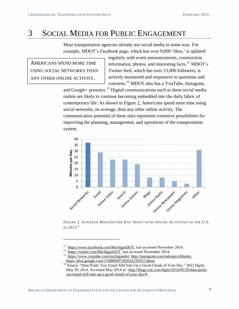
contemporary life. As shown in Figure 2, Americans spend more time using
social networks, on average, than any other online activity. The
communication potential of these sites represents extensive possibilities for
improving the planning, management, and operations of the transportation
system.
FIGURE 2: AVERAGE MINUTES PER DAY SPENT WITH ONLINE ACTIVITIES IN THE U.S.
IN 201314
11 https://www.facebook.com/MichiganDOT last accessed November 2014.
12 https://twitter.com/MichiganDOT last accessed November 2014.
13 https://www.youtube.com/michigandot; http://instagram.com/mdotpicoftheday,
https://plus.google.com/110889497392032235057/about 14
Source: “Data Point: Yes, Email Still Eats Up a Good Chunk of Your Day.” WSJ Digits.
May 20, 2014. Accessed May 2014 at: http://blogs.wsj.com/digits/2014/05/20/data-point-
yes-email-still-eats-up-a-good-chunk-of-your-day/# .
0
5
10
15
20
25
30
35
40
Min
ute
s p
er
Day
SOCIAL MEDIA FOR PUBLIC ENGAGEMENT
MICHIGAN DEPARTMENT OF TRANSPORTATION AND THE CENTER FOR AUTOMOTIVE RESEARCH 8
3.1 COLLECTION AND DISSEMINATION OF SYSTEM STATUS
INFORMATION
Public agencies are legally and ethically obligated to involve the public in
agency activities.15
Social media provides an opportunity to streamline and
improve public relations and communications. Many agencies have already
deployed social media strategies with positive results. For example, MDOT
routinely posts information to its Facebook and Twitter pages and actively
monitors both, responding to comments and complaints relatively quickly and
helpfully. Additionally, each MDOT region has its own Twitter feed and
provides information about events and projects with local impact.16
The
MDOT Bluewater Bridge TOC (BWBTOC) also maintains a Twitter feed.
MDOT’s Facebook and various Twitter accounts are currently working as an
effective and efficient conduit for public dialog.
Social media outlets such as Twitter can be extremely useful for
communicating system status during special events and disruptions. Agencies
can simultaneously disseminate information, gather additional information
from system users, and take advantage of instantaneous unmediated
information sharing on the platform.
One weakness of a social media communication strategy is that users of social
media networks skew demographically younger and more educated than the
general population.17
But these demographic disparities will reduce as
adoption of digital technologies continues. By 2018, more than 75% of drivers
in the U.S. will be smartphone users.18
However, to reach the remaining
population of travelers, transportation agencies will have to continue to
disseminate information through traditional means for constituents that lack
access to mobile devices. A multi-platform approach to information
dissemination is necessary to reach the widest possible cross-section of the
public.
Another weakness of using social media platforms is that such networks often
evolve or fall out of use. Agencies should not consider any social media
engagement strategy as permanent. The transient nature of these platforms
15 Dennis, Cregger, and Hong 2014.
16 http://www.michigan.gov/mdot/0,4616,7-151-9620_67093-261456--,00.html, accessed
May 2014. 17
Mitchell and Guskin 2013; Chan and Schofer 2013. 18
http://www.emarketer.com/Article/US-Smartphone-Usage-Nears-UK-Levels/1010730.
CROWDSOURCING TRANSPORTATION SYSTEMS DATA FEBRUARY 2015
MICHIGAN DEPARTMENT OF TRANSPORTATION AND THE CENTER FOR AUTOMOTIVE RESEARCH 9
will require agencies to periodically assess if a particular outreach strategy is
effective.
Crowdsourcing in Practice
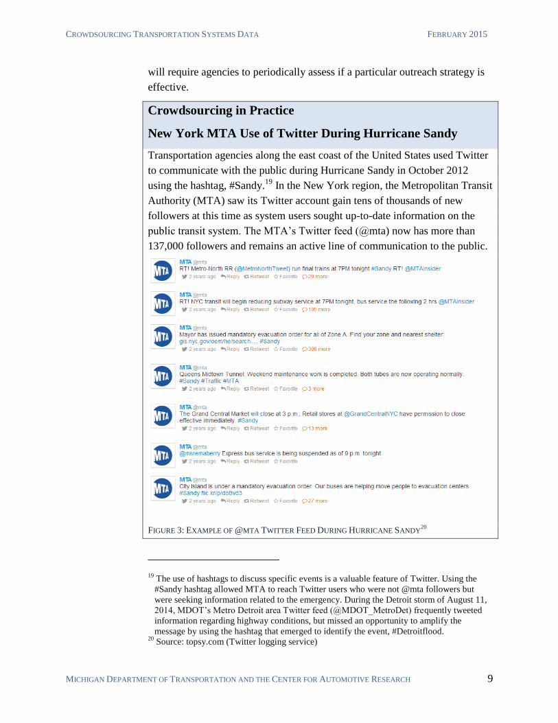
New York MTA Use of Twitter During Hurricane Sandy
Transportation agencies along the east coast of the United States used Twitter
to communicate with the public during Hurricane Sandy in October 2012
using the hashtag, #Sandy.19
In the New York region, the Metropolitan Transit
Authority (MTA) saw its Twitter account gain tens of thousands of new
followers at this time as system users sought up-to-date information on the
public transit system. The MTA’s Twitter feed (@mta) now has more than
137,000 followers and remains an active line of communication to the public.
FIGURE 3: EXAMPLE OF @MTA TWITTER FEED DURING HURRICANE SANDY20
19 The use of hashtags to discuss specific events is a valuable feature of Twitter. Using the
#Sandy hashtag allowed MTA to reach Twitter users who were not @mta followers but
were seeking information related to the emergency. During the Detroit storm of August 11,
2014, MDOT’s Metro Detroit area Twitter feed (@MDOT_MetroDet) frequently tweeted
information regarding highway conditions, but missed an opportunity to amplify the
message by using the hashtag that emerged to identify the event, #Detroitflood. 20
Source: topsy.com (Twitter logging service)
SOCIAL MEDIA FOR PUBLIC ENGAGEMENT
MICHIGAN DEPARTMENT OF TRANSPORTATION AND THE CENTER FOR AUTOMOTIVE RESEARCH 10
THE MICHIGAN 2014-2017 STATE
TRANSPORTATION IMPROVEMENT
PROGRAM (STIP) DRAFT RECEIVED
ONLY TWELVE PUBLIC COMMENTS.
3.2 PLANNING AND PROJECT PRIORITIZATION
Transportation planners are often tasked with setting priorities for distributing
limited funds on an extensive range of potential projects. In Michigan, the
distribution of funding is largely determined by Act 51 of 1951 and Federal
transportation funding regulations. While the regional distribution of
transportation funding is somewhat predetermined by Act 51, the selection of
projects requires a combination of formal strategic planning and public
participation.
Federally funded projects administered by MDOT are programmed through
the State Transportation Improvement Program (STIP).21
A documented
public participation process is a required component of the STIP. MDOT’s
public participation plan includes the dissemination of information via press
releases, focus group sessions, newsletters, brochures, public comment
forums, and newspaper postings.22
Yet, the last STIP received only twelve
public comments—half of which were from people representing corporate or
government interests.23
As shown in Figure 2, Americans spend a lot of
time using social media. The vast majority of this
time is on large and established platforms (e.g.,
Facebook, Twitter, Snapchat, etc.). The raw
number of people a transportation agency could
potentially reach through existing social media
platforms is substantial. Additionally, the increasing popularity of platforms
such as Facebook allow for increasingly broad demographic representation.24
Some planners have already successfully experimented with engaging
constituencies via these platforms to supplement and support traditional public
participation.
21 http://www.michigan.gov/mdot/0,1607,7-151-9621_14807_14808---,00.html. An STIP is
federally required for all states to receive federal highway funds. 22
MDOT Draft STIP FY 2014-2017. Accessed May 2014 at:
http://www.michigan.gov/documents/mdot/MDOT_Draft_2014-
17_STIP_document_430052_7.pdf. 23
MDOT FY 2011-2014 STIP Public Review and Comments Summary Report, accessed
May 2014 at: http://www.michigan.gov/documents/mdot/MDOT_FY11-
14_STIP_Comments_Summary_Report_338493_7.pdf. 24
Evans-Cowley and Griffin 2011.
CROWDSOURCING TRANSPORTATION SYSTEMS DATA FEBRUARY 2015
MICHIGAN DEPARTMENT OF TRANSPORTATION AND THE CENTER FOR AUTOMOTIVE RESEARCH 11
One potential problem with using social media for public participation is the
potential to lose control of the discussion.25
While it is important to allow a
range of views, un-moderated discussions often become un-focused, un-
constructive, and divisive. Forums that allow easy and anonymous
participation often devolve into unstructured arguments and personal attacks.
Considering this, A few agencies have begun utilizing custom-developed
transportation planning and prioritization internet and mobile applications, as
subsequently discussed in section 5.7 of this report.26
Crowdsourcing in Practice
City of Austin Social Networking and Planning Process (SNAPP)
Through a grant from the Federal Transit Administration, the City of Austin collaborated with
partners to create the Social Networking and Planning Project (SNAPP). SNAPP was charged
with piloting, tracking, and evaluating the use of an integrated array of tools to build
relationships though online social networking to increase the quality and quantity of participation
as part of the Austin Strategic Mobility Plan. The SNAPP program resulted in “more than 9,000
relevant comments and approximately 6,300 participants.”27
25 For example: Ford, Dana. “#D’oh! NYPD Twitter Campaign Backfires.” CNN.com. April
24, 2014. Accessed June 2014. 26
infra. pp. 29. 27
Evans-Cowley 2011.
THE INTERNET AS A SENSOR
MICHIGAN DEPARTMENT OF TRANSPORTATION AND THE CENTER FOR AUTOMOTIVE RESEARCH 12
SENSOR: A DEVICE THAT TAKES A
MEASUREMENT AND CONVERTS IT
INTO READABLE DATA.
4 THE INTERNET AS A SENSOR
Broadly defined, a sensor is any device that takes a measurement and converts
it into readable data. Recent research in transportation demand modeling has
investigated the concept of using the internet itself as a ‘virtual sensor’
capable of providing valuable, actionable data.28
The potential to use the
internet as a virtual sensor likely will increase as more connected devices are
adopted by consumers.29
The continued increase of connected people and
devices can provide agencies access to completely
new types of data. Internet-as-a-sensor applications
are just beginning to be adopted in select industries.
These applications often employ new techniques in
data-mining and machine learning. Agencies that are early adopters have the
opportunity to use internet-as-a-sensor methods to develop innovative
solutions to transportation systems management.
4.1 MINING SOCIAL MEDIA DATA TO SUPPLEMENT PUBLIC
PARTICIPATION
Public participation in the transportation planning process is essential to
ensure that the needs and concerns of affected constituencies are considered.
Unfortunately, traditional public participation methods (e.g., community
meetings) often result in low community involvement and over-representation
of special interests.30
Online forums can largely alleviate this issue, as
discussed in section 3.2. Nonetheless, a large percentage of constituencies
remain difficult to engage in a meaningful way. These include people that are
too busy, uninformed, or disengaged to participate in any official forum.
Many of these people, while not easily reachable by planning agencies, are
nevertheless active on social media and might even use these forums to
discuss transportation-related issues with their network of peers. New
paradigms of open data and big data analysis are making it possible to scan a
28 Pereira, Rodrigues, and Ben-Akiva 2011.
29 Internet-connected devices are often described as comprising the ‘Internet of Things (IoT).’
A prime example of sensors embedded in IOT devices are the continued advances in
connected vehicles, flood control/water quality sensors, smart meters/disconnects, or traffic
signal controllers. 30
Misra et al. 2013.
CROWDSOURCING TRANSPORTATION SYSTEMS DATA FEBRUARY 2015
MICHIGAN DEPARTMENT OF TRANSPORTATION AND THE CENTER FOR AUTOMOTIVE RESEARCH 13
wide range of internet sites in search of posts that relate to a particular topic or
agency.31
Such methods are in generally early stages of development, and they
might require complex methods of data mining and sentiment analysis.32
As
these methods continue to develop, transportation planners should consider
these techniques to supplement traditional methods of public participation.
4.2 USING OPEN TRAFFIC DATA
Most transportation departments monitor the condition of their road network
with fixed roadside sensors and traffic cameras. As of 2013, MDOT
maintained approximately 456 traffic cameras and 488 microwave vehicle
detector sites (MVDS).33
The installation cost of this network is in the tens of
millions of dollars, and the network requires millions of dollars of
maintenance each year.34
Future crowdsourcing methods and open data
availability may enable agencies to reduce the cost of such traditional sensor
networks.
TRAFFIC SPEED ESTIMATION
When MDOT and other transportation departments began deploying sensor
and camera networks to monitor traffic, there was no viable alternative to
collecting such data. Prior to deployment of these sensor systems, the only
way of getting real-time traffic data was through eyewitness reports and traffic
helicopters. Today, real-time comprehensive performance data is available
through proprietary probe-vehicle networks, many of which make traffic data
available for free over the internet.
Google was the first company to launch an application programming interface
(API) for its online map in 2005. This API can now be used to reference
Google’s live traffic data.35
There are now similar APIs from Bing Maps,
MapQuest, HERE, TomTom, and others. One study found that travel time
estimation provided by these internet sources is within 95% of the
measurements by traditional sensor networks (MVDS).36
The internet data
31 Russell 2013.
32 Pang and Lee 2008.
33 MDOT and CAR 2013.
34 MDOT and CAR 2013.
35 https://developers.google.com/maps/ accessed November 2014.
36 Morgul et. al 2013 compared open traffic data to fixed MVDS station readings. Bing Maps
and MapQuest APIs were used for the study because these services allow unlimited queries
(continued on next page...)
THE INTERNET AS A SENSOR
MICHIGAN DEPARTMENT OF TRANSPORTATION AND THE CENTER FOR AUTOMOTIVE RESEARCH 14
was also generally found to be less prone to errors and gaps in data
provision.37
The study concluded that this “virtual sensor methodology comes
with almost no additional cost while the quality of the data obtained is quite
satisfactory compared to physical sensors.”38
As traffic data service providers continue to expand probe vehicle networks,
the data provided via web and mobile APIs is expected to become
increasingly accurate. These data could possibly supplement or even replace
existing sensor networks. That said, it remains unclear to what extent free
internet traffic data providers use public data provided by transportation
agencies.39
The quality of the data could suffer if transportation agencies
sunset operation of existing traffic sensors. In order for a stand-alone probe
vehicle network to provide real-time data on the entire traffic network with
accuracy, probe penetration rates of at least 10% are required. With a 20%
penetration rate, the traffic model provided by probe vehicles can be “very
accurate.”40
The penetration rates of proprietary probe vehicle networks are
difficult to determine due to the proprietary nature of probe vehicle networks,
but they are likely much less than 10%. To supplement the relatively low
penetration rates for a given probe network, commercial traffic data providers
supplement their probe network data by fusing probe data with other sources
such as fixed-sensors and open internet sources.41
Additionally, data providers
might not continue to supply free traffic data in the future. If public agencies
did not provide open traffic data, then the market price of such data likely
would increase and end the practice of making traffic data publically available
at no cost to the end-user.
(...continued from previous page)
for free. Other services, such as Google Maps, cap the number of traffic time queries for
free accounts, but do offer paid commercial accounts unlimited queries. 37
Morgul et al. 2013. This study was conducted on a section of divided highway in New
Jersey. These findings may not be generalizable, for example, to low volume and rural
roads. 38
Morgul et al. 2013; Kurkcu, Morgul, and Ozban 2015. 39
For example, MDOT sensor data is combined with probe vehicle data from HERE. HERE
relays the fused data to MiDrive and also markets the data commercially.
http://mdotnetpublic.state.mi.us/drive/. It is reasonable to assume that proprietary traffic
data often incorporates data from such public systems. 40
Nagle and Gayah 2013. This figure assumes that probe data is not supplemented with other
data such as historical trends or fixed-sensor data. 41
This represents a non-direct way of combining probe-vehicle networks, resulting in better
accuracy than any single probe vehicle network could provide.
CROWDSOURCING TRANSPORTATION SYSTEMS DATA FEBRUARY 2015
MICHIGAN DEPARTMENT OF TRANSPORTATION AND THE CENTER FOR AUTOMOTIVE RESEARCH 15
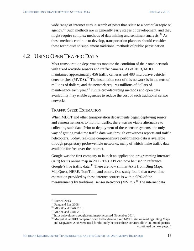
FIGURE 4: COMPARISON OF WEB-REPORTING OF FREEWAY CLOSURE ON HERE.COM, GOOGLE TRAFFIC,
AND WAZE.COM, MARCH 23, 2014
Cro
wd
sou
rcin
g i
n P
ract
ice:
Cro
wd
sou
rced
Tra
ffic
In
form
ati
on
THE INTERNET AS A SENSOR
MICHIGAN DEPARTMENT OF TRANSPORTATION AND THE CENTER FOR AUTOMOTIVE RESEARCH 16
Much of the value provided by contracted third-party data providers is the
data fusion, analysis, and information packaging necessary to turn raw data
into traffic information useful to a transportation agency. However, a
transportation agency could potentially develop the ability to perform these
tasks in-house.
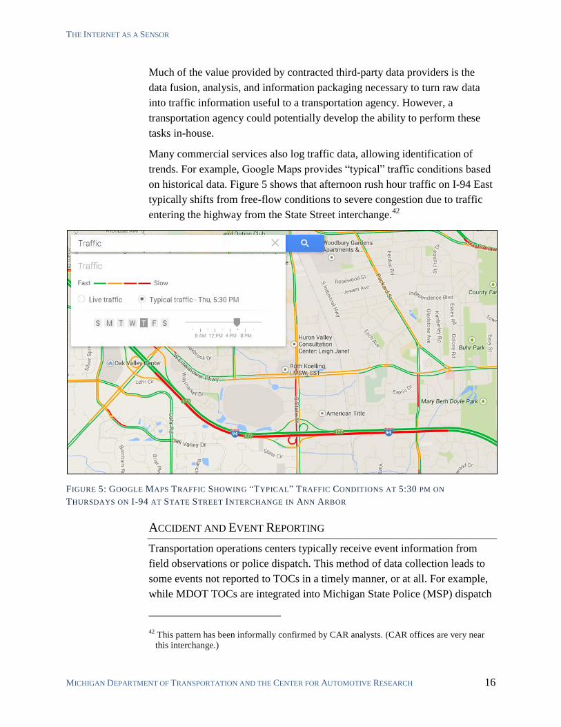
Many commercial services also log traffic data, allowing identification of
trends. For example, Google Maps provides “typical” traffic conditions based
on historical data. Figure 5 shows that afternoon rush hour traffic on I-94 East
typically shifts from free-flow conditions to severe congestion due to traffic
entering the highway from the State Street interchange.42
FIGURE 5: GOOGLE MAPS TRAFFIC SHOWING “TYPICAL” TRAFFIC CONDITIONS AT 5:30 PM ON
THURSDAYS ON I-94 AT STATE STREET INTERCHANGE IN ANN ARBOR
ACCIDENT AND EVENT REPORTING
Transportation operations centers typically receive event information from
field observations or police dispatch. This method of data collection leads to
some events not reported to TOCs in a timely manner, or at all. For example,
while MDOT TOCs are integrated into Michigan State Police (MSP) dispatch
42 This pattern has been informally confirmed by CAR analysts. (CAR offices are very near
this interchange.)
CROWDSOURCING TRANSPORTATION SYSTEMS DATA FEBRUARY 2015
MICHIGAN DEPARTMENT OF TRANSPORTATION AND THE CENTER FOR AUTOMOTIVE RESEARCH 17
programs, if local (i.e., county or municipal) police respond to an accident,
they might never report it to MDOT.
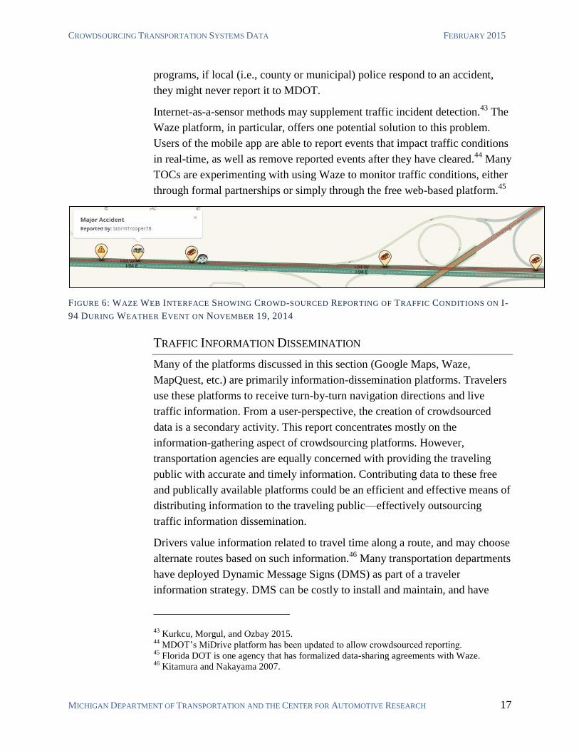
Internet-as-a-sensor methods may supplement traffic incident detection.43
The
Waze platform, in particular, offers one potential solution to this problem.
Users of the mobile app are able to report events that impact traffic conditions
in real-time, as well as remove reported events after they have cleared.44
Many
TOCs are experimenting with using Waze to monitor traffic conditions, either
through formal partnerships or simply through the free web-based platform.45
FIGURE 6: WAZE WEB INTERFACE SHOWING CROWD-SOURCED REPORTING OF TRAFFIC CONDITIONS ON I-
94 DURING WEATHER EVENT ON NOVEMBER 19, 2014
TRAFFIC INFORMATION DISSEMINATION
Many of the platforms discussed in this section (Google Maps, Waze,
MapQuest, etc.) are primarily information-dissemination platforms. Travelers
use these platforms to receive turn-by-turn navigation directions and live
traffic information. From a user-perspective, the creation of crowdsourced
data is a secondary activity. This report concentrates mostly on the
information-gathering aspect of crowdsourcing platforms. However,
transportation agencies are equally concerned with providing the traveling
public with accurate and timely information. Contributing data to these free
and publically available platforms could be an efficient and effective means of
distributing information to the traveling public—effectively outsourcing
traffic information dissemination.
Drivers value information related to travel time along a route, and may choose
alternate routes based on such information.46
Many transportation departments
have deployed Dynamic Message Signs (DMS) as part of a traveler
information strategy. DMS can be costly to install and maintain, and have
43 Kurkcu, Morgul, and Ozbay 2015.
44 MDOT’s MiDrive platform has been updated to allow crowdsourced reporting.
45 Florida DOT is one agency that has formalized data-sharing agreements with Waze.
46 Kitamura and Nakayama 2007.
THE INTERNET AS A SENSOR
MICHIGAN DEPARTMENT OF TRANSPORTATION AND THE CENTER FOR AUTOMOTIVE RESEARCH 18
many weaknesses as a strategy to convey useful information to travelers. For
example, given that DMS are placed at fixed locations, they may not be
placed as to provide actionable information for specific incidents. Some
drivers might not notice DMS or have their vision blocked by a large vehicle.
Finally, it is simply difficult to provide information that is relevant to all
system users, yet actionable for individuals. It is unclear how DMS impacts
traffic flow.47
Crowdsourcing in Practice
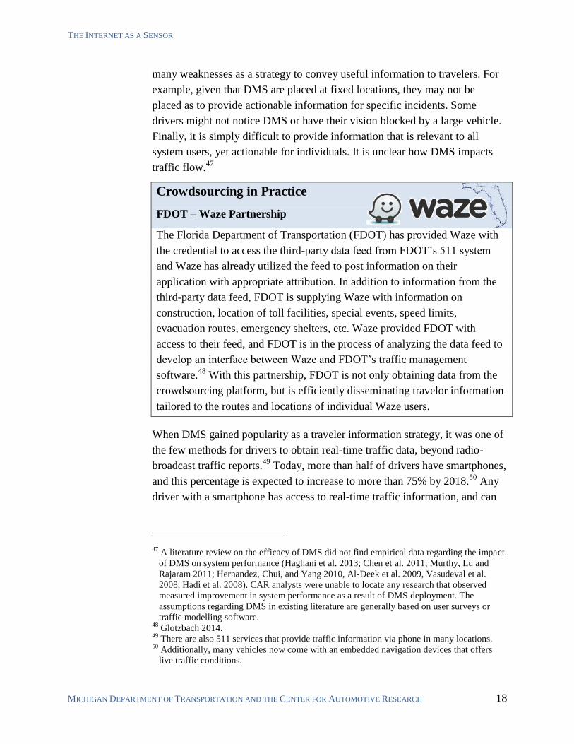
FDOT – Waze Partnership
The Florida Department of Transportation (FDOT) has provided Waze with
the credential to access the third-party data feed from FDOT’s 511 system
and Waze has already utilized the feed to post information on their
application with appropriate attribution. In addition to information from the
third-party data feed, FDOT is supplying Waze with information on
construction, location of toll facilities, special events, speed limits,
evacuation routes, emergency shelters, etc. Waze provided FDOT with
access to their feed, and FDOT is in the process of analyzing the data feed to
develop an interface between Waze and FDOT’s traffic management
software.48
With this partnership, FDOT is not only obtaining data from the
crowdsourcing platform, but is efficiently disseminating travelor information
tailored to the routes and locations of individual Waze users.
When DMS gained popularity as a traveler information strategy, it was one of
the few methods for drivers to obtain real-time traffic data, beyond radio-
broadcast traffic reports.49
Today, more than half of drivers have smartphones,
and this percentage is expected to increase to more than 75% by 2018.50
Any
driver with a smartphone has access to real-time traffic information, and can
47 A literature review on the efficacy of DMS did not find empirical data regarding the impact
of DMS on system performance (Haghani et al. 2013; Chen et al. 2011; Murthy, Lu and
Rajaram 2011; Hernandez, Chui, and Yang 2010, Al-Deek et al. 2009, Vasudeval et al.
2008, Hadi et al. 2008). CAR analysts were unable to locate any research that observed
measured improvement in system performance as a result of DMS deployment. The
assumptions regarding DMS in existing literature are generally based on user surveys or
traffic modelling software. 48
Glotzbach 2014. 49
There are also 511 services that provide traffic information via phone in many locations. 50
Additionally, many vehicles now come with an embedded navigation devices that offers
live traffic conditions.
CROWDSOURCING TRANSPORTATION SYSTEMS DATA FEBRUARY 2015
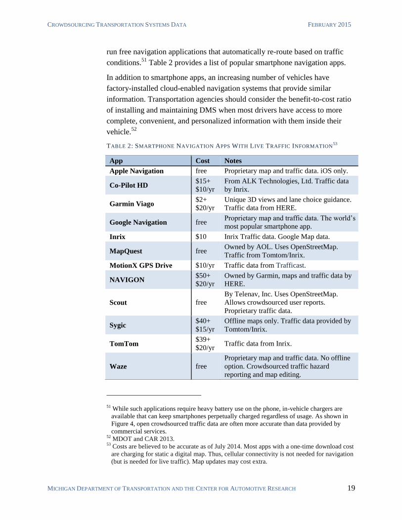
MICHIGAN DEPARTMENT OF TRANSPORTATION AND THE CENTER FOR AUTOMOTIVE RESEARCH 19
run free navigation applications that automatically re-route based on traffic
conditions.51
Table 2 provides a list of popular smartphone navigation apps.
In addition to smartphone apps, an increasing number of vehicles have
factory-installed cloud-enabled navigation systems that provide similar
information. Transportation agencies should consider the benefit-to-cost ratio
of installing and maintaining DMS when most drivers have access to more
complete, convenient, and personalized information with them inside their
vehicle.52
TABLE 2: SMARTPHONE NAVIGATION APPS WITH LIVE TRAFFIC INFORMATION53
51 While such applications require heavy battery use on the phone, in-vehicle chargers are
available that can keep smartphones perpetually charged regardless of usage. As shown in
Figure 4, open crowdsourced traffic data are often more accurate than data provided by
commercial services. 52
MDOT and CAR 2013. 53
Costs are believed to be accurate as of July 2014. Most apps with a one-time download cost
are charging for static a digital map. Thus, cellular connectivity is not needed for navigation
(but is needed for live traffic). Map updates may cost extra.
App Cost Notes
Apple Navigation free Proprietary map and traffic data. iOS only.
Co-Pilot HD $15+
$10/yr
From ALK Technologies, Ltd. Traffic data
by Inrix.
Garmin Viago $2+
$20/yr
Unique 3D views and lane choice guidance.
Traffic data from HERE.
Google Navigation free Proprietary map and traffic data. The world’s
most popular smartphone app.
Inrix $10 Inrix Traffic data. Google Map data.
MapQuest free Owned by AOL. Uses OpenStreetMap.
Traffic from Tomtom/Inrix.
MotionX GPS Drive $10/yr Traffic data from Trafficast.
NAVIGON $50+
$20/yr
Owned by Garmin, maps and traffic data by
HERE.
Scout free
By Telenav, Inc. Uses OpenStreetMap.
Allows crowdsourced user reports.
Proprietary traffic data.
Sygic $40+
$15/yr
Offline maps only. Traffic data provided by
Tomtom/Inrix.
TomTom $39+
$20/yr Traffic data from Inrix.
Waze free
Proprietary map and traffic data. No offline
option. Crowdsourced traffic hazard
reporting and map editing.
THE INTERNET AS A SENSOR
MICHIGAN DEPARTMENT OF TRANSPORTATION AND THE CENTER FOR AUTOMOTIVE RESEARCH 20
Crowdsourcing in Practice
Connected Navigation and Route Planning using Crowdsourced Traffic Data
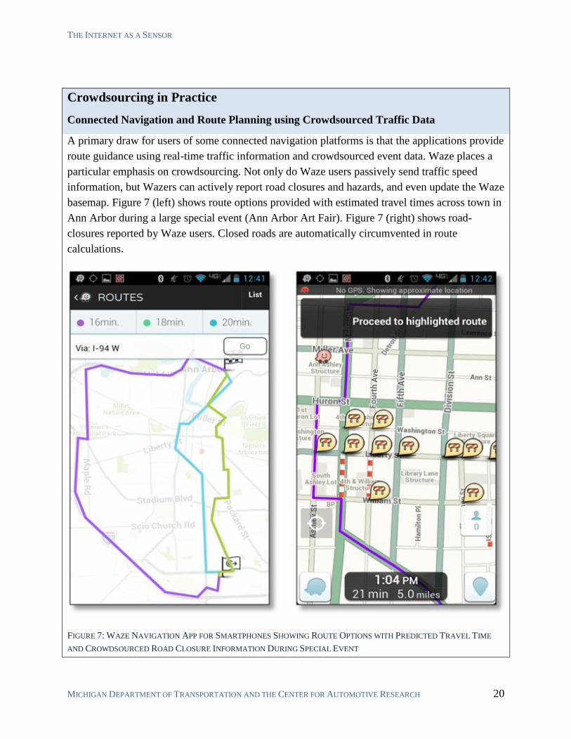
A primary draw for users of some connected navigation platforms is that the applications provide
route guidance using real-time traffic information and crowdsourced event data. Waze places a
particular emphasis on crowdsourcing. Not only do Waze users passively send traffic speed
information, but Wazers can actively report road closures and hazards, and even update the Waze
basemap. Figure 7 (left) shows route options provided with estimated travel times across town in
Ann Arbor during a large special event (Ann Arbor Art Fair). Figure 7 (right) shows road-
closures reported by Waze users. Closed roads are automatically circumvented in route
calculations.
FIGURE 7: WAZE NAVIGATION APP FOR SMARTPHONES SHOWING ROUTE OPTIONS WITH PREDICTED TRAVEL TIME
AND CROWDSOURCED ROAD CLOSURE INFORMATION DURING SPECIAL EVENT
CROWDSOURCING TRANSPORTATION SYSTEMS DATA FEBRUARY 2015
MICHIGAN DEPARTMENT OF TRANSPORTATION AND THE CENTER FOR AUTOMOTIVE RESEARCH 21
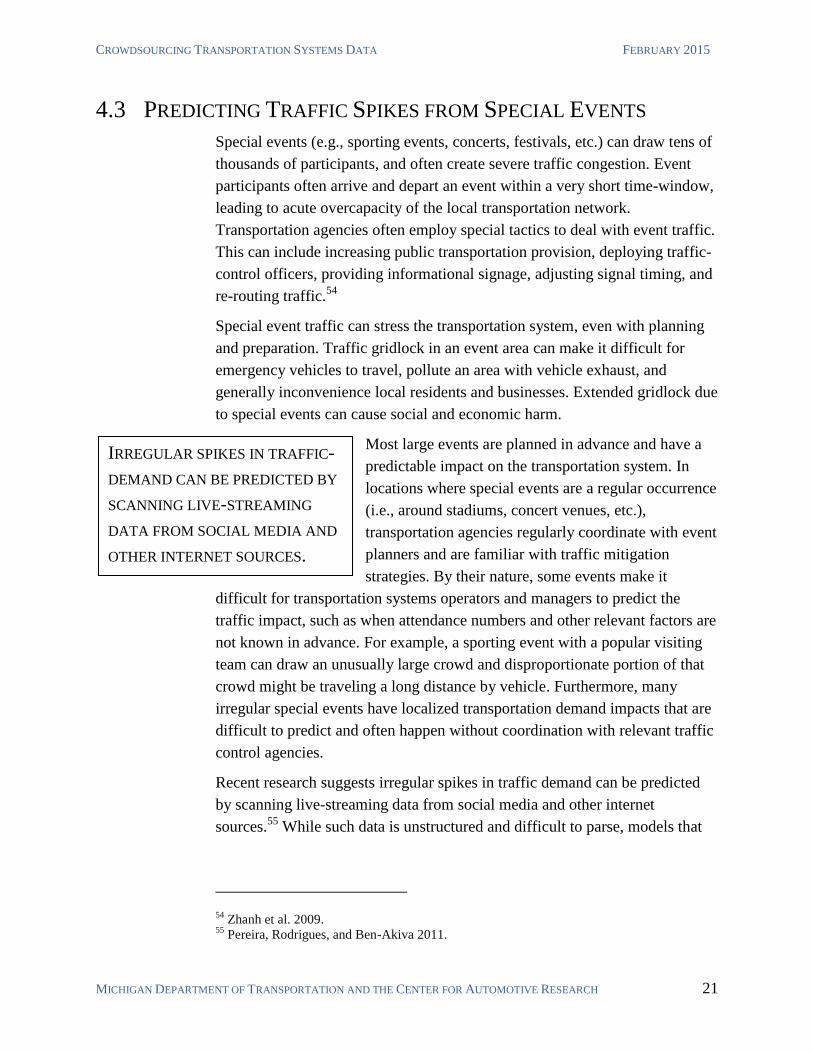
IRREGULAR SPIKES IN TRAFFIC-
DEMAND CAN BE PREDICTED BY
SCANNING LIVE-STREAMING
DATA FROM SOCIAL MEDIA AND
OTHER INTERNET SOURCES.
4.3 PREDICTING TRAFFIC SPIKES FROM SPECIAL EVENTS
Special events (e.g., sporting events, concerts, festivals, etc.) can draw tens of
thousands of participants, and often create severe traffic congestion. Event
participants often arrive and depart an event within a very short time-window,
leading to acute overcapacity of the local transportation network.
Transportation agencies often employ special tactics to deal with event traffic.
This can include increasing public transportation provision, deploying traffic-
control officers, providing informational signage, adjusting signal timing, and
re-routing traffic.54
Special event traffic can stress the transportation system, even with planning
and preparation. Traffic gridlock in an event area can make it difficult for
emergency vehicles to travel, pollute an area with vehicle exhaust, and
generally inconvenience local residents and businesses. Extended gridlock due
to special events can cause social and economic harm.
Most large events are planned in advance and have a
predictable impact on the transportation system. In
locations where special events are a regular occurrence
(i.e., around stadiums, concert venues, etc.),
transportation agencies regularly coordinate with event
planners and are familiar with traffic mitigation
strategies. By their nature, some events make it
difficult for transportation systems operators and managers to predict the
traffic impact, such as when attendance numbers and other relevant factors are
not known in advance. For example, a sporting event with a popular visiting
team can draw an unusually large crowd and disproportionate portion of that
crowd might be traveling a long distance by vehicle. Furthermore, many
irregular special events have localized transportation demand impacts that are
difficult to predict and often happen without coordination with relevant traffic
control agencies.
Recent research suggests irregular spikes in traffic demand can be predicted
by scanning live-streaming data from social media and other internet
sources.55
While such data is unstructured and difficult to parse, models that
54 Zhanh et al. 2009.
55 Pereira, Rodrigues, and Ben-Akiva 2011.
THE INTERNET AS A SENSOR
MICHIGAN DEPARTMENT OF TRANSPORTATION AND THE CENTER FOR AUTOMOTIVE RESEARCH 22
incorporate machine learning for prediction have successfully increased the
accuracy of traffic and transportation demand prediction models.56
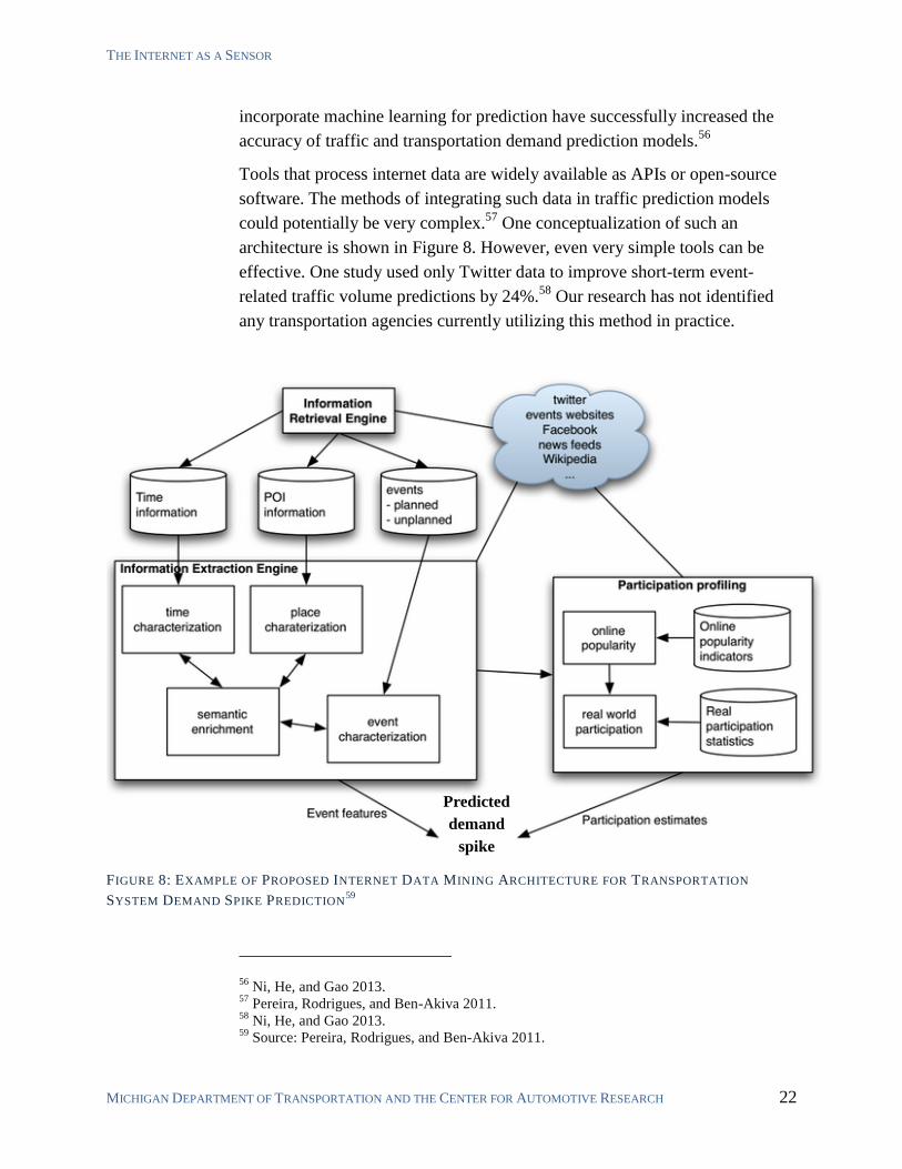
Tools that process internet data are widely available as APIs or open-source
software. The methods of integrating such data in traffic prediction models
could potentially be very complex.57
One conceptualization of such an
architecture is shown in Figure 8. However, even very simple tools can be
effective. One study used only Twitter data to improve short-term event-
related traffic volume predictions by 24%.58
Our research has not identified
any transportation agencies currently utilizing this method in practice.
FIGURE 8: EXAMPLE OF PROPOSED INTERNET DATA MINING ARCHITECTURE FOR TRANSPORTATION
SYSTEM DEMAND SPIKE PREDICTION59
56 Ni, He, and Gao 2013.
57 Pereira, Rodrigues, and Ben-Akiva 2011.
58 Ni, He, and Gao 2013.
59 Source: Pereira, Rodrigues, and Ben-Akiva 2011.
Predicted
demand
spike
CROWDSOURCING TRANSPORTATION SYSTEMS DATA FEBRUARY 2015
MICHIGAN DEPARTMENT OF TRANSPORTATION AND THE CENTER FOR AUTOMOTIVE RESEARCH 23
5 DEDICATED PLATFORMS FOR TRANSPORTATION
SYSTEM MANAGEMENT
Previous chapters have described ways in which data from existing platforms
may be re-purposed for management of the transportation system. This
chapter will discuss the potential to use dedicated crowdsourcing platforms,
where the data generated by the platform is created specifically for
transportation system management. These applications can utilize the phone’s
built-in GPS, accelerometers, camera, and other sensors to allow the agency to
collect a wide variety of information. The potential applications of
crowdsourcing will continue to diversify in the future as technology and
communications continue to improve. Dedicated crowdsourcing apps covered
in this chapter include:
Automated Vehicle Location for Public Transit
Pavement Condition Data Collection
Bicycle Travel and Infrastructure Data
Parking Management
Origin-Destination Studies
Environmental Data Collection
Planning and Project Prioritization
5.1 AUTOMATED VEHICLE LOCATION FOR PUBLIC TRANSIT
Transit agencies often install automated vehicle location (AVL) devices on
transit vehicles to assist in operations. Additionally, many agencies make
vehicle locations available to the public in real-time either through a dedicated
website, or publishing General Transit Feed Specifications (GTFS) in real-
time to application developers.60
While effective, AVL systems can be expensive and incur maintenance costs.
The popularity of transit apps like Google Transit, Moovit,61
and RideScout62
creates the possibility of utilizing the transit system users who use these apps
60 http://maps.google.com/help/maps/mapcontent/transit/live-updates.html accessed July
2014. 61
http://www.moovitapp.com/ accessed July 2014. 62
http://inthecapital.streetwise.co/2014/05/20/dc-tech-ridescout-launches-transit-app-chicago/
accessed July 2014.
DEDICATED PLATFORMS FOR TRANSPORTATION SYSTEMS MANAGEMENT
MICHIGAN DEPARTMENT OF TRANSPORTATION AND THE CENTER FOR AUTOMOTIVE RESEARCH 24
as vehicle location devices. If sufficient user participation can be obtained,
transit agencies could essentially outsource public transit vehicle tracking to
riders—with significant cost savings.63
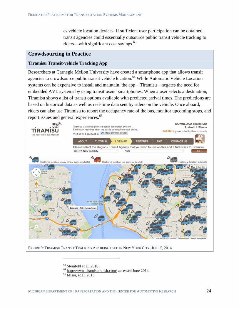
Crowdsourcing in Practice
Tiramisu Transit-vehicle Tracking App
Researchers at Carnegie Mellon University have created a smartphone app that allows transit
agencies to crowdsource public transit vehicle location.64
While Automatic Vehicle Location
systems can be expensive to install and maintain, the app—Tiramisu—negates the need for
embedded AVL systems by using transit users’ smartphones. When a user selects a destination,
Tiramisu shows a list of transit options available with predicted arrival times. The predictions are
based on historical data as well as real-time data sent by riders on the vehicle. Once aboard,
riders can also use Tiramisu to report the occupancy rate of the bus, monitor upcoming stops, and
report issues and general experiences.65
FIGURE 9: TIRAMISU TRANSIT TRACKING APP BEING USED IN NEW YORK CITY, JUNE 5, 2014
63 Steinfeld et al. 2010.
64 http://www.tiramisutransit.com/ accessed June 2014.
65 Misra, et al. 2013.
CROWDSOURCING TRANSPORTATION SYSTEMS DATA FEBRUARY 2015
MICHIGAN DEPARTMENT OF TRANSPORTATION AND THE CENTER FOR AUTOMOTIVE RESEARCH 25
5.2 PAVEMENT CONDITION DATA COLLECTION
Many transportation agencies, including MDOT, already crowdsource data on
potholes and road issues by allowing system users to report issues via phone
or web applications. But this method is not effective at providing a timely and
accurate system-wide perspective. Many research organizations and
transportation agencies are pursuing low-cost pavement condition
measurement using connected vehicles or devices. Sensors embedded in
smartphones have been shown capable of detecting potholes, rough pavement,
and low friction areas.66
MDOT has previously investigated the possibility of
using probe vehicles to obtain pavement condition data automatically.67
The
pursuit of this approach could allow MDOT to incorporate data from the
public. The main difficulty in this approach likely would be recruiting enough
drivers to use the app.68
Crowdsourcing in Practice
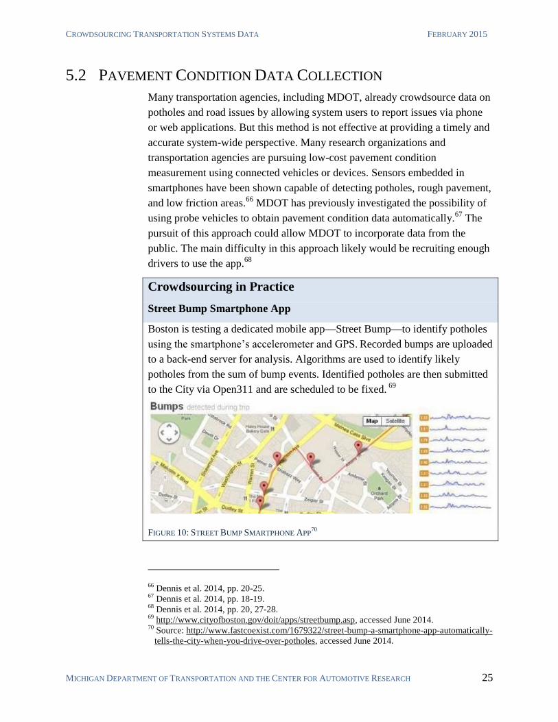
Street Bump Smartphone App
Boston is testing a dedicated mobile app—Street Bump—to identify potholes
using the smartphone’s accelerometer and GPS. Recorded bumps are uploaded
to a back-end server for analysis. Algorithms are used to identify likely
potholes from the sum of bump events. Identified potholes are then submitted
to the City via Open311 and are scheduled to be fixed. 69
FIGURE 10: STREET BUMP SMARTPHONE APP70
66 Dennis et al. 2014, pp. 20-25.
67 Dennis et al. 2014, pp. 18-19.
68 Dennis et al. 2014, pp. 20, 27-28.
69 http://www.cityofboston.gov/doit/apps/streetbump.asp, accessed June 2014.
70 Source: http://www.fastcoexist.com/1679322/street-bump-a-smartphone-app-automatically-
tells-the-city-when-you-drive-over-potholes, accessed June 2014.
DEDICATED PLATFORMS FOR TRANSPORTATION SYSTEMS MANAGEMENT
MICHIGAN DEPARTMENT OF TRANSPORTATION AND THE CENTER FOR AUTOMOTIVE RESEARCH 26
5.3 BICYCLE TRAVEL AND INFRASTRUCTURE DATA
Transportation planners have successfully used crowdsourcing as a method of
gathering data on the use and utilization of bike infrastructure. Cycle trips
make up a low percentage of overall trips and are difficult to capture with
traditional vehicle-counting devices. Municipalities that have developed
crowdsourced mobile applications to collect data on bicycle infrastructure use
include San Francisco, Minneapolis, Atlanta, and Austin.71
Crowdsourcing in Practice
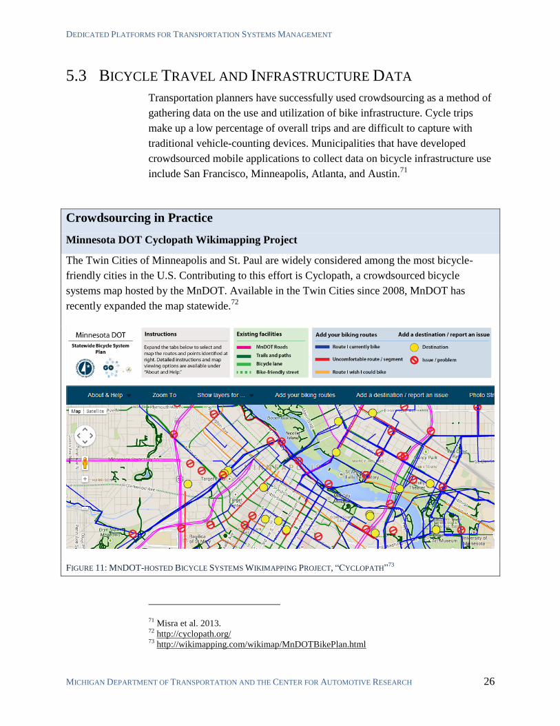
Minnesota DOT Cyclopath Wikimapping Project
The Twin Cities of Minneapolis and St. Paul are widely considered among the most bicycle-
friendly cities in the U.S. Contributing to this effort is Cyclopath, a crowdsourced bicycle
systems map hosted by the MnDOT. Available in the Twin Cities since 2008, MnDOT has
recently expanded the map statewide.72
FIGURE 11: MNDOT-HOSTED BICYCLE SYSTEMS WIKIMAPPING PROJECT, “CYCLOPATH”73
71 Misra et al. 2013.
72 http://cyclopath.org/
73 http://wikimapping.com/wikimap/MnDOTBikePlan.html
CROWDSOURCING TRANSPORTATION SYSTEMS DATA FEBRUARY 2015
MICHIGAN DEPARTMENT OF TRANSPORTATION AND THE CENTER FOR AUTOMOTIVE RESEARCH 27
A general strategy that has proven successful to collect bike trip data is to
deploy a simple smartphone application that allows cyclists to record bicycle
trip route, average speed, distance, and simple notes. Cyclists often voluntarily
use these apps to help improve local biking facilities. The applications are
often coupled with a dedicated web site that allows users to provide additional
notes and interact collaboratively with other users and planners.74
Some
projects do not include a mobile application but instead use a web-based
forum.75
While a web-based application might not include automated field-
data collection, it might attract the efforts of enough contributors to result in a
relatively comprehensive system map (Figure 11). Another resource is Google
Maps, which has a bicycle route layer and allows users to navigate with the
mobile app on a bicycle navigation setting that prefers these routes.76
5.4 PARKING MANAGEMENT
Finding available parking spots can be extremely difficult in many cities.
Recent research has uncovered serious negative externalities associated with
inefficiency in the parking process, such as increased congestion, noise, air
pollution, time delays, and safety hazards.77
It has been suggested that up to
30% of inner-city traffic congestion is caused by people looking for parking
spots.78
Some municipalities have experimented with deploying a network of sensors
to collect and report data on street-parking availability.79
A variety of
developers have attempted to address parking by developing apps that
facilitate the dissemination of parking availability information. Unfortunately,
crowdsourced parking information systems usually suffer low user
participation, likely due to a lack of incentive to report vacant spots.80
Developers are continuing to look for ways to crowdsource parking
availability by developing an incentive scheme that also complies with
municipal laws.81
74 Misra et. al 2013.
75 Krykewycz et al. 2010.
76 MnDOT’s Cyclopath (Figure 11) is built on top of the Google Maps bicycle map.
77 Brook, Ison, and Quddus 2013.
78 Shoup 2011.
79 http://sfpark.org/
80 Hoh et al. 2012.
81 One service, Monkey Parking, allows users to bid for information on a space being held by
the seller. Monkey Parking was forced to cease operations in San Francisco due to laws that
(continued on next page...)
DEDICATED PLATFORMS FOR TRANSPORTATION SYSTEMS MANAGEMENT
MICHIGAN DEPARTMENT OF TRANSPORTATION AND THE CENTER FOR AUTOMOTIVE RESEARCH 28
5.5 ORIGIN-DESTINATION STUDIES
As discussed in Section 2.2, many transportation agencies purchase
aggregated travel data from cellular service providers to supplement or replace
citizen surveys and journals to obtain origin-destination travel data. Another
option is to recruit citizen volunteers to download a dedicated smartphone app
to automatically obtain data. Using various embedded sensors on the
smartphone could also deduce travel mode and additional factors of interest.82
5.6 ENVIRONMENTAL DATA COLLECTION
The U.S. Environmental Protection Agency (EPA) and state/local
governments continue to make National Pollutant Discharge Elimination
System (NPDES) requirements more stringent. Agencies need more
information on how their system functions (from inlets, ditches, outfalls and
stormwater devices). As these stormwater devices and features can be
extensive, data collection and inspections are expensive to perform and
maintain. A number of municipalities have developed customized internet and
smart device-based data collection tools.83
It may be beneficial to expand the
functionality of smartphone-based reporting by allowing for input from the
public. Other research programs have concentrated on developing systems to
crowdsource air quality measurements, a process that can be done passively
by volunteers who carry a small pollution-detection device.84
5.7 PLANNING AND PROJECT PRIORITIZATION
Several transportation agencies have begun using internet and mobile
communications platforms to solicit and facilitate public engagement for
transportation planning and project prioritization. Using social media can be
more effective if planners impose methods of keeping discussions focused and
structured. They can do this by deploying purpose-built platforms managed by
the planning team. Introducing opportunity cost for participation—such as a
brief registration step—can help to eliminate thoughtless and unhelpful
(...continued from previous page)
ban the private sale or rental of public parking spaces. http://spectrum.ieee.org/view-from-
the-valley/at-work/start-ups/drawing-the-line-between-peertopeer-and-jerk-technology 82
Abdulazim, et al. 2011; Safi et al. 2015. 83
For example, http://www.esri.com/esri-news/arcnews/summer13articles/idaho-
transportation-department-connects-field-crews-with-arcgis-online 84
http://www.wired.com/2014/11/clarity-wearable/ accessed November 2014.
CROWDSOURCING TRANSPORTATION SYSTEMS DATA FEBRUARY 2015
MICHIGAN DEPARTMENT OF TRANSPORTATION AND THE CENTER FOR AUTOMOTIVE RESEARCH 29
comments. The registration process may also help prioritize target
constituencies. If personal attacks are a potential problem, planners can
consider prohibiting anonymous contributions. Planners also have the option
of moderating discussions and removing abusive posts.
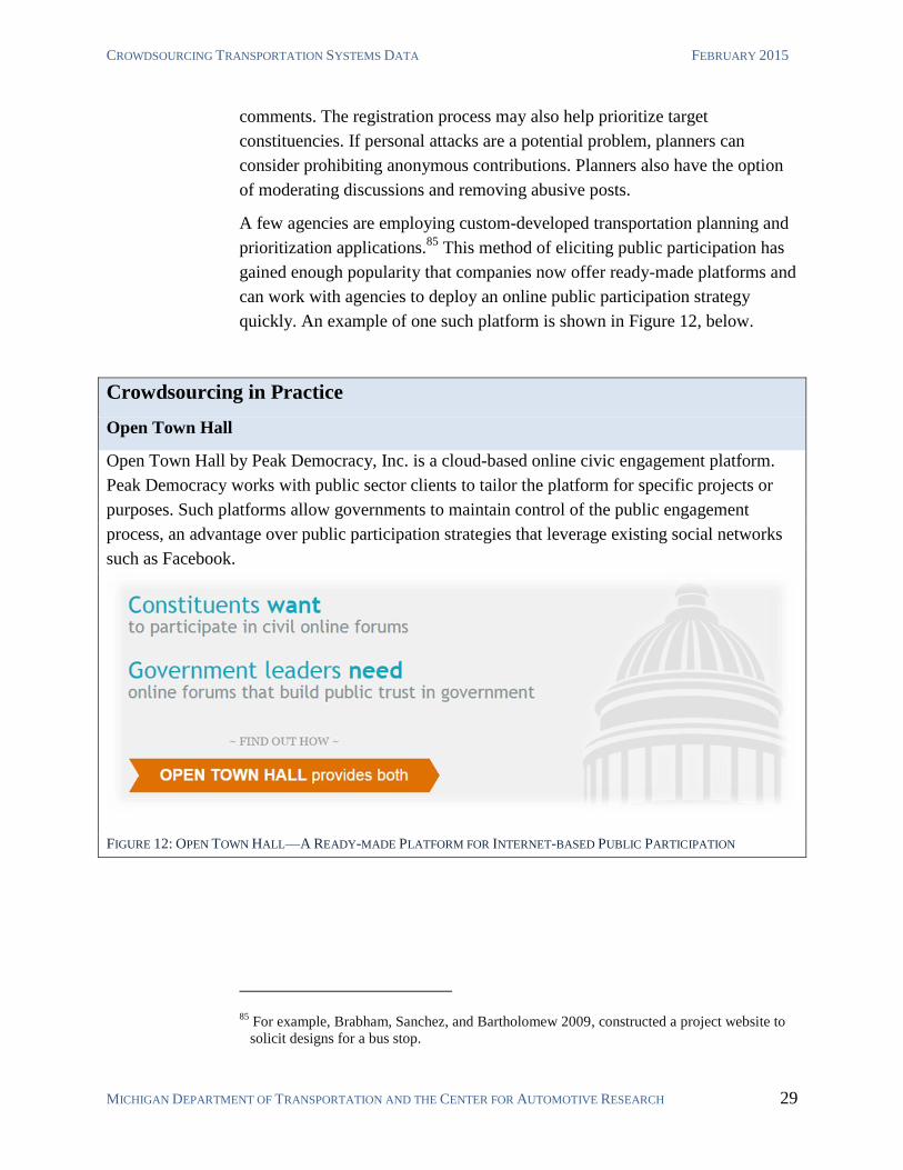
A few agencies are employing custom-developed transportation planning and
prioritization applications.85
This method of eliciting public participation has
gained enough popularity that companies now offer ready-made platforms and
can work with agencies to deploy an online public participation strategy
quickly. An example of one such platform is shown in Figure 12, below.
Crowdsourcing in Practice
Open Town Hall
Open Town Hall by Peak Democracy, Inc. is a cloud-based online civic engagement platform.
Peak Democracy works with public sector clients to tailor the platform for specific projects or
purposes. Such platforms allow governments to maintain control of the public engagement
process, an advantage over public participation strategies that leverage existing social networks
such as Facebook.
FIGURE 12: OPEN TOWN HALL—A READY-MADE PLATFORM FOR INTERNET-BASED PUBLIC PARTICIPATION
85 For example, Brabham, Sanchez, and Bartholomew 2009, constructed a project website to
solicit designs for a bus stop.
INTEGRATING CROWDSOURCED DATA INTO EXISTING AGENCY PRACTICES
MICHIGAN DEPARTMENT OF TRANSPORTATION AND THE CENTER FOR AUTOMOTIVE RESEARCH 30
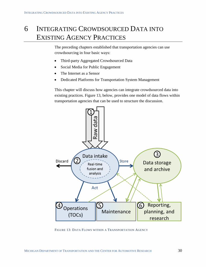
6 INTEGRATING CROWDSOURCED DATA INTO
EXISTING AGENCY PRACTICES
The preceding chapters established that transportation agencies can use
crowdsourcing in four basic ways:
Third-party Aggregated Crowdsourced Data
Social Media for Public Engagement
The Internet as a Sensor
Dedicated Platforms for Transportation System Management
This chapter will discuss how agencies can integrate crowdsourced data into
existing practices. Figure 13, below, provides one model of data flows within
transportation agencies that can be used to structure the discussion.
FIGURE 13: DATA FLOWS WITHIN A TRANSPORTATION AGENCY
CROWDSOURCING TRANSPORTATION SYSTEMS DATA FEBRUARY 2015
MICHIGAN DEPARTMENT OF TRANSPORTATION AND THE CENTER FOR AUTOMOTIVE RESEARCH 31
6.1 OBTAINING RAW DATA
Component 1 of Figure 13 represents the entirety of data that a transportation
agency monitors or collects. These raw data streams include any
crowdsourced data, as well as traditional data such as sensor readings,
inspection reports, construction documents, etc. Data used by transportation
agencies can be obtained in a practically unlimited number of formats. Some
crowdsourced data sets are pre-aggregated and structured, such as the traffic
speed and travel time data provided to MDOT by HERE. Crowdsourced data
also can be largely unstructured, such as posts to social media sites like
Twitter and Facebook. Additionally, data may be structured, but in such a way
that is not convenient for agency use.86
The nature and structure of incoming
data impacts how the agency processes the data internally.
6.2 DATA INTAKE PROCESS
At the point when raw data is obtained by an agency, the agency necessarily
takes some immediate action in response to receiving the data. Component 2
of Figure 13 is represented abstractly as a singular data-intake process through
which all agency data must pass. However, in real-world systems, raw data is
obtained in a range of formats and structures that require a range of
overlapping unique data-intake processes. Data can be structured, semi-
structured, or unstructured, and might not even be digital.87
Upon receipt of raw data, agencies can respond in four fundamental ways:
Ignore and discard data
Act on data in real-time
Store data
Real-time data fusion and analysis (followed by one or more previous
options)
86 An example such ‘semi-structured’ data is crowdsourced incident information reported via
the Waze app. While there is a data structure to Waze incident reports, agencies must
actively monitor the Waze cite and manually respond in order to use the information in
some way (unless the agency has a partnership with Waze that allows access to backend
data). 87
Examples of non-digital data include inspection notes, printed reports, construction
drawings, etc. Data also can arrive verbally (e.g., a notice provided by law enforcement
officials).
INTEGRATING CROWDSOURCED DATA INTO EXISTING AGENCY PRACTICES
MICHIGAN DEPARTMENT OF TRANSPORTATION AND THE CENTER FOR AUTOMOTIVE RESEARCH 32
Agencies may choose to ignore and discard raw data that are not particularly
beneficial. For example, many transportation agencies receive a constant
stream of traffic speed information. If the data reveals no problems that
require attention by operations or maintenance divisions, then the data may be
discarded without being acted upon.88
Some data has value without being actionable in real-time. Examples include
inspection records, field-notes, construction drawings, etc. Such data is often
stored and archived for later use. A record of actions taken by TOCs and any
measurable results can also be stored for later analysis to evaluate TOC
efficacy.
REAL-TIME DATA FUSION AND ANALYSIS
Many transportation agencies are investigating ways to improve performance
and tracking by using real-time data fusion and analysis. For example, one can
imagine a data intake process that simultaneously monitors individual data
sources (e.g., traffic speed sensor data, environmental sensor station data,
National Weather Service forecasts, etc.) and identifies potential congestion
events before they occur by analyzing the relationships between these data
and comparing real-time conditions to historical congestion events. Such an
analytical engine could allow operations and maintenance crews to deploy
mitigation tactics significantly earlier than if individual data streams are
monitored without additional analysis. Such real-time data fusion and analysis
essentially creates new data, in a new format, which the agency was unable to
obtain directly from raw data feeds.89
The new data generated by real-time data fusion and analysis during the data
intake process would then be subject to the same possible fates as previously
discussed. If the new data have no value, then they might be discarded
immediately. If the data have value in real-time, then they probably will be
acted upon by TOCs or maintenance crews or both. If the data can provide
value later, then they likely will be stored and archived.
88 Alternately, DOTs may archive this data for reporting, planning, research, and related uses.
MDOT does not need to archive live traffic data because it receives historical traffic speed
data reports from HERE, separately from real-time data. 89
Beggs 2014.
CROWDSOURCING TRANSPORTATION SYSTEMS DATA FEBRUARY 2015
MICHIGAN DEPARTMENT OF TRANSPORTATION AND THE CENTER FOR AUTOMOTIVE RESEARCH 33
6.3 DATA STORAGE AND ARCHIVING
For the sake of simplicity, Figure 13 represents component 3 as a single
storage and archive process. As with the data intake process, the reality is
much more complicated. Transportation agencies often store and archive
numerous types of data in numerous formats. Some archival data follow
legacy formats, and some might not even be digital.90
Additionally, Figure 13 oversimplifies the relationship between storage and
archival by including any data that is not used in real-time. This is a useful
abstraction when focusing on the potential uses of crowdsourcing. However,
in practice, data storage and archiving are distinct concepts and require
distinct approaches.91
Put simply, data storage refers to data that is being
actively used, or can be manipulated in the near or medium term. Data
archiving describes sending data to a ‘final resting place,’ but in such a format
that it can be referenced and brought into active use when necessary.
MDOT’s data architecture is likely to be updated in the near future as a result
of ongoing efforts like the Data Use Analysis and Processing (DUAP) system,
a Transportation Asset Management System (TAMS) proposal,92
and a
statewide Data Modernization, Assurance, and Governance (DMAG) project.
These various efforts are being implemented to allow MDOT and other State
of Michigan agencies to make better and more efficient use of all types of
data, including crowdsourced data.
As data storage and archiving schemes are developed, MDOT and the State of
Michigan should explore adaptive and scalable solutions offered by cloud
service providers as a replacement for, or compliment to, internally-hosted
custom-developed or commercial-off-the-shelf (COTS) platforms. Cloud-
based asset management platforms are now mature, customizable, price-
competitive, and a good way to prepare for uncertainties in the future
developments of asset management programs.
90 E.g., physical (paper) files.
91 A more complete discussion of data use would require the additional concept of data
backup in addition to storage and archival. 92
Formerly known as the Enterprise Asset Management System (EAMS) Solution. This
project was released for bids in 2014. It is not known to have been awarded as of Nov 11,
2014.
INTEGRATING CROWDSOURCED DATA INTO EXISTING AGENCY PRACTICES
MICHIGAN DEPARTMENT OF TRANSPORTATION AND THE CENTER FOR AUTOMOTIVE RESEARCH 34
6.4 TRANSPORTATION OPERATIONS CENTERS
MDOT and local TOCs currently utilize various types of data to improve the
performance of the transportation system. A summary of data types currently
monitored and collected by Michigan TOCs is given in Table 3. TOCs value
data that can be acted on in real time. Currently (with the exception of
adjusting travel time signs) the task of monitoring pertinent data and acting on
it remains largely manual. TOCs receive important information via email,
radio communications, phone calls, or even personal conversations.93
Actions
could include adjusting DMS messages, deploying police or agency
personnel, and disseminating information (e.g., through email listservs,
MiDrive, Twitter, Waze, etc.). Local TOCs also might respond to traffic
conditions by adjusting signal timing. In the near/mid-term, human operators
will likely continue to be a bridge between any incoming data and the
subsequent response. As such, the format of any data is not particularly
important, as long as it reaches the right people with minimal delay.
Additionally, while TOCs often report that all information could be valuable,
this labor-intensive process of interpreting data and deciding how to act on it
means that TOCs could be susceptible to information overload. Future
transportation management systems (TMS) and TOCs may become much
more automated. If transportation agencies wish to incorporate crowdsourced
data into an automated TMS, the TMS architecture will have to accommodate
whatever data formats are to be used.
Figure 13 shows that real time data flows into TOCs, but also shows a data
flow from TOCs to a data storage and archive process. This data flow
represents any information retained by agency as a result of TOC operations.
Such data is most often used for reporting and activity tracking, but can also
be used to evaluate and improve TOC operations. For example, TOCs might
record congestion locations and agency responses to evaluate the efficacy of
different response strategies.
93 Personal information sharing is particularly evident at RDMC TOC and SEMTOC, as both
TOCs have strategically created shared space for traffic operators and police dispatch.
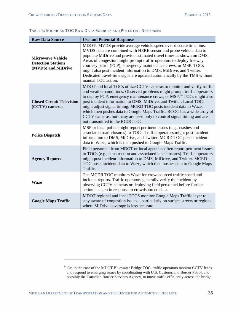
CROWDSOURCING TRANSPORTATION SYSTEMS DATA FEBRUARY 2015
MICHIGAN DEPARTMENT OF TRANSPORTATION AND THE CENTER FOR AUTOMOTIVE RESEARCH 35
94 Or, in the case of the MDOT Bluewater Bridge TOC, traffic operators monitor CCTV feeds
and respond to emerging issues by coordinating with U.S. Customs and Border Patrol, and
possibly the Canadian Border Services Agency, to move traffic efficiently across the bridge.
TABLE 3: MICHIGAN TOC RAW DATA SOURCES AND POTENTIAL RESPONSES
Raw Data Source Use and Potential Response
Microwave Vehicle
Detection Stations
(MVDS) and MiDrive
MDOTs MVDS provide average vehicle speed over discrete time bins.
MVDS data are combined with HERE sensor and probe vehicle data to
populate MiDrive and provide estimated travel times as shown on DMS.
Areas of congestion might prompt traffic operators to deploy freeway
courtesy patrol (FCP), emergency maintenance crews, or MSP. TOCs
might also post incident information to DMS, MiDrive, and Twitter.
Dedicated travel-time signs are updated automatically by the TMS without
manual TOC action.
Closed Circuit Television
(CCTV) cameras
MDOT and local TOCs utilize CCTV cameras to monitor and verify traffic
and weather conditions. Observed problems might prompt traffic operators
to deploy FCP, emergency maintenance crews, or MSP.94
TOCs might also
post incident information to DMS, MiDrive, and Twitter. Local TOCs
might adjust signal timing. MCRD TOC posts incident data to Waze,
which then pushes data to Google Maps Traffic. RCOC has a wide array of
CCTV cameras, but many are used only to control signal timing and are
not transmitted to the RCOC TOC.
Police Dispatch
MSP or local police might report pertinent issues (e.g., crashes and
associated road-closures) to TOCs. Traffic operators might post incident
information to DMS, MiDrive, and Twitter. MCRD TOC posts incident
data to Waze, which is then pushed to Google Maps Traffic.
Agency Reports
Field personnel from MDOT or local agencies often report pertinent issues
to TOCs (e.g., construction and associated lane closures). Traffic operators
might post incident information to DMS, MiDrive, and Twitter. MCRD
TOC posts incident data to Waze, which then pushes data to Google Maps
Traffic.
Waze
The MCDR TOC monitors Waze for crowdsourced traffic speed and
incident reports. Traffic operators generally verify the incident by
observing CCTV cameras or deploying field personnel before further
action is taken in response to crowdsourced data.
Google Maps Traffic
MDOT regional and local TOCS monitor Google Maps Traffic layer to
stay aware of congestion issues—particularly on surface streets or regions
where MiDrive coverage is less accurate.
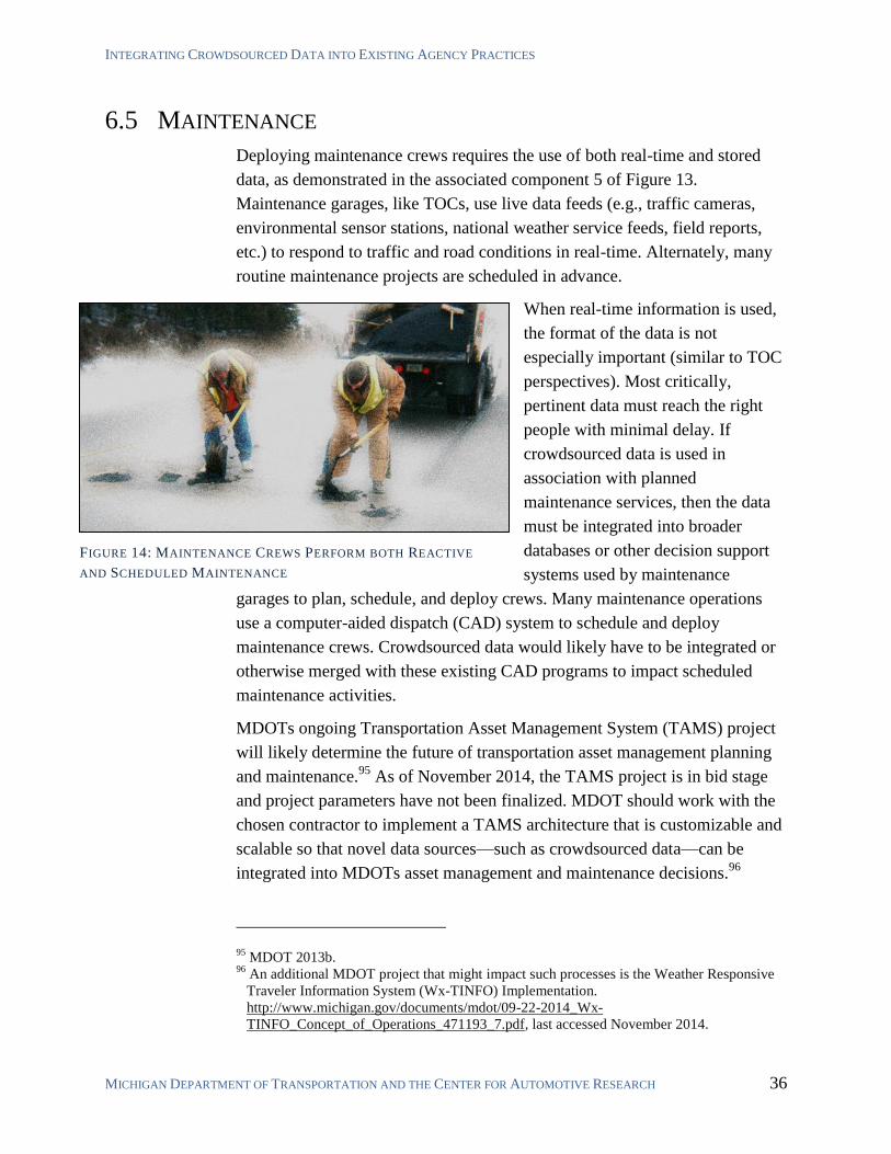
INTEGRATING CROWDSOURCED DATA INTO EXISTING AGENCY PRACTICES
MICHIGAN DEPARTMENT OF TRANSPORTATION AND THE CENTER FOR AUTOMOTIVE RESEARCH 36
6.5 MAINTENANCE
Deploying maintenance crews requires the use of both real-time and stored
data, as demonstrated in the associated component 5 of Figure 13.
Maintenance garages, like TOCs, use live data feeds (e.g., traffic cameras,
environmental sensor stations, national weather service feeds, field reports,
etc.) to respond to traffic and road conditions in real-time. Alternately, many
routine maintenance projects are scheduled in advance.
When real-time information is used,
the format of the data is not
especially important (similar to TOC
perspectives). Most critically,
pertinent data must reach the right
people with minimal delay. If
crowdsourced data is used in
association with planned
maintenance services, then the data
must be integrated into broader
databases or other decision support
systems used by maintenance
garages to plan, schedule, and deploy crews. Many maintenance operations
use a computer-aided dispatch (CAD) system to schedule and deploy
maintenance crews. Crowdsourced data would likely have to be integrated or
otherwise merged with these existing CAD programs to impact scheduled
maintenance activities.
MDOTs ongoing Transportation Asset Management System (TAMS) project
will likely determine the future of transportation asset management planning
and maintenance.95
As of November 2014, the TAMS project is in bid stage
and project parameters have not been finalized. MDOT should work with the
chosen contractor to implement a TAMS architecture that is customizable and
scalable so that novel data sources—such as crowdsourced data—can be
integrated into MDOTs asset management and maintenance decisions.96
95 MDOT 2013b.
96 An additional MDOT project that might impact such processes is the Weather Responsive
Traveler Information System (Wx-TINFO) Implementation.
http://www.michigan.gov/documents/mdot/09-22-2014_Wx-
TINFO_Concept_of_Operations_471193_7.pdf, last accessed November 2014.
FIGURE 14: MAINTENANCE CREWS PERFORM BOTH REACTIVE
AND SCHEDULED MAINTENANCE
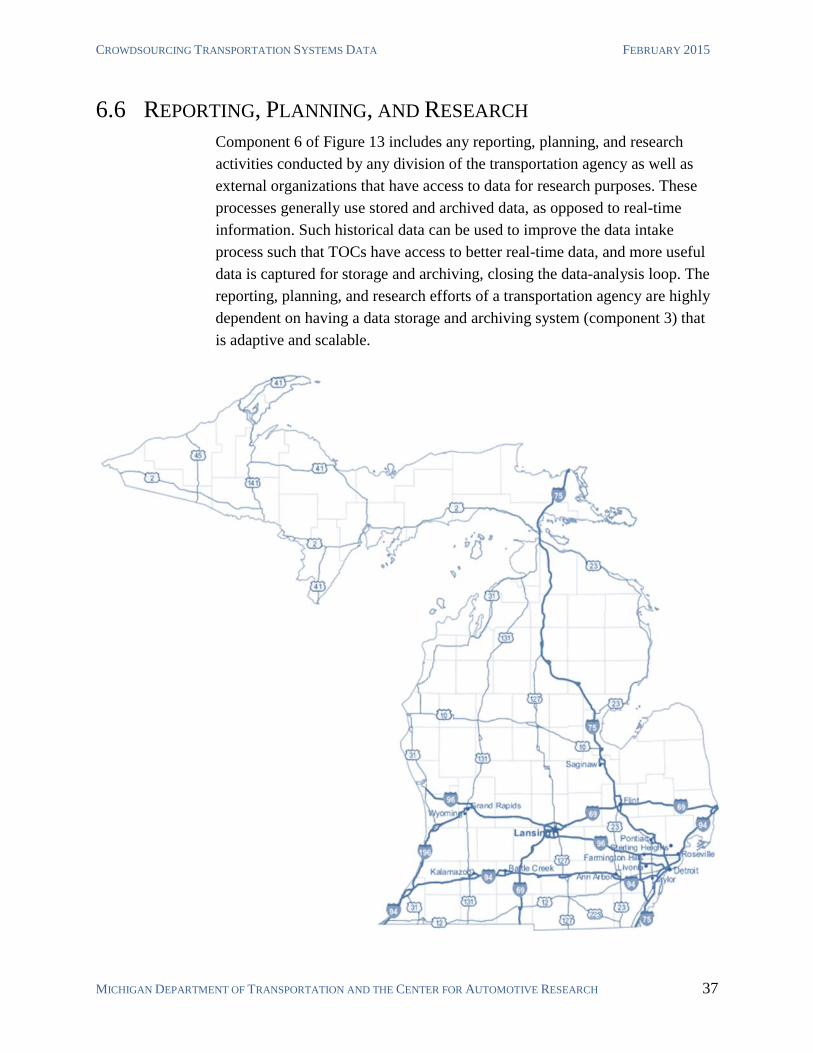
CROWDSOURCING TRANSPORTATION SYSTEMS DATA FEBRUARY 2015
MICHIGAN DEPARTMENT OF TRANSPORTATION AND THE CENTER FOR AUTOMOTIVE RESEARCH 37
6.6 REPORTING, PLANNING, AND RESEARCH
Component 6 of Figure 13 includes any reporting, planning, and research
activities conducted by any division of the transportation agency as well as
external organizations that have access to data for research purposes. These
processes generally use stored and archived data, as opposed to real-time
information. Such historical data can be used to improve the data intake
process such that TOCs have access to better real-time data, and more useful
data is captured for storage and archiving, closing the data-analysis loop. The
reporting, planning, and research efforts of a transportation agency are highly
dependent on having a data storage and archiving system (component 3) that
is adaptive and scalable.
SUMMARY AND CONCLUSIONS
MICHIGAN DEPARTMENT OF TRANSPORTATION AND THE CENTER FOR AUTOMOTIVE RESEARCH 38
7 SUMMARY AND CONCLUSIONS
Crowdsourcing involves leveraging the combined intelligence, knowledge, or
experience of a group of people to answer a question, solve a problem, or
manage a process. Crowdsourcing has the potential to address a growing
range of problems due to the broad adoption of internet-connected devices,
especially smartphones. Leveraging this network of connected devices for
transportation system management is an important opportunity.
THIRD-PARTY AGGREGATED CROWDSOURCED DATA
Many transportation agencies already use crowdsourced data through
contracted commercial providers. Commercial providers offer clearly defined
products and services, as well as customer support and professional expertise.
Such arrangements allow agencies access to proprietary data that would
otherwise be difficult to obtain, and allow them to avoid tedious data cleaning
and management tasks. Agencies can avoid dealing with sensitive personally
identifiable information by receiving only aggregated data from providers.
Transportation agencies have already established practices of purchasing
aggregated third-party data for live and historical traffic data, as well as
origin-destination studies. Purchasing additional types of third-party data is a
future possibility.
SOCIAL MEDIA FOR PUBLIC ENGAGEMENT
Americans spend more time using social networks than any other online
activity. The communication potential of these sites represents extensive
possibilities for improving the planning, management, and operations of the
transportation system. Social media outlets such as Twitter can be extremely
useful for communicating system status during special events and disruptions.
Agencies can simultaneously disseminate information, gather additional
information from system users, and take advantage of instantaneous
unmediated information sharing on the platform.
The raw number of people a transportation agency could potentially reach
through existing social media platforms is substantial. Additionally, the
increasing popularity of platforms such as Facebook allow for broad
demographic representation. Some planners have successfully experimented
with engaging constituencies via these popular platforms to supplement and
support traditional public participation. Using social media might be more
effective if planners impose methods of keeping discussions focused and
CROWDSOURCING TRANSPORTATION SYSTEMS DATA FEBRUARY 2015
MICHIGAN DEPARTMENT OF TRANSPORTATION AND THE CENTER FOR AUTOMOTIVE RESEARCH 39
structured. This can be done by deploying purpose-built platforms managed
by the planning team. This method of eliciting public participation has gained
enough popularity that companies now offer ready-made platforms and can
work with agencies to quickly deploy an online public participation strategy.
THE INTERNET AS A SENSOR
The continued increase of connected people and devices can provide agencies
access to completely new types of data. Recent research in transportation
demand modeling has investigated the concept of using the internet itself as a
virtual sensor capable of providing valuable, actionable data. Internet-as-a-
sensor applications are just beginning to be adopted in select industries. These
applications utilize developing approaches to data science such as data-mining
and machine learning. Early-adopting agencies have the opportunity to utilize
internet-as-a-sensor methods to develop innovative solutions to transportation
systems management.
Traditional public participation methods (e.g., community meetings) often
result in low community involvement and over representation of special
interests. Many of these people, while not easily reachable by planning
agencies, are active on social media, and some of them even discuss
transportation-related issues in these forums. Extracting public sentiment
information from open internet resources is an extensively studied topic. As
these methods continue to develop, transportation planners should consider
using such techniques to supplement traditional methods of acquiring public
participation data. Many of these platforms can also be used as a tool for
information dissemination and as a source of data.
Drivers have already come to rely on free traffic data access over the internet
and mobile apps. Recent work has investigated the possibility of using such
data to supplement or supplant traditional traffic sensor networks. Using the
internet as a virtual sensor to measure network travel time, researchers have
shown that open traffic data can be used to obtain network traffic speed
estimations that are equal or better to traditional sensor networks.
Some researchers have investigated the potential to use the internet as a sensor
to predict the impact that special events, such as festivals and sporting events,
have on the transportation system. Such research has revealed that irregular
spikes in traffic demand can be predicted by scanning live-streaming data
from social media and other internet sources.
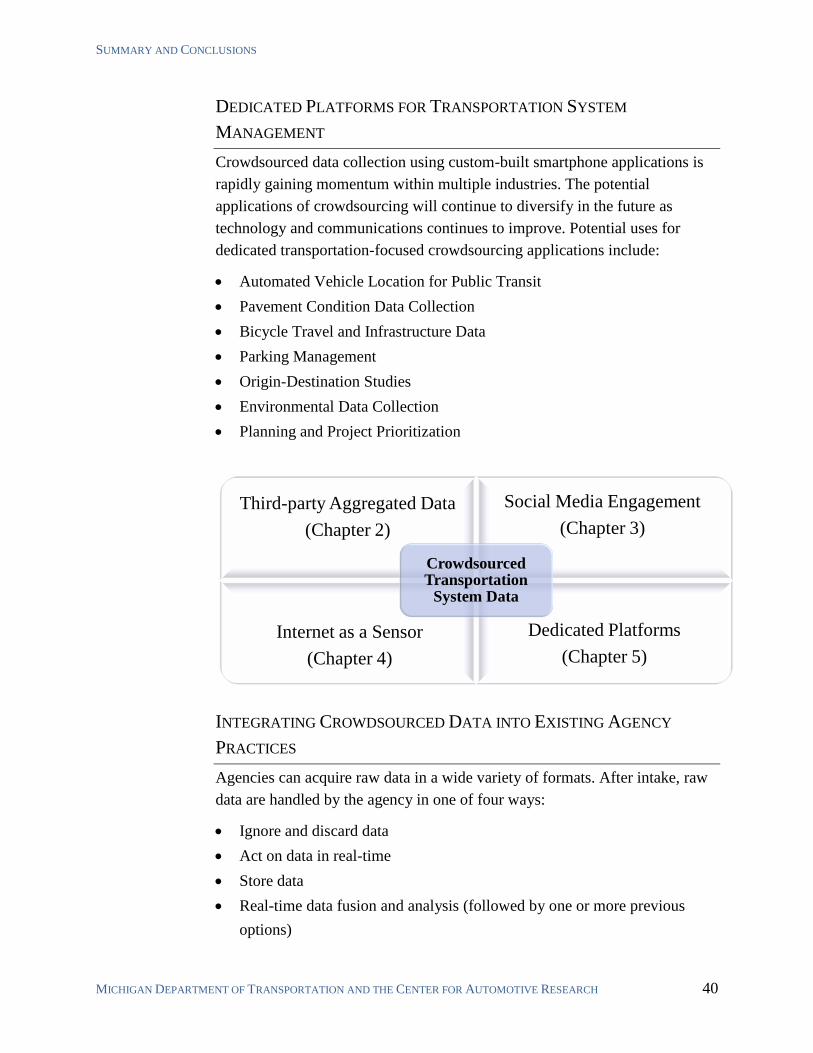
SUMMARY AND CONCLUSIONS
MICHIGAN DEPARTMENT OF TRANSPORTATION AND THE CENTER FOR AUTOMOTIVE RESEARCH 40
DEDICATED PLATFORMS FOR TRANSPORTATION SYSTEM
MANAGEMENT
Crowdsourced data collection using custom-built smartphone applications is
rapidly gaining momentum within multiple industries. The potential
applications of crowdsourcing will continue to diversify in the future as
technology and communications continues to improve. Potential uses for
dedicated transportation-focused crowdsourcing applications include:
Automated Vehicle Location for Public Transit
Pavement Condition Data Collection
Bicycle Travel and Infrastructure Data
Parking Management
Origin-Destination Studies
Environmental Data Collection
Planning and Project Prioritization
INTEGRATING CROWDSOURCED DATA INTO EXISTING AGENCY
PRACTICES
Agencies can acquire raw data in a wide variety of formats. After intake, raw
data are handled by the agency in one of four ways:
Ignore and discard data
Act on data in real-time
Store data
Real-time data fusion and analysis (followed by one or more previous
options)
Third-party Aggregated Data
(Chapter 2)
Social Media Engagement
(Chapter 3)
Internet as a Sensor
(Chapter 4)
Dedicated Platforms
(Chapter 5)
Crowdsourced Transportation
System Data
CROWDSOURCING TRANSPORTATION SYSTEMS DATA FEBRUARY 2015
MICHIGAN DEPARTMENT OF TRANSPORTATION AND THE CENTER FOR AUTOMOTIVE RESEARCH 41
Agencies can develop various tools for real-time data fusion and analysis to
improve operations, maintenance, planning, and research processes. Such
techniques create new data that was not otherwise available to the agency in
raw form. Upon real-time creation of this new data, the intake process cycles
back and a decision must then be made to ignore and discard the data, act on it
in real-time, or store it for later use.
Any data that is retained is subject to data storage and archival processes.
These data are used for reporting, scheduling, planning, and research. The
data storage and archival process should be adaptable and scalable to facilitate
access and use for stored data, including data in non-traditional formats such
as crowdsourced data.97
Reactive traffic management strategies are usually implemented by traffic
operations centers (TOCs) and maintenance crews. TOCs value data that are
actionable in real-time. Most TOCs utilize proven and well-established
methods of collecting real-time data for their purposes. For example, MDOTs
TOCs are highly dependent on police dispatch reports, highway monitoring
cameras, and average traffic speeds provided by contract.98
TOCs have a
range of options in which to respond to traffic condition. These include
adjusting roadside dynamic message signs, alerting police or emergency
services, and alerting agency maintenance crews. Most actions taken by TOCs
will have a human in the loop in the near- to mid-term. As such, if
crowdsourced traffic data are integrated into TOC procedures, the particular
format of the raw data is not particularly important; more crucial is that traffic
operators receive actionable information with minimal delay. Future
transportation management systems may be more highly automated, and will
take action without a human in the loop. Such systems will have to be
designed to include appropriate data formats if agencies wish to include
crowdsourced data in automated TMS operations.
Maintenance operations are generally more sensitive to the format of
incoming data than TOCs. While maintenance crews often respond to traffic
information in real-time, most of their operations are scheduled in advance,
even in the short-term, through computer-aided dispatch (CAD) software. For
maintenance crews to most effectively utilize any kind of crowdsourced data,
97 The Michigan Data Modernization and Governance (DMAG) and MDOT’s Transportation
Asset Management System (TAMS) are currently under development to such purposes. 98
MDOT’s traffic speed data is provided by HERE, which combines MDOT sensor data
which a proprietary network of sensors and probe vehicles.
SUMMARY AND CONCLUSIONS
MICHIGAN DEPARTMENT OF TRANSPORTATION AND THE CENTER FOR AUTOMOTIVE RESEARCH 42
it would likely have to be somehow integrated into an agency’s existing CAD
program.
Any data that is retained is affected by an agency’s storage and archival
process. MDOT’s data storage and archive architecture is likely to be updated
in the near future as a result of ongoing projects, such as the Data Use and
Processing (DUAP) project, a Transportation Asset Management System
(TAMS) proposal,99
and a statewide Data Modernization, Assurance, and
Governance (DMAG) project. These various efforts are being implemented to
allow MDOT and other State of Michigan agencies to make better and more
efficient use of all types of data, including crowdsourced data. As data storage
and archiving schemes are developed, MDOT and the State of Michigan
should explore adaptive and scalable solutions offered by cloud service
providers in as a replacement for, or compliment to, custom-developed or
commercial-off-the-shelf (COTS) platforms hosted internally. Cloud-based
asset management platforms are now mature, customizable, price-competitive,
and a good way to prepare for uncertainties in the future developments of
asset management programs. The customizability and ongoing support
features in cloud-based data storage also can facilitate best use of existing data
in any reporting, planning, and research processes.
99 Formerly known as the Enterprise Asset Management System (EAMS) Solution. This
project was released for bids in 2014. It is not known to have been awarded as of Nov 11,
2014.

CROWDSOURCING TRANSPORTATION SYSTEMS DATA FEBRUARY 2015
MICHIGAN DEPARTMENT OF TRANSPORTATION AND THE CENTER FOR AUTOMOTIVE RESEARCH 43
REFERENCES
Abdulazim, Tamer; Hossam Abdelgawad; Khandker Nurul Habib; and Bahar Abdulhai.
“Using Smartphones and Sensor Technology to Automate the Collection of Travel
Data.” University of Toronto. TRB 2011 Compendium of Papers. 2011.
Al-Deek, Haitham; Srinavasa Ravi Chanra Chilakamarri Venkata; Jason Flick; and Asad
Khattak. “Dynamic Message Sign Deployment and Diversion Behavior of Travelers on
Central Florida Toll Roads.” Transportation Research Record: Journal of the
Transportation Research Board, No. 2129, Transportation Research Board of the
National Academies, Washington. D.C., pp. 24-34, 2009.
Beggs, Ronnie. “Streaming Big Data Management as a Platform for Real-time Traffic
Flow Analysis and Dynamic Congestion Management.” SQLstream. ITS World
Congress 2014.
Brabham, Daren C.; Thomas W. Sanchez; and Kieth Bartholomew. “Crowdsourcing Public
Participation in Transit Planning: Preliminary Results from the Next Stop Design Case.”
University of Utah. TRB 2010 Annual Meeting Compendium of Papers. August 1,
2009.
Brooke, Sarah; Stephen Ison; and Mohammed Quddus. “On-Street Parking Search: a
review and future research direction.” TRB 2014 Compendium of Papers. Submitted
November 2013.
Cambridge Systematics, Inc. “Travel Time Data Collection.” White Paper. Florida
Department of Transportation, District IV. January 31, 2012.
Chan, Raymond and Joseph L. Schofer. “The Role of Social Media in Communicating
Transit Disruptions.” Northwestern University. Transportation Research Board 2014
Annual Meeting Compendium of Papers. Submitted July 2013.
Chen, Xiao; Fang He; Siriphong Lawphongpanich; and Yafeng Yin. “Optimal Travel Time
Displays for Dynamic Message Signs.” University of Florida. TRB 2012 Annual
Compendium of Papers. Submitted August 2011.
Dennis, Eric Paul; Josh Cregger; and Qiang Hong. ITS Data Ethics in the Public Sector.
Center for Automotive Research and Michigan Department of Transportation. July
2014.
Dennis, Eric Paul; Qiang Hong; Richard Wallace; William Tansil; and Matt Smith.
Pavement Condition Monitoring with Connected Vehicle Data. Center for Automotive
Research and Michigan Department of Transportation. January 22, 2014.
REFERENCES AND SUPPLEMENTARY BIBLIOGRAPHY
MICHIGAN DEPARTMENT OF TRANSPORTATION AND THE CENTER FOR AUTOMOTIVE RESEARCH 44
Evans-Cowley, Jennifer and Greg Griffin. “Micro-participation: Community Engagement
in Transportation Planning with Social Media.” TRB 2012 Annual Meeting
Compendium of Papers. Submitted November 2011.
Evans-Cowley, Jennifer. “Evaluation of the Social Networking and Planning Project.”
Texas Citizens Fund. SNAPPatx. January 29, 2011.
Galton, Francis. “Vox Populi.” Nature. No. 1949, Vol. 75. Pp. 450. March 7, 1907.
Glotzbach, Gene. “The Waze Connection.” Sunguide Disseminator. Florida Department of
Transportation. August 2014.
Hadi, Mohammed; Louo Shen; Chengjun Zhan; Yan Xiao; Steven Corbin; and Dong Chen.
“Operational Data for Evaluating Benefits and Costs of Advanced Traffic Management
Components.” Transportation Research Record: Journal of the Transportation
Research Board, No. 2086, Transportation Research Board of the National Academies,
Washington. D.C., pp. 48-55, 2008.
Hanhani, Ali; Masoud Hamedi; Robin Fish; and Azedeh Nouruzi. “Evaluation of Dynamic
Message Signs and their Potential Impact on Traffic Flow.” University of Maryland.
April 2013.
Hernandez, Jessica; Yi-Chang Chui; and Hua Yang. “Statistical Assessment of the Impact
of Dynamic Message Signs on Highway Traffic Redistribution.” TRB 2010 Annual
Compendium of Papers. 2010.
Hoh, Baik; Tingxin Yan; Deepak Ganesan; Kenneth Tracton; Toch Iwuchukwu; and
Juong-Sik Lee. “TruCentive: A Game-theoretic Incentive Platform for Trustworthy
Mobile Crowdsourcing Parking Services.” 15th
International IEEE Conference on
Intelligent Transportation Systems. 2012.
Kitamura, Ryuichi and Shoichiro Nakayama. “Can Travel Time Information Really
Influence Network Flow? Implications of the Minority Game.” Kyoto University.
March 2007.
Krykewycz, Gregory R.; Christopher Pollard; Nicholas Canzoneri; and Elizabeth He. “A
Web-based Crowdsourcing Approach to Improve Area-wide Bikeability Scoring.”
Delaware Valley Regional Planning Commission (DVRPC). TRB 2011 Annual
Compendium of Papers. Submitted October 2010.
Kurkcu, Abdulla; Ender Faruk Morgul; Kaan Ozbay. “Extended Implementation
Methedology for Virtual Sensors: Web-based Ral Time Transportation Data Collection
and Analysis for Incident Management.” 2015 Annual Meeting of the Transportation
Research Board. Washington, D.C. Compendium of Papers. 2015.
CROWDSOURCING TRANSPORTATION SYSTEMS DATA FEBRUARY 2015
MICHIGAN DEPARTMENT OF TRANSPORTATION AND THE CENTER FOR AUTOMOTIVE RESEARCH 45
Lee, J. F. Jennifer and Jeffrey Williams. “A New Way to Utilize Remote Sensing Data –
Automated Road Travel Survey.” TRB 2014 Compendium of Papers. Submitted Nov
2013.
Liou, Ren-Huang; Yi-Bing Lin; Yu-Long Chang; Hui-Nien Hung; Nan-Fu Peng; Ming-
Feng Chang. “Deriving the Vehicle Speeds from a Mobile Telecommunications
Network.” IEEE Transactions on Intelligent Transportation Systems. Vol. 14, No. 3,
September 2013.
Madrigal, Alexis C. “How Google Builds Its Maps—and What It Means for the Future of
Everything.” The Atlantic Online. September 6, 2012.
MDOT (Michigan Department of Transportation) and Center for Automotive Research
(CAR). MDOT ITS Investment Plan. September 2013.
MDOT (Michigan Department of Transportation). Enterprise Asset Management System
Concept of Operations (ConOps) Briefing Report. (Final Report) March 12, 2013
(2013b).
Misra, Aditi; Aaron Gooze; Kari Watkins; Mariam Asad; Christopher A. Le Dantec.
“Crowdsourcing and Its Application to Transportation Data Collection and
Management.” Georgia Institute of Technology. TRB 2014 Annual Compendium of
Papers. Submitted November 2013.
Mitchell, Amy and Emily Guskin. “Twitter News Consumers: Young, Mobile and
Educated.” Pew Research Journalism Project. November 4, 2013.
Morgul, Ender Faruk; Hong Yang; Abdullah Kurkcu; Kaan Ozbay; Bekir Bartin; Camille
Kamga; Richard Salloum. “Virtual Sensors: A Web-based Real-time Data Collection
Methodology for Transportation Operation Performance Analysis.” NYU-Poly Center
for Urban Science + Progress (CUSP). TRB 2014 Annual Compendium of Papers.
Submitted November 2013.
Murthy, Gummada; Jian Lu; and Lakshminarayan Rajaram. “Development and
Application of DMS Operations Evaluation Models (DOEM).” University of South
Florida. TRB 2012 Annual Compendium of Papers. Updated for publication March
2012.
Nagle, Andrew S. and Vikash V. Gayah. “The Accuracy of Network-wide Traffic State
Estimation Using Mobile Probe Data.” The Pennsylvania State University. TRB 2014
Annual Compendium of Papers. Submitted November 2013.
Ni, Ming; Qing He; and Jing Gao. “Using Social Media to Predict Traffic Flow under
Special Event Conditions.” University of Buffalo, SUNY. Transportation Research
Board 2014 Annual Meeting Compendium of Papers. Submitted November 2013.
REFERENCES AND SUPPLEMENTARY BIBLIOGRAPHY
MICHIGAN DEPARTMENT OF TRANSPORTATION AND THE CENTER FOR AUTOMOTIVE RESEARCH 46
Pang, Bo; and Lillian Lee. “Opinion Mining and Sentiment Analysis.” Foundations and
Trends in Information Retrieval. Vol. 2, No 1-2. pp. 1-135. 2008.
Pereira, Franciso Camara; Filipe Rodrigues; and Moshe Ben-Akiva. “Internet as a sensor: a
case study with special events.” Singapore-MIT Alliance for Research and Technology
(SMART). August 2011.
Russell, Matthew A. “Mining the Social Web.” (Second Edition.) O’Reilly Media. 2013.
Safi, Hamid; Behrang Assemi; Mahmoud Mesbah; Lius Ferreira; Mark Hickman. “Design
and Implementation of a Smartphone-based System for Personal Travel Survey: Case
Study From New Zealand.” 2015 Annual Meeting of the Transportation Research
Board. Washington, D.C. Compendium of Papers. 2015.
Shoup, Donald. “Cruising for Parking.” Access, No. 30, Spring 2007.
Steinfeld, Aaron; John Zimmerman; Anthony Tomasic; Daisy Yoo; and Rafae Dar Aziz.
“Mobile Transit Ride Information Via Universal Design and Crowdsourcing.” Carnegie
Mellon University. TRB 2011 Annual Compendium of Papers. Submitted 2010.
Thiagarajan, Arvind; Lenin Ravindranath; Katrina LaCurts; Samuel Madden; Hari
Balakrishnan; Sivan Toledo; and Jakob Eriksson. “VTrack: Accurate, Energy-Aware
Road Traffic Delay Estimation Using Mobile Phones.” SenSys ’09 (Conference).
Berkeley, CA. November 4-6. 2009.
Vasudevan, Meenakshy; Karl E. Wunderlich; Carolina Burnier; and Richard Glassco.
“Mobility and Commute Disutility Effects of 511 Deployment in Salt Lake City, Utah.”
Transportation Research Record: Journal of the Transportation Research Board, No.
2086, Transportation Research Board of the National Academies, Washington. D.C., pp.
64-71, 2008.
Wang, Tingting; Cynthia Chen; and Jingtao Ma. “Mobile Phone Data as an Alternative
Data Source for Travel Behavior Studies.” TRB 2014 Annual Compendium of Papers.
Submitted July 2013.
Zhang, Yucheng; Ping Yi; Kevin L. Kreider; Chun Shao; and Timothy S. Norfolk.
“Modelling Network Impact in the Surrounding Area of Activity Center Due to Special
Events.” University of Akron, Ohio. TRB 2010 Annual Compendium of Papers.
Submitted 2009.
SUPPLEMENTARY BIBLIOGRAPHY Barbeau, Sean J. and Tatu Saloranta. “Performance Evaluation of Transit Data Formats on
a Mobile Device.” TRB 2014 Compendium of Papers. Submitted November 2013.
CROWDSOURCING TRANSPORTATION SYSTEMS DATA FEBRUARY 2015
MICHIGAN DEPARTMENT OF TRANSPORTATION AND THE CENTER FOR AUTOMOTIVE RESEARCH 47
Bessler, Sandford and Thomas Paulin. “Literature Study on the State of the Art in Probe
Data Systems in Europe.” FTW Telecommunications Research Center Vienna.
September 10, 2013.
Eriksson, Jakob; Lewis Girod; Bret Hull; Ryan Newton; Samuel Madden; and Hari
Balakrishnan. “The Pothole Patrol: Using a Mobile Sensor Network for Road Surface
Monitoring.” MobiSys ’08. (Conference) Breckenridge, Colorado. June 17-20, 2008.
Gal-Tzur, Ayelet; Susan Grant-Muller; Einat Minkov; and Silvio Nocera. “The Impact of
Social Media Usage on Transport Policy: Issues, Challenges and Recommendations.”
Procedia – Social and Behavioral Sciences 111 (2014) pp. 937-946. Elsevier Ltd. 2013.
Google. “The bright side of sitting in traffic: Crowdsourcing road congestion data.” Google
Official Blog. http://googleblog.blogspot.com/2009/08/bright-side-of-sitting-in-
traffic.html August 25, 2009.
Grant-Muller, Susan; Ayelet Gal-Tzur; Einat Minkov; Silvio Nocera; Tsvi Kuflik; and Itay
Shoor. “The Efficacy of Mining Social Media Data for Transport Policy and Practice.”
TRB 2014 Compendium of Papers. 2014.
Islam, Shahidul; William G. Buttlar; Roberto G. Aldunate; and William R. Varvik.
“Measurement of Pavement Roughness Using an Android-Based Smartphone
Application.” TRB 2013 Compendium of Papers. 2013.
Jiayi, Liu. “Baidu develops ‘smart bike’ and its operating system.” ZDNet. November 26,
2014. http://www.zdnet.com/baidu-develops-smart-bike-and-its-operating-system-
7000036166/
Kanhere, Salil S. “Participatory Sensing: Crowdsourcing Data from Mobile SmartPhones
in Urban Spaces.” University of South Wales. IEEE Int. Conference on Mobile Data
Management. 2011.
Lei, Hao; Tao Xing; Jeffrey D. Taylor; and Xuesong Zhou. “Monitoring Travel Time
Reliability from the Cloud: Cloud Computing Based Architecture for Advanced Traffic
Information Dissemination.” University of Utah. TRB 2012 Compendium of Papers.
Submitted 2011.
Rosado, Wade. “Data Detour: Analytics will Move Transportation Forward.” Wired online.
http://www.wired.com/2014/07/data-detour-analytics-will-move-transportation-forward/
accessed November 2014. July 10, 2014.
Transportation Research Board (TRB) of the National Academies. “Uses of Social Media
in Public Transportation.” Transit Cooperative Research Program (TCRP) Synthesis 99.
2012.

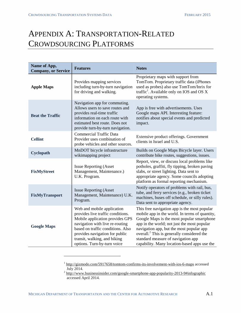
CROWDSOURCING TRANSPORTATION SYSTEMS DATA FEBRUARY 2015
MICHIGAN DEPARTMENT OF TRANSPORTATION AND THE CENTER FOR AUTOMOTIVE RESEARCH A.1
APPENDIX A: TRANSPORTATION-RELATED
CROWDSOURCING PLATFORMS
1 http://gizmodo.com/5917658/tomtom-confirms-its-involvement-with-ios-6-maps accessed
July 2014. 2 http://www.businessinsider.com/google-smartphone-app-popularity-2013-9#infographic
accessed April 2014.
Name of App,
Company, or Service Features Notes
Apple Maps
Provides mapping services
including turn-by-turn navigation
for driving and walking.
Proprietary maps with support from
TomTom. Proprietary traffic data (iPhones
used as probes) also use TomTom/Inrix for
traffic1. Available only on IOS and OS X
operating systems.
Beat the Traffic
Navigation app for commuting.
Allows users to save routes and
provides real-time traffic
information on each route with
estimated best route. Does not
provide turn-by-turn navigation.
App is free with advertisements. Uses
Google maps API. Interesting feature:
notifies about special events and predicted
impact.
Cellint
Commercial Traffic Data
Provider uses combination of
probe vehicles and other sources.
Extensive product offerings. Government
clients in Israel and U.S.
Cyclopath MnDOT bicycle infrastructure
wikimapping project
Builds on Google Maps Bicycle layer. Users
contribute bike routes, suggestions, issues.
FixMyStreet
Issue Reporting (Asset
Management, Maintenance.)
U.K. Program.
Report, view, or discuss local problems like
potholes, graffiti, fly tipping, broken paving
slabs, or street lighting. Data sent to
appropriate agency. Some councils adopting
platform as formal reporting mechanism.
FixMyTransport
Issue Reporting (Asset
Management, Maintenance) U.K.
Program.
Notify operators of problems with rail, bus,
tube, and ferry services (e.g., broken ticket
machines, buses off schedule, or silly rules).
Data sent to appropriate agency.
Google Maps
Web and mobile application
provides live traffic conditions.
Mobile application provides GPS
navigation with live re-routing
based on traffic conditions. Also
provides navigation for public
transit, walking, and biking
options. Turn-by-turn voice
This free navigation app is the most popular
mobile app in the world. In terms of quantity,
Google Maps is the most popular smartphone
app in the world; not just the most popular
navigation app, but the most popular app
overall.2 This is generally considered the
standard measure of navigation app
capability. Many location-based apps use the

APPENDIX A: TRANSPORTATION-RELATED CROWDSOURCING PLATFORMS
MICHIGAN DEPARTMENT OF TRANSPORTATION AND THE CENTER FOR AUTOMOTIVE RESEARCH A.2
directions. Integrated search
feature.
Google Map’s API to supply a basemap for
additional services.
Inrix
Commercial traffic information
service uses data fusion from
proprietary fleet with public and
municipal sources to offer a
variety of products.
Provides built-in navigation platform for
many vehicle manufacturers.
Lyft
Mobile ridesharing service
operates similar to a taxi service
with privately-owned vehicles
Legal issues remain unresolved in many
areas.
Mobile Millenium
Created a probe vehicle network
of volunteers’ smartphones for
live traffic measurement and
information.
PPP between UC Berkeley, Nokia,
NAVTEQ and CalTrans. Project is complete
and was not pursued.
Moovit
Public Transit Navigation and
Information App for
smartphones
Available in many cities worldwide and in
the U.S. including Ann Arbor.
HERE Maps and traffic data provider.
Owned by Nokia. Provides services to
multiple public and private sector clients
including embedded vehicle navigation
systems. Notable for availability of 3D
maps.
OpenStreetMap
Open source road network
basemap uses crowdsourcing for
map corrections.
Unlike other mapping projects,
OpenStreetMap does not charge for use by
commercial entities. Notable users include
Foursquare and MapQuest.
Roadify
Provides GTFS transit data plus
a layer of crowdsourced
commentary about transit routes
and conditions.
Combines AVL feeds from transit agencies
with tweets and user information to provide
information regarding public transit system
use. Free app.
SeeClickFix Web based reporting for civil
government issues.
Site reports issues to appropriate agency.
Many city governments actively monitor site.
SFBetterStreets.org Issue Reporting, planning and
improvement suggestions
The website solicits ideas for street
improvements, provides accessible
descriptions of necessary permit processes,
and suggests strategies for building
community support.
Strava Bicycle-focused fitness app. Aggregated bicyclist data is available to
planners.
Street Bump
Volunteers run app while driving
and automatically record location
of potholes.
Project of City of Boston and ConnectedBits.
Records bump “events” (potholes) to assist
in pavement maintenance. Currently iOS
only.
Sygic GPS
Navigation and
Maps
Basic stored-map GPS
navigation with optional traffic.
Reports data back to Inrix.
Uses TomTom/Inrix for map and traffic info.
Telenav Provides navigation services for Free smartphone navigation app, “Scout,”
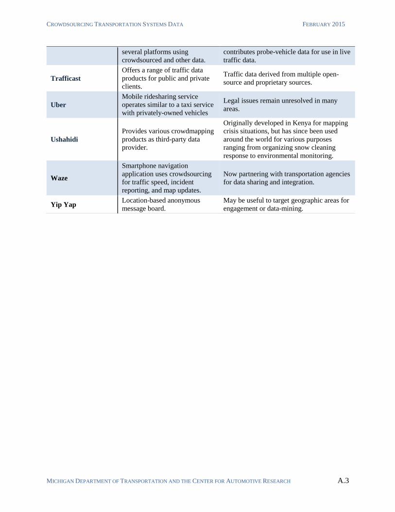
CROWDSOURCING TRANSPORTATION SYSTEMS DATA FEBRUARY 2015
MICHIGAN DEPARTMENT OF TRANSPORTATION AND THE CENTER FOR AUTOMOTIVE RESEARCH A.3
several platforms using
crowdsourced and other data.
contributes probe-vehicle data for use in live
traffic data.
Trafficast
Offers a range of traffic data
products for public and private
clients.
Traffic data derived from multiple open-
source and proprietary sources.
Uber
Mobile ridesharing service
operates similar to a taxi service
with privately-owned vehicles
Legal issues remain unresolved in many
areas.
Ushahidi
Provides various crowdmapping
products as third-party data
provider.
Originally developed in Kenya for mapping
crisis situations, but has since been used
around the world for various purposes
ranging from organizing snow cleaning
response to environmental monitoring.
Waze
Smartphone navigation
application uses crowdsourcing
for traffic speed, incident
reporting, and map updates.
Now partnering with transportation agencies
for data sharing and integration.
Yip Yap Location-based anonymous
message board.
May be useful to target geographic areas for
engagement or data-mining.
APPENDIX B: TRANSPORTATION OPERATIONS CENTER INTERVIEW NOTES
MICHIGAN DEPARTMENT OF TRANSPORTATION AND THE CENTER FOR AUTOMOTIVE RESEARCH A.4
APPENDIX B: TRANSPORTATION OPERATIONS
CENTER INTERVIEW NOTES
CAR conducted interviews with representatives from the following
transportation operations centers (TOCs) to assess how TOCs can best use
crowdsourced transportation data:
MDOT Michigan State Transportation Operations Center (STOC),
Lansing.
Macomb County Department of Roads (MCDR) TOC.
MDOT West Michigan TOC (WMTOC), Grand Rapids.
MDOT Southeast Michigan TOC (SEMTOC), Detroit.
Road Commission for Oakland County (RCOC) TOC.
Bluewater Bridge TOC (BWBTOC), Port Huron
Based on these TOC interviews and findings from them, the CAR team has
aggregated the most pertinent information and summarized it below.
TOCs value data that can be acted on in real time. Currently, the task of
monitoring pertinent data and acting on it is largely manual. Traffic operators
monitor reported traffic speeds and CCTV cameras, but many issues are not
captured by cameras.1 Operators often rely on police dispatch and agency field
personnel to keep the TOC updated on road conditions. Most TOC
representatives expressed challenges in getting timely accurate information
across coverage zones. One operator specifically lamented that it was
particularly difficult to determine when incidents have been cleared and/or
traffic conditions have returned to normal. TOC representatives were
universally interested in using crowdsourced data to supplement existing
practices, and many have already begun to experiment with such methods.
The actions that TOCs take in response to pertinent data are almost entirely
manual. Actions include adjusting DMS messages, deploying police or agency
personnel, and disseminating information (e.g., through email listservs,
MiDrive, Twitter, Waze, etc.). Local TOCs can also respond to traffic
conditions by adjusting signal timing. Traffic operators expressed very little
interest in having any of these actions automated in direct response to
1 The MDOT Bluewater International Bridge TOC is unique in that essentially all of their area
of influence is monitored by CCTV cameras.
CROWDSOURCING TRANSPORTATION SYSTEMS DATA FEBRUARY 2015
MICHIGAN DEPARTMENT OF TRANSPORTATION AND THE CENTER FOR AUTOMOTIVE RESEARCH A.5
incoming data. The format of any data is not particularly important, so long as
it reaches the right people with minimal delay.
THIRD-PARTY AGGREGATED CROWDSOURCED DATA
TOCS were generally familiar with the concept of contracting with third-
parties to obtain aggregated crowdsourced data. MDOT TOCs are involved
with the process by which MDOT populates its MiDrive website with traffic
speeds. (MiDrive data and travel time estimates given by dynamic message
signs is provided via contract with HERE, whose data is partially
crowdsourced via instrumented probe vehicles.) Local TOCs are aware of this
arrangement, but do not have similar arrangements, and generally do not
utilize MiDrive as local roads are not covered. County and city TOCs rely on
CCTV cameras and general incident reporting from police and otherwise.
USING SOCIAL MEDIA FOR PUBLIC ENGAGEMENT
TOCs are aware that social networking site such as Twitter and Facebook can
be valuable as a line of contact to the public. MDOT maintains a Twitter feed
and Facebook page. Each of the MDOT regions also maintains a separate
Twitter feed. WMTOC reported an effort to automate the tweeting of traffic
issues over their feed, which compliments an email listserv.
CROWDSOURCE REPORTING FEATURE OF WAZE
The Macomb County TOC is very keen on using the crowdsourced reporting
feature of the Waze Navigation app for both information gathering and
dissemination. Traffic operators monitor Waze for incidents within the region
and “often get incident information from Waze before we hear from police
dispatches.” Macomb county TOC has also developed a department Waze
map-editor account, which allows the department to share information such as
road closures or construction zones with Waze users. The information posted
to Waze is pushed to Google Maps, and thus both Wazers and Google
Navigate users can receive information from the road commission without
ever realizing they were interacting with the MCDR. 2
2 Any member of the public can become a map-editor on Waze. This privilege is free, but
must be ‘earned’ by being a dependable contributory member of the Waze community.
APPENDIX B: TRANSPORTATION OPERATIONS CENTER INTERVIEW NOTES
MICHIGAN DEPARTMENT OF TRANSPORTATION AND THE CENTER FOR AUTOMOTIVE RESEARCH A.6
The RCMC reported that they briefly talked to Waze about developing a
formal relationship, but initial talks suggested that the terms of such an
arrangement would be problematic.3
RCMC representatives mentioned that they considered developing a custom-
built platform (similar to MiDrive) to provide traffic information, but did not
envision that it would ever be as useful as existing apps like Waze and Google
Maps.
TRANSPORTATION ASSET CONDITION REPORTING
The WMTOC and MCDR TOC are actively investigating methods that would
facilitate citizen reporting of transportation related issues (e.g., malfunctioning
signals, damaged signs, etc.). WMTOC would prefer to utilize an existing app
or service platform for this purpose rather than developing a custom-built
platform. Similarly, MCDR mentioned the possibility of working with
SeeClickFix to allow crowdsource reporting of civil issues.
RCOC uses a custom web-reporting tool, and responds to 100-150 complaints
per week. Complaints submitted via internet and phone are synthesized and
incorporated into project planning and prioritization. SEMTOC asks
individuals who have previously reported issues to continue to submit regular
reports of their experience with the transportation system via email. SEMTOC
representative also voiced concern about information overload if too many
crowdsourced reports must be looked into.
THE INTERNET AS A SENSOR
All TOCS reported using the internet as a sensor in a very rough way (i.e.,
manually monitoring Waze or Google Maps traffic layer).4 Google Maps
provides traffic speed information similar to that provided by HERE via
MiDrive, but at a higher resolution and broader coverage. TOCs reported that
they respond to congestion as reported by Google Maps by, for example,
repositioning intersection cameras (MCDR) or contacting the county road
commission to investigate the situation (WMTOC).
3 Several public agencies have established partnerships with Waze, such as the Florida DOT:
http://www.wfla.com/story/25596106/state-dot-partners-with-waze 4 Following the interview of MCDR by CAR, MCDR staff reported experimenting with using
open traffic data (MapQuest) as a virtual sensor to obtain estimated traffic speed
information. As of publication of this report, it is not known if MCDR found the effort
successful.
CROWDSOURCING TRANSPORTATION SYSTEMS DATA FEBRUARY 2015
MICHIGAN DEPARTMENT OF TRANSPORTATION AND THE CENTER FOR AUTOMOTIVE RESEARCH A.7
The MCDR TOC reported monitoring Waze for crowdsourced incident
reporting. The WMTOC mentioned that some attempt was made to monitor
Waze, but the available information overwhelmed existing resources. None of
the TOCs reported using any such information in an automated way (i.e., as
described in Chapter 4). One WMTOC representative lamented that there does
not seem to be an easy way to use existing open data to receive alerts about
relevant information.5
One TOC suggested that valuable information could be acquired by
monitoring local police-band communications. While it is too labor intensive
to dedicate TOC operators to monitor police chatter, it might prove feasible to
develop voice-recognition applications that alert traffic operators to
potentially relevant issues.6
TOCs reported utilizing the Regional Integrated Transportation Information
System (RITIS),7 a traffic data analysis tool that can provide both real-time
and archived data. RITIS can be set-up to provide email alerts when it detects
traffic incidents; however, traffic operators reported that use of RITIS was
very limited, in part because RITIS makes it difficult to set-up alerts that are
actionable for TOCs.
DEDICATED PLATFORMS
Dedicated platforms include any platform that has been developed specifically
to produce crowdsourced transportation data. Custom-built platforms have
been developed in the public sector, private sector, and through public-private
partnerships.
An example of a public-sector, dedicated crowdsourcing app is MDOT’s new
MiDrive mobile application. The MiDrive mobile app integrates with
MDOT’s MiDrive traveler information site to allow users to report the
location of traffic issues. The MiDrive mobile application would seem to be
similar to private-sector custom built platforms (e.g., Waze, Scout by Telenav)
that allow similar reporting as an extension of a GPS navigation app.
5 Specifically, WMTOC operators would like to be able to receive email alerts when sites
such as Google Maps or Waze report certain types of incidents on routes of interest. Google
has an open API that could allow for such capability, but utilizing this would require manual
coding from the agency end to interact appropriately with the Google API. 6 Many public safety bands are available via digital streams through sites such as
radioreference.com. 7 Developed by the University of Maryland.
APPENDIX B: TRANSPORTATION OPERATIONS CENTER INTERVIEW NOTES
MICHIGAN DEPARTMENT OF TRANSPORTATION AND THE CENTER FOR AUTOMOTIVE RESEARCH A.8
Representatives from WMTOC expressed that the first option when
developing new methods of collecting, disseminating, or analyzing
information should be to utilize an existing platform. Outsourcing the
development, maintenance, and marketing of existing platforms to
commercial developers sometimes allows TOCs, and more broadly DOTs, to
leverage private sector innovation and expertise to supplement public
resources.
One MDOT representative from a regional TOC suggested that private-sector
platforms (e.g., Google Maps Traffic) are often much more useful than
platforms developed for specific agency purposes (e.g., MiDrive). At least one
TOC representative mentioned that Google Maps Traffic data is usually more
accurate and broadly available than the traffic data provided to MiDrive by
HERE.
INTEGRATING CROWDSOURCED DATA INTO EXISTING AGENCY
PRACTICES
The TOCs that we interviewed generally react manually in real-time to any
actionable information (with the exception of dedicated travel-time signs,
which are updated automatically). Potential TOC actions include adjusting
DMS, contacting police dispatch or emergency services, and contacting
maintenance personnel. The Bluewater Bridge TOC responds to conditions
observed on CCTV cameras by cooperating with U.S. Customs and Border
Patrol Agents to optimize the number of toll/inspection booths open. TOCs
perform these functions manually and are not generally interested in having
these duties automated.8 TOCs are most interested in getting pertinent
information in a timely fashion. The format of any data is not particularly
important, so long as it is actionable. CCTV feeds are generally considered
very useful. Email notifications are a standard practice.
8 As an exception, one TOC expressed interest in having Waze data integrated into the TMS.
The interviewee did not make it clear if this integration should be automated or not.
CROWDSOURCING TRANSPORTATION SYSTEMS DATA FEBRUARY 2015
MICHIGAN DEPARTMENT OF TRANSPORTATION AND THE CENTER FOR AUTOMOTIVE RESEARCH A.9
APPENDIX C: LIST OF ABBREVIATIONS
3D Three-dimensional
API Application Programming Interface
AVL Automated Vehicle Location
BWBTOC Bluewater Bridge TOC
CAD Computer Aided Dispatch
CAR Center for Automotive Research
CCTV Closed Circuit Television
COTS Commercial Off The Shelf
DMAG Data Modernization, Assurance, and Governance
DMS Dynamic Message Signs
DUAP Data Use Analysis and Processing
EPA Environmental Protection Agency
FCP Freeway Courtesy Patrol
FDOT Florida Department of Transportation
GPS Global Positioning System
GTFS General Transit Feed Specification
HERE Not an acronym. Refers to the division of Nokia involved in mapping and
location data.
IoT Internet of Things
MCDR Macomb County Department of Roads
MDOT Michigan Department of Transportation
MnDOT Minnesota Department of Transportation
MTA Metropolitan Transportation Authority [of New York]
MSP Michigan State Police
MVDS Microwave Vehicle Detection Station
NPDES National Pollution Discharge Elimination System
PB Parsons Brinkerhoff
POI Point of Interest
PPP Public-Private Partnership
APPENDIX C: LIST OF ABBREVIATIONS
MICHIGAN DEPARTMENT OF TRANSPORTATION AND THE CENTER FOR AUTOMOTIVE RESEARCH A.10
RCOC Road Commission of Oakland County
SEMTOC Southeast Michigan TOC
STIP State Transportation Improvement Program
STOC Statewide TOC
TAMS Transportation Asset Management System
TCP/IP Transport Control Protocol/Internet Protocol
TOC Transportation/Traffic Operations Center
U.K. United Kingdom
U.S. United States
WMTOC West Michigan TOC


![[Karger+ NIPS11] Iterative Learning for Reliable Crowdsourcing Systems](https://img.pdfslide.net/doc/110x75/5463d755b4af9f3f3f8b46cc/karger-nips11-iterative-learning-for-reliable-crowdsourcing-systems.jpg)