Embed Size (px)
Citation preview
P O Box 2828, Shortland Street, Auckland 1140. Telephone: (09) 379-9417 Facsimile (09) 307-6409 Website: www.bioresearches.co.nz
Bioresearches - Avifauna report - Final
REFINING NZ
CRUDE SHIPPING PROJECT AEE REPORT COASTAL BIRDS FINAL FOR: REFINING NZ BY: BIORESEARCHES GROUP LIMITED Graham Don, M.Sc (Hons)
RNZ AEE Report – Coastal Birds i
Bioresearches - Avifauna report - Final
CONTENTS
1. EXECUTIVE SUMMARY ...................................................................................................... 1
2. INTRODUCTION ................................................................................................................ 3
3. FIELD INVESTIGATIONS ..................................................................................................... 7 3.1 Introduction ......................................................................................................... 7 3.2 Methodology ....................................................................................................... 8 3.3 Specific Area Surveys ......................................................................................... 10
3.3.1 Bream Bay Beach ................................................................................... 10 3.3.2 Mair Bank ............................................................................................... 11 3.3.3 Refinery Jetty to Northport ................................................................... 12 3.3.4 One Tree Point ....................................................................................... 14 3.3.5 Snake Bank ............................................................................................. 15 3.3.6 Reotahi Bay ............................................................................................ 17 3.3.7 Taurikura Bay ......................................................................................... 18 3.3.8 McKenzie Bay ......................................................................................... 19 3.3.9 Urquharts Bay ........................................................................................ 19 3.3.10 Comparative Population Composition and Habitat Use ..................... 20
3.4 Pelagic Birds ....................................................................................................... 21 3.5 Breeding Season Surveys ................................................................................... 23
3.5.1 Mair Road to Northport ......................................................................... 23 3.5.2 Marsden Point to Refinery Jetty ............................................................ 23 3.5.3 Refinery Jetty to Northport ................................................................... 23 3.5.4 Darch Point to Home Point .................................................................... 23
3.6 Harbour Penguin Surveys .................................................................................. 24
4. AVIFAUNAL VALUES AND HABITAT SIGNIFICANCE ......................................................... 26 4.1 Introduction ....................................................................................................... 26 4.2 Bream Bay Beach ............................................................................................... 29 4.3 Mair Bank ........................................................................................................... 29 4.4 Refinery Jetty to Northport ............................................................................... 30 4.5 One Tree Point ................................................................................................... 30 4.6 Snake Bank ......................................................................................................... 30 4.7 Reotahi Bay ........................................................................................................ 31 4.8 Taurikura Bay ..................................................................................................... 31 4.9 McKenzie Bay ..................................................................................................... 31 4.10 Urquharts Bay .................................................................................................... 31 4.11 Pelagic Birds ....................................................................................................... 32 4.12 Breeding ............................................................................................................. 32
5. AVIFAUNAL EFFECTS ....................................................................................................... 35 5.1 Discounted Effects ............................................................................................. 35 5.2 Potential Issues .................................................................................................. 36
5.2.1 Turbidity Increase .................................................................................. 36 5.2.2 Resuspended Sediment Deposition ....................................................... 45 5.2.3 Vessel Movements ................................................................................ 45 5.2.4 Vessel Lighting ....................................................................................... 46 5.2.5 Noise ...................................................................................................... 49
RNZ AEE Report – Coastal Birds ii
Bioresearches - Avifauna report - Final
5.2.6 Cumulative Effects ................................................................................. 50
6. CONSULTATION AND REVIEW ........................................................................................ 51
7. RECOMMENDATIONS AND MITIGATION ........................................................................ 52 7.1 Little Penguin ..................................................................................................... 52 7.2 Vessel Lighting ................................................................................................... 53 7.3 Grey-faced Petrel ............................................................................................... 53
8. MONITORING.................................................................................................................. 55 8.1 Monitoring ......................................................................................................... 55
8.1.1 Coastal Birds .......................................................................................... 55 8.1.2 Little Penguin ......................................................................................... 56
9. CONCLUSION .................................................................................................................. 57
10. REFERENCES.................................................................................................................... 58
RNZ AEE Report – Coastal Birds 1
Bioresearches - Avifauna report - Final
1. EXECUTIVE SUMMARY
A description of the coastal and pelagic birds observed utilising or recorded previously
within the broad Project area is presented; that is the result of literature searches,
information from a local bird watcher and specific field investigations completed in
2015 and 2016. High value bird habitats in a national context were identified at Mair
Bank and Bream Bay. Northport to One Tree Point and Urquharts Bay areas were
identified as being of high value in the context of the Outer Harbour.
Breeding within the Harbour was recorded or strongly inferred for variable
oystercatcher, reef heron and little penguin; specific breeding sites used by threatened
and at risk species are of national importance during the breeding season.
The potential risk of Project-generated effects on shorebird habitats was considered
high at Mair Bank and low-moderate at Reotahi Bay as a result of their proximity to
the works. The risk at the other habitats was judged to be low.
Potential issues regarding coastal and pelagic birds were identified as climate change,
turbidity increases, deposition of resuspended sediment, vessel movements, vessel
lighting, underwater noise and cumulative effects. There is no concern regarding
permanent decrease in feeding habitat, a loss of roosting or breeding habitat,
sediment contaminants, maintenance dredging, or the erection and maintenance of
navigational aids. An analysis of potential effects was completed. The species most
susceptible to a turbidity increase in the dredging area is considered to be little
penguin; the concern is disruption of its passage between shoreline nesting areas,
specifically those within the Harbour and the nearby open water. However the
confined sediment plume, limited dredging area within Busby Head, temporary nature
of the works, Project turbidity thresholds and ranges in ambient turbidity, indicate that
adverse effects will likely be avoided and will not be contrary to NZCPS Policy 11 (a) (i)
and Policy 11 (b) (ii). The probability of an adverse turbidity effect at the disposal site
is considered remote and not likely to be contrary to NZCPS Policy 11 (a) (i) or 11 (b)
(ii). Similarly there would be no effect on coastal or pelagic birds from the deposition
of any resuspended sediments. The issue of increased vessel movements is assessed
RNZ AEE Report – Coastal Birds 2
Bioresearches - Avifauna report - Final
relative to the current baseline; because the Project area is frequently used by a wide
variety of vessels the effect has been judged less than minor.
Vessel lighting is a known attraction to pelagic species especially shearwaters and
petrels that nest on the Hen and Chickens Islands, but especially grey-faced petrel that
nests locally and is being actively encouraged within the immediately adjacent Bream
Scenic Reserve. Although the objective of NZCPS Policy 11 (a) (i) would be maintained,
mitigation is proposed via the provision of nesting boxes in the Reserve. The issue of
noise regarding diving and swimming birds is considered negligible and to be
consistent with NZCPS Policies.
Recommendations are the provision of nesting boxes for little penguin (possible
turbidity effect) and grey-faced petrel (possible lighting effect), and a lighting audit of
the Project’s vessels to minimise the light attraction of seabirds. Monitoring of the
post-dredging state-of-the-environment is proposed to cover little penguin specifically
and coastal birds.
In summary the overall impact on coastal and pelagic birds is considered to be low.
The Project would be consistent with NZCPS Policy 11 (a) (i) and Policy 11 (b) (ii).
RNZ AEE Report – Coastal Birds 3
Bioresearches - Avifauna report - Final
2. INTRODUCTION
Assessments of the coastal bird populations in the area from a line between One Tree
Point and Darch Point through to Home Point and the northern end of Bream Bay
Beach were completed in February-March 2015, November 2015 and February-March
2016. The February-March 2015 and 2016 surveys aimed at documenting coastal bird
abundance, diversity and habitat use while the November 2015 surveys recorded
breeding activities in the context of the planned application by Refining NZ for the
Crude Shipping Project.
The aim of the surveys was to gain an understanding of the characteristics and
significance of bird populations in areas in the vicinity of the Project and to update
information that had been reviewed in a literature review completed by Bioresearches
in 2015. That literature review identified that a total of ten nationally threatened and
sixteen nationally at risk coastal and pelagic species had been recorded in the outer
Harbour (east of One Tree Point) and Bream Bay habitats. With non-resident native
and non-threatened birds the total diversity was 34 species. Breeding in Harbour and
Bream Bay edge habitat was reported for both threatened and at risk species
comprising a wide range of bird groups – waders, gulls, terns, penguin, shags and
shearwaters.
The two broad groups of birds present are coastal birds that utilise intertidal and
nearshore habitats, and pelagic birds that generally utilise open water offshore
habitats (eg shearwaters, petrels) but can occur close to shore on occasions. In this
investigation the coastal birds were assessed via field surveys while information on
pelagic species relied on the literature, together with observations and reports
provided by Margaret Hicks, a local resident and experienced bird watcher.
While the surveys completed for this Project were completed in a two year period, a
longer term benchmark is provided by the data collected at Marsden Bay by the
Ornithological Society of NZ (now Birds NZ) and reported by Dickie 1984, from 1975 to
1984 inclusive; and from 2009 to 2015 inclusive by Bioresearches for the Marsden Cove
Development. Those data indicate a relative stability in at least the wading bird
population in this part of the Harbour over that period.
RNZ AEE Report – Coastal Birds 4
Bioresearches - Avifauna report - Final
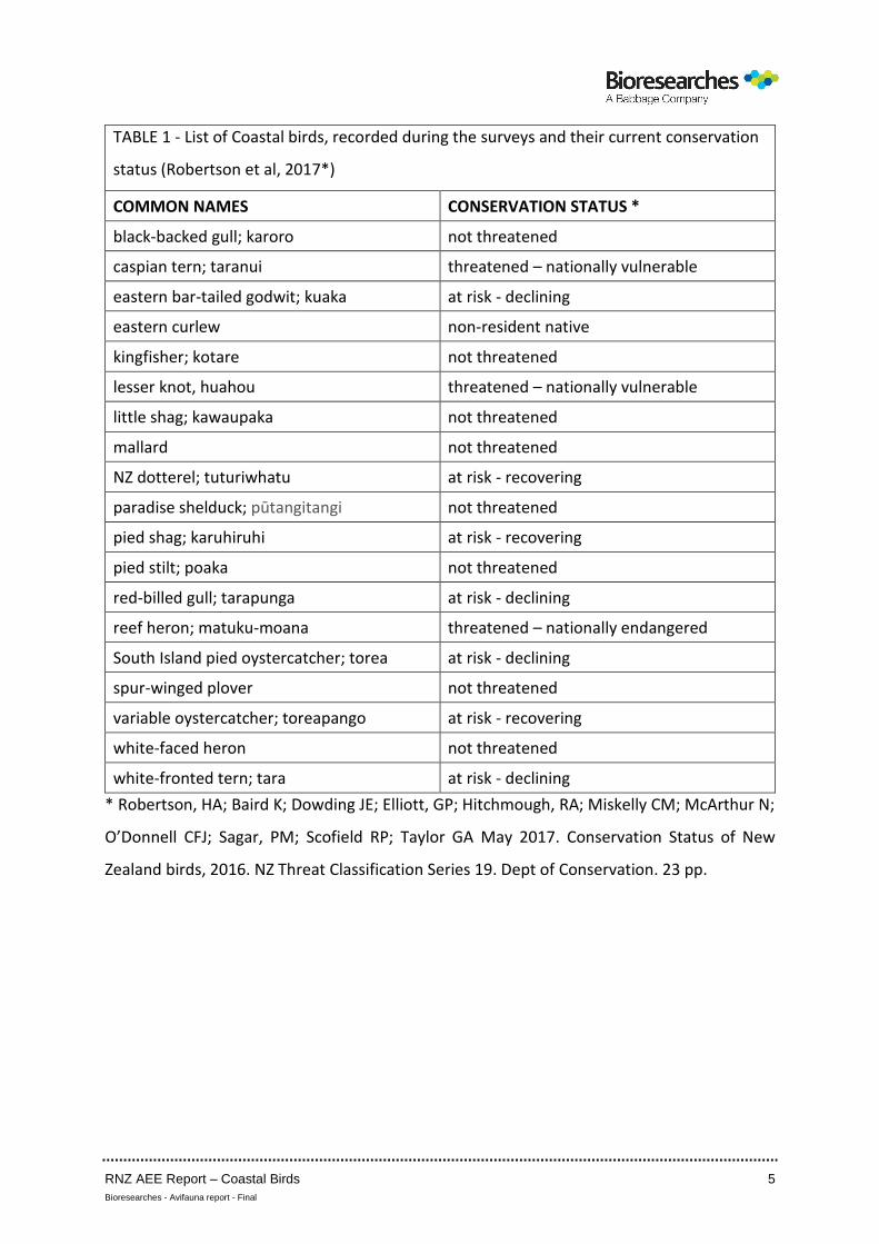
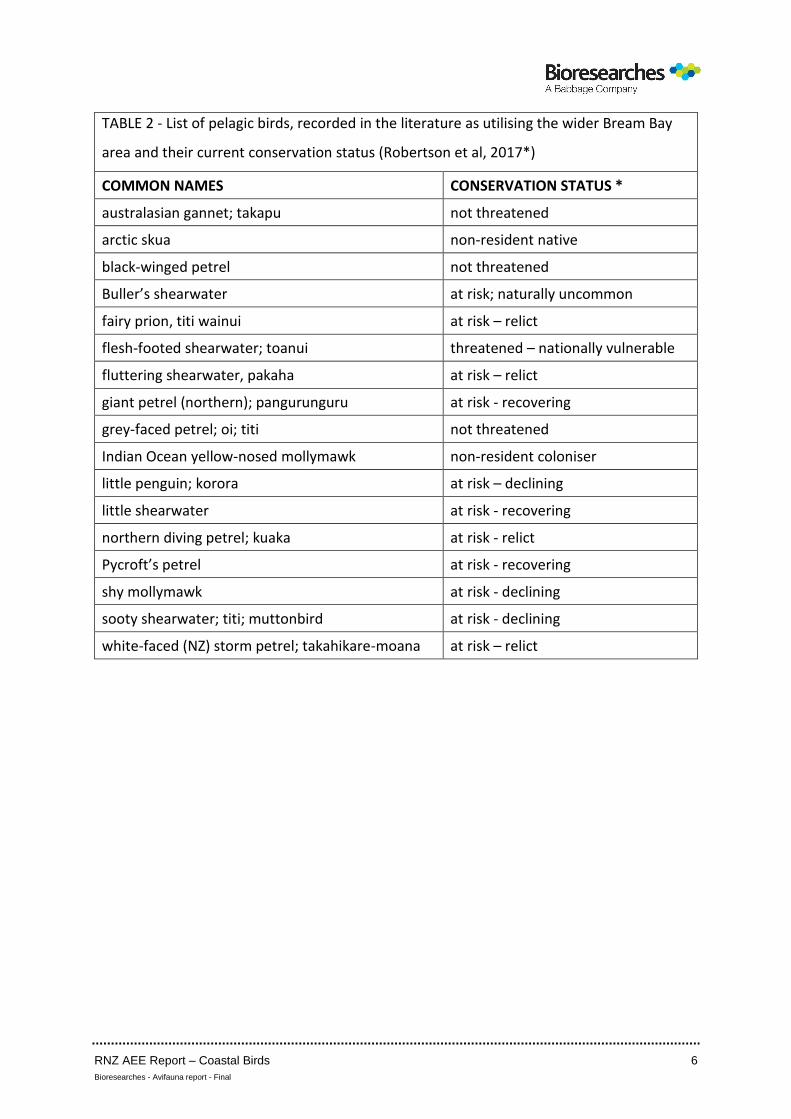
The coastal and pelagic species referred to in this report and their current (May 2017)
national conservation ratings are shown in Tables 1 and 2.
The assessment of effects recognises the New Zealand Coastal Policy Statement
(NZCPS) (2010), particularly Policy 11 Indigenous Biological Diversity (biodiversity) (a)
which states “avoid adverse effects of activities on: (i) indigenous taxa that are listed
or threatened or at risk in the New Zealand Threat Classification System lists.”A total
of 27 such species have been recorded in the outer Harbour survey area and Bream
Bay.
Policy 11(a)(ii) is also relevant but birds listed by the International Union for
Conservation of Nature and Natural Resources (IUCN) are understood to have been
captured by Policy 11(a)(i). Policy 11(a)(v) is relevant to this assessment i.e. “areas
containing nationally significant examples of indigenous community types” insofar as
it relates to communities of coastal birds. That has been summarised in Figure 11 of
this report.
Finally this evaluation recognises Policy 11(b): “avoid significant adverse effects and
avoid, remedy or mitigate other adverse effects of activities on: (ii) habitats in the
coastal environment that are important during the vulnerable life stages of indigenous
species”. Areas of known (literature review, field investigations) habitat used for bird
nesting and juvenile rearing have been identified in this assessment.
RNZ AEE Report – Coastal Birds 5
Bioresearches - Avifauna report - Final
TABLE 1 - List of Coastal birds, recorded during the surveys and their current conservation
status (Robertson et al, 2017*)
COMMON NAMES CONSERVATION STATUS *
black-backed gull; karoro not threatened
caspian tern; taranui threatened – nationally vulnerable
eastern bar-tailed godwit; kuaka at risk - declining
eastern curlew non-resident native
kingfisher; kotare not threatened
lesser knot, huahou threatened – nationally vulnerable
little shag; kawaupaka not threatened
mallard not threatened
NZ dotterel; tuturiwhatu at risk - recovering
paradise shelduck; pūtangitangi not threatened
pied shag; karuhiruhi at risk - recovering
pied stilt; poaka not threatened
red-billed gull; tarapunga at risk - declining
reef heron; matuku-moana threatened – nationally endangered
South Island pied oystercatcher; torea at risk - declining
spur-winged plover not threatened
variable oystercatcher; toreapango at risk - recovering
white-faced heron not threatened
white-fronted tern; tara at risk - declining
* Robertson, HA; Baird K; Dowding JE; Elliott, GP; Hitchmough, RA; Miskelly CM; McArthur N;
O’Donnell CFJ; Sagar, PM; Scofield RP; Taylor GA May 2017. Conservation Status of New
Zealand birds, 2016. NZ Threat Classification Series 19. Dept of Conservation. 23 pp.
RNZ AEE Report – Coastal Birds 6
Bioresearches - Avifauna report - Final
TABLE 2 - List of pelagic birds, recorded in the literature as utilising the wider Bream Bay
area and their current conservation status (Robertson et al, 2017*)
COMMON NAMES CONSERVATION STATUS *
australasian gannet; takapu not threatened
arctic skua non-resident native
black-winged petrel not threatened
Buller’s shearwater at risk; naturally uncommon
fairy prion, titi wainui at risk – relict
flesh-footed shearwater; toanui threatened – nationally vulnerable
fluttering shearwater, pakaha at risk – relict
giant petrel (northern); pangurunguru at risk - recovering
grey-faced petrel; oi; titi not threatened
Indian Ocean yellow-nosed mollymawk non-resident coloniser
little penguin; korora at risk – declining
little shearwater at risk - recovering
northern diving petrel; kuaka at risk - relict
Pycroft’s petrel at risk - recovering
shy mollymawk at risk - declining
sooty shearwater; titi; muttonbird at risk - declining
white-faced (NZ) storm petrel; takahikare-moana at risk – relict
RNZ AEE Report – Coastal Birds 7
Bioresearches - Avifauna report - Final
3. FIELD INVESTIGATIONS
3.1 INTRODUCTION
Over the 2015-16 period there were three groups of surveys as follows:-
(i) February – March 2015: coastal bird surveys at five locations
• Bream Bay Beach (at Mair Road)
• Taurikura Bay
• McKenzie Bay
• Urquharts Bay
(ii) November 2015 – breeding activity surveys:
• Mair Road to Northport inspection
• Marsden Point to Northport habitat use
• Darch Point to Home Point habitat use
(iii) February – March 2016:- coastal bird surveys at eight locations
• Mair Bank (as 2015)
• Refinery Jetty to Northport
• Marsden Bay west to One Tree Point
• Part of Snake Bank
• Reotahi Bay
• Taurikura Bay
• McKenzie Bay
• Urquharts Bay
The above areas are shown on Figures 1 to 8.
RNZ AEE Report – Coastal Birds 8
Bioresearches - Avifauna report - Final
The only 2015 survey area that was not surveyed in 2016 was Bream Bay Beach on the
basis that it supported a low diversity and relatively low numbers of coastal birds and
no significant high tide roosting.
For clarity a summary of the coastal bird count surveys is as follows:
Area of coast Date No. hourly counts
Bream Bay Beach 23.3.15 9
Mair Bank 25.2.15 9
3.3.15 9
9.2.16 9
Refinery Jetty to Northport 8.3.16 9
Marsden Bay West to One Tree Point 16.2.16 8
Part Snake Bank 16.2.16 8
Reotahi Bay 9.3.16 9
Taurikura Bay 18.3.15 9
9.3.16 9
McKenzie Bay 18.3.15 9
9.3.16 9
Urquharts Bay 18.3.15 9
9.3.16 9
Bird use of nine sections of coastline was recorded via a total of 124 hourly counts.
Mair Bank received additional emphasis regarding both the coastal bird surveys and
breeding season surveys because of its proximity to the proposed works, its
significance as a coastal bird habitat in a national context [NZCPS 11(a)(v)]and its
current condition that includes a decrease in the pipi population (Williams JR & Hume
TM 2014; Pawley, 2016) and an apparent increase in green-lipped mussels (Pawley
2016) that may change the attractiveness of Mair Bank as a feeding area for coastal
birds, especially variable oystercatcher.
3.2 METHODOLOGY
The methodology for the bird surveys of the nine sections of coastline was reviewed
by NIWA on behalf of Northland Regional Council. It is the same methodology that has
RNZ AEE Report – Coastal Birds 9
Bioresearches - Avifauna report - Final
been used to monitor the bird populations using Marsden Bay, to the west of
Northport, over the 2003 to 2015 period with approval of Northland Regional Council
and the Department of Conservation.
At each site hourly counts were completed to cover a range of tidal conditions and
habitat use activities recorded using Leupold BX-2 Cascades 10 x 42 binoculars and a
Kowa TSN-883 Prominar spotting scope (25-60 times wide zoom eye piece). Before
each count the air temperature was measured (quartz digi-thermo -10 to +110°C
thermometer) with wind speed, barometric pressure (Silva Alba Windwatch) and
general weather conditions recorded. Field data were entered on pre-prepared,
waterproof record sheets.
As well as recording bird abundance and diversity, bird habitat use was recorded
using an activity code as follows:
FI : feeding in the intertidal area
FW : feeding in or over the water
REI : resting in the intertidal area
REW : resting on the water
ROI : roosting (waders only) in the intertidal area *
ROP : resting/roosting on stakes, poles, rock walls, trees
* Roosting (ROI) over the high tide period is a category applied only to wading birds
in this assessment, because the presence of a high tide wading bird roost is generally
considered a notable coastal feature. The ROI category applies to the period of high
tide itself and one hour either side of it to provide a comparative standard. Roosting
by waders can be related to “staging” i.e. birds form groups at mid to upper shore
levels prior to moving up to above the high tide level to roost over the high tide period
or alternatively, flying elsewhere to roost. Whether birds are resting or roosting at the
time of staging can be variable and debatable, and “roosting” has therefore been
standardised. In contrast, resting/roosting by non-wading birds tends to be more
random in terms of both the location used and tidal stage.
For the breeding season surveys the Mair Road to Northport area was inspected on
foot and using a spotting scope and binoculars. The Marsden Point to Refinery Jetty
RNZ AEE Report – Coastal Birds 10
Bioresearches - Avifauna report - Final
area was monitored for a total of six hours to record breeding season activities. The
coastline from Darch Point to Home Point was inspected mostly on foot (Darch Point
to Little Munro Bay; Urquharts Bay to Home Point) or via a combination of specific
point inspections and spotting scope observations (Little Munro Bay to Urquharts Bay).
3.3 SPECIFIC AREA SURVEYS
3.3.1 Bream Bay Beach
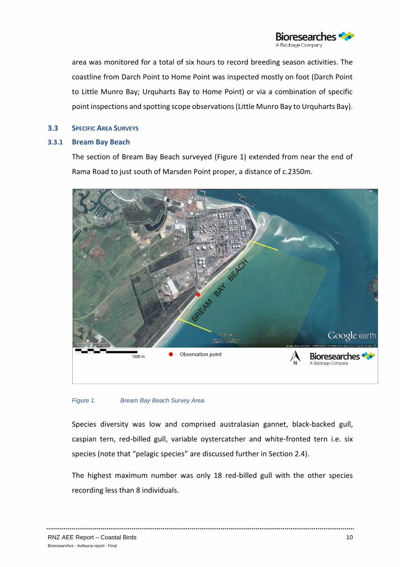
The section of Bream Bay Beach surveyed (Figure 1) extended from near the end of
Rama Road to just south of Marsden Point proper, a distance of c.2350m.
Figure 1. Bream Bay Beach Survey Area.
Species diversity was low and comprised australasian gannet, black-backed gull,
caspian tern, red-billed gull, variable oystercatcher and white-fronted tern i.e. six
species (note that “pelagic species” are discussed further in Section 2.4).
The highest maximum number was only 18 red-billed gull with the other species
recording less than 8 individuals.
RNZ AEE Report – Coastal Birds 11
Bioresearches - Avifauna report - Final
Similar maxima per kilometre were recorded in the same habitat north of Waipu River
mouth but higher numbers were recorded at the Waipu River mouth and estuary in
previous surveys.
The average number of birds (rounded) was 15 with red-billed gull the dominant
species (53.3%) followed by black-backed gull (20.7%) and variable oystercatcher
(13.3%). In total 74% of the population was gulls and the main habitat use was resting
in the intertidal area (79.3% of records).
3.3.2 Mair Bank
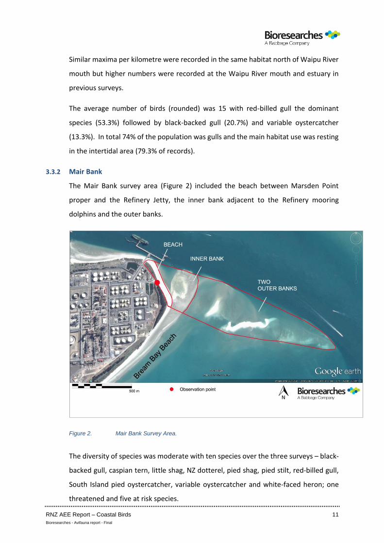
The Mair Bank survey area (Figure 2) included the beach between Marsden Point
proper and the Refinery Jetty, the inner bank adjacent to the Refinery mooring
dolphins and the outer banks.
Figure 2. Mair Bank Survey Area.
The diversity of species was moderate with ten species over the three surveys – black-
backed gull, caspian tern, little shag, NZ dotterel, pied shag, pied stilt, red-billed gull,
South Island pied oystercatcher, variable oystercatcher and white-faced heron; one
threatened and five at risk species.
RNZ AEE Report – Coastal Birds 12
Bioresearches - Avifauna report - Final
The highest maximum was of black-backed gull (196) followed by 70 red-billed gull and
66 variable oystercatcher over the three surveys. The maximum number of individuals
was 288 at low tide on 25.2.15 but 67.4% were black-backed gulls. Average numbers
of birds (rounded) were 119, 76 and 120 over the three surveys with the highest
numbers on the two lowest tides (0.5m).
Mair Bank was utilised for feeding mainly during a four hour period from about four
hours after high tide, over the low tide period and to about two hours after low tide
i.e. for about one third of a 12 hour tidal cycle.
There was no significant high tide wading bird roost but the beach was used for resting
by up to about 100 black-backed gulls and the occasional caspian tern, red-billed gull
and variable oystercatcher.
The dominant species was clearly black-backed gull followed about equally overall by
red-billed gull and variable oystercatcher.
The predominant habitat use was resting in the intertidal (80.4% 2015; 70.7% 2016)
with feeding in the intertidal habitats 14.9% in 2015 and 20.9% in 2016.
The two outer banks were the more important feeding habitats; the average
percentages of feeding records over the surveys were: beach – 5.7%; inner bank –
19.9% and outer banks 74.4%. That probably reflects the presence of shellfish beds in
the outer banks area that remain attractive to coastal birds.
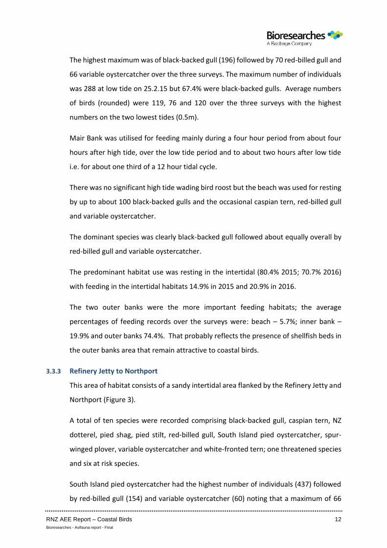
3.3.3 Refinery Jetty to Northport
This area of habitat consists of a sandy intertidal area flanked by the Refinery Jetty and
Northport (Figure 3).
A total of ten species were recorded comprising black-backed gull, caspian tern, NZ
dotterel, pied shag, pied stilt, red-billed gull, South Island pied oystercatcher, spur-
winged plover, variable oystercatcher and white-fronted tern; one threatened species
and six at risk species.
South Island pied oystercatcher had the highest number of individuals (437) followed
by red-billed gull (154) and variable oystercatcher (60) noting that a maximum of 66
RNZ AEE Report – Coastal Birds 13
Bioresearches - Avifauna report - Final
variable oystercatcher was also recorded using Mair Bank in February 2016. The
maxima of all the remaining species were less than 5. The average number of birds
(rounded) was 298 which is high but reflects specific habitat use (refer below).
The key habitat feature of this piece of coastline was its use by the three dominant
species and NZ dotterel for roosting at high water; numbers of wading birds were high
from high tide to half tide falling but red-billed gull, that nests within the Refinery
grounds, remained throughout the survey period and was most common with white-
fronted tern over the low tide period following the departure of the oystercatchers.
South Island pied oystercatcher comprised 56.6% of the records, red-billed gull 30.4%
and variable oystercatcher 8.0%; white-fronted tern occurred at 3.2% while the
remaining species were less than 1%.
The clearly dominant habitat use was resting rather than feeding: resting in the
intertidal – 61.1%; high tide roosting – 37.2%. The value of the habitat for feeding was
low.
Figure 3. Refinery Jetty to Northport Survey Area.
RNZ AEE Report – Coastal Birds 14
Bioresearches - Avifauna report - Final
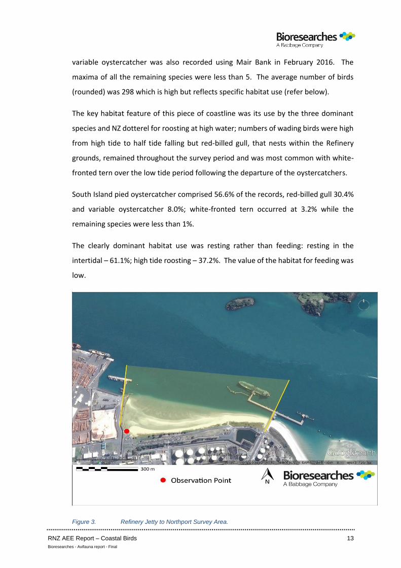
3.3.4 One Tree Point
This area of habitat is contiguous with and similar to Marsden Bay, albeit with a
narrower intertidal area and a lack of high tide roosting opportunity for wading birds
(Figure 4).
Note: where there are multiple observation points, those locations were used on each
hourly count to provide better coverage of the survey area (traversed by vehicle).
Figure 4. One Tree Point Survey Area.
A moderate – high total of 15 species was recorded – black-backed gull, caspian tern,
eastern bar-tailed godwit, eastern curlew, lesser knot, little shag, mallard, NZ dotterel,
paradise shelduck, pied stilt, red-billed gull, South Island pied oystercatcher, variable
oystercatcher, white-faced heron and white-fronted tern.
The notable species were bar-tailed godwit, eastern curlew and lesser knot, all
overseas migrants. A total of two threatened species and six at risk species was
RNZ AEE Report – Coastal Birds 15
Bioresearches - Avifauna report - Final
recorded; bar-tailed godwit is at risk nationally but threatened overseas while lesser
knot is threatened both nationally and overseas.
The highest maxima were black-backed gull (114), white-fronted tern (71), bar-tailed
godwit (60), red-billed gull (58), variable oystercatcher (54) and lesser knot (37). In
contrast to the maxima at Marsden Bay, (i.e. between Northpoint and the One Tree
Point survey area) the maxima at One Tree Point that were lower were for bar-tailed
godwit, lesser knot, NZ dotterel, South Island pied oystercatcher and variable
oystercatcher noting that Marsden Bay is also utilised for high tide roosting. The only
higher maxima at One Tree Point were for black-backed gull and white-fronted tern.
The average number of individuals was 168 (rounded) with the highest number over
the low tide period to half tide rising after which only white-fronted tern was common,
resting on an intertidal fence.
Over the entire survey period the dominant species were black-backed gull (25.2%),
white-fronted tern (20.5%), red-billed gull (17.5%), bar-tailed godwit (13.9%) and
variable oystercatcher (9.2%) while the remaining species occurred at less than 5%.
In contrast to the Refinery Jetty to Northport area and Marsden Bay (c.24% feeding,
c.76% resting/roosting), the split at One Tree Point was 47.6% feeding and 52.4%
resting with no high tide wading bird roost but a high proportion of resting by gulls and
tern.
The predominant features were a lower diversity than Marsden Bay and a population
containing relatively large numbers of black-backed gull and white-fronted tern.
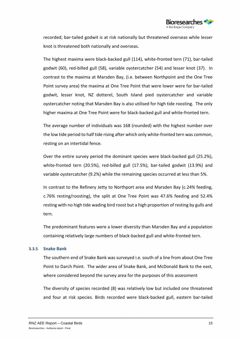
3.3.5 Snake Bank
The southern end of Snake Bank was surveyed i.e. south of a line from about One Tree
Point to Darch Point. The wider area of Snake Bank, and McDonald Bank to the east,
where considered beyond the survey area for the purposes of this assessment
The diversity of species recorded (8) was relatively low but included one threatened
and four at risk species. Birds recorded were black-backed gull, eastern bar-tailed
RNZ AEE Report – Coastal Birds 16
Bioresearches - Avifauna report - Final
godwit, little shag, red-billed gull, South Island pied oystercatcher, variable
oystercatcher, white-faced heron and white-fronted tern.
The highest maximum was for South Island pied oystercatcher (63) but maxima for the
remaining species were all less than 12.
Figure 5. Snake Bank Survey Area. Observation points as shown in Figure 4.
The average number of individuals (rounded) was relatively low at c.39 but birds were
only common over the low tide period, as recorded at Mair Bank, and no high tide
roost is present.
Clearly dominant was South Island pied oystercatcher (75.8%) followed by black-
backed gull (9.7%) and variable oystercatcher (6.5%) with the remainder incidental
only. Feeding, mainly by South Island pied oystercatcher, was the predominant activity
(63.5%). The Snake Bank population differed from that at Mair Bank in that black-
backed and red-billed gull were not as prominent and South Island pied, rather than
variable, was the more common oystercatcher species. Snake Bank is a relatively short
commute for birds roosting at Marsden Bay over the high tide period and contains a
notable population of cockles as a food source.
RNZ AEE Report – Coastal Birds 17
Bioresearches - Avifauna report - Final
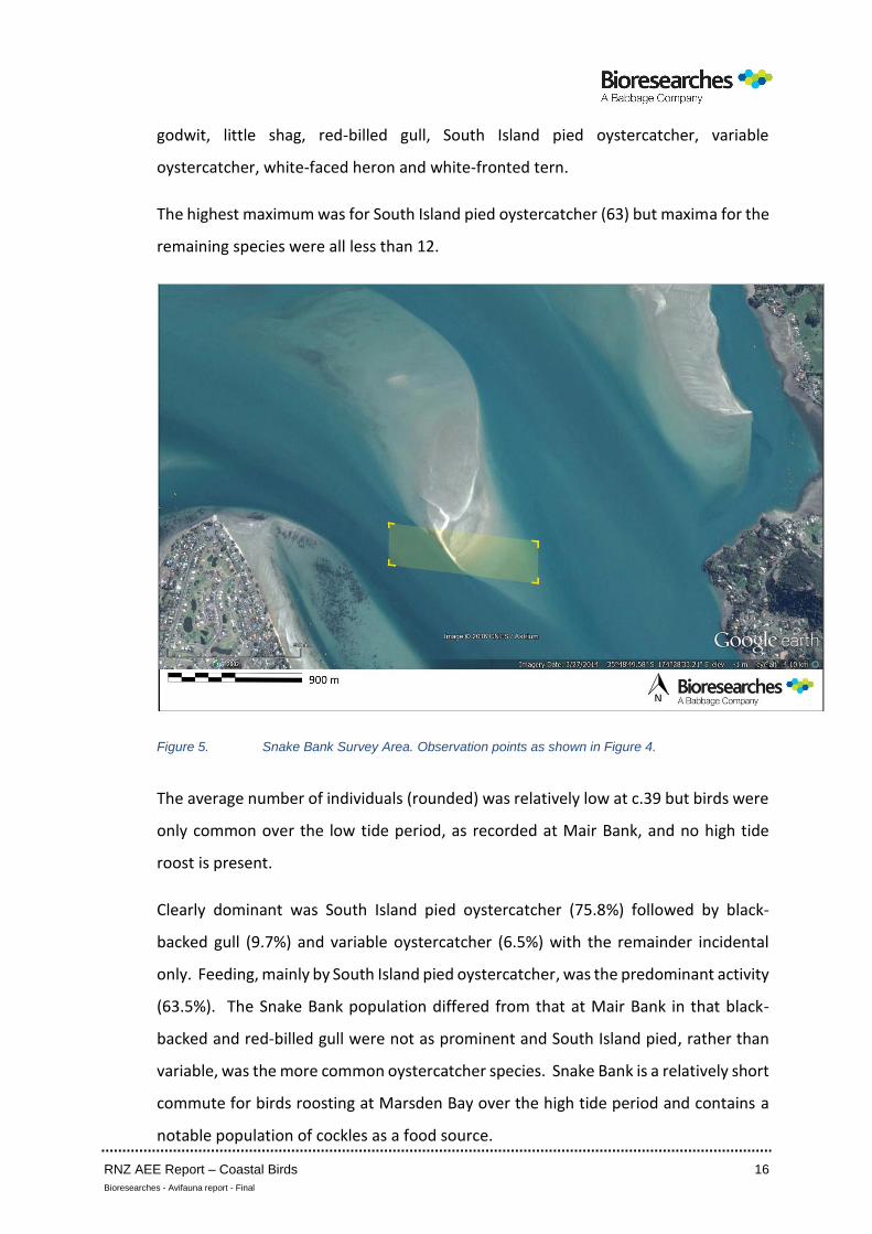
3.3.6 Reotahi Bay
Reotahi Bay (Figure 6) presents a small area of soft intertidal habitat amongst a rocky
shoreline.
Figure 6. Survey Area at Reotahi Bay.
A total of six species were recorded – black-backed gull, caspian tern, red-billed gull,
variable oystercatcher, white-faced heron and white-fronted tern. Of those species,
one is threatened and three at risk.
Overall the maxima were low with the highest being of red-billed gull (26) followed by
white-fronted tern (10) and the rest less than six. The overall average (rounded) was
24 individuals dominated by red-billed gull (77.6%) and white-fronted tern (10.0%)
with the remaining species less than 7%.
The Bay was used almost exclusively for resting (in the intertidal area) or roosting on
poles, boulders and trees, a combined total of 98.2%.
RNZ AEE Report – Coastal Birds 18
Bioresearches - Avifauna report - Final
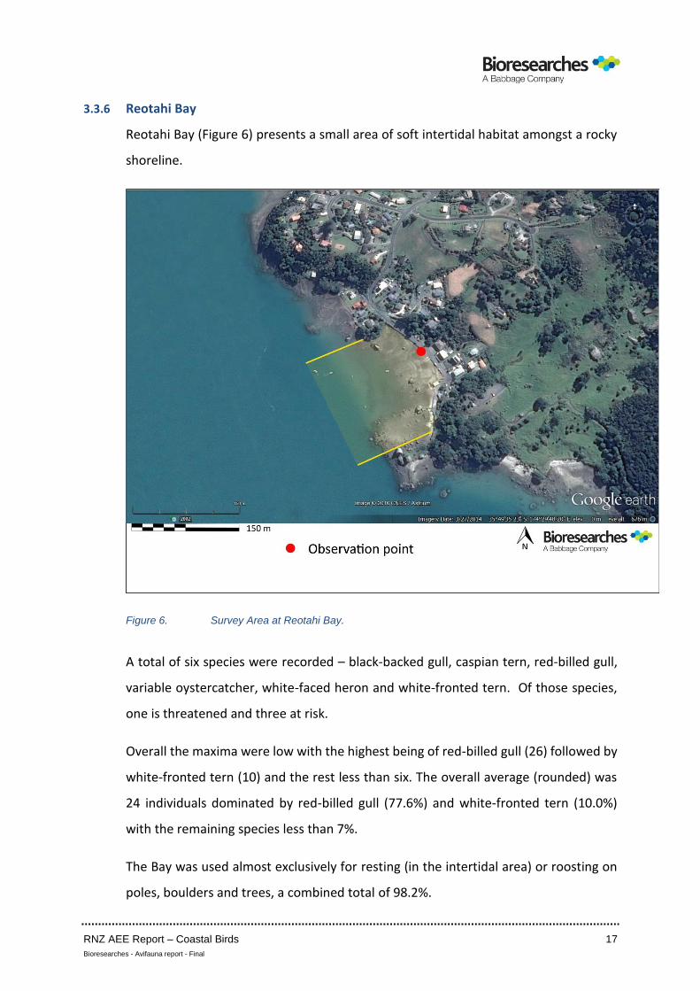
3.3.7 Taurikura Bay
The Bay (Figure 7) contains a combination of rocky and soft intertidal habitat.
Figure 7. Taurikura Bay and McKenzie Bay Survey Areas.
Over the two (2015 and 2016) surveys a total of 11 species was recorded that included
two threatened species and three at risk species. The species recorded were
australasian gannet, black-backed gull, caspian tern, kingfisher, little shag, pied shag,
red-billed gull, reef heron, spur-winged plover, variable oystercatcher and white-faced
heron.
The maxima were low with the highest being for red-billed gull - 24 in 2015 and 29 in
2016; other species were less than 10 and 6 respectively.
The average numbers were 23 (2015) and 30 (2016) and dominated by red-billed gull
at 71.9% and 80.3% of records respectively. The second most dominant species was
variable oystercatcher with 8.1 and 7.7 respectively i.e. 8 individuals in each survey.
Habitat use was biased toward resting in both 2015 and 2016 with 75.9% and 82.4%
resting respectively.
RNZ AEE Report – Coastal Birds 19
Bioresearches - Avifauna report - Final
Overall the 2015 and 2016 results were similar inferring a consistency to bird use of
Taurikura Bay in the March period.
3.3.8 McKenzie Bay
McKenzie Bay is a small, enclosed area of habitat that was utilised by low numbers and
a low diversity of species.
Birds recorded were black-backed gull, caspian tern, red-billed gull, variable
oystercatcher and white-faced heron that included one threatened and two at risk
species.
The rounded average number of birds was 2 in 2015 and 3 in 2016; the dominant
(consistent) species overall was variable oystercatcher and resting and roosting were
the dominant habitat use activities at 96.9%.
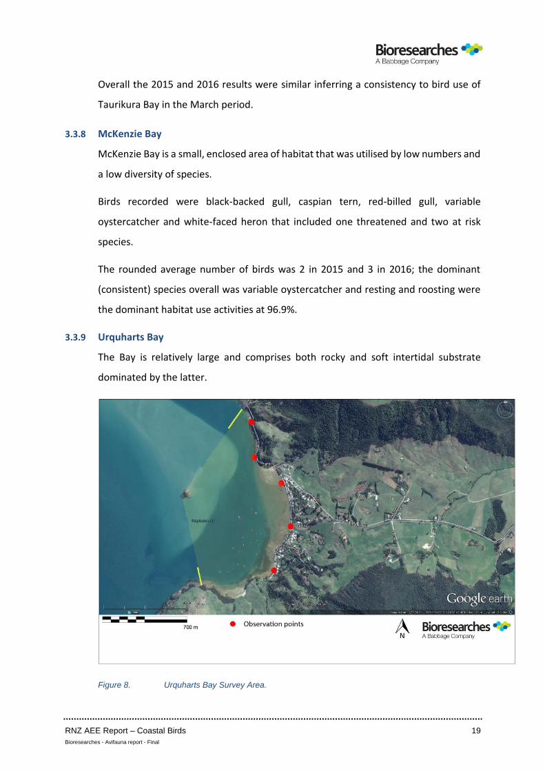
3.3.9 Urquharts Bay
The Bay is relatively large and comprises both rocky and soft intertidal substrate
dominated by the latter.
Figure 8. Urquharts Bay Survey Area.
RNZ AEE Report – Coastal Birds 20
Bioresearches - Avifauna report - Final
A relatively high total of 12 species was recorded, considering the limited habitat, over
the 2015 and 2016 surveys including two threatened and five at risk species.
The population recorded consisted of australasian gannet, black-backed gull, caspian
tern, little shag, pied shag, red-billed gull, reef heron, South Island pied oystercatcher,
spur-winged plover, variable oystercatcher, white-faced heron and white-fronted tern.
As at both Reotahi and Taurikura Bays, the highest maxima at Urquharts Bay were for
red-billed gull (51 : 2015; 37 : 2016) with about equal maxima for black-backed gull
and variable oystercatcher. Little shag was notably common overall.
The average number of individuals was 77 in 2015 and 50 in 2016. The dominant
species were consistent in terms of percentage occurrence. Notably, 8.9% of records
in 2016 were for little shag but only 2.4% in 2015; little shag commonly roosts on
vessels in Urquharts Bay.
The total percentage occurrence of gulls illustrates the typical population in the Bay
with 66.6% in 2015 and 69.7% in 2016 (red-billed plus black-backed gull). That is largely
reflected in the habitat use data with resting and roosting the main activity – 70.1% :
2015; 74.4% : 2016. However the proportion of feeding (29.9% : 2015 and 25.6% :
2016) was relatively high. Marsden Bay, which contains both feeding and high tide
roosting habitat, has c.24% feeding and c.76% resting and roosting activity.
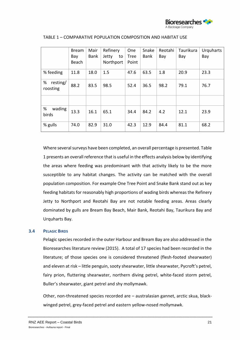
3.3.10 Comparative Population Composition and Habitat Use
The following summarises the percentages of wading birds versus gulls in the survey
area and the percentages of feeding versus resting/roosting. McKenzie Bay is excluded
because of low numbers.
RNZ AEE Report – Coastal Birds 21
Bioresearches - Avifauna report - Final
TABLE 1 – COMPARATIVE POPULATION COMPOSITION AND HABITAT USE
Bream Bay Beach
Mair Bank
Refinery Jetty to Northport
One Tree Point
Snake Bank
Reotahi Bay
Taurikura Bay
Urquharts Bay
% feeding 11.8 18.0 1.5 47.6 63.5 1.8 20.9 23.3
% resting/ roosting
88.2 83.5 98.5 52.4 36.5 98.2 79.1 76.7
% wading birds
13.3 16.1 65.1 34.4 84.2 4.2 12.1 23.9
% gulls 74.0 82.9 31.0 42.3 12.9 84.4 81.1 68.2
Where several surveys have been completed, an overall percentage is presented. Table
1 presents an overall reference that is useful in the effects analysis below by identifying
the areas where feeding was predominant with that activity likely to be the more
susceptible to any habitat changes. The activity can be matched with the overall
population composition. For example One Tree Point and Snake Bank stand out as key
feeding habitats for reasonably high proportions of wading birds whereas the Refinery
Jetty to Northport and Reotahi Bay are not notable feeding areas. Areas clearly
dominated by gulls are Bream Bay Beach, Mair Bank, Reotahi Bay, Taurikura Bay and
Urquharts Bay.
3.4 PELAGIC BIRDS
Pelagic species recorded in the outer Harbour and Bream Bay are also addressed in the
Bioresearches literature review (2015). A total of 17 species had been recorded in the
literature; of those species one is considered threatened (flesh-footed shearwater)
and eleven at risk – little penguin, sooty shearwater, little shearwater, Pycroft’s petrel,
fairy prion, fluttering shearwater, northern diving petrel, white-faced storm petrel,
Buller’s shearwater, giant petrel and shy mollymawk.
Other, non-threatened species recorded are – australasian gannet, arctic skua, black-
winged petrel, grey-faced petrel and eastern yellow-nosed mollymawk.
RNZ AEE Report – Coastal Birds 22
Bioresearches - Avifauna report - Final
The literature indicates that Bream Bay is utilised for feeding by the above species
either regularly or on a seasonal basis.
Observations of three pelagic species have been provided by Margaret Hicks as
follows:
(i) From September onwards, large numbers of Australasian gannets feed in the
vicinity of the Ruakaka Estuary mouth and an extensive area to the north of the
mouth. Ms Hicks reports that advice from the Department of Conservation is
that the gannets are from the Poor Knights Islands colony.
(ii) Little penguins, possibly mainly juveniles, are common in the northern part of
Bream Bay especially in spring and summer; dead individuals are commonly
found washed up on Bream Bay Beach. On 9 November 2015, between Mair
Road and Northport, four dead little penguins and one dead fluttering
shearwater were recorded. The observations are also endorsed by the results
of regular surveys of beach wrecked birds undertaken by the Northland Region
of the Ornithological Society of New Zealand and published in their newsletter
Amokura. For example in February 2007 a notable beach wreck of 258 little
penguin was recorded between Mair Road and Mangawhai (Amokura, 2007).
Other commonly beach wrecked birds are flesh-footed shearwater, Buller’s
shearwater, sooty shearwater, fluttering shearwater, common diving petrel
and australasian gannet, however numbers and species are both highly
variable.
(iii) In April hundreds of fluttering shearwaters are typically observed in Bream Bay
in the area off Bream Bay Beach between Sime Rd and Mair Rd and they also
enter the Mair Bank and outer Harbour open water areas.
There is a high diversity of species that utilises Bream Bay’s open water habitat; several
of those species have been observed to occur in high numbers close to shore at various
times.

RNZ AEE Report – Coastal Birds 23
Bioresearches - Avifauna report - Final
3.5 BREEDING SEASON SURVEYS
The “breeding season” for shorebirds was considered to be from August/September
to December/January acknowledging that some species exhibit breeding outside that
period. The surveys described below were undertaken in November 2015 and results
are shown on Figures 9 & 10.
3.5.1 Mair Road to Northport
The section of foreshore was inspected on foot on 9 November 2015. No nesting birds
were present along the foreshore.
3.5.2 Marsden Point to Refinery Jetty
The use of this area by breeding birds was documented on 9 and 24 November 2015.
The decision to survey this area was based on known breeding of NZ dotterel in
particular within the RNZ grounds and the possibility that early nesting in the area may
have occurred prior to 9 November.
This section of coastline was used by a pair of NZ dotterel for juvenile rearing with
three juveniles present on 9 and 24 November. Secondly a maximum of four adults
were recorded feeding along the intertidal habitat and returning to within the Refinery
grounds.
The area was also utilised by variable oystercatcher for juvenile rearing and adult
feeding with a total of four adults and two juveniles recorded.
3.5.3 Refinery Jetty to Northport
No juveniles of either NZ dotterel or variable oystercatcher were recorded and the
feeding frequency of adults of both species was low. In comparison the adjacent
Marsden Point to Refinery Jetty area had the greater “intensity of use” during the
breeding season period surveyed.
3.5.4 Darch Point to Home Point
This area contained a high diversity of potential breeding habits – rocky outcrops,
overhanging trees (especially pohutukawas), caves, rock platforms, Harbour edge
scrub and sandy beach.
RNZ AEE Report – Coastal Birds 24
Bioresearches - Avifauna report - Final
The following nesting was recorded:
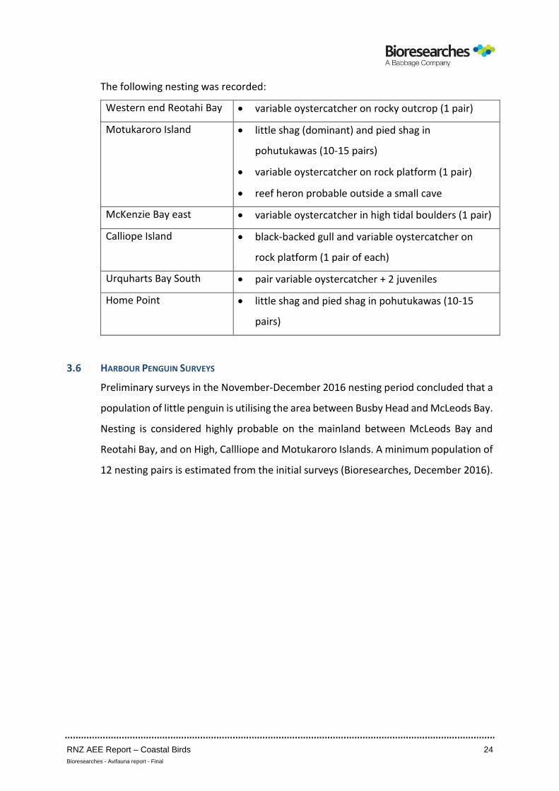
Western end Reotahi Bay • variable oystercatcher on rocky outcrop (1 pair)
Motukaroro Island • little shag (dominant) and pied shag in
pohutukawas (10-15 pairs)
• variable oystercatcher on rock platform (1 pair)
• reef heron probable outside a small cave
McKenzie Bay east • variable oystercatcher in high tidal boulders (1 pair)
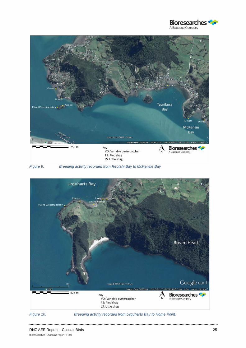
Calliope Island • black-backed gull and variable oystercatcher on
rock platform (1 pair of each)
Urquharts Bay South • pair variable oystercatcher + 2 juveniles
Home Point • little shag and pied shag in pohutukawas (10-15
pairs)
3.6 HARBOUR PENGUIN SURVEYS
Preliminary surveys in the November-December 2016 nesting period concluded that a
population of little penguin is utilising the area between Busby Head and McLeods Bay.
Nesting is considered highly probable on the mainland between McLeods Bay and
Reotahi Bay, and on High, Callliope and Motukaroro Islands. A minimum population of
12 nesting pairs is estimated from the initial surveys (Bioresearches, December 2016).
RNZ AEE Report – Coastal Birds 25
Bioresearches - Avifauna report - Final
Figure 9. Breeding activity recorded from Reotahi Bay to McKenzie Bay
Figure 10. Breeding activity recorded from Urquharts Bay to Home Point.
RNZ AEE Report – Coastal Birds 26
Bioresearches - Avifauna report - Final
4. AVIFAUNAL VALUES AND HABITAT SIGNIFICANCE
4.1 INTRODUCTION
The operative Regional Coastal Plan (RCP) for Northland refers at Section 9.2 to
Habitats of Indigenous Fauna i.e. “all fauna associated with estuarine or marine
habitats other than those known to be introduced by man. This includes resident and
migratory birds, fish and marine mammals”.
Relevant to coastal birds, intertidal habitants include:
• sand flats and banks
• beaches
• rocky shores
Subtidal habitats also involve the full range of types (i.e. soft bottom open coasts to
shallow and deep rocky reefs and flats) that are relevant to open water pelagic species.
A significant threat to habitats of indigenous fauna noted in the RCP is “dredging and
dredge spoil disposal.”
A Policy (9.2.4.1) relevant to this assessment is “to identify habitats or habitat areas of
indigenous fauna that have moderate, moderate high, high or outstanding value within
Northland’s coastal marine area and protect these from adverse effects of subdivision,
use and development.”
Method 9.25.2 of the RCP states that “assessments of significance should include the
criteria listed within the appendices.” Appendix 9 – Criteria used to determine areas
of important conservation value – lists 9 criteria including (3) Protected areas (4)
Wetlands, Estuaries and Coastal Lagoons, (5) Marine Mammals and Birds and (6)
Ecosystems, flora and fauna habitats. Specifically, Criterion 5(b) concerns “habitats of
endangered, vulnerable, rare or threatened bird species” and Criterion 5(c) refers to
“important roost sites, or feeding areas of wading birds”. The assessment of avifaunal
values and habitat significance has considered the criteria and policies of both the RCP
and NZCPS; in combination, both documents capture the features that need to be
considered.
RNZ AEE Report – Coastal Birds 27
Bioresearches - Avifauna report - Final
The draft Northland Regional Plan identifies significant bird areas in the Whangarei
Harbour. Those within the survey area for this project are Snake Bank, Marsden Bay to
One Tree Point; the Northern Coastline – Darch Point to Busby Head, Mair Bank –
Marsden Point and the nearshore area of Bream Bay Beach and Mair Bank across to
Busby Head and thence to Bream Head. (Note: the Plan’s provisions are currently draft
and have no legal effect).
Two habitats within the area of interest for this project that are not annotated as
significant bird areas are (i) the wider Bream Bay pelagic habitat and (ii) the intertidal
area between the Refinery Jetty and Northport.
The most recent Harbour – wide assessment of its avifauna is that of Pierce, 2005 for
Northland Regional Council in the context of a proposed reclassification of a
substantial part of the harbour as a Marine 1 (MM1) Area.
Key locations identified in Pierce 2015 were as follows:
(i) Tidal flats of Marsden Bay (including mangroves) and One Tree Point.
(ii) Mair Bank and Snake Bank
(iii) Northeastern Harbour beaches and headlands i.e. Darch Point to Home Point
in this assessment.
(iv) Islands used for breeding: Motukaroro, High and Calliope.
In addition the area from Home Point to Busby Head, including Frenchman Island, was
identified as a key location. Pierce, 2005 concluded that regarding the key areas,
“habitat and avifaunal values are particularly high at these sites and they require
ongoing protection via the RMA and other statutory means.”
On the basis of the recent literature reviews, surveys specific to this project and
surveys completed in Marsden Bay almost annually in the 2002-2015 period, the
following values are assigned to the key locations identified in Pierce 2005.
(a) Tidal flats – Marsden Bay to One Tree Point: of regional significance and of high
value in an outer Harbour context.
RNZ AEE Report – Coastal Birds 28
Bioresearches - Avifauna report - Final
(b) Mair Bank : national significance and part of Snake Bank: regional significance
and of high value in an outer Harbour context.
(c) Northeastern Harbour beaches and headlands: national significance in parts in
the breeding season because of nesting by threatened and at risk species. Of
local significance outside the breeding seasons and vary between low and high
value in the context of the outer Harbour.
(d) Islands – Motukaroro; High and Calliope: significance as for (c) above.
Frenchman Island, adjacent to Busby Head, would also be of national
significance in the breeding season (as indicated on Figure 11).
The additional areas of significance identified in this survey are Bream Bay pelagic
habitat and the upper intertidal habitat adjacent to Northport. The Bream Bay area is
of national significance for seabirds being in close proximity to breeding habitats at the
Bream Head Scenic Reserve and the Hen and Chicken Islands. The area of the Refinery
Jetty to Northport shoreline that is used for high tide roosting is considered to be of
regional significance during high tide periods only, but is otherwise of low coastal bird
value based on the field investigations completed for this project.
The following assessment of values addresses each survey area and integrates the
information from the Regional Coastal Plan, draft Northland Regional Plan, Pierce 2005
and the specific surveys undertaken for this project.
Sections 3.2 to 3.10 inclusive address the avifaunal values of the various surveyed
areas that apply during most of the year i.e. their general values based on feeding,
resting and roosting. Section 3.11 considers pelagic species including the close
proximity of nationally important seabird breeding colonies. Section 3.12 addresses
breeding activities as a separate consideration because, rather than any area
supporting exceptionally large colonies, the breeding recorded occurred in discrete,
relatively small areas and at isolated nesting sites. Those activities increase the values
for the duration of the breeding season only eg scattered individual variable
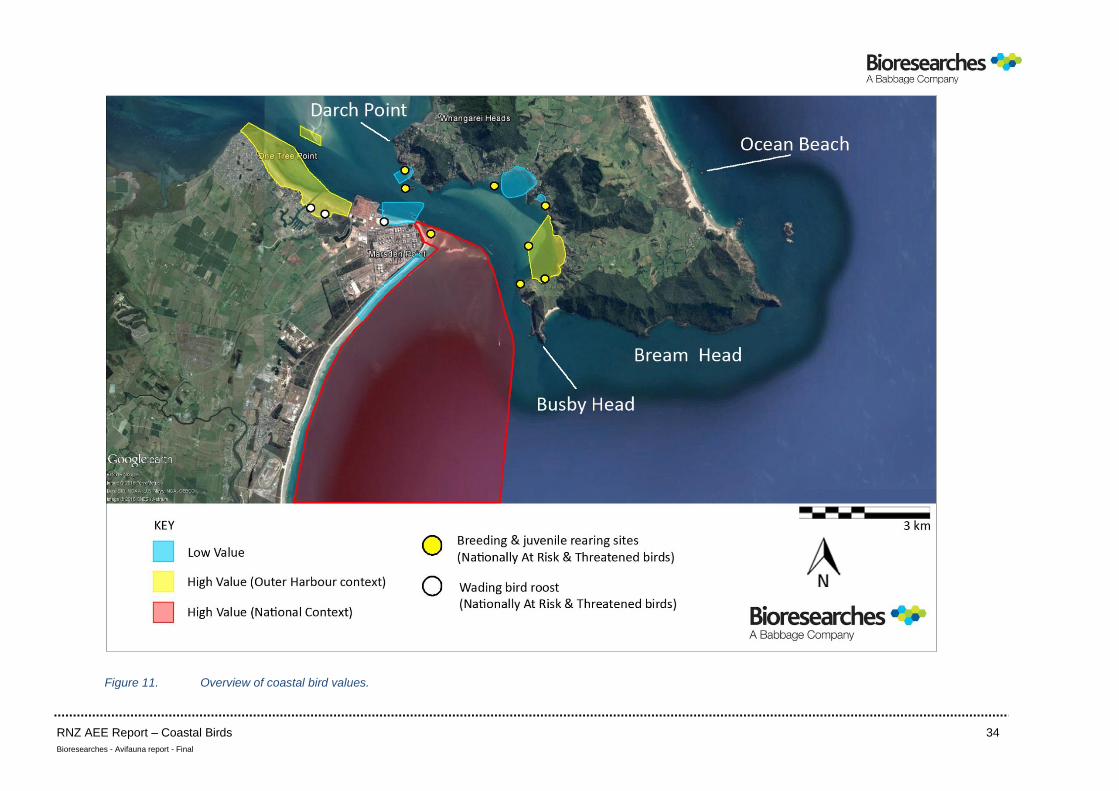
oystercatcher nests. A summary of avifaunal habitat values is shown as Figure 11.
RNZ AEE Report – Coastal Birds 29
Bioresearches - Avifauna report - Final
4.2 BREAM BAY BEACH
The c.2450m section of Beach in the vicinity of Mair Road is open coastline habitat that was
utilised by a low diversity and relatively low numbers of coastal birds. It did not contain
a high tide roost for wading birds and was not used by significant numbers of birds for
feeding either in its intertidal habitat or nearshore open water habitat. It is accepted
however that pelagic species use the nearshore areas for feeding at times (refer 4.11
below).
The intertidal habitat is similar to that along about 30km of Bream Bay from Marsden
Point to Bream Tail, has relatively low coastal bird values and is considered of local
significance only. However, that assessment excludes both Ruakaka and Waipu River
mouths and estuaries that have very high coastal bird values in a national context. The
River mouth habitats were not surveyed because they were considered too remote
from potential works areas. Based on the project description and proposed disposal
areas (i.e. disposal areas 1, 2 and 3.2) the probability of the river mouths and estuaries
being adversely affected is remote.
4.3 MAIR BANK
The three surveys indicated that Mair Bank complex was a notable high tide resting
area for black-backed gull and a key low tide feeding habitat for variable oystercatcher
as a result of its pipi beds. The surveys showed that the two outer banks (Figure 2) are
the most utilised feeding habitats and are therefore the highest value areas within the
context of the entire Bank. Mair Bank presents a habitat that is different from habitats
of both Bream Bay Beach and inside the Harbour entrance. Mair Bank is a sand and
shell ebb-tidal delta swept by strong currents and contains shellfish beds whereas
Bream Bay Beach is an open, sandy surf beach. The Taurikura to Home Point area is
relatively sheltered and contains a diversity of soft sediment and rocky habitats.
Overall Mair Bank is considered a nationally significant coastal bird habitat. A key
feature of Whangarei Harbour is that it is the third ranked wintering site in New
Zealand for variable oystercatcher (Dowding and Moore 2006). The present surveys
showed that Mair Bank is a key feeding area for variable oystercatcher and that raises
the significance of the Bank. The potential risk of an adverse effect on Mair Bank is
high because of its proximity to the works and its use for feeding.
RNZ AEE Report – Coastal Birds 30
Bioresearches - Avifauna report - Final
4.4 REFINERY JETTY TO NORTHPORT
This area of coastline presents poor quality feeding habitat but is a notable high tidal
roosting area and supports a significant portion of the outer Harbour’s variable
oystercatcher population at high tide. Other roosting and resting birds were South
Island pied oystercatcher, red billed gull and white-fronted tern. The area is of
significance in the context of the outer Harbour and functions as an alternative to the
Marsden Bay high tide roosting areas. It is of regional significance during high tide
periods as a roosting site for threatened and at risk species but is otherwise of local
significance only. The potential risk is considered low-moderate because the area is
used mainly for roosting and resting.
4.5 ONE TREE POINT
The coastline from the western side of Marsden Bay to One Tree Point contrasts with
the above (4.4) area in that it is a significant outer Harbour feeding and resting habitat
in the context of the Harbour, but does not contain a high tide roosting area, the
closest of which is in the contiguous Marsden Bay. Notable numbers of black-backed
gull and white-fronted tern were recorded but the maxima of five typical wading
species were lower than recorded in Marsden Bay. Both the Bay and the One Tree
Point area are “stepping stone” habitats to Snake Bank in particular. The Marsden Bay
– One Tree Point – Snake Bay complex is considered a regionally significant coastal bird
habitat. The overall risk is considered low because it is removed from the works area.
4.6 SNAKE BANK
The southern part of Snake Bank supported a low species diversity but a high number
of feeding South Island pied oystercatcher. The southern part of the Bank is a
significant outer Harbour feeding area in the context of Whangarei Harbour especially
in tandem with the Marsden Bay to One Tree Point habitats and in this survey,
particularly for South Island pied oystercatcher. The Marsden Bay – One Tree Point –
Snake Bank complex is considered a regionally significant coastal bird habitat –
separating out individual areas is arbitrary and not appropriate in the context of a
functioning habitat. The overall risk is considered low because it is removed from the
works area.
RNZ AEE Report – Coastal Birds 31
Bioresearches - Avifauna report - Final
4.7 REOTAHI BAY
Reotahi Bay supported a low number and low diversity of birds dominated by red-
billed gull and is used mainly for resting and roosting. It is not a notable local feeding
habitat and is not a significant coastal bird habitat in general relative to the NZCPS (i.e.
for feeding, resting and roosting) outside of the breeding season the details of which
are provided in Section 4.12 below. The risk is considered low-moderate because it is
close to the works but is mainly used for resting.
4.8 TAURIKURA BAY
The results of Taurikura Bay (also dominated by red-billed gull) recorded in 2015 and
2016 were consistent and indicated that the Bay does not contain significant intertidal
feeding habitats or a notable high tide roost. In the context of the northern shoreline
and the NZCPS it is a low value coastal bird habitat. All the remaining northern Bays
(McKenzie, Taurikura and Urquharts) are considered low risk areas because they are
removed from the works area.
4.9 MCKENZIE BAY
The McKenzie Bay results were consistent in 2015 and 2016; it provides limited habitat
that supports a low diversity and very small number of coastal birds. It is not a
significant coastal bird habitat in the context of the northern shoreline and the NZCPS
in general outside the breeding season, the details of which are provided in Section
4.12 below.
4.10 URQUHARTS BAY
The results for Urquharts Bay were also consistent in 2015 and 2016 and indicate that
the Bay supports a relatively diverse avifauna although dominated by red-billed gull.
It provides feeding habitat for variable oystercatcher and resting habitat for red-billed
gull and is a favoured local area by little shag. It is in close proximity to Mair Bank
feeding habitats and overall is a notable habitat for coastal birds but only in the context
of the outer Harbour and the NZCPS outside the breeding season, the details of which
are provided in Section 4.12 below.
RNZ AEE Report – Coastal Birds 32
Bioresearches - Avifauna report - Final
4.11 PELAGIC BIRDS
Bream Bay supports a relatively high diversity of pelagic birds including threatened and
at risk species, some of which can be present in high numbers eg little penguin,
australasian gannet, fluttering shearwater. It is in close proximity to known seabird
breeding colonies within Bream Bay Scenic Reserve and the Hen and Chickens Islands
in particular, together with slightly more distant habitats at the Poor Knights and
Mokohinau Islands. Whangarei Harbour and Bream Bay are within a wider area
proposed as a New Zealand Pelagic Important Bird Area (IBA) (Gaskin, 2014). Overall
Bream Bay is considered a significant habitat for pelagic birds in a national context i.e.
it is of national significance relative to the NZCPS (Figure 11).
4.12 BREEDING
“Breeding” is broadly considered to include the period from nest construction and
establishment to the fledging of juveniles. The notable breeding activities identified in
the survey area (One Tree Point to Darch Point and thence to Home Point) were as
follows:
• juvenile NZ dotterel (at risk species) rearing and variable oystercatcher (at risk species)
rearing: Marsden Point to Refinery Jetty.
• variable oystercatcher nesting along the northern shoreline – Reotahi Bay, McKenzie
Bay East, Urquharts Bay South, Motukaroro and Calliope Islands
• significant shag (little and pied shag – the latter an at risk species) colonies at
Motukaroro Island and Home Point.
• inferred nesting by reef heron (threatened species) – Motukaroro Island.
In addition there is a very high probability of the survey areas being used for nesting
by little penguin (at risk species) based on the literature review completed by
Bioresearches in 2015 and the November –December 2016 surveys. Potential breeding
habitat for little penguin is not shown on Figure 11 but would potentially involve all
areas of shoreline.
On the basis of known and probable nesting and juvenile rearing in the survey area of
one threatened and four at risk species, together with reported additional breeding
RNZ AEE Report – Coastal Birds 33
Bioresearches - Avifauna report - Final
from Home Point to Bream Head, the area as a whole is considered to contain
significant breeding habitats in a national context i.e. relative to the NZCPS. [(Policy
11(a) (i) and Policy 11 (b) (ii)]. That value differs from the general value of the areas as
coastal bird habitat because it refers to the duration of the breeding season for each
species only, but could not be necessarily applied to the habitat outside the breeding
season. As a result of recorded breeding by species that are “at risk” or “threatened”
on a national basis in the 2016 surveys, the following areas are of national importance,
at least in part, during the breeding season of the species concerned – Marsden Point
to Refinery Jetty, Reotahi Bay, Motukaroro Island, McKenzie Bay East, Calliope Island,
Urquharts Bay South and Home Point.
Tree nesting pied shags (Motukaroro Island; Home Point) can lay clutches all through
the year. New Zealand dotterel (Marsden Point to Refinery Jetty) that is “ground-
nesting” has a breeding season extending from about August to December. The
similarly ground-nesting variable oystercatcher (Reotahi Bay, Motukaroro Island,
McKenzie Bay East, Calliope Island, Urquharts Bay South and Marsden Point to
Refinery Jetty) has an approximate September to March inclusive breeding season.
Little penguin can be present at nesting burrows in all months except April and May.
RNZ AEE Report – Coastal Birds 34
Bioresearches - Avifauna report - Final
Figure 11. Overview of coastal bird values.
RNZ AEE Report – Coastal Birds 35
Bioresearches - Avifauna report - Final
5. AVIFAUNAL EFFECTS
There may be effects during the consent period (limited to a maximum of 35 years by
section 123 RMA) as a result of climate change. For shorebirds that could include direct
effects (changes to rainfall, temperature, wind conditions, solar radiation) and indirect
effects – habitat changes eg loss of intertidal flats, saltmarsh and rocky shorelines;
alteration to invertebrate prey distribution and abundance; changes to predator
populations; changes to both South Island breeding and feeding areas and North Island
feeding areas (eg South Island pied oystercatcher). For eastern bar-tailed godwit that
breeds in Western Alaska, climate change is likely to affect birds at all stages of their
annual cycle ie in New Zealand, along the East Asian-Australasian Flyway and in
Alaska – tundra vegetation encroachment on nesting habitat, asynchronous food
production at breeding sites, loss of intertidal foraging areas and changes to synoptic
weather patterns adversely affecting migratory flights.
Pelagic species will also be subject to changing climatic conditions, air temperature,
sea temperature and freshwater inputs for example, all of which could affect marine
productivity and food availability. Overall, the aspects listed as (i) to (iii) inclusive below
could be affected by climatic change (East Asian-Australasian Flyway Partnership e-
Newsletter, No.42, May 2017, Barbraud et al, 2012; Mustin et al 2007; Piersma &
Lindstrom, 2004; Rehfisch & Crick, 2003; www.nzbirdsonline.org.nz).
Although effects as a result of climate change are probable, those effects are unlikely
to be exacerbated by this Project.
5.1 DISCOUNTED EFFECTS
The Project will not result in the following issues that are relevant to coastal and
pelagic birds
(i) there will be no permanent loss of feeding habitat
(ii) no intertidal roosting site for shorebirds will be removed or adversely affected
to the degree that it is no longer used.
(iii) no nesting habitat will be adversely affected
(iv) there is no concern regarding sediment contamination or any contaminant
release that could affect marine habitats and organisms relied on for food. This
RNZ AEE Report – Coastal Birds 36
Bioresearches - Avifauna report - Final
includes the potential for avifauna to be impacted by bioaccumulation of
contaminants.
(v) there is no concern regarding the avifaunal effects of intermittent maintenance
dredging
(vi) there will be no adverse effect as a result of the erection and maintenance of
navigational aids.
5.2 POTENTIAL ISSUES
The potential issues regarding the avifauna arising from the Project are as follows:
(i) turbidity increases in the dredging and disposal areas
(ii) deposition of resuspended sediment on soft substrate and hard substrate
intertidal habitats
(iii) increase in vessel movements
(iv) vessel lighting
(v) underwater noise
(vi) cumulative effects
These potential issues are discussed below.
5.2.1 Turbidity Increase
5.2.1.1 Capital dredging
The dredging area totals 1.95 km2 of seabed that will be excavated on a continuous
(24 hours, 7 days per week) basis for about six months. The uncontaminated sediments
contain less than 6% silt (Coffey 2016). Modelling has indicated that the Trailing
Suction Hopper Dredger (TSHD) sediment plumes will not disperse to adjacent
beaches, sand banks or marine management areas (MetOcean, 2016).
The risk of intertidal deposition of sediment will increase in the smaller berth pocket
area that would be excavated with backhoe and barge equipment (BHD). That risk may
result in the operation being restricted to slack water or ebb tide periods (Tonkin and
Taylor, 2016).
RNZ AEE Report – Coastal Birds 37
Bioresearches - Avifauna report - Final
It is clear, however, that there will be a continual increase in the turbidity in the
immediate vicinity of the dredger for the duration of the dredging which is
unavoidable, in contrast to the short term, temporary increase in turbidity at the
disposal sites during each spoil release.
The 2000 – 2010 average range of turbidity from One Tree Point, Marsden Point, Mair
Bank and Snake Bank is 0.5 to 7.5 NTU with a grand median for those sites of 1.3 NTU
(Coffey, 2016; Table 2).
The comparable secchi disk values are 1.5 to 7.5m with a grand median of 3.9m i.e.
water clarify is generally excellent in these areas.
In contrast, turbidity may decrease significantly in inner Bream Bay following heavy
rainfall where a level of 23.7 NTU has been recorded (Coffey 2016).
For this Project the trigger level threshold for the turbidity entering the Marine 1
Management Areas is 15-20 NTU and 15-20 g/m3 suspended solids [i.e. Motukaroro
Island, Mair Bank, Calliope Bank (northern bays) and the Home Point to Busby Head
coastline].
At the Port of Melbourne a similar water quality threshold was set for a channel
dredging project at 25 g/m3 suspended solids and 17 NTU. Those thresholds were
aimed at protection of feeding areas of crested tern (Sterna cristata) and australasian
gannet (Morus serrator) (Sagar, 2011).
The birds that will be affected by an increase in turbidity are visual fish feeders (eg
little penguin, australasian gannet, white-fronted tern, caspian tern, red-billed gull and
the shag species).
Firstly an increase in turbidity may impair their ability to see and capture fish and fish
may avoid areas of higher turbidity reducing the available area of feeding habitat. In
general the effects of increased turbidity and suspended solids on foraging seabirds
are not well known (Michel et al 2013).
The use of vision by birds to locate food aggregations and capture prey is well known
however (eg Wells et al, 2016; Thiebault et al, 2014; Stempniewicz et al, 2013) and the
occurrence of a continual plume of elevated turbidity is considered to present a
RNZ AEE Report – Coastal Birds 38
Bioresearches - Avifauna report - Final
potential adverse effect, but only to a limited number of species and only while the
dredge is operating.
A vulnerability assessment was undertaken by Cook & Burton, 2010 in the context of
marine aggregate extraction. Some of the affected species are analogous with birds
that occur in the Project’s dredging area. The conclusions were as follows:
Northern gannet (Morus bassanus; compared with australasian gannet Morus
serrator) were considered relatively insensitive to the dredging operation and
associated shipping. “Their wide foraging means that despite being moderately
sensitive to increased sedimentation and impacts to the benthos or associated fish
communities, the vulnerability of Gannets to these issues has been assessed as being
very low. Despite using vision whilst foraging their vulnerability to increased turbidity
has also been assessed as being low.” This conclusion is considered to have a high level
of application to australasian gannet.
Similarly the effects on overseas shag species have application to shags in the Project
area. European or common shag [(Phalacrocorax aristotelis) cf pied shag and little shag
in particular; Phalacrocorax varius and Phalacrocorax melanoleucos – nesting colonies
present] “Despite being highly sensitive to some aspects of marine aggregate dredging,
notably disturbance and the issues related to shipping, the exposure of the European
Shag to dredging operations is low. Consequently European shags have been assessed
as being of low vulnerability to all of the issues associated with marine aggregate
extraction.”
This conclusion is considered to have a low to moderate level of application because
of the recorded degree of use of the Darch Point to Busby Head area by shags and the
presence of nesting colonies of pied and little shag at Motukaroro Island and Home
Point. There is the potential for an adverse effect on an at risk species (pied shag)
through a decreased level of feeding efficiency. The reduced efficiency to capture prey
(small fish) could result from a combination of impaired underwater vision and
avoidance of feeding areas close to the nesting sites by small fish. Those factors in
isolation or combination would lead to a decrease in feeding efficiency and therefore
the ability to sustain juvenile shags.
RNZ AEE Report – Coastal Birds 39
Bioresearches - Avifauna report - Final
The potential effect would apply to the nesting periods that can be variable and
extended but generally peak in the spring-summer. “Some little shags begin nesting
in July or August, while others join the colony later and breeding can extend to April or
May. Peak activity occurs in October-December.” Regarding pied shag – “Clutches are
laid in all months, with peaks during February-April and August-October”
(nzbirdsonline.org.nz).
In general, gulls are likely to be of low sensitivity to the effects of dredging activities as
they have a broad diet and are able to use a wide variety of habitats (Cook & Burton
2010). Although this conclusion has a high level of application to red-billed gull, an
effect is most likely during the breeding period (“They have an extremely long egg-
laying period that can extend from mid-September to January” – nzbirdsonline.org.nz).
A nationally significant nesting colony is present within the RNZ grounds.
There are two species of terns that are common in the dredging area, white-fronted
and caspian, both of which dive for small fish. Cook and Burton 2010 comment on
terns as follows “As they are constrained by a short foraging range, they are highly
vulnerable to reduced food availability”. “Thus any changes in food availability at a
local level could have a dramatic impact on populations. As they require clear water
for foraging (Essink, 1999) terns may thus be particularly sensitive to the turbidity
caused by dredging operations and the re-suspension of sediment.” An increase in
turbidity has been suggested as resulting in the reduced breeding success of sandwich
tern (Sterna sandvicensis) in the Dutch Wadden sea as a result of adults having to fly a
greater distance from the breeding colony to obtain food for their young (Essink,
1999).
In the case of the dredging area effects of this Project, the level of application is
considered relatively low because both white-fronted and caspian terns will range
both up the Harbour and out into Bream Bay to feed. Both species use the intertidal
area, especially Refinery Jetty to Northport, for resting, while white-fronted tern
commonly uses the Refinery Jetty for roosting.
RNZ AEE Report – Coastal Birds 40
Bioresearches - Avifauna report - Final
In general, however, terns can be considered as being moderately to highly vulnerable
to the effects of impacts on the benthos and associated fish communities, and highly
vulnerable to increases in turbidity (Cook and Burton, 2010).
The species and groups of birds discussed above are all able to fly and therefore move
rapidly away from visually unsuitable feeding conditions. There will be sufficient areas
of habitat containing typically high clarity water close to the dredging area to prevent
a significant adverse effect in general, however, a caveat applies to nesting shags, gulls
and terns during the main breeding period when feeding efficiency and energy
conservation obtaining food can be critical to breeding success and juvenile survival.
Specific instances may arise where greater effort may be required to secure food (eg
longer feeding flights; additional feeding time in Bream Bay and beyond). These
instances, if any, cannot be defined precisely but are unlikely to be any greater than
the effects caused by natural, seasonal prey variation or poor weather conditions and
are unlikely to reduce either breeding success or juvenile survival during the six month
period of dredging.
The flightless species using the dredging area footprint is little penguin that hunts prey
visually in daylight (squid, small fish) and is likely to nest around the coastline of the
islands and northern shoreline. Their behaviour that informs consideration of potential
effects in the dredging area is as follows from nzbirdsonline.org.nz.
Eggs are laid from July to mid-November, with additional clutches beginning as late as
December. Incubation takes up to 36 days. Chicks are brooded for 18 – 38 days, and
fledge after 7-8 weeks.
Little penguins are nocturnal on land. They return to nesting areas at dusk,
congregating in small groups, or “rafts” offshore. Rafts usually come ashore together
and are comprised of the same individuals each night. They feed at sea as solidary
individuals or small groups, rarely more than 6 individuals. They must stay ashore
continuously for about 2 weeks during the annual moult (mainly between January and
March), when all feathers are replaced simultaneously.
RNZ AEE Report – Coastal Birds 41
Bioresearches - Avifauna report - Final
During the breeding season little penguins forage within 20 km of the colony, pursuit
diving for prey generally in waters less than 50m deep. Their diet is composed of
varying proportions of small shoaling fish, squid and crustacean species. Important
prey items include arrow squid (Nototodarus sloanii), slender sprat (Sprattus
antipodum), Graham’s gudgeon (Grahamichthys radiata), red cod (Pseudophycis
bachus), ahuru (Auchenoceros punctatus) and stomatopod larvae.
(nzbirdsonline.org.nz).
The concern with the dredging footprint is primarily the disruption to breeding
penguins commuting between inner Harbour nesting habitats and feeding areas (i.e.
probably, Bream Bay).
Although little penguins are typically seen on the water surface, the deepest dive
recorded in New Zealand waters is 35m with an average dive of 5.2 – 6.4m (Doc 2015).
The deepest dive recorded was at Phillip Island, Australia at 66.7m (Ropert-Coudert et
al 2006), however most dives did not exceed 50m. NZ little penguins spend about 60%
of their time below 1m depth while at sea.
There are two main phases of little penguin breeding of concern and during those
phases behaviour can be quite different. The two phases are egg incubation and the
chick-guard stage both of which are shared. In the incubation phase the foraging trips
away from the nest averaged 8 days, however, the majority are about 2 – 3 days
(Cannell, 2016). During the guard phase the penguins foraged closer to the nesting
location and that is driven by the need for penguins to return each evening to feed
their chicks (Cannell, 2016). In the guard phase satellite tracking has shown that most
penguins undertake one day trips up to 22km from the colony but of a mean maximum
distance of 14.2km (Preston, 2007).
The overarching behaviour that could be affected is mid-water to demersal foraging
for food (Preston 2007, Preston et al 2007) – they require light penetration through
the total water column to forage efficiently since they hunt by sight. Therefore areas
affected by a turbidity plume could be rendered unsuitable for foraging by little
penguin resulting in temporary displacement from that feeding area and a lower
foraging efficiency. That would have potentially adverse effects at a local population
RNZ AEE Report – Coastal Birds 42
Bioresearches - Avifauna report - Final
level but not at a national level where the national population is estimated at 50,000
– 100,000 with a world breeding population of c.350,000 – 600,000 individuals
(www.penguins.cl/little-penguins.htm). In context any area of disruption is almost
certainly likely to be minor relative to the wide feeding area available in Bream Bay out
to the Hen and Chickens Islands.
In summary the main concern regarding little penguin is disruption of their passage
between shoreline nesting areas and the nearby open water and specifically between
the inner Harbour and its entrance.
The recent information on little penguin use of the Harbour is sparse. Pierce 2005
refers to past breeding (i.e. pre 1985) on Calliope Island, High Island, some northern
headlands and One Tree Point and notes observations of little penguin at potential
nesting areas including Little Munro Bay and McGregors Bay. Pierce, 2005 concludes
that the current relative scarcity of little penguin in Whangarei Harbour probably
reflects their vulnerability to predators over a long period. No little penguins were
observed either singly or rafting in groups during any of the 2015 – 2016 coastal bird
surveys. In addition the modification and renovation of residential dwellings on the
northern shoreline may have reduced the availability of suitable nesting sites under
houses.
However targeted surveys in November-December 2016 at dusk identified a
population that could represent at least twelve pairs using the Harbour habitat for
nesting and chick rearing. That is a notable result in the context of the Harbour but
numbers recorded suggest a relatively low breeding density.
Therefore although a continual but confined plume has the potential to disrupt
foraging trips during the breeding season, the risk on a population level is considered
low-moderate inside Busby Head on the basis of current information and relative to
the adverse effects of storm events as evidenced by beach wreck data.
Recent advice on nesting little penguin beyond the Harbour has been provided by the
Ranger, Bream Head Conservation Trust (Riaan Elliot pers comm; email of 3.10.16).
Little penguin is known to be currently using the shoreline from Busby Head to Bream
Head and around to Ocean Beach (Bream Islands) for breeding although there are no
RNZ AEE Report – Coastal Birds 43
Bioresearches - Avifauna report - Final
data on the numbers. The probability of an adverse effect in this area on a local
population basis is also considered low because much of the nesting habitat is remote
from the works area, it is an open water situation with high dilution and dispersion
rates and the probability of a “turbidity barrier” to foraging trips being created is
remote; the effects on little penguin nesting beyond the Harbour (ie along the Bream
Head coastline) would be less than minor.
Nevertheless there remains a possibility of a short term change to the local little
penguin population with respect to effects both inside and outside Busby Head in
combination, especially the former.
The characteristics of the sediment plumes associated with the dredging would be as
follows (Metocean Solutions 2016): the plumes associated with the drag head are
“constrained within the lower water column, with negligible expression in the mid-
water and surface levels. In contrast the sediment plumes associated with the overflow
phase are spread across the entire water column”. Of note was that the maximum
excursion of any plume did not exceed 1200m and was constrained to the channel.
There would be a discrete inner Harbour dredging area to the southeast of Motukaroro
Island and more minor works towards Home Point, with the major dredging area being
predominantly outside Busby Head.
Therefore the main area of dredging disturbance, albeit temporary, will be beyond the
Heads and would not affect the passage of little penguin to and from the Harbour. The
turbidity effect of dredging within the Harbour will be temporary and confined to the
existing channel i.e. a turbidity “barrier” across the channel at right angles would not
be created allowing little penguin to traverse the channel’s edges, especially along the
northern side where nesting habitat is more likely. That would avoid a disruptive
barrier being created between inner Harbour nesting habitats and open water (Bream
Bay) feeding areas. In addition, as noted above, there will be Project-specific turbidity
threshold levels that are similar to those aimed at protecting the foraging of terns and
gannets at the Port of Melbourne. Finally, although the specific turbidity levels are not
known, little penguins have adapted to intermittent, temporary turbidity increases
RNZ AEE Report – Coastal Birds 44
Bioresearches - Avifauna report - Final
that would be accommodated during storm events, rainfall events and river
discharges.
On balance the Project would be consistent with NZCPS Policy 11 (a) (i) and Policy 11
(b) (ii) and Objective 3.4 and Policy 4.4.1 of the partially Operative Northland Regional
Policy Statement (‘NRPS’) as applied to little penguin and, indeed, to the other bird
species that nest within or frequent the outer Harbour and Bream Bay.
It is acknowledged, however, that the behaviour of birds is difficult to predict and it is
equally difficult to discount all effects. For that reason, recommendations are
presented below for predator control and the installation of little penguin nesting
boxes inside the Harbour to mitigate any short term changes that might adversely
affect the local breeding population. In the longer term the maintenance of nesting
boxes, especially in a predator – controlled area, would be a positive benefit to the
Harbour’s population, and also to any nesting variable oystercatcher, reef heron and
shags.
In summary, without any mitigation the effects on the local little penguin population
are concluded to be less than minor; with the initiatives outlined in Section 7.1 the nett
result is viewed as ecological enhancement.
5.2.1.2 Disposal Areas
Disposal area 3.2 is 5.75 km2 and 45m deep and would be the repository for most of
the dredged material. Area 1.2 is 2.5 km2 and 7-15m deep.
At Area 3.2 the average mound height would be a maximum of c.4m whereas that at
Area 1.2 would average 0.6m and no shoreward migration of sediment that could
adversely affect the intertidal habitat would occur.
There is no concern regarding potential contaminant release at the disposal sites and
the proportion of silt is low.
The main disposal area is utilised as part of the wider Bream Bay by a relatively high
diversity of pelagic birds at times as identified and described in the Bioresearches
literature review (2015) and Section 3.4 of this report.
RNZ AEE Report – Coastal Birds 45
Bioresearches - Avifauna report - Final
The dredge vessel’s slow passage into the release site will disperse any surface resting
birds as would the passage of tankers, freighters and other vessels at present. The
released sediment will rapidly fall to the seafloor at 45m depth and, because of the
low silt content, any adverse effect on water quality is likely to be very localised. At
least in daylight there would be nothing to attract birds to the vessel in contrast, for
example, with a fishing vessel and the behaviour and presence of birds can be highly
variable.
Species such as grey-faced petrel are nocturnally active at breeding sites (April/May
and August) but rapidly fly out to the continental shelf to feed. Birds have been
recorded flying to the east coast of Australia while their partner is sitting on an egg
(nzbirdsonline.org.nz). In contrast, fluttering shearwaters can form large feeding flocks
in inshore and harbour waters during the summer (Gaskin & Rayner, 2013) and are
typically present off Bream Bay Beach (Sime Road to Mair Road) in April (M. Hicks pers
comm).
Similarly large numbers of gannets can be present from Ruakaka Estuary mouth north
from September onwards and would extend into Area 1.2.
Therefore while there would be disruption to any feeding pelagic birds by the dredge
vessel’s passage, the effect would be less than minor on a population level. Similarly
the probability of pelagic birds being attracted to the stationary vessel and diving to
depths with localised elevated turbidity resulting in an adverse effect, is remote, and
any effect would be very low and would not trigger NZCPS Policy 11 (a) (i) or 11 (b) (ii)
and cut across Objective 3.4 and Policy 4.4.1 of the NRPS.
5.2.2 Resuspended Sediment Deposition
Based on the modelling results for the dredging area and the disposal areas there is no
concern regarding an adverse ecological effect of sediment deposition on adjacent
intertidal and subtidal areas that could impact on the feeding areas of coastal birds.
There would be no adverse effect.
5.2.3 Vessel Movements
The vessels involved with the Project will not be very different from the range using
inner Bream Bay and the Home Point to Busby Point area at present in terms of sizes
RNZ AEE Report – Coastal Birds 46
Bioresearches - Avifauna report - Final
and speeds. Large ships utilise the Busby Head to Northport area on a regular basis at
present. Similarly, freighters and cement carriers pass through the area en route to the
Port of Whangarei and Portland, together with numerous smaller commercial and
private vessels. On balance the risk of additional vessel movements resulting in an
adverse effect on the avifauna is very low.
Arguably the species most at risk is little penguin but injuries and mortality from fast
moving craft are more likely than from the vessels used for this Project. (Canwell
2016). Little penguins can reach speeds of up to 6 kph (3.2 knots) underwater
(www.doc.govt.nz/native - animals/birds/birds-a-z/penguins/little-penguin-korora/)
and have the ability to deep dive.
On balance any effect would be less than minor, and would, therefore, be in
accordance with the direction set by the NZCPS and the NRPS.
5.2.4 Vessel Lighting
Light is well known to attract a variety of marine birds (Montevecchi, 2016). The
adverse attraction to vessel lights by seabirds is considered to be more likely in Bream
Bay beyond Busby Head. That is because the degree of ambient night lighting within
Busby Head is relatively high and contributed by the Refinery, Northport, Marsden
Cove, berthed vessels, residential areas and navigational aids.
Beyond Busby Head, however, the potential attraction of seabirds to a vessel dredging,
in transit to and from disposal area 3.2 in particular, and stationary over that area, is
considered high. Considering the operation is continuous, the potential for an adverse
effect is also considered moderate-high but tempered by the fact that large vessels are
moored in Bream Bay on a continual basis, 12 months a year in all weather conditions.
It is not known whether these vessels are impacted by seabirds however it would be
surprising if that were not the case. Nevertheless the dredger will be a large, “resident”
vessel and a constant light source. Fishing vessels can also be an attractant to seabirds
that impact with their decks at night. The most sensitive seabirds to light attractions
are gadfly petrels (Pterodroma genus), storm petrels, diving petrels, prions and some
smaller shearwater species (Taylor, 2014).
RNZ AEE Report – Coastal Birds 47
Bioresearches - Avifauna report - Final
Petrels and shearwaters in particular are described as being very sensitive to artificial
light (Le Corre et al, 2002) especially fledglings on their first flight to sea. It is thought
that occurs because these species feed on bioluminescent squid and mistake the lights
for potential prey. (Le Corre et al 2002). One of the species known to exhibit this
behaviour is grey-faced petrel (Pterodroma macroptera gouldi) that nests within the
adjacent Bream Head Scenic Reserve (Montevecchi, 2006).
The susceptibility of light-attracted seabirds to collision and injury or death is higher
on moonless nights or during the hours of darkness when the moon is below the
horizon. A critical period is a week either side of the new moon each month, whereas
clear starlit nights are less risky because the birds are able to navigate and orientate
normally. Similarly heavy fog and rain at night can increase the collision risk (Black,
2005; Thompson, 2013; Taylor, 2014).
Therefore it is concluded that collisions between seabirds and the dredging vessel
especially in the areas between Busby Head and disposal Area 3.2 are likely.
From the advice of Taylor 2014 above the more susceptible seabirds are the gadfly
petrels, grey-faced petrel (Pterodroma macroptera gouldi) that nests within Bream
Scenic Reserve, and Pycrofts petrel (Pterodroma pycrofti) that nests on the Hen and
Chicken Islands.
Shearwaters and diving petrels nesting on the Hens and Chickens Islands and therefore
susceptible to collision are as follows -
- flesh-footed shearwater (Puffinus carneipes)
- sooty shearwater (Puffinus griseus)
- fluttering shearwater (Puffinus gavia)
- little shearwater (Puffinus assimilis haurakiensis)
- northern diving petrel (Pelecanoides urinatrix urinatrix)
Additional susceptible species that nest on the Poor Knights Islands are –
- fairy prion (Pachyptila turtur)
RNZ AEE Report – Coastal Birds 48
Bioresearches - Avifauna report - Final
- Buller's shearwater (Puffinus bulleri)
- white-faced storm petrel (Pelagodroma marina maoriana
The literature review undertaken by Bioresearches (2015) identified one nationally
threatened pelagic species (flesh-footed shearwater) and twelve nationally at risk
species that are potentially susceptible.
Clearly, but with the caveats on the existing use of the area by large vessels, the risk of
an effect on species that are considered nationally threatened or at risk is notable and
heightened by the proximity of breeding colonies at Bream Bay Scenic Reserve, the
Hen and Chickens Islands and the Poor Knights Islands, and the use of Bream Bay by
young, inexperienced birds.
It is understood that there has been no breeding activity by grey-faced petrel on
Matakohe-Limestone Island in the inner Harbour in 2016 so that potential risk would
not appear to be an issue. Any birds utilising the Island would anyway have acclimated
to the ambient light levels of the Harbour environment.
On balance the general risk of light attraction and collision would be similar to that of
any other large vessel and would not be significant on a population level but would
increase during the post-fledging period. While NZCPS Policy 11 (a) (i) would not be
triggered, some management may be appropriate, particularly to achieve the direction
set in Objective 3.4 and Policy 4.4.1 of the NRPS.
There are management measures to reduce the attraction of seabirds to a vessel as
summarised by Taylor, 2014 in the case of mining on the Chatham Rise and quoted in
full. Such measures should be considered as part of a lighting audit (refer section 7.2
below) to address concerns, including for locally breeding grey-faced petrel in the
Bream Head Reserve.
“(a) reduce all unnecessary deck and cabin lighting, cover accommodation windows
at night with blinds and curtains;
(b) where possible, orientate all deck lights so they shine only downwards and
shield them to prevent upwards or horizontal light projection.
RNZ AEE Report – Coastal Birds 49
Bioresearches - Avifauna report - Final
(c) use light dimmers and timers to minimise lighting in areas where people are
not constantly active;
(d) trial different light colour options such as green coloured lights in operational
areas to reduce overall light intensity levels on the vessel;
(e) investigate the use of LED floodlights with computer controlled light levels,
colours and timers;”
5.2.5 Noise
The noise generation of potential concern would be underwater noise. This is of
relevance mainly to species that hunt prey underwater for longer periods than the
short dives of birds such as white-fronted tern and australasian gannet. In the project
area that will apply to shags and little penguin.
Roger HaskoningDHV advise that the noise generated by a TSHD will be similar to that
of a large vessel. Clearly large vessels are common in the Project area at present, the
difference being that the noise will be continuous rather than intermittent.
Woehler, 2002 investigated the literature during a study on the underwater hearing
abilities of six species of penguin in Antarctica. Only one study was located; Cooper
1982 found that underwater acoustics (killer whale vocalisations or electronic noise)
had no effect on cape cormorants (Phalacrocorax capensis) or jackass penguins
(Spheniscus demersus), and concluded that underwater acoustics does not seem to be
an efficient scaring technique.
However the present positon appears to be that there are no published studies on the
effects of underwater noise on birds (McCauley & Kent, 2008) that provide an
assurance; however Bream Bay and the Harbour support a diverse and abundant
avifauna despite the passage of large ships and numerous smaller vessels. The
probability of a noise-induced adverse effect on swimming and diving birds is
considered negligible. Noise effects would not cut across the requirements set by
either NZCPS Policy or by the NRPS.
RNZ AEE Report – Coastal Birds 50
Bioresearches - Avifauna report - Final
5.2.6 Cumulative Effects
On balance it is concluded that the cumulative effects (ie general combined overall
disruption) on coastal and pelagic birds and their habitats will be less than minor,
especially in the context of existing conditions and activities, and the proposed
mitigation.
None of the effects arising from dredging and disposal is particularly novel; large
vessels traverse the Whangarei Heads and Harbour area at present on a 24 hour basis
and in a wide range of sea states, weather conditions, tidal stages and turbidity levels.
There is some information that little penguin nationally is subject to external
pressures, including development in the coastal strip. This is evidenced by its ‘at-risk’
ranking. However, there is no information that the current proposal will have effects –
including cumulative effects - on little penguin beyond intermittent, temporary
turbidity increases confined to the existing channel. When considered together with
the provision of nesting boxes and predator eradication and control proposed by way
of environmental enhancement, the effect on little penguin is considered negligible.
RNZ AEE Report – Coastal Birds 51
Bioresearches - Avifauna report - Final
6. CONSULTATION AND REVIEW
This assessment has benefitted from discussion (and subsequent provision of
information) with Margaret Hicks at an Open Day at NZ Refining on 9 March 2015, and
a review by Dr David Thompson, NIWA on behalf of Northland Regional Council.
Comment was also received from tangata whenua regarding coastal birds. While views
expressed by tangata whenua regarding the nature and scale of potential effects on
birds, and in particular variable oystercatcher, have been carefully considered, they are
not consistent with the findings of this assessment. As described above, and following
careful assessment and field investigations, the effects on birds is overall held to be
less than minor, especially in the context of existing conditions and activities, and the
proposed mitigation (refer Section 5.2.6).
With respect to variable oystercatcher, feeding on Mair Bank only occurs when the
Bank is exposed. While there may be additional noise from the dredger, acclimation
will be rapid and feeding will not be disrupted. The current environment includes
movements of ships and other vessels, and a variety of noises. The key variable
oystercatcher roost is within 50-100m of the Northport facility (refer Figure 3) and is
subject to regular industrial noise, discharges and movement of vehicles, cranes and
heavy industry. Indeed there are some variable oystercatcher nests within the RNZ
property, which is a heavy industrial site. On balance the likely effects of the Crude
Shipping Project on variable oystercatcher will be no more than minor and do not
warrant further mitigation.
RNZ AEE Report – Coastal Birds 52
Bioresearches - Avifauna report - Final
7. RECOMMENDATIONS AND MITIGATION
7.1 LITTLE PENGUIN
There is sufficient information to indicate that little penguin would be susceptible to a
sustained increase in turbidity. The effect is a potential decrease in the foraging
efficiency of the penguins which in turn has the potential to impact on juvenile survival
and the viability of the local population. Secondly there is a concern, but only at a
precautionary level, over the effect of continuous underwater noise during the
breeding season. Countering that, the available information indicates that the key
breeding area is possibly the shoreline from Busby Head to Ocean Beach rather than
inside the Harbour and that on balance, the effect at a population level would be low.
However there is clearly a local nesting population within the Harbour and beyond
Busby Head, and there remains a possibility that an adverse effect on the breeding
success of those populations could occur.
It is further recommended that in consultation with the Department of Conservation
the breeding opportunity and potential success of little penguin should be enhanced
via predator control and the provision of nesting boxes on Motukaroro Island
Focus should be on Motukaroro Island because it is in a Marine Reserve and is habitat
that is readily pest controlled. Motukaroro Island is part of the DoC estate and is not
currently pest controlled. Pest eradication is recommended on the Island and along
its facing mainland foreshore to minimise pest incursions, commencing 6 months prior
to the start of any capital dredging. That should provide a sufficient period in which to
eradicate pests and assemble and deploy nesting boxes. The eradication should be
paralleled by the establishment of tracking tunnels on the Island to monitor pest
presence. The most efficient means for both eradication and subsequent control,
especially on the Island, would be via self-setting traps for stoats/rats and possums,
with about 5 stations on the Island and 10 on the mainland edge.
Pest eradication should ideally be completed prior to June when little penguins start
to utilise their burrows (April – May is the only period when little penguins are unlikely
to be present on land.) The pest control should be continued for a minimum of 5 years
RNZ AEE Report – Coastal Birds 53
Bioresearches - Avifauna report - Final
to accommodate acclimation to the boxes and allow a positive impact on the local
population in pest controlled conditions.
The Island has a total area of about 11321m2 (ie 1.13ha). From the literature accessed,
a typical maximum density of a mixture of natural burrows and nest boxes is about 0.5
per 100m2 or 1.0 per 200 m2 (eg Braidwood et al 2011). On that basis there is potential
area available on the Island for c.57 nests/breeding pairs. On the assumptions that (a)
the twelve pairs observed in the November-December 2016 surveys are typical and (b)
for management purposes, all pairs nest on Motukaroro Island, then a theoretical
surplus of nesting area for a further 45 pairs would be available.
Motukaroro Island is likely to consist of a relatively rough, rocky surface and the aim
of 45 nest boxes may not be practicable. It is recommended that the target is 24 boxes
based on an assumed current nesting population of 12 pairs that were observed during
the surveys. An increase of 24 pairs would be a significant conservation gain and, in
combination with pest eradication and control, would ensure any adverse effect on
the local population was negligible.
7.2 VESSEL LIGHTING
In recognition of the high diversity of pelagic species, a relatively high proportion of
which have national conservation ratings, the nearby presence of significant seabird
breeding colonies and the reported aggregations of pelagic species, a lighting audit of
the Project’s vessels should be undertaken relative to the potential measures in
mitigation listed in Section 5.2.4 above. Where there are deficiencies, those should be
rectified where practicable in consultation with the vessel operators.
7.3 GREY-FACED PETREL
The concern with grey-faced petrel is mortality of fledged young as a result of
attraction to lights and subsequent collision with the dredger in particular, especially
when it is operating beyond Busby Heads at night.
As with little penguin, any potential adverse effect could be offset by the provision of
nesting boxes. It is understood that the Bream Head Conservation Trust already
operates a comprehensive predator control program at present and that Refining NZ
is a supporter of the Trust. The grey-faced petrel nest box initiative would be specific
RNZ AEE Report – Coastal Birds 54
Bioresearches - Avifauna report - Final
and targeted, with the nest boxes enhancing existing earth burrows. In consultation
with the Trust and Department of Conservation, the final details could be outlined in
a specific management plan or agreement. It is understood, however, that there are
at least ten active burrows. It is recommended, as with little penguin, that the aim
should be a significant increase of available nest sites and therefore 20 boxes should
be provided contingent upon confirmation from the Trust.
RNZ AEE Report – Coastal Birds 55
Bioresearches - Avifauna report - Final
8. MONITORING
The recommendations below assume that the Recommendations and Mitigation
outlined in Section 7 above can be achieved.
There is no regular monitoring recommended for coastal birds because the major
elements of the Project are essentially fixed and there are unlikely to be any
opportunities to modify those elements in the event of an adverse effect being
recorded, which based on the modelling results and analysis, is considered to be in the
low risk category.
It would be more effective to focus on potential offset measures and monitoring
following completion of the Project.
8.1 MONITORING
The proposal is to document the state of the coastal bird populations in specific areas
following the completion of the Project so that both before and after data were on the
record.
The following exercises are proposed, with the coastal bird surveys being repeats of
the November 2015 – March 2016 surveys in terms of methodology and timing.
8.1.1 Coastal Birds
The following once-off state-of-environment surveys are proposed.
(a) Marsden Point to Northport breeding season (November) habitat use.
(b) Darch Point to Home Point breeding season (November) habitat use.
(c) Mair Bank coastal bird surveys (2) in the February – March period.
(d) Refinery Jetty to Northport coastal bird survey (1) in the February – March period.
(e) Urquharts Bay coastal bird survey (1) in the February - March period.
(a) and (b) would document the degree of post-dredging nesting activity by coastal
birds as previously, especially variable oystercatcher, reef heron, pied shag and little
shag.
RNZ AEE Report – Coastal Birds 56
Bioresearches - Avifauna report - Final
Mair Bank is considered to be of national importance, is immediately adjacent to the
TSHD and berth pocket dredging and is the key feeding habitat for variable
oystercatcher in the outer Harbour.
The Refinery Jetty to Northport habitat is also adjacent to the TSHD and berth pocket
dredging and is a key high tide wading bird roost and general resting area.
Urquharts Bay is a locally significant habitat for coastal birds, is the most notable
habitat on the northern shoreline and the data would reflect the general state of the
northern shoreline.
Overall, the above surveys would substantiate the state-of-environment and baseline
condition of the avifauna post-dredging that is likely to be of interest to stakeholders
and provide useful assurance for Refining NZ.
8.1.2 Little Penguin
Daylight counts and dusk arrival counts should be completed in the November to
January period as a once-off exercise when both parents are likely to be feeding at sea
and therefore more visible. In the chick-guard period (about September to October)
only one adult would be feeding at sea and encounters would be lower. The survey
area should cover the northern bays area from Reotahi Bay to Urquharts Bay inclusive.
In addition a regular, ongoing monitoring program to record nesting box success will
be developed in consultation with the Department of Conservation. To parallel the
pest control that should continue for a minimum of 5 years.
RNZ AEE Report – Coastal Birds 57
Bioresearches - Avifauna report - Final
9. CONCLUSION
Overall the impact of the Project including cumulative effects on coastal and pelagic
birds is considered to be low especially at a national population level; the NZCPS Policy
11 (a) (i), regarding adverse effects on threatened or at risk taxa, and Policy 11 (b) (ii),
regarding adverse effects on vulnerable life stages would not be triggered at a
population or regional level and, if triggered at a local level, can be mitigated.
Furthermore, the other applicable (avifauna) policy from the NRPS will also be
achieved if the Proposal is advanced in the manner that we have recommended.
The key initiative recommended is the provision of little penguin nesting boxes within
the Harbour to offset any local effect on breeding success as a result of dredging and
a turbidity increase.
In addition the provision of nest boxes for grey-faced petrel in Bream Head Scenic
Reserve is recommended to offset any local effect of the dredger’s lighting on fledged
juveniles.
Post-capital dredging monitoring is recommended to provide before and after state-
of-the-environment information on coastal birds and little penguin.
RNZ AEE Report – Coastal Birds 58
Bioresearches - Avifauna report - Final
10. REFERENCES
Amokura 2007 Newsletter of the Northland Region on the Ornithological
Society of NZ No.95. 15pp.
Barbraud, C; Rolland, V; Jenouvrier, S; Nevoux, M; Delord, K; Weimerskirch,
H.2012. Effects of climate change and fisheries bycatch on Southern
Ocean Seabirds: a review. Mar.Ecol.Prog.Ser.454:285-307.
Bioresearches, December 2015. A review of literature on the marine natural
environment of Whangarei Heads, Bream Bay and its adjacent
coastline (for Chancery Green).
Bioresearches, June 2015 Refining New Zealand Crude Shipping Project:-
Coastal Bird Survey February-March 2015. 101pp (for Chancery
Green).
Bioresearches, May 2016 Refining New Zealand Crude Shipping Project:
Coastal Bird Survey November 2015-March 2016. 121pp (for
Chancery Green).
Bioresearches, December 2016 Preliminary Little Penguin Survey November-
December 2016. 10pp (for Chancery Green).
Black, A 2005 Light induced seabird mortality on vessels operating in the
Southern Ocean: incidents and mitigation measures. Antarctic
Science 17(1):67 – 68.
Braidwood, J; Kunz, J; Wilson K-J 2011. Effect of habitat features on the
breeding success of the blue penguin (Eudyptula minor) on the West
Coast of New Zealand. NZJ.Zoology 38(2): 131-141.
Cannell, B 2016 How resilient are the Little Penguins and the coastal marine
habitats they use? 40pp (for City of Rockingham, Fremantle Ports)
RNZ AEE Report – Coastal Birds 59
Bioresearches - Avifauna report - Final
Coffey, B.T. 2016 Crude Shipping Project - Proposal to Deepen and Partially
Realign the Approaches to Marsden Point – Assessment of Marine
Ecological Effects (for Chancery Green)
Cook, A.S.C.P. and Burton, N.H.K. 2010 – A review of the potential impacts of
marine aggregate extraction on seabirds. Marine Environment
Protection Fund (MEPF) Project 09/P130. 100pp.
Cooper, J 1982 Methods of reducing mortality of seabirds caused by
underwater blasting. Marine Ornithology 10: 109-113.
Department of Conservation 2015 Little Penguin behaviour and ecosystem
health 2pp.
East Asian – Australasian Flyway Partnership (EEAFP) e-Newsletter No.42
May 2017.
Dowding JE and Moore SJ 2006 Habitat networks of indigenous shorebirds in
New Zealand. Science for Conservation 261 Dept of Conservation
98 pp.
Essink, K 1999 Ecological effects of dumping of dredged sediments; options
for management. J. Coastal Cons 5:69-80.
Gaskin, CP and Rayner, MJ 2013 Seabirds of the Hauraki, Gulf 143pp (for
Hauraki Gulf Forum)
Gaskin, C February 2014 New Zealand Seabirds – Important Bird Areas and
Conservation (for Forest & Bird) 72pp.
Gaskin, C June 2014. Important Areas for New Zealand Seabirds – Sites at Sea
– Seaward Extensions, Pelagic Areas (for Forest & Bird) 90 pp.
RNZ AEE Report – Coastal Birds 60
Bioresearches - Avifauna report - Final
James, M; Probert, K; Boyd, R & John A 2007 Summary of existing Ecological
Information and Scoping of further Assessments for Port Otago
Dredging Project. 58pp. NIWA Client Report: HAM2007156 (for Port
Otago Limited)
Kowalczyk, ND; Reina, RD; Preston, TJ, Chiaradia, A.2015 Selective foraging
within estuarine plume fronts by an inshore resident seabird.
http://dx.doi.org/10.3389/fmars.2015.00042.
Lalas, C; Jones, P.R.; & Jones, J 1999. The design and use of a nest box for
Yellow-eyed Penguins Megadyptes antipodes – a response to a
conservation need. Marine Orni. 27:199-204.
Le Corre, M; Ollivier A; Ribes, S. and Jouventin, P 2002 Light-induced
mortality of petrels: a 4-year study from Reunion Island (Indian
Ocean) Biol. Cons 105: 93-102.
McCauley RD & Salgado Kent, CP. 2008 Pile driving underwater noise
assessment, proposed Bell Bay Pulp mill wharf development – Centre
for Marine Science & Technology, Curtin University 39pp (for Gunns
Limited)
Metocean Solutions 2016 Crude Shipping Project. Predicted physical
environment effects from channel deepening and offshore disposal.
150 pp (for Chancery Green).
Michel, J; Bejarano, AC; Peterson, CH & Voss, C 2013 Review of Biological and
Biophysical Impacts from Dredging and Handling of Offshore Sand.
U.S. Department of the Interior, Bureau of Ocean Energy
Management.
Minister of Planning November 2007 Port Phillip Bay Channel Dredging
Project Assessment under Environment Effects Act 1978. 144pp.
RNZ AEE Report – Coastal Birds 61
Bioresearches - Avifauna report - Final
Montevecchi, WA 2006, Influences of Artificial Light on Marine Birds pp94-
113 In Rich, C and Longcare R Ecological Consequences of Artificial
Lighting. Island Press. 458 pp.
Mustin, K; Sutherland, W.J.; Gill, J.A. 2007. The complexity of predicting
climate-induced ecological impacts. Clim. Res.35: 1650175.
Pawley, MDM 2016 population and biomass survey of pipi (Paphies australis)
on Mair Bank, Whangarei Harbour, 2016. 12pp (for Refining NZ).
Pierce, RJ 2005 General patterns of bird use of Whangarei Harbour, March
2005 35pp (for Northland Regional Council)
Piersuma, T; Lindstrom, A. 2004. Migrating shorebirds as integrative symbols
of global environmental change. Ibis 146(s1): 61-69.
Preston, TJ 2007 Channel Deepening Project – Expert Witness Statement of
Tiana Jayne Preston 12pp.
Preston, TJ; Ropert – Coudert, Y; Kato, A; Chiaradia, A; Kirkwood, R; Dann, P
and Reina, R.D. 2007 Foraging behaviour of little penguins Eudyptula
minor in an artificially modified environment. Endangered Species
Res 3:1-9 (doi:10.3354/esr00069)
Rehfisch, MM; Crick, H.Q.P. 2003 Predicting the impact of climatic change on
Arctic – breeding waders. Water Study Group Bull: 100:86-95.
Robert – Coudert, Y; Chiaradia, A & Kato A 2006 An exceptionally deep dive
by a little penguin Eudyptula minor. Mar. Ornithology 34:71-74.
Royal HasrkoningDHV 2016 Dredging Methodology Assessment Tech. Memo
to RNZ 11.08.16. 45pp.
Sagar, P.M. 2011 Affidavit of Paul Michael Sagar on behalf of Port Otago
Limited regarding an application for Project Next Generation 42pp.
RNZ AEE Report – Coastal Birds 62
Bioresearches - Avifauna report - Final
Skov, H and Durinck, J 2001 Seabird attraction to fishing vessels is a local
process. Mar. Ecol. Prog. Ser. 214:289 – 298.
Stempniewicz, L; Darecki M; Trudnowska, E; Błachowiak-Samołyk, K;
Boehnke, R; Jakubas,D; Keslinka-Nawrot, L; Kidawa, D; Sagan, S and
Wojczulanis-Jakubas, K 2013. Visual prey availability and distribution
of foraging little auks (Alte alle) in the shelf waters of West
Spitsbergen. Polar Biology 36 (7): 949-955.
Taylor, GAS 2014 Statement of evidence for the Crown; marine consent
application by Chatham Rock Phosphate Limited to undertake mining
of phosphorite nodules on the Chatham Rise. 28pp.
Thaxter, CB and Burton, NHK 2009 High Definition Imagery for Surveying
Seabirds and Marine Mammals: A Review of Recent Trials and
Development of Protocols. British Trust for Ornithology. 30pp (for
Cowrie Ltd).
Thiebault, A; Mullers, R.H.E.; Pistorius, PA and Tremblay, Y. 2014. Local
enhancement in a seabird: reaction distances and foraging
consequence of predator aggregations. Behav. Ecol. 25 (6): 1302-
1310.
Thompson, D 2013 Effects of ships lights on fish, squid and seabirds 15pp (for
Trans-Tasman Resources Ltd).
Tonkin & Taylor Ltd 2016 Wellington Harbour Shipping Channel Deepening –
Marine Ecological Assessment (for Centreport Limited) 70pp +
Appendices
Wells MR; Angel, LP and Arnould, J.P.Y. 2016 Habitat – specific foraging
strategies in Australasian gannets. Biology Open
doi:10.1242/bio.018085. 39pp.
RNZ AEE Report – Coastal Birds 63
Bioresearches - Avifauna report - Final
Williams JR & Hume TM 2014 Investigation into the decline of pipi at Mair
Bank, Whangarei Harbour. NIWA report AKL 2014-022 (for Northland
Regional Council)
Woehler, EJ 2002 Hearing abilities of Antarctic Penguins. Proc. Conf. on
Impact of Acoustics on Marine Organisms, Berlin 17-19 June 2002 pp
82-88.
www.nzbirdsonline.org.nz
www.penguins-world.com/facts-about-penguins/w