Embed Size (px)
Citation preview
Cumberland Council
Cumberland Independent Hearing and Assessment Panel Meeting – 10 August 2016 1
A meeting of the Cumberland Independent Hearing and Assessment Panel (CIHAP) will be
held at 11:30am at the Merrylands Administration Building, 16 Memorial Avenue, Merrylands
on Wednesday, 10 August 2016.
Business as below:
Yours faithfully
CUMBERLAND COUNCIL
ORDER OF BUSINESS
1. Receipt of Apologies
2. Declarations of Interest
3. Address by Invited Speakers
4. Correspondence and Officers' Reports:
- Development Applications
- Planning Proposals

Cumberland Council
Cumberland Independent Hearing and Assessment Panel Meeting – 10 August 2016 2
{THIS PAGE INTENTIONALLY LEFT BLANK}
Cumberland Council
Cumberland Independent Hearing and Assessment Panel Meeting – 10 August 2016 3
CONTENTS
Report No. Name of Report Page No.
Development Applications
C009/16 39 Clyde Street, Guildford ................................................................................... 5
C010/16 16 Frances Street, Lidcombe .......................................................................... 61
C011/16 8-10 Clarence Street, Lidcombe ...................................................................... 93
C012/16 6-14 Park Road, Auburn ................................................................................. 179
Planning Proposals
C013/16 Planning Proposal for 23-27 Lytton Street Wentworthville (Northside
West Clinic Site) – Post Exhibition Report ..................................................... 191
C014/16 Planning Proposal for 11-19 Centenary Road, Merrylands (St Vincent
de Paul site) - Post Exhibition Report ............................................................ 203
C015/16 Planning Proposal Request for 37-39 Pavesi Street, Smithfield ................ 215
Cumberland Council
Cumberland Independent Hearing and Assessment Panel Meeting – 10 August 2016 4
{THIS PAGE INTENTIONALLY LEFT BLANK}
C009/16 Cumberland Council
Cumberland Independent Hearing and Assessment Panel Meeting – 10 August 2016 5
39 Clyde Street, Guildford
Responsible Department: Development, Environment and Infrastructure
Officer: Ashleigh Matta
File Number: 2016/10
Delivery Program Code: 11.2.1 Ensure Development is consistent with LEP and
DCP requirements and vision
Application lodged 18 January 2016
Applicant Mr Leo Wang
Owner Dreamland Capital Pty Ltd
Application No. 2016/10
Description of Land 39 Clyde Street, Guildford (Lot 5 & 6 in Deposited Plan
734)
Proposed Development Alterations and additions including a first floor addition to
an existing dwelling house and its use as a 9 room boarding
house under Affordable Rental Housing SEPP 2009, for 9
boarders.
Site Area 449.7m2
Zoning R3 Medium Density
Disclosure of political
donations and gifts
Nil disclosure
Heritage No
Issues Public submissions
SUMMARY
1. Development Application 2016/10 was received on 18 January 2016 for the
alterations and additions including a first floor addition to an existing dwelling house
and its use as a 10 room boarding house under Affordable Rental Housing SEPP
2009.
2. The application was publicly notified to adjoining and opposite owners, a notice was
placed in the local press and a notice placed on the site for 14 days from 27 January
to 10 February 2016. In response, the application received four submissions and a
petition with 29 signatures. The submissions included a letter from State Member for
Granville, Ms Julie Finn MP. The submissions raised concerns regarding
overshadowing, criminal activity, traffic, parking, waste storage, illegal development
and privacy.
3. Between 14 March 2016 and 21 June 2016 Council received various amended plans
and additional information for the proposed boarding house to address Council’s
concerns regarding privacy, overshadowing, plan of management and parking
dimensions. The application has been modified since lodgement. Modifications
include the reduction in the number of rooms (10 to 9 rooms), increase in the side
setbacks, changes to windows (highlight) and changes to the internal layout.
4. The application is recommended for conditional approval subject to the conditions as
nominated within the attached schedule.
C009/16 Cumberland Council
Cumberland Independent Hearing and Assessment Panel Meeting – 10 August 2016 6
5. The application was deferred at the 13 July 2016 CIHAP meeting due to an
administrative error. The applicant, owner and objectors have now been notified of
the 10 August 2016 CIHAP meeting.
REPORT
Introduction
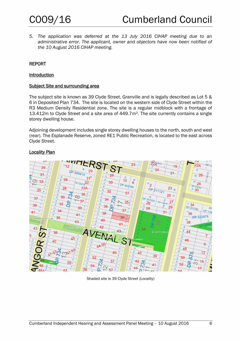
Subject Site and surrounding area
The subject site is known as 39 Clyde Street, Granville and is legally described as Lot 5 &
6 in Deposited Plan 734. The site is located on the western side of Clyde Street within the
R3 Medium Density Residential zone. The site is a regular midblock with a frontage of
13.412m to Clyde Street and a site area of 449.7m². The site currently contains a single
storey dwelling house.
Adjoining development includes single storey dwelling houses to the north, south and west
(rear). The Esplanade Reserve, zoned RE1 Public Recreation, is located to the east across
Clyde Street.
Locality Plan
Shaded site is 39 Clyde Street (Locality)
C009/16 Cumberland Council
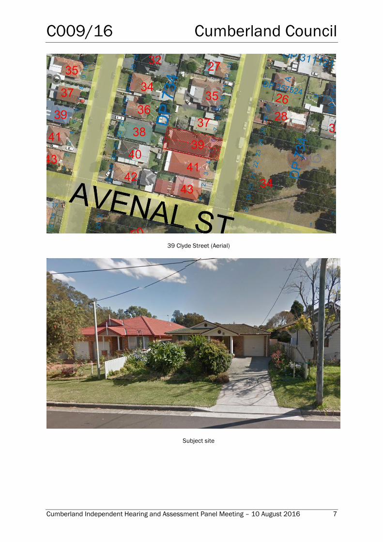
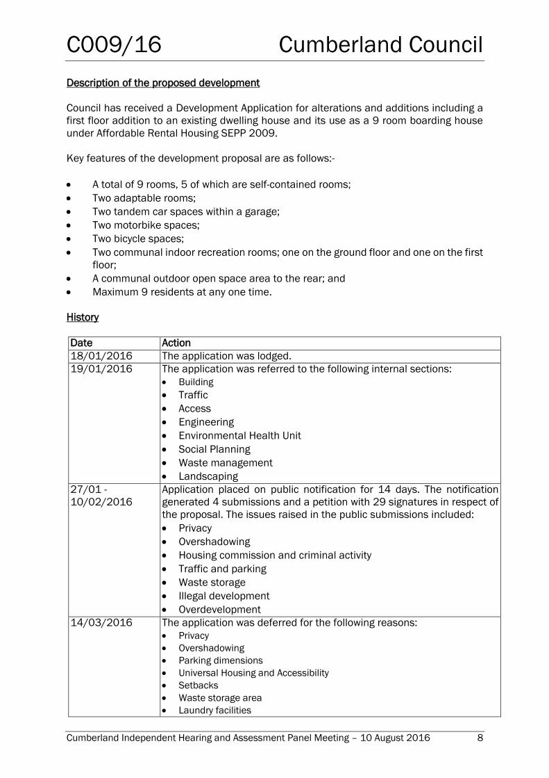
Cumberland Independent Hearing and Assessment Panel Meeting – 10 August 2016 7
39 Clyde Street (Aerial)
Subject site
C009/16 Cumberland Council
Cumberland Independent Hearing and Assessment Panel Meeting – 10 August 2016 8
Description of the proposed development
Council has received a Development Application for alterations and additions including a
first floor addition to an existing dwelling house and its use as a 9 room boarding house
under Affordable Rental Housing SEPP 2009.
Key features of the development proposal are as follows:-
A total of 9 rooms, 5 of which are self-contained rooms;
Two adaptable rooms;
Two tandem car spaces within a garage;
Two motorbike spaces;
Two bicycle spaces;
Two communal indoor recreation rooms; one on the ground floor and one on the first
floor;
A communal outdoor open space area to the rear; and
Maximum 9 residents at any one time.
History
Date Action
18/01/2016 The application was lodged.
19/01/2016 The application was referred to the following internal sections:
Building
Traffic
Access
Engineering
Environmental Health Unit
Social Planning
Waste management
Landscaping
27/01 -
10/02/2016
Application placed on public notification for 14 days. The notification
generated 4 submissions and a petition with 29 signatures in respect of
the proposal. The issues raised in the public submissions included:
Privacy
Overshadowing
Housing commission and criminal activity
Traffic and parking
Waste storage
Illegal development
Overdevelopment
14/03/2016 The application was deferred for the following reasons:
Privacy
Overshadowing
Parking dimensions
Universal Housing and Accessibility
Setbacks
Waste storage area
Laundry facilities
C009/16 Cumberland Council
Cumberland Independent Hearing and Assessment Panel Meeting – 10 August 2016 9
1/04/2016 Amended plans and additional information submitted to Council.
Summary of amendments:
Reduction in the number of rooms from 10 to 9;
An increase in the first floor side setback to the southern boundary from
900mm to 2m and 3m;
Internal modifications to increase the length of the garage;
Changes to the first floor windows to be highlight windows with a sill height
of 1.5m above FFL and louvres up to 1.7m above FFL; and
Changes to two rooms on the ground floor to be adaptable rooms.
The application did not require re-notification as the amended
application is considered to be substantially the same development and
does not result in a greater environmental impact.
4/4/2016 The application was referred back to the internal sections for review.
7/4/2016 Council’s Social Planner requested an amended Plan of Management.
21/6/2016 An amended Plan of Management was submitted to Council.
13/07/2016 Application referred to CIHAP for determination.
Applicants Supporting Statement
The applicant has provided a Statement of Environmental Effects prepared by Enhance dated
January 2016 and was received by Council on 18 January 2016 in support of the application.
Contact with relevant parties
The assessing officer has undertaken a site inspection of the subject site and surrounding
properties and been in regular contact with the applicant throughout the assessment process.
Internal Referrals
Development Engineer
The Development Application was referred to Council’s Development Engineer for
comment who has raised no objections to the proposed development.
Building Surveyor
The Development Application was referred to Council’s Building Surveyor for comment
who has raised no objections to the proposed development subject to conditions of
consent.
Landscape Officer
The Development Application was referred to Council’s Landscape Officer for comment
who has raised no objections to the proposed development.
Traffic
The Development Application was referred to Council’s Traffic Engineer for comment who
has raised no objections to the proposed development.
Environmental Health
C009/16 Cumberland Council
Cumberland Independent Hearing and Assessment Panel Meeting – 10 August 2016 10
The Development Application was referred to Council’s Environmental Health Officer for
comment who has raised no objections to the proposed development subject to
conditions of consent.
Environmental Health (waste)
The Development Application was referred to Council’s Environmental Health Officer for
comment who has raised no objections to the proposed development.
Social Planner
The Development Application was referred to Council’s Social Planner for comment who
raised concerns with the plan of management (POM). Council’s Social Planner has
recommended that a condition be included in the consent requiring the POM to be vetted
by a lawyer to ensure the document is consistent with the Boarding Houses Act. The POM
is to be submitted and approved by Council’s Social Planner prior to the issue of any
Occupation Certificate.
Planning Comments
The provisions of any Environmental Planning Instruments (EP& A Act s79C(1)(a)(i))
State Environmental Planning Policies
The proposed development is affected by the following State Environmental Planning
Policies:
(a) State Environmental Planning Policy (Building Sustainability Index: BASIX) 2004
A BASIX Certificate (No. A239220_03) has been submitted with the application and
demonstrates that the proposed development meets the required water, thermal comfort
and energy targets. The BASIX Commitments specified in the BASIX Certificate and
nominated on the architectural drawings will need to be incorporated into the construction
and fit-out of the development. A condition to require the BASIX commitments to be
implemented in the construction of the development will be included in the recommended
conditions of consent. As such, the panel can be satisfied that the sustainability obligations
under the SEPP have been met.
(b) State Environmental Planning Policy No. 55 – Remediation of Land
The requirement at Clause 7 of SEPP No. 55 for Council to be satisfied that the site is
suitable or can be made suitable to accommodate the proposed development has been
considered in the following table:
Matter for consideration Yes/No
Does the application involve re-development of the site or a change of
land use?
Yes
No Is the development going to be used for a sensitive land use (eg: residential,
educational, recreational, childcare or hospital)? Yes
No
C009/16 Cumberland Council
Cumberland Independent Hearing and Assessment Panel Meeting – 10 August 2016 11
Matter for consideration Yes/No Does information available to you indicate that an activity listed below has ever
been approved, or occurred at the site?
acid/alkali plant and formulation, agricultural/horticultural activities, airports,
asbestos production and disposal, chemicals manufacture and formulation,
defence works, drum re-conditioning works, dry cleaning establishments,
electrical manufacturing (transformers), electroplating and heat treatment
premises, engine works, explosive industry, gas works, iron and steel works,
landfill sites, metal treatment, mining and extractive industries, oil production
and storage, paint formulation and manufacture, pesticide manufacture and
formulation, power stations, railway yards, scrap yards,
service stations, sheep and cattle dips, smelting and refining, tanning and
associated trades, waste storage and treatment, wood preservation
Yes
No
Is the site listed on Council's Contaminated land database? Yes
No
Is the site subject to EPA clean-up order or other EPA restrictions? Yes
No
Has the site been the subject of known pollution incidents or illegal
dumping?
Yes
No
Does the site adjoin any contaminated land/previously contaminated
land?
Yes
No Has the appropriate level of investigation been carried out in respect of
contamination matters for Council to be satisfied that the site is suitable to
accommodate the proposed development or can be made suitable to
accommodate the proposed development?
Yes
No
Details of contamination investigations carried out at the site:
The site is not identified in Council’s records as being contaminated. A Site inspection reveals
the site does not have any obvious history of a previous land use that may have caused
contamination and there is no specific evidence that indicates the site is contaminated. The
subject site is currently used for residential purposes and contamination is not expected.
State Environmental Planning Policy (Affordable Rental Housing) 2009
The proposed development is defined as a ‘boarding house’ under the provisions of State
Environmental Planning Policy (Affordable Rental Housing) 2009. The relevant provisions
and statutory requirements of the SEPP (ARH) have been considered in the assessment of
the application.
A summary of the most important provisions applicable to the development application is
provided in the following table.
A comprehensive assessment and compliance table is attached to this report in Appendix
A which demonstrates the development proposal’s compliance with the relevant planning
controls that are applicable to the site including:
C009/16 Cumberland Council
Cumberland Independent Hearing and Assessment Panel Meeting – 10 August 2016 12
Provision of the State Policy Yes/No Comment
Clause 29(1)(a) - Floor space ratio
Floor Space Ratio for the site is the
existing maximum floor space ratio for
any form of residential accommodation
permitted on the land.
Yes
No
Permissible: 0.7:1.
Proposed: 0.63:1
Clause 29(2)(a) - Maximum height of
the building
The maximum height of the building
must not be more than the maximum
building height permitted under
another environmental planning
instrument for any building on the land.
Yes
No
Permissible: 9m
Proposed: 7.5m
Clause 29(2)(d)(i) – Private open space
requirement
One area of at least 20m2 with a
minimum dimension of 3m is provided
for the use of the lodgers.
Yes
No
A communal courtyard is proposed at
the rear of the site with an area of 20m²
and minimum dimensions of 3m. The
area comprises landscaping, seating
area and a BBQ area.
Clause 29(2)(e) – Car parking
requirement Development within an
accessible area
Car parking rate should be 0.2 spaces
per boarding room plus an additional
space for the manager.
Yes
No
The site is within 800m of Guildford
Railway Station.
Required: Two (2) spaces
Proposed: Two (2) tandem spaces are
proposed.
Council’s Traffic Engineer has reviewed
the application and supports the
proposal subject to standard
conditions.
A manager is not required. Refer to Cl
30(1)(e) of the SEPP.
Clause 30A – Character of local area
Development shall take in to
consideration whether the design of
the development is compatible with the
character of the local area.
Yes
No
The proposal presents as a two
storey dwelling house and is
considered consistent with the
local character of the area.
Refer to Appendix A for a detailed
assessment of the Character of the
area.
C009/16 Cumberland Council
Cumberland Independent Hearing and Assessment Panel Meeting – 10 August 2016 13
Local Environmental Plans
(a) Holroyd Local Environmental Plan 2013 (HLEP 2013)
The proposed development is defined as a ‘boarding house’ under the provisions of
Holroyd Local Environmental Plan 2013. Boarding houses are a permissible land use with
consent under the R3 Medium Density zoning applying to the land under HLEP 2013.
A summary of the most important provisions applicable to the development application is
provided in the following table.
Clause Yes No N/A Comment Land use table
Zone R3 Medium Density Residential
1 Objectives of zone
• To provide for the housing needs of the
community within a medium density
residential environment.
• To provide a variety of housing types within a
medium density residential environment.
• To enable other land uses that provide
facilities or services to meet the day to day
needs of residents.
2 Permitted without consent
Home occupations
3 Permitted with consent
Attached dwellings; Bed and breakfast
accommodation; Boarding houses; Building
identification signs; Business identification signs;
Child care centres; Community facilities; Dual
occupancies; Dwelling houses; Environmental
protection works; Exhibition homes; Exhibition
villages; Group homes; Home businesses; Home
industries; Hostels; Multi dwelling housing;
Neighbourhood shops; Places of public worship;
Recreation areas; Respite day care centres;
Roads; Semi-detached dwellings; Seniors housing
4 Prohibited
Any development not specified in item 2 or 3
The proposal meets
the objectives of the
zone by providing
housing needs of the
community within a
medium density
environment.
A boarding house is
permitted with
consent in the R3
Medium Density
Residential zone.
C009/16 Cumberland Council
Cumberland Independent Hearing and Assessment Panel Meeting – 10 August 2016 14
Clause Yes No N/A Comment 4.3 Height of buildings
(1) The objectives of this clause are as follows:
(a) to minimise the visual impact of
development and ensure sufficient solar
access and privacy for neighbouring
properties,
(b) to ensure development is consistent with
the landform,
(c) to provide appropriate scales and
intensities of development through
height controls.
(2) The height of a building on any land is not to
exceed the maximum height shown for the
land on the Height of Buildings Map.
In accordance with
the Height of
Buildings Map
accompanying HLEP
2013, a maximum 9m
building height is
permitted for the site.
The maximum height
proposed is 7.5m.
4.4 Floor space ratio
(1) The objectives of this clause are as follows:
(a) to support the viability of commercial
centres and provide opportunities for
economic development within those
centres,
(b) to facilitate the development of a variety
of housing types,
(c) to ensure that development is compatible
with the existing and desired future built
form and character of the locality,
(d) to provide a high level of amenity for
residential areas and ensure adequate
provision for vehicle and pedestrian
access, private open space and
landscaping.
(2) The maximum floor space ratio for a building
on any land is not to exceed the floor space
ratio shown for the land on the Floor Space
Ratio Map.
In accordance with
the Floor Space Ratio
map accompanying
HLEP 2013, the
maximum permitted
floor space ratio is
0.7:1. In this regard,
with a site area of
449.7m² the
maximum permitted
floor area is
314.79m2. The
proposed floor area is
282m² which equates
to a FSR of 0.63:1,
consistent with
Holroyd Local
Environmental Plan
2013.
C009/16 Cumberland Council
Cumberland Independent Hearing and Assessment Panel Meeting – 10 August 2016 15
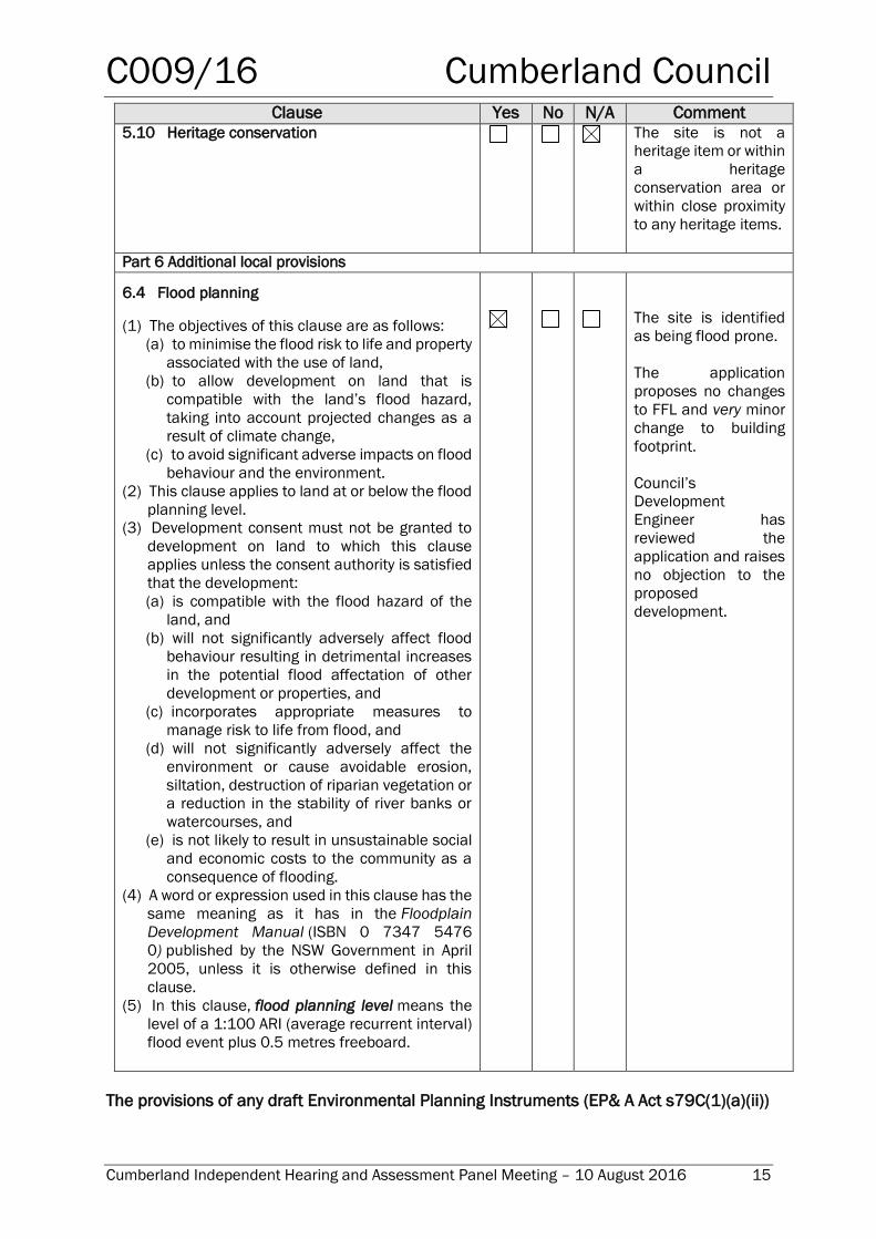
Clause Yes No N/A Comment 5.10 Heritage conservation The site is not a
heritage item or within
a heritage
conservation area or
within close proximity
to any heritage items.
Part 6 Additional local provisions
6.4 Flood planning
(1) The objectives of this clause are as follows:
(a) to minimise the flood risk to life and property
associated with the use of land,
(b) to allow development on land that is
compatible with the land’s flood hazard,
taking into account projected changes as a
result of climate change,
(c) to avoid significant adverse impacts on flood
behaviour and the environment.
(2) This clause applies to land at or below the flood
planning level.
(3) Development consent must not be granted to
development on land to which this clause
applies unless the consent authority is satisfied
that the development:
(a) is compatible with the flood hazard of the
land, and
(b) will not significantly adversely affect flood
behaviour resulting in detrimental increases
in the potential flood affectation of other
development or properties, and
(c) incorporates appropriate measures to
manage risk to life from flood, and
(d) will not significantly adversely affect the
environment or cause avoidable erosion,
siltation, destruction of riparian vegetation or
a reduction in the stability of river banks or
watercourses, and
(e) is not likely to result in unsustainable social
and economic costs to the community as a
consequence of flooding.
(4) A word or expression used in this clause has the
same meaning as it has in the Floodplain
Development Manual (ISBN 0 7347 5476
0) published by the NSW Government in April
2005, unless it is otherwise defined in this
clause.
(5) In this clause, flood planning level means the
level of a 1:100 ARI (average recurrent interval)
flood event plus 0.5 metres freeboard.
The site is identified
as being flood prone.
The application
proposes no changes
to FFL and very minor
change to building
footprint.
Council’s
Development
Engineer has
reviewed the
application and raises
no objection to the
proposed
development.
The provisions of any draft Environmental Planning Instruments (EP& A Act s79C(1)(a)(ii))
C009/16 Cumberland Council
Cumberland Independent Hearing and Assessment Panel Meeting – 10 August 2016 16
The proposed development is not affected by any relevant Draft Environmental Planning
Instruments.
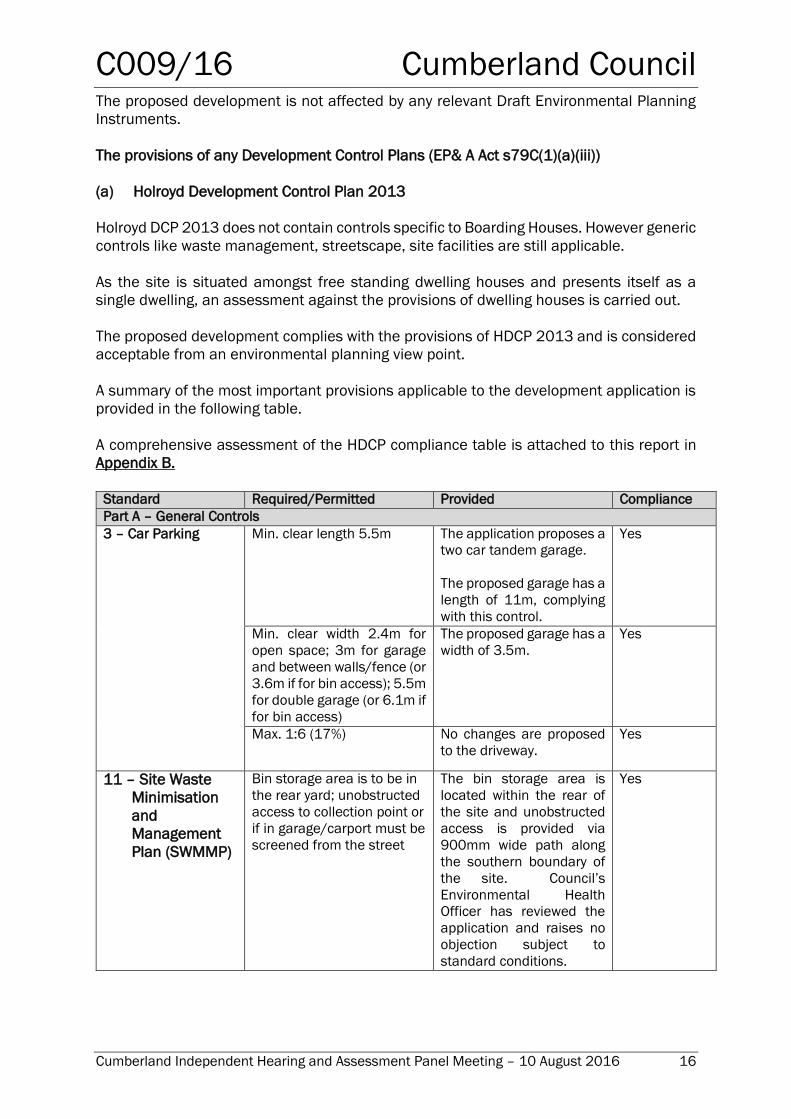
The provisions of any Development Control Plans (EP& A Act s79C(1)(a)(iii))
(a) Holroyd Development Control Plan 2013
Holroyd DCP 2013 does not contain controls specific to Boarding Houses. However generic
controls like waste management, streetscape, site facilities are still applicable.
As the site is situated amongst free standing dwelling houses and presents itself as a
single dwelling, an assessment against the provisions of dwelling houses is carried out.
The proposed development complies with the provisions of HDCP 2013 and is considered
acceptable from an environmental planning view point.
A summary of the most important provisions applicable to the development application is
provided in the following table.
A comprehensive assessment of the HDCP compliance table is attached to this report in
Appendix B.
Standard Required/Permitted Provided Compliance
Part A – General Controls
3 – Car Parking Min. clear length 5.5m The application proposes a
two car tandem garage.
The proposed garage has a
length of 11m, complying
with this control.
Yes
Min. clear width 2.4m for
open space; 3m for garage
and between walls/fence (or
3.6m if for bin access); 5.5m
for double garage (or 6.1m if
for bin access)
The proposed garage has a
width of 3.5m.
Yes
Max. 1:6 (17%) No changes are proposed
to the driveway.
Yes
11 – Site Waste
Minimisation
and
Management
Plan (SWMMP)
Bin storage area is to be in
the rear yard; unobstructed
access to collection point or
if in garage/carport must be
screened from the street
The bin storage area is
located within the rear of
the site and unobstructed
access is provided via
900mm wide path along
the southern boundary of
the site. Council’s
Environmental Health
Officer has reviewed the
application and raises no
objection subject to
standard conditions.
Yes
C009/16 Cumberland Council
Cumberland Independent Hearing and Assessment Panel Meeting – 10 August 2016 17
Part B – Residential
1 – General
Residential
Controls
1.4 - Visual Privacy
Window sills of upper floor
habitable rooms (excluding
bedrooms) shall have a
maximum height of
1500mm
Refer to discussion below.
Yes
It is noted that the plans were amended since the lodgement of the
application to convert all first floor windows within the side and rear
elevations to highlight windows with sill heights of 1500mm with fixed
external privacy louvres to 1700mm.
An assessment of each elevation and the visual privacy impacts, is
provided as follows:
North elevation (side)
Ground Floor: The ground floor contains two highlight windows associated
with the garage and a window and sliding door associated with the living
room and kitchen.
No concerns are raised over the dining room and kitchen windows given
the existing 1.8m high boundary fence which will restrict direct views
between properties. The ground floor is predominately at grade with no fill
proposed and a setback of 2m is proposed to the northern boundary.
First Floor: The first floor contains two highlight windows associated with
bedrooms. The windows have sill heights of 1500mm above FFL, with fixed
external privacy louvres to 1700m.
No concerns are raised given the views into the adjoining property are
restricted and there is a setback of 2.295m to the northern boundary.
South elevation (side)
Ground Floor: The ground floor contains six windows associated with
bedrooms and bathrooms.
No concerns are raised given the existing 1.8m high boundary fence which
will restrict direct views between properties. The ground floor is
predominately at grade with no fill proposed
First floor: The first floor contains two windows associated with a living room
and one window associated with a bedroom. These windows have a sill
height of 1500m above FFL, with fixed external privacy louvres to 1700mm.
No concerns are raised given the views into the adjoining property are
restricted.
West elevation (rear)
Ground floor: The ground floor contains one sliding door associated with
the dining and living room. An outdoor living area is proposed which is
predominantly at grade and proposes no fill.
C009/16 Cumberland Council
Cumberland Independent Hearing and Assessment Panel Meeting – 10 August 2016 18
Part B – Residential
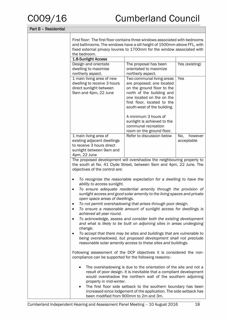
First floor: The first floor contains three windows associated with bedrooms
and bathrooms. The windows have a sill height of 1500mm above FFL, with
fixed external privacy louvres to 1700mm for the window associated with
the bedroom.
1.8-Sunlight Access
Design and orientate
dwelling to maximise
northerly aspect.
The proposal has been
orientated to maximize
northerly aspect.
Yes (existing)
1 main living area of new
dwelling to receive 3 hours
direct sunlight between
9am and 4pm, 22 June
Two communal living areas
are proposed; one located
on the ground floor to the
north of the building and
one located on the on the
first floor, located to the
south-west of the building.
A minimum 3 hours of
sunlight is achieved to the
communal recreation
room on the ground floor.
Yes
1 main living area of
existing adjacent dwellings
to receive 3 hours direct
sunlight between 9am and
4pm, 22 June
Refer to discussion below No, however
acceptable
The proposed development will overshadow the neighbouring property to
the south at No. 41 Clyde Street, between 9am and 4pm, 22 June. The
objectives of the control are:
To recognise the reasonable expectation for a dwelling to have the
ability to access sunlight.
To ensure adequate residential amenity through the provision of
sunlight access and good solar amenity to the living spaces and private
open space areas of dwellings.
To not permit overshadowing that arises through poor design.
To ensure a reasonable amount of sunlight access for dwellings is
achieved all year round.
To acknowledge, assess and consider both the existing development
and what is likely to be built on adjoining sites in areas undergoing
change.
To accept that there may be sites and buildings that are vulnerable to
being overshadowed, but proposed development shall not preclude
reasonable solar amenity access to these sites and buildings.
Following assessment of the DCP objectives it is considered the non-
compliance can be supported for the following reasons:-
The overshadowing is due to the orientation of the site and not a
result of poor design. It is inevitable that a compliant development
would overshadow the northern wall of the southern adjoining
property in mid-winter.
The first floor side setback to the southern boundary has been
increased since lodgement of the application. The side setback has
been modified from 900mm to 2m and 3m.
C009/16 Cumberland Council
Cumberland Independent Hearing and Assessment Panel Meeting – 10 August 2016 19
Part B – Residential
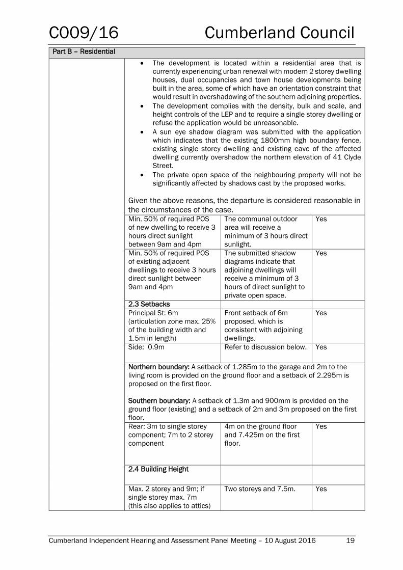
The development is located within a residential area that is
currently experiencing urban renewal with modern 2 storey dwelling
houses, dual occupancies and town house developments being
built in the area, some of which have an orientation constraint that
would result in overshadowing of the southern adjoining properties.
The development complies with the density, bulk and scale, and
height controls of the LEP and to require a single storey dwelling or
refuse the application would be unreasonable.
A sun eye shadow diagram was submitted with the application
which indicates that the existing 1800mm high boundary fence,
existing single storey dwelling and existing eave of the affected
dwelling currently overshadow the northern elevation of 41 Clyde
Street.
The private open space of the neighbouring property will not be
significantly affected by shadows cast by the proposed works.
Given the above reasons, the departure is considered reasonable in
the circumstances of the case. Min. 50% of required POS
of new dwelling to receive 3
hours direct sunlight
between 9am and 4pm
The communal outdoor
area will receive a
minimum of 3 hours direct
sunlight.
Yes
Min. 50% of required POS
of existing adjacent
dwellings to receive 3 hours
direct sunlight between
9am and 4pm
The submitted shadow
diagrams indicate that
adjoining dwellings will
receive a minimum of 3
hours of direct sunlight to
private open space.
Yes
2.3 Setbacks
Principal St: 6m
(articulation zone max. 25%
of the building width and
1.5m in length)
Front setback of 6m
proposed, which is
consistent with adjoining
dwellings.
Yes
Side: 0.9m
Refer to discussion below. Yes
Northern boundary: A setback of 1.285m to the garage and 2m to the
living room is provided on the ground floor and a setback of 2.295m is
proposed on the first floor.
Southern boundary: A setback of 1.3m and 900mm is provided on the
ground floor (existing) and a setback of 2m and 3m proposed on the first
floor.
Rear: 3m to single storey
component; 7m to 2 storey
component
4m on the ground floor
and 7.425m on the first
floor.
Yes
2.4 Building Height
Max. 2 storey and 9m; if
single storey max. 7m
(this also applies to attics)
Two storeys and 7.5m. Yes
C009/16 Cumberland Council
Cumberland Independent Hearing and Assessment Panel Meeting – 10 August 2016 20
Part B – Residential
Min. 2.4m floor to ceiling
height
2.4m floor to ceiling
height on the ground floor
and first floor.
Yes
(b) Council’s Social Impact Assessment Policy
Under Council’s Social Impact Assessment (SIA) Policy the subject application was required
to submit a Social Impact Assessment due to the scale of the development. This was
submitted and assessed by Council’s Social Planner to be satisfactory.
79C(1)(a)(iiia) - any planning agreement that has been entered into under section 93F,
or any draft planning agreement that a developer has offered to enter into under section
93F, and
There is no draft planning agreement associated with the subject Development
Application.
The provisions of the Regulations (EP& A Act s79C(1)(a)(iv))
The proposed development raises no concerns as to the relevant matters arising from the
EP& A Regulations 2000.
79C(1)(a)(v) - any coastal zone management plan (within the meaning of the Coastal
Protection Act 1979)
There is no Coastal Zone Management Plan applicable for the Guildford area.
The Likely Environmental, Social or Economic Impacts (EP& A Act s79C(1)(b))
The likely impacts of the development have been considered in the assessment of the
application and are considered that the proposed development will have no significant
adverse environmental, social or economic impacts in the locality.
The suitability of the site for the development (EP&A Act s79C(1)(c))
The site is identified as being flood prone and Council’s Development Engineer has
reviewed the application and raises no objection to the proposal. The site can be said to
be suitable to accommodate the proposal. The proposed development has been assessed
in regard its environmental consequences and having regard to this assessment, it is
considered that the development is suitable in the context of the site and surrounding
locality.
Submissions made in accordance with the Act or Regulation (EP&A Act s79C(1)(d
Advertised (newspaper) Mail Sign Not Required
In accordance with Part E Public Participation of HDCP 2013, the proposal was publicly
exhibited for a period of 14 days between 27 January and 10 February 2016. The
notification generated 4 submissions and a petition with 29 signatures in respect of the
proposal. The issues raised in the public submissions are summarised and commented on
as follows:
C009/16 Cumberland Council
Cumberland Independent Hearing and Assessment Panel Meeting – 10 August 2016 21
Overshadowing
Concern is raised that the proposed development will overshadow the property to the
south.
Comment: The development complies with the density, bulk and scale and height controls
of the LEP and DCP. The overshadowing is due to the orientation of the site and not a result
of poor design. It is inevitable that a compliant development would overshadow the
northern wall of the southern adjoining property in mid-winter.
Notwithstanding this, the side setback to the southern boundary has been increased since
lodgement of the application to improve solar access to the adjoining property to the south.
In this regard, the side setback of the first floor has been increased from 900mm to 2m
and 3m.
The issue of solar access has been addressed further under HDCP 2013, Part B, Section
1.8-Sunlight Access.
Housing commission and Criminal Activity
Concern is raised that the site is proposed for housing commission creating danger for
young families living in the area and increasing crime in the area. Concern is also raised
that there will be syringes and cigarettes being left on the site and surrounding area.
Comment: A Plan of Management (POM) and house rules have been prepared for the
proposed development and will form part of the endorsed documents, should the
application be approved. The plan of management specifies how the premises will operate
and addresses residents behaviour, house rules, noise, maintaining good relations with
neighbours, use of external areas, the holding of parties, the consumption of alcohol, the
parking of vehicles, dealing with complaints, cleaning schedules, waste disposal, number
of approved rooms and occupants, contact details of the onsite manager and conflict
resolution.
The application is not made by a social housing provider and the objector has not provided
any evidence to support that the proposal will increase criminal activity in the area.
Traffic and Parking
Concern is raised that the proposed development will result in increased traffic and loss
of street parking in Clyde Street, with cars being parked along residents’ driveways
blocking their access.
Comment: The proposed development complies with the parking controls within State
Environmental Planning Policy (Affordable Housing) 2009, which requires the provision of
two (2) spaces for this development. Council’s Traffic Engineer has reviewed the
application and raises no objection to the proposed development. The Plan of
Management submitted with the application includes a house rule which states that cars
are not to block driveways.
The proposed development is considered suitable for the site given its location close to
public transport.
C009/16 Cumberland Council
Cumberland Independent Hearing and Assessment Panel Meeting – 10 August 2016 22
Waste storage
Concern is raised that the proposal, with additional 20-30 residents, will increase the
amount of rubbish in the area. Concern is raised over the number of bins required and
whether the waste storage area provided is sufficient.
Comment: The application proposes a 9 room boarding house and the maximum number
of occupants is 9.
A waste storage room is located at the rear of the site that accommodates 6
waste/recycling bins. Council’s Environmental Health Officer has reviewed the application
and raised no objection to the proposal.
Illegal development
Concern is raised that the proposed development is illegal.
Comment: The proposed development is defined as a ‘boarding house’ under the
provisions of Holroyd Local Environmental Plan 2013. Boarding houses are a permissible
land use with Council consent under the R3 Medium Density zoning applying to the land
under HLEP 2013. Further, the proposal is permissible in accordance with the State
Environmental Planning Policy (Affordable Rental Housing) 2009.
Council Park
Concern is raised that the proposed development will worsen the existing problem with
Council’s Park across the road which has people drinking and doing drugs late at night.
Comment: The objector has not provided any evidence to support that the proposal will
result in illegal activity in the public park. The issue regarding drinking alcohol in a public
park and use of illegal drugs is not related to this Development Application. This is a matter
that should be reported to NSW Police.
Loss of privacy
Concern is raised over the loss of privacy given the proposed windows.
Comment: The plans have been amended since the lodgement of the application to
convert all first floor windows within the side and rear elevations to highlight windows with
sill heights of 1500mm with fixed external privacy louvres to 1700mm above FFL. An
assessment of each elevation and the visual privacy impacts is provided within the report
under HDCP 2013, Part B, Section 1.4 Visual Privacy.
Overdevelopment
Concern is raised that the proposal is an overdevelopment of the 400m² site.
Comment: The proposed development is a permissible development within the zoning
applying to the land and complies with the floor space ratio and height controls of Holroyd
Local Environmental Plan 2013.
C009/16 Cumberland Council
Cumberland Independent Hearing and Assessment Panel Meeting – 10 August 2016 23
It is noted that the site is zoned R3 Medium Density and multi dwelling housing is a
permissible land use in R3 zone. If the site was to be developed for multi dwelling housing,
a site area of 900m² is required and with a FSR of 0.7:1, this would allow a Gross Floor
Area of 630m². Noting the average dwelling size is 100m², 6-9 dwellings could be
proposed, resulting in approximately 15-18 people (7-9 people per lot). This is consistent
with what is proposed on the site.
The proposal is not considered to be an overdevelopment of the site.
Existing dwelling
Concern is raised that the existing dwelling is not capable of accommodating the load of
another level.
Comment: A condition is recommended to be included in the consent requiring a certificate
to be submitted to the Principal Certifying Authority in accordance with the requirements
of Part 3.11, Clause 3.11.2 and Clause 3.11.3 of the Building Code of Australia, by a
qualified practising structural engineer certifying the adequacy of the existing dwelling as
being capable of supporting the proposed live and dead loads.
Amended plans
Amended plans were submitted on 22 April 2016.
Summary of amendments:
Reduction in the number of rooms from 10 to 9;
An increase in the first floor side setback to the southern boundary from 900mm to 2m and
3m;
Internal modifications to increase the length of the garage;
Changes to the first floor windows to be highlight windows with a sill height of 1.5m above FFL
and louvres up to 1.7m above FFL; and
Changes to two rooms on the ground floor to be adaptable rooms.
The application did not require re-notification as the amended application is considered to
be substantially the same development and does not result in a greater environmental
impact.
The public interest (EP& A Act s79C(1)(e))
The public interest is served by permitting the orderly and economic development of land,
in a manner that is sensitive to the surrounding environment and has regard to the
reasonable amenity expectations of surrounding land users. In view of the foregoing
analysis it is considered that the development, if carried out subject to the conditions set
out in the attachment, will have no significant adverse impacts on the public interest.
C009/16 Cumberland Council
Cumberland Independent Hearing and Assessment Panel Meeting – 10 August 2016 24
Section 94 Contribution towards provision or improvement of amenities or services
This part of the Act relates to the collection of monetary contributions from applicants for
use in developing key local infrastructure. The Act reads as follows:
‘(1) If a consent authority is satisfied that development for which development
consent is sought will or is likely to require the provision of or increase the
demand for public amenities and public services within the area, the
consent authority may grant the development consent subject to a
condition requiring:
(a) the dedication of land free of cost, or
(b) the payment of a monetary contribution, or both.
(2) A condition referred to in subsection (1) may be imposed only to require
a reasonable dedication or contribution for the provision, extension or
augmentation of the public amenities and public services concerned.’
Comments: The development would require the payment of contributions in accordance
with Council Section 94 Contributions Plans. It is recommended that conditions be
imposed on any consent requiring the payment of these contributions prior to the issue of
any construction certificate for the development.
As at 15 June 2016, the fee payable is $17,795. This figure is subject to indexation as per
the relevant plan.
Disclosure of Political Donations and Gifts
The NSW Government introduced The Local Government and Planning Legislation
Amendment (Political Donations) Act 2008 (NSW). This disclosure requirement is for all
members of the public relating to political donations and gifts. The law introduces
disclosure requirements for individuals or entities with a relevant financial interest as part
of the lodgement of various types of development proposals and requests to initiate
environmental planning instruments or development control plans.
The applicant and notification process did not result in any disclosure of Political Donations
and Gifts.
Conclusion
The development application has been assessed in accordance with the relevant
requirements of the Environmental Planning and Assessment Act 1979, State
Environmental Planning Policy (Affordable Rental Housing) 2009, Holroyd Local
Environmental Plan 2013 and the Holroyd Development Control Plan 2013 and is
considered to be satisfactory for approval subject to conditions.
Report Recommendation:
That Development Application No. 2016/10 for alterations and additions including a first
floor addition to an existing dwelling house and its use as a 9 room boarding house under
Affordable Rental Housing SEPP 2009 on land at 39 Clyde Street Guildford be approved
subject to the attached condition set.
C009/16 Cumberland Council
Cumberland Independent Hearing and Assessment Panel Meeting – 10 August 2016 25
ATTACHMENTS
1. Draft Notice of Determination
2. Architectural Plans
3. Submissions (x4) (to be circulated to CIHAP members only under separate cover)
4. Plan of Management
5. Locality Map
C009/16 Cumberland Council
Cumberland Independent Hearing and Assessment Panel Meeting – 10 August 2016 26
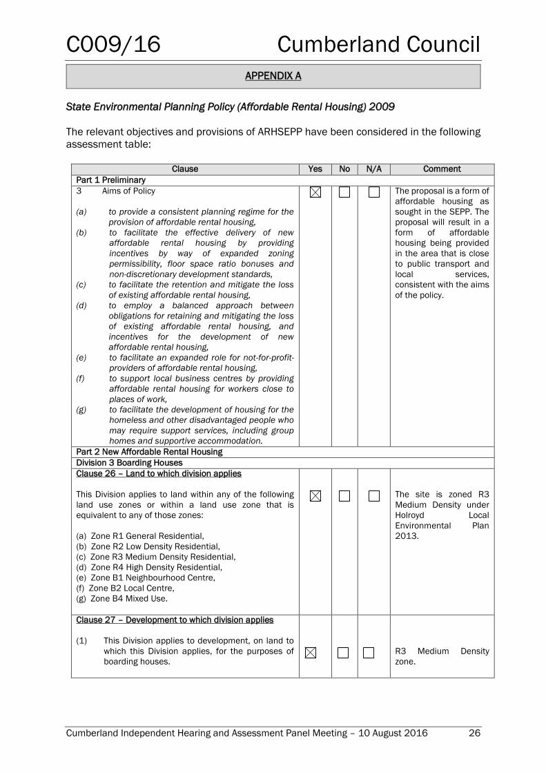
APPENDIX A
State Environmental Planning Policy (Affordable Rental Housing) 2009
The relevant objectives and provisions of ARHSEPP have been considered in the following
assessment table:
Clause Yes No N/A Comment
Part 1 Preliminary
3 Aims of Policy
(a) to provide a consistent planning regime for the
provision of affordable rental housing,
(b) to facilitate the effective delivery of new
affordable rental housing by providing
incentives by way of expanded zoning
permissibility, floor space ratio bonuses and
non-discretionary development standards,
(c) to facilitate the retention and mitigate the loss
of existing affordable rental housing,
(d) to employ a balanced approach between
obligations for retaining and mitigating the loss
of existing affordable rental housing, and
incentives for the development of new
affordable rental housing,
(e) to facilitate an expanded role for not-for-profit-
providers of affordable rental housing,
(f) to support local business centres by providing
affordable rental housing for workers close to
places of work,
(g) to facilitate the development of housing for the
homeless and other disadvantaged people who
may require support services, including group
homes and supportive accommodation.
The proposal is a form of
affordable housing as
sought in the SEPP. The
proposal will result in a
form of affordable
housing being provided
in the area that is close
to public transport and
local services,
consistent with the aims
of the policy.
Part 2 New Affordable Rental Housing
Division 3 Boarding Houses
Clause 26 – Land to which division applies
This Division applies to land within any of the following
land use zones or within a land use zone that is
equivalent to any of those zones:
(a) Zone R1 General Residential,
(b) Zone R2 Low Density Residential,
(c) Zone R3 Medium Density Residential,
(d) Zone R4 High Density Residential,
(e) Zone B1 Neighbourhood Centre,
(f) Zone B2 Local Centre,
(g) Zone B4 Mixed Use.
The site is zoned R3
Medium Density under
Holroyd Local
Environmental Plan
2013.
Clause 27 – Development to which division applies
(1) This Division applies to development, on land to
which this Division applies, for the purposes of
boarding houses.
R3 Medium Density
zone.
C009/16 Cumberland Council
Cumberland Independent Hearing and Assessment Panel Meeting – 10 August 2016 27
Clause Yes No N/A Comment
28 Development may be carried out with consent
Development to which this Division applies may be
carried out with consent.
Noted
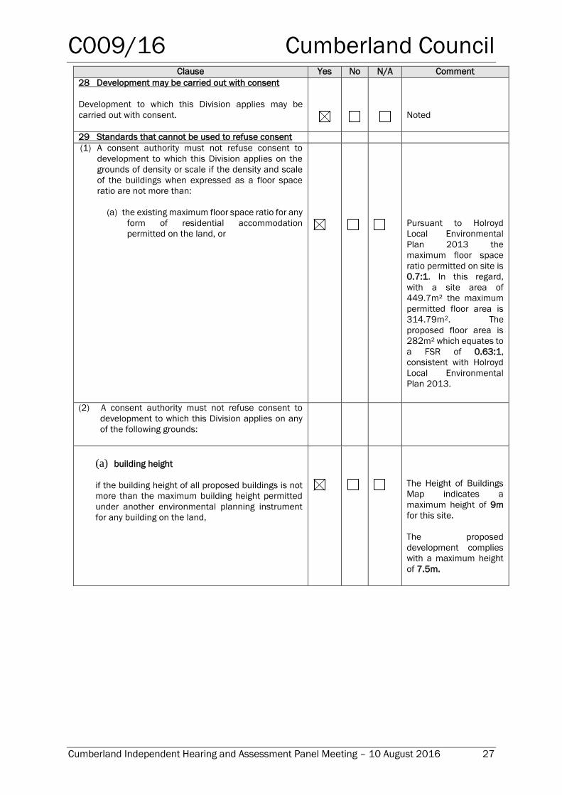
29 Standards that cannot be used to refuse consent
(1) A consent authority must not refuse consent to
development to which this Division applies on the
grounds of density or scale if the density and scale
of the buildings when expressed as a floor space
ratio are not more than:
(a) the existing maximum floor space ratio for any
form of residential accommodation
permitted on the land, or
Pursuant to Holroyd
Local Environmental
Plan 2013 the
maximum floor space
ratio permitted on site is
0.7:1. In this regard,
with a site area of
449.7m² the maximum
permitted floor area is
314.79m2. The
proposed floor area is
282m² which equates to
a FSR of 0.63:1,
consistent with Holroyd
Local Environmental
Plan 2013.
(2) A consent authority must not refuse consent to
development to which this Division applies on any
of the following grounds:
(a) building height
if the building height of all proposed buildings is not
more than the maximum building height permitted
under another environmental planning instrument
for any building on the land,
The Height of Buildings
Map indicates a
maximum height of 9m
for this site.
The proposed
development complies
with a maximum height
of 7.5m.
C009/16 Cumberland Council
Cumberland Independent Hearing and Assessment Panel Meeting – 10 August 2016 28
Clause Yes No N/A Comment
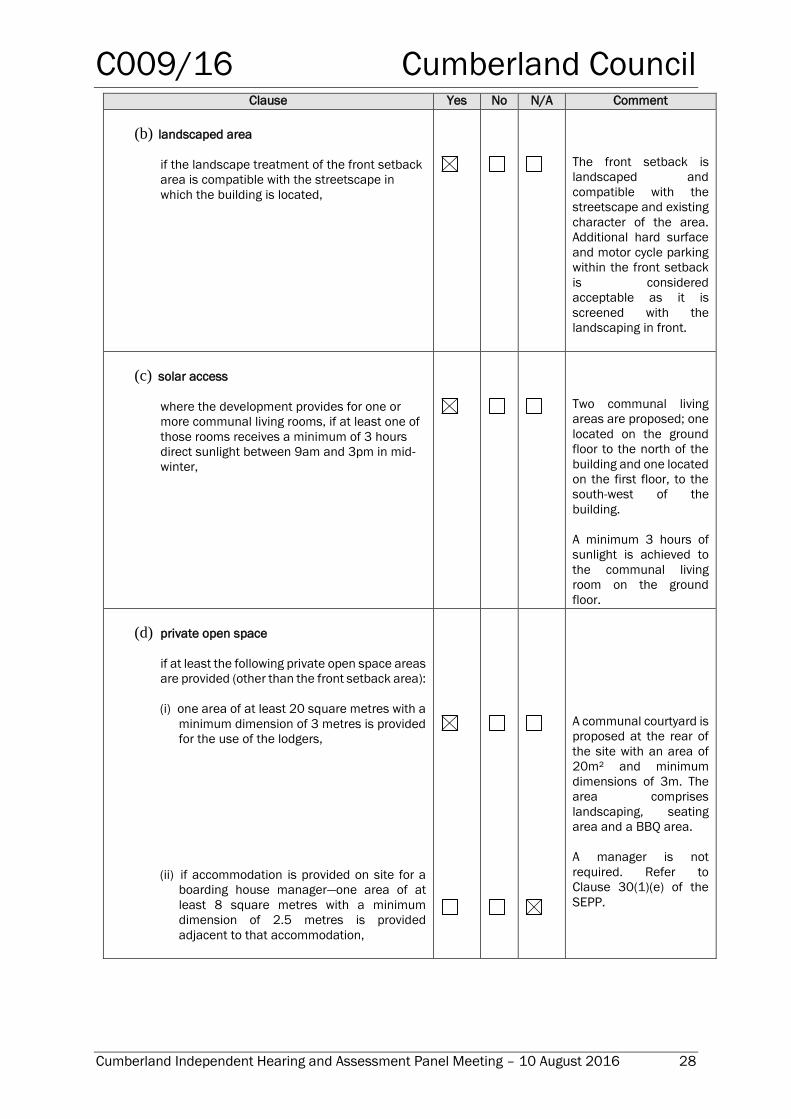
(b) landscaped area
if the landscape treatment of the front setback
area is compatible with the streetscape in
which the building is located,
The front setback is
landscaped and
compatible with the
streetscape and existing
character of the area.
Additional hard surface
and motor cycle parking
within the front setback
is considered
acceptable as it is
screened with the
landscaping in front.
(c) solar access
where the development provides for one or
more communal living rooms, if at least one of
those rooms receives a minimum of 3 hours
direct sunlight between 9am and 3pm in mid-
winter,
Two communal living
areas are proposed; one
located on the ground
floor to the north of the
building and one located
on the first floor, to the
south-west of the
building.
A minimum 3 hours of
sunlight is achieved to
the communal living
room on the ground
floor.
(d) private open space
if at least the following private open space areas
are provided (other than the front setback area):
(i) one area of at least 20 square metres with a
minimum dimension of 3 metres is provided
for the use of the lodgers,
(ii) if accommodation is provided on site for a
boarding house manager—one area of at
least 8 square metres with a minimum
dimension of 2.5 metres is provided
adjacent to that accommodation,
A communal courtyard is
proposed at the rear of
the site with an area of
20m² and minimum
dimensions of 3m. The
area comprises
landscaping, seating
area and a BBQ area.
A manager is not
required. Refer to
Clause 30(1)(e) of the
SEPP.
C009/16 Cumberland Council
Cumberland Independent Hearing and Assessment Panel Meeting – 10 August 2016 29
Clause Yes No N/A Comment
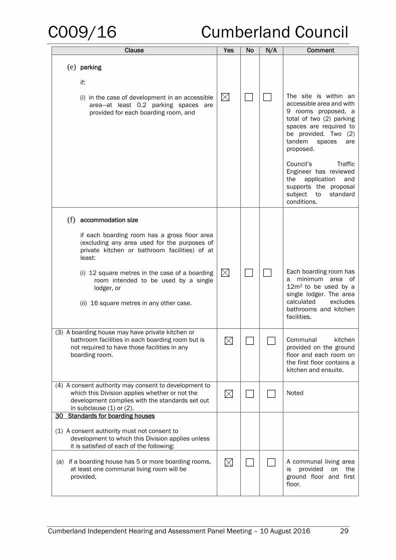
(e) parking
if:
(i) in the case of development in an accessible
area—at least 0.2 parking spaces are
provided for each boarding room, and
The site is within an
accessible area and with
9 rooms proposed, a
total of two (2) parking
spaces are required to
be provided. Two (2)
tandem spaces are
proposed.
Council’s Traffic
Engineer has reviewed
the application and
supports the proposal
subject to standard
conditions.
(f) accommodation size
if each boarding room has a gross floor area
(excluding any area used for the purposes of
private kitchen or bathroom facilities) of at
least:
(i) 12 square metres in the case of a boarding
room intended to be used by a single
lodger, or
(ii) 16 square metres in any other case.
Each boarding room has
a minimum area of
12m2 to be used by a
single lodger. The area
calculated excludes
bathrooms and kitchen
facilities.
(3) A boarding house may have private kitchen or
bathroom facilities in each boarding room but is
not required to have those facilities in any
boarding room.
Communal kitchen
provided on the ground
floor and each room on
the first floor contains a
kitchen and ensuite.
(4) A consent authority may consent to development to
which this Division applies whether or not the
development complies with the standards set out
in subclause (1) or (2).
Noted
30 Standards for boarding houses
(1) A consent authority must not consent to
development to which this Division applies unless
it is satisfied of each of the following:
(a) if a boarding house has 5 or more boarding rooms,
at least one communal living room will be
provided,
A communal living area
is provided on the
ground floor and first
floor.
C009/16 Cumberland Council
Cumberland Independent Hearing and Assessment Panel Meeting – 10 August 2016 30
Clause Yes No N/A Comment
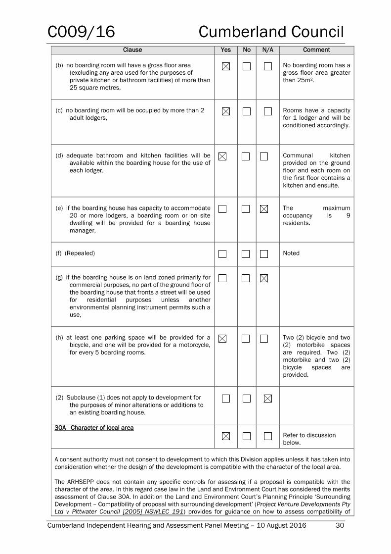
(b) no boarding room will have a gross floor area
(excluding any area used for the purposes of
private kitchen or bathroom facilities) of more than
25 square metres,
No boarding room has a
gross floor area greater
than 25m2.
(c) no boarding room will be occupied by more than 2
adult lodgers,
Rooms have a capacity
for 1 lodger and will be
conditioned accordingly.
(d) adequate bathroom and kitchen facilities will be
available within the boarding house for the use of
each lodger,
Communal kitchen
provided on the ground
floor and each room on
the first floor contains a
kitchen and ensuite.
(e) if the boarding house has capacity to accommodate
20 or more lodgers, a boarding room or on site
dwelling will be provided for a boarding house
manager,
The maximum
occupancy is 9
residents.
(f) (Repealed)
Noted
(g) if the boarding house is on land zoned primarily for
commercial purposes, no part of the ground floor of
the boarding house that fronts a street will be used
for residential purposes unless another
environmental planning instrument permits such a
use,
(h) at least one parking space will be provided for a
bicycle, and one will be provided for a motorcycle,
for every 5 boarding rooms.
Two (2) bicycle and two
(2) motorbike spaces
are required. Two (2)
motorbike and two (2)
bicycle spaces are
provided.
(2) Subclause (1) does not apply to development for
the purposes of minor alterations or additions to
an existing boarding house.
30A Character of local area
Refer to discussion
below.
A consent authority must not consent to development to which this Division applies unless it has taken into
consideration whether the design of the development is compatible with the character of the local area.
The ARHSEPP does not contain any specific controls for assessing if a proposal is compatible with the
character of the area. In this regard case law in the Land and Environment Court has considered the merits
assessment of Clause 30A. In addition the Land and Environment Court’s Planning Principle ‘Surrounding
Development – Compatibility of proposal with surrounding development’ (Project Venture Developments Pty
Ltd v Pittwater Council [2005] NSWLEC 191) provides for guidance on how to assess compatibility of
C009/16 Cumberland Council
Cumberland Independent Hearing and Assessment Panel Meeting – 10 August 2016 31
Clause Yes No N/A Comment
development with the character of the local area. Using case law and the Land and Environment Court
Planning Principle, a merit assessment of character of the local area should consider the following 3 steps:
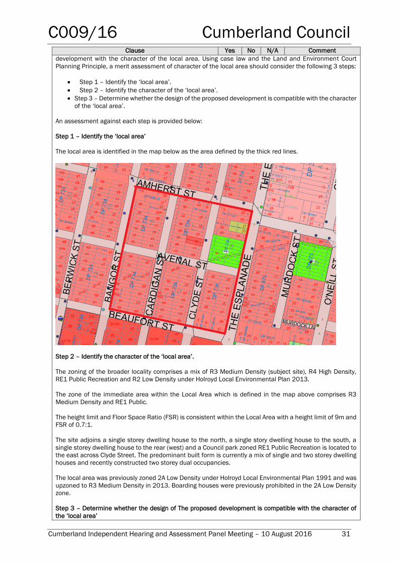
Step 1 – Identify the ‘local area’.
Step 2 – Identify the character of the ‘local area’.
Step 3 – Determine whether the design of the proposed development is compatible with the character
of the ‘local area’.
An assessment against each step is provided below:
Step 1 – Identify the ‘local area’
The local area is identified in the map below as the area defined by the thick red lines.
Step 2 – Identify the character of the ‘local area’.
The zoning of the broader locality comprises a mix of R3 Medium Density (subject site), R4 High Density,
RE1 Public Recreation and R2 Low Density under Holroyd Local Environmental Plan 2013.
The zone of the immediate area within the Local Area which is defined in the map above comprises R3
Medium Density and RE1 Public.
The height limit and Floor Space Ratio (FSR) is consistent within the Local Area with a height limit of 9m and
FSR of 0.7:1.
The site adjoins a single storey dwelling house to the north, a single story dwelling house to the south, a
single storey dwelling house to the rear (west) and a Council park zoned RE1 Public Recreation is located to
the east across Clyde Street. The predominant built form is currently a mix of single and two storey dwelling
houses and recently constructed two storey dual occupancies.
The local area was previously zoned 2A Low Density under Holroyd Local Environmental Plan 1991 and was
upzoned to R3 Medium Density in 2013. Boarding houses were previously prohibited in the 2A Low Density
zone.
Step 3 – Determine whether the design of The proposed development is compatible with the character of
the ‘local area’
C009/16 Cumberland Council
Cumberland Independent Hearing and Assessment Panel Meeting – 10 August 2016 32
Clause Yes No N/A Comment
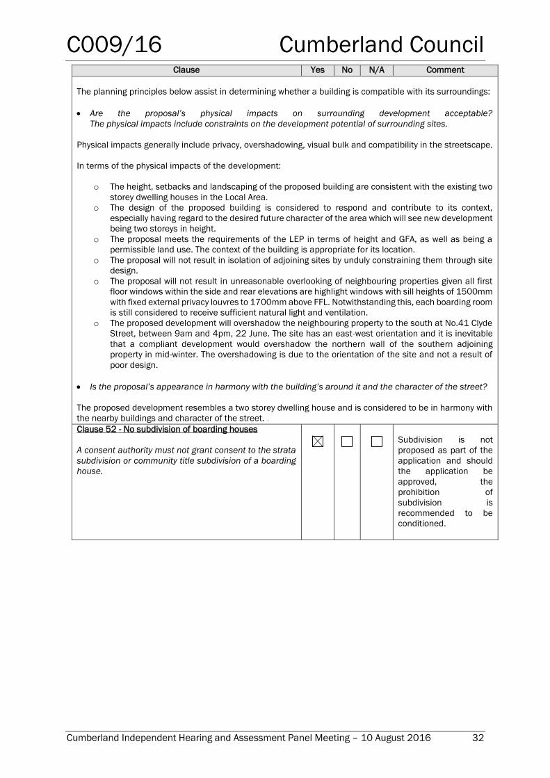
The planning principles below assist in determining whether a building is compatible with its surroundings:
Are the proposal’s physical impacts on surrounding development acceptable?
The physical impacts include constraints on the development potential of surrounding sites.
Physical impacts generally include privacy, overshadowing, visual bulk and compatibility in the streetscape.
In terms of the physical impacts of the development:
o The height, setbacks and landscaping of the proposed building are consistent with the existing two
storey dwelling houses in the Local Area.
o The design of the proposed building is considered to respond and contribute to its context,
especially having regard to the desired future character of the area which will see new development
being two storeys in height.
o The proposal meets the requirements of the LEP in terms of height and GFA, as well as being a
permissible land use. The context of the building is appropriate for its location.
o The proposal will not result in isolation of adjoining sites by unduly constraining them through site
design.
o The proposal will not result in unreasonable overlooking of neighbouring properties given all first
floor windows within the side and rear elevations are highlight windows with sill heights of 1500mm
with fixed external privacy louvres to 1700mm above FFL. Notwithstanding this, each boarding room
is still considered to receive sufficient natural light and ventilation.
o The proposed development will overshadow the neighbouring property to the south at No.41 Clyde
Street, between 9am and 4pm, 22 June. The site has an east-west orientation and it is inevitable
that a compliant development would overshadow the northern wall of the southern adjoining
property in mid-winter. The overshadowing is due to the orientation of the site and not a result of
poor design.
Is the proposal’s appearance in harmony with the building’s around it and the character of the street?
The proposed development resembles a two storey dwelling house and is considered to be in harmony with
the nearby buildings and character of the street. .
Clause 52 - No subdivision of boarding houses
A consent authority must not grant consent to the strata
subdivision or community title subdivision of a boarding
house.
Subdivision is not
proposed as part of the
application and should
the application be
approved, the
prohibition of
subdivision is
recommended to be
conditioned.
C009/16 Cumberland Council
Cumberland Independent Hearing and Assessment Panel Meeting – 10 August 2016 33
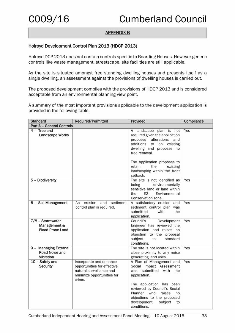
APPENDIX B
Holroyd Development Control Plan 2013 (HDCP 2013)
Holroyd DCP 2013 does not contain controls specific to Boarding Houses. However generic
controls like waste management, streetscape, site facilities are still applicable.
As the site is situated amongst free standing dwelling houses and presents itself as a
single dwelling, an assessment against the provisions of dwelling houses is carried out.
The proposed development complies with the provisions of HDCP 2013 and is considered
acceptable from an environmental planning view point.
A summary of the most important provisions applicable to the development application is
provided in the following table.
Standard Required/Permitted Provided Compliance
Part A – General Controls
4 – Tree and
Landscape Works
A landscape plan is not
required given the application
proposes alterations and
additions to an existing
dwelling and proposes no
tree removal.
The application proposes to
retain the existing
landscaping within the front
setback.
Yes
5 – Biodiversity The site is not identified as
being environmentally
sensitive land or land within
the E2 Environmental
Conservation zone.
Yes
6 – Soil Management An erosion and sediment
control plan is required.
A satisfactory erosion and
sediment control plan was
submitted with the
application.
Yes
7/8 – Stormwater
Management &
Flood Prone Land
Council’s Development
Engineer has reviewed the
application and raises no
objection to the proposal
subject to standard
conditions.
Yes
9 – Managing External
Road Noise and
Vibration
The site is not located within
close proximity to any noise
generating land uses.
Yes
10 – Safety and
Security
Incorporate and enhance
opportunities for effective
natural surveillance and
minimize opportunities for
crime.
A Plan of Management and
Social Impact Assessment
was submitted with the
application.
The application has been
reviewed by Council’s Social
Planner who raises no
objections to the proposed
development, subject to
conditions.
Yes
C009/16 Cumberland Council
Cumberland Independent Hearing and Assessment Panel Meeting – 10 August 2016 34
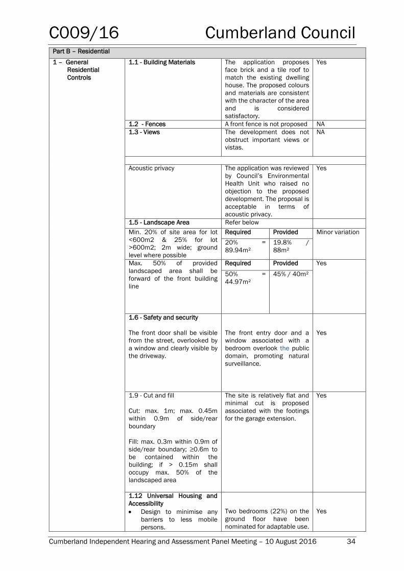
Part B – Residential
1 – General
Residential
Controls
1.1 - Building Materials The application proposes
face brick and a tile roof to
match the existing dwelling
house. The proposed colours
and materials are consistent
with the character of the area
and is considered
satisfactory.
Yes
1.2 - Fences A front fence is not proposed NA
1.3 - Views The development does not
obstruct important views or
vistas.
NA
Acoustic privacy The application was reviewed
by Council’s Environmental
Health Unit who raised no
objection to the proposed
development. The proposal is
acceptable in terms of
acoustic privacy.
Yes
1.5 - Landscape Area Refer below
Min. 20% of site area for lot
<600m2 & 25% for lot
>600m2; 2m wide; ground
level where possible
Required Provided Minor variation
20% =
89.94m²
19.8% /
88m²
Max. 50% of provided
landscaped area shall be
forward of the front building
line
Required Provided Yes
50% =
44.97m²
45% / 40m²
1.6 - Safety and security
The front door shall be visible
from the street, overlooked by
a window and clearly visible by
the driveway.
The front entry door and a
window associated with a
bedroom overlook the public
domain, promoting natural
surveillance.
Yes
1.9 - Cut and fill
Cut: max. 1m; max. 0.45m
within 0.9m of side/rear
boundary
Fill: max. 0.3m within 0.9m of
side/rear boundary; ≥0.6m to
be contained within the
building; if > 0.15m shall
occupy max. 50% of the
landscaped area
The site is relatively flat and
minimal cut is proposed
associated with the footings
for the garage extension.
Yes
1.12 Universal Housing and
Accessibility
Design to minimise any
barriers to less mobile
persons.
Two bedrooms (22%) on the
ground floor have been
nominated for adaptable use.
Yes
C009/16 Cumberland Council
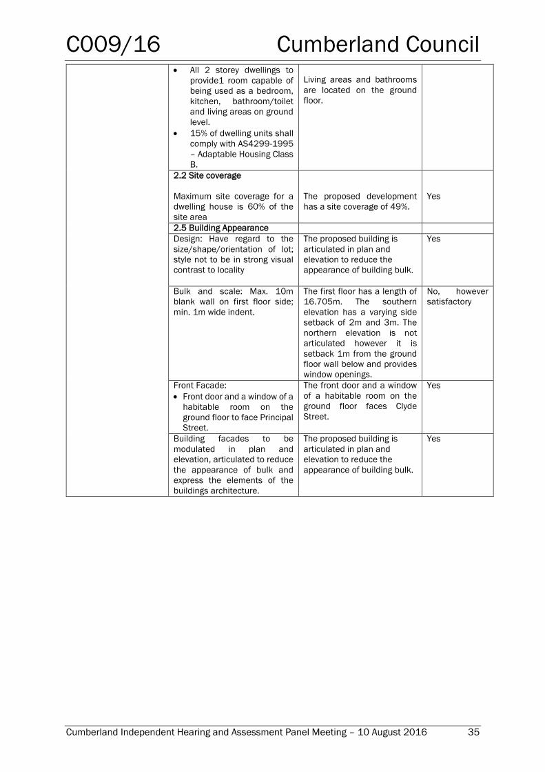
Cumberland Independent Hearing and Assessment Panel Meeting – 10 August 2016 35
All 2 storey dwellings to
provide1 room capable of
being used as a bedroom,
kitchen, bathroom/toilet
and living areas on ground
level.
15% of dwelling units shall
comply with AS4299-1995
– Adaptable Housing Class
B.
Living areas and bathrooms
are located on the ground
floor.
2.2 Site coverage
Maximum site coverage for a
dwelling house is 60% of the
site area
The proposed development
has a site coverage of 49%.
Yes
2.5 Building Appearance
Design: Have regard to the
size/shape/orientation of lot;
style not to be in strong visual
contrast to locality
The proposed building is
articulated in plan and
elevation to reduce the
appearance of building bulk.
Yes
Bulk and scale: Max. 10m
blank wall on first floor side;
min. 1m wide indent.
The first floor has a length of
16.705m. The southern
elevation has a varying side
setback of 2m and 3m. The
northern elevation is not
articulated however it is
setback 1m from the ground
floor wall below and provides
window openings.
No, however
satisfactory
Front Facade:
Front door and a window of a
habitable room on the
ground floor to face Principal
Street.
The front door and a window
of a habitable room on the
ground floor faces Clyde
Street.
Yes
Building facades to be
modulated in plan and
elevation, articulated to reduce
the appearance of bulk and
express the elements of the
buildings architecture.
The proposed building is
articulated in plan and
elevation to reduce the
appearance of building bulk.
Yes
C009/16 Cumberland Council
ATTACHMENT 1
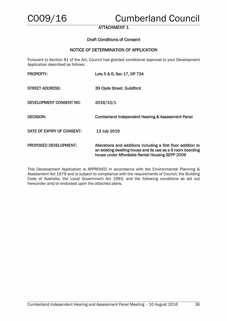
Cumberland Independent Hearing and Assessment Panel Meeting – 10 August 2016 36
Draft Conditions of Consent
NOTICE OF DETERMINATION OF APPLICATION
Pursuant to Section 81 of the Act, Council has granted conditional approval to your Development
Application described as follows:
PROPERTY: Lots 5 & 6, Sec 17, DP 734
STREET ADDRESS: 39 Clyde Street, Guildford
DEVELOPMENT CONSENT NO: 2016/10/1
DECISION: Cumberland Independent Hearing & Assessment Panel
DATE OF EXPIRY OF CONSENT: 13 July 2019
PROPOSED DEVELOPMENT: Alterations and additions including a first floor addition to
an existing dwelling house and its use as a 9 room boarding
house under Affordable Rental Housing SEPP 2009
This Development Application is APPROVED in accordance with the Environmental Planning &
Assessment Act 1979 and is subject to compliance with the requirements of Council, the Building
Code of Australia, the Local Government Act 1993, and the following conditions as set out
hereunder and/or endorsed upon the attached plans.
C009/16 Cumberland Council
ATTACHMENT 1
Cumberland Independent Hearing and Assessment Panel Meeting – 10 August 2016 37
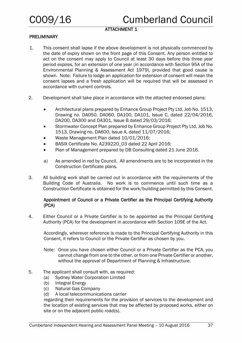
PRELIMINARY
1. This consent shall lapse if the above development is not physically commenced by
the date of expiry shown on the front page of this Consent. Any person entitled to
act on the consent may apply to Council at least 30 days before this three year
period expires, for an extension of one year (in accordance with Section 95A of the
Environmental Planning & Assessment Act 1979), provided that good cause is
shown. Note: Failure to lodge an application for extension of consent will mean the
consent lapses and a fresh application will be required that will be assessed in
accordance with current controls.
2. Development shall take place in accordance with the attached endorsed plans:
Architectural plans prepared by Enhance Group Project Pty Ltd, Job No. 1513,
Drawing no. DA050, DA060, DA100, DA101, Issue C, dated 22/04/2016,
DA200, DA300 and DA301, Issue B dated 29/03/2016;
Stormwater Concept Plan prepared by Enhance Group Project Pty Ltd, Job No.
1513, Drawing no. DA600, Issue A, dated 11/07/2016;
Waste Management Plan dated 10/01/2016;
BASIX Certificate No. A239220_03 dated 22 April 2016;
Plan of Management prepared by DB Consulting dated 21 June 2016.
a) As amended in red by Council. All amendments are to be incorporated in the
Construction Certificate plans.
3. All building work shall be carried out in accordance with the requirements of the
Building Code of Australia. No work is to commence until such time as a
Construction Certificate is obtained for the work/building permitted by this Consent.
Appointment of Council or a Private Certifier as the Principal Certifying Authority
(PCA)
4. Either Council or a Private Certifier is to be appointed as the Principal Certifying
Authority (PCA) for the development in accordance with Section 109E of the Act.
Accordingly, wherever reference is made to the Principal Certifying Authority in this
Consent, it refers to Council or the Private Certifier as chosen by you.
Note: Once you have chosen either Council or a Private Certifier as the PCA, you
cannot change from one to the other, or from one Private Certifier or another,
without the approval of Department of Planning & Infrastructure.
5. The applicant shall consult with, as required:
(a) Sydney Water Corporation Limited
(b) Integral Energy
(c) Natural Gas Company
(d) A local telecommunications carrier
regarding their requirements for the provision of services to the development and
the location of existing services that may be affected by proposed works, either on
site or on the adjacent public road(s).
C009/16 Cumberland Council
ATTACHMENT 1
Cumberland Independent Hearing and Assessment Panel Meeting – 10 August 2016 38
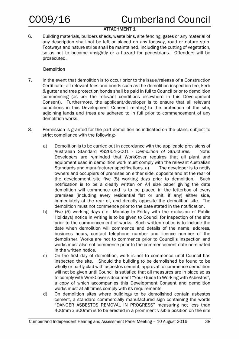
6. Building materials, builders sheds, waste bins, site fencing, gates or any material of
any description shall not be left or placed on any footway, road or nature strip.
Footways and nature strips shall be maintained, including the cutting of vegetation,
so as not to become unsightly or a hazard for pedestrians. Offenders will be
prosecuted.
Demolition
7. In the event that demolition is to occur prior to the issue/release of a Construction
Certificate, all relevant fees and bonds such as the demolition inspection fee, kerb
& gutter and tree protection bonds shall be paid in full to Council prior to demolition
commencing (as per the relevant conditions elsewhere in this Development
Consent). Furthermore, the applicant/developer is to ensure that all relevant
conditions in this Development Consent relating to the protection of the site,
adjoining lands and trees are adhered to in full prior to commencement of any
demolition works.
8. Permission is granted for the part demolition as indicated on the plans, subject to
strict compliance with the following:-
a) Demolition is to be carried out in accordance with the applicable provisions of
Australian Standard AS2601-2001 - Demolition of Structures. Note:
Developers are reminded that WorkCover requires that all plant and
equipment used in demolition work must comply with the relevant Australian
Standards and manufacturer specifications. a) The developer is to notify
owners and occupiers of premises on either side, opposite and at the rear of
the development site five (5) working days prior to demolition. Such
notification is to be a clearly written on A4 size paper giving the date
demolition will commence and is to be placed in the letterbox of every
premises (including every residential flat or unit, if any) either side,
immediately at the rear of, and directly opposite the demolition site. The
demolition must not commence prior to the date stated in the notification.
b) Five (5) working days (i.e., Monday to Friday with the exclusion of Public
Holidays) notice in writing is to be given to Council for inspection of the site
prior to the commencement of works. Such written notice is to include the
date when demolition will commence and details of the name, address,
business hours, contact telephone number and licence number of the
demolisher. Works are not to commence prior to Council’s inspection and
works must also not commence prior to the commencement date nominated
in the written notice.
c) On the first day of demolition, work is not to commence until Council has
inspected the site. Should the building to be demolished be found to be
wholly or partly clad with asbestos cement, approval to commence demolition
will not be given until Council is satisfied that all measures are in place so as
to comply with WorkCover’s document “Your Guide to Working with Asbestos”,
a copy of which accompanies this Development Consent and demolition
works must at all times comply with its requirements.
d) On demolition sites where buildings to be demolished contain asbestos
cement, a standard commercially manufactured sign containing the words
“DANGER ASBESTOS REMOVAL IN PROGRESS” measuring not less than
400mm x 300mm is to be erected in a prominent visible position on the site
C009/16 Cumberland Council
ATTACHMENT 1
Cumberland Independent Hearing and Assessment Panel Meeting – 10 August 2016 39
to the satisfaction of Council’s officers. Advice on the availability of these
signs can be obtained by telephoning Council's Customer Service Centre
during business hours on 9840 9840. The sign is to be erected prior to
demolition work commencing and is to remain in place until such time as all
asbestos cement has been removed from the site to an approved waste
facility. This condition is imposed for the purpose of worker and public safety
and to ensure compliance with Clause 259(2)(c) of the Occupational Health
and Safety Regulation 2001.
e) Demolition shall not commence until all trees required to be
retained/transplanted are protected in accordance with those conditions
stipulated under “Prior to Works Commencing” in this Consent.
f) All previously connected services are to be appropriately disconnected as part
of the demolition works. The applicant is obliged to consult with the various
service authorities regarding their requirements for the disconnection of
services.
g) Demolition works involving the removal and disposal of asbestos cement
must only be undertaken by contractors who hold a current WorkCover
“Demolition Licence” and a current WorkCover “Class 2 (Restricted) Asbestos
Licence”.
h) Demolition is to be completed within five (5) days of commencement.
i) Demolition works are restricted to Monday to Friday between the hours of
7.00am to 6.00pm. No demolition works are to be undertaken on Saturdays,
Sundays or Public Holidays.
j) Protective fencing is to be installed to prevent public access to the site.
k) All asbestos laden waste, including asbestos cement flat and corrugated
sheets must be disposed of at a tipping facility licensed by the Office of
Environment and Heritage (OEH).
l) Before demolition operations begin, the property shall be connected to the
sewer of Sydney Water to which a pedestal pan shall be temporarily
connected for the use as the employees’ toilet service during demolition
operations.
m) After completion, the applicant shall notify Council within seven (7) days to
assess the site and ensure compliance with AS2601-2001 – Demolition of
Structures.
NOTE: The person responsible for disposing of the above asbestos waste is to
telephone the OEH on (02) 9995 5000 or Council’s Waste Officer on (02)
9840 9715 to determine the location of a tip licensed to receive asbestos.
Within fourteen (14) days of the completion of demolition works, the
applicant must lodge with Council, all original weighbridge receipts issued
by the receiving tip as evidence of proper disposal.
n) Within fourteen (14) days of completion of demolition, the applicant shall
submit to Council:
i) An asbestos clearance certificate prepared by a NATA accredited
occupational hygienist; and
ii) A signed statement verifying that demolition work and the recycling of
materials was undertaken in accordance with the Waste Management
Plan approved with this consent under DCP 2013 Part A, Section 11.0.
In reviewing such documentation Council will require the provision of
original weighbridge receipts for the recycling/disposal of all materials.
C009/16 Cumberland Council
ATTACHMENT 1
Cumberland Independent Hearing and Assessment Panel Meeting – 10 August 2016 40
Note: To find a list of NATA accredited facilities visit the NATA website at
www.nata.asn.au and under ‘Find a Facility or Lab’ type in ‘asbestos
identification’ in ‘keywords’ then click on ‘chemical testing’ in NSW
then click on the search button. A list of laboratories will be produced
which you can contact for the purpose of having a clearance certificate
issued.
9. Payment of $433.60 fee for inspection by Council of the demolition site prior to
commencement of any demolition works.
BASIX (Building Sustainability Index)
10. Under Clause 136D of the Environmental Planning & Assessment Regulation 2000,
it is a condition of this Development Consent that all the commitments listed as per
Condition 2 in relation to BASIX are fulfilled.
Subdivision
11. Any form of subdivision of the boarding house is not permitted.
PRIOR TO ISSUE/RELEASE OF CONSTRUCTION CERTIFICATE
The following conditions must be complied with prior to the issue of a Construction
Certificate. In many cases the conditions require certain details to be included with or
incorporated in the detailed plans and specifications which accompany the Construction
Certificate:-
Payment of Bonds, Fees and Long Service Levy
12. The Principal Certifying Authority is to ensure and obtain written proof that all bonds,
fees and contributions as required by this consent have been paid to the applicable
authority. This includes all Long Service Levy payments to be made to the Long
Service Payments Corporation.
Section 94 Contribution
13. Prior to the issue of a Construction Certificate, a monetary contribution imposed
under section 94 of the Environmental Planning and Assessment Act 1979 and
Holroyd Section 94 Development Contributions Plan 2014, for 9 boarding rooms is
to be paid to Council. At the time of this development consent, the current rate of
the contribution is $17,795. The amount of the contribution will be determined at
the time of payment in accordance with the relevant s94 Contributions Plan in force
at that time. A copy of the Holroyd Section 94 Development Contributions Plan 2013
can be viewed on Council’s website at www.holroyd.nsw.gov.au or inspected at
Council’s Civic Centre located at 16 Memorial Avenue, Merrylands between the
hours of 8am and 4.30pm Monday to Friday.
Damage Deposit
C009/16 Cumberland Council
ATTACHMENT 1
Cumberland Independent Hearing and Assessment Panel Meeting – 10 August 2016 41
14. A cash bond/bank guarantee of $1,643.20 must be paid/lodged with Council to
cover making good any damage caused to the property of Council, during the course
of construction associated with the development. This will be held for ‘six (6) months
after the completion of works’ or six (6) months after the issue of ‘Final Occupation
Certificate’ (whichever occurs last) to remedy any defects that may arise within this
time.
Note:- The applicant/owner shall be held responsible for and may be
required to pay the full reinstatement costs for damage caused to Council’s
property (such as road pavement, kerb and guttering, footway, stormwater
drainage etc), unless the applicant/owner notifies Council in writing and
provides photographic proof of any existing damage to Council’s property.
Such notification shall occur prior to works/demolition commencing.
However, if in the opinion of Council, during the course of construction
existing damage has worsened, Council may require full reinstatement. If
damage does occur during the course of construction, prior to reinstating
any damage to Council’s property, the applicant/owner shall obtain design
specifications of all proposed restoration works. Restoration/construction
works within the road reserve shall be carried out by a licensed
construction contractor at the applicant/owners expense and shall be
inspected by Council prior to placement of concrete and/or asphalt.
Consistency with Endorsed Development Consent Plans
15. The Principal Certifying Authority must ensure that any certified plans forming part
of the Construction Certificate, are in accordance with the Development Consent
plans.
Sydney Water
16. A building plan approval must be obtained from Sydney Water Tap In™ to ensure
the development will not affect any Sydney Water wastewater and water mains,
stormwater drains and/or easement.
A copy of the building plan approval receipt from Sydney Water Tap in™ must be
submitted to the Principal Certifying Authority, prior to the issue of a Construction
Certificate.
Please refer to the website www.sydneywater.com.au.
Road Works
17. If demolition/construction activity will impact on traffic flow or pedestrian access or
any road and drainage works are proposed to be carried out in the public road
reserves, a Traffic Management Plan shall be lodged and seek approval with
Council, in strict compliance with the current Australian Standard 1742.3 (Traffic
Control Devices for Works on Roads). If required to be prepared (to be determined
by the Principal Certifying Authority), a copy of the approved Traffic Management
Plan shall be kept on site during the course of construction for reference and
compliance.
Required Submissions to Certifying Authority
C009/16 Cumberland Council
ATTACHMENT 1
Cumberland Independent Hearing and Assessment Panel Meeting – 10 August 2016 42
18. If the development likely to disturb or impact upon telecommunications
infrastructure, written confirmation from the service provider that they have agreed
to the proposed works must be submitted to the Principal Certifying Authority prior
to the issue of a Construction Certificate or any works commencing, whichever
occurs first.
19. The arrangements and costs associated with any adjustment to
telecommunications infrastructure shall be borne in full by the applicant/developer.
20. Retaining walls greater than 1.0m above finished ground level or other approved
methods necessary to prevent the movement of excavated or filled ground, together
with associated stormwater drainage measures, shall be designed by an
appropriately qualified person. Details are to be included with any Construction
Certificate application.
21. Structural engineer’s details (in duplicate) prepared and certified by a practising
qualified structural engineer of all reinforced concrete and structural members shall
be submitted to the Principal Certifying Authority.
Sight Distance
22. To maintain sight distance to pedestrians, all fencing and landscaping within 2.0m of a
driveway shall have a maximum height of 1.0 m and 50% transparent above a height of
0.5m. All solid posts higher than 0.5m (but lower than 1m) shall have a maximum width
350mm and a minimum spacing of 1.2m. Details shall be submitted to the Principal
Certifying Authority, prior to the issue of a Construction Certificate.
Salinity
23. The subject site has been identified as having a potential salinity hazard. To prevent
moisture/salinity from entering the built structure, appropriate construction
methods are to be incorporated for all dwellings/buildings. Details of proposed
methods of construction are to be detailed in the engineering plans and submitted
to the PCA.
Note: Further information for building in a saline environment is available in the
following documents:
“Building in Saline Environment” prepared by DIPNR 2003.
Water Sensitive Urban Design in the Sydney Regions “Practice Note 12:
Urban Salinity”
Wagga Wagga City Council’s “Urban Salinity Action” October 1999
“Guide to Residential Slabs and Footings in Saline Environments”
prepared by Cement Concrete and Aggregates Australia, May 2005
Construction Management Plan
24. A Construction Management Plan (CMP) prepared by a suitable qualified consultant
shall be prepared to address issues such as traffic control, noise, dust, etc., during
construction. All measures works/methods/procedures/control

C009/16 Cumberland Council
ATTACHMENT 1
Cumberland Independent Hearing and Assessment Panel Meeting – 10 August 2016 43
measures/recommendations made within the Construction Management Plan shall
be implemented accordingly.
PRIOR TO WORKS COMMENCING
The following conditions are to be complied with prior to any works commencing on the
site:
Appointment of Principal Certifying Authority and Notification of Commencement
of Work
25. The person having the benefit of the development consent, not the principal
contractor (builder), must: -
a) Appoint a Principal Certifying Authority in accordance with Section 81A(2)(b)
of the Act.
b) Have the Principal Certifying Authority complete the ‘Accredited Certifier
Details’ on the approved form provided by Council for this purpose, an original
of which is attached to this Development Consent.
c) Notify Council of the appointment of the Principal Certifying Authority and of
the intention to commence building work, such notification is to be given to
Council at least two (2) working days prior to the proposed commencement
date, and be on the approved form provided by Council for this purpose, an
original of which is attached to this Development Consent.
If nominated, Council can provide this service for you and act as the Principal
Certifying Authority.
N.B. The Principal Certifying Authority must also notify the person having the
benefit of the Development Consent of any mandatory critical stage
inspections and other inspections that are to be carried out in respect of the
building work such notification must comply with Clause 103A of the
Regulations.
Notification of Principal Contractor (Builder)/Owner-Builder
26. The person having the benefit of the Development Consent must:-
(a) Notify the Principal Certifying Authority that the person will carry out the work
as an owner-builder, if that is the case;
OR
(b) Appoint a Principal Contractor for the building work (who must be the holder
of a contractor licence if any residential building work is involved), and notify
the Principal Contractor of any mandatory critical stage inspections and other
inspections that are to be carried out in respect of the building work.
C009/16 Cumberland Council
ATTACHMENT 1
Cumberland Independent Hearing and Assessment Panel Meeting – 10 August 2016 44
(c) Notify the Principal Certifying Authority of any such appointment.
Where Council is the Principal Certifying Authority, such notification is to be on the
approved form provided by Council for this purpose, an original of which is attached
to this Development Consent.
Required Submissions to Certifying Authority
27. To facilitate a complete assessment and enable the Certifying Authority to check
compliance on site, truss validation and design, details certified by a qualified
practising structural engineer shall be submitted to Council or the Principal
Certifying Authority for examination and approval. Details shall include:
a) job address and builder’s name
b) design wind velocity
c) terrain category
d) truss spacing
e) roof pitch
f) material of roof
g) roof batten/purlin spacing
h) material of ceiling
i) job number
28. A certificate shall be submitted to the Principal Certifying Authority in accordance
with the requirements of Part 3.11, Clause 3.11.2 and Clause 3.11.3 of the Building
Code of Australia, by a qualified practising structural engineer certifying the
adequacy of the existing dwelling as being capable of supporting the proposed live
and dead loads.
Photographic Record of Council Property – Damage Deposit
29. The applicant shall submit to Council, for the purposes of the damage deposit bond
lodged to cover making good any damage caused to the property of Council, a full
and satisfactory photographic record of the condition of Council’s property (i.e., road
pavement, kerb and guttering, footway, stormwater drainage, etc.) adjacent to the
subject site. The purpose of the photographic record is to establish any pre-existing
damage to Council’s property to ensure that you are not liable for any re-instatement
works associated with that damage. However, if in the opinion of Council, the
existing damage has worsened or any new damage is caused during the course of
construction, the Council may require either part or full re-instatement.
Note: Failure to provide a full and satisfactory photographic record described
above, is likely to render the applicant liable to rectify all damages unless
satisfactory proof can be provided that the damage was pre-existing.
Fencing of Sites
30. Fencing of sites is required to prevent public access when the site is unoccupied
and building works are not in progress. In this regard the MINIMUM acceptable
standard of fencing to the site is properly constructed chain wire fencing 1.8m high,
C009/16 Cumberland Council
ATTACHMENT 1
Cumberland Independent Hearing and Assessment Panel Meeting – 10 August 2016 45
clad internally with Hessian or Geotextile fabric. All openings are to be provided with
gates, such gates are not at any time to swing out from the site or obstruct the
footpath or roadway.
Signs to be Erected on Sites
31. A sign must be erected in a prominent position on any site on which building work,
subdivision work or demolition work is being carried out:
(a) showing the name, address and telephone number of the Principal Certifying
Authority for the work, and
(b) showing the name of the principal contractor (if any) for any building work and
a telephone number on which that person may be contacted outside working
hours and at any time for business purposes, and
(c) stating that unauthorised entry to the work site is prohibited.
The sign must be rigid and durable and be read easily by anyone in any public road
or other public place adjacent to the site.
Any such sign is to be maintained while the building work, subdivision work or
demolition work is being carried out, but must be removed when the work has been
completed.
This clause does not apply in relation to building work, subdivision work or
demolition work that is carried out inside an existing building that does not affect
the external walls of the building.
Note: Principal Certifying Authorities and Principal Contractors must also ensure
that signs required by this clause are erected and maintained (clause 227A
of the Regulations currently imposes a maximum penalty of $1,100).
Prohibited Signage
32. Advertising, Real Estate Agents, Architects, Designers, site suppliers and any other
signage not mentioned in the conditions, is not to be placed or displayed on the site,
such that the signage is visible from any public place. Offenders may be prosecuted.
Protection of Public Places
33. A hoarding or fence must be erected between the work site and any public place, if
the work involved in the erection or demolition of the building; is likely to cause
pedestrian or vehicular traffic in a public place to be obstructed or rendered
inconvenient, or involves the enclosure of a public place.
If necessary, an awning is to be erected, sufficient to prevent any substance from,
or in connection with, the work falling into the public place.
The work site must be kept lit between sunset and sunrise if it is likely to be
hazardous to persons in the public place.
C009/16 Cumberland Council
ATTACHMENT 1
Cumberland Independent Hearing and Assessment Panel Meeting – 10 August 2016 46
Site Control Measures
34. Suitable erosion and sediment control measures shall be provided at all vehicular
entry/exit points and all other measures required with and/or shown on plans
accompanying the Construction Certificate, to control soil erosion and
sedimentation, are to be in place prior to the commencement of construction works.
Such controls are to be provided in accordance with Council’s “Erosion & Sediment
Control Policy.”
Note: On-the-spot fines may be issued by council where measures are absent or
inadequate.
Footpaving, Kerbing and Guttering
35. Protection must be provided for Council footpaving, kerbing and guttering. Wooden
mats must also be provided at all entrances where the site fronts paved footpaths.
36. Finished street levels shall not be assumed. The owner or builder must make
application to Council’s Engineering Services Department for street levels.
Support for Neighbouring Buildings
37. If an excavation associated with the erection or demolition of a building extends
below the level of the base of the footings of a building on an adjoining allotment of
land (including a public road and any other public place), the person causing the
excavation to be made:-
a) must preserve and protect the building from damage, and
b) if necessary, must underpin and support the building in an approved manner,
and
c) must, at least seven (7) days before excavating below the level of the base
of the footings of a building on an adjoining allotment of land, give notice of
intention to do so to the owner of the adjoining allotment of land and furnish
particulars to the owner of the building being erected or demolished.
The owner of the adjoining allotment of land is not liable for any part of the cost of
work carried out for the purposes of this clause, whether carried out on the
allotment of land being excavated or on the adjoining allotment of land. (In this
clause, allotment of land includes a public road and any other public place).
Toilet Facilities
38. Toilet facilities are to be provided, at or in the vicinity of the work site on which work
involved in the erection or demolition of a building is being carried out, at the rate
of one toilet for every 20 persons or part of 20 persons employed at the site.
Each toilet provided:
a) Must be a standard flushing toilet, and
b) Must be connected:
i) To a public sewer,
ii) If connection to a public sewer is not practicable, to an accredited
sewage management facility approved by the Council, or
C009/16 Cumberland Council
ATTACHMENT 1
Cumberland Independent Hearing and Assessment Panel Meeting – 10 August 2016 47
iii) If connection to a public sewer or an accredited sewage management
facility is not practicable, to some other sewage management facility
approved by the Council.
iv) The position of the toilet on the site shall be determined by Council’s
Building Surveyor and/or Sydney Water.
Residential Building Work - Insurance
39. Residential building work within the meaning of the Home Building Act 1989 must
not be carried out unless the Principal Certifying Authority for the development to
which the work relates (where not Council) has given Council written notice of the
following information:-
(a) in the case of work for which a Principal Contractor is required to be
appointed:
(i) the name and licence number of the Principal Contractor, and
(ii) the name of the insurer by which the work is insured under Part 6 of that
Act,
(b) in the case of work to be done by an owner-builder:
(i) the name of the owner-builder, and
(ii) if the owner-builder is required to hold an owner-builder permit under
that Act, the number of the owner-builder permit.
If arrangements for doing the residential building work are changed while the work
is in progress so that the information notified under this condition becomes out of
date, further work must not be carried out unless the Principal Certifying Authority
for the development to which the work relates (where not Council) has given Council
written notice of the updated information.
The notification is to be on the approved form provided by Council for this purpose,
an original of which is attached to this Development Consent.
Road Works
40. The applicant is to submit to Council an application for a road opening permit when
the drainage connection into Council’s system is within the road reserve. In this
regard the applicant shall pay Council a $159.20 fee prior to the commencement
of works. Additional road opening permits and fees may be necessary where there
are connections to public utility services (eg. telephone, electricity, sewer, water or
gas) required within the road reserve.
41. The applicant to arrange with the relevant public utility authority the alteration or
removal of any affected services in connection with the development. Any such
work being carried out at the applicant’s cost.
Works Within Council’s Reserve
C009/16 Cumberland Council
ATTACHMENT 1
Cumberland Independent Hearing and Assessment Panel Meeting – 10 August 2016 48
42. All works within the Council reserve shall be completed within three (3) weeks of
the date of commencement. Council’s Development Engineer shall be advised
prior to the commencement of works.
43. Submission to Council of a Certificate of Currency of the contractor’s Workers’
Compensation Policy prior to the commencement of works.
44. All construction works shall be in accordance with the WorkCover safety
requirements. Submission of insurance documentation demonstrating a minimum
Public Liability cover of $10,000,000 is to be submitted prior to commencement of
works. Council shall be named on the Certificate of Currency as an interested party.
Notification to Relevant Public Authority
45. The applicant shall ensure that relevant public utility authorities are made aware of
the salinity problems that have been identified by the Department of Land and
Water Conservation, such that their services are designed to take into consideration
the effects the saline soils may have on their installations.
DURING CONSTRUCTION
The following conditions are applicable during construction:-
Endorsed Plans & Specifications
46. A copy of the endorsed stamped plans and specifications, together with a copy of
the Development Consent, Construction Certificate and approved Traffic
Management Plan are to be retained on site at all times.
Hours of Work & Display of Council Supplied Sign
47. For the purpose of preserving the amenity of neighbouring occupations building
work including the delivery of materials to and from the site is to be restricted to the
hours of 7.00am to 6.00pm Mondays to Fridays and 8.00am to 4.00pm Saturdays.
Work on the site on Sundays and Public Holidays is prohibited. Note: Demolition
work is not permitted on weekends or Public Holidays - refer to specific demolition
condition for approved hours.
The yellow “Hours of Building Work” sign (supplied by Council with the approval), is
to be displayed in a prominent position at the front of the site for the duration of
the work.
Site Control
48. All soil erosion measures required in accordance with the approved sediment and
erosion control plan and any other relevant conditions of this Consent are to be put
in place prior to commencement of construction works are to be maintained during
the entire construction period until disturbed areas are restored by turfing, paving
or revegetation. This includes the provision of turf laid on the nature strip
adjacent to the kerb.
C009/16 Cumberland Council
ATTACHMENT 1
Cumberland Independent Hearing and Assessment Panel Meeting – 10 August 2016 49
49. Builder’s refuse disposal and storage facilities are to be provided on the
development site for the duration of construction works and all rubbish shall be
removed from the site upon completion of the project.
50. Stockpiles of sand, soil and other material shall be stored clear of any drainage line
or easement, tree protection zone, water bodies, footpath, kerb or road surface and
shall have erosion and sediment control measures in place to prevent the
movement of such materials onto the aforementioned areas and adjoining land.
Asbestos Cement Sheeting
51. i) All asbestos cement sheeting must be removed by contractors with an
appropriate licence issued by WorkCover and who are familiar with asbestos
removal prior to the commencement of:-
(a) Recladding or brick veneering of any building where the existing walls to
be covered are currently clad with asbestos cement;
OR
(b) Construction work where new work abuts existing asbestos cement
sheeting and/or where parts of the existing building clad with asbestos
cement sheeting are to be altered or demolished.
Removal must be carried out strictly in accordance with WorkCover’s “Your
Guide to Working with Asbestos” (copy attached).
ii) All asbestos laden waste, including asbestos cement flat and corrugated
sheets must be disposed of at a tipping facility licensed by the Environment
Protection Authority (EPA).
Note: The person responsible for disposing of the above asbestos waste is
to telephone the EPA on (02) 9995 5000 or Council’s Waste Officer
on (02) 9840 9715 to determine the location of a tip licensed to
received asbestos. Upon completion of tipping operations the
applicant shall lodge with the Council, all receipts issued by the
receiving tip as evidence of proper disposal.
iii) Within fourteen (14) days of completion of renovation or recladding or brick
veneering works where asbestos cement sheeting was removed, the
applicant shall submit to Council an asbestos clearance certificate prepared
by a NATA accredited occupational hygienist.
Note: To find a list of NATA accredited facilities visit the NATA website at
www.nata.asn.au and under ‘Find a Facility or Lab’ type in ‘asbestos
identification’ in ‘keywords’ then click on ‘chemical testing’ in NSW
then click on the search button. A list of laboratories will be produced
which you can contact for the purpose of having a clearance certificate
issued.
C009/16 Cumberland Council
ATTACHMENT 1
Cumberland Independent Hearing and Assessment Panel Meeting – 10 August 2016 50
Waste Management
52. The approved Waste Management Plan must be implemented and complied with
during all stages of works on site.
53. Within seven (7) days of completion of construction/building works, the applicant
shall submit a signed statement to Council or the Principal Certifying Authority
verifying that demolition work and recycling of materials was undertaken in
compliance with the Waste Management Plan. The Principal Certifying Authority
shall submit a copy of the statement to Council.
In reviewing such documentation Council will require the provision of actual
weighbridge receipts for the recycling/disposal of all materials.
Compliance with Critical Stage Inspections and other Inspections nominated by the
Principal Certifying Authority
54. Section 109E(3)(d) of the Act requires certain specific inspections (prescribed by
clause 162A of the Regulations) and known as ‘Critical Stage Inspections’ to be
carried out for building work. Prior to permitting commencement of the work your
Principal Certifying Authority is required to give notice of these inspections pursuant
to clause 103A of the Regulations.
N.B. An Occupation Certificate cannot be issued and the building may not be able
to be used or occupied where any mandatory critical stage inspections or
other inspections required by the Principal Certifying Authority are not carried
out.
Where Council is nominated as Principal Certifying Authority, notification of all
inspections required is provided with the Construction Certificate approval.
Construction
55. The building and external walls are not to proceed past ground floor
formwork/reinforcing steel level until such time as the Principal Certifying Authority
has been supplied with a check survey report prepared by a registered surveyor
certifying that the floor levels and external wall locations to be constructed, comply
with the approved plans, finished floor levels (FFL)s and setbacks to boundary/ies.
The slab shall not be poured, nor works continue, until the Principal Certifying
Authority has advised the builder/developer that the floor level and external wall
setback details shown on the submitted survey are satisfactory.
In the event that Council is not the Principal Certifying Authority, a copy of the survey
shall be provided to Council within three (3) working days.
On placement of the concrete, works again shall not continue until the Principal
Certifying Authority has issued a Certificate stating that the Condition of approval
has been complied with and that the slab has been poured at the approved levels.
Landscaping/Site Works
C009/16 Cumberland Council
ATTACHMENT 1
Cumberland Independent Hearing and Assessment Panel Meeting – 10 August 2016 51
56. All turfed areas shall be finished level with adjoining surfaces and also fall evenly to
approved points of drainage discharge.
57. The applicant shall accept all responsibility for the accuracy of the information
provided to Council for assessment. If any tree/s are not shown on the endorsed
plan or are required to be retained/transplanted and protected but are threatened
by demolition/construction work through unforeseen construction requirements or
plan inaccuracy, all site and building works so affected are to cease until the matter
is resolved to the satisfaction of Council. Council’s Environmental and Planning
Services Department is to be notified immediately upon such a problem being
encountered.
Roadworks and Footpaving
58. Pedestrian access, including disabled and pram access, is to be maintained as per
Australian Standard AS1742.3 “Part 3 – Traffic Control Devices for Works on
Roads”.
59. All advisory and regulatory sign posting (for example parking restriction signage,
pedestrian crossing signs, warning signs) are to remain in place during construction.
Vehicle Cleansing
60. Concrete trucks and trucks used for the transportation of building materials shall
not traffic soil, cement or similar materials onto the road. Hosing down of vehicle
tyres shall be conducted in a suitable off-street area where wash water is prevented
from entering the stormwater system or adjoining property.
Importation of Fill
61. All imported fill shall be validated in accordance with Council’s Contaminated Land
Policy to ensure that it is suitable for the proposed land use from a contamination
perspective.
Additional Information during Demolition/Construction
62. Any new information which comes to light during demolition or construction works
which has the potential to alter previous conclusions about site contamination, shall
be notified to Council immediately.
Driveways
63. All new driveways shall be located at least 1.0 metre away from the side boundaries
with the area between the driveway and the boundary suitably landscaped.
Alarms
64. The developer/builder shall not install any audible intruder alarms within the units.
If the building is to be provided with a burglar alarm system, this shall incorporate
back to base monitoring such that residents can connect thereto from each
individual unit.
C009/16 Cumberland Council
ATTACHMENT 1
Cumberland Independent Hearing and Assessment Panel Meeting – 10 August 2016 52
Underground Cabling
65. All communications cabling shall be installed underground as per relevant authority
requirements (including broadband and Category 5).
Underground Power Connection
66. Where electricity reticulation cannot be obtained directly from the street, power
connection is to be underground. No intermediate power pole is permitted.
Salinity
67. The building and external walls are not to proceed past ground floor
formwork/reinforcing steel level until such time as the Principal Certifying Authority
has confirmed that all required construction measures addressing salinity, as
required by this Consent and its accompanying Construction Certificate have been
carried out.
Rainwater Tank
68. The design of the rainwater tank(s) should allow a horizontal clearance of at least
450mm for pedestrian movement. This tank must not exceed 2.4 metres in height
above ground level, including any stand for the tank.
PRIOR TO ISSUE OF FINAL OCCUPATION CERTIFICATE
The following conditions are to be complied with prior to the issue of a final occupation
certificate:-
Compliance Certificates/Documentary Evidence
69. A final clearance is to be obtained from Integral Energy if such clearance has not
previously been issued.
70. A Section 73 Certificate (Sydney Water) must be submitted to the Principal Certifying
Authority prior to occupation of the development.
71. Details of the registered community housing provider responsible for the
management of the boarding house and the contract with the housing provider shall
be submitted.
72. Structural Engineer’s certificate from the supervising structural engineer
responsible for the design shall be submitted to the Principal Certifying Authority
and shall state that all foundation works/reinforced concrete/structural members
have been carried out/erected in accordance with the Engineer’s requirements and
the relevant SAA Codes.
Note: Any such certificate is to set forth the extent to which the engineer has relied
on relevant specifications, rules, codes of practice or publications in respect of the
construction.
C009/16 Cumberland Council
ATTACHMENT 1
Cumberland Independent Hearing and Assessment Panel Meeting – 10 August 2016 53
73. A certificate of compliance for the construction of vehicular crossings, footpath
paving, kerb and guttering and roadworks shall be obtained from Council and be
submitted to the Principal Certifying Authority.
House/Street Number
74. A house/street number must be displayed on all newly developed properties in
accordance with Council's "Policy on the Display of House Numbers" available from
the Customer Services Counter or Council's website, www.holroyd.nsw.gov.au.
General
75. Council shall be notified of the issue of the Occupation Certificate where Council is
not the Principal Certifying Authority.
76. Documentary evidence and/or certificate of compliance must be submitted to
Council to show that all works have been completed in accordance with this
Development Consent and its accompanying Construction Certificate.
77. Any works requiring levels within the road reserve will require the submission of
Council’s Vehicle Crossing application form.
78. The vehicle crossing between the street and front boundary shall be constructed of
plain concrete with no colour or stencilling.
79. Removal of all redundant vehicular crossings and laybacks along the full road
frontage and replacement with kerb and gutter. These works shall be carried out by
a licensed construction contractor at the applicant’s expense and shall be in
accordance with Council’s standard drawing number SD-8100.
Accommodation – Registration and Caretaker
80. Prior to the issue of any Occupation Certificate, Council must be advised in writing
of the business name, address, owner or company name, 24 hour contact details
for the site manager, and the number of occupants approved for the premises. A
caretaker/manager must be contactable 24 hours a day.
Health Database Registration
81. The business is to be registered with Council prior to the issue of any Occupation
Certificate.
Air Conditioning
82. At the completion of the installation of the mechanical ventilation system, the
Principal Certifying Authority is to be provided with a certificate from the installer
that includes:
(a) inspection, testing and commissioning details,
(b) date of inspection testing and commissioning,
(c) the name and address of the individual who carried out the test,
C009/16 Cumberland Council
ATTACHMENT 1
Cumberland Independent Hearing and Assessment Panel Meeting – 10 August 2016 54
(d) statement that the service has been designed, installed and is capable of
operating to the above standard.
Restrictive covenant
83. A restrictive covenant is to be registered on the title of the development restricting
any alteration to its use as a boarding house.
84. A covenant is to be registered on title prior to an Occupation Certificate being issued
or commencement of the building operating as a boarding house, whichever
happens first. All costs of the preparation and registration of any associated
documentation are to be borne by the applicant.
CONDITIONS RELATING TO USE
The following conditions are applicable to the use of the development:-
Subdivision
85. Any form of subdivision of the boarding house is not permitted.
Boarding House Use
86. The use and operation of the premises must comply with the requirements of
Schedule 2 (Standards for Places of Shared Accommodation) of the Local
Government (General) Regulation 2005, under the Local Government Act 1993 as
well as the Public Health Act 2010, the Boarding Houses Act 2012 and regulations
thereunder.
87. The accommodation of the building must be used as a boarding house as defined
in State Environmental Planning Policy (Affordable Rental Housing) 2009 and not
for the purposes of permanent residential accommodation or hotel, motel, serviced
apartments, private hotel, tourist accommodation or the like.
88. Any alteration to the boarding house will require a Development Application or
Section 96 Modification Application be lodged with and approved by Council.
89. The owner and/or their representative such as a building manager or agent are not
permitted to advertise or organise for short term or share accommodation in the
building.
90. The lodgers must be subject to an occupancy agreement for a term of at least three
(3) months.
91. The rent charged shall not exceed the maximum tariff for boarding houses or lodging
houses as determined by the Office of State Revenue NSW Boarding House land tax
exempting rules.
92. The boarding house shall be operated in accordance with the approved Plan of
Management and house rules at all times. Any variation to the Plan of Management
may only be made with the written consent of Council.
C009/16 Cumberland Council
ATTACHMENT 1
Cumberland Independent Hearing and Assessment Panel Meeting – 10 August 2016 55
93. A maximum 9 residents shall occupy the boarding house at any one time; with a
maximum of 1 resident per room.
Access and Car Parking
94. The car parking spaces, driveways and manoeuvring areas are to be used for
resident vehicles only and not for the storage of materials, furniture or goods.
95. At least 2 car parking spaces, 2 motorbike spaces and 2 bicycle spaces numbered
and linemarked in accordance with the endorsed plan, are to be made available at
all times for resident vehicles in conjunction with the occupation of the building.
Alarms
96. Where audible intruder alarms are installed in the units by residents, they shall be
fitted with a timing device in accordance with the requirements of the Protection of
the Environment Operations Act 1997. (Note: Condition 64 above, prevents the
developer/builder from installing audible alarms).
General
97. House/Street and Unit Identification numbers are to be clearly displayed.
Emergency Procedures
98. Instructions concerning procedures to be adopted in the event of an emergency are
to be clearly displayed on the premises at the main entrances and in the communal
recreation room for both public and staff information at all times to the satisfaction
of Council, prior to commencement of the use.
Fire Safety
99. The owner of a building to which an essential fire safety measure is applicable must
not fail to maintain each essential fire safety measure in the building premises to a
standard not less than that specified in the Fire Safety Schedule.
Air Pollution
100. The use of the premises shall not give rise to air impurities in contravention of the
Protection of the Environment Operations Act 1997 and shall be controlled in
accordance with the requirements of such Act.
101. In the event of Council receiving complaints regarding air pollution or odour from
the premises, the person(s) in control of the premises shall at their own cost arrange
for an environmental investigation to be carried out (by a suitably qualified person)
and submit a report to Council specifying the proposed methods for the control of
odour exiting the premises.
Waste Storage
C009/16 Cumberland Council
ATTACHMENT 1
Cumberland Independent Hearing and Assessment Panel Meeting – 10 August 2016 56
102. All waste and recycling containers shall be stored in the designated waste storage
area. The body corporate shall be responsible for movement of the waste and
recycling containers to the footpath for weekly collections, and the return of waste
and recycling containers to the waste storage area. The Body Corporate shall clean
the waste storage area, dry arrestor pit and waste collection containers.
103. In the event of Council receiving complaints regarding excessive odour from the
garbage bay area, the person(s) in control of the premises shall at their own cost
arrange for an environmental investigation to be carried out (by a suitably qualified
person) and submit a report to Council specifying the proposed methods for the
control of odour emanating from the garbage bay area.
Noise
104. The operation of all plant and equipment shall not give rise to an equivalent
continuous (LAeq) sound pressure level at any point on any residential property
greater than 5dB(A) above the existing background LA90 level (in the absence of the
noise under consideration).
105. In the event of Council receiving complaints regarding excessive noise, the
person(s) in control of the premises shall at their own cost arrange for an acoustic
investigation to be carried out (by a suitably qualified person) and submit a report
to Council specifying the proposed methods for the control of noise emanating from
the premises.
106. Noise and vibration from the use of the air conditioning system (if any installed)
shall not exceed the background level by more than 5dB(A) and shall not be audible
in any premises of a different occupancy between 10:00pm and 7:00am on
weekdays and 10:00pm and 8:00am on weekends and public holidays.
Visual Privacy
107. Visual privacy mechanisms adopted shall be maintained in their as constructed
condition for the life of the development.
Safety
108. Landscaping shall be maintained at all times to permit surveillance.
109. Where an intruder alarm is installed on the premises it shall be fitted with a timing
device in accordance with the requirements of the Protection of the Environment
Operations Act 1997.
Rainwater Tank
110. The operation of the pump from the rainwater tank shall not give rise to an
equivalent continuous (LAeq) sound pressure level at any point on any residential
property greater than 5dB(A) above the existing background LA90 level (in the
absence of the noise under consideration). Council may require an Acoustic Report
to be submitted, prepared by a suitably qualified person, to ensure this requirement
is met in the event of Council receiving complaints.
C009/16 Cumberland Council
ATTACHMENT 1
Cumberland Independent Hearing and Assessment Panel Meeting – 10 August 2016 57
111. The design of the rainwater tank(s) should allow a horizontal clearance of at least
450mm for pedestrian movement. This tank must not exceed 2.4 metres in height
above ground level, including any stand for the tank.
Subdivision
112. Any form of subdivision of the boarding house is not permitted.
ADVISORY NOTES
Other Necessary Approvals
A. The applicant’s attention is drawn to the need to obtain Council’s separate approval
for any ancillary activity not approved by this consent, including:
(a) Works, including the pruning or removal of any tree(s) not authorised in the
preceding conditions or on the approved plans. Council’s Tree Preservation
Order protects trees by definition taller than 3.5m or having a trunk
circumference exceeding 500mm measured one metre above ground level. If
in doubt contact Council’s Tree Management Officer.
(b) Any fencing located forward of the proposed building and exceeding the
limitations specified in Local Environmental Plan 2013, Part 3 “Exempt and
Complying Development”.
(c) The erection of any advertising sign, not being exempt from the need to obtain
approval.
(d) The installation of any furnace, kilns, steam boiler, chemical plant, sand blast,
spray painting booth or the like.
NOTE: * If you carry out building work as an owner builder and sell your home
within seven (7) years from the date of completion (date of final
occupation certificate), then a Certificate of Insurance must be attached
to your Contract of Sale.
B. Section 97 of the Act provides that an applicant who is dissatisfied with the
Council’s determination of the Development Application may appeal to the Land
and Environment Court within 6 months of the date of determination, or as
otherwise prescribed.
C. Section 82A of the Act provides that an applicant may request, within 6 months of
the date of determination of the Development Application, that the Council review
its determination (this does not apply to integrated or designated development). A
fee is required for this review.
It should also be noted that an application under Section 82A of the Act cannot be
reviewed/determined after 6 months of the date of determination. Therefore, the
submission of a Section 82A Application must allow sufficient time for Council to
complete its review within the prescribed time frame, including the statutory
requirement for public notification.
D. Information regarding the location of underground services may be obtained from
Sydney One Call Service (NSW Dial Before You Dig), telephone 1100, Fax 1300 652
C009/16 Cumberland Council
ATTACHMENT 1
Cumberland Independent Hearing and Assessment Panel Meeting – 10 August 2016 58
077. Inquirers should provide SOCS with the street/road name and number, side
of street/road and the nearest cross street/road.
E. A Construction Certificate shall be obtained in accordance with Section 81A (2)(a)of
the Act, prior to the commencement of any work on site. Council can provide this
service for you.
F. An Occupation Certificate is to be issued by the Principal Certifying Authority prior
to the occupation of the building.
G. DEMOLITION
(a) Demolition is to be carried out in accordance with AS2601-2001, Demolition
of Structures.
(b) Demolition is to be carried out in such a way and with such control measures
as are necessary to prevent the occurrence of any dust, noise, runoff or other
nuisance.
(c) All sediment/soil is to be prevented from entering Council's stormwater
drainage system.
(d) The public footpath and roadway is to be protected against damage as a result
of demolition activities and is to be kept clean and free of all soil and other
materials.
(e) On completion of demolition the site is to be left in a clean and tidy condition.
(f) Council has a Tree Management Order which applies to the entire Council. No
ring-barking, cutting down, topping, lopping, removing, injuring or wilful
destruction of any tree or trees exceeding 3.5m in height and 3m in branch
spread shall take place without the prior written consent of Council.
(g) There shall be no burning of any waste, as this is prohibited within the Council.
(h) Demolition material can be recycled saving the environment and also tipping
costs. For more information, contact the Environment Protection Authority’s
Recycling hotline on 9325 5555.
(i) Public roads shall be kept clean and free of any materials which may fall from
vehicles or plant to ensure safety and amenity of the area.
H. SMOKE DETECTORS
A system of self-contained smoke alarms complying with the requirements of
AS3786-1993, Smoke Alarms or listed in the Scientific Services Laboratory
Register of Accredited Products being installed in the dwelling, connected to the
mains power supply and provided with a standby power supply. Alarms are to be
positioned on the ceiling and setback a minimum distance of 300mm from any wall.
Alarms are to be placed in the vicinity of each area containing bedrooms with a
minimum of one (1) alarm required for each storey of the dwelling.
I. TERMITE PROTECTION
Structural members are to be protected from attacked by subterranean termites in
accordance with the requirements of AS3660.1-2000 Protection of building from
subterranean termites and a durable notice must be affixed within the metre box
indicating the type of protection, its date of installation, life expectancy of any
chemical barrier used, and system maintenance and inspection requirements. A
C009/16 Cumberland Council
ATTACHMENT 1
Cumberland Independent Hearing and Assessment Panel Meeting – 10 August 2016 59
certificate of compliance of the approved system must be submitted to Council or
the Principal Certifying Authority on completion of the system installation. With
respect to chemical protection, a pipe system shall be installed beneath the slabs
plastic membrane to allow re-application of the chemical border.
J. TERMITE PROTECTION
Structural members are to be protected from attacked by subterranean termites in
accordance with the requirements of AS3660.1-2000 Protection of building from
subterranean termites and a durable notice must be affixed within the metre box
indicating the type of protection, its date of installation, life expectancy of any
chemical barrier used, and system maintenance and inspection requirements. A
certificate of compliance of the approved system must be submitted to Council or
the Principal Certifying Authority on completion of the system installation. With
respect to chemical protection, a pipe system shall be installed beneath the slabs
plastic membrane to allow re-application of the chemical border.
K. WET AREAS
Wet areas in the dwelling are to be waterproofed in accordance with AS3740
Waterproofing of wet areas within residential buildings.
Where Council is the Principal Certifying Authority for the works, the submission of
evidence of suitability for the waterproofing product used will be required at the wet
area inspection stage. The evidence of suitability is to be in the form of:-
1. A current Certificate of Accreditation for the product.
AND
2. A certificate from the person responsible for the installation of the product
advising that the product was applied in accordance with the relevant
manufacturers specifications.
Note: Any copy of documentary evidence submitted, must be a complete copy of
the original report or document.
L. LANDINGS
A landing having a minimum length of 750mm and a grade no steeper than 1.50,
must be provided where the sill of a threshold of a doorway opens onto a stair that
provides a change in floor level or floor to ground level greater than 3 risers or
570mm in accordance with Clause 3.9.1.3 (Stair Construction) of the Building Code
of Australia.
M. SARKING
To reduce the risk of injury during works to the roof, sarking with fall arresting ability
is to be provided to the underside of the roof. Manufacturers’ specifications for the
sarking is to be submitted to Council prior to its installation.
C009/16 Cumberland Council
ATTACHMENT 1
Cumberland Independent Hearing and Assessment Panel Meeting – 10 August 2016 60
N. CONSTRUCTION/OCCUPATION CERTIFICATE FEES
An administration fee per certificate (in accordance with Council’s adopted fees and
charges) is payable to Council on lodgement of Construction and Occupation
Certificates from Principal Certifying Authorities.
O. SOUND TRANSMISSION AND INSULATION
To ensure the amenity of occupants in attached residential development (Class 1
buildings), separating walls must be constructed in accordance with Part 3.8.6 of
the Building Code of Australia.
C010/16 Cumberland Council
Cumberland Independent Hearing and Assessment Panel Meeting – 10 August 2016 61
16 Frances Street, Lidcombe
Responsible Department: Development, Environment and Infrastructure
Officer: Michael Lawani
File Number: DA-438/2015
Delivery Program Code: 2a.1.1.3 - Assess development applications, complying
development and construction certificates
Application lodged 02-Dec-2015
Applicant Frances St Dual Property Trust
Owner Frances St Dual Property Pty Ltd
Application No. DA-438/2015
Description of Land Lot 2 DP 151852, 16 Frances Street, LIDCOMBE NSW
2141
Proposed Development Demolition of an existing dwelling and construction of a new
two storey attached dual occupancy with basement parking
Site Area 640.00m2
Zoning Zone R3 - Medium Density Residential
Disclosure of political
donations and gifts
Nil disclosure
Heritage Not applicable
SUMMARY
1. The subject application seeks consent for demolition of existing structures and
construction of an attached dual occupancy, each dwelling having four bedrooms
over basement parking for four cars.
2. When first submitted, the application was inconsistent with a number of objectives,
performance criteria and development standards of the Auburn DCP 2010.
Amendments to the application were requested in January 2016 and received on
18th March 2016.
3. This report details compliance and non-compliance with applicable provisions of
relevant State Environmental Planning Policies, the Auburn Local Environmental Plan
2010 and the Auburn Development Control Plan 2010. Key issues addressed are:
zoning and permissibility,
streetscape character,
relationships with adjoining development,
vehicle parking and manoeuvring, and
landscaping.
4. This assessment concludes that applicable objectives and performance criteria of
Auburn’s planning framework have not been satisfactorily met by the amended
proposal and a number of deficiencies of standards in the Auburn Development
Control Plan 2010 remain.
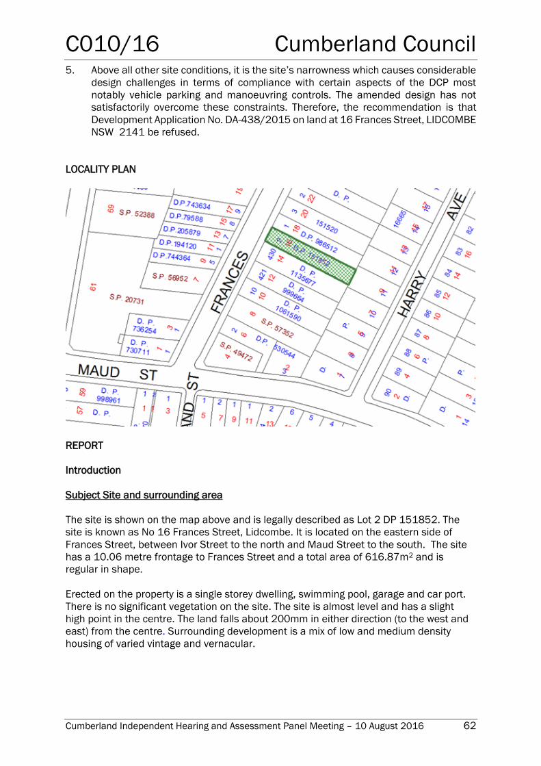
C010/16 Cumberland Council
Cumberland Independent Hearing and Assessment Panel Meeting – 10 August 2016 62
5. Above all other site conditions, it is the site’s narrowness which causes considerable
design challenges in terms of compliance with certain aspects of the DCP most
notably vehicle parking and manoeuvring controls. The amended design has not
satisfactorily overcome these constraints. Therefore, the recommendation is that
Development Application No. DA-438/2015 on land at 16 Frances Street, LIDCOMBE
NSW 2141 be refused.
LOCALITY PLAN
REPORT
Introduction
Subject Site and surrounding area
The site is shown on the map above and is legally described as Lot 2 DP 151852. The
site is known as No 16 Frances Street, Lidcombe. It is located on the eastern side of
Frances Street, between Ivor Street to the north and Maud Street to the south. The site
has a 10.06 metre frontage to Frances Street and a total area of 616.87m2 and is
regular in shape.
Erected on the property is a single storey dwelling, swimming pool, garage and car port.
There is no significant vegetation on the site. The site is almost level and has a slight
high point in the centre. The land falls about 200mm in either direction (to the west and
east) from the centre. Surrounding development is a mix of low and medium density
housing of varied vintage and vernacular.
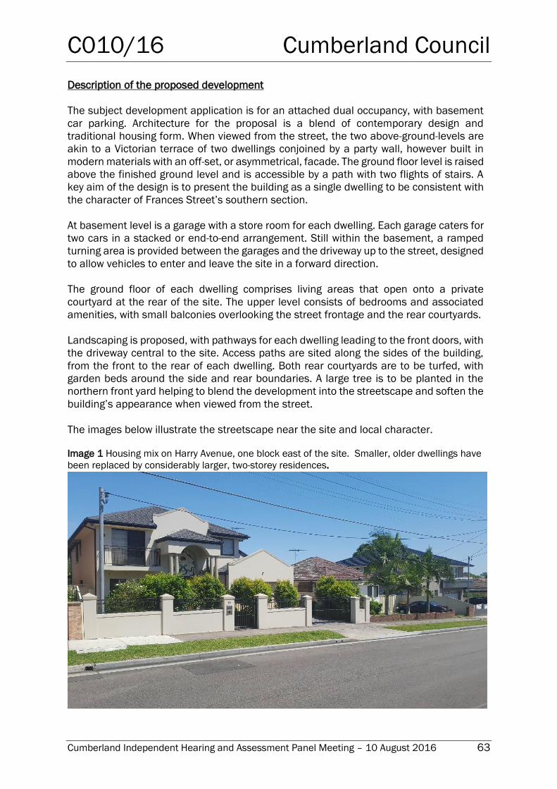
C010/16 Cumberland Council
Cumberland Independent Hearing and Assessment Panel Meeting – 10 August 2016 63
Description of the proposed development
The subject development application is for an attached dual occupancy, with basement
car parking. Architecture for the proposal is a blend of contemporary design and
traditional housing form. When viewed from the street, the two above-ground-levels are
akin to a Victorian terrace of two dwellings conjoined by a party wall, however built in
modern materials with an off-set, or asymmetrical, facade. The ground floor level is raised
above the finished ground level and is accessible by a path with two flights of stairs. A
key aim of the design is to present the building as a single dwelling to be consistent with
the character of Frances Street’s southern section.
At basement level is a garage with a store room for each dwelling. Each garage caters for
two cars in a stacked or end-to-end arrangement. Still within the basement, a ramped
turning area is provided between the garages and the driveway up to the street, designed
to allow vehicles to enter and leave the site in a forward direction.
The ground floor of each dwelling comprises living areas that open onto a private
courtyard at the rear of the site. The upper level consists of bedrooms and associated
amenities, with small balconies overlooking the street frontage and the rear courtyards.
Landscaping is proposed, with pathways for each dwelling leading to the front doors, with
the driveway central to the site. Access paths are sited along the sides of the building,
from the front to the rear of each dwelling. Both rear courtyards are to be turfed, with
garden beds around the side and rear boundaries. A large tree is to be planted in the
northern front yard helping to blend the development into the streetscape and soften the
building’s appearance when viewed from the street.
The images below illustrate the streetscape near the site and local character.
Image 1 Housing mix on Harry Avenue, one block east of the site. Smaller, older dwellings have
been replaced by considerably larger, two-storey residences.
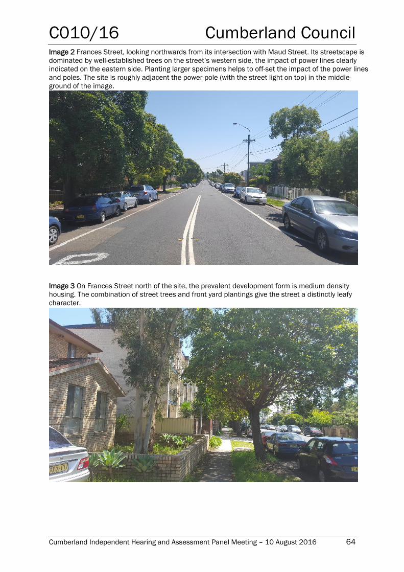
C010/16 Cumberland Council
Cumberland Independent Hearing and Assessment Panel Meeting – 10 August 2016 64
Image 2 Frances Street, looking northwards from its intersection with Maud Street. Its streetscape is
dominated by well-established trees on the street’s western side, the impact of power lines clearly
indicated on the eastern side. Planting larger specimens helps to off-set the impact of the power lines
and poles. The site is roughly adjacent the power-pole (with the street light on top) in the middle-
ground of the image.
Image 3 On Frances Street north of the site, the prevalent development form is medium density
housing. The combination of street trees and front yard plantings give the street a distinctly leafy
character.
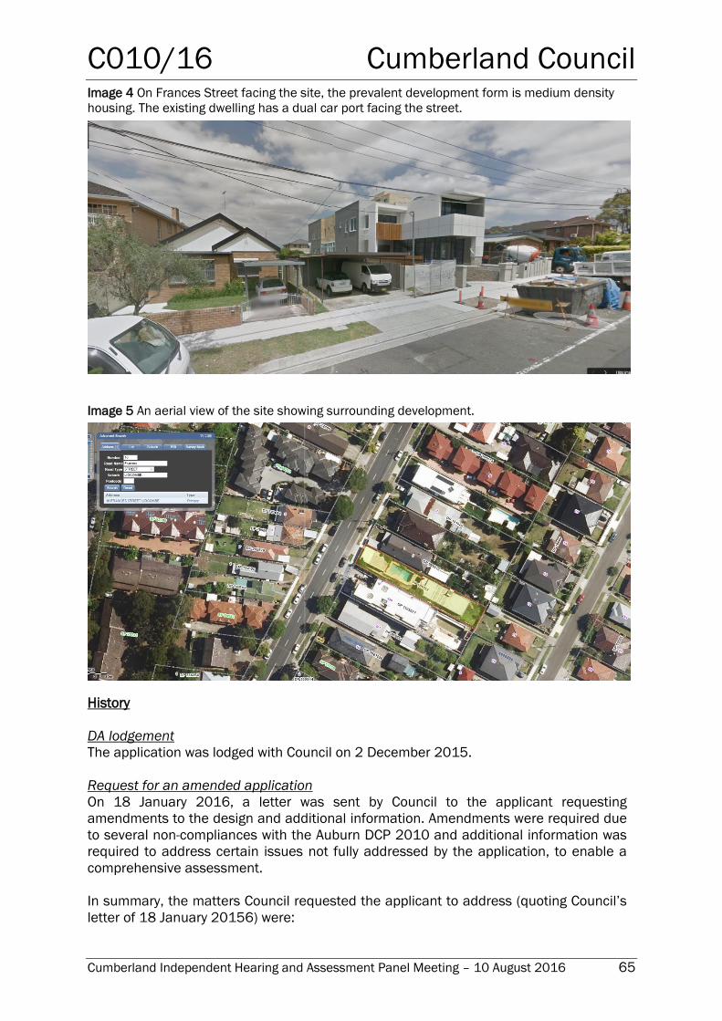
C010/16 Cumberland Council
Cumberland Independent Hearing and Assessment Panel Meeting – 10 August 2016 65
Image 4 On Frances Street facing the site, the prevalent development form is medium density
housing. The existing dwelling has a dual car port facing the street.
Image 5 An aerial view of the site showing surrounding development.
History
DA lodgement
The application was lodged with Council on 2 December 2015.
Request for an amended application
On 18 January 2016, a letter was sent by Council to the applicant requesting
amendments to the design and additional information. Amendments were required due
to several non-compliances with the Auburn DCP 2010 and additional information was
required to address certain issues not fully addressed by the application, to enable a
comprehensive assessment.
In summary, the matters Council requested the applicant to address (quoting Council’s
letter of 18 January 20156) were:
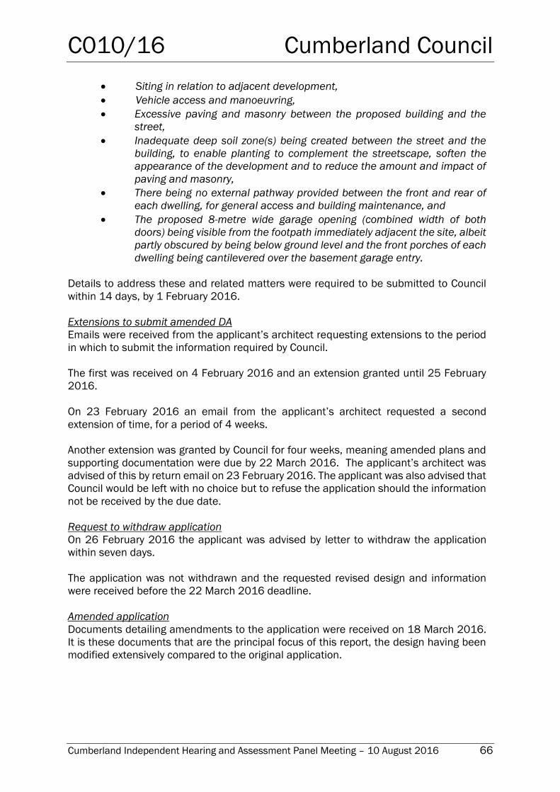
C010/16 Cumberland Council
Cumberland Independent Hearing and Assessment Panel Meeting – 10 August 2016 66
Siting in relation to adjacent development,
Vehicle access and manoeuvring,
Excessive paving and masonry between the proposed building and the
street,
Inadequate deep soil zone(s) being created between the street and the
building, to enable planting to complement the streetscape, soften the
appearance of the development and to reduce the amount and impact of
paving and masonry,
There being no external pathway provided between the front and rear of
each dwelling, for general access and building maintenance, and
The proposed 8-metre wide garage opening (combined width of both
doors) being visible from the footpath immediately adjacent the site, albeit
partly obscured by being below ground level and the front porches of each
dwelling being cantilevered over the basement garage entry.
Details to address these and related matters were required to be submitted to Council
within 14 days, by 1 February 2016.
Extensions to submit amended DA
Emails were received from the applicant’s architect requesting extensions to the period
in which to submit the information required by Council.
The first was received on 4 February 2016 and an extension granted until 25 February
2016.
On 23 February 2016 an email from the applicant’s architect requested a second
extension of time, for a period of 4 weeks.
Another extension was granted by Council for four weeks, meaning amended plans and
supporting documentation were due by 22 March 2016. The applicant’s architect was
advised of this by return email on 23 February 2016. The applicant was also advised that
Council would be left with no choice but to refuse the application should the information
not be received by the due date.
Request to withdraw application
On 26 February 2016 the applicant was advised by letter to withdraw the application
within seven days.
The application was not withdrawn and the requested revised design and information
were received before the 22 March 2016 deadline.
Amended application
Documents detailing amendments to the application were received on 18 March 2016.
It is these documents that are the principal focus of this report, the design having been
modified extensively compared to the original application.
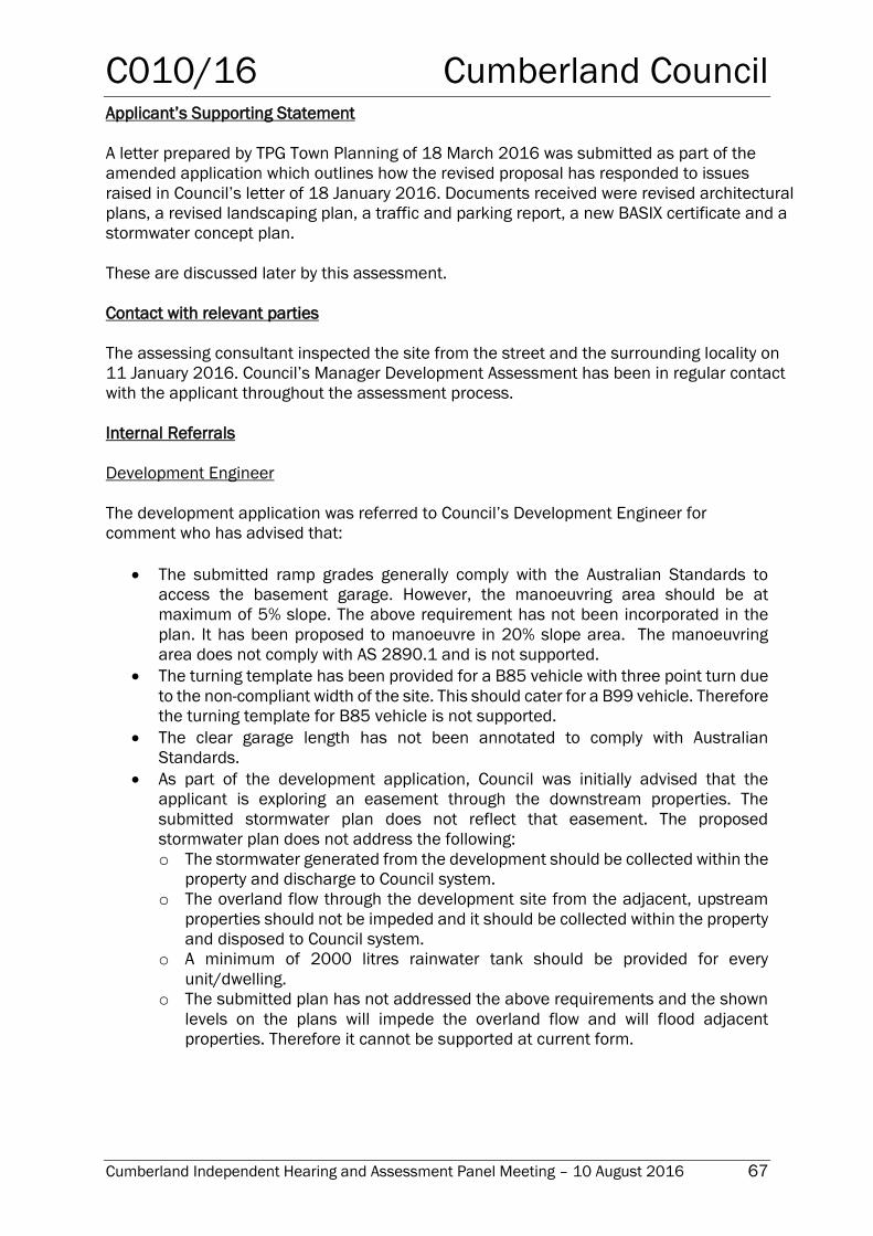
C010/16 Cumberland Council
Cumberland Independent Hearing and Assessment Panel Meeting – 10 August 2016 67
Applicant’s Supporting Statement
A letter prepared by TPG Town Planning of 18 March 2016 was submitted as part of the
amended application which outlines how the revised proposal has responded to issues
raised in Council’s letter of 18 January 2016. Documents received were revised architectural
plans, a revised landscaping plan, a traffic and parking report, a new BASIX certificate and a
stormwater concept plan.
These are discussed later by this assessment.
Contact with relevant parties
The assessing consultant inspected the site from the street and the surrounding locality on
11 January 2016. Council’s Manager Development Assessment has been in regular contact
with the applicant throughout the assessment process.
Internal Referrals
Development Engineer
The development application was referred to Council’s Development Engineer for
comment who has advised that:
The submitted ramp grades generally comply with the Australian Standards to
access the basement garage. However, the manoeuvring area should be at
maximum of 5% slope. The above requirement has not been incorporated in the
plan. It has been proposed to manoeuvre in 20% slope area. The manoeuvring
area does not comply with AS 2890.1 and is not supported.
The turning template has been provided for a B85 vehicle with three point turn due
to the non-compliant width of the site. This should cater for a B99 vehicle. Therefore
the turning template for B85 vehicle is not supported.
The clear garage length has not been annotated to comply with Australian
Standards.
As part of the development application, Council was initially advised that the
applicant is exploring an easement through the downstream properties. The
submitted stormwater plan does not reflect that easement. The proposed
stormwater plan does not address the following:
o The stormwater generated from the development should be collected within the
property and discharge to Council system.
o The overland flow through the development site from the adjacent, upstream
properties should not be impeded and it should be collected within the property
and disposed to Council system.
o A minimum of 2000 litres rainwater tank should be provided for every
unit/dwelling.
o The submitted plan has not addressed the above requirements and the shown
levels on the plans will impede the overland flow and will flood adjacent
properties. Therefore it cannot be supported at current form.
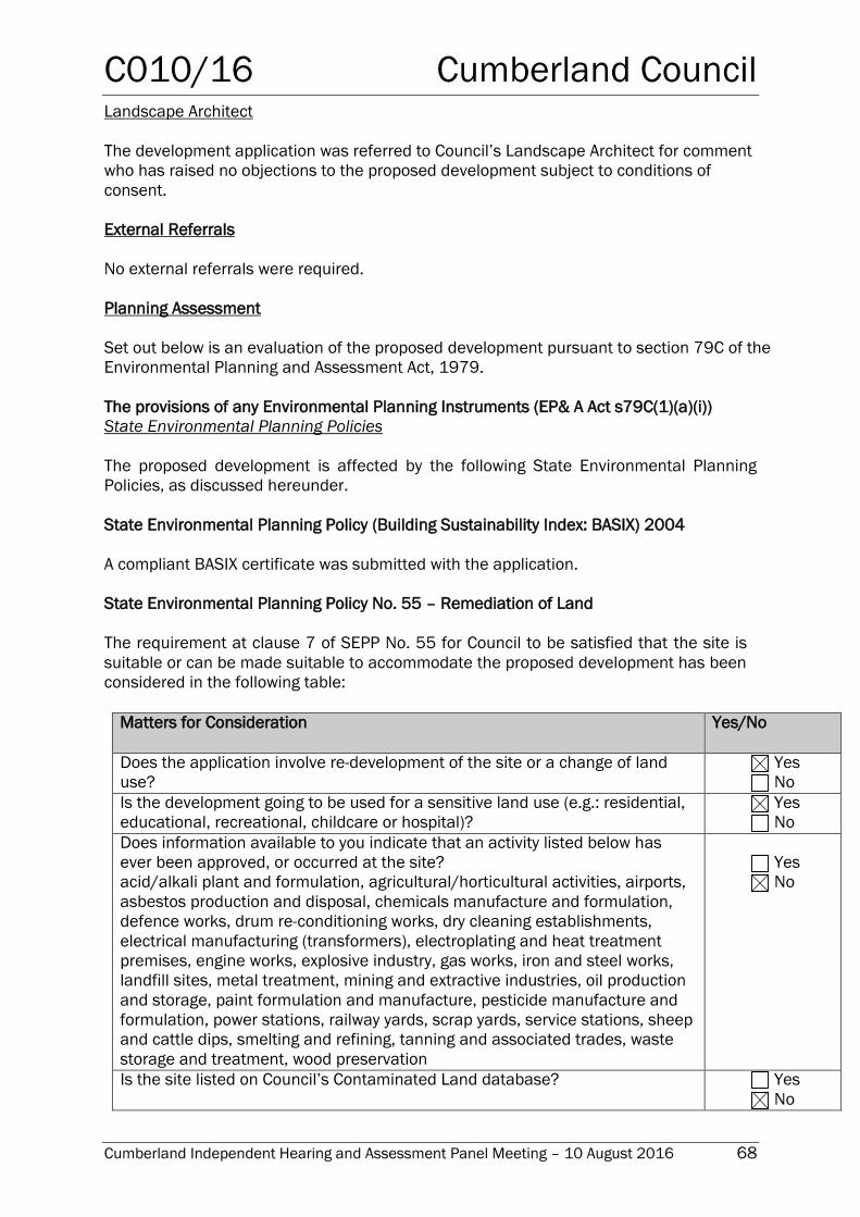
C010/16 Cumberland Council
Cumberland Independent Hearing and Assessment Panel Meeting – 10 August 2016 68
Landscape Architect
The development application was referred to Council’s Landscape Architect for comment
who has raised no objections to the proposed development subject to conditions of
consent.
External Referrals
No external referrals were required.
Planning Assessment
Set out below is an evaluation of the proposed development pursuant to section 79C of the
Environmental Planning and Assessment Act, 1979.
The provisions of any Environmental Planning Instruments (EP& A Act s79C(1)(a)(i))
State Environmental Planning Policies
The proposed development is affected by the following State Environmental Planning
Policies, as discussed hereunder.
State Environmental Planning Policy (Building Sustainability Index: BASIX) 2004
A compliant BASIX certificate was submitted with the application.
State Environmental Planning Policy No. 55 – Remediation of Land
The requirement at clause 7 of SEPP No. 55 for Council to be satisfied that the site is
suitable or can be made suitable to accommodate the proposed development has been
considered in the following table:
Matters for Consideration Yes/No
Does the application involve re-development of the site or a change of land
use?
Yes
No
Is the development going to be used for a sensitive land use (e.g.: residential,
educational, recreational, childcare or hospital)?
Yes
No
Does information available to you indicate that an activity listed below has
ever been approved, or occurred at the site?
acid/alkali plant and formulation, agricultural/horticultural activities, airports,
asbestos production and disposal, chemicals manufacture and formulation,
defence works, drum re-conditioning works, dry cleaning establishments,
electrical manufacturing (transformers), electroplating and heat treatment
premises, engine works, explosive industry, gas works, iron and steel works,
landfill sites, metal treatment, mining and extractive industries, oil production
and storage, paint formulation and manufacture, pesticide manufacture and
formulation, power stations, railway yards, scrap yards, service stations, sheep
and cattle dips, smelting and refining, tanning and associated trades, waste
storage and treatment, wood preservation
Yes
No
Is the site listed on Council’s Contaminated Land database? Yes
No
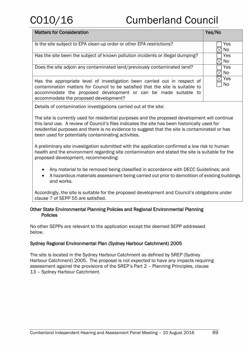
C010/16 Cumberland Council
Cumberland Independent Hearing and Assessment Panel Meeting – 10 August 2016 69
Matters for Consideration Yes/No
Is the site subject to EPA clean-up order or other EPA restrictions? Yes
No
Has the site been the subject of known pollution incidents or illegal dumping? Yes
No
Does the site adjoin any contaminated land/previously contaminated land? Yes
No
Has the appropriate level of investigation been carried out in respect of
contamination matters for Council to be satisfied that the site is suitable to
accommodate the proposed development or can be made suitable to
accommodate the proposed development?
Yes
No
Details of contamination investigations carried out at the site:
The site is currently used for residential purposes and the proposed development will continue
this land use. A review of Council’s files indicates the site has been historically used for
residential purposes and there is no evidence to suggest that the site is contaminated or has
been used for potentially contaminating activities.
A preliminary site investigation submitted with the application confirmed a low risk to human
health and the environment regarding site contamination and stated the site is suitable for the
proposed development, recommending:
Any material to be removed being classified in accordance with DECC Guidelines; and
A hazardous materials assessment being carried out prior to demolition of existing buildings
and works.
Accordingly, the site is suitable for the proposed development and Council’s obligations under
clause 7 of SEPP 55 are satisfied.
Other State Environmental Planning Policies and Regional Environmental Planning
Policies
No other SEPPs are relevant to the application except the deemed SEPP addressed
below.
Sydney Regional Environmental Plan (Sydney Harbour Catchment) 2005
The site is located in the Sydney Harbour Catchment as defined by SREP (Sydney
Harbour Catchment) 2005. The proposal is not expected to have any impacts requiring
assessment against the provisions of the SREP’s Part 2 – Planning Principles, clause
13 – Sydney Harbour Catchment.
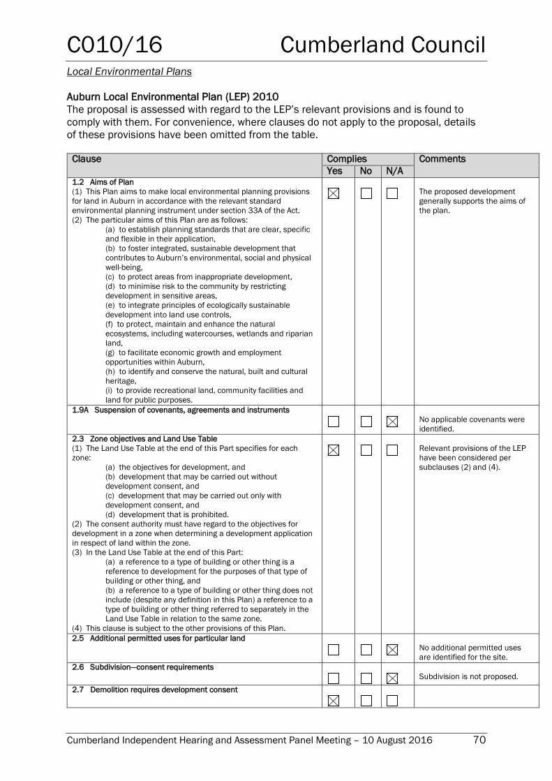
C010/16 Cumberland Council
Cumberland Independent Hearing and Assessment Panel Meeting – 10 August 2016 70
Local Environmental Plans
Auburn Local Environmental Plan (LEP) 2010
The proposal is assessed with regard to the LEP’s relevant provisions and is found to
comply with them. For convenience, where clauses do not apply to the proposal, details
of these provisions have been omitted from the table.
Clause Complies Comments
Yes No N/A 1.2 Aims of Plan
(1) This Plan aims to make local environmental planning provisions
for land in Auburn in accordance with the relevant standard
environmental planning instrument under section 33A of the Act.
(2) The particular aims of this Plan are as follows:
(a) to establish planning standards that are clear, specific
and flexible in their application,
(b) to foster integrated, sustainable development that
contributes to Auburn’s environmental, social and physical
well-being,
(c) to protect areas from inappropriate development,
(d) to minimise risk to the community by restricting
development in sensitive areas,
(e) to integrate principles of ecologically sustainable
development into land use controls,
(f) to protect, maintain and enhance the natural
ecosystems, including watercourses, wetlands and riparian
land,
(g) to facilitate economic growth and employment
opportunities within Auburn,
(h) to identify and conserve the natural, built and cultural
heritage,
(i) to provide recreational land, community facilities and
land for public purposes.
The proposed development
generally supports the aims of
the plan.
1.9A Suspension of covenants, agreements and instruments
No applicable covenants were
identified.
2.3 Zone objectives and Land Use Table
(1) The Land Use Table at the end of this Part specifies for each
zone:
(a) the objectives for development, and
(b) development that may be carried out without
development consent, and
(c) development that may be carried out only with
development consent, and
(d) development that is prohibited.
(2) The consent authority must have regard to the objectives for
development in a zone when determining a development application
in respect of land within the zone.
(3) In the Land Use Table at the end of this Part:
(a) a reference to a type of building or other thing is a
reference to development for the purposes of that type of
building or other thing, and
(b) a reference to a type of building or other thing does not
include (despite any definition in this Plan) a reference to a
type of building or other thing referred to separately in the
Land Use Table in relation to the same zone.
(4) This clause is subject to the other provisions of this Plan.
Relevant provisions of the LEP
have been considered per
subclauses (2) and (4).
2.5 Additional permitted uses for particular land
No additional permitted uses
are identified for the site.
2.6 Subdivision—consent requirements
Subdivision is not proposed.
2.7 Demolition requires development consent
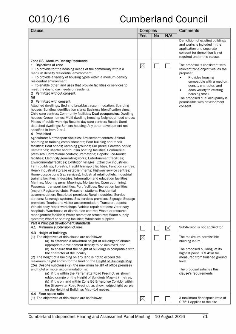
C010/16 Cumberland Council
Cumberland Independent Hearing and Assessment Panel Meeting – 10 August 2016 71
Clause Complies Comments
Yes No N/A Demolition of existing buildings
and works is included in the
application and separate
consent for demolition is not
required under this clause.
Zone R3 Medium Density Residential
1 Objectives of zone
• To provide for the housing needs of the community within a
medium density residential environment.
• To provide a variety of housing types within a medium density
residential environment.
• To enable other land uses that provide facilities or services to
meet the day to day needs of residents.
2 Permitted without consent
Nil
3 Permitted with consent
Attached dwellings; Bed and breakfast accommodation; Boarding
houses; Building identification signs; Business identification signs;
Child care centres; Community facilities; Dual occupancies; Dwelling
houses; Group homes; Multi dwelling housing; Neighbourhood shops;
Places of public worship; Respite day care centres; Roads; Semi-
detached dwellings; Seniors housing; Any other development not
specified in item 2 or 4
4 Prohibited
Agriculture; Air transport facilities; Amusement centres; Animal
boarding or training establishments; Boat building and repair
facilities; Boat sheds; Camping grounds; Car parks; Caravan parks;
Cemeteries; Charter and tourism boating facilities; Commercial
premises; Correctional centres; Crematoria; Depots; Eco-tourist
facilities; Electricity generating works; Entertainment facilities;
Environmental facilities; Exhibition villages; Extractive industries;
Farm buildings; Forestry; Freight transport facilities; Function centres;
Heavy industrial storage establishments; Highway service centres;
Home occupations (sex services); Industrial retail outlets; Industrial
training facilities; Industries; Information and education facilities;
Marinas; Mooring pens; Moorings; Mortuaries; Open cut mining;
Passenger transport facilities; Port facilities; Recreation facilities
(major); Registered clubs; Research stations; Residential
accommodation; Restricted premises; Rural industries; Service
stations; Sewerage systems; Sex services premises; Signage; Storage
premises; Tourist and visitor accommodation; Transport depots;
Vehicle body repair workshops; Vehicle repair stations; Veterinary
hospitals; Warehouse or distribution centres; Waste or resource
management facilities; Water recreation structures; Water supply
systems; Wharf or boating facilities; Wholesale supplies
The proposal is consistent with
relevant zone objectives, as the
proposal:
Provides housing
compatible with a medium
density character, and
Adds variety to existing
housing stock.
The proposed dual occupancy is
permissible with development
consent.
Part 4 Principal development standards
4.1 Minimum subdivision lot size
Subdivision is not applied for.
4.3 Height of buildings
(1) The objectives of this clause are as follows:
(a) to establish a maximum height of buildings to enable
appropriate development density to be achieved, and
(b) to ensure that the height of buildings is compatible with
the character of the locality.
(2) The height of a building on any land is not to exceed the
maximum height shown for the land on the Height of Buildings Map.
(2A) Despite subclause (2), the maximum height of office premises
and hotel or motel accommodation is:
(a) if it is within the Parramatta Road Precinct, as shown
edged orange on the Height of Buildings Map—27 metres,
(b) if it is on land within Zone B6 Enterprise Corridor within
the Silverwater Road Precinct, as shown edged light purple
on the Height of Buildings Map—14 metres.
The maximum permissible
building is 9m.
The proposed building, at its
highest point, is 8.45m tall,
measured from finished ground
level.
The proposal satisfies this
clause’s requirements.
4.4 Floor space ratio
(1) The objectives of this clause are as follows:
A maximum floor space ratio of
0.75:1 applies to the site.
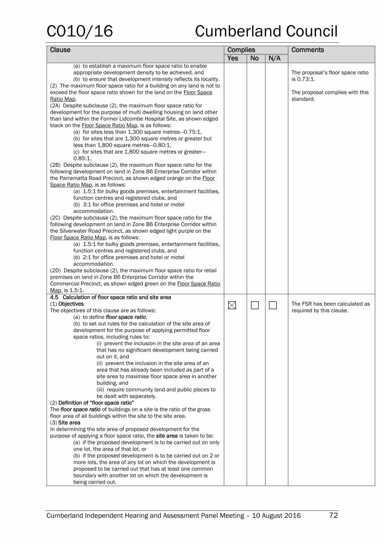
C010/16 Cumberland Council
Cumberland Independent Hearing and Assessment Panel Meeting – 10 August 2016 72
Clause Complies Comments
Yes No N/A (a) to establish a maximum floor space ratio to enable
appropriate development density to be achieved, and
(b) to ensure that development intensity reflects its locality.
(2) The maximum floor space ratio for a building on any land is not to
exceed the floor space ratio shown for the land on the Floor Space
Ratio Map.
(2A) Despite subclause (2), the maximum floor space ratio for
development for the purpose of multi dwelling housing on land other
than land within the Former Lidcombe Hospital Site, as shown edged
black on the Floor Space Ratio Map, is as follows:
(a) for sites less than 1,300 square metres—0.75:1,
(b) for sites that are 1,300 square metres or greater but
less than 1,800 square metres—0.80:1,
(c) for sites that are 1,800 square metres or greater—
0.85:1.
(2B) Despite subclause (2), the maximum floor space ratio for the
following development on land in Zone B6 Enterprise Corridor within
the Parramatta Road Precinct, as shown edged orange on the Floor
Space Ratio Map, is as follows:
(a) 1.5:1 for bulky goods premises, entertainment facilities,
function centres and registered clubs, and
(b) 3:1 for office premises and hotel or motel
accommodation.
(2C) Despite subclause (2), the maximum floor space ratio for the
following development on land in Zone B6 Enterprise Corridor within
the Silverwater Road Precinct, as shown edged light purple on the
Floor Space Ratio Map, is as follows:
(a) 1.5:1 for bulky goods premises, entertainment facilities,
function centres and registered clubs, and
(b) 2:1 for office premises and hotel or motel
accommodation.
(2D) Despite subclause (2), the maximum floor space ratio for retail
premises on land in Zone B6 Enterprise Corridor within the
Commercial Precinct, as shown edged green on the Floor Space Ratio
Map, is 1.5:1.
The proposal’s floor space ratio
is 0.73:1.
The proposal complies with this
standard.
4.5 Calculation of floor space ratio and site area
(1) Objectives
The objectives of this clause are as follows:
(a) to define floor space ratio,
(b) to set out rules for the calculation of the site area of
development for the purpose of applying permitted floor
space ratios, including rules to:
(i) prevent the inclusion in the site area of an area
that has no significant development being carried
out on it, and
(ii) prevent the inclusion in the site area of an
area that has already been included as part of a
site area to maximise floor space area in another
building, and
(iii) require community land and public places to
be dealt with separately.
(2) Definition of “floor space ratio”
The floor space ratio of buildings on a site is the ratio of the gross
floor area of all buildings within the site to the site area.
(3) Site area
In determining the site area of proposed development for the
purpose of applying a floor space ratio, the site area is taken to be:
(a) if the proposed development is to be carried out on only
one lot, the area of that lot, or
(b) if the proposed development is to be carried out on 2 or
more lots, the area of any lot on which the development is
proposed to be carried out that has at least one common
boundary with another lot on which the development is
being carried out.
The FSR has been calculated as
required by this clause.
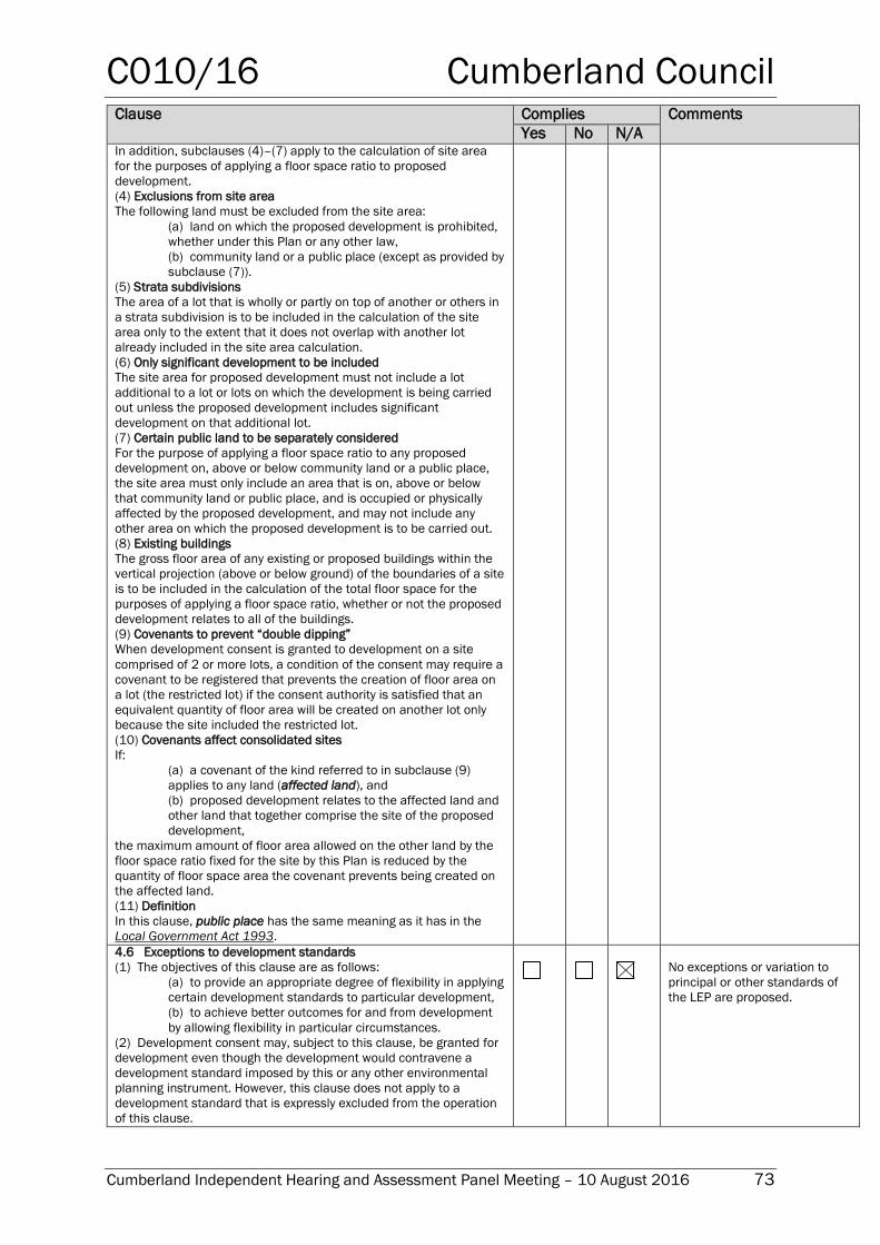
C010/16 Cumberland Council
Cumberland Independent Hearing and Assessment Panel Meeting – 10 August 2016 73
Clause Complies Comments
Yes No N/A In addition, subclauses (4)–(7) apply to the calculation of site area
for the purposes of applying a floor space ratio to proposed
development.
(4) Exclusions from site area
The following land must be excluded from the site area:
(a) land on which the proposed development is prohibited,
whether under this Plan or any other law,
(b) community land or a public place (except as provided by
subclause (7)).
(5) Strata subdivisions
The area of a lot that is wholly or partly on top of another or others in
a strata subdivision is to be included in the calculation of the site
area only to the extent that it does not overlap with another lot
already included in the site area calculation.
(6) Only significant development to be included
The site area for proposed development must not include a lot
additional to a lot or lots on which the development is being carried
out unless the proposed development includes significant
development on that additional lot.
(7) Certain public land to be separately considered
For the purpose of applying a floor space ratio to any proposed
development on, above or below community land or a public place,
the site area must only include an area that is on, above or below
that community land or public place, and is occupied or physically
affected by the proposed development, and may not include any
other area on which the proposed development is to be carried out.
(8) Existing buildings
The gross floor area of any existing or proposed buildings within the
vertical projection (above or below ground) of the boundaries of a site
is to be included in the calculation of the total floor space for the
purposes of applying a floor space ratio, whether or not the proposed
development relates to all of the buildings.
(9) Covenants to prevent “double dipping”
When development consent is granted to development on a site
comprised of 2 or more lots, a condition of the consent may require a
covenant to be registered that prevents the creation of floor area on
a lot (the restricted lot) if the consent authority is satisfied that an
equivalent quantity of floor area will be created on another lot only
because the site included the restricted lot.
(10) Covenants affect consolidated sites
If:
(a) a covenant of the kind referred to in subclause (9)
applies to any land (affected land), and
(b) proposed development relates to the affected land and
other land that together comprise the site of the proposed
development,
the maximum amount of floor area allowed on the other land by the
floor space ratio fixed for the site by this Plan is reduced by the
quantity of floor space area the covenant prevents being created on
the affected land.
(11) Definition
In this clause, public place has the same meaning as it has in the
Local Government Act 1993. 4.6 Exceptions to development standards
(1) The objectives of this clause are as follows:
(a) to provide an appropriate degree of flexibility in applying
certain development standards to particular development,
(b) to achieve better outcomes for and from development
by allowing flexibility in particular circumstances.
(2) Development consent may, subject to this clause, be granted for
development even though the development would contravene a
development standard imposed by this or any other environmental
planning instrument. However, this clause does not apply to a
development standard that is expressly excluded from the operation
of this clause.
No exceptions or variation to
principal or other standards of
the LEP are proposed.
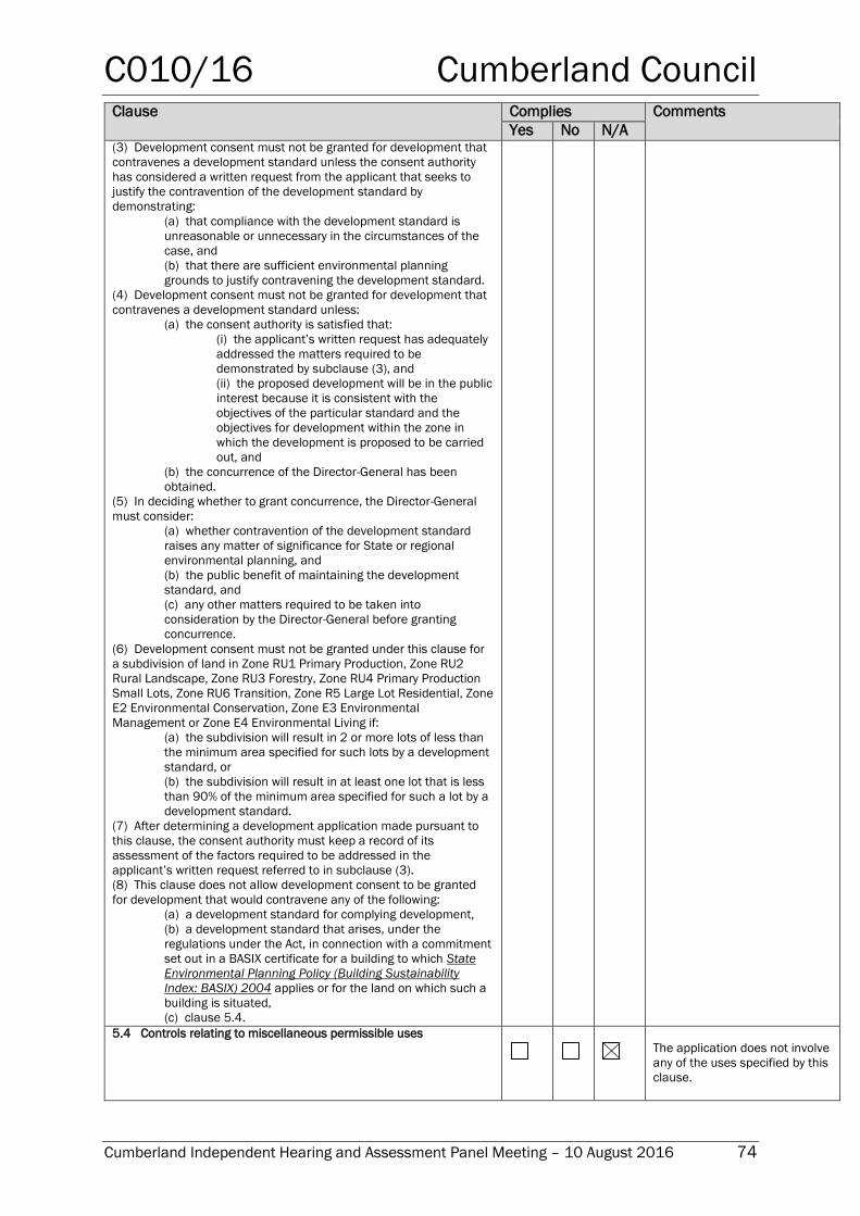
C010/16 Cumberland Council
Cumberland Independent Hearing and Assessment Panel Meeting – 10 August 2016 74
Clause Complies Comments
Yes No N/A (3) Development consent must not be granted for development that
contravenes a development standard unless the consent authority
has considered a written request from the applicant that seeks to
justify the contravention of the development standard by
demonstrating:
(a) that compliance with the development standard is
unreasonable or unnecessary in the circumstances of the
case, and
(b) that there are sufficient environmental planning
grounds to justify contravening the development standard.
(4) Development consent must not be granted for development that
contravenes a development standard unless:
(a) the consent authority is satisfied that:
(i) the applicant’s written request has adequately
addressed the matters required to be
demonstrated by subclause (3), and
(ii) the proposed development will be in the public
interest because it is consistent with the
objectives of the particular standard and the
objectives for development within the zone in
which the development is proposed to be carried
out, and
(b) the concurrence of the Director-General has been
obtained.
(5) In deciding whether to grant concurrence, the Director-General
must consider:
(a) whether contravention of the development standard
raises any matter of significance for State or regional
environmental planning, and
(b) the public benefit of maintaining the development
standard, and
(c) any other matters required to be taken into
consideration by the Director-General before granting
concurrence.
(6) Development consent must not be granted under this clause for
a subdivision of land in Zone RU1 Primary Production, Zone RU2
Rural Landscape, Zone RU3 Forestry, Zone RU4 Primary Production
Small Lots, Zone RU6 Transition, Zone R5 Large Lot Residential, Zone
E2 Environmental Conservation, Zone E3 Environmental
Management or Zone E4 Environmental Living if:
(a) the subdivision will result in 2 or more lots of less than
the minimum area specified for such lots by a development
standard, or
(b) the subdivision will result in at least one lot that is less
than 90% of the minimum area specified for such a lot by a
development standard.
(7) After determining a development application made pursuant to
this clause, the consent authority must keep a record of its
assessment of the factors required to be addressed in the
applicant’s written request referred to in subclause (3).
(8) This clause does not allow development consent to be granted
for development that would contravene any of the following:
(a) a development standard for complying development,
(b) a development standard that arises, under the
regulations under the Act, in connection with a commitment
set out in a BASIX certificate for a building to which State
Environmental Planning Policy (Building Sustainability
Index: BASIX) 2004 applies or for the land on which such a
building is situated,
(c) clause 5.4. 5.4 Controls relating to miscellaneous permissible uses
The application does not involve
any of the uses specified by this
clause.
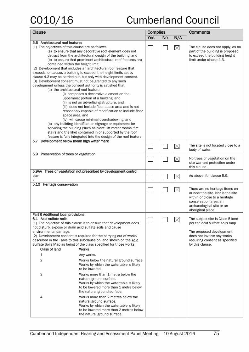
C010/16 Cumberland Council
Cumberland Independent Hearing and Assessment Panel Meeting – 10 August 2016 75
Clause Complies Comments
Yes No N/A 5.6 Architectural roof features
(1) The objectives of this clause are as follows:
(a) to ensure that any decorative roof element does not
detract from the architectural design of the building, and
(b) to ensure that prominent architectural roof features are
contained within the height limit.
(2) Development that includes an architectural roof feature that
exceeds, or causes a building to exceed, the height limits set by
clause 4.3 may be carried out, but only with development consent.
(3) Development consent must not be granted to any such
development unless the consent authority is satisfied that:
(a) the architectural roof feature:
(i) comprises a decorative element on the
uppermost portion of a building, and
(ii) is not an advertising structure, and
(iii) does not include floor space area and is not
reasonably capable of modification to include floor
space area, and
(iv) will cause minimal overshadowing, and
(b) any building identification signage or equipment for
servicing the building (such as plant, lift motor rooms, fire
stairs and the like) contained in or supported by the roof
feature is fully integrated into the design of the roof feature.
The clause does not apply, as no
part of the building is proposed
to exceed the building height
limit under clause 4.3.
5.7 Development below mean high water mark
The site is not located close to a
body of water.
5.9 Preservation of trees or vegetation
No trees or vegetation on the
site warrant protection under
this clause.
5.9AA Trees or vegetation not prescribed by development control
plan
\
As above, for clause 5.9.
5.10 Heritage conservation
There are no heritage items on
or near the site. Nor is the site
within or close to a heritage
conservation area, an
archaeological site or an
Aboriginal place.
Part 6 Additional local provisions
6.1 Acid sulfate soils
(1) The objective of this clause is to ensure that development does
not disturb, expose or drain acid sulfate soils and cause
environmental damage.
(2) Development consent is required for the carrying out of works
described in the Table to this subclause on land shown on the Acid
Sulfate Soils Map as being of the class specified for those works.
Class of land Works
1 Any works.
2 Works below the natural ground surface.
Works by which the watertable is likely
to be lowered.
3 Works more than 1 metre below the
natural ground surface.
Works by which the watertable is likely
to be lowered more than 1 metre below
the natural ground surface.
4 Works more than 2 metres below the
natural ground surface.
Works by which the watertable is likely
to be lowered more than 2 metres below
the natural ground surface.
The subject site is Class 5 land
per the acid sulfate soils map.
The proposed development
does not involve any works
requiring consent as specified
by this clause.
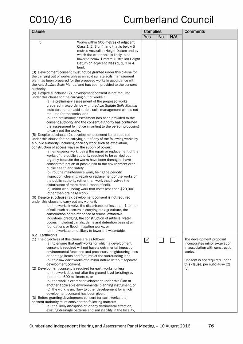
C010/16 Cumberland Council
Cumberland Independent Hearing and Assessment Panel Meeting – 10 August 2016 76
Clause Complies Comments
Yes No N/A
5 Works within 500 metres of adjacent
Class 1, 2, 3 or 4 land that is below 5
metres Australian Height Datum and by
which the watertable is likely to be
lowered below 1 metre Australian Height
Datum on adjacent Class 1, 2, 3 or 4
land.
(3) Development consent must not be granted under this clause for
the carrying out of works unless an acid sulfate soils management
plan has been prepared for the proposed works in accordance with
the Acid Sulfate Soils Manual and has been provided to the consent
authority.
(4) Despite subclause (2), development consent is not required
under this clause for the carrying out of works if:
(a) a preliminary assessment of the proposed works
prepared in accordance with the Acid Sulfate Soils Manual
indicates that an acid sulfate soils management plan is not
required for the works, and
(b) the preliminary assessment has been provided to the
consent authority and the consent authority has confirmed
the assessment by notice in writing to the person proposing
to carry out the works.
(5) Despite subclause (2), development consent is not required
under this clause for the carrying out of any of the following works by
a public authority (including ancillary work such as excavation,
construction of access ways or the supply of power):
(a) emergency work, being the repair or replacement of the
works of the public authority required to be carried out
urgently because the works have been damaged, have
ceased to function or pose a risk to the environment or to
public health and safety,
(b) routine maintenance work, being the periodic
inspection, cleaning, repair or replacement of the works of
the public authority (other than work that involves the
disturbance of more than 1 tonne of soil),
(c) minor work, being work that costs less than $20,000
(other than drainage work).
(6) Despite subclause (2), development consent is not required
under this clause to carry out any works if:
(a) the works involve the disturbance of less than 1 tonne
of soil, such as occurs in carrying out agriculture, the
construction or maintenance of drains, extractive
industries, dredging, the construction of artificial water
bodies (including canals, dams and detention basins) or
foundations or flood mitigation works, or
(b) the works are not likely to lower the watertable. 6.2 Earthworks
(1) The objectives of this clause are as follows:
(a) to ensure that earthworks for which a development
consent is required will not have a detrimental impact on
environmental functions and processes, neighbouring uses
or heritage items and features of the surrounding land,
(b) to allow earthworks of a minor nature without separate
development consent.
(2) Development consent is required for earthworks, unless:
(a) the work does not alter the ground level (existing) by
more than 600 millimetres, or
(b) the work is exempt development under this Plan or
another applicable environmental planning instrument, or
(c) the work is ancillary to other development for which
development consent has been given.
(3) Before granting development consent for earthworks, the
consent authority must consider the following matters:
(a) the likely disruption of, or any detrimental effect on,
existing drainage patterns and soil stability in the locality,
The development proposal
incorporates minor excavation
in association with construction
works.
Consent is not required under
this clause, per subclause (2)
(c).
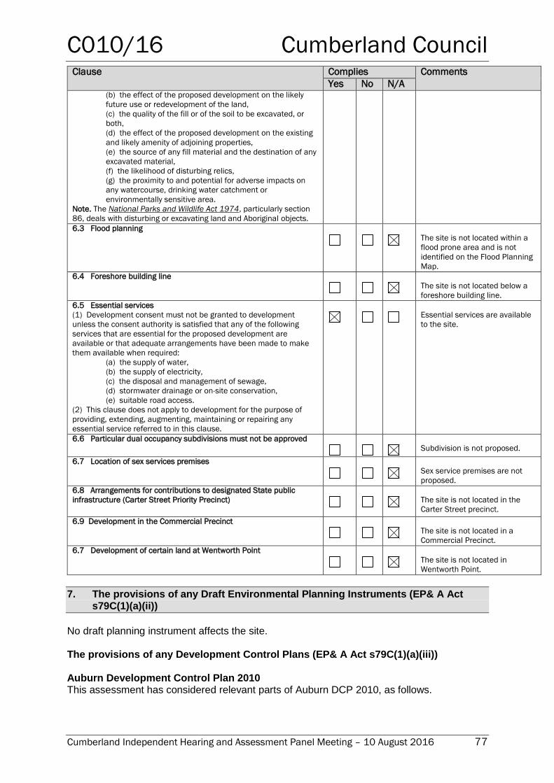
C010/16 Cumberland Council
Cumberland Independent Hearing and Assessment Panel Meeting – 10 August 2016 77
Clause Complies Comments
Yes No N/A (b) the effect of the proposed development on the likely
future use or redevelopment of the land,
(c) the quality of the fill or of the soil to be excavated, or
both,
(d) the effect of the proposed development on the existing
and likely amenity of adjoining properties,
(e) the source of any fill material and the destination of any
excavated material,
(f) the likelihood of disturbing relics,
(g) the proximity to and potential for adverse impacts on
any watercourse, drinking water catchment or
environmentally sensitive area.
Note. The National Parks and Wildlife Act 1974, particularly section
86, deals with disturbing or excavating land and Aboriginal objects. 6.3 Flood planning
The site is not located within a
flood prone area and is not
identified on the Flood Planning
Map.
6.4 Foreshore building line
The site is not located below a
foreshore building line.
6.5 Essential services
(1) Development consent must not be granted to development
unless the consent authority is satisfied that any of the following
services that are essential for the proposed development are
available or that adequate arrangements have been made to make
them available when required:
(a) the supply of water,
(b) the supply of electricity,
(c) the disposal and management of sewage,
(d) stormwater drainage or on-site conservation,
(e) suitable road access.
(2) This clause does not apply to development for the purpose of
providing, extending, augmenting, maintaining or repairing any
essential service referred to in this clause.
Essential services are available
to the site.
6.6 Particular dual occupancy subdivisions must not be approved
Subdivision is not proposed.
6.7 Location of sex services premises
Sex service premises are not
proposed.
6.8 Arrangements for contributions to designated State public
infrastructure (Carter Street Priority Precinct)
The site is not located in the
Carter Street precinct.
6.9 Development in the Commercial Precinct
The site is not located in a
Commercial Precinct.
6.7 Development of certain land at Wentworth Point
The site is not located in
Wentworth Point.
7. The provisions of any Draft Environmental Planning Instruments (EP& A Act s79C(1)(a)(ii))
No draft planning instrument affects the site. The provisions of any Development Control Plans (EP& A Act s79C(1)(a)(iii)) Auburn Development Control Plan 2010 This assessment has considered relevant parts of Auburn DCP 2010, as follows.
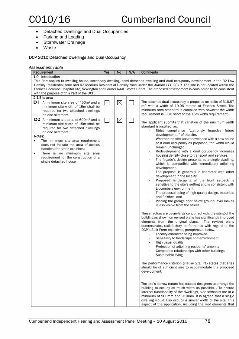
C010/16 Cumberland Council
Cumberland Independent Hearing and Assessment Panel Meeting – 10 August 2016 78
Detached Dwellings and Dual Occupancies
Parking and Loading
Stormwater Drainage
Waste
DCP 2010 Detached Dwellings and Dual Occupancy
Assessment Table Requirement Yes No N/A Comments
1.0 Introduction
This Part applies to dwelling house, secondary dwelling, semi-detached dwelling and dual occupancy development in the R2 Low
Density Residential zone and R3 Medium Residential Density zone under the Auburn LEP 2010. The site is not located within the
Former Lidcombe Hospital site, Newington and Former RAAF Stores Depot. The proposed development is considered to be consistent
with the purpose of this Part of the DCP.
2.1 Site area
D1 A minimum site area of 450m2 and a
minimum site width of 15m shall be
required for two attached dwellings
on one allotment.
D2 A minimum site area of 600m2 and a
minimum site width of 15m shall be
required for two detached dwellings
on one allotment.
Notes:
The minimum site area requirement
does not include the area of access
handles (for battle axe sites).
There is no minimum site area
requirement for the construction of a
single detached house
The attached dual occupancy is proposed on a site of 616.87
m2 with a width of 10.06 metres at Frances Street. The
minimum area standard is complied with however the width
requirement is 33% short of the 15m width requirement.
The applicant submits that variation of the minimum width
standard is justified, as:
- Strict compliance “…strongly impedes future
development…” of the site,
- Whether the site was redeveloped with a new house
or a dual occupancy as proposed, the width would
remain unchanged,
- Redevelopment with a dual occupancy increases
housing density close to transport and services,
- The façade’s design presents as a single dwelling,
which is compatible with immediately adjoining
development,
- The proposal is generally in character with other
development in the locality,
- Proposed landscaping of the front setback is
sensitive to the site’s setting and is consistent with
Lidcombe’s environment,
- The proposal being of high quality design, materials
and finishes, and
- Placing the garage door below ground level makes
it less visible from the street.
These factors are by-an-large concurred with, the siting of the
building as shown on revised plans has significantly improved
elements from the original plans. The revised plans
demonstrates satisfactory performance with regard to the
DCP’s Built Form objectives, paraphrased below.
- Locality-character being improved
- Sensitivity to landscape and environment
- High visual quality
- Protection of adjoining residents’ amenity
- Compatible relationships with other buildings
- Sustainable living
The performance criterion (clause 2.1, P1) states that sites
should be of sufficient size to accommodate the proposed
development.
The site’s narrow nature has caused designers to arrange the
building to occupy as much width as possible. . To ensure
internal functionality of the dwellings, side setbacks are at a
minimum of 900mm and 910mm. It is agreed that a single
dwelling would also occupy a similar width of the site. This
aspect of the application, including the roof elements that
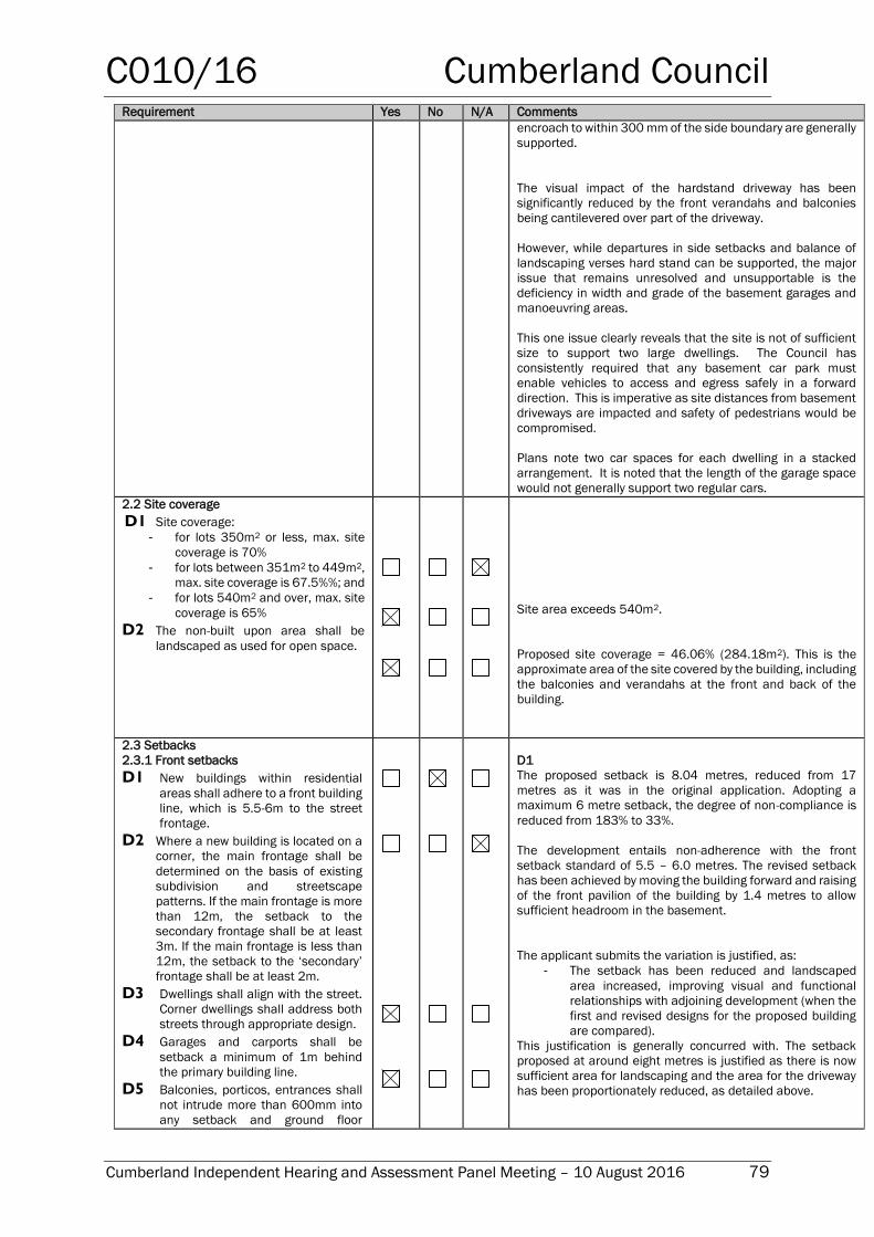
C010/16 Cumberland Council
Cumberland Independent Hearing and Assessment Panel Meeting – 10 August 2016 79
Requirement Yes No N/A Comments
encroach to within 300 mm of the side boundary are generally
supported.
The visual impact of the hardstand driveway has been
significantly reduced by the front verandahs and balconies
being cantilevered over part of the driveway.
However, while departures in side setbacks and balance of
landscaping verses hard stand can be supported, the major
issue that remains unresolved and unsupportable is the
deficiency in width and grade of the basement garages and
manoeuvring areas.
This one issue clearly reveals that the site is not of sufficient
size to support two large dwellings. The Council has
consistently required that any basement car park must
enable vehicles to access and egress safely in a forward
direction. This is imperative as site distances from basement
driveways are impacted and safety of pedestrians would be
compromised.
Plans note two car spaces for each dwelling in a stacked
arrangement. It is noted that the length of the garage space
would not generally support two regular cars.
2.2 Site coverage
D1 Site coverage:
- for lots 350m2 or less, max. site
coverage is 70%
- for lots between 351m2 to 449m2,
max. site coverage is 67.5%%; and
- for lots 540m2 and over, max. site
coverage is 65%
D2 The non-built upon area shall be
landscaped as used for open space.
Site area exceeds 540m2.
Proposed site coverage = 46.06% (284.18m2). This is the
approximate area of the site covered by the building, including
the balconies and verandahs at the front and back of the
building.
2.3 Setbacks
2.3.1 Front setbacks
D1 New buildings within residential
areas shall adhere to a front building
line, which is 5.5-6m to the street
frontage.
D2 Where a new building is located on a
corner, the main frontage shall be
determined on the basis of existing
subdivision and streetscape
patterns. If the main frontage is more
than 12m, the setback to the
secondary frontage shall be at least
3m. If the main frontage is less than
12m, the setback to the ‘secondary’
frontage shall be at least 2m.
D3 Dwellings shall align with the street.
Corner dwellings shall address both
streets through appropriate design.
D4 Garages and carports shall be
setback a minimum of 1m behind
the primary building line.
D5 Balconies, porticos, entrances shall
not intrude more than 600mm into
any setback and ground floor
D1
The proposed setback is 8.04 metres, reduced from 17
metres as it was in the original application. Adopting a
maximum 6 metre setback, the degree of non-compliance is
reduced from 183% to 33%.
The development entails non-adherence with the front
setback standard of 5.5 – 6.0 metres. The revised setback
has been achieved by moving the building forward and raising
of the front pavilion of the building by 1.4 metres to allow
sufficient headroom in the basement.
The applicant submits the variation is justified, as:
- The setback has been reduced and landscaped
area increased, improving visual and functional
relationships with adjoining development (when the
first and revised designs for the proposed building
are compared).
This justification is generally concurred with. The setback
proposed at around eight metres is justified as there is now
sufficient area for landscaping and the area for the driveway
has been proportionately reduced, as detailed above.
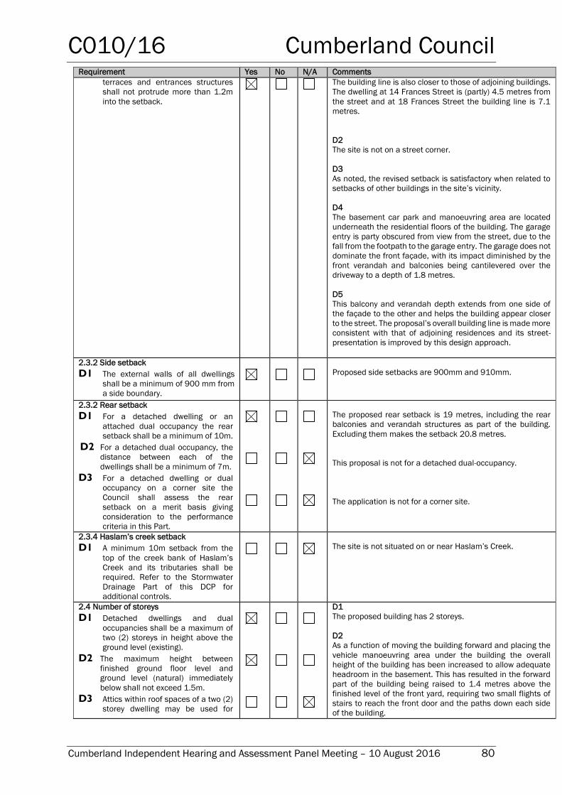
C010/16 Cumberland Council
Cumberland Independent Hearing and Assessment Panel Meeting – 10 August 2016 80
Requirement Yes No N/A Comments
terraces and entrances structures
shall not protrude more than 1.2m
into the setback.
The building line is also closer to those of adjoining buildings.
The dwelling at 14 Frances Street is (partly) 4.5 metres from
the street and at 18 Frances Street the building line is 7.1
metres.
D2
The site is not on a street corner.
D3
As noted, the revised setback is satisfactory when related to
setbacks of other buildings in the site’s vicinity.
D4
The basement car park and manoeuvring area are located
underneath the residential floors of the building. The garage
entry is party obscured from view from the street, due to the
fall from the footpath to the garage entry. The garage does not
dominate the front façade, with its impact diminished by the
front verandah and balconies being cantilevered over the
driveway to a depth of 1.8 metres.
D5
This balcony and verandah depth extends from one side of
the façade to the other and helps the building appear closer
to the street. The proposal’s overall building line is made more
consistent with that of adjoining residences and its street-
presentation is improved by this design approach.
2.3.2 Side setback
D1 The external walls of all dwellings
shall be a minimum of 900 mm from
a side boundary.
Proposed side setbacks are 900mm and 910mm.
2.3.2 Rear setback
D1 For a detached dwelling or an
attached dual occupancy the rear
setback shall be a minimum of 10m.
D2 For a detached dual occupancy, the
distance between each of the
dwellings shall be a minimum of 7m.
D3 For a detached dwelling or dual
occupancy on a corner site the
Council shall assess the rear
setback on a merit basis giving
consideration to the performance
criteria in this Part.
The proposed rear setback is 19 metres, including the rear
balconies and verandah structures as part of the building.
Excluding them makes the setback 20.8 metres.
This proposal is not for a detached dual-occupancy.
The application is not for a corner site.
2.3.4 Haslam’s creek setback
D1 A minimum 10m setback from the
top of the creek bank of Haslam’s
Creek and its tributaries shall be
required. Refer to the Stormwater
Drainage Part of this DCP for
additional controls.
The site is not situated on or near Haslam’s Creek.
2.4 Number of storeys
D1 Detached dwellings and dual
occupancies shall be a maximum of
two (2) storeys in height above the
ground level (existing).
D2 The maximum height between
finished ground floor level and
ground level (natural) immediately
below shall not exceed 1.5m.
D3 Attics within roof spaces of a two (2)
storey dwelling may be used for
D1
The proposed building has 2 storeys.
D2
As a function of moving the building forward and placing the
vehicle manoeuvring area under the building the overall
height of the building has been increased to allow adequate
headroom in the basement. This has resulted in the forward
part of the building being raised to 1.4 metres above the
finished level of the front yard, requiring two small flights of
stairs to reach the front door and the paths down each side
of the building.
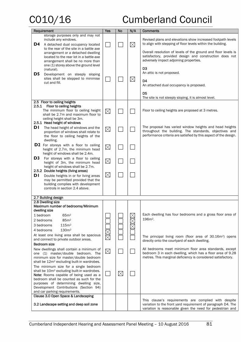
C010/16 Cumberland Council
Cumberland Independent Hearing and Assessment Panel Meeting – 10 August 2016 81
Requirement Yes No N/A Comments
storage purposes only and may not
include any windows.
D4 A detached dual occupancy located
to the rear of the site in a battle axe
arrangement or a detached dwelling
located to the rear lot in a battle-axe
arrangement shall be no more than
one (1) storey above the ground level
(natural).
D5 Development on steeply sloping
sites shall be stepped to minimise
cut and fill.
Revised plans and elevations show increased footpath levels
to align with stepping of floor levels within the building.
Overall resolution of levels of the ground and floor levels is
satisfactory, provided design and construction does not
adversely impact adjoining properties.
D3
An attic is not proposed.
D4
An attached dual occupancy is proposed.
D5
The site is not steeply sloping, it is almost level.
2.5 Floor to ceiling heights
2.5.1 Floor to ceiling heights
The minimum floor to ceiling height
shall be 2.7m and maximum floor to
ceiling height shall be 3m.
2.5.1 Head height of windows
D1 The head height of windows and the
proportion of windows shall relate to
the floor to ceiling heights of the
dwelling.
D2 For storeys with a floor to ceiling
height of 2.7m, the minimum head
height of windows shall be 2.4m.
D3 For storeys with a floor to ceiling
height of 3m, the minimum head
height of windows shall be 2.7m.
2.5.2 Double heights (living areas)
D1 Double heights in or for living areas
may be permitted provided that the
building complies with development
controls in section 2.4 above.
Floor to ceiling heights are proposed at 3 metres.
The proposal has varied window heights and head heights
throughout the building. The standards, objectives and
performance criteria are satisfied by this aspect of the design.
2.7 Building design
2.8 Dwelling size
Maximum number of bedrooms/Minimum
dwelling size
1 bedroom 65m2
2 bedrooms 85m2
3 bedrooms 115m2
4 bedrooms 130m2
At least one living area shall be spacious
and connect to private outdoor areas.
Bedroom size
New dwellings shall contain a minimum of
one (1) master/double bedroom. The
minimum size for master/double bedroom
shall be 12m2 excluding built-in wardrobes.
The minimum size for a single bedroom
shall be 10m2 excluding built-in wardrobes.
Note: Rooms capable of being used as a
bedroom shall be counted as such for the
purposes of determining dwelling size,
Development Contributions (Section 94)
and car parking requirements.
Each dwelling has four bedrooms and a gross floor area of
196m2.
The principal living room (floor area of 30.16m2) opens
directly onto the courtyard of each dwelling.
All bedrooms meet minimum floor area standards, except
bedroom 3 in each dwelling, which has a floor area of 9.28
metres. This marginal deficiency is considered satisfactory.
Clause 3.0 Open Space & Landscaping
3.2 Landscape setting and deep soil zone
This clause’s requirements are complied with despite
variation to the front yard requirement of paragraph D4. The
variation is reasonable given the need for pedestrian and
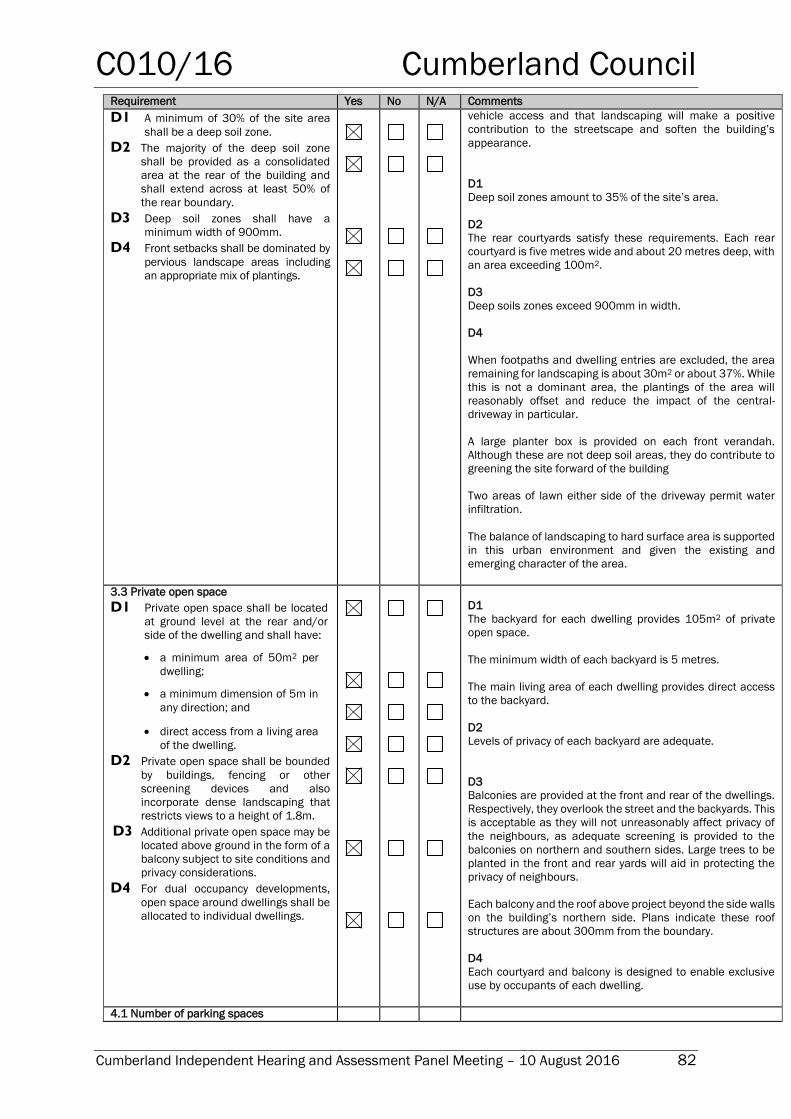
C010/16 Cumberland Council
Cumberland Independent Hearing and Assessment Panel Meeting – 10 August 2016 82
Requirement Yes No N/A Comments
D1 A minimum of 30% of the site area
shall be a deep soil zone.
D2 The majority of the deep soil zone
shall be provided as a consolidated
area at the rear of the building and
shall extend across at least 50% of
the rear boundary.
D3 Deep soil zones shall have a
minimum width of 900mm.
D4 Front setbacks shall be dominated by
pervious landscape areas including
an appropriate mix of plantings.
vehicle access and that landscaping will make a positive
contribution to the streetscape and soften the building’s
appearance.
D1
Deep soil zones amount to 35% of the site’s area.
D2
The rear courtyards satisfy these requirements. Each rear
courtyard is five metres wide and about 20 metres deep, with
an area exceeding 100m2.
D3
Deep soils zones exceed 900mm in width.
D4
When footpaths and dwelling entries are excluded, the area
remaining for landscaping is about 30m2 or about 37%. While
this is not a dominant area, the plantings of the area will
reasonably offset and reduce the impact of the central-
driveway in particular.
A large planter box is provided on each front verandah.
Although these are not deep soil areas, they do contribute to
greening the site forward of the building
Two areas of lawn either side of the driveway permit water
infiltration.
The balance of landscaping to hard surface area is supported
in this urban environment and given the existing and
emerging character of the area.
3.3 Private open space
D1 Private open space shall be located
at ground level at the rear and/or
side of the dwelling and shall have:
a minimum area of 50m2 per
dwelling;
a minimum dimension of 5m in
any direction; and
direct access from a living area
of the dwelling.
D2 Private open space shall be bounded
by buildings, fencing or other
screening devices and also
incorporate dense landscaping that
restricts views to a height of 1.8m.
D3 Additional private open space may be
located above ground in the form of a
balcony subject to site conditions and
privacy considerations.
D4 For dual occupancy developments,
open space around dwellings shall be
allocated to individual dwellings.
D1
The backyard for each dwelling provides 105m2 of private
open space.
The minimum width of each backyard is 5 metres.
The main living area of each dwelling provides direct access
to the backyard.
D2
Levels of privacy of each backyard are adequate.
D3
Balconies are provided at the front and rear of the dwellings.
Respectively, they overlook the street and the backyards. This
is acceptable as they will not unreasonably affect privacy of
the neighbours, as adequate screening is provided to the
balconies on northern and southern sides. Large trees to be
planted in the front and rear yards will aid in protecting the
privacy of neighbours.
Each balcony and the roof above project beyond the side walls
on the building’s northern side. Plans indicate these roof
structures are about 300mm from the boundary.
D4
Each courtyard and balcony is designed to enable exclusive
use by occupants of each dwelling.
4.1 Number of parking spaces
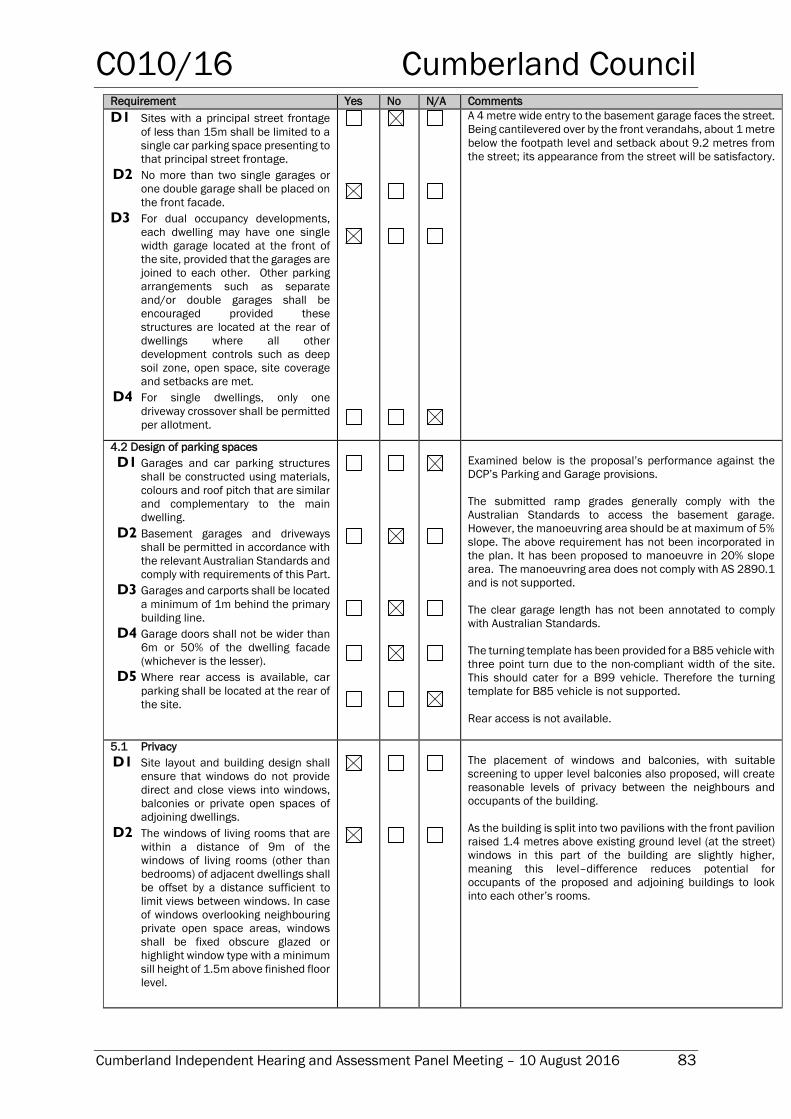
C010/16 Cumberland Council
Cumberland Independent Hearing and Assessment Panel Meeting – 10 August 2016 83
Requirement Yes No N/A Comments
D1 Sites with a principal street frontage
of less than 15m shall be limited to a
single car parking space presenting to
that principal street frontage.
D2 No more than two single garages or
one double garage shall be placed on
the front facade.
D3 For dual occupancy developments,
each dwelling may have one single
width garage located at the front of
the site, provided that the garages are
joined to each other. Other parking
arrangements such as separate
and/or double garages shall be
encouraged provided these
structures are located at the rear of
dwellings where all other
development controls such as deep
soil zone, open space, site coverage
and setbacks are met.
D4 For single dwellings, only one
driveway crossover shall be permitted
per allotment.
A 4 metre wide entry to the basement garage faces the street.
Being cantilevered over by the front verandahs, about 1 metre
below the footpath level and setback about 9.2 metres from
the street; its appearance from the street will be satisfactory.
4.2 Design of parking spaces
D1 Garages and car parking structures
shall be constructed using materials,
colours and roof pitch that are similar
and complementary to the main
dwelling.
D2 Basement garages and driveways
shall be permitted in accordance with
the relevant Australian Standards and
comply with requirements of this Part.
D3 Garages and carports shall be located
a minimum of 1m behind the primary
building line.
D4 Garage doors shall not be wider than
6m or 50% of the dwelling facade
(whichever is the lesser).
D5 Where rear access is available, car
parking shall be located at the rear of
the site.
Examined below is the proposal’s performance against the
DCP’s Parking and Garage provisions.
The submitted ramp grades generally comply with the
Australian Standards to access the basement garage.
However, the manoeuvring area should be at maximum of 5%
slope. The above requirement has not been incorporated in
the plan. It has been proposed to manoeuvre in 20% slope
area. The manoeuvring area does not comply with AS 2890.1
and is not supported.
The clear garage length has not been annotated to comply
with Australian Standards.
The turning template has been provided for a B85 vehicle with
three point turn due to the non-compliant width of the site.
This should cater for a B99 vehicle. Therefore the turning
template for B85 vehicle is not supported.
Rear access is not available.
5.1 Privacy
D1 Site layout and building design shall
ensure that windows do not provide
direct and close views into windows,
balconies or private open spaces of
adjoining dwellings.
D2 The windows of living rooms that are
within a distance of 9m of the
windows of living rooms (other than
bedrooms) of adjacent dwellings shall
be offset by a distance sufficient to
limit views between windows. In case
of windows overlooking neighbouring
private open space areas, windows
shall be fixed obscure glazed or
highlight window type with a minimum
sill height of 1.5m above finished floor
level.
The placement of windows and balconies, with suitable
screening to upper level balconies also proposed, will create
reasonable levels of privacy between the neighbours and
occupants of the building.
As the building is split into two pavilions with the front pavilion
raised 1.4 metres above existing ground level (at the street)
windows in this part of the building are slightly higher,
meaning this level–difference reduces potential for
occupants of the proposed and adjoining buildings to look
into each other’s rooms.
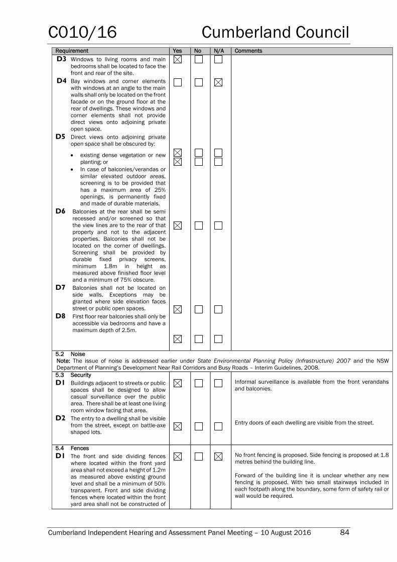
C010/16 Cumberland Council
Cumberland Independent Hearing and Assessment Panel Meeting – 10 August 2016 84
Requirement Yes No N/A Comments
D3 Windows to living rooms and main
bedrooms shall be located to face the
front and rear of the site.
D4 Bay windows and corner elements
with windows at an angle to the main
walls shall only be located on the front
facade or on the ground floor at the
rear of dwellings. These windows and
corner elements shall not provide
direct views onto adjoining private
open space.
D5 Direct views onto adjoining private
open space shall be obscured by:
existing dense vegetation or new
planting; or
In case of balconies/verandas or
similar elevated outdoor areas,
screening is to be provided that
has a maximum area of 25%
openings, is permanently fixed
and made of durable materials.
D6 Balconies at the rear shall be semi
recessed and/or screened so that
the view lines are to the rear of that
property and not to the adjacent
properties. Balconies shall not be
located on the corner of dwellings.
Screening shall be provided by
durable fixed privacy screens,
minimum 1.8m in height as
measured above finished floor level
and a minimum of 75% obscure.
D7 Balconies shall not be located on
side walls. Exceptions may be
granted where side elevation faces
street or public open spaces.
D8 First floor rear balconies shall only be
accessible via bedrooms and have a
maximum depth of 2.5m.
5.2 Noise
Note: The issue of noise is addressed earlier under State Environmental Planning Policy (Infrastructure) 2007 and the NSW
Department of Planning’s Development Near Rail Corridors and Busy Roads – Interim Guidelines, 2008.
5.3 Security
D1 Buildings adjacent to streets or public
spaces shall be designed to allow
casual surveillance over the public
area. There shall be at least one living
room window facing that area.
D2 The entry to a dwelling shall be visible
from the street, except on battle-axe
shaped lots.
Informal surveillance is available from the front verandahs
and balconies.
Entry doors of each dwelling are visible from the street.
5.4 Fences
D1 The front and side dividing fences
where located within the front yard
area shall not exceed a height of 1.2m
as measured above existing ground
level and shall be a minimum of 50%
transparent. Front and side dividing
fences where located within the front
yard area shall not be constructed of
No front fencing is proposed. Side fencing is proposed at 1.8
metres behind the building line.
Forward of the building line it is unclear whether any new
fencing is proposed. With two small stairways included in
each footpath along the boundary, some form of safety rail or
wall would be required.
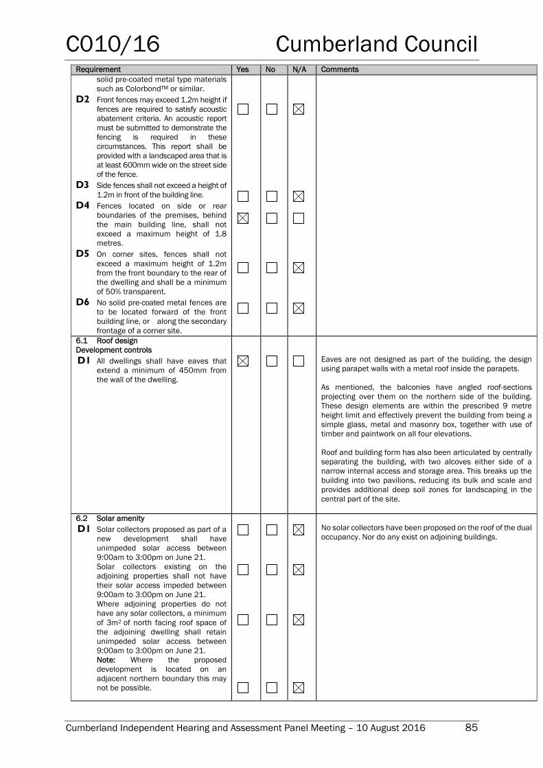
C010/16 Cumberland Council
Cumberland Independent Hearing and Assessment Panel Meeting – 10 August 2016 85
Requirement Yes No N/A Comments
solid pre-coated metal type materials
such as ColorbondTM or similar.
D2 Front fences may exceed 1.2m height if
fences are required to satisfy acoustic
abatement criteria. An acoustic report
must be submitted to demonstrate the
fencing is required in these
circumstances. This report shall be
provided with a landscaped area that is
at least 600mm wide on the street side
of the fence.
D3 Side fences shall not exceed a height of
1.2m in front of the building line.
D4 Fences located on side or rear
boundaries of the premises, behind
the main building line, shall not
exceed a maximum height of 1.8
metres.
D5 On corner sites, fences shall not
exceed a maximum height of 1.2m
from the front boundary to the rear of
the dwelling and shall be a minimum
of 50% transparent.
D6 No solid pre-coated metal fences are
to be located forward of the front
building line, or along the secondary
frontage of a corner site.
6.1 Roof design
Development controls
D1 All dwellings shall have eaves that
extend a minimum of 450mm from
the wall of the dwelling.
Eaves are not designed as part of the building, the design
using parapet walls with a metal roof inside the parapets.
As mentioned, the balconies have angled roof-sections
projecting over them on the northern side of the building.
These design elements are within the prescribed 9 metre
height limit and effectively prevent the building from being a
simple glass, metal and masonry box, together with use of
timber and paintwork on all four elevations.
Roof and building form has also been articulated by centrally
separating the building, with two alcoves either side of a
narrow internal access and storage area. This breaks up the
building into two pavilions, reducing its bulk and scale and
provides additional deep soil zones for landscaping in the
central part of the site.
6.2 Solar amenity
D1 Solar collectors proposed as part of a
new development shall have
unimpeded solar access between
9:00am to 3:00pm on June 21.
Solar collectors existing on the
adjoining properties shall not have
their solar access impeded between
9:00am to 3:00pm on June 21.
Where adjoining properties do not
have any solar collectors, a minimum
of 3m2 of north facing roof space of
the adjoining dwelling shall retain
unimpeded solar access between
9:00am to 3:00pm on June 21.
Note: Where the proposed
development is located on an
adjacent northern boundary this may
not be possible.
No solar collectors have been proposed on the roof of the dual
occupancy. Nor do any exist on adjoining buildings.
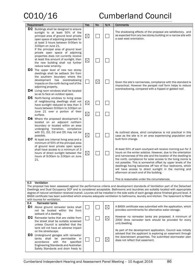
C010/16 Cumberland Council
Cumberland Independent Hearing and Assessment Panel Meeting – 10 August 2016 86
Requirement Yes No N/A Comments
D2 Buildings shall be designed to ensure
sunlight to at least 50% of the
principal area of ground level private
open space of adjoining properties for
at least 3 hours between 9:00am to
3:00pm on June 21.
If the principal area of ground level
private open space of adjoining
properties does not currently receive
at least this amount of sunlight, then
the new building shall not further
reduce solar amenity.
D3 The upper level of new two storey
dwellings shall be setback 3m from
the southern boundary where the
development has overshadowing
impacts on the north-facing roof of the
adjoining property.
D4 Living room windows shall be located
so as to face an outdoor space.
D5 North-facing windows to living areas
of neighbouring dwellings shall not
have sunlight reduced to less than 3
hours between 9:00am to 3:00pm on
June 21 over a portion of their
surface.
D6 Where the proposed development is
located on an adjacent northern
boundary or located within an area
undergoing transition, compliance
with D1, D2, D3 and D5 may not be
possible.
D7 At least one internal living area and a
minimum of 50% of the principal area
of ground level private open space
shall have access to a minimum of 3
hours of direct sunlight between the
hours of 9:00am to 3:00pm on June
21.
The shadowing effects of the proposal are satisfactory, and
as expected from any two storey building on a narrow site with
a east west orientation.
Given the site’s narrowness, compliance with this standard is
impractical. However the parapet roof form helps to reduce
overshadowing, compared with a hipped or gabled roof.
As outlined above, strict compliance is not practical in this
case as the site is in an area experiencing population and
built form change.
At least 50% of each courtyard will receive morning sun for 3
hours on the winter solstice. However, due to the orientation
and narrowness of the site and the location of the dwelling to
the north, compliance for solar access to the living rooms is
not possible. This is somewhat offset by upper levels of the
dwellings having balconies off two of four bedrooms, which
will have access to direct sunlight in the morning and
afternoon at each end of the building.
This is reasonable under the circumstances.
6.3 Ventilation
The proposal has been assessed against the performance criteria and development standards of Ventilation part of the Detached
Dwellings and Dual Occupancy DCP and is considered acceptable. Bathrooms and laundries are suitably located with appropriate
degree of natural ventilation received overall. Louvres will be installed in the side walls of each garage above finished ground level. A
BASIX certificate has been submitted which ensures adequate ventilation to bathrooms, laundry and kitchen. The basement is fitted
with louvres for ventilation.
6.4 Rainwater tanks
D1 Above ground rainwater tanks shall
not be located within the front
setback of a dwelling.
D2 Rainwater tanks that are visible from
the street shall be suitably screened
unless Council is satisfied that the
tank will not have an adverse impact
on the streetscape.
D3 Underground garages with rainwater
tanks shall be permissible in
accordance with the specified
Engineering Standards and Australian
Safety Standards and drain freely to
A BASIX certificate was submitted with the application, which
provides commitments for alternative water storage.
However no rainwater tanks are proposed. A minimum of
2000 litres rainwater tank should be provided for every
unit/dwelling.
As part of the development application, Council was initially
advised that the applicant is exploring an easement through
the downstream properties. The submitted stormwater plan
does not reflect that easement.
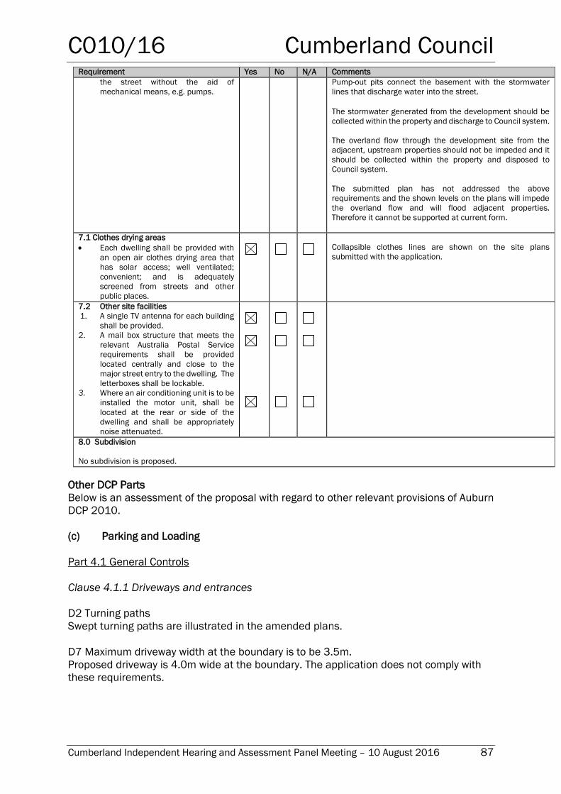
C010/16 Cumberland Council
Cumberland Independent Hearing and Assessment Panel Meeting – 10 August 2016 87
Requirement Yes No N/A Comments
the street without the aid of
mechanical means, e.g. pumps.
Pump-out pits connect the basement with the stormwater
lines that discharge water into the street.
The stormwater generated from the development should be
collected within the property and discharge to Council system.
The overland flow through the development site from the
adjacent, upstream properties should not be impeded and it
should be collected within the property and disposed to
Council system.
The submitted plan has not addressed the above
requirements and the shown levels on the plans will impede
the overland flow and will flood adjacent properties.
Therefore it cannot be supported at current form.
7.1 Clothes drying areas
Each dwelling shall be provided with
an open air clothes drying area that
has solar access; well ventilated;
convenient; and is adequately
screened from streets and other
public places.
Collapsible clothes lines are shown on the site plans
submitted with the application.
7.2 Other site facilities
1. A single TV antenna for each building
shall be provided.
2. A mail box structure that meets the
relevant Australia Postal Service
requirements shall be provided
located centrally and close to the
major street entry to the dwelling. The
letterboxes shall be lockable.
3. Where an air conditioning unit is to be
installed the motor unit, shall be
located at the rear or side of the
dwelling and shall be appropriately
noise attenuated.
8.0 Subdivision
No subdivision is proposed.
Other DCP Parts
Below is an assessment of the proposal with regard to other relevant provisions of Auburn
DCP 2010.
(c) Parking and Loading
Part 4.1 General Controls
Clause 4.1.1 Driveways and entrances
D2 Turning paths
Swept turning paths are illustrated in the amended plans.
D7 Maximum driveway width at the boundary is to be 3.5m.
Proposed driveway is 4.0m wide at the boundary. The application does not comply with
these requirements.
C010/16 Cumberland Council
Cumberland Independent Hearing and Assessment Panel Meeting – 10 August 2016 88
Part 4.2 Detached dwellings and dual occupancies
Clause 4.2.1 Number of parking spaces
D1 A maximum of two parking spaces or a minimum of one parking space per dwelling is
required for each dwelling in a dual occupancy development.
The application complies with these requirements.
D2 Stacked parking is permitted for up to two cars per dwelling.
The application complies with these requirements.
Clause 4.2.2 Design of parking spaces
D1 Vehicle manoeuvring areas must comply with AS 2890 – Parking Facilities
According to Council’s engineer, the application does not comply with these requirements.
However, the manoeuvring area should be at maximum of 5% slope. The above
requirement has not been incorporated in the amended plan. It has been proposed to
manoeuvre in 20% slope area. The manoeuvring area does not comply with AS 2890.1
and is not supported.
D2 In this case the minimum width of the parking spaces should be 3.0 m.
The application complies with these requirements.
(d) Stormwater Drainage
A stormwater concept plan has been submitted for the proposal. A pump-out tank to
dispose of stormwater for each garage is proposed however this has been deemed an
unacceptable form of stormwater management by Council’s engineer.
(e) Waste
A waste management plan has been submitted, which addresses waste management for
demolition, construction and habitation of the dual occupancy.
Conclusion: Assessment under Auburn DCP 2010
The proposal is non-compliant and deficient in its ability to cater for convenient and safe
parking and manoeuvring of vehicles on site
Whilst the applicant justifies a number of the proposed variations to DCP standards, the
overall narrowness of the site results in considerable design challenges in terms of
compliance particularly with regards to safe vehicle parking and manoeuvring. This is
considered unsatisfactory and as such the DA should be refused based on non-compliance
of the following DCP controls:
1. The submitted ramp grades generally comply with the Australian Standards to
access the basement garage. However, the manoeuvring area should be at
maximum of 5% slope. The above requirement has not been incorporated in the
plan. It has been proposed to manoeuvre in 20% slope area. The manoeuvring
area does not comply with AS 2890.1 and is not supported.
C010/16 Cumberland Council
Cumberland Independent Hearing and Assessment Panel Meeting – 10 August 2016 89
2. Further the clear garage length has not been annotated to comply with Australian
Standards.
3. The turning template has been provided for a B85 vehicle with three point turn due
to the non-compliant width of the site. This should cater for a B99 vehicle. Therefore
the turning template for B85 vehicle is not supported.
4. The driveway is proposed to have a width of 4.0 metres at the property boundary.
The development control plans state this width to be no more than 3.5 metres.
5. A stormwater concept plan has been submitted for the proposal. A pump-out tank
to dispose of stormwater for each garage is proposed however this has been
deemed an unacceptable form of stormwater management by Council’s engineer.
However in view of the near-level grade of the site there is likely no practical
alternative to a pump-out system in this case.
Minimum site width
The degree of variation of the minimum site-width standard is considered large (the site is
just over 10 metres wide whereas the minimum prescribed by the DCP is 15 metres).
Although the design response illustrated in the amended plans and the statement
submitted in their support justify the built form and character / amenity elements of the
proposal, the narrow lot width clearly cannot support adequate vehicle management for
two dwellings on site.
Front setback
The overall effect of this 33% variation is a building suitably aligned with surrounding
development, noting that the building line varies from building to building along Frances
Street. Strict compliance with the building line standard can be dispensed with in these
circumstances.
Side setback
The side setback standard is not complied with, caused by relatively small sections of the
front and rear balconies extending into the north-side setback, to within 300mm of the
boundary. Being about 8 metres above the ground and this setback reducing in an angled,
receding line toward the centre of the building, this variation is minor and acceptable, as
it is arguably integral to the building’s architecture and adds to the building’s visual appeal.
Being on the north side of the building, these parts of the roof will not affect the property
to the south.
Landscape setting and deep soil zone
Although the greater proportion of the proposal’s front yard is paved (about 30% is covered
by the driveway) the remainder is landscaped by two lawns and a large tree. The lawns and
tree, with large planter boxes to be installed on entry porch to each dwelling, will combine
to blend the development into the streetscape and soften its appearance.
C010/16 Cumberland Council
Cumberland Independent Hearing and Assessment Panel Meeting – 10 August 2016 90
Rainwater tanks
No rainwater tanks are proposed. A minimum of 2000 litres rainwater tank should be
provided for every unit/dwelling.
79C(1)(a)(iii) - any planning agreement that has been entered into under section 93F, or
any draft planning agreement that a developer has offered to enter into under section
93F, and
No draft planning agreement is associated with the subject application.
The provisions of the Regulations (EP& A Act s79C(1)(a)(iv))
Matters prescribed by the EP& A Regulations 2000 do not apply to the site or the
application.
79C(1)(a)(v) - any coastal zone management plan (within the meaning of the Coastal
Protection Act 1979)
No Coastal Zone Management Plan applies to the Auburn area.
The Likely Environmental, Social or Economic Impacts (EP& A Act s79C(1)(b))
The proposal will introduce a slight increase in the local population, a commensurate
improvement in economic and social conditions is anticipated. The deficient on site vehicle
management proposed will cause inconvenience and difficulties for residents and will
compromise pedestrian safety which is socially unacceptable.
The suitability of the site for the development (EP&A Act s79C(1)(c))
While the built form elements have been largely resolved for the amended proposal, the
site due to its narrow nature is unsuitable for the development as it cannot support safe
and convenient vehicle housing and management on site. In addition, satisfactory
stormwater management remains unresolved.
Submissions made in accordance with the Act or Regulation (EP&A Act s79C(1)(d
Advertised (newspaper) Mail Sign Not Required
Owners and occupiers of adjacent and nearby property were notified of the proposed
development as required by the Auburn DCP 2010. No submissions were received.
The public interest (EP& A Act s79C(1)(e))
Being inconsistent with Council’s design-performance standards, relating to vehicle and
stormwater management it is in the public interest to refuse the application..
C010/16 Cumberland Council
Cumberland Independent Hearing and Assessment Panel Meeting – 10 August 2016 91
Section 94 Contribution towards provision or improvement of amenities or services
This part of the Act relates to the collection of monetary contributions from applicants for
use in developing key local infrastructure. The Act reads as follows:
‘(1) If a consent authority is satisfied that development for which
development consent is sought will or is likely to require the provision of or
increase the demand for public amenities and public services within the area,
the consent authority may grant the development consent subject to a
condition requiring:
(a) the dedication of land free of cost, or
(b) the payment of a monetary contribution, or both.
(2) A condition referred to in subsection (1) may be imposed only to
require a reasonable dedication or contribution for the provision, extension or
augmentation of the public amenities and public services concerned.’
Comments:
If the development was recommended for approval, a contribution would be payable in
accordance with the Auburn Contributions Plan, for two, four bedroom dwellings (less any
credit for the existing dwelling). The contribution payable as required by a recommended
condition of consent is $11,837.91.
Auburn City Council Operational Plan / Delivery Program
This assessment and report relates to the Auburn City Council Operational Plan and
Delivery Program, Our Places – Attractive and Liveable theme, action “2a.1.1.3 Assess
development applications, complying development and construction certificates”.
Disclosure of Political Donations and Gifts
The NSW Government introduced The Local Government and Planning Legislation
Amendment (Political Donations) Act 2008 (NSW). The law introduces disclosure
requirements for individuals or entities with a relevant financial interest as part of the
lodgement of various types of development proposals and requests to initiate
environmental planning instruments or development control plans.
The applicant and notification process did not result in any disclosure of Political Donations
and Gifts.
Conclusion
The development application has been assessed in accordance with applicable
requirements of the Environmental Planning and Assessment Act 1979, environmental
planning instruments and the Auburn Development Control Plan 2010.
The assessment presented in this report finds the proposed development is deficient in a
number of standards set out in the Auburn Development Control Plan 2010 and therefore
this DA should be refused.
C010/16 Cumberland Council
Cumberland Independent Hearing and Assessment Panel Meeting – 10 August 2016 92
Report Recommendation:
That Development Application No. DA-438/2015 for Demolition of an existing dwelling and
construction of a new two storey attached dual occupancy with basement parking on land
at 16 Frances Street, Lidcombe be refused for the following reasons:
1. Unsatisfactory and unsafe vehicle parking and manoeuvring on site that would result
in an inability to access and egress the site in a forward direction.
2. Unresolved stormwater management on site.
ATTACHMENTS (to be circulated to CIHAP members only under separate cover)
1. Architectural Plans/Landscape Plans –T070907/2016
C011/16 Cumberland Council
Cumberland Independent Hearing and Assessment Panel Meeting – 10 August 2016 93
8-10 Clarence Street, Lidcombe
Responsible Department: Development, Environment and Infrastructure
Officer: Michael Lawani
File Number: DA-276/2015
Delivery Program Code: 2a.1.1.3 - Assess development applications, complying
development and construction certificates.
Application lodged 07-Aug-2015
Applicant H Huang
Owner Mr W Lin and Ms H Wei
Application No. DA-276/2015
Description of Land Lot A DP 329490, Lot B DP 329490, 8 - 10 Clarence
Street, LIDCOMBE
Proposed Development Demolition of existing structures & construction of a part
5/part 6 storey residential flat building containing 2 x 1
bedroom, 16 x 2 bedroom and 2 x 3 bedroom units over 2
levels of semi-basement & basement car parking,
landscaping, provision of site services
Site Area 929sqm
Zoning Zone R4 - High Density Residential
Disclosure of political
donations and gifts
Nil disclosure
Heritage N/A
Issues Clause 4.6 Variations to maximum FSR and Height under
ALEP 2010
Site isolation
Minor non-compliances with Apartment Design Guide and
ADCP 2010 – Residential Flat Buildings
SUMMARY
1. Development Application No. DA-276/2015 was received on 7 August 2015 for the
demolition of existing structures & construction of a part 5/part 6 storey residential
flat building containing 2 x 1 bedroom, 16 x 2 bedroom and 2 x 3 bedroom units
over 2 levels of semi-basement & basement car parking, landscaping, provision of
site services at 8-10 Clarence Street, Lidcombe.
2. The application has been supported by Clause 4.6 Variations under the Auburn
Local Environmental Plan 2010 to exceed the maximum FSR of 2.0:1 at 8 Clarence
Street by 0.22:1, and to exceed the height limit of 18m at 10 Clarence Street by
2.8m.
3. The application was publicly notified to the occupants and owners of the adjoining
properties for a period of 14 days from 1 September 2015 to 15 September 2015
and two submissions were received, including a petition containing 23 signatures,
which raised concerns regarding height, bulk and scale, privacy, noise,
overshadowing, parking and traffic and waste management. Council Officers also
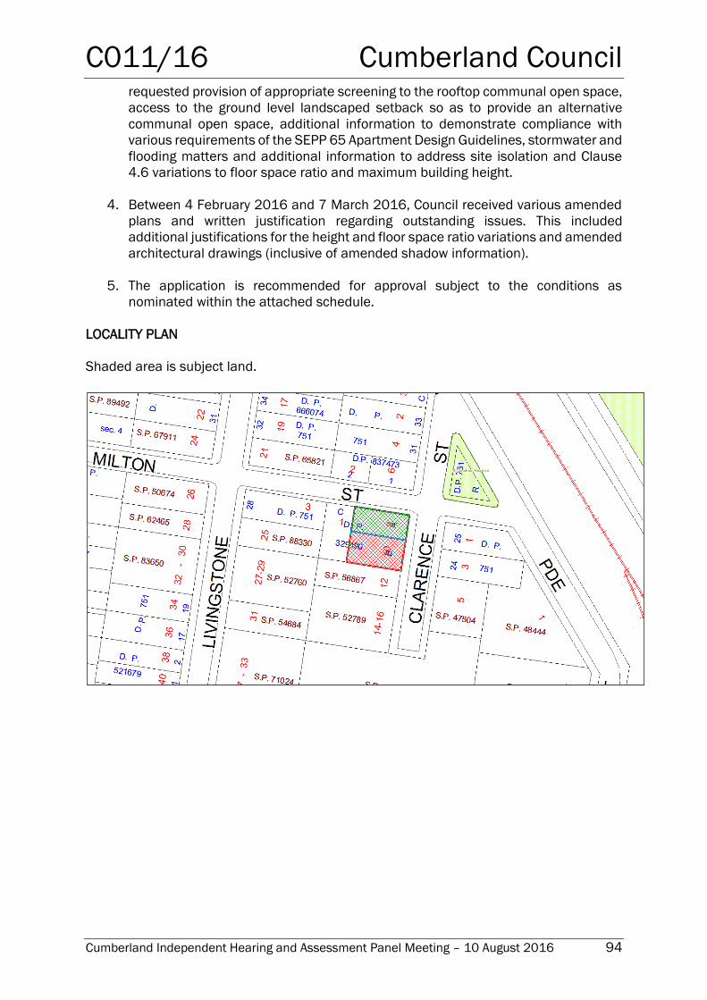
C011/16 Cumberland Council
Cumberland Independent Hearing and Assessment Panel Meeting – 10 August 2016 94
requested provision of appropriate screening to the rooftop communal open space,
access to the ground level landscaped setback so as to provide an alternative
communal open space, additional information to demonstrate compliance with
various requirements of the SEPP 65 Apartment Design Guidelines, stormwater and
flooding matters and additional information to address site isolation and Clause
4.6 variations to floor space ratio and maximum building height.
4. Between 4 February 2016 and 7 March 2016, Council received various amended
plans and written justification regarding outstanding issues. This included
additional justifications for the height and floor space ratio variations and amended
architectural drawings (inclusive of amended shadow information).
5. The application is recommended for approval subject to the conditions as
nominated within the attached schedule.
LOCALITY PLAN
Shaded area is subject land.
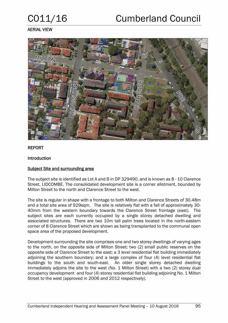
C011/16 Cumberland Council
Cumberland Independent Hearing and Assessment Panel Meeting – 10 August 2016 95
AERIAL VIEW
REPORT
Introduction
Subject Site and surrounding area
The subject site is identified as Lot A and B in DP 329490, and is known as 8 - 10 Clarence
Street, LIDCOMBE. The consolidated development site is a corner allotment, bounded by
Milton Street to the north and Clarence Street to the west.
The site is regular in shape with a frontage to both Milton and Clarence Streets of 30.48m
and a total site area of 929sqm. The site is relatively flat with a fall of approximately 30-
40mm from the western boundary towards the Clarence Street frontage (east). The
subject sites are each currently occupied by a single storey detached dwelling and
associated structures. There are two 10m tall palm trees located in the north-eastern
corner of 8 Clarence Street which are shown as being transplanted to the communal open
space area of the proposed development.
Development surrounding the site comprises one and two storey dwellings of varying ages
to the north, on the opposite side of Milton Street; two (2) small public reserves on the
opposite side of Clarence Street to the east; a 3 level residential flat building immediately
adjoining the southern boundary; and a large complex of four (4) level residential flat
buildings to the south and south-east. An older single storey detached dwelling
immediately adjoins the site to the west (No. 1 Milton Street) with a two (2) storey dual
occupancy development and four (4) storey residential flat building adjoining No. 1 Milton
Street to the west (approved in 2006 and 2012 respectively).
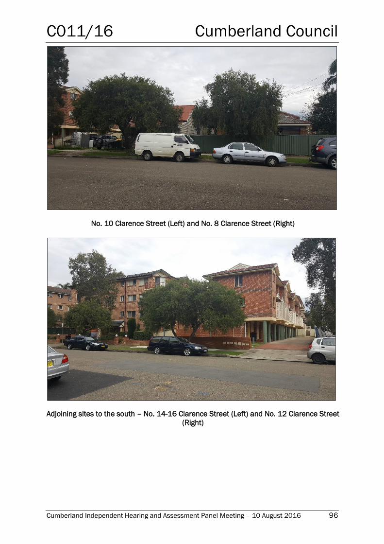
C011/16 Cumberland Council
Cumberland Independent Hearing and Assessment Panel Meeting – 10 August 2016 96
No. 10 Clarence Street (Left) and No. 8 Clarence Street (Right)
Adjoining sites to the south – No. 14-16 Clarence Street (Left) and No. 12 Clarence Street
(Right)
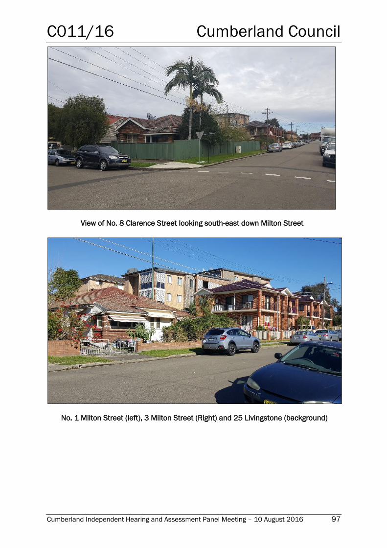
C011/16 Cumberland Council
Cumberland Independent Hearing and Assessment Panel Meeting – 10 August 2016 97
View of No. 8 Clarence Street looking south-east down Milton Street
No. 1 Milton Street (left), 3 Milton Street (Right) and 25 Livingstone (background)
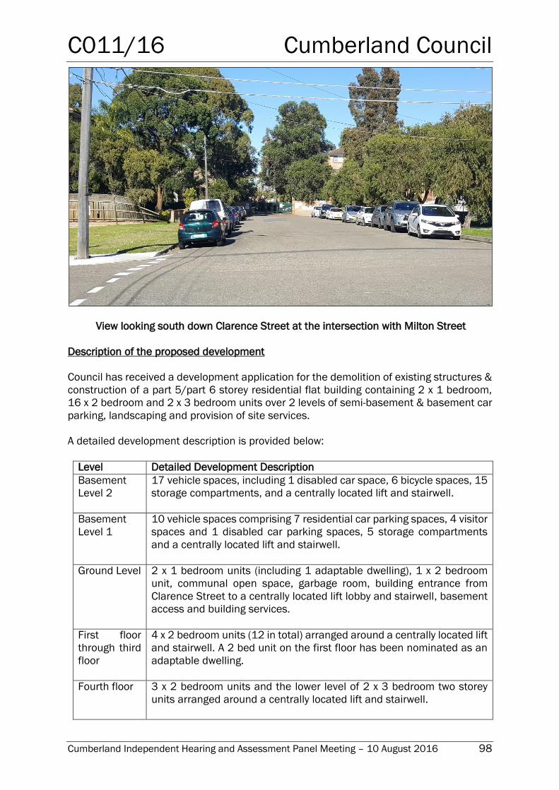
C011/16 Cumberland Council
Cumberland Independent Hearing and Assessment Panel Meeting – 10 August 2016 98
View looking south down Clarence Street at the intersection with Milton Street
Description of the proposed development
Council has received a development application for the demolition of existing structures &
construction of a part 5/part 6 storey residential flat building containing 2 x 1 bedroom,
16 x 2 bedroom and 2 x 3 bedroom units over 2 levels of semi-basement & basement car
parking, landscaping and provision of site services.
A detailed development description is provided below:
Level Detailed Development Description
Basement
Level 2
17 vehicle spaces, including 1 disabled car space, 6 bicycle spaces, 15
storage compartments, and a centrally located lift and stairwell.
Basement
Level 1
10 vehicle spaces comprising 7 residential car parking spaces, 4 visitor
spaces and 1 disabled car parking spaces, 5 storage compartments
and a centrally located lift and stairwell.
Ground Level 2 x 1 bedroom units (including 1 adaptable dwelling), 1 x 2 bedroom
unit, communal open space, garbage room, building entrance from
Clarence Street to a centrally located lift lobby and stairwell, basement
access and building services.
First floor
through third
floor
4 x 2 bedroom units (12 in total) arranged around a centrally located lift
and stairwell. A 2 bed unit on the first floor has been nominated as an
adaptable dwelling.
Fourth floor 3 x 2 bedroom units and the lower level of 2 x 3 bedroom two storey
units arranged around a centrally located lift and stairwell.
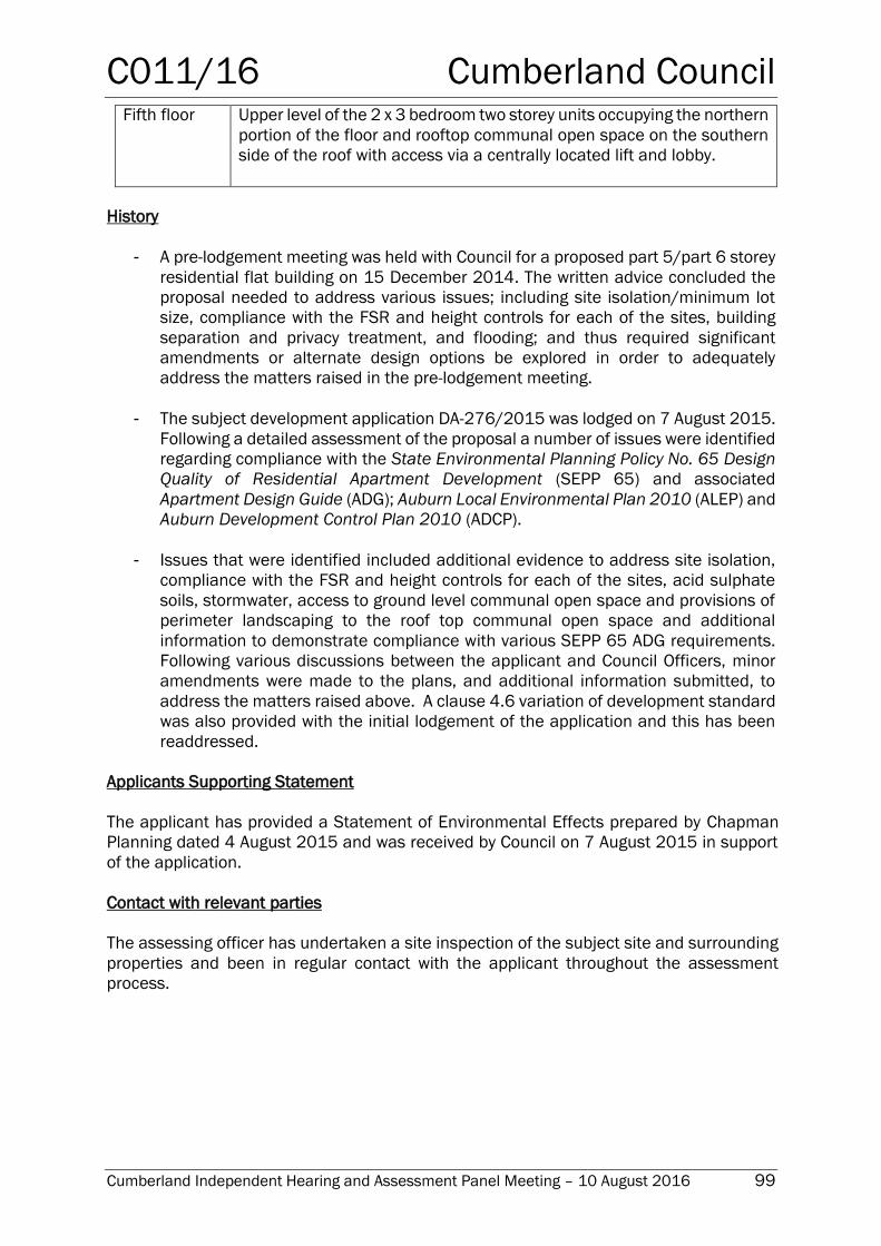
C011/16 Cumberland Council
Cumberland Independent Hearing and Assessment Panel Meeting – 10 August 2016 99
Fifth floor Upper level of the 2 x 3 bedroom two storey units occupying the northern
portion of the floor and rooftop communal open space on the southern
side of the roof with access via a centrally located lift and lobby.
History
- A pre-lodgement meeting was held with Council for a proposed part 5/part 6 storey
residential flat building on 15 December 2014. The written advice concluded the
proposal needed to address various issues; including site isolation/minimum lot
size, compliance with the FSR and height controls for each of the sites, building
separation and privacy treatment, and flooding; and thus required significant
amendments or alternate design options be explored in order to adequately
address the matters raised in the pre-lodgement meeting.
- The subject development application DA-276/2015 was lodged on 7 August 2015.
Following a detailed assessment of the proposal a number of issues were identified
regarding compliance with the State Environmental Planning Policy No. 65 Design
Quality of Residential Apartment Development (SEPP 65) and associated
Apartment Design Guide (ADG); Auburn Local Environmental Plan 2010 (ALEP) and
Auburn Development Control Plan 2010 (ADCP).
- Issues that were identified included additional evidence to address site isolation,
compliance with the FSR and height controls for each of the sites, acid sulphate
soils, stormwater, access to ground level communal open space and provisions of
perimeter landscaping to the roof top communal open space and additional
information to demonstrate compliance with various SEPP 65 ADG requirements.
Following various discussions between the applicant and Council Officers, minor
amendments were made to the plans, and additional information submitted, to
address the matters raised above. A clause 4.6 variation of development standard
was also provided with the initial lodgement of the application and this has been
readdressed.
Applicants Supporting Statement
The applicant has provided a Statement of Environmental Effects prepared by Chapman
Planning dated 4 August 2015 and was received by Council on 7 August 2015 in support
of the application.
Contact with relevant parties
The assessing officer has undertaken a site inspection of the subject site and surrounding
properties and been in regular contact with the applicant throughout the assessment
process.
C011/16 Cumberland Council
Cumberland Independent Hearing and Assessment Panel Meeting – 10 August 2016 100
Internal Referrals
Development Engineer
The development application was referred to Council’s Development Engineer for
comment who has raised no objections to the proposed development subject to
conditions of consent.
External Referrals
NSW Police
The development application was referred to the NSW Police Service in accordance with
the Policy on Crime Prevention Through Environmental Design (CPTED) for a crime risk
assessment. In correspondence dated 27 July 2016, no objections have been raised by
NSW Police to the proposed development subject to the imposition of conditions on any
development consent in respect of security and crime prevention.
Planning Comments
The provisions of any Environmental Planning Instruments (EP& A Act s79C(1)(a)(i))
State Environmental Planning Policies
The proposed development is affected by the following State Environmental Planning
Policies:
State Environmental Planning Policy (Building Sustainability Index: BASIX) 2004
As the development relates to a new residential flat buildings a BASIX certificate hasbeen
submitted to accompany the development application. The plans and details submitted
with the development application satisfy the relevant BASIX commitments required to be
endorsed on the development application plans. Conditions will be imposed on the
development consent to ensure that the construction of the new residential flat building is
in accordance with all specified BASIX commitments. The proposed development is
considered acceptable in respect of the relevant requirements of SEPP (BASIX) 2004.
State Environmental Planning Policy (Infrastructure) 2007 (Infrastructure SEPP)
The proposed development is affected by the Infrastructure SEPP 2007 at the following
clauses:-
Clause 87 – Impact of rail noise or vibration on non-rail development
The proposal relates to the construction of 20 residential units on a site that is located
approximately 80m from a railway line. In accordance with Development Near Rail
Corridors and Busy Roads – Interim Guidelines a specialist acoustic report is not required
for development 80m or more from a rail corridor. Nonetheless the applicant has
submitted an acoustic report prepared by Acoustic Logic (Reference Number
20150520.1/1105A/RO which concludes that:
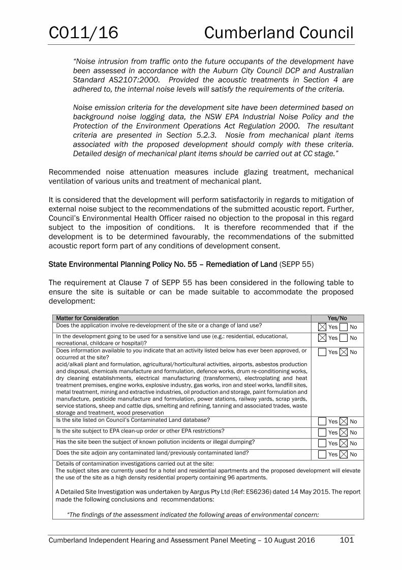
C011/16 Cumberland Council
Cumberland Independent Hearing and Assessment Panel Meeting – 10 August 2016 101
“Noise intrusion from traffic onto the future occupants of the development have
been assessed in accordance with the Auburn City Council DCP and Australian
Standard AS2107:2000. Provided the acoustic treatments in Section 4 are
adhered to, the internal noise levels will satisfy the requirements of the criteria.
Noise emission criteria for the development site have been determined based on
background noise logging data, the NSW EPA Industrial Noise Policy and the
Protection of the Environment Operations Act Regulation 2000. The resultant
criteria are presented in Section 5.2.3. Nosie from mechanical plant items
associated with the proposed development should comply with these criteria.
Detailed design of mechanical plant items should be carried out at CC stage.”
Recommended noise attenuation measures include glazing treatment, mechanical
ventilation of various units and treatment of mechanical plant.
It is considered that the development will perform satisfactorily in regards to mitigation of
external noise subject to the recommendations of the submitted acoustic report. Further,
Council’s Environmental Health Officer raised no objection to the proposal in this regard
subject to the imposition of conditions. It is therefore recommended that if the
development is to be determined favourably, the recommendations of the submitted
acoustic report form part of any conditions of development consent.
State Environmental Planning Policy No. 55 – Remediation of Land (SEPP 55)
The requirement at Clause 7 of SEPP 55 has been considered in the following table to
ensure the site is suitable or can be made suitable to accommodate the proposed
development:
Matter for Consideration Yes/No
Does the application involve re-development of the site or a change of land use? Yes No
In the development going to be used for a sensitive land use (e.g.: residential, educational,
recreational, childcare or hospital)? Yes No
Does information available to you indicate that an activity listed below has ever been approved, or
occurred at the site?
acid/alkali plant and formulation, agricultural/horticultural activities, airports, asbestos production
and disposal, chemicals manufacture and formulation, defence works, drum re-conditioning works,
dry cleaning establishments, electrical manufacturing (transformers), electroplating and heat
treatment premises, engine works, explosive industry, gas works, iron and steel works, landfill sites,
metal treatment, mining and extractive industries, oil production and storage, paint formulation and
manufacture, pesticide manufacture and formulation, power stations, railway yards, scrap yards,
service stations, sheep and cattle dips, smelting and refining, tanning and associated trades, waste
storage and treatment, wood preservation
Yes No
Is the site listed on Council’s Contaminated Land database? Yes No
Is the site subject to EPA clean-up order or other EPA restrictions? Yes No
Has the site been the subject of known pollution incidents or illegal dumping? Yes No
Does the site adjoin any contaminated land/previously contaminated land? Yes No
Details of contamination investigations carried out at the site:
The subject sites are currently used for a hotel and residential apartments and the proposed development will elevate
the use of the site as a high density residential property containing 96 apartments.
A Detailed Site Investigation was undertaken by Aargus Pty Ltd (Ref: ES6236) dated 14 May 2015. The report
made the following conclusions and recommendations:
“The findings of the assessment indicated the following areas of environmental concern:
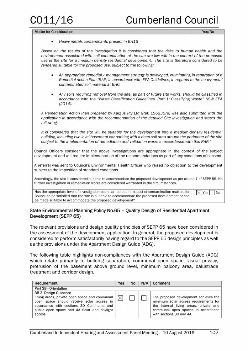
C011/16 Cumberland Council
Cumberland Independent Hearing and Assessment Panel Meeting – 10 August 2016 102
Matter for Consideration Yes/No
Heavy metals contaminants present in BH16
Based on the results of the investigation it is considered that the risks to human health and the
environment associated with soil contamination at the site are low within the context of the proposed
use of the site for a medium density residential development. The site is therefore considered to be
rendered suitable for the proposed use, subject to the following:
An appropriate remedial / management strategy is developed, culminating in reparation of a
Remedial Action Plan (RAP) in accordance with EPA Guidelines, in regards to the heavy metal
contaminated soil material at BH6.
Any soils requiring removal from the site, as part of future site works, should be classified in
accordance with the “Waste Classification Guidelines, Part 1: Classifying Waste” NSW EPA
(2014).
A Remediation Action Plan prepared by Aargus Pty Ltd (Ref: ES6236/s) was also submitted with the
application in accordance with the recommendation of the detailed Site investigation and states the
following.
It is considered that the site will be suitable for the development into a medium-density residential
building, including two-level basement car parking with a deep soil area around the perimeter of the site
subject to the implementation of remediation and validation works in accordance with this RAP.”
Council Officers consider that the above investigations are appropriate in the context of the subject
development and will require implementation of the recommendations as part of any conditions of consent.
A referral was sent to Council’s Environmental Health Officer who raised no objection to the development
subject to the imposition of standard conditions.
Accordingly, the site is considered suitable to accommodate the proposed development as per clause 7 of SEPP 55. No
further investigation or remediation works are considered warranted in the circumstances.
Has the appropriate level of investigation been carried out in respect of contamination matters for
Council to be satisfied that the site is suitable to accommodate the proposed development or can
be made suitable to accommodate the proposed development?
Yes No
State Environmental Planning Policy No.65 – Quality Design of Residential Apartment
Development (SEPP 65)
The relevant provisions and design quality principles of SEPP 65 have been considered in
the assessment of the development application. In general, the proposed development is
considered to perform satisfactorily having regard to the SEPP 65 design principles as well
as the provisions under the Apartment Design Guide (ADG).
The following table highlights non-compliances with the Apartment Design Guide (ADG)
which relate primarily to building separation, communal open space, visual privacy,
protrusion of the basement above ground level, minimum balcony area, balustrade
treatment and corridor design.
Requirement Yes No N/A Comment
Part 3B - Orientation
3B-2 Design Guidance
Living areas, private open space and communal
open space should receive solar access in
accordance with sections 3D Communal and
public open space and 4A Solar and daylight
access.
The proposed development achieves the
minimum solar access requirements for
the internal living areas, private and
communal open spaces in accordance
with sections 3D and 4A.
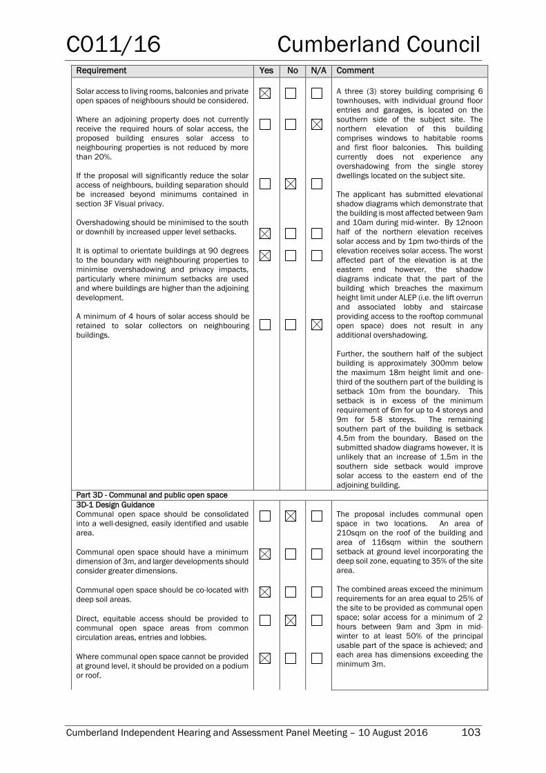
C011/16 Cumberland Council
Cumberland Independent Hearing and Assessment Panel Meeting – 10 August 2016 103
Requirement Yes No N/A Comment
Solar access to living rooms, balconies and private
open spaces of neighbours should be considered.
Where an adjoining property does not currently
receive the required hours of solar access, the
proposed building ensures solar access to
neighbouring properties is not reduced by more
than 20%.
If the proposal will significantly reduce the solar
access of neighbours, building separation should
be increased beyond minimums contained in
section 3F Visual privacy.
Overshadowing should be minimised to the south
or downhill by increased upper level setbacks.
It is optimal to orientate buildings at 90 degrees
to the boundary with neighbouring properties to
minimise overshadowing and privacy impacts,
particularly where minimum setbacks are used
and where buildings are higher than the adjoining
development.
A minimum of 4 hours of solar access should be
retained to solar collectors on neighbouring
buildings.
A three (3) storey building comprising 6
townhouses, with individual ground floor
entries and garages, is located on the
southern side of the subject site. The
northern elevation of this building
comprises windows to habitable rooms
and first floor balconies. This building
currently does not experience any
overshadowing from the single storey
dwellings located on the subject site.
The applicant has submitted elevational
shadow diagrams which demonstrate that
the building is most affected between 9am
and 10am during mid-winter. By 12noon
half of the northern elevation receives
solar access and by 1pm two-thirds of the
elevation receives solar access. The worst
affected part of the elevation is at the
eastern end however, the shadow
diagrams indicate that the part of the
building which breaches the maximum
height limit under ALEP (i.e. the lift overrun
and associated lobby and staircase
providing access to the rooftop communal
open space) does not result in any
additional overshadowing.
Further, the southern half of the subject
building is approximately 300mm below
the maximum 18m height limit and one-
third of the southern part of the building is
setback 10m from the boundary. This
setback is in excess of the minimum
requirement of 6m for up to 4 storeys and
9m for 5-8 storeys. The remaining
southern part of the building is setback
4.5m from the boundary. Based on the
submitted shadow diagrams however, it is
unlikely that an increase of 1.5m in the
southern side setback would improve
solar access to the eastern end of the
adjoining building.
Part 3D - Communal and public open space
3D-1 Design Guidance
Communal open space should be consolidated
into a well-designed, easily identified and usable
area.
The proposal includes communal open
space in two locations. An area of
210sqm on the roof of the building and
area of 116sqm within the southern
setback at ground level incorporating the
deep soil zone, equating to 35% of the site
area.
The combined areas exceed the minimum
requirements for an area equal to 25% of
the site to be provided as communal open
space; solar access for a minimum of 2
hours between 9am and 3pm in mid-
winter to at least 50% of the principal
usable part of the space is achieved; and
each area has dimensions exceeding the
minimum 3m.
Communal open space should have a minimum
dimension of 3m, and larger developments should
consider greater dimensions.
Communal open space should be co-located with
deep soil areas.
Direct, equitable access should be provided to
communal open space areas from common
circulation areas, entries and lobbies.
Where communal open space cannot be provided
at ground level, it should be provided on a podium
or roof.
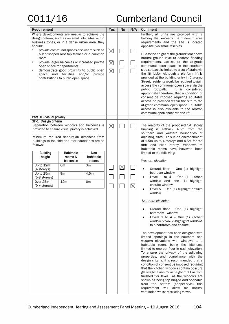
C011/16 Cumberland Council
Cumberland Independent Hearing and Assessment Panel Meeting – 10 August 2016 104
Requirement Yes No N/A Comment
Where developments are unable to achieve the
design criteria, such as on small lots, sites within
business zones, or in a dense urban area, they
should:
• provide communal spaces elsewhere such as
a landscaped roof top terrace or a common
room.
Further, all units are provided with a
balcony that exceeds the minimum area
requirements and the site is located
opposite two small reserves.
Due to the height of the ground floor above
natural ground level to address flooding
requirements, access to the at-grade
communal open space in the southern
side setback is limited to a set of stairs via
the lift lobby. Although a platform lift is
provided at the building entry in Clarence
Street, residents would be required to gain
access the communal open space via the
public footpath. It is considered
appropriate therefore, that a condition of
consent be imposed requiring equitable
access be provided within the site to the
at-grade communal open space. Equitable
access is also available to the rooftop
communal open space via the lift.
• provide larger balconies or increased private
open space for apartments.
• demonstrate good proximity to public open
space and facilities and/or provide
contributions to public open space.
Part 3F - Visual privacy 3F-1 Design criteria
Separation between windows and balconies is
provided to ensure visual privacy is achieved.
Minimum required separation distances from
buildings to the side and rear boundaries are as
follows:
Building
height
Habitable
rooms &
balconies
Non
habitable
rooms
Up to 12m
(4 storeys)
6m 3m
Up to 25m
(5-8 storeys)
9m 4.5m
Over 25m
(9 + storeys)
12m 6m
The majority of the proposed 5-6 storey
building is setback 4.5m from the
southern and western boundaries of
adjoining sites. This is an encroachment
of 1.5m up to 4 storeys and 4.5m for the
fifth and sixth storey. Windows to
habitable rooms have however, been
limited to the following:
Western elevation
Ground floor – One (1) highlight
bedroom window
Level 1 to 4 – One (1) kitchen
window and one (1) highlight
ensuite window
Level 5 – One (1) highlight ensuite
window
Southern elevation
Ground floor - One (1) highlight
bathroom window
Levels 1 to 4 – One (1) kitchen
window & two (2) highlights windows
to a bathroom and ensuite.
The development has been designed with
limited openings in the southern and
western elevations with windows to a
habitable room, being the kitchens,
limited to one per floor in each elevation.
To ensure the privacy of the adjoining
properties, and compliance with the
design criteria, it is recommended that a
condition of consent be imposed requiring
that the kitchen windows contain obscure
glazing to a minimum height of 1.6m from
finished flor level. As the windows are
shown as being top hinged and openable
from the bottom (hopper-style) this
requirement will allow for natural
ventilation whilst restricting views.
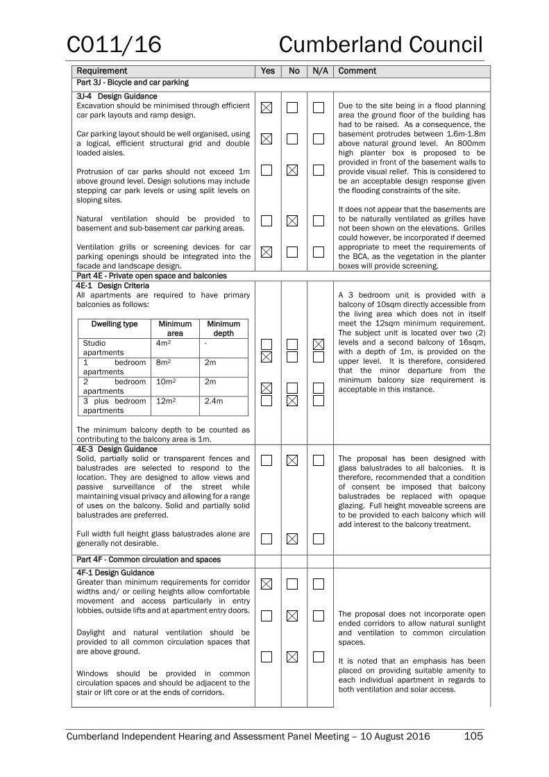
C011/16 Cumberland Council
Cumberland Independent Hearing and Assessment Panel Meeting – 10 August 2016 105
Requirement Yes No N/A Comment
Part 3J - Bicycle and car parking
3J-4 Design Guidance
Excavation should be minimised through efficient
car park layouts and ramp design.
Car parking layout should be well organised, using
a logical, efficient structural grid and double
loaded aisles.
Protrusion of car parks should not exceed 1m
above ground level. Design solutions may include
stepping car park levels or using split levels on
sloping sites.
Natural ventilation should be provided to
basement and sub-basement car parking areas.
Ventilation grills or screening devices for car
parking openings should be integrated into the
facade and landscape design.
Due to the site being in a flood planning
area the ground floor of the building has
had to be raised. As a consequence, the
basement protrudes between 1.6m-1.8m
above natural ground level. An 800mm
high planter box is proposed to be
provided in front of the basement walls to
provide visual relief. This is considered to
be an acceptable design response given
the flooding constraints of the site.
It does not appear that the basements are
to be naturally ventilated as grilles have
not been shown on the elevations. Grilles
could however, be incorporated if deemed
appropriate to meet the requirements of
the BCA, as the vegetation in the planter
boxes will provide screening.
Part 4E - Private open space and balconies
4E-1 Design Criteria
All apartments are required to have primary
balconies as follows:
Dwelling type Minimum
area
Minimum
depth
Studio
apartments
4m2 -
1 bedroom
apartments
8m2 2m
2 bedroom
apartments
10m2 2m
3 plus bedroom
apartments
12m2 2.4m
The minimum balcony depth to be counted as
contributing to the balcony area is 1m.
A 3 bedroom unit is provided with a
balcony of 10sqm directly accessible from
the living area which does not in itself
meet the 12sqm minimum requirement.
The subject unit is located over two (2)
levels and a second balcony of 16sqm,
with a depth of 1m, is provided on the
upper level. It is therefore, considered
that the minor departure from the
minimum balcony size requirement is
acceptable in this instance.
4E-3 Design Guidance
Solid, partially solid or transparent fences and
balustrades are selected to respond to the
location. They are designed to allow views and
passive surveillance of the street while
maintaining visual privacy and allowing for a range
of uses on the balcony. Solid and partially solid
balustrades are preferred.
Full width full height glass balustrades alone are
generally not desirable.
The proposal has been designed with
glass balustrades to all balconies. It is
therefore, recommended that a condition
of consent be imposed that balcony
balustrades be replaced with opaque
glazing. Full height moveable screens are
to be provided to each balcony which will
add interest to the balcony treatment.
Part 4F - Common circulation and spaces
4F-1 Design Guidance
Greater than minimum requirements for corridor
widths and/ or ceiling heights allow comfortable
movement and access particularly in entry
lobbies, outside lifts and at apartment entry doors.
Daylight and natural ventilation should be
provided to all common circulation spaces that
are above ground.
Windows should be provided in common
circulation spaces and should be adjacent to the
stair or lift core or at the ends of corridors.
The proposal does not incorporate open
ended corridors to allow natural sunlight
and ventilation to common circulation
spaces.
It is noted that an emphasis has been
placed on providing suitable amenity to
each individual apartment in regards to
both ventilation and solar access.
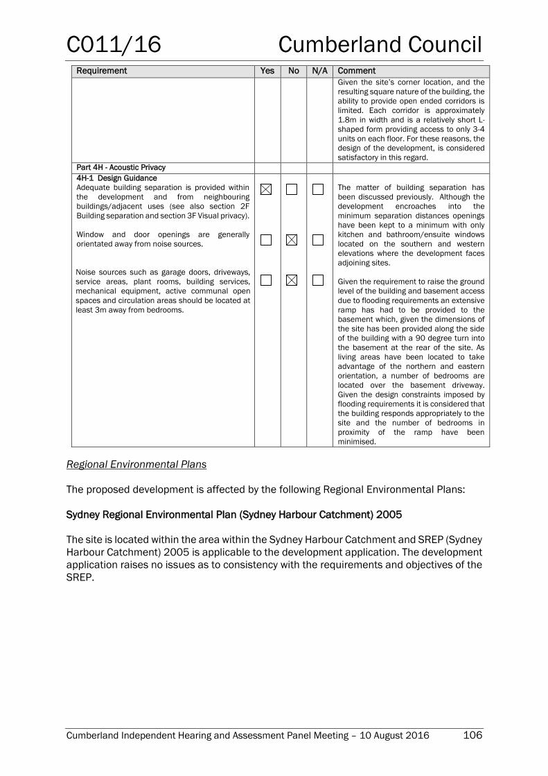
C011/16 Cumberland Council
Cumberland Independent Hearing and Assessment Panel Meeting – 10 August 2016 106
Requirement Yes No N/A Comment
Given the site’s corner location, and the
resulting square nature of the building, the
ability to provide open ended corridors is
limited. Each corridor is approximately
1.8m in width and is a relatively short L-
shaped form providing access to only 3-4
units on each floor. For these reasons, the
design of the development, is considered
satisfactory in this regard.
Part 4H - Acoustic Privacy
4H-1 Design Guidance
Adequate building separation is provided within
the development and from neighbouring
buildings/adjacent uses (see also section 2F
Building separation and section 3F Visual privacy).
Window and door openings are generally
orientated away from noise sources.
Noise sources such as garage doors, driveways,
service areas, plant rooms, building services,
mechanical equipment, active communal open
spaces and circulation areas should be located at
least 3m away from bedrooms.
The matter of building separation has
been discussed previously. Although the
development encroaches into the
minimum separation distances openings
have been kept to a minimum with only
kitchen and bathroom/ensuite windows
located on the southern and western
elevations where the development faces
adjoining sites.
Given the requirement to raise the ground
level of the building and basement access
due to flooding requirements an extensive
ramp has had to be provided to the
basement which, given the dimensions of
the site has been provided along the side
of the building with a 90 degree turn into
the basement at the rear of the site. As
living areas have been located to take
advantage of the northern and eastern
orientation, a number of bedrooms are
located over the basement driveway.
Given the design constraints imposed by
flooding requirements it is considered that
the building responds appropriately to the
site and the number of bedrooms in
proximity of the ramp have been
minimised.
Regional Environmental Plans
The proposed development is affected by the following Regional Environmental Plans:
Sydney Regional Environmental Plan (Sydney Harbour Catchment) 2005
The site is located within the area within the Sydney Harbour Catchment and SREP (Sydney
Harbour Catchment) 2005 is applicable to the development application. The development
application raises no issues as to consistency with the requirements and objectives of the
SREP.
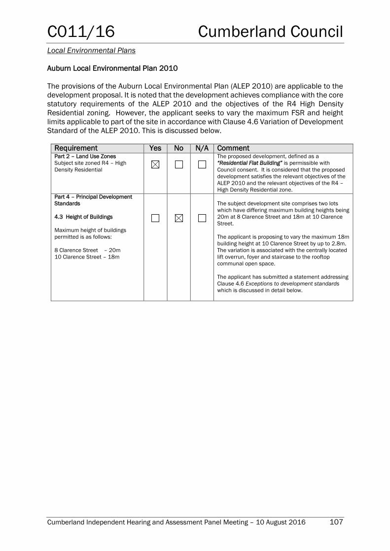
C011/16 Cumberland Council
Cumberland Independent Hearing and Assessment Panel Meeting – 10 August 2016 107
Local Environmental Plans
Auburn Local Environmental Plan 2010
The provisions of the Auburn Local Environmental Plan (ALEP 2010) are applicable to the
development proposal. It is noted that the development achieves compliance with the core
statutory requirements of the ALEP 2010 and the objectives of the R4 High Density
Residential zoning. However, the applicant seeks to vary the maximum FSR and height
limits applicable to part of the site in accordance with Clause 4.6 Variation of Development
Standard of the ALEP 2010. This is discussed below.
Requirement Yes No N/A Comment Part 2 – Land Use Zones
Subject site zoned R4 – High
Density Residential
The proposed development, defined as a
“Residential Flat Building” is permissible with
Council consent. It is considered that the proposed
development satisfies the relevant objectives of the
ALEP 2010 and the relevant objectives of the R4 –
High Density Residential zone.
Part 4 – Principal Development
Standards
4.3 Height of Buildings
Maximum height of buildings
permitted is as follows:
8 Clarence Street – 20m
10 Clarence Street – 18m
The subject development site comprises two lots
which have differing maximum building heights being
20m at 8 Clarence Street and 18m at 10 Clarence
Street.
The applicant is proposing to vary the maximum 18m
building height at 10 Clarence Street by up to 2.8m.
The variation is associated with the centrally located
lift overrun, foyer and staircase to the rooftop
communal open space.
The applicant has submitted a statement addressing
Clause 4.6 Exceptions to development standards
which is discussed in detail below.
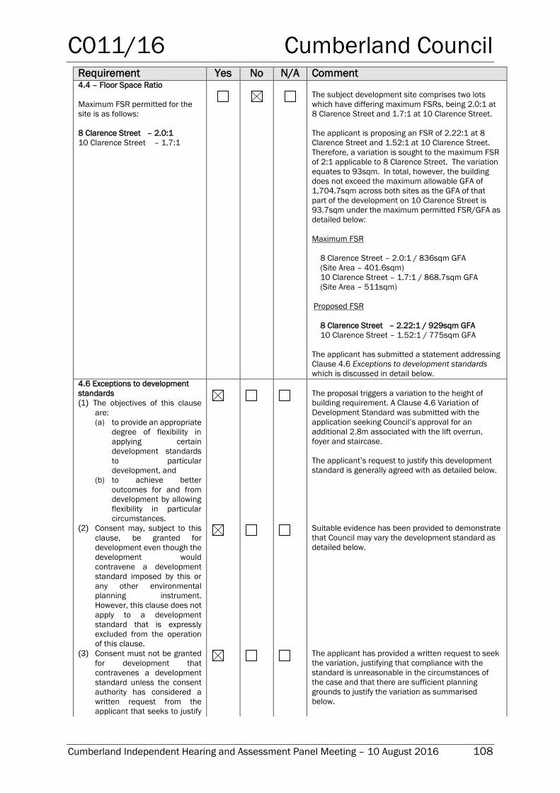
C011/16 Cumberland Council
Cumberland Independent Hearing and Assessment Panel Meeting – 10 August 2016 108
Requirement Yes No N/A Comment 4.4 – Floor Space Ratio
Maximum FSR permitted for the
site is as follows:
8 Clarence Street – 2.0:1
10 Clarence Street – 1.7:1
The subject development site comprises two lots
which have differing maximum FSRs, being 2.0:1 at
8 Clarence Street and 1.7:1 at 10 Clarence Street.
The applicant is proposing an FSR of 2.22:1 at 8
Clarence Street and 1.52:1 at 10 Clarence Street.
Therefore, a variation is sought to the maximum FSR
of 2:1 applicable to 8 Clarence Street. The variation
equates to 93sqm. In total, however, the building
does not exceed the maximum allowable GFA of
1,704.7sqm across both sites as the GFA of that
part of the development on 10 Clarence Street is
93.7sqm under the maximum permitted FSR/GFA as
detailed below:
Maximum FSR
8 Clarence Street – 2.0:1 / 836sqm GFA
(Site Area – 401.6sqm)
10 Clarence Street – 1.7:1 / 868.7sqm GFA
(Site Area – 511sqm)
Proposed FSR
8 Clarence Street – 2.22:1 / 929sqm GFA
10 Clarence Street – 1.52:1 / 775sqm GFA
The applicant has submitted a statement addressing
Clause 4.6 Exceptions to development standards
which is discussed in detail below.
4.6 Exceptions to development
standards
(1) The objectives of this clause
are:
(a) to provide an appropriate
degree of flexibility in
applying certain
development standards
to particular
development, and
(b) to achieve better
outcomes for and from
development by allowing
flexibility in particular
circumstances.
The proposal triggers a variation to the height of
building requirement. A Clause 4.6 Variation of
Development Standard was submitted with the
application seeking Council’s approval for an
additional 2.8m associated with the lift overrun,
foyer and staircase.
The applicant’s request to justify this development
standard is generally agreed with as detailed below.
(2) Consent may, subject to this
clause, be granted for
development even though the
development would
contravene a development
standard imposed by this or
any other environmental
planning instrument.
However, this clause does not
apply to a development
standard that is expressly
excluded from the operation
of this clause.
Suitable evidence has been provided to demonstrate
that Council may vary the development standard as
detailed below.
(3) Consent must not be granted
for development that
contravenes a development
standard unless the consent
authority has considered a
written request from the
applicant that seeks to justify
The applicant has provided a written request to seek
the variation, justifying that compliance with the
standard is unreasonable in the circumstances of
the case and that there are sufficient planning
grounds to justify the variation as summarised
below.
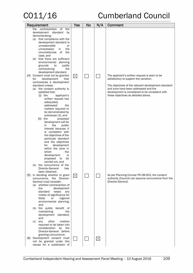
C011/16 Cumberland Council
Cumberland Independent Hearing and Assessment Panel Meeting – 10 August 2016 109
Requirement Yes No N/A Comment the contravention of the
development standard by
demonstrating:
(a) that compliance with the
development standard is
unreasonable or
unnecessary in the
circumstances of the
case, and
(b) that there are sufficient
environmental planning
grounds to justify
contravening the
development standard.
(4) Consent must not be granted
for development that
contravenes a development
standard unless:
(a) the consent authority is
satisfied that:
(i) the applicant’s
written request has
adequately
addressed the
matters required to
be demonstrated by
subclause (3), and
(ii) the proposed
development will be
in the public
interest because it
is consistent with
the objectives of the
particular standard
and the objectives
for development
within the zone in
which the
development is
proposed to be
carried out, and
(b) the concurrence of the
Director-General has
been obtained.
The applicant’s written request is seen to be
satisfactory to support the variation.
The objectives of the relevant development standard
and zone have been addressed and the
development is considered to be consistent with
these objectives as detailed above.
(5) In deciding whether to grant
concurrence, the Director-
General must consider:
(a) whether contravention of
the development
standard raises any
matter of significance for
State or regional
environmental planning,
and
(b) the public benefit of
maintaining the
development standard,
and
(c) any other matters
required to be taken into
consideration by the
Director-General before
granting concurrence.
As per Planning Circular PS 08-003, the consent
authority (Council) can assume concurrence from the
Director-General.
(6) Development consent must
not be granted under this
clause for a subdivision of
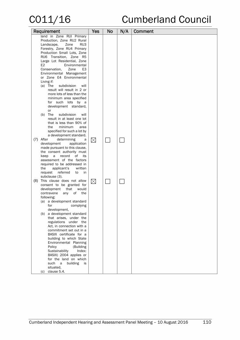
C011/16 Cumberland Council
Cumberland Independent Hearing and Assessment Panel Meeting – 10 August 2016 110
Requirement Yes No N/A Comment land in Zone RUI Primary
Production, Zone RU2 Rural
Landscape, Zone RU3
Forestry, Zone RU4 Primary
Production Small Lots, Zone
RU6 Transition, Zone R5
Large Lot Residential, Zone
E2 Environmental
Conservation, Zone E3
Environmental Management
or Zone E4 Environmental
Living if:
(a) The subdivision will
result will result in 2 or
more lots of less than the
minimum area specified
for such lots by a
development standard,
or
(b) The subdivision will
result in at least one lot
that is less than 90% of
the minimum area
specified for such a lot by
a development standard.
(7) After determining a
development application
made pursuant to this clause,
the consent authority must
keep a record of its
assessment of the factors
required to be addressed in
the applicant’s written
request referred to in
subclause (3).
(8) This clause does not allow
consent to be granted for
development that would
contravene any of the
following:
(a) a development standard
for complying
development,
(b) a development standard
that arises, under the
regulations under the
Act, in connection with a
commitment set out in a
BASIX certificate for a
building to which State
Environmental Planning
Policy (Building
Sustainability Index:
BASIX) 2004 applies or
for the land on which
such a building is
situated,
(c) clause 5.4.
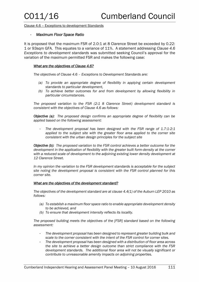
C011/16 Cumberland Council
Cumberland Independent Hearing and Assessment Panel Meeting – 10 August 2016 111
Clause 4.6 – Exceptions to development Standards
- Maximum Floor Space Ratio
It is proposed that the maximum FSR of 2.0:1 at 8 Clarence Street be exceeded by 0.22:
1 or 93sqm GFA. This equates to a variance of 11%. A statement addressing Clause 4.6
Exceptions to development standards was submitted seeking Council’s approval for the
variation of the maximum permitted FSR and makes the following case:
What are the objectives of Clause 4.6?
The objectives of Clause 4.6 – Exceptions to Development Standards are:
(a) To provide an appropriate degree of flexibility in applying certain development
standards to particular development,
(b) To achieve better outcomes for and from development by allowing flexibility in
particular circumstances.
The proposed variation to the FSR (2:1 8 Clarence Street) development standard is
consistent with the objectives of Clause 4.6 as follows:
Objective (a): The proposed design confirms an appropriate degree of flexibility can be
applied based on the following assessment:
- The development proposal has been designed with the FSR range of 1.7:1-2:1
applied to the subject site with the greater floor area applied to the corner site
consistent with the urban design principles for the subject site
Objective (b): The proposed variation to the FSR control achieves a better outcome for the
development in the application of flexibility with the greater built form-density at the corner
with a reduced scale of development to the adjoining existing lower density development at
12 Clarence Street.
In my opinion the variation to the FSR development standards is acceptable for the subject
site noting the development proposal is consistent with the FSR control planned for this
corner site.
What are the objectives of the development standard?
The objectives of the development standard are at clause 4.4(1) of the Auburn LEP 2010 as
follows:
(a) To establish a maximum floor space ratio to enable appropriate development density
to be achieved, and
(b) To ensure that development intensity reflects its locality.
The proposed building meets the objectives of the [FSR] standard based on the following
assessment:
- The development proposal has been designed to represent greater building bulk and
scale to the corner consistent with the intent of the FSR control for corner sites.
- The development proposal has been designed with a distribution of floor area across
the site to achieve a better design outcome than strict compliance with the FSR
development standards. The additional floor area will not be visually significant or
contribute to unreasonable amenity impacts on adjoining properties.
C011/16 Cumberland Council
Cumberland Independent Hearing and Assessment Panel Meeting – 10 August 2016 112
Compliance with the development standard is unreasonable or unnecessary in this
particular case?
Pursuant to clause 4.6(3)(a) of the LEP the variation to the 2:1 FSR development standard
([8] Clarence Street) is acceptable in the circumstances of this case and compliance with
the development standards is considered to be unreasonable and unnecessary because it
meets the objective of the [FSR] standard even though it does not strictly comply based on
the following:
The development proposal has a total FSR of 1.83:1 on the consolidated site
consistent with the range of 1.7:1-2:1 applied to this corner site with the increased
floor area at the corner ensuring that the built form is compatible with the FSR
controls planned for corner sites.
The variation to the 2:2 FSR control will not be visually significant noting the
development has a total FSR of 1.83:1 ensuring the total floor area is consistent
with the maximum FSR control for the consolidated site area.
The variation to the 2:1 FSR control is a better planning outcome for the subject site
with a reduced built form – floor area for the building adjoining the existing 3 storey
form at 12 Clarence Street.
The additional floor area will not result in unreasonable overshadowing at mid-winter
compared to a development that complies with the numerical control.
Are there sufficient environmental planning grounds to justify contravening the development
standard?
Pursuant to Clause 4.6(3)(b) of the LEP the grounds for variation to the FSR control
contained in this application confirms that there are sufficient environmental planning
grounds to support the variation to the 2:1 FSR development standard ([8] Clarence Street)
contained in clause 4.4(2) of the Auburn LEP 2010 given the development proposal meets
the total GFA calculation applied to the site.
The grounds for variation to the FSR control contained in this application confirm that
achieving compliance with the controls is unreasonable in the circumstances as the
underlying objectives of the control are achieved.
The variation to the FSR standards does not attempt to affect the planning outcome for the
locality. The portion of the building exceeding the 2:1 FSR control will not contribute to
unreasonable building bulk or scale being compatible with the form and scale of buildings
planned for corner sites in the R4 - High Density Residential zone.
Is the proposed Development in the public interest?
Clause 4.6(4)(ii) of the LEP states:
Development consent must not be granted for development that contravenes a
development standard unless:
(a) the consent authority is satisfied that:
(i) the applicant’s written request has adequately addressed the matters required
to be demonstrated by subclause (3), and
(ii) the proposed development will be in the public interest because it is consistent
with the objectives of the particular standard and the objectives for
development within the zone in which the development is proposed to be carried
out, and
C011/16 Cumberland Council
Cumberland Independent Hearing and Assessment Panel Meeting – 10 August 2016 113
(b) the concurrence of the Secretary has been obtained.
The proposed variation to [FSR] is in the public interest as follows:
- The development proposal has been designed to achieve a suitable development
yield consistent with the planning controls for the subject site and the variation to
the FSR control will not be perceptible from the public domain, noting the overall
FSR for the development of 1.83:1. The development proposal is in the public
interest with the development form and scale consistent with the planning controls
for the locality and the provision of additional housing within the catchment of public
transport and services.
- The building has been designed with a reduced scale of development adjoining the
lower scale built form to the south and will not present unacceptable bulk and scale
to the public domain or result in unreasonable amenity impacts.
Are there sufficient environmental planning grounds to justify contravening the development
standard?
The development proposal has sufficient grounds to vary the 2:1 FSR control ([8] Clarence
Street) contained in Cluse 4.4 of the Auburn LEP 2010. The development proposal has a
GFA of 1704m2 and meets the total permissible floor area for the consolidated site.
The additional floor area will not be visually significant when viewed from the public domain
or adjoining properties, and will not result in unreasonable amenity impacts.
The variation to the FSR development standards does not attempt to affect the planning
outcomes for the broader locality; rather the development proposal has been designed to
present a suitable form for development on this corner site with distribution of floor area
across the site consistent with the FSR controls.
In my opinion the application to vary the FSR development standard is well founded and as
addressed the development proposal does not hinder attainment of the Objects of the Act
or the aims and objectives of the Auburn LEP 2010. The variation to the FSR standard
should be supported.”
Planners comment: The applicant has provided sufficient justification in regards to the
variation of Clause 4.4 Floor space ratio, demonstrating that compliance with the
development standard is unreasonable and that there are sufficient environmental
planning grounds to justify contravening the standard.
As detailed in the ALEP 2010 compliance table the FSR for the combined sites does not
exceed the permitted maximum and redistributing the GFA would potentially result in a
greater breach of the maximum height limit at 10 Clarence Street and greater amenity
impacts for the adjoining property to the south. The proposed development does not
exceed the maximum intensity of development permitted for the site and as such complies
with the objectives for the particular development standard.
The consent authority can therefore be satisfied that in the circumstances of this case, the
variation will achieve a suitable planning outcome and allow for appropriate levels of
amenity for existing and future surrounding developments.
- Maximum Building Height
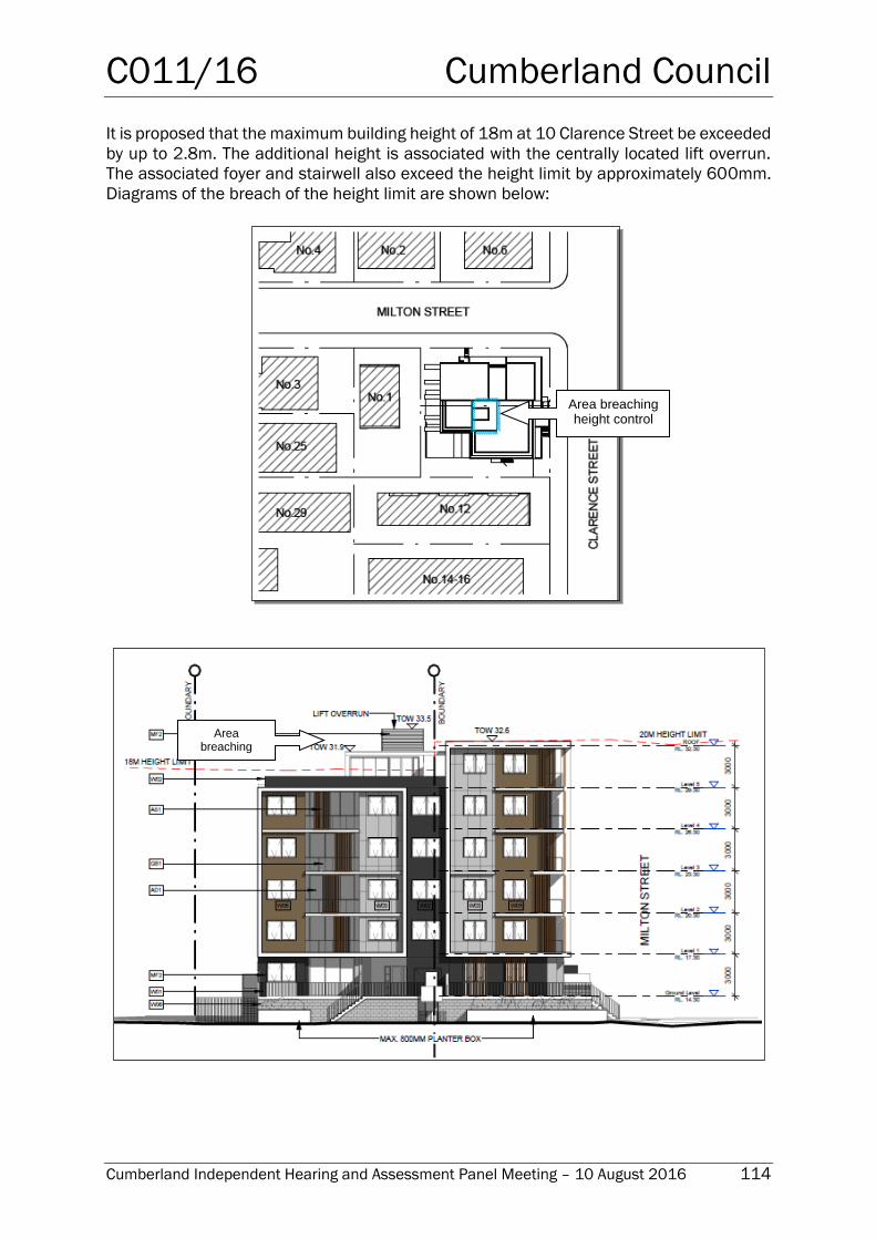
C011/16 Cumberland Council
Cumberland Independent Hearing and Assessment Panel Meeting – 10 August 2016 114
It is proposed that the maximum building height of 18m at 10 Clarence Street be exceeded
by up to 2.8m. The additional height is associated with the centrally located lift overrun.
The associated foyer and stairwell also exceed the height limit by approximately 600mm.
Diagrams of the breach of the height limit are shown below:
Area breaching height control
Area breaching
height control
C011/16 Cumberland Council
Cumberland Independent Hearing and Assessment Panel Meeting – 10 August 2016 115
A statement addressing Clause 4.6 Exceptions to development standards was submitted
seeking Council’s approval for the variation of the maximum permitted building height and
makes the following case:
What are the objectives of Clause 4.6?
(a) To provide an appropriate degree of flexibility in applying certain development
standards to particular development,
(b) To achieve better outcomes for and from development by allowing flexibility in
particular circumstances.
The proposed variation to the 18m height development standard measured to the lift overrun
is consistent with the objectives of clause 4.6 as follows:
Objective (a): the proposed design confirms an appropriate degree of flexibility can be applied
based on the following assessment:
- The development proposal is largely within the 18-20m height controls applying to
the site with the minor variation being the lift overrun that provides access to the
communal roof terrace. The lift overrun and associate structure for weather
protection will not be highly visible from Clarence Street or Milton Street – public
domain.
Objective (b): The proposed variation to the height control achieves a better outcome for and
from the development in the application of flexibility based on the following:
- The building height is consistent with the scale of the development planned for the
subject site with the higher built element to the corner and the roof structure – lift
overrun set behind the portion of the built form at the corner, recessed-setback 13m
from Clarence Street, will not be visible from the public domain, and ensures there
is accessible communal open space for the development receiving solar access.
In my opinion the variation to the building height development standard is acceptable for the
subject site noting the development proposal is consistent with the building height planned
for this corner site with the minor variation resulting from the lift overrun to the communal
terrace allowing for flexibility to the height control noting the variation of 2m – 3m is confined
to the lift overrun and associated structure centrally located on the building and set behind
the building height to the corner with the majority of the building meeting the 18m - 20m
height control.
What are the objectives of the development standard?
The objectives of the development standard area t clause 4.3(1) of the Auburn LEP 2010 as
follows:
(a) to establish a maximum height of buildings to enable appropriate development
density to be achieved, and
(b) to ensure that the height if buildings is compatible with the character of the locality.
The proposed building meets the objectives of the building height development standard
based on the following assessment:
- The development proposal has been designed as a 5 – 6 storey form with a
defined step in the building height consistent with the intent of the height control
C011/16 Cumberland Council
Cumberland Independent Hearing and Assessment Panel Meeting – 10 August 2016 116
for corner sites ensuring the variation to the 18m height control on part of the site
(10 Clarence Street) will not present unreasonable building height or scale to the
public domain or adjoining properties.
The development proposal has been designed with step in building consistent with the height
control noting the portion of the building exceeding the height control is recessed and will not
be visually significant confirming the development is consistent with the planning control for
the subject site.
Compliance with the development standard is unreasonable or unnecessary in this particular
case?
Pursuant to Clause 4.6(3) of the LEP the variation to the 18m building height development
standard is acceptable in the circumstances of this case and compliance with the
development standard is considered unreasonable and unnecessary because it meets the
objective of the height standards even though it does not strictly comply based on the
following:
The development proposal present a 5-6 storey building form to the public domain
and adjoining properties with the lift overrun exceeding the 18m height control being
recessed ensuring the built form is compatible with the eight controls for corner
sites.
The variation to the 18m height control for the lift overrun is centrally located
ensuring the built form will be viewed as 5-6 storey development t the public domain
and adjoining properties consistent with the planning controls for the site.
The variation to the 18m height at the upper level is 2m – 3m above the height
control. The building presents a 5 – 6 storey form at this corner site and the portion
of the building exceeding 18m in height is not visually significant.
The recessed lift overrun exceeding the 18m height control is centrally located and
will not be visually dominant and does not contribute to unreasonable visual bulk
and scale when viewed from the public domain or adjoining properties.
The Shadow Study report supporting the application prepared by MOMA architects
confirms the portion of the building exceeding the 18m height control will not result
in unreasonable overshadowing at mid-winter. The portion of additional shadow cast
by the non-complying part of the building is shown below.
C011/16 Cumberland Council
Cumberland Independent Hearing and Assessment Panel Meeting – 10 August 2016 117
The upper level of the building is stepped presenting a well-articulated building
addressing the corner and consistent with the planning controls for the locality.
Are there sufficient environmental planning grounds to justify contravening the development
standard?
Pursuant to clause 4.6(3)(b) of the LEP the grounds for variation to the height control
contained in this application confirms that there are sufficient environmental planning
grounds to support the variation to the 18m building height development standard contained
in clause 4.3(2) of the Auburn LEP 2010 given the variation is minor, confined to the lift
overrun and associated structure providing access to the roof-top communal space. The
variation to the 18m height control is setback behind the corner elements and will not be
highly visible from the public domain.
The minor variation to the building height standard does not attempt to affect the planning
outcome for the locality, rather the variation is to the proposed upper level – lift overrun result
in a minor variation to 18m height control applied to part of the site (10 Clarence Street). The
building has been designed to present a step in building height suitable for this corner site
and the portion of the building exceeding the 18m height control will not contribute to
unreasonable building bulk or scale being compatible with the form and scale of buildings
planned for corner sites in the R4 – High Density zone.
Is the proposed Development in the public interest?
Clause 4.6(4)(ii) of the LEP states:
Additional
shadow
C011/16 Cumberland Council
Cumberland Independent Hearing and Assessment Panel Meeting – 10 August 2016 118
Development consent must not be granted for development that contravenes a development
standard unless:
(a) the consent authority is satisfied that:
(i) the applicant’s written request has adequately addressed the matters
required to be demonstrated by subclause (3), and
(ii) the proposed development will be in the public interest because it is
consistent with the objectives of the particular standard and the objectives
for development within the zone in which the development is proposed to be
carried out, and
(b) the concurrence of the Secretary has been obtained.
The proposed variation to the building height is in the public interest as follows:
- The development proposal has been designed to achieve a suitable development
yield consistent with the planning controls for the subject site and the minor
variation to the height control will not be perceptible form the public domain. The
development proposal is in the public interest with the development form and scale
consistent with the planning controls for the locality and the provision of additional
housing within the catchment of public transport and services.
- The portion of the building exceeding the 18m height control will not present
unacceptable bulk and scale to the public domain or result in unreasonable
amenity impacts.
- The lift overrun and associated structures ensures the development provides
accessible communal open space on the roof-top area that will receive solar
access and contribute to residential amenity.
Are there sufficient environmental planning grounds to justify contravening the developments
standards?
The development proposal has sufficient grounds to vary the 18m height control contained in
Clause 4.3 of the Auburn LEP 2010. The minor variation is confined to the lift overrun and
associated structures providing access to the communal open space.
The variation to the 18m building height control is applied to part of the subject site (10
Clarence Street); notwithstanding, the building has been designed to present a 5-6 storey
form on this corner site consistent with the planning controls with the upper level – lift overrun
recessed ensuring that building steps when viewed from the public domain – Clarence Street.
The lift overrun is centrally located on the roof form [and] and will not be visually dominant
[when] viewed from the public domain or adjoining properties, and will not result in
unreasonable amenity impacts.
The variation to the building height standards does not attempt to affect the planning
outcomes for the broader locality; rather the development proposal has been designed to
present a suitable form of development on this corner site with stepped building height
reflecting the scale and form of development planned for residential flat building development
on corner sites. Further, the recessed lift overrun [will not be] visually dominant or result in
unreasonable impacts to the surrounding properties.
In my opinion the application to vary the building height development standard is well founded
and as addressed the development proposal does not hinder attainment of the Objects of the
C011/16 Cumberland Council
Cumberland Independent Hearing and Assessment Panel Meeting – 10 August 2016 119
Act or the aims and objectives of the Auburn LEP 2010. The variation to the building height
standard should be supported.
Planners comment: The applicant has provided sufficient justification in regards to the
variation of Clause 4.3 Height of Buildings, demonstrating that compliance with the
development standard is unreasonable and that there are sufficient environmental
planning grounds to justify contravening the standard.
As previously stated, the height breach relates to the centrally located lift overrun and
associated foyer and staircase providing access to the rooftop communal open space. The
only additional shadow cast is at 9am in mid-winter and elevational shadow diagrams have
also been submitted to demonstrate that this shadow does not impact on the adjoining
residential flat building immediately adjoining the southern boundary of the site.
The consent authority can therefore be satisfied that in the circumstances of this case, the
variation will achieve a suitable planning outcome and allow for appropriate levels of
amenity for existing and future surrounding developments.
The provisions of any Draft Environmental Planning Instruments (EP& A Act s79C(1)(a)(ii))
The proposed development is not affected by any relevant Draft Environmental Planning
Instruments.
The provisions of any Development Control Plans (EP& A Act s79C(1)(a)(iii))
Auburn Development Control Plan 2010
The relevant sections of Auburn Development Control Plan 2010 have been considered in
the assessment of the development application and are discussed in detail below.
a) Residential Flat Buildings
The relevant design requirements and objectives of the Residential Flat Buildings chapter
of the ADCP 2010 have been considered in the assessment of the development
application. The following table highlights non-compliances within the Residential Flat
Building chapter of the ADCP 2010 which relates primarily to site area, setback of
articulation elements, balcony balustrade treatment, communal open space and deep soil
zone.
Requirement Yes No N/A Comments
2.0 Built Form
2.1 Site area
D1 A residential flat building development shall
have a minimum site area of 1000m2 and a
street frontage of 20m in the B4 Zone or 26m
in the R4 Zone.
D2 Where lots are deep and have narrow street
frontages the capacity for maximising
residential development is limited. Two or
more sites may need to be amalgamated to
provide a combined site with sufficient width
for good building design.
The development site has an area of
929sqm which is 71sqm below the
required minimum area for a residential
flat building. The developer has
unsuccessfully made offers to purchase
the adjoining site to the west (No. 1 Milton
Street). The matter of site isolation is
discussed in further detail below. Despite
the non-compliance with the minimum site
area the development is considered to
perform satisfactorily having regard to the
objectives and performance criteria of the
DCP.
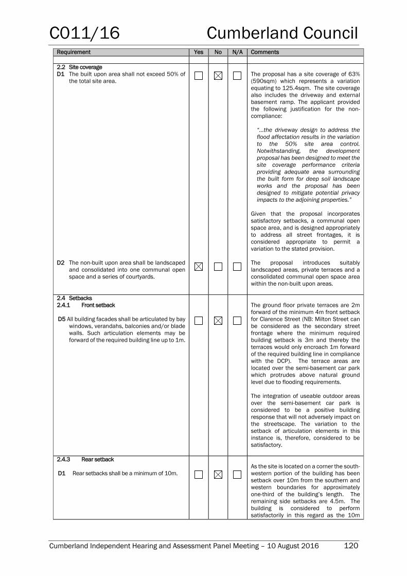
C011/16 Cumberland Council
Cumberland Independent Hearing and Assessment Panel Meeting – 10 August 2016 120
Requirement Yes No N/A Comments
2.2 Site coverage
D1 The built upon area shall not exceed 50% of
the total site area.
D2 The non-built upon area shall be landscaped
and consolidated into one communal open
space and a series of courtyards.
The proposal has a site coverage of 63%
(590sqm) which represents a variation
equating to 125.4sqm. The site coverage
also includes the driveway and external
basement ramp. The applicant provided
the following justification for the non-
compliance:
“…the driveway design to address the
flood affectation results in the variation
to the 50% site area control.
Notwithstanding, the development
proposal has been designed to meet the
site coverage performance criteria
providing adequate area surrounding
the built form for deep soil landscape
works and the proposal has been
designed to mitigate potential privacy
impacts to the adjoining properties.”
Given that the proposal incorporates
satisfactory setbacks, a communal open
space area, and is designed appropriately
to address all street frontages, it is
considered appropriate to permit a
variation to the stated provision.
The proposal introduces suitably
landscaped areas, private terraces and a
consolidated communal open space area
within the non-built upon areas.
2.4 Setbacks
2.4.1 Front setback
D5 All building facades shall be articulated by bay
windows, verandahs, balconies and/or blade
walls. Such articulation elements may be
forward of the required building line up to 1m.
The ground floor private terraces are 2m
forward of the minimum 4m front setback
for Clarence Street (NB: Milton Street can
be considered as the secondary street
frontage where the minimum required
building setback is 3m and thereby the
terraces would only encroach 1m forward
of the required building line in compliance
with the DCP). The terrace areas are
located over the semi-basement car park
which protrudes above natural ground
level due to flooding requirements.
The integration of useable outdoor areas
over the semi-basement car park is
considered to be a positive building
response that will not adversely impact on
the streetscape. The variation to the
setback of articulation elements in this
instance is, therefore, considered to be
satisfactory.
2.4.3 Rear setback
D1 Rear setbacks shall be a minimum of 10m.
As the site is located on a corner the south-
western portion of the building has been
setback over 10m from the southern and
western boundaries for approximately
one-third of the building’s length. The
remaining side setbacks are 4.5m. The
building is considered to perform
satisfactorily in this regard as the 10m
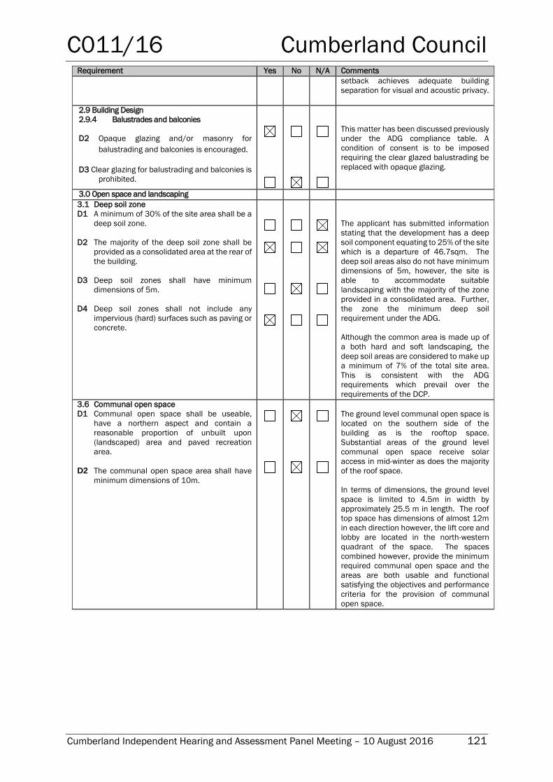
C011/16 Cumberland Council
Cumberland Independent Hearing and Assessment Panel Meeting – 10 August 2016 121
Requirement Yes No N/A Comments
setback achieves adequate building
separation for visual and acoustic privacy.
2.9 Building Design
2.9.4 Balustrades and balconies
D2 Opaque glazing and/or masonry for
balustrading and balconies is encouraged.
D3 Clear glazing for balustrading and balconies is
prohibited.
This matter has been discussed previously
under the ADG compliance table. A
condition of consent is to be imposed
requiring the clear glazed balustrading be
replaced with opaque glazing.
3.0 Open space and landscaping
3.1 Deep soil zone
D1 A minimum of 30% of the site area shall be a
deep soil zone.
D2 The majority of the deep soil zone shall be
provided as a consolidated area at the rear of
the building.
D3 Deep soil zones shall have minimum
dimensions of 5m.
D4 Deep soil zones shall not include any
impervious (hard) surfaces such as paving or
concrete.
The applicant has submitted information
stating that the development has a deep
soil component equating to 25% of the site
which is a departure of 46.7sqm. The
deep soil areas also do not have minimum
dimensions of 5m, however, the site is
able to accommodate suitable
landscaping with the majority of the zone
provided in a consolidated area. Further,
the zone the minimum deep soil
requirement under the ADG.
Although the common area is made up of
a both hard and soft landscaping, the
deep soil areas are considered to make up
a minimum of 7% of the total site area.
This is consistent with the ADG
requirements which prevail over the
requirements of the DCP.
3.6 Communal open space
D1 Communal open space shall be useable,
have a northern aspect and contain a
reasonable proportion of unbuilt upon
(landscaped) area and paved recreation
area.
D2 The communal open space area shall have
minimum dimensions of 10m.
The ground level communal open space is
located on the southern side of the
building as is the rooftop space.
Substantial areas of the ground level
communal open space receive solar
access in mid-winter as does the majority
of the roof space.
In terms of dimensions, the ground level
space is limited to 4.5m in width by
approximately 25.5 m in length. The roof
top space has dimensions of almost 12m
in each direction however, the lift core and
lobby are located in the north-western
quadrant of the space. The spaces
combined however, provide the minimum
required communal open space and the
areas are both usable and functional
satisfying the objectives and performance
criteria for the provision of communal
open space.
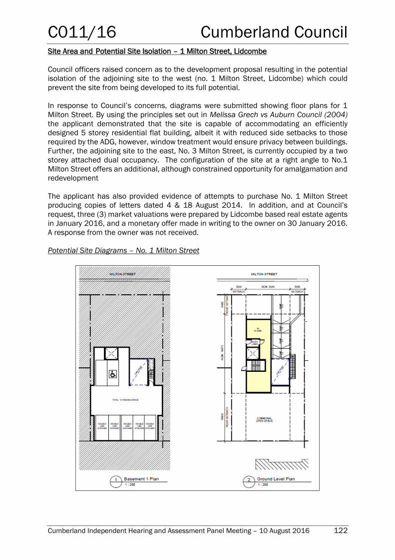
C011/16 Cumberland Council
Cumberland Independent Hearing and Assessment Panel Meeting – 10 August 2016 122
Site Area and Potential Site Isolation – 1 Milton Street, Lidcombe
Council officers raised concern as to the development proposal resulting in the potential
isolation of the adjoining site to the west (no. 1 Milton Street, Lidcombe) which could
prevent the site from being developed to its full potential.
In response to Council’s concerns, diagrams were submitted showing floor plans for 1
Milton Street. By using the principles set out in Melissa Grech vs Auburn Council (2004)
the applicant demonstrated that the site is capable of accommodating an efficiently
designed 5 storey residential flat building, albeit it with reduced side setbacks to those
required by the ADG, however, window treatment would ensure privacy between buildings.
Further, the adjoining site to the east, No. 3 Milton Street, is currently occupied by a two
storey attached dual occupancy. The configuration of the site at a right angle to No.1
Milton Street offers an additional, although constrained opportunity for amalgamation and
redevelopment
The applicant has also provided evidence of attempts to purchase No. 1 Milton Street
producing copies of letters dated 4 & 18 August 2014. In addition, and at Council’s
request, three (3) market valuations were prepared by Lidcombe based real estate agents
in January 2016, and a monetary offer made in writing to the owner on 30 January 2016.
A response from the owner was not received.
Potential Site Diagrams – No. 1 Milton Street
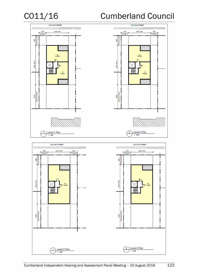
C011/16 Cumberland Council
Cumberland Independent Hearing and Assessment Panel Meeting – 10 August 2016 123
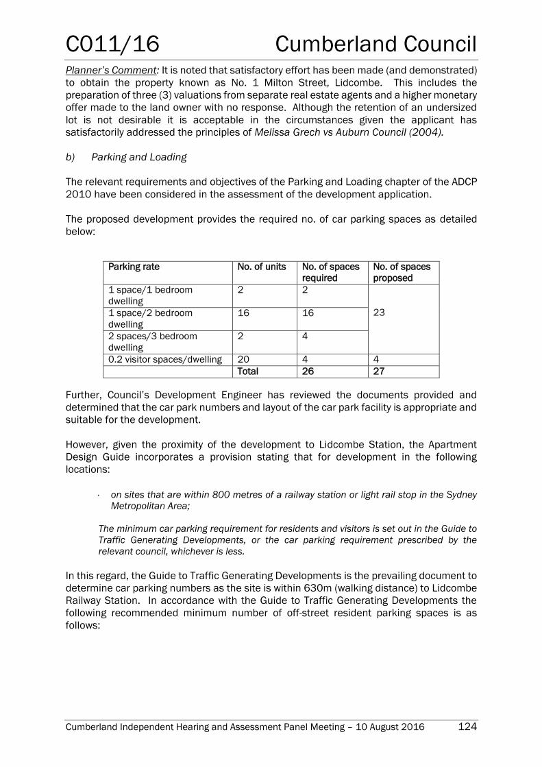
C011/16 Cumberland Council
Cumberland Independent Hearing and Assessment Panel Meeting – 10 August 2016 124
Planner’s Comment: It is noted that satisfactory effort has been made (and demonstrated)
to obtain the property known as No. 1 Milton Street, Lidcombe. This includes the
preparation of three (3) valuations from separate real estate agents and a higher monetary
offer made to the land owner with no response. Although the retention of an undersized
lot is not desirable it is acceptable in the circumstances given the applicant has
satisfactorily addressed the principles of Melissa Grech vs Auburn Council (2004).
b) Parking and Loading
The relevant requirements and objectives of the Parking and Loading chapter of the ADCP
2010 have been considered in the assessment of the development application.
The proposed development provides the required no. of car parking spaces as detailed
below:
Parking rate No. of units No. of spaces
required
No. of spaces
proposed
1 space/1 bedroom
dwelling
2 2
23 1 space/2 bedroom
dwelling
16 16
2 spaces/3 bedroom
dwelling
2 4
0.2 visitor spaces/dwelling 20 4 4
Total 26 27
Further, Council’s Development Engineer has reviewed the documents provided and
determined that the car park numbers and layout of the car park facility is appropriate and
suitable for the development.
However, given the proximity of the development to Lidcombe Station, the Apartment
Design Guide incorporates a provision stating that for development in the following
locations:
on sites that are within 800 metres of a railway station or light rail stop in the Sydney
Metropolitan Area;
The minimum car parking requirement for residents and visitors is set out in the Guide to
Traffic Generating Developments, or the car parking requirement prescribed by the
relevant council, whichever is less.
In this regard, the Guide to Traffic Generating Developments is the prevailing document to
determine car parking numbers as the site is within 630m (walking distance) to Lidcombe
Railway Station. In accordance with the Guide to Traffic Generating Developments the
following recommended minimum number of off-street resident parking spaces is as
follows:

C011/16 Cumberland Council
Cumberland Independent Hearing and Assessment Panel Meeting – 10 August 2016 125
Metropolitan Regional (CBD) Centres:
Parking rate No. of units Min no. of
spaces
required
No. of spaces
proposed
0.4 spaces/1 bedroom unit 2 (0.8) 1
23 0.7 spaces/2 bedroom unit 16 (11.2) 12
1.2 spaces/3 bedroom unit 2 (2.4) 3
1 visitor space/ 7 units 20 (2.9) 3 4
Total 19 27
As demonstrated in the above tables the development provides a sufficient number of car
parking spaces to satisfy the requirements of the ADG and ADCP 2010.
c) Stormwater Drainage
The relevant requirements and objectives of the Stormwater Drainage section of the ADCP
2010 have been considered in the assessment of the development application. Council’s
Development Engineer has raised no objections subject to the imposition of conditions.
d) Access and Mobility
The relevant requirements and objectives of the Access and Mobility part of the ADCP
2010 have been considered in the assessment of the development application. . A
satisfactory number of adaptable apartments have been provided within the development.
There are a number of disability access provisions incorporated into the development
which include:-
Lifts connecting all floors of the development with the basement;
Direct access from the pedestrian footpath to the building entry; and
Appropriate car spaces.
e) Waste
The relevant requirements and objectives of the Waste section of the ADCP 2010 have
been considered in the assessment of the development application. .A satisfactory waste
management plan has been submitted for the construction phase and on-going occupation
of the development. Should the application be approved, a condition of consent will be
imposed requiring compliance with the submitted waste management plan.
f) Tree Preservation
The relevant requirements and objectives of the Tree Preservation section of the ADCP
2010 have been considered in the assessment of the development application and
detailed in the report. The applicant is proposing to relocate two (2) 10m tall palm trees
from the north-eastern corner of 8 Clarence Street to the rear communal open space area.
There are no significant trees on the site proposed for removal.
C011/16 Cumberland Council
Cumberland Independent Hearing and Assessment Panel Meeting – 10 August 2016 126
79C(1)(a)(iiia) - any planning agreement that has been entered into under section 93F,
or any draft planning agreement that a developer has offered to enter into under section
93F, and
There is no draft planning agreement associated with the subject Development
Application.
The provisions of the Regulations (EP& A Act s79C(1)(a)(iv))
The proposed development raises no concerns as to the relevant matters arising from the
EP& A Regulations 2000.
79C(1)(a)(v) - any coastal zone management plan (within the meaning of the Coastal
Protection Act 1979)
There is no Coastal Zone Management Plan applicable for the Auburn area.
The Likely Environmental, Social or Economic Impacts (EP& A Act s79C(1)(b))
It is considered that the proposed development will have no significant adverse
environmental, social or economic impacts in the locality.
The suitability of the site for the development (EP&A Act s79C(1)(c))
The subject site and locality is not known to be affected by any natural hazards or other
site constraints likely to have a significant adverse impact on the proposed development.
Accordingly, the site can be said to be suitable to accommodate the proposal. The
proposed development has been assessed in regard it its environmental consequences
and having regard to this assessment, it is considered that the development is suitable in
the context of the site and surrounding locality.
Submissions made in accordance with the Act or Regulation (EP&A Act s79C(1)(d
Advertised (newspaper) Mail Sign Not Required
In accordance with Council’s Notification of Development Proposals Development Control
Plan, the proposal was publicly exhibited for a period of 14 days between 1 September
2015 and 15 September 2015. The notification generated two (2) submissions, including
a petition containing 23 signatures, in respect of the proposal with none disclosing a
political donation or gift. The issues raised in the public submissions are summarised and
commented on as follows:
The proposed six (6) storey building is incompatible with the existing four (4) storey
buildings in the area especially as it will be located at the main entrance to Clarence
Street.
Comment: The existing 4 storey residential flat buildings in Clarence Street are of an
architectural style typical of the 1990’s. The proposed development, at 5-6 storeys,
complies with Council’s current planning controls under ALEP 2010 and the area
C011/16 Cumberland Council
Cumberland Independent Hearing and Assessment Panel Meeting – 10 August 2016 127
surrounding Clarence Street will, in time, be redeveloped with buildings of the same scale.
It should be noted that Council’s planning controls include higher FSR and height for corner
allotments throughout higher density zones so as to enable an emphasis to the corner
treatment of buildings. The development responds to the controls in this regard
A six (6) storey building will be the highest in this location and will bock all natural light
which will impact on surrounding residents.
The non-compliant site area, building height, building envelope, open space and site
coverage, as well as achieving the maximum floor space, results in an
overdevelopment of the site and significant amenity impacts upon neighbours and
local residents from overshadowing.
Comment: The overshadowing caused by the building has been discussed in detail in the
ADG compliance table. Overshadowing of surrounding properties is at its greatest at 9am
in mid-winter extending over portions of two properties to the south (No.s 12 and 14-16
Clarence Street), one property to the west (No.1 Milton Street) and three properties to the
south-west (No.s 27-29, 31 and 33-37 Livingstone Street). By midday, however,
overshadowing is confined to No. 12 Clarence Street and a small area of No. 14-16
Clarence Street. The development performs satisfactorily having regard to solar access
requirements and the non-compliances with the maximum building height associated with
the lift overrun, foyer and stairs are only apparent at 9am in mid-winter.
The 22% non-compliance with the SEPP 65/ADG maximum apartment depth control
of 18m is further evidence that the proposed building is oversized and excessively
bulky.
Comment: The corner location of the site has resulted in a square shaped floor plan,
however, all units are 15m in depth or less and comply with the depth and cross-ventilation
requirements of the ADG.
The site area of 929sqm is below the minimum 1,000sqm site area required for
residential flat building development and should be amalgamated with No. 1 Milton
Street. The proposed development cannot be considered by Council given that it does
not meet the minimum site area requirement and will also result in isolation of No. 1
Milton Street.
The inadequate site area results in overdevelopment and numerous non-compliances
with Council’s core DCP objectives and controls (height, building envelope, open
space, site coverage, resulting in significant amenity impacts on neighbours and local
residents such as loss of privacy and overshadowing.
Comment: The minimum site area for residential flat building development is a
development control under the Residential Flat Buildings part of Council’s Auburn
Development Control Plan 2010. As discussed in the report attempts were made by the
developer to purchase no. 1 Milton Street and the evidence provided satisfies the planning
principles of the relevant Land and Environment Court case. Further, s79C(3A)(b) of the
Environmental Planning & Assessment Act, 1979, requires the consent authority to be
flexible in applying the provisions of a development control plan where a development does
not comply with a certain standard and allows reasonable alternative solutions that
achieve the objectives of the particular standard. As discussed throughout the report the
C011/16 Cumberland Council
Cumberland Independent Hearing and Assessment Panel Meeting – 10 August 2016 128
development performs satisfactorily having regard to requirements of the DCP and the
performance criteria relating to site area insofar as the site is of sufficient size to
accommodate residential flat development and provide adequate open space and car
parking consistent with the DCP requirements.
The communal open space does not comply with SEPP 65/ADG requirements in terms
of its size and its rooftop location (due to privacy/amenity impacts) is further evidence
the proposed building is oversized, excessively bulky and is a gross overdevelopment
of the site. Communal open space should be located at ground level to achieve the
intent to allow for adequate open space and hence, adequate setbacks, compliant
site coverage, building envelope etc.
Comment: The application has been amended since the time of the original exhibition
period to provide better connection between the building and the landscaped setback on
the southern side of the building to provide an alternative communal open space area.
The rooftop area and the at-grade communal open space have a combined area of
326sqm which exceeds the minimum ADG requirement by 10%. The ADG also recognises
that in certain circumstances, such as on small lots, the provision of communal open space
can be met elsewhere such as a landscaped roof top terrace, larger balconies or increased
private open space for apartments and demonstrate proximity to public open space. The
proposed development provides communal open space at ground level and on the roof
top, balconies exceed the minimum size requirements, and the site is directly opposite two
small reserves.
The application should be referred to the Police for a formal assessment of the
safety/crime risks given the common security, safety and amenity issues associated
with this type of development.
Comment: As discussed previously, the application was referred to the NSW Police for
comment who raised no objection to the proposal and included recommendations which
are to be incorporated as conditions of consent.
It appears that all possible development options, including more sustainable,
reasonable and less impactful options, have not been considered, e.g. fully
submerging the basement to lower overall height, reduction in floor space and building
envelope/bulk etc.
Comment: The proposal was the subject of a Pre-DA application and proposed two levels
of basement car parking and the sixth storey of the building running in a north-south
direction (as opposed to the east-west direction as currently proposed) with the step down
to the 5th storey located on the western side of the building (as opposed to the southern
side of the building as currently proposed). Council advised the applicant that the full
basement could not be supported due to the flooding constraints of the site and the
distribution of the building height and FSR would be required to comply with ALEP 2010.
As discussed in the AEP 2010 compliance table, minor variations are sought to the
maximum permissible FSR and building height, however, these variations are considered
to have merit as the overall allowable intensity of development is not being exceeded and
the height breach associated with the lift overrun and foyer/staircase do not result in
unacceptable overshadowing of surrounding properties. It should also be noted that the
building as proposed results in less overshadowing of adjoining properties than that
proposed in the pre-lodgement application.
C011/16 Cumberland Council
Cumberland Independent Hearing and Assessment Panel Meeting – 10 August 2016 129
The development will result in the loss of privacy to the neighbours to the west and
south of the site. In addition to non-compliance with the objectives and controls of
Councils DCP, the application is also contrary to the NSW Land and Environment
Court’s planning principles for protection of visual privacy which were established by
Senior Commissioner Dr John Roseth in Meriton v Sydney City Council [2004] NSWLEC
313, including the freedom of one dwelling and its private open space from being
overlooked by another dwelling and its private open space with such matters to be
taken into consideration as density, separation, use and design.
The development is a combination of poor design and overdevelopment of the site,
and will adversely impact the neighbour’s visual and acoustic privacy. The communal
open space proposed at roof top level will result in excessive overlooking opportunities
as well as activities that will cause significant amenity impacts from loud noise and
loss of privacy.
Comment: The application has been amended since the time of the original exhibition
period to include screen planting around the perimeter of the roof top open space and
better connection between the building and the landscaped setback on the southern side
of the building to provide an alternative communal open space area. Each unit has been
designed with balconies which exceed the minimum requirements of the ADG and which
receive the required solar access. Whilst the rooftop communal open space area provides
an alternative space for residents, use of communal spaces will be intermittent and a
condition of consent is to be imposed with the respect to compliance with relevant noise
requirements.
The development has also been designed with minimal windows to kitchens and highlight
windows to bathrooms in the southern and western elevations where the setback to these
boundaries is 4.5m. Further, a condition of consent is to be imposed requiring opaque
glazing to kitchen windows in these elevations. Where bedroom windows are provided the
setbacks have been increased to over 10m from these boundaries. It is considered that
appropriate measures have been taken to ensure that there is no loss of privacy to
adjoining and surrounding residents.
An increase in the number of units will exacerbate existing traffic and parking
problems in Clarence Street and the surrounding road network.
Comment: Clarence Street is a relatively short street with a cul-de-sac end providing
vehicular entry to a large complex of 4 storey residential flat buildings. The proposed
development does not exceed the intensity of development permitted under ALEP 2010
and therefore, will not add any additional traffic to the street than anticipated by the
planning controls. Further, adequate parking is to be provided on site to meet the
requirements of ADCP 2010 and exceeds the minimum requirements of the ADG. It should
also be noted that extensive parking is available in Railway Parade adjoining the railway
line.
An increase in the number of cars and garbage bins placed out on collection day will
exacerbate the issue of there being insufficient space for garbage collection.
Comment: As discussed in the ADCP – Parking and Loading section of this report the
proposal provides parking to meet Council’s requirements and exceeds the minimum
C011/16 Cumberland Council
Cumberland Independent Hearing and Assessment Panel Meeting – 10 August 2016 130
requirements of the ADG. Further, the proposed development will accommodate on-site
garbage collection therefore there will be no impact on existing parking and on-street
collection in the vicinity of the site.
The submitted Waste Management Plan does not adequately address the potential
presence of asbestos in the existing dwelling.
Comment: Conditions of consent are recommended to be imposed with respect to the
appropriate handling of asbestos during building demolition. Further, the remediation
action plan submitted with the application includes details regarding asbestos control
and management and a condition of consent is recommended to be imposed requiring
compliance with the remediation action plan.
The proposal is not in the public interest, being the local residents impacted by this
illegal/non-complying development pursuant to section 79C(1)(c)(e) of the
Environmental Planning & Assessment Act, 1979.
Comment: Refer below.
The public interest (EP& A Act s79C(1)(e))
The public interest is served by permitting the orderly and economic development of land,
in a manner that is sensitive to the surrounding environment and has regard to the
reasonable amenity expectations of surrounding land users. In view of the foregoing
analysis it is considered that the development, if carried out subject to the conditions set
out in the recommendation below, will have no significant adverse impacts on the public
interest.
Section 94 Contribution towards provision or improvement of amenities or services
This part of the Act relates to the collection of monetary contributions from applicants for
use in developing key local infrastructure. The Act reads as follows:
‘(1) If a consent authority is satisfied that development for which development
consent is sought will or is likely to require the provision of or increase the
demand for public amenities and public services within the area, the
consent authority may grant the development consent subject to a
condition requiring:
(a) the dedication of land free of cost, or
(b) the payment of a monetary contribution, or both.
(2) A condition referred to in subsection (1) may be imposed only to require
a reasonable dedication or contribution for the provision, extension or
augmentation of the public amenities and public services concerned.’
Comments:
The development would require the payment of contributions in accordance with Council
Section 94 Contributions Plans. It is recommended that conditions be imposed on any
consent requiring the payment of these contributions prior to the issue of any construction
certificate for the development.
C011/16 Cumberland Council
Cumberland Independent Hearing and Assessment Panel Meeting – 10 August 2016 131
The calculation is based on 2x 1 bedroom, 16 x 2 bed and 2 x 3 bed dwellings. As at 29
June 2016 the fee payable is $100,267.25. This figure is subject to indexation as per the
relevant plan.
Auburn City Council Operational Plan / Delivery Program
This assessment and report relates to the Auburn City Council Operational Plan and
Delivery Program, Our Places – Attractive and Liveable theme, action “2a.1.1.3 Assess
development applications, complying development and construction certificates”.
Disclosure of Political Donations and Gifts
The NSW Government introduced The Local Government and Planning Legislation
Amendment (Political Donations) Act 2008 (NSW). This disclosure requirement is for all
members of the public relating to political donations and gifts. The law introduces
disclosure requirements for individuals or entities with a relevant financial interest as part
of the lodgement of various types of development proposals and requests to initiate
environmental planning instruments or development control plans.
The applicant and notification process did not result in any disclosure of Political Donations
and Gifts.
Conclusion
The development application has been assessed in accordance with the relevant
requirements of the Environmental Planning and Assessment Act 1979, Auburn Local
Environmental Plan 2010 and the Auburn Development Control Plan 2010 and is
considered to be satisfactory for approval subject to conditions.
The proposed development is appropriately located within the R4 High Density Residential
zone under the provisions of the Auburn Local Environmental Plan 2010, however
variations in relation to the height of buildings and floor space ratio are proposed.
Having regard to the assessment of the proposal from a merit perspective, Council may be
satisfied that the development has been responsibly designed and provides for acceptable
levels of amenity for future residents. It is considered that the proposal successfully
minimises adverse impacts on the amenity of neighbouring properties. Hence the
development, irrespective of the departures noted above, is consistent with the intentions
of Council’s planning controls and represents a form of development contemplated by the
relevant statutory and non-statutory controls applying to the land.
For these reasons, it is considered that the proposal is satisfactory having regard to the
matters of consideration under Section 79C of the Environmental Planning and
Assessment Act, 1979, and the development may be approved subject to conditions.
C011/16 Cumberland Council
Cumberland Independent Hearing and Assessment Panel Meeting – 10 August 2016 132
Report Recommendation:
That Development Application No. DA-276/2015 for Demolition of existing structures &
construction of a part 5/part 6 storey residential flat building containing 2 x 1 bedroom,
16 x 2 bedroom and 2 x 3 bedroom units over 2 levels of semi-basement & basement car
parking, landscaping, provision of site services and strata subdivision on land at 8-10
Clarence Street, Lidcombe be approved subject to the attached conditions.
ATTACHMENT (following this Report)
1. Draft Conditions of Consent - P029732/2016
ATTACHMENTS (to be circulated to CIHAP members only under separate cover))
2. Architectural Plans/Landscape Plans –T0707432/2016
3. Shadow Diagrams - T070433/2016
4. Clause 4.6 Variations – Floor Space Ratio and Building Height – T070488/2016
5. 2 x Submissions Received –T070489/2016
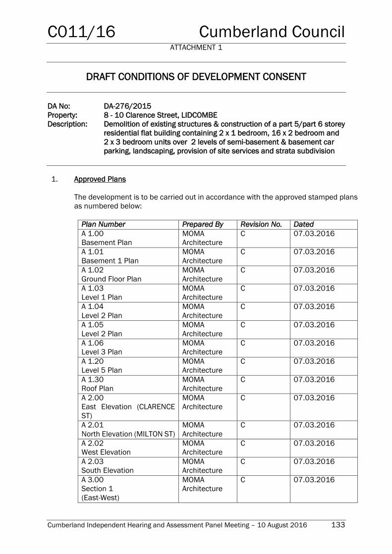
C011/16 Cumberland Council ATTACHMENT 1
Cumberland Independent Hearing and Assessment Panel Meeting – 10 August 2016 133
DRAFT CONDITIONS OF DEVELOPMENT CONSENT
DA No: DA-276/2015
Property: 8 - 10 Clarence Street, LIDCOMBE
Description: Demolition of existing structures & construction of a part 5/part 6 storey
residential flat building containing 2 x 1 bedroom, 16 x 2 bedroom and
2 x 3 bedroom units over 2 levels of semi-basement & basement car
parking, landscaping, provision of site services and strata subdivision
1. Approved Plans
The development is to be carried out in accordance with the approved stamped plans
as numbered below:
Plan Number Prepared By Revision No. Dated
A 1.00
Basement Plan
MOMA
Architecture
C 07.03.2016
A 1.01
Basement 1 Plan
MOMA
Architecture
C 07.03.2016
A 1.02
Ground Floor Plan
MOMA
Architecture
C 07.03.2016
A 1.03
Level 1 Plan
MOMA
Architecture
C 07.03.2016
A 1.04
Level 2 Plan
MOMA
Architecture
C 07.03.2016
A 1.05
Level 2 Plan
MOMA
Architecture
C 07.03.2016
A 1.06
Level 3 Plan
MOMA
Architecture
C 07.03.2016
A 1.20
Level 5 Plan
MOMA
Architecture
C 07.03.2016
A 1.30
Roof Plan
MOMA
Architecture
C 07.03.2016
A 2.00
East Elevation (CLARENCE
ST)
MOMA
Architecture
C 07.03.2016
A 2.01
North Elevation (MILTON ST)
MOMA
Architecture
C 07.03.2016
A 2.02
West Elevation
MOMA
Architecture
C 07.03.2016
A 2.03
South Elevation
MOMA
Architecture
C 07.03.2016
A 3.00
Section 1
(East-West)
MOMA
Architecture
C 07.03.2016
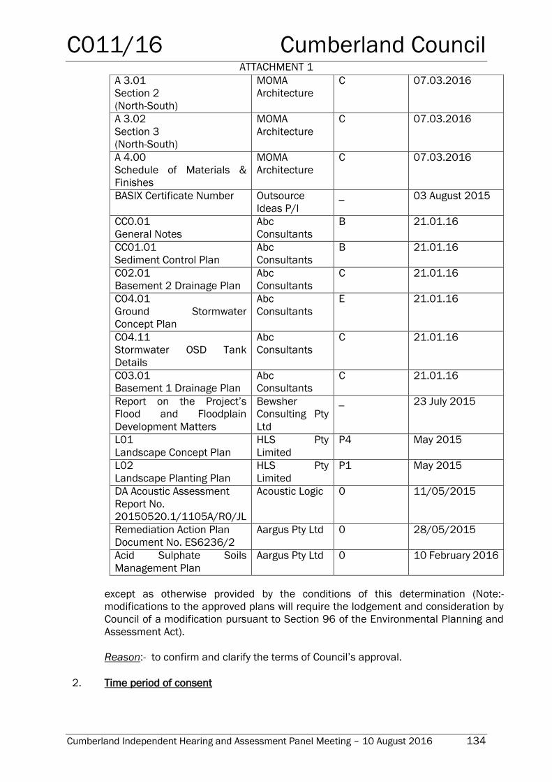
C011/16 Cumberland Council ATTACHMENT 1
Cumberland Independent Hearing and Assessment Panel Meeting – 10 August 2016 134
A 3.01
Section 2
(North-South)
MOMA
Architecture
C 07.03.2016
A 3.02
Section 3
(North-South)
MOMA
Architecture
C 07.03.2016
A 4.00
Schedule of Materials &
Finishes
MOMA
Architecture
C 07.03.2016
BASIX Certificate Number
Outsource
Ideas P/l
_ 03 August 2015
CC0.01
General Notes
Abc
Consultants
B 21.01.16
CC01.01
Sediment Control Plan
Abc
Consultants
B 21.01.16
C02.01
Basement 2 Drainage Plan
Abc
Consultants
C 21.01.16
C04.01
Ground Stormwater
Concept Plan
Abc
Consultants
E 21.01.16
C04.11
Stormwater OSD Tank
Details
Abc
Consultants
C 21.01.16
C03.01
Basement 1 Drainage Plan
Abc
Consultants
C 21.01.16
Report on the Project’s
Flood and Floodplain
Development Matters
Bewsher
Consulting Pty
Ltd
_ 23 July 2015
L01
Landscape Concept Plan
HLS Pty
Limited
P4 May 2015
L02
Landscape Planting Plan
HLS Pty
Limited
P1 May 2015
DA Acoustic Assessment
Report No.
20150520.1/1105A/R0/JL
Acoustic Logic 0 11/05/2015
Remediation Action Plan
Document No. ES6236/2
Aargus Pty Ltd 0 28/05/2015
Acid Sulphate Soils
Management Plan
Aargus Pty Ltd 0 10 February 2016
except as otherwise provided by the conditions of this determination (Note:-
modifications to the approved plans will require the lodgement and consideration by
Council of a modification pursuant to Section 96 of the Environmental Planning and
Assessment Act).
Reason:- to confirm and clarify the terms of Council’s approval.
2. Time period of consent
C011/16 Cumberland Council ATTACHMENT 1
Cumberland Independent Hearing and Assessment Panel Meeting – 10 August 2016 135
This consent shall lapse five (5) years from the date of determination unless the
approved building, engineering or construction work has been physically commenced
in accordance with this consent.
Development consent for the use of land does not lapse if the approved use of any
land, building or work is actually commenced prior to the date on which the consent
would otherwise lapse.
Reason:- to satisfy the requirements of Section 95 of the Environmental Planning and
Assessment Act.
3. Auburn DCP 2007: Section 94 Development Contributions
Development Contributions are payable in accordance with Auburn Council Council’s
Section 94 Development Contribution Plan 2007, which has been prepared under
Section 94 of the Environmental Planning and Assessment Act 1979, as amended.
The amounts payable will be adjusted in accordance with the section titled Review of
Contribution rates and are generally indexed on a quarterly basis by the Consumer
Price Index CPI (all Groups Sydney) unless otherwise stated in the plan.
Contributions will be adjusted at the payment date in accordance with the plan and
payment is to be made prior to the issue of any Construction Certificate.
Council’s Development Contribution Plan 2007 is available for inspection at Council’s
Customer Services Centre, Civic Place, 1 Susan Street, Auburn or on line at
www.auburn.nsw.gov.au.
Reason: To ensure that the development complies with the Auburn DCP 2007: Section
94 Development Contributions.
4. Auburn DCP 2007 - LGA Wide
A sum of $100,267.25 is to be paid to Council for the purpose of LGA Wide plans being
the provision of open space and recreation facilities, community facilities, accessibility
and traffic works, town centre upgrades, car parking and Council's administration of
the development contributions framework.
The above sum is broken down to the following items:
Item Amount
Community Facilities $24,726.46
Public Domain $54,687.21
Accessibility and Traffic $15,073.75
Administration $5,779.83
TOTAL $100,267.25
C011/16 Cumberland Council ATTACHMENT 1
Cumberland Independent Hearing and Assessment Panel Meeting – 10 August 2016 136
Reason: to provide open space and recreation facilities, community facilities,
accessibility and traffic works, town centre upgrades, car parking and Council's
administration of the development contributions framework.
5. BASIX Requirements
Under Clause 97A(3) of the Environmental Planning & Assessment Regulation 2000,
it is a condition of this development consent that all the commitments listed in each
relevant BASIX Certificate for the development are fulfilled. In this condition:-
a) Relevant BASIX Certification means:-
i) A BASIX Certificate that was applicable to the development when this
development consent was granted (or, if the development consent is
modified under Section 96 of the Act, a BASIX Certificate that is applicable
to the development when this development consent is modified) or;
ii) If a replacement BASIX Certificate accompanies any subsequent
application for a construction certificate, the replacement BASIX
Certificate; and
b) BASIX Certificate has the meaning given to that term in the Environmental
Planning & Assessment Regulation 2000.
Reason:- To comply with the Environmental Planning and Assessment Regulations.
6. Disabled Access & Facilities
Access and facilities for people with disabilities must be provided in accordance with
the relevant requirements of the Building Code of Australia (for all new building work)
and in addition, with the relevant requirements of the ‘Disability (Access to Premises
– Building) Standards 2010’ (including for existing buildings, whether or not any works
are proposed). Details of the proposed access, facilities and car parking for people
with disabilities are to be included in the plans/specifications for the construction
certificate.
Reason: to ensure compliance with the requirements of the Building Code of Australia
7. Commonwealth Disability Discrimination Act
The Commonwealth Disability Discrimination Act 1992 commenced the ‘Disability
(Access for Premises – Buildings) Standards 2010’ on 1 May 2011 and now applies
to all new buildings and affected parts of existing buildings. Submission and/or
approval of this application does not imply or confer compliance with either the Act or
the new Access Standard. Applicants should satisfy themselves and make their own
inquiries to the Human Rights and Equal Opportunity Commission.
Reason: to provide advice on the requirements of the Commonwealth Disability
Discrimination Act 1992
C011/16 Cumberland Council ATTACHMENT 1
Cumberland Independent Hearing and Assessment Panel Meeting – 10 August 2016 137
8. Disabled access – communal open space
Disabled access shall be provided directly from the ground floor lift lobby to the at-
grade communal open space area on the southern side of the site. An area of
hardstand and seating shall be provided adjacent to the disabled access.
Details demonstrating compliance shall be submitted to the Manager – Development
Assessment, Cumberland Council – Auburn Branch for approval prior to issue of the
Construction Certificate.
Reason:- To ensure equitable access is provided to communal areas for the use of
residents and visitors in accordance with Auburn Development Control Plan 2010.
9. Balcony balustrades
All balcony balustrades shall contain opaque glazing. Details demonstrating
compliance shall be submitted to the Principal Certifying Authority for approval prior
to issue of the Construction Certificate.
Reason:- to comply with the requirements of the Apartment Design Guide and ADCP
2010 – Residential Flat Buildings.
10. Opaque glazing – kitchen windows
The hopper-style kitchen windows in the southern and western elevations shall contain
obscure glazing to a minimum height of 1.6m as measured from the finished floor
level.
Details demonstrating compliance shall be submitted to the Principal Certifying
Authority for approval prior to issue of the Construction Certificate.
Reason:- to protect the privacy of adjoining properties.
11. Universal Design Features – Apartment Design
A minimum of 20% of the total number of apartments shall incorporate the Liveable
Housing Guideline's silver level universal design features. Details demonstrating
compliance shall be submitted to the Principal Certifying Authority for approval prior
to the issue of the relevant Construction Certificate.
Reason:- to ensure suitably designed units form part of the development in
accordance with the Apartment Design Guide under State Environmental Planning
Policy No 65 - Design Quality of Residential Apartment Development.
12. Submission of Construction Certificate
Construction works are not to commence until such time that a construction certificate
for the proposed works has been issued by Council or an Accredited Certifier.
C011/16 Cumberland Council ATTACHMENT 1
Cumberland Independent Hearing and Assessment Panel Meeting – 10 August 2016 138
Where an Accredited Certifier issues a construction certificate, a copy of the following
documents must be forwarded to Council within 2 days of issue, together with payment
of the Council’s adopted registration fee: determination; application to which it relates;
construction certificate issued; plans and specifications; any fire safety schedule; and
any other documents lodged with the certificate.
Any modification involving building works to the approved development made under
Section 96 of the Environmental Planning and Assessment Act 1979 requires the
submission of an amended construction certificate.
Reason:- to comply with the requirements of Section 81A of the Environmental
Planning and Assessment Act and clause 142 of the Environmental Planning and
Assessment Regulation 2000.
13. No alteration without prior Council approval
The completed building is not to be altered externally in character or colour without
the prior consent of Council.
Reason:- to ensure the external appearance of the development is not obtrusive or
offensive and does not degrade the visual quality of the surrounding area.
14. Appointment of Principal Certifying Authority/Notice of Commencement of Work
Site works are not to commence until:-
a) a construction certificate for the building work has been issued by the consent
authority, and
b) the person having the benefit of the development consent has:-
i) appointed a principal certifying authority for the building work, and
ii) notified the principal certifying authority that the person will carry out the
building work as an owner-builder, if that is the case, and
b1) the principal certifying authority has, no later than 2 days before the building
work commences:-
i) notified the consent authority and the council (if the council is not the
consent authority) of his or her appointment, and
ii) notified the person having the benefit of the development consent of any
critical stage inspections and other inspections that are to be carried out
in respect of the building work, and
b2) the person having the benefit of the development consent, if not carrying out the
work as an owner-builder, has:-
i) appointed a principal contractor for the building work who must be the
holder of a contractor licence if any residential building work is involved,
and
C011/16 Cumberland Council ATTACHMENT 1
Cumberland Independent Hearing and Assessment Panel Meeting – 10 August 2016 139
ii) notified the principal certifying authority of any such appointment, and
iii) unless that person is the principal contractor, notified the principal
contractor of any critical stage inspections and other inspections that are
to be carried out in respect of the building work, and
c) the person having the benefit of the development consent has given at least 2
days’ notice to the council of the person’s intention to commence the erection
of the building.
Reason:- to comply with the requirements of Section 81A of the Environmental
Planning and Assessment Act
15. Principal Certifying Authority
1) The person having the benefit of a development consent or complying
development certificate for development involving building work or subdivision
work may appoint the consent authority, the council or an accredited certifier as
the principal certifying authority for the development.
1A) Despite subsection (1), such an appointment may not be made by any contractor
or other person who will carry out the building work or subdivision work unless
the contractor or other person is the owner of the land on which the work is to
be carried out.
2) Despite subsection (1), an accredited certifier must not be appointed as the
principal certifying authority for development involving subdivision work unless
the subdivision to which the work relates is of a kind identified by an
environmental planning instrument as one in respect of which an accredited
certifier may be a certifying authority.
3) A principal certifying authority for building work or subdivision work to be carried
out on a site is required to be satisfied:-
a) that a construction certificate or complying development certificate has
been issued for such of the building work or subdivision work as requires
development consent and over which the principal certifying authority has
control, before the work commences on the site, and
b) that the principal contractor for the work is the holder of the appropriate
licence and is covered by the appropriate insurance, in each case if
required by the Home Building Act 1989, before any residential building
work over which the principal certifying authority has control commences
on the site, unless the work is to be carried out by an owner-builder, and
c) that the owner-builder is the holder of any owner-builder permit required
under the Home Building Act 1989, before an owner-builder commences
on the site any residential building work over which the principal certifying
authority has control, and
d) that building work or subdivision work on the site has been inspected by
the principal certifying authority or another certifying authority on such
occasions (if any) as are prescribed by the regulations and on such other
occasions as may be required by the principal certifying authority, before
C011/16 Cumberland Council ATTACHMENT 1
Cumberland Independent Hearing and Assessment Panel Meeting – 10 August 2016 140
the principal certifying authority issues an occupation certificate or
subdivision certificate for the building or work, and
e) that any preconditions required by a development consent or complying
development certificate to be met for the work before the issue of an
occupation certificate or subdivision certificate have been met, before the
principal certifying authority issues the occupation certificate or
subdivision certificate.
4) A principal certifying authority must also comply with such other requirements of
a like or different nature as may be imposed on principal certifying authorities by
the regulations.
Note. Section 81A prohibits the commencement of building work or subdivision work
unless the consent authority has been notified of the appointment of a principal
certifying authority for the work. Section 109D (2) prohibits the issue of an occupation
certificate authorising the occupation and use of a new building except by the principal
certifying authority appointed for the erection of the building. Section 109D (3)
prohibits the issue of a subdivision certificate for a subdivision involving subdivision
work except by the principal certifying authority appointed for the carrying out of the
subdivision.
Reason:- to comply with the requirements of Section 109E of the Environmental
Planning and Assessment Act.
16. Compliance with the Building Code of Australia
All building work must be carried out in accordance with the requirements of the
Building Code of Australia.
Reason:- to ensure compliance with the requirements of the Building Code of Australia
and to comply with Clause 98 of the Environmental Planning and Assessment
Regulation 2000.
17. Insurance requirements under the Home Building Act 1989
A contract of insurance for residential building work must be in force before any
building works commence, where the works are being undertaken by a builder and
tradesperson and the works have a market value of greater than $20,000 (or as varied
from time to time by the Home Building Act 1989).
Where the contract price or the reasonable market cost of the labour and materials
involved does not exceed $20,000, there is no legal requirement for home warranty
insurance to be obtained.
Contractors who carry out residential building work must still hold an appropriate
licence with Fair Trading where the labour and materials involved are valued at over
$1,000.
Home owners should be wary of any builder or tradesperson who says they do not
need insurance if the value of work exceeds $20,000, or who suggests you obtain an
owner-builder permit while they carry out the work for you.
C011/16 Cumberland Council ATTACHMENT 1
Cumberland Independent Hearing and Assessment Panel Meeting – 10 August 2016 141
NOTE: Evidence of the contract of insurance or owner builder permit, if required, must
be submitted with the application for construction certificate. The construction
certificate will not be released by Council unless this evidence is provided.
Reason:- to comply with Clause 98 of the Environmental Planning and Assessment
Regulation 2000.
18. Replacement of Principal Certifying Authorities
Unless the relevant authority so approves in writing, a person may not be appointed to
replace another person as the principal certifying authority for development.
A principal certifying authority appointed to replace another principal certifying
authority must ensure that notice of the appointment and of the approval of that
appointment is given to the consent authority (and, if the consent authority is not the
council, to the council) within 2 days of the appointment.
Reason:- to comply with the requirements of Section 109EA of the Environmental
Planning and Assessment Act and clause 162 of the Environmental Planning and
Assessment Regulation.
19. Notice to Allow Inspections
To allow a principal certifying authority or another certifying authority time to carry out
critical stage inspections or any other inspections required by the principal certifying
authority, the principal contractor for a building site, or the owner-builder, must notify
the principal certifying authority at least 48 hours before building work is commenced
at the site if a critical stage inspection is required before the commencement of the
work.
Reason:- to comply with the requirements of Clause 163 of the Environmental
Planning and Assessment Regulation.
20. Erection of Signs
A rigid and durable sign must be erected in a prominent position on any site on which
building work, subdivision work or demolition work is being carried out:-
a) showing the name, address and telephone number of the principal certifying
authority for the work, and
b) showing the name of the principal contractor (if any) for any building work and a
telephone number on which that person may be contacted outside working
hours, and
c) stating that unauthorised entry to the work site is prohibited.
Any such sign is to be maintained while the building work, subdivision work or
demolition work is being carried out, but must be removed when the work has been
completed.
C011/16 Cumberland Council ATTACHMENT 1
Cumberland Independent Hearing and Assessment Panel Meeting – 10 August 2016 142
Note: Principal certifying authorities and principal contractors must also ensure that
signs required by this clause are erected and maintained (see clause 227A which
currently imposes a maximum penalty of $1,100.
Reason:- to comply with the requirements of Clause 98A and 136B of the
Environmental Planning and Assessment Regulations.
21. Traffic Management
A traffic management plan shall be submitted to and approved by Council for all
demolition, excavation and construction activities associated with the development
prior to the commencement of work.
Reason:- to minimise the impact on street traffic.
22. Construction/Demolition Hours
Site works, building works and demolition works, including the delivery of materials or
equipment to and from the property are to be carried out between the hours of 7.00
am and 6.00 p.m. only from Mondays to Fridays and between 8.00 am and 4.00 p.m.
only on Saturdays. No construction works or deliveries for the construction are to take
place on Sundays or public holidays.
Prior to commencement of any demolition or construction work the applicant is to
erect signs on the site, which are clearly visible from the footpaths adjoining the site
boundaries, which state the permitted construction/demolition hours. These signs
must also state “Any instances of site works, building works, demolition works or
deliveries outside the permitted hours can be reported to Auburn Council on 9735-
1222 during office hours or 0417-287-113 outside office hours”.
Reason:- to reduce nuisance to the surrounding properties during the construction
period.
23. Demolition of buildings
The building/s shall only be demolished in accordance with the requirements of AS
2601-2001 "The Demolition of Structures".
Amongst others, precautions to be taken shall include compliance with the
requirements of the WorkCover Authority of New South Wales, including but not limited
to:-
a) Protection of site workers and the general public.
b) Erection of hoardings where appropriate.
c) Asbestos handling and disposal where applicable.
d) Any disused service connections shall be capped off to Council's requirements.
e) The disposal of refuse is to be to an approved waste disposal depot.
C011/16 Cumberland Council ATTACHMENT 1
Cumberland Independent Hearing and Assessment Panel Meeting – 10 August 2016 143
Reason:- to ensure protection of the public, environment and to uphold public health
standards. This also complies with the requirements of clause 92 of the
Environmental Planning and Assessment Regulation 2000.
24. Demolition - Lead Management Work Plan
A Lead Management Work Plan shall be prepared in accordance with AS2601-2001
Demolition of Structures by a person with suitable expertise and experience and
submitted to the PCA or Council for approval prior to the issuing of the Construction
Certificate. The Lead Management Work Plan shall outline the identification of any
hazardous materials, including surfaces coated with lead paint, method of demolition,
the precautions to be employed to minimise any dust nuisance and the disposal
methods for hazardous materials. The Lead Management Work Plan shall be
prepared in accordance with:-
a) AS 4361:1998 Guide to lead paint management;
b) Australian Standard AS 2601: 2001 Demolition of Structures;
c) Lead Safe A renovator’s guide to the dangers of lead, NSW EPA, 1998 (booklet)
Reason:- to ensure suitable procedures are employed to manage demolition activities
involving lead paint.
25. Demolition – Lead Paint Disposal
The demolition and disposal of materials incorporating lead such as lead paint and
dustpaint shall be conducted in accordance with AS2601-2001 Demolition of
Structures. Removal, cleaning and disposal of lead-based paint shall conform with
relevant EPA guidelines including the Lead Safe A renovator’s guide to the dangers of
lead, NSW EPA, 1998. Hazardous dust shall not be allowed to escape from the site.
Any existing accumulations of dust (eg; ceiling voids and wall cavities) shall be
removed by the use of an industrial vacuum fitted with a high efficiency particulate air
(HEPA) filter. All dusty surfaces and dust created from work shall be suppressed by a
fine water spray. Water shall not be allowed to enter the street and stormwater
systems. Demolition shall not be performed during high winds, which may cause dust
to spread beyond the site boundaries. Please note that Council may require testing to
verify that the soil lead levels are below acceptable health criteria.
Reason:- to ensure the disposal and demolition of materials incorporating lead is
carried out in a safe manner in accordance with relevant regulations.
26. Demolition – common sewerage system
If the land to which the application relates is served by a common sewerage system
that is also used by others, then measures must be placed in effect and prior to the
commencement of work to ensure the operation of the sewerage system is without
disruption to other joint users.
Reason:- to ensure demolition activities do not disrupt the operation of the sewerage
system for other users of the system.
C011/16 Cumberland Council ATTACHMENT 1
Cumberland Independent Hearing and Assessment Panel Meeting – 10 August 2016 144
27. Demolisher Details
The demolisher/owner/applicant shall:-
a) Lodge with Council, and at least forty-eight (48) hours prior to the
commencement of work (due to the potential impact on Council’s
infrastructure):-
i) Written notice, indicating the date when demolition of the building is to
commence.
Ii) The demolisher’s full name and address.
iii) Details of Public Liability Insurance.
b) Comply with Australian Standard 2601 – 2001 "Demolition of Structures"; and,
c) Have a current public liability/risk insurance, and policy details of such shall be
submitted to Council for its records.
d) Ensure that all possible/practicable steps are taken to prevent nuisance to the
inhabitants of the surrounding neighbourhood from wind-blown dust, debris,
noise and the like arising from the demolition works
This Consent shall not preclude the demolisher from giving notice to other statutory
authorities, such as Sydney Water Corporation, WorkCover, etc.
Reason:- to ensure details of the demolisher are provided to Council and relevant
safety requirements are met.
28. Demolition Works – noise and vibration
The following shall be compiled with:-
a) Vibration levels induced by the demolition activities shall not exceed 1mm/sec
peak particle velocity (ppv) when measured at the footing of any occupied
building.
b) Vibration levels induced by the demolition activities shall not exceed 3mmsec
peak particle velocity (ppv) when measured at the footing of any unoccupied
building.
c) The upper noise level from the demolition operations measured over a period of
10 minutes must not exceed the background noise level by more than 10dB(A).
Reason:- to ensure noise and vibration arising from the demolition works does not
impact on the amenity of the surrounding area.
29. Asbestos
a) In the event that asbestos is on a site or building under demolition or
construction, WorkCover NSW is to be contacted to ascertain the appropriate
response, to ensure the safety and protection of existing and future workers and
residents. An Asbestos Removal Contractor licensed by WorkCover NSW is to
C011/16 Cumberland Council ATTACHMENT 1
Cumberland Independent Hearing and Assessment Panel Meeting – 10 August 2016 145
handle/remove/transport and dispose of any products containing asbestos in a
manner approved of by the Department of Environment and Conservation (DEC).
Copies of tipping dockets are to be retained and able for viewing by Council
officers on request.
b) Asbestos material can only be disposed of at a landfill site nominated by Waste
Services NSW for that purpose. An appointment must be made with Waste
Services NSW to dispose of asbestos materials at the nominated landfill.
c) Anyone who removes, repairs or disturbs bonded or a friable asbestos material
must hold a current removal licence from Workcover NSW. Before starting work,
a work site-specific permit approving each asbestos project must be obtained
from Workcover NSW. A permit will not be granted without a current Workcover
licence. All removal, repair or disturbance of or to asbestos material must comply
with:-
i) Work Health and Safety Act 2011;
ii) The Work Health and Safety Regulation 2011;
iii) Protection of the Environment Operations Act 1997
iv) Environmental Guidelines: Assessment, Classification and Management of
Liquid and Non-Liquid Wastes, NSW EPA, May 1999
v) Waste Avoidance and Resource Recovery Act 2001.
vi) The Code of Practice for the Safe Removal of Asbestos [NOHSC: 2002
(1998)];
vii) The Guide to the Control of Asbestos Hazards in Buildings and Structures
[NOHSC: 3002 (1998)] http://www.nohsc.gov.au ; and
viii) The Workcover NSW Guidelines for Licensed Asbestos Removal
Contractors.
Note: The Code of Practice and Guide referred to above are known collectively
as the Worksafe Code of Practice and Guidance Notes on Asbestos. They are
specifically referenced in the Occupational Health and Safety Regulation 2001
under Clause 259.
Under the Work Health and Safety Regulation 2011, the Worksafe Code of
Practice and Guidance Notes on Asbestos are the minimum standards for
asbestos removal work.
Council does not control or regulate the Worksafe Code of Practice and Guidance
Notes on Asbestos. You should make yourself aware of the requirements by
visiting <http://www.workcover.nsw.gov.au> or one of Workcover NSW’s offices
for further advice.
d) In order to ensure safe handling of asbestos materials, the re-use or sale of
asbestos building materials is strictly prohibited.
Reason:- to ensure the safe handling, treatment and disposal of asbestos materials
arising from the demolition/construction works.
30. Services to be capped
C011/16 Cumberland Council ATTACHMENT 1
Cumberland Independent Hearing and Assessment Panel Meeting – 10 August 2016 146
Prior to the commencement of demolition works, the applicant must ensure that utility
services to the land upon which the building to be demolished stands, as well as the
building itself, are terminated and capped in accordance with the requirements of
supply authority, eg. Electricity-Supplier of Electricity to the subject premises, Gas-
Supplier of Gas to the subject premises.
Reason:- to ensure all services are capped adequately.
31. Site to be kept in a clean condition
Upon completion of demolition works and if no new building works are commenced on
site, the site shall be kept in a clean manner with landscaping and fencing to the
satisfaction of Council.
Reason: to control soil erosion, and not have any unsightly views.
32. Neighbour 24 notification of commencement of demolition
Prior to the commencement of work the applicant shall provide 24 hours notice in
writing to the neighbours adjoining and opposite the site of the intended time and date
of the start of the demolition work.
Reason:- to ensure details of the demolisher are provided to neighbours.
33. Information required prior to the issue of Construction Certificate
The following documentation (where applicable) is to be submitted to Council or the
accredited certifier, prior to the granting of the construction certificate:
a) Detailed building plans and specifications containing sufficient information to
verify that the completed building will comply with the Building Code of Australia.
b) A list of any existing fire safety measures provided in relation to the land or any
existing building on the land (not applicable to dwellings or outbuildings)
c) A list of any proposed fire safety measures provided in relation to the land or any
existing building on the land (not applicable to dwellings or outbuildings)
d) A report prepared by a professional engineer detailing the proposed methods of
excavation, shoring or pile construction, and what measures are to be
implemented to prevent damage from occurring to adjoining or nearby premises
as a result of the proposed excavation works. (NOTE: Any practices or procedures
specified to avoid damage to adjoining or nearby premises are to be incorporated
into the plans and specifications for the construction certificate).
e) Method of protecting window/door openings as required by BCA Part 3.
f) Method of ventilating the basement car park. (Note: If mechanical ventilation is
required, mechanical ventilation plans shall be submitted that also confirm the
minimum height clearances specified by AS 2890.1 – Car parking, will be
achieved).
Reason:- to ensure that adequate information is submitted to enable assessment or
that the development can proceed with the concurrence of others.
C011/16 Cumberland Council ATTACHMENT 1
Cumberland Independent Hearing and Assessment Panel Meeting – 10 August 2016 147
34. Infrastructure Fee
The infrastructure inspection fee in accordance with Councils Fees and Charges
Schedule shall be paid prior to the issue of the Construction Certificate.
Reason: to contribute to the cost of inspection and identification of any damage to
Council’s infrastructure as a result of the development.
35. Maintain plans on-site
A copy of the construction certificate, the approved plans & specifications and
development consent conditions must be kept on the site at all times and be available
to the Council officers upon request.
Reason:- to ensure a record of the approved plans are readily available.
36. Items not to be placed on roadway
The following items must not be placed on the footpath, roadway or nature strip at any
time:-
a) Building materials, sand, waste materials or construction equipment;
b) Bulk bins/waste skips/containers; or
c) Other items that may cause a hazard to pedestrians.
Reason:- to ensure the public is not inconvenienced, placed in danger and to prevent
harm to the environment occurring.
37. Sign to be erected concerning unauthorised entry to the site
A sign must be erected in a prominent position stating that unauthorised entry to the
site is not permitted. The sign must also name the builder or other person responsible
for the site and a telephone number at which the builder or other person can be
contacted outside working hours. Where Council is not the Principal Certifying
Authority, the sign shall also display the name and contact details of the nominated
Principal Certifying Authority. The sign is to be removed when the building works have
been completed.
Reason:- to restrict public access to the site and to provide suitable contact details in
a clear and conspicuous position.
38. Toilet accommodation for people working at the site
Suitable toilet accommodation is to be provided at the work site at all times. If
temporary toilet accommodation is proposed, it must:-
Have a hinged door capable of being fastened from both inside and outside,
Be constructed of weatherproof material,
Have a rigid and impervious floor; and
C011/16 Cumberland Council ATTACHMENT 1
Cumberland Independent Hearing and Assessment Panel Meeting – 10 August 2016 148
Have a receptacle for, and supply of, deodorising fluid.
Reason:- to ensure suitable toilet accommodation is provided for workers.
39. Survey Report
A Registered Surveyors check survey certificate is to be forwarded to the Principal
Certifying Authority (and a copy is to be forwarded to the Council, if the Council is not
the principal certifying authority), detailing compliance with Council’s approval at the
following stage/s of construction:
a) Prior to construction of the first completed floor/floor slab (prior to pouring of
concrete), showing the area of land, building and boundary setbacks and
verifying that the building is being constructed at the approved levels.
b) On completion of the erection of the building showing the area of the land, the
position of the building and boundary setbacks and verifying that the building
has been constructed at the approved levels.
Reason:- to ensure each stage of the development complies with the approved plans.
40. Fencing of Construction Sites – Rental details to be provided to the PCA
Public access to the site and building works, materials and equipment on the site is to
be restricted, when work is not in progress or the site is unoccupied.
A temporary hoarding or fence is to be provided to protect the public, located to the
perimeter of the site (unless the site is separated from the adjoining land by an existing
structurally adequate fence, having a minimum height of 1.5 metres). Hoardings or
fences are to have a minimum height of 1.8 metres and be constructed of solid
plywood sheeting (painted white) or of cyclone wire fencing with geotextile fabric
attached to the inside of the fence, to provide dust control.
Hoardings or fences are to be structurally adequate and be constructed in a good and
workmanlike manner and the use of poor quality materials or steel reinforcement
mesh as fencing is not permissible.
The public safety provisions and temporary fences must be in place prior to the
commencement of any demolition, excavation or building works and be maintained
throughout construction.
NOTE: Should ANY part of the fence or hoarding encroach beyond the boundaries of
the site, it will be necessary to:-
Make payment to Council for the rental of the road reserve area in accordance
with Council’s adopted charges (per metre per month – minimum 3 months)
BEFORE the fence/hoarding is erected.
Supply evidence that the road reserve rental fee has been paid to the PCA and
to any authorised Council officer.
Comply with Council’s specifications for the erection of Class A or B Hoardings.
C011/16 Cumberland Council ATTACHMENT 1
Cumberland Independent Hearing and Assessment Panel Meeting – 10 August 2016 149
Reason:- to provide protection to public places and to prevent unauthorised access
to the site.
41. Sedimentation Control
Prior to the commencement of site works, the following measures are to be
implemented on the site to assist with sedimentation control during the construction
phase of the project:-
a) A dish shaped diversion drain or similar structure will be constructed above the
proposed building works to divert run-off to a stable discharge area such as
dense ground cover. This diversion drain is to be lined with turf or otherwise
stabilised.
b) A sediment-trapping fence using a geotechnical fabric specifically designed for
such purpose and installed to manufacturer’s specifications is to be placed
below the construction area.
c) Vegetation and/or existing building structures will be cleared from the
construction site only, other areas to remain undisturbed.
d) Restricting vehicle access to one designated point and having these driveways
adequately covered at all times with blue metal or the like.
e) A vehicle wheel wash, cattle grid, wheel shaker or other appropriate device, shall
be installed prior to commencement of any site works or activities, to prevent
mud and dirt leaving the site and being deposited on the street.
f) Building operations such as brick cutting, washing tools or brushes and mixing
mortar are not permitted on public roadways or footways or in any other locations
which could lead to the discharge of materials into the stormwater drainage
system.
g) Stockpiles of topsoil, sand, aggregate, soil or other material shall not be located
on any drainage line or easement, natural watercourse, footpath or roadway and
shall be protected with adequate sediment controls.
h) The installation of gutters, downpipes, and the connection of downpipes to the
stormwater disposal system prior to the fixing of the roof cladding.
Such measures are to be maintained at all times to the satisfaction of Council and the
Principal Certifying Authority. Failure to do so may result in the issue of penalty
infringement notices.
Reason:- to minimise soil erosion and control sediment leaving the site during
construction and to prevent water pollution from occurring.
42. Display of a warning sign for soil and water management
Throughout the construction/remediation/demolition period, a warning sign for soil
and water management must be displayed on the most prominent point of the building
site, visible to both the street and site works.
C011/16 Cumberland Council ATTACHMENT 1
Cumberland Independent Hearing and Assessment Panel Meeting – 10 August 2016 150
Reason:- to ensure all building workers are aware of the need to maintain the
sediment and erosion control devices.
43. Engineering Design – Basement Excavation
The following engineering details or design documentation (where appropriate) shall
be submitted to the Principal Certifying Authority (Council or accredited certifier) prior
to the issuing of a construction certificate:-
a) Documentary evidence prepared by a suitably qualified professional
geotechnical engineer shall be submitted to the certifying authority, that
confirms the suitability and stability of the site for the proposed excavation and
building as well as certifying the suitably and adequacy of the proposed design
and construction of the building for the site.
b) A report shall be prepared by a professional engineer and submitted to the
certifying authority prior to the issuing of a construction certificate, detailing the
proposed methods of excavation, shoring or pile construction, including details
of vibration emissions and detailing any possible damage which may occur to
adjoining or nearby premises that may be caused by the proposed building and
excavation works.
Any practices or procedures specified in the engineer’s report in relation to the
avoidance or minimisation of structural damage to nearby premises, are to be
fully complied with and incorporated into the plans and specifications for the
construction certificate.
A copy of the engineer’s report is to be submitted to the Council, if the Council is
not the certifying authority.
c) Driven type piles/shoring must not be provided unless a geotechnical engineer’s
report is submitted to the certifying authority, prior to the issuing of a
construction certificate, which states that damage should not occur to any
adjoining premises and public place as a result of the works.
d) The installation of ground or rock anchors underneath any adjoining premises
including (a public roadway or public place) must not be carried out without the
specific written consent of the owners of the affected adjoining premises and
(where applicable) details of compliance must be provided to the certifying
authority prior to the commencement of any excavation or building works.
Reason:- to ensure the proposed method of excavation is suitable for the site and to
prevent damage from occurring to adjoining premises.
44. Excavations extending below the base of footings of adjoining development
Where excavations extend below the level of the base of the footings of a building on
an adjoining allotment of land, the person causing the excavation must preserve and
protect the building from damage and, if necessary, underpin and support the
adjoining building in an approved manner. The person causing the excavation must
C011/16 Cumberland Council ATTACHMENT 1
Cumberland Independent Hearing and Assessment Panel Meeting – 10 August 2016 151
give the owner of the adjoining property at least seven (7) days written notice of its
intention to excavate below the level of the base of the footing. The person must also
furnish the adjoining property owner with particulars of the proposed work.
Reason:- to ensure the support for neighbouring buildings.
45. Dilapidation Report - Prior to Excavation of Basement
(a) A dilapidation report prepared by a professional engineer or suitably qualified
building professional shall be submitted to the Principal Certifying Authority
prior to the commencement of demolition, excavation or building works.
The report shall detail the current condition and status of all buildings, including
ancillary structures (i.e. including dwellings, residential flat buildings,
commercial/industrial building, garages, carports, verandahs, fences,
retaining walls, swimming pools and driveways etc.) located upon all of the
premises adjoining the subject site.
The report is to be supported with photographic evidence of the status of the
buildings and a copy of the report must also be forwarded to the Council and
to the owners of each of the abovestated premises, prior to the commencement
of any works. The applicant shall bear the full cost of this report.
(b) Notwithstanding (a) above, certification by a practicing professional engineer
in lieu of a dilapidation report may be provided prior to the commencement of
demolition, excavation or building works certifying that the demolition,
excavation and or building works will not have an impact on any adjoining
structure including ancillary structures (i.e. including dwellings, residential flat
buildings, commercial/industrial building, garages, carports, verandahs,
fences, retaining walls, swimming pools and driveways etc.).
The applicant shall bear the full cost of this certification and the Council or
Principal Certifier reserves the right to request a full report as described in (a)
above should the certification provided by the engineer be considered
unacceptable or insufficient.
Reason:- to enable the monitoring of any potential damage that may be caused to
adjoining premises as a result of excavating and building in close proximity to the
adjoining premises.
46. Footpath area to be illuminated
Where any hoarding or awning is constructed over the public place, the footpath area
shall be kept illuminated between sunset and sunrise.
Reason:- the ensure the safety of pedestrians when passing the site.
47. Fencing of construction sites – Rental details to be provided to the PCA (A & B Type
Hoardings)
C011/16 Cumberland Council ATTACHMENT 1
Cumberland Independent Hearing and Assessment Panel Meeting – 10 August 2016 152
A separate application is to be made to Council for Approval under Section 68 of the
Local Government Act 1993 to erect any hoarding or scaffolding in a public place and
such application is to include:
A payment to Council for the following fees in accordance with Council’s adopted
charges:
o Hoarding/Structure Application Fee
o Rental of Footpath Area (per metre per month – minimum 3 months rental)
o Footpath Bond
Submit the following documents to Council with your application:
o Certificate of Currency for Public Liability Insurance
o Certificate of Currency for Worker’s Compensation Insurance
o Letter indemnifying Council against claims and expenses made in relation
to the existence of the structure and/or traffic provisions
o Traffic/Pedestrian Control Plan
o In respect to any required Type B Hoarding, structural certification prepared
and sign by an appropriately qualified practising Structural Engineer
Comply with Council’s specifications for the erection of Class A Hoardings.
Supply evidence to the PCA and to any authorised Council officer that the road
reserve rental fee has been paid.
Note: Public access to the site and building works, materials and equipment on the
site is to be restricted, when work is not in progress or the site is unoccupied.
A temporary hoarding or fence is to be provided to protect the public, located to the
perimeter of the site (unless the site is separated from the adjoining land by an existing
structurally adequate fence, having a minimum height of 1.5 metres). Hoardings or
fences are to have a minimum height of 1.8 metres and be constructed of solid
plywood sheeting (painted white) or of cyclone wire fencing with geotextile fabric
attached to the inside of the fence, to provide dust control.
Note: A “B Class” overhead type hoarding is required to be provided to protect the
public, located adjacent to the development, prior to the commencement of any works
on the site which comprise:
Any works or hoisting of materials over a public footway or adjoining premises, or
Any building or demolition works on buildings which are over 7.5 metres in height
and located within 3.6 metres of the street alignment.
Hoardings or fences are to be structurally adequate and be constructed in a good and
workmanlike manner and the use of poor quality materials or steel reinforcement
mesh as fencing is not permissible.
The public safety provisions and temporary fences must be in place prior to the
commencement of any demolition, excavation or building works and be maintained
throughout construction. Details of the proposed hoardings or fences located upon the
site are to be submitted to the PCA and the public safety provision and temporary
fences must be in place prior to the commencement of any site works, demolition,
excavation or building works and maintained throughout construction.
C011/16 Cumberland Council ATTACHMENT 1
Cumberland Independent Hearing and Assessment Panel Meeting – 10 August 2016 153
Reason: to provide protection to public places, prevent unauthorised access to the
site and a safe working environment.
48. Soil and Water Management Plan – Large sites
A Soil and Water Management Plan (also known as an Erosion and Sediment Control
Plan) shall be prepared according to the NSW EPA's Managing Urban Stormwater:
Construction Activities. This Plan shall be implemented prior to commencement of
any site works or activities. All controls in the Plan shall be maintained at all times. A
copy of the Soil and Water Management Plan must be kept on-site at all times and
made available to Council officers on request.
Reason:- to ensure sediment and erosion controls are maintained during the
construction process to prevent water pollution from occurring.
49. Noise from construction activities
Noise from construction activities associated with the development shall comply with
the NSW Interim Construction Noise Guidelines (DECCW) 2009.
Reason:- to ensure noise arising from construction activities is in accordance with
relevant legislation and Environment Protection Authority requirements.
50. Dial before you dig (advisory)
Dial Before You Dig is a free national community service designed to prevent damage
and disruption to the vast pipe and cable networks which provides Australia with the
essential services we use everyday – electricity, gas, communications and water.
Before you dig call “Dial before you dig” on 1100 (listen to the prompts) or facsimile
1300 652 077 (with your street no./name, side of street and the distance to the
nearest cross street) or register on line at www.dialbeforeyoudig.com.au for
underground utility services information for any excavation areas.
The Dial Before You Dig service is also designed to protect Australia’s excavators.
Whether you are a back yard renovator, an individual tradesman or a professional
excavator the potential for injury, personal liability and even death exists every day.
Obtaining accurate information about your work site significantly minimises these
risks.
Reason: To ensure that essential services such as electricity, gas, communications
and water are not affected by excavation or construction.
51. Remediation and validation
The following shall be complied with in respect of remediation and validation works at
the property:
a) Remediation and validation works shall be carried out in accordance with the
approved Remediation Action Plan. The applicant shall inform Council in writing
of any proposed variation to the remediation works. Council shall approve these
C011/16 Cumberland Council ATTACHMENT 1
Cumberland Independent Hearing and Assessment Panel Meeting – 10 August 2016 154
variations in writing prior to the commencement of works. Please note that
variations to the approved remediation works may require the submission to
Council of a Section 96 Application or further Development Application pursuant
to the Environmental Planning and Assessment Act 1979.
b) After completion of the remedial works, a copy of the Validation Report shall be
submitted to Council prior to the commencement of construction works. The
Occupation Certificate shall not be issued until Council reviews and approves the
final Validation Report. The validation report shall be prepared in accordance
with the EPA guidelines, Consulting Reporting on Contaminated Sites, and shall:
i) Describe and document all works performed;
ii) Include results of validation testing and monitoring;
iii) Include validation results of any fill imported on to the site;
iv) Show how all agreed clean-up criteria and relevant regulations have been
complied with; and
v) Include clear justification as to the suitability of the site for the proposed
use and the potential for off-site migration of any residual contaminants.
c) Following the preparation of the validation report, Council may require that the
applicant engage an accredited auditor under the Contaminated Land
Management Act 1997 to review the Validation Report prepared by the
contaminated land consultant and issue a Site Audit Statement. The
accredited auditor shall consult with Council prior to finalising and issuing the
Site Audit Statement. The Site Audit Statement should allow for soil access to
occur as per the approved Remedial Action Plan.
The accredited auditor shall provide Council with a copy of the Site Audit Report
and Site Audit Statement, prior to the issuing of the Occupation Certificate.
In circumstances where the SAS conditions (if applicable) are not consistent
with the consent, the consent shall prevail to the extent of the inconsistency
and a Section 96 Application or further Development Application pursuant to
the Environmental Planning and Assessment Act 1979 will be required.
Reason:- to ensure the provisions of State Environmental Planning Policy No. 55 –
Remediation of Land and the Contaminated Land Management Act are complied with.
52. Discovery of additional information during remediation, demolition or construction
Any new information which comes to light during remediation, demolition or
construction works which has the potential to alter previous conclusions about site
contamination shall be notified to the Council and the PCA immediately.
Reason:- to ensure Council is informed of any new information relevant to site
conditions and site contamination associated with the development.
53. Off-site soil disposal
C011/16 Cumberland Council ATTACHMENT 1
Cumberland Independent Hearing and Assessment Panel Meeting – 10 August 2016 155
Any soil disposed of offsite shall be classified in accordance with the procedures in the
NSW EPA Environmental Guidelines: Assessment, Classification & Management of
Liquid & Non-Liquid Wastes (1999).
Reason:- to ensure soil disposed off-site is classified in accordance with relevant EPA
requirements.
54. Ground floor access ramp intersection design
Prior to issue of any Construction Certificate an amended plan addressing the
following shall be submitted to and approved by Cumberland Council’s Manager
Development Assessment:
a) A minimum 4.0m radius curve shall be provided at the ramp intersection near
proposed garbage room at the ground floor.
Reason: to ensure two way ramp complies with Australian standard AS2890.1
requirements.
55. Ground floor access ramp intersection design
Prior to issue of any Construction Certificate amended stormwater plans addressing
following shall be submitted to and approved by Cumberland Council’s Manager
Development Assessment:
a) Minimum 2.2m headroom shall be provided along the access ramp. In this
regard:
i) The supporting structure for the stormwater outlet within the basement
shall be redesigned; and
ii) Section 1 detail shall be updated to reflect the changes in the stormwater
plan.
b) A minimum 900mm headroom clearance shall be provided within the OSD
tank;
c) Stormwater outlet from the site shall be a straight pipe and no bends are
permitted;
d) All access grates to the OSD basin shall be double (2/900x450) hinged grates;
and
e) Stormwater outlet to street gutter shall be 100mm diameter UPVC pipe.
Reason:- to ensure stormwater structures do not interfere with the required headroom
and to ensure the stormwater plan complies with Council’s ADCP 2010.
56. Hydraulic engineering design certificate
C011/16 Cumberland Council ATTACHMENT 1
Cumberland Independent Hearing and Assessment Panel Meeting – 10 August 2016 156
A written verification from a suitably qualified hydraulic engineer shall be obtained,
stating that:
a) Construction Certificate plans comply with the approved Report on the project’s
Flood and Floodplain Development Matters prepared by Bewsher dated 23. 07.
2015; and
b) The development has no adverse impact on flood levels and/or adjoining
properties.
Prior to the issue of any Construction Certificate the written verification shall be
submitted to and approved by Principal Certifying Authority.
Reason:- to ensure construction plans comply with the flood study.
57. Hydraulic engineering construction certificate
A written verification from suitably qualified hydraulic engineer shall be obtained,
stating that:
a) Development complies with the approved Report on the project’s Flood and
Floodplain Development Matters prepared by Bewsher dated 23. 07. 2015;
and
b) The development has no adverse impact on flood levels and/or adjoining
properties.
Prior to the issue of any Occupation Certificate the written verification shall be
submitted to and approved by Principal Certifying Authority
Reason:- to ensure construction comply with the flood study.
58. Flood Risk Management
As the site is located within a floodplain, the subject development shall comply with
Chapter 6 of Council’s ‘Auburn Development Control Plan 2010 – Stormwater
Drainage’. In this regard:
a) Supporting documents shall be prepared in order to ensure that the
development complies with the controls nominated in Table 5 Auburn
Development Control Plan 2010 – Stormwater Drainage; and
b) Details shall be submitted to and approved by the Principal Certifying Authority
prior to the issue of any Construction Certificate.
Reason:- to reduce flood risk to the people and properties.
59. Stormwater disposal
C011/16 Cumberland Council ATTACHMENT 1
Cumberland Independent Hearing and Assessment Panel Meeting – 10 August 2016 157
All stormwater runoff generated from the proposed development, except the approved
bypassing area, shall be directed to the On-Site Detention system prior to being
discharged to the Clarence Street gutter.
Reason:- to prevent localised flooding.
60. Submission of full stormwater disposal details
Full stormwater drainage details showing the proposed method of stormwater
collection and disposal are to be submitted to Council or the Accredited Certifier to
ensure the approved stormwater plans are incorporated with the Construction
Certificate.
The details shall be prepared by a suitably qualified person and must be in accordance
"Auburn Development Control Plans 2010 - Stormwater Drainage" and "Australian
Rainfall & Runoff 1987".In this regard,
a) The proposed stormwater system shall be generally in accordance with the
approved stormwater concept plans All access grates to the detention facility
shall be double (2/900x450) hinged grates;
b) Maximum spacing between the grated access pits in the OSD shall not exceed
5.0m; and
c) Stormwater runoff from the access ways will have to undergo some form of
industrial standard primary treatment/separation prior to disposal into existing
stormwater systems. In this regard, a stormwater treatment device capable of
removing litter, oil, grease and sediment shall be provided prior to discharge to
the stormwater system.
Note: "Auburn Development Control Plans 2010 - Stormwater Drainage" is available to
purchase at Council or the document can be found at Auburn Council’s web page
www.auburn.nsw.gov.au
Reason:- to ensure the stormwater is suitably discharged.
61. Structural Engineering Certificate
The applicant shall submit a structural engineer’s certificate of adequacy verifying that
the works as detailed on the approved plans for the storage tank have been completed
under his/her supervision and that the design is adequate to support the anticipated
design loads. The certificate shall be submitted to Council with the works-as-executed
plan.
Reason:- to ensure the construction is structurally adequate.
62. Water Reuse
The stormwater generated from the roof area shall be reused for the irrigation of the
landscape area within the subject development site.
C011/16 Cumberland Council ATTACHMENT 1
Cumberland Independent Hearing and Assessment Panel Meeting – 10 August 2016 158
Full details of the Water reuse facilities shall be submitted to Council or the Accredited
Certifier with the Construction Certificate.
On completion, a certificate from a registered plumber shall be submitted for the pipe
network. The certification shall indicate the water reuse system has been installed in
accordance with the approved water reuse design plans.
Reason:- to ensure the water reuse facilities within the development are constructed
and maintained in good working order.
63. Stormwater disposal – on-site detention
On-site stormwater detention storage is to be provided in conjunction with the
stormwater disposal. The storage is to comply with “Auburn Development Control
Plans 2000 - Stormwater Drainage”. Where multiple detention basins with differing
top water levels are used, the basins must be routed to the outlet pit independent of
each other.
A positive covenant under Section 88E of the Conveyancing Act is to be created on the
title of the property detailing the on-site stormwater detention system incorporated in
the development. The wording of the instrument is to be submitted and approved by
Council prior to lodgement at the Land Titles Office. Evidence confirming the positive
covenant has been registered shall be submitted to Council prior to occupation of the
building or issue of the occupation certificate.
Note:
1. Positive covenant wording shall be obtained from Council prior to lodgement.
2. Work as executed plan shall be accompanied by relevant checklists.
Reason:- to prevent localised flooding by ensuring the detention system is maintained
as designed.
64. Maintenance schedule – OSD
Prior to the issue of the occupation certificate, a maintenance schedule of the
proposed on-site detention facility shall be submitted to Council for approval with the
stormwater work-as executed plan. This maintenance schedule shall be registered as
part of the positive covenant.
Reason: to ensure the onsite detention facility is in good working order
65. Annual maintenance inspection of OSD
Annual maintenance inspection summary of the onsite detention with associated
certificates shall be sent to Council within the first month of every calendar year. In
this regard:
All critical inspections shall be carried out by a qualified person.
C011/16 Cumberland Council ATTACHMENT 1
Cumberland Independent Hearing and Assessment Panel Meeting – 10 August 2016 159
A maintenance log book shall be maintained as per the approved maintenance
schedule on site and readily available for inspection by a Council officer.
All associated cost shall be borne by the owner
Reason: to ensure the onsite detention facility is in good working order
66. Engineer Certificate for pump
A certificate from a practising hydraulic engineer verifying that the stormwater pump
installation and the design with the executed levels shall be submitted to the Council
with the work as executed plan prior to the release of Occupation Certificate.
Reason:- to ensure the system has been constructed Council’s standards and
specifications.
67. Basement drainage system
Basement drainage is to comply with “Auburn development control plans 2010
stormwater drainage”. In this regard:
a) Two pump units being installed, the capacity of each being calculated on the basis
of a hundred year storm recurrence interval and a storm duration of 5 (five)
minutes, one pump acting in reserve capacity.
b) The two pumps being designed to work on an alternate basis to ensure that both
pumps receive equal usage and neither pump remains continuously idle.
c) A holding well being provided within the basement, of sufficient capacity to store
the discharge based on a hundred year storm recurrence interval and storm
duration of ninety minutes. In addition to this an above ground storage shall be
provided up to a hundred year storm recurrence interval and storm duration of two
hours. The holding well is to be designed so that a minimum volume of water is
retained in the well for health reasons when the pumps are in the “off” position or
if there is a break in electrical supply.
d) A storm of two hours’ duration has been adopted as a basis for determining the
size of the well, the assumption being that electrical supply will be reinstated within
this period.
e) The pump out system is to be independent of any gravity drainage lines, except at
the property boundary where a grated surface pit is to be constructed from which
a connection will be permitted to the gravity drainage system. The invert levels of
the pipes in the grated surface pit are to be such that the outlet from the pump out
system is above the inlet of the gravity system.
f) Storage areas and areas used for purposes other than car parking or access aisles
are to be constructed a minimum of 100mm above the top water level.
C011/16 Cumberland Council ATTACHMENT 1
Cumberland Independent Hearing and Assessment Panel Meeting – 10 August 2016 160
g) The contributing catchment area to the pump out system is to be limited to the
access ramp area only and subsoil drainage.
Reason:- to prevent localised flooding.
68. Footpath Construction – Taylor Street
The footpath adjoining Taylor Street frontage shall be reconstructed in accordance
with the Council’s Standard footpath construction requirements. Site boundary line
levels shall be raised to the boundary line levels, with satisfactory end-transitions
provided.
a) Detail footpath design shall be submitted and approved by Council’s Works and
Services section prior to the issue of a Construction Certificate;
b) Street boundary levels obtained from Council shall be incorporated in the design;
c) The details of construction requirements shall be requested from the Council prior
to commencement of construction;
d) Formwork inspection and footpath inspection shall be carried out by Council;
e) The footpath shall be constructed at the completion of works and finished to the
satisfaction of Council prior to the issue of an Occupation Certificate; and
f) All associated cost shall be borne by the applicant.
Reason:- to provide a safe footpath for increased pedestrian use and one that will
complement the Cumberland Council’s requirements.
69. Footpath / Nature strip maintenance during and after construction
The footpath and nature strip within the street frontages shall be maintained during
the period of construction to Council’s satisfaction.
Reason: to ensure pedestrian safety during the construction period.
70. Works-as-Executed Plan – Drainage Plans
Prior to occupation of the building or issue of the occupation certificate, two (2) copies
of the Works-as-Executed (W.A.E.) Plan prepared by a registered surveyor and certified
by the design engineer shall be submitted to Council. The W.A.E. plan shall show
(where applicable):
a) Whether all works have been completed generally with the approved drainage
plans;
b) Any departure from the approved plan and conditions;
c) Any additional work that has been undertaken;
C011/16 Cumberland Council ATTACHMENT 1
Cumberland Independent Hearing and Assessment Panel Meeting – 10 August 2016 161
d) Location, levels and sizes of pipes and pits;
e) Finished floor and finished surface levels. The location of finished levels should
in general correspond with those shown on Council’s approved drainage plan;
f) Basement pump out volumes.
NOTE: The WAE surface level shall be taken after all landscaping has been completed.
In this regard:
• The above information is to be superimposed on a full sized copy of Council
approved drainage plan and is to be submitted to Council.
• Checklists A3, A4 & A5 in the appendix of the “Auburn Development Control Plan
2010 - Stormwater Drainage” shall be completed and shall be certified by the
practicing hydraulic engineer and the registered surveyor.
Reason:- to account for minor variations and to ensure Council has the final details.
71. Flood Risk Evacuation Plan
A flood risk evacuation plan shall be prepared by a suitably qualified person in
conjunction with Council’s floodplain risk management plan. The flood risk
management plan shall be in force at all times.
Reason:- to ensure adequate evacuation procedures are implemented on the
premises in the event of flooding occurring on the site.
72. Reinstatement of footpath and footpath crossing
The footpath and footpath crossing/s adjacent to the property shall be reinstated by
Council at the completion of works with all costs being borne by the developer.
Alternatives to the pre-payment for this work will be considered if written request is
made to Council.
Reason:- to ensure the footpath and the footpath crossings are repaired from any
damage caused during the construction phase.
73. Vehicle Driveway Crossings and Gutter Laybacks
Arrangements shall be made with Council for the prepaid construction of vehicular
crossings and gutter laybacks at all property entrances and exits, and for the removal
of all disused driveway crossings and gutter laybacks. Alternatives to the pre-payment
for this work will be considered if written request is made to Council. The gutter
crossing and/or the removal of any redundant crossings must be constructed to the
satisfaction of Council (and to the Council’s specifications including payment of any
required bonds) or the prepayment made to Council for Council to carry out the work,
prior to the issue of any occupation certificate.
C011/16 Cumberland Council ATTACHMENT 1
Cumberland Independent Hearing and Assessment Panel Meeting – 10 August 2016 162
Removal of obstructions, such as power poles, trees, drainage pits and the like shall
be carried out at the applicant’s expense.
Reason:- to ensure that works are carried out in accordance with Council’s standard.
74. Carrying capacity of driveways – Heavy duty
Suitable heavy-duty driveway crossings are to be installed at all ingress/egress points
to the property at the applicant's cost by Council. Alternatives to the pre-payment for
this work will be considered if written request is made to Council. The gutter crossing
and/or the removal of any redundant crossings must be constructed to the
satisfaction of Council (and to the Council’s specifications including payment of any
required bonds) or the prepayment made to Council for Council to carry out the work,
prior to the issue of any occupation certificate.
Reason:- to ensure the driveways can support the expected weight of heavy vehicles
likely to frequent the site.
75. Street boundary levels
Street boundary levels for vehicle access and drainage purposes are to be obtained
at the applicant’s cost from Council's Service Planning Department prior to
commencement of any works. These levels are to be incorporated in all drainage
submissions required under this determination.
Reason:- to ensure the correct levels are obtained and used for the development.
76. Road opening permit
Prior to commencement of any work on Council roads and footpaths, a road-opening
permit shall be obtained from Council’s Service Planning Department.
Reason:- to safeguard Council property against damage.
77. Restoration works
Prior to commencement of any excavation work on Council roads or footpaths, the
applicant shall pay for all restoration costs. The area of restoration shall be
determined on site between the applicant or its contractor and Council’s Contracts &
Maintenance Engineer.
Reason:- to ensure that Council’s infrastructure is maintained in a safe and trafficable
manner.
78. Convex safety mirror
Convex safety mirrors shall be provided in the basement at the entry ramp to improve the
sight distance. In this regard:
C011/16 Cumberland Council ATTACHMENT 1
Cumberland Independent Hearing and Assessment Panel Meeting – 10 August 2016 163
a) Detail plans showing the compliance of above requirements shall be submitted and
approved by the Principle Certifying Authority prior to issue of a Construction
Certificate; and
a) Convex safety mirrors shall be maintained in good condition.
Reason:- to improve the sight distance.
79. Headroom clearance – within the Basement
The headroom clearance within the basement shall comply with AS 2890.1 and
2890.6 requirements.
Detailed plans showing compliance with the above requirements shall be submitted
and approved by the Principal Certifying Authority prior to issue of a Construction
Certificate.
Reason:- to ensure headroom clearance complies with Australian Standards AS
2890.1 AS2890.6 and Council’s ADCP 2010.
80. Ramp gradients
Circulation ramp grades shall comply with section 2.5.3 of the Australian Standard
AS2890.1:2004. In this regard, a detailed longitudinal section along the ramps to a
scale of 1:20, shall be submitted to and approved by the Principal Certifying Authority
prior to the issue of a Construction Certificate.
A Copy of the approved plan shall be submitted to Cumberland Council’s Manager
Development Assessment.
Reason:- to ensure the access ramps comply with Australian Standard
AS28890.1:2004.
81. Headroom clearance along the ramp
Headroom clearance shall comply with section 5.3 of the Australian Standard
AS2890.1:2004. In accordance with the Standard a minimum 2.2m headroom
clearance shall be provided. In this regard, a detail longitudinal section of ramps to a
scale of 1:20, shall be submitted to and approved by the Principal Certifying Authority
prior to the issue of a Construction Certificate.
A copy of the approved plan shall be submitted to Cumberland Council’s Manager –
Development Assessment.
Reason:- to ensure the access ramps comply with Australian Standard
AS28890.1:2004.
82. Works within Council controlled lands
(1) For drainage works:
C011/16 Cumberland Council ATTACHMENT 1
Cumberland Independent Hearing and Assessment Panel Meeting – 10 August 2016 164
a) Within Council controlled lands.
b) Connecting to Council’s stormwater drainage system.
Inspections will be required:-
i) After the excavation of pipeline trenches.
ii) After the laying of all pipes prior to backfilling.
iii) After the completion of all pits and connection points.
(2) A minimum of 48 hours’ notice shall be given to Council to inspect works.
Inspections may be arranged by telephoning Council’s Works and Services
Section during office hours.
(3) Work is not to proceed until the works are inspected and approved by Council.
Reason:- to ensure works on public/Council controlled lands are carried out as per
Council’s requirements.
83. Street Tree Planting
The following street trees shall be planted by the applicant. Any costs associated with
this work shall be borne by the applicant.
Species Min. No Min. Pot Size Min. Height
Murraya paniculata
(south)
2 45 Litres 2 metres
Trees shall be planted a minimum of 1.2 from driveways, service pits and stormwater
pits/lintels.
The applicant shall be responsible for co-ordination with all relevant service authorities
as required to facilitate planting. Planting shall be completed prior to the issuing of an
Occupation Certificate and shall be maintained for a minimum 12 month period.
Reason:- to ensure planting and ongoing maintenance of street trees occurs to
Council’s satisfaction.
84. Maintenance of proposed street trees
Newly planted trees on Council land shall be maintained for a period of twelve months.
Maintenance shall include watering, weeding, removal of rubbish from tree base,
pruning, fertilizing, pest and disease control and any other activities required to
maintain a healthy tree. A suitably qualified horticulturist shall undertake all
maintenance work.
Reason:- to ensure planting and ongoing maintenance of street trees to Council’s
satisfaction.
85. Turf on Council's Verge
C011/16 Cumberland Council ATTACHMENT 1
Cumberland Independent Hearing and Assessment Panel Meeting – 10 August 2016 165
All turf on Council's verge directly adjacent to the lot on Milton Street shall be removed
and replaced with Kikuyu turf prior to the issue of an Occupation Certificate. Levels
on the verge must remain unchanged.
Reason:- to improve streetscape appearance.
86. Car parking to Comply with Approved Details
The area set aside for the parking of vehicles, and so delineated on the endorsed plan
Drawing No. A 1.00 and A 1.01 Issue C dated 29/07/2015 dated 07.03.2016 shall
not be used for any other purpose.
Reason:- to ensure the car parking area is not used for purposes other than the
parking of cars associated with the use.
87. Number of Car Parking Spaces
A total of 28 off-street car parking spaces are to be provided to the development,
including a minimum of 2 disabled car parking spaces The spaces are to have
minimum dimensions of 5.5 m x 2.4 m and be suitably sealed, marked, drained and
freely accessible at all times. Visitor car parking spaces shall be a minimum width of
2.6 m. Disabled car parking shall comply with the relevant Australian Standards.
Car parking spaces are not to be enclosed by any device, such as a wire or mesh cage,
walls or other similar fixtures unless there is a minimum clear internal width of 3
metres. Car parking spaces shall not be enclosed without the prior consent of council.
Reason:- to ensure there is sufficient car parking for the development and to comply
with ADCP 2010 - Parking & Loading.
88. Accessible parking design
Accessible car parking spaces, including the shared zone, shall comply with Australian
Standard AS2890.6. Details demonstrating compliance shall be submitted to the
Principal Certifying Authority for approval prior to the issue of the relevant construction
certificate.
Reason:- to ensure accessible parking spaces comply with Australian standard
AS2890.6.
89. Car Parking Allocation
A set of tandem car parking spaces is to be allocated to each of the 3 bedroom units
with the remaining set of tandem spaces to be allocated to a 2 bedroom unit. The
disabled car parking spaces are to be allocated to the units noted on the approved
plans as “Adaptable Dwellings”.
Details demonstrating compliance shall be submitted to the Principal Certifying
Authority prior to issue of the Occupation Certificate.
C011/16 Cumberland Council ATTACHMENT 1
Cumberland Independent Hearing and Assessment Panel Meeting – 10 August 2016 166
Reason:- to ensure car parking spaces are appropriately allocated within the
development.
90. Signs for Visitor Parking
Suitable signs shall be erected at the front of the property indicating the availability of
visitor parking within the property. All visitor parking spaces shall be clearly
signmarked.
Reason:- to ensure the visitor parking spaces are clearly identified.
91. Adequate Signs and Pavement Markings Required to Assist Traffic Flow on Site.
Adequate signs and pavement markings are to be provided to direct the flow of traffic
within the site. Details are to be provided prior to the issue of the construction
certificate.
Reason:- to assist with traffic flow within the development.
92. Vehicles Driven in Forward Direction
All vehicles must be driven in a forward direction at all times when entering or leaving
the premises.
Reason:- to preserve and enhance the safe operation of the car parking area.
93. Protective bar to vehicular entry
A protective bar shall be installed at the vehicular entry to the development to prevent
damage from vehicles that are too high or those that fail to wait for the opening of any
roller shutter etc. Details and installation of the proposed protective bar shall be noted
on the Construction Certificate drawings and installed prior to the issue of Occupation
Certificate.
Reason:- to prevent damage from oversized vehicles when entering the premises.
94. Roller doors and shutters – silent operation
The roller doors or other shutters to the car park shall operate silently and be
appropriately maintained.
Reason:- to ensure quiet operation and ongoing maintenance to car park doors.
95. Intercom/remote access to basement
An intercom and remote access system shall be provided at all vehicular access points
to the basement car park and connected to all residential units. Details of the
proposed intercom and remote access system to the basement car park are to be
C011/16 Cumberland Council ATTACHMENT 1
Cumberland Independent Hearing and Assessment Panel Meeting – 10 August 2016 167
submitted with the Construction Certificate plans/specifications and the locations
detailed on the construction drawings.
Reason:- to ensure that visitor car parking spaces are easily and conveniently
accessible for visitors to the premises.
96. Driveway surface treatment
Driveway surface treatments must finish at the property boundary.
Reason:- to ensure compliance with Council’s Development Control Plan
requirements.
97. Car Parking Spaces – Restrictive Covenant
The following shall be complied with:-
a) The on site car parking spaces, exclusive of service and visitor spaces, are not
to be used by those other than the occupant or tenant of the subject building.
Any occupant, tenant, lessee or registered proprietor of the development site or
part thereof shall not enter into an agreement to lease, license or transfer
ownership of any car parking spaces to those other than an occupant, tenant or
lessee in the building.
b) Prior to Occupation Certificate under the Environmental Planning and
Assessment Act 1979 a documentary Restrictive Covenant, is to be registered
on the Title of the development site pursuant to Section 88E of the Conveyancing
Act 1919, to the effect of (a) above. The Covenant is to be created appurtenant
to Council, at no cost to and to the satisfaction of Council.
c) Any future strata subdivision of the site is to include a Restriction on User
pursuant to Section 39 of the Strata Titles (Freehold Development) Act 1973, as
amended, burdening all utility car parking allotments in the Strata Plan and/or
an appropriate Restrictive Covenant pursuant to Section 88B of the
Conveyancing Act 1919 burdening all car parking lots in the strata scheme.
Reason:- to ensure the car parking spaces are used in accordance with the details of
the development approval.
98. Arrangements for Water and Sewer Services
A Section 73 Compliance Certificate under the Sydney Water Act 1994 must be
obtained.
Application must be made through an authorised Water Servicing Coordinator. Please
refer to “Your Business” section of Sydney Water’s web site at
www.sydneywater.com.au then the “e-developer” icon or telephone 132 092.
Following application a “Notice of Requirements” will detail water and sewer
extensions to be built or charges to be paid. Please make early contact with the
C011/16 Cumberland Council ATTACHMENT 1
Cumberland Independent Hearing and Assessment Panel Meeting – 10 August 2016 168
Coordinator, since building of water/sewer extensions can be time consuming and
may impact on other services and building, driveway or landscaping design.
The Section 73 Certificate must be submitted to the Principal Certifying Authority
(Council or accredited certifier) prior to release of the final plan of subdivision or
occupation of the development.
Reason:- to ensure that adequate water and sewer services can be provided to the
site.
99. Sydney Water Approval
The approved development application plans must be accompanied by a valid Building
Plan Assessment Approval Receipt. This receipt can be acquired through the "Sydney
Water Tap" in system by the Sydney Water Authority.
Please refer to the web site www.sydneywater.com.au for:
• Information on the "Sydney Water Tap in" system and
• Registering and applying for the approval receipt for the Proposed Building
Plan.
or telephone 13 20 92.
Note:
The consent authority or accredited certifier must either:
• ensure that a valid approval receipt has been obtained from Sydney Water
before the issue of any Construction Certificate (receipt valid usually 1 year from
the date of issue); or
• if there is a combined Development/Construction Certificate application, ensure
that a valid approval receipt has been obtained prior to works commencing on
site.
Reason:- to ensure the development does not damage or interfere with Sydney Water
assets.
100. Aboveground Power Lines
Where practicable, all existing overhead power lines adjacent to the development site
shall be relocated underground to Energy Australia standards and specifications. If
not practicable to relocate the power lines underground, arrangements shall be made
with Energy Australia to place the conduit to carry those power lines underground so
that they can be utilized at a later date by Energy Australia. In this regard all associated
costs shall be borne by the applicant.
Reason:- to improve the aesthetic quality of the area.
101. Service Relocation/Adjustment
C011/16 Cumberland Council ATTACHMENT 1
Cumberland Independent Hearing and Assessment Panel Meeting – 10 August 2016 169
The applicant shall locate any utility services affected by the proposal and shall be
responsible for any damage to, or relocation of services required by the proposal
including adjustment to the levels of pit lids etc. All works shall be carried out to the
satisfaction of the relevant Authority or Council.
All the costs shall be borne by the applicant.
Reason-: to protect utility services.
102. Materials and Finishes
Materials and finishes to the development shall be in accordance with the details of
the approved plans and the following requirements:-
a) Quality and durable materials are to be used throughout the development.
b) The applied external paint finishes to the building shall have a minimum
aggregate thickness of 200 microns.
Reason:- to ensure a high quality appearance to all materials within the development.
103. SEPP 65 – Design Verification
The following requirements arising from State Environmental Planning Policy No. 65 –
Design Quality of Residential Flat Buildings must be complied with:-
a) A certifying authority must not issue a Construction Certificate in respect of the
development unless the certifying authority has received a design verification
from a qualified designer, being a statement in which the qualified designer
verifies that the plans and specification achieve or improve the design quality of
the development for which development consent was granted, having regard to
the design quality principles set out in Part 2 of State Environmental Planning
Policy No. 65 – Design Quality of Residential Flat Development.
b) A certifying authority must not issue an Occupation Certificate to authorise a
person to commence occupation or use of the development unless the certifying
authority has received a design verification from a qualified designer, being a
statement in which the qualified designer verifies that the development as shown
in the plans and specifications in respect of which the Construction Certificate
was issued, having regard to the design quality principles set out in Part 2 of
State Environmental Planning Policy No. 65 – Design Quality of Residential Flat
Development.
Reason:- to ensure that the requirements of SEPP No. 65 and the EP&A Regulations
are complied with in the carrying out of the development.
104. Architect – Notify Council if Changed
The architect of the project, as approved, should not be changed without prior notice
to Council.
C011/16 Cumberland Council ATTACHMENT 1
Cumberland Independent Hearing and Assessment Panel Meeting – 10 August 2016 170
Reason:- to ensure Council is aware and kept informed of the current project architect.
105. Underside of balconies
The underside of the balconies within the development must be designed to prevent
exposed pipes and utilities being visible.
Reason:- to ensure an attractive appearance to the development in accordance with
Council’s Development Control Plan requirements.
106. Reflectivity Index of Glazing
The reflectivity index (expressed as a percentage of the reflected light falling upon any
surface) of external glazing for windows, walls or roof finishes of the proposed
development is to be no greater than 20%. Written conformation of the reflectivity
index of materials is to be submitted with the Construction Certificate.
Note: The reflectivity index of glazing elements can be obtained from glazing
manufacturers. Glass with mirrored or reflective foil finishes is unlikely to achieve
compliance with this requirement.
Reason:- to ensure that excessive glare or reflectivity nuisance from glazing does not
occur as a result of the development.
107. Side/Rear Boundary Fencing
Fences located on the side or rear boundaries of the premises, behind the main
building setback (not within the front yard), shall not exceed a maximum height of 1.8
metres.
Reason:- to maintain reasonable levels of amenity to the adjoining premises.
108. Fencing/gates and adjoining land
There must be no encroachment of any part of the structure/s onto the adjoining
premises or onto Council’s road reserve, footway or public place. Any gate openings
shall be constructed so that the gates, when hung, will be fitted in such a manner that
they will not open over the footway or public place.
Reason:- to ensure the fence/gates do not restrict access and that encroachments
do not occur.
109. Telecommunications Facilities - Residential
The following requirements apply to telecommunication facilities in the building:-
a) Appropriate access and space within the plant area of the building shall be
provided for a minimum of three telecommunication carriers or other providers
of broad-band access by ground or satellite delivery.
C011/16 Cumberland Council ATTACHMENT 1
Cumberland Independent Hearing and Assessment Panel Meeting – 10 August 2016 171
b) Appropriate ducting and cabling shall be provided for a minimum of three
telecommunication carriers or other providers for telecommunication access
and broad-band cabling to each apartment of the building.
c) The details of (a) and (b) above shall be submitted for the approval of the
certifying authority, prior to issue of a construction certificate for the building
under the Environmental Planning and Assessment Act 1979.
d) A separate Development Application must be submitted at the appropriate time
for any external receiving device proposed to be installed. For each form of
transmitter, there shall be only one common receiving device installed on the
subject development.
Reason:- to ensure adequate provision for telecommunication facilities within the
development.
110. Lighting to publicly accessible areas
The following lighting requirements shall be complied with:
a) The public areas shall be provided with lighting to ensure pedestrian safety. Such
lighting shall be at a minimum level of 10 lux in the horizontal and vertical plane.
b) Details of the lighting is to be submitted for the approval of the Principal Certifying
Authority prior to issue of the Construction Certificate and location of the lighting
endorsed on the construction drawings.
Reason:- to ensure publicly accessible areas of the development are provided with
sufficient illumination.
111. Target hardening strategies to reduce crime
The following target hardening strategies shall be undertaken on site to assist in the
reduction of crime in the locality:-
a) CCTV digital cameras shall be installed in and around the premises, particularly
at the entry and exit points to assist police to identify offenders of crime.
b) Warning signs strategically posted in and around the premises to warn intruders
of the security measures.
c) Additional lightning be installed in and around the premises to act as a deterrent
for crime. The lighting shall be installed in accordance with the Australian
Standards 1158.3 1999.
The details shall be shown in the construction plans for approval by Council or the
Accredited Certifier prior to the issue of a Construction Certificate.
Reason:- to reduce the incidence of late night crime in the locality and to improve
public safety late at night.
112. Mail Box Structure
An Australia Post approved lockable mail box structure(s) shall be centrally located to
the primary street entry of the site.
C011/16 Cumberland Council ATTACHMENT 1
Cumberland Independent Hearing and Assessment Panel Meeting – 10 August 2016 172
Reason:- to ensure compliance with Council’s Development Control Plan
requirements.
113. Compliance with Submitted Acoustic Report
All noise control measures specified in the acoustic assessment report prepared by
Acoustic Logic Reference number 20150520.1/1105A/R0/JL, dated May 2015 shall
be installed prior to the issuing of the occupation certificate. All noise reduction
measures specified in the acoustic report shall be complied with at all times during
the operation of the premises.
Reason:- to ensure suitable acoustic amenity is provided.
114. Acoustic Certification
Within three (3) months of the premises being occupied, an acoustic report prepared
by a suitably qualified person, is to be submitted to the consent authority
demonstrating that the criteria contain in the acoustic assessment report prepared by
Acoustic Logic Reference number 20150520.1/1105A/R0/JL, dated May 2015 have
been meet. Where the criteria are not met the acoustic report is to include
recommendation of noise control measures that are to be implemented to ensure
compliance with the criteria.
Reason:- to ensure all noise mitigation recommendations are adhered to.
115. Amenity
The operation of the premises shall be conducted in such a manner as not to interfere
with or materially affect the amenity of the neighbourhood by reason of noise,
vibration, odour, fumes, vapour, steam, soot, ash, dust, waste water, waste products,
grit, oil, or otherwise.
Reason:- to protect the amenity of the locality.
116. Odour
No offensive odour from any trade, industry or process shall be detected outside the
premises by an authorised Council Officer as defined in the Protection of the
Environment Operations Act 1997.
Reason:- to protect the surrounding locality from offensive odours.
117. Water Pollution
The operation of the premises shall be conducted in a manner which does not pollute
waters as defined by the Protection of the Environment Operations Act 1997.
Reason:- to protect waterways and stormwater systems from pollution.
C011/16 Cumberland Council ATTACHMENT 1
Cumberland Independent Hearing and Assessment Panel Meeting – 10 August 2016 173
118. Noise and Vibration
The use of the premises shall not give rise to any of the following when measured or
assessed at “sensitive” positions within any other property. These “sensitive”
positions should be selected to reflect the typical use of a property (ie any outdoor
areas for day and evening but closer to the façade at night time), unless other
positions can be shown to be more relevant.
a) 'offensive noise' as defined in the Protection of the Environment Operations Act
1997.
b) transmission of vibration to any place of different occupancy above the
requirements of AS2670.
c) a sound pressure LAeq,period at any noise sensitive position of any other
premises or occupancy greater than the recommended amenity noise criteria
detailed in the Department of Environment and Conservation, New South Wales
(EPA) Industrial Noise Policy.
d) a sound pressure LAeq,15min at any noise sensitive position greater than the
intrusiveness criteria determined in accordance with the Department of
Environment and Conservation, New South Wales (EPA) Industrial Noise Policy
and does not contain any tones, low frequency or impulsive factors as defined in
the Department of Environment and Conservation, New South Wales (EPA)
Industrial Noise Policy table 4.1.
For assessment purposes, the above LAeq sound levels shall be assessed over a period
of 10-15 minutes and adjusted in accordance with EPA guidelines for tonality,
frequency weighting, impulsive characteristics, fluctuations and temporal content
where necessary.
Reason:- to ensure adequate acoustic amenity in the locality.
119. Air conditioning units – location and acoustics
a) Air conditioning units are not to be visible from the street or public place and are
not to obscure windows/window frames or architectural features of the building.
b) The operation of air conditioning units shall be so:
(i) as not to cause “offensive noise” as defined under the Protection of the
Environment Operations Act 1997;
(ii) as to be inaudible at the nearest affected residence between the hours of
10.00pm and 7.00am on weekdays and 10.00pm and 8.00am on
weekends and public holidays;
(iii) as not to discharge a condensate or moisture onto the ground surface of
the premises or into a stormwater drainage system in contravention of the
requirements of the Protection of the Environment Operations Act 1997.
c) Should Council receive noise complaints from neighbouring residents in
relation to the air conditioning units, Council may issue a Noise Notice. Such
notice may require you to engage the services of a competent and appropriately
qualified Acoustic Consultant to undertake a noise level assessment of the air
conditioning unit. If the unit is assessed as exceeding the permitted noise
C011/16 Cumberland Council ATTACHMENT 1
Cumberland Independent Hearing and Assessment Panel Meeting – 10 August 2016 174
criteria, you may be directed to provide noise attenuation measures such as an
acoustic enclosure and/or relocation of the unit.
Reason:- to ensure that air conditioning units associated with the development are
appropriately located and do not detract from the appearance of the buildings and to
ensure the operation of air conditioning units does not adversely impact on the
acoustic amenity of the locality.
120. Intruder Alarms
Any intruder alarm at the premises shall be fitted with a timing device in accordance
with the requirements of Section 53 of the Protection of the Environment Operations
(Noise Control) Regulation 2000.
Reason:- to prevent ongoing noise arising from intruder alarms and ensure compliance
with relevant legislation.
121. Suitable arrangements to be made for garbage and recycling services
Suitable arrangements for garbage and recycling services are to be made with Council
prior to occupation of the building.
Reason:- to ensure adequate garbage and recycling services are provided for the
development.
122. Display of Waste Management Plan – Ongoing use
The occupant/body corporate shall be provided with at least one copy of the waste
management plan. An additional copy of the plan shall be displayed in a secure, visible
and accessible position within or adjacent to the waste storage area. The approved
Waste Management Plan must be complied with at all times during occupation.
Reason:- to ensure waste is properly managed by occupants of the building.
123. Garbage Storage and Collection
All garbage shall be removed from the site directly via the garbage storage area.
Garbage bins shall not be stored on or collected from the footpath or kerb.
Reason:- to ensure that all garbage storage and collection is managed efficiently and
without significant impact on the street.
124. Waste and recyclables storage area:
The waste and recyclable storage area shall be fully enclosed, adequately ventilated
and constructed with a concrete floor and concrete or cement rendered walls covering
the floor. The floor shall be graded to an approved sewer connection incorporating a
sump and galvanised grate cover or basket. A hot and cold hose cock shall be
provided within the room. Details shall be provided with the Construction Certificate
C011/16 Cumberland Council ATTACHMENT 1
Cumberland Independent Hearing and Assessment Panel Meeting – 10 August 2016 175
and endorsed on the construction drawings, and works completed prior to the issue
of an Occupation Certificate.
Reason:- to ensure the waste and recyclables storage area is appropriately
constructed and able to be readily cleaned and maintained.
125. Ongoing Waste Management
Ongoing waste management within the development shall be carried out in
accordance with the approved Waste Management Plan and the following
requirements:-
a) Appropriate waste management practices are to be adopted within the
development at all times.
b) The waste storage room shall be kept in a clean, tidy and hygienic condition at
all times.
c) The waste and recyclable storage area shall be fully enclosed, adequately
ventilated and constructed with a concrete floor and concrete or cement
rendered walls covering the floor. The floor shall be graded to an approved sewer
connection incorporating a sump and galvanised grate cover or basket. A hot
and cold hose cock shall be provided within the room. Details shall be provided
with the Construction Certificate and endorsed on the construction drawings,
and works completed prior to the issue of an Occupation Certificate.
d) A person shall be employed/nominated to manage the collection of waste
material by Council, including, but not limited to bin placement at the road edge
and retrieval of bins soon after collection of contents, cleansing of bins, storage
of bins in the compound and the like.
e) The nature strip is to be kept in a clean and tidy condition upon garbage
collection.
Reason:- to ensure appropriate ongoing waste management practices within the
development in accordance with Council’s Development Control Plan requirements.
126. Subdivision development application requirements
The following requirements will apply to any future development application for
subdivision at the site:-
a) The Strata subdivision or other subdivision of the development being the subject
of a further Development Application to Council; and,
b) This development application for subdivision must be accompanied by the
following documentation that indicates:-
i) The requirement for the employment of a person to manage the collection
of waste material by Council, including, but not limited to bin placement at
the road edge and retrieval of bins soon after collection of contents,
cleansing of bins, storage of bins in the compound and the like.
C011/16 Cumberland Council ATTACHMENT 1
Cumberland Independent Hearing and Assessment Panel Meeting – 10 August 2016 176
ii) Responsibilities with regard to the ongoing maintenance of the building
and landscaped areas at the property in accordance with the plans and
details approved under this Development Consent.
iii) Responsibilities with regard to the operation maintenance of artificial
features at the property (eg water features, intercom systems, vehicle
access doors etc.) in accordance with the plans and details approved under
this Development Consent.
iv) Responsibilities for ensuring owners and/or tenants have adequate and
hygienic waste sterile, disposal and collection arrangements and for
ensuring the waste storage area is appropriately maintained and kept in a
clean and safe state at all times.
v) Responsibilities to ensure that receptacles for the removal of waste,
recycling on the designated day of collection.
vi) The Owners Corporation obligations under clauses 177, 182, 183, 184,
185 and 186 of the Environmental Planning and Assessment Regulation
2000.
vii) The Owners Corporation/Executive Committee obligations to ensure all
wastewater and stormwater treatment devices (including drainage
systems, sumps and traps) are regularly maintained in order to remain
effective. All solid and liquid wastes collected from the devices shall be
disposed of in a manner that does not pollute waters and in accordance
with the Protection of the Environment Operations Act 1997.
Reason:- to ensure appropriate documentation is submitted with any application for
subdivision of the development.
127. Consolidation of lots
The individual lots are to be consolidated into a single parcel. Written evidence of
registration of consolidation by the Land and Property Information Office is to be
submitted to Council prior to the granting of the occupation certificate.
Reason:- to ensure the whole of the land essential to the proper operation of the
development is preserved.
128. Provision of Street Numbers
A street number is to be displayed in a prominent position at the entrance to the
premises. Numbers are to be of a colour contrasting with the wall to which they are
affixed.
Reason:- to clearly identify the street number of the property.
129. Final Fire Safety Certificate
Prior to the occupation of the building, the owner of the building shall submit to the
Principal Certifying Authority (Council or Accredited Certifier), a final fire safety
certificate in relation to each essential fire safety measure specified in the fire safety
schedule, attached to the development consent or construction certificate.
C011/16 Cumberland Council ATTACHMENT 1
Cumberland Independent Hearing and Assessment Panel Meeting – 10 August 2016 177
Such certificate shall state that each essential fire safety measure specified:-
a) Has been assessed by a properly qualified person, and
b) Was found, at the date of assessment, to be capable of performing to a standard
not less than that required by the current fire safety schedule for the building for
which the certificate is issued.
NOTES:
1. As soon as practicable after a final fire safety certificate is issued, the owner of
the building to which it relates:-
i) Must cause a copy of the statement (and current fire safety schedule) to
be given to the Commissioner of NSW Fire Brigades, and
ii) Must cause a further copy of the statement (and current copy of the current
fire safety schedule) to be prominently displayed in the building.
2. A “fire safety measure” is defined as any measure (including any item of
equipment, form of construction or fire safety strategy) that is , or is proposed to
be, implemented in the building to ensure the safety of persons using the
building in the event of fire.
Reason:- to ensure compliance with Regulations 149 & 171 of the Environmental
Planning and Assessment Regulation 2000.
130. Annual Fire Safety Statement
The owner of any building in which fire safety measures are installed, must cause the
Council to be given an annual fire safety statement, within 12 months after the last
such statement or final fire safety certificate was issued.
The certificate shall certify:-
a) That each essential fire safety measure has been assessed by a properly
qualified person and was found, at the date of assessment, to be capable of
performing to a standard not less than that required by the current fire safety
schedule.
b) That a properly qualified person has inspected the building and has certified that,
as at the date of inspection, the condition of the building did not disclose any
grounds for a prosecution under Division C.
NOTES:
1. As soon as practicable after an annual fire safety statement is issued, the owner
of the building to which it relates:-
i) must cause a copy of the statement (and current fire safety schedule) to
be given to the Commissioner of NSW Fire Brigades, and
ii) must cause a further copy of the statement (and current copy of the current
fire safety schedule) to be prominently displayed in the building.
C011/16 Cumberland Council ATTACHMENT 1
Cumberland Independent Hearing and Assessment Panel Meeting – 10 August 2016 178
2. A “fire safety measure” is defined as any measure (including any item of
equipment, form of construction or fire safety strategy) that is, or is proposed to
be, implemented in the building to ensure the safety of persons using the
building in the event of fire.
Reason:- to ensure compliance with Regulation 171 of the Environmental Planning
and Assessment Regulation 2000.
131. Fire Safety Notices
The fire-isolated stairway, fire-isolated passageway or fire-isolated ramp must contain a
notice advising of “Offences relating to fire exits”. The notice shall contain the wording
prescribed by Clause 183 of the Environmental Planning and Assessment Regulation,
2000 and the Building Code of Australia.
Reason:- to comply with Clause 183 of the Environmental Planning and Assessment
Regulation 2000 and the BCA.
132. Submission of Works-as-Executed Fire Services Plan
A works-as-executed fire services plan is to be submitted to the Council prior to
occupation of the development, detailing the location of the essential fire safety
measures installed within the building premises.
Reason:- to ensure a record of the location and type of fire safety services is
documented.
133. Occupation Certificate
A person must not commence occupation or use of the whole or part of a new building
unless an occupation certificate has been issued in relation to the building or part.
The application for an Occupation Certificate must be made to the Principal Certifying
Authority (Council or an accredited certifier) using the approved form.
Reason:- to comply with the requirements of Section 109M/N of the Environmental
Planning and Assessment Act.
C012/16 Cumberland Council
Cumberland Independent Hearing and Assessment Panel Meeting – 10 August 2016 179
6-14 Park Road, Auburn
Responsible Department: Development, Environment and Infrastructure
Officer: Michael Lawani
File Number: DA-150/2014/D
Delivery Program Code: 2a.1.1.3 - Assess development applications, complying
development and construction certificates
Application lodged 09-May-2016
Applicant Zhinar Architects
Owner Apartments On Park Pty Limited
Application No. DA-150/2014/D
Description of Land Lot 9 Sec 4 DP 982836, Lot 10 Sec 4 DP 982836, Lot 11
Sec 4 DP 982836, Lot 12 Sec 4 DP 982836, Lot 13 Sec 4
DP 982836, 6-14 Park Road, Auburn
Proposed Development Section 96(1A) application to modify condition 99 relating to
waste and recycling collection bay signage and internal head
height clearance
Site Area 2965.73m2
Zoning Zone B4 - Mixed Use Zone
Disclosure of political
donations and gifts
Nil disclosure
Heritage No
Issues Internal waste and recycling collection loading bay head
height clearance constructed at only 3m, contrary to the 4m
clearance required under Auburn DCP and as Conditioned
(Cond. 99) in the consent.
Independent Planning Assessment – suspended Councillor
SUMMARY
1. In May 2013, consent was granted to the construction of an 8 storey mixed use
development on the subject site. This consent was subsequently superseded in
September 2014, when DA-150/2014 for alterations and additions to the approved
8 storey mixed use development was approved. This included the construction of 4
additional residential levels. Construction of the building is nearing completion.
2. The approved development includes internal facilities at ground floor level (accessed
from Park Road) for the on-site collection of waste and recycling material, via a
loading bay adjacent to the commercial and residential waste and recycling storage
rooms.
3. However, the loading bay for garbage and recycling collection has not been
constructed in accordance with the consent. The entry point to the loading bay has
been constructed with a head clearance of only 3m, contrary to Condition 99 of the
consent, which specified a minimum (signposted) head clearance of 4.0m, in
accordance with Council’s DCP.
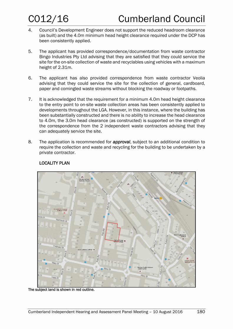
C012/16 Cumberland Council
Cumberland Independent Hearing and Assessment Panel Meeting – 10 August 2016 180
4. Council’s Development Engineer does not support the reduced headroom clearance
(as built) and the 4.0m minimum head height clearance required under the DCP has
been consistently applied.
5. The applicant has provided correspondence/documentation from waste contractor
Bingo Industries Pty Ltd advising that they are satisfied that they could service the
site for the on-site collection of waste and recyclables using vehicles with a maximum
height of 2.31m.
6. The applicant has also provided correspondence from waste contractor Veolia
advising that they could service the site for the collection of general, cardboard,
paper and comingled waste streams without blocking the roadway or footpaths.
7. It is acknowledged that the requirement for a minimum 4.0m head height clearance
to the entry point to on-site waste collection areas has been consistently applied to
developments throughout the LGA. However, in this instance, where the building has
been substantially constructed and there is no ability to increase the head clearance
to 4.0m, the 3.0m head clearance (as constructed) is supported on the strength of
the correspondence from the 2 independent waste contractors advising that they
can adequately service the site.
8. The application is recommended for approval, subject to an additional condition to
require the collection and waste and recycling for the building to be undertaken by a
private contractor.
LOCALITY PLAN
The subject land is shown in red outline.
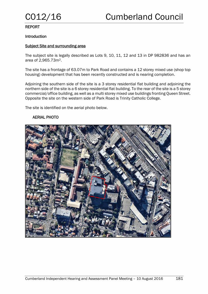
C012/16 Cumberland Council
Cumberland Independent Hearing and Assessment Panel Meeting – 10 August 2016 181
REPORT
Introduction
Subject Site and surrounding area
The subject site is legally described as Lots 9, 10, 11, 12 and 13 in DP 982836 and has an
area of 2,965.73m2.
The site has a frontage of 63.07m to Park Road and contains a 12 storey mixed use (shop top
housing) development that has been recently constructed and is nearing completion.
Adjoining the southern side of the site is a 3 storey residential flat building and adjoining the
northern side of the site is a 6 storey residential flat building. To the rear of the site is a 5 storey
commercial/office building, as well as a multi storey mixed use buildings fronting Queen Street.
Opposite the site on the western side of Park Road is Trinity Catholic College.
The site is identified on the aerial photo below.
AERIAL PHOTO
C012/16 Cumberland Council
Cumberland Independent Hearing and Assessment Panel Meeting – 10 August 2016 182
Description of the proposed modification
Council has received an application under the provisions of Section 96(1A) of the
Environmental Planning and Assessment Act, 1979 seeking to modify conditions 1 and 99
of development consent - DA-150/2014/D as follows:
Amend condition No. 99 to reduce the required head room clearance at the entry
point to the waste collection bay from 4.0m to 3.0m.
Amend condition No. 1 to include reference to additional plans and supporting
documentation submitted with the Section 96(1A) application.
History
The Statement of Environmental Effects that accompanies the application provides a
description of the approval history of the development that is the subject of this report. This is
reproduced below:
On 23 May 2013, Development Application (DA16-2013) was approved for
demolition of existing structures and construction of 8 storey mixed-use strata
building including 98 residential units over ground level commercial premises with
3 levels of basement car parking.
On 24 April 2014, Section 96(2) (DA16/2013/A) was approved to modify basement
layout (B1-B3) and reduce floor height of ground floor.
On 19 September 2014, Development Application (DA-150/2014) was approved
for alterations and additions to approved 8 storey mixed use development including
construction of 4 additional residential levels.
On 21 May 2015, Section 96(2) (DA-150/2014/A) was approved for alterations
and additions, including a reduction in the street setback of levels 8 to 11,
subdividing a top floor apartment into two separate apartments, alteration to
balconies of apartments facing north east across Levels 5 to 11, addition of 3
parking spaces to the development and alterations to building materials and
finishes.
On 17 May 2016, Section 96(2) (DA-150/2014/C) was refused to convert the
previously approved undercover communal space of kid’s playground area and gym
to commercial space (a condition of consent requires that some of this area is
retained for resident use), and combine previously approved 3 commercial units to
1 unit.
The building has now been substantially constructed and is nearing completion. However,
contrary to Condition 99 of the consent that required a minimum head height clearance of
4.0m, the waste and recycling collection bay has been constructed with a door clearance
height of only 3.0m and an overall height of 3.45m. This reduced height means that the
collection vehicles generally used by Council’s waste contractor will not be able to access
the collection area.
C012/16 Cumberland Council
Cumberland Independent Hearing and Assessment Panel Meeting – 10 August 2016 183
Applicants Supporting Statement
The applicant has provided a Statement of Environmental Effects in support of the application,
prepared by Planning Ingenuity Pty Ltd, dated 6 May 2016 and received by Council on 9 May
2016.
Contact with relevant parties
The assessing officer has undertaken a site inspection of the subject site and surrounding
properties, but there has not been a need to contact the applicant during the assessment
process.
Internal Referrals
Development Engineer
The development application was referred to Council’s Development Engineer for
comment who has advised that the proposed modifications cannot be supported. In this
regard, Council has consistently applied the requirement for a minimum head clearance
of 4.0m for waste collection truck access, in accordance with Auburn DCP 2010.
Planning Comments
Section 96(1A) of the Environmental Planning and Assessment Act 1979 Section 96(1A) of the Environmental Planning and Assessment Act 1979 allows Council to
modify a development consent if:-
(a) it is satisfied that the proposed modification is of minimal environmental impact.
The proposed modification is relatively minor in nature and will not result in any significant
environmental impact.
(b) it is satisfied that the development for which the consent as modified relates is
substantially the same development as the development for which consent was
originally granted and before that consent as originally granted was modified (if at
all)
The modification being sought would result in substantially the same development as that
already approved. Accordingly, the modification is considered acceptable in respect of
Section 96(1A) of the Act.
(c) it has notified the application in accordance with:
(i) the regulations, if the regulations so require, or
(ii) a development control plan, if the consent authority is a council that has
made a development control plan that requires the notification or advertising
of applications for modification of a development consent
C012/16 Cumberland Council
Cumberland Independent Hearing and Assessment Panel Meeting – 10 August 2016 184
(d) it has considered any submissions made concerning the proposed modification
within any period prescribed by the regulations or provided by the development
control plan, as the case may be.
In accordance with Council’s Development Control Plan, the proposal was publicly
exhibited for a period of 14 days between 4 July 2016 and 18 July 2016. No submissions
were received.
Other Considerations
In determining an application for modification of consent, Council must also take into
consideration relevant matters referred to in Section 79C(1). These matters have been
considered in the assessment of the Section 96 Application. Following is a discussion of
matters arising in relation to section 79C(1) relevant to the proposed modification.
The provisions of any Environmental Planning Instruments (EP& A Act s79C(1)(a)(i))
State Environmental Planning Policies
The proposed modification is not specifically affected by any relevant State Environmental
Planning Policies.
Regional Environmental Plans
The proposed modification is not specifically affected by any relevant Regional
Environmental Plans.
Local Environmental Plans
Auburn Local Environmental Plan 2010
Zoning
The subject site is zoned B4 Mixed Use under the provisions of Auburn Local
Environmental Plan 2010 (ALEP 2010). The development, as proposed to be modified,
is defined as a shop top housing development and is permissible with Council consent.
The provisions of any Environmental Planning Instruments (EP& A Act s79C(1)(a)(ii))
The proposed modification is not affected by any relevant Draft Environmental Planning
Instruments.
The provisions of any Development Control Plans (EP& A Act s79C(1)(a)(iii))
Auburn Development Control Plan 2010 came into force commensurate with the gazettal
of Auburn LEP 2010 and provides more detailed controls for various types of development
to support the provisions of the LEP.
In relation to the proposed modification, the relevant section of the DCP is the Waste
section that aims to facilitate sustainable waste management and minimisation practices
in accordance with the principles of ecologically sustainable development. One of the
C012/16 Cumberland Council
Cumberland Independent Hearing and Assessment Panel Meeting – 10 August 2016 185
objectives of this part of the DCP is to ensure efficient storage, access, collection of waste
and quality design of facilities. This section of the DCP sets out a range of performance
criteria and development controls in order to achieve the objectives of the DCP.
Section 2.0 of the Waste section of the DCP relates to demolition and construction and
performance criteria P5 requires that…..appropriate vehicular access is provided to enable
the removal of waste materials for reuse, recycling and/or disposal.
Section 4.3 of the Waste section of the DCP relates to the location of waste and recycling
storage facilities for commercial and industrial development (and includes the commercial
component in mixed use developments) and sets out performance criteria and
development controls aimed at ensuring that the location and design of internal waste and
recycling storage facilities can accommodate the waste and recycling service requirements
of a building. In particular, with regards to:
the size of the development and the volume of total waste generated from that
development;
convenient placement of waste storage and recycling areas or garbage and
recycling rooms;
structural capability of the driveway to carry the full load waste and vehicle;
provision for turning circles and three point turn arrangements so that vehicles
enter and leave the site moving in a forward direction;
driveway width and adequate clearance height at entrance ways of garbage
collection vehicles entering the premises;
on-site manoeuvrability for all site users; and
ensuring legality of access by the creation of an easement and private
arrangements for on-site waste collection.
Control D5 of Section 4.3 (reproduced below) specifies the following requirements for
development (including mixed commercial/residential development) that provides
facilities to allow for the on-site collection of waste and recycling:
D5 When collection vehicles are required to enter a building (to collect waste and
recycling), the following access controls apply:
Maximum grade 1 in 20 for first 6 metres from street, then 1 in 8 or 1 in 6.5
with a transition of 1 in 12 for 4 metres at lower end.
Minimum vertical clearance height required is 4.0 metres. (Note:
Clearances must take into account service ducts, pipe works, etc).
Minimum width of driveway required is 3.6 metres.
Minimum radius of the turning circle required is 10.5 metres.
Collection vehicles shall enter and exit in a forward direction.
Collection point for waste shall comply with relevant Australian Standards
for loading bays.
In accordance with dot point 2, Condition 99 of the consent was imposed to ensure that
the required minimum head height clearance to the waste and recycling collection bay was
achieved and was appropriately signposted to prevent delivery trucks from using the
loading bay. Condition 99 read as follows:
99 Waste Collection
C012/16 Cumberland Council
Cumberland Independent Hearing and Assessment Panel Meeting – 10 August 2016 186
The proposed loading bay adjacent to the basement ramp shall be used only for
waste collection. In this regard appropriate signage including head room clearance
(minimum 4.0 metres) shall be provided at the entry point. Prior to issue of the
Occupancy Certificate the Principal Certifying Authority shall ensure that the sign
has been installed.
Reason:- to prevent delivery trucks using the bay via reverse movements.
However, contrary to this condition, the loading bay has been constructed with a door
clearance height of only 3.0m and an overall height of 3.45m. This reduced height means
that the collection vehicles generally used by Council’s waste contractor will not be able to
access the collection area.
In the Statement of Environmental Effects submitted with the application, it is stated that
the reduction in height was due to structural design considerations and while the reduced
height clearance is inconsistent with the approval, in their view, the development remains
capable of being serviced for waste and recycling collection.
In support of this, the applicant has provided documentation from two (2) separate private
waste contractors, Bingo Industries Pty Ltd and Veolia, indicating that they are satisfied
that they could service the site for the on-site collection of waste and recyclables. Included
in the correspondence from Bingo Industries Pty Ltd is a specification sheet for a waste
collection vehicle (Isuzu (Euro 5) Rear Loader 8m3 Collector Series II CS Mini) that has an
overall height of 2.31m and would therefore be accommodated in the reduced 3.0m
access door height. An extract from the Specification sheet is provided below:
Figure 1: Extract showing the dimensions of the Isuzu (Euro 5) Rear Loader 8m3 Collector
Series II CS Mini vehicle.
The application is also accompanied by a loading dock plan (Drawing No. 8342 CCA 303)
prepared by Zhinar Architects that provides two cross sections of the waste and recycling
loading bay (as constructed), showing one occupied by the vehicle used by Bingo Industries
Pty Ltd and the other occupied by a vehicle used by Veolia. Both cross sections
demonstrate that these smaller collection vehicles can be readily accommodated in the
loading bay despite the reduced head height clearance. An extract from the cross sections
is provided below:
C012/16 Cumberland Council
Cumberland Independent Hearing and Assessment Panel Meeting – 10 August 2016 187
Figure 2: Extract showing cross sections of the loading bay occupied by Veolia (top) and Bingo
Industries Pty Ltd (bottom) waste collection vehicles within a 3.0m head height clearance.
Council has consistently applied the DCP requirement for a minimum 4.0m head height
clearance for on-site waste and recycling collection in order to ensure that the collection
areas can accommodate a standard collection vehicle regularly used by Council’s / Council
waste contractors. In this regard, it is noted that the operational/travel height of a ‘typical’
rear loading waste collection vehicle is indicated as being 3.5m in the DECCW’s Better
Practice Guide for Waste Management in Multi-Unit Dwellings. As such, a vehicle of this
size will not be able to use the waste collection loading bay as it has been constructed. As
a consequence, it is unlikely that Council’s waste and recycling service will be able to
service this building.
As construction of the building has been substantially completed, it is not possible to
increase the head clearance in the loading bay. Further, it would be impractical to require
partial demolition of the structure in order to try and achieve the required height clearance.
Therefore, despite Council’s consistent application of the requirement for a 4.0m head
height clearance, on the basis that the applicant has been able to demonstrate that private
waste contractors are able to adequately service the building with the reduced height, the
only practical alternative would be to allow the reduced height clearance in this instance,
subject to the requirement that the building be serviced by a private waste and recycling
contractor. Accordingly, it is recommended that an additional condition be imposed on the
(modified) consent to require the waste and recycling collection for the building to be
undertaken by a private contractor, using collection vehicles no greater in height than 2.5
metres, such as the Isuzu (Euro 5) Rear Loader 8m3 Collector Series II CS Mini, or similar.
To ensure that suitable arrangements for the collection of waste and recyclables is in place
prior to occupation of the building, details of the appointed waste and recycling contractor
would need to be provided to the Principal Certifying Authority prior to issue of the
Occupancy Certificate.
79C(1)(a)(iiia) - any planning agreement that has been entered into under section 93F, or
any draft planning agreement that a developer has offered to enter into under section
93F, and
There is no draft planning agreement associated with the subject Development
Application.
C012/16 Cumberland Council
Cumberland Independent Hearing and Assessment Panel Meeting – 10 August 2016 188
The provisions of the Regulations (EP& A Act s79C(1)(a)(iv))
The proposed development raises no concerns as to the relevant matters arising from the
Environmental Planning & Assessment Regulations 2000.
79C(1)(a)(v) - any coastal zone management plan (within the meaning of the Coastal
Protection Act 1979)
There is no Coastal Zone Management Plan applicable for the Cumberland (formerly
Auburn) area.
The Likely Environmental, Social or Economic Impacts (EP& A Act s79C(1)(b))
It is considered that the proposed modification will have no significant adverse
environmental, social or economic impacts in the locality.
The suitability of the site for the development (EP&A Act s79C(1)(c))
The subject site and locality is not known to be affected by any natural hazards or other
site constraints likely to have a significant adverse impact on the proposed development.
Accordingly, the site can be said to be suitable to accommodate the proposal. The
proposed modification has been assessed in regard it its environmental consequences
and having regard to this assessment, it is considered that the modification is suitable in
the circumstances.
Submissions made in accordance with the Act or Regulation (EP&A Act s79C(1)(d
In accordance with Council’s Development Control Plan, the modification application was
publicly exhibited between 4 July and 18 July 2016. No submissions were received in
respect of the proposed modification.
The public interest (EP& A Act s79C(1)(e))
The public interest is served by permitting the orderly and economic development of land,
in a manner that is sensitive to the surrounding environment and has regard to the
reasonable amenity expectations of surrounding land users.
In view of the foregoing analysis it is considered that the proposed modification will have
no significant adverse impacts on the public interest on the basis that the applicant has
supplied correspondence from 2 independent waste contractors advising that they would
be able to adequately service the site, despite the reduced head clearance for access to
the waste and recycling collection bay.
Auburn City Council Operational Plan / Delivery Program
This assessment and report relates to the Auburn City Council Operational Plan and
Delivery Program, Our Places – Attractive and Liveable theme, action “2a.1.1.3 Assess
development applications, complying development and construction certificates”.
C012/16 Cumberland Council
Cumberland Independent Hearing and Assessment Panel Meeting – 10 August 2016 189
Disclosure of Political Donations and Gifts
The NSW Government introduced The Local Government and Planning Legislation
Amendment (Political Donations) Act 2008 (NSW). This disclosure requirement is for all
members of the public relating to political donations and gifts. The law introduces
disclosure requirements for individuals or entities with a relevant financial interest as part
of the lodgement of various types of development proposals and requests to initiate
environmental planning instruments or development control plans.
The applicant and notification process did not result in any disclosure of Political Donations
and Gifts.
Conclusion
The Section 96(1A) Modification application has been assessed in accordance with the
relevant requirements of the Environmental Planning and Assessment Act 1979, Auburn
Local Environmental Plan 2010 and the Auburn Development Control Plan 2010 and is
considered to be satisfactory for modification.
The development to which the modification application relates is appropriately located
within a B4 Mixed Use zone under the provisions of the Auburn Local Environmental Plan
2000, however a variation in relation to the minimum vertical clearance height of 4.0m for
the waste and recycling collection bay under the requirements of the Waste Section of
Auburn Development Control Plan 2010 is sought.
Having regard to the assessment of the proposed modification from a merit perspective, it
is considered that the proposal modification to the minimum head height clearance to the
waste and recycling collection bay be supported, subject to the building being serviced by
a private waste and recycling contractor, using collection vehicles that can be
accommodated by the reduced head height clearance, as constructed.
For this reason, it is considered that the proposed modification is satisfactory having
regard to the matters of consideration under Section 79C of the Environmental Planning
and Assessment Act, 1979, and the consent may be modified accordingly.
Report Recommendation:
That pursuant to the provisions of Section 96(1A) of the Environmental Planning &
Assessment Act, 1979, application No. DA-150/2014/D to modify conditions 1 and 99
relating to loading bay signage and internal head height clearance on land at 6-14 Park
Road, Auburn be approved and the consent amended in the following manner:
1. By amending Condition 1 to include reference to the following plans:
Ground Floor Plan – Job No. 8342 S96-H:06, Issue H, dated 27 April 2015,
prepared by Zhinar Architects.
Loading Dock – Job No. 8342 CCA 303.
2. By amending Condition 99 (as per underline and strikethrough) as follows:
C012/16 Cumberland Council
Cumberland Independent Hearing and Assessment Panel Meeting – 10 August 2016 190
99 Waste Collection
The proposed loading bay adjacent to the basement ramp shall be used only for
waste collection. In this regard appropriate signage including head room clearance
(minimum 4.0 3.0 metres) shall be provided at the entry point. Prior to issue of the
Occupancy Certificate the Principal Certifying Authority shall ensure that the sign has
been installed.
Reason:- to prevent delivery trucks using the bay via reverse movements.
3. By adding the following condition:
99a Waste Collection Service
All waste and recycling collection for the building is to be undertaken by a private
contractor, using collection vehicles no greater in height than 2.5 metres, such as
the Isuzu (Euro 5) Rear Loader 8m3 Collector Series II CS Mini, or similar.
Details of the appointed waste and recycling contractor are to be provided to the
Principal Certifying Authority prior to issue of the Occupancy Certificate.
ATTACHMENTS
Nil
C013/16 Cumberland Council
Cumberland Independent Hearing and Assessment Panel Meeting – 10 August 2016 191
Planning Proposal for 23-27 Lytton Street Wentworthville
(Northside West Clinic Site) – Post Exhibition Report
Responsible Department: Development, Environment & Infrastructure
Officer: Manager Strategic Planning
File Number: HC-23-08-20
Delivery Program Code: 5.1.1 Oversee the land use planning, design and
compliance framework for managing and facilitating
appropriate development.
9.3.1 Ensure planning and development implements
Environmentally Sustainable Design principles.
Request lodged 31 March 2015
Applicant / Proponent Willowtree Planning on behalf of
Ramsay Health Care (Australia) Ltd
Owner Healthcare Corporation Pty Ltd – a subsidiary of Ramsay Health
Care (Australia) Ltd
Company Details Ramsay Health Care (Australia) Ltd
ABN: 57 001 288 768
Level 8; 154 Pacific Highway, St Leonards 2065
Non Executive Directors
o Michael Siddle (Chairman)
o Peter Evans (Deputy Chairman)
o Tony Clark AM Pat Grier AM
o Rod McGeoch AO
o Kerry Roxburgh
o Patricia Akopiantz
o Margaret Seale
Executive Directors
o Christopher Rex (Managing Director)
o Bruce Soden (Group Finance Director)
Group General Counsel & Company Secretary
o John O’Grady
Description of Land 23-27 Lytton Street, Wentworthville
Lot 1 DP787784
Proposal summary The proposal seeks to amend the land use zoning, maximum
building height and floor space ratio affecting the Site, to enable
the expansion of the existing clinic building and services offered.
Site Area / Description
of existing use
The site is a polygon shape and has an area of 6,687m2. The site
is occupied by the Northside West Clinic, owned and operated by
Ramsay Health Care, and associated ground level car parking.
Existing Zoning and
Planning Controls
Land use zoning
Maximum building height
Floor space ratio (FSR)
R2 Low Density Residential
9m
0.5:1
Proposed Zoning and
Planning Controls
Land use zoning
Maximum building height
Floor space ratio (FSR)
R4 High Density Residential
15m
1:1
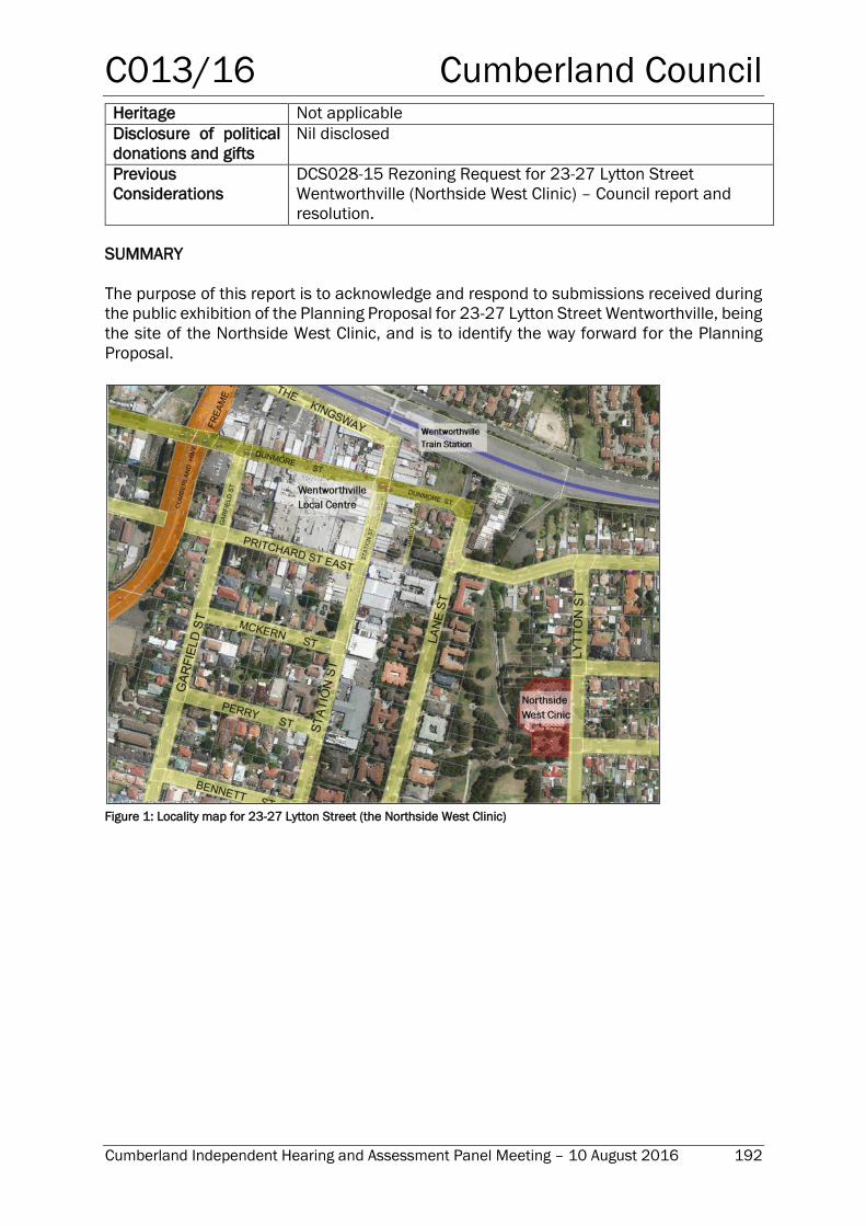
C013/16 Cumberland Council
Cumberland Independent Hearing and Assessment Panel Meeting – 10 August 2016 192
Heritage Not applicable
Disclosure of political
donations and gifts
Nil disclosed
Previous
Considerations
DCS028-15 Rezoning Request for 23-27 Lytton Street
Wentworthville (Northside West Clinic) – Council report and
resolution.
SUMMARY
The purpose of this report is to acknowledge and respond to submissions received during
the public exhibition of the Planning Proposal for 23-27 Lytton Street Wentworthville, being
the site of the Northside West Clinic, and is to identify the way forward for the Planning
Proposal.
Figure 1: Locality map for 23-27 Lytton Street (the Northside West Clinic)
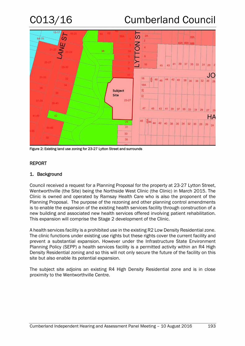
C013/16 Cumberland Council
Cumberland Independent Hearing and Assessment Panel Meeting – 10 August 2016 193
Figure 2: Existing land use zoning for 23-27 Lytton Street and surrounds
REPORT
1. Background
Council received a request for a Planning Proposal for the property at 23-27 Lytton Street,
Wentworthville (the Site) being the Northside West Clinic (the Clinic) in March 2015. The
Clinic is owned and operated by Ramsay Health Care who is also the proponent of the
Planning Proposal. The purpose of the rezoning and other planning control amendments
is to enable the expansion of the existing health services facility through construction of a
new building and associated new health services offered involving patient rehabilitation.
This expansion will comprise the Stage 2 development of the Clinic.
A health services facility is a prohibited use in the existing R2 Low Density Residential zone.
The clinic functions under existing use rights but these rights cover the current facility and
prevent a substantial expansion. However under the Infrastructure State Environment
Planning Policy (SEPP) a health services facility is a permitted activity within an R4 High
Density Residential zoning and so this will not only secure the future of the facility on this
site but also enable its potential expansion.
The subject site adjoins an existing R4 High Density Residential zone and is in close
proximity to the Wentworthville Centre.
C013/16 Cumberland Council
Cumberland Independent Hearing and Assessment Panel Meeting – 10 August 2016 194
2. History
A summary of the history of this planning proposal is provided in the table below:
31 March 2015 Proponent lodges the Planning Proposal request for
23-27 Lytton St Wentworthville with Holroyd City Council
7 July 2015 Report on the Rezoning Request considered by Holroyd City
Council, with resolution to proceed to a Planning Proposal.
30 October 2015 Planning Proposal lodged with Department of Planning &
Environment
29 February 2016 Planning Proposal receives favourable Gateway Determination
(with conditions) and written authorisation for delegation
27 April 2016 to
25 May 2016
Public exhibition of Planning Proposal including supplementary
report.
3. Gateway Determination and Department’s Written Authorisation to Exercise
Delegation
The Planning Proposal was lodged with the Department of Planning & Environment in
October 2015. The Gateway Determination to proceed, with conditions, was made on 29
February 2016.
The conditions of the Gateway Determination were in relation to (i) consultation to be
undertaken with the community and public authorities and (ii) modification of the Planning
Proposal to include further assessments on an alternative zoning of SP2 Infrastructure
and the potential impacts of a residential development (as typical and permitted under an
R4 high density residential zoning), be undertaken. These further assessments were
completed and provided in a supplementary report to the Planning Proposal.
All documentation relevant to the Planning Proposal including the supplementary report
were made available for public exhibition.
With the Gateway Determination the Department also provided the written authorisation
to Council to exercise the functions of the Greater Sydney Commission in respect of this
Planning Proposal for the proposed amendments.
4. Exhibition of Planning Proposal
The public exhibition period for the Planning Proposal commenced on Wednesday 27 April
2016 and concluded at midnight of Wednesday 25 May 2016.
Newspaper advertisements were placed in local papers. An advertisement was placed in
the (then) Holroyd Council Corporate Page of the Parramatta Advertiser newspaper on 27
April and 11 May 2016 and of the Holroyd Sun newspaper of 12 May 2016.
Copies of all the documentation comprising the Planning Proposal were placed in the
Merrylands and Wentworthville libraries and in Customer Service area of the Merrylands
Administration building. The documentation was also made available for download through
the (then) Holroyd City Council website.
C013/16 Cumberland Council
Cumberland Independent Hearing and Assessment Panel Meeting – 10 August 2016 195
As part of the community consultation component of the public exhibition, letter
notifications were sent to adjacent landowners advising of the Planning Proposal, locations
to view the associated documentation, and how to make submissions. Letter notifications,
providing copies of all associated documentation, were also sent those public authorities
as specified in the Gateway Determination advice of the Department of Planning &
Environment.
Written submissions to the Planning Proposal were invited. Submissions could be made
by post, by email, or hand-delivered, with details of these methods provided as part of the
exhibition material.
5. Submissions Received and Response
Public Authority Submissions Received
Submissions were received from four (4) public authorities in response to the letter
notifications issued. Details of these submissions are provided below.
Endeavour Energy
Endeavour Energy had no objection to the Planning Proposal. The following advice was
provided for consideration:
The site is affected by an easement for a padmount substation. There are restrictions
on the installation of services or structures within the easement site and alteration of
the easement level.
The site is affected by overhead power lines to the road frontage.
The Holroyd Zone substation which services the existing clinic has limited spare
capacity. The expansion of the Clinic may require an upgrade to the onsite padmount
substation and associated infrastructure.
Asbestos may be present within Endeavour Energy infrastructure in this area.
Much of this information and further detail as provided in the submission is of greater
relevance to the proponent in preparing the detailed plans and works toward the
Development Application process, and for the information of Council.
Roads & Maritime Services (RMS) within Transport for NSW
RMS did not object to the Planning Proposal or the proposed development. RMS advised
that the proposed development will not have a significant traffic impact on the regional
classified road network.
Transport for NSW
Transport for NSW advised they have reviewed the Planning Proposal documentation and
they do not have any comments on the Planning Proposal.
Sydney Water
Sydney Water did not object to the Planning Proposal.
C013/16 Cumberland Council
Cumberland Independent Hearing and Assessment Panel Meeting – 10 August 2016 196
Sydney Water advised that the proposed development can be serviced from the existing
100mm mains water infrastructure, although upgrade to the mains may be required
depending on the size scale and location of any development.
Sydney Water advised that a 525mm wastewater main within the property boundary is
available for connection and that the proposed development site is traversed by a
wastewater main. Where proposed works are in close proximity to a Sydney Water asset,
the developer may be required to carry out additional works to facilitate the development
and protect that asset. The requirement for such works can be confirmed as the proposal
progresses to more detailed planning and design.
Community Submissions Received
Overview
A total of two (2) written submissions, both objections, were received through the
community consultation component of the exhibition of this Planning Proposal.
The following provides an overview of the specific concerns noted in the submissions,
followed by a response to those concerns.
Category – Truck movements for existing facility operations
Specific concerns:
Trucks arriving at and leaving the facility, utilising the steep angled driveway, in the
early hours of the morning that causes noise disturbance to nearby residences.
Response:
This existing driveway is to the southern side of the clinic building. The driveway
provides access to a carpark and loading zone area that is below the level of the
road. As a result this driveway is angled.
The driveway to the northern side of the existing building connects to a carpark and
loading zone area that is at a similar level as the road.
Another existing driveway at the southern property boundary leading into a carpark
is at a similar level as the road.
This existing driveway and its use are outside the scope of the planning Proposal.
However, Council will raise with the Clinic the concern over the (heavy) vehicle noise
occurring late at night / in the early hours for a response on how to redress this.
Category – Construction Phase – Noise
Specific concerns:
Noise generated as a result of construction related activities, (as anticipated for
Stage 2 based on the experience of the Stage 1 construction), including:
o The building works themselves.
o Workers movements - especially where vehicles are parked on the street and in
front of private residences - in moving themselves and tools/equipment between
their vehicles and the construction site.
Response:
The conditions of consent placed on any approved Development Application can
address and, if required, restrict the hours of construction activities. The standard
hours for construction activities are 7am-6pm Monday to Friday and 8am-1pm on
C013/16 Cumberland Council
Cumberland Independent Hearing and Assessment Panel Meeting – 10 August 2016 197
Saturdays. It is noted that the existing clinic is likely to continue function during the
construction works and so constitutes a ‘sensitive’ land use to construction noise.
Any redevelopment in the area, whether in relation to the Clinic or for dwellings, will
involve construction activities and associated noise that will occur for a limited period
of time – being the duration of the construction phase.
Category– Construction Phase – Traffic movements and street parking
Specific Concerns:
Increased vehicle movements on local streets.
On-street parking by construction workers, compounding existing issue of on-street
parking, in front of private residences (based on the experience of the Stage 1
construction works).
Response:
Councils Traffic Engineering section did not raise any traffic or street parking issues
specific to the construction phase – although a more general issue in relation to on-
street parking in the area was noted in their advice.
The assessment of any lodged Development Application, and associated conditions
imposed, will consider the local traffic and parking requirements during both
construction and operation of the clinic. It is noted that in the construction phase
there will be a nett reduction in on-site parking which will need to be addressed in
any future Development Application documentation.
It is possible that some on-street parking is related to use of the Lytton Street /
Finlayson Creek Park. There is an access path between the Park and Lytton Street
that is located on the southern boundary of the Clinic.
Category – Construction Phase – other issues
Specific concerns:
Blocked / obstructed footpaths.
Increased rubbish in street.
Loitering near the entry to Lytton Street Park, including at night.
Response:
A Development Consent granted to a Development Application can include
conditions to manage impacts of the construction phase of that development. These
conditions can be tailored to address specific concerns such as to keep footpaths
clear and management of waste.
Complaints can be made to Council when issues such as these require attention and
Council can require the property owner to address them accordingly.
There is an access way from Lytton Street into the Lytton Street / Finlayson Creek
Park located at the southern boundary of the Clinic. The Park and its entry are
intended to attract and be enjoyed by people. People are not prevented from using
or pausing in the area. Such activities at night may not be related to the construction
works at the Clinic.
Council can review the existing lighting in the vicinity of this access path, having
regard to the NSW Police Crime Prevention through Environmental Design principles.
Operational Phase – traffic movements, street parking.
Specific concerns:
Existing issues with street parking levels and parking in front of private residences.
Increase in local traffic generally - from Clinic and local growth generally.
C013/16 Cumberland Council
Cumberland Independent Hearing and Assessment Panel Meeting – 10 August 2016 198
Potential increase in street parking – compounding existing on-street parking issues,
including in front of private residences, by those attending the Clinic.
Response
Operation of the facility including trucks attending the facility, and the noise related
issues of these operations, should be addressed as part of the consent conditions
imposed on any approved Development Application.
Detailed plans of the new building, and assessment of these, should consider the
angle of driveways and the vehicle types using these driveways and the times of
access especially by heavy vehicles.
It will be recommended that, as designs of the new building are developed and
assessed at a Development Application stage, that the driveway to the new building
of the Clinic be kept at or close to the grade of the road. The concept design indicates
a slight change in elevation of the driveway.
The conditions of consent for any future facility may include a requirement for the
driveway to the building to be at similar level to that of the road and so avoid an
angled driveway and/or to restrict the hours during which heavy vehicles can attend
the facility during its operation to minimise noise impacts to local residents.
Detailed assessment of potential impacts including as related to traffic will be
undertaken as part of any future development application process. The Traffic Impact
Assessment report lodged with Planning Proposal Request, and the advice of
Councils Traffic Engineers indicates that the new facility could generate up to about
95 vehicle trips during peak hour. While this would be expected to have an impact
on the existing road network and capacity, confirmation of the vehicle trips and local
traffic flows as well as identification of measures to mitigate any identified impacts
will be required from the proponent as part of any future Development Application
process.
On-site car parking in basement levels is proposed as part of the new facility. The
number and layout of those spaces would be confirmed as part of any future
development application. Car parking for staff, patients and visitors would need to
be provided for in accordance with Councils Development Control Plan (DCP) 2013.
It is possible that some on-street parking is related to use of the Finlayson Street
Park area, to which there is an access path on the southern boundary of the Clinic,
and not all due to the Clinics’ operation.
The traffic and parking concerns raised in submissions will be forwarded to Council’s
Engineering Services Department for consideration in future works and plans.
Council may undertake parking surveys to assess the use of off and on street parking
and identify potential response measures.
Category – Operational Phase – Impact on Residential Area
Specific concerns:
Low-density residential area
Demand placed on public transport (crowding) and facilities – resulting from local
population growth through rezoning.
Response:
The area to the south and east of the Clinic remains zoned as R2 Low Density
Residential. There is approximately 15m separation, consisting of open space and
pedestrian path (access to Lytton Street Park), to the property to the south, and
approximately 20m separation, being Lytton Street, to the properties to the east.
C013/16 Cumberland Council
Cumberland Independent Hearing and Assessment Panel Meeting – 10 August 2016 199
The existing higher density zoning to the north (R4 High Density Residential and R3
Medium Density Residential) is to focus increases in population near existing local
centres and public transport options.
The suburb and region is undergoing substantial redevelopment and growth that will
increase population and activity.
With the proposed implementation of the Wentworthville Revitalisation Strategy,
further growth and benefit for local residents is anticipated. Infrastructure upgrades
are proposed within the Strategy to support that growth.
The planning and provision of public transport, in particular train services and bus
services, is the responsibility of State government and generally occurs in
accordance with population increases. Council is in communication with relevant
State agencies regarding population and centres growth.
A health services facility is a permissible use in an R3 Medium Density Residential
and R4 High Density Residential zoned areas under the ISEPP and as such is
considered compatible with these residential areas. Furthermore, as the Clinic is a
relatively low scale facility (in size and patient numbers), has an existing presence on
the site, the type of services proposed in the new building, and the physical
separation, its proximity to the R2 Low Density Residential areas is not considered
incompatible with those residential areas.
Category – Impact on Property Values
Specific concerns:
Potential adverse impact on property value due to expanded facility.
Response:
A number of factors affect property prices and property values, positively and
negatively. No evidence was provided in the submission that the clinic would
detrimentally impact property values in the area.
Property values are not a determining factor in strategic planning merit assessments
and subsequent recommendations.
The implementation of the Wentworthville Centre Revitalisation Strategy is to
reinvigorate the centre, encourage human activity, improve safety and promote
investment. There is the potential for the benefits of this, including increased interest
in the area and so on property values, to flow into the surrounding area.
Review of Planning Proposal
In the review of submissions received and the concerns raised, there is no single or
combination of matters that are not able to be addressed through the design of the new
facility or through the Development Application process, including conditions of consent.
Therefore, there are considered to be insufficient grounds to preclude or change the
proposed (amended) planning controls.
No alternative amendments to planning controls, such as an R3 Medium Density Zone,
lower FSR or building height, have been assessed. The proposed building height of 15m is
needed to meet the determined accommodation space for patients, and to provide for the
roof structures and is reasonable given the adjoining R4 High Density Residential zone
control (to the north). The proposed FSR is related to that building height and the zoning
as well as the intended use.
C013/16 Cumberland Council
Cumberland Independent Hearing and Assessment Panel Meeting – 10 August 2016 200
Although an R3 Medium Density Residential zone is also a prescribed zone within which
Health Services facilities are permitted under the Infrastructure SEPP, changing the
proposed zoning to R3 Medium Density Residential will not mitigate the concerns raised
in submissions, as the current and future expanded use of the site is as a Health Services
facility and not a residential apartment building, and other concerns raised would be
applicable to any construction site. Furthermore a zone of R3 Medium Density Residential
may require review (reduction) of the maximum building height and FSR to keep these
appropriate to the land use zoning; however a lower FSR and Building Height may not
achieve the outcomes sought by Ramsay Health in the new facility and so preclude that
facility. Therefore there is no basis to amend the proposed zoning of the site to R3 Medium
Density Residential, rather there may be basis to deny an R3 Medium Density Residential
zoning for the Site.
6. Conclusion
The public exhibition of the Planning Proposal to amend the planning controls affecting
23-27 Lytton Street Wentworthville concluded on 25 May 2016. Four (4) submissions were
received from Public Authorities (being RMS, Transport for NSW, Endeavour Energy and
Sydney Water) and two (2) submissions were received from members of the community.
No submission from public authorities objected to the Planning Proposal. Both
submissions received from the community objected to the proposed development that
would be enabled by the amendments to planning controls. Some concerns raised in those
objecting submissions are relevant to any construction and redevelopment activity and
others to the proposed facility; all of which can be addressed through any future
Development Application and associated conditions of consent. Some concerns raised
may be related to the use of the Lytton Street Park and associated pathway.
7. Next Steps
With the Gateway Determination, Council received authorisation from the Department of
Planning & Environment to exercise the functions of the Greater Sydney Commission with
respect of implementing the proposed changes to planning controls in relation to the
Planning Proposal for 23-27 Lytton Street Wentworthville (being the Northside West Clinic
site).
Therefore, upon Council endorsement of the recommendations in this report, Council will
finalise the proposed changes in the planning controls for the Site as an amendment to
the Holroyd LEP 2013.
Report Recommendation:
That the Cumberland Independent Hearing and Assessment Panel (CIHAP):
1. Receive and note the report and outcomes of the community consultation.
2. Note Council’s compliance with the conditions of the Department of Planning and
Environment’s Gateway Determination issued (with delegations) for this Planning
Proposal in accordance with section 56(2) of the Environmental Planning and
Assessment Act 1979.
C013/16 Cumberland Council
Cumberland Independent Hearing and Assessment Panel Meeting – 10 August 2016 201
3. Recommend approval to proceed with the amendments to the controls affecting
23-27 Lytton Street Wentworthville, as nominated in the Planning Proposal. That is,
to amend the planning controls to:
a. Zoning of R4 High Density Residential.
b. Maximum building height of 15m.
c. Floor Space Ratio (FSR) of 1:1.
4. Recommend that this Planning Proposal, with the proposed planning controls as
listed in Recommendation 3, be reported to Council seeking a resolution to forward
it to the Department of Planning & Environment for finalisation.
5. Recommend that the concerns raised in the community submissions are passed to
the relevant departments within Council for action or for consideration in the
Development Application process (whichever is appropriate).
ATTACHMENTS
Nil

Cumberland Council
Cumberland Independent Hearing and Assessment Panel Meeting – 10 August 2016 202
{THIS PAGE INTENTIONALLY LEFT BLANK}
C014/16 Cumberland Council
Cumberland Independent Hearing and Assessment Panel Meeting – 10 August 2016 203
Planning Proposal for 11-19 Centenary Road Merrylands (St
Vincent de Paul Site) - Post Exhibition Report
Responsible Department: Development, Environment & Infrastructure
Officer: Director of Development, Environment & Infrastructure
File Number: HC-23-08-25
Delivery Program Code: 5.1.1 Oversee the land use planning, design and
compliance framework for managing and facilitating
appropriate development.
8.1.1 Oversee and implement Council’s Residential
Development Strategy and appropriate housing
opportunities through land use planning.
8.2.1 Ensure housing growth is focused around centres
and planning controls do not compromise housing
affordability.
9.3.1 Ensure planning and development implements
Environmentally Sustainable Design principles.
Application lodged 29 June 2015
Applicant / Proponent Wakefield Planning on behalf of
St Vincent De Paul Society Trust NSW
Owner St Vincent De Paul Society Trust NSW
Company Details St Vincent de Paul Society Trust NSW – Parramatta Diocesan
Central Council
ABN: 91 161 127 340
73-75 Dunmore Street, Wentworthville NSW 2145
PO Box 573, Wentworthville NSW 2145
Ph (02) 8861 9700
The list of Responsible Persons for the organisation was
previously provided under Councillor Memo 010/2016
Description of Land 11-19 Centenary Road Merrylands
15 Wyreema Street Merrylands
Lot 2 DP597975
Lot 1 DP597975
Lot 19 DP2020
Lot 20 DP2020
Lot 21 DP2020
Lot 22 DP2020
Lot 23 DP2020
Lot 24 DP2020
Proposal summary Seeks to amend the land use zoning, maximum building height
and floor space ratio for the site to enable redevelopment for a
4-storey residential apartment building with basement parking.
Site Area / Description of
existing use
The subject site is at the end of a block with street frontage on
three (3) sides and has an area of approximately 4,298m2.
The site is currently occupied by the St Vincent de Paul Society
with a warehouse for sorting and storage of goods and
associated sales, and a single storey house that is used for office
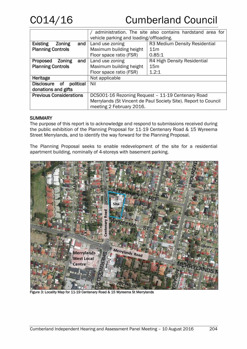
C014/16 Cumberland Council
Cumberland Independent Hearing and Assessment Panel Meeting – 10 August 2016 204
/ administration. The site also contains hardstand area for
vehicle parking and loading/offloading.
Existing Zoning and
Planning Controls
Land use zoning
Maximum building height
Floor space ratio (FSR)
R3 Medium Density Residential
11m
0.85:1
Proposed Zoning and
Planning Controls
Land use zoning
Maximum building height
Floor space ratio (FSR)
R4 High Density Residential
15m
1.2:1
Heritage Not applicable
Disclosure of political
donations and gifts
Nil
Previous Considerations DCS001-16 Rezoning Request – 11-19 Centenary Road
Merrylands (St Vincent de Paul Society Site). Report to Council
meeting 2 February 2016.
SUMMARY
The purpose of this report is to acknowledge and respond to submissions received during
the public exhibition of the Planning Proposal for 11-19 Centenary Road & 15 Wyreema
Street Merrylands, and to identify the way forward for the Planning Proposal.
The Planning Proposal seeks to enable redevelopment of the site for a residential
apartment building, nominally of 4-storeys with basement parking.
Figure 3: Locality Map for 11-19 Centenary Road & 15 Wyreema St Merrylands
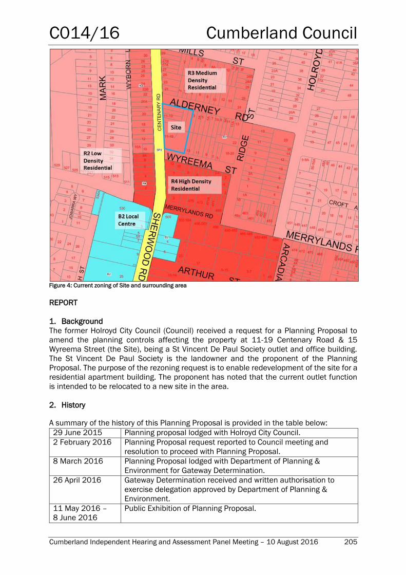
C014/16 Cumberland Council
Cumberland Independent Hearing and Assessment Panel Meeting – 10 August 2016 205
Figure 4: Current zoning of Site and surrounding area
REPORT
1. Background
The former Holroyd City Council (Council) received a request for a Planning Proposal to
amend the planning controls affecting the property at 11-19 Centenary Road & 15
Wyreema Street (the Site), being a St Vincent De Paul Society outlet and office building.
The St Vincent De Paul Society is the landowner and the proponent of the Planning
Proposal. The purpose of the rezoning request is to enable redevelopment of the site for a
residential apartment building. The proponent has noted that the current outlet function
is intended to be relocated to a new site in the area.
2. History
A summary of the history of this Planning Proposal is provided in the table below:
29 June 2015 Planning proposal lodged with Holroyd City Council.
2 February 2016 Planning Proposal request reported to Council meeting and
resolution to proceed with Planning Proposal.
8 March 2016 Planning Proposal lodged with Department of Planning &
Environment for Gateway Determination.
26 April 2016 Gateway Determination received and written authorisation to
exercise delegation approved by Department of Planning &
Environment.
11 May 2016 –
8 June 2016
Public Exhibition of Planning Proposal.
C014/16 Cumberland Council
Cumberland Independent Hearing and Assessment Panel Meeting – 10 August 2016 206
3. Gateway Determination and Department’s Written Authorisation to Exercise
Delegation
The Planning Proposal was lodged with the Department of Planning & Environment in
March 2016. The Gateway Determination to proceed, with conditions, was made in April
2016. The conditions of the Gateway Determination were in relation to the consultation to
be undertaken with the community and the specified public authorities as part of the public
exhibition of the Planning Proposal.
With the Gateway Determination the Department also provided the written authorisation
to Council to exercise the functions of the Greater Sydney Commission in respect of this
Planning Proposal for the proposed amendments.
4. Exhibition of Planning Proposal
The public exhibition period for the Planning Proposal commenced on Wednesday 11 May
2016 and concluded at midnight of Wednesday 8 June 2016.
Newspaper advertisements were placed in local papers. An advertisement was placed in
the (then) Holroyd Council Corporate Page of the Parramatta Advertiser newspaper on 18
May and 25 May 2016 and of the Holroyd Sun newspaper of 12 May 2016.
Copies of all the documentation comprising the Planning Proposal were placed in the
Holroyd and Wentworthville libraries and in the Customer Service area of the Holroyd
Council Administration building. The documentation was also made available for download
through the (then) Holroyd City Council website.
As part of the community consultation component of the public exhibition, letter
notifications were sent to adjacent landowners advising of the Planning Proposal, locations
to view the associated documentation, and how to make submissions. Letter notifications,
providing copies of all associated documentation, were also sent those public authorities
as specified in the Gateway Determination advice of the Department of Planning &
Environment. These specified public authorities were Roads and Maritime Services (RMS)
and Sydney Water.
Written submissions to the Planning Proposal were invited. Submissions could be made
by post, by email, or hand-delivered, with details of these methods provided as part of the
exhibition material.
5. Submissions Received and Response
Public Authority Submissions Received
Submissions were received from two (2) public authorities in response to the letter
notifications issued. Details of these submissions are provided below.
Sydney Water
Sydney Water did not object to the Planning Proposal.
Sydney Water advised that the potable water main available for connection to the Site is
the 150mm main on the western side of Centenary Road.
C014/16 Cumberland Council
Cumberland Independent Hearing and Assessment Panel Meeting – 10 August 2016 207
They advised that the wastewater main traversing through the site is also available for
connection. Where proposed works are in close proximity to a Sydney Water asset the
developer may be required to carry out additional works to facilitate the development and
protect that asset. Subject to the scope of development, servicing options may involve
adjustment/deviation and or compliance with the guidelines for building over / adjacent
to Sydney water assets.
Further advice can be provided as part of later detailed application and design processes.
Roads and Maritime Services (RMS)
RMS did not object to the Planning Proposal subject to all vehicular access to the site being
via Wyreema Street only, as Centenary Road forms part of the Liverpool to Parramatta
Transitway and vehicular conflict on this route should be minimised as far as possible. It
is noted that the Planning Proposal request documentation allows for this limitation, with
access proposed via Wyreema Street and/or Alderney Road.
RMS also stated that Council should give consideration to the cumulative traffic impact of
current and future traffic generating development proposals within this precinct on the
existing signalised intersection of Centenary Road and Merrylands Road (non-classified
regional roads under the care and control of Council) which is currently at capacity. In this
regard, Council should consider investigating the feasibility of improvements to this
existing signalised intersection to accommodate the additional demand and appropriate
funding mechanism.
The RMS advice has to been forwarded to Councils’ Engineering section for consideration
and action as appropriate. The Holroyd Development Control Plan (DCP) 2013 identifies
the future widening of Merrylands Road at this intersection. It is noted that the traffic study
undertaken during the Medium Density Zoning Review in 2014 identified that the
Centenary Road / Merrylands Road intersection was at capacity and recommended
improvements which would be included in the Section 94 Capital Works program review.
Works on the intersection itself could not be attributed to localised growth and so would
need to be funded by Council and RMS.
Community Submissions Received
Overview
One (1) written submission was received through the community consultation component
of the public exhibition of this Planning Proposal.
This submission objected to, and outlines the authors’ concerns in respect of, two current
residential proposals, being this Planning Proposal and a current Development Application
(DA) for 5-7 Centenary Road & 10-12 Wyreema Street Merrylands. The location of this DA
is immediately south of this Planning Proposal Site. The DA is for a 5-storey residential
apartment building comprising 36 units and two (2) levels basement car parking. This DA
was lodged with Council in May 2016 and is under assessment.
The concerns within the submission specific to this DA will be considered in the separate
assessment of that DA. The concerns in relation to the Planning Proposal and the Council
response are provided below.
C014/16 Cumberland Council
Cumberland Independent Hearing and Assessment Panel Meeting – 10 August 2016 208
The submission refers to three buildings, of which one is identified as being on the corner
of Centenary Road / Merrylands Road. It is presumed that (2) two of these buildings are
within the sites of the Planning Proposal and previously mentioned DA. The third building
may be referring to another earlier DA, for 3 Centenary Road & 479 Merrylands Road. That
DA, for a (part) 4-storey and (part) 6-storey residential apartment building containing 36
units with basement car parking, was conditionally approved in May 2016. Alternatively,
the third building may be referring to a separate DA for the construction of a 5-storey
apartment building containing 36 units for the site at 4-6 Centenary Road, was approved
in September 2015 and works for that development have commenced. This development
is located diagonally opposite the subject Site.
The three (3) above sites with development approved or under assessment have FSRs of
1.8:1 or 2.0:1.
A map identifying these four (4) sites is provided below for context (Figure 5), with the Site
of the Planning Proposal being the larger and bound by Alderney Road, Centenary Road
and Wyreema Street. The three (3) sites of the DAs are located to the immediate south
(bound in green and in yellow) and diagonally opposite (to the south-west) (bound in blue).
The proposal is for a lower FSR and therefore density of development than the sites to the
south. The combined area of the two DA sites to the immediate south (being at 3 Centenary
Road and5-7 Centenary Road) is approximately 2,788 m2, and is to support 72 units. The
site of the Planning Proposal has an area of about 4,298m2 and at 1.2:1 FSR would
support an estimated 48-58 units. Therefore the site of the Planning Proposal will be less
densely built than the sites of those developments to the immediate south.
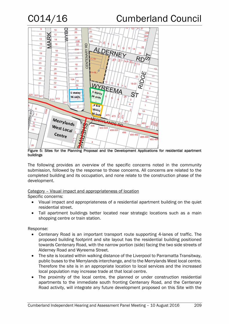
C014/16 Cumberland Council
Cumberland Independent Hearing and Assessment Panel Meeting – 10 August 2016 209
Figure 5: Sites for the Planning Proposal and the Development Applications for residential apartment
buildings
The following provides an overview of the specific concerns noted in the community
submission, followed by the response to those concerns. All concerns are related to the
completed building and its occupation, and none relate to the construction phase of the
development.
Category – Visual impact and appropriateness of location
Specific concerns:
Visual impact and appropriateness of a residential apartment building on the quiet
residential street.
Tall apartment buildings better located near strategic locations such as a main
shopping centre or train station.
Response:
Centenary Road is an important transport route supporting 4-lanes of traffic. The
proposed building footprint and site layout has the residential building positioned
towards Centenary Road, with the narrow portion (side) facing the two side streets of
Alderney Road and Wyreema Street.
The site is located within walking distance of the Liverpool to Parramatta Transitway,
public buses to the Merrylands interchange, and to the Merrylands West local centre.
Therefore the site is in an appropriate location to local services and the increased
local population may increase trade at that local centre.
The proximity of the local centre, the planned or under construction residential
apartments to the immediate south fronting Centenary Road, and the Centenary
Road activity, will integrate any future development proposed on this Site with the
C014/16 Cumberland Council
Cumberland Independent Hearing and Assessment Panel Meeting – 10 August 2016 210
growing centre i.e. this development would not be an ‘island’ surrounded by low
density development.
The proposal contains a maximum height of buildings control of 15m (4 storeys). This
is a relatively modest building height and will provide a height transition between the
greater building heights to the south to the Local Centre and the R3 Medium Density
Residential development to the east and north of the Site (noting this is at present
predominantly developed as low density residential, with future redevelopment
possible at higher densities).
The topography of the site slopes downwards from east to west; therefore perception
of building height looking from the east towards Centenary Road can be mitigated.
Any future DA will provide further details of the visual appearance, setbacks, finish,
landscaping and other appearance and amenity related aspects of the building and
its surroundings. Such details of the development will need to be in compliance of
the Holroyd Development Control Plan (DCP 2013), against which any application will
be assessed.
Any future DA will also be assessed against the State Government’s State
Environmental Planning Policy 65 (SEPP65) Design Quality of Residential Apartment
Development, including the Design Quality Principles, and the associated Apartment
Design Guide.
Any development consent granted to a DA can impose conditions to manage and
mitigate potential impacts of a development to neighbouring properties.
Category – Traffic levels.
Specific concerns:
Cumulative impact to existing high traffic levels and congestion on Sherwood /
Centenary Roads and Merrylands Road.
Response
At this location both Centenary Road and Merrylands Road are identified as non-
classified Regional Roads by RMS. As such they provide important road network
connections between the main arterial network and local roads. It is expected that
these two roads shall continue to support significant and increasing traffic loads.
Council works in conjunction with RMS to manage and upgrade Regional Roads.
Further assessment of the potential impact of a residential apartment building on
this Site will be undertaken on receipt of any future DA documentation including
the anticipated contribution to traffic loads.
RMS provided comments to Council on this Planning Proposal that recognises the
existing traffic pressures and the cumulative effect of further development affecting
the Centenary Road / Merrylands Road intersection. The future widening of
Merrylands Road at this intersection is planned for within the Holroyd DCP 2013.
Category – Modification of proposed development
Specific concerns:
The submission requests modification of the proposed development to a 3-storey
building, with balconies only permitted for units facing Centenary Road to avoid
concerns over privacy.
Response:
The Holroyd DCP 2013 and the State legislative planning instrument SEPP 65 Design
Quality of Residential Apartment Development and associated Apartment Design
C014/16 Cumberland Council
Cumberland Independent Hearing and Assessment Panel Meeting – 10 August 2016 211
Guide provide the minimum requirements for building design and quality including in
relation to balconies, building setbacks and landscaping in order to protect and
maintain residential amenity. Detailed assessment of formal plans for a specific
development submitted as part of any future DA will consider issues such as privacy
for adjacent lots, and the visual appearance / impact of the building. This
assessment will be made with regard to the Holroyd DCP 2013 and SEPP 65.
Conditions may be imposed as part of any development consent in order to mitigate
any negative impacts and to improve amenity outcomes.
The Planning Proposal and earlier Council Report on the Planning Proposal Request
identified the merits in amending the controls as proposed for a 15m maximum
building height. These merits were:
o Provides a clear transition between (i) the R4 High Density residential land
having a maximum building height of 15m and 21m to the south (beyond
Wyreema St) to
(ii) the R3 Medium Density Residential land with maximum building heights of
9m to the east and north.
o Appropriateness for higher density housing given the site faces the major
transport route of Centenary Road and its intersection with Merrylands Road.
o Walking distance to public transport (Liverpool to Parramatta Transitway, bus
services on Merrylands Road connecting to the Merrylands Interchange) and the
Merrylands West local centre.
o The topography of the site slopes downwards from east to west. As a building
height is taken from the ground level, the perception of building height on the
Site looking from the east towards Centenary Road could be mitigated by the
lower topography.
There are three (3) major residential apartment building developments in progress
(at different stages) to the immediate south and diagonally south-west of this Site.
Those developments are for 4- to 6-storey buildings but at a higher FSR. Therefore
these developments, although each supporting a lower number of dwellings in total,
will be contained on a smaller site and so the building would be expected to have a
greater visual presence than the development proposed on the subject Site.
Issues in relation to a 3-storey height limit for the Site are:
o There will be a reduced dwelling yield from the 48 dwellings indicated under the
current proposal.
o The visual transition between the local centre and Merrylands Road / Centenary
Road intersection and to the residential areas to the north and east may not be
as distinct, particularly if those residential areas redevelop in accordance with
the current controls.
A 4-storey, 15m maximum building height, residential building is modest structure
and not considered a tall building in the current and planned context near the local
centre and
T-way station.
The proposed development is compatible with the development that is in progress
and proposed on that section of Centenary Road between the site and Merrylands
Road.
Review of Planning Proposal
The amendments to controls per the Planning Proposal were considered in view of the
submission received and the points made in the response to that submission.
C014/16 Cumberland Council
Cumberland Independent Hearing and Assessment Panel Meeting – 10 August 2016 212
The community submission had two parts, being (i) to restrict balconies to those
apartments facing Centenary Road and (ii) to restrict the building height to 3-storeys, which
would have a corresponding maximum building height control of 12.5m. However, the
privacy concerns underlying this suggestion can be addressed through building design.
Restriction of the building height to 3-storeys may have negative implications for the
development and the immediate area as outlined above.
This Site is considered appropriate for a 4-storey apartment building at 15m (maximum
building height) given the site faces the major traffic route of Centenary Road, the nearby
higher residential apartment building developments (proposed or under construction)
being of greater density, and the proximity of the local centre and public transport services.
This Site will also extend the transition between the higher development potential of the
Centenary Road / Merrylands Road intersection and Merrylands West Local Centre to the
adjacent lower density residential areas to the north and east of the Site. Perception of
bulk or size of the development is tempered by the lower FSR (compared to the nearby
residential apartment development), by the topography, and the implementation of design
quality requirements of the Holroyd DCP 2013 and SEPP 65.
Therefore, the Planning Proposal nominated amendments to the controls for the Site,
being to amend the land use zoning to R4 High Density Residential, FSR of 1.2:1 and
maximum building height of 15m, are recommended for adoption.
6. Conclusion
The public exhibition of the Planning Proposal to amend the planning controls affecting
11-19 Centenary Road & 15 Wyreema Street Merrylands concluded on 8 June 2016. Two
(2) submissions were received from Public Authorities and one (1) submission of objection
was received from the community which also suggested an alternative development
scenario.
The consideration of the community submission prompted the review of the amendments
proposed in the Planning Proposal. It is determined that there is insufficient merit to the
alternative development scenario, and that the best outcome can be achieved by retaining
the amendments as per the Planning Proposal and the application of the Holroyd DCP
2013 and SEPP 65.
7. Next Steps
With the Gateway Determination, Council received authorisation from the Department of
Planning & Environment to exercise the functions of the Greater Sydney Commission with
respect of implementing the proposed changes to planning controls in relation to the
Planning Proposal for 11-19 Centenary Road & 15 Wyreema Street Merrylands.
Therefore, upon a favourable Council resolution of the report recommendations, Council
will finalise the proposed planning controls changes for the Site as an amendment to the
Holroyd LEP 2013.
C014/16 Cumberland Council
Cumberland Independent Hearing and Assessment Panel Meeting – 10 August 2016 213
Report Recommendation:
That the Cumberland Independent Hearing and Assessment Panel (CIHAP):
1. Receive and note the report and outcomes of the community consultation.
2. Note Council’s compliance with the conditions of the Department of Planning and
Environment’s Gateway Determination issued (with delegations) for this Planning
Proposal in accordance with section 56(2) of the Environmental Planning and
Assessment Act 1979.
3. Recommend proceeding with the amendments to the controls affecting 11-19
Centenary Road & 15 Wyreema Street Merrylands, as nominated in the Planning
Proposal. That is, to amend the planning controls to:
a. Land use zoning of R4 High Density Residential.
b. Maximum building height of 15m.
c. Floor Space Ratio (FSR) of 1.2:1.
4. Recommend that this Planning Proposal, with the proposed planning controls as
listed in Recommendation 3, be reported to Council seeking a resolution to forward
it to the Department of Planning & Environment for finalisation.
ATTACHMENTS
Nil
Cumberland Council
Cumberland Independent Hearing and Assessment Panel Meeting – 10 August 2016 214
{THIS PAGE INTENTIONALLY LEFT BLANK}
C015/16 Cumberland Council
Cumberland Independent Hearing and Assessment Panel Meeting – 10 August 2016 215
Planning Proposal Request for 37-39 Pavesi Street,
Smithfield
Responsible Department: Development, Environment & Infrastructure
Officer: Heidi Bischof
File Number: HC-23-08-31
Delivery Program Code: 5.1.1 Oversee the land use planning, design and
compliance framework for managing and facilitating
appropriate development
8.1.1 Oversee and implement Council’s Residential
Development Strategy and appropriate housing
opportunities through land use planning
8.2.1 Ensure housing growth is focused around
centres and planning controls do not compromise
housing affordability
Application lodged 4 March 2016
Proponent Landcorp Australia Pty Ltd
Owner Merinos Investments Pty Ltd
Description of Land 37-39 Pavesi Street, Smithfield
Lot 36 DP 10958
Proposal Rezoning of the site from IN2 Light Industrial to R2 Low
Density Residential to facilitate multiple semi-detached/dual
occupancy development
Site Area 8,103m2
Zoning IN2 Light Industrial
Heritage Adjacent to heritage item
Disclosure of political
donations and gifts
Nil disclosure
Previous Considerations Nil
SUMMARY
A request to prepare a Planning Proposal for 37-39 Pavesi Street, Smithfield was
submitted to Council on 4 March 2016.
The proponent is requesting to rezone the site from IN2 Light Industrial to R2 Low Density
Residential to facilitate dual occupancy development. A 9m building height, 0.5:1 FSR and
410m2 minimum lot size are also sought.
The purpose of this report is to provide a strategic merit assessment of the proposal, to
establish whether it should proceed to Gateway. On the basis of the assessment it is
recommended that Council proceed with the planning proposal subject to modifications to
the proposed minimum lot size and proposed concept & road design.
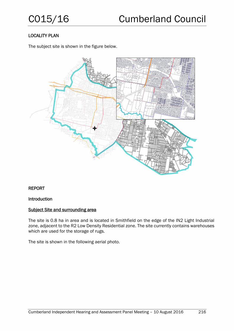
C015/16 Cumberland Council
Cumberland Independent Hearing and Assessment Panel Meeting – 10 August 2016 216
LOCALITY PLAN
The subject site is shown in the figure below.
REPORT
Introduction
Subject Site and surrounding area
The site is 0.8 ha in area and is located in Smithfield on the edge of the IN2 Light Industrial
zone, adjacent to the R2 Low Density Residential zone. The site currently contains warehouses
which are used for the storage of rugs.
The site is shown in the following aerial photo.
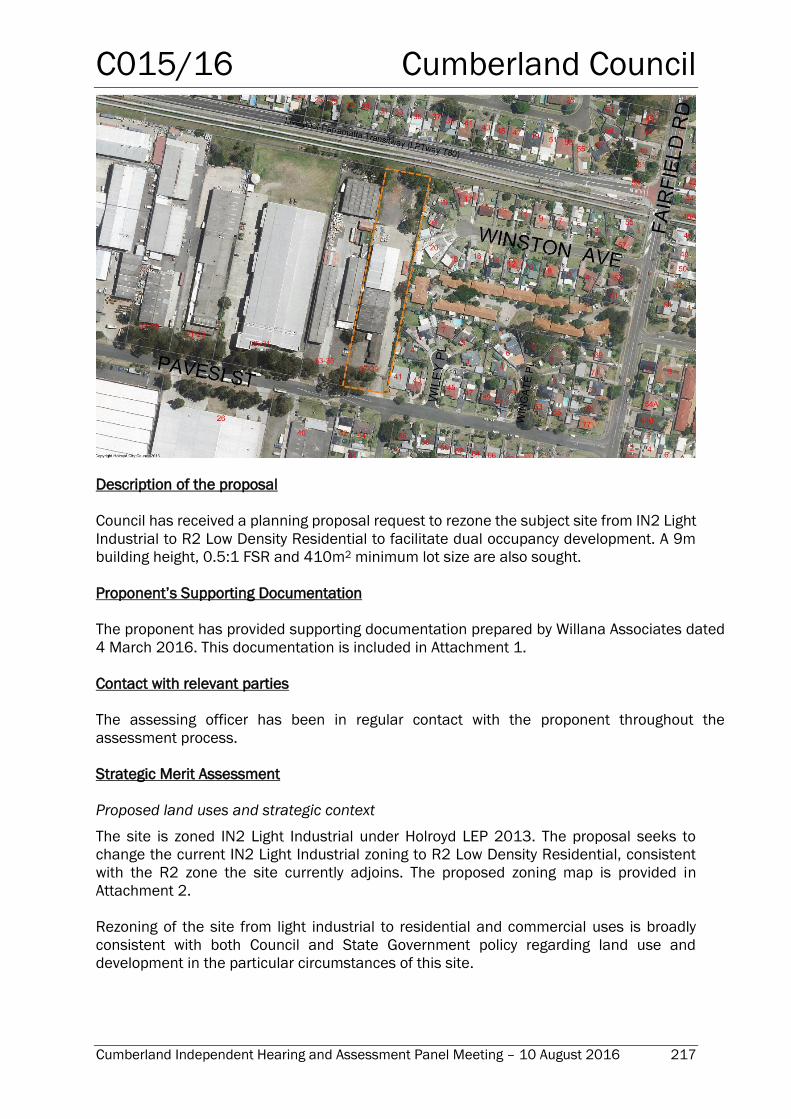
C015/16 Cumberland Council
Cumberland Independent Hearing and Assessment Panel Meeting – 10 August 2016 217
Description of the proposal
Council has received a planning proposal request to rezone the subject site from IN2 Light
Industrial to R2 Low Density Residential to facilitate dual occupancy development. A 9m
building height, 0.5:1 FSR and 410m2 minimum lot size are also sought.
Proponent’s Supporting Documentation
The proponent has provided supporting documentation prepared by Willana Associates dated
4 March 2016. This documentation is included in Attachment 1.
Contact with relevant parties
The assessing officer has been in regular contact with the proponent throughout the
assessment process.
Strategic Merit Assessment
Proposed land uses and strategic context
The site is zoned IN2 Light Industrial under Holroyd LEP 2013. The proposal seeks to
change the current IN2 Light Industrial zoning to R2 Low Density Residential, consistent
with the R2 zone the site currently adjoins. The proposed zoning map is provided in
Attachment 2.
Rezoning of the site from light industrial to residential and commercial uses is broadly
consistent with both Council and State Government policy regarding land use and
development in the particular circumstances of this site.
C015/16 Cumberland Council
Cumberland Independent Hearing and Assessment Panel Meeting – 10 August 2016 218
The proposal would result in the creation of approximately 22 new residential dwellings on
11 lots, according to the accompanying concept plan.
The proposal also includes the following amendments to planning controls under Holroyd
LEP 2013:
Amending the HLEP 2013 Floor Space Ratio Map FSR_006 to include the Site as
having a maximum floor space ratio of 0.5:1
Amending the HLEP 2013 Height of Building Map HOB 006 to identify the Site as
having a maximum height of building of 9m
Amending the HLEP 2013 Lot Size Map LSZ 006 to change the minimum lot size
from 1200m² to 410m²
The proposed FSR and building height are consistent with those for the R2 Low Density
Residential zone. However, a minimum lot size of 410m2 would be inconsistent with the
minimum lot size for the R2 zone under Holroyd LEP 2013, which is 450m2. It would also
be inconsistent with the controls of Holroyd DCP 2013, which indicates a minimum lot size
for attached dual occupancy development of 500m2 for the R2 zone and 450m2 for the
R3 zone.
The proposal states that lots would be 450m2 (each to be subdivided into 2 x 225m2 lots),
which satisfies the requirements of Part B, Clause 3.1 C2 of Holroyd DCP 2013 that would
normally apply to the R3 Medium Density Residential zone. Council’s earlier advice to the
proponent indicated that the minimum lot size for the R3 zone would be acceptable for
this site as it would allow for development of a comparable density to the R2 zone of 25
dwellings per hectare (gross density), albeit at the upper end of what would be considered
‘low density’. It should be noted however, that the site is in relatively close proximity to the
Liverpool-Parramatta Transitway, and therefore could theoretically accommodate a slightly
higher (medium-low) density of development.
Built form and density
Each Torrens title lot would have a minimum area of 225m2 (i.e. 450m2 prior to
subdivision). This is consistent with an overall net density of 25 dwellings per hectare.
While the Planning Proposal Report claims that this is consistent with an overall net density
of 25 dwellings per hectare, the proposal would allow for 22 dwellings within the subject
site, which equates to 27 dwellings per hectare.
Development Control Plan
The proponent submitted a draft site-specific DCP in support of the proposal. This has been
assessed by Council’s Development Services section and the following comments are
provided.
The majority of proposed DCP controls are identical to or essentially the same as
existing controls included in Holroyd DCP 2013 and are not necessary to effect the
residential development of the land.
Control no. 4 proposes a minimum lot size of 410m2. However, the rationale for a
site specific minimum lot size of 410 m2 is unclear. If this is to allow for the apparent
smaller size of two of the 11 lots, then this is an indication that the proposed density
C015/16 Cumberland Council
Cumberland Independent Hearing and Assessment Panel Meeting – 10 August 2016 219
of the site is too high and needs to be reduced. If a low density is considered
appropriate for this site, the prescribed minimum lot size should be 450m2 and the
existing Holroyd DCP residential controls can be readily applied. If a variation to the
minimum lot size is sought this could be considered on merit pursuant to a Clause
4.6 request to vary the standard under Holroyd LEP 2013.
The proposed lot layout would be subject to a detailed merit assessment at DA
stage. This can include indicative building massing at the subdivision stage to
demonstrate adequate solar access opportunities.
Applying conventional subdivision design principles, the proposed lot layout with a
slight NE-SW orientation is unlikely to maximise solar access opportunities and as
such, should not be supported as a preferred or indicative lot layout.
In the absence of a proposed public road Community title subdivision is considered
to be the only option for the site.
In summary, Council does not support the proposed minimum lot size of 410m2 nor the
proposed subdivision plan. Following any rezoning of the subject site, a revised subdivision
plan would need to be prepared and submitted at DA stage in accordance with the controls
of Holroyd DCP 2013. As such, it is considered that a site-specific DCP is not warranted for
this site.
Social Impact Assessment
The proposal includes a comprehensive review of the development’s consistency with
planning strategies and its potential impact on a range of relevant factors, including local
amenity (noise, construction impacts), community identity and connectedness, crime and
safety, economic benefits, impacts on cultural values and local facilities, health and social
equity.
The proposal identifies a number of major positive impacts, including:
Provision of needed housing consistent with the housing targets established in the West
Central Sub-region section of the metropolitan strategy
Provision of needed housing for the current/future employees in the West Central Sub-
Region
Improved housing affordability consistent with the need for more affordable housing in
the Region
Improved safety in the locale from the additional passive surveillance provided by new
residents
Short term employment generation (for trades businesses during construction) and on-
going benefits to local businesses from the spending of new residents
Potential for enhanced active and passive recreation due to the proximity of Tom Uren
Park
Only minor negative social impacts are identified in the proposal, including minor
residential amenity impacts during construction and traffic impacts.
It is agreed that, in terms of housing, employment, social cohesion and enhanced use of
local infrastructure, the proposal’s social impacts will be mainly positive.
C015/16 Cumberland Council
Cumberland Independent Hearing and Assessment Panel Meeting – 10 August 2016 220
Economic Impact Assessment
An Economic Impact Assessment report in support of the proposal was prepared for the
proponent by Colliers International. The report indicates that the rezoning of the subject
site would have a minor impact on the supply of employment land in the West Central
region, the Cumberland Council and even the Smithfield Industrial Precinct, with the
subject site representing less than 0.1% of the total employment land within the Holroyd
LGA and just 0.0148% of stock in the West Central region (i.e. developed and undeveloped
zoned employment land stock). Additionally, while it is contiguous to the successful
Smithfield Industrial Precinct, the subject site’s relevance as an industrial concern has
been permanently undermined, owing to site-specific constraints. A traffic control device
positioned immediately to the west of the subject site has restricted access to the site for
larger commercial vehicles. Direct access to the Cumberland Highway, which is a major
north-south arterial road and the main connector to the Sydney Orbital Road System from
Smithfield, from the site has been severed. Given that the majority of industrial-based
operations require a large commercial vehicle, the usefulness of the subject site from an
industrial perspective has been considerably reduced.
As a result, access to the site is obtained via an indirect route, using ‘local’ roads which
are not entirely suitable for large vehicles – via Fairfield Road (from Woodpark Road) or via
Sturt Street, McCredie Road and then Fairfield Road. Compared to adjoining properties,
the connection between Cumberland Highway and the subject premises is indirect and
improvised, meaning that the site is inferior from an industrial perspective. Moreover, it is
also apparent that there are pinch-points along the Sturt Street and McCredie Road route
which are not ideal for large vehicles and present potential safety implications for other
vehicles and users of the road.
As a result of the site access issues, the subject site was on the market for two years, and
development applications for permissible uses including a mosque and industrial complex
were not supported by Council because of the negative economic, environmental and
amenity impacts that these uses would have on the existing (adjoining) residential
dwellings. Overall, it was considered that the proposed uses would reduce the value of
adjoining residential lands. Therefore, while already compromised by the traffic control
device, these rejections further undermined the site’s value as an industrial premise.
The proposal would create a 20 metre buffer between residential development to the east
and light industrial uses to the west, providing sufficient separation to mitigate the
negative externalities created by industrial operations. As such, it will preserve the
relevance of remaining industrial provision within the Smithfield Industrial Precinct.
Additionally, the report argues that the Smithfield region is in dire need of more housing
supply and diversity. As such, the proposed residential rezoning is to be viewed as an
addition to the existing residential neighbourhood, enhancing and promoting additional
housing stock and typology mix.
It may be considered that the proposal is partially inconsistent with the Section 117
Direction 1.1 Business and Industrial Zones, specifically requiring a planning proposal to
‘retain the areas and locations of existing business and industrial zones’. However, given
the access issues created by the traffic control device, the existing residential development
directly opposite the site and within 1m of the site’s eastern boundary, it can be argued
that the site is not suitably located for employment (industrial) uses. Additionally, by
C015/16 Cumberland Council
Cumberland Independent Hearing and Assessment Panel Meeting – 10 August 2016 221
establishing a substantial buffer between industrial and residential uses the proposal
would support and enhance the protection of employment land in the Smithfield-Wetherill
Park industrial precinct. In this regard, the partial non-compliance with this direction can
be considered acceptable.
While the report acknowledges the continuing value of the Smithfield-Wetherill Park
employment precinct, and the loss of employment land that would occur as a result of the
proposal, the negligible extent of this loss combined with the specific unique
circumstances of the subject site regarding access issues, it is considered that the
proposal could be supported from an economic standpoint.
Traffic & Transport
A Traffic and Parking Assessment Report prepared by Varga Traffic Planning was submitted
with the planning proposal request.
There is an existing chicane located on Pavesi Street immediately to the west of the subject
site, preventing heavy vehicle access to/from Fairfield Road. The site is the only industrial-
zoned property east of the chicane. The proposal would therefore remove any industrial
traffic from the eastern side of the chicane, enabling the chicane to separate all industrial
traffic from residential traffic.
The proposal would result in a net increase of 7.7 peak hour vehicle trips, which would not
have a significant impact on the road network.
While the proposal is acceptable in terms of the proposed change of land use, there are
two concerns regarding the proposed road design. The swept paths provided in the
proponent’s traffic report demonstrate that service vehicles cannot negotiate the bends
without using the entire width of the carriageway, which is not acceptable. Additionally, the
proposed turning arrangement for service vehicles is located along the middle of the road
in front of two proposed dwellings, which is also not acceptable. Provision for turning of
these vehicles would need to be relocated to the end of the road. As such, the proposed
road design would not be supported at DA stage, and the concept would need to be revised
to address these concerns.
The proposed parking provision is 44 spaces, which is consistent with Council’s
requirements for dual occupancy development of two spaces per dwelling. The provision
of ten on-street parking spaces is proposed, which meets the required rate of 1 space per
3 dwellings.
It is noted that the proponent is proposing to dedicate the new road to Council. There is
some concern with this, primarily in that the neighbouring industrial property could legally
gain access to this road, which would not be supported by Council. An alternative option is
that the development be community title. It is recommended that this matter be reported
to Council’s Traffic Committee for consideration.
The site has good proximity to public transport. It is located in close proximity to the
Liverpool-Parramatta Transitway and is approximately a 500m walk from the Woodpark
transitway station.
C015/16 Cumberland Council
Cumberland Independent Hearing and Assessment Panel Meeting – 10 August 2016 222
Pedestrian access to and from the site is poor, with only one access point on Pavesi Street.
The Sydney Water pipeline prevents access to the north. In addition, the cul-de-sac setting
of adjacent development, and multi-dwelling housing prevents access from the east.
Heritage
The subject site is adjacent to the water supply pipeline that connects the Prospect
Reservoir to ‘Pipehead’ at Frank Street, Guildford. ‘Pipehead’, the pipeline, Greystanes
aqueduct, lower canal and other associated structures are considered to be items of state
heritage significance. The pipeline is located along the northern boundary of the site. The
system is no longer active but represents a significant technical development of the early
20th century that supported the urbanisation of Sydney as part of the water supply system.
For the length of the pipeline traversing Smithfield and Guildford the common interface is
the open space of properties containing detached dwellings or high and medium bay
height industrial and warehouse developments. The land occupied by the pipeline is
inaccessible to the general public and forms a dominant visual element in the view of
people observing it from either side of the corridor. The subject site is currently occupied
by a medium height (in the order of 6m) warehouse building occupying approximately 25%
of the site area. The area adjacent to the boundary shared with the item is occupied by
parking and storage.
The proposed concept consists of low-density housing, access ways and planting, primarily
located along the eastern boundary with an attached 2-storey dual occupancy located
approximately 4m from the shared boundary. Within the corridor, adjacent to the shared
boundary, trees are the dominant visual element. The proposal includes further planting
of trees on the subject site along the western boundary.
Visibility of the proposed residential development from within the corridor would be
minimal, and regardless the corridor is inaccessible to the public. As such, the proposal
would not alter the context or views of the pipeline and would therefore have no adverse
impact on its heritage significance.
Ecological issues
An Arboricultural Impact Assessment was submitted with the proposal. This assessment
includes a survey of trees within the site and a plan showing trees to be
retained/protected. The assessment was reviewed by Council’s Landscape Technical
Officer and is considered acceptable on the basis that any future subdivision and
development proposal would be subject to standard DCP landscaping requirements and
incorporate the tree protection plan submitted with the rezoning request.
Flooding & Stormwater Management
The subject site is not subject to flooding, therefore no flood controls apply.
There are no issues relating to stormwater management that would prevent the site being
rezoned for residential purposes. Council’s On-site Detention Policy and Section 7 of
Holroyd DCP 2013 would apply to the proposal, requiring any future residential
development to minimise stormwater runoff from the site through on-site detention of
stormwater and water-sensitive urban design.
C015/16 Cumberland Council
Cumberland Independent Hearing and Assessment Panel Meeting – 10 August 2016 223
Contamination
A Detailed Site Investigation was prepared by Environmental Investigations dated 20
January 2016. The abovementioned report is following on from a previous Stage 1
Preliminary Site Investigation undertaken by Consulting Earth Scientist dated August
2014.
The report follows the requirements of SEPP 55, NSW EPA Guidelines for Consultants
Reporting on Contaminated Sites, and the National Environmental Protection Measure
(NEMP) (2013 Amendment). In addition the report includes conceptual site modelling as
well as a Sampling, Analytical & Quality Plan (SAQP).
The report has made a number of findings concerning asbestos fibres in soil and
contamination of soil and groundwater with heavy metals and other chemicals. The report
also identifies several data gaps which will require further investigation.
The report provides a series of recommendations, which are summarised as follows:
Prior to the site demolition, carry out a Hazardous Materials Survey;
Prepare and implement a Remedial Action Plan;
Undertake supplementary investigations, and subsequent remediation/validation
works on the site; and
Prepare a Validation Report that certifies the site suitability of the soils and
groundwater for the proposed land use.
Subject to the recommendations of the Detailed Site Investigation being adhered to, the
site may be suitable for the proposed land use.
Noise
An Acoustic Assessment was prepared by Acouras Consultancy dated 18 February 2016.
This report has been prepared on the basis that 22 dual occupancy dwellings will be
approved for the subject site.
The report has been prepared in accordance with the NSW EPA Industrial Noise Policy with
unattended noise monitoring occurring from 12th to 18th of November 2015. The report
also provides comments regarding the sound insulation requirements as outlined in Part
F5 of the Building Code of Australia.
Section 3 of the report provides comments and recommendations regarding the façade
glazing, building façade and mechanical services requirements should the proposal
proceed.
The Acoustic Assessment provides in principal support for a proposed 22 dual occupancy
development. However, this report may require amendment if any design requirements
are altered should this proposal proceed to a development approval.
The proposed concept includes the following measures to minimise any potential noise
impacts on new residential dwellings:
C015/16 Cumberland Council
Cumberland Independent Hearing and Assessment Panel Meeting – 10 August 2016 224
12.7m-wide road reserve along western boundary to include a minimum 2.4m wide
continuous landscaped strip and high noise wall.
Increase in distance between residential dwellings and the industrial zone from less
than 1m to 20m.
Additionally, the existing chicane east of the site access road ensures that there is no
movement of heavy vehicles past the site, which also minimises any potential noise
impacts on new residential dwellings.
Hazard & Risk
A Risk Assessment was prepared by Scott Lister dated 23 December 2015. The purpose of the
Risk Assessment was to assess the hazard and risk screening from adjoining sites that may
impact on the subject premises being 37-39 Pavesi Street, Smithfield.
It is noted that dangerous goods are distributed by one of the industrial premises in close
proximity to the site. However, the Risk Assessment concludes that any rezoning of the land
shouldn’t be impacted on the basis of hazard and risks associated from neighbouring industrial
premises.
Public benefits & essential infrastructure
The proposal would be subject to Section 94 Development Contributions to facilitate the
delivery of local infrastructure to meet the demand generated by new development. There are
various mechanisms under the Environmental Planning and Assessment Act 1979 through
which this infrastructure could be delivered, including a Voluntary Planning Agreement (VPA)
between the proponent and Council, which may be considered as an alternative to Council’s
Section 94 Plan for delivery of particular infrastructure elements included in the Plan’s
schedule of works.
Conclusion
The request for the rezoning of 37-39 Pavesi Street, Smithfield from IN2 Light Industrial to
R2 Low Density Residential has been assessed in accordance with the State Government’s
‘A guide to Preparing Planning Proposals’.
On the basis of Council’s strategic merit assessment of the proposal, it is recommended
that Council proceed with preparing a planning proposal subject to modifications to the
proposed minimum lot size and the proposed concept & road design.
Report Recommendation:
1. That Council proceed with the preparation of a Planning Proposal for 37-39 Pavesi
Street, Smithfield, which proposes to rezone the site for R2 Low Density Residential,
with the following planning controls:
A maximum floor space ratio of 0.5:1
A maximum building height of 9m
A minimum lot size of 450m2
2. That a revised concept be provided prior to public exhibition, incorporating the
following:
C015/16 Cumberland Council
Cumberland Independent Hearing and Assessment Panel Meeting – 10 August 2016 225
Revised road design that ensures service vehicles can move safely along the
entire length of the road
Revised turning arrangement for service vehicles, located at the end of the
road
A minimum lot size of 450m2
3. That, prior to public exhibition, the revised road design be reported to Council’s
Traffic Committee along with the proposal to dedicate the new road to Council, for
the committee’s consideration.
ATTACHMENTS (to be circulated to Panel Members under separate cover)
1. Proponent’s supporting documentation
2. Proposed Draft LEP maps