Embed Size (px)
Citation preview
Authorised and published by the Victorian Government, 1 Treasury Place, Melbourne
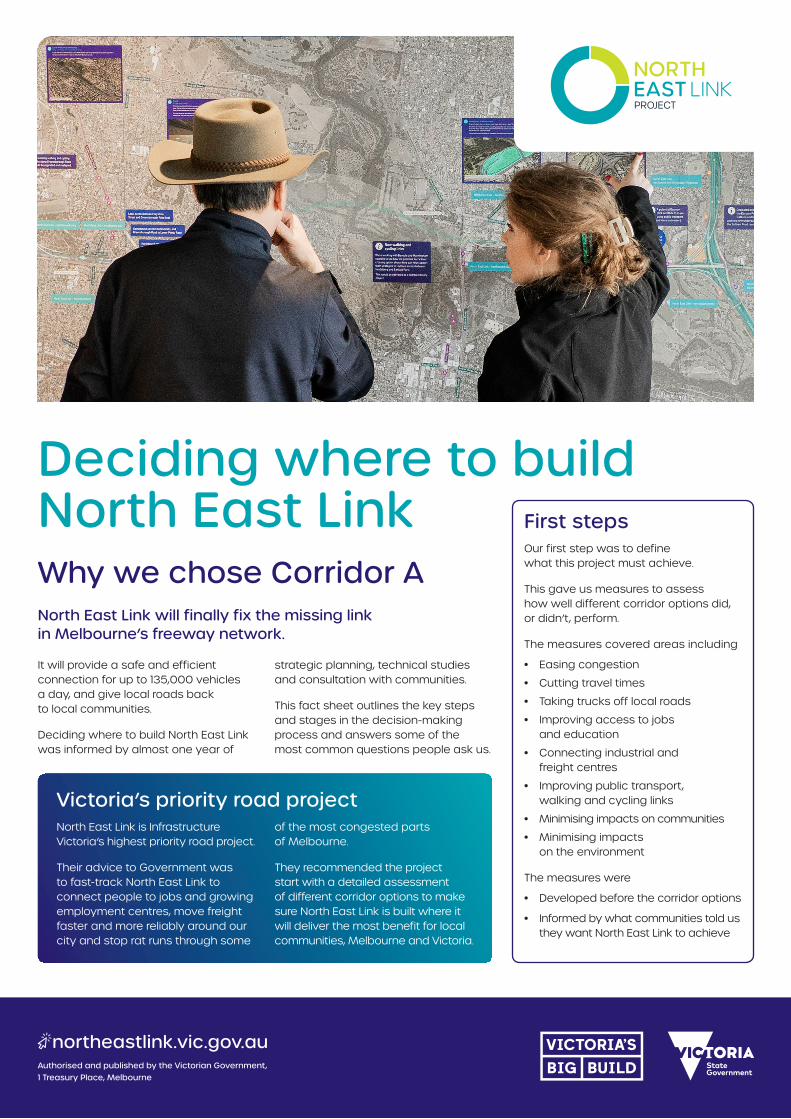
Deciding where to build North East LinkWhy we chose Corridor ANorth East Link will finally fix the missing link in Melbourne’s freeway network.
It will provide a safe and efficient connection for up to 135,000 vehicles a day, and give local roads back to local communities.
Deciding where to build North East Link was informed by almost one year of
strategic planning, technical studies and consultation with communities.
This fact sheet outlines the key steps and stages in the decision-making process and answers some of the most common questions people ask us.
Victoria’s priority road projectNorth East Link is Infrastructure Victoria’s highest priority road project.
Their advice to Government was to fast-track North East Link to connect people to jobs and growing employment centres, move freight faster and more reliably around our city and stop rat runs through some
of the most congested parts of Melbourne.
They recommended the project start with a detailed assessment of different corridor options to make sure North East Link is built where it will deliver the most benefit for local communities, Melbourne and Victoria.
First stepsOur first step was to define what this project must achieve.
This gave us measures to assess how well different corridor options did, or didn’t, perform.
The measures covered areas including
• Easing congestion
• Cutting travel times
• Taking trucks off local roads
• Improving access to jobs and education
• Connecting industrial and freight centres
• Improving public transport, walking and cycling links
• Minimising impacts on communities
• Minimising impacts on the environment
The measures were
• Developed before the corridor options
• Informed by what communities told us they want North East Link to achieve
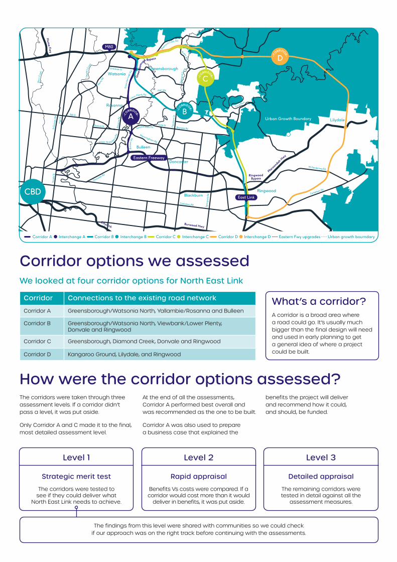
Corridor options we assessed
How were the corridor options assessed?The corridors were taken through three assessment levels. If a corridor didn’t pass a level, it was put aside.
Only Corridor A and C made it to the final, most detailed assessment level.
At the end of all the assessments, Corridor A performed best overall and was recommended as the one to be built.
Corridor A was also used to prepare a business case that explained the
benefits the project will deliver and recommend how it could, and should, be funded.
St G
eorg
es R
dH
oodl
e St
Hig
h St
Plent
y Rd
Bell St
Sprin
gval
e Rd
Canterbury Rd
Mt Dandenong Rd
Canterbury Rd
Reynolds Rd
Yarra River
Foote St Fitz
simon
s Ln
Banksia St
Grimshaw St
Rosa
nna
Rd
Doncaster Rd
Bulle
enRd
Temples towe Rd
Diamond Creek Rd
Lower Plenty Rd
Main Rd
Lower Heid e lberg
Rd
RyansR
d
Dia
mon
dCr
eek
P lenty River
Mer
r iCr
eek
Dare
bin
Cree
k
eens
bor o
ugh
G
Rd
r
Kangaroo GroundWattle
Glen Rd
Elth
am
-YarraGl
enRd
Burwood Hwy
Ringwood Bypass
CityLink
Maroondah H
wy
Hum
e Fwy
Manningham Rd
Gre
ensb
orou
gh Bypass
Urban Growth Boundary
CBD
A•C
ORRIDOR•
C•C
ORRIDOR•
B•C
ORRIDOR•
D•C
ORRIDOR•
M 0
Greensborough
Diamond Creek
Urban Growth Boundary Lilydale
Rosanna
Watsonia
Doncaster
Blackburn
Bulleen
Ringwood
Eastern Freeway
East Link
Corridor A Interchange A Corridor B Interchange B Eastern Fwy upgrades Urban growth bourndaryCorridor C Interchange C Corridor D Interchange D
We looked at four corridor options for North East Link
Corridor Connections to the existing road network
Corridor A Greensborough/Watsonia North, Yallambie/Rosanna and Bulleen
Corridor B Greensborough/Watsonia North, Viewbank/Lower Plenty, Donvale and Ringwood
Corridor C Greensborough, Diamond Creek, Donvale and Ringwood
Corridor D Kangaroo Ground, Lilydale, and Ringwood
What’s a corridor?A corridor is a broad area where a road could go. It’s usually much bigger than the final design will need and used in early planning to get a general idea of where a project could be built.
Level 1
Strategic merit test
The corridors were tested to see if they could deliver what
North East Link needs to achieve.
Level 2
Rapid appraisal
Benefits Vs costs were compared. If a corridor would cost more than it would
deliver in benefits, it was put aside.
Level 3
Detailed appraisal
The remaining corridors were tested in detail against all the
assessment measures.
The findings from this level were shared with communities so we could check if our approach was on the right track before continuing with the assessments.
Why corridor A was selectedCorridor A performed best against all the assessment measures and best delivers what North East Link needs to do.
Corridor A:
• Takes the most cars and trucks off local roads
• Connects more people to jobs and education where Melbourne is growing
• Provides the best opportunities to improve public transport by putting services where they’re needed most
• Provides the best opportunities to improve walking and cycling
• Requires less homes
• Has less impact on sensitive environmental areas
• Delivers the greatest benefits for cost
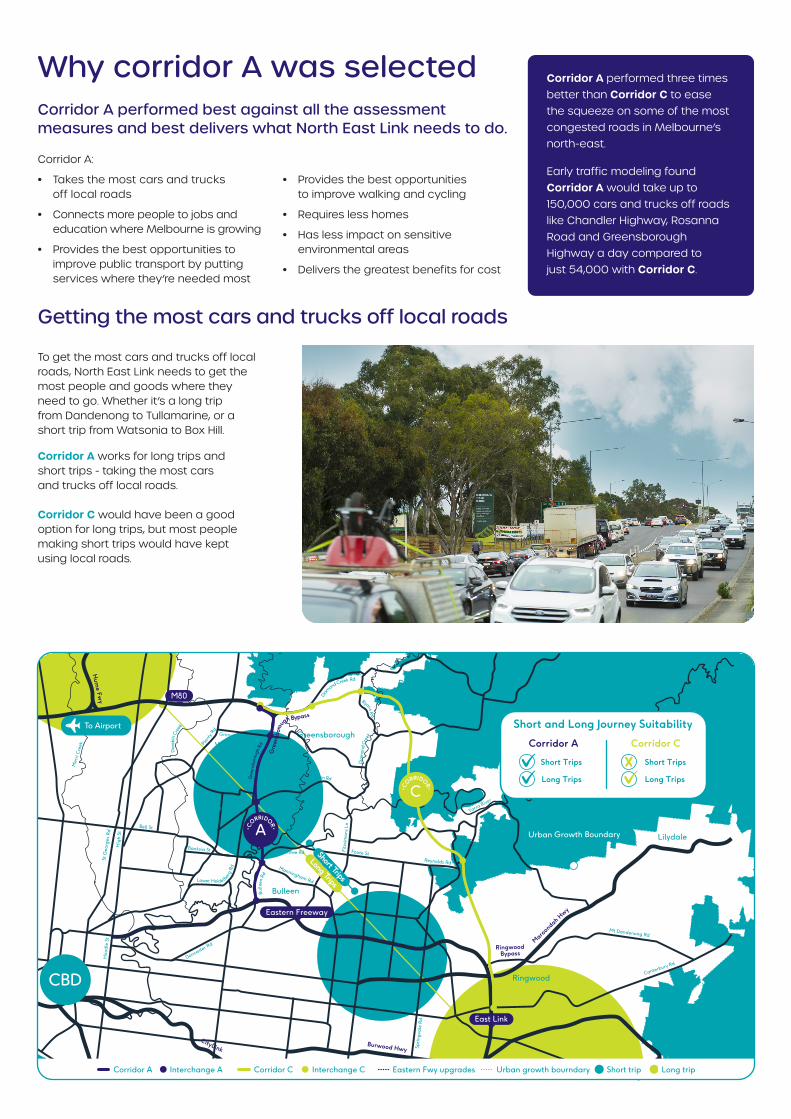
Getting the most cars and trucks off local roads
To get the most cars and trucks off local roads, North East Link needs to get the most people and goods where they need to go. Whether it’s a long trip from Dandenong to Tullamarine, or a short trip from Watsonia to Box Hill.
Corridor A works for long trips and short trips - taking the most cars and trucks off local roads. Corridor C would have been a good option for long trips, but most people making short trips would have kept using local roads.
Corridor A performed three times better than Corridor C to ease the squeeze on some of the most congested roads in Melbourne’s north-east.
Early traffic modeling found Corridor A would take up to 150,000 cars and trucks off roads like Chandler Highway, Rosanna Road and Greensborough Highway a day compared to just 54,000 with Corridor C.
Greensborough
Diamond Creek
Lilydale
Watsonia
Doncaster
Blackburn
Bulleen
Ringwood
St G
eorg
es R
dH
oodl
e St
Hig
h St
Mer
ri C
reek Pl
enty
Rd
Bell St
Burwood Hwy
Maroondah H
wy
Sprin
gval
e R
d
Canterbury Rd
Mt Dandenong Rd
Canterbury Rd
Ringwood Bypass
Reynolds Rd
Yarra River
Foote St
Fitz
sim
ons
Ln
Banksia St
Grimshaw St
Rosa
nna
Rd
Doncaster Rd
Bulle
enRd
Templestowe Rd
Elth
am
-YarraGl
enRd
Diam
ondCreek Rd
Lower Plenty RdMainRd
Lower Heidelber
gRd
RyansR
d
CityLink
Dia
mon
dCr
eek
Plenty River
Dar
ebin
Cree
k
Kangaroo Ground Wattle
Glen Rd
eens
boro
ugh
G
Rd
r
To Airport
Manningham Rd
Gre
ensb
orou
gh Bypass
Hum
e Fwy
Corridor CCorridor A
Short Trips
Long Trips
Short Trips
Long Trips
Short and Long Journey Suitability
Corridor A Interchange A Corridor C Interchange C Eastern Fwy upgrades Urban growth bourndary Short trip Long trip
M 0
C•C
ORRIDOR•
A•C
ORRIDOR•
CBD
Urban Growth Boundary
Rosanna
Eastern Freeway
East Link
Short Trips
Long Trips
Benefits for buses, bikes and feetCommunities let us know very early on how important it is to plan North East Link as a project for all types of transport - not just cars and trucks.
We looked carefully at which corridor would best support public transport, walking and cycling. This included opportunities to deliver projects recommended in strategic plans such as Plan Melbourne, which is guiding the growth of our city for the next 35 years.
Corridor A creates the best opportunities to improve existing walking and cycling paths and build new links to connect them up.
Once finished, North East Link will have built more than 25 kilometres of new and upgraded paths including some of Victoria’s strategic cycling corridors. These are paths identified by the Victorian Government and local councils to provide more direct journeys and encourage more people to get on a bike.
Corridor A also delivers Infrastructure Victoria’s recommendation to upgrade the Doncaster Area Rapid Transit (DART) bus system.
The busway along the Eastern Freeway will be the first dedicated busway in Melbourne, giving passengers faster, smoother trips and pave the way for more buses to run more often.
By taking the most cars and trucks off local roads, Corridor A also makes the most space for buses and cyclists to travel on less congested roads.
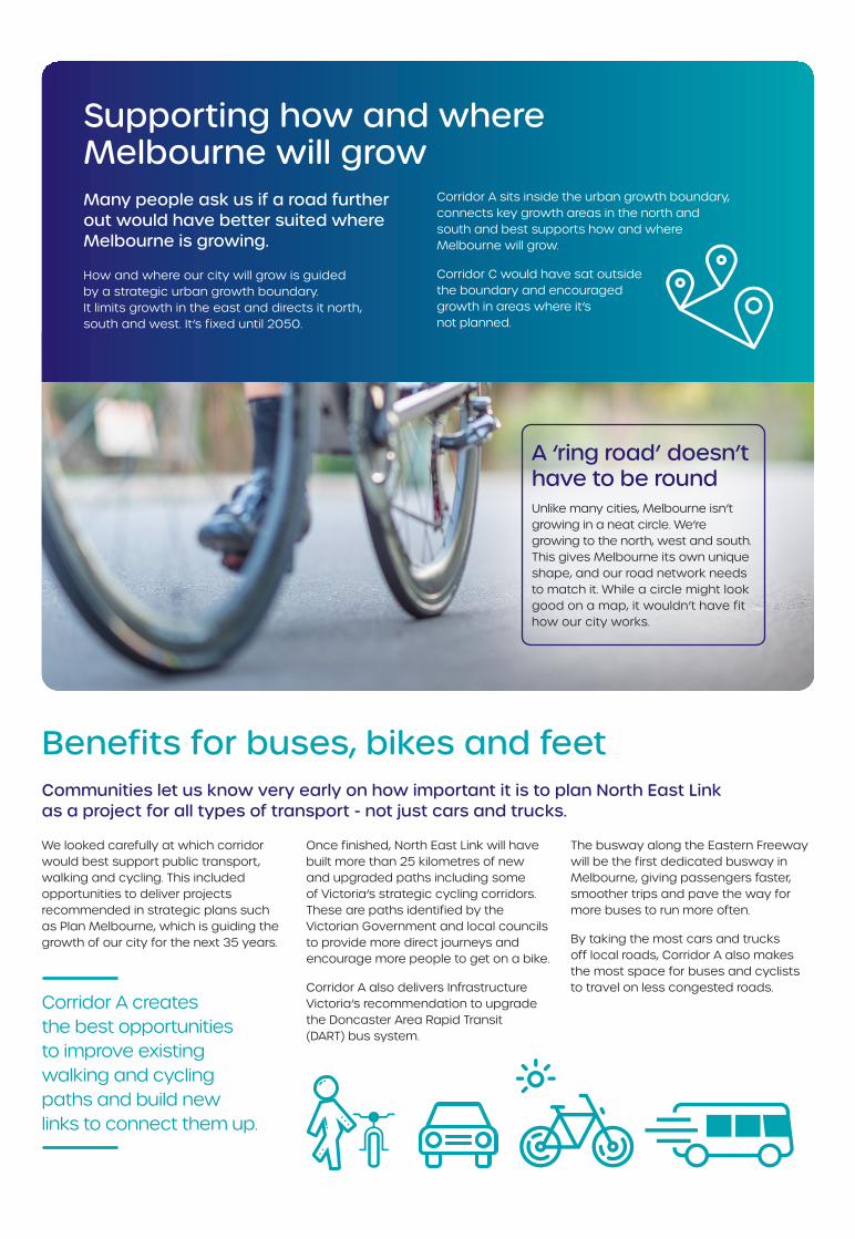
A ‘ring road’ doesn’t have to be roundUnlike many cities, Melbourne isn’t growing in a neat circle. We’re growing to the north, west and south. This gives Melbourne its own unique shape, and our road network needs to match it. While a circle might look good on a map, it wouldn’t have fit how our city works.
Supporting how and where Melbourne will growMany people ask us if a road further out would have better suited where Melbourne is growing.
How and where our city will grow is guided by a strategic urban growth boundary. It limits growth in the east and directs it north, south and west. It’s fixed until 2050.
Corridor A sits inside the urban growth boundary, connects key growth areas in the north and south and best supports how and where Melbourne will grow.
Corridor C would have sat outside the boundary and encouraged growth in areas where it’s not planned.
Looking after the environment and communitiesBuilding a project like North East Link is challenging and all the corridor options would have had some impact on communities and the environment.
The impacts for Corridor A and Corridor C on communities were found to be about the same.
Both require homes, businesses and open space, impact community facilities and are close to residential areas.
Corridor A was found to have less impacts on the environment.
Corridor C would have:
• Required around 60 hectares of native vegetation to be cleared (compared to 10 hectares for Corridor A)
• Impacted around 95 hectares of areas identified as having high ecological value (compared to 50 hectares for Corridor A)
• Crossed three waterways where listed species are likely to be found (Plenty River, Diamond Creek and Mullum Mullum Creek).
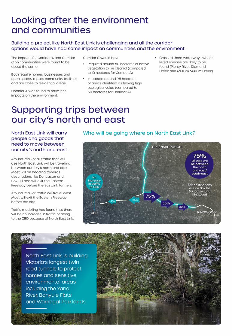
Who will be going where on North East Link?
GREENSBOROUGH
RINGWOODCBD
Key destinations include Box Hill, Doncaster and
Ringwood
75%Of trips will be between
the north and east/
south-eastNo
increase in traffic to CBD
75%
55%30%
25%4%
North East Link will carry people and goods that need to move between our city’s north and east.
Around 75% of all traffic that will use North East Link will be travelling between our city’s north and east. Most will be heading towards destinations like Doncaster and Box Hill and will exit the Eastern Freeway before the EastLink tunnels.
Around 25% of traffic will travel west. Most will exit the Eastern Freeway before the city.
Traffic modelling has found that there will be no increase in traffic heading to the CBD because of North East Link.
Supporting trips between our city’s north and east
North East Link is building Victoria’s longest twin road tunnels to protect homes and sensitive environmental areas including the Yarra River, Banyule Flats and Warringal Parklands.
NEL0234
Contact [email protected]
1800 105 105
northeastlink.vic.gov.au
North East Link Project GPO Box 4509, Melbourne VIC 3001
Translation service – For languages other than English, please call 03 9209 0147
Please contact us if you would like this information in an accessible format.
If you need assistance because of a hearing or speech impairment, please visit relayservice.gov.au
Authorised and published by the Victorian Government, 1 Treasury Place, Melbourne
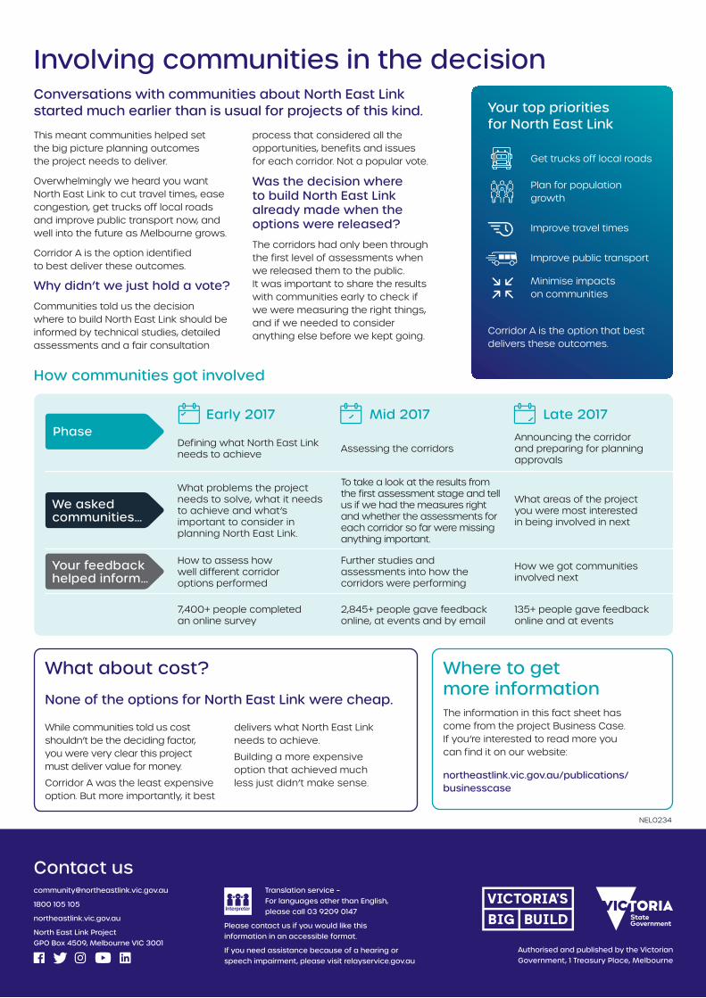
Involving communities in the decisionConversations with communities about North East Link started much earlier than is usual for projects of this kind.
This meant communities helped set the big picture planning outcomes the project needs to deliver.
Overwhelmingly we heard you want North East Link to cut travel times, ease congestion, get trucks off local roads and improve public transport now, and well into the future as Melbourne grows.
Corridor A is the option identified to best deliver these outcomes.
Why didn’t we just hold a vote?
Communities told us the decision where to build North East Link should be informed by technical studies, detailed assessments and a fair consultation
process that considered all the opportunities, benefits and issues for each corridor. Not a popular vote.
Was the decision where to build North East Link already made when the options were released?
The corridors had only been through the first level of assessments when we released them to the public. It was important to share the results with communities early to check if we were measuring the right things, and if we needed to consider anything else before we kept going.
Your top priorities for North East Link
Get trucks off local roads
Plan for population growth
Improve travel times
Improve public transport
Minimise impacts on communities
Corridor A is the option that best delivers these outcomes.
What about cost?
None of the options for North East Link were cheap.
While communities told us cost shouldn’t be the deciding factor, you were very clear this project must deliver value for money.
Corridor A was the least expensive option. But more importantly, it best
delivers what North East Link needs to achieve.
Building a more expensive option that achieved much less just didn’t make sense.
Where to get more informationThe information in this fact sheet has come from the project Business Case. If you’re interested to read more you can find it on our website:
northeastlink.vic.gov.au/publications/businesscase
Early 2017 Mid 2017 Late 2017
Defining what North East Link needs to achieve Assessing the corridors
Announcing the corridor and preparing for planning approvals
We asked communities…
What problems the project needs to solve, what it needs to achieve and what’s important to consider in planning North East Link.
To take a look at the results from the first assessment stage and tell us if we had the measures right and whether the assessments for each corridor so far were missing anything important.
What areas of the project you were most interested in being involved in next
Your feedback helped inform…
How to assess how well different corridor options performed
Further studies and assessments into how the corridors were performing
How we got communities involved next
7,400+ people completed an online survey
2,845+ people gave feedback online, at events and by email
135+ people gave feedback online and at events
How communities got involved
Phase