Embed Size (px)
Citation preview
Department of the Army Fort Sill Regulation 95-1 Headquarters, U.S. Army Garrison 462 Hamilton Road, Suite 120 Fort Sill, Oklahoma 73503 3 December 2019
Aviation ARMY AVIATION: GENERAL PROVISIONS AND FLIGHT REGULATIONS
Summary. This regulation establishes responsibilities, procedures, and rules for aircrew training, standardization, and the operation of Army aircraft assigned, attached, or transit to Fort Sill, Oklahoma. Applicability. This regulation applies to commanders and aviation personnel assigned, attached, tenant, or transient to Fort Sill while performing flight operations in the Fort Sill local flying area. Supplementation. Supplementation of this regulation is prohibited without prior approval from the Directorate of Plans, Training, Mobilization and Security, 455 McNair Avenue, Suite 201-A, Fort Sill, OK 73503. Suggested Improvements. The proponent of this regulation is the Directorate of Plans, Training, Mobilization, and Security (DPTMS). Users are invited to send comments and suggested improvements on DA Form 2028 (Recommended Changes to Publications and Blank Forms) directly to DPTMS. Distribution. This regulation is distributed solely through the Directorate of Human Resources (DHR), Administrative Services Division (ASD) Homepage at https://sill-www.army.mil/USAG/publications.html
*This regulation supersedes Fort Sill Regulation 95-1, 1 April 2018. Table of Contents Paragraph Page Chapter 1 Introduction 5 Purpose 1-1 5 References 1-2 5 Explanation of abbreviations and terms 1-3 5 Records Management reviews 1-4 5 Reviews 1-5 5 Responsibilities 1-6 5 Waivers 1-7 5 Chapter 2 Aviation management 6 Use of Fort Sill Aviation Facilities by non-DOD
Aircraft 2-1 6
Static Displays and Aerial Demonstrations 2-2 6 Transportation of Passengers 2-3 7
*Fort Sill Regulation 95-1, 3 December 2019
2
Aircraft Accountability 2-4 7 Request for Operational Support Airlift (OSA)
Support 2-5 7
Request for Helicopter Training Support 2-6 8 Emergency Commercial Medical Helicopter
Ambulance Request 2-7 8
Table 2-1 Commercial Air Evac Mission Contact Numbers 8 Table 2-2 EVAC Call Signs & Frequencies 8 Aviation Facilities Locations and Responsible
Agencies for Landing Areas 2-8 9
Table 2-3 Installation Helicopter Training Areas (HTA’S) 9 Table 2-4 Assault Landing Zones (ALZ) 9 Table 2-5 Fort Sill Cantonments, Helipad & Landing Areas 9 Drop Zones (DZs), Landing Zones 2-9 10 Clearance into HPAAF Movement Area 2-10 10 Chapter 3 Airspace 10 Restricted Area Description 3-1 10 Responsibility and Scheduling 3-2 11 Use of Airports, Heliports, & other Landing Areas 3-3 12 Local Flying Area 3-4 12 Henry Post Army Airfield Area 3-5 12 Reynolds Army Clinic (RAC) Helipad 3-6 13 Chapter 4 Flight Procedures and Rules 14 Notice to Airmen (NOTAM) & local (L-_NOTAM) 4-1 14 Flight Plans 4-2 14 Special Visual Flight Rules 4-3 14 Flight Following 4-4 15 Table 4-1 Fort Sill Flight Following Frequencies 18 Altitudes – Rotary Wing Aircraft 4-5 18 R5601 General Operating Procedures 4-6 19 Corridor Airspace Route Structure (CARS) 4-7 19 Table 4-2 Yellow Route 20 Table 4-3 Blue Route 20 Table 4-4 Red Route 21 Table 4-5 Green Route 21 East Air Corridor 22 VFR Corridors Departure & Arrival Procedures 4-8 23 Table 4-6 Goodyear Departure Corridor 24 Table 4-7 Goodyear Arrival Corridor 24 Table 4-8 Lake George Departure Corridor 25 Table 4-9 Lake George Arrival Corridor 25 Table 4-10 Snow Ridge Departure Corridor 25 Table 4-11 Snow Ridge Arrival Corridor 25 Table 4-12 North Field Departure Corridor 26
*Fort Sill Regulation 95-1, 3 December 2019
3
Table 4-13 North Field Arrival Corridor 26 Ceremonies Avoidance Flight Rules 4-9 26 Table 4-14 Ceremonies Locations 27 Cantonment Area and Helipads 4-10 27 Training Area Communication Requirements 4-11 27 Aided and Unaided Night Operations 4-12 28 Terrain & Nap of the Earth (NOE) Flights 4-13 30 Flights outside Local Flying Areas 4-14 31 Helicopter External load 4-15 31 Rotary Wing Emergency Procedures Training 4-16 31 Rotary Wing Procedures When Close Air Support
Missions Are Scheduled in R-5601 4-17 32
Close Air Support Missions in R-5601 4-18 32 No-Fly Areas 4-19 32 Table 4-15 No-Fly Areas Coordinates 33 Automated Weather Observing System 4-20 34 Chapter 5 Refueling Procedures 34 Refueling Overview 5-1 34 Rapid Refueling Guidance 5-2 34 Chapter 6 Test Flights 34 Maintenance Test Flights 6-1 34 Maintenance Test Flight Plans 6-2 35 Test Flight Call Signs 6-3 35 Test Flight Areas 6-4 35 Chapter 7 Safety 36 Fort Sill Aviation Safety Program 7-1 36 Crew Endurance 7-2 36 Risk Management 7-3 36 Environmental Considerations 7-4 36 Underwire Flight Program 7-5 36 Flight Hazard Program 7-6 37 Aircraft Mishap Procedures 7-7 37 Table 7-1 Emergency Telephone Numbers 37 Aviation Life Support Equipment (ALSE) 7-8 37 Operational Hazard Report (OHR) 7-9 37 Accident Reporting and Investigations 7-10 38 Chapter 8 Special Procedures 38 Overdue Aircraft 8-1 38 Search and Rescue (SAR) 8-2 38 Live Ordinance Recovery 8-3 38 Inadvertent Instrument Meteorological Conditions
(IIMC) Recovery 8-4 39
VIP Arrival Procedures 8-5 40 Aircraft with Hazardous Cargo (HC) 8-6 40

*Fort Sill Regulation 95-1, 3 December 2019
4
ATC Procedures during Non-availability of Aircraft Rescue & Fire Fighting Equipment (ARFF)
8-7 41
Fixed Wing Rotary Wing VIP Parking Procedures 8-8 42 Chapter 9 Severe Weather Procedures 42 Weather Definitions 9-1 42 HPAAF Severe Weather Plans 9-2 42 Mooring and Tie Down 9-3 43 Figure 2-1 Cantonment Helipads/Landing Sites 44 Figure 2-2 Drop Zones (DZS), Landing Zones (LZS) and
Installation Helicopter Training Areas (HTA’s) 45
Figure 3-1 Fort Sill Restricted Area 5601 46 Figure 4-1 Rotary Wing Local Flying Area 47 Figure 4-2 Fixed Wing Local Flying Area 48 Figure 4-3 HPAAF Traffic Pattern 49 Figure 4-4 HPAAF Designated Parking Areas for Army Fixed
Wing and Rotary Wing Aircraft 50
Figure 4-5 Choke Point 51 Figure 5-1 HPAAF Severe Weather Notification Plan 52 Figure 5-2 Yellow/Blue Routes 53 Figure 5-3 Red/Green Routes 54 Figure 5-4 East Air Corridor (East/West/VFR Sectors) 55 Figure 5-5 VFR Arrival/Departure Corridors 56 Figure 5-6 Ceremonies Avoidance Routes (East/West) 57 Figure 5-7 Nap of the Earth (NOE) Training Route 58 Figure 5-8 ACA Carlton 59 Figure 5-9 ACA Williams 60 Figure 5-10 ACA Carlton Plus “The Shelf” 61 Figure 6-1 HPAAF Rapid Refuel Area (Tactical) 62 Figure 7-1 Maintenance Test Flight Areas (SE and SW) 63 Appendix A References 65 Appendix B Precautionary & Emergency Landing Information 66 Appendix C Range Safety Briefing 67 Appendix D Aircraft Emergency Plan 71 Appendix E Aerial Laser Operations 72 Appendix F Frequencies and Phone Numbers 75 Glossary Glossary 77
*Fort Sill Regulation 95-1, 3 December 2019
5
Chapter 1. Introduction 1-1. Purpose. This regulation establishes responsibilities, procedures, and rules for aircrew training, standardization, and the operation of all aircraft assigned, attached toor transit to Fort Sill, Oklahoma. 1-2. References. Required and related publications; and, prescribed and referenced forms, are listed in appendix A. 1-3. Explanation of Abbreviations and Terms. Abbreviations and terms used in this regulation are explained in the glossary. 1-4. Records Management. Records created as a result of processes prescribed by this regulation must be identified, maintained, and disposed of according to Army Regulation (AR) 25-400-2, the Army Records Information Management System (ARIMS) and Department of the Army (DA) Pamphlet (Pam) 25-403, Guide to Recordkeeping in the Army. Record titles and descriptions are available on the Army Records Information Management System website https://www.arims.army.mil/ARIMS/MainPage.aspx. 1-5. Reviews. DPTMS will review this regulation annually for revision and update. If revisions and updates are required, request from Department of Human Resources (DHR) publications officer NLT 18 months a working copy of this regulation to revise/update. This publication must be revised and returned to DHR publications officer no more than 12 months after receiving the DHR working copy. This annual review doesn't preclude changes being made as required to promote safe and efficient flight operations. 1-6. Responsibilities. The proponent of this document is DPTMS, Airfield Division. 1-7. Waivers. The DPTMS Airfield Division is the proponent for this Regulation. Any deviation to this regulation that is not in accordance with AR 95-1, paragraphs 1-6, Deviations and 1-7, Waivers and Delegation of Authority must be approved in writing by the proponent of this document. a. Aviation Brigade Commanders have individual waiver authority according to Forces Command (FORSCOM) Supplement 1 to AR 95-1. b. Aviation units not assigned to Fort Sill will send waiver requests to Chief, Airfield Division, DPTMS. c. Waivers will be available for Aviation Resource Management Survey (ARMS) Inspections.
*Fort Sill Regulation 95-1, 3 December 2019
6
Chapter 2. Aviation Management 2-1. Use of Fort Sill Aviation Facilities by Non-DOD Aircraft. Address inquiries and requests for aircraft not exempt by AR 95-2, chapter 16 to: Cdr, USAG, ATTN: IMSI-PLA, Fort Sill, Oklahoma 73503-5000. a. Civil aircraft are not authorized to land at any airfield or heliport on the Fort Sill Military Reservation without an approved Civil Aircraft Landing Permit (CALP) and a Prior Permission Request (PPR) unless an emergency situation exists. Civil aircraft requesting permission to use HPAAF must meet the requirements of AR 95-2, DD Forms 2400, 2401, and 2402 must be on file and current with airfield operations prior to approval of landing request. PPR numbers for Civilian aircraft are controlled by the Supervisor Airfield Operations Specialist IAW AR 95-2.
b. Requester must furnish the following: (1) Type aircraft and tail number. (2) Estimated time of arrive (ETA). (3) Estimated time of departure (ETD). (4) Point of contact at Fort Sill. (5) Name, address, and phone number of pilot. (6) Insurance required by AR 95-2. (7) Completed hold harmless agreement for any damage resulting from the use of Fort Sill facilities. c. Enter the PPR number on the flight plan. 2-2. Static Displays and Aerial Demonstrations. a. Authorize flights of U.S. Army aircraft IAW AR 95-1. Exercise care so that U.S. Army aircraft are not used in support of other agencies (government or nongovernment) in any manner which could be construed as competitive to private industry. Refer questionable requests to DPTMS for determination in coordination with Fort Sill's Public Affairs Office (PAO). Provisions of DOD 4515.13R and AR 360-61 apply to U.S. Army aircraft participating in community relations activities (static displays, aerial demonstrations, etc.). Coordinate requests for use of Army aircraft in support of community relations events on and off-post through the PAO.
*Fort Sill Regulation 95-1, 3 December 2019
7
b. Conduct static displays and aerial demonstrations according to AR 360-61, Community Relations. (1) Landing of aircraft at other than approved helipads for static displays or any other non-tactical purpose, on or off post, requires a ground safety survey prior to landing. The unit's aviation safety officer (ASO) is responsible for ensuring the survey is conducted.
(2) The unit ASO will conduct the survey and provide a copy of the survey to the airfield manager five working days prior to the requested landing date. (3) If time does not permit a ground safety survey, units shall annotate and conduct the operation as no less than a high-risk mission. The high-risk mission approval authority will sign the mission risk management sheet. c. Submit all requests for community relations use of Army aircraft not covered in AR 95-2 through Cdr, USAG, ATTN: IMC/PL, Fort Sill, Oklahoma 73503-5500 to appropriate Army MACOM for approval. 2-3. Transportation of Passengers. DOD 4515.13R and AR 95-1 prescribe who may be transported in U.S. Army aircraft. Obtain authorization for short local orientation flights for visiting nonmilitary dignitaries from Senior Installation Commander, when such flights are considered to be in the best interest of the Department of the Army. Forward requests for these flights to DPTMS for approval on an individual basis. 2-4. Aircraft Accountability. a. Henry Post Army Airfield (HPAAF) Operations maintains a list of assigned and tenant aircraft. b. Prior to commencing any aviation operations or training events on the Fort Sill reservation, active, guard, reserve component, and visiting DOD or approved contractor aviation units will provide HPAAF Operations with a complete and updated listing of all aircraft type and tail numbers. Upon arrival to Fort Sill, units will provide the HPAAF airfield manager with a telephone number(s) and a local point of contact who is available continuously (H+24) for the duration of aviation operations or training exercises to assist flight following if an aircraft is missing, overdue, or involved in a mishap. 2-5. Requests for Operational Support Airlift (OSA) Support. a. Military personnel and DOD Civilian employees with official business travel requirements may request Operational Support Airlift (OSA) Fixed Wing support in accordance with AR 95-1, paragraph 3-5. Submit requests for OSA aircraft missions on DA Form 2768 through an authorizing official within their chain of command. Authorizing official will state requirements for official government travel and forward all approved request to the Fort Sill OSA Support Validator Office, Building 4907, Room 206, HPAAF
*Fort Sill Regulation 95-1, 3 December 2019
8
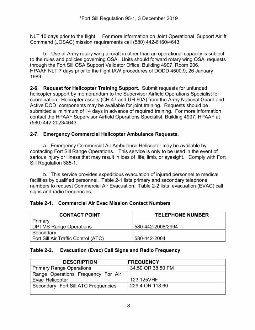
NLT 10 days prior to the flight. For more information on Joint Operational Support Airlift Command (JOSAC) mission requirements call (580) 442-6160/4643. b. Use of Army rotary wing aircraft in other than an operational capacity is subject to the rules and policies governing OSA. Units should forward rotary wing OSA requests through the Fort Sill OSA Support Validator Office, Building 4907, Room 206, HPAAF NLT 7 days prior to the flight IAW procedures of DODD 4500.9, 26 January 1989. 2-6. Request for Helicopter Training Support. Submit requests for unfunded helicopter support by memorandum to the Supervisor Airfield Operations Specialist for coordination. Helicopter assets (CH-47 and UH-60A) from the Army National Guard and Active DOD components may be available for joint training. Requests should be submitted a minimum of 14 days in advance of required training. For more information contact the HPAAF Supervisor Airfield Operations Specialist, Building 4907, HPAAF at (580) 442-2023/4643. 2-7. Emergency Commercial Helicopter Ambulance Requests. a. Emergency Commercial Air Ambulance Helicopter may be available by contacting Fort Sill Range Operations. This service is only to be used in the event of serious injury or illness that may result in loss of life, limb, or eyesight. Comply with Fort Sill Regulation 385-1. b. This service provides expeditious evacuation of injured personnel to medical facilities by qualified personnel. Table 2-1 lists primary and secondary telephone numbers to request Commercial Air Evacuation. Table 2-2 lists evacuation (EVAC) call signs and radio frequencies. Table 2-1. Commercial Air Evac Mission Contact Numbers
CONTACT POINT TELEPHONE NUMBER Primary DPTMS Range Operations
580-442-2008/2994
Secondary Fort Sill Air Traffic Control (ATC)
580-442-2004
Table 2-2. Evacuation (Evac) Call Signs and Radio Frequency
DESCRIPTION FREQUENCY Primary Range Operations 34.50 OR 38.50 FM Range Operations Frequency For Air Evac Helicopter
123.125VHF
Secondary Fort Sill ATC Frequencies 229.4 OR 118.60
*Fort Sill Regulation 95-1, 3 December 2019
9
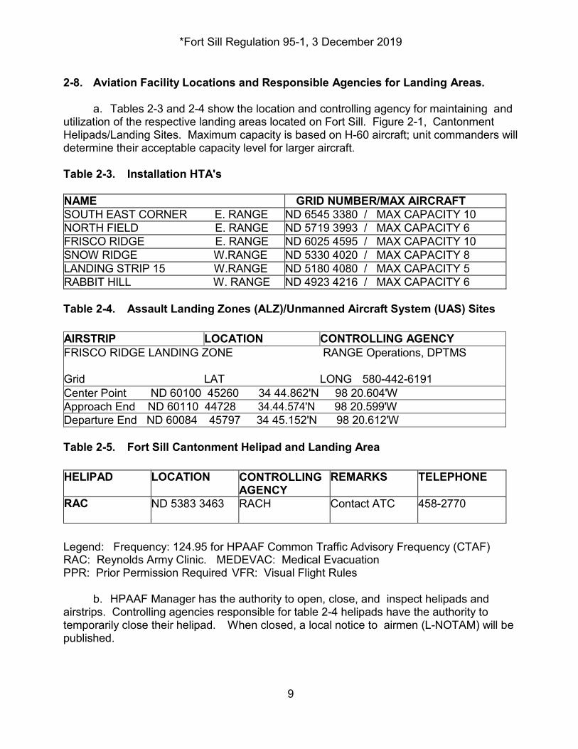
2-8. Aviation Facility Locations and Responsible Agencies for Landing Areas. a. Tables 2-3 and 2-4 show the location and controlling agency for maintaining and utilization of the respective landing areas located on Fort Sill. Figure 2-1, Cantonment Helipads/Landing Sites. Maximum capacity is based on H-60 aircraft; unit commanders will determine their acceptable capacity level for larger aircraft. Table 2-3. Installation HTA's NAME GRID NUMBER/MAX AIRCRAFT SOUTH EAST CORNER E. RANGE ND 6545 3380 / MAX CAPACITY 10 NORTH FIELD E. RANGE ND 5719 3993 / MAX CAPACITY 6 FRISCO RIDGE E. RANGE ND 6025 4595 / MAX CAPACITY 10 SNOW RIDGE W.RANGE ND 5330 4020 / MAX CAPACITY 8 LANDING STRIP 15 W.RANGE ND 5180 4080 / MAX CAPACITY 5 RABBIT HILL W. RANGE ND 4923 4216 / MAX CAPACITY 6 Table 2-4. Assault Landing Zones (ALZ)/Unmanned Aircraft System (UAS) Sites AIRSTRIP LOCATION CONTROLLING AGENCY FRISCO RIDGE LANDING ZONE RANGE Operations, DPTMS
Grid LAT LONG 580-442-6191 Center Point ND 60100 45260 34 44.862'N 98 20.604'W Approach End ND 60110 44728 34.44.574'N 98 20.599'W Departure End ND 60084 45797 34 45.152'N 98 20.612'W Table 2-5. Fort Sill Cantonment Helipad and Landing Area HELIPAD LOCATION CONTROLLING
AGENCY REMARKS TELEPHONE
RAC ND 5383 3463 RACH Contact ATC 458-2770
Legend: Frequency: 124.95 for HPAAF Common Traffic Advisory Frequency (CTAF) RAC: Reynolds Army Clinic. MEDEVAC: Medical Evacuation PPR: Prior Permission Required VFR: Visual Flight Rules b. HPAAF Manager has the authority to open, close, and inspect helipads and airstrips. Controlling agencies responsible for table 2-4 helipads have the authority to temporarily close their helipad. When closed, a local notice to airmen (L-NOTAM) will be published.
*Fort Sill Regulation 95-1, 3 December 2019
10
c. Chapter 4, paragraph 4-10, addresses specific procedures for use of helipads. d. Aviation units when using any on-post landing strips will follow the procedures listed in Fort Sill Reg 385-1. e. The Airfield Manager will insure a quarterly hazards inspection of the Installation Helicopter, Training Areas (HTAs) and Landing Zones on the Fort Sill Military Reservation are conducted. This inspection will include checks to reveal potentially hazardous conditions to flight and ground operations. The Airfield Manager will coordinate with the Supervisor Airfield Operations Specialist who, in turn, will coordinate with Directorate of Public Works (DPW) and DPTMS Range Branch to correct any hazardous conditions found during the inspection. The Airfield Manager will prepare a written report for any areas having known hazardous conditions. Aviation units, and the Army Radar Approach Control (ARAC) will receive this report.. 2-9. Drop Zones (DZ), Landing Zones (LZ) and Installation Helicopter Training Areas (HTA's). All grid zone designators are 14S unless specified. See Figure 2-2, Drop Zones (DZ), Landing Zones (LZ) and Installation HTA’s. 2-10. Clearance into HPAAF Movement Area. HPAAF movement area is OFF LIMITS to unauthorized aircraft and vehicles. This area includes the runway, taxiways and a 150’ area encompassing the runway/taxiway environment. Common traffic advisory frequency (CTAF) procedures are in effect. All aircraft and vehicles will monitor and make advisory calls on CTAF frequency 124.95 stating movement intentions. ARAC monitors CTAF and can (when requested) provide wind, altimeter, and airfield lighting. Chapter 3. Airspace 3-1. Restricted Area Description. Fort Sill Restricted Area 5601 (R-5601) Special Use Airspace found on Dallas/Fort Worth Sectional Chart is divided into different areas for regulatory purposes: (See figure 3-1, Fort Sill Restricted Area 5601). The on-post area is defined by the military reservation boundary depicted on Fort Sill Military Installation Map, Series V783S, (Edition 6-SRP), 1:50,000. This is the authorized map for flight operations on the reservation, which consists of the Training Areas (TAs) and Impact Areas. a. R5601 A (East Range) is located East of I-44 and consists of North Arbuckle Range Impact Area and South Arbuckle Range Impact Areas and contains TA's 61 thru TA 82, and Frisco Ridge, South East Corner and North Field Helicopter Landing Area. Airspace is surface (SFC) – Flight Level (FL) 400 and time of use is continuous.
*Fort Sill Regulation 95-1, 3 December 2019
11
b. R5601 B (West Range) is located West of HPAAF Surface Area and West IFR Traffic Corridor and consists of the West Range Impact Area and contains TA's 11 thru 59, Rabbit Hill Field and Ketch Field Landing Strip. Airspace is SFC – FL400 and time of use is continuous. c. R5601 C (Quanah Range/Falcon Range) is located West of Highway 115, North of Highway 62, South of Wichita Mountain Wildlife Refuge and East of N/S Gridline 22 and contains TA's 1 thru 10. Airspace is SFC – FL400 and time of use is continuous. When Falcon Range is hot all aircraft must contact Falcon Range on UHF freq. 363.7 (P), 342.3 (S) or VHF freq. 143.75 (P),141.85 (S) for clearance into Falcon Range. All pilots will review Range Operations Air Activity Schedule for scheduled Close Air Support (CAS) missions prior to flight into R5601. d. R5601 D is Special Use Airspace (SUA) located outside of Fort Sill's military reservation boundary. R5601 D is located generally North and West of R 5601 C. This airspace is normally used to allow CAS maneuvering airspace while utilizing Falcon Range. This airspace begins at 500' AGL to FL 400. Time of use is sunrise (SR) – 2200 local, Monday-Friday and other times by Notice to Airmen (NOTAM). e. R5601E is Special Use Airspace (SUA) located outside of the Fort Sill’s Military Reservation boundary. R5601E is located generally south of R5601C. This airspace is normally used to allow CAS maneuvering airspace while utilizing Falcon Range. This airspace begins at 500’ AGL to 6000’ MSL. Time of use is SR – 2200 local, Monday-Friday and other times by DOD NOTAM. f. R5601F is Special Use Airspace (SUA) located outside of the Fort Sill’s military reservation boundary. R5601F is located generally north of R5601 B, and D, the northern boundary is the Washita Military Operations Area (MOA). This airspace is normally used to allow CAS maneuvering airspace. This airspace begins at 500’ AGL (5500’ over the refuge) to FL 400. Time of use is SR - 2200 local, Monday-Friday and other times by DOD NOTAM. g. R5601G is Special Use Airspace (SUA) located outside of the Fort Sill’s military reservation boundary. R5601G is located generally north of R5601 B, and C, D and F and is below the Washita Military Operations Area (MOA). This airspace is normally used to allow CAS maneuvering airspace. This airspace begins at 500’ AGL to 7,999’. Time of use is SR - 2200 local, Monday-Friday and other times by DOD NOTAM. h. R5601H is located over the Cantonment area. Airspace is surface (SFC) – Flight Level (FL) 400 and time of use is by NOTAM only. i. R5601J is north of R5601A and B. This airspace is normally used to allow CAS maneuvering airspace. This airspace begins at 500’ AGL (3500’ AGL over the town of Elgin and 5500’ over the refuge) to FL 400. j. R5602A lies over R5601A, B, H and J. This airspace begins at 40,000 MSL up to
*Fort Sill Regulation 95-1, 3 December 2019
12
and including 60,000’ MSL. Air activities are prohibited in this airspace. k. R5602B lies East of R5602A. This airspace begins at 40,000 MSL up to and including 60,000’ MSL. Air activities are prohibited in this airspace. 3-2. Responsibility and Scheduling. a. Unit representatives requesting to use Fort Sill's airspace must coordinate the use of these areas with Range Operations and Fort Sill's Air Traffic and Airspace Officer. b. Submit airspace requests for on-post and the HTA's according to this Regulation and Fort Sill Regulation 385-1 to DPTMS Range Branch (scheduling). c. Range Facility Management Support System (RFMSS) is an automated system programmed to meet scheduling needs of units, and is available to battalion and separate company S3s. Aviation scheduling officers will use RFMSS to determine availability of resources, access schedule of events, submit requests, and produce reports. 3-3. Use of Airports, Heliports, and Other Landing Areas. a. Pilots operating from Fort Sill may operate Army Aircraft at airports and heliports and other government leased private land training areas IAW AR 95-1. b. DPTMS Airfield Operations Division, will maintain a list approved and valid Government leased private training and landing areas in the local flying area. The HPAAF Supervisor Airfield Operations Specialist is responsible for ensuring the list is posted and valid. 3-4. Local Flying Area. The Fort Sill's Rotary Wing Aircraft local flying area boundary is a 100 NM radius from the approximate center of HPAAF using a Dallas-Fort Worth VFR Sectional Aeronautical Chart (See figure 4-1, Rotary Wing Local Flying Area). Army Fixed Wing aircraft will use a 200 nautical mile (NM)radius using the same chart criteria above as their local flying area boundaries (See figure 4-2, Fixed Wing Local Flying Area). 3-5. Henry Post Army Airfield Traffic Boundaries. a. Fixed Wing Aircraft Traffic Pattern Altitudes. The downwind altitudes are 2200- 2700. Fixed wing aircraft will use the West traffic pattern or as authorized by air traffic control (ATC). NOTE: Sheppard AFB Undergraduate Pilot Training aircraft prefer 2200’. b. Rotary Wing Aircraft Traffic Pattern Altitudes. The downwind altitude is 1900 feet mean sea level (MSL). Rotary wing aircraft may use East or West traffic pattern or as cleared by ATC. (1) Night Operations. Rotary Wing aircraft will use the main runway or parallel taxiway during normal night operations. Aircraft will use the East traffic pattern or as approved or directed by ATC.
*Fort Sill Regulation 95-1, 3 December 2019
13
(2) Daylight Operations. Rotary Wing aircraft will normally use the parallel taxiway or the East sod area for daylight operations rather than the main runway. (3) External loads. Rotary wing aircraft with external loads will fly routes that avoid flight over built-up areas and the main runway. The primary training area for external loads is the Southeast Corner Training Area. c. HPAAF Restrictions and Procedures. (1) Hovering. Do not hover within 200' of any weather instruments or the Indian Agency Cemetery (IAC). (2) Airspeed. IAW FAA JO 7110.65. (3) The East Sod Movement Area. No take-offs or approaches and landings to East Sod area will over-fly any parked or taxing aircraft, hangars, motor park or housing areas located generally north of helipad. Aircrews will advise the HPAAF CTAF in which cardinal direction they intent to take off or for landing. (4) Aircraft parked on the temporary pads on HPAAF will broadcast on CTAF to hover taxi to any other location. Pilots are advised to monitor and make advisory radio calls on CTAF frequency As required. Fort Sill Approach Control also monitors CTAF and can when requested provided wind, altimeter and traffic information. Figure 4-4 depicts HPAAF designated parking areas for Army fixed and rotary wing aircraft. 3-6. Reynolds Army Clinic MEDEVAC HELIPAD. RAC MEDEVAC Helipad is located approximately 0.6 NM west of HPAAF . Grid location is ND 53825 34600. It's designed for one rotary wing aircraft at time. It's a day/night VFR Limited Use Helipad. RAC Helipad is only for use by aircraft to transport patients to appropriate medical care. Military or commercial EMS helicopters requested by RACH or Range Operations to transport critical/emergency care patients are authorized use of this helipad at any time. All other rotary wing aircraft will coordinate with DPTMS Airfield Division, DPTMS, if they desire to conduct approach and landing operations to the helipad. RAC MEDEVAC Helipad lighting is controlled by transmitting on CTAF 124.95, five (5) clicks for bright perimeter lights and seven (7) clicks to dim perimeter lights. Helipad lighting will go off 15 minutes after activation. All aircraft will contact HPAAF CTAF for landing/departing RAC Helipad. Chapter 4. Flight Procedures and Rules 4-1. Notice To Airmen (NOTAM) And Local-Notice To Airmen (L-NOTAM). HPAAF Airfield Operations maintains NOTAM and L-NOTAM files. Fort Sill NOTAMS can be found by going to https://www.notams.jcs.mil/. 4-2. Flight Plans. Operations specified in paragraph 3-3a require coordination with external agencies such as flight service or ATC are considered "cross- country" flight plans. Operations specified in 3-3b in which data remains at Airfield Operations or units
*Fort Sill Regulation 95-1, 3 December 2019
14
flight operations are considered "local" flight plans. a. Flights outside of local flying area (1) Instrument flight rules (IFR) operations require a DD Form 175 (Military Flight Plan) completed according to the appropriate flight information publication (FLIP) and general planning (GP). IFR cross country flight plans must be filed with Ft. Worth Flight Service Station (FSS). DD Form 175-1 (Flight Weather Briefing) is required when the route of flight will be outside the 100 nautical mile radius, centered on HPAAF for rotary wing and 200 NM for fixed wing aircraft. (2) VFR operations that terminate or involve engine shutdown at locations outside the reservation or HTA's require a DD Form 175 or an Operations Log monitored by that unit's flight operations personnel. (3) Prior to departing HPAAF, the pilot-in- command must ensure a VFR/IFR Flight Plan has been filed with FSS (1-800-992-7433). Aircrews shall insure VFR flight plans are opened with FSS.
(4) The pilot must open and close flight plans directly with a FSS or through an ATC facility. In any case, when landing at a destination that does not have Aeronautical Information System (AIS) capabilities, the pilot must close the flight plan with Ft. Worth Flight Service Station (FSS) upon arrival. When departing a location that does not have AISR capabilities, open the flight plan with FSS so they can send a departure message back to HPAAF. b. Within the Local Flying Area. (1) Local flight plans are for flights that meet criteria in paragraphs below: (a) Flights originating and terminating within Fort Sill or the local HTA's locations.
(b) Flights outside Fort Sill local flying area not involving engine shutdown. (2) File a local flight plan, (operation’s log), with unit's flight operations. If unable to file via landline an alternate method is to file or change/amend local light plans by contacting ARAC on (primary) VHF 118.6 or (secondary) UHF 290.37. Before departing any location the pilot will contact ARAC to activate the filed flight plan. c. Procedures for filling out DA 175 Local flight plans. (1) The term “local” is the first item in the route of flight section followed by the route in parentheses. When possible, identify the training area (TA) if landing on the reservation or “Name of HTA's” as prefixes on local flight plans. (2) Maximum time enroute for local flight plans is 8 hours, unless extension is
*Fort Sill Regulation 95-1, 3 December 2019
15
coordinated with whichever activity is maintaining the aircraft local flight plan (i.e., the unit's flight operations) (3) Mobilization units with an established flight operations at HPAAF or located at local field sites may file and flight follow local flight plans using a unit operations log IAW AR 95-1, paragraph 5-2. d. Filing flight plans. IFR flight should be filed at least 45 minutes prior to scheduled departure. NOTE: VFR flight plans filed with FSS, will not generate a flight strip to ATC. e. Other Requirements. (1) Flights that do not depart within 2 hours of the estimated time of departure (ETD) will have flight plans canceled. (2) The aircraft listed as lead of a formation flight must depart with the flight. If the lead aircraft serial numbers change, notify Airfield Operations/ATC prior to takeoff. In the event the lead aircraft PC changes, a new flight plan is required. If the flight breaks up or an individual aircraft separates from the flight, they are required to file their own flight plan. 4-3. Special Visual Flight Rules (SVFR). SVFR is not authorized at Henry Post Army Airfield. 4-4. Flight Following. Military Rotary Wing Aircraft requesting Flight Following service will contact "Fort Sill Flight Following" on frequencies VHF 126.2 or UHF 268.8. Fort Sill Flight Following can normally provide radar services within 25 nautical miles (NM) of Fort Sill. Traffic advisories may be available beyond 25 NM out to the boundaries of Fort Sill's controlled airspace. a. Usage. Use of Fort Sill Flight Following (FSFF) is mandatory for all single- aircraft flights on a VFR flight plan, except when under control of unit operations, Henry Post, or other agency (FSS). Flights of two or more aircraft may flight follow internally for echelon aircraft and must monitor and transmit intentions on UHF 242.2 (Air-to-Air) and monitor Range Operations (34.50 or 38.50, as appropriate). b. Required Reports. If FSFF is utilized, the following report procedures apply. (1) Initial Contact. Give the following information to FSFF upon initial contact: identification (call sign); departure reporting point/arrival reporting point; destination; and type of flight plan (e.g., NVD, night, VFR, local). (2) Position Reports. Make position reports as required by FSFF or at 30- minute intervals. Aircraft conducting NVD night training will transmit position reports every thirty (30) minutes to FSFF.
*Fort Sill Regulation 95-1, 3 December 2019
16
(3) The pilot may obtain a 30 minute “BLOCK TIME” to terminate operations at a field site. If aircraft is to remain on the ground longer than 30 minutes, upon arrival at destination, pilots will terminate with FSFF and report the actual position of the aircraft, grid coordinate, or other commonly known landmark. Pilot will notify FSFF that aircraft is on the ground and will give an ETD. If radio contact is unavailable, the pilot will provide FSFF with the appropriate information via land line or any other available communication from the field site. If pilot does not contact FSFF 15 minutes after ETD, FSFF will proceed with overdue aircraft procedures. Aircraft with destinations more than 25 NM from Fort Sill will terminate Flight Following prior to the 25 NM point. c. Overdue Aircraft Procedures. (1) Consider aircraft overdue 15 minutes after a required report has not been received. (2) When an aircraft is overdue, ATC will-- (a) Initiate a communication search.
(b) After an aircraft has been overdue 15 minutes from last required report, notify HPAAF Operations/Airfield Management that a communications search for the aircraft has been initiated. (3) If there is a reason to believe that an aircraft is overdue prior to 30 minutes, take appropriate action immediately. (a) After the aircraft has been overdue 30 minutes, notify HPAAF that communications search has failed to locate the aircraft.
(b) Notify HPAAF Airfield Management when communication is reestablished with
the overdue aircraft. (4) HPAAF Airfield Management, when notified by the Flight Following facility of an overdue aircraft, will take the following actions. (a) Contact owning unit operations to inform them of aircraft being 15 minutes overdue and request they perform a ramp check.
(b) If aircraft becomes 30 minutes overdue, initiate search and rescue procedures in accordance with individual unit search and rescue plans. (5) DPTMS Airfield Division will be responsible for ramp checks and search and rescue for aircraft not permanently assigned at Fort Sill. (6) In the event of an Emergency Locator Transmitter (ELT) Signal, the following agencies will take the appropriate actions:
*Fort Sill Regulation 95-1, 3 December 2019
17
(a) ARAC will contact Lawton Tower to confirm receipt of an ELT signal and
strength to assess location. Contact airfield management and advise them of an ELT signal. Solicit the assistance of other aircraft known to be operating in the signal area.
(b) Airfield Operations will contact local units and advise them that an ELT signal is being received and to perform a physical check of all their aircraft and personnel ALSE equipment. Contact transit pilots to check their aircraft if it is determined that the signal may be emanating from on HPAAF. Attempt to locate the signal by using the portable hand carried ETL receiver.
(c) Aviation Units will direct a physical inspection of all their aircraft. Report the
findings to Airfield Op/Airfield Management once this action is completed. (8) Pilot responsibilities are as follows:
(a) Pilots operating within the Fort Sill delegated airspace and within R5601 must
maintain clearance from other aircraft, active firing points, and the impact area.
(b) Get range and flight hazard information (artillery fire and air strikes) by telephone (442-2994), by monitoring Range Operations Frequency 34.50 (W) 38.50 (E)., or through Fort Sill Approach Control. Additionally, units will request and obtain copies of the current day’s range overlays from Range Operations, Building 1490.
(c) Within Fort Sill's reservation the use of Fort Sill Flight Following is mandatory.
Notify Fort Sill Flight Following when changing to another agency. When operating within R5601 and communication with Fort Sill Flight Following is hampered, flight-follow with an appropriate ATC facility as soon as practical.
(d) For multiple aircraft operations on the reservation, at least one aircraft in the flight shall monitor Fort Sill Air to Air Frequency 143.1 and relay the information as required.
(e) The transponder code in R-5601 will be assigned by FSFF.
(f) Pilots must contact Range Operations for clearance prior to entering ranges,
unless in contact with unit operations controlling the range. Range Operations or unit operations provide exit and entry routing to aircraft.
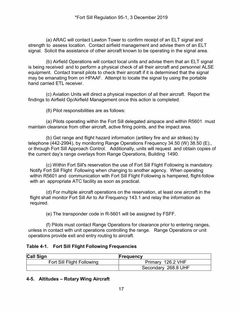
Table 4-1. Fort Sill Flight Following Frequencies Call Sign Frequency
Fort Sill Flight Following Primary 126.2 VHF Secondary 268.8 UHF 4-5. Altitudes – Rotary Wing Aircraft
*Fort Sill Regulation 95-1, 3 December 2019
18
a. Aircraft may fly at 500 feet AGL and below within the Fort Sill boundaries except when directed by ATC. Coordinate flights above 500 feet AGL while within R5601 with Range Operations. b. Unless operations are in an under wire flight area, flights off the Fort Sill Military Installation will maintain an altitude of at least 500 feet AGL with a 500-foot slant range from buildings, livestock, or other man-made obstructions. Aviation unit commanders may authorize flights below 500 feet AGL, case-by-case. c. Due to noise sensitive areas in the local area outside the Fort Sill Military Installation (Wichita Mountain Wildlife Refuge minimum is 2000’ AGL), tactical training below 500 feet AGL is discouraged. Battalion commanders or higher, may authorize tactical flight training below 500 feet AGL, case-by-case when in sparsely populated areas. d. During off-post flights in airspace at or below 200 feet AGL, pilots will not intentionally fly within a 500-foot slant range of buildings, livestock or other man-made obstructions, except while performing an instrument approach or departure, during takeoff or landing, or when mission requirements dictate. e. Single engine aircraft must maintain an altitude that assures an autorotation descent to a suitable landing area when operating over built-up areas or water. Over- water flights must carry survival equipment per AR 95-1. f. Aircraft engaged in over-water flight will adhere to the following requirements: All personnel aboard Army single engine or multiengine aircraft that do not have single engine flight capability that are flown beyond the gliding distance of land, will wear life preservers. All other aircraft will have life preservers readily available. 4-6. R5601 General Operating Procedures. R5601 is the restricted airspace above the entire Fort Sill reservation. Fort Sill Commanding General has exclusive user rights and control of R5601. All pilots desiring to fly within R5601 must receive an initial aviation and range briefing (except when using the open air corridors) on command and local directives and range operations and safety procedures. Pilots must request the briefing and local area orientations through DPTMS Airfield Division, ATTN: Airfield Manager or located in Bldg 4907, (442-4643/2023). Pilots must comply with the requirements of Ft. Sill Reg 385-1. a. Flights within R5601, the Pilot-in-command (PIC) or the Air Mission Commander (AMC) for multi-ship missions will telephonically call Range Operations to obtain current firing point and corridor information. (1) Before entering R5601, contact Range Operations on East Range Area FM 38.50, and West Range Area FM 34.50, or 363.7 UHF for FALCON Range Area. Range O p e r a t i o n s will issue separate authorization for each of the three Fort Sill ranges areas.
*Fort Sill Regulation 95-1, 3 December 2019
19
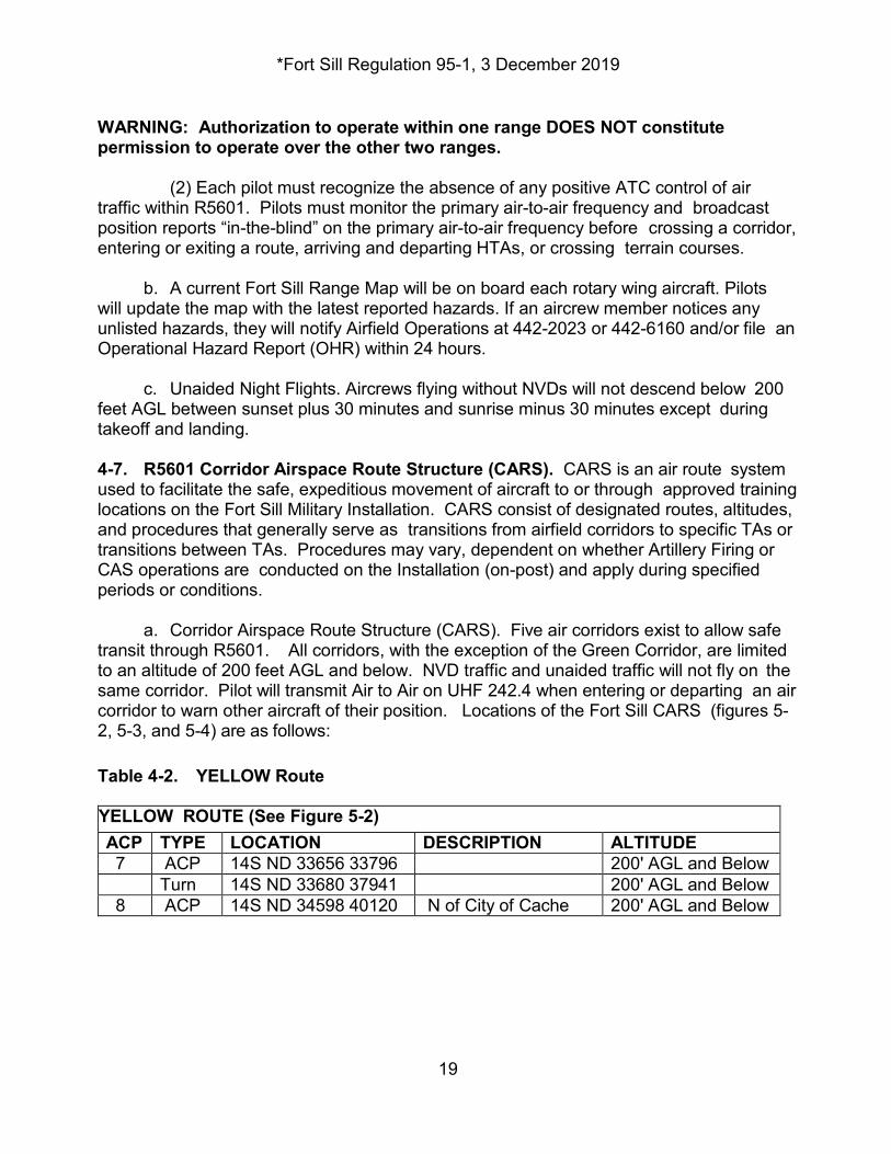
WARNING: Authorization to operate within one range DOES NOT constitute permission to operate over the other two ranges. (2) Each pilot must recognize the absence of any positive ATC control of air traffic within R5601. Pilots must monitor the primary air-to-air frequency and broadcast position reports “in-the-blind” on the primary air-to-air frequency before crossing a corridor, entering or exiting a route, arriving and departing HTAs, or crossing terrain courses. b. A current Fort Sill Range Map will be on board each rotary wing aircraft. Pilots will update the map with the latest reported hazards. If an aircrew member notices any unlisted hazards, they will notify Airfield Operations at 442-2023 or 442-6160 and/or file an Operational Hazard Report (OHR) within 24 hours. c. Unaided Night Flights. Aircrews flying without NVDs will not descend below 200 feet AGL between sunset plus 30 minutes and sunrise minus 30 minutes except during takeoff and landing. 4-7. R5601 Corridor Airspace Route Structure (CARS). CARS is an air route system used to facilitate the safe, expeditious movement of aircraft to or through approved training locations on the Fort Sill Military Installation. CARS consist of designated routes, altitudes, and procedures that generally serve as transitions from airfield corridors to specific TAs or transitions between TAs. Procedures may vary, dependent on whether Artillery Firing or CAS operations are conducted on the Installation (on-post) and apply during specified periods or conditions. a. Corridor Airspace Route Structure (CARS). Five air corridors exist to allow safe transit through R5601. All corridors, with the exception of the Green Corridor, are limited to an altitude of 200 feet AGL and below. NVD traffic and unaided traffic will not fly on the same corridor. Pilot will transmit Air to Air on UHF 242.4 when entering or departing an air corridor to warn other aircraft of their position. Locations of the Fort Sill CARS (figures 5-2, 5-3, and 5-4) are as follows: Table 4-2. YELLOW Route YELLOW ROUTE (See Figure 5-2) ACP TYPE LOCATION DESCRIPTION ALTITUDE 7 ACP 14S ND 33656 33796 200' AGL and Below
Turn 14S ND 33680 37941 200' AGL and Below 8 ACP 14S ND 34598 40120 N of City of Cache 200' AGL and Below
*Fort Sill Regulation 95-1, 3 December 2019
20
General: Bidirectional, and will be flown at an altitude no higher than 200' AGL. Route will be flown using "rules of the road". Operate 100 meters right of centerline at “see and avoid” speed. Corridor Width: No more than 100 meters left/right of centerline. Hazards: High tension lines following State Highway 115 Remarks: Firing points along this route may be active. Contact Range Operations for safety briefing prior to using CARS. Current route restrictions are available from Fort Sill Flight Following.
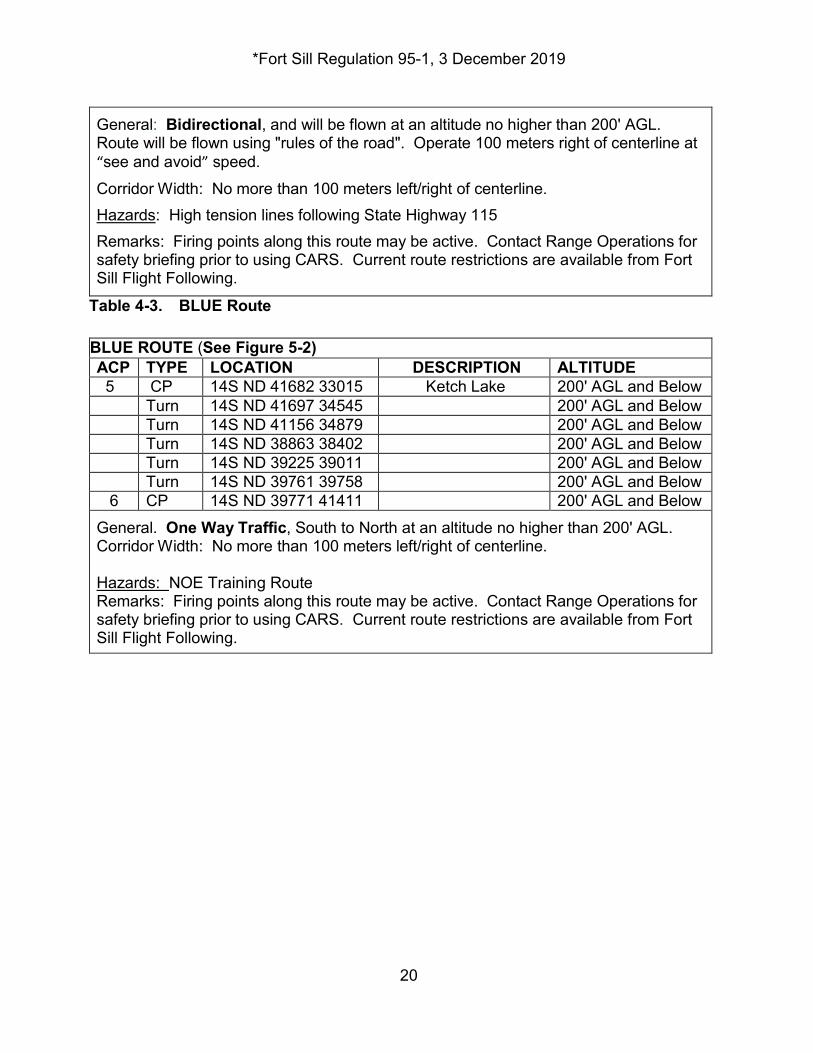
Table 4-3. BLUE Route BLUE ROUTE (See Figure 5-2) ACP TYPE LOCATION DESCRIPTION ALTITUDE 5 CP 14S ND 41682 33015 Ketch Lake 200' AGL and Below
Turn 14S ND 41697 34545 200' AGL and Below Turn 14S ND 41156 34879 200' AGL and Below Turn 14S ND 38863 38402 200' AGL and Below Turn 14S ND 39225 39011 200' AGL and Below Turn 14S ND 39761 39758 200' AGL and Below
6 CP 14S ND 39771 41411 200' AGL and Below General. One Way Traffic, South to North at an altitude no higher than 200' AGL. Corridor Width: No more than 100 meters left/right of centerline. Hazards: NOE Training Route Remarks: Firing points along this route may be active. Contact Range Operations for safety briefing prior to using CARS. Current route restrictions are available from Fort Sill Flight Following.
*Fort Sill Regulation 95-1, 3 December 2019
21
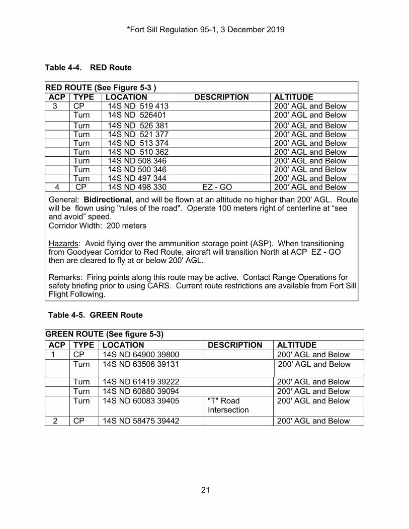
Table 4-4. RED Route RED ROUTE (See Figure 5-3 ) ACP TYPE LOCATION DESCRIPTION ALTITUDE 3 CP 14S ND 519 413 200' AGL and Below
Turn 14S ND 526401
200' AGL and Below Turn 14S ND 526 381 200' AGL and Below Turn 14S ND 521 377 200' AGL and Below Turn 14S ND 513 374 200' AGL and Below Turn 14S ND 510 362 200' AGL and Below Turn 14S ND 508 346 200' AGL and Below Turn 14S ND 500 346 200' AGL and Below Turn 14S ND 497 344 200' AGL and Below
4 CP 14S ND 498 330 EZ - GO 200' AGL and Below General: Bidirectional, and will be flown at an altitude no higher than 200' AGL. Route will be flown using "rules of the road". Operate 100 meters right of centerline at “see and avoid” speed. Corridor Width: 200 meters Hazards: Avoid flying over the ammunition storage point (ASP). When transitioning from Goodyear Corridor to Red Route, aircraft will transition North at ACP EZ - GO then are cleared to fly at or below 200' AGL. Remarks: Firing points along this route may be active. Contact Range Operations for safety briefing prior to using CARS. Current route restrictions are available from Fort Sill Flight Following.
Table 4-5. GREEN Route
GREEN ROUTE (See figure 5-3) ACP TYPE LOCATION DESCRIPTION ALTITUDE 1 CP 14S ND 64900 39800 200' AGL and Below
Turn 14S ND 63506 39131 200' AGL and Below
Turn 14S ND 61419 39222 200' AGL and Below Turn 14S ND 60880 39094 200' AGL and Below Turn 14S ND 60083 39405 "T" Road
Intersection 200' AGL and Below
2 CP 14S ND 58475 39442 200' AGL and Below
*Fort Sill Regulation 95-1, 3 December 2019
22
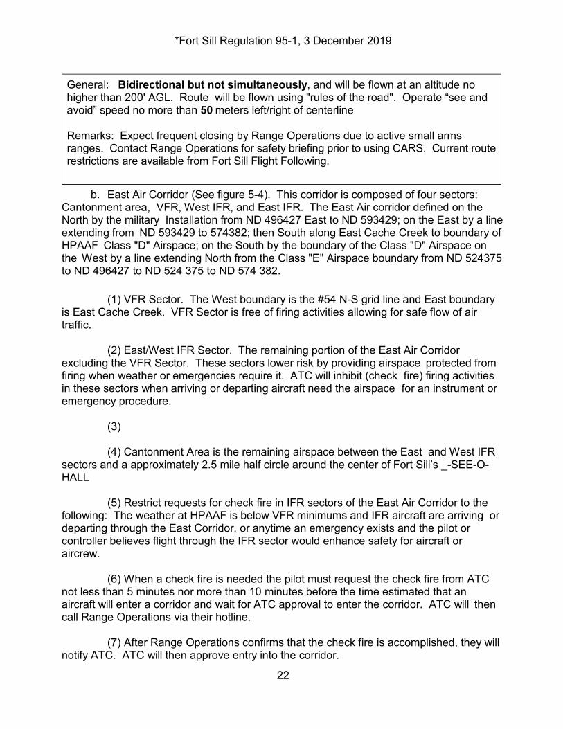
General: Bidirectional but not simultaneously, and will be flown at an altitude no higher than 200' AGL. Route will be flown using "rules of the road". Operate “see and avoid” speed no more than 50 meters left/right of centerline Remarks: Expect frequent closing by Range Operations due to active small arms ranges. Contact Range Operations for safety briefing prior to using CARS. Current route restrictions are available from Fort Sill Flight Following.
b. East Air Corridor (See figure 5-4). This corridor is composed of four sectors: Cantonment area, VFR, West IFR, and East IFR. The East Air corridor defined on the North by the military Installation from ND 496427 East to ND 593429; on the East by a line extending from ND 593429 to 574382; then South along East Cache Creek to boundary of HPAAF Class "D" Airspace; on the South by the boundary of the Class "D" Airspace on the West by a line extending North from the Class "E" Airspace boundary from ND 524375 to ND 496427 to ND 524 375 to ND 574 382. (1) VFR Sector. The West boundary is the #54 N-S grid line and East boundary is East Cache Creek. VFR Sector is free of firing activities allowing for safe flow of air traffic. (2) East/West IFR Sector. The remaining portion of the East Air Corridor excluding the VFR Sector. These sectors lower risk by providing airspace protected from firing when weather or emergencies require it. ATC will inhibit (check fire) firing activities in these sectors when arriving or departing aircraft need the airspace for an instrument or emergency procedure. (3) (4) Cantonment Area is the remaining airspace between the East and West IFR sectors and a approximately 2.5 mile half circle around the center of Fort Sill’s _-SEE-O-HALL (5) Restrict requests for check fire in IFR sectors of the East Air Corridor to the following: The weather at HPAAF is below VFR minimums and IFR aircraft are arriving or departing through the East Corridor, or anytime an emergency exists and the pilot or controller believes flight through the IFR sector would enhance safety for aircraft or aircrew. (6) When a check fire is needed the pilot must request the check fire from ATC not less than 5 minutes nor more than 10 minutes before the time estimated that an aircraft will enter a corridor and wait for ATC approval to enter the corridor. ATC will then call Range Operations via their hotline.
(7) After Range Operations confirms that the check fire is accomplished, they will notify ATC. ATC will then approve entry into the corridor.
*Fort Sill Regulation 95-1, 3 December 2019
23
(8) After the aircraft clear the corridor, ATC will notify Range Operations via hotline that the check-fire is no longer required.
(9) Range Branch will notify ATC when firing in the East Corridor is complete.
(10) Range Branch will have an individual designated to answer the hotline from ATC when there is firing within the corridor. Backup communication for the hotline will be commercial telephone system. (11) All aircraft will cease operations and depart the range immediately upon request from Range Operations. (12) The pilot-in-command will radio to Range Operations when the mission has been completed and the aircraft has departed the range 4-8. VFR Corridors Departure and Arrival Procedures for HPAAF. Corridors control the flow of traffic to and from HPAAF. Rules-of-the road apply on all corridors. When arriving and departing, use the appropriate Corridor, reporting point, and altitude (See figure 5-5, VFR Arrival/Departure Corridors) displays the appropriate corridors. a. Due to the possible high density of rotary wing aircraft operating within R5601 and HPAAF Traffic Area during aviation mobilization training, the following VFR corridors and procedures must be followed: All pilots must monitor Fort Sill's Primary air to air frequency of UHF 242.4. Aircraft crews must broadcast positions reports in the blind on primary air-to-air frequencies prior to transitioning any designated HPAAF VFR arrival/departure corridors, entry/exit of any route structure, arrival/departure to and from HTA's, or transitioning any terrain/NOE routes. b. Aircrews operating in corridors will maintain see and avoid airspeed not to exceed 100 Knots IAS. c. Aircrews will avoid over flight of all Fort Sill Post housing. d. Aircrews must contact Fort Sill Flight Following prior to entering or departing HPAAF VFR arrival/departure corridors. e. Flight crews must be vigilant near the south entry of the Red Route. This area has been identified as a possible choke point as the Goodyear Route, Red Route and access point to the MOW-WAY FARP merge. See figure 4-5 f. Henry Post Army Airfield Arrival and Departure Corridors Routes and procedures are as follows: (1) Goodyear Air Corridor.
*Fort Sill Regulation 95-1, 3 December 2019
24
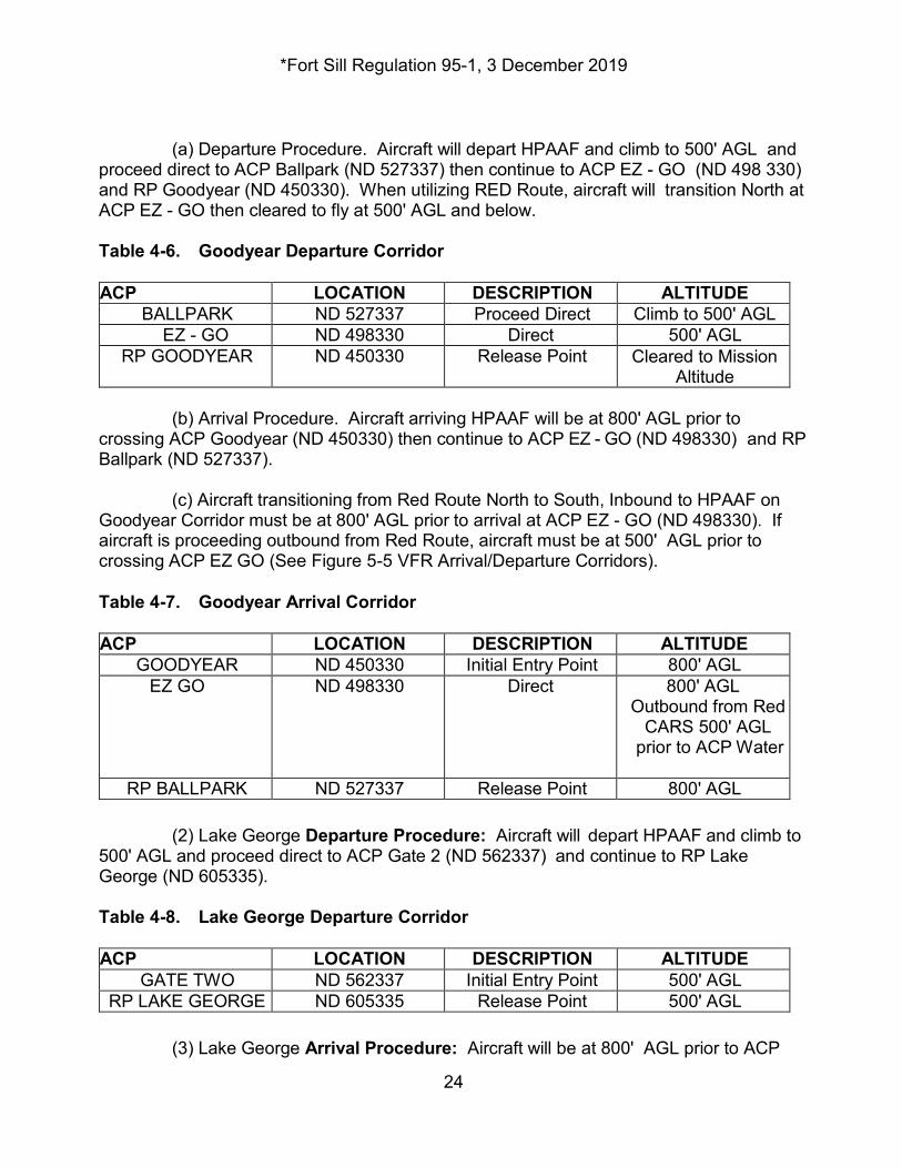
(a) Departure Procedure. Aircraft will depart HPAAF and climb to 500' AGL and proceed direct to ACP Ballpark (ND 527337) then continue to ACP EZ - GO (ND 498 330) and RP Goodyear (ND 450330). When utilizing RED Route, aircraft will transition North at ACP EZ - GO then cleared to fly at 500' AGL and below. Table 4-6. Goodyear Departure Corridor ACP LOCATION DESCRIPTION ALTITUDE
BALLPARK ND 527337 Proceed Direct Climb to 500' AGL EZ - GO ND 498330 Direct 500' AGL
RP GOODYEAR ND 450330 Release Point Cleared to Mission Altitude
(b) Arrival Procedure. Aircraft arriving HPAAF will be at 800' AGL prior to crossing ACP Goodyear (ND 450330) then continue to ACP EZ - GO (ND 498330) and RP Ballpark (ND 527337). (c) Aircraft transitioning from Red Route North to South, Inbound to HPAAF on Goodyear Corridor must be at 800' AGL prior to arrival at ACP EZ - GO (ND 498330). If aircraft is proceeding outbound from Red Route, aircraft must be at 500' AGL prior to crossing ACP EZ GO (See Figure 5-5 VFR Arrival/Departure Corridors). Table 4-7. Goodyear Arrival Corridor ACP LOCATION DESCRIPTION ALTITUDE
GOODYEAR ND 450330 Initial Entry Point 800' AGL EZ GO ND 498330 Direct 800' AGL
Outbound from Red CARS 500' AGL
prior to ACP Water
RP BALLPARK ND 527337 Release Point 800' AGL (2) Lake George Departure Procedure: Aircraft will depart HPAAF and climb to 500' AGL and proceed direct to ACP Gate 2 (ND 562337) and continue to RP Lake George (ND 605335). Table 4-8. Lake George Departure Corridor ACP LOCATION DESCRIPTION ALTITUDE
GATE TWO ND 562337 Initial Entry Point 500' AGL RP LAKE GEORGE ND 605335 Release Point 500' AGL
(3) Lake George Arrival Procedure: Aircraft will be at 800' AGL prior to ACP
*Fort Sill Regulation 95-1, 3 December 2019
25
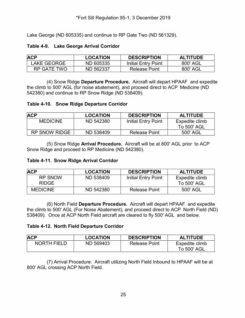
Lake George (ND 605335) and continue to RP Gate Two (ND 561329). Table 4-9. Lake George Arrival Corridor ACP LOCATION DESCRIPTION ALTITUDE
LAKE GEORGE ND 605335 Initial Entry Point 800' AGL RP GATE TWO ND 562337 Release Point 800' AGL
(4) Snow Ridge Departure Procedure. Aircraft will depart HPAAF and expedite the climb to 500' AGL (for noise abatement), and proceed direct to ACP Medicine (ND 542380) and continue to RP Snow Ridge (ND 538409). Table 4-10. Snow Ridge Departure Corridor ACP LOCATION DESCRIPTION ALTITUDE
MEDICINE ND 542380 Initial Entry Point Expedite climb To 500' AGL
RP SNOW RIDGE ND 538409 Release Point 500' AGL (5) Snow Ridge Arrival Procedure. Aircraft will be at 800' AGL prior to ACP Snow Ridge and proceed to RP Medicine (ND 542380). Table 4-11. Snow Ridge Arrival Corridor ACP LOCATION DESCRIPTION ALTITUDE
RP SNOW RIDGE
ND 538409 Initial Entry Point Expedite climb To 500' AGL
MEDICINE ND 542380 Release Point 500' AGL (6) North Field Departure Procedure. Aircraft will depart HPAAF and expedite the climb to 500' AGL (For Noise Abatement), and proceed direct to ACP North Field (ND) 538409). Once at ACP North Field aircraft are cleared to fly 500' AGL and below. Table 4-12. North Field Departure Corridor ACP LOCATION DESCRIPTION ALTITUDE
NORTH FIELD ND 569403 Release Point Expedite climb To 500' AGL
(7) Arrival Procedure: Aircraft utilizing North Field Inbound to HPAAF will be at 800' AGL crossing ACP North Field.
*Fort Sill Regulation 95-1, 3 December 2019
26
Table 4-13. North Field Arrival Corridor ACP LOCATION DESCRIPTION ALTITUDE
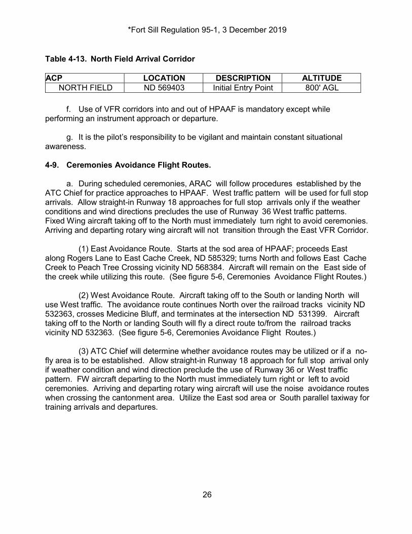
NORTH FIELD ND 569403 Initial Entry Point 800' AGL f. Use of VFR corridors into and out of HPAAF is mandatory except while performing an instrument approach or departure. g. It is the pilot’s responsibility to be vigilant and maintain constant situational awareness. 4-9. Ceremonies Avoidance Flight Routes. a. During scheduled ceremonies, ARAC will follow procedures established by the ATC Chief for practice approaches to HPAAF. West traffic pattern will be used for full stop arrivals. Allow straight-in Runway 18 approaches for full stop arrivals only if the weather conditions and wind directions precludes the use of Runway 36 West traffic patterns. Fixed Wing aircraft taking off to the North must immediately turn right to avoid ceremonies. Arriving and departing rotary wing aircraft will not transition through the East VFR Corridor. (1) East Avoidance Route. Starts at the sod area of HPAAF; proceeds East along Rogers Lane to East Cache Creek, ND 585329; turns North and follows East Cache Creek to Peach Tree Crossing vicinity ND 568384. Aircraft will remain on the East side of the creek while utilizing this route. (See figure 5-6, Ceremonies Avoidance Flight Routes.) (2) West Avoidance Route. Aircraft taking off to the South or landing North will use West traffic. The avoidance route continues North over the railroad tracks vicinity ND 532363, crosses Medicine Bluff, and terminates at the intersection ND 531399. Aircraft taking off to the North or landing South will fly a direct route to/from the railroad tracks vicinity ND 532363. (See figure 5-6, Ceremonies Avoidance Flight Routes.) (3) ATC Chief will determine whether avoidance routes may be utilized or if a no-fly area is to be established. Allow straight-in Runway 18 approach for full stop arrival only if weather condition and wind direction preclude the use of Runway 36 or West traffic pattern. FW aircraft departing to the North must immediately turn right or left to avoid ceremonies. Arriving and departing rotary wing aircraft will use the noise avoidance routes when crossing the cantonment area. Utilize the East sod area or South parallel taxiway for training arrivals and departures.
*Fort Sill Regulation 95-1, 3 December 2019
27
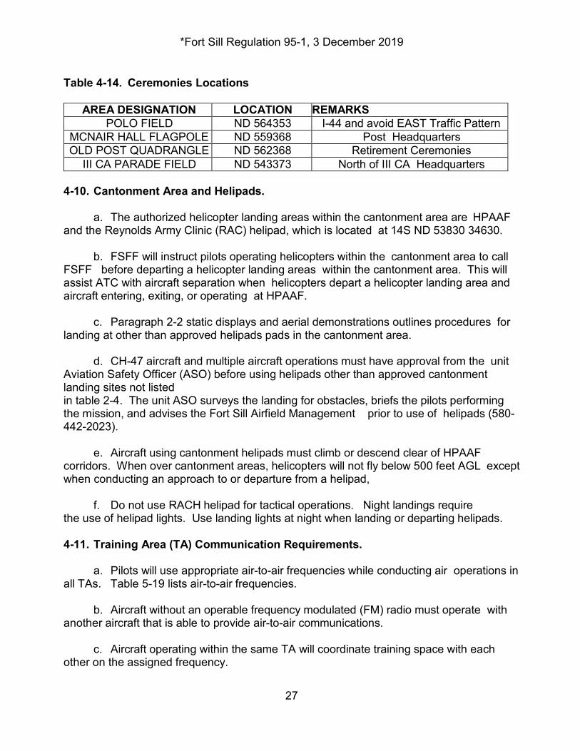
Table 4-14. Ceremonies Locations
AREA DESIGNATION LOCATION REMARKS POLO FIELD ND 564353 I-44 and avoid EAST Traffic Pattern
MCNAIR HALL FLAGPOLE ND 559368 Post Headquarters OLD POST QUADRANGLE ND 562368 Retirement Ceremonies
III CA PARADE FIELD ND 543373 North of III CA Headquarters 4-10. Cantonment Area and Helipads. a. The authorized helicopter landing areas within the cantonment area are HPAAF and the Reynolds Army Clinic (RAC) helipad, which is located at 14S ND 53830 34630. b. FSFF will instruct pilots operating helicopters within the cantonment area to call FSFF before departing a helicopter landing areas within the cantonment area. This will assist ATC with aircraft separation when helicopters depart a helicopter landing area and aircraft entering, exiting, or operating at HPAAF. c. Paragraph 2-2 static displays and aerial demonstrations outlines procedures for landing at other than approved helipads pads in the cantonment area. d. CH-47 aircraft and multiple aircraft operations must have approval from the unit Aviation Safety Officer (ASO) before using helipads other than approved cantonment landing sites not listed in table 2-4. The unit ASO surveys the landing for obstacles, briefs the pilots performing the mission, and advises the Fort Sill Airfield Management prior to use of helipads (580-442-2023). e. Aircraft using cantonment helipads must climb or descend clear of HPAAF corridors. When over cantonment areas, helicopters will not fly below 500 feet AGL except when conducting an approach to or departure from a helipad, f. Do not use RACH helipad for tactical operations. Night landings require the use of helipad lights. Use landing lights at night when landing or departing helipads. 4-11. Training Area (TA) Communication Requirements. a. Pilots will use appropriate air-to-air frequencies while conducting air operations in all TAs. Table 5-19 lists air-to-air frequencies. b. Aircraft without an operable frequency modulated (FM) radio must operate with another aircraft that is able to provide air-to-air communications. c. Aircraft operating within the same TA will coordinate training space with each other on the assigned frequency.
*Fort Sill Regulation 95-1, 3 December 2019
28
d. Aircraft within Class E airspace at HPAAF must use CTAF. 4-12. Aided and Unaided Night Operations. a. Turn on the landing light for all normal night operations at HPAAF. Aided or unaided night operations without landing lights may be conducted on the airfield with air traffic control (ATC) approval, case by case. b. Aided night operations below 200 feet AGL in off-post areas require a day time hazards to flight reconnaissance of the intended flight route within 3 days prior to use. c. The rotary wing traffic pattern altitude is 1900 feet MSL. Airfield lighting is at the minimum intensity as requested by participating aircraft, consistent with other requirements. Aided aircraft in the HPAAF traffic pattern at night will have position lights on steady bright. Lights may be dim on short final, 100 feet AGL or less. After landing, place lights to steady bright. The anti-collision light may be turned off during ground operations with permission. d. Aircraft will maintain contact with each other on air-to-air frequency. Aircraft will comply with lighting and other requirements outlined in FAA Exemption 3946A to FAR 91.73 (a) and (b). (1) All risk factors are evaluated and briefed thoroughly to include the effects of operations in conjunction with or near ground forces. (2) Planned flight routes will remain clear of airspace not scheduled for lights-out operations, special use airspace, and surface areas of Class E and higher airspace and corridors. e. For operations under "minimal lighting" or “lights out” conditions on or off the reservation, position lights on steady dim and the anti-collision light off. In formation flights, the anti-collision light of the trail aircraft remains on. f. When using airspace on- or off-post-- (1) Single aircraft will place position lights on steady bright and the anti-collision light on. (2) Formation’s trail aircraft position lights will be on steady bright and the anti-collision light on. Except when in corridors, other aircraft in the formation may have anti-collision lights turned off and position lights on steady dim. g. Units will establish night flying SOPs for operations under lights-out, if applicable. Aided (NVD) flight training: The following procedures are established for use of NVDs for Fort Sill flight training and apply to pilots who conduct flight training using NVDs: h. HPAAF Lighting. Keep airfield lighting to the minimum necessary for mission
*Fort Sill Regulation 95-1, 3 December 2019
29
accomplishment. (1) Rotating beacons must be on constantly between official sunset and sunrise, unless a Notice to Airmen (NOTAM) was issued indicating a beacon is inoperative or will be turned off for training. (2) Runway lights are required to be on prior to non-NVD aircraft being established on final approach, but not later than 3 NM from HPAAF. i. Traffic Restrictions. Do not place undue traffic restrictions upon nonparticipating aircraft, but make maximum effort to assist NVD pilots in their training. Mixing of aided and non-aided is prohibited. The following rules apply as indicated: (1) HPAAF. In the HPAAF Class "E" Airspace and traffic pattern, anti-collision lights will be on and position lights set to BRIGHT at all times. Do not implement special separation or procedures since all aircraft will be fully illuminated. Expect aided aircrews to conduct themselves in the traffic pattern as if unaided and should consider removing NVD’s if city lights, airfield lights, or the lights of other aircraft become distracting. Aircrews will advise ATC that they are aided so that controllers and other aircraft can avoid light distractions to aided aircraft to the maximum extent possible. (2) HTA's. If NVD training is being conducted and an unaided aircraft approaches, the NVD aircraft will turn on position lights to bright until the unaided aircraft departs the area. j. Authorized Routes. (1) NVD aircraft transitioning out of HPAAF will transition via the most direct route from HPAAF to one of the established VFR Departure Corridors at an altitude of 500' AGL immediately upon departure from traffic, aircraft must contact Fort Sill Flight Following (FSFF) with their intentions and request traffic advisories. (2) NVD aircraft transitioning into HPAAF will transition via the most direct route from one of the established VFR Arrival Corridors to HPAAF at an altitude of 2000 feet MSL. (800' AGL) Prior to arrival at the VFR Corridor Entry Point, arriving aircraft will contact FSFF with their intentions and request traffic advisories. (3) Units may conduct NVD "lights out" training in Fort Sill restricted areas, provided that the unit conducting "lights out" training submits a local NOTAM to HPAAF Airfield Operations NLT 24 hours prior to conducting training. (4) Follow the below procedures for aircraft lighting: a. Navigation lights set to steady dim within R5601, but outside Class E airspace set to NAV lights to steady bright.
*Fort Sill Regulation 95-1, 3 December 2019
30
b. Navigation lights as required when off-post IAW FAA Exemption 3946 to FAR 91.209(A) (B). c. Anti-collision Light as required below 200' AGL and outside HPAAF Class "E" Airspace.
k. NVD Training Aircraft Presence. Use any lights at any time to signal controllers or to warn other aircraft of NVD training aircraft presence. Any aircraft that departs the R5601 restricted area (or other area for NVD training) must comply with FAA regulations for minimum lighting. l. Weather Minimums. Minimum weather forecast for the flight will be 500’ ceiling and one statute mile visibility from takeoff until estimated time of return (ETR) plus one hour. Terminate flight anytime reported weather or pilot-observed weather is less than these minimums. If you must terminate your flights because of deteriorating weather, the PIC may elect to continue to HPAAF on an IFR clearance, if it can be done safely. m. Flight Following. Single aircraft conducting NVD training will flight-follow in accordance with this document. Required reports will be no more than 30 minutes apart. n. Communication Requirements. All aided aircraft within the HPAAF "E" surface area will make Initial calls/reports to FSFF, CTAF or ARAC will include the remark "NVD FLIGHT” or “AIDED." o. Inadvertent IMC. Give consideration to the fact that wearing the NVD's could contribute to inadvertent IMC due to the ability to see through thin, partial obstructions such as fog and rain. Remove or flip up the NVD's up once cruise flight is established. p. Disorientation Procedures. Upon realizing they are disoriented, an aircrew should climb to an altitude that ensures obstacle clearance on a heading that will keep the aircraft clear of the restricted area hot firing points, impact area, and approach paths to HPAAF and Lawton Airport. Adjust aircraft lights as necessary, NVD's removed if desired and an attempt made to reorient the aircraft using navigational aids and visual landmarks. Contact Fort Sill approach control for assistance in determining position. You may resume the NVD mission once orientation is reestablished. 4-13. Terrain and NOE Flights. Conduct terrain flight in approved, authorized areas. The flight area or route must be specific with established safety restrictions. Flight hazard maps will be maintained IAW paragraph 4-6, and depict all known power lines and towers. Use flight hazard maps in the cockpit. Include flight hazards in preflight briefings. Avoid no-fly areas marked on appropriate maps. Plan flight routes to avoid buildings, livestock, and other man-made obstructions. Aircrews will not monitor a commercial broadcasting station during terrain flight operations. a. NOE Route Description. The NOE route is a one-way route that begins at start point (SP) (ND 408346) and precedes NNW along the low ground to Checkpoint “Alpha”
*Fort Sill Regulation 95-1, 3 December 2019
31
(ND 388397). The route continues NW to Ketch Lake (ND 370403) turning south along valley passing East of Mount McKinley to a small body of water grid (ND 361375). Turning NNW the route passes through a saddle on the West side of Mount McKinley to the release point at Fern Mountain (RP) (ND 346398).” (Figure 5-7, West Range NOE Training Route.) b. Hazard Reconnaissance. Units desiring to use the NOE training route must complete a daylight aerial reconnaissance of the route for new hazards prior to first use and thereafter, once every 60 days. Whenever an aircrew discovers a new hazard, the PIC will note the location, height, and type of new hazards and give that information to their unit ASO. The unit ASO will update their unit’s hazard map, post a notice in their reading file, and give the information to airfield management . The airfield management will then notify the Supervisor Airfield Operations Specialist to update the airfield operations hazards map. c. COORDINATION. All aircrews utilizing this NOE route must make a call in the blind on Fort Sill’s Air to Air Frequency. This call in the blind must be made prior to start point (SP), check point “Alpha”, and at the release point (RP). Prior to use, aircrews will verify with Range Operations if Crater Creek Canyon Demolition Area is active. Additionally, aircrews will not utilize the NOE route if route BLUE is closed. All units utilizing this route must check and update their hazards map prior to flight. 4-14. Flights Outside Local Flying Areas. Only brigade, battalion or aviation commanders may approve helicopter training flights outside the Fort Sill local flying area (100 NM radius) and fixed wing aircraft training flights beyond a 200 NM radius from Fort Sill 4-15. Helicopter External Loads. a. Practice external load operations at HPAAF are not authorized without prior coordination with airfield management. The SEC is the primary external load training site. b. External loads off the Fort Sill Installation require approval by the Director, DPTMS. When such operations are required, select routes that comply with FAA regulations and present the least possible hazard to persons and property. 4-16. Rotary Wing Emergency Procedures Training. a. HPAAF is the primary location for emergency procedure training. IP's desiring to use the runway or parallel taxiway must visually inspect the surface for suitability. b. HPAAF may be used for rotary wing emergency procedures training, traffic permitting. c. Rotary wing IP's and SP's may perform simulated engine failure to termination with power at airfields which meet the requirements of AR 95-1.
*Fort Sill Regulation 95-1, 3 December 2019
32
4-17. Rotary Wing Procedures when Close Air Support (CAS) missions are scheduled in R5601. a. When CAS missions are active, all rotary wing aircraft must establish radio communications with the FAC, prior to going West of the 50 North-South Grid Line. (Frequency is UHF 356.5 or UHF 344.5 and Call Sign is N18.) NOTE: This is the published procedure in Fort Sill Reg 385-1. b. Rotary-wing aircraft must stay alert for low-level jet traffic from the North- South Grid Line 34 through the North-South Grid Line 42. 4-18. Close Air Support (CAS) Missions in R5601. Remain clear of all corridors and cantonment area unless otherwise coordinated or directed by Fort Sill Air Traffic Control. Specific altitudes and procedures are included in the ACA’s in this document and/or the SPIN documents for each mission which are coordinated with Range Operations, and Chief of Air Traffic Control, DPTMS. (See figures 5-8 through 5-10 for ACA’s for R5601) 4-19. No-Fly Areas. a. Permanent no-fly restricted areas are coordinated with AT&A and listed in this regulation. Aircraft will not over-fly the following areas at less than 1,000 feet AGL: (1) Areas restricted by NOTAM or L-NOTAM. (2) Ammunition storage areas.
(3) Hospitals.
(4) Schools.
(5) Housing areas. b. Flight hazard maps and the CARS maps will depict no-fly areas listed below:
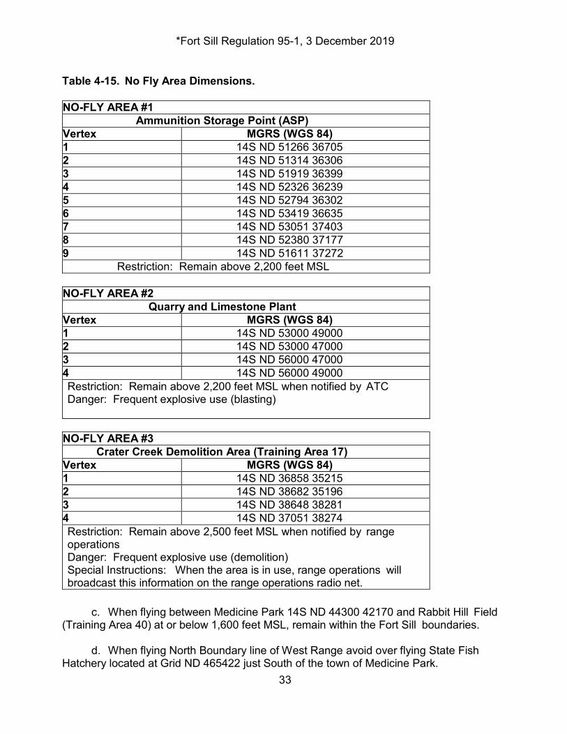
*Fort Sill Regulation 95-1, 3 December 2019
33
Table 4-15. No Fly Area Dimensions. NO-FLY AREA #1
Ammunition Storage Point (ASP) Vertex MGRS (WGS 84) 1 14S ND 51266 36705 2 14S ND 51314 36306 3 14S ND 51919 36399 4 14S ND 52326 36239 5 14S ND 52794 36302 6 14S ND 53419 36635 7 14S ND 53051 37403 8 14S ND 52380 37177 9 14S ND 51611 37272
Restriction: Remain above 2,200 feet MSL NO-FLY AREA #2
Quarry and Limestone Plant Vertex MGRS (WGS 84) 1 14S ND 53000 49000 2 14S ND 53000 47000 3 14S ND 56000 47000 4 14S ND 56000 49000 Restriction: Remain above 2,200 feet MSL when notified by ATC Danger: Frequent explosive use (blasting)
NO-FLY AREA #3
Crater Creek Demolition Area (Training Area 17) Vertex MGRS (WGS 84) 1 14S ND 36858 35215 2 14S ND 38682 35196 3 14S ND 38648 38281 4 14S ND 37051 38274 Restriction: Remain above 2,500 feet MSL when notified by range operations Danger: Frequent explosive use (demolition) Special Instructions: When the area is in use, range operations will broadcast this information on the range operations radio net.
c. When flying between Medicine Park 14S ND 44300 42170 and Rabbit Hill Field (Training Area 40) at or below 1,600 feet MSL, remain within the Fort Sill boundaries. d. When flying North Boundary line of West Range avoid over flying State Fish Hatchery located at Grid ND 465422 just South of the town of Medicine Park.
*Fort Sill Regulation 95-1, 3 December 2019
34
NOTE: Flights over the Wichita Mountains Wildlife Refuge. Flights over the Wichita Mountains Wildlife Refuge are highly discouraged. The Wildlife Refuge personnel are highly sensitive to any inadvertent flights into their noise sensitive area. Be good neighbors and do not over-fly the Refuge below 2000' AGL unless flight is approved by Wichita Mountain Wildlife Refuge Management. 4-20. Automated Weather Observing System (AWOS. The nearest AWOS system is located at the Lawton-Fort Sill Regional Airport. Lawton AWOS frequency is 120.75. Chapter 5. Refueling Procedures 5-1. Refueling Overview. a. Use of HPAAF Refueling Personnel and Equipment. (1) HPAAF has F-24 fuel for aircraft refueling services available for DOD aircraft with a DOD Aircraft Identification Card. Aircrews or Flight Operations personnel may request aircraft refueling by contacting HPAAF Airfield Management Office at 580-442-2023/4643 during published operating hours. With no prior notice fuel personnel may take two (2) hours to provide aircraft refueling services. (2) All assigned, attached or mobilization aviation units will insure the refueling of their aircraft is according to the aircraft TM and to ATP 4-43 standards. b. Non-refueling personnel will go to a marshaling area at least 50 feet away from the refueling aircraft as directed by refueling personnel. c. Aircraft de-fueling may be accomplished by units on HPAAF. The ARFF must be placed on in house standby during de-fuel operations. 5-2. Rapid Refueling. a. HPAAF refuel does not perform hot refueling, but does have six concrete refueling pads available for a unit to set up its own hot refuel operation. The unit will have to supply its own equipment and personnel and submit their FARP plan to HPAAF safety for review. b. Aircraft departing HPAAF rapid refueling pad will visually clear traffic prior to air taxi to East Sod to taxi to parking or departure. c. Refer to figure 6-1 for refueling area diagrams of HPAAF Chapter 6. Test Fl ights 6-1. Maintenance Test Flights (MTFS). a. Conduct MTFs under VFR conditions during daylight hours. Test flights
*Fort Sill Regulation 95-1, 3 December 2019
35
conducted under other than VFR conditions require approval of the unit commander. Assigned, attached, or TDY units operating at Fort Sill must follow Fort Sill test flight procedures. Conduct test flights according to AR 95-1 and the appropriate aircraft ATM. b. Conduct test flights in the appropriate test flight area; terminate at the point of origin and restrict flights to two and one-half hours or less per sortie. Fixed wing aircraft may request an extension. c. Do not conduct test flights involving maximum torque airspeed (VH) checks while within HPAAF traffic pattern. Flight checks in excess of 120 KIAS require approval. d. During test flights, aircrews will flight follow with Fort Sill Approach Control. e. Perform the first auto-rotational revolutions per minute (RPM) check of the day on any aircraft following main rotor maintenance to HPAAF. Maintenance pilots (MP) will request ARAC activate Fire Station #2 to standby with appropriate crash rescue equipment designated for emergency procedures training. MP's will immediately request thru ARAC the release of ARFF personnel when maintenance checks of auto-rotational RPM checks are completed. 6-2. Maintenance Test Flight Plans. MPs will file local flight plans with ARAC by telephone or with the control by radio using test pilot call signs. 6-3. Test Flight Call Signs. a. Aviation units assigned, attached or transit at HPAAF will designate Maintenance Pilot call signs and numbers to individual MPs. A by-name list of issued call signs and numbers will be provided to HPAAF Operations. Lists will be updated as changes occur. b. Test flight call signs are used only for MTFs and in-flight maintenance operational checks (MOCs). Maintenance Examiners (ME) may use test flight call signs while conducting training or evaluations during an MTF or in-flight MOC. The misuse of call signs will result in termination of test flight call sign authority for that test pilot. 6-4. Test Flight Areas. Test flight areas will be posted on local maps in unit and airfield operations. Test pilots will know test flight area boundaries and hazards. Designated test flight areas are as follows: a. Area I. HPAAF closed traffic pattern 1900 feet MSL or as approved by ATC (See figure 4-7, HPAAF Traffic Pattern). b. Area II. South East Maintenance Test Flight Area. Boundaries are from and including Southeast Corner HTA, East to Pumpkin Center, southeast to Duncan Haliburton Airport, Northeast to Lake Fuqua, Northwest to Rush Springs, Northwest to Cyril, Southwest to Elgin, and South along the Fort Sill East boundary to Southeast Corner HTA. (Figure 7-1, Maintenance Test Flight Areas.)
*Fort Sill Regulation 95-1, 3 December 2019
36
c. Area III. South West Maintenance Test Flight Area. Beginning at the Goodyear Tire Plant, West to Cache, West to a point 2NM south of Indiahoma, Southeast to Chattanooga, Northeast to Faxon, North to Goodyear Tire Plant. (Figure 7- 1, Maintenance Test Flight Areas.) d. Pilots performing test flights in the above and other areas will establish and maintain communications with Fort Sill Approach Control on designated flight following frequencies. Chapter 7 Safety 7-1. Fort Sill Aviation Safety Program. a. HPAAF is not resourced for aviation safety. Airfield management conducts a safety inspection of all airfield facilities in conjunction with the safety officer of the unit utilizing the area.
a. Aviation units will take corrective action within 30 days after receipt of survey results. Corrective actions taken to correct deficiencies found will be returned to the HPAAF Aviation Safety Officer within 7 days after corrective actions has been taken.
7-2. Crew Endurance. Each aviation unit commander assigned, attached, or conducting mobilization training at Fort Sill will design a crew endurance program tailored to their unit mission and include it in their standing operating procedures (SOP). 7-3. Risk Management. Units will have a risk management program according to DA Pam 385-30 and FM 5-19. 7-4. Environmental Considerations. Before conducting operations unit commanders must ensure crews are familiar with environmental conditions. Each aircraft will have survival equipment for the type of environment in which flight occurs. 7-5. Under Wire Flight Program. Helicopter aviation units may conduct under wire flight training when included in unit training programs and after individual sites are surveyed by the unit ASO. After survey, approval is required by the using aviation commander to conduct under wire flight training. Units will maintain a list of authorized sites and provide locations to airfield management. 7-6. Flight Hazard Program. a. Aircrews have a responsibility to report new hazards that are not posted to Fort Sill's and units flight hazards maps. (See figure 8-1, Sample Flight Hazards Map.) Pilots submit reports to HPAAF Safety or HPAAF Operations as soon as possible. b. Airfield management will evaluate the reports with the chart update manual CHUM and NOTAMS and notify the HPAAF Supervisor Airfield Operations Specialist who will post the information to the master flight hazards map as received. The Supervisor
*Fort Sill Regulation 95-1, 3 December 2019
37
Airfield Operations Specialist will forward the information to the Fort Sill AT&A. Airfield management will furnish Aviation unit's Flight Operations a copy of local area Flight Hazards Maps whenever the master flight hazard map is reprinted. c. HPAAF Airfield Operations will maintain a 1:50,000 map and a 1:100,000 map depicting man-made flight hazards 50 feet AGL and higher above the surface. 7-7. Aircraft Mishap Procedures. The first person to become aware of an aircraft mishap, forced landing, precautionary landing, or missing aircraft, notifies HPAAF Airfield Operations (442-2023), the EOC (442-3241), Range Operations (442-2008), or ARAC (442-2004). ARAC will activate the Primary Crash Alarm System. Table 7-1. Emergency Telephone Numbers Fort Sill Army Radar Approach Control (ARAC) (580) 442-2004 Emergency Operations Center (EOC) (580) 442-3240/3041/3042 Fort Sill Emergency Dispatcher 911
7-8. Aviation Life Support Equipment (ALSE). Use ALSE while at Fort Sill according to AR 95-1, MACOM and command directives. 7-9. Operational Hazard Reports (OHR). Operational Hazards are any condition, action or set of circumstances that compromise the safety of Army aircraft, associated personnel, airfields or equipment. Operational Hazards should be corrected at the lowest level possible. a. Airfield management must be notified of all instances that compromise the safety of Army aircraft, associated personnel, airfields or equipment. Use DA Form 2696 when filing a written report IAW DA PAM 385-90. If the hazard concerns Fort Sill facilities or personnel the DA Form 2696 will be turned into Airfield management. If the responsibility for the hazard is another unit the 2696 will be turned into their safety officer. The receiving safety officer will ensure that OHRs are promptly forwarded to the appropriate agency/commander for action and are returned to the Safety Officer within 10 working days of the date the report was received; ensuring that the completed action is returned to the originator (if known) within 20 working days of the date the report was received. b. In the event the action cannot be completed within 20 working days, then an interim report is returned to the originator with an updated written report provided every 10 working days until the action is completed. 7-10. Accident Reporting and Investigation. All aircraft accidents/incidents and all accidents, regardless of the amount of property damage or the severity of the injury, that happens on HPAAF will be reported through the chain-of-command and to the HPAAF safety officer as soon as possible. Courtesy copies of all AAAR and AGARs will be submitted to airfield management for tracking and trend analysis.
*Fort Sill Regulation 95-1, 3 December 2019
38
Chapter 8. Special Procedures 8-1. Overdue Aircraft. Aircraft will make required reports to Fort Sill Flight Following every 30 minutes; after 30 minutes, aircraft are considered overdue. Fort Sill Flight Following will initiate a communication search. If the aircraft is not located, Fort Sill Flight Following will advise airfield management, who initiates a communications and ramp search. If this search is negative, airfield management then notifies the EOC. The EOC will then initiate a search and rescue (SAR). The authority for launching SAR for military aircraft is the Installations Search and Rescue Coordinator or the Fort Sill's Chief of Staff. 8-2. Search and Rescue (SAR). a. When assisting in SAR operations, aircrews will establish contact with the nearest ATC facility. Pilots will attempt to coordinate penetration of sole use airspace prior to takeoff. If coordination is not possible, the aviator will advise Fort Sill Flight Following at initial contact. Fort Sill Flight Following has the authority to request Army aircraft that are in-flight to provide immediate assistance to the aircraft in distress. b. The Fort Sill aircraft crash search and rescue (ACS&R) map is required to be posted in all unit's Flight Operations areas and aboard every helicopter assigned, attached, or transit unit's when flying within Fort Sill's R5601 immediate area. While on the reservation, report locations in 6 or 8 digit military grid reference system MGRS. c. Fort Sill assigned aircraft are authorized, at the discretion of the PIC, to proceed to a known or suspected mishap sight while within the local flying area. The primary duty of the crew is to confirm a mishap and accurately report its location to ATC. Fort Sill assigned aircraft will not conduct extended SAR missions without an approved flight mission briefing. 8-3. Live Ordnance Recovery.
a. HPAAF does not have the proper facilities to handle aircraft with live ordnance. If an aircraft emergency exists that precludes armed aircraft returning to their FARP for de-arming the aircraft may return to HPAAF. If conditions permit jettison wing stores in the east or west impact areas, ensure switches for all weapons systems not jettisoned are in the safe position before landing at HPAAF. Once on the ground if possible the aircraft will be positioned on the compass rose orientated 111°. b. Weather Recovery. (1) If the ceiling drops below 500 and 2 armed helicopters will return to their FARP, Commanders will then decide if aircraft will wait for the weather to improve or dearm and return to Post. If an armed helicopter goes IMC all armament systems will be placed in safe mode and the IMC instructions listed in para 9-5 will be followed. Once the aircraft has landed at HPAAF it will be taxied to the compass rose (decommissioned) and orientated 111°degrees heading.
*Fort Sill Regulation 95-1, 3 December 2019
39
(2) Unit personnel will download armament systems and recover ammunition. If download is unsuccessful, the unit must provide aircraft guards. (3) If circumstances prohibit use of the Compass Rose pad, armed helicopters will park on the South Parallel Taxiway with the aircraft oriented 111 degrees heading. 8-4. Inadvertent Instrument Meteorological Conditions (IIMC) Recovery. Procedures. IIMC procedures apply to the Fort Sill military reservation. Use these procedures when an aircraft encounters unexpected instrument meteorological conditions (IMC). a. Aircraft flown on Fort Sill in weather below a 300-foot ceiling in the day or a 1000-foot ceiling at night will have-- (1) One radio tuned to Fort Sill Approach Control. (2) A navigation radio tuned to an appropriate NDB or VHF Omni-directional range (VOR). (3) AHRS only equipped crews will program an emergency altitude heading reference system (AHRS) approach procedure for HPAAF. AHRS approaches are flown during training in VMC conditions or during actual emergency conditions. (4) Aircraft equipped with Doppler, GPS/INS/EGI navigation or other similar equipment will have HPAAF or Lawton Regional Airport Navigational Aids programmed into their system. b. If the aircraft encounters IMC, immediately accept it and commit to instrument flight. (1) Attitude indicator: level the wings, IAW appropriate ATM. (2) Heading indicator: maintain heading, turn only to avoid known obstacles or live fire areas, IAW appropriate ATM. (3) Torque meter: adjust to climb power, IAW appropriate ATM. (4) Airspeed adjusts to climb airspeed: Climb to 3700 feet MSL, squawk Emergency 7700 on the transponder contact Fort Sill Approach Control and declare an Emergency. Proceed as directed by approach control. c. In the event communication is not established or is lost, take the following actions: (1) Continue according to ATC instructions. d. Use "simulated IIMC recovery" in the initial transmission to approach control when
*Fort Sill Regulation 95-1, 3 December 2019
40
conducting simulated IIMC operations. Do not use transponder code 7700 during simulated recovery operation. Helicopters participating in simulated IIMC procedures will not receive IFR priority. e. When the unit is deployed or at remote training location where suitable approaches are not available, commanders are authorized to develop AHARS/GPS approaches for VMC training and emergency IIMC recovery. Locally developed approaches will conform to established ATM terminal instrument procedures TERPS and FAA standards. 8-5. VIP Arrival Procedures. Give priority to aircraft carrying codes to the extent possible within safety limitations in traffic sequencing. MEDEVAC and aircraft emergencies always have priority over other aircraft. 8-6. Aircraft with Hazardous Cargo (HC). HC includes explosives, cargo of fuel, highly combustible material, and all chemical, biological and radiological material. Since HPAAF does not have a designated HC area approval for landing aircraft with HC will be on a case by case basis. Aircraft with HC aboard requires a minimum of 48 hours prior permission request (PPR) before landing at HPAAF. Upon notification that an aircraft with HC requests to land at HPAAF the airfield manager, with input from other Fort Sill agencies if needed, will decide whether to approve or deny the request. If the request is approved the following procedures will be implemented. a. If hazardous cargo is scheduled to arrive during other than normal hours of operations, HPAAF Operations will ensure airfield personnel are on duty from 1 hour prior to the scheduled ETA until completion of the unloading/refueling procedures. b. Airfield Management will— (1) Notify Supervisor Airfield Operations Specialist as soon as possible of any changes to the status of HC.
(2) If material transported is for a Fort Sill agency, the agency will be on on-site to download and transport the material off the airfield no later than 15 minutes before ETA.
(3) Notify ARAC with ETA of aircraft and provide the ARAC with type and amount of hazardous cargo.
(4) Alert Fire Department for on-field standby. Also provide Fire Department type and amount of hazardous cargo. c. HPAAF Supervisor Airfield Operations Specialist will-- (1) Direct Rotary Wing aircraft arriving with hazardous cargo to the compass rose for unloading/refueling. Fixed Wing Cargo Aircraft will use the South run-up area.
*Fort Sill Regulation 95-1, 3 December 2019
41
(2) Refuel and off load only in the areas designated in (1) above.
(3) Not leave aircraft with hazardous cargo on board unattended at any time. d. Airfield management will-- (1) Make periodic observations of the parked aircraft and report any unauthorized personnel to the appropriate authority. (2) Notify the Fire department for on-field standby and all pertinent information. 8-7. ATC Procedures During Non-availability of Aircraft Rescue and Fire Fighting Equipment (ARFF). a. The Fort Sill Fire Department requires, on occasions, the use of personnel and equipment normally covering the airfield to respond to other emergencies. Should the need arise to utilize this procedure, the Fire Department will notify ARAC. If Fort Sill Fire Department is unavailable for ARFF standby, ATC will terminate all nonstandard maneuvers. b. In case of emergency or crash, the ARAC will notify the Fire Department, by Primary Crash direct line (PCAS) or radio, direct landline or by calling 911. The Fire Department dispatcher will notify the senior fire officer, who will determine if Fort Sill firefighters can respond or if he/she must activate the mutual aid agreement with Lawton for dispatch of their crash units. c. The Supervisor Airfield Operations Specialist is responsible for issuing an Air Advisory (AIRAD) if ARFF equipment and personnel are not available after 8 hours, and a NOTAM if the condition exists beyond 10 days. d. Once equipment is available again, the Fire Department will notify the HPAAF Airfield Management during normal duty hours. HPAAF Airfield Management will notify the ATC Chief and ARAC. e. the Supervisor Airfield Operations Specialist. After normal duty hours the Fire Department will contact ARAC, 442-2004. f. The Supervisor Airfield Operations Specialist will notify HPAAF Airfield Manager when issuing an Air Advisory (AIRAD) for non-availability of ARFF capability. 8-8. Fixed Wing Rotary Wing VIP Parking Procedures. a. HPAAF Airfield Management will coordinate with ATC personnel to give priority of use for VIP parking pads (normally A-1, to aircraft with code arrivals and departures. ATC will restrict use of the diagonal taxiway between the parallel taxiway and the VIP parking pads to small Fixed Wing aircraft. Rotary Wing traffic with VIP's on board will be directed/marshalled down the parallel taxiway to Alpa Row for Rotary Wing VIP parking.
*Fort Sill Regulation 95-1, 3 December 2019
42
b. Pilots arriving/departing HPAAF will coordinate with airfield management before utilizing the A-1, parking pads (VIP). Pilots will advise ATC if carrying a code passenger and will comply with ATC instructions concerning VIP parking procedures. c. Move aircraft utilizing Hot Spot if not departing with passengers within 30 minutes unless approved by airfield management . Do not leave aircraft parked unnecessarily on VIP parking pads. d. Airfield management will close taxiway B (from the parallel Taxiway A-C onto Apron 1) to Rotary Wing aircraft when Fixed Wing aircraft are parked on VIP parking pads (See figure 9-2.) Chapter 9. Special Weather Procedures 9-1. Weather Definitions. Fort Sill Regulation 115-9 details specific weather information and support requirements. 9-2. HPAAF Severe Weather Plans. a. Severe weather is defined as follows: Tornadoes or severe thunderstorms. Maximum wind gusts of 50 knots or greater, hail three-quarter inch or more in diameter, or both. b. Upon receipt of a severe weather warning, units will recall and ground all aircraft. Commanders will update the Emergency Operations Center (EOC) 442-3240/3241/3242 every 15 minutes until all aircraft and flight line equipment is secure.
c. Commanders will provide clear and complete guidance in staff duty instruction book. Include recall procedures for key individuals in severe weather plans. Ensure that personnel monitor weather activity full time after the receipt of any weather warning or advisory. d. Commanders of aviation units assigned, attached or conducting mobilization training at HPAAF will within 12 hours of aircraft arrival provide HPAAF Supervisor Airfield Operations Specialist or airfield management with a Unit's Severe Weather telephone contact roster. This is to ensure unit personnel can be rapidly contacted in the event of Severe Weather Warnings. e. Upon receipt of weather warning for lightning or when lightning is observed within 7 miles, commanders will take necessary actions to protect personnel and equipment. All aircraft fueling operations will cease when lightning is observed within 7 miles. A lightning warning will not by itself inhibit aircraft flight operations.
f. Commanders when notified of the potential for windstorms in excess of 50 knots will take appropriate actions as prescribed in TM 1-1500-250-23.
*Fort Sill Regulation 95-1, 3 December 2019
43
g. Upon encountering thunderstorms or severe weather phenomena, aircrews will-- (1) Terminate training and exit the affected area as soon as possible. If continued flight is not practical, attempt to contact ATC, land and shut down, or land and continue to operate the aircraft according to the operator’s manual. (2) Assess aircraft for any damage.
(3) Contact unit as soon as possible to report status.
(4) Contact HPAAF Weather and submit a pilot information report PIREP. 9-3. Mooring and Tie Down. a. Moor or hangar assigned, attached, mobilization and transient aircraft at the end of the last flight of each day. Tie down and secure blades and covers. Moor aircraft not in hangars according to operators’ manuals and TM 1-1500-250-23. If commanders deem prescribed procedures to be inappropriate, submit requests for deviation through the HPAAF Manager, Airfield Operations Division, DPTMS, to the Garrison Commander, ATTN: IMSI-PL, Fort Sill, OK 73503-5000. b. Commanders will take reasonable precautions in mooring aircraft that remain overnight (RON) away from installation airfields. In areas where tie-downs are not available, commanders should consider flying aircraft to hangar or ramp tie down areas.
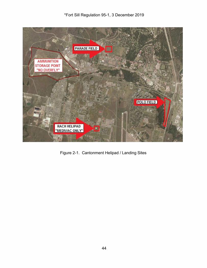
*Fort Sill Regulation 95-1, 3 December 2019
44
Figures
Figure 2-1. Cantonment Helipad / Landing Sites
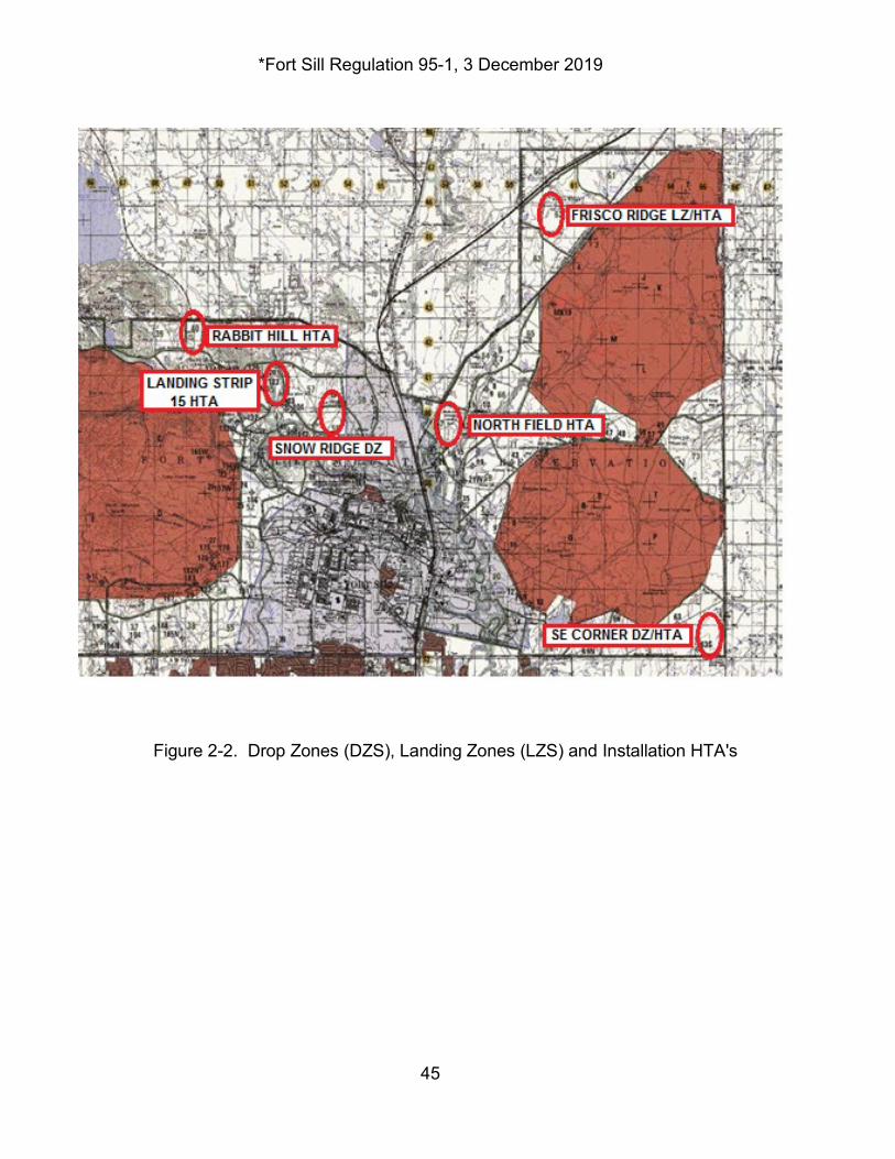
*Fort Sill Regulation 95-1, 3 December 2019
45
Figure 2-2. Drop Zones (DZS), Landing Zones (LZS) and Installation HTA's
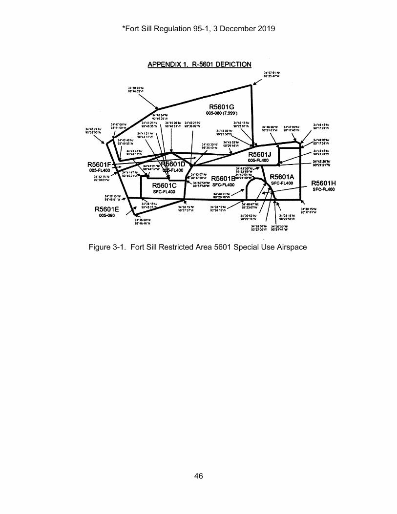
*Fort Sill Regulation 95-1, 3 December 2019
46
Figure 3-1. Fort Sill Restricted Area 5601 Special Use Airspace
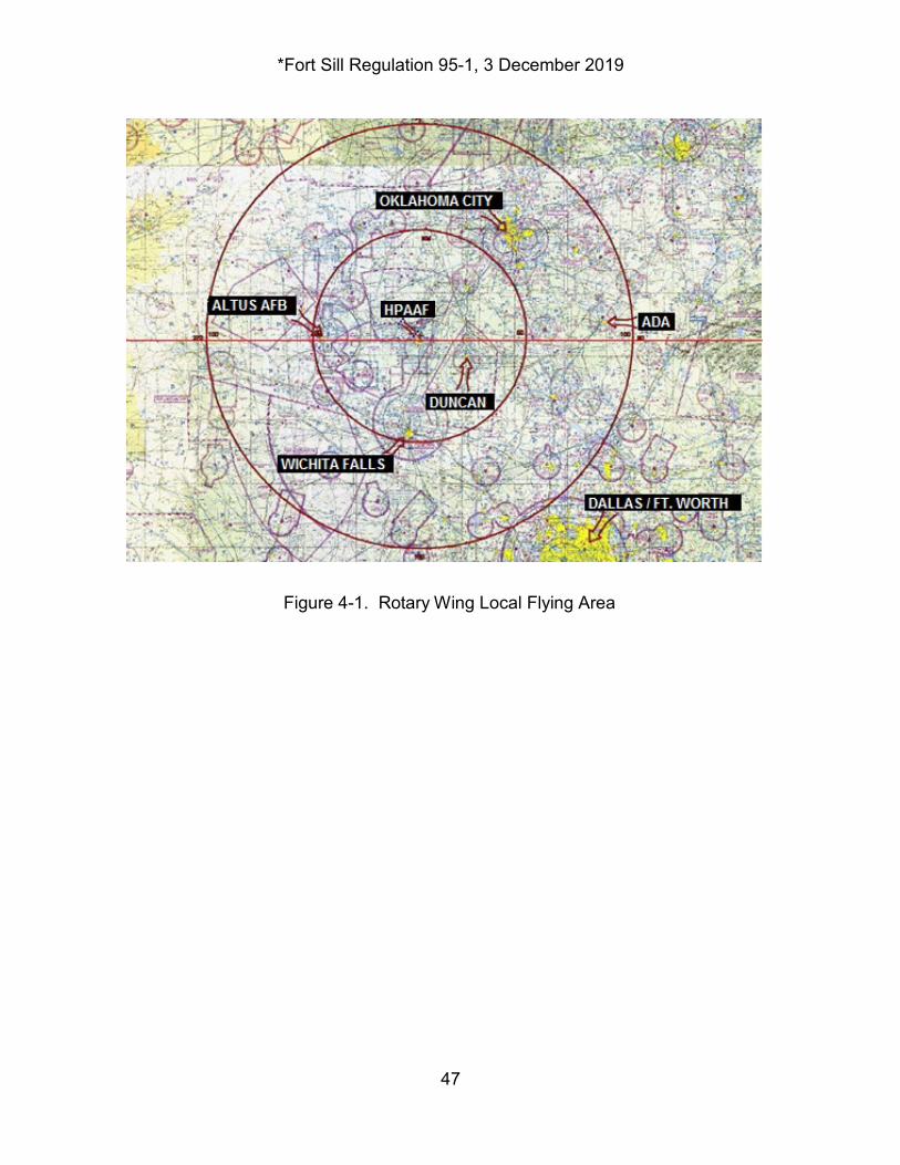
*Fort Sill Regulation 95-1, 3 December 2019
47
Figure 4-1. Rotary Wing Local Flying Area
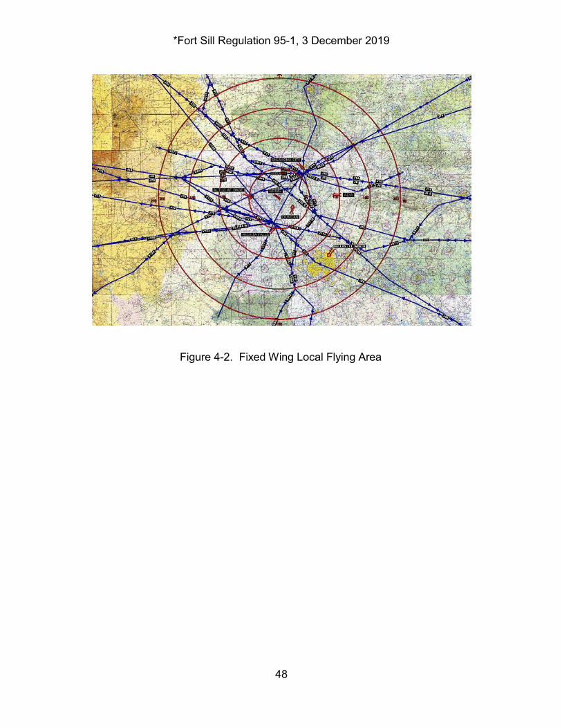
*Fort Sill Regulation 95-1, 3 December 2019
48
Figure 4-2. Fixed Wing Local Flying Area
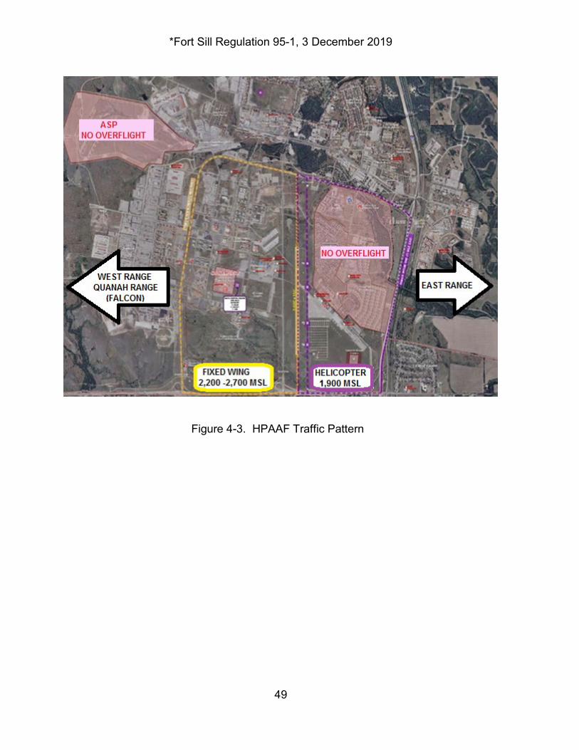
*Fort Sill Regulation 95-1, 3 December 2019
49
Figure 4-3. HPAAF Traffic Pattern
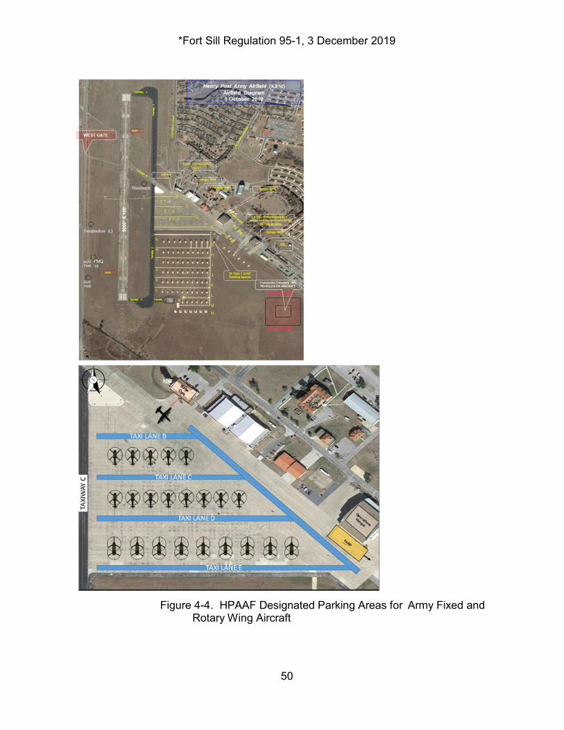
*Fort Sill Regulation 95-1, 3 December 2019
50
Figure 4-4. HPAAF Designated Parking Areas for Army Fixed and
Rotary Wing Aircraft
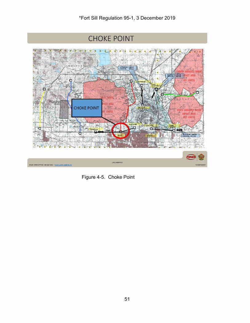
*Fort Sill Regulation 95-1, 3 December 2019
51
Figure 4-5. Choke Point

*Fort Sill Regulation 95-1, 3 December 2019
52
HPAAF AIRFIELD OPERATIONS NORMAL DUTY HOURS
(0700 – 1600 HRS) Mon-Fri. exc. Fed Hol.
HPAAF AIRFIELD OPERATIONS AFTER-NORMAL DUTY HOURS (1600 – 0700 HRS) Mon-Fri. exc. Fed Hol.
Figure 5-1. HPAAF Severe Weather Notification Plan
HPAAF SEVERE WEATHER NOTIFICATION PLAN
442-5808 442-6160
OL-U WEATHER STATION 442-3200 442-4000
HPAAF FLIGHT MANAGEMENT OFFICE
TENANT/TRANSIT AIRCRAFT CREWS AS REQ. AS REQ.
442-3200 442-4000
442-3240 442-3241
TENANT/TRANSIT A/C CREWS
OL-U WEATHER STATION
EMERGENCY OPERATIONS CENTER (EOC)
HENRY POST AIRFIELD, DPTMS
928-785-7903
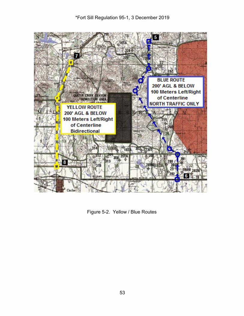
*Fort Sill Regulation 95-1, 3 December 2019
53
Figure 5-2. Yellow / Blue Routes
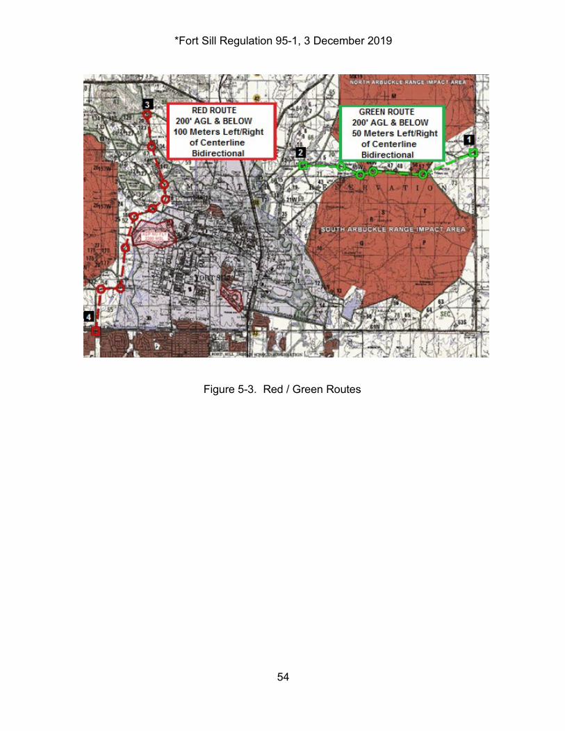
*Fort Sill Regulation 95-1, 3 December 2019
54
Figure 5-3. Red / Green Routes
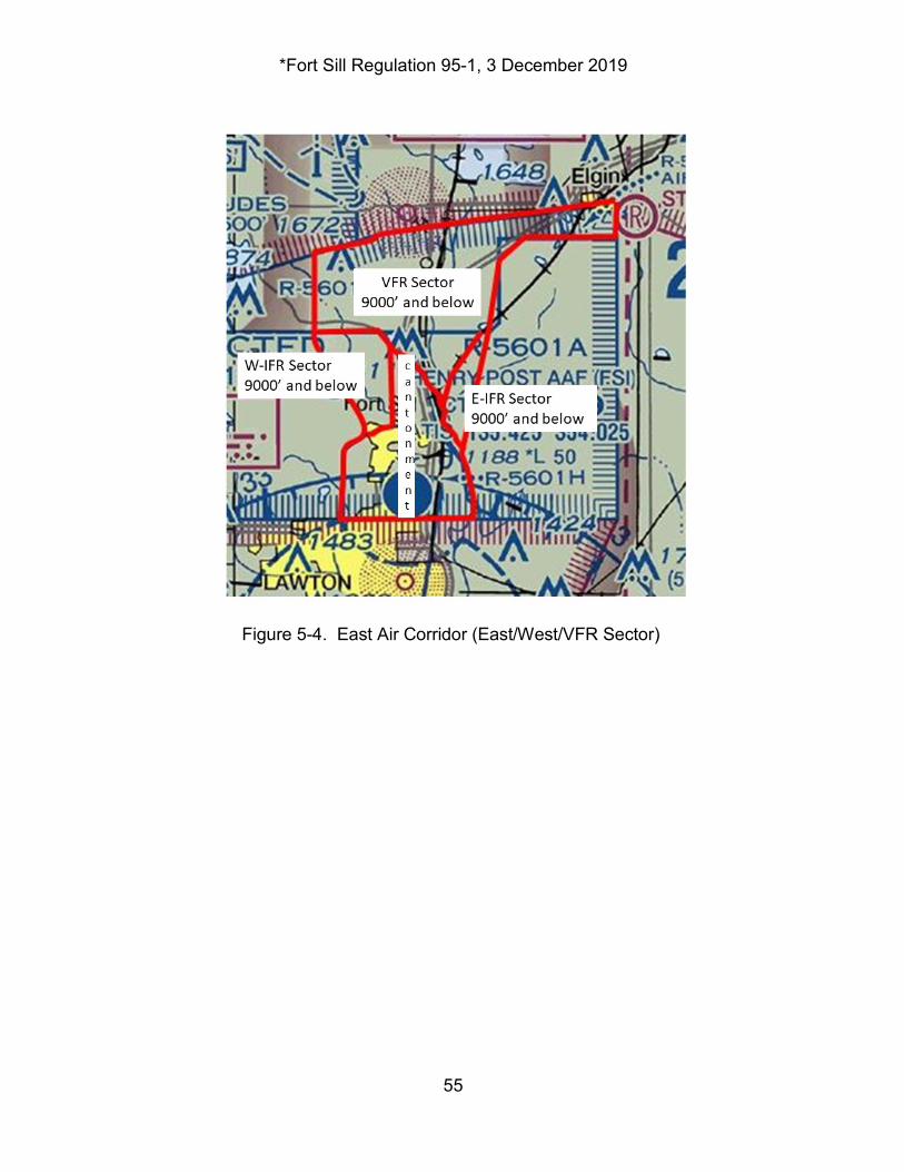
*Fort Sill Regulation 95-1, 3 December 2019
55
Figure 5-4. East Air Corridor (East/West/VFR Sector)
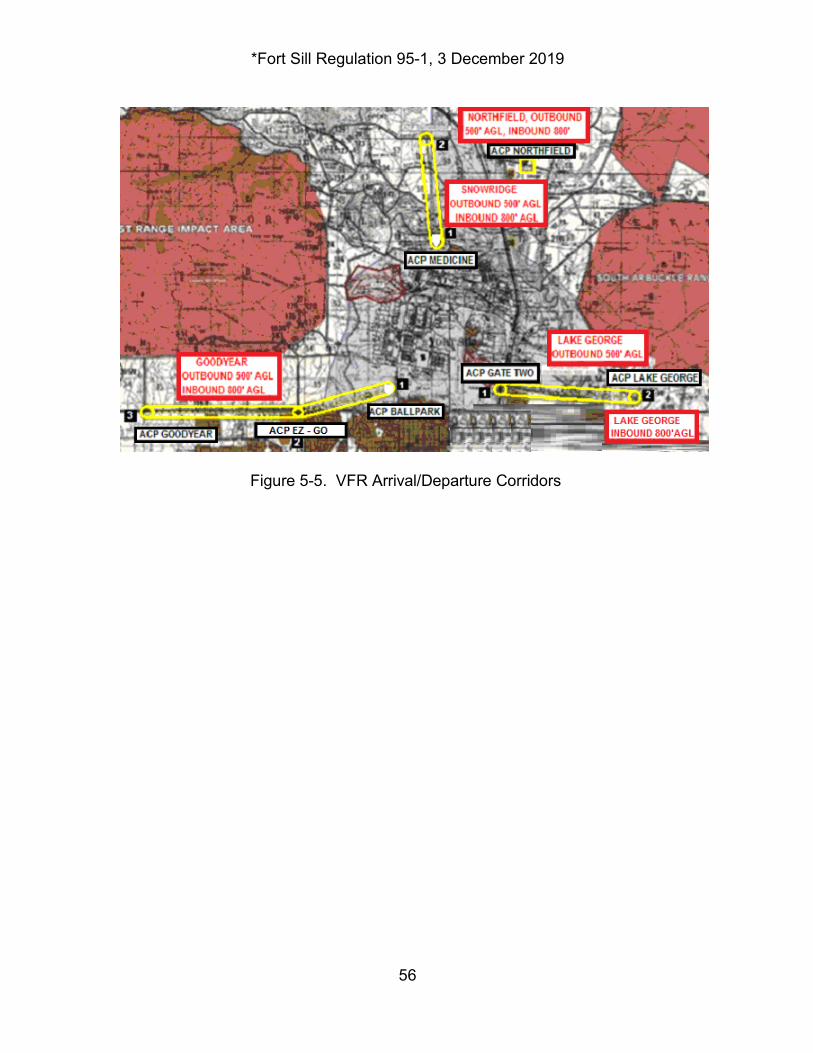
*Fort Sill Regulation 95-1, 3 December 2019
56
Figure 5-5. VFR Arrival/Departure Corridors
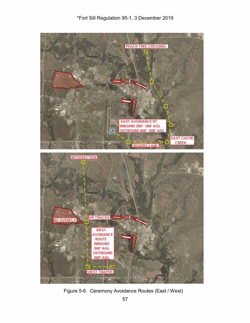
*Fort Sill Regulation 95-1, 3 December 2019
57
Figure 5-6. Ceremony Avoidance Routes (East / West)
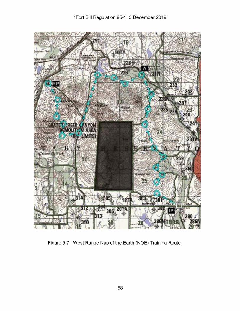
*Fort Sill Regulation 95-1, 3 December 2019
58
Figure 5-7. West Range Nap of the Earth (NOE) Training Route
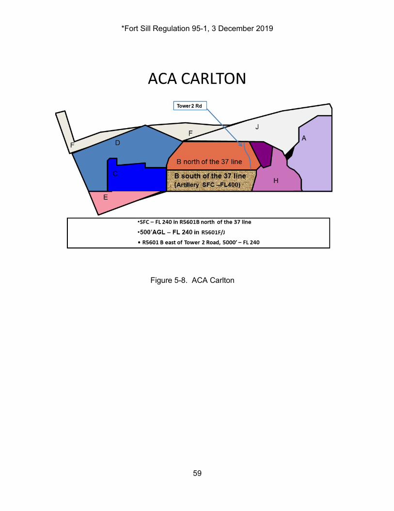
*Fort Sill Regulation 95-1, 3 December 2019
59
Figure 5-8. ACA Carlton
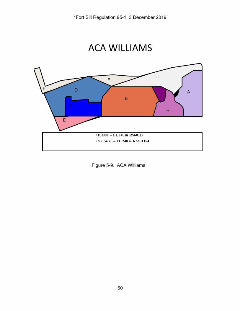
*Fort Sill Regulation 95-1, 3 December 2019
60
Figure 5-9. ACA Williams
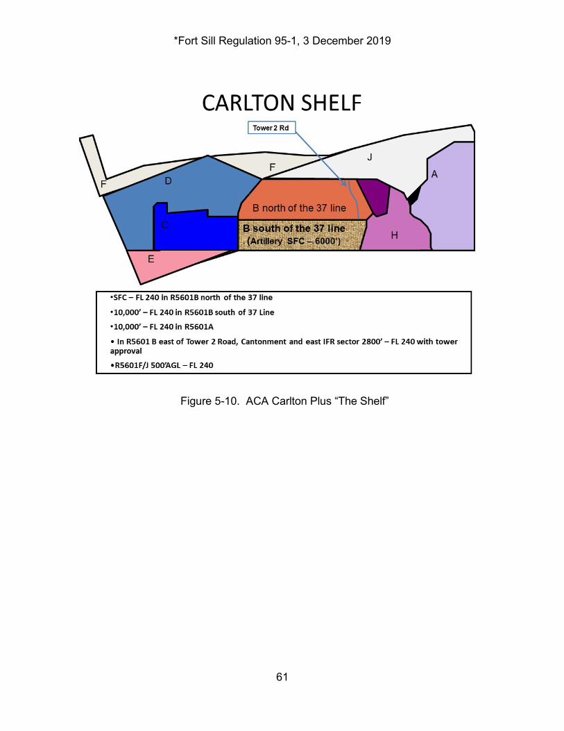
*Fort Sill Regulation 95-1, 3 December 2019
61
Figure 5-10. ACA Carlton Plus “The Shelf”
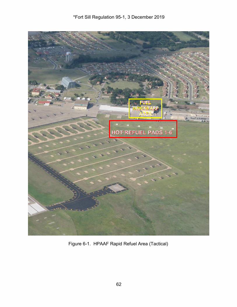
*Fort Sill Regulation 95-1, 3 December 2019
62
Figure 6-1. HPAAF Rapid Refuel Area (Tactical)
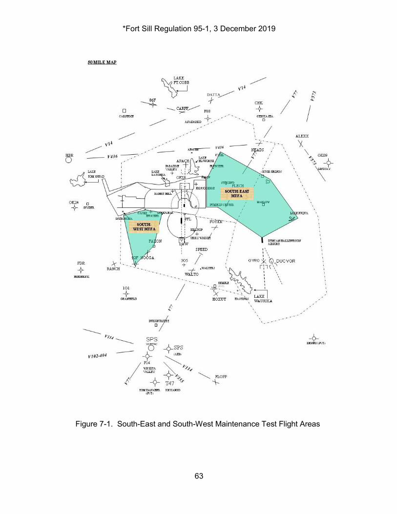
*Fort Sill Regulation 95-1, 3 December 2019
63
Figure 7-1. South-East and South-West Maintenance Test Flight Areas
*Fort Sill Regulation 95-1, 3 December 2019
64
Appendix A References Section I Required Publications AR 95-1 Aviation: Flight Regulations AR 95-2 Air Traffic Control, Airspace, Flight Activities and Navigational Aids AR 360-61 Community Relations AR 385-40 Accident Reporting and Records AR 385-95 Army Aviation Accident Prevention FAR 91.157 Federal Aviation Regulation, Part 91 Fort Sill Reg 385-1 Safety Post Range Regulation Fort Sill Reg 420-90 Fire Regulations FORSCOM Reg 350-1 Specialized Training in FORSCOM Active Army and Reserve Component Units FORSCOM Suppl 1 to AR 95-1 Aviation: Flight Regulations ATP 4-43 Petroleum Supply Operations TM 1-1500-250-23 General Tie down and Mooring on All Series Army Models
Section II Related Publications AR 25-400-2 Army Records Information Management System AR 600-105 Aviation Service of Rated Army Officers FAR 91.209 Aircraft Lights Fort Sill Regulation 115-9 USAFACFS Weather Support TC 1-210 Aircrew Training Program Commanders Guide UFC 3-260-01 Airfield and Heliport Planning and Design Section III Prescribed forms DA Form 759 Individual Flight Record and Flight Certificate – Army DA Form 7120-R Commander’s Task List DD Form 175 Military Flight Plan Section IV Reference Forms This section contains no entries.
*Fort Sill Regulation 95-1, 3 December 2019
65
Appendix B Precautionary and Emergency Landing Information B-1. Purpose. To provide information to clarify what responses or actions occur in the Fort Sill area when an aviator declares a precautionary or an emergency landing. B-2. Definitions. a. Emergency. An event for which an individual perceives that a response is essential to prevent or reduce injury or property damage according to AR 385-40, Accident Reporting and Record. This is a condition or situation one level short of the “May-Day” call when a crash landing, damage or destruction to the aircraft, and injury or death to personnel is imminent. b. Precautionary Landing (PL). A landing resulting from an unplanned event that makes continued flight inadvisable per AR 385-40. This compares to the ICAO/FAA call of “Pan-Pan.” B-3. What to Declare. a. Emergencies are declared when the individual perceives that the current situation has the potential of causing, or developing into a situation that may cause damage to the aircraft or injury to person(s). b. Precautionary landings are declared when the individual perceives that the current situation is unlikely to cause damage to the aircraft or injury to person(s), nor is it likely that the situation will lead to damage or injury, however, further flight is inadvisable. c. It is imperative that pilots declaring a PL make every attempt to either report "down and safe" or "landing assured" to ATC. If the call cannot be made prior to loss of radio contact with ATC, the crew should attempt to notify ATC of their status by aircraft relay, guard frequencies, telephone, or using their survival radio as soon as possible. This will allow ATC to terminate the precautionary, saving resources and manpower. If, in your judgment, you need assistance, do not hesitate to declare an emergency or a precautionary landing. When the situation is under control and assistance is no longer needed, please ensure you let ATC know.
*Fort Sill Regulation 95-1, 3 December 2019
66
Appendix C Fort Sill Regulation 95-1/5601 Range Safety Briefing C-1. Range Safety Briefing. Fort Sill Regulation 95-1/5601 RANGE SAFETY BRIEFING Officers shall utilize the outline below. Aviation 95-1/5601 Range Safety briefings are required prior to the first flight mission within Fort Sill's R5601 Airspace. Following this briefing a local area orientation will be given by a qualified local area orientation pilot. This requirement is mandatory for all pilots assigned, attached, mobilizing or transit at Fort Sill. This briefing/local area orientation is valid for 1 year. A by name roster of all personnel who received a complete briefing and orientation flight will be maintained by the HPAAF Supervisor Airfield Operations Specialist. C-2. Range Briefing Outline. a. Fort Sill has some of the most dangerous airspace in the United States; strict situational awareness to hazards is essential to safe operations. b. Layout of the Fort Sill Range Area. (1) Boundary Locations. (a) Fence type. (b) Signs. (c) Firebreak description. (d) Gates. (2) Restricted Area R5601. (a) Subdivisions. (b) Controlling Agencies are Range Operations, ARAC, and Quanah/Falcon Range (USAFR). (c) Wichita Mountain Wildlife Refuge
(3) AIRAD/NOTAM Notification. c. Ranges. (1) Small Arms Ranges.
*Fort Sill Regulation 95-1, 3 December 2019
67
(2) Artillery/Indirect Fire. Training Area Method. (3) Laser Ranges. (a) Laser Points.
(b) Laser Boxes. (4) CAS/Bomber Ranges. (5) EOD Range. (6) CS Training Area. (7) HTA's On Post, Off Post (8) Range Air Corridors, Green, Red, Blue and Yellow (9) NOE Training Route d. Hazards/Hazard Protection Controls. (1) Artillery trajectories, fuses, blast danger area, and safety boxes. (2) Duds in impact areas. (3) Duds outside impact areas (South of Mow-Way House, EOD valley, Quanah/Falcon Range). (4) Wires. (5) s. (6) Antennas. (7) HIRTA. (8) Lasers. (9) Mid-air collision avoidance. (10) Direct Fire Weapons.
(11) Illumination and flare parachutes.
74
*Fort Sill Regulation 95-1, 3 December 2019
e. Communications. (1) Mandatory Frequencies (Underlined is preferred Frequency). (a) Range Operations: West 34.50, 356.50, East 38.50, 356.50. (b) Air-to-air: 242.4. (c) Fort Sill Flight Following: 126.2, 268.8. (2) Services Provided. (a) Range Operations is not a flight following agency, it has no air traffic controllers. Range Operations provides telephonic range advisories before take-off and radio updates during flight. Range Operations only needs to know if you are in R5601 airspace. Position reports are discouraged. (b) Air-to-air is for collision avoidance. Advisory position reports for corridors and boundaries with direction of flight are sufficient to alert other aircraft on the range. (c) Fort Sill Flight Following provides positive (FSFF assigned transponder code) and procedural flight following with a 30 minute "operations normal" call with the same air traffic controllers manning Fort Sill approach. (3) Other Available Frequencies. (a) Commercial Air Evacuation Helicopter on Range Operations Freq. 143.125 (b) Quanah/Falcon Range: 363.7 (P) 342.3 (S) or 143.75 (P) 141.85 (S) (c) Fort Sill METRO: 375.20 f. Henry Post Army Airfield (HPAAF). (1) Dimensions.
(2) Facilities. (3) Services. (4) Communications. (5) Traffic Pattern. (6) Refueling. (7) Entry and exits.
74
*Fort Sill Regulation 95-1, 3 December 2019
(8) HPAAF Corridors g. Air Safety. (1) Frequency cards. ATIS 135.425 or 354.025 (2) Fort Sill maps. (3) Hazard maps. (4) Aircraft Crash Search and Rescue (ACS&R) Maps. (5) Minimum safe altitude. (3500 Ft MSL) (6) IMC procedure. (7) Flight plans. (8) Fort Sill Emergency Management plan. (9) Crash rescue. (10) SAR.
*Fort Sill Regulation 95-1, 3 December 2019
70
Appendix D Aircraft Emergency Plan
D-1. Purpose. This plan prescribes the procedures to be followed in the event of an aircraft emergency during the conduct of range firing. D-2. Procedures. Anyone who is involved in or witness to an aircraft emergency will immediately declare a "Cease-Fire" and immediately advise Range Operations and Airfield Operations IAW the Fort Sill Installation Emergency Plan. a. The Range OIC will ensure that the following is accomplished: (1) Designate one aircraft to remain over the site (or fly chase to maintain communications and assist air or ground rescue teams). (2) Direct uninvolved aircraft away from the scene with anti-collision lights on. (3) Contact Range Operations to request Emergency Medical Personnel as required. (4) Forward information thru the crash net and request Air or Ground Ambulance as required. (5) Notify ARAC. b. Any aircraft emergency resulting in visible damage to systems or components will be considered an accident and investigated as such. D-3. In-Flight Emergency. Report immediately any aircraft emergency to any Fort Sill ATC facility. D-4. Lost Communications. a. In the event of lost communications, the PILOT-IN-COMMAND will accomplish the following: (1) Clear the range area. (2) Follow prescribed lost communications procedures in accordance with existing regulations. (3) Report to the Fort Sill ATC upon landing. b. ATC will call a "Check-Fire" until the aircraft is located.
*Fort Sill Regulation 95-1, 3 December 2019
71
Appendix E Aerial Laser Operations E-1. Aerial Laser Operations. This appendix establishes the procedures to be followed to ensure safe aerial lasing and compliance with the following references: a. AR 40-46, Control of Health Hazards from Lasers and other High Intensity Optical Sources. b. AR 385-9, Safety Requirements for Military Lasers. c. AR 385-63, Policies and Procedures for Firing Ammunition for Training, Target Practice, and Combat. d. TB Med 524, Occupational and Environmental Health; Control of Hazards to Health from Laser Radiation. e. Fort Sill Reg 385-1, Post Range Regulation. E-2. Range Operations. a. Do not conduct laser operations without a certified Laser Range Safety Officer (LRSO) continuously on the firing range. Maintain strict adherence to this regulation and the above listed references. Any special/supplemental instructions/limitations/ warnings issued for specific aircraft by appropriate authority must be understood and complied with by all participating personnel. b. Checklists for laser operations on Fort Sill are contained in this appendix. Checklists are required for use by all key personnel involved in laser operations. c. Do not permit laser firing if standing water or reflective materiel is detected within 30 meters of the target area. d. Laser operations will cease when any unsafe condition may exist. E-3. LRSO Certification. Company/troop/battery commanders may certify rated pilots to perform as LRSOs on Fort Sill after thorough training in the provisions of this regulation, the references listed above, and the Operator's Manual of all assigned lasing aircraft. Document this certification in memorandum format and hand carry to Fort Sill Range Operations Office. E-4. Range Responsibilities. a. LRSO will-- (1) Maintain responsibility for the overall operation of the range and enforcement of range safety.
*Fort Sill Regulation 95-1, 3 December 2019
72
(2) Be thoroughly familiar with the range layout, applicable directives, and the Aircraft Emergency Plan (appendix E). (3) Ensure all required support activities are in place (if applicable) and all personnel are briefed as required. (4) Ensure all participating personnel have laser eye protection (glasses and/or visors). Ensure all participating magnifying devices used to observe the targets have appropriate laser safety filters in the optical train of the magnifying filters. (5) Maintain continuous positive two-way communications with Range Operations. b. Range Officer-in-Charge (OIC) will-- (1) Be responsible for the preparation and briefing of all aircrews prior to any laser operations. (4) Supervise the overall operation and safety procedures of aircraft under his/her control and assist the LRSO to resolve conflicts. (5) Appoint each PILOT-IN-COMMAND to act as the LRSO of his/her aircraft. (6) Ensure at least one person is performing range OIC and LRSO duties. E-5. Terminology and Definitions. a. Use the following standard terminology to enhance lasing safety: (1) Switches "COLD:" Laser switch is "STANDBY" or "OFF." (2) Switches "HOT:" Laser switch is "ARM," "ARMED," or "ON." b. Definitions. (1) Maximum Hover Altitude (MHA). The flight altitude above ground level, at a maximum, that an aircraft may obtain prior to illuminating the target. (2) Minimum Lasing Altitude (MLA). The flight altitude above ground level, at a minimum, that the aircraft must maintain before illuminating the target. (3) Aircraft Operational Control Area (AOCA). The area that the aircraft can tactically maneuver and simultaneously conduct laser operations. (4) Target Location Area (TLA). The area defined by DPTMS Range Branch as authorized to fire as laser into. E-6. Conduct of Firing.
*Fort Sill Regulation 95-1, 3 December 2019
73
a. Conduct a complete range and safety briefing (Fort Sill Reg 385-1, figure 3-3) prior to all laser operations. b. Conduct a radio check-in on FM or UHF IAW Fort Sill Reg 385-1, paragraph 3-5d. c. Firing will be IAW Fort Sill Reg 385-1, paragraphs 3-25 through 3-32. d. Checklists (figures 3-2 and 3-3) in Fort Sill Reg 385-1. e. The only authorized AOCAs on Fort Sill are listed in Fort Sill Reg 385-1, figure 3-5. f. Check-Out with Range Operations (Same as C-6b) before leaving the range.
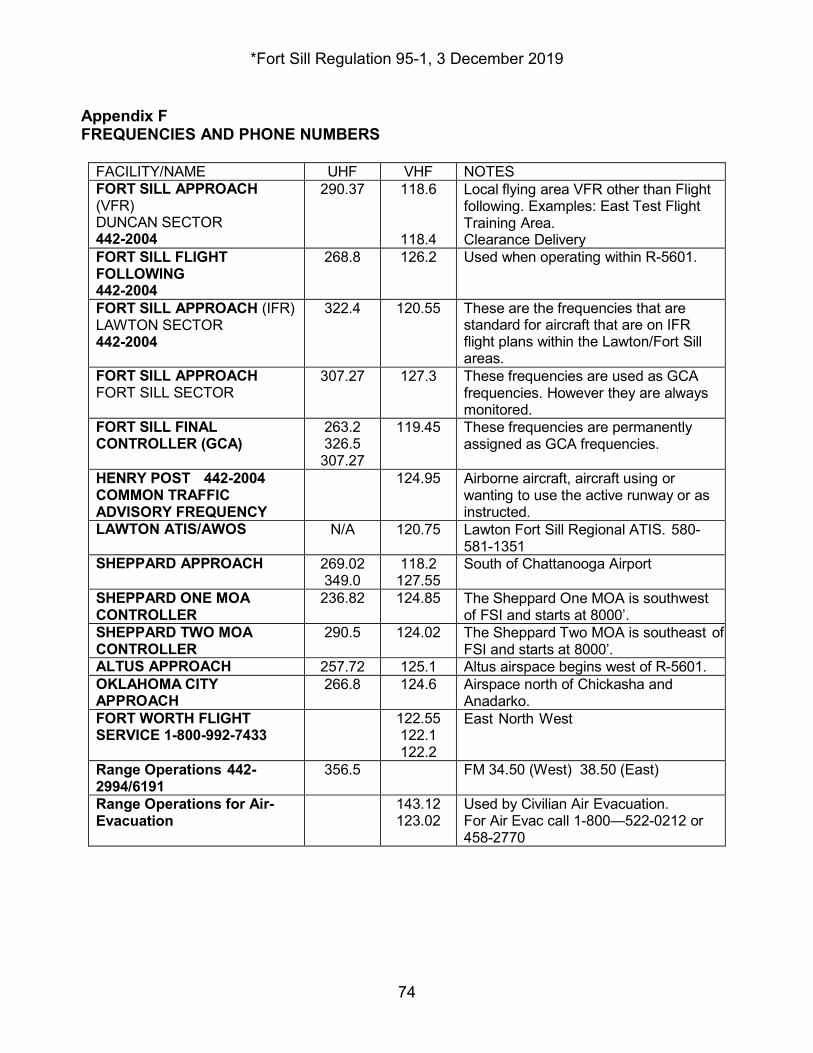
*Fort Sill Regulation 95-1, 3 December 2019
74
Appendix F FREQUENCIES AND PHONE NUMBERS
FACILITY/NAME UHF VHF NOTES FORT SILL APPROACH (VFR) DUNCAN SECTOR 442-2004
290.37 118.6
118.4
Local flying area VFR other than Flight following. Examples: East Test Flight Training Area. Clearance Delivery
FORT SILL FLIGHT FOLLOWING 442-2004
268.8 126.2 Used when operating within R-5601.
FORT SILL APPROACH (IFR) LAWTON SECTOR 442-2004
322.4 120.55 These are the frequencies that are standard for aircraft that are on IFR flight plans within the Lawton/Fort Sill areas.
FORT SILL APPROACH FORT SILL SECTOR
307.27 127.3 These frequencies are used as GCA frequencies. However they are always monitored.
FORT SILL FINAL CONTROLLER (GCA)
263.2 326.5 307.27
119.45 These frequencies are permanently assigned as GCA frequencies.
HENRY POST 442-2004 COMMON TRAFFIC ADVISORY FREQUENCY
124.95 Airborne aircraft, aircraft using or wanting to use the active runway or as instructed.
LAWTON ATIS/AWOS N/A 120.75 Lawton Fort Sill Regional ATIS. 580-581-1351
SHEPPARD APPROACH 269.02 349.0
118.2 127.55
South of Chattanooga Airport
SHEPPARD ONE MOA CONTROLLER
236.82 124.85 The Sheppard One MOA is southwest of FSI and starts at 8000’.
SHEPPARD TWO MOA CONTROLLER
290.5 124.02 The Sheppard Two MOA is southeast of FSI and starts at 8000’.
ALTUS APPROACH 257.72 125.1 Altus airspace begins west of R-5601. OKLAHOMA CITY APPROACH
266.8 124.6 Airspace north of Chickasha and Anadarko.
FORT WORTH FLIGHT SERVICE 1-800-992-7433
122.55 122.1 122.2
East North West
Range Operations 442-2994/6191
356.5 FM 34.50 (West) 38.50 (East)
Range Operations for Air- Evacuation
143.12 123.02
Used by Civilian Air Evacuation. For Air Evac call 1-800—522-0212 or 458-2770
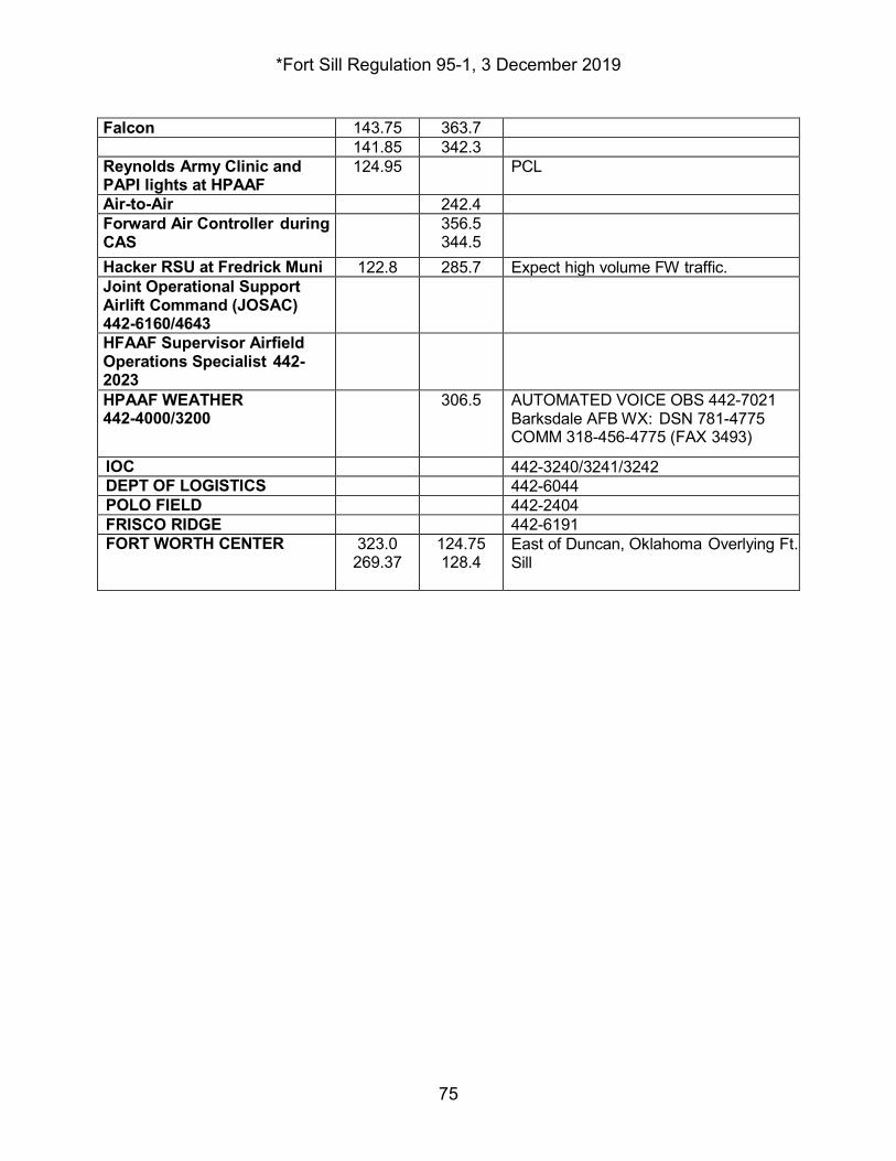
*Fort Sill Regulation 95-1, 3 December 2019
75
Falcon 143.75 363.7 141.85 342.3 Reynolds Army Clinic and PAPI lights at HPAAF
124.95 PCL
Air-to-Air 242.4 Forward Air Controller during CAS
356.5 344.5
Hacker RSU at Fredrick Muni 122.8 285.7 Expect high volume FW traffic. Joint Operational Support Airlift Command (JOSAC) 442-6160/4643
HFAAF Supervisor Airfield Operations Specialist 442-2023
HPAAF WEATHER 442-4000/3200
306.5 AUTOMATED VOICE OBS 442-7021 Barksdale AFB WX: DSN 781-4775 COMM 318-456-4775 (FAX 3493)
IOC 442-3240/3241/3242 DEPT OF LOGISTICS 442-6044 POLO FIELD 442-2404 FRISCO RIDGE 442-6191 FORT WORTH CENTER 323.0
269.37 124.75 128.4
East of Duncan, Oklahoma Overlying Ft. Sill
*Fort Sill Regulation 95-1, 3 December 2019
76
Glossary Section I Abbreviations 26 OWS 26th Operational Weather Squadron 3DRC 3d Research Corporation ACC Air Combat Command ACP Air Control Point AFB Air Force Base AFMAN Air Force Manual AIS Aeronautical Information System AISR Aeronautical Information System Revised AMC Air Mission Commander AOS Alternate Observing System ARNG Army National Guard ASD Administrative Services Division ASO Aviation Safety Officer
ARAC Army Radar Approach Control AT Air Traffic or Advanced Training ATC Air Traffic Control AVCATT Flight Simulator AWOS Automated Weather Observing System CARS Corridor Airspace Route Structure CAS Close Air Support COR Contracting Officer’s Representative DA Department of the Army DHR Directorate of Human Resources DPTMS Directorate of Plans, Training, Mobilization, and Security DPW Directorate of Public Works DOD Department of Defense DZS Drop Zones ELT
*Fort Sill Regulation 95-1, 3 December 2019
77
Emergency Locator Transmitter EMS Emergency Medical Services ETA Estimated Time of Arrival ETD Estimated Time of Departure FAA Federal Aviation Administration FAR Federal Aviation Regulation FSASC Fort sill Aviation Safety Council FSFF Fort Sill Flight Following FSS Flight Service Station GP General Planning HPAAF Henry Post Army Airfield HTA Helicopter Training Area IATF Individual Aircrew Training Folder IE Instrument Examiner IFR Instrument Flight Rules IMC Instrument Meteorological Conditions
EOC Emergency Operations Center IP Instructor Pilot JOSAC Joint Operational Support Airlift Command KIAS Knots Indicated Airspeed L-NOTAM Local Notice to Airmen LZS Landing Zones ME Maintenance Evaluator MEDDAC Medical Department Command MP Maintenance Pilot MPD Military Personnel Division NOE Nap of the Earth NOTAM Notice to Airmen N-TFS New Tactical Forecast System NVD Unaided Night Flight NVG Night Vision Goggle OHR
*Fort Sill Regulation 95-1, 3 December 2019
78
Operational Hazard Report OPCON Operational Control OSA Operational Support Airlift PAO Public Affairs Officer PC Pilot in Command PIREP Pilot Report PMSV Pilot-to-Metro-Service POI Program of Instruction PPP Prior Permission Request RACH Reynolds Army Clinic RFMSS Range Facility Management Support System SI Standardization Instructor SOP Standard Operating Procedures
*Fort Sill Regulation 95-1, 3 December 2019
79
SP Standardization Pilot SVFR Special Visual Flight Rules SWOP Severe Weather Operation Plan TA Training Area TAF Terminal Aerodrome Forecasts TSB Training Support Battalion TWR Tower
UFC United Facilities Criteria USAF United States Air Force USAG United States Army Garrison USAR United States Army Reserve UT Unit Trainer Section II Terms This section contains no entries. Section III Special Abbreviations and Terms This section contains no entries.
IMSI-PLA
*Fort Sill Regulation 95-1,
Q� �;:;r DON A. KING, Jr. COL, SF
€✓,f� �ESA.Mr�
Garrison Commander
u;:_•�ctor of Human Resources
DISTRIBUTION: FS lntRAnet 75th FA Bde 30th ADA Bde 31st ADA Bde 428th FA Bde 434th FA Bde MEDDAC
80
3 December 2019