Embed Size (px)
Citation preview
Phase One Detailed Planning Application
Environmental Statement Volume 4: Non-Technical Summary
Prepared for Lend Lease by Waterman Energy, Environment & Design Ltd

Phase One Detailed Planning Application
2
LOGO: Se
Phase One Detailed Planning Application
3
LOGO: Se
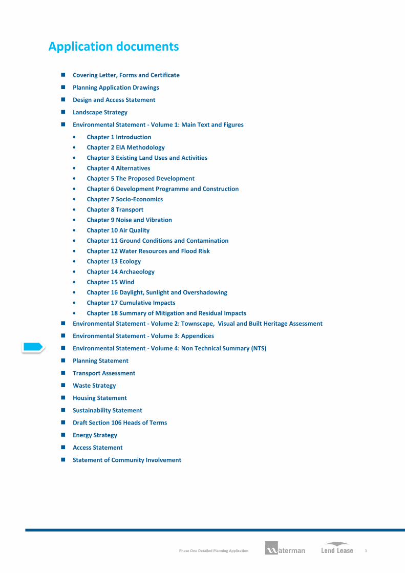
Application documents
Covering Letter, Forms and Certificate
Planning Application Drawings
Design and Access Statement
Landscape Strategy
Environmental Statement - Volume 1: Main Text and Figures
• Chapter 1 Introduction
• Chapter 2 EIA Methodology
• Chapter 3 Existing Land Uses and Activities
• Chapter 4 Alternatives
• Chapter 5 The Proposed Development
• Chapter 6 Development Programme and Construction
• Chapter 7 Socio-Economics
• Chapter 8 Transport
• Chapter 9 Noise and Vibration
• Chapter 10 Air Quality
• Chapter 11 Ground Conditions and Contamination
• Chapter 12 Water Resources and Flood Risk
• Chapter 13 Ecology
• Chapter 14 Archaeology
• Chapter 15 Wind
• Chapter 16 Daylight, Sunlight and Overshadowing
• Chapter 17 Cumulative Impacts
• Chapter 18 Summary of Mitigation and Residual Impacts
Environmental Statement - Volume 2: Townscape, Visual and Built Heritage Assessment
Environmental Statement - Volume 3: Appendices
Environmental Statement - Volume 4: Non Technical Summary (NTS)
Planning Statement
Transport Assessment
Waste Strategy
Housing Statement
Sustainability Statement
Draft Section 106 Heads of Terms
Energy Strategy
Access Statement
Statement of Community Involvement

Phase One Detailed Planning Application
4
LOGO: Se
Phase One Detailed Planning Application
5
LOGO: Se
Contents
1 Introduction 7
2 The Existing Site and Its Surrounding Context 8
3 What are the Proposals? 9
4 Approach and Environmental Impact Assessment Methodology 11
5 What Are the Likely Environmental Impacts and How Will They Be Minimised? 12
6 What Will Happen Next? 19

Phase One Detailed Planning Application
6
LOGO: Se
Phase One Detailed Planning Application
7
LOGO: Se
1 Introduction
This Non-Technical Summary (NTS) of the Environmental Statement (ES) has been prepared by Waterman Energy, Environment & Design Limited (‘Waterman’), on behalf of Lend Lease (Elephant and Castle) Limited (the ‘Applicant’), to support a detailed planning application for Phase One of the Heygate Regeneration in Elephant and Castle (the ‘Site’).
The Applicant is seeking to obtain detailed planning permission for the mixed-use development of the Site which covers an area of 1.142 hectares (ha) and is located within the administrative boundary of Southwark Council. The proposed development (the ‘Development’) will provide 235 residential units and retail space together with the provision of new open space, landscaping, pedestrian linkages, car and cycle parking.
As part of the detailed planning application an Environmental Impact Assessment (EIA) has been undertaken by Waterman. EIA is a formal procedure that must be followed for certain types and scales of development, where the likely significant environmental impacts of the development are systematically assessed and reported. The purpose is to ensure that appropriate information about the likely environmental impacts of the Development is available for consideration by the relevant Local Planning Authority (LPA), consultees and the public, and that the LPA have this information before they determine a planning application. The EIA process can also identify ways in which the development can be modified, or likely significant adverse impacts mitigated, so as to reduce or avoid potential significant adverse impacts and to create and enhance beneficial impacts. The legislation relevant to EIA is the Town and Country Planning (Environmental Impact Assessment) (England and Wales) Regulations, 2011 (the EIA Regulations).
From an early stage the Applicant recognised that the planning application required an EIA and hence instructed Waterman to undertake the EIA for the Development. To ensure that all potential likely significant impacts were considered in the EIA, the Applicant consulted with Southwark Council in a process known as ‘Scoping’. The findings of the EIA are reported in an ES, which has been prepared to accompany the detailed planning application. The likely significant environmental impacts of the Development, both during the construction stage, and once completed and operational have been considered in accordance with the Scoping Opinion received from Southwark Council.
This document provides a summary of the findings of the EIA in non-technical language.
Phase One Detailed Planning Application
8
LOGO: Se
2 The Existing Site and Its Surrounding Context
The Site has recently undergone demolition works, having previously been occupied by residential uses comprising four large buildings containing houses and apartments with associated garages, amenity landscaping, walkways, mature and semi-mature trees. The demolition works were completed in July 2011 and there is now approximately 3,200m3 of crushed concrete, existing trees, an electricity substation and adjacent garage remaining on the Site. Demolition and removal of the existing substation with adjacent garage and the foundations of the former buildings does not form part of this planning application and is subject to a separate approval. For the purposes of the EIA, it is assumed this will have occurred prior to the commencement of the Development.
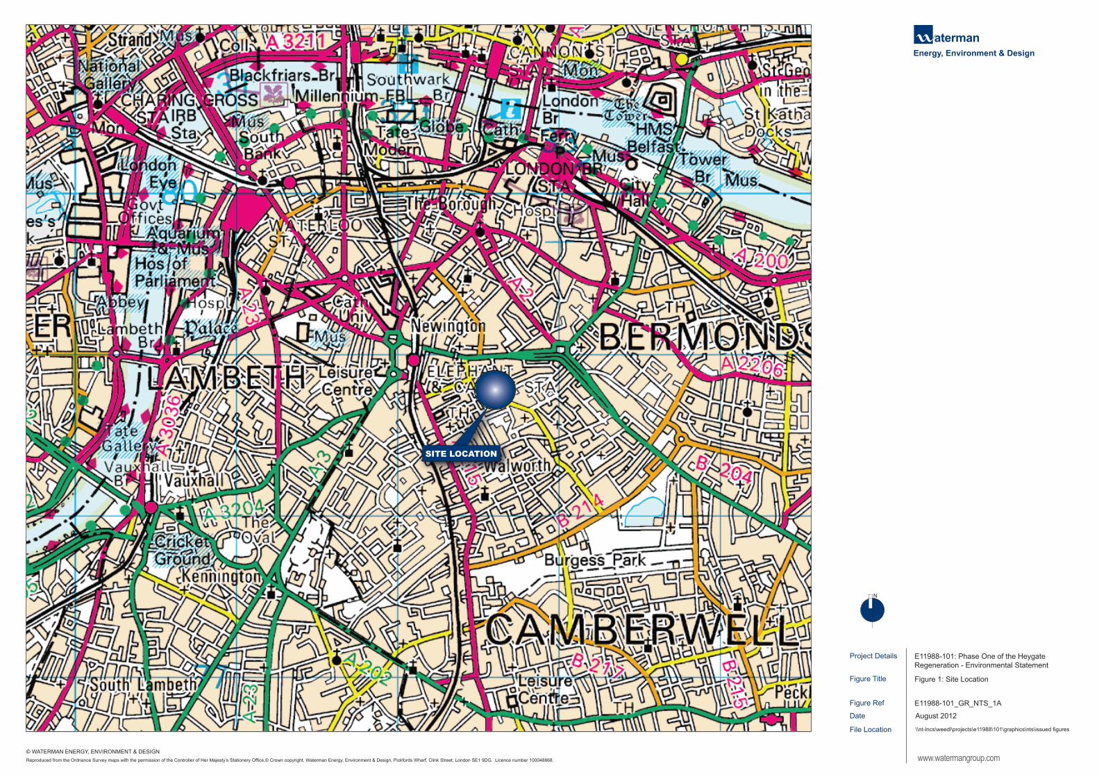
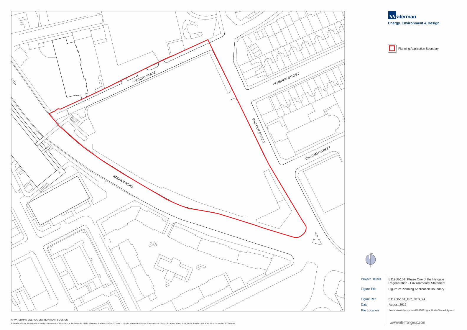
A plan showing the location of the Site is presented as Figure 1. The planning application boundary of the Site is shown in Figure 2. The Site is located on a triangular area of land and broadly bounded by the following:
Victory Place to the north; Balfour Street to the east; and Rodney Road to the south and west.
Land uses surrounding the Site are varied including community, residential, shops and offices together with open space and significant transport infrastructure. Residential dwellings are located immediately to the south on Rodney Road in the Peabody Buildings and to the east on Balfour Street, Henshaw Street and Chatham Street. The Grade II listed building on Victory Place is also a residential building. Surrounding land uses in the immediate vicinity of the Site include:
Victory Community Park to the north; a small local car park on Balfour Street to the east; the Lady Margaret Church to the east on the corner of Chatham Street and Balfour Street; Victory Primary School and Children’s Centre located immediately adjacent to the north-west corner
of the Site on Victory Place. The primary school pupils’ entrance is on Victory Place, teachers’ access to school parking is also located off Victory Place, and access to the children’s centre and school administration and servicing is from Elba Place; and
the bus route 343 passes along Rodney Road with a bus stop on the Site at the corner of Rodney Road and Balfour Street, which goes to Peckham and New Cross.
Further from the Site, to the south is Nursery Row Park; to the south-east, the Aylesbury Estate; to the north, the New Kent Road; and to the west, is the main area of the Heygate Estate, the Elephant and Castle Shopping Centre; a raised railway viaduct and the Underground and Railway Stations of the Elephant and Castle.
The Site lies within the Heygate Estate which is identified within local and regional planning policy, and the Elephant and Castle Supplementary Planning Document (SPD) and Opportunity Area Planning Framework (OAPF), as one of 38 development sites within the Elephant and Castle Opportunity Area (OA). The Heygate Estate is considered to be a key component of the Elephant and Castle OA due to its proximity to a number of transport services and its potential to contribute significantly to housing targets among other objectives for the OA. Southwark Council has prepared the Elephant and Castle SPD and OAPF, which was adopted on 20th March 2012. This document provides guidance on the mix of land uses within the OA including residential, business, community and cultural uses and improvements to infrastructure including public transport, walking and cycling network improvements.
Project Details
Figure Ref
Date
Figure Title
File Location
Figure 1: Site Location
\\nt-lncs\weedl\projects\e11988\101\graphics\nts\issued figures
E11988-101_GR_NTS_1A
August 2012
E11988-101: Phase One of the Heygate Regeneration - Environmental Statement
www.watermangroup.com
Energy, Environment & Design
N
Reproduced from the Ordnance Survey maps with the permission of the Controller of Her Majesty’s Stationery Office,© Crown copyright, Waterman Energy, Environment & Design, Pickfords Wharf, Clink Street, London SE1 9DG. Licence number 100048868.
© WATERMAN ENERGY, ENVIRONMENT & DESIGN
SITE LOCATION
Project Details
Figure Ref
Date
Figure Title
File Location
Figure 2: Planning Application Boundary
\\nt-lncs\weedl\projects\e11988\101\graphics\es\issued figures
E11988-101_GR_NTS_2A
August 2012
E11988-101: Phase One of the Heygate Regeneration - Environmental Statement
www.watermangroup.com
Energy, Environment & Design
Planning Application Boundary
VICTORY PLACE
HENSHAW STREET
BALFOUR STREET
CHATHAM STREET
RODNEY ROAD
N
Reproduced from the Ordnance Survey maps with the permission of the Controller of Her Majesty’s Stationery Office,© Crown copyright, Waterman Energy, Environment & Design, Pickfords Wharf, Clink Street, London SE1 9DG. Licence number 100048868.
© WATERMAN ENERGY, ENVIRONMENT & DESIGN
Phase One Detailed Planning Application
9
LOGO: Se
3 What are the Proposals?
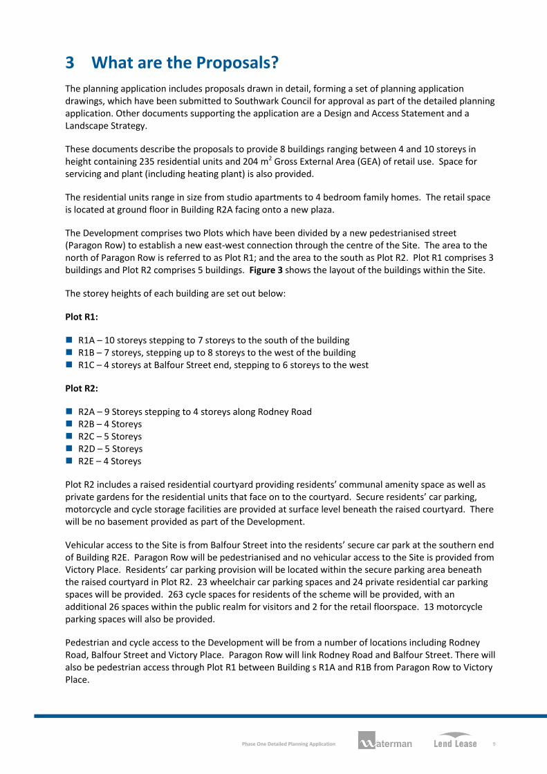
The planning application includes proposals drawn in detail, forming a set of planning application drawings, which have been submitted to Southwark Council for approval as part of the detailed planning application. Other documents supporting the application are a Design and Access Statement and a Landscape Strategy.
These documents describe the proposals to provide 8 buildings ranging between 4 and 10 storeys in height containing 235 residential units and 204 m2 Gross External Area (GEA) of retail use. Space for servicing and plant (including heating plant) is also provided.
The residential units range in size from studio apartments to 4 bedroom family homes. The retail space is located at ground floor in Building R2A facing onto a new plaza.
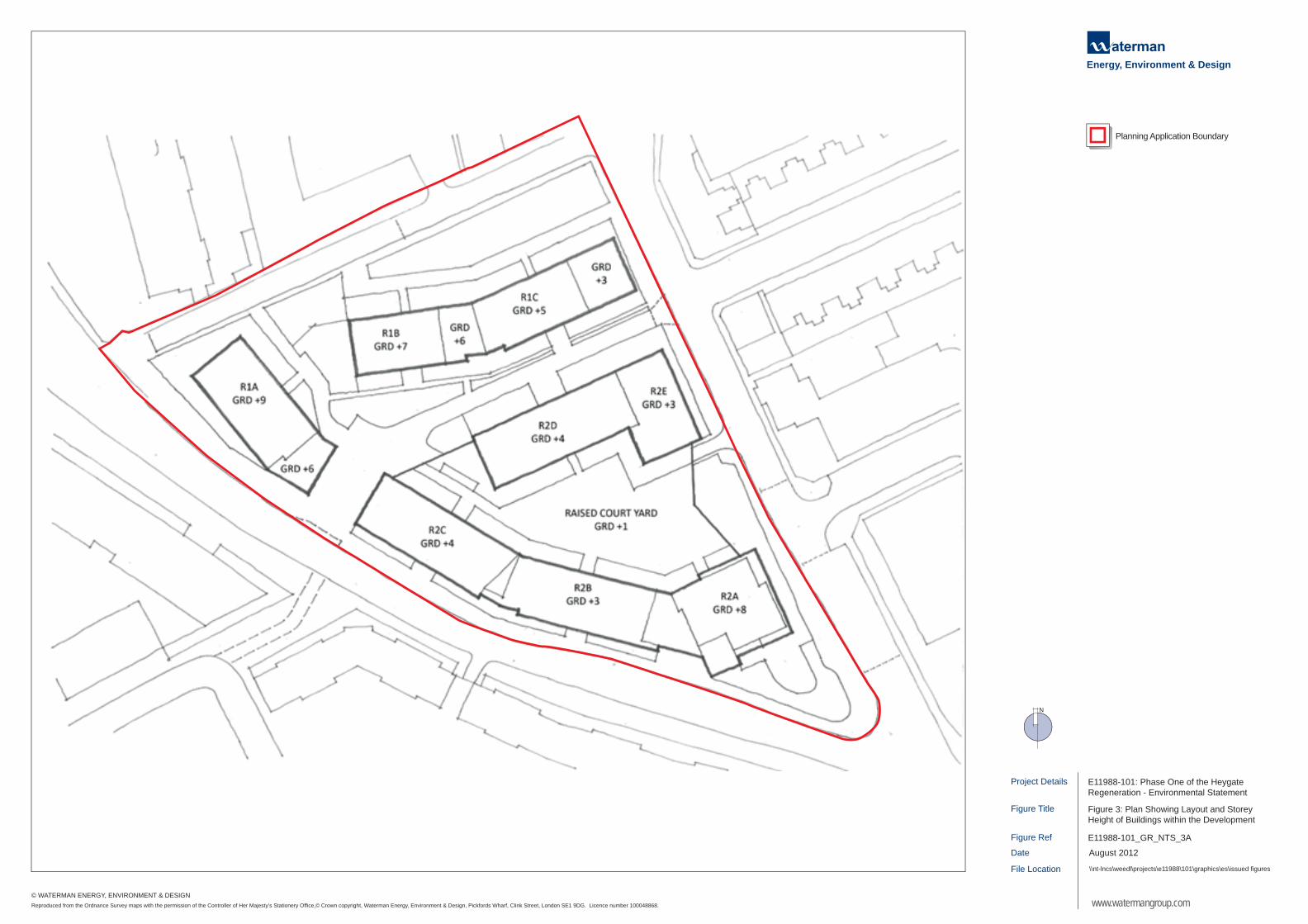
The Development comprises two Plots which have been divided by a new pedestrianised street (Paragon Row) to establish a new east-west connection through the centre of the Site. The area to the north of Paragon Row is referred to as Plot R1; and the area to the south as Plot R2. Plot R1 comprises 3 buildings and Plot R2 comprises 5 buildings. Figure 3 shows the layout of the buildings within the Site.
The storey heights of each building are set out below:
Plot R1:
R1A – 10 storeys stepping to 7 storeys to the south of the building R1B – 7 storeys, stepping up to 8 storeys to the west of the building R1C – 4 storeys at Balfour Street end, stepping to 6 storeys to the west
Plot R2:
R2A – 9 Storeys stepping to 4 storeys along Rodney Road R2B – 4 Storeys R2C – 5 Storeys R2D – 5 Storeys R2E – 4 Storeys
Plot R2 includes a raised residential courtyard providing residents’ communal amenity space as well as private gardens for the residential units that face on to the courtyard. Secure residents’ car parking, motorcycle and cycle storage facilities are provided at surface level beneath the raised courtyard. There will be no basement provided as part of the Development.
Vehicular access to the Site is from Balfour Street into the residents’ secure car park at the southern end of Building R2E. Paragon Row will be pedestrianised and no vehicular access to the Site is provided from Victory Place. Residents’ car parking provision will be located within the secure parking area beneath the raised courtyard in Plot R2. 23 wheelchair car parking spaces and 24 private residential car parking spaces will be provided. 263 cycle spaces for residents of the scheme will be provided, with an additional 26 spaces within the public realm for visitors and 2 for the retail floorspace. 13 motorcycle parking spaces will also be provided.
Pedestrian and cycle access to the Development will be from a number of locations including Rodney Road, Balfour Street and Victory Place. Paragon Row will link Rodney Road and Balfour Street. There will also be pedestrian access through Plot R1 between Building s R1A and R1B from Paragon Row to Victory Place.
Project Details
Figure Ref
Date
Figure Title
File Location
Figure 3: Plan Showing Layout and StoreyHeight of Buildings within the Development
\\nt-lncs\weedl\projects\e11988\101\graphics\es\issued figures
E11988-101_GR_NTS_3A
August 2012
E11988-101: Phase One of the Heygate Regeneration - Environmental Statement
www.watermangroup.com
Energy, Environment & Design
Planning Application Boundary
N
Reproduced from the Ordnance Survey maps with the permission of the Controller of Her Majesty’s Stationery Office,© Crown copyright, Waterman Energy, Environment & Design, Pickfords Wharf, Clink Street, London SE1 9DG. Licence number 100048868.
© WATERMAN ENERGY, ENVIRONMENT & DESIGN
Phase One Detailed Planning Application
10
LOGO: Se
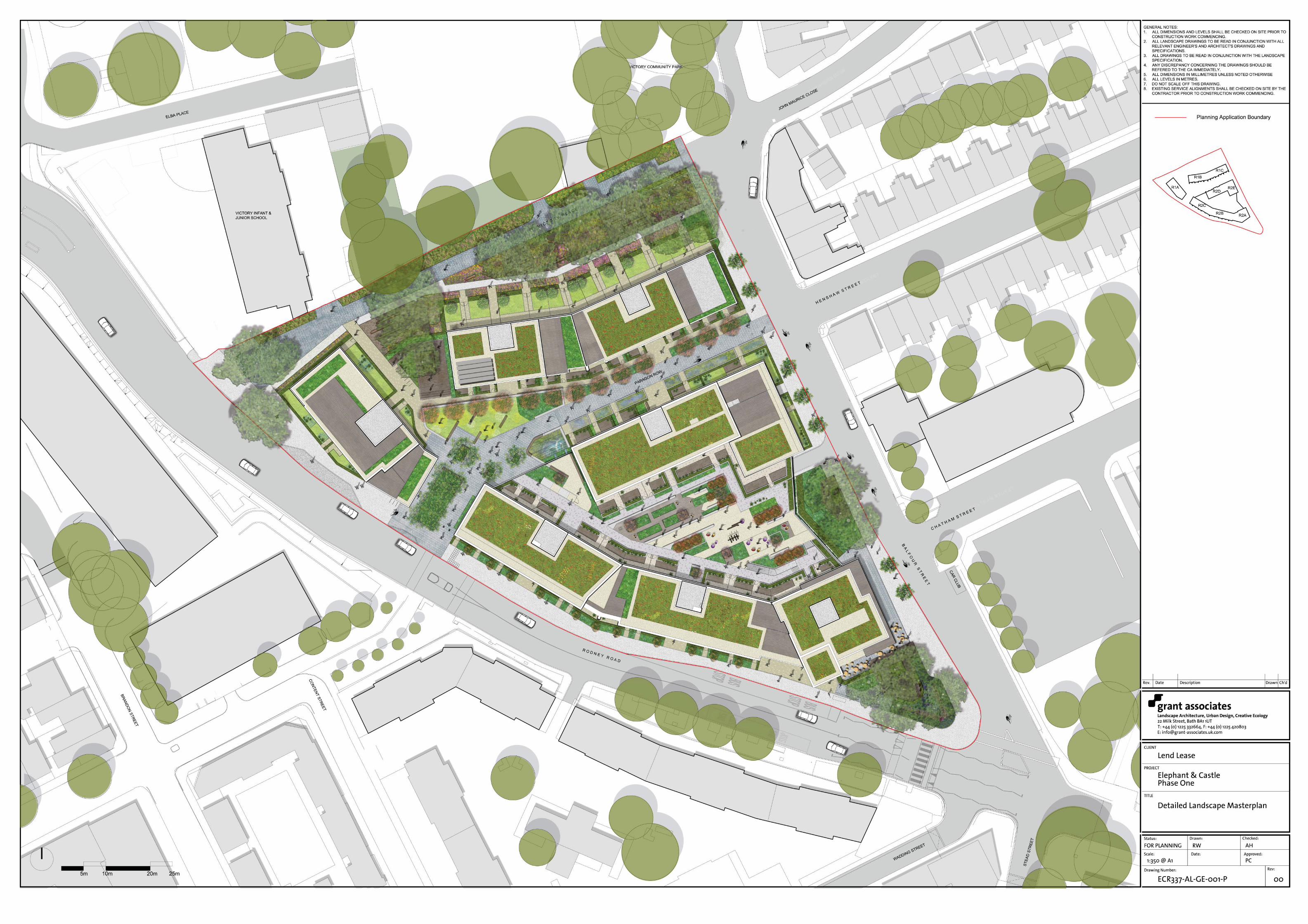
Planning Application Drawing ECR-337-AL-GE-0-001-P shows the public realm areas and landscaping proposals. The Development includes the provision of 5,300m2 of new public realm. Public space will be provided along the northern boundary of the Site along Victory Place and along Paragon Row within the Site. Both of these areas provide accessible pedestrian access through the Site connecting Rodney Road and Balfour Street. The space along the northern Site boundary will include soft landscaping with woodland planting, retained and new trees and informal play space and seating. Trees will be planted along Paragon Row. A new plaza will also be provided outside the retail space in the south-east corner of the Site.
In addition, all residential units will have individual private amenity space either as a garden, balcony or terrace. A large communal amenity space will be provided within the raised courtyard. A smaller area including children’s playspace will be provided in Plot R1 on Victory Place.
The landscaping proposals include for the creation of new habitats including native woodland planting, ponds, hedges, green roofs, planted terraces and the use of vertical climbing structures. Bird and bat boxes will also be provided within the Development.
The majority of trees on-Site, including the majority of the mature London Plane trees within the perimeter of the Site will be retained as part of the Development. New trees will be planted as part of the landscaping proposals which will ensure no net loss of tree numbers on-Site. Furthermore, off-Site tree planting will also be provided.
A detailed surface water drainage strategy has been developed which includes measures to store rainfall and control the rate of discharge of this water to the local sewer network.
The construction programme for the Development is assumed to take around 24 months to complete. Construction will commence in early to mid 2013 and for the purposes of the ES, the year of completion and full operation of the Development is therefore considered to be 2015.
A Construction Management Plan (CMP) has been developed by the Applicant. The CMP sets out how the construction works will be carried out and the Applicant’s intentions for managing environmental impacts during construction. Once a contractor has been instructed and the details and methods of the construction works agreed, it is proposed that a Construction Environmental Management Plan (CEMP) will be prepared for the Development. The CEMP will include all details of relevant environmental management controls necessary for environmental protection during the construction works.
Phase One Detailed Planning Application
11
LOGO: Se
4 Approach and Environmental Impact Assessment
Methodology
The EIA was undertaken in accordance with the EIA Regulations and best practice guidance using established methods such as site surveys, reviews of available reports and data, computer modelling, consultations with relevant organisations and specialist assessments.
The first stage of the EIA process involved undertaking a ‘Scoping Study’. The purpose of the ‘Scoping Study’ was to identify the likely significant environmental impacts that could arise from the Development and therefore provide the focus of the EIA. The findings of the scoping exercise, along with details of the proposed methods for the specialist assessments, were presented in a Scoping Study report and submitted to Southwark Council on 4 August 2011.
The Scoping Study confirmed that the Development will likely give rise to a number of issues which need to be considered in the EIA. These comprise:
socio-economics transportation noise and vibration air quality ground conditions and contamination water resources and flood risk ecology archaeology wind daylight, sunlight and overshadowing townscape, visual and built heritage cumulative impacts
The scope of the EIA was formally agreed with Southwark Council and their formal Scoping Opinion was received on 2 November 2011.
Each of the above issues is addressed in the ES, with a Chapter dedicated to each. The Townscape, Visual and Built Heritage Assessment is presented in a separate volume (Volume 2) of the ES. In each chapter, a description of the assessment methodology is given together with a description of the relevant environmental aspects of the Site and surrounding area. This is followed by an assessment of the likely significant impacts of the Development (both beneficial and adverse) and any measures that should be adopted to reduce or offset any significant adverse impacts identified during the assessment. The ES also provides an assessment of the residual impacts that will remain after mitigation measures have been implemented, as well as the cumulative impacts of the scheme. Cumulative impacts can arise due to the combination of individual impacts (e.g. dust and noise during construction works) or as a result of a combination of impacts from several developments (referred to as ‘committed developments’).
Phase One Detailed Planning Application
12
LOGO: Se
5 What Are the Likely Environmental Impacts and How
Will They Be Minimised?
5.1 Socio-Economics
It is estimated that the Development will generate in the region of 60 construction jobs during the 24 month construction programme. In addition, an average annual spend in the local area of approximately £196,000 is anticipated from the construction workers.
The provision of 235 new homes will accommodate a new resident population of approximately 400 people. This will contribute to the housing targets for Southwark and the Elephant and Castle OA as set out by Southwark Council and the Mayor of London.
The net demand for school places from the Development is estimated as 17 primary school places and 7 secondary school places. It is assessed that this additional demand will not place significant pressure on local schools.
It is considered that there is sufficient surplus capacity in existing healthcare facilities to meet the demands of the new residential population.
The Development includes the provision of a small amount of employment floorspace. It is estimated that approximately 11 jobs will be created directly by the Development.
The new residential population on-Site has the potential to generate an additional £3.4 million annually in household spending, a significant proportion of which can be expected to be captured locally.
The design of the Development has ensured that each of the residential units within the Development will have private access to outdoor space. This space will be in the form of a garden, balcony or terrace. In addition, there is communal space within the raised courtyard and several areas of new public open space. Playspace is provided on-Site for younger children living within the Development. There is good access to existing open space within the local area for play facilities for older children.
The new residential population within the Development will ensure both animation and passive surveillance to the public realm. Design features such as CCTV will minimise the opportunities for crime and maximise the sense of security.
The Development will make a positive contribution towards the overall regeneration objectives for the Elephant and Castle OA.
5.2 Transportation
During construction there will be traffic flow, particularly heavy goods vehicles, associated with general plant and material deliveries and the removal of waste from the Site. To effectively manage this, a Traffic Management Plan will be developed and implemented. This will be agreed with Southwark Council and Transport for London and will include measures such as the use of agreed appropriate routes to and from Site for construction vehicles and restricting the largest vehicles to arriving and departing from Site during off-peak times of the day. Appropriate signage will be implemented around the Site as well as communication methods for keeping local residents informed of activities.
Overall, once the Development is completed and occupied, it is predicted to result in insignificant increases in traffic flows on the local road network. Notwithstanding this, the Development will include
Phase One Detailed Planning Application
13
LOGO: Se
for a designated car club parking space and it is further proposed that a car sharing scheme is organised for the residents of the Development, by registering on a local car sharing website.
A Residential Travel Plan has also been developed and has been submitted with the detailed planning application. This sets out a framework for the delivery of new transport initiatives and measures for residents that will travel to and from the Development on a regular basis, with the aim of reducing reliance on private car usage and encouraging travel by modes of transport that are more sustainable than the private car.
All proposed parking for residents will be provided within the Development.
Prior to the occupation of the Development, a Servicing Management Plan will be prepared which will aim to ensure that servicing and deliveries to the residential and retail uses within the Development can take place efficiently without a significant impact on the local highway network. This will be secured by planning condition.
The Development is predicted to generate additional walking and cycle trips on the local network surrounding the Site. The Development does, however, provide for a new pedestrian route through the Site and enhancement of the existing routes to connect to local routes on Rodney Road and Balfour Street. It is also proposed to provide new cycle parking facilities for residents as well as spaces for visitors.
With regard to the increased use of public transport in the area, the predicted net increase in passengers using the Elephant and Castle Rail Station, London Underground Bakerloo and Northern lines and local buses is predicted to be extremely low. However, it should be noted that improvements have been identified for the Northern Line Ticket Hall within the Elephant and Castle SPD / OAPF. These improvements have been identified to accommodate the additional passengers arising from the level of development expected in the OA, including the Development.
5.3 Noise and Vibration
The construction works will include activities that will be likely to increase noise levels and potentially cause vibration within and immediately adjacent to the Site. In particular, when activities are occurring closest to the Site boundary, this could result in short-term impacts on occupants on surrounding streets particularly Balfour Street, Victory Place and Rodney Road.
However, the implementation of noise and vibration control and management measures through a CEMP for the construction works will help to reduce noise disturbance to occupants of existing and proposed properties. The CEMP will include measures such as using low-noise machinery and equipment, enclosing and screening machinery and using low-vibratory foundation methods. In addition, construction traffic is predicted to result in insignificant noise increases on local roads.
An assessment of residential amenity for future residents of the Development has been undertaken. The assessment results indicate that although elevated noise levels will be experienced at façades facing onto Balfour Street and Rodney Road, the scheme design serves to mitigate these noise levels to ensure that good internal noise levels can be achieved, thereby satisfying the requirements of the Elephant and Castle SPD / OAPF.
It is predicted that noise levels in outside amenity spaces such as gardens and the raised courtyard will be higher than the adopted assessment criteria. However, it is considered that all reasonable measures have been incorporated into the design of the Development to ensure that noise levels are minimised as far as is reasonably practicable, and in line with the expectations of the future residents of the Development in this urban location.
Phase One Detailed Planning Application
14
LOGO: Se
Any items of fixed building services plant installed as part of the Development will have the potential to generate noise. Suitable noise level limits have therefore been proposed to ensure that noise from plant does not cause disturbance to either future occupants of the Development or occupants of existing properties in the surrounding area.
Given the size and likely daytime use of the retail unit, it is unlikely that there will be noise break-out associated with the unit that will give rise to disturbance to either existing or future residents. Furthermore, given that servicing of the retail space will be limited to a small number of vehicles during the daytime period, servicing and delivery noise is not expected to give rise to complaints by existing or future residents.
An assessment of the increase in noise levels resulting from additional traffic generated by the Development has found that this is insignificant on all local roads.
5.4 Air Quality
The main impact on local air quality during construction relates to dust, which is most likely to be generated from earthworks. Nuisance caused from dust, however, will only likely be experienced by people living closest to the Site and on a temporary, short-term basis. A range of measures to minimise or prevent dust will be implemented through the CEMP.
Any emissions from equipment and machinery operating on the Site during construction will be small and will not detrimentally affect air quality. It is anticipated that the impact of construction vehicles entering and leaving the Site during the period of greatest vehicle movements will be minimal in the context of local background pollutant concentrations and existing local road traffic emissions. To address this, the CEMP will include measures such as the use of agreed appropriate routes to and from Site only for construction vehicles and restricting the largest vehicles to arriving and departing from Site during off-peak periods.
Computer modelling has been carried out to predict the impact of future traffic-related exhaust emissions and heating plant emissions and the likely changes in local air quality following the completion and occupation of the Development. The impact of the Development on local air quality has been predicted for a number of existing sensitive locations surrounding the Site and for future sensitive locations within the Site.
Accounting for the traffic that could be generated by the Development, it is predicted that the Development will result in an imperceptible change in air quality at all of the existing sensitive locations. In addition, no exceedances of the UK air quality objectives are predicted for the existing or the future sensitive locations.
A Residential Travel Plan has been developed. This sets a framework for the delivery of new transport initiatives and measures for residents that will travel to and from the Development on a regular basis, with the aim of reducing reliance on private car usage and to encourage travel by modes of transport that are more sustainable than the private car.
5.5 Ground Conditions and Contamination
A desk-based study of ground contamination and an intrusive Site Investigation (taking and testing samples from the ground) at the Site have established that there is the potential for localised contamination to exist on the Site. Due to the historical development of the Site, the most likely source of contamination is likely to relate to the presence of Made Ground on the Site. Made Ground is material which is not naturally occurring and is present due to past activities on a site. It may include
Phase One Detailed Planning Application
15
LOGO: Se
concrete, bricks and other materials. However, the potential for significant contamination to be present on the Site is considered to be generally low.
During construction, any existing contamination on the Site could be exposed and disturbed, potentially resulting in harm to human health and the underlying groundwater. There is also the potential for existing ground contamination to pose a risk to human health and groundwater once the Development is completed and operational.
However, all construction works will be undertaken in accordance with measures set out in the CMP. In addition, in line with mandatory legislative requirements and best practice guidance, redevelopment of the Site would take place in a manner that would not cause any unacceptable contamination risk to human health and the wider environment.
The foundation design will be prepared in consultation with the Environment Agency to minimise the risk of contamination of deep groundwater. If extensive contamination is discovered during the construction works this will be investigated, tested and appropriate remedial measures taken, including removal from Site in accordance with relevant waste management legislation. Clean topsoil will be provided in all soft landscaped areas.
5.6 Water Resources and Flood Risk
The Site is protected by the Thames Tidal Defences, and as such, the tidal and fluvial flood risk at the Site is considered to be low.
During construction, changes in Site conditions have the potential to result in a temporary risk of surface water flooding. However, measures will be put in place to control surface water run-off from the Site in line with industry standards.
The Development does not include any basements that could be affected by groundwater flooding and there is a negligible risk of surface flooding from groundwater.
A surface water drainage strategy has been developed which includes measures to store rainfall on the Site and control the rate of discharge of this water to the local sewer network. These measures include the use of sustainable drainage methods and the strategy also allows for the likely future increase in rainfall due to climate change. The Development will therefore not increase flood risk on-site or elsewhere beyond the Site boundary, which is in line with national and local policy as well as Environment Agency guidance.
Thames Water has confirmed that the estimated surface water and foul water discharges from the Development could be accommodated by the existing sewer network within the vicinity of the Site, without the need for any reinforcement works to the current infrastructure. Similarly Thames Water has also confirmed that the increased demand for water supply resulting from the Development could be accommodated within the existing infrastructure without the need for reinforcement works.
5.7 Ecology
The Site currently contains limited ecological interest, although trees provide nesting and foraging opportunities to various bird species and a limited foraging and commuting resource to bats. The areas of hard standing and bare ground on the Site are of no ecological interest and have no potential to support protected species.
A CEMP will be implemented to ensure that appropriate environmental controls are used to protect retained habitats at the Site and surrounding areas, during construction. Updated habitat surveys will
Phase One Detailed Planning Application
16
LOGO: Se
be undertaken (where existing survey data is two years old or more) prior to construction works to check whether habitats have become suitable for protected species.
The ecological value of the Site will be enhanced as a result of the completed and operational Development due to the provision of ecological enhancement measures which include the creation of new habitat such as woodland planting, hedges, green roofs and the provision of suitable nesting and foraging opportunities for birds and bats.
In addition, an Ecological Management Plan should be prepared and implemented to ensure that the wildlife benefits created by the Development will remain in place for the lifetime of the Development.
5.8 Archaeology
The archaeological assessment undertaken as part of the EIA identified that the archaeological potential of the Site is limited. The three previous phases of residential development on the Site (the construction of housing in the 19th and 20th Centuries) and likely cultivation of the Site area before this will have damaged any sub-surface remains. Given such disturbance and the limited archaeological potential, it is not considered that any further archaeological work will be required for the construction of the Development. There will be no archaeological impacts resulting from the operation of the Development as there will be no significant disturbance of the ground.
5.9 Wind
An assessment of the likely wind conditions as a result of the Development and the suitability of these in terms of pedestrian comfort for locations within and around the Site has been undertaken.
The Site preparation works will not be expected to have a significant impact on the wind conditions within, and immediately surrounding the Site, since the Site is vacant. As construction progresses the wind conditions will move towards the conditions predicted for the completed Development.
Following completion of the Development, the wind conditions likely to be experienced at all locations within, and surrounding, the Development have been found to be suitable for the intended uses. These locations include existing public realm surrounding the Site and public realm, communal and private amenity spaces, balconies, roof terraces and entrances within the Development. It is therefore considered that wind conditions will not impact on pedestrian comfort either within the Development or within the public realm surrounding the Site, following completion of the Development.
5.10 Daylight, Sunlight and Overshadowing
Construction of the Development will have a gradually increasing impact on the levels of daylight, sunlight, and overshadowing to existing residential properties and amenity spaces surrounding the Site as the massing of the Development steadily increases. Those impacts that are perceptible as the superstructure nears completion would be similar to those of the completed Development.
Following completion of the Development, the results of the assessment show that all of the existing residential properties surrounding the Site are predicted to receive adequate levels of daylight and sunlight as set down in guidance.
In terms of the potential for the Development to result in overshadowing of existing amenity spaces in the vicinity of the Site, all eight amenity spaces assessed remain compliant with the criteria set down in the guidance.
Phase One Detailed Planning Application
17
LOGO: Se
The vast majority of the proposed dwellings assessed within the Development have been predicted to experience adequate daylight. There are just two bedrooms (within Building R2D) and one living and kitchen room (within Building R2E) that are not predicted to achieve the relevant BRE criteria set down by the guidance. This is not unusual given the urban context of the Site and its surroundings.
In general, adequate sunlight is predicted to be received at Buildings R1A, R2A, R2B, R2C, R2D and R2E within the Development. Where building façades face Paragon Row within Buildings R1B and R1C, the majority of the lowest level windows are not predicted to receive adequate levels of sunlight. This is not unusual given the urban context of the Site and its surroundings.
It should be noted that the assessment of daylight and sunlight availability to the residential units in the Development is based upon windows of the lowest habitable residential level in each Building of the Development. The assessment results are therefore representative of a worst-case and robust assessment. With increased height within the Building, daylight and sunlight availability is likely to improve.
Six of the amenity spaces within the Development are predicted to meet the criteria relating to sunlight for amenity spaces as set down by the guidance. Four of these are public and semi-private amenity spaces. Of the six private garden amenity spaces assessed, two are predicted to meet the criteria relating to sunlight for amenity spaces as set down by the guidance. The private gardens that do not meet the guidance criteria are north facing or are obstructed from the south. In addition, it should be noted that the dwellings to which these private gardens relate have access to front gardens which face south, are not obscured by buildings and would therefore have adequate sunlight levels. The residents within these dwellings also have easy access to several public spaces, as well as the communal residents’ amenity space within the raised courtyard within the Development which receive very good sunlight levels throughout the year.
Overall, the results of the assessment have shown that there will be no daylight, sunlight or overshadowing impacts to existing residential properties and amenity spaces surrounding the Site
5.11 Townscape, Visual and Built Heritage
The likely visual impact arising from the construction of the Development is anticipated to be insignificant for distant views. However, views from positions close to the Site are anticipated to be affected in the short term, lasting for the anticipated 24 month construction programme. Such impacts will be associated with the visual intrusion of large construction plant and machinery, including a tower crane, and the presence of partially completed built form of the Development.
Consideration of the visual impact of the completed Development has been an integral part of the Applicant’s design approach. The design of the Development has been adapted and modified throughout the design process to take account of likely townscape, visual impact and built heritage constraints and opportunities. As such, likely significant adverse impacts have been avoided. The intention of the Applicant is for the Development to promote buildings of the highest architectural and urban design quality, which will integrate successfully with the existing buildings and spaces in the surrounding area and have a likely beneficial impact on their settings. The likely impacts on the proposed Larcom Street Conservation Area to the west of the Site, the Grade II listed Lady Margaret Church to the east and the Grade II listed Elephant House to the north of the Site will be beneficial. The likely impacts on the Peabody Buildings to the south of the Site and Victory Primary School buildings to its north-west, which although not listed are proposed for possible local listing, will be beneficial.
In the visual assessment, the suitability of the design of the Development in its spatial location has been assessed using nine different viewing positions, which were selected in consultation with Southwark Council. The Development, due to its scale, will have an insignificant impact on long distance and
Phase One Detailed Planning Application
18
LOGO: Se
medium distance views, and the likely impact on local townscape views from positions close to the Site will be beneficial.
5.12 Cumulative Impacts
Two types of cumulative impacts have been considered:
impact interactions: the combination of individual impacts arising from the Development on a particular receptor, for example noise and vibration, dust and visual impacts; and
cumulative impacts: impacts from reasonably foreseeable developments, which in isolation may be insignificant, but when considered together could result in a significant cumulative impact.
During construction, a combination of nuisance impacts (i.e. impact interactions) from noise and dust together with visual, traffic and pollution impacts could be experienced. The implementation of mitigation measures through the implementation of the CEMP will minimise the nuisance impacts on existing residents surrounding the Site during construction.
The cumulative impacts of the Development together with other planned (or committed) developments have been assessed. The other planned developments that have been considered comprise schemes that are presently reasonably foreseeable to come forward and were agreed with Southwark Council. In total, 19 additional developments have been considered within the cumulative impacts assessment, including:
Heygate Masterplan; Stead Street; Oakmayne Plaza; and Elephant and Castle Shopping Centre Redevelopment.
During construction of the Development, similar works on the other committed developments would be likely to result in temporarily increased traffic, noise, emissions and visual impacts on the local townscape. Again, the implementation of mitigation measures through the implementation of the CEMP for the Development and the other committed developments will minimise the cumulative nuisance impacts on existing residents surrounding the Site during construction.
The key cumulative impacts of the Development, once completed, were generally found to be minimal. Exceptions include beneficial cumulative socio-economic and townscape and visual impacts as follows:
the provision of between 235 residential units by the Development and between approximately 4,095 and 4,255 residential units by the committed developments would cumulatively and significantly contribute to achievement of the housing targets of Southwark Council;
the Development in isolation would generate 11 jobs and the committed developments are expected to provide an additional estimated 1,460 to 2,685 jobs. This would significantly contribute towards the 5,000 net new job target identified within Southwark Council’s planning policies including the Elephant and Castle SPD / OAPF;
the Development and committed developments together are anticipated to increase expenditure within the borough. The combined annual household spending of the Development and the committed developments could give rise to approximately £63 to £64 million. In terms of employee spending, the cumulative sum is estimated at between £1.9 and £2.8 million per annum;
the Development and other committed developments would be likely to result in significant beneficial cumulative townscape character impacts in the Walworth Road, New Kent Road and Larcom Street areas, including the proposed Larcom Street Conservation Area; and
the Development and other committed developments would be likely to result in significant beneficial cumulative impacts on views from Nursery Park Row and Brandon Street.
Phase One Detailed Planning Application
19
LOGO: Se
6 What Will Happen Next?
Following the submission of the detailed planning application, there will be an opportunity for any interested parties to comment on the proposals. The ES and a set of documents supporting the outline planning application can be viewed on Southwark Council’s website:
Southwark Council Website: www.southwark.gov.uk
A copy will also be available in the Hub on Walworth Road. The address is:
Consultation Hub
182 Walworth Road
London
SE17 1JJ
Additional copies of the ES can be purchased from Waterman on request (contact details below). Additional copies of the Non-Technical Summary can be obtained free of charge. A CD version of the Environmental Statement can be purchased at a cost of £20.
Waterman Energy, Environment & Design Ltd.
Pickfords Wharf
Clink Street
London
SE1 9DG
Tel: 020 7928 7888
Fax: 020 7928 3033
Email: [email protected]