Embed Size (px)
Citation preview
United StatesDepartmentof Agriculture
Forest Service
Rocky MountainResearch Station
Research Paper RMRS-RP-89
June 2011
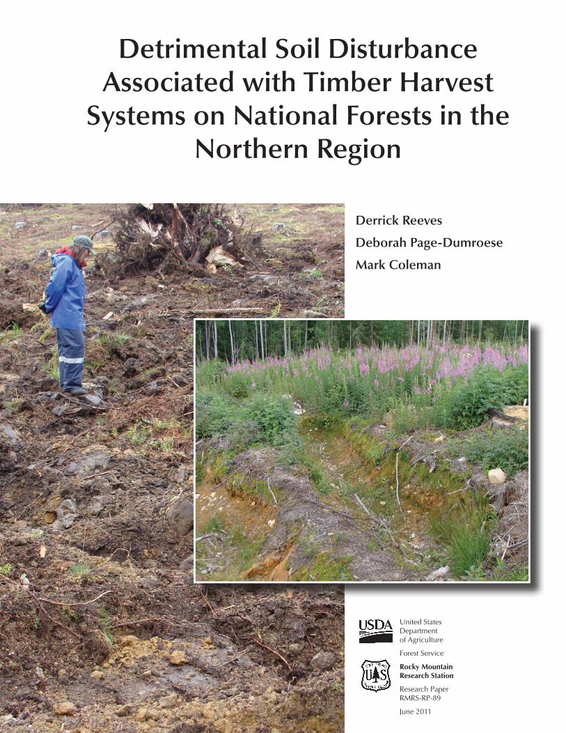
Detrimental Soil Disturbance Associated with Timber Harvest
Systems on National Forests in the Northern Region
Derrick Reeves
Deborah Page-Dumroese
Mark Coleman
You may order additional copies of this publication by sending your mailing information in label form through one of the following media. Please specify the publication title and series number.
Publishing Services
Telephone (970) 498-1392 FAX (970) 498-1122 E-mail [email protected] Website http://www.fs.fed.us/rm/publications Mailing address Publications Distribution Rocky Mountain Research Station 240 West Prospect Road Fort Collins, CO 80526
Reeves, Derrick; Page-Dumroese, Deborah; Coleman, Mark. 2011. Detrimental soil disturbance associated with timber harvest systems on National Forests in the Northern Region. Res. Pap. RMRS-RP-89 Fort Collins, CO: U.S. Department of Agriculture, Forest Service, Rocky Mountain Research Station. 12 p.
AbstrActMaintaining site productivity on forested lands within the National Forest System is a Federal mandate. To meet this mandate, soil conditions on timber harvest units within the Northern Region of the USDA Forest Service cannot exceed a threshold of 15% areal extent of detrimental soil disturbance (DSD; defined as a combination of compaction, puddling, rutting, burning, erosion, and displacement). The objectives of this study were to collate post-harvest soil monitoring data and to statistically document the areal extent of DSD resulting from timber harvest systems in the Northern Region. Current and legacy post-harvest soil monitoring data on National Forests throughout the Northern Region were collected to determine whether timber harvest systems (ground-based, skyline, or helicopter) used in the Northern Region result in DSD levels in excess of the mandated 15% areal extent. Statistical models developed in this study showed significant differences in the areal extent of DSD following timber harvest operations among ground-based, skyline, and helicopter harvest systems; among harvest seasons; and among National Forests. The frequency of DSD harvest operations followed the general trend of ground-based>skyline>helicopter. Winter ground-based harvest resulted in a significantly lower areal extent of DSD than summer ground-based harvest. Differences among Forests may have been caused by unique physiographic and ecological characteristics and distinct survey methods. However, despite significant differences in the amount of DSD resulting from similar timber harvest systems, none of the harvest systems that we evaluated on the National Forests consistently resulted in mean disturbance levels in excess of the 15% areal extent threshold.
Keywords: displacement, compaction, ground-based logging, skyline, helicopter, areal extent
AuthorsDerrick Reeves, MSc student, Department of Environmental Sciences, University of Idaho, Moscow.
Deborah Page-Dumroese, Research Soil Scientist, Rocky Mountain Research Station, Moscow, Idaho.
Mark Coleman, Assistant Professor and Director Intermountain Forest Tree Nutrition Cooperative, College of Natural Resources, University of Idaho, Moscow.
reseArch summAry
The National Forest Management Act of 1976 (NFMA) mandates that management systems “will not produce substantial and permanent impairment of the productivity of the land.” In response to this mandate, soil quality standards were developed for each Region of the USDA Forest Service. To comply with the NFMA mandate in the Northern Region, detrimental soil disturbance (DSD; a combination of compaction, rutting, severely burned soil, displacement, erosion, and soil mass movement) must not exceed 15% of the areal extent of a timber harvest unit when harvest and site preparation activities are complete. In the Northern Region, monitoring of post-harvest soil disturbance levels has been achieved using several methods since the soil quality standards were last revised in 1999. Despite the lack of a common monitoring protocol, the shared objective of all soil monitoring methods has been to find the areal extent of detrimentally disturbed soil on the harvest unit in order to determine the extent to which harvest activities meet the Regional standard.
We collected current and legacy soil monitoring data that was gathered post-1999 from throughout the Northern Region for all timber harvest systems in order to evaluate the differences in the areal extent of DSD resulting from ground-based, skyline, and helicopter harvest systems over different harvest seasons. Where sufficient data were available, we also evaluated the areal extent of DSD resulting from different harvest systems/harvest seasons for the individual Forests in the Northern Region.
Using a statistical model developed in this study, we came to the following conclusions:
(1) The mean areal extent of DSD does not exceed the 15% threshold for any harvest system in the Northern Region, based on the data we collected and were given.
(2) Significant differences in the areal extent of post-harvest/post-site preparation DSD result from different harvest systems. The trend in DSD for the Northern Region harvest systems is ground-based>skyline>helicopter.
(3) The areal extent of DSD is significantly higher as a result of ground-based summer harvest than ground-based winter harvest.
(4) The harvest method that listed “tractor” as the equipment type lacked enough precision for definitive conclusions about DSD resulting from ground-based equipment.
(5) Significant variation exists in the areal extent of DSD post-harvest among National Forests in the Northern Region (and by extension, the soil disturbance monitors) utilizing similar harvest systems and harvest seasons.
(6) The institutional bias in the Northern Region that directs soil monitoring efforts toward harvest units that are more susceptible to DSD is justified.
(7) The applicability of large-scale assessments to determine the impact to the soil resource and its productive capacity is limited because of disparate sampling protocols that are implemented over a wide-range of climatic, geographic, and soil characteristics.
Land managers can reasonably predict that the areal extent of post-harvest DSD on proposed skyline and helicopter harvest units will fall under the 15% threshold on harvest units with minimal pre-existing DSD. In addition, the Forest Service stands to benefit from the adoption of a common soil monitoring protocol that standardizes a common monitoring method when pre- and post-harvest soil monitoring occurs, and delineates the soil disturbance resulting from harvest activities and from site preparation activities.
i
Acknowledgments
We thank all the forest soil scientists in the Northern Region for providing soil monitoring data from the forests included in this paper. Without their dedicated assistance, we wouldn’t have been able to evaluate the impacts of harvest operations. We also thank the countless summer employees who helped collect monitoring data. Most of all, we acknowledge the help and financial support of Meredith Webster and the Northern Region.
contents
Research Summary ......................................................................i
Acknowledgments .......................................................................ii
Introduction ................................................................................1
Methods ......................................................................................2Data Collection .......................................................................2Detrimental Soil Impacts Definition .........................................2Monitoring Methods ................................................................2Description of Harvest Systems ................................................2
Statistical Analysis ......................................................................4
Results ........................................................................................4Region-Wide ...........................................................................4Individual Forests ....................................................................4
Discussion ...................................................................................7
Regional Analysis ....................................................................7Individual Forest Analysis ........................................................9
Conclusion ................................................................................10
References ................................................................................10
Appendix A. ..............................................................................12
ii
USDA Forest Service RMRS-RP-89. 2011. 1
Introduction
Maintenance of soil productivity is a statutory mandate of the National Forest Management Act (NFMA) of 1976. The NFMA and the administrative National Forest System Land and Resource Management Planning Act of 1982 (Planning Rule) related to maintenance of soil productivity are general statements that give managers significant flexibility in how soil and site productivity are maintained. Efforts to deter-mine the extent to which management activities undertaken by the USDA Forest Service were meeting legal mandates relative to soil productivity led to the first soil quality stan-dards (SQS) in North America.
Forest Service Manual 2500 and the SQS (USDA 1999) developed for the Northern Region of the Forest Service de-scribe specific definitions, policy, and direction for meeting mandates and directives set forth in NFMA and the Planning Rule. The Northern Region SQS (Supplement 2500-99-1) were last revised in 1999. The objectives of the SQS are to “meet direction in the National Forest Management Act of 1976 and other legal mandates, and to manage Forest System lands under ecosystem management principles without per-manent impairment of land productivity and to maintain or improve soil quality.” This policy is based on the assumption that detrimental soil disturbance (DSD) must reduce vegeta-tive growth by more than 15% before it is detectable during routine measurements (Powers and others 1990). However, it has also come to mean that the areal extent of DSD should be less than 15% to maintain site quality (Powers and oth-ers 1998). To meet the policy direction, cumulative levels of soil impacts considered detrimental to land productiv-ity must not exceed 15% of the areal extent of any given management unit. Soils are considered to be detrimentally impacted when disturbance thresholds (set by each USDA Forest Service Region) are exceeded for compaction, dis-placement, rutting, severe burning, surface erosion, loss of
surface organic matter, and soil mass movement. The as-sumption is that the magnitude of these impacts is dependent on the ecological interaction between local climate and soil physical, chemical, and biological properties and processes. However, at the time these standards were developed, little research had been completed to validate the impacts of these soil disturbances on forest productivity (e.g., vegetative re-growth after harvesting) (Page-Dumroese and others 2000) or on how individual soil types might respond to various management systems. Areas not managed for vegetation and water resources such as permanent roads, harvest landings, mines, developed recreation areas, and administrative sites were exempted from the SQS.
The USDA Forest Service SQS describe a systematic process by which data are collected to determine if soil man-agement objectives to maintain long-term productivity are achieved (Neary and others 2010). Howes and others (1983) provided a protocol for quantitative forest soil monitoring that was used in the Pacific Northwest Region, but a rapid qualitative assessment was favored to reduce the monitoring burden and to allow more assessment capacity (Howes 2001; Curran and others 2005). Page-Dumroese and others (2009) developed the Forest Soil Disturbance Monitoring Protocol, which has been adopted for nationwide use by the USDA Forest Service. This protocol standardizes how soil data are collected so that sites can be compared at both temporal and spatial scales. Previously, post-harvest soil disturbance moni-toring data had been observed and documented using several different formats and field methods since the SQS were re-vised in 1999. Although the format has varied over time, the common objective has been to document the extent of DSD in various timber harvest units. The objectives of this study were to collate the post-harvest soil monitoring data and to statistically document the areal extent of DSD resulting from ground-based, skyline, and helicopter timber harvest systems in the Northern Region of the USDA Forest Service.
Detrimental Soil Disturbance Associated with Timber Harvest Systems on National Forests
in the Northern Region
Derrick Reeves, Deborah Page-Dumroese, Mark Coleman
2 USDA Forest Service RMRS-RP-89. 2011.
harvest units on random or pre-selected transects represen-tative of the area. Periodic sample points were collected along each transect. The number of sample points in each unit, number of units monitored, level of site stratification (slope, aspect, etc.), and how much of the area is traversed is at the discretion of each soil scientist. Quantitative or qualitative methods, such as measuring a 15% increase in bulk density, could be applied using any method available at the time of data collection and ranged from collecting bulk density cores (e.g., Blake and Hartge 1986) to using the “shovel test” (sliding a tile spade into the soil to deter-mine a change in soil resistance to penetration relative to a site-specific control [unharvested or unimpacted] soil). Because of the discretionary nature of soil disturbance col-lection and also because of the lack of soil monitoring data on some National Forests, we were unable to stratify sites by soil texture, depth to bedrock, rock fragment content, cover type and amount, or other site features for DSD modeling. In addition, only a few locations collected pre-harvest data to provide a baseline for comparison. There was no time stan-dard after harvest and site preparation operations ceased for monitoring to take place.
Description of Harvest Systems
Ground-based harvest systems
(1) Harvest systems were considered ground-based if the following equipment was used during harvest operations: rubber-tired skidders (RTS) yarding bole only or whole tree segments that were hand fell (“hand fell + RTS”) or machine fell (“machine fell + RTS”).
(2) Harvester/Forwarder or cut to length systems (“Harvester/Forwarder”).
(3) Tractor was often used as a default category when soil monitors are unsure of the ground-based equipment used. “Tractor” includes rubber-tired skidders or tracked vehicles yarding hand felled or machine felled timber.
(4) Harvest units that were ground-based, machine fell, and lacked a specific yarding machine were recorded as “machine fell + ground skid.”
Skyline harvest systems
Harvest systems were considered to be skyline if the following equipment was used during harvest operations: sta-tionary machines that yard whole tree or bole only segments to a central landing location by means of a cable suspending at least one end of the tree segment. Units that were hand fell and skyline yarded were recorded as “skyline,” and units
Methods
Data Collection
Data for the areal extent of post-harvest and post-site preparation DSD were collected from 409 individual tim-ber harvest units from 11 National Forests in the Northern Region (Figure 1). Only data collected after the last revi-sion of the SQS (post 1999) were considered for this study. Data were provided by each of the National Forests in report or field data sheet form, and we collected additional data in the summer of 2009 to fill obvious gaps. Additional data was collected using the Forest Soil Disturbance Monitoring Protocol (Page-Dumroese and others 2009). The data set in-cluded DSD information from ground-based, skyline, and helicopter harvest systems from each of four harvest seasons (spring, summer, fall, and winter; Table 1).
Detrimental Soil Impacts Definition
Existence of one, or a combination of any, of the attri-butes listed below can indicate detrimental soil conditions. After management activities of harvesting and site prepa-ration, 85% of the activity area (harvest unit) must be in a satisfactory condition (without detrimental impacts). The Northern Region SQS define detrimental impacts as the fol-lowing (FSM 2500-99-1):
Compaction: a 15% increase in the natural bulk density. Cumulative effects of multiple site entries should be considered.
Rutting: wheel ruts at least 2 inches (5 cm) deep in wet soils.
Displacement: removal of >1inch (2.5 cm) of any surface horizon, usually the A horizon, from a continuous area greater than 100 ft2 (9.2 m2).
Severely burned soil: physical and biological changes to the soil resulting from high-intensity burns of long duration as described in the Burned-Area Emergency Rehabilitation Handbook (FSH 2509.13).
Surface erosion: rills, gullies, pedestals, and soil deposition.
Soil mass movement: any soil mass movement caused by management activity.
Monitoring Methods
Soil scientists on each of the National Forests used any available methods for determining when detrimental soil con-ditions existed in harvest units. Typically, monitors traversed
USDA Forest Service RMRS-RP-89. 2011. 3
Figure 1. National Forests of the Northern Region that were included in the study.
Table 1. Number of timber harvest units associated with individual National Forests by harvest system.
GroundForest (non-winter) Ground (winter)a Skyline Helicopter Total % of total
Beaverhead-Deerlodge 4 0 0 0 4 <1Bitterroot 4 5 1 2 12 2.9Clearwater 11 0 10 0 21 5.1Custer 12 2 0 0 14 3.4Flathead 22 19 0 1 42 10.3Helena 2 7 2 0 11 2.7Idaho Panhandle 10 9 5 0 24 5.8Kootenai 118 78 9 10 215 52.6Lewis and Clark 3 1 0 0 4 <1Nez Perce 0 0 0 2 2 <1a Winter harvest is designated as harvest operations that were completed during December, January, or February.
4 USDA Forest Service RMRS-RP-89. 2011.
that were machine fell and skyline yarded were recorded as “machine fell + skyline.”
Helicopter harvest systems
Harvest systems were considered helicopter logged if the whole tree or bole only segments were yarded to a central landing area by a helicopter. Helicopter units that were hand fell were recorded as “helicopter.” Helicopter units that had post-harvest site preparation (i.e., fuel treatments) conducted by machines were recorded as “helicopter + machine fuels.”
Harvest season
Harvest season for each unit was assigned based on the month in which harvest operations were completed. Spring harvests were completed in March, April, or May; summer harvests were completed in June, July, or August; fall har-vests were completed in September, October, and November; and winter harvests were completed in December, January, and February.
Post-harvest site preparation
While most forest sites within the Northern Region have some type of post-harvest site preparation done before soil monitoring occurs, we were unable to separate the impacts of logging from those of site preparation.
Statistical Analysis
All analyses were evaluated using a SAS PROC GLM procedure (SAS Institute 2008). A linear multiple regression analysis was used to test for significant effects (α = 0.05) of harvest season, harvest system, the National Forest on which harvest occurred, and the interaction between the Forest and harvest season (Forest*season) on the areal extent of DSD. Statistical models were used to generate least squares means to evaluate the areal extent of DSD across Northern Region Forests and within each Forest. A square root transformation was applied to DSD values to create a normally distributed data set.
Results
Region-Wide
All harvest systems
National Forest, harvest system, and harvest season were significant factors in predicting the amount of DSD resulting
Table 2. Analysis of Variance (ANOVA) table listing model variables and probability values for a Regional analysis of DSD.
Variable p-Value
Forest <0.0001Harvest system <0.0001Harvest season 0.0407
from timber harvest activities across the Region for all har-vest systems (p-value<0.0407; Table 2).
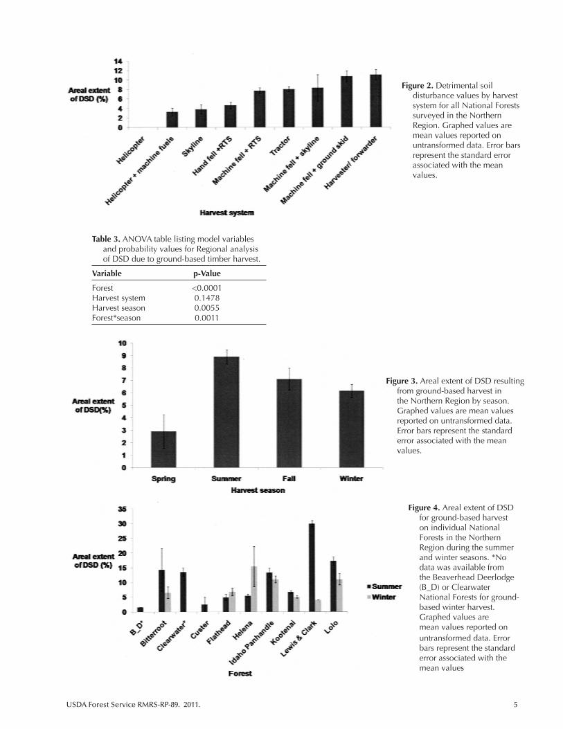
As expected, helicopter harvesting, where no post-har-vest site preparation was performed using ground-based machines, resulted in significantly less DSD (0.2%) than units harvested by either skyline or ground-based systems (3.8% and 8.2%, respectively) (Figure 2). In addition, hand-felling with skyline systems resulted in significantly less DSD (1.9%) than harvesting with ground-based systems (8.2%). There were no differences in the areal extent of DSD between those units that were machine fell + skyline versus those that were harvested with ground-based equip-ment. Winter harvest units had significantly less areal extent of DSD (7.6%) than summer harvest units (9.6%).
Ground-based harvest
Three of the four model variables (Forest, Harvest season, Forest*season) had a significant effect on the areal extent of DSD due to ground-based harvest in the Northern Region (Table 3). The type of ground-based equipment used during harvest operations was not a significant factor.
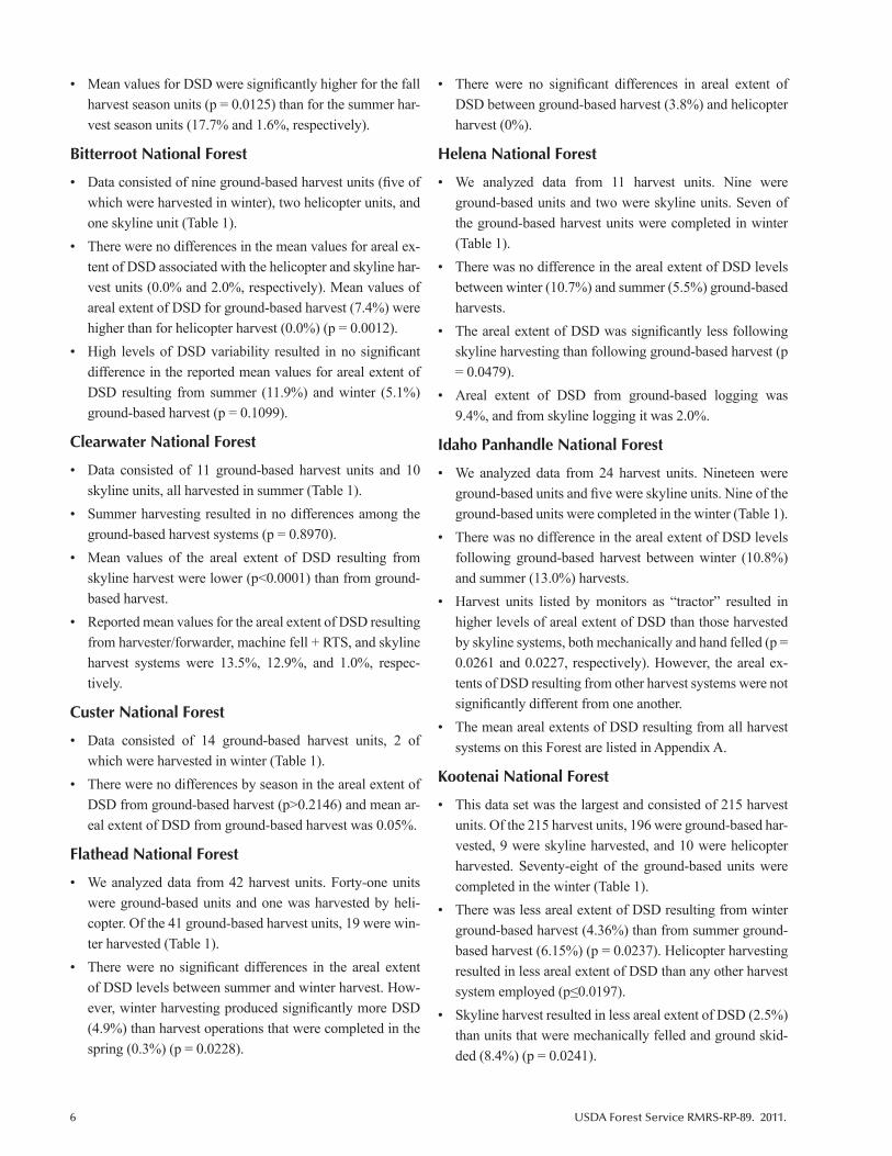
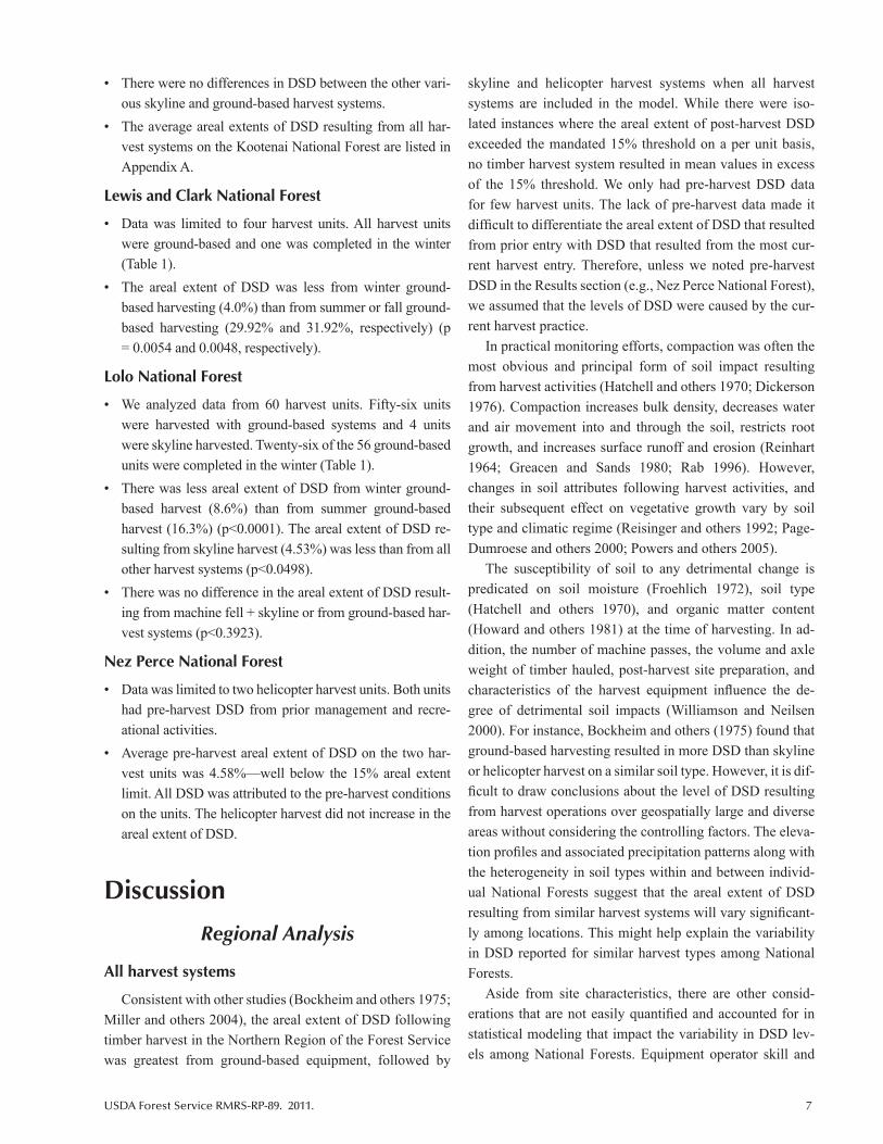
For ground-based harvest operations, there were differ-ences in the amount of DSD by different harvest seasons (p = 0.0055). The areal extent of DSD was higher during the summer and fall (9.9% and 9.2%, respectively) than during winter or spring (7.0% and 6.0%, respectively) (Figure 3). Additionally, differences in the areal extent of DSD during the same season depended on the National Forest where the harvest took place (Figure 4). For example, summer harvest-ing on the Lewis and Clark National Forest exceed 25% areal extent, whereas on the Custer National Forest it was less than 5%.
Individual Forests
Beaverhead-Deerlodge National Forest
• Areal extent of DSD values was limited to four ground-based harvest units. Three harvests were completed in the fall, and one was completed in the summer (Table 1).
USDA Forest Service RMRS-RP-89. 2011. 5
Table 3. ANOVA table listing model variables and probability values for Regional analysis of DSD due to ground-based timber harvest.
Variable p-Value
Forest <0.0001Harvest system 0.1478Harvest season 0.0055Forest*season 0.0011
Figure 2. Detrimental soil disturbance values by harvest system for all National Forests surveyed in the Northern Region. Graphed values are mean values reported on untransformed data. Error bars represent the standard error associated with the mean values.
Figure 3. Areal extent of DSD resulting from ground-based harvest in the Northern Region by season. Graphed values are mean values reported on untransformed data. Error bars represent the standard error associated with the mean values.
Figure 4. Areal extent of DSD for ground-based harvest on individual National Forests in the Northern Region during the summer and winter seasons. *No data was available from the Beaverhead Deerlodge (B_D) or Clearwater National Forests for ground-based winter harvest. Graphed values are mean values reported on untransformed data. Error bars represent the standard error associated with the mean values
6 USDA Forest Service RMRS-RP-89. 2011.
• Mean values for DSD were significantly higher for the fall harvest season units (p = 0.0125) than for the summer har-vest season units (17.7% and 1.6%, respectively).
Bitterroot National Forest
• Data consisted of nine ground-based harvest units (five of which were harvested in winter), two helicopter units, and one skyline unit (Table 1).
• There were no differences in the mean values for areal ex-tent of DSD associated with the helicopter and skyline har-vest units (0.0% and 2.0%, respectively). Mean values of areal extent of DSD for ground-based harvest (7.4%) were higher than for helicopter harvest (0.0%) (p = 0.0012).
• High levels of DSD variability resulted in no significant difference in the reported mean values for areal extent of DSD resulting from summer (11.9%) and winter (5.1%) ground-based harvest (p = 0.1099).
Clearwater National Forest
• Data consisted of 11 ground-based harvest units and 10 skyline units, all harvested in summer (Table 1).
• Summer harvesting resulted in no differences among the ground-based harvest systems (p = 0.8970).
• Mean values of the areal extent of DSD resulting from skyline harvest were lower (p<0.0001) than from ground-based harvest.
• Reported mean values for the areal extent of DSD resulting from harvester/forwarder, machine fell + RTS, and skyline harvest systems were 13.5%, 12.9%, and 1.0%, respec-tively.
Custer National Forest
• Data consisted of 14 ground-based harvest units, 2 of which were harvested in winter (Table 1).
• There were no differences by season in the areal extent of DSD from ground-based harvest (p>0.2146) and mean ar-eal extent of DSD from ground-based harvest was 0.05%.
Flathead National Forest
• We analyzed data from 42 harvest units. Forty-one units were ground-based units and one was harvested by heli-copter. Of the 41 ground-based harvest units, 19 were win-ter harvested (Table 1).
• There were no significant differences in the areal extent of DSD levels between summer and winter harvest. How-ever, winter harvesting produced significantly more DSD (4.9%) than harvest operations that were completed in the spring (0.3%) (p = 0.0228).
• There were no significant differences in areal extent of DSD between ground-based harvest (3.8%) and helicopter harvest (0%).
Helena National Forest
• We analyzed data from 11 harvest units. Nine were ground-based units and two were skyline units. Seven of the ground-based harvest units were completed in winter (Table 1).
• There was no difference in the areal extent of DSD levels between winter (10.7%) and summer (5.5%) ground-based harvests.
• The areal extent of DSD was significantly less following skyline harvesting than following ground-based harvest (p = 0.0479).
• Areal extent of DSD from ground-based logging was 9.4%, and from skyline logging it was 2.0%.
Idaho Panhandle National Forest
• We analyzed data from 24 harvest units. Nineteen were ground-based units and five were skyline units. Nine of the ground-based units were completed in the winter (Table 1).
• There was no difference in the areal extent of DSD levels following ground-based harvest between winter (10.8%) and summer (13.0%) harvests.
• Harvest units listed by monitors as “tractor” resulted in higher levels of areal extent of DSD than those harvested by skyline systems, both mechanically and hand felled (p = 0.0261 and 0.0227, respectively). However, the areal ex-tents of DSD resulting from other harvest systems were not significantly different from one another.
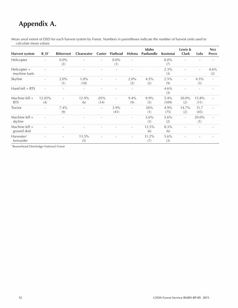
• The mean areal extents of DSD resulting from all harvest systems on this Forest are listed in Appendix A.
Kootenai National Forest
• This data set was the largest and consisted of 215 harvest units. Of the 215 harvest units, 196 were ground-based har-vested, 9 were skyline harvested, and 10 were helicopter harvested. Seventy-eight of the ground-based units were completed in the winter (Table 1).
• There was less areal extent of DSD resulting from winter ground-based harvest (4.36%) than from summer ground-based harvest (6.15%) (p = 0.0237). Helicopter harvesting resulted in less areal extent of DSD than any other harvest system employed (p≤0.0197).
• Skyline harvest resulted in less areal extent of DSD (2.5%) than units that were mechanically felled and ground skid-ded (8.4%) (p = 0.0241).
USDA Forest Service RMRS-RP-89. 2011. 7
• There were no differences in DSD between the other vari-ous skyline and ground-based harvest systems.
• The average areal extents of DSD resulting from all har-vest systems on the Kootenai National Forest are listed in Appendix A.
Lewis and Clark National Forest
• Data was limited to four harvest units. All harvest units were ground-based and one was completed in the winter (Table 1).
• The areal extent of DSD was less from winter ground-based harvesting (4.0%) than from summer or fall ground-based harvesting (29.92% and 31.92%, respectively) (p = 0.0054 and 0.0048, respectively).
Lolo National Forest
• We analyzed data from 60 harvest units. Fifty-six units were harvested with ground-based systems and 4 units were skyline harvested. Twenty-six of the 56 ground-based units were completed in the winter (Table 1).
• There was less areal extent of DSD from winter ground-based harvest (8.6%) than from summer ground-based harvest (16.3%) (p<0.0001). The areal extent of DSD re-sulting from skyline harvest (4.53%) was less than from all other harvest systems (p<0.0498).
• There was no difference in the areal extent of DSD result-ing from machine fell + skyline or from ground-based har-vest systems (p<0.3923).
Nez Perce National Forest
• Data was limited to two helicopter harvest units. Both units had pre-harvest DSD from prior management and recre-ational activities.
• Average pre-harvest areal extent of DSD on the two har-vest units was 4.58%—well below the 15% areal extent limit. All DSD was attributed to the pre-harvest conditions on the units. The helicopter harvest did not increase in the areal extent of DSD.
Discussion
Regional Analysis
All harvest systems
Consistent with other studies (Bockheim and others 1975; Miller and others 2004), the areal extent of DSD following timber harvest in the Northern Region of the Forest Service was greatest from ground-based equipment, followed by
skyline and helicopter harvest systems when all harvest systems are included in the model. While there were iso-lated instances where the areal extent of post-harvest DSD exceeded the mandated 15% threshold on a per unit basis, no timber harvest system resulted in mean values in excess of the 15% threshold. We only had pre-harvest DSD data for few harvest units. The lack of pre-harvest data made it difficult to differentiate the areal extent of DSD that resulted from prior entry with DSD that resulted from the most cur-rent harvest entry. Therefore, unless we noted pre-harvest DSD in the Results section (e.g., Nez Perce National Forest), we assumed that the levels of DSD were caused by the cur-rent harvest practice.
In practical monitoring efforts, compaction was often the most obvious and principal form of soil impact resulting from harvest activities (Hatchell and others 1970; Dickerson 1976). Compaction increases bulk density, decreases water and air movement into and through the soil, restricts root growth, and increases surface runoff and erosion (Reinhart 1964; Greacen and Sands 1980; Rab 1996). However, changes in soil attributes following harvest activities, and their subsequent effect on vegetative growth vary by soil type and climatic regime (Reisinger and others 1992; Page-Dumroese and others 2000; Powers and others 2005).
The susceptibility of soil to any detrimental change is predicated on soil moisture (Froehlich 1972), soil type (Hatchell and others 1970), and organic matter content (Howard and others 1981) at the time of harvesting. In ad-dition, the number of machine passes, the volume and axle weight of timber hauled, post-harvest site preparation, and characteristics of the harvest equipment influence the de-gree of detrimental soil impacts (Williamson and Neilsen 2000). For instance, Bockheim and others (1975) found that ground-based harvesting resulted in more DSD than skyline or helicopter harvest on a similar soil type. However, it is dif-ficult to draw conclusions about the level of DSD resulting from harvest operations over geospatially large and diverse areas without considering the controlling factors. The eleva-tion profiles and associated precipitation patterns along with the heterogeneity in soil types within and between individ-ual National Forests suggest that the areal extent of DSD resulting from similar harvest systems will vary significant-ly among locations. This might help explain the variability in DSD reported for similar harvest types among National Forests.
Aside from site characteristics, there are other consid-erations that are not easily quantified and accounted for in statistical modeling that impact the variability in DSD lev-els among National Forests. Equipment operator skill and
8 USDA Forest Service RMRS-RP-89. 2011.
experience have been found to play an important role in the areal extent of DSD resulting from harvest operations (Pinard and others 2000; Stone 2002). This may become an even greater issue with the continuing decline in the tim-ber industry. For example, as experienced operators retire or move to other occupations, lack of steady employment may deter qualified individuals from filling these roles in the future. On National Forests that are not in close proximity to actively managed corporate timber lands, this may lead to a deficit in skilled equipment operators. Perhaps equally important to the reduction of DSD by knowledgeable op-erators is the skill and experience of the sale administrator who oversees active timber sales. Knowledge of local condi-tions as well as operator tendencies are important in keeping DSD levels below the mandated 15% of areal extent in an activity area. This knowledge is especially important during ground-based winter harvest operations. As winter harvest conditions become sub-optimal (e.g., during snow melt) and the soil moisture content increases, DSD is more likely to occur and the areal extent of that disturbance increases. It is imperative at this point of the harvest operation that the sale administrator monitors harvest operations closely and halts harvest operations until site conditions become less suscep-tible to high disturbance levels.
Other variables that influence the amount and type of disturbance noted during soil monitoring are: time elapsed since harvest, type of site preparation operations, when the soil monitoring occurs relative to operations, training and experience of the monitoring personnel, existence of pre-harvest data for a baseline assessment, and if the harvested site was stratified to reflect changes in site characteristics (slope, aspect, soil, vegetation, etc.) (Page-Dumroese and others 2006).
Our research showed that there are significant differenc-es in the amounts of DSD that result from similar harvest techniques among National Forests. When considering how and when to monitor, resource professionals should take into account the unique local attributes of weather patterns, soil texture, surface organic matter, and soil moisture con-ditions, as well as the individual contractors involved with the harvest activities. Effective communication between all resource professionals (timber sale administrators, silvicul-turists, forestry technicians, hydrologists, etc.) is necessary to successfully achieve management objectives.
Ground-based harvest systems
Ground-based harvest systems have high potential to create damage under some conditions. Based on other stud-ies, we expected that harvest season would be a significant
factor in the areal extent of DSD resulting from ground-based timber harvesting (Klock 1975; Page-Dumroese and others 2006; Johnson and others 2007). Winter ground-based harvests often result in less areal extent of DSD than during other seasons when performed under ideal conditions, and they are often used as a best management practice (Miller and others 2004, Page-Dumroese and oth-ers 2006, Johnson and others 2007; Page-Dumroese and others 2010) because they minimize soil damage. However, there were two exceptions to that trend in our data. DSD resulting from ground-based harvest was higher during the winter harvest season than the summer harvest season on both the Flathead and Helena National Forests. This was partly explained by the small sample size and several in-stances where the areal extent of DSD exceeded the 15% threshold for a harvest unit (see the discussions on Flathead and Helena National Forests)
Ground-based harvest operations that were completed in the spring resulted in the least amount of total DSD. The low levels of DSD resulting from ground-based harvest in the spring were likely an anomaly of how we delineated harvest season within the analyses, and they further empha-size the importance of optimal winter harvest conditions and the role that local weather patterns play in maintain-ing them. The seasonal designation used in this study was based entirely on the month that harvest operations were completed. The eight ground-based spring harvest units in our data set were all completed in early March. Spring op-erations had minimal impact under the existing conditions at the time of observation (Figure 3). In our experience, ground-based harvest operations that were ongoing in March were indicative of either high-elevation, above-average snow pack, and/or below-average temperatures. In short, optimal snow pack and temperature conditions for ground-based winter harvesting help preserve organic horizons, water infiltration, and root structure (Williamson and Neilsen 2000). Winter conditions also reduce the oc-currence of soil compaction and rutting.
During the collection and analysis of these monitoring data, we noted that the term “tractor” was often used as a catch-all term when soil disturbance monitors were unsure of the exact equipment used for ground-based timber har-vest. Every effort was made to determine the exact piece (or pieces) of equipment that was used on each ground-based harvest unit that did not have a clear equipment notation. However, this datum was unavailable on some units. This likely explains why we could detect no statis-tically significant differences in the areal extent of DSD among the various ground-based harvest equipment types.
USDA Forest Service RMRS-RP-89. 2011. 9
The lack of precision in the data set regarding the ground-based harvest equipment employed leaves us hesitant to draw any conclusions as to the relative areal extent of DSD resulting from different ground-based harvest equipment. Greater precision in the monitoring and recording process regarding different equipment is necessary to determine if there are differences in the areal extent of DSD resulting from each equipment type.
Individual Forest Analysis
The amount of soil monitoring data available from each of the National Forests across the Northern Region varied considerably due to many factors, including the disparity in timber harvest levels among the National Forests, how much emphasis was placed on pre- and post-harvest soil monitor-ing, and how sites were selected to be monitored. The amount of legacy data (data collected in hard copy form prior to the utilization of computer based spreadsheets) in each National Forests’ database also played a significant role in the amount and type of data available for this study. National Forest data were heavily weighted toward ground-based harvest. This was due, in part, to the relative distribution of the timber harvest system that was employed and management expecta-tions that ground-based harvesting would cause the greatest areal extent of soil impacts. In addition, on some National Forests, there were no helicopter-logged units and few sky-line harvested units. Another factor was the institutional bias toward monitoring soil disturbance on sites that are most likely to result in higher levels of DSD (personal cor-respondence with Meredith Webster, Northern Region Soil Program Manager). A more complete analysis was possible for forests that included these factors (i.e., units logged with other than ground-based systems, pre-harvest or legacy data available, and monitoring occurring in all harvest systems). The following discussion of the individual National Forests is limited to those with noteworthy or unusual results.
Beaverhead-Deerlodge
On this National Forest, the average areal extent of DSD for fall harvesting is relatively high and was likely a result of one harvest unit with 45% areal extent of DSD and a small sample size (n = 3). It was unclear whether the 45% was due to an excessive amount of skid trails, wet soil, driving across the entire site, or some other factor.
Bitterroot National Forest
There was no difference in the areal extent of DSD re-sulting from helicopter and skyline harvest systems. This is likely because there were only two helicopter harvest units
monitored (Table 1). Additionally, although there was no statistical difference in monitoring results between winter and summer ground-based harvest, it is worth noting that the areal extent of DSD resulting from summer ground-based harvest was more than two times the level of DSD resulting from winter ground-based harvesting.
Custer National Forest
The areal extent of DSD on the Custer National Forest resulting from timber harvest activities was the lowest of any Forest at 0.05%. This is especially remarkable con-sidering that all harvest activities were completed with ground-based equipment. Relatively arid conditions, coarse-textured soil, and strong communication between the operator and sale administrator about the desired post-harvest conditions possibly played a role in the resulting levels of areal extent of DSD. Ground-based operations conducted on fairly coarse-textured soil result in condi-tions that are fairly resilient after harvest operations and may not impact vegetative productivity (Powers 2006).
Flathead National Forest
Although there were no significant statistical differenc-es in the areal extent of DSD between winter and summer ground-based harvest operations, the Flathead National Forest was one of two Northern Region National Forests where the average areal extent of DSD was higher in winter than in summer (Figure 4). On the Flathead, this anomaly was attributed to two winter ground-based units that ex-ceeded the 15% areal extent of DSD threshold. In contrast, there were two spring ground-based units that resulted in 0% and 1% areal extent of DSD. These data again empha-size the need to monitor local weather conditions carefully when winter harvest operations are underway. A cold snap in March can produce weather that is more conducive to successful “winter” harvest than a warm spell in December, January, or February.
Helena National Forest
Opposite the trend of higher DSD during summer ground-based harvests, Helena National Forest showed nearly twice the areal extent of DSD following winter log-ging than that observed during summer. However, due to variation in the DSD observations, this difference was in-significant (p = 0.2548). The Helena National Forest was one of two Forests where ground-based winter harvest resulted in more DSD than ground-based summer harvest (Figure 4). This was due, in part, to the small sample size associated with summer ground-based harvest (Table 1) and to the large areal extent of DSD resulting from winter
10 USDA Forest Service RMRS-RP-89. 2011.
ground-based harvest on two units. It is possible that the areal extents of DSD associated with the two winter har-vest units reflect disturbance resulting from fire, recreation, or some other management activity not associated with the timber harvest but not explicitly noted in the monitoring data.
Conclusion
Across the Northern Region, no timber harvest system consistently resulted in mean DSD in excess of the man-dated 15% areal extent within a timber harvest unit. There are, however, statistically significant differences in the amount of DSD resulting from ground-based, skyline, and helicopter timber harvest systems. Significant differences also exist in the areal extent of DSD resulting from ground-based harvest in winter versus summer. The Forest Service is justified in its institutional bias toward monitoring har-vest units that are at risk from higher impact harvest (e.g., ground-based harvesting). Where pre-harvest soil monitor-ing reveals low areal extent of DSD on planned skyline and helicopter harvest units in the Northern Region, land managers can reasonably predict that post-harvest lev-els of DSD will likely fall under the 15% of areal extent threshold.
Ultimately, the utility of the soil monitoring data is dependent upon the accuracy with which they reflect con-ditions on the ground. For a wide-scale synthesis of soil monitoring data to be successful, it is imperative that the sample size of monitoring points within a harvest unit be adequate to represent the amount of soil disturbance caused by harvest equipment. Inadequate sample size and the melding together of disparate methods, soil types, and climatic regimes limit the applicability of individual Forest data for large-scale assessments such as this one. In addi-tion, a goal of soil monitoring should be to separate the impacts of pre-harvest from post-harvest as well as the im-pacts of additional site preparation such as prescribed fire or slash piling. With the adoption of a common method (see Page-Dumroese and others 2009) and the development of a national soil monitoring database, the applicability of any analysis increases so that best management practices can be further refined. In addition, a national database of data that are collected in a similar manner will provide a decision support tool that will help determine which units are most at risk from harvesting or site preparation impacts and where scarce monitoring resources can be directed.
ReferencesBlake, G.R.; Hartge, K.H. 1986. Bulk density. In A. Klute, ed.
Methods of soil analysis. Part I. Agronomy 9. Agronomy Society of America: Madison, WI: 363-375.
Bockheim, J.G.; Ballard, T.M.; Willington, R.P. 1975. Soil disturbance associated with timber harvesting in southwestern British Columbia. Canadian Journal of Forest Research. 43: 285-290.
Curran, M.P.; Miller, R.E.; Howes, S.W.; Maynard, D.G.; Terry, T.A.; Heninger, R.L.; Niemann, T.; van Rees, K.; Powers, R.F.; Schoenholtz, S.H. 2005. Progress towards more uniform assessment and reporting of soil disturbance for operations, research, and sustainability protocols. Forest Ecology and Management. 220: 17-30.
Dickerson, B.P. 1976. Soil compaction after tree length skidding in northern Mississippi. Journal of Soil Science. 40: 75-84.
Froehlich, H.A. 1972. The impact of even age forest management on physical properties of soils. In R. Herman, D. Lavender, eds. Even-age management. School of Forestry, Oregon State University. Corvallis, OR: 190-220.
Greacen, E.L.; Sands, R. 1980. Compaction of forest soils—a review. Australian Journal of Soil Research. 18: 163-189.
Hatchell, G.E.; Ralson, C.W.; Foil, R.R. 1970. Soil disturbance in logging. Journal of Forestry. 68: 772-775.
Hatchell, G.E.; Ralson, C.W.; Foil, R.R. 1996. Influence of logging traffic on the hydromorphic degradation of acid forest soils developed on loessic loam in middle Belgium. Forest Ecology and Management. 87: 193-207.
Howard, R.F.; Singer, M.J.; Frantz, G.A. 1981. Effects of soil properties, water content and compactive effort on the compaction of selected California forest and range soils. Soil Science Society of America. 45: 231-236.
Howes, S.J.; Hazard, J.; Geist, M.J. 1983. Guidelines for sampling some physical conditions of surface soils. R6-PNW-146. U.S. Department of Agriculture, Forest Service, Pacific Northwest Region Publication. 34p.
Howes, S.W. 2001. Proposed soil resource condition assessment. Wallowa-Whitman National Forest. Unpublished methods.
Johnson, L.R.; Page-Dumroese, D.; Han, H-S. 2007. Effects of machine traffic on the physical properties of ash-cap soils. In D. Page-Dumroese, R. Miller, J. Mital, P. McDaniel, D. Miller, eds. Proceedings of conference on Volcanic-ash-derived forest soils of the Inland
USDA Forest Service RMRS-RP-89. 2011. 11
Northwest: properties and implications for management and restoration. Proc. RMRS-P-44. Fort Collins, CO: U.S. Department of Agriculture, Forest Service, Rocky Mountain Research Station: 69-82.
Klock, G.O. 1975. Impacts of five postfire salvage logging systems on soils and vegetation. Journal of Soil Water Conservation. 30: 78-81.
Miller, R.E.; Colbert, S.R.; Morris, L.A. 2004. Effects of heavy equipment on physical properties of soils and on long-term productivity: a review of literature and current research. NCASI Technical Bulletin 887. National Council for Air and Stream Improvement. 76 p.
Neary, D.G.; Page-Dumroese, D.; Trettin, C.C. 2010. Soil quality monitoring: examples of existing protocols. In D. Page-Dumroese, D. Neary, C. Trettin, eds. Scientific background for soil monitoring on forests and rangelands. Proc. RMRS-P-59. Fort Collins, CO: U.S. Department of Agriculture, Rocky Mountain Research Station: 61-83.
Page-Dumroese, D.; Abbott, A.M.; Rice, T. 2009. Forest soil disturbance monitoring protocol. Gen. Tech. Rep. WO-82a.Washington, DC: U.S. Department of Agriculture, Forest Service. 31 p.
Page-Dumroese, D.; Jurgensen, M.; Abbott, A.; Rice, T.; Tirocke, J.; DeHart, S. 2006. Monitoring changes in soil quality from post-fire logging in the Inland Northwest. In P.L. Andrews and B.W. Butler, comps. Proceedings of a conference on Fuels management—how to measure success. Proc. RMRS-P-41. Fort Collins, CO: U.S. Department of Agriculture, Forest Service, Rocky Mountain Research Station: 605-614.
Page-Dumroese, D.; Jurgensen, M.; Elliot, W.; Rice, T.; Nesser, J.; Collins, T.; Meurisse, R. 2000. Soil quality standards and guidelines for forest sustainability in northwestern North America. Forest Ecology and Management. 138: 445-462.
Page-Dumroese, D.S.; Jurgensen, M.; Terry, T. 2010. Maintaining soil productivity during forest or biomass-to-energy harvesting in the western United States. Western Journal of Applied Forestry. 25: 5-12.
Pinard, M.A.; Barker, M.G.; Tay, J. 2000. Soil disturbance and post-logging forest recovery on bulldozer paths in Sabah, Malaysia. Forest Ecology and Management. 130: 213-225.
Powers, R.F.; Tiarks, A.E.; Boyle, J.R. 1998. Assessing soil quality: practicable standards for sustainable forest productivity in the United States. In E.A. Davidson, M.B. Adams, K. Ramakrishna, eds. The contribution of soil science to the development and implementation of
criteria and indicators of sustainable forest management. Soil Science Society of America Special Publication No. 53. Soil Science Society of America, Madison, WI: 53-80.
Powers, R.F.; Alban, D.H.; Miller, R.E.; Tiarks, A.E.; Wells, C.G.; Avers, P.E.; Cline, R.G.; Fitzgerald, R.O.; Loftus, N.S., Jr. 1990. Sustaining site productivity in North American forests: problems and prospects. In S.P. Gessel, D.S. Lacate, G.F. Weetman, R.F. Powers, eds. Proceedings of the 7th North American forest soils conference on sustained productivity of forest soils; July, 1988. Faculty of Forestry, University of British Columbia, Vancouver: 49-79.
Powers, R.F.; Scott, D.A.; Sanchez, F.G.; Voldseth, R.A.; Page-Dumroese, D.; Elioff, J.D.; Stone, D.M. 2005. The North American long-term soil productivity experiment: findings from the first decade of research. Forest Ecology and Management. 220: 31-50.
Powers, R.F. 2006. Long-term soil productivity: genesis of the concept and principles behind the program. Canadian Journal of Forest Resources. 36: 519-528.
Rab, M.A. 1996. Soil physical and hydrological properties following logging and slash burning in the Eucalyptus regnans forest of southeastern Australia. Forest Ecology and Management. 84: 159-176.
Reinhart, K. 1964. Effect of a commercial clearcutting in West Virginia on overland flow and storm runoff. Journal of Forestry. 62: 167-171.
Reisinger, T.W.; Pope, P.E.; Hammon, S.C. 1992. Natural recovery of compacted soils in an upland hardwood forest in Indiana. Northern Journal of Applied Forestry. 9: 138-141.
SAS Institute Inc. 2008. SAS/STAT 9.2 Users Guide. SAS Institute Inc. Cary, NC.
Stone, D.M. 2002. Logging options to minimize soil disturbance in the northern Lake States. Northern Journal of Applied Forestry. 19: 115-121.
United States Department of Agriculture [USDA]. 1999. Forest Service Manual 2500. Region 1 Supplement No. 2500-99-1. Washington, DC: U.S. Department of Agriculture, Forest Service.
Webster, M. Northern Region Soil Program Manager. Personal correspondence; June 4, 2010.
Williamson, J.R.; Neilsen, W.A. 2000. The influence of forest site on rate and extent of soil compaction and profile disturbance of skid trails during ground-based harvesting. Canadian Journal of Forest Research. 30: 1196-1205.
12 USDA Forest Service RMRS-RP-89. 2011.
Mean areal extent of DSD for each harvest system by Forest. Numbers in parentheses indicate the number of harvest units used to calculate mean values.
Idaho Lewis & Nez Harvest system B_D* Bitterroot Clearwater Custer Flathead Helena Panhandle Kootenai Clark Lolo Perce
Helicopter - 0.0% - - 0.0% - 0.0% - - - (2) (1) (7)
Helicopter + - - - - - - 2.3% - - 4.6% machine fuels (3) (2)
Skyline - 2.0% 1.0% - - 2.0% 4.5% 2.5% - 4.5% - (1) (10) (2) (2) (9) (3)
Hand fell + RTS - - - - - - 4.6% - - - (3)
Machine fell + 12.05% - 12.9% .05% - 9.4% 9.9% 5.4% 30.0% 15.8% - RTS (4) (6) (14) (9) (5) (109) (2) (11)
Tractor - 7.4% - - 3.9% - 26% 4.9% 14.7% 11.7 - (9) (41) (1) (75) (2) (45)
Machine fell + - - - - - - 5.6% 5.6% - 20.0% - skyline (3) (2) (1)
Machine fell + - - - - - - 12.5% 8.3% - - - ground skid (6) (6)
Harvester/ - - 13.5% - - - 11.2% 5.6% - - - forwarder (5) (7) (3)* Beaverhead Deerlodge-National Forest
Appendix A.
Federal Recycling Program Printed on Recycled Paper
Rocky Mountain Research Station
The Rocky Mountain Research Station develops scientific information and technology to improve management, protection, and use of the forests and rangelands. Research is designed to meet the needs of the National Forest managers, Federal and State agencies, public and private organizations, academic institutions, industry, and individuals. Studies accelerate solutions to problems involving ecosystems, range, forests, water, recreation, fire, resource inventory, land reclamation, community sustainability, forest engineering technology, multiple use economics, wildlife and fish habitat, and forest insects and diseases. Studies are conducted cooperatively, and applications may be found worldwide.
Station HeadquartersRocky Mountain Research Station
240 W Prospect RoadFort Collins, CO 80526
(970) 498-1100
Research Locations
Reno, NevadaAlbuquerque, New MexicoRapid City, South Dakota
Logan, UtahOgden, UtahProvo, Utah
The U.S. Department of Agriculture (USDA) prohibits discrimination in all its programs and activities on the basis of race, color, national origin, age, disability, and where applicable, sex, marital status, familial status, parental status, religion, sexual orientation, genetic information, political beliefs, reprisal, or because all or part of an individual’s income is derived from any public assistance program. (Not all prohibited bases apply to all programs.) Persons with disabilities who require alternative means for communication of program information (Braille, large print, audiotape, etc.) should contact USDA’s TARGET Center at (202) 720-2600 (voice and TDD). To file a complaint of discrimination, write to USDA, Director, Office of Civil Rights, 1400 Independence Avenue, S.W., Washington, DC 20250-9410, or call (800) 795-3272 (voice) or (202) 720-6382 (TDD). USDA is an equal opportunity provider and employer.
Flagstaff, ArizonaFort Collins, Colorado
Boise, IdahoMoscow, Idaho
Bozeman, MontanaMissoula, Montana