Embed Size (px)
Citation preview
Development Agromet Services in India
BackgroundLinkages Agro Met ForecastingAgro Met AdvisoriesAdvisory Dissemination Capacity BuildingNew InitiativesFuture Plans
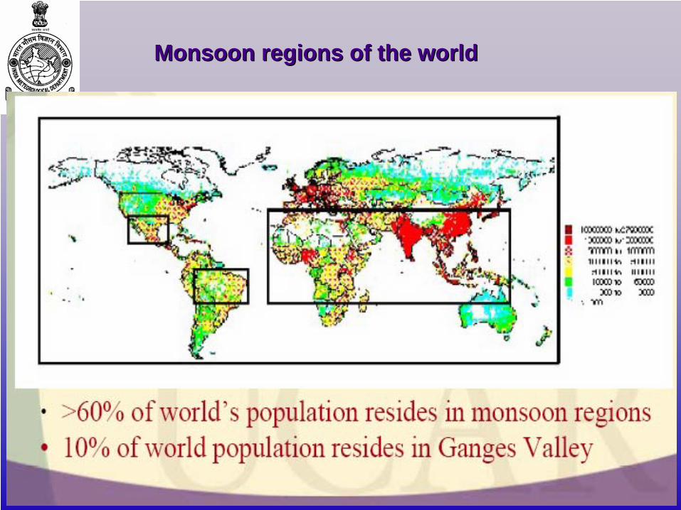
Monsoon regions of the worldMonsoon regions of the world
500
600
700
800
900
1000
1100
1200
1901 1906 1911 1916 1921 1926 1931 1936 1941 1946 1951 1956 1961 1966 1971 1976 1981 1986 1991 1996 2001 2006
-30
-20
-10
0
10
20
30
1901 1906 1911 1916 1921 1926 1931 1936 1941 1946 1951 1956 1961 1966 1971 1976 1981 1986 1991 1996 2001 2006
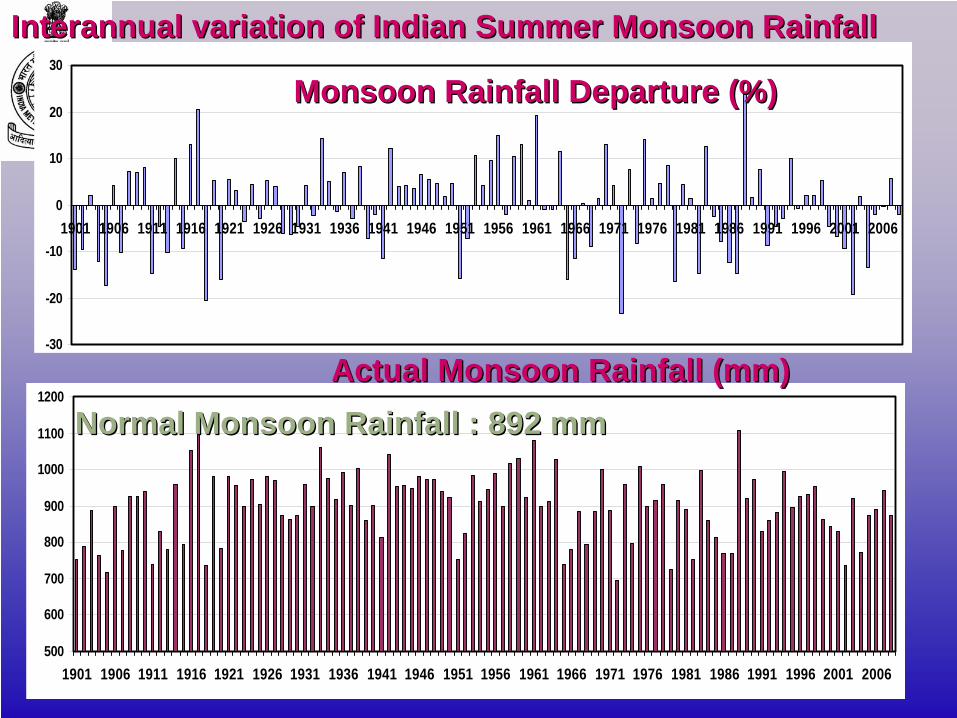
InterannualInterannual variation of Indian Summer Monsoon Rainfallvariation of Indian Summer Monsoon Rainfall
Monsoon Rainfall Departure (%)Monsoon Rainfall Departure (%)
Actual Monsoon Rainfall (mm)Actual Monsoon Rainfall (mm)Normal Monsoon Rainfall : 892 mmNormal Monsoon Rainfall : 892 mm
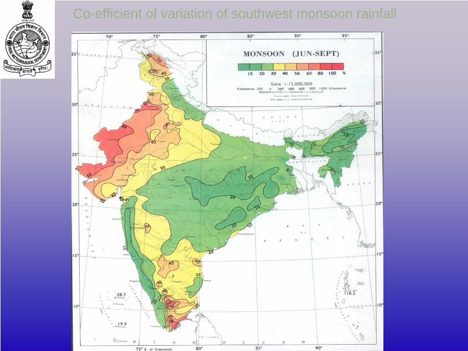
Co-efficient of variation of southwest monsoon rainfall
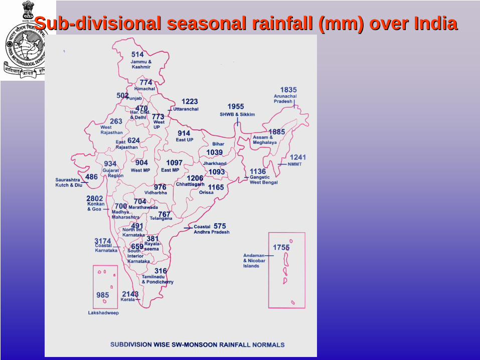
SubSub--divisional seasonal rainfall (mm) over Indiadivisional seasonal rainfall (mm) over India
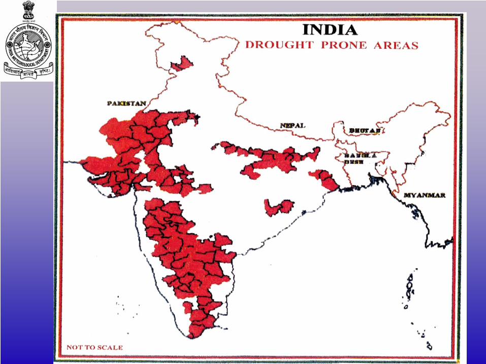
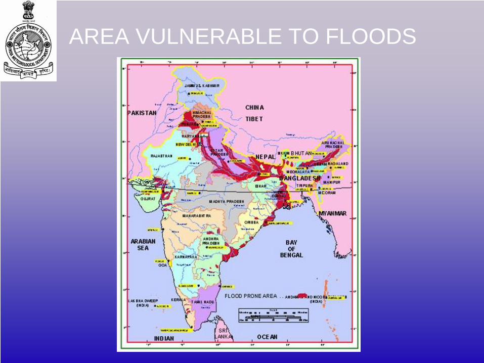
AREA VULNERABLE TO FLOODS
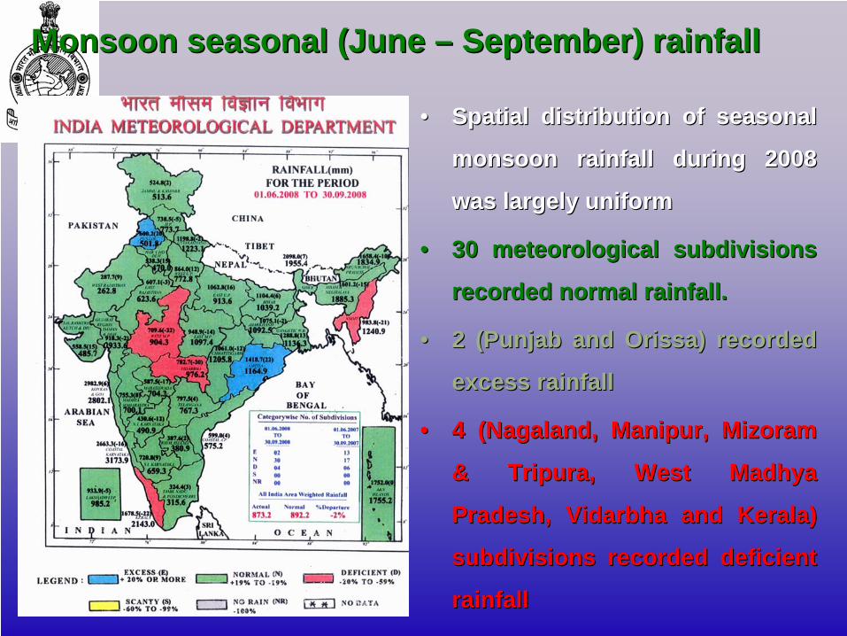
Monsoon seasonal (June Monsoon seasonal (June –– September) rainfallSeptember) rainfall
•• Spatial distribution of seasonal Spatial distribution of seasonal
monsoon rainfall during 2008 monsoon rainfall during 2008
was largely uniformwas largely uniform
•• 30 meteorological subdivisions 30 meteorological subdivisions
recorded normal rainfall. recorded normal rainfall.
•• 2 (Punjab and Orissa) recorded 2 (Punjab and Orissa) recorded
excess rainfallexcess rainfall
•• 4 (Nagaland, Manipur, Mizoram 4 (Nagaland, Manipur, Mizoram
& Tripura, West Madhya & Tripura, West Madhya
Pradesh, Pradesh, VidarbhaVidarbha and Kerala) and Kerala)
subdivisions recorded deficient subdivisions recorded deficient
rainfallrainfall
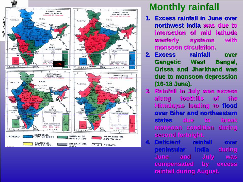
Monthly rainfall1.1. Excess rainfall in June over Excess rainfall in June over
northwest Indianorthwest India was due to was due to interaction of mid latitude interaction of mid latitude westerly systems with westerly systems with monsoon circulation.monsoon circulation.
2.2. Excess rainfall Excess rainfall over over GangeticGangetic West Bengal, West Bengal, Orissa and Jharkhand was Orissa and Jharkhand was due to monsoon depression due to monsoon depression (16(16--18 June). 18 June).
3.3. Rainfall in July was excess Rainfall in July was excess along foothills of the along foothills of the Himalayas leading to Himalayas leading to flood flood over Bihar and northeastern over Bihar and northeastern statesstates due to break due to break monsoon condition during monsoon condition during second fortnight. second fortnight.
4.4. Deficient rainfall over Deficient rainfall over peninsular Indiapeninsular India during during June and July was June and July was compensated by excess compensated by excess rainfall during August.rainfall during August.
-3%
93.3
510
3.6 12
2.1
75.8
1 85.8 10
2.8
33.9
234
.9 40.9
203.
0822
4.3
265.
8
14.2 21
.4 27.8
217.
2824
5.7
293.
60
50
100
150
200
250
300
Rice Wheat Coarsegrains
Totalcereals
Pulses Foodgrains
Production (m.tons) in 2006
Demand offood(m. tons) in2010
Demand offood(m. tons) in2020
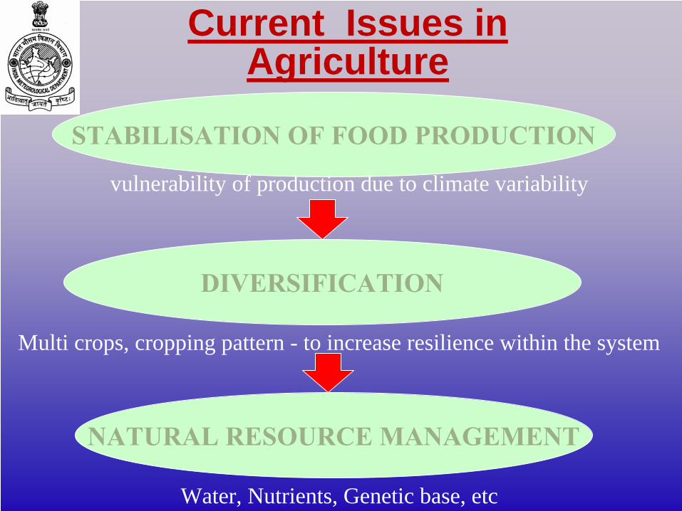
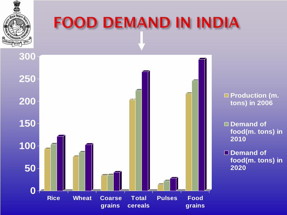
STABILISATION OF FOOD PRODUCTION
DIVERSIFICATION
NATURAL RESOURCE MANAGEMENT
Water, Nutrients, Genetic base, etc
Multi crops, cropping pattern - to increase resilience within the system
vulnerability of production due to climate variability
Current Issues in Agriculture
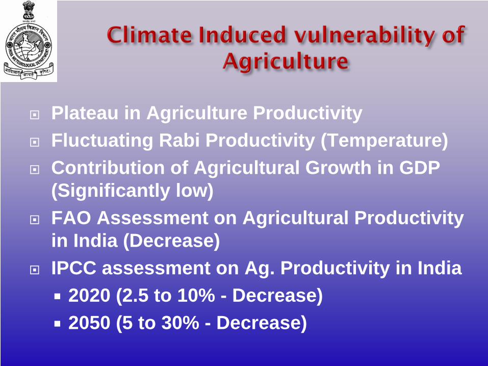
Plateau in Agriculture ProductivityFluctuating Rabi Productivity (Temperature)Contribution of Agricultural Growth in GDP (Significantly low)FAO Assessment on Agricultural Productivity in India (Decrease)IPCC assessment on Ag. Productivity in India
2020 (2.5 to 10% - Decrease)2050 (5 to 30% - Decrease)
To keep pace with the increasing population, the growth in agriculture should not only be maintained but should also be sustainable in the long run.
Additional land is not available for tilling. Indiscriminate increase in other inputs such as fertilizers, pesticides, water, etc has its own detrimental effects.
Major resource, not hitherto been tapped to its fullest extent is Weather and Climate.
Weather and Agri Production in India
In increasing agricultural production, meteorology has a vital role to play.
Farming community should be advised suitably so that the beneficial effects of favourable weather conditions are taken full advantage of and the adverse effects of unfavourable weather are minimized.
Agromet Advisory Service should be the focus of our new endeavour.
Weather and Agri Production in India
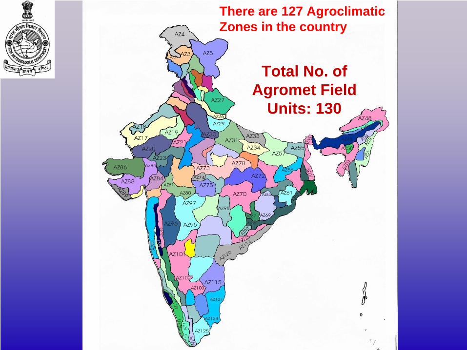
There are 127 AgroclimaticZones in the country
Total No. of Agromet Field
Units: 130
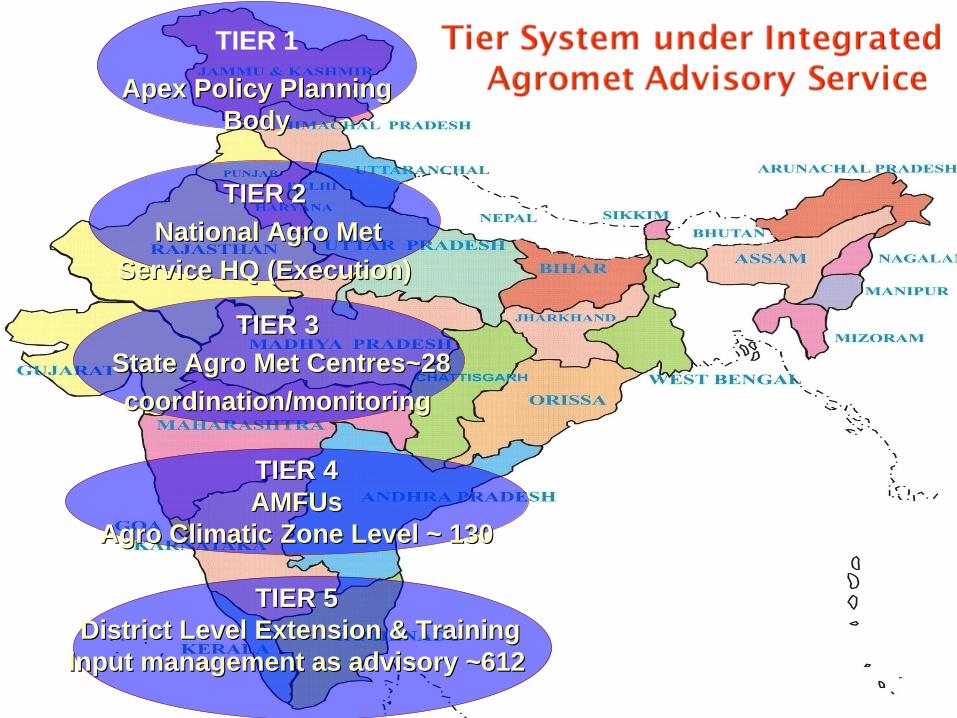
TIER 1
Apex Policy Planning Apex Policy Planning BodyBody
TIER 2TIER 2National Agro Met National Agro Met
Service HQ (Execution)Service HQ (Execution)
TIER 3TIER 3State Agro Met Centres~28State Agro Met Centres~28coordination/monitoringcoordination/monitoring
TIER 4TIER 4AMFUsAMFUs
Agro Climatic Zone Level ~ 130Agro Climatic Zone Level ~ 130
TIER 5TIER 5District Level Extension & TrainingDistrict Level Extension & Training
Input management as advisory ~612Input management as advisory ~612
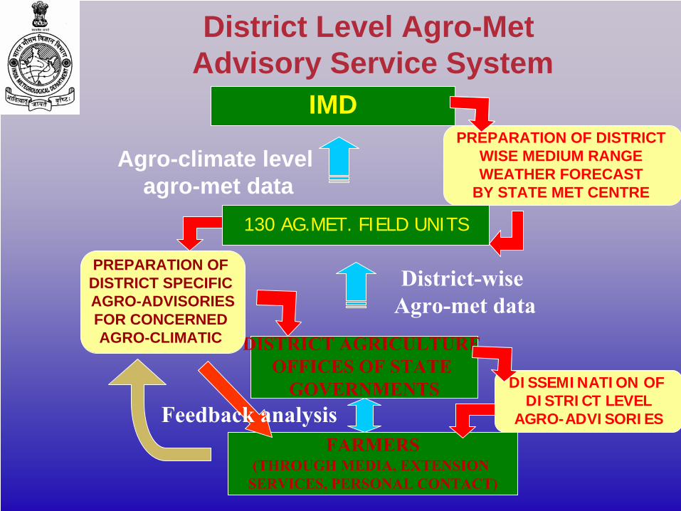
IMD
130 AG.MET. FIELD UNITS
DISTRICT AGRICULTURE OFFICES OF STATE
GOVERNMENTS
PREPARATION OF DISTRICT WISE MEDIUM RANGE WEATHER FORECAST
BY STATE MET CENTRE
PREPARATION OF DISTRICT SPECIFIC AGRO-ADVISORIESFOR CONCERNED AGRO-CLIMATIC
DISSEMINATION OF DISTRICT LEVEL
AGRO-ADVISORIES
FARMERS(THROUGH MEDIA, EXTENSION
SERVICES, PERSONAL CONTACT)
District-wise Agro-met data
Agro-climate level agro-met data
Feedback analysis
District Level Agro-Met Advisory Service System
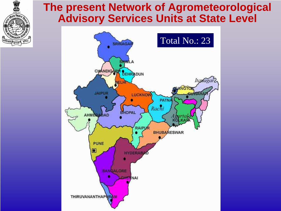
Total No.: 23
The present Network of Agrometeorological Advisory Services Units at State Level
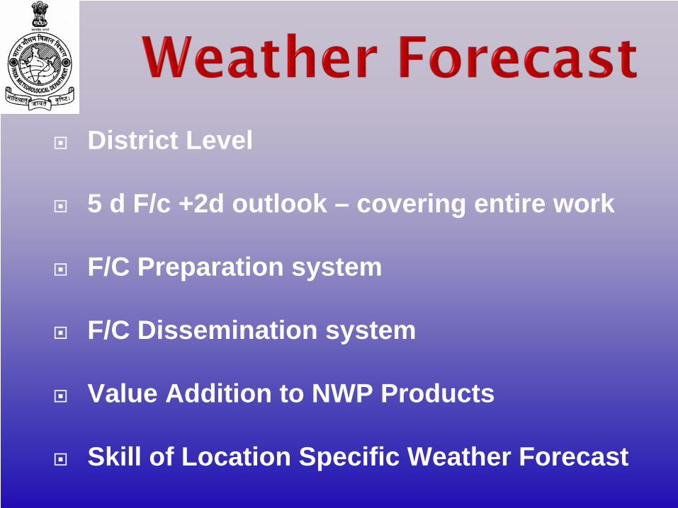
District Level
5 d F/c +2d outlook – covering entire work
F/C Preparation system
F/C Dissemination system
Value Addition to NWP Products
Skill of Location Specific Weather Forecast
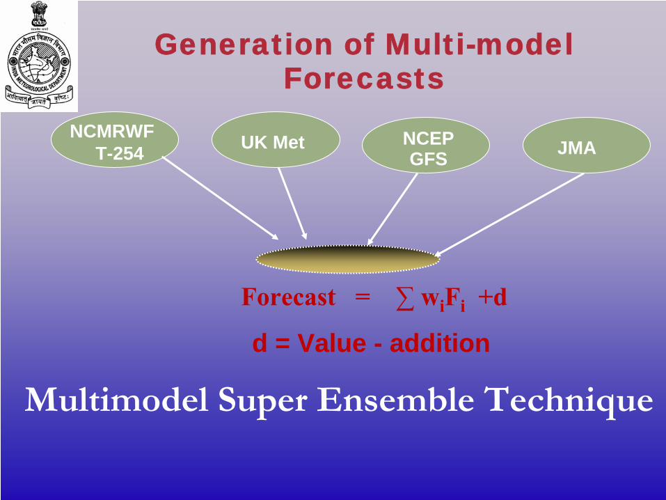
NCMRWFT-254
Multimodel
Super Ensemble Technique
UK Met NCEP GFS JMA
Generation of Multi-model Forecasts
Forecast = ∑
wi
Fi
+d
d = Value - addition
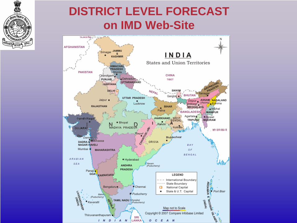
DISTRICT LEVEL FORECAST on IMD Web-Site
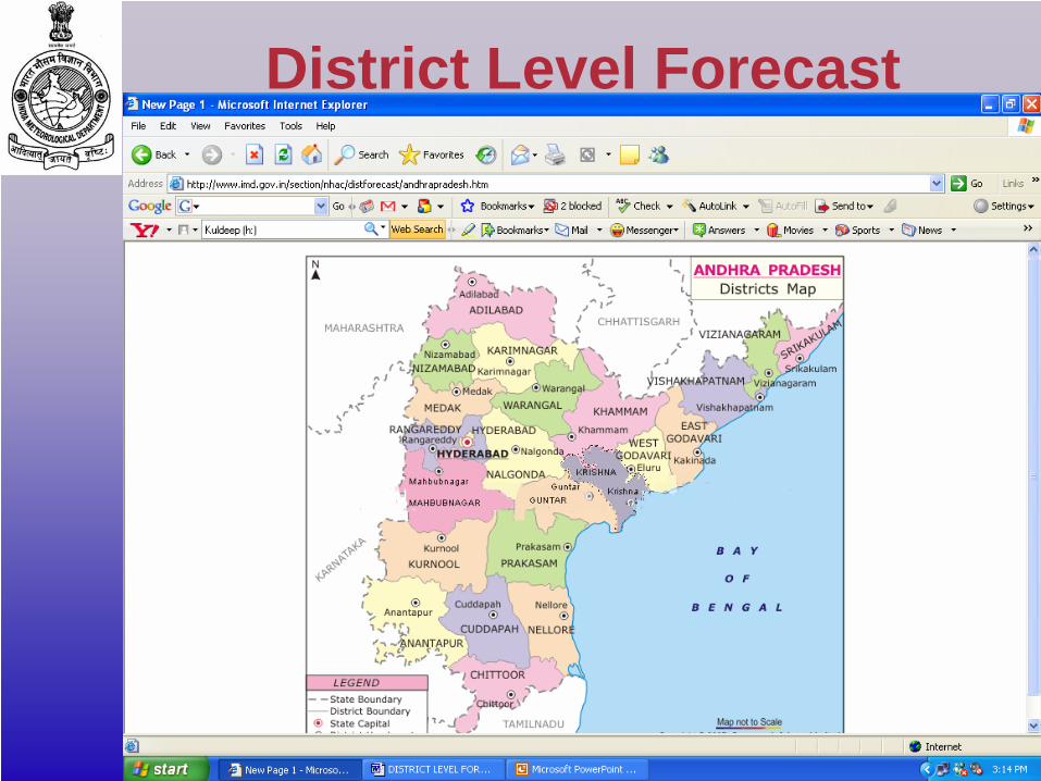
District Level Forecast

5 day Forecast
AGROMET ADVISORIES
Primarily targeted for national level planners e.g. Crop Weather Watch Group (CWWG), DoAC.
It is also communicated to all the related Ministries (State & Central), Organizations, NGOs for their use.
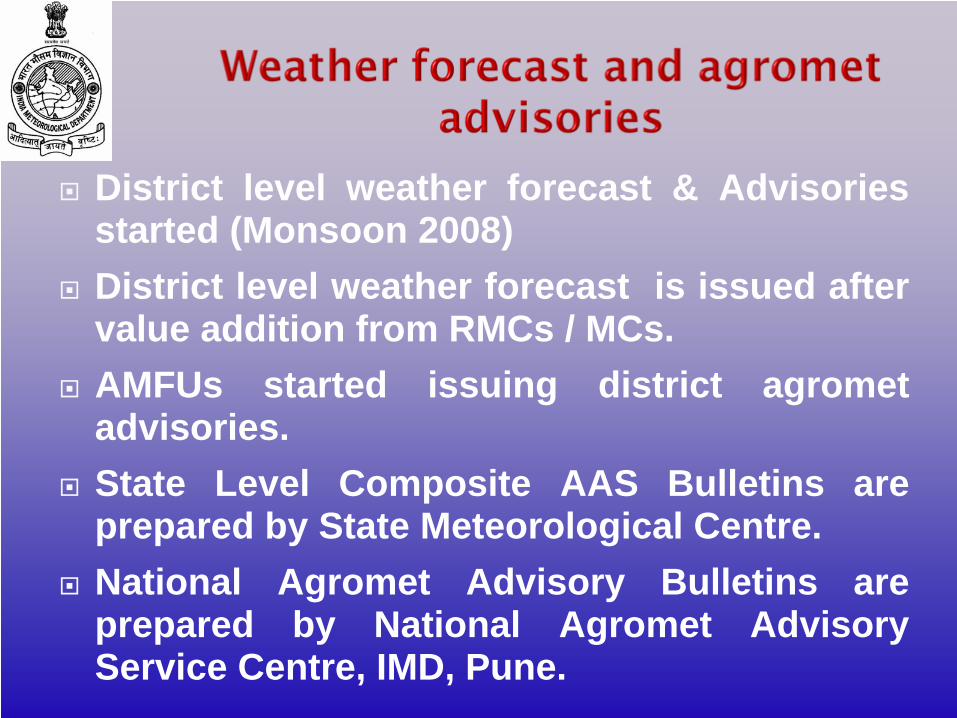
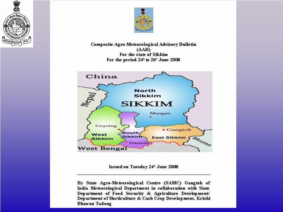
District level weather forecast & Advisories started (Monsoon 2008)District level weather forecast is issued after value addition from RMCs / MCs. AMFUs started issuing district agrometadvisories.State Level Composite AAS Bulletins are prepared by State Meteorological Centre. National Agromet Advisory Bulletins are prepared by National Agromet Advisory Service Centre, IMD, Pune.
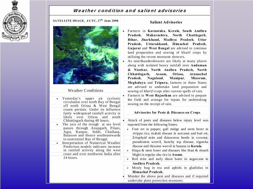
Weather condition and salient advisories
SATELLITE IMAGE, 4 UTC, 27th June 2008
Weather Conditions
• Yesterday’s upper a ir cyclonic circulation over north Bay of Bengal off north Orissa & West Bengal coasts persists. Under its influence fairly widespread rainfa ll ac tivity is likely over Orissa and south Chhattisgarh during 48 hours.
• The axis of the trough at sea level passes through Anupgarh, Pilani, Agra, Kanpur, Siddi, Chaibasa, Balasore and thence southeastwards to eastcentra l Bay of Bengal.
• Interpre ta tion of Numerical Weather Prediction models indicates inc rease in rainfall activity along the west coast and over northwest India after 24 hours.
Salient Advisories
• Farmers in Karnataka, Kerala, South Andhra
Pradesh , Maharashtra, North Chattisgarh , Bihar, Jharkhand, Madhya Pradesh, Uttar Pradesh, Uttarakhand, Himachal Pradesh , Gujarat and West B engal are advised to continue land preparation and sowing of kharif crops by utilising the recent monsoon showers.
• As rain/thundershowers are likely at many places along with isolated heavy rainfall over Andaman & Nicobar, North Andhra Pradesh, North Chhattisgarh, Assam, Orissa, Arunachal Pradesh , Nagaland , Manipur, Mizoram , Meghalaya and Tripura, farmers in these States are advised to undertake land preparation and sowing of kharif crops after current spells of rain.
• Farmers in West Rajasthan are advised to prepare the field and arrange for inputs for undertaking sowing on the receipt of rain.
Advisories for Pests & Diseases on Crops
• Attack of pests and diseases below injury level was
reported from the following States: Foot rot in pepper, gall midge and stem borer in
virippu rice, mahali disease in arecanut and bud rot, Eriophyid mite and rhinoceros beetle in coconut, pseudostem weevil, bunchy top disease, sigatoka disease and rhizome weevil in banana in Kerala.
Hispa & stem borer and diseases like blast & sheath blight in regular ahu rice in Assam.
Red mite and early shoot borer in sugarcane in Andhra Pradesh.
Mealy bug in tea and aphids in gladiolus in Himachal Pradesh.
• Monitor the above pest and diseases and if required undertake plant protection measures.
Targeted for State level planners e.g. state CWWG meeting.
This is also meant for other users like Fertiliser industry, Pesticide industry, Irrigation Department, Seed Corporation, Transport and other organisations which provide inputs in agriculture.
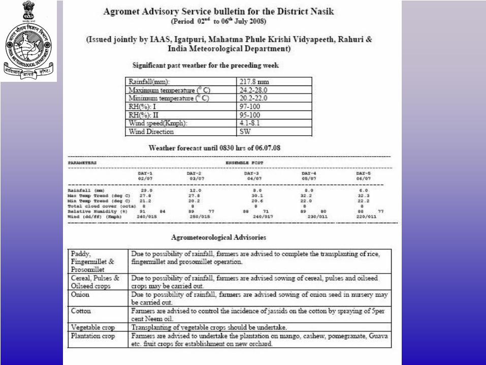
This is targeted for the farmers at large. Advisories are weather sensitive.Includes horticultural crops, livestock, agro-forestry etc.
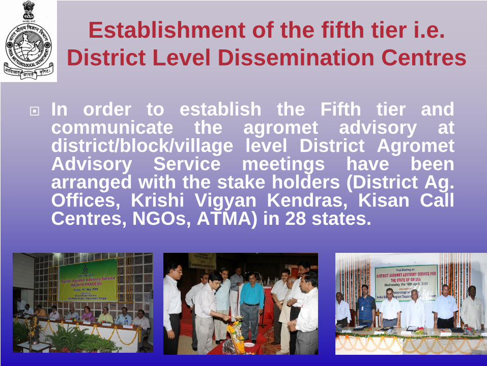
In order to establish the Fifth tier and communicate the agromet advisory at district/block/village level District AgrometAdvisory Service meetings have been arranged with the stake holders (District Ag. Offices, Krishi Vigyan Kendras, Kisan Call Centres, NGOs, ATMA) in 28 states.
Establishment of the fifth tier i.e. District Level Dissemination Centres
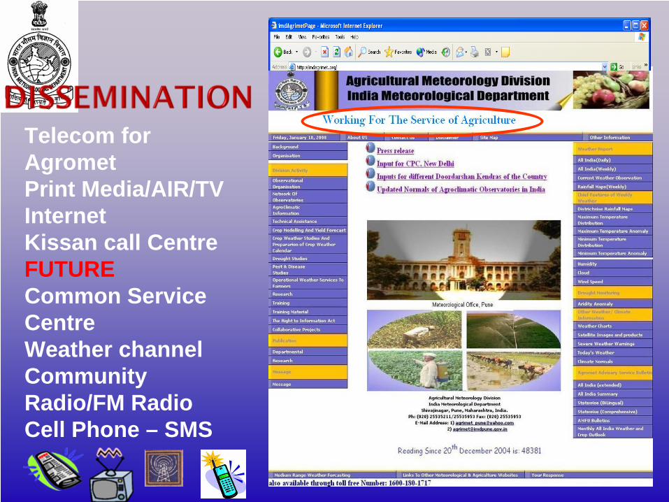
Telecom for AgrometPrint Media/AIR/TVInternet Kissan call CentreFUTURECommon Service CentreWeather channelCommunity Radio/FM RadioCell Phone – SMS
Pesticides application – prediction of pests and diseases incidence/chance of epidemic occurrence, when to apply, prepone/postponing application based on sensitive weather elements.Fertilizer application – when to apply i.e. pre-poning/ postponing application based on sensitive weather elements.Application of Irrigation – when and how much to apply i.e. pre-poning /post-poning application based on past weather as well as weather forecast.Date of sowing Date of harvest Incidence of cold / heat waves Incidence of frost and fogIncidence of agricultural droughtContingent crop planning Selection of cultivars
Agromet Products Some Examples
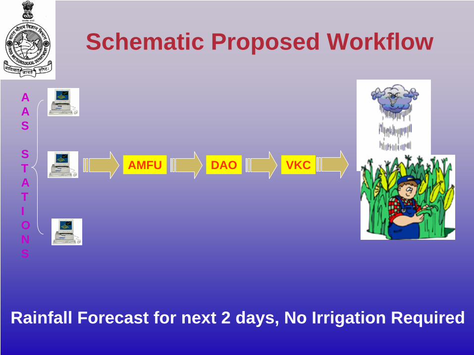
Rainfall Forecast for next 2 days, No Irrigation Required
AMFU DAO VKC
A A S
S T A T I O N S
Schematic Proposed Workflow
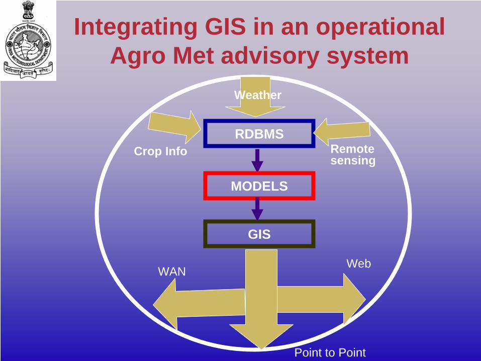
RDBMS
MODELS
GIS
Remote sensing
Weather
Crop Info
WebWAN
Point to Point
Integrating GIS in an operational Agro Met advisory system
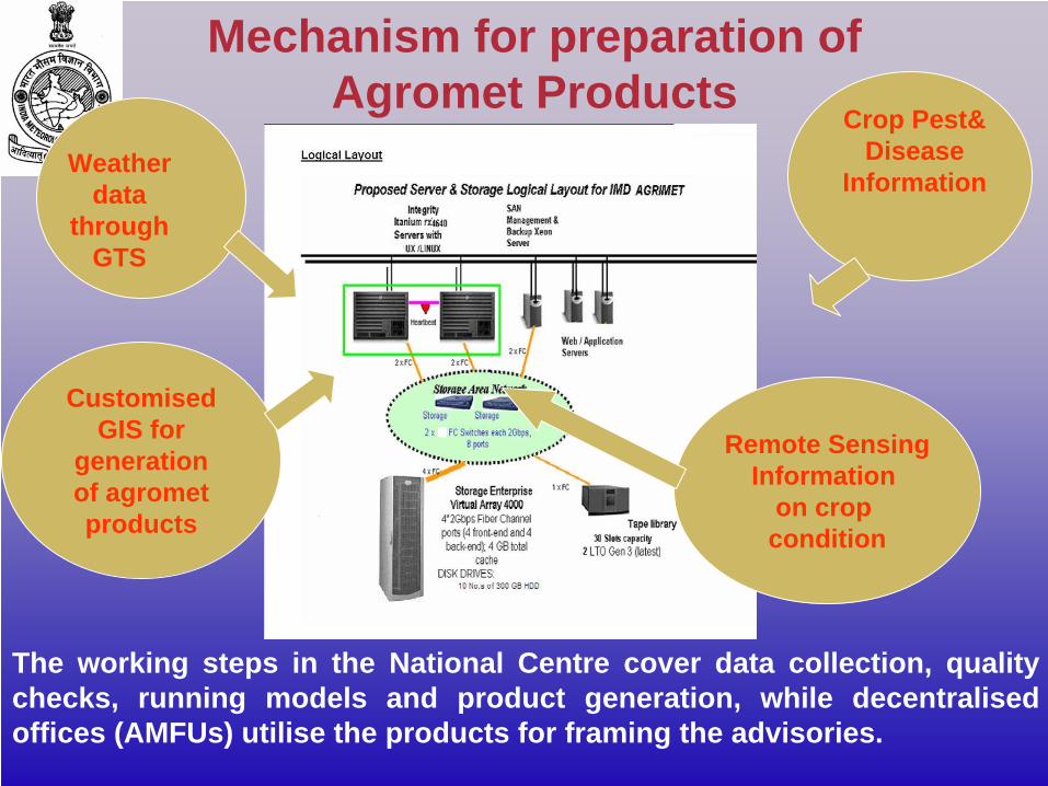
Weather data
through GTS
Crop Pest& Disease
Information
CustomisedGIS for
generationof agrometproducts
Remote SensingInformation
on crop condition
The working steps in the National Centre cover data collection, quality checks, running models and product generation, while decentralised offices (AMFUs) utilise the products for framing the advisories.
Mechanism for preparation of Agromet Products
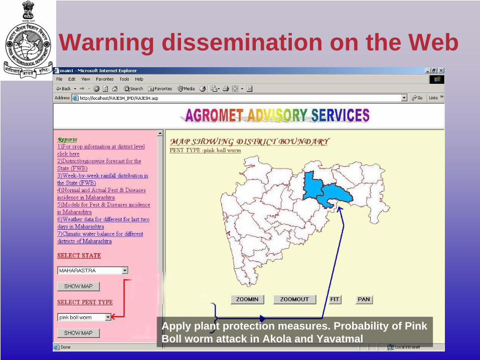
Apply plant protection measures. Probability of Pink Boll worm attack in Akola and Yavatmal
Warning dissemination on the Web
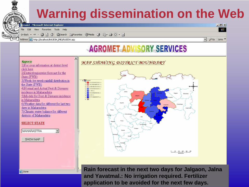
Rain forecast in the next two days for Jalgaon, Jalna and Yavatmal.: No irrigation required. Fertilizer application to be avoided for the next few days.
Ratnagiri
Kolhapur
Dhule
Raigarh
Satara
Pune
Sangli
Solapur
Osmanabad
Mumbai
Thane
Ahmednagar
Sindhudurg
Nashik
Bid
JalnaAurangabad
Jalgaon
Buldana
Latur
Parbhani
Nanded
Akola
Yavatmal
Amravati
Gadchiroli
Wardha
Nagpur
Chandrapur
Bhandara
0 40 80 120 160 200
Kilometers
Warning dissemination on the Web
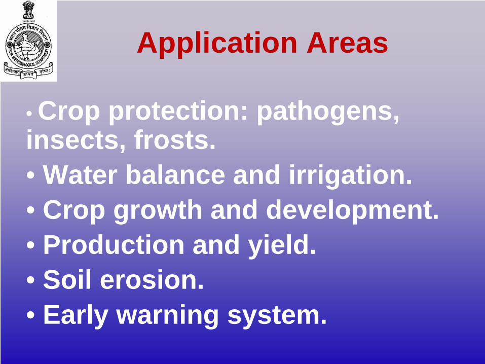
Application Areas
• Crop protection: pathogens, insects, frosts.• Water balance and irrigation.• Crop growth and development.• Production and yield.• Soil erosion.• Early warning system.

Proposed Virtual Private Network among the different Tiers

DISTRICT LEVEL FORECAST on IMD Web-Site
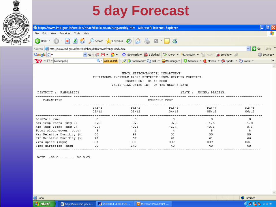
5 day Forecast
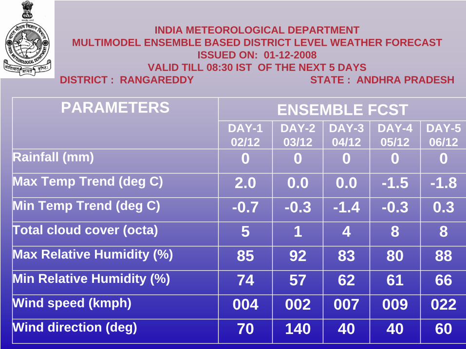
INDIA METEOROLOGICAL DEPARTMENT MULTIMODEL ENSEMBLE BASED DISTRICT LEVEL WEATHER FORECAST
ISSUED ON: 01-12-2008 VALID TILL 08:30 IST OF THE NEXT 5 DAYS
DISTRICT : RANGAREDDY STATE : ANDHRA PRADESH
PARAMETERS ENSEMBLE FCSTDAY-1 02/12
DAY-2 03/12
DAY-3 04/12
DAY-4 05/12
DAY-506/12
Rainfall (mm) 0 0 0 0 0Max Temp Trend (deg C) 2.0 0.0 0.0 -1.5 -1.8Min Temp Trend (deg C) -0.7 -0.3 -1.4 -0.3 0.3Total cloud cover (octa) 5 1 4 8 8Max Relative Humidity (%) 85 92 83 80 88Min Relative Humidity (%) 74 57 62 61 66Wind speed (kmph) 004 002 007 009 022Wind direction (deg) 70 140 40 40 60
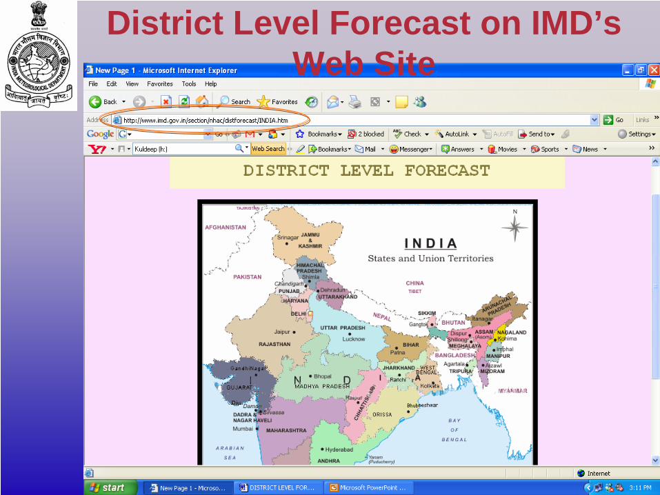
District Level Forecast on IMD’s Web Site
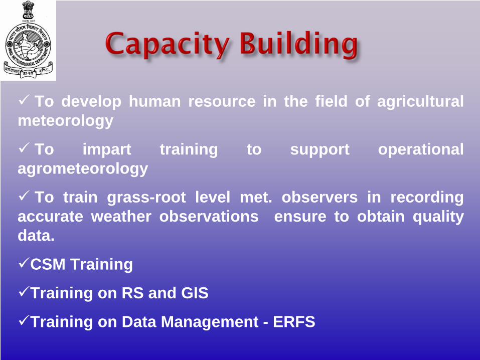
To develop human resource in the field of agricultural meteorology
To impart training to support operational agrometeorology
To train grass-root level met. observers in recording accurate weather observations ensure to obtain quality data.
CSM Training
Training on RS and GIS
Training on Data Management - ERFS
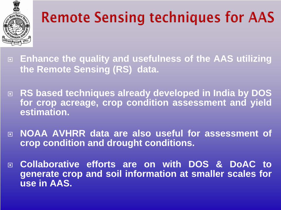
Enhance the quality and usefulness of the AAS utilizing the Remote Sensing (RS) data.
RS based techniques already developed in India by DOS for crop acreage, crop condition assessment and yield estimation.
NOAA AVHRR data are also useful for assessment of crop condition and drought conditions.
Collaborative efforts are on with DOS & DoAC to generate crop and soil information at smaller scales for use in AAS.
Calibrate, validate and operationalise crop simulation models appropriate to each crop in different districts. Considering the number of Districts and the number of crops grown in each of them, a few hundred crop growth models would have to be developed, tested and operationalised. This is a highly inter-disciplinary task and experts in modeling, weather prediction, agronomy, plant pathology, entomology and other agricultural disciplines would have be drawn into the mission to make it successful. Final aim is to develop Expert Systems for farm level decision making.
FORECASTSoil Temperature, Soil Moisture, Evaporation, Evapotranspiration, Fog, Frost, Degree Days, Aridity etc.
ADVISORYCrop & location Specific AdvisoriesHorticultural CropsLivestockFisheriesWasteland and Forest FiresPost Harvest and Storage
New Products Needed
India Meteorological Department has envisaged launching a dedicated Weather Channel in India under a Public-Private Partnership mode. The Weather Channel would provide weather services through various communication modes like TV, Radio, SMS and internet portal.IMD would provide all types of weather data satellite, radar, seismological, astronomical, agrometeorologial, radiation, air pollution and hydrological data etc.All types of weather forecast, other periodical reports etc. would also be provided. Numerical Weather Prediction model products, customized products etc. on real time as well as the historical records would also be provided.
Widen the outreach of AAS through Exhibitions
Documentary films
Suitable advertisements
Prepare pamphlets
Participate in Ag. Extension activities like KrishiMela etc.—Almost all units
Organize meets with farmers
Provide suitable grant-in-aid for these activities
Popularization of service

Training Needs of End-users
• Farm Level Demonstration• Training Work-shop• Kisan Goshthi (Experience Sharing)• Teaching Weather Sensitivity of Crop/
Animal Production• Time And Method of Pesticides For Plant
Protection• Teaching Methods of Crop Protection
From Adverse Weather• Farmers Training and Awareness
Programmes.
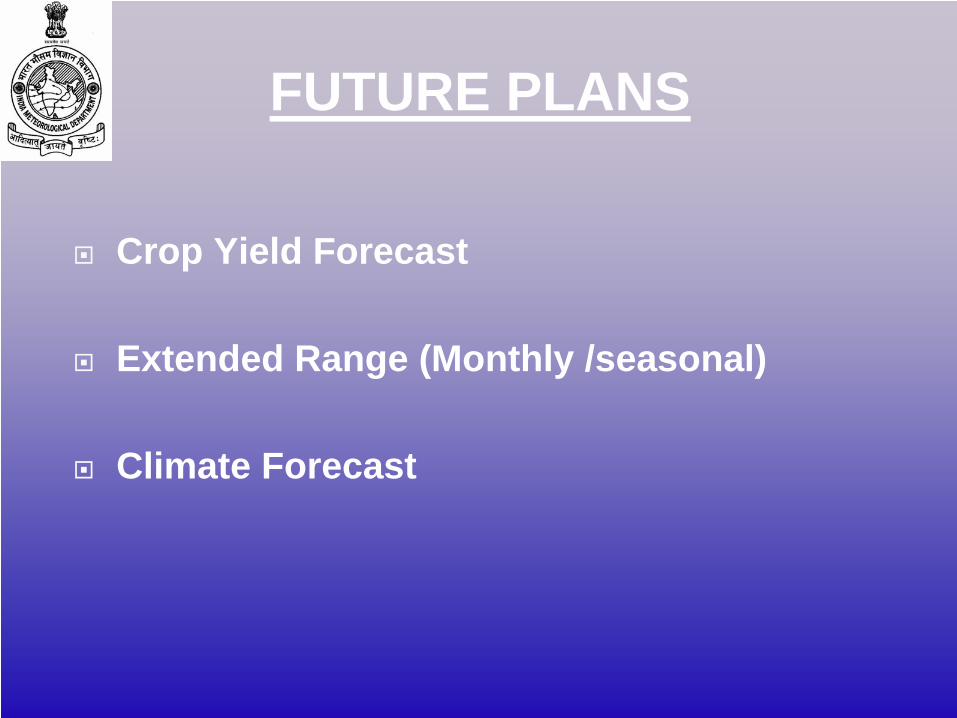
FUTURE PLANS
Crop Yield Forecast
Extended Range (Monthly /seasonal)
Climate Forecast
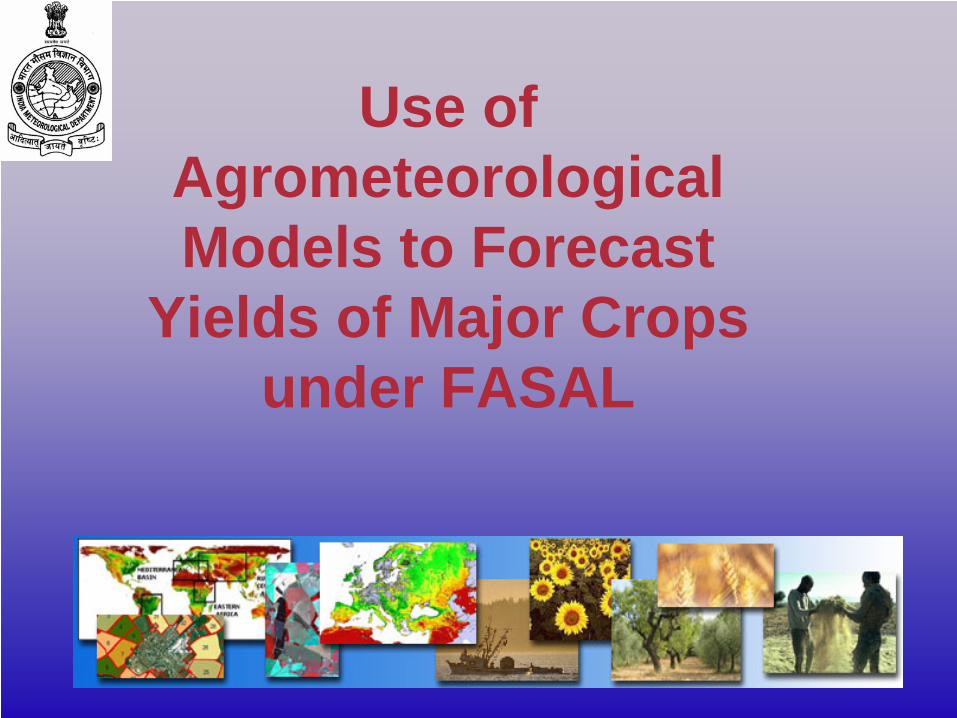
Use of Agrometeorological Models to Forecast
Yields of Major Crops under FASAL
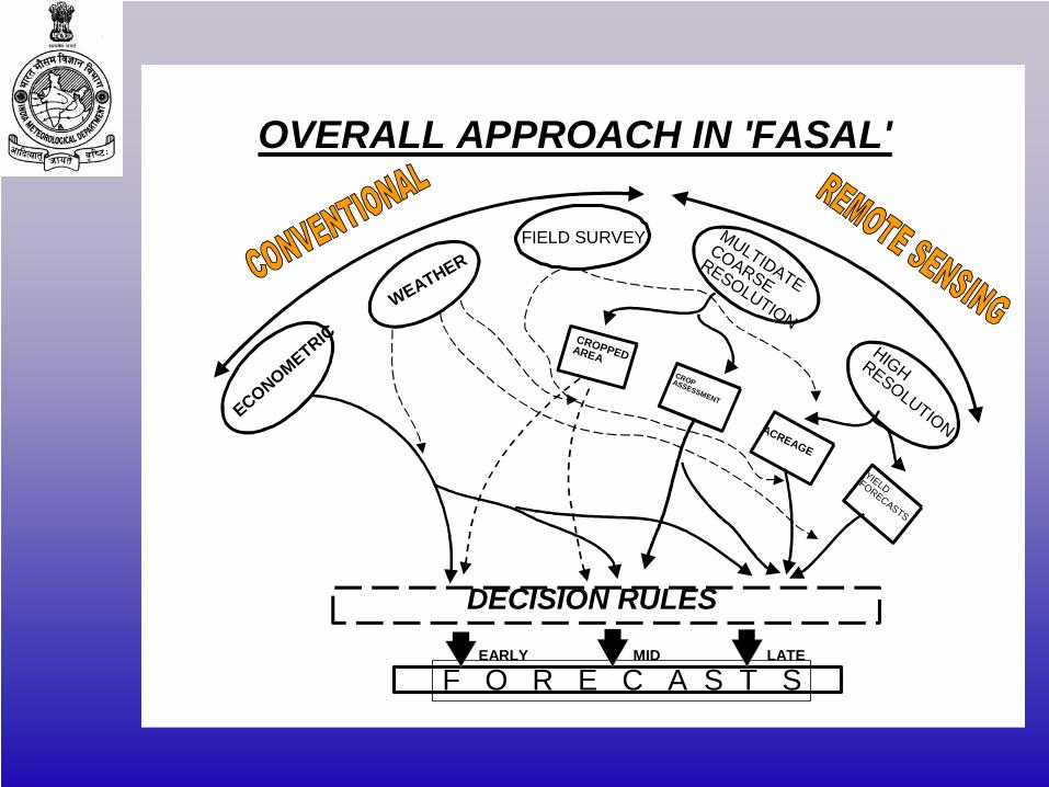
F O R E C A S T S
DECISION RULES
ECONOMETRIC
WEATHERFIELD SURVEY MULTIDATE
COARSERESOLUTION
HIGHRESOLUTION
CROPPEDAREACROPASSESSMENT
ACREAGE
YIELDFORECASTS
EARLY MID LATE
OVERALL APPROACH IN 'FASAL'
Issue of national / state / district level multiple crop yield forecast from the beginning to the end of crop seasonYield forecast by integration of Remote Sensing, Meteorological and crop data. Yield models to be prepared jointly by IMD, DOS and DAC.Yield forecast will be updated with Meteorological information and Remote sensing data from SAC, in consultation with DAC under FASAL Programme
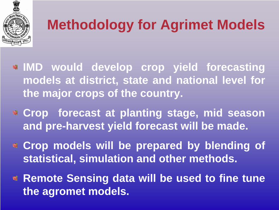
IMD would develop crop yield forecasting models at district, state and national level for the major crops of the country.
Crop forecast at planting stage, mid season and pre-harvest yield forecast will be made.
Crop models will be prepared by blending of statistical, simulation and other methods.
Remote Sensing data will be used to fine tune the agromet models.
Methodology for Agrimet Models
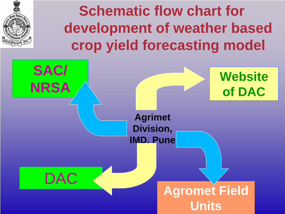
Schematic flow chart for development of weather based crop yield forecasting model
Agrimet Division,
IMD, Pune
SAC/ NRSA
DAC
Website of DAC
Agromet Field Units
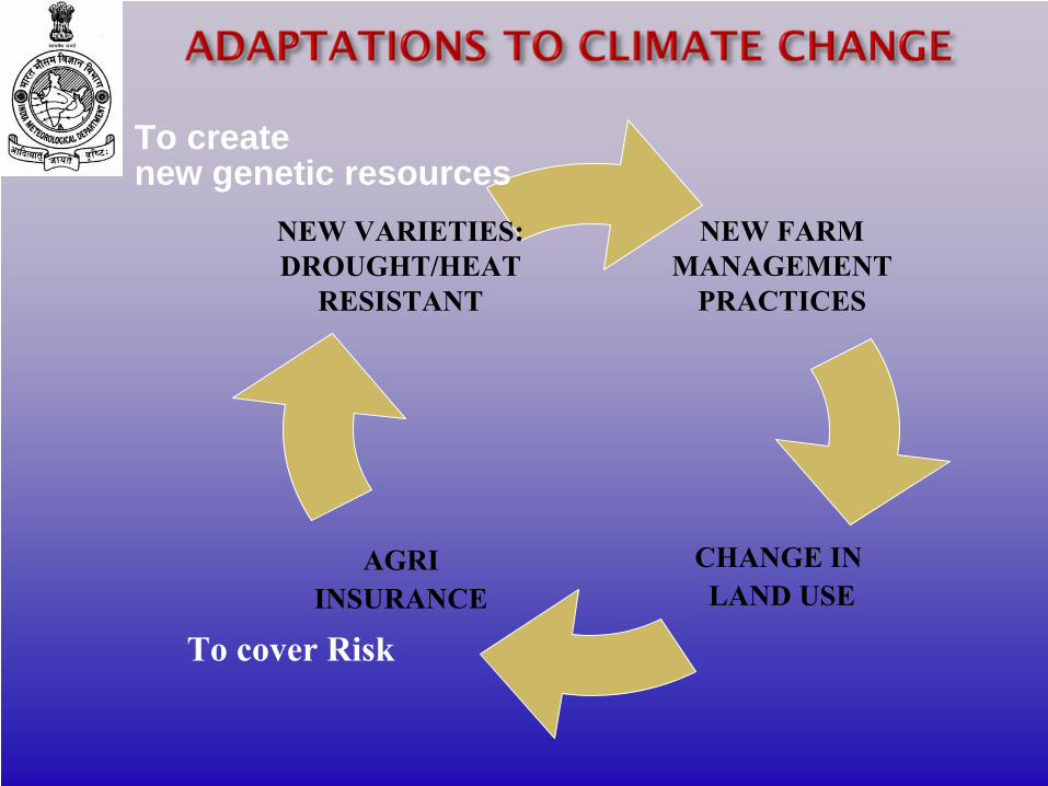
NEW FARMMANAGEMENT
PRACTICES
CHANGE IN LAND USE
AGRIINSURANCE
NEW VARIETIES:DROUGHT/HEAT
RESISTANT
To cover Risk
To createnew genetic resources

…Thank you