Embed Size (px)
Citation preview
Development of underground mine monitoring and communicationsystem integrated ZigBee and GIS
Moridi Mohammad Ali a,⇑, Kawamura Youhei a, Sharifzadeh Mostafa a, Chanda Emmanuel Knox b,Wagner Markus c, Jang Hyongdoo a, Okawa Hirokazu d
a Department of Mining Engineering and Metallurgy Engineering, Western Australian School of Mines, Curtin University, Kalgoorlie 6433, Australiab School of Civil, Environment and Mining Engineering, The University of Adelaide, Adelaide 5005, Australiac School of Computer Science, The University of Adelaide, Adelaide 5005, Australiad Graduate School of Engineering and Resource Science, Department of Materials-Process Engineering and Applied Chemistry Environment, Akita University, Akita 010-8502, Japan
a r t i c l e i n f o
Article history:Received 24 December 2014Received in revised form 18 January 2015Accepted 18 April 2015Available online xxxx
Keywords:Wireless sensor networksZigBeeUnderground mine safetyVentilationMine monitoring
a b s t r a c t
An automated underground mine monitoring and communication system based on the integration ofnew technologies is introduced to promote safety and health, operational management andcost-effectiveness. The proposed system integration considering Wireless Sensor Network (WSN) assistedGeographic Information System (GIS) enables to monitor and control underground mining applicationsfrom surface office. Based on the capabilities of WSNs, ZigBee network is adapted for near real-timemonitoring, ventilation system control and emergency communication in underground mine. ZigBeenodes were developed to sense environmental attributes such as temperature, humidity and gasesconcentration; switching ON and OFF ventilation fans; and texting emergency messages. A trigger actionplan for monitored attributes above normal and threshold value limits is programmed in the surface GISmanagement server. It is designed to turn the auxiliary fans on remotely or automatically in orangecondition and sending evacuation messages for underground miners in unsafe (red) condition.Multi-users operation and 3D visualisations are other successful achievements of the proposed systemfor the underground monitoring and communication.
! 2015 Published by Elsevier B.V. on behalf of China University of Mining & Technology.
1. Introduction
Underground mine safety and health remain challenging issuesin the mining industry. Death toll statistics in China’s coal mineshave gradually reduced from 5798 to 2631 between 2000 and2009 but fatality still occurs [1]. The number of occupational min-ing fatalities in the United States’ underground metal mines hasfluctuated from 40 to 46 during the years 2001–2010. Most impor-tantly, 33.8% of the deaths have resulted from ignitions and explo-sions of gas or dust in underground mining [2]. In April 2014, twomen were killed when a wall collapsed in an underground coalmine in New South Wales, Australia. Human errors were concludedfrom reports as the most significant reasons for mining fatalities.Thus, safety is always a significant concern in mining operation.Some studies have recently focused on improving the health forunderground miners. Laney and Attfield have drawn attention tothe fact that the prevalence of coal workers’ pneumoconiosis or
progressive massive fibrosis increased from 1990 to 2000 amongUnited States underground miners [3]. Therefore, specific consider-ation of both safety and health issues deserves priority in mineoperation management and engineering designs to provide andmaintain a safe and healthy workplace. In response to these chal-lenges, mine automation by new technologies such as WirelessSensor Network (WSN) assisted with geographic informationsystem (GIS) has been widely utilised in underground mines toenhance safety and health, productivity and reduce operationalcosts [4,5].
The underground WSNs consist of a few to several hundrednodes between a surface gateway and specified sensor nodes atunderground levels [6]. ZigBee based on IEEE 802.15.4 protocol isa new wireless sensor technology which has more benefits thanother WSNs for underground monitoring and communication sys-tems [7]. Even though ZigBee technology provides only a low datarate, its benefits are low power consumption, very cost-effectivenodes, network installation and maintenance [8]. It is also capableof providing networking applications for data transmissionbetween nodes (node to node relays) with high performance based
http://dx.doi.org/10.1016/j.ijmst.2015.07.0172095-2686/! 2015 Published by Elsevier B.V. on behalf of China University of Mining & Technology.
⇑ Corresponding author. Tel.: +61 8 9088 6160.E-mail address: [email protected] (M.A. Moridi).
International Journal of Mining Science and Technology xxx (2015) xxx–xxx
Contents lists available at ScienceDirect
International Journal of Mining Science and Technology
journal homepage: www.elsevier .com/locate / i jmst
Please cite this article in press as: Moridi MA et al. Development of underground mine monitoring and communication system integrated ZigBee and GIS.Int J Min Sci Technol (2015), http://dx.doi.org/10.1016/j.ijmst.2015.07.017

on many wireless hops. It does not require any access point or cen-tral node to transmit data between clusters. Significance of ZigBeein underground mines compared to other WSNs was evaluated inthe recent publication of authors [9].
GIS is new technology used for spatial data analysis in order tocapture, store, analyse, manage, and present data that is linked tolocations [10]. GIS allows users to view, understand, question,interpret, and visualize data in many ways that reveal relation-ships, patterns, and trends in the form of maps, globes, reports,and charts. Web-GIS is an inevitable trend which helps solve theproblems of spatial information integration and sharing in techni-cal aspect of web media [11,12]. Recently, researchers have techni-cally focused on the GIS supports for the management ofemergency and unsafe conditions [13–16].
In this study underground safety and health concerns aresignificantly mitigated based on the system integration whichincorporates ventilation management and emergency messagetexting. The system integration based on the development ofZigBee nodes is introduced to sense the underground mineenvironment, to regulate ventilation system and to communicatebetween surface offices and miners. Therefore, reduced power con-sumption, near real-time monitoring of the environment and bilat-eral communicating between surface and underground personnelare achieved. Experimental tests were carried out to verify networkreliability and security of the packet delivery in undergroundmines. The architecture of underground monitoring and communi-cation for the system integration is illustrated in Fig. 1. TemporalZigBee data including messages and environmental attribute read-ings such as temperature, humidity and gases concentration aretransferred to GIS management server in the surface control centre.The transmitted data are received and stored by ZigBee programthen provided for manipulation in the control centre. Risk situa-tions are immediately identified and responded through a logicalprocess of data analysis in the GIS management server beforereaching dangerous (unsafe) levels and accidents occurring. Theventilation system management is also used for the workplacehealth and safety compliance and the optimisation of mine sitepower usage.
The remainder of this paper is organised as follows. The funda-mental knowledge of ZigBee technology and GIS are first described.Then, the implementation and structure of system integration aredemonstrated. Finally, the strategic process of combining ZigBeedata and map information through the GIS management server ismodelled for monitoring, communication and controlling theenvironmental attributes in an underground mine.
2. Background of ZigBee and GIS system integration
2.1. ZigBee network
ZigBee has recently been used in the field of mine safety for arange of applications mostly in underground coal mines as an auto-matic meter reading system, security system and remote controlalongside supporting other WSNs [17,18]. The reliability and secu-rity of the ZigBee network performance have nevertheless beenextensively considered. The ZigBee network applications in under-ground mines are limited considering the narrow bandwidth of upto 250 kbps (kilobits per second) at a frequency of 2.4 GHz [19]. Tosupport the performance of these applications, ZigBee networksprofit from IEEE 802.15.4 protocol [20]. IEEE 802.15.4 characterisesthe physical and medium access control layers of wireless personalarea networks. The physical layer is the hardware for the networkcommunication and enables operation in different frequencyranges. The medium access control layer is responsible in provid-ing reliable data transmission and communications between anode and its immediate neighbours. It also avoids data collisionsand improves network efficiency [21].
The reliability of ZigBee network under outdoor condition wasverified by our team research, but the narrow space ofunderground environments has significantly intensified the signalstrength to transmit data between two fixed nodes for a specifieddistance [15,22]. A recent study by authors has confirmed a similarconclusion and showed a stable communication of packet deliver-ies between fixed ZigBee nodes for the underground monitoringand communication system in different openings [9]. Conse-quently, ZigBee applications considering developed ZigBee nodesby our group research for underground monitoring and communi-cation in the field of safety and health are investigated in real cases.Based on the experiments, to utilise underground ZigBee applica-tions of sensing the environment and texting messages, schedulingspecific times for data transmission through the network arerequired. In other words, measuring and sending data by sensornodes are set in different time intervals to avoid any network con-gestion and to improve network performance.
2.2. Geographic information system
GIS is based on computer programs used for storage, modelling,retrieval, mapping and analysis of geographic data. In this system,spatial features of a specified environment are stored and manipu-lated in a coordinate system, which refers to a specific place. GIS
GIS output communication
To underground ZigBe nodes
To surface control centre
Information communication
Fig. 1. Architecture of monitoring and communication system in underground mines.
2 M.A. Moridi et al. / International Journal of Mining Science and Technology xxx (2015) xxx–xxx
Please cite this article in press as: Moridi MA et al. Development of underground mine monitoring and communication system integrated ZigBee and GIS.Int J Min Sci Technol (2015), http://dx.doi.org/10.1016/j.ijmst.2015.07.017
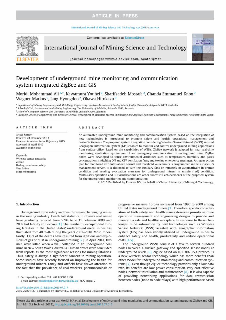
merges multi-layers of required geographic and spatial data for theuser evaluation, and helps determine the locations and times ofpossible incidents in advance. Fig. 2 illustrates a cycle of GIS to pro-cess data and layers for the purpose of risk assessment in under-ground mine sites. GIS server is capable of managing andprocessing data for a substantial number of attributes coming fromdifferent sources. It also is able to distribute and share databetween users based on internet or intranet, and data could besaved, manipulated or informed by other users. Therefore, GIScan decrease the time and cost of sharing geographic data and itsattributes.
2.3. System integration
In the challenging environment and changing topology of amine, reliable and simplified communication is a high-stake issuewith the objectives of safe and efficient mining operations.Automation of remote and automatic systems has improved work-place safety and health for miners, yielded cost-effectiveness, man-agement improvement of technical problems, energy savings,real-time response to incidents. In response to these challenges,integration of technologies has a significant role in undergroundmining automation. According to WSNs’ specific features of highreliability and multi-hop networking, ZigBee can create anintegrated wireless network between nodes in the undergroundmine tunnels and the surface gateway. In this study, ZigBee’scapability of monitoring underground environmental attributes iscombined with geographic information to provide potentialapplications in communication, operational and environmentalmonitoring systems of underground mining.
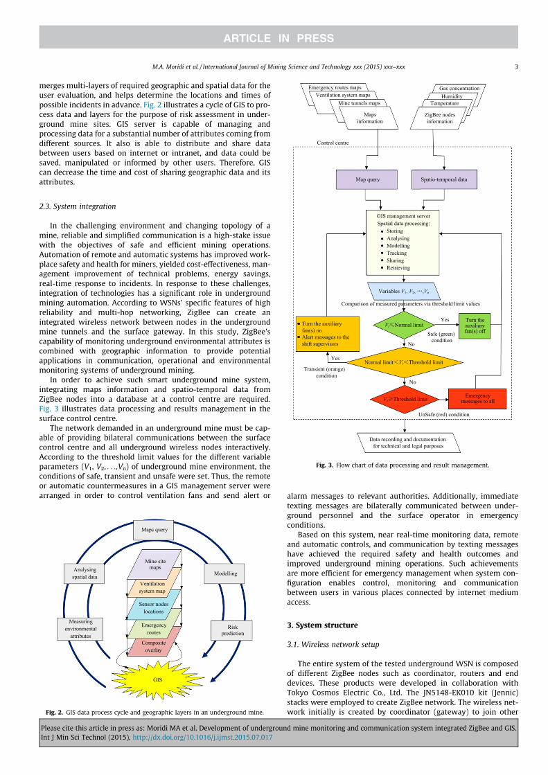
In order to achieve such smart underground mine system,integrating maps information and spatio-temporal data fromZigBee nodes into a database at a control centre are required.Fig. 3 illustrates data processing and results management in thesurface control centre.
The network demanded in an underground mine must be cap-able of providing bilateral communications between the surfacecontrol centre and all underground wireless nodes interactively.According to the threshold limit values for the different variableparameters (V1, V2, . . .,Vn) of underground mine environment, theconditions of safe, transient and unsafe were set. Thus, the remoteor automatic countermeasures in a GIS management server werearranged in order to control ventilation fans and send alert or alarm messages to relevant authorities. Additionally, immediate
texting messages are bilaterally communicated between under-ground personnel and the surface operator in emergencyconditions.
Based on this system, near real-time monitoring data, remoteand automatic controls, and communication by texting messageshave achieved the required safety and health outcomes andimproved underground mining operations. Such achievementsare more efficient for emergency management when system con-figuration enables control, monitoring and communicationbetween users in various places connected by internet mediumaccess.
3. System structure
3.1. Wireless network setup
The entire system of the tested underground WSN is composedof different ZigBee nodes such as coordinator, routers and enddevices. These products were developed in collaboration withTokyo Cosmos Electric Co., Ltd. The JN5148-EK010 kit (Jennic)stacks were employed to create ZigBee network. The wireless net-work initially is created by coordinator (gateway) to join other
Maps query
Mine site maps
ModellingAnalysing spatial data
Ventilation system map
Sensor nodes locations
Risk prediction
Emergency routes
Composite overlay
GIS
Measuring environmental
attributes
Fig. 2. GIS data process cycle and geographic layers in an underground mine.
Gas concentrationHumidity
Temperature
ZigBee nodes information
Emergency routes mapsVentilation system maps
Mine tunnels maps
Maps information
Control centre
Map query Spatio-temporal data
GIS management serverSpatial data processing:
StoringAnalysingModellingTrackingSharingRetrieving
Variables V1, V2, ,Vn
Comparison of measured parameters via threshold limit values
Yes
Yes
No
No
Vi Normal limitTurn the auxiliary fan(s) off
Normal limit Vi Threshold limit
Vi Threshold limit Emergency messages to all
UnSafe (red) condition
Transient (orange) condition
Turn the auxiliary fan(s) onAlert messages to the shift supervisors
Data recording and documentation for technical and legal purposes
Safe (green) condition
Fig. 3. Flow chart of data processing and result management.
M.A. Moridi et al. / International Journal of Mining Science and Technology xxx (2015) xxx–xxx 3
Please cite this article in press as: Moridi MA et al. Development of underground mine monitoring and communication system integrated ZigBee and GIS.Int J Min Sci Technol (2015), http://dx.doi.org/10.1016/j.ijmst.2015.07.017
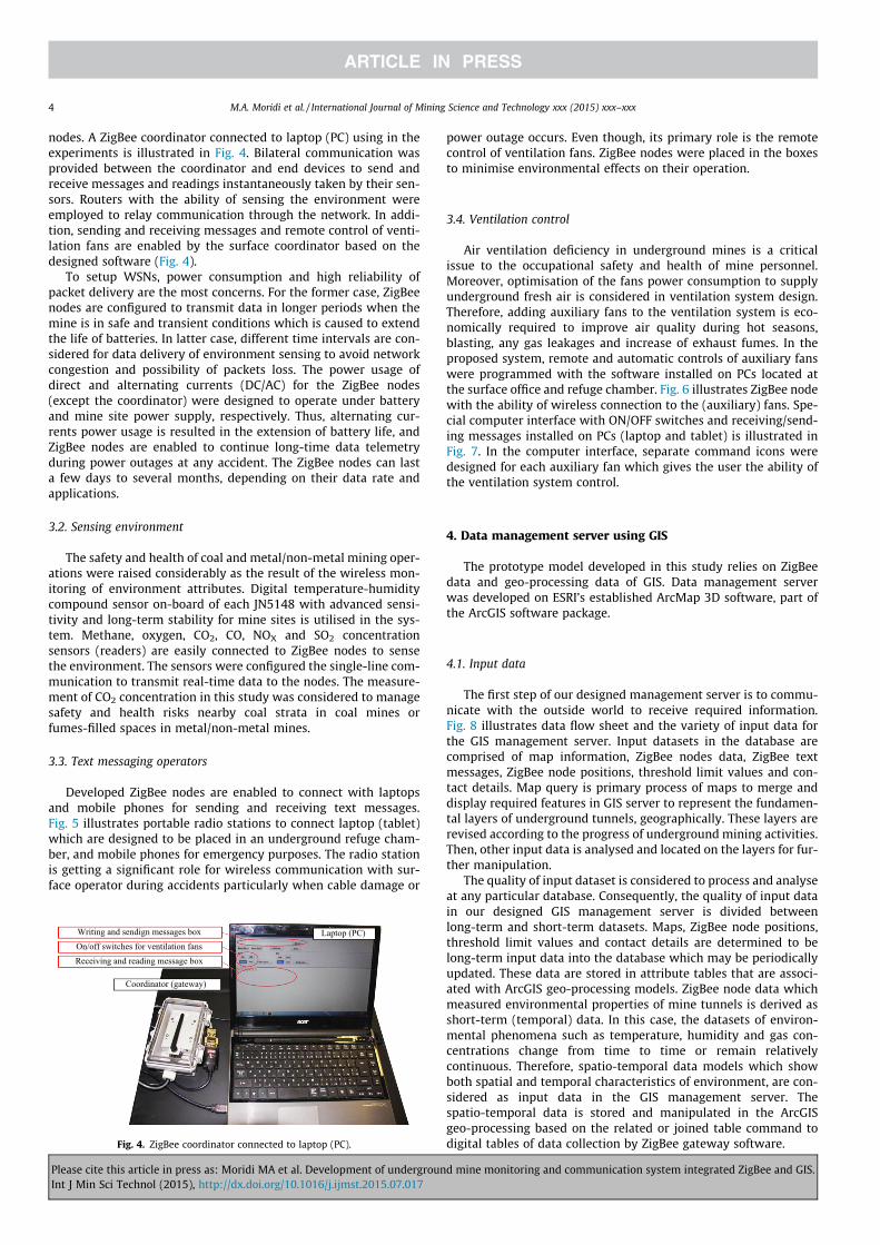
nodes. A ZigBee coordinator connected to laptop (PC) using in theexperiments is illustrated in Fig. 4. Bilateral communication wasprovided between the coordinator and end devices to send andreceive messages and readings instantaneously taken by their sen-sors. Routers with the ability of sensing the environment wereemployed to relay communication through the network. In addi-tion, sending and receiving messages and remote control of venti-lation fans are enabled by the surface coordinator based on thedesigned software (Fig. 4).
To setup WSNs, power consumption and high reliability ofpacket delivery are the most concerns. For the former case, ZigBeenodes are configured to transmit data in longer periods when themine is in safe and transient conditions which is caused to extendthe life of batteries. In latter case, different time intervals are con-sidered for data delivery of environment sensing to avoid networkcongestion and possibility of packets loss. The power usage ofdirect and alternating currents (DC/AC) for the ZigBee nodes(except the coordinator) were designed to operate under batteryand mine site power supply, respectively. Thus, alternating cur-rents power usage is resulted in the extension of battery life, andZigBee nodes are enabled to continue long-time data telemetryduring power outages at any accident. The ZigBee nodes can lasta few days to several months, depending on their data rate andapplications.
3.2. Sensing environment
The safety and health of coal and metal/non-metal mining oper-ations were raised considerably as the result of the wireless mon-itoring of environment attributes. Digital temperature-humiditycompound sensor on-board of each JN5148 with advanced sensi-tivity and long-term stability for mine sites is utilised in the sys-tem. Methane, oxygen, CO2, CO, NOX and SO2 concentrationsensors (readers) are easily connected to ZigBee nodes to sensethe environment. The sensors were configured the single-line com-munication to transmit real-time data to the nodes. The measure-ment of CO2 concentration in this study was considered to managesafety and health risks nearby coal strata in coal mines orfumes-filled spaces in metal/non-metal mines.
3.3. Text messaging operators
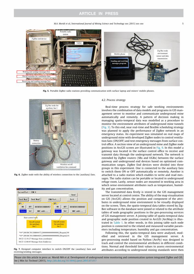
Developed ZigBee nodes are enabled to connect with laptopsand mobile phones for sending and receiving text messages.Fig. 5 illustrates portable radio stations to connect laptop (tablet)which are designed to be placed in an underground refuge cham-ber, and mobile phones for emergency purposes. The radio stationis getting a significant role for wireless communication with sur-face operator during accidents particularly when cable damage or
power outage occurs. Even though, its primary role is the remotecontrol of ventilation fans. ZigBee nodes were placed in the boxesto minimise environmental effects on their operation.
3.4. Ventilation control
Air ventilation deficiency in underground mines is a criticalissue to the occupational safety and health of mine personnel.Moreover, optimisation of the fans power consumption to supplyunderground fresh air is considered in ventilation system design.Therefore, adding auxiliary fans to the ventilation system is eco-nomically required to improve air quality during hot seasons,blasting, any gas leakages and increase of exhaust fumes. In theproposed system, remote and automatic controls of auxiliary fanswere programmed with the software installed on PCs located atthe surface office and refuge chamber. Fig. 6 illustrates ZigBee nodewith the ability of wireless connection to the (auxiliary) fans. Spe-cial computer interface with ON/OFF switches and receiving/send-ing messages installed on PCs (laptop and tablet) is illustrated inFig. 7. In the computer interface, separate command icons weredesigned for each auxiliary fan which gives the user the ability ofthe ventilation system control.
4. Data management server using GIS
The prototype model developed in this study relies on ZigBeedata and geo-processing data of GIS. Data management serverwas developed on ESRI’s established ArcMap 3D software, part ofthe ArcGIS software package.
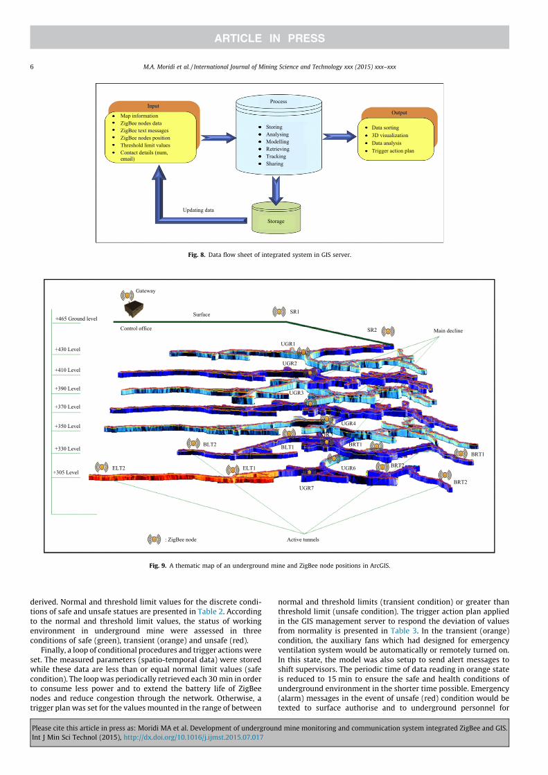
4.1. Input data
The first step of our designed management server is to commu-nicate with the outside world to receive required information.Fig. 8 illustrates data flow sheet and the variety of input data forthe GIS management server. Input datasets in the database arecomprised of map information, ZigBee nodes data, ZigBee textmessages, ZigBee node positions, threshold limit values and con-tact details. Map query is primary process of maps to merge anddisplay required features in GIS server to represent the fundamen-tal layers of underground tunnels, geographically. These layers arerevised according to the progress of underground mining activities.Then, other input data is analysed and located on the layers for fur-ther manipulation.
The quality of input dataset is considered to process and analyseat any particular database. Consequently, the quality of input datain our designed GIS management server is divided betweenlong-term and short-term datasets. Maps, ZigBee node positions,threshold limit values and contact details are determined to belong-term input data into the database which may be periodicallyupdated. These data are stored in attribute tables that are associ-ated with ArcGIS geo-processing models. ZigBee node data whichmeasured environmental properties of mine tunnels is derived asshort-term (temporal) data. In this case, the datasets of environ-mental phenomena such as temperature, humidity and gas con-centrations change from time to time or remain relativelycontinuous. Therefore, spatio-temporal data models which showboth spatial and temporal characteristics of environment, are con-sidered as input data in the GIS management server. Thespatio-temporal data is stored and manipulated in the ArcGISgeo-processing based on the related or joined table command todigital tables of data collection by ZigBee gateway software.
Writing and sendign messages boxOn/off switches for ventilation fansReceiving and reading message box
Coordinator (gateway)
Laptop (PC)
Fig. 4. ZigBee coordinator connected to laptop (PC).
4 M.A. Moridi et al. / International Journal of Mining Science and Technology xxx (2015) xxx–xxx
Please cite this article in press as: Moridi MA et al. Development of underground mine monitoring and communication system integrated ZigBee and GIS.Int J Min Sci Technol (2015), http://dx.doi.org/10.1016/j.ijmst.2015.07.017
4.2. Process strategy
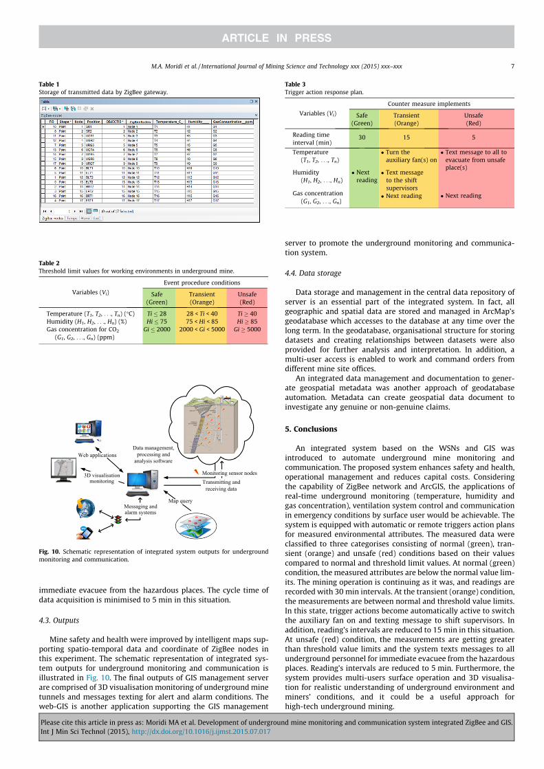
Real-time process strategy for safe working environmentsinvolves the combination of data models and programs in GIS man-agement server to monitor and communicate underground mineautomatically and remotely. A pattern of decision making inmanaging spatio-temporal data was modelled as a procedure tomonitor the environment attributes of underground mine tunnels(Fig. 3). To this end, near real-time and flexible scheduling strategywas planned to apply the performance of ZigBee network in anemergency status. An experiment was simulated on real maps ofunderground mine with developed ZigBee nodes to control ventila-tion fans (ON/OFF) and text emergency messages from surface con-trol office. A section view of an underground mine and ZigBee nodepositions in ArcGIS screen are illustrated in Fig. 9. In this model agateway was located in the surface control office to receive andtransmit data through the underground network. The network isextended by ZigBee routers (SRx and UGRx) between the surfacegateway and underground end devices based on optimised com-munication ranges. ZigBee End devices were divided into threegroups in this experiment. One is connected to the auxiliary fansto switch them ON or OFF automatically or remotely. Another isattached to a radio station which enables to write and read mes-sages. The radio station can be portable or located in undergroundrefuge room. Lastly, sensor nodes are mounted in working area inwhich sense environment attributes such as temperature, humid-ity and gas concentration.
The transmitted data firstly is stored in the GIS managementserver located at control centre. The ability of the map visualisationon GIS (ArcGIS) allows the position and component of the attri-butes in underground mine environment to be visually displayedon the screen. Then, the spatio-temporal data tables stored by Zig-Bee software in the database were joined or related to the attributetables of node geographic positions in the geo-processing servicesof GIS management server. A joining table of spatio-temporal dataand geographic node position created in ArcGIS (ArcMap) is illus-trated in Table 1. In other words, in this joining table each nodeposition is connected to the related and measured variable param-eters including temperature, humidity and gas concentration.
Following this, the spatio-temporal data were analysed, mod-elled and retrieved in the GIS management server. Ageo-processing model based on Python (ArcPy) was designed totrack and control the environmental attributes in different condi-tions. Normal and threshold limit values to assess environmentalattributes according to underground mining standards were then
Portable radio station
ZigBee end device
Tablet
Writing and sendign messages box
On/off switches for ventilation fans
Receiving and reading message box
Mobile phoneZig Bee node environment
sensor and data transmission
Fig. 5. Portable ZigBee radio stations providing communication with surface laptop and miners’ mobile phones.
Zig Bee node for auxiliary fan 1
Battery connection
Wireless on/off ventilation fan command
Fig. 6. ZigBee node with the ability of wireless connection to the (auxiliary) fans.
Start control term
On/off switch for auxiliary
fan 1
On/off switch for auxiliary
fan 2
*##* [001BC50120B00457] [0000000000000000] [Reqstat] 00*##* [001BC50120B004EF] [0000000000000000] [Reqstat] 0104/23 12:54:27 Message from coordinator04/23 12:00:05 Message from Enddevice
Fig. 7. Designed computer interface to switch ON/OFF the (auxiliary) fans andreceiving/sending messages.
M.A. Moridi et al. / International Journal of Mining Science and Technology xxx (2015) xxx–xxx 5
Please cite this article in press as: Moridi MA et al. Development of underground mine monitoring and communication system integrated ZigBee and GIS.Int J Min Sci Technol (2015), http://dx.doi.org/10.1016/j.ijmst.2015.07.017
derived. Normal and threshold limit values for the discrete condi-tions of safe and unsafe statues are presented in Table 2. Accordingto the normal and threshold limit values, the status of workingenvironment in underground mine were assessed in threeconditions of safe (green), transient (orange) and unsafe (red).
Finally, a loop of conditional procedures and trigger actions wereset. The measured parameters (spatio-temporal data) were storedwhile these data are less than or equal normal limit values (safecondition). The loop was periodically retrieved each 30 min in orderto consume less power and to extend the battery life of ZigBeenodes and reduce congestion through the network. Otherwise, atrigger plan was set for the values mounted in the range of between
normal and threshold limits (transient condition) or greater thanthreshold limit (unsafe condition). The trigger action plan appliedin the GIS management server to respond the deviation of valuesfrom normality is presented in Table 3. In the transient (orange)condition, the auxiliary fans which had designed for emergencyventilation system would be automatically or remotely turned on.In this state, the model was also setup to send alert messages toshift supervisors. The periodic time of data reading in orange stateis reduced to 15 min to ensure the safe and health conditions ofunderground environment in the shorter time possible. Emergency(alarm) messages in the event of unsafe (red) condition would betexted to surface authorise and to underground personnel for
Output
Process
StoringAnalysingModellingRetrievingTrackingSharing
Input
Map informationZigBee nodes dataZigBee text messagesZigBee nodes positionThreshold limit valuesContact details (num, email)
Updating data
Storage
Data sorting3D visualizationData analysisTrigger action plan
Fig. 8. Data flow sheet of integrated system in GIS server.
Main decline
SR1Surface
Gateway
Control office
UGR1
UGR2
UGR3
UGR4
UGR6
UGR7
SR2
ELT1ELT2
BLT2 BLT1 BRT1
BRT2
BRT1
BRT2
Active tunnels: ZigBee node
+465 Ground level
+430 Level
+410 Level
+390 Level
+370 Level
+350 Level
+330 Level
+305 Level
Fig. 9. A thematic map of an underground mine and ZigBee node positions in ArcGIS.
6 M.A. Moridi et al. / International Journal of Mining Science and Technology xxx (2015) xxx–xxx
Please cite this article in press as: Moridi MA et al. Development of underground mine monitoring and communication system integrated ZigBee and GIS.Int J Min Sci Technol (2015), http://dx.doi.org/10.1016/j.ijmst.2015.07.017
immediate evacuee from the hazardous places. The cycle time ofdata acquisition is minimised to 5 min in this situation.
4.3. Outputs
Mine safety and health were improved by intelligent maps sup-porting spatio-temporal data and coordinate of ZigBee nodes inthis experiment. The schematic representation of integrated sys-tem outputs for underground monitoring and communication isillustrated in Fig. 10. The final outputs of GIS management serverare comprised of 3D visualisation monitoring of underground minetunnels and messages texting for alert and alarm conditions. Theweb-GIS is another application supporting the GIS management
server to promote the underground monitoring and communica-tion system.
4.4. Data storage
Data storage and management in the central data repository ofserver is an essential part of the integrated system. In fact, allgeographic and spatial data are stored and managed in ArcMap’sgeodatabase which accesses to the database at any time over thelong term. In the geodatabase, organisational structure for storingdatasets and creating relationships between datasets were alsoprovided for further analysis and interpretation. In addition, amulti-user access is enabled to work and command orders fromdifferent mine site offices.
An integrated data management and documentation to gener-ate geospatial metadata was another approach of geodatabaseautomation. Metadata can create geospatial data document toinvestigate any genuine or non-genuine claims.
5. Conclusions
An integrated system based on the WSNs and GIS wasintroduced to automate underground mine monitoring andcommunication. The proposed system enhances safety and health,operational management and reduces capital costs. Consideringthe capability of ZigBee network and ArcGIS, the applications ofreal-time underground monitoring (temperature, humidity andgas concentration), ventilation system control and communicationin emergency conditions by surface user would be achievable. Thesystem is equipped with automatic or remote triggers action plansfor measured environmental attributes. The measured data wereclassified to three categorises consisting of normal (green), tran-sient (orange) and unsafe (red) conditions based on their valuescompared to normal and threshold limit values. At normal (green)condition, the measured attributes are below the normal value lim-its. The mining operation is continuing as it was, and readings arerecorded with 30 min intervals. At the transient (orange) condition,the measurements are between normal and threshold value limits.In this state, trigger actions become automatically active to switchthe auxiliary fan on and texting message to shift supervisors. Inaddition, reading’s intervals are reduced to 15 min in this situation.At unsafe (red) condition, the measurements are getting greaterthan threshold value limits and the system texts messages to allunderground personnel for immediate evacuee from the hazardousplaces. Reading’s intervals are reduced to 5 min. Furthermore, thesystem provides multi-users surface operation and 3D visualisa-tion for realistic understanding of underground environment andminers’ conditions, and it could be a useful approach forhigh-tech underground mining.
Table 3Trigger action response plan.
Table 1Storage of transmitted data by ZigBee gateway.
Data management, processing and
analysis softwareWeb applications
3D visualisation monitoring
Messaging and alarm systems
Map query
Monitoring sensor nodesTransmitting and
receiving data
Fig. 10. Schematic representation of integrated system outputs for undergroundmonitoring and communication.
Table 2Threshold limit values for working environments in underground mine.
M.A. Moridi et al. / International Journal of Mining Science and Technology xxx (2015) xxx–xxx 7
Please cite this article in press as: Moridi MA et al. Development of underground mine monitoring and communication system integrated ZigBee and GIS.Int J Min Sci Technol (2015), http://dx.doi.org/10.1016/j.ijmst.2015.07.017
References
[1] Wu L, Jiang Z, Cheng W, Zuo X, Lv D, Yao Y. Major accident analysis andprevention of coal mines in China from the year of 1949 to 2009. Int J Min SciTechnol 2011;21(5):693–9.
[2] CDC. Centres for disease control and prevention mining fatalities,underground. USA; 2010.
[3] Laney AS, Attfield MD. Coal workers’ pneumoconiosis and progressivemassive fibrosis are increasingly more prevalent among workers in smallunderground coal mines in the United States. Occup Environ Med 2010;67(6):428–31.
[4] Chehri A, Fortier P, Tardif PM. UWB-based sensor networks for localization inmining environments. Ad Hoc Networks (Elsevier) 2009;7(5):987–1000.
[5] Bhattacharjee S, Roy P, Ghosh S, Misra S, Obaidat MS. Wireless sensor network-based fire detection, alarming, monitoring and prevention system for Bord-and-Pillar coal mines. J Syst Softw 2012;85(3):571–81.
[6] Karl H, Willig A. Protocols and architectures for wireless sensornetworks. England: John Wiley and Sons; 2005.
[7] Chen S, Yao J, Wu Y. Analysis of the power consumption for wireless sensornetwork node based on ZigBee. Proc Eng 2012;29:1994–8.
[8] Ma SG. Construction of wireless fire alarm system based on ZigBee technology.Proc Eng 2011;11:308–13.
[9] Moridi MA, Kawamura Y, Sharifzadeh M, Chanda EK, Jang H. An investigationof underground monitoring and communication system based on radio wavesattenuation using ZigBee. Tunn Undergr Space Technol 2014;43:362–9.
[10] ESRI. ArcGIS" for emergency management. USA; 2012.[11] Huang X, Zhu W, Lu D. Underground miners localization system based on
ZigBee and WebGIS. In: Proceeding of 18th International Conference onGeo-informatics; 2010.
[12] Ghorbani M, Sharifzadeh M, Yasrobi S, Daiyan M. Geotechnical, structural andgeodetic measurements for conventional tunnelling hazards in urban
areas-the case of Niayesh road tunnel project. Tunn Undergr Space Technol2012;31:1–8.
[13] Sharifzadeh M, Mitani Y, Esaki T. Rock joint surfaces measurement andanalysis of aperture distribution under different normal and shear loadingusing GIS. Rock Mech Rock Eng 2008;41(2):299–323.
[14] S!alap S, Karslıoglu MO, Demirel N. Development of a GIS-based monitoringand management system for underground coal mining safety. Int J Coal Geol2009;80(2):105–12.
[15] Kawamura Y, Dewan AM, Veenendaal B, Hayashi M, Kitahara I, Nobuhara H,Ishii K. Using GIS to develop a mobile communications network for disaster-damaged areas. Int J Digital Earth 2013;7(4):279–93.
[16] Sun EJ, Nieto A. Zigbee/google earth based assisted driving system in mining.Min Sci Technol 2009;19(5):626–30.
[17] He HJ, Wang SY. The application of ARM and ZigBee technology wirelessnetworks in monitoring mine safety system. In: Proceeding of the ISECSinternational colloquium on computing, communication, control, andmanagement. Guangzhou; 2008.
[18] Chehri A, Farjow W, Mouftah HT, Fernando X. Design of wireless sensornetwork for mine safety monitoring. In: Proceeding of 24th Canadianconference on electrical and computer engineering. Niagara Falls; 2011.
[19] Pandit V, Rane U. Coal mine monitoring using ARM7 and ZigBee. Int J EmergTechnol Adv Eng 2013;3(5):352–9.
[20] Kim H, Chung JM, Kim CH. Secured communication protocol forinternetworking ZigBee cluster networks. Comput Commun 2009;32(13–14):1531–40.
[21] Terada M. Application of ZigBee sensor network to data acquisition andmonitoring. Meas Sci Rev 2009;6:183–7.
[22] Chehri A, Mouftah H, Fortier P, Aniss H. Experimental testing of IEEE801.15.4/ZigBee sensor networks in confined area. In: Proceedings of the eighth annualconference on communication networks and services research conference.Montreal; 2010.
8 M.A. Moridi et al. / International Journal of Mining Science and Technology xxx (2015) xxx–xxx
Please cite this article in press as: Moridi MA et al. Development of underground mine monitoring and communication system integrated ZigBee and GIS.Int J Min Sci Technol (2015), http://dx.doi.org/10.1016/j.ijmst.2015.07.017