Embed Size (px)
Citation preview
1
Document 1
Recommended Plan – Confederation Line West Functional Design Report
(Tunney’s Pasture to Baseline Station and Bayshore Station)
Background:
On 17 June 2009, Transit Committee approved Statement of Work for the Western Light
Rail Transit Corridor Planning and Environmental Assessment Study. The original
purpose of the study was to identify the best possible alignment for the conversion of
bus rapid transit to LRT west from Bayview to Lincoln Fields and Baseline Stations
including the removal of 450,00 yearly buses from the Sir John A Macdonald Parkway.
The planning study was underway in early 2010. The Committee report can be found at:
ACS2009-ICS-PGM-0050
On 17 July 2013 Council approved the “Richmond Underground” (R12) alignment after
extensive review and consultation on 12 alternative alignments. The “Richmond
Underground” included a shallow buried tunnel and open trench segment between
Dominion and Cleary Stations, on National Capital Commission (NCC) lands along the
Sir John A. Macdonald Parkway corridor, then it continued under Richmond Road to the
follow the existing Transitway in the Pinecrest Creek corridor. Council directed staff to
complete the functional design and environmental assessment; include consideration of
all mitigation measures in the staff report as well as concerns raised by the community,
and to continue to work with the NCC to address concerns raised by the NCC Board of
Directors. The 17 July 2013 City Council report can be found at this link: ACS2013-PAI-
PGM-0158
As recommended by the Transportation Committee, on 17 July 2013, Council passed
the following direction:
1. Approve the Richmond Underground corridor as the preferred corridor to extend
Light Rail Transit westerly from Bayview Station to Baseline Station, as described
in this report;
2. Direct staff to complete the functional design for the Richmond Underground
corridor and that the staff ensure that the work plan for the functional detailed
design include consideration of all mitigation measures detailed in the staff report
as well as the concerns raised by the community and by the public delegations
heard at the Special Transportation Committee meeting of July 10, 2013; and
3. Direct staff to complete the Environmental Assessment process and
documentation based on the functional design and file the Environmental Study
Report in accordance with the Ontario Transit Regulation 231/08.
2
4. Approve that the Richmond Underground be included in the 2013 TMP refresh
scheduled for completion this year and that the notice of completion of the
environmental project report be posted in Q1 2014; and
5. Direct staff to continue to work with the NCC during the functional and detailed
design stages of the WLRT project to address the concerns raised by the NCC
Board of Directors; and
6. Inform the NCC Board of Directors Chair, in writing, the outcome of this direction.
Transportation Master Plan
On 26 November 2013, Council approved the 2013 Transportation Master Plan (TMP)
that identifies the “Stage 2” proposal to extend the Light Rail Confederation Line further
west to Baseline and Bayshore Stations as part of the Affordable Network, Rapid
Transit and Transit Priority (RTTP) Network, 2031 (ACS2013-PIA-PGM-0193). As a
result, the extension to Bayshore Station from the junction with the future Western Light
Rail Transit in the Pinecrest Creek Corridor, just south of Lincoln Fields, would be
implemented as light rail transit (LRT) rather than bus rapid transit (BRT)
Western Extension from Lincoln Fields to Bayshore
On 5 Feb 2014, Transportation Committee approved the Statement-of-Work for the
West Light Rail Transit Extension (Lincoln Fields Station to Bayshore Station) Planning
and Environmental Assessment Study. The study for this segment of the LRT was
added to the current scope of work for the Planning and Environmental Assessment
Study for the Western Light Rail Transit (Tunney’s Pasture to Baseline Station) that was
already underway, such that one Environmental Project Report will be prepared in
fulfillment of the provincial environmental assessment process. West Light Rail Transit
Extension (Lincoln Fields Station to Bayshore Station) Planning and Environmental
Assessment Study – Statement of Work can be found at this link: ACS2014-PAI-PGM-
0039
An EA was completed for the West Transitway Extension for bus rapid transit (BRT)
from Lincoln Fields to Bayshore in the early 1990’s. The purpose of this western
extension to the Confederation Line study was to address the technology change from
BRT to LRT. The study was initiated and public consultation events for the Lincoln
Fields to Bayshore segment, as required as part of the provincial Environmental
Assessment process, occurred in June 2014 and April 2015.
The following map is an excerpt from the Transportation Master Plan and highlights the
study area for Western Extension of the Confederation Line LRT.
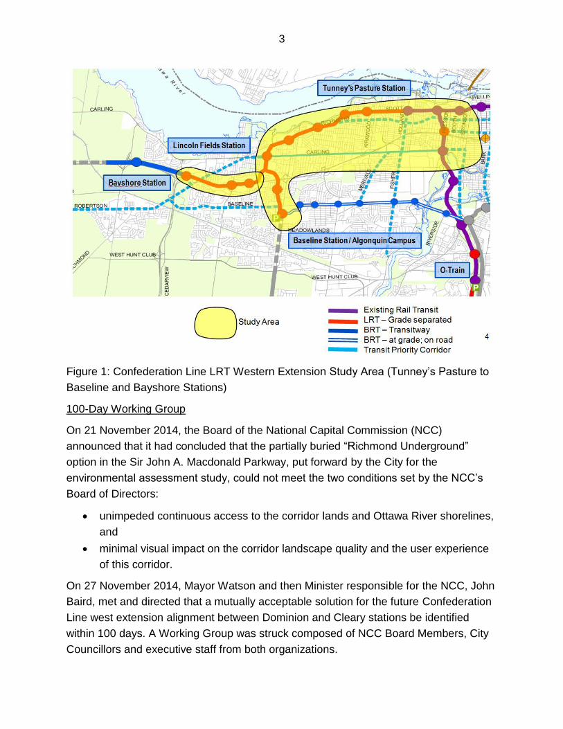
3
Figure 1: Confederation Line LRT Western Extension Study Area (Tunney’s Pasture to
Baseline and Bayshore Stations)
100-Day Working Group
On 21 November 2014, the Board of the National Capital Commission (NCC)
announced that it had concluded that the partially buried “Richmond Underground”
option in the Sir John A. Macdonald Parkway, put forward by the City for the
environmental assessment study, could not meet the two conditions set by the NCC’s
Board of Directors:
unimpeded continuous access to the corridor lands and Ottawa River shorelines,
and
minimal visual impact on the corridor landscape quality and the user experience
of this corridor.
On 27 November 2014, Mayor Watson and then Minister responsible for the NCC, John
Baird, met and directed that a mutually acceptable solution for the future Confederation
Line west extension alignment between Dominion and Cleary stations be identified
within 100 days. A Working Group was struck composed of NCC Board Members, City
Councillors and executive staff from both organizations.
4
On 6 March 2015, the 100-Day Working Group announced an agreement-in-principle
for a solution that is outlined in a Memorandum of Understanding. The 100-Day Solution
recommends running a portion of the Confederation Line West extension under rebuilt
and realigned lanes of the Sir John A. Macdonald Parkway between Dominion and
Cleary stations. The resulting solution and Memorandum of Understanding was posted,
for public information, to the NCC and City web pages. It is attached as a separate
document to this report. A background and analysis summary of the 100-Day Working
Group review is also attached as a separate document to this report.
On 30 March 2015, the City of Ottawa followed up the announcement of the 100-Day
Solution with a Public Open House, at City Hall. At the Open House the public had the
opportunity to review and provide feedback on the preferred solution between Dominion
and Cleary Stations
On 22 April 2015, the NCC Board approved the Memorandum of Understanding
approving the jointly developed solution for the portion of the alignment between
Dominion and Cleary Stations.
On 29 April 2015, a final Public Open House was held providing an overview of the
recommendations for the 13 kilometre Confederation Line West LRT Extension study
from Tunney's Pasture to Baseline and Bayshore Stations, as well as the functional
design recommendations for the segment from Lincoln Fields Station to Bayshore
Station.
A summary of the consultation and notification follows at the end of this document.
Recommended Functional Design: Overview of Alignment, Stations, Connectivity
and Operations
5
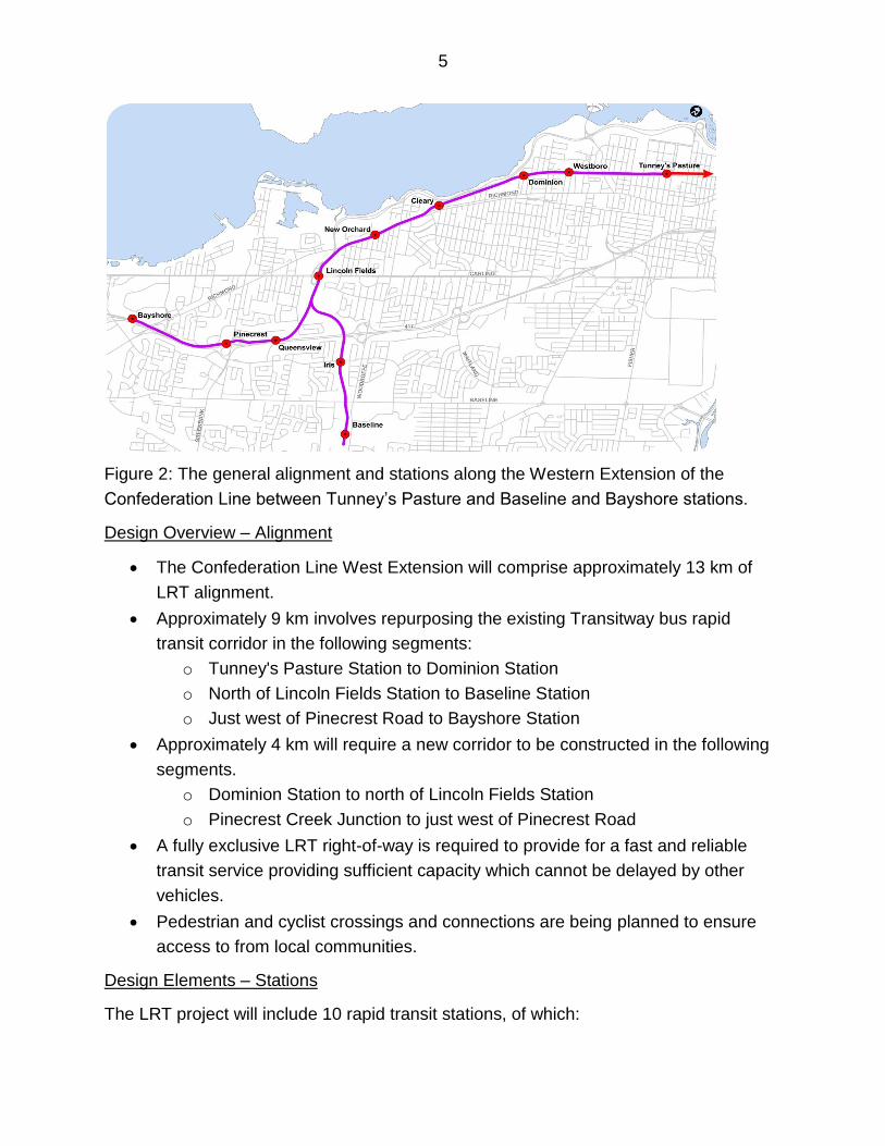
Figure 2: The general alignment and stations along the Western Extension of the
Confederation Line between Tunney’s Pasture and Baseline and Bayshore stations.
Design Overview – Alignment
The Confederation Line West Extension will comprise approximately 13 km of
LRT alignment.
Approximately 9 km involves repurposing the existing Transitway bus rapid
transit corridor in the following segments:
o Tunney's Pasture Station to Dominion Station
o North of Lincoln Fields Station to Baseline Station
o Just west of Pinecrest Road to Bayshore Station
Approximately 4 km will require a new corridor to be constructed in the following
segments.
o Dominion Station to north of Lincoln Fields Station
o Pinecrest Creek Junction to just west of Pinecrest Road
A fully exclusive LRT right-of-way is required to provide for a fast and reliable
transit service providing sufficient capacity which cannot be delayed by other
vehicles.
Pedestrian and cyclist crossings and connections are being planned to ensure
access to from local communities.
Design Elements – Stations
The LRT project will include 10 rapid transit stations, of which:
6
7 are existing Transitway stations to be rebuilt to accommodate LRT;
3 are new stations to serve existing communities and expand access to rapid
transit;
One existing station (Queensway) will be decommissioned as part of the project,
a new station at Queensview Drive and existing station at Iris St. will provide
alternate access to rapid transit for the local community;
Station designs will:
Carry common look and feel elements to those being built for the Confederation Line;
Provide for safe, efficient and accessible access to rapid transit;
Have convenient pedestrian and cycling connections to and from surrounding
communities;
Integrate with the character of existing residential and green space areas.
Fulfill AODA, Building Code and City of Ottawa Accessibility design standards
including the implementation of redundant elevators.
Design Elements – Connectivity
Station connectivity to surrounding communities is a key consideration in project
planning.
• The main priority for station access is pedestrian and cycling activity
o New/improved links to be identified
o Parallel pathway facilities to be provided via a combination of existing and
new linkages
• Bus connection activity at stations
o Bus terminals will be provided at major stations, where large volumes of
passengers will be transferring and local services begin/end
o On-street bus stops for local routes will support easy access to Cleary,
New Orchard, Iris and Pinecrest stations; location and scale will match OC
Transpo needs and the community context
• Pick-up and Drop-off Activity
o Formal facilities will be provided at major stations to serve broader needs
o Informal (limited) facilities will be considered at other stations to serve
more local needs and to spread activity
Design Elements – Transit Operations
• LRT service will operate as an extension of the Confederation Line.
7
• On the core part of the network (between Blair and Lincoln Fields Stations) trains
will initially operate approximately every 3 minutes (in each direction) during
morning and afternoon peak periods.
• The design of the line will support the potential operation of trains as frequent as
every 1.5 minutes in each direction through the downtown, to provide an ultimate
capacity of 24,000 persons per hour per direction during (pphpd) peak hours.
• Train frequencies in off-peaks and on weekends will range from 5 to 15 minutes.
• At Lincoln Fields service will split, with half of trains serving Baseline and half
serving Bayshore.
• Bus (rapid transit and local routes) will connect with the LRT at key locations to
facilitate passenger transfers and provide a seamless network serving the City.
• Bus Rapid Transit services from Kanata and Barrhaven will connect to LRT at
Bayshore and Baseline Stations, respectively.
• Local buses will connect to LRT stations where routes intersect.
• Some local routes may be extended/reorganized to provide connections to LRT
and improve neighbourhood connectivity.
• Night bus service will be provided when the LRT is closed overnight for
maintenance (currently, Routes 95 and 97 run 24 hours a day).
Recommended Functional Design: Detailed Segment-by-Segment Description:
Alignment: Tunney’s Pasture Station to Dominion Station
Between Tunney’s Pasture and Dominion Station, the LRT alignment makes use of the
existing West Transitway corridor, which is a below-grade (trench) facility located north
of Scott Street. A new bridge structure at Goldenrod over the WLRT will be constructed
to permit local bus access to Tunney’s Pasture and improve access for pedestrians,
cyclists and vehicles to PWGSC’s Tunney’s Pasture campus. Existing structures at
other locations will be retained, and rebuilt if necessary to maintain adequate vertical
clearances over the LRT.
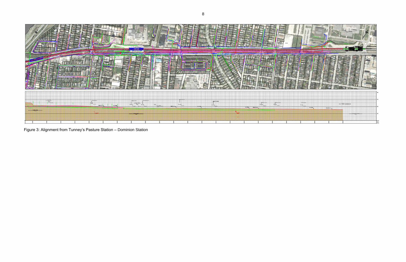
8
Figure 3: Alignment from Tunney’s Pasture Station – Dominion Station
9
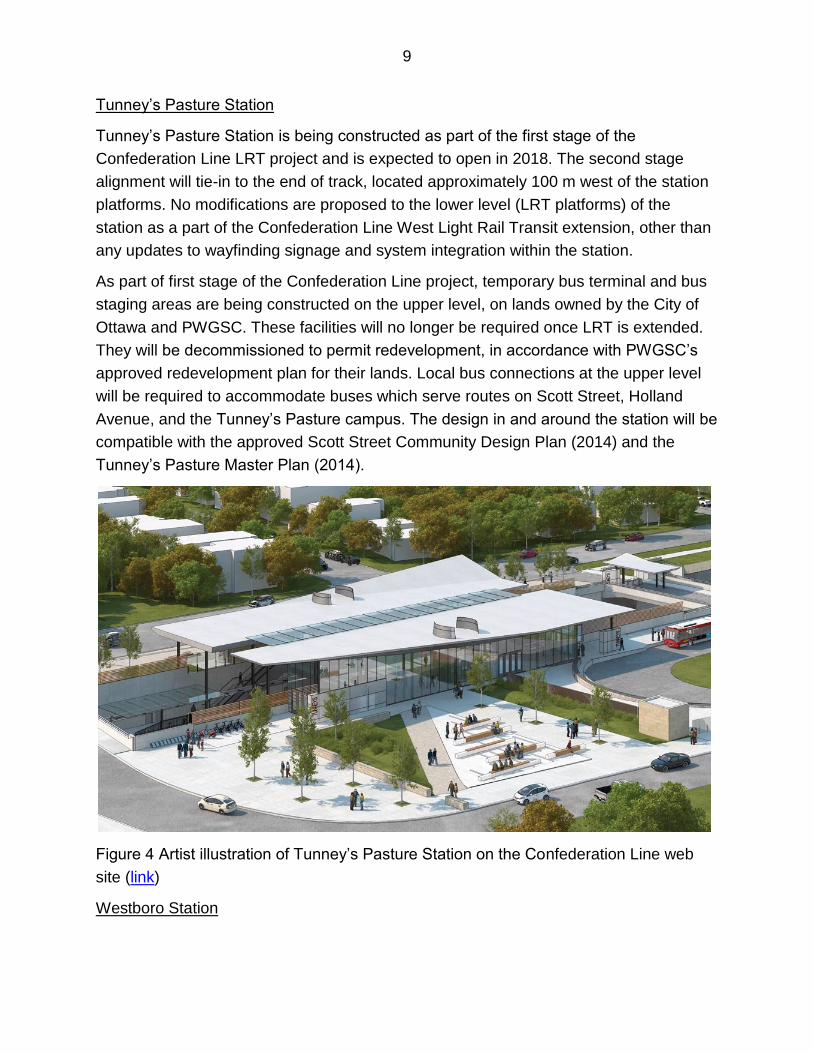
Tunney’s Pasture Station
Tunney’s Pasture Station is being constructed as part of the first stage of the
Confederation Line LRT project and is expected to open in 2018. The second stage
alignment will tie-in to the end of track, located approximately 100 m west of the station
platforms. No modifications are proposed to the lower level (LRT platforms) of the
station as a part of the Confederation Line West Light Rail Transit extension, other than
any updates to wayfinding signage and system integration within the station.
As part of first stage of the Confederation Line project, temporary bus terminal and bus
staging areas are being constructed on the upper level, on lands owned by the City of
Ottawa and PWGSC. These facilities will no longer be required once LRT is extended.
They will be decommissioned to permit redevelopment, in accordance with PWGSC’s
approved redevelopment plan for their lands. Local bus connections at the upper level
will be required to accommodate buses which serve routes on Scott Street, Holland
Avenue, and the Tunney’s Pasture campus. The design in and around the station will be
compatible with the approved Scott Street Community Design Plan (2014) and the
Tunney’s Pasture Master Plan (2014).
Figure 4 Artist illustration of Tunney’s Pasture Station on the Confederation Line web
site (link)
Westboro Station
10
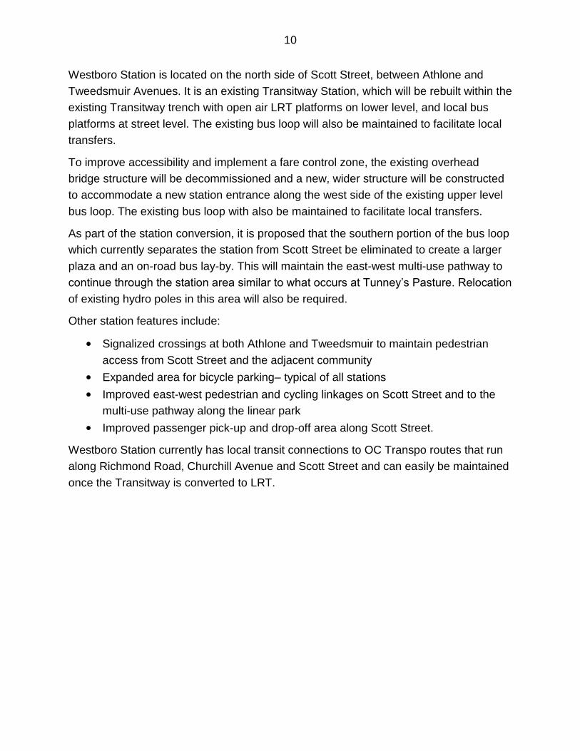
Westboro Station is located on the north side of Scott Street, between Athlone and
Tweedsmuir Avenues. It is an existing Transitway Station, which will be rebuilt within the
existing Transitway trench with open air LRT platforms on lower level, and local bus
platforms at street level. The existing bus loop will also be maintained to facilitate local
transfers.
To improve accessibility and implement a fare control zone, the existing overhead
bridge structure will be decommissioned and a new, wider structure will be constructed
to accommodate a new station entrance along the west side of the existing upper level
bus loop. The existing bus loop with also be maintained to facilitate local transfers.
As part of the station conversion, it is proposed that the southern portion of the bus loop
which currently separates the station from Scott Street be eliminated to create a larger
plaza and an on-road bus lay-by. This will maintain the east-west multi-use pathway to
continue through the station area similar to what occurs at Tunney’s Pasture. Relocation
of existing hydro poles in this area will also be required.
Other station features include:
• Signalized crossings at both Athlone and Tweedsmuir to maintain pedestrian
access from Scott Street and the adjacent community
• Expanded area for bicycle parking– typical of all stations
• Improved east-west pedestrian and cycling linkages on Scott Street and to the
multi-use pathway along the linear park
• Improved passenger pick-up and drop-off area along Scott Street.
Westboro Station currently has local transit connections to OC Transpo routes that run
along Richmond Road, Churchill Avenue and Scott Street and can easily be maintained
once the Transitway is converted to LRT.
11
Figure 5: Plan view of Westboro Station
Figure 6: Bird’s-eye view of Westboro station looking northeast.
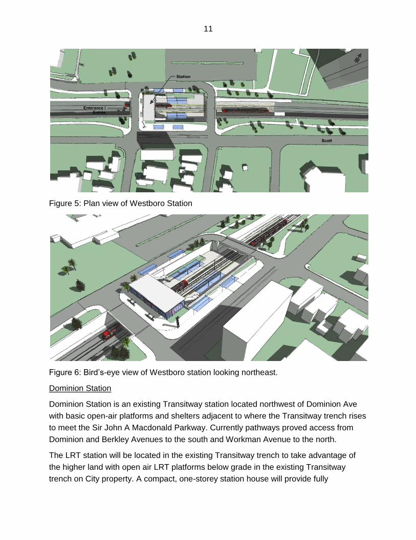
Dominion Station
Dominion Station is an existing Transitway station located northwest of Dominion Ave
with basic open-air platforms and shelters adjacent to where the Transitway trench rises
to meet the Sir John A Macdonald Parkway. Currently pathways proved access from
Dominion and Berkley Avenues to the south and Workman Avenue to the north.
The LRT station will be located in the existing Transitway trench to take advantage of
the higher land with open air LRT platforms below grade in the existing Transitway
trench on City property. A compact, one-storey station house will provide fully
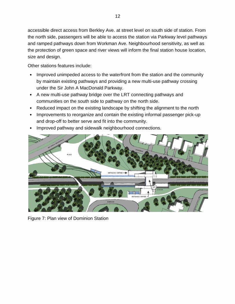
12
accessible direct access from Berkley Ave. at street level on south side of station. From
the north side, passengers will be able to access the station via Parkway level pathways
and ramped pathways down from Workman Ave. Neighbourhood sensitivity, as well as
the protection of green space and river views will inform the final station house location,
size and design.
Other stations features include:
• Improved unimpeded access to the waterfront from the station and the community
by maintain existing pathways and providing a new multi-use pathway crossing
under the Sir John A MacDonald Parkway.
• A new multi-use pathway bridge over the LRT connecting pathways and
communities on the south side to pathway on the north side.
• Reduced impact on the existing landscape by shifting the alignment to the north
• Improvements to reorganize and contain the existing informal passenger pick-up
and drop-off to better serve and fit into the community.
• Improved pathway and sidewalk neighbourhood connections.
Figure 7: Plan view of Dominion Station
13
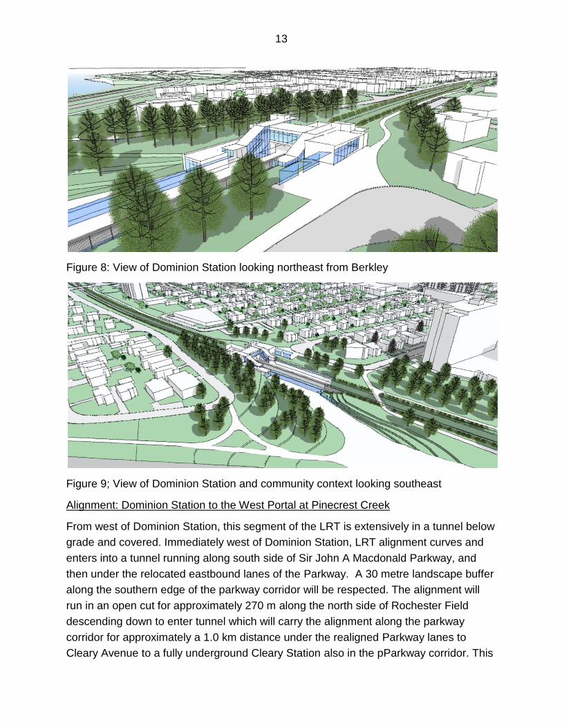
Figure 8: View of Dominion Station looking northeast from Berkley
Figure 9; View of Dominion Station and community context looking southeast
Alignment: Dominion Station to the West Portal at Pinecrest Creek
From west of Dominion Station, this segment of the LRT is extensively in a tunnel below
grade and covered. Immediately west of Dominion Station, LRT alignment curves and
enters into a tunnel running along south side of Sir John A Macdonald Parkway, and
then under the relocated eastbound lanes of the Parkway. A 30 metre landscape buffer
along the southern edge of the parkway corridor will be respected. The alignment will
run in an open cut for approximately 270 m along the north side of Rochester Field
descending down to enter tunnel which will carry the alignment along the parkway
corridor for approximately a 1.0 km distance under the realigned Parkway lanes to
Cleary Avenue to a fully underground Cleary Station also in the pParkway corridor. This
14
approach of bundling transportation infrastructure into one corridor route allows the
tunnel to be approximately one metre below the grade of the parkway above – and
based on preliminary geotechnical advice, this significantly reduces the potential cost
for tunnel construction. This also creates opportunities for more consolidated space for
landscape planting that will be part of the NCC’s efforts to establish a “linear park” as
part of the Sir John A. Macdonald Parkway. This segment reflects the approach
recommended for the 100-Day Solution that was endorsed by the NCC Board of
Directors with the approval of the March 6, 2015 Memorandum of Understanding. Part
of the coordinated renewal and enhancement of the Parkway landscape will included
pathways improvements to segregate cyclist from pedestrians along the shoreline of
this section of the corridor, and two new grades separated pathway underpasses (one
near Dominion Station, one near Cleary). Finally, existing views from open spaces and
private lands abutting the south edge of the parkway corridor will be maintained.
West of Cleary Station, the LRT alignment remains below-grade and crosses under
Cleary Avenue and through lands held by the First Unitarian Church and under a large
water main. The alignment follows an abandoned rail corridor and crosses under
existing parking areas, internal driveways, outdoor storage areas and landscaped areas
on the Unitarian campus. It would be approximately 4 to 6 metres below grade and
approximately 18 metres from the Unitarian House and River Parkway Children’s
Centre. Then the LRT underground alignment curves south to run under Richmond
Road requiring two properties of existing private businesses fronting onto Richmond
Road to be acquired to permit construction.
The LRT tunnel would continue under Richmond Road, passing over the Nepean West
Sanitary Collector in the vicinity of Lockhart Ave and under the Woodroffe Avenue
intersection. West of Woodroffe Avenue, the alignment shifts under the Byron Linear
Park to arrive at the New Orchard Station
West of New Orchard Station, the underground LRT alignment curves north to re-enter
the Richmond Road right-of-way. To set up the curve south into the NCC
Parkway/Pinecrest Creek Corridor, the LRT alignment continues on a long curve under
McEwen Park. The alignment impacts a small commercial property in this area. The
tunnelled segment will end at the west portal in the Pinecrest Creek corridor and the
LRT will return to grade in the Pinecrest Creek corridor just south of the Richmond Road
overpass over the Parkway.
15
Figure 10: Alignment from Dominion Station to West Portal at Pinecrest Creek
16
The tunnel will be in three segments:
East Portal in Rochester Field to Cleary Station – approximately 1000 metres
long
Cleary Station to New Orchard Station – 1050 metres long
New Orchard to the West Portal at Pinecrest Creek – 610 metres
There are a number of ancillary structures and equipment that are required for LRT
operation that must be located along the route.
Two Emergency Exit Buildings (EEB), large enough to house stairs, a landing
and an exit door, will be needed along the underground segments of the LRT.
Based on the length of the tunnel segments and safety standards, preliminary
locations for been identified – one with direct access to Skead Avenue and the
other within the Byron Linear Park near Lockhart.
Mechanical ventilation areas have also been identified. At the eastern edge of Sir
John A Macdonald Parkway corridor, in the vicinity of Cleary Station; in the
vicinity of New Orchard Station, and at the West Portal. The requirement for
mechanical ventilation for the Connaught Tunnel will be determined at a more
detailed design phase. While the LRT tunnel is served by passive ventilation for
daily service, mechanical ventilation is used for emergency purposes such a fire
and smoke.
Electrical Power Sub-Stations will be needed along the alignment. Potential
locations have been identified in the vicinity of: Westboro Station; Cleary Station;
Lincoln Fields Station; Iris Station; Baseline Station; Queensview Station, and
Bayshore Station.
In general, the most likely method of construction for the tunnel segments of the
western extension of the Confederation Line will be a “cut and cover” technique where
the surface is opened up, the trench excavated, the tunnel constructed and then
backfilled and covered. The restoration of the surface lands after construction creates
the opportunity to renew the landscape or streetscape under which the LRT travels. As
such, Richmond Road will be reconstructed as a “complete street” providing
improvements such as wider sidewalks or new cycling lanes, and landscaped
boulevards to enhance more sustainable travel choices and community benefits. Areas
of the Byron Linear Park that will be impacted will also be reinstated with enhancements
such as renewed pathways, trees, benches, and landscaping.
Concerns have been expressed regarding potential impacts of sound and vibration from
the construction and operation of the LRT in the vicinity of residential and institutional
17
uses such as a church, daycare and seniors residence. The objective is to minimize the
potential impacts of noise and vibration and keep them within provincial and municipal
thresholds.
The environmental assessment documentation will include modelling of noise and
vibration and make recommendations for mitigation. Both noise and vibration levels will
be monitored before, during and after the facility is in operation to ensure effects are
mitigated.
Best practices as well as construction and design techniques being refined for the
Confederation Line will also be used for this stage.
The electric LRT trains will be travelling underground in a concrete tunnel
designed to minimize the effects of noise and vibrations.
The City will use continuously-welded rail to eliminate the “clickety-clack” of older
railways.
Isolation systems in the tunnel will be used where noise and vibration
transmission exceeds allowable thresholds while tie and ballast will be reserved
for open-air track away from noise sensitive land uses.
The vehicles themselves use noise attenuating insulation near the wheels and
electric motors to further reduce noise.
Noise and vibration generated during construction will be managed to be within
appropriate provincially and municipally established thresholds.
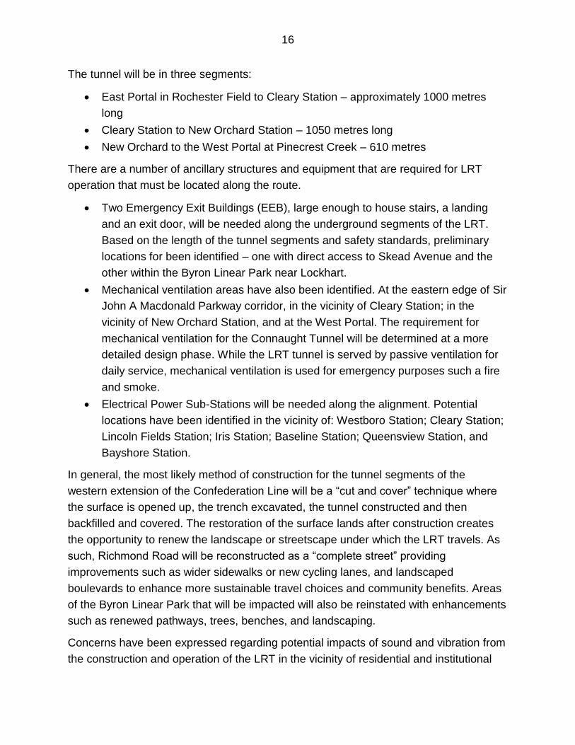
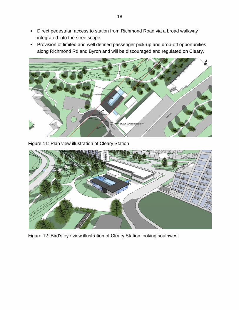
Cleary Station
Cleary Station is a new station, located to serve the McKellar Park community. It is
within the Sir John A Macdonald Parkway Corridor adjacent to the east side of Cleary
Avenue where the City right of way ends at the private entrance to the Unitarian Church
grounds. With the exception of a station house to provide accessible at-grade access
from Cleary as well as the Parkway pathways, the station will be fully buried with a
“green roof” to blend into the surrounding landscape and topography. The design is a
result of the 100-day solution and responds to NCC and local community concerns. It
has such features as:
• Final station house location, size and design will fit into the open space and
community context
• Existing pathway continuity will be maintained and enhanced with a new multi-use
pathway crossing under the Parkway providing access to the waterfront from the
station and the community
18
• Direct pedestrian access to station from Richmond Road via a broad walkway
integrated into the streetscape
• Provision of limited and well defined passenger pick-up and drop-off opportunities
along Richmond Rd and Byron and will be discouraged and regulated on Cleary.
Figure 11: Plan view illustration of Cleary Station
Figure 12: Bird’s eye view illustration of Cleary Station looking southwest
19
Figure 13: Bird’s eye view illustration of Cleary Station from Richmond and Cleary
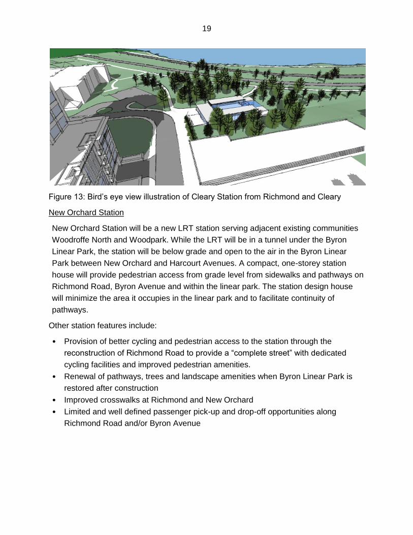
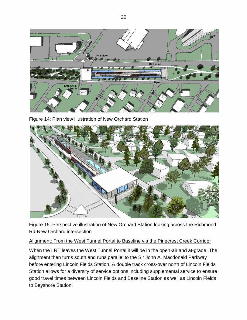
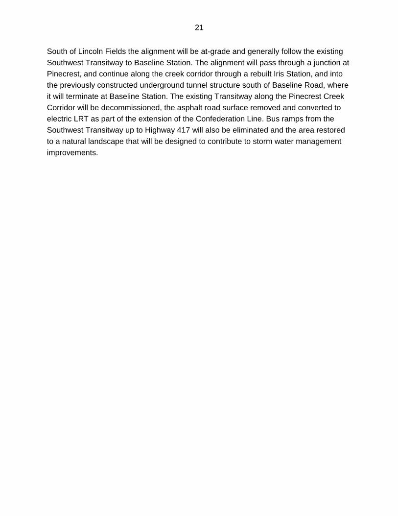
New Orchard Station
New Orchard Station will be a new LRT station serving adjacent existing communities
Woodroffe North and Woodpark. While the LRT will be in a tunnel under the Byron
Linear Park, the station will be below grade and open to the air in the Byron Linear
Park between New Orchard and Harcourt Avenues. A compact, one-storey station
house will provide pedestrian access from grade level from sidewalks and pathways on
Richmond Road, Byron Avenue and within the linear park. The station design house
will minimize the area it occupies in the linear park and to facilitate continuity of
pathways.
Other station features include:
• Provision of better cycling and pedestrian access to the station through the
reconstruction of Richmond Road to provide a “complete street” with dedicated
cycling facilities and improved pedestrian amenities.
• Renewal of pathways, trees and landscape amenities when Byron Linear Park is
restored after construction
• Improved crosswalks at Richmond and New Orchard
• Limited and well defined passenger pick-up and drop-off opportunities along
Richmond Road and/or Byron Avenue
20
Figure 14: Plan view illustration of New Orchard Station
Figure 15: Perspective illustration of New Orchard Station looking across the Richmond
Rd-New Orchard intersection
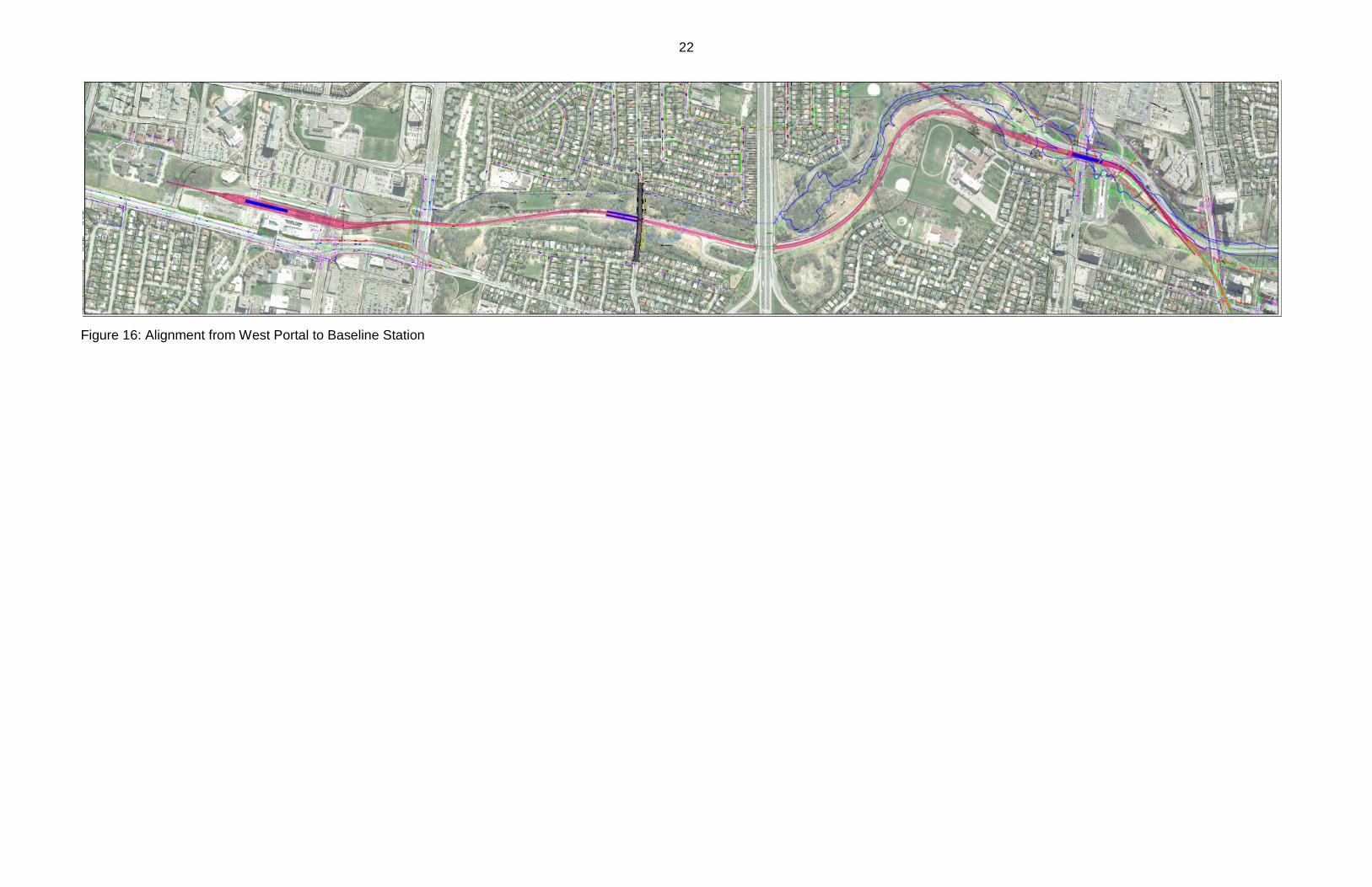
Alignment: From the West Tunnel Portal to Baseline via the Pinecrest Creek Corridor
When the LRT leaves the West Tunnel Portal it will be in the open-air and at-grade. The
alignment then turns south and runs parallel to the Sir John A. Macdonald Parkway
before entering Lincoln Fields Station. A double track cross-over north of Lincoln Fields
Station allows for a diversity of service options including supplemental service to ensure
good travel times between Lincoln Fields and Baseline Station as well as Lincoln Fields
to Bayshore Station.
21
South of Lincoln Fields the alignment will be at-grade and generally follow the existing
Southwest Transitway to Baseline Station. The alignment will pass through a junction at
Pinecrest, and continue along the creek corridor through a rebuilt Iris Station, and into
the previously constructed underground tunnel structure south of Baseline Road, where
it will terminate at Baseline Station. The existing Transitway along the Pinecrest Creek
Corridor will be decommissioned, the asphalt road surface removed and converted to
electric LRT as part of the extension of the Confederation Line. Bus ramps from the
Southwest Transitway up to Highway 417 will also be eliminated and the area restored
to a natural landscape that will be designed to contribute to storm water management
improvements.
22
Figure 16: Alignment from West Portal to Baseline Station
23
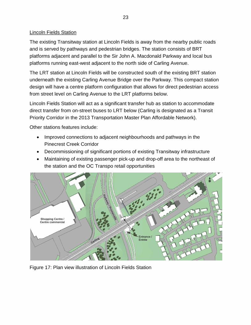
Lincoln Fields Station
The existing Transitway station at Lincoln Fields is away from the nearby public roads
and is served by pathways and pedestrian bridges. The station consists of BRT
platforms adjacent and parallel to the Sir John A. Macdonald Parkway and local bus
platforms running east-west adjacent to the north side of Carling Avenue.
The LRT station at Lincoln Fields will be constructed south of the existing BRT station
underneath the existing Carling Avenue Bridge over the Parkway. This compact station
design will have a centre platform configuration that allows for direct pedestrian access
from street level on Carling Avenue to the LRT platforms below.
Lincoln Fields Station will act as a significant transfer hub as station to accommodate
direct transfer from on-street buses to LRT below (Carling is designated as a Transit
Priority Corridor in the 2013 Transportation Master Plan Affordable Network).
Other stations features include:
Improved connections to adjacent neighbourhoods and pathways in the
Pinecrest Creek Corridor
Decommissioning of significant portions of existing Transitway infrastructure
Maintaining of existing passenger pick-up and drop-off area to the northeast of
the station and the OC Transpo retail opportunities
Figure 17: Plan view illustration of Lincoln Fields Station
24
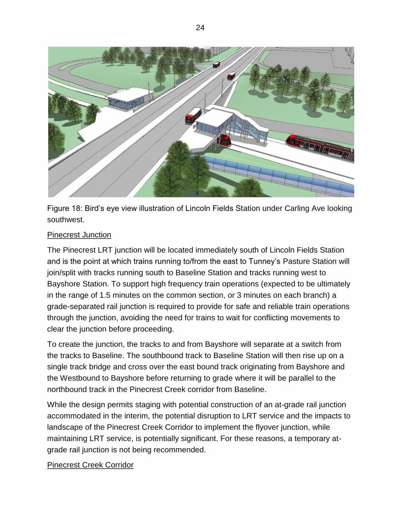
Figure 18: Bird’s eye view illustration of Lincoln Fields Station under Carling Ave looking
southwest.
Pinecrest Junction
The Pinecrest LRT junction will be located immediately south of Lincoln Fields Station
and is the point at which trains running to/from the east to Tunney’s Pasture Station will
join/split with tracks running south to Baseline Station and tracks running west to
Bayshore Station. To support high frequency train operations (expected to be ultimately
in the range of 1.5 minutes on the common section, or 3 minutes on each branch) a
grade-separated rail junction is required to provide for safe and reliable train operations
through the junction, avoiding the need for trains to wait for conflicting movements to
clear the junction before proceeding.
To create the junction, the tracks to and from Bayshore will separate at a switch from
the tracks to Baseline. The southbound track to Baseline Station will then rise up on a
single track bridge and cross over the east bound track originating from Bayshore and
the Westbound to Bayshore before returning to grade where it will be parallel to the
northbound track in the Pinecrest Creek corridor from Baseline.
While the design permits staging with potential construction of an at-grade rail junction
accommodated in the interim, the potential disruption to LRT service and the impacts to
landscape of the Pinecrest Creek Corridor to implement the flyover junction, while
maintaining LRT service, is potentially significant. For these reasons, a temporary at-
grade rail junction is not being recommended.
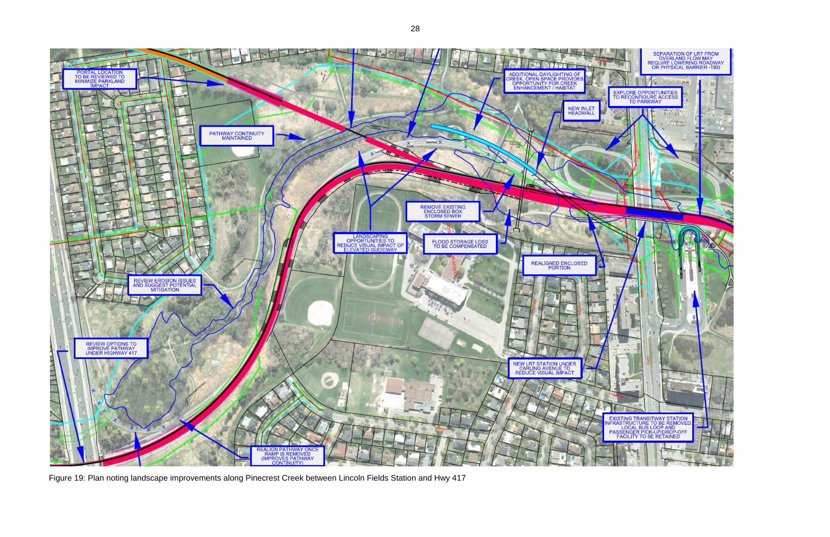
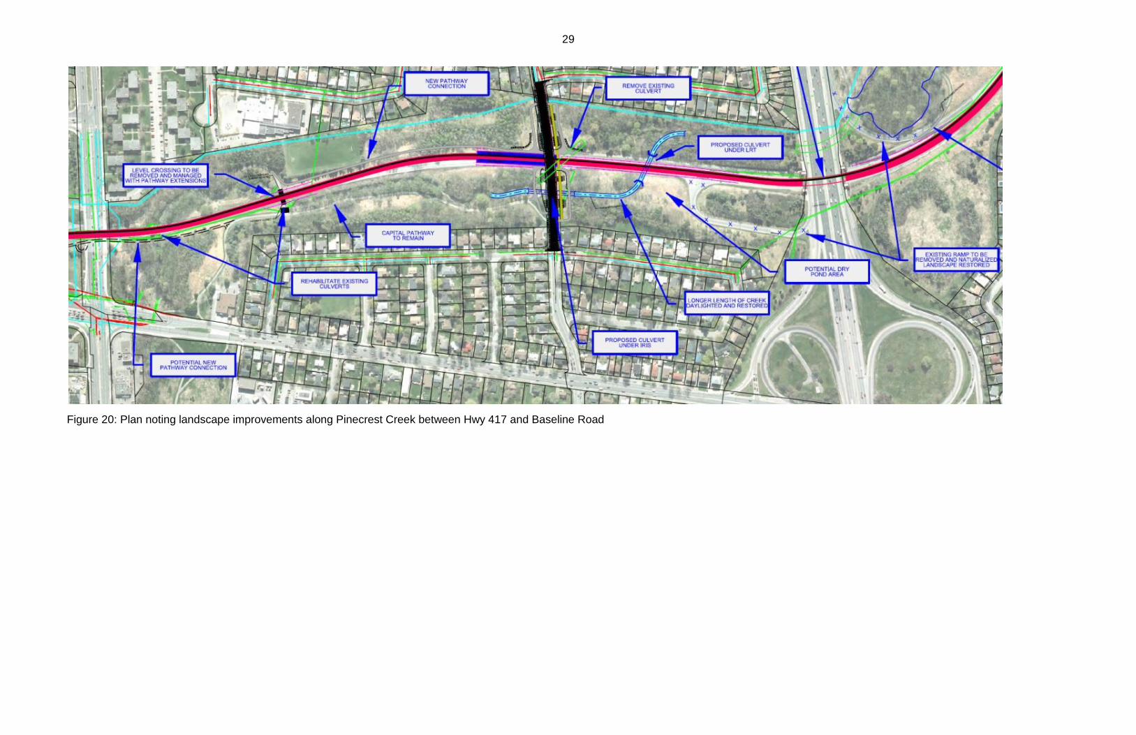
Pinecrest Creek Corridor
25
The existing Transitway and future LRT runs through the Pinecrest Creek Corridor on
NCC lands. Work with the NCC to address potential areas of concern with respect to
construction and operation through the Pinecrest Creek Corridor remains ongoing and
the outcomes can be summarised under the following three key areas of interest:
pathway connectivity; visual impacts and landscape quality, and creek environmental
quality and storm water management.
Pathway Connectivity
• The continuity of existing Capital Pathway in the corridor and pathway links to
communities will be maintained. Further work with NCC to refine future pathways
will ensure they are easy to follow and connect to the Capital Pathway Network
and near-by community destinations.
• To create sufficient clearance over the junction overpass, the Sackville Avenue
multi-use pathway bridge over the present day Transitway /future LRT route will
have to be relocated. The relocated bridge will continue to serve the same
destination such as the high school and other community destinations.
• The existing westbound on-ramp to Highway 417 will be decommissioned
(including the at-grade pathway crossing).
• The continuity of the Capital Pathway along the creek will be maintained since
the extension to Bayshore will bridge over the creek and the pathway.
• The planned Iris Street bridge structure is designed to serve many modes and
would maintain the continuity of community cycling on Iris Street as well as the
Capital Pathway and community pathway links along the creek valley.
• The at-grade pathway crossing of the Transitway just north of Baseline Avenue
will have to be closed and connectivity between community destinations,
including Baseline Station and Algonquin College, and the Capital Pathway, can
be maintained in the creek corridor by an extension of the pathway south, along
the east side of the LRT, under the Baseline overpass to Navaho Drive.
Visual Impact and Landscape Quality
• Landscaping elements and visual impacts will continue to be assessed in
cooperation with the NCC, with berms and vegetation strategically located to
reduce the visual presence of elements such as the Pinecrest Junction and Iris
Street Station and bridge.
• Ecological design principles will be used to restore the creek corridor landscape
including naturalistic landscape forms, vegetation groupings and native plant
materials.
26
• The NCC is reviewing its Parkway Policy and exploring opportunities to enhance
the park landscape character of the parkway corridor, including opportunities to
create a renewed “gateway” to the parkway by reorganising the intersection of
the Sir John A Macdonald Parkway route with the streets of the urban area. The
functional design for the LRT has flexibility and opportunity to coordinate and be
compatible with options that may be developed by the NCC as they continue to
explore this aspect of capital planning and design.
Creek Environmental Quality and Storm Water Management
For many years Pinecrest Creek has been showing indications of environmental stress.
Incremental modifications to the creek and valley, upstream urban development, and
major pipe and transportation infrastructure have contributed to a deteriorated creek
corridor. As part of the construction of the Western LRT, there are many opportunities to
implement recommendations in existing City and NCC studies for the Pinecrest Creek.
The environmental assessment will identify a range of opportunities to address storm
water management issues and implement environmental design measures to address
water quality and quantity at the detail design stage.
Among the recommendations in these environmental reports, a number of measures
can be implemented in concert with LRT design and construction to improve
environmental quality of the creek corridor and create storm water storage and
detention capacity. They include:
Creating additional natural creek channels by relocating the major pipe inlet,
shortening the piped segment, and “daylighting” more creek with naturalised
banks;
Restoring creek valley lands by re-grading disturbed and open landscape lands
to create a new food plain;
Creating spillways and other measures to diffuse storm flow energies and interim
storm water storage and detention capacity; and,
Following environmental engineering best practices to restore naturalised creek
banks.
Adressing the impacts of major storm events that sweep down the creek valley will
require specific measures. The Pinecrest Creek is entombed in pipes and storm sewers
from Carling Avenue north to the Ottawa River. The existing pipes do not have the
capacity to handle a major 100-year storm event. This causes the back up of flood
waters (including onto the parkway and Transitway routes) and damage to the creek
banks and valley.
27
An important objective is to have the LRT operate during a 100-year storm event.
Therefore the LRT track and tunnel portals must be protected from the flood waters.
Preliminary solutions, that can be refined at the detail design stage, include:
Continuing to use the parkway roadway as part of an overland flow corridor to the
Ottawa River;
Protecting the LRT tracks by elevating them above the flood level or by creating
a flood wall barrier or a combination of the two, and
Ensuring the opening of the west tunnel portal would be above the 100-year flood
level.
The City is initiating as study to address environmental assessment requirements for a
proposed retrofit storm water management pond to be located on NCC property at the
northeast corner of Baseline Road and Woodroffe Avenue. The study will also include
an assessment of the cumulative impacts on Pinecrest Creek of the retrofit pond and a
number of other City projects and will recommend mitigating measures. With an
anticipated completion date of late 2016, the study will not be completed in time to
inform the environmental assessment for the Western LRT. However, the study scope
will include the assessment of, and recommended measures, to mitigate the cumulative
impacts of all anticipated City projects, including the Western LRT. Should the study
identify additional mitigating measures beyond those identified in the Western LRT EA
documentation, such measures can be incorporated at a later design stage in
coordination with the City’s work with the NCC.
28
Figure 19: Plan noting landscape improvements along Pinecrest Creek between Lincoln Fields Station and Hwy 417
29
Figure 20: Plan noting landscape improvements along Pinecrest Creek between Hwy 417 and Baseline Road
30
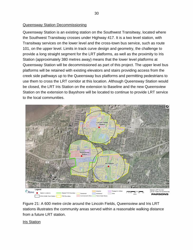
Queensway Station Decommissioning
Queensway Station is an existing station on the Southwest Transitway, located where
the Southwest Transitway crosses under Highway 417. It is a two level station, with
Transitway services on the lower level and the cross-town bus service, such as route
101, on the upper level. Limits in track curve design and geometry, the challenge to
provide a long straight segment for the LRT platforms, as well as the proximity to Iris
Station (approximately 380 metres away) means that the lower level platforms at
Queensway Station will be decommissioned as part of this project. The upper level bus
platforms will be retained with existing elevators and stairs providing access from the
creek side pathways up to the Queensway bus platforms and permitting pedestrians to
use them to cross the LRT corridor at this location. Although Queensway Station would
be closed, the LRT Iris Station on the extension to Baseline and the new Queensview
Station on the extension to Bayshore will be located to continue to provide LRT service
to the local communities.
Figure 21: A 600 metre circle around the Lincoln Fields, Queensview and Iris LRT
stations illustrates the community areas served within a reasonable walking distance
from a future LRT station.
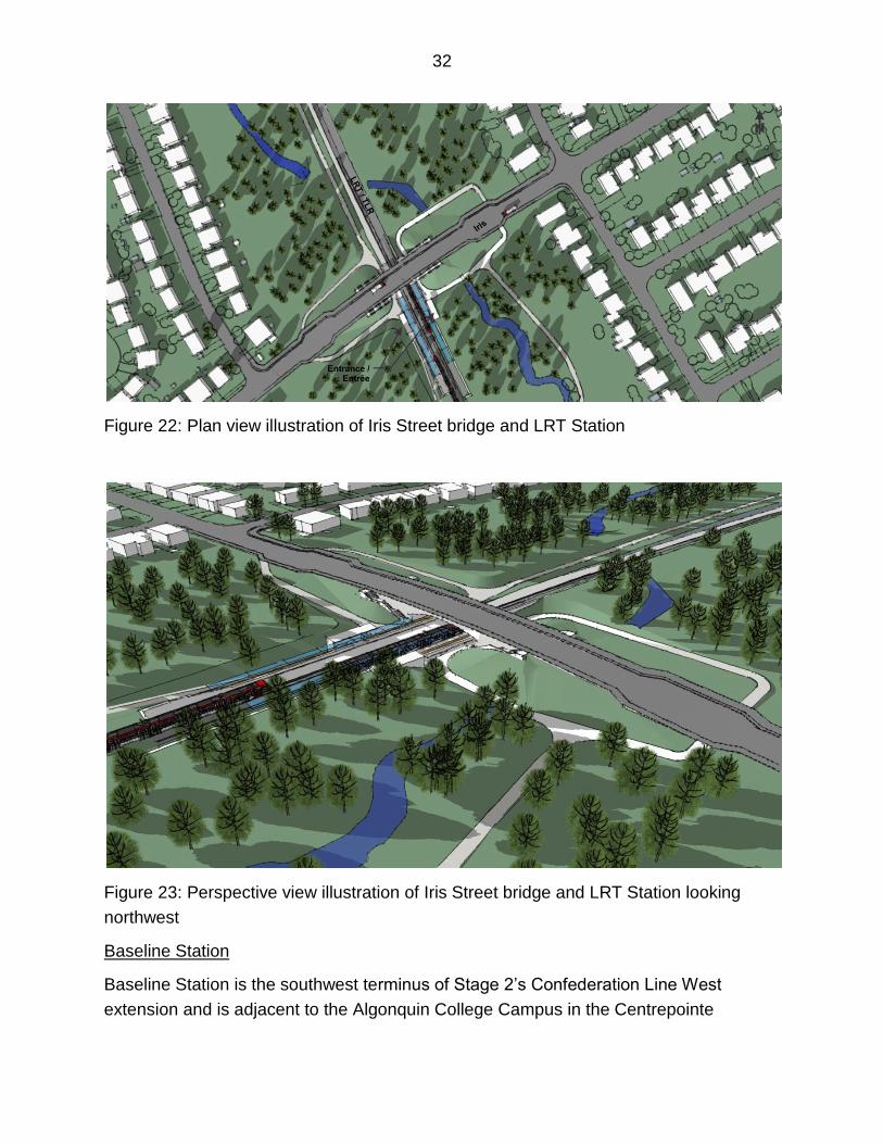
Iris Station
31
Iris Station is an existing Transitway station with basic platforms and shelters to the
south (southbound) and north (northbound) of Iris Street between Parkway Drive and
Adirondak Drive. The Southwest Transitway currently crosses Iris Street at grade. At-
grade intersections with LRT service will be eliminated as part of the Confederation Line
extensions. The station will be completely replaced in conjunction with a new Iris Street
overpass as part of the plan to provide grade separation between the LRT and Iris
Street. The station and bridge design makes use of the natural terrain and elevations,
creating a low impact design that fits into the natural and community context. The bridge
design features make use of a “half-up/half-down” configuration with open air platforms
in the creek valley slightly below street level and a new Iris Street bridge passing over
the LRT. Ramps, following the natural slopes of the creek valley, will provide access the
station rather than elevators to minimize the station’s visual impact, as well as
construction and on-going operating costs.
Other features include:
Side platform configuration, with station entrances on both sides of the LRT
alignment, connected to Iris Street via ramps and stairs;
Reduced overall footprint for the bridge design, with no property acquisition
requirements;
Bridge structure that will serve many modes and maintain pedestrian and cycling
continuity along Iris Street, and provide access to the Capital Pathway, and
community links along the creek valley;
Better definition of existing informal passenger pick-up and drop-off areas along
Iris Street;
Provision of local bus interchange with LRT at on-street stops at the east and
west ends of the bridge; and,
Re-alignment and relocation of Pinecrest Creek to create a longer length of open
and naturalized creek channel that will flow along the east side of the LRT
corridor before passing under the LRT track. The creek is currently entombed in
a long pipe under where Iris Street and the Transitway intersect.
32
Figure 22: Plan view illustration of Iris Street bridge and LRT Station
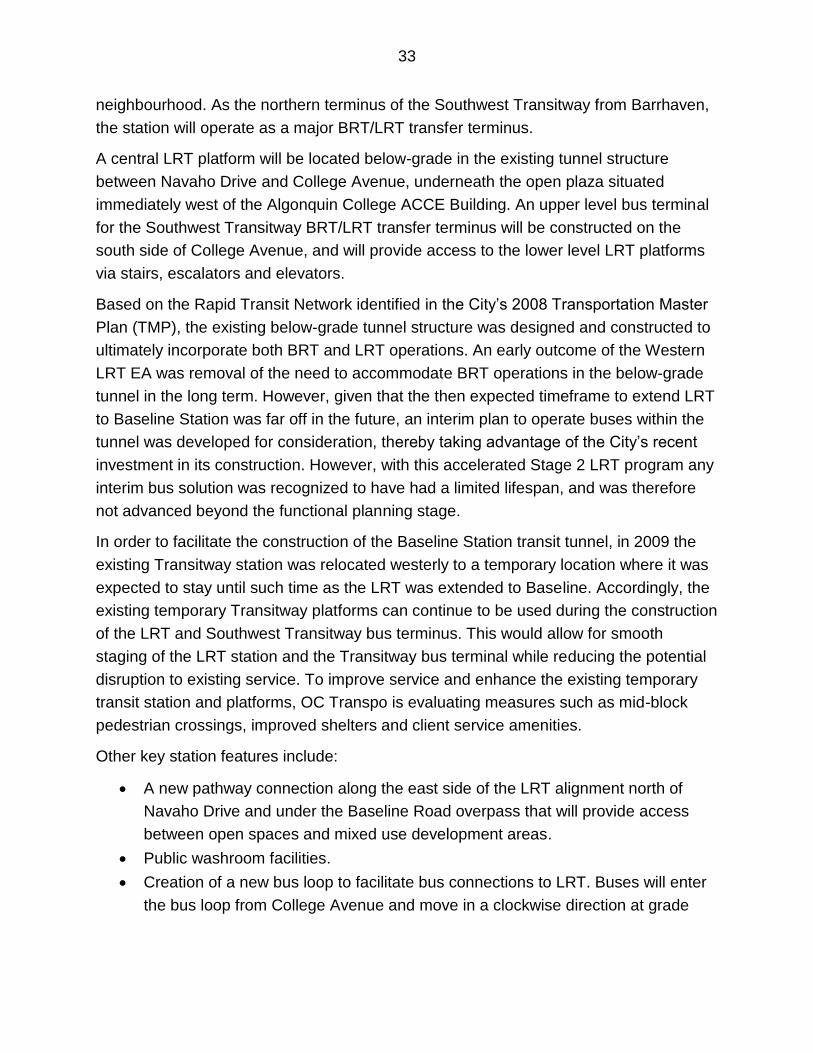
Figure 23: Perspective view illustration of Iris Street bridge and LRT Station looking
northwest
Baseline Station
Baseline Station is the southwest terminus of Stage 2’s Confederation Line West
extension and is adjacent to the Algonquin College Campus in the Centrepointe
33
neighbourhood. As the northern terminus of the Southwest Transitway from Barrhaven,
the station will operate as a major BRT/LRT transfer terminus.
A central LRT platform will be located below-grade in the existing tunnel structure
between Navaho Drive and College Avenue, underneath the open plaza situated
immediately west of the Algonquin College ACCE Building. An upper level bus terminal
for the Southwest Transitway BRT/LRT transfer terminus will be constructed on the
south side of College Avenue, and will provide access to the lower level LRT platforms
via stairs, escalators and elevators.
Based on the Rapid Transit Network identified in the City’s 2008 Transportation Master
Plan (TMP), the existing below-grade tunnel structure was designed and constructed to
ultimately incorporate both BRT and LRT operations. An early outcome of the Western
LRT EA was removal of the need to accommodate BRT operations in the below-grade
tunnel in the long term. However, given that the then expected timeframe to extend LRT
to Baseline Station was far off in the future, an interim plan to operate buses within the
tunnel was developed for consideration, thereby taking advantage of the City’s recent
investment in its construction. However, with this accelerated Stage 2 LRT program any
interim bus solution was recognized to have had a limited lifespan, and was therefore
not advanced beyond the functional planning stage.
In order to facilitate the construction of the Baseline Station transit tunnel, in 2009 the
existing Transitway station was relocated westerly to a temporary location where it was
expected to stay until such time as the LRT was extended to Baseline. Accordingly, the
existing temporary Transitway platforms can continue to be used during the construction
of the LRT and Southwest Transitway bus terminus. This would allow for smooth
staging of the LRT station and the Transitway bus terminal while reducing the potential
disruption to existing service. To improve service and enhance the existing temporary
transit station and platforms, OC Transpo is evaluating measures such as mid-block
pedestrian crossings, improved shelters and client service amenities.
Other key station features include:
A new pathway connection along the east side of the LRT alignment north of
Navaho Drive and under the Baseline Road overpass that will provide access
between open spaces and mixed use development areas.
Public washroom facilities.
Creation of a new bus loop to facilitate bus connections to LRT. Buses will enter
the bus loop from College Avenue and move in a clockwise direction at grade
34
level. From this loop, passengers can take the stairs/escalators/elevators to the
train platforms located below-grade in the Baseline Station tunnel.
As part of a much larger urban intensification area, Baseline Station will support
the Mixed-Use Centre designation and opportunities to create Transit-Oriented
Development.
The underground structure has the capacity to not only serve as an LRT station
but as a vehicle storage and staging area. This could allow for storage of several
LRT vehicles in a covered facility so they can be ready for early service start up
during the morning and afternoon peak periods.
Figure 24: Plan view illustration Baseline LRT Station
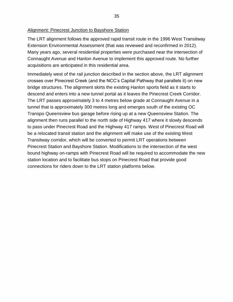
Figure 25: Perspective view illustration of Baseline LRT Station looking northeast
showing the plaza pavilion and Transitway bus terminal, as well as potential land
development parcels based on area development plans
35
Alignment: Pinecrest Junction to Bayshore Station
The LRT alignment follows the approved rapid transit route in the 1996 West Transitway
Extension Environmental Assessment (that was reviewed and reconfirmed in 2012).
Many years ago, several residential properties were purchased near the intersection of
Connaught Avenue and Hanlon Avenue to implement this approved route. No further
acquisitions are anticipated in this residential area.
Immediately west of the rail junction described in the section above, the LRT alignment
crosses over Pinecrest Creek (and the NCC’s Capital Pathway that parallels it) on new
bridge structures. The alignment skirts the existing Hanlon sports field as it starts to
descend and enters into a new tunnel portal as it leaves the Pinecrest Creek Corridor.
The LRT passes approximately 3 to 4 metres below grade at Connaught Avenue in a
tunnel that is approximately 300 metres long and emerges south of the existing OC
Transpo Queensview bus garage before rising up at a new Queensview Station. The
alignment then runs parallel to the north side of Highway 417 where it slowly descends
to pass under Pinecrest Road and the Highway 417 ramps. West of Pinecrest Road will
be a relocated transit station and the alignment will make use of the existing West
Transitway corridor, which will be converted to permit LRT operations between
Pinecrest Station and Bayshore Station. Modifications to the intersection of the west
bound highway on-ramps with Pinecrest Road will be required to accommodate the new
station location and to facilitate bus stops on Pinecrest Road that provide good
connections for riders down to the LRT station platforms below.
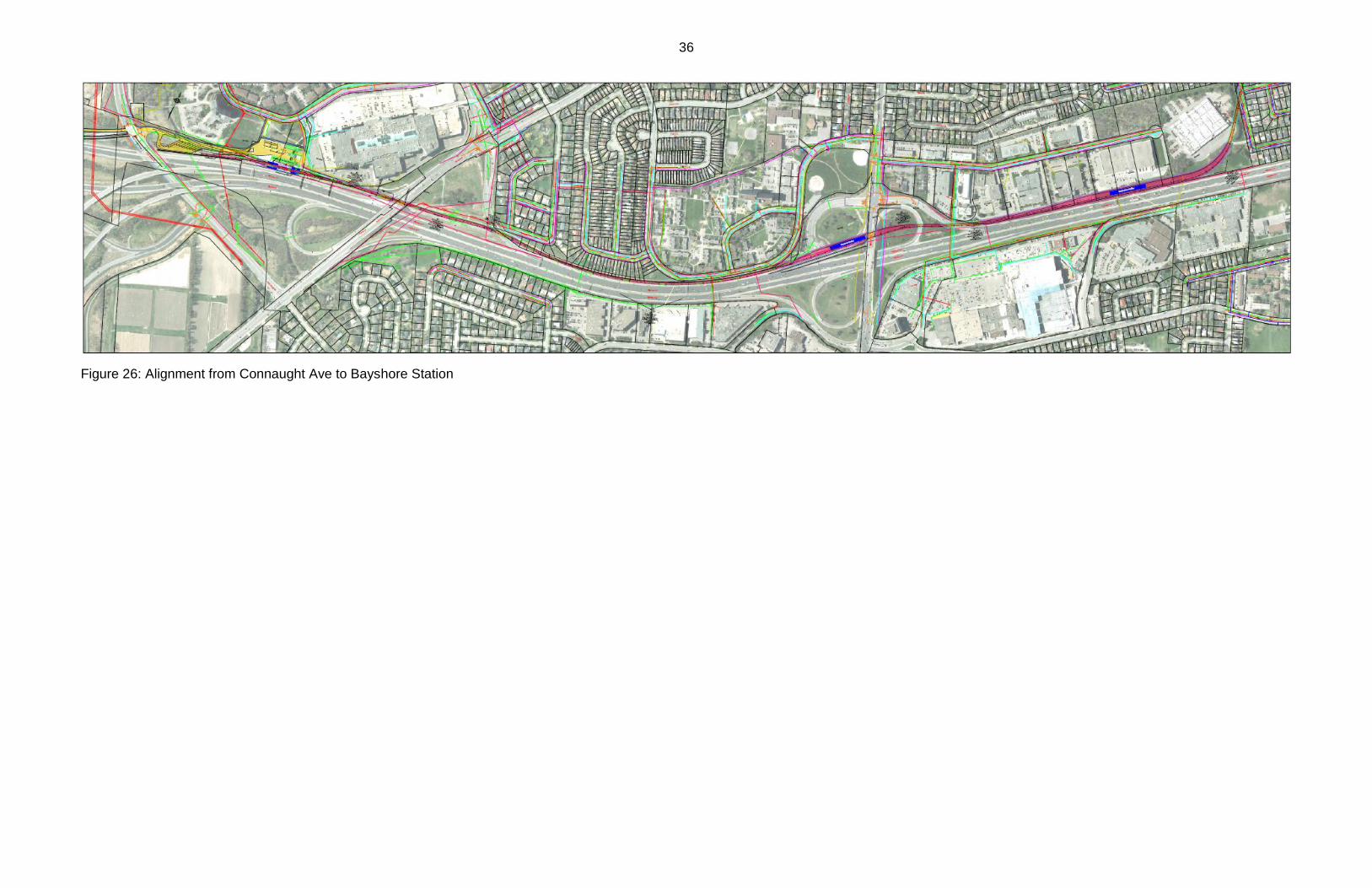
36
Figure 26: Alignment from Connaught Ave to Bayshore Station
37
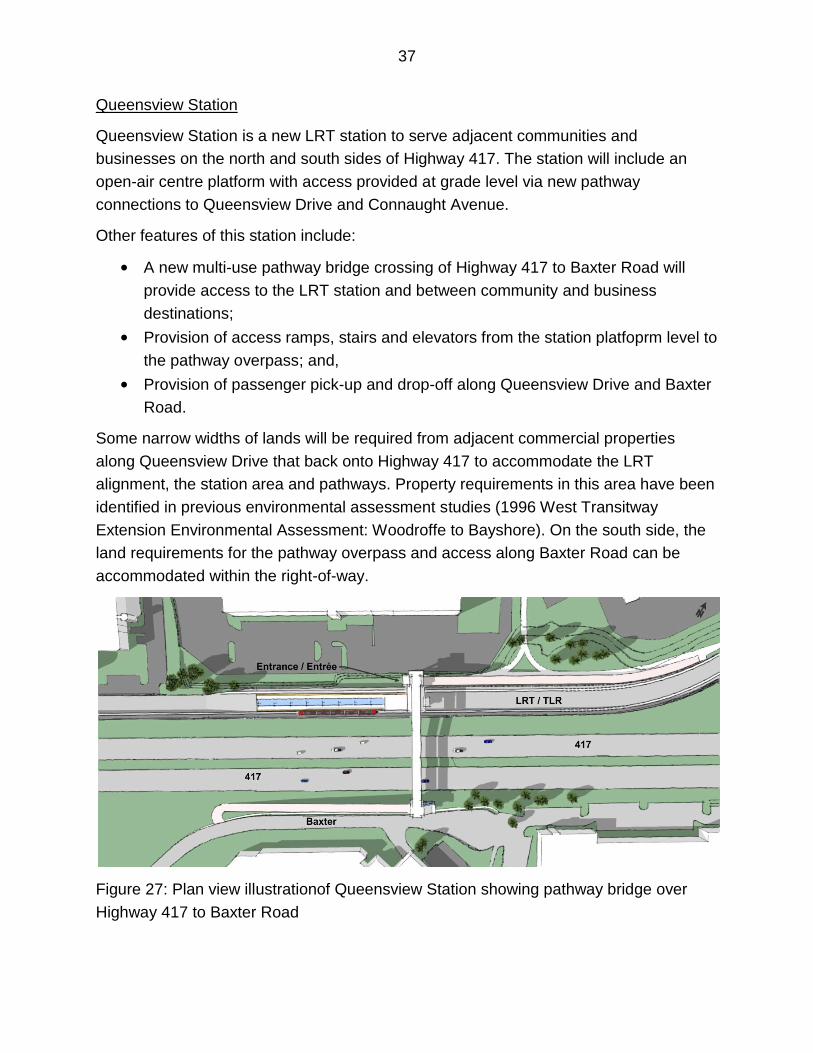
Queensview Station
Queensview Station is a new LRT station to serve adjacent communities and
businesses on the north and south sides of Highway 417. The station will include an
open-air centre platform with access provided at grade level via new pathway
connections to Queensview Drive and Connaught Avenue.
Other features of this station include:
• A new multi-use pathway bridge crossing of Highway 417 to Baxter Road will
provide access to the LRT station and between community and business
destinations;
• Provision of access ramps, stairs and elevators from the station platfoprm level to
the pathway overpass; and,
• Provision of passenger pick-up and drop-off along Queensview Drive and Baxter
Road.
Some narrow widths of lands will be required from adjacent commercial properties
along Queensview Drive that back onto Highway 417 to accommodate the LRT
alignment, the station area and pathways. Property requirements in this area have been
identified in previous environmental assessment studies (1996 West Transitway
Extension Environmental Assessment: Woodroffe to Bayshore). On the south side, the
land requirements for the pathway overpass and access along Baxter Road can be
accommodated within the right-of-way.
Figure 27: Plan view illustrationof Queensview Station showing pathway bridge over
Highway 417 to Baxter Road
38
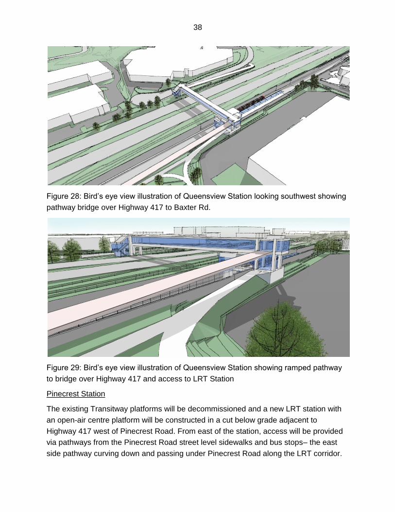
Figure 28: Bird’s eye view illustration of Queensview Station looking southwest showing
pathway bridge over Highway 417 to Baxter Rd.
Figure 29: Bird’s eye view illustration of Queensview Station showing ramped pathway
to bridge over Highway 417 and access to LRT Station
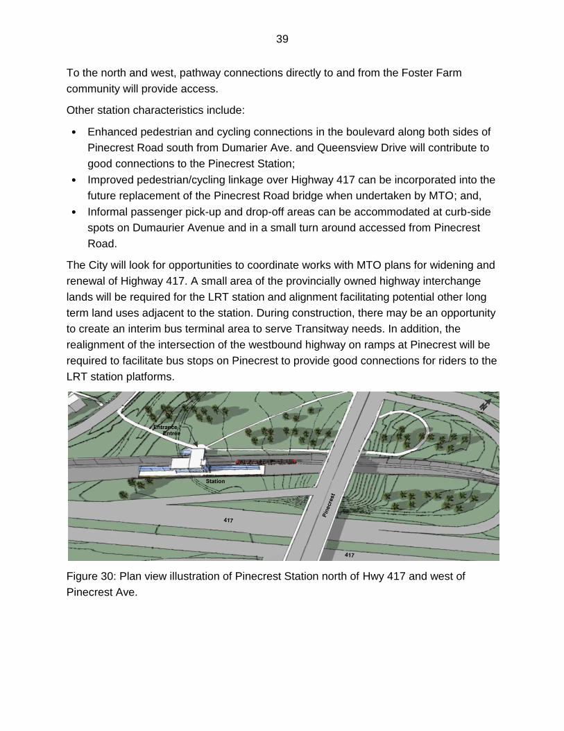
Pinecrest Station
The existing Transitway platforms will be decommissioned and a new LRT station with
an open-air centre platform will be constructed in a cut below grade adjacent to
Highway 417 west of Pinecrest Road. From east of the station, access will be provided
via pathways from the Pinecrest Road street level sidewalks and bus stops– the east
side pathway curving down and passing under Pinecrest Road along the LRT corridor.
39
To the north and west, pathway connections directly to and from the Foster Farm
community will provide access.
Other station characteristics include:
• Enhanced pedestrian and cycling connections in the boulevard along both sides of
Pinecrest Road south from Dumarier Ave. and Queensview Drive will contribute to
good connections to the Pinecrest Station;
• Improved pedestrian/cycling linkage over Highway 417 can be incorporated into the
future replacement of the Pinecrest Road bridge when undertaken by MTO; and,
• Informal passenger pick-up and drop-off areas can be accommodated at curb-side
spots on Dumaurier Avenue and in a small turn around accessed from Pinecrest
Road.
The City will look for opportunities to coordinate works with MTO plans for widening and
renewal of Highway 417. A small area of the provincially owned highway interchange
lands will be required for the LRT station and alignment facilitating potential other long
term land uses adjacent to the station. During construction, there may be an opportunity
to create an interim bus terminal area to serve Transitway needs. In addition, the
realignment of the intersection of the westbound highway on ramps at Pinecrest will be
required to facilitate bus stops on Pinecrest to provide good connections for riders to the
LRT station platforms.
Figure 30: Plan view illustration of Pinecrest Station north of Hwy 417 and west of
Pinecrest Ave.
40
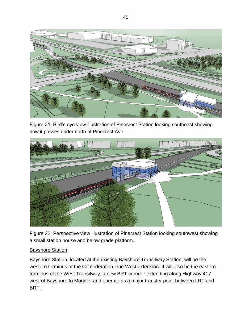
Figure 31: Bird’s eye view illustration of Pinecrest Station looking southeast showing
how it passes under north of Pinecrest Ave.
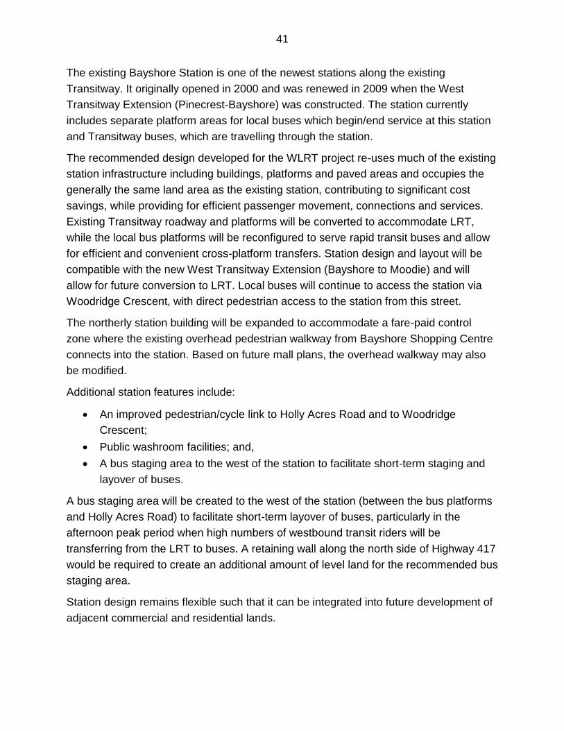
Figure 32: Perspective view illustration of Pinecrest Station looking southwest showing
a small station house and below grade platform.
Bayshore Station
Bayshore Station, located at the existing Bayshore Transitway Station, will be the
western terminus of the Confederation Line West extension. It will also be the eastern
terminus of the West Transitway, a new BRT corridor extending along Highway 417
west of Bayshore to Moodie, and operate as a major transfer point between LRT and
BRT.
41
The existing Bayshore Station is one of the newest stations along the existing
Transitway. It originally opened in 2000 and was renewed in 2009 when the West
Transitway Extension (Pinecrest-Bayshore) was constructed. The station currently
includes separate platform areas for local buses which begin/end service at this station
and Transitway buses, which are travelling through the station.
The recommended design developed for the WLRT project re-uses much of the existing
station infrastructure including buildings, platforms and paved areas and occupies the
generally the same land area as the existing station, contributing to significant cost
savings, while providing for efficient passenger movement, connections and services.
Existing Transitway roadway and platforms will be converted to accommodate LRT,
while the local bus platforms will be reconfigured to serve rapid transit buses and allow
for efficient and convenient cross-platform transfers. Station design and layout will be
compatible with the new West Transitway Extension (Bayshore to Moodie) and will
allow for future conversion to LRT. Local buses will continue to access the station via
Woodridge Crescent, with direct pedestrian access to the station from this street.
The northerly station building will be expanded to accommodate a fare-paid control
zone where the existing overhead pedestrian walkway from Bayshore Shopping Centre
connects into the station. Based on future mall plans, the overhead walkway may also
be modified.
Additional station features include:
An improved pedestrian/cycle link to Holly Acres Road and to Woodridge
Crescent;
Public washroom facilities; and,
A bus staging area to the west of the station to facilitate short-term staging and
layover of buses.
A bus staging area will be created to the west of the station (between the bus platforms
and Holly Acres Road) to facilitate short-term layover of buses, particularly in the
afternoon peak period when high numbers of westbound transit riders will be
transferring from the LRT to buses. A retaining wall along the north side of Highway 417
would be required to create an additional amount of level land for the recommended bus
staging area.
Station design remains flexible such that it can be integrated into future development of
adjacent commercial and residential lands.
42
Other than a small triangular piece of land internal to the station in the vicinity of the bus
platforms, no additional lands beyond those previously identified as part of the West
Transitway Extension EA will be required.
To accommodate the bus staging area at the west end of Bayshore Station, the grade-
separated Transitway overpass across Holly Acres Road, recommended as part of the
previous West Transitway Extension (Bayshore to Moodie) EA, would be deferred.
Instead, the existing at-grade Holly Acres Road/Bayshore intersection will be
maintained, with modifications to permit two-way (east/west) bus traffic and to
accommodate the Highway 417 westbound on-ramp from Holly Acres Road and
improve cycling and pedestrian movements across this intersection.
It should be noted that the approved EA study for the Transitway section to the east
(West Transitway Extension (Woodroffe to Bayshore)) recommended an at-grade
connection at Holly Acres Road. The grade-separation would only be needed when the
Transitway was extended further west of Holly Acres Road towards Kanata. Given the
latest review of transit service, an at-grade crossing of Holly Acres is still viable and the
grade-separation solution can be deferred. This represents a modification to the existing
West Transitway Extension (Holly Acres to Moodie) and will be documented in the
Environmental Project Report for the Confederation Line Western Extension.
The sound attenuation walls that were identified by the Ministry of Transportation to be
implemented as part of the West Transitway Extension (Holly Acres to Moodie) project
to address highway noise remain part of the current project.
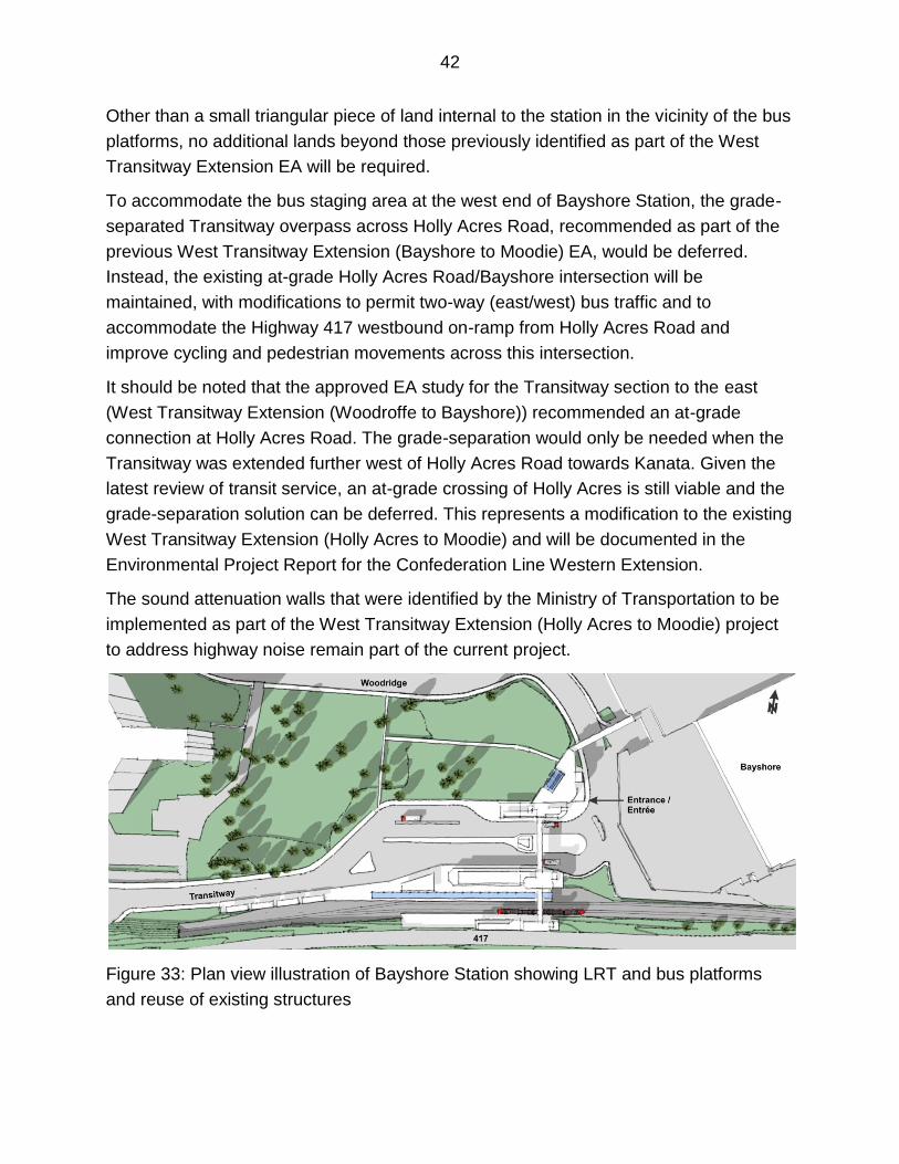
Figure 33: Plan view illustration of Bayshore Station showing LRT and bus platforms
and reuse of existing structures
43
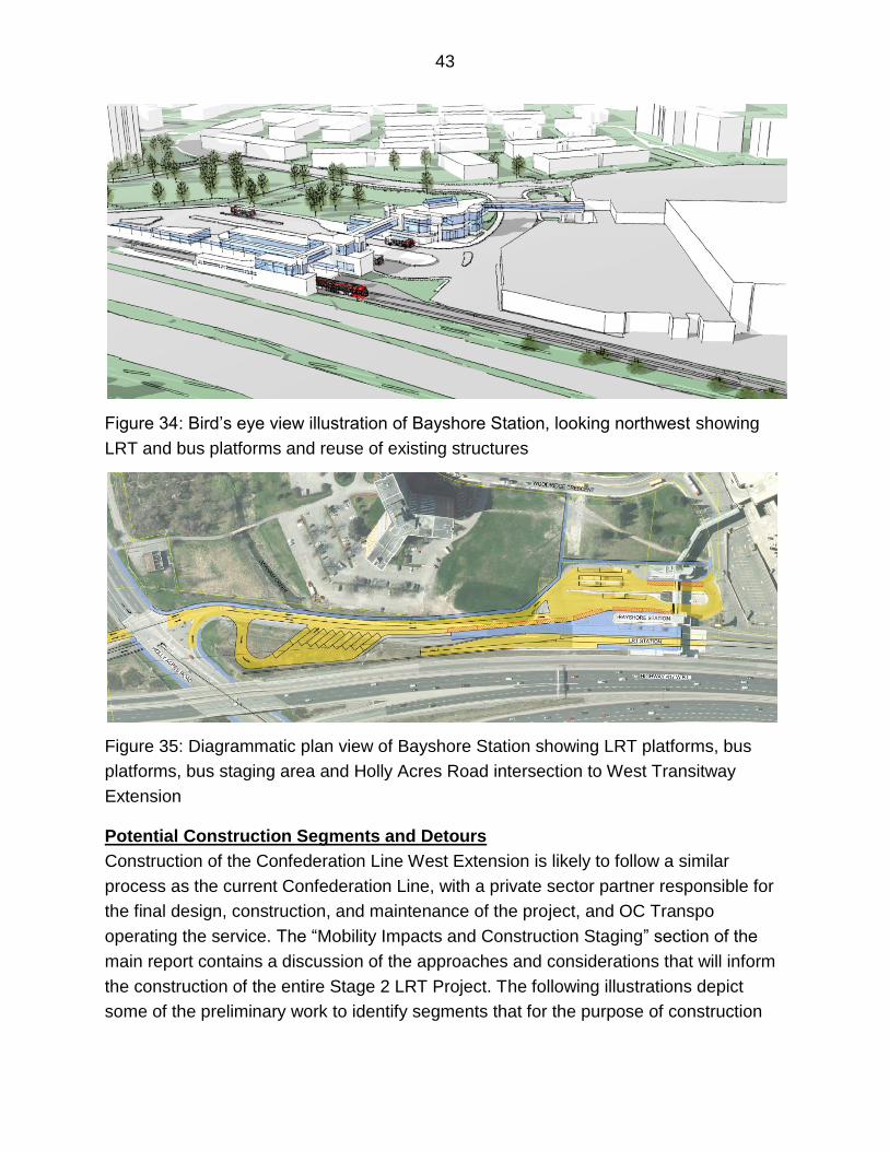
Figure 34: Bird’s eye view illustration of Bayshore Station, looking northwest showing
LRT and bus platforms and reuse of existing structures
Figure 35: Diagrammatic plan view of Bayshore Station showing LRT platforms, bus
platforms, bus staging area and Holly Acres Road intersection to West Transitway
Extension
Potential Construction Segments and Detours
Construction of the Confederation Line West Extension is likely to follow a similar
process as the current Confederation Line, with a private sector partner responsible for
the final design, construction, and maintenance of the project, and OC Transpo
operating the service. The “Mobility Impacts and Construction Staging” section of the
main report contains a discussion of the approaches and considerations that will inform
the construction of the entire Stage 2 LRT Project. The following illustrations depict
some of the preliminary work to identify segments that for the purpose of construction
44
may assist in work to minimize impacts rapid transit service, local bus service, area
traffic and properties, as well as reduce the severity and duration of detours.
Segment 1: Dominion to south of Lincoln Fields
• Can be constructed without major impacts to existing rapid transit service
• Construction will require localized detours for both transit service and general
traffic
• Pathway connectivity maintained for pedestrians and cyclists
Figure 36: Segment 1 - Dominion to south of Lincoln Fields
Segment 2: Tunney's Pasture to Dominion
Affects Transitway Service
• Transitway closed east of Dominion Station – all services rerouted and course to
be determined
• Local bus service along Richmond/Scott
Some local impacts along route
• More immediate and temporary impacts associated with station construction
• Some local property access may be restricted or altered but emergency access
will always be maintained
45
Supplemental transit service opportunities include:
• Carling/Woodroffe/Richmond/Churchill/Scott
• Sir John A Macdonald Parkway
• Carling/Holland
Other transit diversions could include:
• Bus rapid transit (BRT) lanes on Baseline Road
• Use of Highway 417 for peak period bus serivce
• Buses from Barrhaven via Riverside South to the Trillium Line and Southeast
Transitway
Figure 37: Tunney's Pasture to Dominion
Segment 3: Pinecrest to Bayshore
LRT open to Lincoln Fields
• Possible temporary bus terminal expansion could accommodate transfers
Affects Transitway Service
West Transitway between Pinecrest Station and Bayshore closed to permit
conversion to LRT.
46
Transitway service diversions could include:
• Highway 417/Pinecrest/Richmond/Carling
Some local construction impacts along route including
• Temporary detours for traffic, transit, cyclist and pedestrians during construction
• Alterations to highway ramps from Pinecrest to Highway 417 ramps and
construction of new road structures over LRT will impact all modes.
Figure 38: Segment 3 – Pinecrest to Bayshore
Segment 4: Lincoln Fields to Baseline
LRT open to Lincoln Fields
• Possible temporary bus terminal expansion could accommodate transfers
Affects Transitway Service
Southwest Transitway between Lincoln Fields and Baseline Stations closed to
permit conversion to LRT.
Transitway diversions could include:
Woodroffe/Carling
Buses from Barrhaven via Riverside South to the Trillium Line and Southeast
Transitway
47
Buses to/from Kanata and Bayshore continue to divert via Highway
417/Pinecrest/Carling
Some local impacts along route
• Closure of Iris Street to construct new bridge will require temporary detours for all
travel modes.
• Pathways within Pinecrest Creek corridor will need to be closed or diverted to
permit construction of new structures
Figure 39: Segment 4 – Lincoln Fields to Baseline
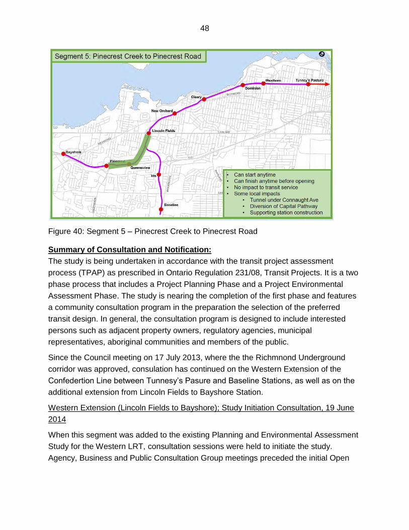
Segment 5: Pinecrest Creek to Pinecrest Road
• Can start anytime
• Can finish any time before opening
No impact to transit service
Some local impacts along route
• Tunnel under Connaught Avenue will require temporary roadway detours but
access will always be maintained
• Diversion of Capital Pathway around new LRT alignment
• More immediate and temporary impacts associated with station construction
48
Figure 40: Segment 5 – Pinecrest Creek to Pinecrest Road
Summary of Consultation and Notification:
The study is being undertaken in accordance with the transit project assessment
process (TPAP) as prescribed in Ontario Regulation 231/08, Transit Projects. It is a two
phase process that includes a Project Planning Phase and a Project Environmental
Assessment Phase. The study is nearing the completion of the first phase and features
a community consultation program in the preparation the selection of the preferred
transit design. In general, the consultation program is designed to include interested
persons such as adjacent property owners, regulatory agencies, municipal
representatives, aboriginal communities and members of the public.
Since the Council meeting on 17 July 2013, where the the Richmnond Underground
corridor was approved, consulation has continued on the Western Extension of the
Confedertion Line between Tunnesy’s Pasure and Baseline Stations, as well as on the
additional extension from Lincoln Fields to Bayshore Station.
Western Extension (Lincoln Fields to Bayshore); Study Initiation Consultation, 19 June
2014
When this segment was added to the existing Planning and Environmental Assessment
Study for the Western LRT, consultation sessions were held to initiate the study.
Agency, Business and Public Consultation Group meetings preceded the initial Open
49
House for this segment on 19 June 2015 at the Foster Farm Community Centre. 23
people signed the registry at the open house.
The following is a summary of the comments:
Footbridge over Highway 417 is very important to success of LRT project, and
should be directly connected to Queensview Station, and should provide linkages
to residential areas south of the Queensway;
Seek opportunities to improve accessibility of pedestrians and cyclists to stations;
Include area from Bayshore Station to Moodie Drive into study area;
Make the tunnel in the vicinity of Connaught Ave as long as possible to have
minimal impact on residents of Queensway Terrace North;
Minimize disruption to neighbourhood during construction, and operating trains
should not be felt inside homes;
Address impact of greater number of transfers at Bayshore and possible need to
increase loading bays; and
Address interim bus travel from the Sir John A. Macdonald Parkway to west
Ottawa, while LRT is being built.
Public Open House notification included: announcements in all the EMC community
newspapers and in LeDoit and on the City web pages; e-mailed letters to identified First
Nations groups; a flyer drop to residents and business abutting the corridor, as well as
e-notices forwarded by the community associations.
Joint announcement by the NCC and City of Ottawa regarding the 100-Day Working
Group recommended solution,6 March 2015
On 6 March 2015, the City of Ottawa and the NCC hosted a public announcement on
the outcomes and recommendations following the 100-Day Working Group review.
Communications in support of the 6 March 2015 joint announcement by the NCC and
City of Ottawa regarding the 100-Day Working Group preferred solution included:
Updates to both the NCC and City web pages with documentation from the 100-
Day Working Group, including a Memorandum of Understanding.
E-mails to directly affected landowners in the vicinity of Cleary and Dominion
Stations; Community Association in the study area and key provincial and federal
contacts selected from the Confederation Line Stage 1 process
50
Small group meetings with community associations and interest groups, directly
affected private and institutional landowners, and individuals invited by the Ward
Councillors where elected official on the100-day Working Group, City senior
management and the Ward Councillors attended.
Pubic Open House on the 100-Day Working Group preferred solution, 30 March 2015
Following the joint announcement between the City of Ottawa and the National Capital
Commission's (NCC) 100-Day Working Group, an Open House was held on 30 March
2015 in Jean Pigott Place at Ottawa City Hall to provide the public the opportunity
review and provide feedback on the proposed alignment between Dominion and Cleary
Stations. The open house included display panels, a presentation and a question and
answer session. 210 people sign the registry and Council Chambers was full. City
representative from the 100-Day Working Group and senior staff from the NCC (Steven
Willis) and the City (Nancy Schepers) and the study team were available to answer
questions.
A common response provided o the comment sheets and follow-up e-mails was one of
support for the compromise on the alignment and burying a portion of the LRT. Other
responses included:
Support for the plan that was put forward;
Concerns for adverse impacts (noise, vibration, lighting, construction) of Cleary
station on the Unitarian Church, Unitarian House and the River Parkway
Children's Centre
Bury more or all of the remaining exposed tracks at Dominion Station;
Concerns over capacity to handle pedestrians, motorists and passenger drop-off
at Cleary Station
Consider Rochester Park as a station instead of Dominion Station;
Lack of support for the location/design/requirement of Dominion and Cleary
Station;
Concerns in the vicinity of Dominion Station: traffic, passenger drop-offs;
inadequate sidewalks
Support for and desire to see improvements to pathways along the south side of
John A. MacDonald Parkway
28 comment sheets were prepared at the open house and a similar number
correspondences were recieved by e-mail and post afterwards. While concerns still
51
exist over station location, design, and impact on their surroundings, the number of
comment sheets have declined significantly compared to the June 2013 Open House
Notification for the Public Open House on the 100-Day Solution; 30 March 2015; Ottawa
City Hall included:
Advertisements in all the EMC community newspapers and in LeDoit
Announcement on the City web page
e-mail letters to identified First Nations representatives (4 groups)
e-mail notification to Agency, business, and public consultation groups
Over 4100 flyers dropped to the door of residences and business in the vicinity of
the study area
E-news letter to over 1000 subscribers (770 English and almost 400 French)
Public Service Announcements (PSA)
Open House display boards were posted to the City web pages after the event
On-going consultation with the National Capital Commission (NCC)
Throughout the study, consultation and communications with the National Capital
Commission (NCC) has been an on-going component of the consultation process.
Since July 2013 consultation has continued, including:
22 January 2014 – Senior City staff provided an update on the Western LRT
Study to the NCC Board of Directors;
22 April 2015 – the NCC Board of Directors approved the NCC-City of Ottawa
Memorandum of Understanding for the Use of the Sir John A. Macdonald
Parkway for the Western Expansion of Light Rail;
23 April 2015 – the 100-Day Working Group met and was briefed on the progress
in the planning and environmental assessment and the functional design for the
Pinecrest Creek Corridor;
Between February 2014 and April 2015 there have been 10 staff level City-NCC
meetings and work sessions addressing various detailed aspects of the planning
and environmental assessment study and the recommended plan.
Confederation Line West LRT Extension Study from Tunney's Pasture to Baseline and
Bayshore Stations Public Open House, 29 April 2015
52
On 29 April 2015, a final Open House was held in Jean Pigott Hall, Ottawa City Hall to
allow the public to review and provide feedback on the recommendations for the
Confederation Line West LRT Extension study from Tunney’s Pasture to Baseline and
Bayshore Stations. The open house included display panels, a presentation and a
question and answer session. Agency, Business and Public Consultation Group
meetings preceded this final open house. A total of 85 people signed in over the course
of the evening. 11 questionnaires were completed at the open house and five e-mails
were received afterwards. The most common response was one of support for the plan
being put forward and general commentary on station design and implementation. While
concerns still exist over station location, design, and impact on the surrounding
community, the number of comment sheets have declined significantly. The following
are the other most frequently discussed issues or concerns in the comment-
questionnaires:
Concern over station design and impacts on immediate neighbourhood and
properties;
Support the plan that was put forward;
Request that direct and uninterrupted multi-use pathways be provided;
Enjoyed the style of the consultation and presentation;
Notification of the Open House included:
Advertisements in all the EMC community newspapers and in LeDoit
Notice on the City of Ottawa’s study consultation web pages;
E-newsletter (to over 1000 subscribers)
Web postings, e-mails or “Tweets” by community associations and local area
Councillors
e-mail notification to agency, business, and public consultation groups
A Public Service Announcement (PSA)
e-mail to identified First Nations representatives (4 groups)
The following First Nations groups were notified during each of the rounds of
consultation.
Algonquins of Ontario Consultation Office
Algonquins of Pikwakangan

53
Kitigan Zibi Anishinabeg First Nation
Métis Nation of Ontario