Embed Size (px)
Citation preview
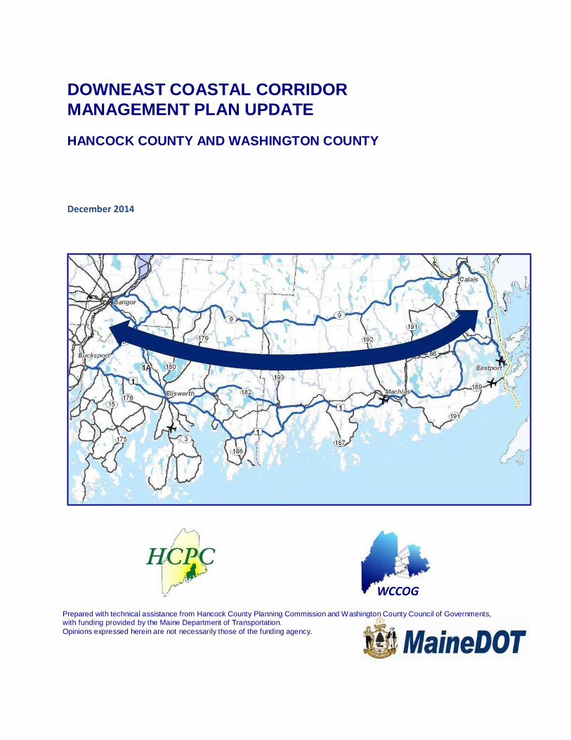
DOWNEAST COASTAL CORRIDOR
MANAGEMENT PLAN UPDATE
HANCOCK COUNTY AND WASHINGTON COUNTY
December 2014
WCCOG Prepared with technical assistance from Hancock County Planning Commission and Washington County Council of Governments, with funding provided by the Maine Department of Transportation.
Opinions expressed herein are not necessarily those of the funding agency.
Table of Contents 1 INTRODUCTION ................................................................................................................................................. 4
1.1 The Downeast Coastal Corridor ....................................................................................................................... 4
2 OVERVIEW OF EXISTING CONDITIONS .................................................................................................................... 6
2.1 VEHICLE MILES TRAVELED ................................................................................................................................ 6
2.2 TRANSPORTATION FACILITIES .......................................................................................................................... 8
2.2.1 Highways ................................................................................................................................................... 8
2.2.2 Bicycle and pedestrian facilities .............................................................................................................. 10
2.2.3 Transit service ......................................................................................................................................... 11
2.2.4 Rail facilities and service ......................................................................................................................... 12
2.2.5 Ports and marine service ........................................................................................................................ 13
2.2.6 Airports ................................................................................................................................................... 14
2.2.7 Designated Scenic Byways ...................................................................................................................... 15
2.3 CHARACTERISTICS OF THE DOWNEAST COASTAL CORRIDOR ........................................................................ 15
2.3.1 Existing Transportation System Deficiencies ........................................................................................... 15
2.3.2 Projected demographics and development patterns ............................................................................. 16
2.3.3 Emerging Land Use Trends ..................................................................................................................... 19
2.3.4 Review of Existing Local and Regional Plans ........................................................................................... 20
3 DRIVING FORCES ................................................................................................................................................... 21
4 SCENARIO UPDATES .............................................................................................................................................. 29
4.1 DOWNEAST COASTAL CORRIDOR SCENARIOS (CIRCA 2030) ......................................................................... 29
4.1.1 Energy Led Development ........................................................................................................................ 29
4.1.2 Tourism and Seasonal Resident Growth and Diversification .................................................................. 30
4.1.3 Health and Human Services .................................................................................................................... 30
4.1.4 Transportation Diversification ................................................................................................................ 31
4.1.5 Status Quo .............................................................................................................................................. 31
5 RECOMMENDATIONS ........................................................................................................................................... 32
5.1 Medium-Term Recommendations ................................................................................................................. 33
5.2 Long-Term Recommendations ....................................................................................................................... 34
5.3 Prioritized Action Plan .................................................................................................................................. 35
APPENDICES ............................................................................................................................................................. 37
Appendix 1. Washington County Advisory Committee 2014 Work Session Meeting Summaries ..................... 37
Appendix 2. Washington County Advisory Committee Members and Stakeholders for 2014 Plan Update .......... 37
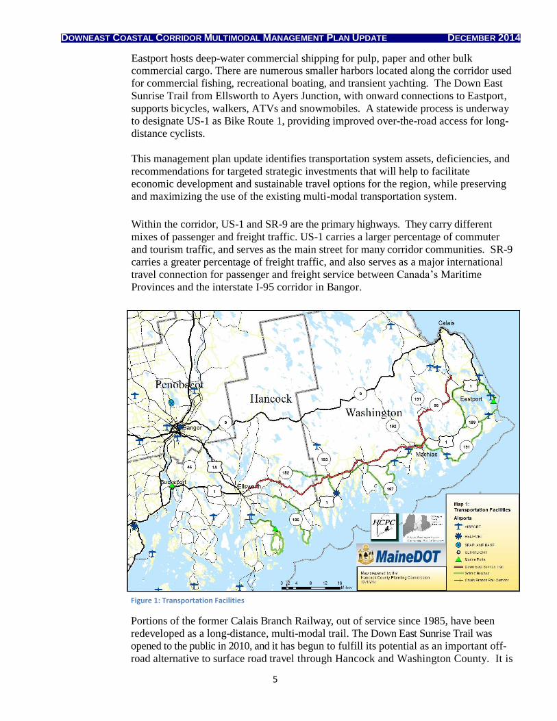
Figure 1: Transportation Facilities ............................................................................................................................. 5
Figure 2: Average Annual Daily Traffic Counts ........................................................................................................... 7
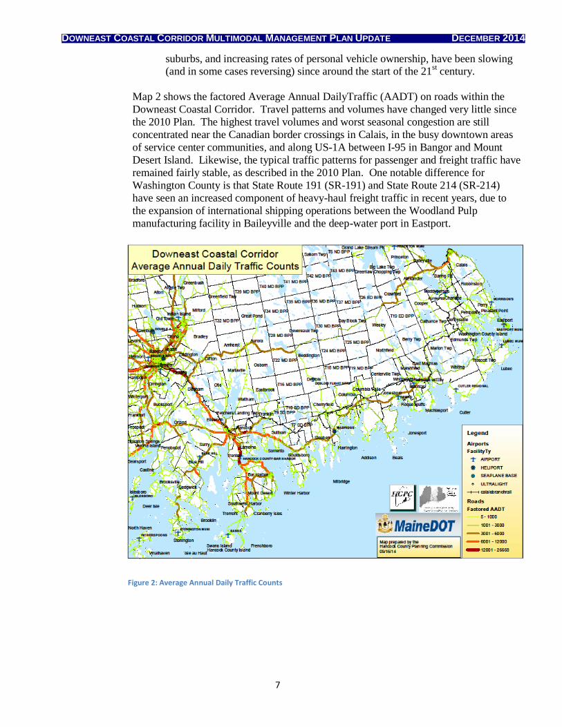
Figure 3: Daily Traffic Counts 2009 -2013 .................................................................................................................. 8
Figure 4: Paved Shoulders ......................................................................................................................................... 9
Figure 5: High Crash Locations ................................................................................................................................. 16
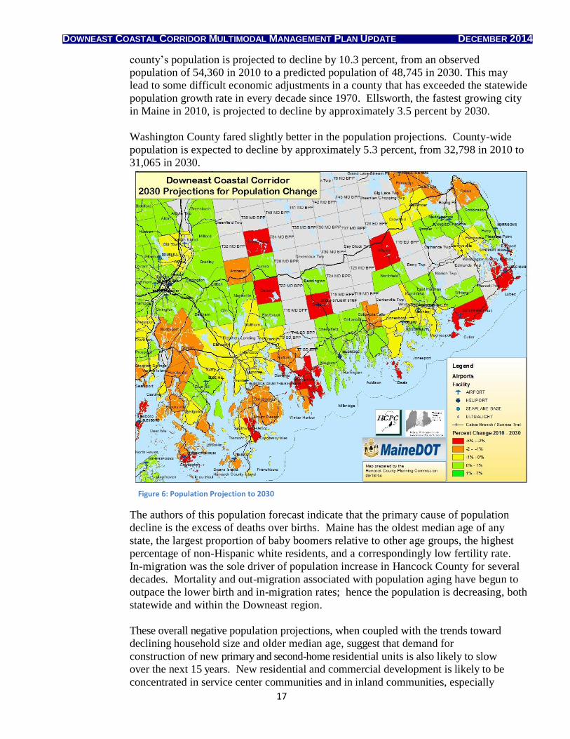
Figure 6: Population Projection to 2030 .................................................................................................................. 17
Figure 7: Population Density .................................................................................................................................... 18
DOWNEAST COASTAL CORRIDOR MULTIMODAL MANAGEMENT PLAN UPDATE DECEMBER 2014
4
1 INTRODUCTION
The Downeast Coastal Corridor is one of 38 Corridors of Regional Economic
Significance for Transportation (CREST) identified by the Maine Department of
Transportation (MaineDOT). The original management plan for this corridor was
published in June 2010; the majority its content and public discussion actually took
place in 2008-2009, using data from 2007 and even earlier.
Over the past five years, the multi-modal transportation system in Hancock and
Washington Counties has changed in ways that were not easily predictable or
measurable when the original Downeast Multi-Modal Corridor Management Plan
(hereafter referenced as the 2010 Plan) was developed. While portions of the original
plan remain highly relevant, other portions do not accurately reflect socioeconomic
trends and changed conditions that will influence the maintenance and management of
the transportation system in Downeast Maine. This document is intended to be an
updating supplement to the original study, not a stand-alone report, and thus it only
covers topics where the information has changed significantly since the original study
was issued.
In Washington County, a Public Advisory Committee helped to shape the plan update
in facilitated two-hour work sessions, followed by a public meeting to present the
results to a wider group of regional stakeholders. The committee included
representatives from MaineDOT, Washington County Council of Governments
(WCCOG), municipalities and business owners located within the planning corridor,
and others with interests in the connections between transportation, land use,
economic development, and related quality of life considerations. In Hancock
County, the Hancock County Planning Commission (HCPC) presented the data and
solicited stakeholder feedback on the plan update through several established
transportation working groups, as well as in public forums on regional transportation
issues. Both WCCOG and HCPC highlighted plan update components on their
respective websites, and solicited online feedback from members of the general public
throughout the planning process.
1.1 The Downeast Coastal Corridor
The Downeast Coastal Corridor encompasses the major east-west transportation
connections between the Bangor region and the coastal regions of both Hancock and
Washington County. Included in this broad corridor are US Route 1 (US-1) from
Bucksport to Calais, State Route 9 (SR-9) from Bangor to Calais, as well as minor
arterial and collector routes that serve as connectors and short-cuts between the major
arterial highways (see Map 1).
In addition to the road network, the region is served by Bangor International Airport
(BGR), the Hancock County Bar Harbor Airport, and several smaller, general-purpose
airports in the two counties. Bucksport is a major port for inbound fuel shipments and
DOWNEAST COASTAL CORRIDOR MULTIMODAL MANAGEMENT PLAN UPDATE DECEMBER 2014
5
Eastport hosts deep-water commercial shipping for pulp, paper and other bulk commercial cargo. There are numerous smaller harbors located along the corridor used
for commercial fishing, recreational boating, and transient yachting. The Down East
Sunrise Trail from Ellsworth to Ayers Junction, with onward connections to Eastport,
supports bicycles, walkers, ATVs and snowmobiles. A statewide process is underway
to designate US-1 as Bike Route 1, providing improved over-the-road access for long-
distance cyclists.
This management plan update identifies transportation system assets, deficiencies, and
recommendations for targeted strategic investments that will help to facilitate
economic development and sustainable travel options for the region, while preserving
and maximizing the use of the existing multi-modal transportation system.
Within the corridor, US-1 and SR-9 are the primary highways. They carry different
mixes of passenger and freight traffic. US-1 carries a larger percentage of commuter
and tourism traffic, and serves as the main street for many corridor communities. SR-9
carries a greater percentage of freight traffic, and also serves as a major international
travel connection for passenger and freight service between Canada’s Maritime
Provinces and the interstate I-95 corridor in Bangor.
Figure 1: Transportation Facilities
Portions of the former Calais Branch Railway, out of service since 1985, have been
redeveloped as a long-distance, multi-modal trail. The Down East Sunrise Trail was
opened to the public in 2010, and it has begun to fulfill its potential as an important off-
road alternative to surface road travel through Hancock and Washington County. It is
DOWNEAST COASTAL CORRIDOR MULTIMODAL MANAGEMENT PLAN UPDATE DECEMBER 2014
6
used year-round by bicyclists, pedestrians, skiers, horseback riders, ATV riders, and snowmobilers, both for short-distance and long-distance trips. The full right of way
along the former rail line has been banked by the State of Maine to permit the
restoration of tracks and trains at some future date, when regional rail service may
once again become cost-effective. If there is sufficient economic incentive in future
years to restore the rail line, the long-range plan calls for realignment of the Down
East Sunrise Trail to run adjacent to the railway. Construction of a rail-with-trail
would be a very small line item in the overall budget for a service restoration project
that could meet modern railway standards.
2 OVERVIEW OF EXISTING CONDITIONS
This section of the report presents a summary of existing conditions that have changed
since the 2010 Plan was issued, including types of travel on the corridor, transportation
facilities, major transportation problems, and corridor characteristics.
2.1 VEHICLE MILES TRAVELED
The annual rate of per capita Vehicle Miles Traveled (VMT) reached its peak in the year
2004, and has declined in every year since. This trend is reflected in both national and
statewide traffic counts, and marks a significant change for Hancock and Washington
County since 1990-2000, when VMT increased by 25.1% and 14.6% respectively over
the course of the decade (as described in the 2010 Plan). There are a number of long-
term socioeconomic factors that appear to contribute to a slow decline in VMT:
The leading edge of the huge baby boomer generation is already over 65, and most people drive fewer miles as they age. Retirees no longer commute to work,
and many older people voluntarily limit their own driving to daylight hours, fair
weather, and shorter-distance trips to familiar locations. Some will give up
driving altogether, due to decreasing vision or other physical challenges that
make driving too difficult or dangerous.
The double blow of economic recession plus higher gasoline prices has made vehicle ownership and driving less affordable for people across all age and
income brackets, resulting in fewer, shorter recreational trips and more
combined-purpose trips. Ridership on public transit (where available) is at a
record high, and demand for improved public transit service is expected to
continue to increase.
Many in the millennial generation are opting to live in places where they can walk, bicycle, or use public transit for most or all of their daily trips. When they
do need to drive, younger adults are more likely to offer and seek out
ride-sharing opportunities.
High-speed internet (where available) provides access to opportunities for
telecommuting, online service transactions, and online shopping, eliminating the
need for many daily trips.
Major societal trends that have contributed to ever-increasing VMT since the end of World War II, such as the development and growth of the Interstate Highway
System, expansion of the labor force, out-migration of the middle class to the
DOWNEAST COASTAL CORRIDOR MULTIMODAL MANAGEMENT PLAN UPDATE DECEMBER 2014
7
suburbs, and increasing rates of personal vehicle ownership, have been slowing (and in some cases reversing) since around the start of the 21
st century.
Map 2 shows the factored Average Annual DailyTraffic (AADT) on roads within the
Downeast Coastal Corridor. Travel patterns and volumes have changed very little since
the 2010 Plan. The highest travel volumes and worst seasonal congestion are still
concentrated near the Canadian border crossings in Calais, in the busy downtown areas
of service center communities, and along US-1A between I-95 in Bangor and Mount
Desert Island. Likewise, the typical traffic patterns for passenger and freight traffic have
remained fairly stable, as described in the 2010 Plan. One notable difference for
Washington County is that State Route 191 (SR-191) and State Route 214 (SR-214)
have seen an increased component of heavy-haul freight traffic in recent years, due to
the expansion of international shipping operations between the Woodland Pulp
manufacturing facility in Baileyville and the deep-water port in Eastport.
Figure 2: Average Annual Daily Traffic Counts
DOWNEAST COASTAL CORRIDOR MULTIMODAL MANAGEMENT PLAN UPDATE DECEMBER 2014
8
Figure 3: Average Annual
Figure 3: Daily Traffic Counts 2009 – 2013
2.2 TRANSPORTATION FACILITIES
This section provides an update on existing transportation facilities, the roles they serve
within the corridor, and their overall performance.
2.2.1 Highways
Since the publication of the 2010 Plan, MaineDOT has developed a new system for
evaluating and selecting projects for inclusion in its three-year Work Plan. Budget-
tightening measures at the federal level have significantly reduced the funding available
for highway maintenance and capital improvements. In order to stretch Maine’s limited
transportation dollars, MaineDOT has adopted an asset management methodology based
on two components: Highway Corridor Priority (HCP) and Customer Level of Service
(CSL). Higher-priority roads will receive a correspondingly larger share of the triennial
work plan budget than lower-priority roads, and will have higher CSL strategic goals to
meet as well; however, regional MaineDOT maintenance crews will continue to monitor
the CSL evaluation measures – safety, condition, and service – for all of the roads in the
state inventory, and take corrective actions to improve lower-priority roads as needed to ensure safe and convenient driving conditions.
-
2,000
4,000
6,000
8,000
10,000
12,000
14,000
16,000
2009 2010 2011 2012 2013
Ave
rage
An
nu
al D
aily
Tri
ps
Average Annual Daily Traffic Counts
US 1 W/O SR 182
SR 182 N/O US 1
SR 3 THOMPSON ISLAND
SR 9 W/O SR 193
SR 193 SE/O SR 9
US 1/SR 191
SR 191 N/O PALMER LANDING
US 1 SE/O S PRINCETON RD
DOWNEAST COASTAL CORRIDOR MULTIMODAL MANAGEMENT PLAN UPDATE DECEMBER 2014
9
Descriptions of the six HCP levels, as defined by MaineDOT, are provided below. MaineDOT’s interactive map can be used to determine the HCP for all roads in both
counties, and for the rest of Maine as well.
HCP 1 roads include the Maine Turnpike, the Interstate Highway System, and key principal
arterials. The 1,400 miles of HCP 1 roads represent only 7% of the miles, but carry 40% of all
traffic in Maine.
HCP 2 roads total about 940 miles. They are non-Interstate, high-value arterial highways that
represent about 4% of the total miles of road but carry 11% of overall traffic.
HCP 3 roads are the remaining arterials and most significant major-collector highways. These
2,050 miles represent only 9% of miles, but carry 19% of the traffic.
HCP 4 roads are the remainder of the major collector highways. These 1,900 miles represent
about 8% of total miles, and carry 10% of all traffic.
HCP 5 roads are comprised of 2,500 miles of minor-collector highways; they total 11% of
miles, but carry only 7% of traffic.
HCP 6 roads are local roads and streets, and are the year-round responsibility of
municipalities. Though they carry just 13% of the statewide traffic, these 14,300 miles make
up 61% of the total road miles in Maine. Though this sounds like a lot, Maine actually has the
lowest percentage of local roads in New England, and the ninth-lowest percentage in the
nation. By comparison, 74% of New Hampshire public roads are local.
(Source: MaineDOT Work Plan, Calendar Years 2014-2015-2016)
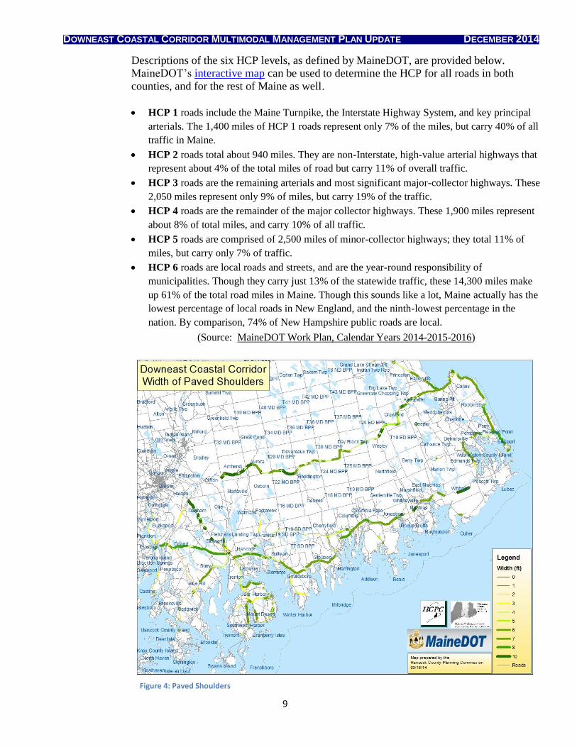
Figure 4: Paved Shoulders
DOWNEAST COASTAL CORRIDOR MULTIMODAL MANAGEMENT PLAN UPDATE DECEMBER 2014
10
For the most part, stakeholders in Hancock and Washington County agree that the new HCP classification system makes sense, as it allows MaineDOT to focus its limited
funding on roads with the highest strategic value and the greatest number of users.
However, there were specific concerns within Washington County about the priorities
assigned to some of the routes, and whether MaineDOT would consider changing the
priorities for roads that hold a very high regional economic significance, even if their
overall statewide significance is lower. For example, the only state-designated HCP 1 road
in Washington County is SR-9, a highway that provides most of its economic return and
strategic value to people who live and work elsewhere. US-1 from Ellsworth to Calais is
classified as HCP 2, even though this road is essentially the spinal cord for passenger and
freight traffic movement along the Downeast coast. Thus for people who actually live and
work within the Downeast Coastal Corridor, the HCP ratings for these roads could
arguably be switched.
Stakeholders would also like to see MaineDOT re-prioritize SR-191 and SR-214 from HCP 4 to HCP 3. Heavy trucking has increased on these highways due to the steady
international freight shipping commerce between Baileyville and Eastport, and it is likely
to increase even more if a rail-to-truck transloading facility is constructed in the future.
Therefore, these two roads will probably need a stronger pavement section and more
frequent maintenance than a typical HCP 4 road. In addition, SR-191 is the most direct
route between Machias and Calais, the largest service center communities in Washington
County. Most of the regional stakeholders concurred that SR-191 is at least as important
for regional connectivity and future economic development as State Routes 192 and 193,
both of which are classified HCP 3.
2.2.2 Bicycle and pedestrian facilities
The Down East Sunrise Trail (DEST) was opened for public use in 2010. It starts at
Washington Junction in Hancock and runs northeast through the communities of Hancock,
Franklin, Sullivan, Gouldsboro, Steuben, Milbridge, Harrington, Cherryfield, Columbia,
Columbia Falls, Jonesboro, Whitneyville, Machias, East Machias, Dennysville, Pembroke
and Charlotte, ending at the abandoned railway junction known as Ayers Junction,
approximately 14 miles south of Calais. DEST is a component of the East Coast
Greenway, an initiative to create a mostly off-road trail covering the 2,900 miles between
the Canadian border in Calais and Key West, Florida, where the Gulf of Mexico meets the
Atlantic Ocean.
DEST is used year-round by bicyclists, pedestrians, snowmobilers, ATV riders, skiers,
and horseback riders, some of whom are out on the trail daily. Anecdotal observations
suggest that it is being used as a bicycle commuter route in the Machias area. DEST has
boosted the regional economy by creating a need for shuttle services, bicycle rentals,
camping supplies, food and equipment stores, restaurants, and lodging facilities close to
the trail. Many of the abutting towns are interested in developing connector trails to
attract more DEST users to their downtown villages.
As of 2014, MaineDOT is planning for a project that will extend DEST southwesterly
from its current terminus atWashington Junction to downtown Ellsworth, using funds left
over from the salvage sale of the steel rails when the existing rail-trail was constructed.
DOWNEAST COASTAL CORRIDOR MULTIMODAL MANAGEMENT PLAN UPDATE DECEMBER 2014
11
State and regional planners hope to incorporate a multi-modal transportation and tourist information station into the design for the new Ellsworth trailhead. Because the rail line
is still active in seasonal use for an excursion train that runs between Washington Junction
and Ellsworth, the proposed trail extension will be constructed as a rail-with-trail project.
When the 2010 Plan was published, only Ellsworth, Bucksport, Milbridge, Machias,
Lubec, and Calais had begun engaging their residents in bicycle-pedestrian planning
efforts. As of 2010, many more communities have bicycle-pedestrian assessments and
plans either underway or completed. WCCOG prepared a Village Bicycle & Pedestrian
Access Plan in 2011 to enable Cherryfield, Harrington, Columbia Falls, Whitneyville,
East Machias, and Dennysville to benefit economically and recreationally from their
proximity to DEST. WCCOG also produced a Routing Study for Potential/Alternative
Trail Connections between Pleasant Point and Eastport in 2012, and prepared a
Downtown Bicycle and Pedestrian Assessment for the City of Eastport in 2013.
2.2.3 Transit service
The 2010 Plan described the three regional transit providers and the services they
provided. Since that time, all three providers have added new routes within their service
areas, and there have been significant changes in the availability and delivery of transit
and ride-sharing services.
The Washington Hancock Community Agency (WHCA) operates demand-response and
contracted transit service in both counties. West’s Transportation provides contracted,
demand-response, and fixed-route service in both counties, including a once-daily run
from Calais to Bangor International Airport and back via Ellsworth. Downeast
Transportation, Inc. (DTI) operates fixed-route service in Hancock County, including
subscription-service bus runs for Jackson Laboratories employees from Bangor,
Milbridge, Franklin, and Ellsworth, and in-town shuttles serving Bucksport, Ellsworth,
and Bar Harbor.
DTI also operates the seasonal Island Explorer, which provides no-fare, continuous,
daily service on seven routes that serve most of the Mt. Desert Island communities,
Trenton, and Acadia National Park. The newest route makes a circuit around the
Schoodic peninsula, with stops at the Bar Harbor Ferry terminal and in the neighboring
villages of Winter Harbor, Birch Harbor, and Prospect Harbor. Schoodic area service
will double in 2015. Overall, DTI services have reduced auto emissions and enabled
visitors to avoid traffic and parking congestion. The success of the Island Explorer has
allowed park managers to defer implementation of additional parking and vehicle use
restrictions within the park.
Since 2012, the State of Maine has contracted with an independent, external broker to
take all MaineCare ride requests and distribute these rides among the regional transit
agencies in the most efficient and cost-effective manner. The first year of brokered
service (with Connecticut-based Coordinated Transportation Solutions) did not go
smoothly at all. Service complaints by MaineCare recipients, including policies affecting
young children, lead to termination of the CTS contract. The current broker, Logisticare
(based in Atlanta) appears to be doing a more competent job in its first year of operation
DOWNEAST COASTAL CORRIDOR MULTIMODAL MANAGEMENT PLAN UPDATE DECEMBER 2014
12
in Washington and Hancock County, although all of the regional transit agencies are still adjusting to the changes in their operating and scheduling models.
WHCA also provides scheduled bus trips to shopping centers, grocery stores, pharmacies,
and medical appointments in certain communities for seniors. When space is available,
the bus can accommodate other riders and other destinations. A recent grant has enabled
WHCA to provide demand-response transit service from several peninsula communities
up to US-1, scheduled to connect with the daily West’s Transportation fixed-route bus
service that runs between Calais and Bangor via Ellsworth.
Taxi service has not improved in the region since the 2010 Plan was issued. Much of
Washington County remains unserved or underserved, although Hancock County is now
fairly well-covered.
Many healthcare and social service professionals regard the existing deficiencies in
transit, taxi service, and ride-sharing as significant barriers to healthier lifestyles and
equal access to medical services, both for high-risk individuals and for the Downeast
population as a whole. In recent years, a number of community groups have come
together to address these issues, sharing information and resources between organizations
and developing realistic, collaborative goals for progressive improvement. The First
Light Transit Steering Committee and a consultant report (jointly funded by Maine Rural
Partners and the Community Caring Collaborative) laid the groundwork by providing
simple, low-cost recommendations to increase the use and effectiveness of public transit
services in Washington County.
More recently, the Downeast Acadia Transportation Access Team, sponsored by Healthy
Acadia and addressing the needs of both Washington and Hancock County, has produced
both a transportation service brochure and a transportation access script that help
providers quickly determine whether their clients may need help with transportation to
and from their scheduled appointments. Healthy Acadia’s partnership effort has involved
team members and community-based services provided by WCCOG, HCPC, Washington
County: One Community, Friends in Action, WHCA, West’s Transportation, Downeast
Transportation and the Island Explorer, Beth C. Wright Cancer Resource Center, the
Cancer Support Center of Maine, Community Access Resource Exchange (C.A.R.E.) of
Bucksport, Island Connections, the Region 7 office of the Maine Center for Disease
Control and Prevention, and others.
2.2.4 Rail facilities and service
In response to a federal request for major projects of regional and national significance,
the Port of Eastport submitted a proposal in November 2014to create an alternative
transportation corridor to the port. A new corridor would eliminate the problem of heavy
freight traffic running through the Passamaquoddy Reservation at Sipayik (Pleasant
Point), while also improving road and rail options to reach the seaport. The proposal was
supported by MaineDOT, the Passamaquoddy Tribal Council, and all affected local
jurisdictions.
DOWNEAST COASTAL CORRIDOR MULTIMODAL MANAGEMENT PLAN UPDATE DECEMBER 2014
13
Proposed port access improvements include a rail-to-truck transloading facility option associated with road and rail reconfigurations. Freight rail shipment via Eastport would
provide a more timely and cost-effective option for northern-tier heavy industries.
Increased use of the deepwater port of Eastport would also relieve congestion at other
Atlantic seaports and within the I-95 corridor between Baltimore and Portland. The goal
of connecting Eastport to the international freight rail network within the Downeast
Coastal Corridor is alive, well and potent.
The Downeast Scenic Railroad, a project of the Downeast Rail Preservation Heritage
Trust, now operates a seasonal, weekends-only rail tour. It traverses over ten miles of
operational track on the original, historic Maine Shore Line that once transported
nineteenth-century “rusticators” between Brewer and Washington Junction. The
volunteer-run excursion train runs a 90-minute tour from Ellsworth to Washington
Junction and back.
Pan Am rail service operating between Brewer and the Verso Paper Mill in Bucksport is
likely to be curtailed with the cessation of papermaking, unless and until a new owner
reopens the mill for industrial production. The Bucksport mill will continue to generate
electricity using a blend of biomass and natural gas, but rail shipments are less likely
under this scenario. The tracks and ties on the 20-mile section of track between Brewer
and Bucksport are in poor condition, limiting travel speeds to 10 miles per hour.
2.2.5 Ports and marine service
The deep-water port at Eastport has increased its shipping capacity and product diversity
since the 2010 Plan was published. Paper-quality pulp and wood chips from the
Woodland Pulp facility in Baileyville are being shipped to ports in the Far East and
Europe. The recently lucrative niche market of shipping pregnant milking cattle to
Russia and Turkey has experienced interruption due to conflict and instability in those
trade regions. A new $10 million state of the art conveyor system was completed and
opened in 2012, funded through a federal economic stimulus grant, $4.5 million in voter-
approved state bonds, and the Maine Port Authority.
2012 also marked the return of commercial cruise ship tourism to Eastport, after an 80-
year hiatus. Cruise ships tie up at the breakwater pier in downtown Eastport alongside
fishing vessels and pleasure craft, not at the industrial seaport facility on Estes Head.
Eastport’s natural deep harbor can accommodate cruise ships of any size. In the 2014 tourist
season, Eastport hosted five cruise ships carrying over 900 passengers, including one ship
making its maiden voyage along the East Coast.
A significant portion of the Eastport breakwater collapsed into the inner harbor on December
4, 2014. Multiple agencies are working to secure adequate funding to get it repaired before
the 2015 summer season.
Bucksport continued to operate as one of Maine’s largest fuel off-loading facilities. Webber
Dock has capacity for barges greater than 500 feet in length, with drafts up to 33 feet. Fuel
can be pumped directly to Brewer and Bangor storage tanks from the dock facility.
DOWNEAST COASTAL CORRIDOR MULTIMODAL MANAGEMENT PLAN UPDATE DECEMBER 2014
14
Commercial fishing remains a major economic driver in Downeast Maine, although resource depletion has led to severe restrictions on fishing seasons and limited catch allowances over
the last few years. Maine’s commercial fishery revenues for 2013 were the third highest in
the United States, topped only by Alaska and Massachusetts, and Mainers bring in over 80
percent of the nation’s lobster landings. Thriving working harbors are an integral part of the
Downeast regional heritage, providing community-based jobs as well as scenic tourism
opportunities. Stakeholders indicated strong support for extending state funding to preserve
and upgrade port facilities in working harbors. As the 2014 partial failure of the Eastport
breakwater demonstrates, delayed maintenance of existing infrastructure will often prove to
be even more costly in the long run.
2.2.6 Airports
There have been no significant changes in passenger or freight air service for the
corridor since the 2010 Plan was issued. The Hancock County Bar Harbor
Airport in Trenton (FAA identifier: BHB) remains one of the busiest airports in
Maine during late summer, with scheduled commercial service as well as
facilities to accommodate all types of general aviation aircraft. According to the
Federal Aviation Administration, total enplanements at BHB for 2011 increased
by 12.61% over 2010 figures (12,510 vs. 11,109).
A decade-long effort to site and construct a new regional airport near Machias
remains in limbo, as of December 2014. The proposed Level I facility would
permit all-weather, four-season, 24-hour operations, with sufficient capacity to
handle scheduled commercial flights and all types of general aviation aircraft.
The existing Machias Valley Airport is Level IV, the lowest possible service
rating. It can only handle small, single-engine private planes on visual approach.
There is not enough room to develop a Level I runway (minimum length 5000
feet) on the Machias Valley Airport site.
MaineDOT’s 2006 Maine Aviation System Update Plan set a benchmark to
develop at least one Level 1 regional airport within a 30-minute drive of each of
Maine’s designated service center communities, and identified the Machias area
as a prime location to help meet this statewide standard. However, the plans for
a new regional airport stalled after two failed site selection processes. There
were strident local objections to both of the preferred-alternative sites for the
airport, largely due to concerns about disruptive noise and light pollution. In
2009, the airport planning process fell apart when municipal leaders in the
region could not come to agreement about governance and cost-sharing issues.
Another option would be for the Washington County Government to assume
ownership of the new airport, and figure out the best way to distribute the costs
(and potential future profits) among the surrounding communities. That
operational model has worked well for the Hancock County Bar Harbor Airport.
However, the initial challenge is to identify a suitable, non-controversial site
somewhere in or near Machias.
DOWNEAST COASTAL CORRIDOR MULTIMODAL MANAGEMENT PLAN UPDATE DECEMBER 2014
15
2.2.7 Designated Scenic Byways
There are now three designated scenic byways along the corridor. The nationally
designated Schoodic National Scenic Byway and the state designated Black Woods
Scenic Byway were described in the 2010 Plan. Both continue to generate new tourism-
related events and seek public-private funding for additional development of byway
attractions.
The newest addition is the Bold Coast Scenic Byway, still evolving in its development
as of December 2014. The Bold Coast Scenic Byway is a state designated byway, 125
miles in length, that was officially designated in 2011. It begins along US-1 in
Milbridge, just west of the intersection of US-1 and the Wyman Road, and ends in
downtown Eastport. Along the way, the Bold Coast Scenic Byway generally follows
US-1 with several significant coastal detours. In Columbia Falls, the byway loops
along State Route 187 through Jonesport to rejoin US-1 in Jonesboro. In East
Machias, the byway follows State Route 191 through Cutler, turns northeasterly onto
State Route 189 to reach Lubec, and then doubles back along State Route 189 to
rejoin US-1 in Whiting. In Perry, the byway turns eastward along State Route 190
through the Passamaquoddy Reservation at Sipayik (Pleasant Point) to its terminus in
downtown Eastport. The Corridor Management Plan for the Bold Coast Scenic Byway
is in final draft review and will be released in early 2015.
2.3 CHARACTERISTICS OF THE DOWNEAST COASTAL CORRIDOR
2.3.1 Existing Transportation System Deficiencies
The most significant transportation problems in the corridor have not changed since the
2010 Plan. Neither MaineDOT nor local public works officials have been able to
address them systematically, due to transportation budget shortfalls and increased costs
for project construction and materials. They include:
1. Restricted mobility on US-1 in Washington County, due to the lack of passing
lanes and safe truck turn-out facilities;
2. The lack of freight rail service in general, and freight rail or truck-to-rail service to
Eastport’s deep-water seaport in particular;
3. Inadequate winter maintenance on the north-south connector routes between
US-1 and SR-9, resulting in compromised mobility, access, and safety; and
4. High Crash Locations (HCLs), generally attributable to seasonal congestion and
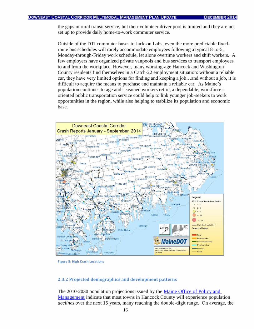
excessive speed, as shown in Figure 5.
A new deficiency apparent over the past five years is the lack of statewide funding and
policies to support a rural public transportation system to better meet the needs of
working adults. Existing demand-response transit service in the Downeast region focuses
primarily on the scheduled appointments of MaineCare recipients and contracted social
service clients. General-public riders can be bumped on short notice due to space
limitations, even after scheduling their rides at least 48 hours in advance. Volunteer-
organized ride-sharing services (notably, Ellsworth-based Friends in Action) fill some of
DOWNEAST COASTAL CORRIDOR MULTIMODAL MANAGEMENT PLAN UPDATE DECEMBER 2014
16
the gaps in rural transit service, but their volunteer driver pool is limited and they are not set up to provide daily home-to-work commuter service.
Outside of the DTI commuter buses to Jackson Labs, even the more predictable fixed-
route bus schedules will rarely accommodate employees following a typical 8-to-5,
Monday-through-Friday work schedule, let alone overtime workers and shift workers. A
few employers have organized private vanpools and bus services to transport employees
to and from the workplace. However, many working-age Hancock and Washington
County residents find themselves in a Catch-22 employment situation: without a reliable
car, they have very limited options for finding and keeping a job…and without a job, it is
difficult to acquire the means to purchase and maintain a reliable car. As Maine’s
population continues to age and seasoned workers retire, a dependable, workforce-
oriented public transportation service could help to link younger job-seekers to work
opportunities in the region, while also helping to stabilize its population and economic
base.
Figure 5: High Crash Locations
2.3.2 Projected demographics and development patterns
The 2010-2030 population projections issued by the Maine Office of Policy and
Management indicate that most towns in Hancock County will experience population
declines over the next 15 years, many reaching the double-digit range. On average, the
DOWNEAST COASTAL CORRIDOR MULTIMODAL MANAGEMENT PLAN UPDATE DECEMBER 2014
17
county’s population is projected to decline by 10.3 percent, from an observed population of 54,360 in 2010 to a predicted population of 48,745 in 2030. This may
lead to some difficult economic adjustments in a county that has exceeded the statewide
population growth rate in every decade since 1970. Ellsworth, the fastest growing city
in Maine in 2010, is projected to decline by approximately 3.5 percent by 2030.
Washington County fared slightly better in the population projections. County-wide
population is expected to decline by approximately 5.3 percent, from 32,798 in 2010 to
31,065 in 2030.
Figure 6: Population Projection to 2030
The authors of this population forecast indicate that the primary cause of population
decline is the excess of deaths over births. Maine has the oldest median age of any
state, the largest proportion of baby boomers relative to other age groups, the highest
percentage of non-Hispanic white residents, and a correspondingly low fertility rate.
In-migration was the sole driver of population increase in Hancock County for several
decades. Mortality and out-migration associated with population aging have begun to
outpace the lower birth and in-migration rates; hence the population is decreasing, both
statewide and within the Downeast region.
These overall negative population projections, when coupled with the trends toward
declining household size and older median age, suggest that demand for
construction of new primary and second-home residential units is also likely to slow
over the next 15 years. New residential and commercial development is likely to be
concentrated in service center communities and in inland communities, especially
DOWNEAST COASTAL CORRIDOR MULTIMODAL MANAGEMENT PLAN UPDATE DECEMBER 2014
18
those with available lake frontage for residential development. Coastal land prices are primarily driven by demand for high-end seasonal residences, and coastal living
has already become unaffordable for many young working families.
The 2010-2030 projections indicate most of the stable or positive growth rates will
occur in interior portions of Hancock County: Dedham, East Hancock
(unorganized), Eastbrook, Mariaville, and Otis. Blue Hill and Hancock are the
only coastal communities in Hancock County that are expected to grow in
population over the next 15 years.
Figure 7: Population Density
In Washington County, the communities split almost 50/50 in terms of positive vs.
negative growth projections for 2010-2030. Nonetheless, the same trend was
evident: growth rates are projected to be highest in the smaller inland communities.
Addison, Milbridge, Perry, Robbinston and the Passamaquoddy Reservation at
Sipayik (Pleasant Point) are the only coastal communities with positive long-term
growth projections.
The magnitude and predictability of change may be misleading in these
projections. Small changes in population can result in significant changes in rates
for the smallest towns. Central Hancock (unorganized) is projected to lose 42.3
percent of its population by 2030. However, given a population of 106 residents as
of 2010, that seemingly precipitous drop represents a decline of just 38 people.
DOWNEAST COASTAL CORRIDOR MULTIMODAL MANAGEMENT PLAN UPDATE DECEMBER 2014
19
The margin of error is quite large for population estimates and projections in Maine’s small towns and unorganized territories.
2.3.3 Emerging Land Use Trends
Both of the emerging land use trends identified in the 2010 Plan continue to influence
land use and transportation choices within the Downeast Coastal Corridor. However,
there are newly emerging counter-trends that may offset their predicted impacts.
2010 trend: New development, particularly for seasonal and second-home residences,
continues to shift away from the high-priced coastal communities to more affordable
properties inland. However, most jobs are still located along the coast. Thus, more
commuter traffic from inland towns to the coast can be expected.
2014 counter-trend: Increasing demand for close-to-town convenience and shorter
commutes has led to denser residential development and redevelopment in service
center communities. Living within walking or biking distance of “everything” is
particularly attractive to members of the cash-strapped and environmentally conscious
millennial generation, but people of all ages are reconsidering whether a peaceful rural
lifestyle is worth all the extra driving time and inconvenience. Smaller communities
with well-defined village centers may also reap the economic benefits of this counter-
trend. It remains to be seen whether millennials will continue to opt for in-town, low-
carbon-footprint lifestyles, once they become financially established and start raising
children.
2010 trend: Large parcels of industrial forestlands have been sold, and will continue to
be sold, to land developers to facilitate new residential and commercial construction.
Demand for high-end residential construction is likely to focus on the most scenic lakes,
rivers, and mountaintop properties within the corridor.
2014 counter-trend: Large parcels of industrial forestlands have been sold, and will
continue to be sold, to the federal and state governments and to an ever-increasing number of regional land trusts, ensuring that they will be permanently conserved with
minimal or no future land development. As a rule, conserved lands place almost no
measurable increased demand on the regional transportation system.
2014 counter-counter-trend: Land developers will compete with land trusts AND
wind energy developers for some of the prime mountaintop locations. Windpower
facilities place a high transient demand on the regional transportation system during the
construction phase, but the developers cover the full costs of required right of way
improvements and any incidental road damage incurred in transporting their
components to the erection site, and windpower sites generate very few trips once
construction is completed. Over their respective lifetimes, a large windpower facility
will generate far fewer trips and overall transportation system impacts than the average
10 vehicle trips per day per single-family residence.
Maine’s aging population will continue to exert a strong influence on land use patterns
within the corridor. Hancock and Washington County are popular retirement
destinations, and most of the population growth over the past two decades has occurred
in older age groups. Thus, demand for housing can be expected to increase ahead of
employment generation or demand for new schools. For example, the 0-19 age group in
DOWNEAST COASTAL CORRIDOR MULTIMODAL MANAGEMENT PLAN UPDATE DECEMBER 2014
20
Hancock County is projected to decrease by 15 percent between 2000 and 2020. By contrast, the 65+ age group is expected to increase by 85 percent. Demand for elderly-
related services, such as assisted living centers, medical facilities, home-care providers,
and geriatric specialists, is also expected to rise.
2.3.4 Review of Existing Local and Regional Plans
All of the towns along US-1 in Hancock County have adopted comprehensive plans since enactment of Maine’s Growth Management Act in 1988. With the exception of the
town of Hancock, all these plans were deemed consistent with the Growth Management
Act review criteria. The plans for Sullivan and Hancock were adopted in the early
1990s. The only Hancock County town on SR-9 to have adopted a comprehensive plan
consistent with the Growth Management Act is Aurora. While the plan was adopted in
the early 1990s, Aurora has experience relatively little growth since that time. Aurora,
Great Pond and Amherst conducted a comprehensive plan survey in 2014, and are
exploring the idea of undertaking a three-town regional comprehensive plan update.
Franklin, located on State Route 182, has not adopted a comprehensive plan and has no
current plans to do so.
Here are some specific transportation-related updates from Hancock County communities:
Bucksport is currently updating its 2003 comprehensive plan, although the
recent closure of the Verso Mill has temporarily disrupted the planning process.
Since the 2010 Plan was issued, Bucksport has completed several sidewalk and
riverfront path projects to increase safety for walkers and bikers. A new
pedestrian underpass facilitates car-free travel across the Penobscot River via
US-1/State Route 3. Bucksport also completed a sidewalk assessment in 2014.
Ellsworth completed a Bicycle Pedestrian Plan in 2007 with assistance from HCPC. Many elements of the plan have been implemented, including new and
rebuilt sidewalks and the Ellsworth Trail (constructed as a rail-with-trail). In
2015, the Ellsworth Elementary and Middle School will start up a Walking
School Bus program for students.
The Old Pond Railway Trail has been completed in the town of Hancock. This trail provides a safe walking route that runs roughly parallel to US-1, though it is
primarily used for recreation rather than transportation.
In accordance with the Schoodic National Scenic Byway Corridor Plan,
additional scenic pull-offs have been constructed or improved in Hancock and
Sullivan along US-1. These pull-offs include interpretive displays and in some
cases, public toilets.
In accordance with the Black Woods Scenic Byway Corridor Plan, numerous improvements have been made along State Route 182 in Township 10. These
include new trailheads, boat launch facilities, and wayfinding signage.
In Washington County, all towns along US-1 have adopted comprehensive plans that are
consistent with the Growth Management Act. Many have developed, or are currently
developing, bicycle-pedestrian plans to attract DEST users to visit their downtown
villages and businesses. SR-9 through Washington County traverses five unorganized
DOWNEAST COASTAL CORRIDOR MULTIMODAL MANAGEMENT PLAN UPDATE DECEMBER 2014
21
territories and five organized municipalities. Three of these five municipalities (Beddington, Alexander and Baileyville) have adopted comprehensive plans that are
consistent with the Growth Management Act. The other two (Wesley and Crawford) do
not have comprehensive plans.
Local comprehensive plans address a wide range of corridor management concerns, including access management and concentrated commercial development. Most also
include goals and strategies to promote regional transportation planning and convenient
multi-modal connections. Recommendations included in the final section of this plan
draw largely from goals and strategies that have been previously established in
municipal comprehensive plans. Others derive from existing scenic byway corridor
management plans.
Numerous county-wide and regional planning documents have defined additional goals
and strategies for improving regional, statewide, and international transportation within
the Downeast Coastal Corridor. Not surprisingly, the same strategic investment
recommendations can often be found in multiple documents. In addition to those
already mentioned in the 2010 Plan, the following documents provide key
recommendations for strategic multi-modal transportation improvements within the
corridor study area:
Transportation Infrastructure for Economic Development, a component of the GROWashington-Aroostook Regional Planning Initiative, 2013
Transportation and Housing, a component of the GROWashington-Aroostook Regional Planning Initiative, 2013
Routing Study for Potential/Alternative Trail Connections between Pleasant Point and Eastport, WCCOG, 2012
Coastal Canadian Corridor Management Plan, WCCOG, 2011
Bold Coast Scenic Byway Corridor Management Plan, WCCOG, 2015
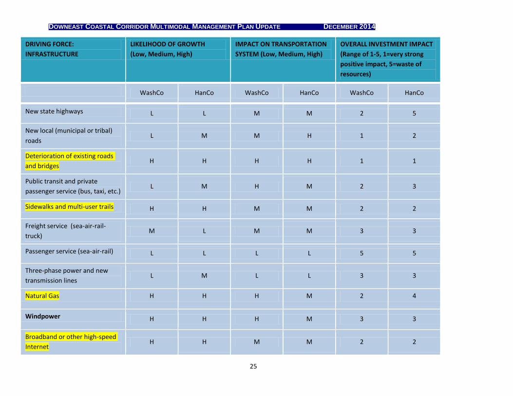
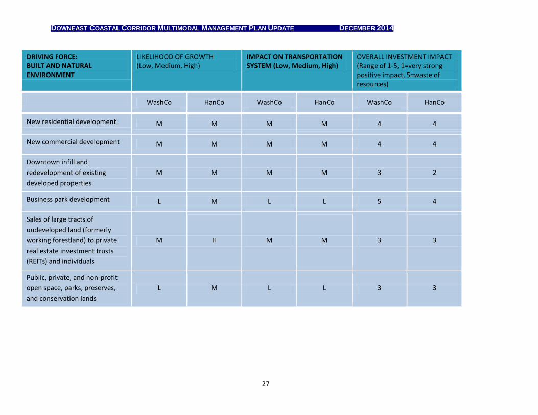
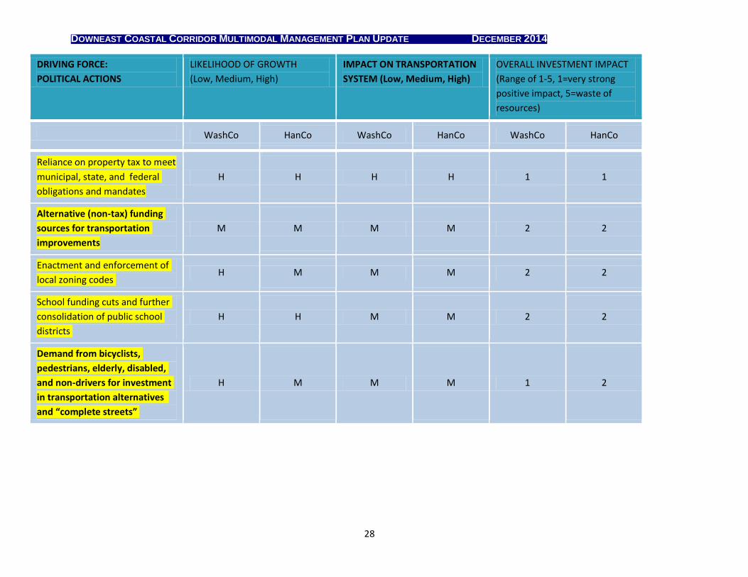
3 DRIVING FORCES
Driving forces are factors or trends that are expected to influence future land use
and economic development patterns. Changes in the driving forces can increase or
decrease transportation demand within the corridor.
Driving forces were classified within six sub-categories:
Economy
Social and Demographic Trends
Infrastructure
Travel Demand
Built & Natural Environment
Political Actions
DOWNEAST COASTAL CORRIDOR MULTIMODAL MANAGEMENT PLAN UPDATE DECEMBER 2014
22
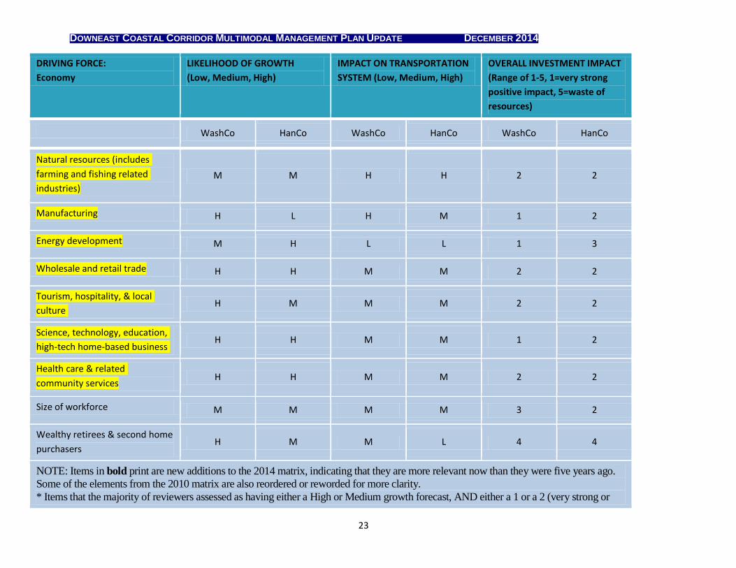
For this plan update, the Washington County Advisory Committee and regional stakeholders reviewed and updated the driving forces matrix that was originally developed by the Hancock
County Advisory Committee and the Washington County Advisory Committee for the 2010
Plan. HCPC participated in the Machias public hearing and updated the matrix based on
transportation meetings and discussions held in Hancock County. Several additional regional
driving forces were added to the 2014 evaluation during the update process.
For each driving force, reviewers assessed the following:
The likelihood of its growth or expansion over the next 20 years (High,
Medium, or Low);
The likely impact on the regional transportation system due to the expected growth in that sector (High, Medium, or Low); and
The expected impact on regional economic development, if transportation funds were invested to promote additional growth within that sector (rated
on a 1-5 scale, with 1=very strong economic impact, and 5=waste of
resources.
Items in bold print are new additions to the 2014 matrix, indicating that they are
more relevant now than they were five years ago. Some of the elements from the
2010 matrix have been reordered or reworded for more clarity. Items are
highlighted in yellow to indicate that the majority of reviewers forecast them as
having either a High or Medium growth, and also rated them as having (1) very
strong or (2) strong economic development benefits. The updated ratings were used
to refine the goals and strategies for corridor management that are listed in Section
5 of this report.
DOWNEAST COASTAL CORRIDOR MULTIMODAL MANAGEMENT PLAN UPDATE DECEMBER 2014
23
DRIVING FORCE:
Economy
LIKELIHOOD OF GROWTH
(Low, Medium, High)
IMPACT ON TRANSPORTATION
SYSTEM (Low, Medium, High)
OVERALL INVESTMENT IMPACT
(Range of 1-5, 1=very strong
positive impact, 5=waste of
resources)
WashCo HanCo WashCo HanCo WashCo HanCo
Natural resources (includes
farming and fishing related
industries)
M M H H 2 2
Manufacturing H L H M 1 2
Energy development M H L L 1 3
Wholesale and retail trade H H M M 2 2
Tourism, hospitality, & local
culture H M M M 2 2
Science, technology, education,
high-tech home-based business H H M M 1 2
Health care & related
community services H H M M 2 2
Size of workforce M M M M 3 2
Wealthy retirees & second home
purchasers H M M L 4 4
NOTE: Items in bold print are new additions to the 2014 matrix, indicating that they are more relevant now than they were five years ago.
Some of the elements from the 2010 matrix are also reordered or reworded for more clarity.
* Items that the majority of reviewers assessed as having either a High or Medium growth forecast, AND either a 1 or a 2 (very strong or
DOWNEAST COASTAL CORRIDOR MULTIMODAL MANAGEMENT PLAN UPDATE DECEMBER 2014
24
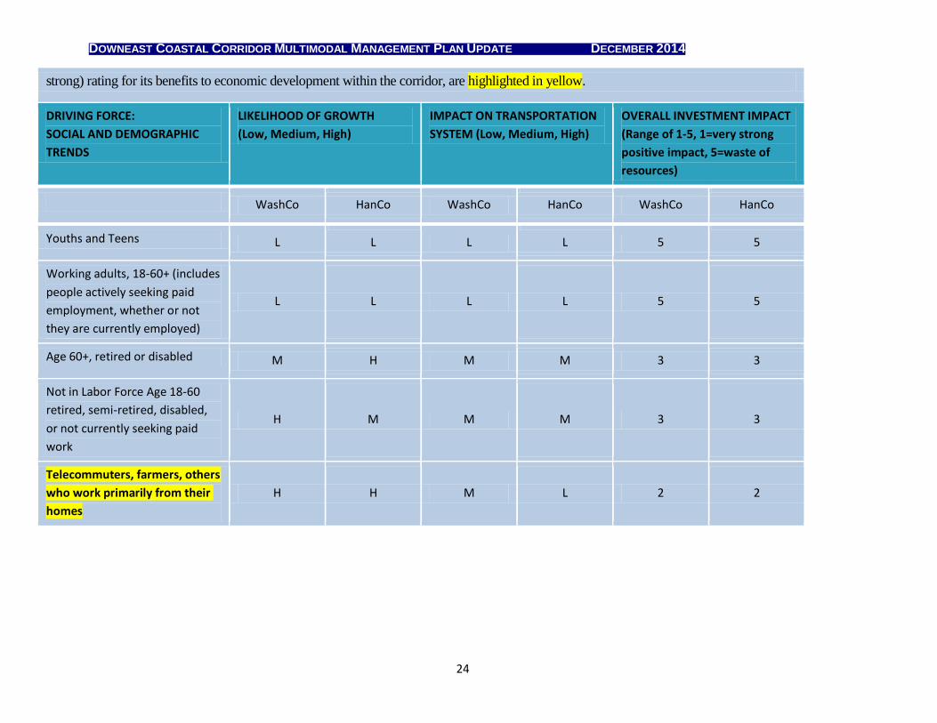
strong) rating for its benefits to economic development within the corridor, are highlighted in yellow.
DRIVING FORCE:
SOCIAL AND DEMOGRAPHIC
TRENDS
LIKELIHOOD OF GROWTH
(Low, Medium, High)
IMPACT ON TRANSPORTATION
SYSTEM (Low, Medium, High)
OVERALL INVESTMENT IMPACT
(Range of 1-5, 1=very strong
positive impact, 5=waste of
resources)
WashCo HanCo WashCo HanCo WashCo HanCo
Youths and Teens L L L L 5 5
Working adults, 18-60+ (includes
people actively seeking paid
employment, whether or not
they are currently employed)
L L L L 5 5
Age 60+, retired or disabled M H M M 3 3
Not in Labor Force Age 18-60
retired, semi-retired, disabled,
or not currently seeking paid
work
H M M M 3 3
Telecommuters, farmers, others
who work primarily from their
homes
H H M L 2 2
DOWNEAST COASTAL CORRIDOR MULTIMODAL MANAGEMENT PLAN UPDATE DECEMBER 2014
25
DRIVING FORCE:
INFRASTRUCTURE
LIKELIHOOD OF GROWTH
(Low, Medium, High)
IMPACT ON TRANSPORTATION
SYSTEM (Low, Medium, High)
OVERALL INVESTMENT IMPACT
(Range of 1-5, 1=very strong
positive impact, 5=waste of
resources)
WashCo HanCo WashCo HanCo WashCo HanCo
New state highways L L M M 2 5
New local (municipal or tribal)
roads L M M H 1 2
Deterioration of existing roads
and bridges H H H H 1 1
Public transit and private
passenger service (bus, taxi, etc.) L M H M 2 3
Sidewalks and multi-user trails H H M M 2 2
Freight service (sea-air-rail-
truck) M L M M 3 3
Passenger service (sea-air-rail) L L L L 5 5
Three-phase power and new
transmission lines L M L L 3 3
Natural Gas H H H M 2 4
Windpower H H H M 3 3
Broadband or other high-speed
Internet H H M M 2 2
DOWNEAST COASTAL CORRIDOR MULTIMODAL MANAGEMENT PLAN UPDATE DECEMBER 2014
26
DRIVING FORCE:
INFRASTRUCTURE
LIKELIHOOD OF GROWTH
(Low, Medium, High)
IMPACT ON TRANSPORTATION
SYSTEM (Low, Medium, High)
OVERALL INVESTMENT IMPACT
(Range of 1-5, 1=very strong
positive impact, 5=waste of
resources)
WashCo HanCo WashCo HanCo WashCo HanCo
Vehicle fuel costs H M M M 1 3
Seasonal or year-round traffic
congestion M M M M 3 2
Access management to preserve
high-speed mobility H M H H 1 1
Conflicts between commercial
and tourism traffic H M H M 3 3
DOWNEAST COASTAL CORRIDOR MULTIMODAL MANAGEMENT PLAN UPDATE DECEMBER 2014
27
DRIVING FORCE: BUILT AND NATURAL ENVIRONMENT
LIKELIHOOD OF GROWTH (Low, Medium, High)
IMPACT ON TRANSPORTATION SYSTEM (Low, Medium, High)
OVERALL INVESTMENT IMPACT (Range of 1-5, 1=very strong positive impact, 5=waste of resources)
WashCo HanCo WashCo HanCo WashCo HanCo
New residential development M M M M 4 4
New commercial development M M M M 4 4
Downtown infill and
redevelopment of existing
developed properties
M M M M 3 2
Business park development L M L L 5 4
Sales of large tracts of
undeveloped land (formerly
working forestland) to private
real estate investment trusts
(REITs) and individuals
M H M M 3 3
Public, private, and non-profit
open space, parks, preserves,
and conservation lands
L M L L 3 3
DOWNEAST COASTAL CORRIDOR MULTIMODAL MANAGEMENT PLAN UPDATE DECEMBER 2014
28
DRIVING FORCE:
POLITICAL ACTIONS
LIKELIHOOD OF GROWTH
(Low, Medium, High)
IMPACT ON TRANSPORTATION
SYSTEM (Low, Medium, High)
OVERALL INVESTMENT IMPACT
(Range of 1-5, 1=very strong
positive impact, 5=waste of
resources)
WashCo HanCo WashCo HanCo WashCo HanCo
Reliance on property tax to meet
municipal, state, and federal
obligations and mandates
H H H H 1 1
Alternative (non-tax) funding
sources for transportation
improvements
M M M M 2 2
Enactment and enforcement of
local zoning codes H M M M 2 2
School funding cuts and further
consolidation of public school
districts
H H M M 2 2
Demand from bicyclists,
pedestrians, elderly, disabled,
and non-drivers for investment
in transportation alternatives
and “complete streets”
H M M M 1 2
DOWNEAST COASTAL CORRIDOR MULTIMODAL MANAGEMENT PLAN UPDATE DECEMBER 2014
29
4 SCENARIO UPDATES
The Advisory Committee and community stakeholders also reviewed the five economic
development scenarios for corridor management as described in the 2010 Plan, using
the updated rankings from the driving forces matrix. The scenarios portray a range of
plausible outcomes for the regional economy over the next 15 years, depending on the
mix of strategic transportation investments and policy decisions that state and local
officials elect to pursue. The 2014 reviewers approved all but one of the 2010 scenarios
with only minor tweaks to bring them up to date. However, the last scenario, “Status
Quo,” deeply provoked the Washington County stakeholders, as described below.
For purposes of brevity, a synopsis of each scenario provides some context for the updated
information that follows. The full narrative for each scenario can be found in the 2010
Plan.
4.1 DOWNEAST COASTAL CORRIDOR SCENARIOS (CIRCA 2030)
4.1.1 Energy Led Development
Synopsis: Hancock and Washington County have adapted to the decline of fossil
fuel availability with a variety of large and small energy initiatives that have boosted
and diversified the regional economy, including tidal power, wind power, biomass,
liquid nitrogen gas (LNG), solar power, hydropower, geothermal technology, and
new electric transmission lines.
2014 update:
Since 2010 oil shale and gas fracture mining technology have expanded
dramatically outside of New England. Oil, gasoline and natural gas commodity
prices have declined significantly. Lower fuel prices have helped to mitigate one
of Maine’s primary challenges to competing in the global economy, while also
stimulating additional tourism.
Despite lower fossil fuel prices, industrial scale windpower development
continues to flourish, particularly in northern Hancock County. Natural gas
pipelines continue to spread southward and eastward from Bangor. A new
electrical transmission line now extends from Ellsworth east into Washington
County, at times following the Down East Sunrise Trail right of way.
Solar, hydro, wind, biomass, and geothermal technology are more widely
available and increasingly affordable for small-scale use in single-family homes
and apartment complexes. This technology enables some residents to live
entirely “off the grid” while others can take advantage of reverse-metering to
generate income by providing additional power for the grid. Combined with
DOWNEAST COASTAL CORRIDOR MULTIMODAL MANAGEMENT PLAN UPDATE DECEMBER 2014
30
lower fuel prices, the off-grid option helps to stimulate residential development
in remote areas.
4.1.2 Tourism and Seasonal Resident Growth and Diversification
Synopsis: Tourism continues to be a major economic activity for Hancock and
Washington County, as the natural beauty, outdoor recreation opportunities, and
cultural heritage of the region continue to attract new generations and different flavors
of tourists and seasonal residents. Increasing numbers of visitors want to experience a
car-free vacation in the region, and seasonal transit services, water taxis, ferries, and
cruise ships are making that possible. The Down East Sunrise Trail continues to attract
outdoor enthusiasts in all four seasons, and retired baby boomers have extended the
length of the “shoulder seasons” for tourism activities.
2014 updates: The accelerating recovery from the 2008 recession is stimulating
increased investment in tourism businesses and second homes. Tourism appears to
have increased modestly along the coast, though some communities are recovering
faster than others. Expanded service on the free seasonal Island Explorer bus
system has encouraged more visitors to experience the pleasure and convenience of
car-free tourism around Mt. Desert Island and the Schoodic Peninsula.
Bicycling and walking opportunities also draw visitors seeking the “car-free
vacation” experience, particularly for ferry and cruise ship passengers. DEST has
begun to generate increased demand for bicycle, ATV, and snowmobile rentals,
lodging, food, general stores, and vehicle shuttle services along its length as it
becomes more widely known and used.
Scenic byways continue to grow in popularity among vehicular travelers and touring bicyclists. The new Bold Coast Scenic Byway, “Where the Journey IS the Destination!” highlights cultural, historical, scenic, and recreational opportunities throughout the Washington County portion of the corridor. The Schoodic National Scenic Byway and Black Woods Scenic Byway have made numerous improvements including turnouts, trail access, water access way-finding and interpretation.
4.1.3 Health and Human Services
Synopsis: Lower birth rates, continued out-migration of young adults, and an aging
population have led to a drop in school enrollments, creating economic and logistical
difficulties for rural school districts throughout Hancock and Washington County.
Additional school district consolidations have led to geographically vast district
boundaries, and many districts have made the tough economic decision to eliminate
school bus service to outlying areas. Meanwhile, the region’s increasing elderly
population is overwhelming the available resources in rural healthcare centers and
social services. The rural public transit system is struggling to cope with increases in
ridership and unmet demand, while at the same time its cadre of volunteer drivers is
dwindling. Municipal and school officials, non-profit agencies, and health care
providers are working more collaboratively with the public sector to develop
innovative, low-cost transportation alternatives that will allow all non-drivers to travel
more conveniently.
DOWNEAST COASTAL CORRIDOR MULTIMODAL MANAGEMENT PLAN UPDATE DECEMBER 2014
31
2014 update: No changes requested.
4.1.4 Transportation Diversification
Synopsis: Washington and Hancock County have been steadily increasing options for
moving people and freight. Targeted public-private investments have bolstered the
public transit system and multi-modal travel connectivity in most service center
communities. Other scenario elements include:
improved mobility,
higher fuel efficiency for long-haul trucking,
restored freight rail service to Eastport,
seasonal water taxi and ferry routes for cross-peninsula travel,
increased the use of “blue highway” inter-regional shipping by sea via Eastport,
expanded regional facilities for passenger air service and air freight, and
increased walking and bicycling for shorter trips.
2014 update:
Diversification remains a challenge, particularly in the area of passenger
transportation. Regional bus ridership has increased for commuters to specific
destinations, underwritten by major employers such as Jackson Labs and Maine
Fair Trade Lobster in Gouldsboro. Island Explorer ridership has also increased
steadily. But other fixed route transit services remain under-utilized. Intercity
carriers, like Greyhound and Concord Coach Lines, still do not see enough of a
market to be able to offer service in Hancock and Washington County.
Nonetheless, the 2014 stakeholders are standing ready to do whatever they can to
help make this scenario a reality! Many commented on the very high potential
returns on investment presented by the transportation diversification scenario,
both tangible and intangible: shorter travel times for freight shipments, greater
travel choices and travel convenience for all residents and visitors, a more robust
active tourism industry, and a healthier population. It is also reasonable to expect
increased job creation, due to the higher levels of economic activity that all of these
new transportation hubs would generate.
4.1.5 Status Quo
Synopsis: In this scenario the transportation system and the regional economy remain
more or less stagnant, due to declining population and seasonally fluctuating employment
patterns that largely depend on revenues generated through the tourism and service
sectors. There is little to no funding available for targeted public investment in new
transportation services and infrastructure. Private entities may occasionally fund stop-gap
transportation solutions to meet their unique business needs, but these measures tend to
be transient and typically do not benefit the general public.
2014 update: Many of the challenges envisioned in this scenario remain unsolved.
Concerns about population decline in 2010 have proven correct. Slower in-
DOWNEAST COASTAL CORRIDOR MULTIMODAL MANAGEMENT PLAN UPDATE DECEMBER 2014
32
migration no longer masks the aging demographic trend, and both counties have
experienced declines. Funding shortfalls and the looming insolvency of the
Highway Trust Fund have reduced spending on a number of statewide
transportation programs, including scenic byways and transportation alternatives.
Voters have historically supported transportation bond referendum initiatives, but
the state remains cautious about taking on new debt.
However, as a statement of principle, Washington County stakeholders rejected this
scenario and asked for it to be deleted from the updated plan. They thought it was
far too negative, particularly in assuming a generally passive response to regional
stagnation and limited public-sector investment, as implied in the scenario. They
noted that Washington County residents and business owners are feisty, creative
individuals who are accustomed to doing more with less. The status quo scenario
fails to accurately reflect their optimism and can-do attitude, as well as their firm
resolve to overcome and rise above whatever challenges the future may hold.
There are suggestions of change in our transportation and economic development
future that would take the region far beyond the “Status Quo” scenario. Elements
of the other scenarios, such as the rise of alternative energy systems, improved
travel corridors, telecommunications growth, economic diversification, evolving
tourism infrastructure, and increased attention to creating healthier communities,
suggest that present-day restructuring can lay the ground work for future growth.
However, the challenges over the next few decades will remain significant.
5 RECOMMENDATIONS The 2010 goals were reviewed and modified for inclusion in this plan update. Goals
and recommendations from 2010 with no current relevance have been removed. For
instance, the only remaining “unbuilt” section of US-1 is the segment from Topsfield to
Danforth in Washington County, well outside the study area for the Downeast Coastal
Corridor.
Goal 1: Promote intermodal improvements and system preservation measures to ensure
that the corridor remains viable for the safe and efficient movement of freight, tourist
and commuter traffic.
Goal 2: Encourage multimodal travel and sustainability through “complete streets”
planning for future highway improvement projects, particularly in densely populated
service centers and downtown villages. A complete street accommodates vehicles
while also providing safe travel spaces for bicyclists, pedestrians, and transit users.
Goal 3: Develop a rural public transit system and schedules that truly benefit the
general public, in addition to MaineCare recipients and social service clients.
Goal 4: Provide incentives to stimulate private development initiatives that preserve
or enhance key natural features and the small-town, rural character of the Downeast
Coastal Corridor, while also promoting sustainable economic prosperity.
DOWNEAST COASTAL CORRIDOR MULTIMODAL MANAGEMENT PLAN UPDATE DECEMBER 2014
33
Goal 5: Promote measures to remove or minimize recurrent seasonal traffic bottlenecks that reduce mobility through the region’s service center
communities.
Goal 6: Increase opportunities for neighboring municipalities to participate in the
traffic permitting process to learn about the transportation impacts of proposed large-
scale developments and their recommended mitigation measures, in order to reduce the
likelihood of widespread regional mobility issues due to overdevelopment.
Medium and long-term recommendations are presented on the following pages.
5.1 Medium-Term Recommendations
Improve safety and mobility on high-speed highways. WCCOG’s 2007 Mobility and Safety Analysis provides numerous low-tech, low-cost spot
improvements that would help to separate high-speed commuter and freight
traffic on US-1 from meandering tourist traffic, ensuring higher mobility for
through traffic and greater safety for all.
Improve connector roads between US Route 1 and State Route 9. State
Routes 46, 191, 192, and 193 are strategically important for rapid freight and
passenger movement between and along the two major east-west arterials, US-1
along the coast and SR-9 inland. Route 182 continues to serve as a freight rout
between Cherryfield and Ellsworth, but requires additional reconstruction to
remain viable.
Improve intermodal access to Eastport. For overseas shipments of heavy and
oversized materials, transport via rail and marine freight is often the most cost-
effective and environmentally responsible solution. Rail shipment also reduces
travel demand and preserves pavement by removing the heaviest truckloads from
the highway system. The deep-water port at Eastport would attract more
transcontinental shipping business if it were served directly by rail lines. A less
complex and more affordable alternative is the proposed rail-to-truck
transloading facility, to be constructed along an operational rail line relatively
close to the port. A proposal to construct an alternative road and bridge over
SR190 that would bypass the Passamaquoddy Reservation at Sipayik (Pleasant
Point) is supported by the Tribal Council. It would allow freight traffic to
increase (whether by road or rail), open the upper portion of Carrying Place Cove
to tidal flushing (an environmental improvement), and restore a safe and quiet
“Main Street” to Sipayik. This project would be a major, multi-year capital
investment, and likely would require a combination of public and private funding
to construct and operate. However, it would also provide a very high return on
investment through high-paying permanent jobs, attraction of new industries
(particularly in manufacturing and natural resource extraction), and economic
multiplier effects from the money flowing into and out of a revitalized seaport.
DOWNEAST COASTAL CORRIDOR MULTIMODAL MANAGEMENT PLAN UPDATE DECEMBER 2014
34
Leverage transportation assets to assist in regional economic recovery
in and around Bucksport. The December 2014 closure of the Verso Mill
has created an immediate loss of approximately 500 jobs, with economic impacts
extending into several counties. Bucksport stands at the junction between rail, ocean
shipping, fuel pipelines, and two arterial highways. Transportation will likely play a
critical role in Bucksport’s economic future.
Integrate transportation planning with industrial redevelopment and
reuse initiatives. Wherever feasible, integrate brownfields site assessments and
redevelopment opportunities with an analysis of transportation system
deficiencies in the same area. Joint projects can leverage public-private
investment and result in significant cost savings.
Improve bicycle and pedestrian facilities. Implement the recommendations
from Bicycle and Pedestrian Plans, Safe Routes to Schools Plans, and School
Travel Plans, especially in service centers and downtown villages. Continue to
improve access to the Down East Sunrise Trail through development of
appropriate trailheads, vehicle parking areas, and signage.
Support municipal investment and district designations that reinforce
regional transportation initiatives such as multi-modal passenger
transportation hubs, intermodal transloading areas, commercial and industrial
zones, and access management to preserve corridor efficiency and promote
transit-oriented development.
Address regional needs for improved air transportation. Development of
a regional Level 1 airport will address identified transportation, economic
development and public health deficiencies in Washington County.
Continue to attract additional air freight and passenger services to Hancock
County Bar Harbor Airport to augment existing summer resident and tourism
markets and sustain operations during the off season.
Address deferred highway maintenance. Regional stakeholders strongly
support MaineDOT’s new policy for maintaining and preserving the existing
state highway system, using its limited funding to systematically address
known deficiencies in a prioritized manner. Over the long run, timely
highway maintenance leads to cost savings, since it prevents the road
pavement from deteriorating so badly that it requires more extensive
rehabilitation or reconstruction. Proper road maintenance also contributes to
regional economic development goals, enabling people and goods to reach
their destinations more quickly and safely.
5.2 Long-Term Recommendations
Create measures to assure that future road improvements reflect the needs
of the major groups of users (truckers, commuters and tourists). The needs
DOWNEAST COASTAL CORRIDOR MULTIMODAL MANAGEMENT PLAN UPDATE DECEMBER 2014
35
of these three groups must be addressed in a manner that preserves and protect the unique character of the corridor.
Promote effective access management policies and other land management
measures, recognizing local government responsibility for land use
controls. Commercial and residential development along highway corridors can cause traffic congestion and higher crash rates. State and regional support
for local land use planning can help to preserve important transportation
corridors. In areas where access management is already a problem, work
collaboratively with private landowners to incentivize the development of appropriate local solutions, such as connecting parking lots and private access
roads.
Adjust the transportation system to reflect increased fuel and vehicle
costs, an aging population, and the need for reduced air emissions. Public-private initiatives can help to develop a rural transportation system that works
better for all. An integrated transportation system is likely to feature ridesharing, volunteer drivers, vanpools, park-and-ride lots, public transit for working adults, and demand-response paratransit for elderly and special-needs
individuals.
5.3 Prioritized Action Plan
While all of the recommendations provided in this update are highly desirable, the
economic reality is that not all will be able to be funded, even over the long term. The
following items have been highlighted as having particular significance in terms of their
overall economic importance and strategic value to Hancock and Washington County.
Therefore, they should be placed on a fast track for funding and implementation, perhaps
through public-private partnerships or innovative financing mechanisms if adequate
public funding is not available. The listed order does not reflect their overall value to
regional corridor management, as all are considered key to a sustainable transportation
system and continued regional economic development.
1. Bucksport and Eastport port improvements and road-rail connections, as listed herein 2. Ellsworth STAR Center – multi-modal passenger transportation hub for Hancock County 3. Park and Ride lots in Gouldsboro and Sullivan (low cost, possible private sector opportunity) 4. Site selection for a Machias-area regional airport 5. Road improvements:
a. US-1 passing lanes b. US-1 pavement improvements and shoulder widening c. Pavement improvements and winter maintenance on key collector highways (State
Routes 46, 182, 190, 191, 192, 193, 214) 6. Further development of existing Scenic Byways:
a. Bold Coast b. Black Woods c. Schoodic

DOWNEAST COASTAL CORRIDOR MULTIMODAL MANAGEMENT PLAN UPDATE DECEMBER 2014
36
7. Bicycle and pedestrian improvements: a. Implement locally developed plans, in partnership with municipalities b. Down East Sunrise Trail surface improvements, extensions, and local connectors
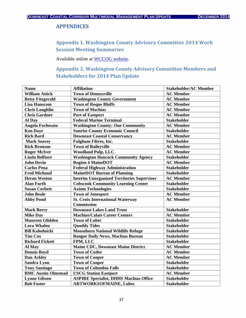
DOWNEAST COASTAL CORRIDOR MULTIMODAL MANAGEMENT PLAN UPDATE DECEMBER 2014
37
APPENDICES
Appendix 1. Washington County Advisory Committee 2014 Work
Session Meeting Summaries
Available online at WCCOG website.
Appendix 2. Washington County Advisory Committee Members and
Stakeholders for 2014 Plan Update
Name Affiliation Stakeholder/AC Member
William Attick Town of Dennysville AC Member
Betsy Fitzgerald Washington County Government AC Member
Lisa Hanscom Town of Roque Bluffs AC Member
Chris Loughlin Town of Machias AC Member
Chris Gardner Port of Eastport AC Member
Al Day Federal Marine Terminal Stakeholder
Angela Fochesato Washington County: One Community AC Member
Ken Daye Sunrise County Economic Council Stakeholder
Rich Bard Downeast Coastal Conservancy AC Member
Mark Seavey Fulghum Fibres, Inc. Stakeholder
Rick Bronson Town of Baileyville AC Member
Roger McIver Woodland Pulp, LLC AC Member
Linda Belfiore Washington Hancock Community Agency Stakeholder
John Devin Region 4 MaineDOT AC Member
Carlos Pena Federal Highway Administration Stakeholder
Fred Michaud MaineDOT Bureau of Planning Stakeholder
Heron Weston Interim Unorganized Territories Supervisor AC Member
Alan Furth Cobscook Community Learning Center Stakeholder
Susan Corbett Axiom Technologies Stakeholder
John Beale Town of Jonesport AC Member
Abby Pond St. Croix International Waterway
Commission
AC Member
Mark Berry Downeast Lakes Land Trust Stakeholder
Mike Day Machias/Calais Career Centers AC Member
Maureen Glidden Town of Lubec Stakeholder
Lora Whalen Quoddy Tides Stakeholder
Bill Kolodnicki Moosehorn National Wildlife Refuge Stakeholder
Tim Cox Bangor Daily News, Machias Bureau Stakeholder
Richard Fickett FPM, LLC Stakeholder
Al May Maine CDC, Downeast Maine District AC Member
Dennis Boyd Town of Cutler AC Member
Dan Ackley Town of Cooper AC Member
Sandra Lyon Town of Cooper Stakeholder
Tony Santiago Town of Columbia Falls Stakeholder
BMC Austin Olmstead USCG Station Eastport AC Member
Lynne Gibson ASPIRE Specialist, DHHS Machias Office Stakeholder
Bob Foster ARTWORKSOFMAINE, Lubec Stakeholder