Embed Size (px)
Citation preview
Tattered Fragments of the MapEdited by Adam Katz and Brian Rosa
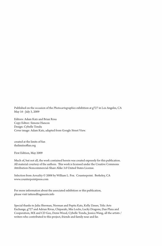
Published on the occasion of the Photocartographies exhibition at g727 in Los Angeles, CAMay 16 - July 3, 2009
Editors: Adam Katz and Brian RosaCopy Editor: Simone HancoxDesign: Cybelle TonduCover image: Adam Katz, adapted from Google Street View.
created at the limits of funthelimitsoffun.org
First Edition, May 2009
Much of, but not all, the work contained herein was created expressly for this publication. All material courtesy of the authors. This work is licensed under the Creative Commons Attribution-Noncommercial-Share Alike 3.0 United States License.
Selection from Aereality © 2008 by William L. Fox. Counterpoint. Berkeley, CA www.counterpointpress.com
For more information about the associated exhibition or this publication, please visit tatteredfragments.info
Special thanks to Julia Sherman, Norman and Pepita Katz, Kelly Zinser, Telic Arts Exchange, g727 and Adrian Rivas, Chiparaki, Mia Locks, Lucky Dragons, Dan Plaza and Cooperation, MX and CD Gee, Denis Wood, Cybelle Tondu, Jessica Wang, all the artists / writers who contributed to this project, friends and family near and far.


Contents
PREFACE 7
INTRODUCTION
Brian Rosa 9
Adam Katz with Denis Wood 11
ANTHONY AUERBACH:
The World is a Cut-Up 21
BILL BROWN:
Oklahoma Motel 31
Biosphere 2 33
SIMONE HANCOX:
The Map is Performed in the Territory 37
ELIZABETH EVITTS DICKINSON:
The Rise of the User Generated City 43
BILL FOX:
The Angels of Mulholland Drive 49
HERBERT GOTTFRIED: 55
North Acton, Route 27 Community Gardens 56
Comfort Suites Under Construction, Bedford 57
GERARDO GREENE GONDI:
Image Texture 59
ALEX HABER:
Mapping the Void in Perec’s Species of Spaces 63
CRIS BENTON:
A Brief History of Kite Aerial Photography 73
ANUSHA VENKATARAMAN:
Situating the Grassroots: Collectivity and Imagination 85

7
Photocartographies is a curatorial project that has materialized as an exhibition, a series of public programs and this book,
Tattered Fragments of the Map. Although some artists involved in the ex-hibition have also contributed written work, this publication is certainly not a catalogue of the show. Instead, we hope that various ideas which surfaced during our investigation and preparation could be presented here in a sort of schizophrenic, scattershot survey of mapping and its associated theoretical implications. These articles represent a series of tangents and departures, gestures toward the premise that a map is not a representation so much as a system of propositions.
Maps are tied to a history of authority, scientific rationality and practical application, masking the underlying subjectivity and biases of their creation. Satellite-based navigation, the disciplines of geography and, more recently, urban planning, have popularized and proliferated map imagery while helping to cement an aura of unassailable carto-graphic objectivity. Maps have become ubiquitous tools in our daily lives, and are understandably identified in accordance with a few simple assumptions: they are graphic representations of spatial relations and their creators are technicians bound to graphic systems that reflect a physical reality. However, the true nature of maps is one of distortion, beginning with their projections of three-dimensional surfaces onto two-dimensional frames, and compounded by territorialization, a habit of identifying, naming and claiming. Maps are image-objects in which different conceptions and configurations of time and space are created, not just charted.
Preface
TATTERED FRAGMENTS of the MAP
8
In 1858 Gaspard Felix Tournachon executed the first aerial photo-graphs from a hot air balloon tethered above the Paris skyline. In turn, Baron Haussmann employed this omniscient view to redesign the city, combating its perceived disorder. Over the last 150 years, people have used zeppelins, airplanes, and satellites to photographically capture and archive every piece of our globe with increasing accuracy and frequency.
More recently, public access to maps, as well as the access to their means of production, have been greatly enabled by digital technolo-gies—most notably tools such as Google Earth and freely accessible archives like those offered by the United States Geological Survey. Borges’ story of mapping the entire Kingdom with exactitude may seem improbably complete. And yet, maps can never escape being part of the world their creators try to represent. Like the photographic image, “The map does not reproduce an unconscious closed in upon itself; it constructs the unconscious” by coding power, politics, and aesthetics. All maps are still projections, and all territories are maps.
9
The word “frontier” has numerous definitions, from “the area along an international border” to “a region just beyond or at
the edge of a settled area” to “an undeveloped area or field for discov-ery.” Perhaps this multiplicity of meanings under a single name is an apt metaphor for the collection of artworks and essays included in the Photocartographies project – an examination of the margins, a re-con-textualization of landscape, a proposition for subjective, and perhaps subversive, cartographic discovery.
Authorities recently discovered that smugglers have developed a network of dozens of tunnels, engineered in various degrees of sophisti-cation, to burrow below the newly- constructed frontier walls between Mexico and the United States. In the event One Flew Over the Void, as part of inSITE 2005, the Bulbo arts collective shot a human cannonball over the wall separating Tijuana from San Diego. A concrete border’s impermeability is reliant on its inflexibility and rigidity, but therein also lies its weakness. When one can’t get around, one must go over or under. Cartographic boundaries are not usually so literal as border walls, but this makes them no less real and no less powerful. As much as these subversive tactics dissolve borders in a figurative sense, the lines on the map (and the terrain) remain.
Unlike the history of most forms of visual and verbal communica-tion, the history of mapping has shown few movements of popular or subversive expression. Incipient art practices that play with or question the authority of maps have begun to flourish as mapping has emerged as a ubiquitous tool, as well as a dominant graphical paradigm. The process
TATTERED FRAGMENTS of the MAP
10
of mapping developed over hundreds of years as an expression and ex-ecution of power, and the technological tools necessary to create maps have only recently been made available to the general public. Whether new tools such as Google Earth have “democratized” the agency of map-ping is unclear, but the free availability of such technology has increased popular interest in the production of maps as navigational and referen-tial aids.
If cartographic “facts” are inevitably imbued with an assertion of power and a specific cultural and political perspective, we have reached a turning point at which their semiotic tools can now be re-contextu-alized or détourned. Rather than digging below the border, we may burrow below the surface of the map, crawl within its folds, and find out what lies beneath its structure.
We are not seeking answers here, but rather collecting a series of works that challenge the authority or reconfigure the way that we utilize maps as narrative tools, means of investigation, and territorial representations.
-Brian Rosa
11
In 1992, Denis Wood coauthored The Power of Maps, a book (and an exhibition by the same name) that radically challenged
the authority of cartography and revealed maps as complicated social constructs. His work was instrumental to the movement of critical car-tographers and has continued to be at the forefront of critical thought surrounding the history of mapmaking, counter-mapping and map art. Indeed, his writing foregrounds much of the thinking that brought about this book and the accompanying exhibition. Although I approached this project with more appetite than expertise, I had read Denis’ books and been compelled by this epistemology of maps. Today, with the prolif-eration of mapping, and the technology for manipulating map imagery, it seems appropriate to revisit the map as potential site of power and knowledge formation.
Denis was kind enough to share some thoughts from his home in Raleigh, North Carolina.
l
Adam Katz: While you maintain a love of maps, you certainly have no reverence for the profession of mapmaking. In fact, in recent work you exclaimed, “cartography is dead.” How do you distinguish between the history of cartography and that of maps or mapmaking?
Denis Wood: I don’t think mapmaking is more than five or six hun-dred years old as a widespread practice. Cartography, as such, is far, far
TATTERED FRAGMENTS of the MAP
12
younger; it only came into being as an academic discipline in the middle of the 19th Century. The word was coined in the beginning third of the 19th Century and it was a way that German and other European and American geographers attempted to legitimate their discipline within the university. The mapmakers wanted to bring their discipline into the university as well. It was part of this widespread embourgeoisment of work practices: undertakers become morticians, newspaper writers become journalists. Cartography was never able to complete that whole process of professionalizing a practice and, at the very least, get license and title laws. I have to say, this is one thing for which I thank all of the legislative and other relevant branches of government who have never ceded to the cartographer’s request to make theirs a licensed profession. Because, despite the fact that cartography comes into be-ing – and becomes a sort of deeply rooted practice by the middle of the 20th Century in geography departments around the world – most of the maps that were ever made have nothing to do with cartography. The people who made them were not cartographers, they were not trained as cartographers, they didn’t know anything about cartography. They worked for oil companies, making highway maps, they worked for state departments of transportation, they worked for railway companies mak-ing time-tables and route engineering maps, etc., etc. The wide world of mapmaking included as a small subset that of cartography.
Cartographers, attempting to legitimate their being, did try to say that all mapmaking was cartography in some way or another. They did try to show they were rooted in the earliest stirrings of the human im-agination along unimaginable paths. They made extraordinary claims, but these claims had only passing impact on the actual practice of real mapmakers who were going about making tourist maps of London or Paris or Venice or wherever, without consulting cartographers.
Then in the early 1990s GIS reached a position where it was capable of allowing totally untutored people to make maps of precision and qual-ity, just as high of that of most cartographers. One way it did this was by taking all the knowledge that had been codified by the cartographers and dumping it into the GIS programs as defaults and presets and stuff like that. But what happens in any event is that geographic information
Introduction
13
systems, which then professionalizes itself into Geographic Information Science, really supplants cartography as a university discipline to the extent today that mapping and cartography positions in universities are declining precipitously as GIS positions are multiplying logarithmically. So, you had in the early 90s the strong push from GIS to move forward with mapmaking in an academic setting without cartography.
Graphic spatial representations seem to be common across cul-tures and throughout much of history. Do you think that the desire to map is something innate in human beings?
Well, the thing about graphic spatial representations is this: it’s like talking and writing. Certainly everybody talks, there’s no question about that. But not everybody writes. And people for most of human history have lived very full lives without writing. It seems like writing is something some cultures develop when there comes a pressing need because of the growth in size and complexity of the society; a need to record things without trusting them to the fallibility of human memory. Or to record things because the people who are going to be engaged are too far apart to see each other. For example, early pre-cuneiform writing clearly came from the need of trading partners who don’t see each other at opposite ends of a trade-link to know what was being sent. The person receiving wants to know what was being sent, not just what he gets. If he’s being sent a hundred sheep he needs to know he’s not being sent eighty sheep when eighty sheep show up. So they included these little tokens in these clay balls. Anyhow, they weren’t going to have face- to-face relationships, they were going to have long-lasting distant relation-ships and they really wanted to record them. These people seemed to develop writing.
The same thing is true with mapping. Everybody creates spatial im-ages of their environment that they depend on them to navigate and to attach meaning to places, and so forth. Indeed, it goes a ways down the phylogenetic ladder. Humans, animals, life-forms do this: they create these images of space. Whether or not they need to record them, make them graphic, is a whole other question. And guess what, it depends
TATTERED FRAGMENTS of the MAP
14
on precisely the same set of conditions that the development of writing does.
Writing can carry out most of the things that people use maps for. Writing is a much more flexible instrument than mapping is. When writing developed it pushed off the date at which we would start devel-oping mapping because writing could handle most of these tasks. You can do a deed with verbal means. You don’t need a map for that. You can govern an empire with a senate that does nothing but argue and talk about places of which they have very mixed mental images. But the fact that they don’t necessarily know or understand that doesn’t preclude them from running an empire without maps. There weren’t maps of the Roman Empire – certainly not that the Roman government ever used. There’s no evidence that these early societies mapped whatsoever. Only when the social structures that they created really become complicated did we begin to develop mapping as a sort of exigent need, and that seems to really come with the development of the modern state form which has an abstract quality that older forms didn’t have.
And what about the tendency of these newly developed image-objects to code subjects and produce identities?
We’re coming out of a feudal period when we develop most maps. When peoples’ relationships with the large social structure was face to face, and you knew who your overlord was and he knew who his over-lord was, and you knew there was a set of connections that took you to a king or to some kind of ruler, and that was the symbol around which you organized your understanding of the larger system of social relations… then he’s replaced by a “United States of America” or by “France,” or what replaces it? Well, one of the things the map does right off the bat is provide the nation with a geo-body. This is a term developed in a study of Thailand by Thongchai Winichakul. A map enables a geo-body and that geo-body become iconicized, it becomes a shape you put on badges and emblems; it becomes a shape people can recognize. The researcher Martin Brückner, talking about the history of the United States, says: you know, nobody believed this thing could hold together. The sec-
Introduction
15
tional discords, the differences between the New England north and the slave-owning South, not to mention the Mid-Atlantic states… What unified these things? The only thing after the revolution that unifies them is that they can point to this map of thirteen colonies as an entity, as a thing. And he demonstrates that this map hangs in taverns, it’s in homes, people have it over their piano, they have it over their mantle, it’s everywhere.
The same story can be told of 17th Century Japan. There is a history of insane discord that is finally solved under the forthcoming shogunate. Somebody pulls it all together, the civil war stops…. What’s the first thing he does? He says: okay, we’re going to map the country. And guess what the mapping does? It does a lot of things – one thing, it gets eve-ryone unified in a national task at the same time it’s giving him highly detailed information about how many people live here and how much rice is there and what kind of taxes he’s going to be able to get there. This is brought together into a map. That map becomes so popular, map-ping becomes so popular, by the time you coast into the 18th Century in Japan, they’re mapping everything. They’re mapping the route from Kyoto to Edo. They’re mapping the locations of all the brothels in Edo so that if you’re traveling there you can find one. They’re mapping the country as a whole, they’re mapping individual provinces, they have atlases, it just doesn’t stop. It was the same story happening in China, same story happening in Russia, same story happening in Thailand, same story happening in India. The story was being replicated wherever the young nation states were coming into being.
In The Power of Maps, you outline how maps inscribe power and support dominant political structures. Since then, your work has inspired many efforts (activist and academic – even artistic) to coun-ter the normative modes of cartography and to resist the repression of the state, capital, etc. In the wake of critical cartographers came counter cartography. Now we have examples of counter-counter-cartography – could you explain what this is and what it indicates about the power of maps?
TATTERED FRAGMENTS of the MAP
16
The mapping of Palestine is, I think, a paradigmatic case of all the currents that are running through mapmaking today. The history of mapping ancient Palestine is much more imagined than real. You can count the maps of Palestine made from the 6th Century on. There were like one a century that are made until you got to the 15th Century. It’s not mapped. And it’s not mapped for all the reasons maps aren’t made. There’s no reason to make a map of Palestine, and so none come into being… [heavy duty mapping by imperial powers began with the Venetians and Russians during the 15th Century and took on a con-temporary cast as the interests of the English, French and Russians con-verged in the area up through the 19th Century]. As the 19th Century came to an end, this mapping had multiplied. By the time the Ottoman Empire started mapping in 1909, there was a lot of this mapping going on. Coming into World War I, all of these places are remapped by these imperial interests.
World War I came to an end and the British instituted a survey of Palestine, and they created a really serious map of Palestine. And of course it was the mapping of Palestine as it existed. That is to say, an Arab entity that has thousands of Arab place names inscribed on the land. At the same time that this is going on in the 1920s, the Zionists became involved in Israel and they were very, very unhappy with the British insistence on using Arab names and in calling the entity Palestine. They want to call it Eretz Israel, and they want to rename all the places that had biblical Hebraic names, with Hebraic names.
The British were not about to do this. Who would be able to use such a map? It’s an Arab place. So the Zionists started creating a counter-map that restored to Palestine its biblical past, and in doing so constituted a kind of deed to the land. It was a way of showing that Palestine belonged to the Jews 2,000 to 4,000 years ago, and therefore still belongs to the Jews. The map became a deed in fact. And at the same time the map was used to record details of the Arab landscape that would become extraor-dinarily useful, essential to the Haganah in carrying out its objectives in the 1948-49 war period. And then this map that they created fused with the British map to become the Israeli survey of Israel, which is the entity that exists today. So what the Israelis have done is created a map
Introduction
17
that counters Palestine with the state of Israel, which counters its Arab past: Arab names and Arab places, with Jewish names, Hebrew language and biblical history. And that is the map we all become familiar with as the state of Israel came into being and became an existent state. In fact, we’re pretty unaware of all this earlier history.
Having created Israel and having pushed the Palestinians out of their land, the Israelis created a powerfully focused Palestinian nationalism. And these Palestinians looked at these Israeli maps and they rejected them completely. They said “This is not the place, this is not our map, it does not have the right names on it, this map does not have the real places on it.” Late in the game, the Palestinians started creating a coun-ter-counter-map of Palestine, and this counter-counter-map reached its apotheosis in the sort of incredible atlas of Abu-Sitta, called Atlas of Palestine, in 1948. This is an ongoing project now of the Palestinian counter-counter-mapping of the Israeli counter-mapping of the imperi-alist maps of Arab Palestine.
Do you see any emancipatory opportunity in such counter-map-ping projects?
My view is that in the end, the map is not going to be an emancipatory tool. But what we have to do is emancipate ourselves from the authori-ties of the map by multiplying maps. It is my hope that their numbers become so great – that there are so many points of view, that there are so many different understandings of what the real is – that the map will lose its unitary authority to declare that this is the truth. Somebody will always be standing up there with a counter-map, and saying, “On the contrary, this is the truth.”
So, you call for the proliferation of maps as a way of destabiliz-ing their authority, an authority that has historically been codified and formalized by state institutions and the academy. And some might point to the prevalence of user-generated maps and digital map technology and say that this is indeed what is happening today. Or alternatively, you have been making maps of all sorts to describe
TATTERED FRAGMENTS of the MAP
18
your neighborhood of Boylan Heights. But what about expanding the notion of what a map can be? Can charts or photographs or per-formances be understood as maps?
If it’s going to be taken as a map, it’s going to have to wear its signs of authority. It’s going to have to have those or it’s not going to be accepted as a map. It’s going to be accepted as something like a map or something playing with a map, etc. For example, it’s going to be accepted as an art map. The first things artists attack are those signs of authority. But, with-out those signs of authority it’s not going to be read as a map. The thing that a map is, is authoritative. That’s what a map is. The being-ness of a map is its authoritativeness. Without that, it’s not a map. It’s nothing. Or it’s a picture, it’s a photograph.
If I go back into these histories where historians of cartography make these claims about its ancient past and they talk about “wherever man has had a sense of place, he has been driven to make some kind of map, however primitive, blah blah blah.” And then they follow this forward and somehow it inexorably leads to the United States Geological Survey, right? I wonder why when they walk forward with that they don’t follow this instinct to create an understanding of place into poetry, into the prose that will follow later on, into landscape painting, into other forms of making reference to symbologizing place. They never follow those because they’re doing a map history. If you follow back into landscape painting you will find precisely the same claim made about its roots that you find at the heart of the beginning of the map history, except histori-ans will follow it forward to landscape painting. These are all retrospec-tive views of this urge, a kind of projection of contemporary practice back into some distant past. Now I guess one of the claims I’m making is - whatever maps are, it’s not about creating a sense of place; whatever maps are, it’s about being a vehicle for the creation and conveyance of authority about, and ultimately over, territory.
In one of the articles in this collection, Simone Hancox quotes Susan Sontag talking about photography, in a turn of phrase that could just as easily be applied to maps: “Photography implies that we
Introduction
19
know about the world if we accept it as the camera records it. But this is the opposite of understanding, which starts from not accepting the world as it looks.” Do you perceive a similar trajectory between the photographic and the cartographic technologies despite their distinct modalities?
First of all, they have a very distinct parallel trajectory. As we know them today in their popular forms, both of them are children of the 19th Century and both of them owe their ubiquity to lithography. They are both utilized in the same way by the same agents to make the same point which is this is evidence of the real – here is a photograph of it; here is a map of it; believe it, we have the evidence. And they are both una-shamedly used to hammer home whatever unpleasant truth the people wielding the hammer want to make us buy into. And of course, I can’t es-cape from the notorious example in “the weapons of mass destruction”: Colin Powell pointing at that aerial photograph/map showing us where these weapons are. That’s what they use them for – they use them for that again and again. And they’ve used them to show us the inferiority of blacks, or they used them to hammer home the segregation of blacks and their inequitous treatment at the hands of whites. They used them to show the superiority of the whites and they use them to show the inferiority of the whites. It doesn’t make any difference what the topic is, these agents have used maps and they have used photographs to make their point that these things, their concern, is real. Here’s a photograph of it, it’s obviously real; here’s a map of it, it’s obviously real.

21
Atlas is the term for a collection of maps in the form of a book. Atlas binds unwieldy sheets into a convenient volume.
Gerardus Mercator (1512 – 1594) is said to have been the first to give the name Atlas to such a volume. Mercator’s project (initiated in 1578, updated in 1585) remained a fragment – a fragment, according to Adorno’s definition, being a work interrupted by death.1
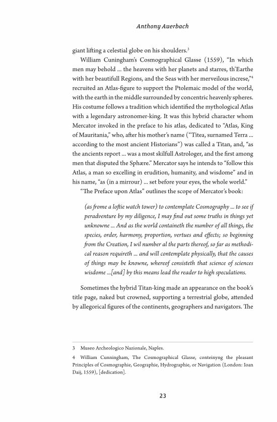
Mercator was not the first to compile a book of maps, nor the first to associate the figure of Atlas, the weary Titan, with the art of cartog-raphy. A “Modern Geography” published in the mid-sixteenth century by Antonio Lafreri, comprising, as the title explains, “most of the world, collected from various authors and arranged according to Ptolemy’s Geography together with drawings of cities and fortresses of various provinces,”2 was presided over on its title page by Atlas supporting – and this appears to be the innovation – a terrestrial globe, instead of the celestial sphere with which he was normally depicted, after the model provided by the famous Farnese Atlas, a second-century Roman copy of a Hellenistic statue unearthed in the early sixteenth century: a nude
1 ‘The fragment is the intrusion of death into the work.’ Quoted in ‘Editors’ Afterword’ to Theodor W. Adorno, Aesthetic Theory, ed. by Gretel Adorno and Rolf Tiedemann, trans. by Robert Hullot-Kentor (London: Athlone Press, 1997), p361.
2 Geografia: Tavole Moderne di Geografia de la Maggior parte del Mondo di di-versi avtori raccolte et messe secondo l’ordine di Tolomeo con idisegni di molte citta et fortezze di diverse provintie stampate in rame con studio et diligenza in Roma, by Antonio Lafreri, usually dated 1550–1572.
The World is a Cut-UpAnthony Auerbach
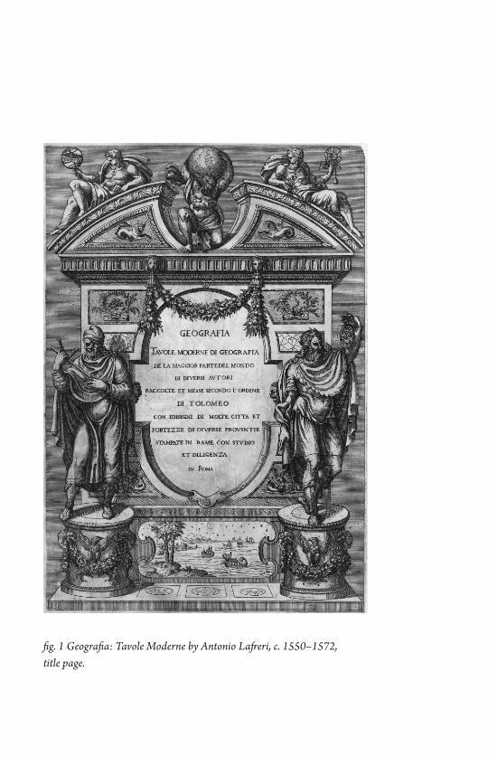
fig. 1 Geografia: Tavole Moderne by Antonio Lafreri, c. 1550–1572, title page.
Anthony Auerbach
23
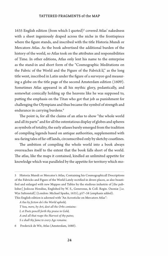
giant lifting a celestial globe on his shoulders.3 William Cuningham’s Cosmographical Glasse (1559), “In which
men may behold ... the heavens with her planets and starres, th’Earthe with her beautifull Regions, and the Seas with her merveilous increse,”4 recruited an Atlas-figure to support the Ptolemaic model of the world, with the earth in the middle surrounded by concentric heavenly spheres. His costume follows a tradition which identified the mythological Atlas with a legendary astronomer-king. It was this hybrid character whom Mercator invoked in the preface to his atlas, dedicated to “Atlas, King of Mauritania,” who, after his mother’s name (“Titea, surnamed Terra ... according to the most ancient Historians”) was called a Titan, and, “as the ancients report ... was a most skilfull Astrologer, and the first among men that disputed the Sphære.” Mercator says he intends to “follow this Atlas, a man so excelling in erudition, humanity, and wisdome” and in his name, “as (in a mirrour) ... set before your eyes, the whole world.”
“The Preface upon Atlas” outlines the scope of Mercator’s book:
(as frome a loftie watch tower) to contemplate Cosmography ... to see if peradventure by my diligence, I may find out some truths in things yet unknowne ... And as the world containeth the number of all things, the species, order, harmony, proportion, vertues and effects; so beginning from the Creation, I wil number al the parts thereof, so far as methodi-cal reason requireth ... and will contemplate physically, that the causes of things may be knowne, whereof consisteth that science of sciences wisdome ...[and] by this means lead the reader to high speculations.
Sometimes the hybrid Titan-king made an appearance on the book’s title page, naked but crowned, supporting a terrestrial globe, attended by allegorical figures of the continents, geographers and navigators. The
3 Museo Archeologico Nazionale, Naples.
4 William Cunningham, The Cosmographical Glasse, conteinyng the pleasant Principles of Cosmographie, Geographie, Hydrographie, or Navigation (London: Ioan Daij, 1559), [dedication].
TATTERED FRAGMENTS of the MAP
24
1635 English edition (from which I quoted)5 covered Atlas’ nakedness with a sheet ingeniously draped across the niche in the frontispiece where the figure stands, and inscribed with the title Historia Mundi or Mercators Atlas. As the book advertised the additional burden of the history of the world, so Atlas took on the attributes and responsibilities of Time. In other editions, Atlas only lent his name to the enterprise as the stand-in and short form of the “Cosmographic Meditations on the Fabric of the World and the Figure of the Fabrick’d,” as the long title went, inscribed in Latin under the figure of a surveyor-god measur-ing a globe on the title page of the second Amsterdam edition (1609). Sometimes Atlas appeared in all his mythic glory, pedantically, and somewhat comically holding up the heavens like he was supposed to, putting the emphasis on the Titan who got that job as punishment for challenging the Olympians and thus became the symbol of strength and endurance in carrying burdens.6
The point is, for all the claims of an atlas to show “the whole world and all its parts” and for all the ostentatious display of globes and spheres as symbols of totality, the early atlases barely emerged from the tradition of compiling legends based on antique authorities, supplemented with sea-faring tales of far-off lands, circumscribed only by sketchy coastlines.
The ambition of compiling the whole world into a book always overreaches itself to the extent that the book falls short of the world. The atlas, like the maps it contained, kindled an unlimited appetite for knowledge which was paralleled by the appetite for territory which mo-
5 Historia Mundi or Mercator’s Atlas, Containing his Cosmographicall Descriptions of the Fabricks and Figure of the World Lately rectified in divers places, as also beauti-fied and enlarged with new Mappes and Tables by the studious industrie of [the pub-lisher] Jodocus Hondius, Englished by W. S., Generosus, & Coll. Regin. Oxoniæ [i.e. Wye Saltonstall] (London: Michael Sparke, 1635), p57–58 (emphasis added). This English edition is adorned with “An Acrosticke on Mercators Atlas”:
A tlas by fiction do’s the World uphold;T hou, more, by Art, dost all the Orbe containe:L et Poets pencill forth thy praise in Gold,A and all that reape the Harvest of thy paine;S o shall thy fame to every Age remaine.
6 Frederick de Wit, Atlas (Amsterdam, 1680).
Anthony Auerbach
25
tivated the colonising enterprise known as the “age of discovery”. What distinguishes the atlas from earlier cosmographies, island-
books and mappae mundi is its systematic structure. Such a structure – under the rule of the map – does not discriminate between the known and the unknown. Instead of sorting and organising discrete bits of knowledge like the collector and the naturalist – or like the traveller, stringing them along the narrative line of a journey (a yarn which can be easily wound into a book) – by contrast, the systematic approach posits a unity and divides it arbitrarily. The map’s grid and the atlas’ system organise, above all, empty space – a blank surface to be populated with signs. The signs inscribed, and thus indexed by the map’s grid, are facts, hence (according to philosophers) better than things, because they are supposed to have sense. A map represents the ‘logical space’ whereby the facts are the world.7 The priority of cartographic geometry is spelled out in Cunningham’s recommendation of his Cosmographical Glasse (which contained no maps) to those readers who do not necessarily “delight in travailing [travelling (working)]” so that they “may also pro-tract, & set out perticuler cardes [charts] for anye countrye, Region, or province: or els th’universall face of th’earth in à generall Mappe. Firste if they describe Parallele circles in the Mappe, answeringe to the like circles in the heavens ... to limite out the Zones, Climates, & Paralleles of Longitude, and Latitude: which being once præpared, you shall place there in the countries, hilles, fluddes, seas, fortresses, Ilandes, cities, desertes, & such like (according to the præcepts of th’art) as are placed on the platte forme of th’earthe.”8
Maps, and the atlases which cut and fold them into books, seem to offer a view of the world unbounded by the horizons which normally limit our prospects. A map is bounded only by the cuts which detach it from the globe. The almost-blankness of the map is enough to promise sight of land to the navigator, and to the speculator, uncounted treasure.
7 See Ludwig Wittgenstein, Tractatus Logico-Philosophicus, trans. by D. F. Pears and B. F. McGuinness, London: Routledge & Kegan Paul, 1961, § 1.13.)
8 Cosmographical Glasse, p5.
TATTERED FRAGMENTS of the MAP
26
l
What aerial photographs have in common with maps is the allure of a view beyond the horizon. Never mind that with
altitude the horizon recedes but is not overcome, and with photography it just falls out out the picture. The apparent similarity between maps and aerial photographs is a matter of desire, as if the one desired to be-come, or to be fulfilled in the other. What the map lacks is overabundant on the photograph. What is blank on the map is overdetermined in the photograph. Whereas the photograph records everything indiscrimi-nately, anything on the map makes sense. The map gets credit for the meaning the photograph cannot declare.
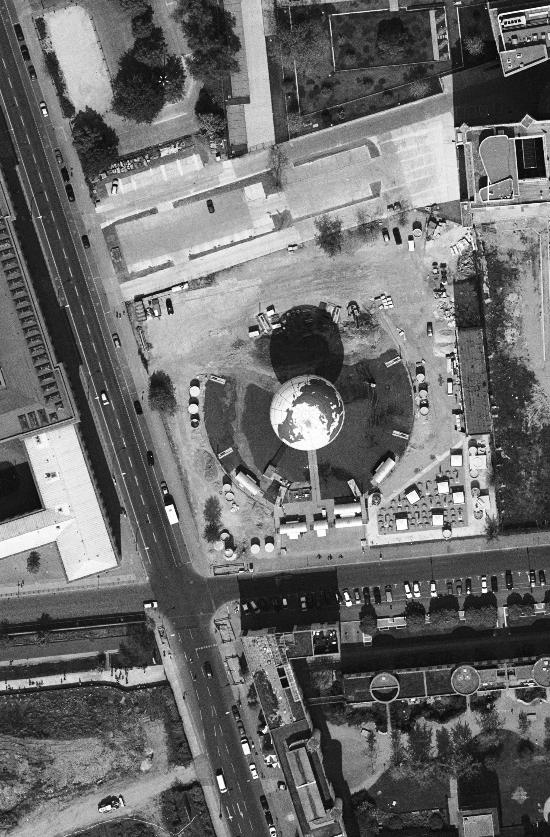
Technically speaking, aerial photography depends on photography and aviation rather than on surveying and navigation. The first aerial photographer,9 however, was not the first to dream of a bird’s-eye view. The aerial photographic techniques developed for military reconnais-sance (military aviation in turn owes its origin to reconnaissance) found numerous other applications including geology, archaeology, hydrol-ogy, forestry and various kinds of cartography. A post-war manual, The Uses of Air Photography tells us:
A map shows selected and conventionalised features: an air photograph makes no selection and employs no convention. A photograph will thus record not only such major features as are commonly delineated on a map, but a wealth of minor and often transient detail never found on the largest general survey. This detail constitutes an almost inexhaust-ible store of information of value to geology, to geography, to ecology, to agriculture, archaeology, history and town-planning; and these are only the principal fields of study that gain from the application of air photography to their problems. [...] The fact that, compared with maps, photographs neither select nor conventionalise the information they present has called for special techniques of interpretation to serve this
9 Gaspard-Félix Tournachon (known as Nadar) in a balloon, 1858.
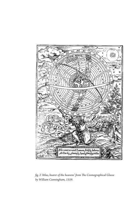
fig. 2 ‘Atlas, bearer of the heavens’ from The Cosmographical Glasse by William Cunningham, 1559.
Anthony Auerbach
29
multiplicity of interests.10
Here lies the strategic value of aerial reconnaissance and its challenge to would-be prospectors: interpretation.
fig. 3 (opposite) ‘minor and often transient detail’, corner of Zimmerstraße and Wilhelmstraße, Berlin (Google, 2006), cf. the quote from The Uses of Air Photography.
10 J. K. S. St. Joseph (ed.), The Uses of Air Photography: Nature and Man in a New Perspective (London: John Baker, 1966), p15.

31
Oklahoma is the “sooner state” because the White settlers couldn’t wait to get here. The story goes that the day the ter-
ritory was opened to settlement, a bunch of land-crazy pioneers were perched on the border-line, like Olympic runners waiting for the gun to fire. Then a gun really did fire, and the settlers scrambled in, and once the dust settled, Oklahoma was a fucking garden all a-bloom. That’s the story, anyway. The White settlers couldn’t wait to get here and the Indians, on the other hand – they could wait. The license plates in OK identify the state as “Native America” because this is Indian country. The Indians were mostly forced to settle here after being driven off their tribal lands. Oklahoma is what sat at the far end of the trail of tears.
I stop for breakfast at a diner just across the border from Kansas. I sit there for a long time, trying to square these two founding myths: Oklahoma the promised land, Oklahoma the penal colony. Finally I give up and work on a crossword puzzle instead. The coffee in this place tastes like the pot. It tastes like boiled aluminum. It’s Alzheimer’s coffee, that wakes you up only to make you forget why you’re awake. Wide-awake and forgetful, which might be the best way to face the day in a state with such a sad history. The diner and the motel last night – that perfect old school flophouse where you inquire about the rooms at a gas station across the street – are owned by the Kaw Indians. I sip my aluminum-flavored coffee in a dining room full of White farmers (“It rained enough last night,” one says, “to knock the dust off the trees and put it back on the ground”), and I wonder if all the old debts have been paid; all the reparations, unspoken and unofficial. Maybe that’s what’s
Oklahoma MotelBill Brown
32
TATTERED FRAGMENTS of the MAP
going on at the Indian casinos you find all over this state. That’s where the conquering race – hobbling around with walkers and clacking their dentures – slips quarters in the slots and pays off its historical debts one quarter at a time.
33
Biosphere 2 is a really rich guy’s science fair project. That’s how my pal Sarah puts it. She’s not wrong, but it turns out things are
a lot weirder than that. Back in the 1980’s, a Texas oil billionaire named Ed Bass decided to build a huge, totally sealed terrarium in the desert just north of Tucson. Why an oil tycoon decided to build a giant green-house isn’t entirely clear, but it seems to have involved some shady eco-cult called The Intitute for Ecotechnics; a collection of hippy-scientists; William S. Burroughs; and a plan to colonize Mars. Or something like that. Biosphere 2 was supposed to be a miniature version of Earth (aka, Biosphere 1). Miniature and, apparently, portable. A laboratory for liv-ing off-world. By 1990, it was finished: a giant glass-and-steel Mayan-revival sci-fi greenhouse with its own computer-controlled rainforest, a couple deserts, some monkeys and pigs, and a million-gallon saltwater ocean with a wave machine. From the beginning, tourists were invited to visit, which made Biosphere 2 less an ecological laboratory than an ecological-laboratory-themed roadside attraction. Sarah and I visit the place on a Tuesday in early December. The tour group consists of the 2 of us, two older couples, and a tour guide named Lynn. Otherwise, the place is deserted. Lynn tells us that originally, the idea of Biosphere 2 was to lock a bunch of scientists (well, not scientists, exactly, but people with “scientific backgrounds”) inside and see if they could survive for a couple years. 8 Biospherians eventually entered the Biosphere. It was a big deal, and at first, things went pretty well. There were tons of tourists. The fruit trees in the rainforest produced fruit. The chickens laid eggs. But then, things began to go wrong. The pigs started to raid the vegeta-
Biosphere 2Bill Brown
34
TATTERED FRAGMENTS of the MAP
ble gardens. The monkeys squealed all night and drove the Biospherians crazy. The bees died. Most serious of all, the oxygen levels inside the Biosphere began to plummet. No one could figure out why. Due to the lack of oxygen, the Biospherians began to stumble around and bump into walls and act confused. After a few months, Biosphere 2 was in bad shape. Lynn the tour guide implies that the Biospherians wound up hat-ing each other. I find out later that they split into two factions: the True Believers who would do anything to make the project work, and the Realists who thought it wouldn’t be a bad idea to open a window and let in some fresh air. In the end, the people running the project decided to pump in oxygen. They really had no other choice, but it pretty much de-feated the whole point of a sealed, self-contained environment. 2 years later, when the Biospherians finally emerged from the Biosphere, they were pale (since the greenhouse glass filtered out UV light) and skinny (since the various ecosystems barely produced enough food) and pretty sick of Biosphere 2.
We follow Lynn around. Originally, the greenhouse was all sealed up, and tourists couldn’t go inside. Now it doesn’t matter. We walk through the Biosphere 2 gourmet kitchen, and past one of the Biosphere 2 bed-rooms with abstract expressionist paintings hanging on the wall. One of the original Biospherians painted them, apparently while suffering from acute oxygen deprivation. We troop through the rainforest, and the marsh. We stare at the million-gallon ocean and listen to the lonely pulse of the wave machine, slow and regular, like the fading pulse of some monstrous dying thing. We stand there for a while, looking out over a dead sea under a sky of steel trellis and glazed glass. Lynn men-tions that there wasn’t enough money to construct a solar power system and make Biosphere 2 truly self-sufficient. Instead, it gets its electricity from the local electrical company. No one on the tour says anything, but I’m pretty sure we’re all starting to think the same thing: that Biosphere 2 isn’t just a failure, but a Colossal Fiasco, and this causes all of us to lapse into a kind of embarrassed silence.
After the tour, Lynn ditches us, leaving us all to wander around the place, alone and unsupervised. There are no surveillance cameras. No docents or security guards. I say to Sarah that it feels like we’re astro-
Bill Brown
35
nauts who’ve responded to a distress call from some space station in deep space. When we get there, all the machines are running and the computers are automatically taking care of things, but the space sta-tion crew has vanished without a trace. Sarah and I creep from one ecosystem to another. We notice the ants. There are ants everywhere. Biosphere 2 is overrun with them. As the other species died off, the ants kept multiplying. Swarming over the handrails and the tropical plants. Swarming over you, too, if you’re not careful. We wander down into the basement. A huge concrete crypt beneath the Biosphere. There are gillion-gallon water tanks down there, and evaporative coolers as big as a house. There are no fiberglass rocks down in the basement, like there are topside. No landscaped terraces or banana trees or viewing plat-forms. The basement is full of the hidden machinery that was supposed to make Biosphere 2 bloom. The machines worked just fine. Precise and computer-controlled and energy efficient. Dropping precisely the right amount of rain on the simulated rainforest. Keeping the humidity in the simulated desert low. In the end, the machinery was the only thing that worked according to plan.
By 1994, things got ugly. Ed Bass wanted his greenhouse back. The hippy “visionaries” managing the place resisted. Restraining orders were issued. Federal marshals showed up. At some point – and this is where things get especially confusing – a couple of the former Biospherians (one of whom was a Belgian engineer who called himself Laser) broke into the Biosphere in the dead of night and opened up all the emer-gency exits and busted out a couple windows. I’m not sure why they did this. Needless to say, the billionaire oil tycoon and the eco-cultists were no longer on speaking terms. It took a couple years, but in 1996, Bass convinced Columbia University to take over management of the place. They tried to move away from the Disney Science of the original Biosphere and do some real research. Columbia lasted for a few years, but Lynn tells us they recently jumped ship. Now Biosphere’s future is up for grabs. I read somewhere that Mr. Bass is thinking of developing the land around the Biosphere. Building a bunch of tract homes he’ll call something like Biosphere Estates.
Outside Biosphere 2, Sarah and I walk past a row of interpretive
36
TATTERED FRAGMENTS of the MAP
plaques that neither of us has the heart to read. We’re pretty sure we know what they don’t say. They don’t say that Biosphere 2 has all the elements of a Greek tragedy. A not very good, B-grade Greek tragedy, in fact, featuring an arrogant billionaire with big but totally hazy ambi-tions, a Greek chorus of freaky voodoo scientists, an insane project, and a series of disasters that reduces the whole thing to ruins. Maybe that was the point all along. Maybe Ed Bass is an eco-radical genius, and he figured the best way to demonstrate the fragility of Biosphere 1 was to build Biosphere 2 and watch it crash and burn. A dramatic lesson that would cause people to set aside their plans to colonize Mars, and stop treating this planet like a disposable diaper. If that was the plan, I guess it failed, too.
37
A map is not the territory it represents, but, if correct, it has a similar structure to the reality it represents, which accounts for
its usefulness.1 Alfred Korzybski’s famous opus referred to the general seman-
tics, his philosophy of language-meaning. This phrase has come into frequent usage, and is just as frequently divorced from the discipline from which Korzybski wrote. According to Korzybski, the “territory” is lived experience, and the “map” represents the tools with which each individual make sense of the world. This is because an individual’s un-derstanding of reality is dependent on the structures that person (both consciously and unconsciously) creates through filters such as language, neurological processing, and social and cultural experiences. This map that is individual to us all determines our perception of reality, and as such is not the territory (objective reality itself). Korzybski uses a car-tographic metaphor for how one processes and perceives the linguistic world, indicating that the inherent spatiality of being shapes language, and vice versa. To understand Korzybski is to see the body as a physical sensorium that perpetually processes “being in the world.”
Korzybski’s philosophy on our personal mapping processes in rela-tion to an external objective reality reveals much about the practice of cartography, which has a history of being naturalised as a neutral sci-ence. Throughout the course of history, certain cartographic method-
1 Korzybski, Alfred (1994) Science and Sanity: An Introduction to Non-Aristotelian Systems and General Semantics, Institute of General Semantics, p58.
The Map is Performed in the TerritorySimone Hancox
TATTERED FRAGMENTS of the MAP
38
ologies have been, and are, accredited with greater scientific objectivity. In spite of this, rather than heralding the map as purveyor of a transhis-torical truth, “maps are at least as much an image of the social order as they are a measurement of the phenomenal world.”2 Bearing this in mind, how does the map-territory metaphor conceived by Korzybski in the 1930s inform how we interpret the contemporary cultural, social, technological and political milieu? Considering that today, satellite pictures, mobile mapping devices and geotagging are widely available to a viewing public, and in an age when cartography increasingly uses the medium of photography, the map teeters ever closer to a simulation of the territory. More specifically, how does this affect the individual’s processing of the world, and particularly one’s experience of space? Like Korzybski’s theory of the semantic map which is contingent on a given milieu and personal circumstance, the cartographic map is implicated by the context from whence it is born – it is a reciprocal relationship. To reiterate: it is not that the development of cartography impacts upon one’s capacity to comprehend “being in the world,” but it does penetrate how any given individual interprets it; in turn, the personal map one uses to read the world affects the cartographic objects and images that any given individual(s) produce(s). The phenomenological resonance in Korzybski’s relativist thinking suggests that it is impossible to escape from one’s very position in the world, which informs the personal map used to interpret the territory. If there is an objective reality, it lies outside of the self. Of course, Korzybski’s logic may become problematic when it reduces our access to the world to solely subjective realities, devoid of any Aristotelian sensus communis (indeed, he was an anti-Aristotelian thinker). Nevertheless, rather than critiquing this theory here, I intend to glean the positive awakenings of what this map-territory thesis may offer to our understanding of cartography (and particular its relation-ship with photography) in current practices.
Both cartography and photography have received criticism for ap-propriating the landscape through temporally static, spatially delimited
2 Harley, J. B. (2001) The New Nature of Maps: Essays in the History of Cartography London: Johns Hopkins University Press, p158.
Simone Hancox
39
and two-dimensional images; they have frequently been used as tools of knowledge-power via visual possession, and this is where much of the politics involved in these practices are performed. In a critique of pho-tography, Susan Sontag states that “Photography implies that we know about the world if we accept it as the camera records it. But this is the opposite of understanding, which starts from not accepting the world as it looks.”3 The power of the scientific cartographer or artistic pho-tographer to influence what is accepted for ocularcentric contemplation is seemingly problematic. Although they potentially offer alternative cognitive and sensory understandings of engaging with and reading the world, the personal semantic maps of photographer and cartographer, artistic practitioner and curator alike are complicit with factors such as education, socio-cultural background and life experience. Korzybski suggests a critical awareness of both our own mapping process and those of others by using a technique called the “consciousness of abstracting.” In doing so, one is firstly sensitive to the fact that people may perceive reality differently, but also cautious of what is presented as “fact.” This also allows potential agency for the individual against consensus reality, particularly the semantics that may be manipulated through, for exam-ple, politics, media and advertising. The production of cartographic and artistic practices thus retain their validity, but with an awareness that authorship is not necessarily authority.
With regards to the map itself, John Brian Harley states “Cartography remains a teleological discourse, reifying power, reinforcing the status quo, and freezing social interaction within charted lines.”4 However, just as meaning-making processes can be manipulated, they can also be re-appropriated; recently, there has been a rise in the number of artistic practices that subvert the normalised methods of presenting space by employing photo-cartographic methodologies that question the very nature of knowledge, power and understanding. The imperative here, then, is an inquiry into the validity of photography and cartography
3 Sontag, Susan (2002) On Photography, London: Penguin, p23.
4 Harley, J. B. (2001) The New Nature of Maps: Essays in the History of Cartography, London: Johns Hopkins University Press, p79.
TATTERED FRAGMENTS of the MAP
40
as practices that not only engage with knowledge-power, but disperse authority and promotes agency for their viewer, which I believe releases the potential political efficacy of the image. Applying Korzybskian logic, the production of the image is always subject to the personal mapping process as conditioned by any given subject’s situatedness. The map-object or photo-object, though a static image, thus alludes to its incep-tion: a gaze whose ontological condition is that of presentness. This gaze must be understood as inherently grounded in (and tainted by) all other sensory and personal components of the trajectory from which the individual looks.
The gaze of the scientific cartographer or artistic practitioner is ul-timately a performance, to varying degrees, of identity and/or power. Although artistic practitioners are still inscribed by a consensual real-ity they may also attempt to resist it through dissensus, which is at the heart of a critical practice. Dissensus should be understood here as a de-naturalisation of the gaze. An allusion to the performative is achieved when the artist makes apparent, or provides a glimpse of the processes behind their static representation. Offering alternative ways of looking to those which are consensually normalised and pertaining to the per-formance of the gaze implicit in the production of any image, the artist opens up the democratisation of both looking and representing through the acceptance of difference. They disclose to their viewers that they too are equally bestowed with the capacity to look, interpret, and experi-ence differently. By exposing the gaze to be contingent on the present, performative and subject to flux, and by undoing the rigid objective reality of (in this case) spatial understanding, the artist dispels some of the authority inherent in the presentation of their image. As such, there is also a double performance of the gaze: the artistic practitioner invites the gaze of viewers, whose alternate semantic-maps offer a differ-ent way of reading the image presented to them: it is an interpretation of an interpretation in a resonantly Barthesian “death of the author.” These images cannot directly present the mutability of space through time, but some are more capable than others in awakening the viewer to the presentness and subjectivity behind the image. Understanding the performance of a gaze that is unique to all and susceptible to change
Simone Hancox
41
thus offers political agency for the viewer – looking as a democratised form of knowledge creation.
Certain practices are more overt in their exploration of the perfor-mativity of the gaze, the embodied experience necessary to its creation, and thus the performance of the map itself. Artist Francis Alÿs made a piece entitled Sometimes Doing Something Poetic Can Become Political and Sometimes Doing Something Political Can Become Poetic (2004). This series of paintings, drawings, sculptures, photos and film were first exhibited at The Israel Museum in Jerusalem. After the Arab-Israeli War in 1948, a peace agreement was signed between Moshe Dayan, an Israeli military leader, and Abdullah al-Tal, representing the Arab forces. During this agreement, Moshe Dayan marked the Israeli front line with a green pencil upon a 1:20,000 scale map. In 2004, Alÿs walked along this armistice boundary, re-inscribing the actual territory through embod-ied experience, as well as marking the journey via a leaking can of green paint. Although Alÿs documents his journey through visual media, it is secondary to the performance itself. Without undermining the sig-nificance and power of visual semantics and the appropriation of space via the map, Alÿs reveals that the presentness of walking and sensing the landscape can never be fully encapsulated in visual documentation. Thus Alÿs alludes to the ephemerality of the performance he created – the act itself passes into history. Alÿs physically re-enacts the gaze that is part of a political power struggle, and re-appropriates it through his subjective body-based knowledge. His aim is “to generate situations that can provoke through their experience a sudden unexpected distancing... that can destabilize and open up, for just an instant – in a flash – a dif-ferent vision of the situation, as if from the inside.”5 By inscribing the map with an alternative narrative through artistic performance, Alÿs offers a form of dissensus of how the world is read by questioning the consensual (and naturalised) division of territory.
Understanding the evolution of the practices of photography and cartography is just one means by which to acknowledge that our per-
5 Ferguson, Russell and Francis Alÿs (2007) ‘Russell Ferguson in conversation with Francis Alÿs’ in F. Alÿs, et al. (eds.) Francis Alÿs, London: Phaidon, p40.
TATTERED FRAGMENTS of the MAP
42
sonal maps are subject to reconfiguration. Even as cartographic proc-esses become increasingly acute in their representation of the landscape through the use of photographic images, the creation of spatial represen-tations captured and frozen in time are dependent on a gaze caught in a condition of presentness. A practice such as Alÿs’s suggests, therefore, that the map itself is always a part of the territory. By re-appropriating the map’s navigational utility, by alluding to the performance of the gaze within the territory, the map is shown to both read the territory, and re-make it from within, reconfiguring ways of seeing and of sens-ing. The position from which each person looks is always, to differing degrees, subjective – that is, subject to each individual’s Korzybskian map of how they interpret the world. Those art practices that question what it means to look, and disrupt naturalised cultural notions, are thus better able to promote agency when they dissolve the authority of the gaze. One cannot step outside of the territory one wishes to appropriate or re-appropriate, but must do so from within: each person, society or culture performs their gaze in the territory that contains, informs, and is informed by the map.
43
In the early 1960s, Robert Moses proposed an expressway for Manhattan that would have leveled multiple city blocks and bifur-
cated the Lower East Side and SoHo. The Lower Manhattan Expressway (LoMEx) was never constructed – thanks to a now infamous standoff in 1962 with community activists led by Jane Jacobs – but Moses’ asphalt vision resurfaced recently. A map of the eight-lane highway appeared on the web courtesy of photographer and geography student, Andrew Lynch. Lynch was curious how the expressway would read on a modern map, so he downloaded the necessary streetscapes from Google and he overlaid the path of the LoMEx. A broad yellow band now sweeps down Broome Street from the Holland Tunnel to the Manhattan Bridge; another band shoots down the Bowery on its way to the Williamsburg Bridge. Two yellow rivers wind through the epicenter of one of world’s most vibrant urban neighborhoods. It serves as a stark reminder of how fragile a city really is. What if Jacobs had lived in Poughkeepsie instead of Greenwich Village and never picked up a picket sign? What if Moses had won the fight?
There are other renderings of the LoMEx, other maps and drawings of its potentially disastrous path, but it is Lynch’s Google version that is the most compelling. In the last few years, the Google Map aesthetic has become a pervasive visual language; it is increasingly how we read space. This map feels like the real thing and that is exactly what Lynch in-tended. “ We have become so accustomed to viewing the world through Google Maps (or some other online mapping software) that I feel like these maps are starting to shape our view point of the city,” he wrote on
The Rise of the User Generated CityElizabeth Evitts Dickinson
TATTERED FRAGMENTS of the MAP
44
his blog. To look at his map out of context, you would never know it to be speculative.
The purpose of a map is to place us geographically, to define and outline our world. As such, maps are often taken as reality, as objec-tive presentations of fact. Anyone studying cartography, however, recognizes maps as a relatively subjective form. They have always been communication tools rooted in culture and history and how we under-stand territory depends on our perspective. Interpretation, bias, and circumstance play a large role. Take, for example, the research of Ohio-based archivist William C. Barrow. In 2003 he studied official maps of Cleveland and found, among other things, subdivisions that were never realized. “Inaccuracies in local history maps are most often caused by the failure of commercial map makers to keep track of changes in the community, or by their need to incorporate the newest information as it comes available, sometimes adding features that ultimately never appear on the ground,” he wrote at the time.
Today, new technologies allow improved tracking of those changes that Barrow references. Google Earth affords extraordinary visual access to the world, allowing us to zoom in on 360-degree street-level images and see a place for ourselves. Click on a tab and up comes additional data, from restaurant reviews to traffic updates. We now have the power to map minutiae at a grand scale, creating what journalist Evan Ratliff referred to in a 2007 Wired magazine article as “a geoweb that’s expand-ing so quickly its outer edges are impossible to pin down.”
This increased visual access adds a kind of veracity; it creates a sense that the cartographer’s subjectivity has been replaced by literal images of what exists. It’s easy to forget that much of what is found in these online maps comes from individuals uploading data and photos via an accessible software language. Applications from map providers like Google, Microsoft, and Yahoo invite volunteers to contribute their own information onto these increasingly data-rich streetscapes. There was a time when cartography was the realm of the professional explorer – like Lewis and Clark – willing to brave the wilds and return home with de-tailed coordinates and sketches of unknown landscapes. Today, any one of us can access the necessary software to impose our own geographic
Elizabeth Evitts Dickinson
45
interests onto the world. As mapping software becomes more ubiquitous, maps become in-
creasingly subjective. We can take our worldview and filter our spatial experience to create individualized interpretations of cities. We can de-velop our own maps, layering subsets of information based on personal obsession – be it social networks, bird migrations, or bar crawls – and add it to this ever-widening gyre of geographic data. The Lewis or Clark of today is sitting safely behind a laptop and instead of mapping terra incognita, he is placing red pin tabs over his favorite tattoo parlors.
The map key is expanding exponentially as a result. The Green Maps movement looks at cities through the lens of sustainable businesses and resources. Here, the Google red tab is replaced by a series of graphic abstractions representing earth-friendly resources. The website Mr. Beller’s Neighborhood maps New York via oral histories. Click on a pushpin and you can read a story about what happened at that address.
Cities themselves are now embracing this user-generated approach. In Baltimore, the department of tourism recently scrapped its website and re-launched a new one based on a concept known as “My Baltimore.” “People can define for themselves what they mean by ‘Baltimore,’” ex-plains Amber Shriver, the site’s designer. Anyone can upload images to create their own personalized tour of the city. There is no longer one official story, no longer one official map. We are all the cartographers of our own lives.
With this new capacity for mapmaking comes a need to recalibrate our relationship with maps themselves. There is a growing debate about how all this user-generated data will affect our perception of space. David Weinberger, author of Everything is Miscellaneous, put it this way in the 2007 Wired article written by Ratliff: “Once you express location in human terms, you get multiple places with the same name, or politi-cal issues over where boundaries are, or local differences. As soon as you leave the latitude/longitude substrate, you get lost in the ambiguous jumble of meaning. It’s as close to Babel as we get.”
What blogging and citizen journalism have done to the news in-dustry, user-generated mapping is doing to geography. There is no gatekeeper. There is no fact checker taking responsibility for accuracy.
TATTERED FRAGMENTS of the MAP
46
We have this belief that we are more informed, that we have more data, and yet we have little by way of interpreting the legitimacy of all that information.
Some believe that access to so much photocartography, like Google Earth, increases the potential to bias our understanding of what a par-ticular geography can achieve. We see a picture and it is welded into our mind as fact. We can forget that these images are just captured moments in time. In a Google Street View map of my home you’ll find a photo of my husband in the driveway unloading the trunk of our car after a vacation. A vacation that we took more than a year ago. The Google Map image is not an accurate portrayal of today’s reality; it is, rather, a reality constructed via a series of steps over time in a software program.
There have been some interesting studies on how tourism images im-pact perceptions of place, and they are worth a look as we consider this eruption in global photocartography. In her 2005 essay titled Reality vs. Actuality: A Construction of the Truth, University of Washington student Carly Cannell cites research about how the photographic language in tourist brochures affects the way tourists think and act, right down to the way they construct their own photos. “Our reality becomes that of the presented photos and our experiences are shaped accordingly,” she writes. “The preconceived notions of the destination and culture cause [tourists] to seek out the same pictures as those in the travel books. In this sense, the travel experience is solely confined to the constructed reality, and [tourists] do not even acknowledge the fact that [they] are only seeing a fraction of the city and people.”
As a culture we have come to understand the potential to manipulate reality within the context of photographic images. We know deep down that the model on the pages of has pores, yet that airbrushed version of beauty becomes the standard. As we begin to link photographic images and other attributes to places via our maps, we start to shape our percep-tions of that place, for good and bad.
The growing dialogue over user-generated mapping sounds a lot like early conversations about photography. In 1928, Walter Benjamin wrote in one of his many essays about film that, “the limits of photography cannot yet be predicted. Everything to do with it is still so new that even
Elizabeth Evitts Dickinson
47
initial exploration may yield strikingly creative results. Technical exper-tise is obviously the tool of the pioneer in this field. The illiterates of the future will be the people who know nothing of photography.”
The same could be said for today’s emerging cartographic experi-ence. User-generated maps, with their democratic access and multiple viewpoints, open us to new possibilities and perspectives. The ability to manipulate maps and to read them for what they really are will be-come an invaluable skill. Maps will become an increasingly powerful tool. How that power will be harnessed is at the heart of the debate. Mapping technology has the potential to skew reality; it also has the potential to aid in the fight for responsible urbanism. Take the Web site, URBZ, as an example. The organization is developing multimedia wiki interfaces to give anyone the ability to access, upload, and geotag local information. They are mapping data in some of the most remote and troubled places, including Dharavi, one of the largest slums in the heart of Mumbai. “URBZ believes that the deepest knowledge about cities ex-ists amongst its inhabitants and communities,” the founders explain on the site. “For urban planners and other practitioners, working with this knowledge through direct engagement with people is the best possible way to enhance the quality and impact of their work.”
If Moses and Jacobs were facing off about the LoMEx today, Jacobs would likely include the wiki developed by URBZ as one of the many tools in her arsenal of urban activism. Jacobs always advocated for a clear understanding of how cities actually function at the street level. The ability to apply mapping technology in meaningful ways will become an increasingly important instrument in urban planning and civic under-standing. A great power resides with the mapmaker. It is important to remember that today – more than ever – those maps are subjective. We are all the mapmakers now.

49
Mulholland Drive was conceived of and built by many of the same people responsible for the Los Angeles Aqueduct, that
visionary, if supremely dubious public works project that sucked wa-ter from the Owens River Valley 233 miles south to the San Fernando Valley. The aqueduct was completed in 1913, and around the same time engineer William Mulholland was muttering about a road atop the Hollywood Hills. As Mulholland was overseeing the construction of the aqueduct, the L.A. city engineer for street design, H. Z. Osborn Jr., began arguing that the basin needed a grid of arterial boulevards to accommodate urban growth. Political opposition by property owners was stiff, and if wasn’t until 1924 that a team of consultants was able to present a plan that the nonprofit Traffic Commission could get passed. The 1920s saw the population of L.A. triple, the number of cars boom, and relief from traffic became more palatable to the populace. Not much has changed; one of the reasons I’m avoiding the 405/101 interchange today is that the city is widening it to accommodate a population of people and cars that’s still growing. The boulevards that Osborn had envisioned were built, but Mulholland Highway was destined never to become part of the transportation network as such. Instead, it quickly became known as a scenic drive from which you could apprehend the horizontal nature of the city.
From up here the straight and broad boulevards of the Valley – leg-endary streets such as Sepulveda and Van Nuys – run north across its 375-squaremile floor upon which 1.7 million people, myself included, live. The Valley is big, but it’s bounded; you can see how the Santa
The Angels of Mulholland DriveAdapted from AerealityBill Fox
TATTERED FRAGMENTS of the MAP
50
Susanna and Verdugo mountains enclose it. At about the ten-mile mark along Mulholland, however, with the road now crossing to the southern side of the ridge, the view opens up to the L.A. Basin and downtown. And suddenly I’m gazing out over what seems to be that endless urban grid. It just disappears into the haze and over the horizon. You can’t help but pull over and stare at it.
Think of Los Angeles, and most likely the first image that comes to mind is this grid before me, but at night. At first it was pictured from Mulholland, and then increasingly after World War II from airplanes. The night views were more typically presented in film shots or in paint-ings, given the technical difficulties of making still photos with low light in vibrating aircraft, or they were presented to us in literature.
The first known attempt at making topographically accurate views of cities, at least in the West, are in a remarkable travel book by Bernhard von Breydenbach, who lived from 1440 to 1497. Peregrinatio in Terram Sanctam, or “Journey to the Holy Land,” was published in 1486. The Peregrinatio was the first illustrated travel book and the first book to credit an illustrator on the title page. It was widely reproduced via woodblocks across Europe as a guide to travelers, became the best-selling book of its time, and contemporary books reusing the title have continued to be published worldwide.
Breydenbach hired Erhard Reuwich, whom he called “a skilled artist,” to document the journey, and they sailed to Iraklion, Modoni, Rhodes, Venice, Corfu, and Parenzo before reaching the Holy Land. At each city Reuwich made sketches of elevated oblique views that cap-tured the overall layout of the towns with their major buildings. The views were made as a kind of running profile from an imaginary traverse in the air, more like the profiles made by sailors of coastlines than an aerial map made from a static viewpoint.
Although a few European townscapes were made prior to Breydenbach’s journey, the publication of his book created a huge appe-tite amongst Europeans for aerial views of their own cities. The impetus may have been twofold. One, as cities were getting larger, people could no longer see out to the edge of town just by looking down a street. It was becoming more difficult to place yourself in the world. And, two, as
Bill Fox
51
competition among cities for trade increased, it benefited the merchants to promote a more sophisticated civic identity. The European capital of mapmaking and global trade at the time was Venice, and around 1497 the publisher Anton Kolb commissioned the Venetian painter and engraver Jacopo de’ Barbari to create an aerial perspective of the city. Unlike Reuwich’s views, which offered relatively simple outlines of ma-jor buildings, this would be a fantastically detailed accounting of each building and street in the city. It took the artist and a team of workers climbing bell towers three years to assemble the picture, which Lucia Nuti argues is more a painting than a map. But it was so accurate that historians today still refer to it as a baseline reference document.
Throughout the sixteenth century the techniques for measuring height and distance would steadily improve through the efforts of mili-tary officers laying siege to various cities, and who needed to improve constantly the accuracy of their bombardments, tunnel excavations, and breaching tools. By 1570 Abraham Ortelius of Antwerp could as-semble the best maps in the world for the first edition of the world’s first modern atlas, the Theatrum Orbis Terrarum. Included were bird’s-eye city views. Two years later his friend and colleague Georg Braun would begin to publish a compendium of nothing but city maps and views into what by 1617 would be the six-volume Civitatas Orbis Terrarum. Braun gathered together more than a hundred cartographers, painters, and sur-veyors in order to create the atlas of 546 cities that ranged from Moscow in the north to Cairo in the south. Nuti points out that the bird’s-eye views of cities published by Braun were so seductive that travelers to Italy in the sixteenth and seventeenth centuries climbed bell towers in the towns pictured to find the same vantage points assumed by the artists. Invariably, they were unsuccessful. The artists had, indeed, used those same bell towers to inform their representations, but the vantage points of their aerial views were entirely imaginary.
In America, elevated panoramic views were being made as early as 1719 of seaports such as Boston, but true bird’s-eye views didn’t really become popular until the nineteenth century, when something on the order of 5,000 were made from coast to coast of at least 2,400 separate locations, according to John Rep’s study of lithographs made during
TATTERED FRAGMENTS of the MAP
52
that century. The civic pride of Renaissance Italians had nothing on the manifest ambitions of western expansionists, and as Rep points out in Bird’s Eye Views: Historic Lithographs of North American Cities, the American practice was uniquely democratic: the views weren’t made of just major trading centers, but also small towns such as Moscow, Idaho. Artists would walk the town streets, sketch the facades of every structure, then do a perspectival drawing of the city grid and fill in the buildings. Some of the itinerant artists were so skilled that they could do a dozen or more such views a year. The aerial views became the most popular lithographs of the century, and were used by land speculators to promote development, then by residents to orient themselves. And Los Angeles, in a land boom on the opposite coast from the older and richer cities of New York and Boston, had everything to prove and land to sell. How appropriate that the City of Angels, then, would be represented iconically by the God’s Eye view of the world
In 1857 the partnership of Kuchel & Dresel made a low oblique of the pueblo’s Spanish adobe buildings situated around the central plazas with snow-covered mountains in the background. It’s a somewhat in-timate view, made as if from a third-story window. By 1871 Augustus Koch found it necessary to position his vantage point as a high oblique in order to show how the growing town was surrounded by ranchos and groves of trees. With hindsight the view seems both bucolic and a come-hither – as in “Here’s plenty of open land with nothing but orchards on it, come build.” Then in 1877 Eli S. Grover produced a large panorama as if drawn from hills in Griffith Park looking out toward the ocean to south and west. It’s patently clear in this view that the primary resource of the city is the basin itself, flat land over which to spread for hundreds of square miles.
A national depression in 1893 slowed the land boom and the popu-larity of bird’s-eye views slid as well. In the early twentieth century the country bounced back and cities began growing so fast that the views became quickly obsolete. For one thing, transportation was increasingly mechanized, first through trolley cars and light rail lines, then with the automobile. In a city such as Los Angeles, the availability of land cou-pled with the spread of oil fields and purchase of automobiles meant a
Bill Fox
53
geographical explosion. Aerial photography arrived just in time to ad-dress the problem, and the traditional viewmakers began to complain that aerial photographers could document in a single day what they would take months to accomplish. A bird’s-eye photograph of the city made in 1902 by J. W. Austin is a good example, a wide-angle panorama looking north that is filled with a grid from edge to edge. The view that I’m looking at from the front seat of my car perched on Mulholland Drive was already outlined by then.
After World War I there was a surplus of aircraft and pilots, and both found their way into commercial aereality. Passenger service was a dis-tinct possibility, the postal service was increasing airborne delivery, and a number of aerial photography firms were formed. Sherman Fairchild invented an improved aerial camera during World War I, started making aerial timber surveys in Canada after the conflict, and then pieced to-gether the first aerial map of New York City, a landmark in cartography. He went on to supply both cameras and aircraft to the military in the next war. While Fairchild concentrated mostly on surveying the eastern United States, Robert Spence worked over southern California in depth starting in 1920 for more than fifty years, interrupted only while he served during World War II taking aerials for the military over Burma. Both Fairchild and Spence photos were used by developers to produce surveys for real estate deals, and in fact their photographs will still oc-casionally show up in court cases as evidence.
Aerial views, like any other system of representation, are hardly neu-tral documents, however. While the Spence photos over Los Angeles might at first be read as clear of any overt agenda, their use by Charles Owens at the Los Angeles Times displays how they were harnessed to the ambitions of the city’s leaders. What Spence might have taken to be scenically pleasing views of the city also served to help form a cohesive regional identity for L.A. as a metropolis. Owens was a young artist hired on at the paper in 1919. He worked there until 1952 and specialized in the aerial views of the city that Harry Chandler, owner of the paper and a fervent civic booster, needed to promote development. Using photos by Spence and flying over the city himself, Owens created high, oblique aerial depictions that were both map and picture, document and adver-
TATTERED FRAGMENTS of the MAP
54
tising. Whether it was a page of the newspaper that showed the driving routes around a twenty-mile radius from downtown, or the route of the pipeline from Owens Valley, Owens (no relation) helped promote the Chandler agenda. His imagery, because it was a direct descendant of the nineteenth-century bird’s-eye lithographs, was easily assimilated by the public, and his newspaper maps were so popular they were reprinted as brochures for people to use in their automobiles. Los Angeles was now so large that you couldn’t navigate around it without an aerial view on the seat next to you.
55
Introduction
Lines of latitude rarely impinge on our everyday experience. Most of us recognize them as a set of east-west lines on a map,
coordinated with lines of longitude to create a spatial system useful in ascertaining locations. The lines have a history of application in cartography, and an equally rich record of use in the affairs of societies preoccupied with discovery, enterprise, empire, war and the occasional human folly. Today, a line of latitude or longitude can be seen as a tool with which to document a cultural landscape and its environmental systems. A Line on the Land: 42.30N and the Massachusetts Landscape is that kind of project – a collaboration by a photographer and a poet to recreate a line across a state. One minute of latitude is a mile wide on the ground, thus 42.30N is 1 mile by 155 miles of landscape, from the Marblehead Neck on the east to Berry Mountain on the west. We drove, walked, and even paddled across Massachusetts using a hand-held GPS device to locate the latitude. Once in the line, we explored that mile, responding independently to what we found. Our intent was to make the abstraction real by juxtaposing the image and poem across the land.
Herbert Gottfried
TATTERED FRAGMENTS of the MAP
56
North Acton, Route 27 Community Gardens
The gardens, permitted by Acton’s Rec Department,
are visually a jumble more like gardens
might have looked two hundred years ago.
There is a general order – a regular division,
water spigots, a walkway between the plots.
And each planter has a plan, what to plant
and where, and how to string the vines.
Community production – lots of stuff
and little time to tend and gather.
Tomatoes ripe and drop,
the headed veg is overdue, sunflowers bow too low.
The garden’s cut from woods on three sides,
so there’s a shady place, an old chair for coping
with the heat and the satisfaction of coaxing life
from seeds or hot house flats. Visitors wonder
is this surplus or part of daily bread,
a local hobby or food for thought, like
the more or less greening of the latitude?
Herbert Gottfried
57
Comfort Suits Under Construction, Bedford
The project, almost complete,
offers nights for corporate types
with business at headquarters, or
tourists on the songlines of local history.
The promise is of Comfort,
an accommodation formerly unknown,
arrangements of space and amenity –
and the guaranty of branding.
Given the culture of the region
there could be Discomfort Suites,
hard beds on rocky ground,
dead Indians in your dreams,
and a daily portion of cheap whiskey.
But that was long ago
and all the land’s now civil,
beds firm and well supported,
breakfast in the lobby and a van
to take you anywhere within reason.

59
Seeing a photograph we are seeing a landscape. The image texture offers a sight of something, unveiling a particular image and
meaning of the world. There is always a certain type of illusion in the act of seeing a picture. We can see the world by ways of its possible images, and at the same time we can give meaning to what we see through what these possible images tell us about the world.
As opposed to what direct visual observation of the world reveals to us, there is a peculiar element that lets an image have its own identity – when we see the world with nothing mediating between us and what stands before us, we say that we see it “directly.” Furthermore, at every turn of the head and flick of the eyelid, the configuration of the world changes. In the case of a photograph, we see the world through what the lens of the camera captured from a specific angle, through the techno-logical prowess of an instrument that extracts an image from space and time.
As an image of the world mediated through a technological instru-ment, a photo- image always seems to have the property of having been framed, the expanse specified by a spatial parameter that lets an image be itself through what its texture reveals to our eyes. The bordering dimen-sion of the photo gives us the ability to recognize an image as being “of something”, of anything possible to be captured by the medium. As an image of our world, the photo presents a generalized aspect of such a world – things, people, events, optical or perspectival views, etc. But as a particular image of anything possible (optically speaking), a photo actually shows how the world is “in the flesh,” or how it has been, quali-
Image TextureGerardo Greene Gondi
TATTERED FRAGMENTS of the MAP
60
tatively speaking, when that specific photo was taken.Through the optical principles of the camera obscura, as well as the
chemical or digital processes of image creation, all of the elements that constitute a physical image reinforce the notion that when we see the world through a photo we are dealing with some kind of medium, with some kind of technical expansion of ourselves, or with some kind of visual system or language.
Roland Barthes once said that when we see a photo we properly don’t see the photo; what we see is the referent, the thing that once existed and was present when the photo was taken. Somehow, the referent en-compasses the whole of the image. Thus, the referent and the photo im-age are tied together like laminated objects, where you can’t separate the sheets without destroying the whole image or object. Barthes also made it clear that, in viewing photography, we process it similarly to when we see a scene directly. When we “see,” we see things, objects, perspectives, etc. But what we can’t see is the specific process of “seeing,” and we are incapable of seeing the sense data that would give rise to these factual things that we do see. As a central problem of phenomenology, we can see what is perceived, but we can never see perception; a kind of veil limits our capacity for actually seeing anything more than the referents to which our acts of vision intend. So, in the case of the seeing of a photo something similar happens, our vision discovers the things portrayed in the image, but not the image itself; the image can be discovered through its image texture and its material presence.
The mere process of photo registration constitutes an image of the world with a strong resemblance to how we see the world directly through our eyes. Somehow simulated by the properties of the physical image, our visual perception discovers an image texture that hovers in front of us when we see it. Furthermore, the image texture connects us to a certain view of the world, and, thus, to a visual history of the world, or a form of existence that really took place somewhere and somehow in the historical world.
In a sense, the space of the picture, represented or viewed through the image texture, would correspond to the space of the actual scene that has been photographed, the particular fragment of space and time
Gerardo Greene Gondi
61
that has been registered through the medium of photography. Indirectly, it would also correspond to the space in which the whole act of photo-graphing took place. But also, the space of the picture would refer to the specific space of the image itself, the space proper of the image texture, disjointed from the referential space represented. This is why a photo, as an image, could be characterized as an entity inhabiting its own empiri-cal space, and also as a photo-graphic representation of something, or as a field of view with possibilities for its being explored.
As a particular fragment of place and time, a photo is a piece of ex-istence forever fixed to a particular point of view. The elements of the space of the image, joined together by virtue of the bounding margins that circumscribe the visual information containing the specific imagi-nal space, give expression to the image texture that, as a landscape, lets our eyes wander through the elements that articulate it and give it its character. The elements contained in a picture inhabit their own space, the space of the image. We see the space of the image through the image texture. This texture, conveyed through the technical medium, can show us, as through a window, a possible perspective of the world, and thus, a possible form of reality. But it can also show us a visual configuration that is somehow distinct from what would be the referential scheme of that which is portrayed. Separate from the image of the “world,” with its things and aspects, we also see the image texture that bears an image-world. Besides the presence of the referent, we see the chiaroscuro of the image, the fusions and contrasts, the enticements of chromatic renderings.
Apart from telling us what and how the world is, the image texture takes us beyond our empirical world of direct perception, and intro-duces us into a world of representational space where direct perception effectively takes place, but is inextricably tied to the peculiar confine-ments of the image or representation world. According to Barthes, the image world in a photograph seems tragically stuck or jammed in time, and as a consequence of this, not giving way to resolution or any other form of dialectic. For him, photography relates to death in two ways: on the one hand, a photo can show us an image of someone that may already be dead, or of something that may longer exist. In another sense,
TATTERED FRAGMENTS of the MAP
62
as soon as a photo image is taken, it is a register of the past, sealed in the present as a photo. But even with this “tragic” element hidden or latent in every photo, maybe some aspects or details of some photos can still incite or excite an emotional response in us, and thus, the image can become vital.
Barthes exposed the neglected temporal character of the image as a whole, and the absence of movement or vitality in a photo, as long as the photo doesn’t provoke the viewer or take their attention. We can find meaning in any photo, but only some will provoke us, piercing our attention. However, we can confront this by saying that the “past present” captured in the photo, although re-presented as in fixed time, still lets our eyes rasterize points of perception and wander inside the sight captured. In other words, although the world captured in the photo and represented through the image texture somehow maintains itself joined to the confinements of the image world, it can give rise to a certain liberty for us wander in its shadows, perhaps not paying at-tention to anything in particular, letting our eyes simply see the image, transcending the omnipresence of the referent.
More than a window to the referent, the image texture could be seen as a window to the configuration of reality taking place right in front of our eyes. Seeing a photo we are seeing a landscape of reality: a proper configuration that expresses on the one hand a certain form (the object or scene photographed), on the other, an idea (the idea that we make of what we see in the photo), and still on another, a particular texture where all these elements converge (the image texture that shimmers before our eyes).
So, three worlds are embedded in the act of seeing a photograph: the actual spatial and temporal world of picture seeing; the actual but past world captured in the photo (reproduced by or represented in the image texture); and the peculiar and proper image world (image texture), illu-sionaly disjointed from the actual photo action and time, but projected beyond it into a world of picture seeing and world meaning. There is always an act of sense giving in every phase of visual consciousness.
63
It usually begins like this: black marks on a white page, indicating title, author, publisher, and finally first words. Georges Perec, in
the opening of the first chapter of Species of Spaces, puts the next step best: “Letter by letter, a text forms, affirms itself, is confirmed, is frozen, is fixed: a fairly strictly horizontal [this word is diagonal on the page] line is set down on the blank sheet of paper, blackens the virgin space, gives it direction, vectorizes it” (9). While Perec is certainly not unique in describing the materiality of a text as foundational to its existence, his usage of spatial terminology adds a new and fascinating dimension to our understanding of the text and its status. Suddenly, the “lines” of a text become not only textual but cartographic, lines of flight connecting disparate locations, be they real or imaginary, actual or theoretical. The page becomes a sort of map, the two-dimensional space on and through which these locations are tied together by the “vectorized” lines of the text.
At first glance, this may seem to be an oblique way to approach the reading and writing of a text, one whose utility is questionable, but the conflation of the cartographic and the textual is fundamental for the success of Perec’s project in Species of Spaces. This text is not quite a collection of poetry, not quite a collection of essays. It is an attempt to catalog, describe, and problematize the spaces of our everyday lives, ranging in scale from the personal to the universal: organized like a camera zooming out, the book begins with musings on “The Page” and “The Bed” and ends with “The World” and finally “Space” itself. At each level, Perec describes the ways we conceive of these spaces in our lives,
Mapping the Void in Perec’s Species of SpacesAlex Haber


TATTERED FRAGMENTS of the MAP
66
ways to trouble these simple definitions and arbitrary boundaries, as well as literary projects he has undertaken (or hopes to undertake) that confront them. In an insert in the French edition of the book, Perec describes the project succinctly as a “journal d’un usager de l’espace,” or a “journal of a user of space.” That Perec chooses to begin this journal with the blank page is not surprising, as writing makes up a large part of his life and experience in space. But it would also be a mistake to see this as a purely personal gesture: the consistent conflation of the literary and the cartographic through this work makes a larger statement about Perec’s understanding of the conceptual relationship between those two realms of creation and ordering. For Perec, the literary is always already the cartographic, and vice versa, and this blending comes with a great deal of power.
This parallel is evident in Species of Spaces from the outset, even be-fore the beginning of the text itself: the epigraph for the book comes in the form of an image, the “Map of the Ocean” from Lewis Carroll’s “The Hunting of the Snark.” This map is nothing but a thin black line in the form of a square delineating part of the blank page from the rest. Since a map is generally understood to be a guide, a blank map seems coun-terintuitive. Nonetheless, Perec, at the outset, posits this map as the basis of his entire project in Species of Spaces: “The subject of this book is not the void exactly, but rather what there is round about or inside it (cf Fig. 1)” (5). The “Fig. 1” to which he is referring is Carroll’s “Map of the Ocean.” Perec sees all spaces, fundamentally, as voids, since they are defined as something and not as something else, having a certain kind of utility or categorization simply because of an arbitrary boundary and a stated definition (like the thin black line on the page, or like the page itself). When he states that the subject of his book is not the void but “what there is round about or inside it,” Perec frames the book as a series of observations on the arbitrary distinctions that order our experience of space and therefore of life and of the literary. What better basis and metaphor for space, then, than the blank page itself, the fundamental void on which all our knowledge is presented? And this knowledge is always presented arbitrarily, determined both by the physical size of the page and the choice and ordering of information presented on it. Perec
Alex Haber
67
literalizes this comparison in the following bizarre and beautiful image: “Assuming the average format of a book to be 21 by 29.7 cm, you could, if you were to pull apart all the printed books kept in the Bibliothèque Nationale and spread the pages carefully out one beside the other, cover the whole, either of the island of St. Helena or of Lake Trasimeno” (10). Just as the map becomes the territory in the famous Borges story, here the book, or more accurately the page, becomes the territory. This is the power of the void of the page, the Map of the Ocean, realized, reductio ad absurdum.
As Perec zooms out, interrogating larger spaces, the intersections between the literary and the cartographic multiply. While they began with the page-as-map and the writer-as-cartographer, they expand into the city, memory, and other forms of documentation as Perec’s scope widens. This is exemplified by a literary project Perec describes in the text, one that, as it happens, he was never to complete, entitled Places. For this project, he chose twelve sites in Paris that had sentimental meaning for him and dedicated himself to a twelve-year project around them. With the help of a mathematical algorithm, he would execute two kinds of literary/artistic production in relation to one every month: the first, a straight “description” of the place, walking or sitting and observ-ing it, describing its physicality in detail, and the second, written away from the place itself, recounting whatever memories he could recall centering on that place. After each of these pieces was completed, he would seal it in an envelope, not to be opened again until the project was complete. In addition to the observations and the memories, there was a third kind of artistic production Perec intended to enact on the place: “On several occasions, I have got a man or woman photographer friend to go with me to the places I was describing who, either freely, or as indicated by me, took photographs that I then slipped, without looking at them (with a single exception), into the corresponding envelopes” (55). These three modes of documenting Perec’s chosen places had a threefold intention: “What I hope for from it, in effect, is nothing other than the record of a threefold experience of ageing [sic]: of the places themselves, of my memories, and of my writing” (56).
That Perec should choose this project as a twelve-year commitment
TATTERED FRAGMENTS of the MAP
68
speaks volumes about his overlapping views of the cartographic and of the literary. In his own conception, Places was a project in which the personal, the literary, and the cartographic were inseparable. Even the ostensibly “objective” observation pieces are tainted with Perec’s autobiographical details. One of the places he chose to document was the Rue Vilin, where he spent the first five years of his life. In one of his descriptions of this place, published later outside the context of the Places project, he describes the street in the following way: “On the odd-number side, on the left, level with the No 49, the street bends for a second time, also through about 30 degrees. This gives the street the general appearance of a very elongated S (like the high-tension symbol SS)” (215). That Perec would immediately jump to the symbol of the German death squads to describe the street in Paris where he lived with his parents, both of whom were killed in the Holocaust, is no coinci-dence. And while the photographs that accompany this writing did not survive, it leads us to wonder whether Perec would have directed his “photographer friend” to capture the street in such a way that would make this comparison evident. The places Perec chose to observe in this project, even in its most “objective” mode, cannot but be imbued with the personal elements he brings to the site of literary creation. Simultaneously, Perec’s work cannot but be influenced by the physical-ity of the spaces themselves. In this way, Places is a psychogeographic exercise: over the course of its creation, it charts a personal guidebook to the Paris of Georges Perec, one that could easily be read as a map of his desires, his memories, his psyche, and, of course, of Paris itself as it intersects with all of these. Places demonstrates the blurring of the literary and the cartographic that is at the heart of Perec’s work in Species of Spaces, expanding on his opening conflation of the page and the map by showing that the literary project as conceived and produced, and not just the physical means of its production, is the site of this blurring.
On a more basic level than either the page-as-map or the literary-project-as-cartographic-exercise, Perec draws a striking comparison between language itself and the cartographic at the outset of the book. Writing, he claims, is always already mapping, and not only because of the void of the blank page that yearns to be defined and filled:
Alex Haber
69
“This is how space begins, with words only, signs traced on the blank page. To describe space: to name it, to trace it, like those portalano-makers who saturated the coastlines with the names of harbours, the names of capes, the names of inlets, until in the end the land was only separated from the sea by a continuous ribbon of text. Is the aleph, that place in Borges from which the entire world is visible simultaneously, anything other than an alphabet?” (13)
It is this poetic correlation – that writing, vectorizing the page, is akin to mapping in one of its earliest forms – best sums up Perec’s assertion that the usage of language itself in writing is a cartographic function. Space begins, he claims, with its description, its naming, its classification (as is, of course, the project of Species of Spaces), and with its tracing on to a map. The portolan, an early navigational map for sailors, conceived of and documented space subjectively by indicating the relationship of geographic features on a coastline to points in a body of water through lines (rhumb lines). As Perec indicates, each of these points would of course be named, creating the impression that the coastline itself was nothing but a vectorized, continuous line of text. We create space, Perec is asserting here, by writing it in relation to our arbitrary position, as explorers out to sea, and not in relation to some geodetic system of categorization. But if the first half of this quote shows us that it is writ-ing that creates space, the second half shows us that all writing, and not just geographic writing, exists in this function. The Borgesian aleph, the arbitrary but unique position from which the entire universe can be seen, and presumably mapped, is nothing other than language itself. Language, for Perec, in the form of writing, vectorized lines on a page, is that which allows access to all spaces; writing oneself, from one’s subjec-tive position (as Perec does in the Places project) and through language, is not just what allows us to see all spaces, but to create all spaces. It is by this logic that Perec can begin Species of Spaces with the page and end with space itself without ever once having the reader doubt the integrity of his project. More than just a self-supporting rationalization, this deep assertion about the connections between writing and mapping begins to overturn all of our deeply-held and philosophical notions of space
TATTERED FRAGMENTS of the MAP
70
as extant before the act of writing. The Rue Vilin, then, does not come into being until Perec chooses it and writes on it as a site for the Places project. Before this, it is nothing but a void, a blank page. Expanding on this notion, if the map is the territory (or, as we saw in Perec’s case, the page is the territory), it is because the map precedes the territory, defines it, brings it into existence.
We have seen that the void, the object of this book, the subject of Lewis Carroll’s “Map of the Ocean” is also, for Perec, the basis for all space, all mapping, and all writing. We have no choice, as writers, as cartographers, but to map this void, in the form of space itself, as well as in the form of the blank page, that is omnipresent and growing. In doing so, we actually create those spaces we had hoped to categorize and docu-ment, both in relation to our own psyches and to the spaces themselves (if we can even claim that there is a distinction here to begin with). It is this task, the task of mapping the void itself, with which Perec leaves us at the end of Species of Spaces: “To write: to try meticulously to retain something, to cause something to survive; to wrest a few precise scraps from the void as it grows, to leave somewhere a furrow, a trace, a mark or a few signs” (92). Space is vast, it is empty, it is undifferentiated, and it is incomprehensible as a complete system. It is only by writing/mapping that we can hope to make sense of it, for through this exercise we create the spaces of our lives; through this exercise, we live.
In what seems to be a simple children’s poem by Paul Eluard that he cites in the opening chapter, Perec lays out this project in a most playful manner. The poem begins with Paris, zooming in (“In Paris, there is a street;/ in that street, there is a house;/ in that house, there is a staircase...”) until it finally reaches a small egg with a bird inside. In the next stanza, however, Eluard goes the other way, conceptual-izing space not with Paris as an arbitrary starting point, but with the bird inside the egg, now hatching: “The bird knocked the egg over;/ the egg knocked the nest over;/ the nest knocked the cage over...” until finally “the street knocked the town of Paris over” (8). If the logic of “inside” could continue from Paris down through the egg, why couldn’t the logic of “knocked over” go the other way? Though in the form of a children’s poem, this outline of Perec’s project demonstrates the re-
Alex Haber
71
markably revolutionary implications of his assertion that writing and mapping are one in the same. By understanding that all starting points are arbitrary, that all layers, levels, and dimensions of space are created by those who write, and that beneath it all is the void, we can actually effectuate a revolutionary project in the form of the simple exercise of putting words to a page. Perhaps – just perhaps – by writing these few words, by making “a mark or a few signs,” by mapping the void, we can in fact topple the largest of mountains. Or perhaps we will always return to an image of ourselves reflected back at us through our rhumb lines, sit-ting and writing with the same lofty goal in mind. Or perhaps, as Perec believed, we will find both to be true – constraint and new possibility in one gesture, writing and mapping together.
Perec, Georges. Species of Spaces and Other Pieces. Ed. and tr. John Sturrock. New York: Penguin, 1999.

73
Poet Thomas Campbell observed “’Tis distance lends enchant-ment to the view.” You might think ‘tis height lends enchant-
ment to kite aerial photography (KAP) but its charms are considerably more subtle. Of course, there is something enthralling about height alone. Photographer William Garnet’s assertion that aeronautical height is “like sudden wealth” holds true even from the seat of a passenger jet. But unlike an airliner, kites provide a vantage point just beyond nor-mal human experience, often by only by a few meters. This is prime, and often unexplored, aerial territory. To work this ground kite aerial photographers use techniques borrowed from a century ago, well before airplanes carried cameras, when earthbound photographers used great inventiveness to send cameras skyward.
Aerial photography seemingly appeals to that part in all of us that would slip our earthly bonds and see the world from new heights. An aerial view offers a fresh perspective of familiar landscapes and in doing so challenges our spatial sensibilities, our grasp of relationships. That this is an innate human desire is evident in the myths and dreams of millennia. Our first brush with realistic aerial imagery came with the confluence of surveying and perspective to provide constructed views of urban landscapes. These began in the 16th Century with views such as Jacobo de Barbari’s aerial depiction of Venice (c. 1500) and by the mid-1800s any city worth its salt was portrayed in such a view.
By 1860, photography had advanced to the point where aerial photo-graphs could be attempted. The challenges were considerable. Carrying the first cameras aloft involved perilous ascents in the balloons of that
A Brief History of Kite Aerial PhotographyCris Benton
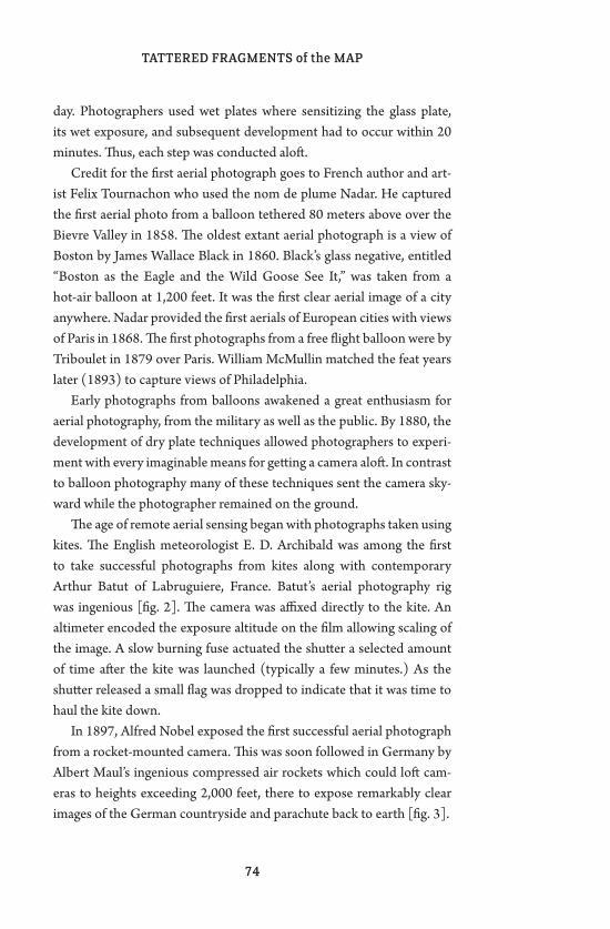
TATTERED FRAGMENTS of the MAP
74
day. Photographers used wet plates where sensitizing the glass plate, its wet exposure, and subsequent development had to occur within 20 minutes. Thus, each step was conducted aloft.
Credit for the first aerial photograph goes to French author and art-ist Felix Tournachon who used the nom de plume Nadar. He captured the first aerial photo from a balloon tethered 80 meters above over the Bievre Valley in 1858. The oldest extant aerial photograph is a view of Boston by James Wallace Black in 1860. Black’s glass negative, entitled “Boston as the Eagle and the Wild Goose See It,” was taken from a hot-air balloon at 1,200 feet. It was the first clear aerial image of a city anywhere. Nadar provided the first aerials of European cities with views of Paris in 1868. The first photographs from a free flight balloon were by Triboulet in 1879 over Paris. William McMullin matched the feat years later (1893) to capture views of Philadelphia.
Early photographs from balloons awakened a great enthusiasm for aerial photography, from the military as well as the public. By 1880, the development of dry plate techniques allowed photographers to experi-ment with every imaginable means for getting a camera aloft. In contrast to balloon photography many of these techniques sent the camera sky-ward while the photographer remained on the ground.
The age of remote aerial sensing began with photographs taken using kites. The English meteorologist E. D. Archibald was among the first to take successful photographs from kites along with contemporary Arthur Batut of Labruguiere, France. Batut’s aerial photography rig was ingenious [fig. 2]. The camera was affixed directly to the kite. An altimeter encoded the exposure altitude on the film allowing scaling of the image. A slow burning fuse actuated the shutter a selected amount of time after the kite was launched (typically a few minutes.) As the shutter released a small flag was dropped to indicate that it was time to haul the kite down.
In 1897, Alfred Nobel exposed the first successful aerial photograph from a rocket-mounted camera. This was soon followed in Germany by Albert Maul’s ingenious compressed air rockets which could loft cam-eras to heights exceeding 2,000 feet, there to expose remarkably clear images of the German countryside and parachute back to earth [fig. 3].
fig. 1 Nadar “elevating photography to the condition of art”, 1862, Honoré Daunier. This caricature appeared in Le Boulevard on 25 May, 1862. Albert Garcia Espuche, author of the catalog essay in “cities: from the balloon to the satellite” published by the Centre de Cultura Contemporania de Barcelona notes the irony of Daunier’s caption for “what Nadar had really done was to change the level of art to the level of science and utility, from the artistic drawing to an instrument of work.”
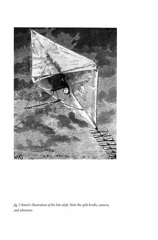
fig. 2 Batut’s illustration of the kite aloft. Note the split bridle, camera, and altimeter.
Cris Benton
77
If the hardware of rocketry seems excessive for casual aerial imaging then pharmacist Julius Neubronner’s designs for pigeon-mounted cam-eras might, at first glance, appear more practical. In 1903, Neubronner worked with the Bavarian Pigeon Corps to produce breast harnesses and cameras that would allow avian aerials. The design challenge was to develop small format cameras weighing less than the 75-gram payload of an athletic pigeon. Neubronner responded with camera designs that were marvels of miniaturization. Pigeon aerial photographs proved popular in documenting public events [fig. 4].
One of the most memorable aerial images from this era was George Lawrence’s remarkable 1906 kite aerial photograph taken as San Francisco lay devastated by the ‘06 earthquake [fig. 5]. Less than 20 years after Batut’s first efforts Lawrence used a train of up to nine large Conyne kites to loft a moving-slit panoramic camera. The camera weighed 49 pounds and was lifted to a height of approximately 1,200 feet anchored by a wire tether. The shutter was released via an electric wire to produce a negative measuring 18” x 48”. Lawrence’s San Francisco feat led to similar aerial panoramas in other cities. But with the birth of the airplane, so ended the Golden Age of kite aerial photography – not to mention balloon, rocket and other alternative means of lofting the camera. In the airplane however, the photographer was once again united with the airborne camera.
During the 20th Century a variety of more casual photographers ex-perimented, typically in the vacuum of isolation, with alternate means for aerial imaging. Since the 1990s, kite aerial photography has enjoyed a renaissance of sorts, fueled in part by communities on the internet and a plethora of new technologies in photography, kite making, and radio control. Among the joys of contemporary kite aerial photography (KAP) are the opportunities for invention, the physical challenge of po-sitioning kite and rig, the unusual ‘once removed’ aspect of composition in absentia and the distinct pleasure of messing around with kites.
William Morton Wheeler, Harvard professor of zoology and con-temporary of Batut and Lawrence, once compared the naturalist as “impressed by the overwhelming intricacy of natural phenomena and reveling in their very complexity“ to the professional biologist who
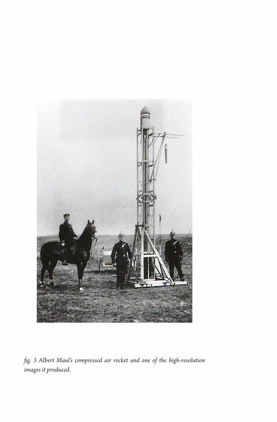
fig. 3 Albert Maul’s compressed air rocket and one of the high-resolution images it produced.
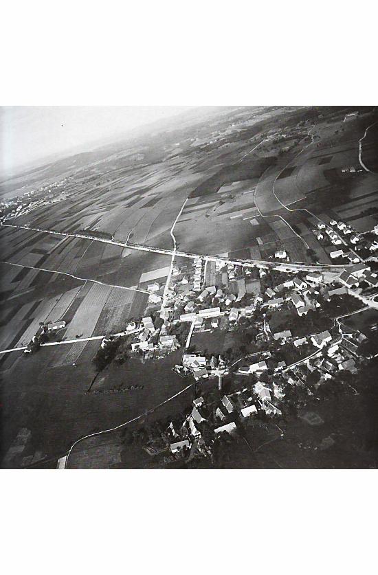
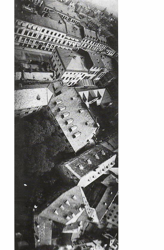
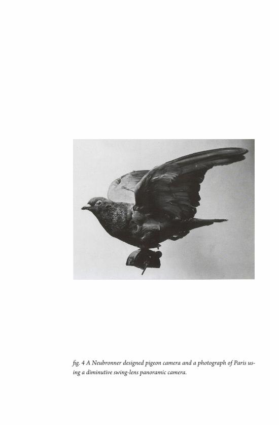
fig. 4 A Neubronner designed pigeon camera and a photograph of Paris us-ing a diminutive swing-lens panoramic camera.
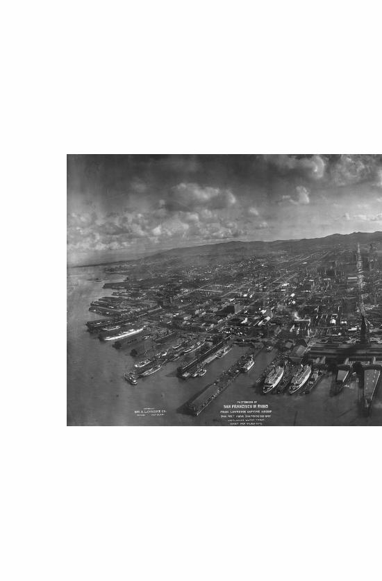
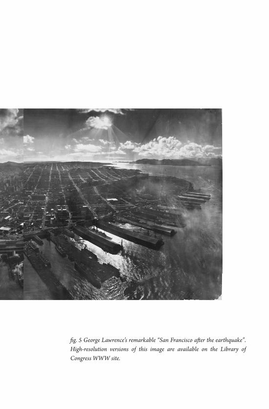
fig. 5 George Lawrence’s remarkable “San Francisco after the earthquake”. High-resolution versions of this image are available on the Library of Congress WWW site.
TATTERED FRAGMENTS of the MAP
84
“is oriented toward and dominated by ideas, and rather terrified or oppressed by the intricate hurly-burly of concrete sensuous reality.” Aerial images from the height of a kite offer a richness, complexity, and intimacy rarely found in photographs from a greater distance. And while they may display certain normative cartographic forms, these images are just as often filled with the hurly-burly of their moment, a distinctly photographic trait.
85
In civilizations without boats, dreams dry up, espionage takes the place of adventure, and the police take the place of pirates.1
Michel Foucault used the above statement to argue that ‘places without places’ (represented by the boat), sites unmoored
and unregulated by the constraints of context, play a pivotal role in the social imagination. What are these places, and where are[n’t] their spaces? Is it truly possible to create unsituated sites that are “off the map,” outside of the geo-political landscape? Or do these contradic-tions require us to reposition the margin, such that these places become the center of empowered spatial practice?
Artists, activists, and local communities have long engaged in grassroots spatial practices that simultaneously critique and provide an alternative to dominant forms of cultural and economic production. Recently, these strategies have taken place primarily on a small scale in place-specific communities—almost on a hyper-local level—and rep-resent a wide range of activities, from community-based art and design projects, gardening, alternative education, to the creation of local micro-economies. Though small in scale, often marginalized, and sometimes unconnected from each other, these practices are a significant source of power and represent a re-orientation of the collective imagination.
1 Michel Foucault, “Of Other Spaces,” March 1967.
Situating the Grassroots: Collectivity and ImaginationAnusha Venkataraman
TATTERED FRAGMENTS of the MAP
86
Theoretical Foundations: Space and Action
W hat exactly are ‘spatial practices’? And what practices are not spatial? Henri Lefebvre breaks spatial practices into three
dimensions: the experienced, the perceived, and the imagined. The ‘experienced’ realm of practices refers to the physical space with which we interact, and the flows, systems, and constraints which shape those interactions. ‘Perceived’ spatial practices point to representations of space, be they maps, systematizations, or language used in discourse about space. Last, the ‘imagined’ makes reference to “spaces of repre-sentation,” or those spaces and ideas that envision – or even implement – new spatial meanings.2 Also described as ‘the production of space,’ this category can include a wide range of creative spatial practices, from utopias to dreamscapes and the stories we tell about the spaces in which we live, and even executed projects that radically alter the terrain of experience.
If this discussion seems opaque, it’s because it is. These realms are, of course, overlapping, often indistinguishable, and sometimes mutually constitutive. However, the distinctions are useful in understanding the relation of power to spatial practice. Power in one realm of spatial prac-tice can amplify control over another sector; for example, those who can physically shape the space of the city – architects, planners, and the people with money to employ them – control the way others interact in that space. And perhaps more significantly, those with command over the tools of representation can more easily shape the imagination.
This analysis could lead us to conclude that we are forever inscribed by the power structures we inhabit. This is true to a degree, but, a la so-ciologist Pierre Bourdieu, we also have the power to shape the structure through our personal and collective spatial practices – that is, though our exercise of agency. The concept of the ‘heterotopia,’ first articulated by Foucault and later appropriated most notably by geographers David Harvey and Edward Soja, is useful here. Defined as “counter-sites, a
2 This discussion is greatly indebted to David Harvey’s analysis of Lefebvre and his ‘grid’ of spatial practices, The Condition of Postmodernity (1990), Table 3.1.
Anusha Venkataraman
87
kind of effectively enacted utopia in which the real sites … are simul-taneously represented, contested, and inverted,”3 heterotopias are the spaces we make to assert our agency. They rebel against the dominant structure(s) and re-center spatial practices on the actors that inhabit, produce, and re-produce space. They are the utopian imagination in real form, ‘carved out’ from what we are given and cobbled together through what we can dream.
We can view the proliferation of place-based, grassroots activities through the lens of the heterotopia. Though outwardly divergent in their modes of practice and the actors practicing them, as well as the types of spaces/places in which they are implemented, these strategies are all “enacted utopias,” microcosms of what we wish to see on a larger scale. Through their very enactment, sites of resistance produce new modes of spatial interaction that have the potential to fundamentally reprogram networks of power.
The Political Moment
W hy is ‘small’ so big today, especially among the young and the politically disenfranchised? Perhaps it is disillusionment
with the apparent failure of global capital, combined with a distaste for historical meta-narratives, which has driven us home to our local com-munities, where even small actions have a discernible and often visible effect. As Claire Bishop remarks, “the creative energy of participatory practices rehumanizes – or at least de-alienates – a society rendered numb and fragmented by the repressive instrumentality of capitalism.”4 On the other hand, ‘small’ is sometimes the only available option in this social, cultural, and economic milieu, depending on who you are.
Small-scale interventions then become an alternative to hegemony. In fact, their rise marks the end of hegemony in some senses – a relevant
3 Foucault, “Of Other Spaces.”
4 Claire Bishop, “The Social Turn: Collaboration and Its Discontents.” ArtForum, February 2006.
TATTERED FRAGMENTS of the MAP
88
notion at this political moment, as “America” transitions into a new self-identity, and the dominant economic system is being called into ques-tion. bell hooks emphasizes the importance of re-visioning and placing counter-hegemonic practices in specific sites. For those who have been historically and culturally marginalized, these counter-practices are necessary to the very act of survival; they are the only possible way to maintain agency – not to mention dignity and faith in the possibility of change. “We are transformed, individually and collectively, as we make radical creative space which affirms and sustains our subjectivity, which gives us a new location from which to articulate our sense of the world.”5 The margin is the location for critical practice: neither floating outside (with Foucault’s boat) nor truly inside, it is the only possible site for resistance.
Re-Writing the Myth
Every moment of major social change requires a collective leap of im-agination. Political transformation must be accompanied not just by spontaneous and organized expressions of unrest and risk, but by an explosion of mass creativity.6
It is on the personal, collective, and community levels that we have carved the spaces for utopian imagination. Decolonized from the
oppressions of capital and moored firmly to shared social values, the enacted realities of the utopian imagination constitute a new ‘founding myth,’ an ontological re-orientation of public life. We can re-shape the collective imagination through the writing of a new founding myth: that these small, participation-based, place-specific practices are mainstream and do form a new ethos of social formation. This founding myth is be-
5 bell hooks, “Choosing the Margin as a Space of Radical Openness.” Yearnings: Race, Gender and Cultural Politics.
6 Jeff Chang, “The Creativity Stimulus.” The Nation, April 15, 2009
Anusha Venkataraman
89
ing written today. Right now. The language we use to intervene in the existing narrative and describe this founding myth is crucial, insofar as language, as a mechanism of power, inscribes (and is inscribed by) one’s relational position in social space. How can we begin to speak of, with, to, and from the margin without marginalizing it? How do we talk about the center without reinforcing its supremacy?
Can we imagine a network connecting discrete, though participatory interventions? Can we imagine a social (infra)structure that encourages creative grassroots movements to flourish? And last, can we translate that structure into political and economic policies that enable the mar-gin to become the center? At the intersection of community organizing, artistic practice, and political movement-making has emerged a fertile ground of grassroots spatial strategies that have begun to do this – if we can envision the movement of those strategies to the center of public practice, the utopia can be enacted, one step at a time.


Anthony Auerbach is an artist and theorist out of London, working in different places. His (photo)cartographic interests stem from a preoccupation with drawing, hence with surfaces: marks, traces, inscriptions, and erasure of the same.
Cris Benton is a Professor of Architecture and former department chair at UC Berkeley. He harbors considerable passion for Kite Aerial Photography (KAP) and its associated historical, applied, and artistic dimensions.
Bill Brown is a “nomadic” filmmaker, photographer, and author from Lubbock, Texas. He’s the author of a zine called Dream Whip and the book Saugus to the Sea.
Elizabeth Evitts Dickinson is a Baltimore-based writer who covers architecture, design, urban planning, and culture for publications like The New York Times Magazine, Metropolis, and Architect.
William L. Fox is a writer, independent scholar, and poet whose work is a sustained inquiry into how human cognition transforms land into landscape. He currently acts as director of The Center for Art + Environment at the Nevada Museum of Art.
Herbert Gottfried is a poet and Pofessor Emeritus in the Department of Landscape Architecture at Cornell University, where he cunducts cultural landscape studies.
Gerardo Greene Gondi is a photographer and PhD candidate in philosophy at the Universidad Nacional Autónoma de México (UNAM), Mexico City. His research ad-dresses phenomenology and photography.
Alex Haber is a scholar of comparative literature whose research interests include literary constraint, the city, and theories of selfhood in nineteenth and twentieth century French literature and thought.
Simone Hancox is a PhD candidate in the Department of Drama at Queen Mary, University of London. Her research interests include performance and the city, walking as an aesthetic practice, urban interventions and live art.
Anusha Venkataraman is a scholar who focuses on engaged artistic practices as tools for community development. She has worked with artist collectives in Providence, RI and Brooklyn, NY on participatory urban interventions.
Denis Wood is an artist, author, and critical cartographer based in North Carolina. He is currently working on the second edition of his groundbreaking work, The Power of Maps.

The Photocartographies exhibition at g727, curated by Adam Katz and Brian Rosa, included work by Anthony Auerbach, Katherine E. Bash, Cris Benton, Noah Beil, Frank Gohlke, Gregory Michael Hernandez, David Horvitz, David Maisel, Adam Ryder, Nikolas Schiller, Oraib Toukan and Angie Waller.