Embed Size (px)
Citation preview
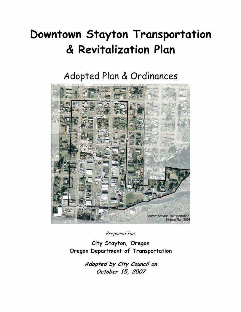
Downtown Stayton Transportation & Revitalization Plan
Adopted Plan & Ordinances
Prepared for:
City Stayton, Oregon Oregon Department of Transportation
Adopted by City Council on October 15, 2007
City of Stayton, Oregon Downtown Stayton Transportation & Revitalization Plan
Plan & Ordinances
A Plan and implementing ordinances for Downtown Stayton that describes design,
transportation and land use elements to achieve the Vision.
Prepared by:
Spencer & Kupper In association with
Donald B. Genasci & Associates Robert Bernstein, PE
Landsman Transportation Planning E.D. Hovee & Company
Dailey GIS
City of Stayton Downtown Revitalization Committee
Dan Brummer Public member Mike Faught Public Works Director Dan Fleishman City Planner Tim Grimes City Councilor Jeff Mexico Stayton-Sublimity Chamber of
Commerce Bob Pendleton Public Member Steve Robinson Downtown business owner John L. Sullivan Public Member Michelle Wonderling Planning Commissioner
This project is partially funded by a grant from the Transportation and Growth Management (TGM) Program, a joint program of the Oregon Department of Transportation and the Oregon Department
of Land Conservation and Development. This TGM grant is financed, in part, by federal Safe, Accountable, Flexible, and Efficient Transportation Equity Act-A Legacy for Users (SAFETEA-LU),
local government and the State of Oregon funds.
Downtown Stayton Transportation & Revitalization Plan ii
Plan & Ordinances
Table of Contents I. Introduction 1 II. Vision, Goals, Policies and Action Items 3 III. Summary of Existing Conditions 10 IV. Demographics and Market Analysis 12 V. Design, Transportation & Land Use Elements 14 VI. Implementation Recommendations & Action Plan 22
Appendices
A- Downtown Stayton Mixed Use Districts B- Downtown Stayton Design Overlay Zone
Downtown Stayton Transportation & Revitalization Plan iii
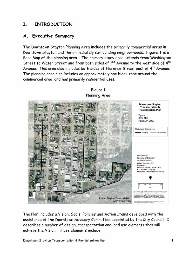
I. INTRODUCTION A. Executive Summary The Downtown Stayton Planning Area includes the primarily commercial areas in Downtown Stayton and the immediately surrounding neighborhoods. Figure 1 is a Base Map of the planning area. The primary study area extends from Washington Street to Water Street and from both sides of 1St Avenue to the west side of 4th Avenue. This area also includes both sides of Florence Street east of 4th Avenue. The planning area also includes an approximately one block zone around the commercial area, and has primarily residential uses.
Figure 1 Planning Area
The Plan includes a Vision, Goals, Policies and Action Items developed with the assistance of the Downtown Advisory Committee appointed by the City Council. It describes a number of design, transportation and land use elements that will achieve the Vision. Those elements include:
Downtown Stayton Transportation & Revitalization Plan 1
• Concentrating commercial development in a compact area along 3rd Avenue.
• Distinguishing between the downtown commercial zones and commercial zones in other parts of the city. Two new mixed-use zones, a Central Core Mixed Use and Downtown Residential Mixed Use are proposed.
• Allowing mixed use residential development in the downtown.
• Developing a new Civic Center downtown.
• Redeveloping the Woolen Mill property for housing.
• Constructing streetscape improvements on important mixed use commercial
streets.
• Establishing gateways into downtown.
• Establishing a special character on 1st Avenue.
• Establishing links and access to parks, public facilities and waterways. Implementation recommendations and an action plan are included to assure on-going success of the Plan. Three key recommendations related to supporting existing and recruiting new businesses downtown, and funding needed downtown improvements are summarized below. The key implementation elements are:
• A Strategic Business Development Plan that provides a strategy for recruiting new businesses to the Downtown and positioning Downtown Stayton in the regional marketplace.
• Pursue the formation of an urban renewal district to include the entire
Downtown Area. Adopting an urban renewal plan will provide a reliable funding source for capital improvement projects and a mechanism to carry out long term economic development activities.
• Establish the highest priorities for spending Transportation Impact Fees
and System Development Charge revenues within the Downtown. Establish policies that TIF and SDC fees generated by developments within the Downtown are earmarked for improvements within the Downtown.
Downtown Stayton Transportation & Revitalization Plan 2
B. Plan Development Process In August 2006 the City of Stayton initiated a planning process to prepare a new plan for the Downtown. The City Council appointed a Downtown Revitalization Committee (DRC) to oversee the work by consultants, city staff, and staff from the Oregon Department of Transportation’s Growth Management Program (TGM). The project is funded by the TGM program and City of Stayton. The consulting team headed by Spencer & Kupper met regularly with the DRC and produced the following work products that form the basis of this Plan:
Existing Conditions Analysis, March 2007 Downtown Stayton Market Analysis, March 2007 Mill Site Market Analysis, March 2007 Vision, Goals, Policies and Action Items, March 2007 Plan Concepts and Elements, May 2007 Refined Plan Elements, June 2007 Mill Site Concepts & Application Analysis Memo, July 2007
A Public Forum was hosted by the DRC on May 9, 2007 that provided the general public an opportunity to review results from the work products, and to comment on the draft plan concepts and elements. Based on the input received at the Public Forum, the plan elements were refined and implementation strategies developed. The DRC provided review and input on all work products, as well as a first draft of this Plan. II. VISION, GOALS, POLICIES AND ACTION ITEMS The Downtown Revitalization Committee, appointed by the Stayton City Council, developed a vision for Downtown Stayton, and goals, policies and action items that lay the foundation for this Plan.
A. Vision Statements • A unified thriving downtown district serves as the community’s focal point
with a mix of retail, professional offices, government, cultural, social and recreational opportunities, innovative housing and parks and a supply of adequate parking.
Downtown Stayton Transportation & Revitalization Plan 3
• Renovation and new development are compatible with small town architectural characteristics, and embrace sustainable design and construction practices, combining residential and commercial uses with open space and landscaped areas.
• A redeveloped Paris Woolen Mill site for housing and public access to greenways and trails are major features downtown, and help unify and enhance the entire area.
• A new city hall complex focuses government services downtown, is a transit hub and includes a plaza that has become the community’s living room.
• Downtown streets are designed for the pedestrian, minimizing conflicts with autos, and have lighting, street trees, benches and other furnishings that promote safety and comfort.
• Traffic moves easily and efficiently through and within the area, creating a transportation area that enhances commerce in the downtown, without dominating the district’s character. Downtown is a hub for local and regional transit services.
• The downtown is fully “wired” and a place that residents, visitors and workers can connect with each other and the entire world, with a wide range of activities occurring downtown.
• Buildings are oriented to the streets and waterways and the area is pedestrian friendly.
• New housing types are creative and affordable, meeting the needs of a more elderly and diverse population, including housing above storefronts, waterfront condominiums, and housing developed on the Paris Woolen Mills site.
• Pedestrian and bicycle paths link residential neighborhoods to the downtown.
B. Goals, Policies & Action Steps Goals-Land Use & Development
1. Downtown Stayton continues functioning as the primary focus area of the community.
2. Downtown Stayton is an area for specialty shops, restaurants, entertainment, government offices and professional offices.
Downtown Stayton Transportation & Revitalization Plan 4
3. Mixed use developments that emphasize residential, commercial and office uses are throughout Downtown.
Policies
A. Zoning districts for the Downtown shall permit a wide range of mixed residential, retail and office uses.
B. Zoning for 3rd Avenue south of Burnett Street shall ensure that ground floor uses located along this primary shopping street are customer-oriented businesses.
C. Zoning for 3rd and 4th Avenues north of Burnett shall reflect the predominance of existing residential uses.
Action Steps
a. Amend the zoning and development code to create new zoning districts for the downtown area that distinguish it from the other commercial districts.
b. Amend the zoning and development code as needed to permit mixed uses, including an active ground floor requirement on 3rd Avenue south of Burnett Street.
c. Amend the zoning map to place the residential properties on 3rd and 4th Avenues north of Burnett into mixed use Residential zones.
Goals-Housing Innovation
4. Innovative housing types are provided throughout Downtown, including housing as part of mixed use developments and medium and high density housing.
5. Downtown housing meets the needs of a wide range of city residents including populations with special needs.
Policies
A. High density residential uses and residential uses combined with commercial uses shall be allowed in the Downtown zones.
B. High density residential development shall be allowed along the Stayton Power Canal and Salem Ditch, between 1st Avenue and 4th Avenue.
C. High or medium density residential development shall be allowed along Florence Street east of 4th Avenue.
Downtown Stayton Transportation & Revitalization Plan 5
D. Land for medium density residential development shall be designated on the periphery of the Downtown and in each sector of the city and urban growth area.
Action Steps
a. Amend the zoning code and development code as needed to permit residential uses.
b. Amend the Zoning Map to change Florence Street east of 4th Avenue to Medium and/or High Density Residential
Goals-Design and Historic Preservation
6. Renovation and new development exhibit high quality design and construction, are compatible with a small town atmosphere, and embrace sustainable design and construction practices.
7. Historic sites and structures located Downtown are protected and preserved.
8. Buildings are oriented to the streets and waterways and the area is pedestrian friendly.
9. Signage is oriented to the pedestrian and contributes to the character of the Downtown.
Policies
A. Develop design and compatibility standards for renovations and new developments that respect the area’s existing scale and character, foster high quality design, and incorporate sustainable practices.
B. Strengthen the existing design review practices and procedures so that design standards are prescriptive rather than suggestive, yet opportunities for innovation are provided.
C. Provide incentives for historic preservation.
D. Provide incentives for sustainable design and construction practices.
E. Enact sign standards appropriate for the downtown districts, including allowing signs to be placed on sidewalks.
Action Steps
a. Revise design standards and where the standards apply including options for approval, decision-making and administration within one year of adoption.
Downtown Stayton Transportation & Revitalization Plan 6
b. Develop proposals for incentives within one year of adoption.
c. Implement signage programs:
• Historical Commercial Building Signage • City Center signs
Goals-Streetscape and Pedestrian Environment
10. A safe pedestrian-oriented atmosphere prevails throughout the Downtown district.
11. Waterways are more accessible and these features help establish a special character to Downtown.
Policies
A. A pedestrian-oriented atmosphere in the downtown area shall be provided through requirements that include curb cuts, sidewalks, street trees, lighting and other street hardware for pedestrians and the disabled.
B. The city shall adopt downtown street design and waterway standards that identify desired improvements within public rights-of-way.
C. Downtown streetscape and waterway improvement projects shall be included in the city’s capital improvement program.
D. Downtown streetscape and waterway improvements shall be coordinated with necessary sewer, water, drainage and utility improvements so that minimal disruption is caused during construction.
Action Steps
a. Initiate a process to prepare street design and waterway standards for the Downtown.
b. Initiate discussions with Santiam Water Control District about waterway improvements
c. As part of the capital improvement plan, include street and waterway projects:
1. Streetscape improvements 2. Foot Bridge from Downtown to Park 3. Pedestrian and bike paths between Downtown and
neighborhoods
d. Prioritize funds for street, sewer and water improvements for the Downtown Area.
Downtown Stayton Transportation & Revitalization Plan 7
Goal-Parking
12. Adequate parking facilities are provided for development without dominating the character of Downtown.
Policies
A. The development regulations shall contain specific requirements for all off-street parking needed for commercial, industrial, public and residential developments.
B. Parking lot location and design standards shall be prepared so that buildings not parking form the character of important pedestrian streets. Whenever possible, parking shall be located to the rear of sides of buildings.
C. Public on and off street parking shall be the primary resource to meet Downtown parking needs.
Action Steps
a. Initiate a process to prepare a Downtown parking strategy. The Downtown parking strategy shall identify when developments shall provide off-street parking, when no off-street parking is required, and when public parking shall be provided.
b. Initiate a process to prepare a Downtown parking location and design standards.
c. Identify potential public parking lots.
Goal-Civic Center Location
13. Locate and construct a new city hall complex in the Downtown area.
Policies
A. The primary city administrative facility shall be located in the Downtown area.
B. The city hall complex shall support and be complementary to Downtown activities.
C. The city hall complex shall include a plaza or park area available to the community.
D. The city hall complex shall consider shared parking opportunities in support of the Downtown.
E. The city hall complex shall consider opportunities for a transit hub.
Downtown Stayton Transportation & Revitalization Plan 8
Action Steps
a. Continue the process to locate and design a new city hall complex.
b. Initiate discussions with CARTS considering extending transit service into the downtown and to a transit hub at the city hall complex.
Goal-Downtown Revitalization & Implementation
14. Develop a coordinated Downtown revitalization strategy that involves the business community, property owners, residents and decision makers.
15. Secure a reliable funding source or sources adequate to undertake Downtown revitalization projects.
16. Increase retail and service business activity.
Policies
A. A Downtown revitalization strategy shall be prepared that considers capital and on-going revitalization projects, decision making, marketing and administration.
B. The city shall evaluate potential funding sources for implementation, including the use of urban renewal and tax increment financing.
C. Work with the Stayton-Sublimity Chamber of Commerce on business promotion and attraction efforts.
Action Steps
a. Prepare an overall Downtown revitalization strategy that coordinates the different elements of revitalization, establishes priorities and identifies responsibilities.
b. Prepare a funding feasibility study, including the feasibility of establishing an urban renewal district.
c. Develop recommendations for funding revitalization projects.
d. Develop recommendations for providing incentives for private investment, including considering development fees, tax credits and other tools.
e. Develop a joint marketing strategy to allow downtown business to pool resources.
Downtown Stayton Transportation & Revitalization Plan 9
f. Develop a campaign to attract new businesses to the downtown area.
III. SUMMARY OF EXISTING LAND USE, INFRASTRUCTURE
AND TRANSPORTATION CONDITIONS The report entitled Existing Conditions Analysis, March 2007 analyzed the existing land use and development policy framework focused on Downtown Stayton, existing land use and related conditions, the status of existing infrastructure and master plans for sewer, water, drainage and parks needs and project improvements, and transportation conditions, policies and plans. Based on the analysis of existing conditions, following is a summary of opportunities and constraints that can help guide this Plan.
• Existing zoning in the CR and CG districts limit residential uses to mixed use projects and only on or above the 2nd floor. This requirement is a significant limitation to attracting residential uses to the downtown area, and is contrary to current policies that encourage housing in the downtown.
• There is little high and medium density zoning adjacent to the downtown
area. Residential growth in and adjacent to downtowns should be provided for as a high priority.
• Design guidelines associated with the two historic overlay districts are not
binding. This presents uncertainty for the downtown, property owners and citizens. High quality deign is a stated goal, but the mechanisms to ensure good design are not in place.
• Residential uses make up 32% of the planning area, with office/commercial
uses at 29%. Vacant properties and surface parking lots occupy 24% of the land area. The planning area is already a mixed use district. There are significant opportunities for infill and redevelopment.
• Approximately 40% of the Planning Area has an improvement value to land
value ratio of less than 1:1, and 60% of the area has ratios less than 2:1. This analysis indicates that there is significant infill and redevelopment potential within the planning area.
Downtown Stayton Transportation & Revitalization Plan 10
• Redevelopment of the Mill property and other vacant areas off Florence Street present an opportunity to attract housing in close proximity to the downtown.
• There are a number of historic resources located within the planning area
that can help define the character of the downtown. However, some of these buildings are in need of significant rehabilitation that may not be economically feasible.
• Current public facility master plans have identified water and sanitary sewer
system improvements in the downtown, and generally speaking, existing lines are old and may need to be replaced as development and streetscape improvements are made. A stormwater master plan is currently being prepared.
• A parks master plan and identified improvements include pedestrian and
bicycle paths along both the Salem and Stayton ditches, and improvements within the Community Center Complex. All of these projects would enhance the downtown. There is no plaza or other “hard surface” space identified.
• The Salem and Stayton ditches located in the planning area present unique
opportunities to showcase these water features as design and recreational elements, as well as capitalize on their functional and historical character.
• The city is currently evaluating potential sites for a new city hall civic
center complex. This presents a significant opportunity if the project is located within the downtown area, retains local employment and a major attractor, and potentially includes a plaza or other civic open space.
• The street grid that exists within the planning area is made up primarily of
local streets with relatively light vehicular traffic. The block sizes formed by the grid are small, creating a good pedestrian network, and many corner parcels that are attractive to businesses.
• Current street lighting is aimed at autos not pedestrians. Pedestrian-
oriented lighting can be an important streetscape element downtown.
• The focus street in the downtown, 3rd Avenue, is off-set from the main traffic street, 1St Avenue. Signage, way-finding and other improvements are needed to let both residents and visitors know where downtown is.
Downtown Stayton Transportation & Revitalization Plan 11
• Many sidewalks in the downtown are in need of improvement and/or are of substandard width.
• Currently, adequate parking exists downtown in the form of on-street and
off-street parking lots. There are three public lots near 3rd Avenue, and a number of private lots throughout the planning area. As infill and redevelopment occur, there will be a need for additional off-street parking.
• The zoning code requires that developments in the downtown provide off-
street parking. This requirement can be difficult to meet in a downtown setting, because parcels are typically small, and many existing buildings take up a large portion of the parcel. Many downtowns have adopted a standard that off-street parking is not a development requirement. A stronger public role in providing parking is therefore necessary so that parking supply can match the demand for parking.
IV. DEMOGRAPHICS AND DOWNTOWN TRADE AREA MARKET ANALYSIS A Downtown Stayton Market Analysis, March 2007 reviewed market trends influencing demand for mixed use developments – focused on housing and commercial retail. The analysis provides an overview assessment of demographic and economic trends, residential and commercial space markets, and retail sales and leakage information for four market areas: downtown Stayton, the city of Stayton, the upper Santiam Canyon and Marion County. The Downtown Stayton Transportation & Revitalization Plan is based on the following market conditions:
• Existing population and incomes of the immediate Stayton area should not be
relied on to propel substantial new retail and related service business investment. While additional residential density will help provide added activity more conducive to retail, the bulk of customers required for sustainable downtown businesses will come from a much larger market area – likely encompassing the entire upper Santiam Canyon area plus pass-through and destination visitors.
• To encourage business investment, encouragement of a more upscale, higher
end residential and mixed use neighborhood will be critical. This likely
Downtown Stayton Transportation & Revitalization Plan 12
involves emphasis on encouraging upgrading of existing residential structures as well as facilitating higher density infill residential on vacant and underutilized parcels in and near the downtown area. Densities need to be appropriate to the market and community context, for example, townhome, semi-attached and smaller multi-unit structures – with a strong mix of home ownership product.
• Because downtown Stayton is at the edge rather than in the center of
Stayton’s market and is removed from the Highway 22 Santiam Canyon travel corridor, increased attention will need to be given to drawing prospective customers away from their normal travel patterns into the downtown area. This draw can be facilitated by actions with greater emphasis on vehicular wayfinding (including signage and visual cues such as banners, street and sidewalk pavings and landscape treatments), special events/festivals, and (most importantly) building on the most unique attraction Stayton has to offer – its riverfront. Stayton is the only community presenting the opportunity for a downtown situated in direct proximity to the Santiam River plus an internal canal system – an extraordinary amenity package offering linkages between recreation, living, and shopping.
• The past track record of real estate demand and absorption cannot be relied
on to support a vibrant downtown and mixed use neighborhood. Rather, downtown Stayton needs to be prepared to compete for residents and customers not yet acquainted with the downtown by creating and then selling a compelling vision for the next great mixed use village neighborhood in Marion County.
• Real estate and business investment can expect to be drawn primarily from
the immediate Stayton and possibly Salem metro areas. A part of Plan implementation, will be revision of codes for the downtown area to encourage more mixed use. For property developers and real estate brokerage interests, it also will be useful to illustrate that the same development can be built for no more and in no greater time than in nearby alternatives ranging from Salem to Silverton to Independence to McMinnville.
Downtown Stayton Transportation & Revitalization Plan 13
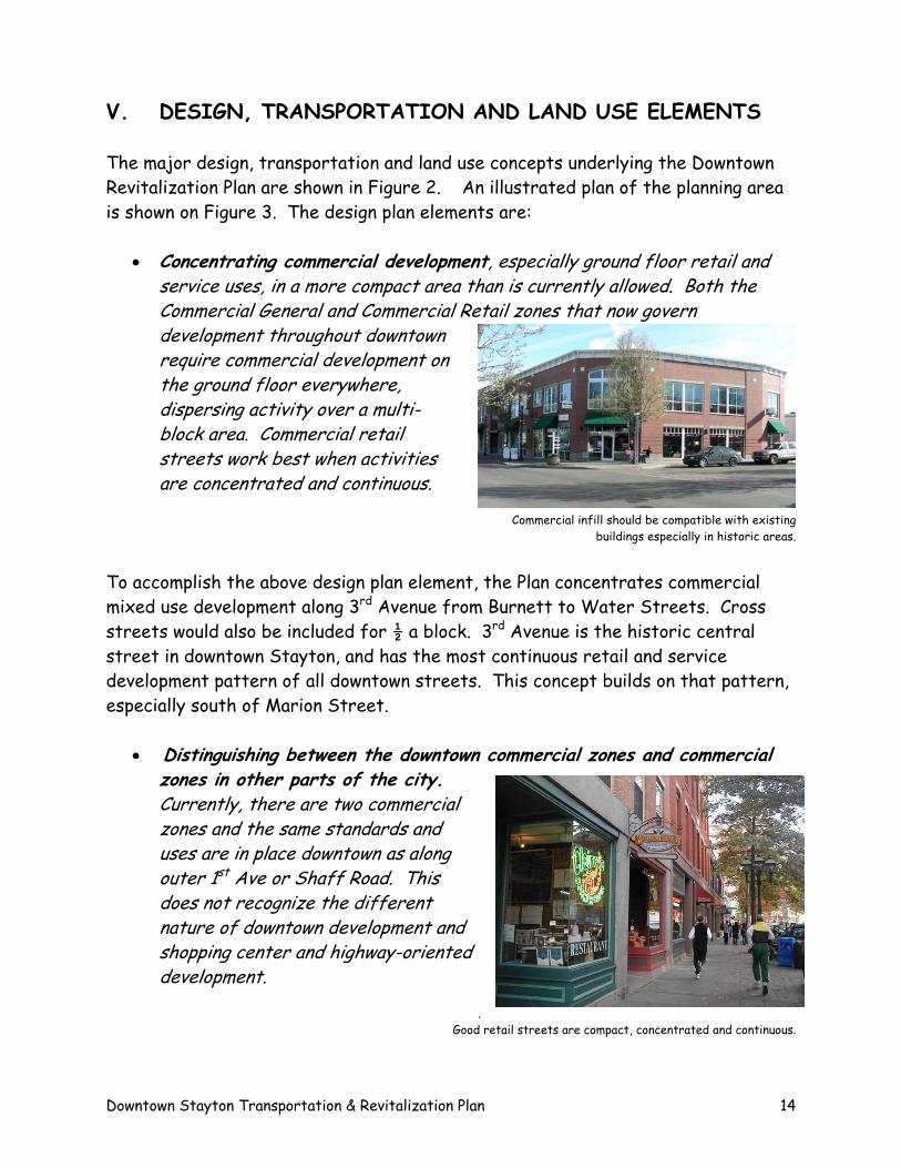
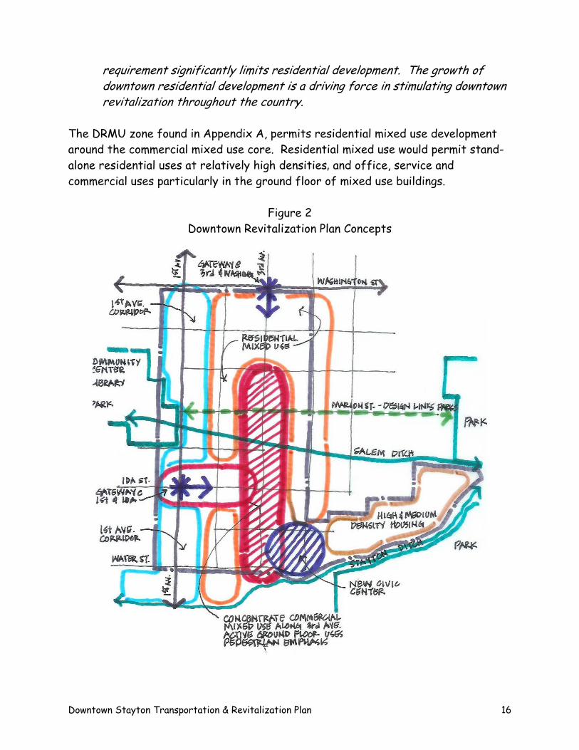
V. DESIGN, TRANSPORTATION AND LAND USE ELEMENTS The major design, transportation and land use concepts underlying the Downtown Revitalization Plan are shown in Figure 2. An illustrated plan of the planning area is shown on Figure 3. The design plan elements are:
• Concentrating commercial development, especially ground floor retail and service uses, in a more compact area than is currently allowed. Both the Commercial General and Commercial Retail zones that now govern development throughout downtown require commercial development on the ground floor everywhere, dispersing activity over a multi-block area. Commercial retail streets work best when activities are concentrated and continuous.
Commercial infill should be compatible with existing
buildings especially in historic areas.
To accomplish the above design plan element, the Plan concentrates commercial mixed use development along 3rd Avenue from Burnett to Water Streets. Cross streets would also be included for ½ a block. 3rd Avenue is the historic central street in downtown Stayton, and has the most continuous retail and service development pattern of all downtown streets. This concept builds on that pattern, especially south of Marion Street.
• Distinguishing between the downtown commercial zones and commercial zones in other parts of the city. Currently, there are two commercial zones and the same standards and uses are in place downtown as along outer 1st Ave or Shaff Road. This does not recognize the different nature of downtown development and shopping center and highway-oriented development.
.
Good retail streets are compact, concentrated and continuous.
Downtown Stayton Transportation & Revitalization Plan 14
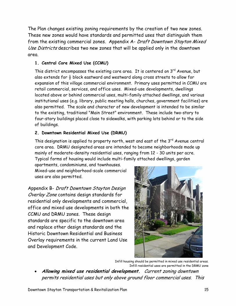
The Plan changes existing zoning requirements by the creation of two new zones. These new zones would have standards and permitted uses that distinguish them from the existing commercial zones. Appendix A- Draft Downtown Stayton Mixed Use Districts describes two new zones that will be applied only in the downtown area.
1. Central Core Mixed Use (CCMU)
This district encompasses the existing core area. It is centered on 3rd Avenue, but also extends for ½ block eastward and westward along cross streets to allow for expansion of this village commercial environment. Primary uses permitted in CCMU are retail commercial, services, and office uses. Mixed-use developments, dwellings located above or behind commercial uses, multi-family attached dwellings, and various institutional uses (e.g. library, public meeting halls, churches, government facilities) are also permitted. The scale and character of new development is intended to be similar to the existing, traditional "Main Street" environment. These include two-story to four-story buildings placed close to sidewalks, with parking lots behind or to the side of buildings.
2. Downtown Residential Mixed Use (DRMU)
This designation is applied to property north, west and east of the 3rd Avenue central core area. DRMU designated areas are intended to become neighborhoods made up mainly of moderate-density residential uses, ranging from 12 - 30 units per acre. Typical forms of housing would include multi-family attached dwellings, garden apartments, condominiums, and townhouses. Mixed-use and neighborhood-scale commercial uses are also permitted.
Appendix B- Draft Downtown Stayton Design Overlay Zone contains design standards for residential only developments and commercial, office and mixed use developments in both the CCMU and DRMU zones. These design standards are specific to the downtown area and replace other design standards and the Historic Downtown Residential and Business Overlay requirements in the current Land Use and Development Code.
Infill housing should be permitted in mixed use residential areas.
Infill residential uses are permitted in the DRMU zone • Allowing mixed use residential development. Current zoning downtown
permits residential uses but only above ground floor commercial uses. This
Downtown Stayton Transportation & Revitalization Plan 15
requirement significantly limits residential development. The growth of downtown residential development is a driving force in stimulating downtown revitalization throughout the country.
The DRMU zone found in Appendix A, permits residential mixed use development around the commercial mixed use core. Residential mixed use would permit stand-alone residential uses at relatively high densities, and office, service and commercial uses particularly in the ground floor of mixed use buildings.
Figure 2
Downtown Revitalization Plan Concepts
Downtown Stayton Transportation & Revitalization Plan 16
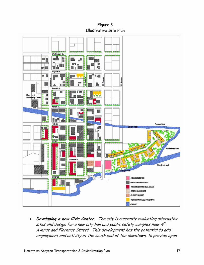
Figure 3 Illustrative Site Plan
• Developing a new Civic Center. The city is currently evaluating alternative sites and design for a new city hall and public safety complex near 4th Avenue and Florence Street. This development has the potential to add employment and activity at the south end of the downtown, to provide open
Downtown Stayton Transportation & Revitalization Plan 17
space and a transit hub capability in the area, and to relate public uses and access along the Stayton Ditch.
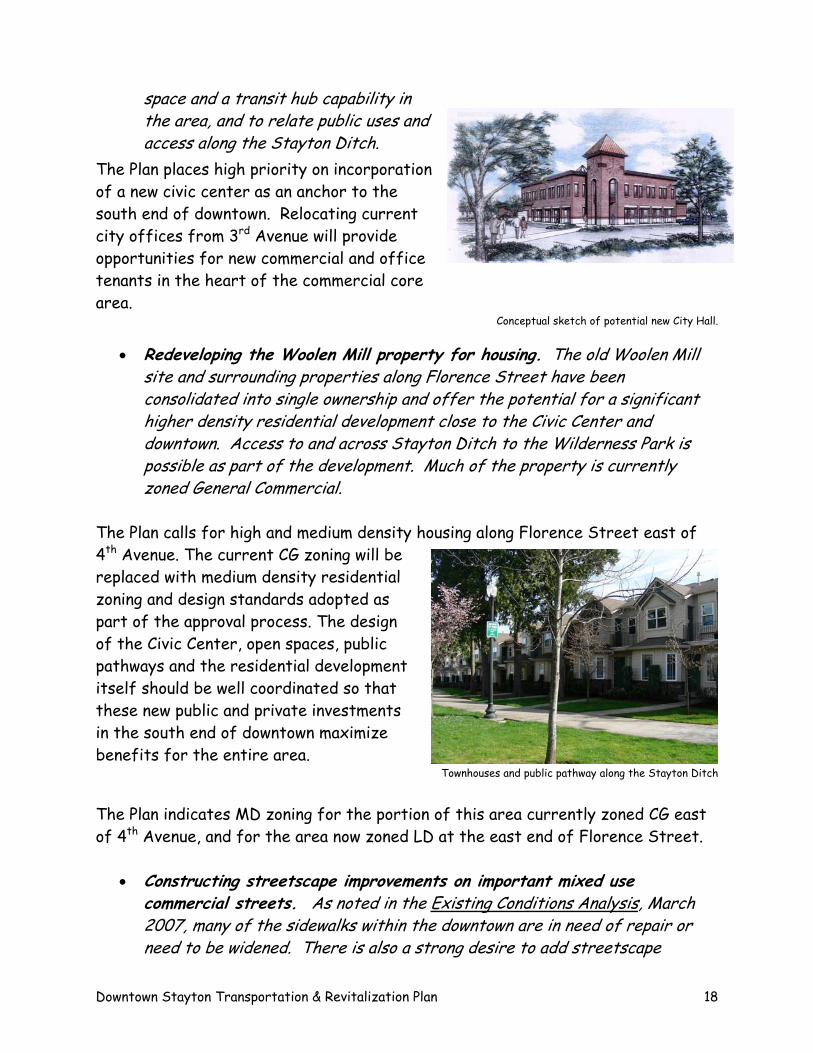
The Plan places high priority on incorporation of a new civic center as an anchor to the south end of downtown. Relocating current city offices from 3rd Avenue will provide opportunities for new commercial and office tenants in the heart of the commercial core area.
Conceptual sketch of potential new City Hall.
• Redeveloping the Woolen Mill property for housing. The old Woolen Mill site and surrounding properties along Florence Street have been consolidated into single ownership and offer the potential for a significant higher density residential development close to the Civic Center and downtown. Access to and across Stayton Ditch to the Wilderness Park is possible as part of the development. Much of the property is currently zoned General Commercial.
The Plan calls for high and medium density housing along Florence Street east of 4th Avenue. The current CG zoning will be replaced with medium density residential zoning and design standards adopted as part of the approval process. The design of the Civic Center, open spaces, public pathways and the residential development itself should be well coordinated so that these new public and private investments in the south end of downtown maximize benefits for the entire area.
Townhouses and public pathway along the Stayton Ditch
The Plan indicates MD zoning for the portion of this area currently zoned CG east of 4th Avenue, and for the area now zoned LD at the east end of Florence Street.
• Constructing streetscape improvements on important mixed use commercial streets. As noted in the Existing Conditions Analysis, March 2007, many of the sidewalks within the downtown are in need of repair or need to be widened. There is also a strong desire to add streetscape
Downtown Stayton Transportation & Revitalization Plan 18
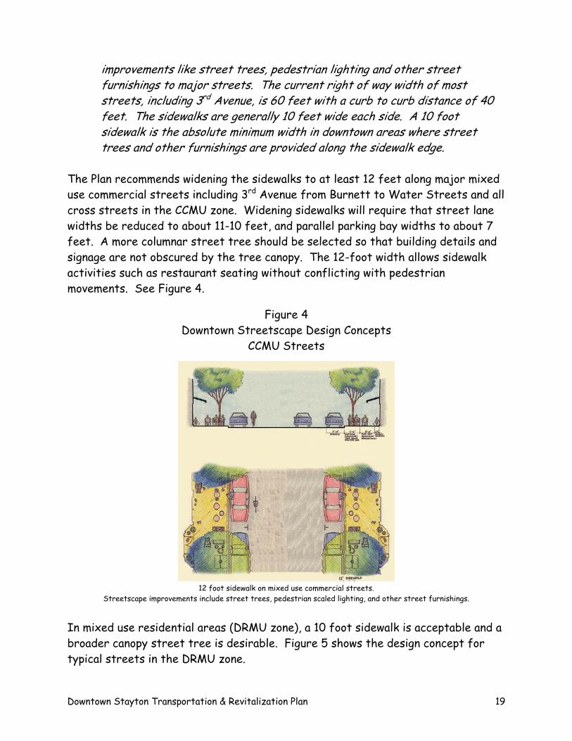
improvements like street trees, pedestrian lighting and other street furnishings to major streets. The current right of way width of most streets, including 3rd Avenue, is 60 feet with a curb to curb distance of 40 feet. The sidewalks are generally 10 feet wide each side. A 10 foot sidewalk is the absolute minimum width in downtown areas where street trees and other furnishings are provided along the sidewalk edge.
The Plan recommends widening the sidewalks to at least 12 feet along major mixed use commercial streets including 3rd Avenue from Burnett to Water Streets and all cross streets in the CCMU zone. Widening sidewalks will require that street lane widths be reduced to about 11-10 feet, and parallel parking bay widths to about 7 feet. A more columnar street tree should be selected so that building details and signage are not obscured by the tree canopy. The 12-foot width allows sidewalk activities such as restaurant seating without conflicting with pedestrian movements. See Figure 4.
Figure 4 Downtown Streetscape Design Concepts
CCMU Streets
12 foot sidewalk on mixed use commercial streets. Streetscape improvements include street trees, pedestrian scaled lighting, and other street furnishings.
In mixed use residential areas (DRMU zone), a 10 foot sidewalk is acceptable and a broader canopy street tree is desirable. Figure 5 shows the design concept for typical streets in the DRMU zone.
Downtown Stayton Transportation & Revitalization Plan 19
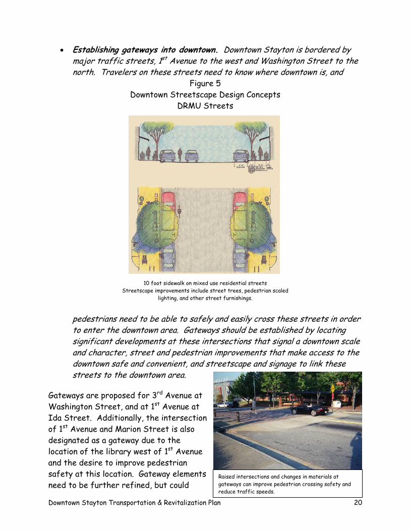
• Establishing gateways into downtown. Downtown Stayton is bordered by major traffic streets, 1st Avenue to the west and Washington Street to the north. Travelers on these streets need to know where downtown is, and
Figure 5 Downtown Streetscape Design Concepts
DRMU Streets
10 foot sidewalk on mixed use residential streets Streetscape improvements include street trees, pedestrian scaled
lighting, and other street furnishings.
pedestrians need to be able to safely and easily cross these streets in order to enter the downtown area. Gateways should be established by locating significant developments at these intersections that signal a downtown scale and character, street and pedestrian improvements that make access to the downtown safe and convenient, and streetscape and signage to link these streets to the downtown area.
Gateways are proposed for 3rd Avenue at Washington Street, and at 1st Avenue at Ida Street. Additionally, the intersection of 1st Avenue and Marion Street is also designated as a gateway due to the location of the library west of 1st Avenue and the desire to improve pedestrian safety at this location. Gateway elements need to be further refined, but could
Downtown Stayton Transportation & Revitalization Plan 20
Raised intersections and changes in materials at gateways can improve pedestrian crossing safety and reduce traffic speeds.
include: raised intersections and changes in materials that offer good pedestrian crossings and traffic management capabilities, traffic controls that prioritize movements into the downtown, signage directing travelers into the downtown, streetscape improvements including unique street trees and pedestrian lighting that tie to the downtown.
Specific design and improvement standards for gateways will need to be developed and adopted by the City and approved by Marion County for 1st Avenue.
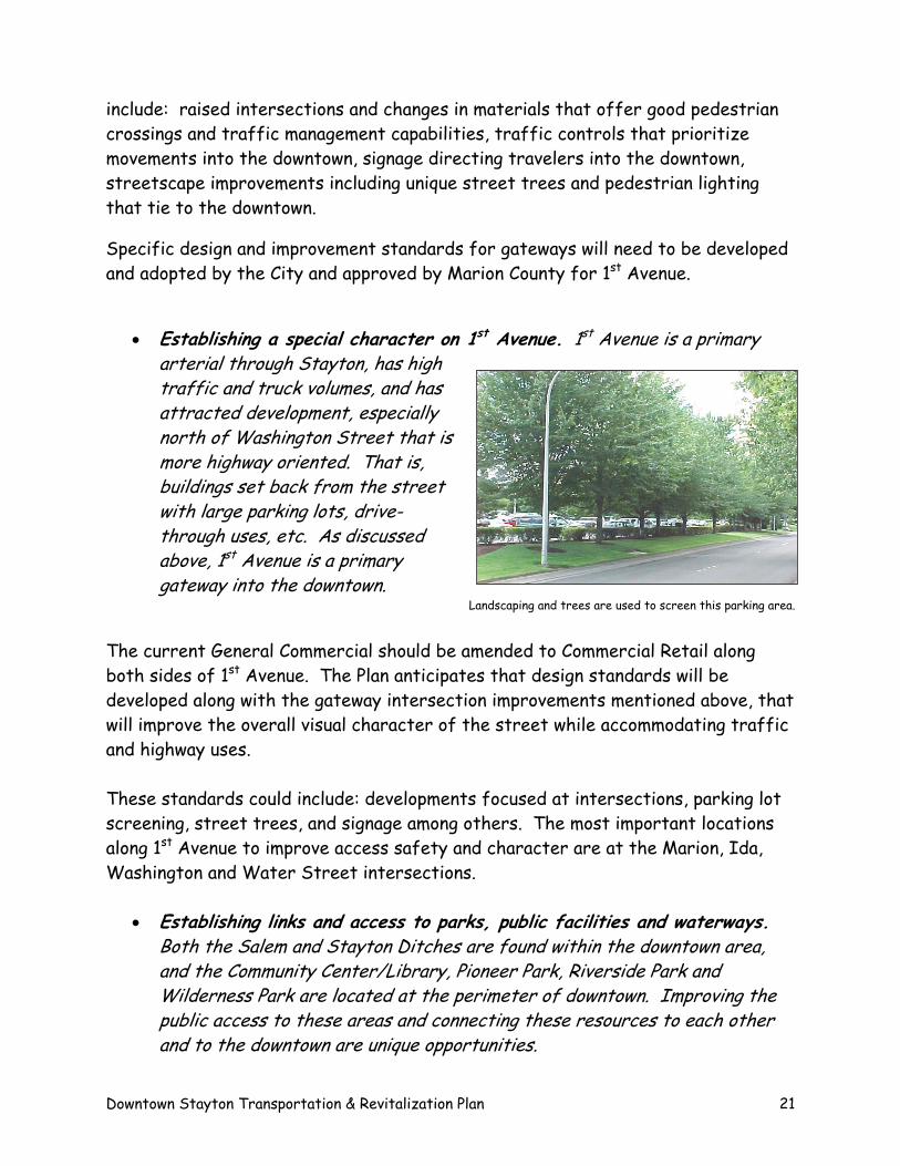
• Establishing a special character on 1st Avenue. 1st Avenue is a primary arterial through Stayton, has high traffic and truck volumes, and has attracted development, especially north of Washington Street that is more highway oriented. That is, buildings set back from the street with large parking lots, drive-through uses, etc. As discussed above, 1st Avenue is a primary gateway into the downtown.
Landscaping and trees are used to screen this parking area.
The current General Commercial should be amended to Commercial Retail along both sides of 1st Avenue. The Plan anticipates that design standards will be developed along with the gateway intersection improvements mentioned above, that will improve the overall visual character of the street while accommodating traffic and highway uses. These standards could include: developments focused at intersections, parking lot screening, street trees, and signage among others. The most important locations along 1st Avenue to improve access safety and character are at the Marion, Ida, Washington and Water Street intersections.
• Establishing links and access to parks, public facilities and waterways. Both the Salem and Stayton Ditches are found within the downtown area, and the Community Center/Library, Pioneer Park, Riverside Park and Wilderness Park are located at the perimeter of downtown. Improving the public access to these areas and connecting these resources to each other and to the downtown are unique opportunities.
Downtown Stayton Transportation & Revitalization Plan 21
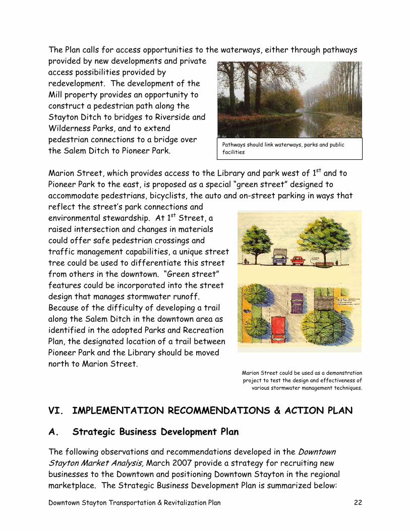
The Plan calls for access opportunities to the waterways, either through pathways provided by new developments and private access possibilities provided by redevelopment. The development of the Mill property provides an opportunity to construct a pedestrian path along the Stayton Ditch to bridges to Riverside and Wilderness Parks, and to extend pedestrian connections to a bridge over the Salem Ditch to Pioneer Park.
Pathways should link waterways, parks and public facilities
Marion Street, which provides access to the Library and park west of 1st and to Pioneer Park to the east, is proposed as a special “green street” designed to accommodate pedestrians, bicyclists, the auto and on-street parking in ways that reflect the street’s park connections and environmental stewardship. At 1st Street, a raised intersection and changes in materials could offer safe pedestrian crossings and traffic management capabilities, a unique street tree could be used to differentiate this street from others in the downtown. “Green street” features could be incorporated into the street design that manages stormwater runoff. Because of the difficulty of developing a trail along the Salem Ditch in the downtown area as identified in the adopted Parks and Recreation Plan, the designated location of a trail between Pioneer Park and the Library should be moved north to Marion Street.
Marion Street could be used as a demonstration project to test the design and effectiveness of
various stormwater management techniques.
VI. IMPLEMENTATION RECOMMENDATIONS & ACTION PLAN
A. Strategic Business Development Plan
The following observations and recommendations developed in the Downtown Stayton Market Analysis, March 2007 provide a strategy for recruiting new businesses to the Downtown and positioning Downtown Stayton in the regional marketplace. The Strategic Business Development Plan is summarized below:
Downtown Stayton Transportation & Revitalization Plan 22
• Existing population and incomes of the immediate Stayton area should not be
relied on to propel substantial new retail and related service business investment. While additional residential density will help provide added activity more conducive to retail, the bulk of customers required for sustainable downtown businesses will come from a much larger market area – likely encompassing the entire upper Santiam Canyon area plus pass-through and destination visitors.
• To encourage business investment, encouragement of a more upscale, higher
end residential and mixed use neighborhood will be critical. This likely involves emphasis on encouraging upgrading of existing residential structures as well as facilitating higher density infill residential on vacant and underutilized parcels in and near the downtown area. Densities need to be appropriate to the market and community context, for example, townhome, semi-attached and smaller multi-unit structures – with a strong mix of home ownership product.
• Because downtown Stayton is at the edge rather than in the center of
Stayton’s market and is removed from the Highway 22 Santiam Canyon travel corridor, increased attention will need to be given to drawing prospective customers away from their normal travel patterns into the downtown area. This draw can be facilitated by actions with greater emphasis on vehicular wayfinding (including signage and visual cues such as banners, street and sidewalk pavings and landscape treatments), special events/festivals, and (most importantly) building on the most unique attraction Stayton has to offer – its waterways and related parks. Stayton’s internal canal system and major parks are an extraordinary amenity package offering linkages between recreation, living, and shopping.
• The past track record of real estate demand and absorption cannot be
relied on to support a vibrant downtown and mixed use neighborhood. Rather, downtown Stayton needs to be prepared to compete for residents and customers not yet acquainted with the downtown by creating and then selling a compelling vision for the next great mixed use village neighborhood in Marion County.
• Real estate and business investment can expect to be drawn primarily from
the immediate Stayton and possibly Salem metro areas. As other communities have done, Stayton revised its codes for the downtown area to
Downtown Stayton Transportation & Revitalization Plan 23
encourage extraordinary flexibility of mixed use. For property developers and real estate brokerage interests, it also will be useful to illustrate that the same development can be built for no more and in no greater time than in nearby alternatives ranging from Salem to Silverton to Independence to McMinnville.
Sales leakage information can be translated into estimates of square footage demand. The estimates provided below represent maximum potentials assuming 100% sales leakage recapture. Also quantified with this analysis are future retail potentials associated with population growth.
• If 100% of the current resident spending potential were to be recaptured and
accommodated within the comparison trade area, up to nearly 51,000 square feet of retail space could be supported through 2011 throughout the upper Santiam Canyon trade area – including downtown Stayton. Clothing and accessories represents the retail category that could conceivably support the greatest increase in commercial building space – followed by furniture and home furnishings and then building materials and garden supplies stores.
• Up to an additional 19,000 square feet of retail development could be supported
with population growth reasonably anticipated to 2011 – for a total current plus future growth space potential of up to 70,000 square feet. The strongest categories of added space demand in the upper Santiam Canyon for added space are clothing and accessories (up to 18,000 square feet) followed by building materials and garden supplies (15,000 square feet) and furniture and home furnishings categories (14,000 square feet).
• The degree to which downtown Stayton is able to better serve and capture the
combination of local and regional resident demand depends on a variety of factors – some of which are more readily influenced by local initiative than others. For some categories such as building materials and garden supplies, the amount of retail potential is not large enough to attract the attention of national home improvement retailers. Consequently, there is opportunity to recruit smaller independent hardware, lumber and garden retailers (including urban oriented garden stores) – if local entrepreneurial capital can be found and convinced that residents will not drive to large format stores a few miles away in Salem.
• A companion strategy is to build downtown retail around entrepreneurial uses
that can effectively cater to multiple markets – including an expanded
Downtown Stayton Transportation & Revitalization Plan 24
downtown area residential base, existing Canyon residents and possibly Salem/Marion County and other visitors traveling the Santiam Canyon (as to Detroit Lakes or central Oregon) or viewing Stayton as an attractive day trip destination. Restaurants, sporting/hobby, book/music, potentially apparel and other specialty stores are types of retail that could cater to these multiple consumer markets.
The strategy likely offering the most retail potential for downtown Stayton is one that involves attracting small independently owned specialty shops together with dining establishments that cater to a combination of a growing downtown residential and employment base, upscale Canyon shoppers, and destination day-trip travel drawn from the mid-Willamette Valley region. The following section includes a public implementation strategy for assisting downtown business and supporting growth and expansion opportunities. A range of implementation tools are discussed and action plan identified that lists public and private activities necessary to implement the Plan, priorities, costs and responsibilities. B. Implementation Tools and Action Plan The Implementation Toolkit Available Implementation Tools Implementing the Downtown Plan will require a variety of tools and strategies, some of them not yet in place. Though sources of funding are of course critical to any capital-intensive action plan, great importance also must be given to setting up mechanisms and organizations to assist in the implementation program.
The capital activities called for in the Plan for the Downtown District essentially are either standard public works projects, such as street, traffic and streetscape improvements, parks, and public buildings, or they are actions that will require initiatives by private developers. The table below shows the funding sources most appropriate to the activities and actions desired to carry out the Downtown plan. Table 1 is not intended to be comprehensive, but presents the sources most likely to be available and appropriate in the foreseeable future.
Downtown Stayton Transportation & Revitalization Plan 25
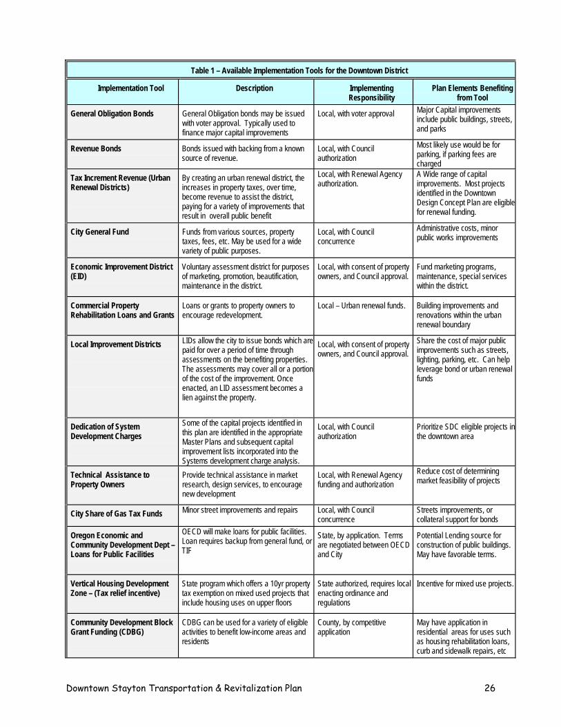
Table 1 – Available Implementation Tools for the Downtown District
Implementation Tool Description Implementing Responsibility
Plan Elements Benefiting from Tool
General Obligation Bonds
General Obligation bonds may be issued with voter approval. Typically used to finance major capital improvements
Local, with voter approval Major Capital improvements include public buildings, streets, and parks
Revenue Bonds
Bonds issued with backing from a known source of revenue.
Local, with Council authorization
Most likely use would be for parking, if parking fees are charged
Tax Increment Revenue (Urban Renewal Districts)
By creating an urban renewal district, the increases in property taxes, over time, become revenue to assist the district, paying for a variety of improvements that result in overall public benefit
Local, with Renewal Agency authorization.
A Wide range of capital improvements. Most projects identified in the Downtown Design Concept Plan are eligible for renewal funding.
City General Fund
Funds from various sources, property taxes, fees, etc. May be used for a wide variety of public purposes.
Local, with Council concurrence
Administrative costs, minor public works improvements
Economic Improvement District (EID)
Voluntary assessment district for purposes of marketing, promotion, beautification, maintenance in the district.
Local, with consent of property owners, and Council approval.
Fund marketing programs, maintenance, special services within the district.
Commercial Property Rehabilitation Loans and Grants
Loans or grants to property owners to encourage redevelopment.
Local – Urban renewal funds. Building improvements and renovations within the urban renewal boundary
Local Improvement Districts
LIDs allow the city to issue bonds which are paid for over a period of time through assessments on the benefiting properties. The assessments may cover all or a portion of the cost of the improvement. Once enacted, an LID assessment becomes a lien against the property.
Local, with consent of property owners, and Council approval.
Share the cost of major public improvements such as streets, lighting, parking, etc. Can help leverage bond or urban renewal funds
Dedication of System Development Charges
Some of the capital projects identified in this plan are identified in the appropriate Master Plans and subsequent capital improvement lists incorporated into the Systems development charge analysis.
Local, with Council authorization
Prioritize SDC eligible projects in the downtown area
Technical Assistance to Property Owners
Provide technical assistance in market research, design services, to encourage new development
Local, with Renewal Agency funding and authorization
Reduce cost of determining market feasibility of projects
City Share of Gas Tax Funds Minor street improvements and repairs Local, with Council concurrence
Streets improvements, or collateral support for bonds
Oregon Economic and Community Development Dept – Loans for Public Facilities
OECD will make loans for public facilities. Loan requires backup from general fund, or TIF
State, by application. Terms are negotiated between OECD and City
Potential Lending source for construction of public buildings. May have favorable terms.
Vertical Housing Development Zone – (Tax relief incentive)
State program which offers a 10yr property tax exemption on mixed used projects that include housing uses on upper floors
State authorized, requires local enacting ordinance and regulations
Incentive for mixed use projects.
Community Development Block Grant Funding (CDBG)
CDBG can be used for a variety of eligible activities to benefit low-income areas and residents
County, by competitive application
May have application in residential areas for uses such as housing rehabilitation loans, curb and sidewalk repairs, etc
Downtown Stayton Transportation & Revitalization Plan 26
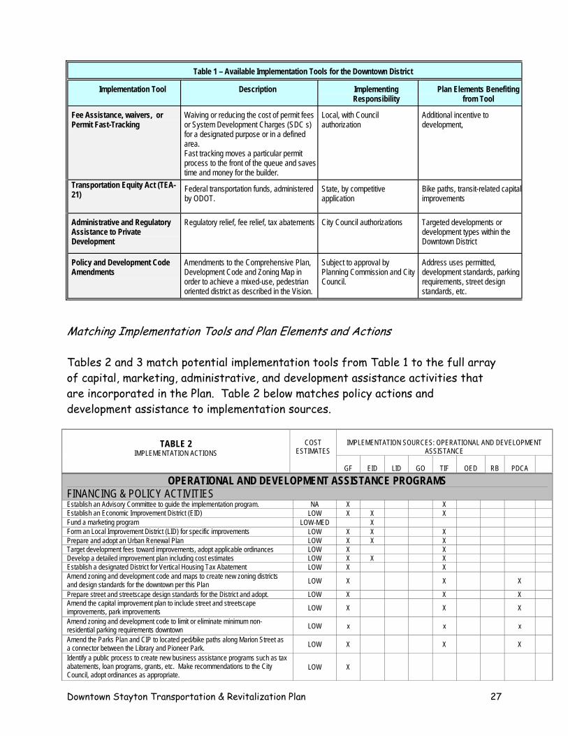
Table 1 – Available Implementation Tools for the Downtown District
Implementation Tool Description Implementing Plan Elements Benefiting Responsibility from Tool
Fee Assistance, waivers, or Permit Fast-Tracking
Waiving or reducing the cost of permit fees or System Development Charges (SDC s) for a designated purpose or in a defined area. Fast tracking moves a particular permit process to the front of the queue and saves time and money for the builder.
Local, with Council authorization
Additional incentive to development,
Transportation Equity Act (TEA-21)
Federal transportation funds, administered by ODOT.
State, by competitive application
Bike paths, transit-related capital improvements
Administrative and Regulatory Assistance to Private Development
Regulatory relief, fee relief, tax abatements City Council authorizations Targeted developments or development types within the Downtown District
Policy and Development Code Amendments
Amendments to the Comprehensive Plan, Development Code and Zoning Map in order to achieve a mixed-use, pedestrian oriented district as described in the Vision.
Subject to approval by Planning Commission and City Council.
Address uses permitted, development standards, parking requirements, street design standards, etc.
Matching Implementation Tools and Plan Elements and Actions Tables 2 and 3 match potential implementation tools from Table 1 to the full array of capital, marketing, administrative, and development assistance activities that are incorporated in the Plan. Table 2 below matches policy actions and development assistance to implementation sources.
IMPLEMENTATION SOURCES: OPERATIONAL AND DEVELOPMENT
ASSISTANCE
TABLE 2
IMPLEMENTATION ACTIONS
COST
ESTIMATES
GF
EID
LID
GO
TIF
OED
RB
PDCA
OPERATIONAL AND DEVELOPMENT ASSISTANCE PROGRAMS FINANCING & POLICY ACTIVITIES Establish an Advisory Committee to guide the implementation program. NA X X Establish an Economic Improvement District (EID) LOW X X X Fund a marketing program LOW-MED X Form an Local Improvement District (LID) for specific improvements LOW X X X Prepare and adopt an Urban Renewal Plan LOW X X X Target development fees toward improvements, adopt applicable ordinances LOW X X Develop a detailed improvement plan including cost estimates LOW X X X Establish a designated District for Vertical Housing Tax Abatement LOW X X Amend zoning and development code and maps to create new zoning districts and design standards for the downtown per this Plan LOW X X X
Prepare street and streetscape design standards for the District and adopt. LOW X X X Amend the capital improvement plan to include street and streetscape improvements, park improvements LOW X X X
Amend zoning and development code to limit or eliminate minimum non-residential parking requirements downtown LOW x x x
Amend the Parks Plan and CIP to located ped/bike paths along Marion Street as a connector between the Library and Pioneer Park. LOW X X X
Identify a public process to create new business assistance programs such as tax abatements, loan programs, grants, etc. Make recommendations to the City Council, adopt ordinances as appropriate.
LOW X
Downtown Stayton Transportation & Revitalization Plan 27
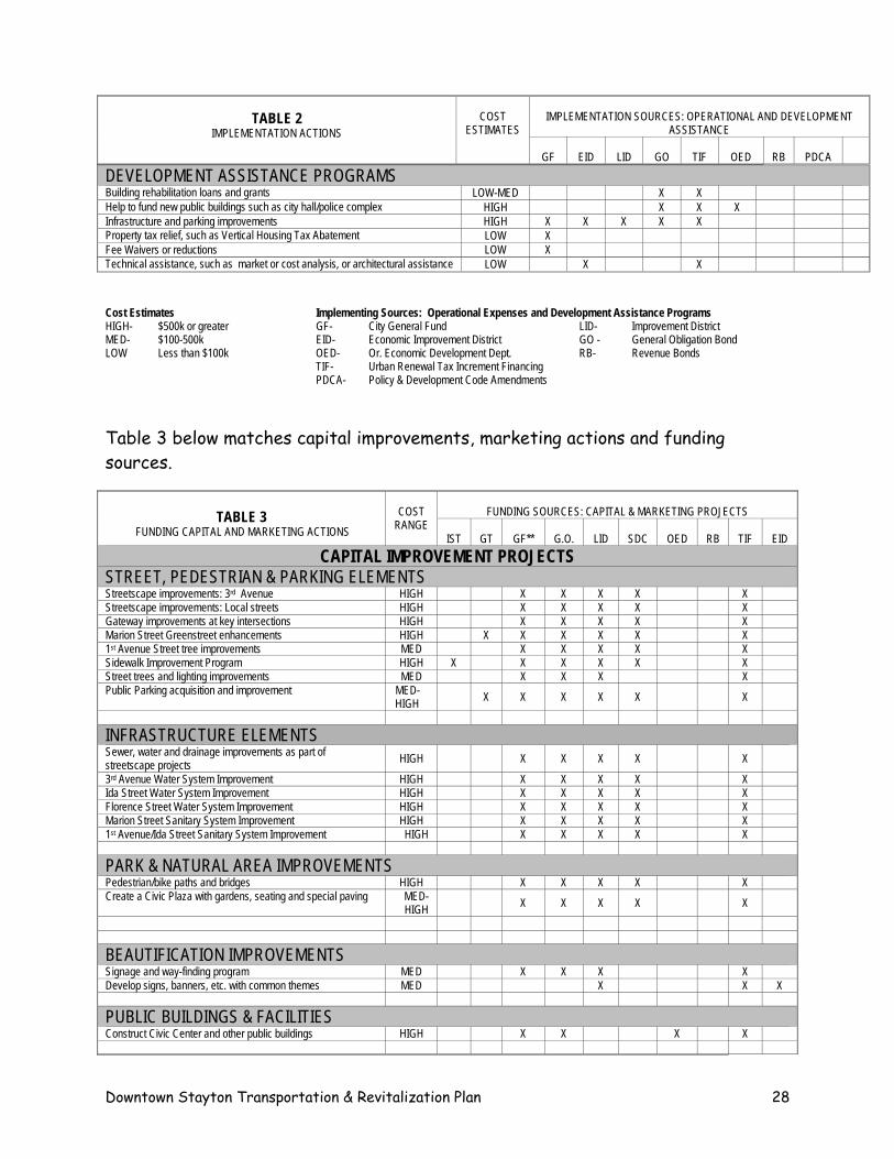
IMPLEMENTATION SOURCES: OPERATIONAL AND DEVELOPMENT
ASSISTANCE
TABLE 2
IMPLEMENTATION ACTIONS
COST
ESTIMATES
GF
EID
LID
GO
TIF
OED
RB
PDCA
DEVELOPMENT ASSISTANCE PROGRAMS Building rehabilitation loans and grants LOW-MED X X Help to fund new public buildings such as city hall/police complex HIGH X X X Infrastructure and parking improvements HIGH X X X X X Property tax relief, such as Vertical Housing Tax Abatement LOW X Fee Waivers or reductions LOW X Technical assistance, such as market or cost analysis, or architectural assistance LOW X X Cost Estimates Implementing Sources: Operational Expenses and Development Assistance Programs HIGH- $500k or greater GF- City General Fund LID- Improvement District MED- $100-500k EID- Economic Improvement District GO - General Obligation Bond LOW Less than $100k OED- Or. Economic Development Dept. RB- Revenue Bonds TIF- Urban Renewal Tax Increment Financing
PDCA- Policy & Development Code Amendments
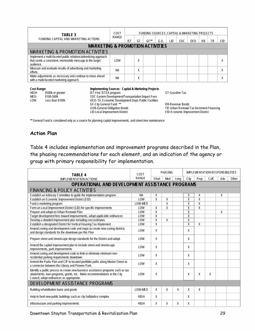
Table 3 below matches capital improvements, marketing actions and funding sources.
FUNDING SOURCES: CAPITAL & MARKETING PROJECTS
TABLE 3
FUNDING CAPITAL AND MARKETING ACTIONS
COST
RANGE IST
GT
GF**
G.O.
LID
SDC
OED
RB
TIF
EID
CAPITAL IMPROVEMENT PROJECTS STREET, PEDESTRIAN & PARKING ELEMENTS Streetscape improvements: 3rd Avenue HIGH X X X X X Streetscape improvements: Local streets HIGH X X X X X Gateway improvements at key intersections HIGH X X X X X Marion Street Greenstreet enhancements HIGH X X X X X X 1st Avenue Street tree improvements MED X X X X X Sidewalk Improvement Program HIGH X X X X X X Street trees and lighting improvements MED X X X X Public Parking acquisition and improvement MED-
HIGH X X X X X X
INFRASTRUCTURE ELEMENTS Sewer, water and drainage improvements as part of streetscape projects HIGH X X X X X
3rd Avenue Water System Improvement HIGH X X X X X Ida Street Water System Improvement HIGH X X X X X Florence Street Water System Improvement HIGH X X X X X Marion Street Sanitary System Improvement HIGH X X X X X 1st Avenue/Ida Street Sanitary System Improvement HIGH X X X X X PARK & NATURAL AREA IMPROVEMENTS Pedestrian/bike paths and bridges HIGH X X X X X Create a Civic Plaza with gardens, seating and special paving MED-
HIGH X X X X X
BEAUTIFICATION IMPROVEMENTS Signage and way-finding program MED X X X X Develop signs, banners, etc. with common themes MED X X X PUBLIC BUILDINGS & FACILITIES Construct Civic Center and other public buildings HIGH X X X X
Downtown Stayton Transportation & Revitalization Plan 28
FUNDING SOURCES: CAPITAL & MARKETING PROJECTS
TABLE 3
FUNDING CAPITAL AND MARKETING ACTIONS
COST
RANGE IST
GT
GF**
G.O.
LID
SDC
OED
RB
TIF
EID
MARKETING & PROMOTION ACTIVITIES MARKETING & PROMOTION ACTIVITIES Implement a multi-faceted public relations/advertising approach that sends a consistent, memorable message to the target audience.
LOW
X X
Measure and evaluate results of advertising and marketing efforts. NA X X
Make adjustments as necessary and continue to move ahead with a multi-faceted marketing approach. NA X X
Cost Range: Implementing Sources: Capital & Marketing Projects HIGH- $500k or greater IST-Fed. ISTEA program GT-Gasoline Tax MED- $100-500k SDC-System Development/Transportation Impact Fees LOW Less than $100k OED- Or. Economic Development Dept.-Public Facilities GF-City General Fund ** RB-Revenue Bonds
GOB-General Obligation Bonds TIF-Urban Renewal Tax Increment Financing LID-Local Improvement District EID-Economic Improvement District
** General Fund is considered only as a source for planning capital improvements, and street tree maintenance
Action Plan Table 4 includes implementation and improvement programs described in the Plan, the phasing recommendations for each element, and an indication of the agency or group with primary responsibility for implementation.
PHASING IMPLEMENTATION RESPONSIBILITIES TABLE 4
IMPLEMENTATION ACTIONS
COST
RANGE Short Med Long City Prop CofC Adv Other
OPERATIONAL AND DEVELOPMENT ASSISTANCE PROGRAMS FINANCING & POLICY ACTIVITIES Establish an Advisory Committee to guide the implementation program. NA X X X X Establish an Economic Improvement District (EID) LOW X X X X Fund a marketing program LOW-MED X X X Form an Local Improvement District (LID) for specific improvements LOW X X X X Prepare and adopt an Urban Renewal Plan LOW X X X Target development fees toward improvements, adopt applicable ordinances LOW X X Develop a detailed improvement plan including cost estimates LOW X X X Establish a designated District for Vertical Housing Tax Abatement LOW X X X Amend zoning and development code and maps to create new zoning districts and design standards for the downtown per this Plan LOW X X
Prepare street and streetscape design standards for the District and adopt. LOW X X
Amend the capital improvement plan to include street and streetscape improvements, park improvements LOW X X
Amend zoning and development code to limit or eliminate minimum non-residential parking requirements downtown LOW X X
Amend the Parks Plan and CIP to located ped/bike paths along Marion Street as a connector between the Library and Pioneer Park. LOW X X
Identify a public process to create new business assistance programs such as tax abatements, loan programs, grants, etc. Make recommendations to the City Council, adopt ordinances as appropriate.
LOW X X X X
DEVELOPMENT ASSISTANCE PROGRAMS Building rehabilitation loans and grants LOW-MED X X X X X
Help to fund new public buildings such as city hall/police complex HIGH X X
Infrastructure and parking improvements HIGH X X X X
Downtown Stayton Transportation & Revitalization Plan 29
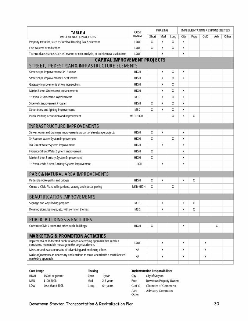
PHASING IMPLEMENTATION RESPONSIBILITIES TABLE 4
IMPLEMENTATION ACTIONS
COST
RANGE Short Med Long City Prop CofC Adv Other Property tax relief, such as Vertical Housing Tax Abatement LOW X X X X
Fee Waivers or reductions LOW X X X X
Technical assistance, such as market or cost analysis, or architectural assistance LOW X X
CAPITAL IMPROVEMENT PROJECTS
STREET, PEDESTRIAN & INFRASTRUCTURE ELEMENTS Streetscape improvements: 3rd Avenue HIGH X X X
Streetscape improvements: Local streets HIGH X X X
Gateway improvements at key intersections HIGH X X
Marion Street Greenstreet enhancements HIGH X X X
1st Avenue Street tree improvements MED X X X
Sidewalk Improvement Program HIGH X X X X
Street trees and lighting improvements MED X X X X
Public Parking acquisition and improvement MED-HIGH X X X
INFRASTRUCTURE IMPROVEMENTS
Sewer, water and drainage improvements as part of streetscape projects HIGH X X X
3rd Avenue Water System Improvement HIGH X X X
Ida Street Water System Improvement HIGH X X
Florence Street Water System Improvement HIGH X X
Marion Street Sanitary System Improvement HIGH X X
1st Avenue/Ida Street Sanitary System Improvement HIGH X X
PARK & NATURAL AREA IMPROVEMENTS
Pedestrian/bike paths and bridges HIGH X X X X
Create a Civic Plaza with gardens, seating and special paving MED-HIGH X X
BEAUTIFICATION IMPROVEMENTS
Signage and way-finding program MED X X X
Develop signs, banners, etc. with common themes MED X X X
PUBLIC BUILDINGS & FACILITIES
Construct Civic Center and other public buildings HIGH X X X
MARKETING & PROMOTION ACTIVITIES Implement a multi-faceted public relations/advertising approach that sends a consistent, memorable message to the target audience. LOW X X X
Measure and evaluate results of advertising and marketing efforts. NA X X X Make adjustments as necessary and continue to move ahead with a multi-faceted marketing approach. NA X X X
Cost Range Phasing Implementation Responsibilities HIGH- $500k or greater Short- 1 year City- City of Stayton MED- $100-500k Med- 2-5 years Prop- Downtown Property Owners LOW Less than $100k Long- 6+ years C of C- Chamber of Commerce Adv- Advisory Committee Other
Downtown Stayton Transportation & Revitalization Plan 30
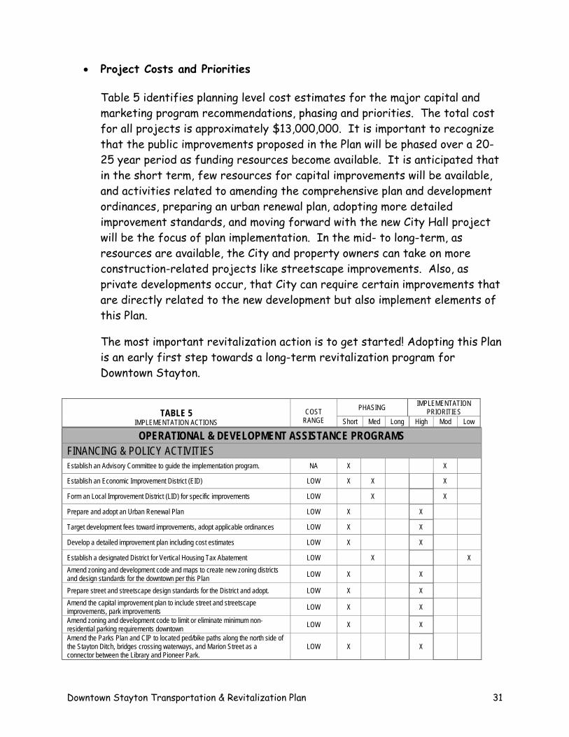
• Project Costs and Priorities Table 5 identifies planning level cost estimates for the major capital and marketing program recommendations, phasing and priorities. The total cost for all projects is approximately $13,000,000. It is important to recognize that the public improvements proposed in the Plan will be phased over a 20-25 year period as funding resources become available. It is anticipated that in the short term, few resources for capital improvements will be available, and activities related to amending the comprehensive plan and development ordinances, preparing an urban renewal plan, adopting more detailed improvement standards, and moving forward with the new City Hall project will be the focus of plan implementation. In the mid- to long-term, as resources are available, the City and property owners can take on more construction-related projects like streetscape improvements. Also, as private developments occur, that City can require certain improvements that are directly related to the new development but also implement elements of this Plan. The most important revitalization action is to get started! Adopting this Plan is an early first step towards a long-term revitalization program for Downtown Stayton.
PHASING IMPLEMENTATION
PRIORITIES
TABLE 5 IMPLEMENTATION ACTIONS
COST
RANGE Short Med Long High Mod Low
OPERATIONAL & DEVELOPMENT ASSISTANCE PROGRAMS FINANCING & POLICY ACTIVITIES Establish an Advisory Committee to guide the implementation program. NA X X
Establish an Economic Improvement District (EID) LOW X X X
Form an Local Improvement District (LID) for specific improvements LOW X X
Prepare and adopt an Urban Renewal Plan LOW X X
Target development fees toward improvements, adopt applicable ordinances LOW X X
Develop a detailed improvement plan including cost estimates LOW X X
Establish a designated District for Vertical Housing Tax Abatement LOW X X Amend zoning and development code and maps to create new zoning districts and design standards for the downtown per this Plan LOW X X
Prepare street and streetscape design standards for the District and adopt. LOW X X Amend the capital improvement plan to include street and streetscape improvements, park improvements LOW X X
Amend zoning and development code to limit or eliminate minimum non-residential parking requirements downtown LOW X X
Amend the Parks Plan and CIP to located ped/bike paths along the north side of the Stayton Ditch, bridges crossing waterways, and Marion Street as a connector between the Library and Pioneer Park.
LOW X X
Downtown Stayton Transportation & Revitalization Plan 31
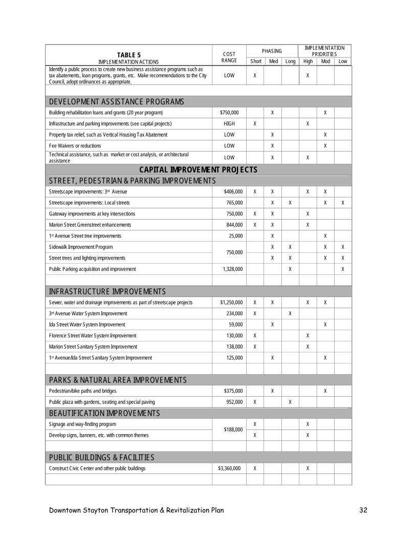
IMPLEMENTATION PRIORITIES PHASING
TABLE 5 IMPLEMENTATION ACTIONS
COST
RANGE Short Med Long High Mod Low Identify a public process to create new business assistance programs such as tax abatements, loan programs, grants, etc. Make recommendations to the City Council, adopt ordinances as appropriate.
LOW X X
DEVELOPMENT ASSISTANCE PROGRAMS Building rehabilitation loans and grants (20 year program) $750,000 X X
Infrastructure and parking improvements (see capital projects) HIGH X X
Property tax relief, such as Vertical Housing Tax Abatement LOW X X
Fee Waivers or reductions LOW X X Technical assistance, such as market or cost analysis, or architectural assistance LOW X X
CAPITAL IMPROVEMENT PROJECTS STREET, PEDESTRIAN & PARKING IMPROVEMENTS Streetscape improvements: 3rd Avenue $406,000 X X X X
Streetscape improvements: Local streets 765,000 X X X X
Gateway improvements at key intersections 750,000 X X X
Marion Street Greenstreet enhancements 844,000 X X X
1st Avenue Street tree improvements 25,000 X X
Sidewalk Improvement Program X X X X
Street trees and lighting improvements 750,000
X X X X
Public Parking acquisition and improvement 1,328,000 X X
INFRASTRUCTURE IMPROVEMENTS Sewer, water and drainage improvements as part of streetscape projects $1,250,000 X X X X
3rd Avenue Water System Improvement 234,000 X X
Ida Street Water System Improvement 59,000 X X
Florence Street Water System Improvement 130,000 X X
Marion Street Sanitary System Improvement 138,000 X X
1st Avenue/Ida Street Sanitary System Improvement 125,000 X X
PARKS & NATURAL AREA IMPROVEMENTS Pedestrian/bike paths and bridges $375,000 X X
Public plaza with gardens, seating and special paving 952,000 X X
BEAUTIFICATION IMPROVEMENTS Signage and way-finding program X X
Develop signs, banners, etc. with common themes $188,000
X X
PUBLIC BUILDINGS & FACILITIES Construct Civic Center and other public buildings $3,360,000 X X
Downtown Stayton Transportation & Revitalization Plan 32
PHASING IMPLEMENTATION PRIORITIES
TABLE 5
IMPLEMENTATION ACTIONS
COST
RANGE Short Med Long High Mod Low
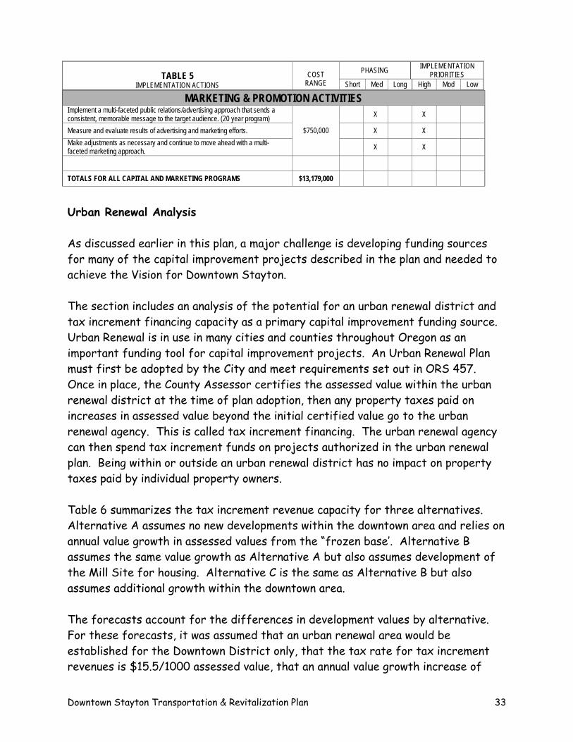
MARKETING & PROMOTION ACTIVITIES Implement a multi-faceted public relations/advertising approach that sends a consistent, memorable message to the target audience. (20 year program) X X
Measure and evaluate results of advertising and marketing efforts. X X Make adjustments as necessary and continue to move ahead with a multi-faceted marketing approach.
$750,000
X X
TOTALS FOR ALL CAPITAL AND MARKETING PROGRAMS $13,179,000
Urban Renewal Analysis As discussed earlier in this plan, a major challenge is developing funding sources for many of the capital improvement projects described in the plan and needed to achieve the Vision for Downtown Stayton. The section includes an analysis of the potential for an urban renewal district and tax increment financing capacity as a primary capital improvement funding source. Urban Renewal is in use in many cities and counties throughout Oregon as an important funding tool for capital improvement projects. An Urban Renewal Plan must first be adopted by the City and meet requirements set out in ORS 457. Once in place, the County Assessor certifies the assessed value within the urban renewal district at the time of plan adoption, then any property taxes paid on increases in assessed value beyond the initial certified value go to the urban renewal agency. This is called tax increment financing. The urban renewal agency can then spend tax increment funds on projects authorized in the urban renewal plan. Being within or outside an urban renewal district has no impact on property taxes paid by individual property owners. Table 6 summarizes the tax increment revenue capacity for three alternatives. Alternative A assumes no new developments within the downtown area and relies on annual value growth in assessed values from the “frozen base’. Alternative B assumes the same value growth as Alternative A but also assumes development of the Mill Site for housing. Alternative C is the same as Alternative B but also assumes additional growth within the downtown area. The forecasts account for the differences in development values by alternative. For these forecasts, it was assumed that an urban renewal area would be established for the Downtown District only, that the tax rate for tax increment revenues is $15.5/1000 assessed value, that an annual value growth increase of
Downtown Stayton Transportation & Revitalization Plan 33
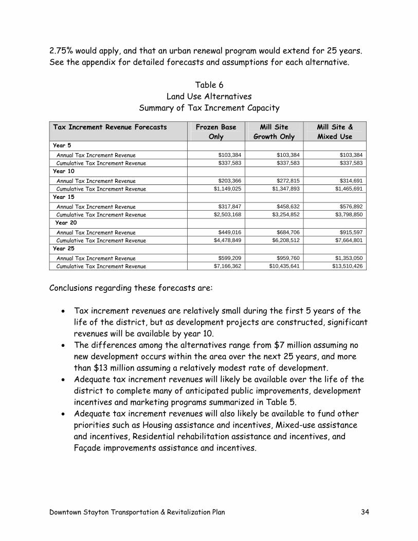
2.75% would apply, and that an urban renewal program would extend for 25 years. See the appendix for detailed forecasts and assumptions for each alternative.
Table 6 Land Use Alternatives
Summary of Tax Increment Capacity Tax Increment Revenue Forecasts Frozen Base
Only Mill Site
Growth Only Mill Site & Mixed Use
Year 5 Annual Tax Increment Revenue $103,384 $103,384 $103,384 Cumulative Tax Increment Revenue $337,583 $337,583 $337,583 Year 10
Annual Tax Increment Revenue $203,366 $272,815 $314,691 Cumulative Tax Increment Revenue $1,149,025 $1,347,893 $1,465,691 Year 15
Annual Tax Increment Revenue $317,847 $458,632 $576,892 Cumulative Tax Increment Revenue $2,503,168 $3,254,852 $3,798,850 Year 20
Annual Tax Increment Revenue $449,016 $684,706 $915,597 Cumulative Tax Increment Revenue $4,478,849 $6,208,512 $7,664,801 Year 25
Annual Tax Increment Revenue $599,209 $959,760 $1,353,050 Cumulative Tax Increment Revenue $7,166,362 $10,435,641 $13,510,426
Conclusions regarding these forecasts are:
• Tax increment revenues are relatively small during the first 5 years of the life of the district, but as development projects are constructed, significant revenues will be available by year 10.
• The differences among the alternatives range from $7 million assuming no new development occurs within the area over the next 25 years, and more than $13 million assuming a relatively modest rate of development.
• Adequate tax increment revenues will likely be available over the life of the district to complete many of anticipated public improvements, development incentives and marketing programs summarized in Table 5.
• Adequate tax increment revenues will also likely be available to fund other priorities such as Housing assistance and incentives, Mixed-use assistance and incentives, Residential rehabilitation assistance and incentives, and Façade improvements assistance and incentives.
Downtown Stayton Transportation & Revitalization Plan 34
Recommendations Three key recommendations related to funding needed downtown improvements are summarized below. These recommendations set a city-wide priority to fund improvements in the downtown area. Other sources of funding noted in this section should also be considered for high priority projects.
• Pursue the formation of an urban renewal district to include the entire Downtown Area. Adopting an urban renewal plan will provide a reliable funding source for capital improvement projects and a mechanism to carry out long term economic development activities.
• Pursue general obligation bond financing for the new city hall civic center.
This project is an important catalyst project, is need in the short-term, and will serve to stimulate private investments in the southern part of the downtown.
Downtown Stayton Transportation & Revitalization Plan 35
APPENDIX A Downtown Stayton Mixed Use Districts Downtown Stayton Transportation & Revitalization Plan Purpose
This section of the Community Development Code implements the Downtown Stayton Transportation & Revitalization Plan which calls for the downtown area to accommodate intensive commercial, residential, and mixed-use development. The downtown area is envisioned as the focus of the community, incorporating these uses in a pedestrian-oriented district. In order to accomplish these purposes, two mixed use districts apply to the downtown area, as shown on the Official Zoning Map. All of the districts of the Downtown permit commercial, residential, and mixed-use developments. These districts are designed to work together to result in a lively, prosperous downtown which serves as an attractive place to live, work, shop, and recreate with less reliance on the automobile than might be found elsewhere in the community.
Downtown Districts Characteristics
1. Central Core Mixed Use (CCMU)
This district encompasses the existing core area. It is centered on 3rd Avenue., but also extends eastward and westward along cross streets to allow for expansion of this village commercial environment. Primary uses permitted in CCMU are retail commercial, services, and office uses. Mixed-use developments, dwellings located above or behind commercial uses, multi-family attached dwellings, and various institutional uses (e.g. library, public meeting halls, churches, government facilities) are also permitted. The scale and character of new development is intended to be similar to the existing, traditional "Main Street" environment. These include two-story to four-story buildings placed close to sidewalks, with parking lots behind or to the side of buildings.
2. Downtown Residential Mixed Use (DRMU)
This designation is applied to property north, west and east of the 3rd Avenue central core area. DRMU designated areas are intended to become neighborhoods made up mainly of moderate-density residential uses, ranging from 12 - 30 units per acre. Typical forms of housing would include multi-family attached dwellings, garden apartments, condominiums, and townhouses. Mixed-use and neighborhood-scale commercial uses are also permitted.
Permitted Uses
1. Permitted Land Uses
The types of land uses which are permitted in the Downtown are listed in Table 1. A "P" in this table indicates that a use type is permitted in that district, subject to conformance with applicable provisions of this section and other sections of the Development Code. An "C" in this table indicates a use type which may be permitted in that district as a Conditional Use in accordance with Section 17.12.190. An "NP" in this table indicates a use type which is not permitted in that district. Existing uses which are not permitted in a particular district may continue in existence, subject to provisions of 17.16.050 Non-Conformance.
Downtown Stayton Transportation & Revitalization Plan 36
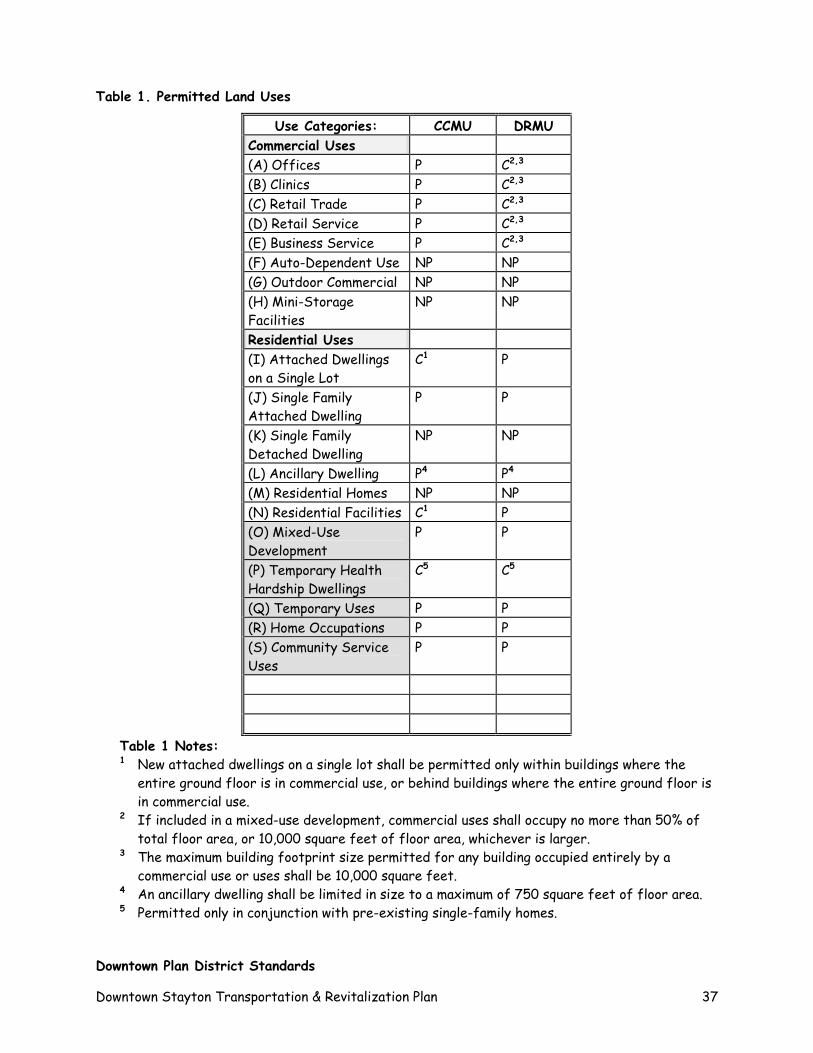
Table 1. Permitted Land Uses
Use Categories: CCMU DRMU Commercial Uses (A) Offices P C2,3
(B) Clinics P C2,3
(C) Retail Trade P C2,3
(D) Retail Service P C2,3
(E) Business Service P C2,3
(F) Auto-Dependent Use NP NP (G) Outdoor Commercial NP NP (H) Mini-Storage Facilities
NP NP
Residential Uses (I) Attached Dwellings on a Single Lot
C1 P
(J) Single Family Attached Dwelling
P P
(K) Single Family Detached Dwelling
NP NP
(L) Ancillary Dwelling PP
4 PP
4
(M) Residential Homes NP NP (N) Residential Facilities C1 P (O) Mixed-Use Development
P P
(P) Temporary Health Hardship Dwellings
C5 C5
(Q) Temporary Uses P P (R) Home Occupations P P (S) Community Service Uses
P P
Table 1 Notes: 1 New attached dwellings on a single lot shall be permitted only within buildings where the
entire ground floor is in commercial use, or behind buildings where the entire ground floor is in commercial use.
2 If included in a mixed-use development, commercial uses shall occupy no more than 50% of total floor area, or 10,000 square feet of floor area, whichever is larger.
3 The maximum building footprint size permitted for any building occupied entirely by a commercial use or uses shall be 10,000 square feet.
4 An ancillary dwelling shall be limited in size to a maximum of 750 square feet of floor area. 5 Permitted only in conjunction with pre-existing single-family homes.
Downtown Plan District Standards
Downtown Stayton Transportation & Revitalization Plan 37
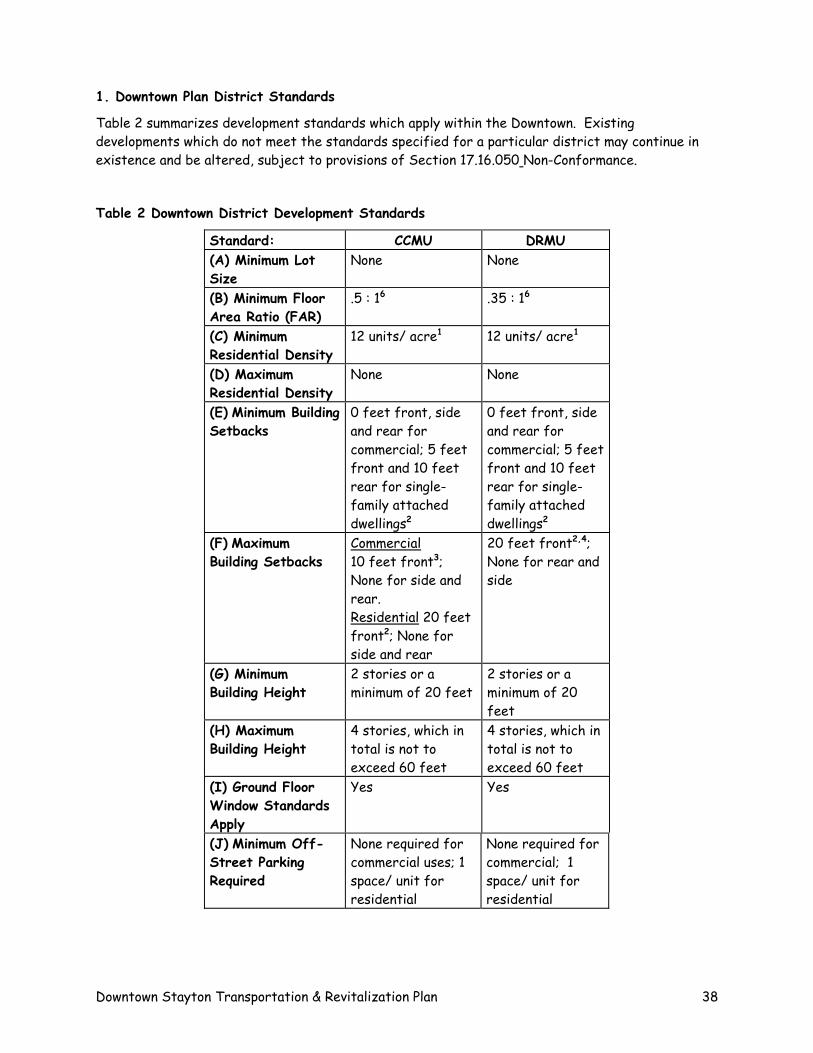
1. Downtown Plan District Standards
Table 2 summarizes development standards which apply within the Downtown. Existing developments which do not meet the standards specified for a particular district may continue in existence and be altered, subject to provisions of Section 17.16.050 Non-Conformance.
Table 2 Downtown District Development Standards
Standard: CCMU DRMU (A) Minimum Lot Size
None None
(B) Minimum Floor Area Ratio (FAR)
.5 : 16 .35 : 16
(C) Minimum Residential Density
12 units/ acre1 12 units/ acre1
(D) Maximum Residential Density
None None
(E) Minimum Building Setbacks
0 feet front, side and rear for commercial; 5 feet front and 10 feet rear for single-family attached dwellings2
0 feet front, side and rear for commercial; 5 feet front and 10 feet rear for single-family attached dwellings2
(F) Maximum Building Setbacks
Commercial 10 feet front3; None for side and rear. Residential 20 feet front2; None for side and rear
20 feet front2,4; None for rear and side
(G) Minimum Building Height
2 stories or a minimum of 20 feet
2 stories or a minimum of 20 feet
(H) Maximum Building Height
4 stories, which in total is not to exceed 60 feet
4 stories, which in total is not to exceed 60 feet
(I) Ground Floor Window Standards Apply
Yes Yes
(J) Minimum Off-Street Parking Required
None required for commercial uses; 1 space/ unit for residential
None required for commercial; 1 space/ unit for residential
Downtown Stayton Transportation & Revitalization Plan 38
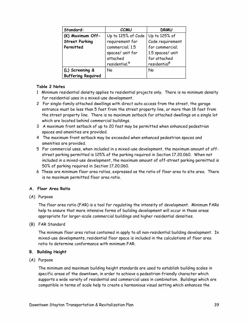
Standard: CCMU DRMU (K) Maximum Off-Street Parking Permitted
Up to 125% of Code requirement for commercial; 1.5 spaces/ unit for attached residential.5
Up to 125% of Code requirement for commercial; 1.5 spaces/ unit for attached residential5
(L) Screening & Buffering Required
No No
Table 2 Notes 1 Minimum residential density applies to residential projects only. There is no minimum density
for residential uses in a mixed-use development. 2 For single-family attached dwellings with direct auto access from the street, the garage
entrance must be less than 5 feet from the street property line, or more than 18 feet from the street property line. There is no maximum setback for attached dwellings on a single lot which are located behind commercial buildings.
3 A maximum front setback of up to 20 feet may be permitted when enhanced pedestrian spaces and amenities are provided.
4 The maximum front setback may be exceeded when enhanced pedestrian spaces and amenities are provided.
5 For commercial uses, when included in a mixed-use development, the maximum amount of off-street parking permitted is 125% of the parking required in Section 17.20.060. When not included in a mixed-use development, the maximum amount of off-street parking permitted is 50% of parking required in Section 17.20.060.
6 These are minimum floor area ratios, expressed as the ratio of floor area to site area. There is no maximum permitted floor area ratio.
A. Floor Area Ratio
(A) Purpose
The floor area ratio (FAR) is a tool for regulating the intensity of development. Minimum FARs help to ensure that more intensive forms of building development will occur in those areas appropriate for larger-scale commercial buildings and higher residential densities.
(B) FAR Standard
The minimum floor area ratios contained in apply to all non-residential building development. In mixed-use developments, residential floor space is included in the calculations of floor area ratio to determine conformance with minimum FAR.
B. Building Height
(A) Purpose
The minimum and maximum building height standards are used to establish building scales in specific areas of the downtown, in order to achieve a pedestrian-friendly character which supports a wide variety of residential and commercial uses in combination. Buildings which are compatible in terms of scale help to create a harmonious visual setting which enhances the
Downtown Stayton Transportation & Revitalization Plan 39
livability of a neighborhood and helps to bring about the successful mixing of diverse land uses and activities.
(B) Height Standards
Minimum and maximum building heights are specified in Table 2. Any required building story must contain a habitable floor.
(1) The minimum building height standard applies to new commercial, residential, and mixed-use buildings. It does not apply to community service buildings, accessory structures, one-time additions or expansions of non-conforming buildings of no more than 25% and less than 1,000 square feet, or to buildings with less than 1,000 square feet of floor area.
(2) Where a minimum building height of two stories is required, a building containing only one habitable floor will be considered to be in compliance with this requirement when the applicant demonstrates that the building is designed and built, in accordance with applicable codes, to provide for later installation of a second floor within the building shell as originally constructed. An applicant for a development permit may be required to provide drawings demonstrating the feasibility of later installation of the second floor, although detailed construction plans for the second floor need not be submitted until the time it is proposed to be installed. When construction of the second floor is deferred under this subsection, only the actual floor area available at the time of initial occupancy shall be used in calculations to determine conformance with a minimum floor area ratio requirement.
(3) When constructing or installing a required second story, the floor area of the second story shall comprise not less than 50% of the total ground floor area. When such a partial second story is constructed or installed, the second story floor space shall be located over that portion of the ground floor which is nearest the abutting street or streets.
(4) In addition to conforming to the Ground Floor Windows requirements for any new commercial or mixed-use building subject to a 2-story height minimum, at least 20% of the upper facade area shall be made up of display areas or windows for all facades facing a street.
C. Setbacks
(A) Purpose
Required building setbacks work with standards for building height and size, and floor area ratios to ensure placement of buildings in a way which creates an attractive streetscape and pleasant pedestrian experience. These regulations also ensure compatibility of building scale, leading to a coherent design scheme appropriate for the various land use districts of the Downtown.
(B) Building Setback Standard
Required minimum and maximum setback standards are specified in Table 2.
(1) Minimum setback distances shall be determined in conformance with the definition for "Setback" as specified in Section 17.04.100.
(2) Conformance with maximum setback distance is achieved when no portion of a building facade is farther from the property line than the distance specified for Maximum Building Setback in Table 2. However, maximum building setbacks may be exceeded when a
Downtown Stayton Transportation & Revitalization Plan 40
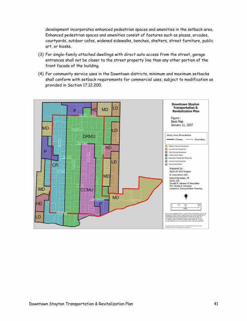
development incorporates enhanced pedestrian spaces and amenities in the setback area. Enhanced pedestrian spaces and amenities consist of features such as plazas, arcades, courtyards, outdoor cafes, widened sidewalks, benches, shelters, street furniture, public art, or kiosks.
(3) For single-family attached dwellings with direct auto access from the street, garage entrances shall not be closer to the street property line than any other portion of the front facade of the building.
(4) For community service uses in the Downtown districts, minimum and maximum setbacks shall conform with setback requirements for commercial uses, subject to modification as provided in Section 17.12.200.
Downtown Stayton Transportation & Revitalization Plan 41
APPENDIX B
Downtown Stayton Design Overlay Zone
Downtown Stayton Transportation & Revitalization Plan
Purpose
A special set of design standards apply to all attached residential, commercial and mixed-use structures located within the downtown area. The purpose of these standards is to assure a high quality, pedestrian-oriented development pattern in the downtown area consistent with the vision expressed in the Downtown Stayton Vision. The provisions of this Overlay district do not change the base zoning or range of uses permitted on a property except as described in this section. When standards contained in this Overlay district differ from standards for the base zone, the base zone standards prevail. Applicability All attached residential, commercial and mixed-use structures located within the downtown area as shown on the Official Zoning Map. Development Review Process All attached residential, commercial and mixed-use structures located within the downtown area shall be reviewed and approved following the requirements of Section 17.12.070. Approval criteria include a finding that a proposal meets the standards contained in this section, in addition to any other applicable criterion of this Title.
1. Design Standards for Attached Residential Structures
The standards of this section apply to development of new primary and accessory attached residential structures in the Downtown Design Overlay Zone. The addition of an attached accessory structure to a primary structure, where all the uses on the site are residential, is also subject to this Section.
A. Landscaping. The purpose of this standard is to create an attractive landscaped area when residential structures are set back from the property line. In addition to the requirements of Section 17.20.090, landscaping must be provided between structures and the street, as follows:
Foundation landscaping. All street-facing elevations must have landscaping along their foundation. The landscaped area may be along the outer edge of a porch instead of the foundation. This landscaping requirement does not apply to portions of the building facade that provide access for pedestrians or vehicles to the building. The foundation landscaping must meet the following standards:
Downtown Stayton Transportation & Revitalization Plan 42
The landscaped area must be at least 3 feet wide;
There must be at least one three-gallon shrub for every 3 lineal feet of foundation. Shrubs shall meet the plant material requirements of Section 17.20.090.8; and
Ground cover plants must cover the remainder of the landscaped area in accordance with Section 17.20.090.8.
Front yard trees. There must be at least one tree in front of each residential structure. On corner lots, there must be one tree for each 30 feet of frontage on the side street. Tree selection is subject to an approved tree list.
B. Building setback on public streets and public plazas. The purpose of this standard is to reinforce the existing development pattern in downtown Stayton where buildings are placed close to the street.
Primary buildings must not be set back from the front lot line more than 20 feet.
Where the building has frontage on designated public plazas, the following standards must be met.
a. A building wall that faces the plaza must be set back no more than 0 feet from the lot line. Where the site has two frontages that are on the plaza, this standard must be met on both frontages. Where there are more than two such frontages, this standard must be met on any two frontages;
b. For ground floor residential uses, the building wall may be set back from the lot line to allow for a front porch at a main entrance. The maximum setback is 6 feet. The area between the building and an adjacent plaza must be hard-surfaced for use by pedestrians as an extension of the sidewalk; and
C. Residential buffer. The purpose of this standard is to provide a transition in scale where the Downtown Overlay Zone is adjacent to a lower density residential zone. Where a site zoned Downtown Design Overlay abuts or is across a street from an LD or MD zone, the following is required:
On sites that abut a LD or MD zone the following must be met:
In the portion of the site within 25 feet of the lower density residential zone, the building height limits are those of the adjacent residential zone; and
A 10 foot deep area landscaped to at least the Section 17.20.090 standards must be provided along any lot line that abuts the lower density residential zone.
On sites across the street from a LD or MD zone the following must be met:
On the portion of the site within 15 feet of the intervening street, the height limits are those of the lower density residential zone across the street; and
Downtown Stayton Transportation & Revitalization Plan 43
A 10 foot deep area landscaped to at least the Section 17.20.090 standards must be provided along the property line across the street from the lower density residential zone. Pedestrian and bicycle access is allowed, but may not be more than 6 feet wide.
D. Avoid large monumental building elevations. The purpose of this standard is to provide for variety and articulation of buildings similar to the existing development pattern in downtown Stayton. In addition to the Architectural Standards set out in Section 17.20.190.3, the front elevation of large structures must be divided into smaller areas or planes. When the front elevation of a structure is more than 750 square feet in area, the elevation must be divided into distinct planes of 500 square feet or less. For the purpose of this standard, areas of wall that are entirely separated from other wall areas by a projection, such as the porch or a roof over a porch, are also individual building wall planes. This division can by done by any feature found in Section 17.20.190.3.b.
E. Roofs. The purpose of this standard is to require traditional roof forms consistent with existing development patterns in downtown Stayton. Roofs should have significant pitch, or if flat, be designed with a cornice or parapet. Primary structures must have either:
A sloped roof with a pitch that is no flatter than 6/12 and no steeper than 12/12; or
A roof with a pitch of less than 6/12 if either:
The space on top of the roof is used as a deck or balcony that is no more than 150 square feet in area and is accessible from an interior room; or
A cornice or parapet that meets the following:
There must be two parts to the cornice or parapet. The top part must project at least 6 inches from the face of the building and be at least 2 inches further from the face of the building than the bottom part of the cornice or parapet; and
The height of the cornice or parapet is based on the height of the building as follows:
• Buildings 10 feet or less in height must have a cornice or parapet at least 12 inches high.
• Buildings greater than 10 feet and less than 30 feet in height must have a cornice or parapet at least 18 inches high.
• Buildings 30 feet or greater in height must have a cornice or parapet at least 24 inches high.
F. Main entrance. The purpose of this standard is to locate and design building entrances that are safe, accessible from the street, and have weather protection.
1. Location of main entrance. The main entrance of the Primary structure must face the street lot line or plaza. Where there is more than one street lot line or plaza, the entrance may face either of them or to the corner. For residential developments there are the following exceptions:
Downtown Stayton Transportation & Revitalization Plan 44
a. For buildings that have more than one main entrance only one entrance must meet this requirement.
b. Entrances that face a shared landscaped courtyard are exempt from this requirement.
2. Front porch at main entrances to residential uses in a mixed-use development. There must be a front porch at the main entrance to residential portions of a mixed-use development, if the main entrance faces a street. If the porch projects out from the building it must have a roof. If the roof of a required porch is developed as a deck or balcony it may be flat. If the main entrance is to a single dwelling unit, the covered area provided by the porch must be at least 6 feet wide and 4 feet deep. If the main entrance is to a porch that provides the entrance to 2 or more dwelling units, the covered area provided by the porch must be at least 9 feet wide and 7 feet deep.
G. Vehicle areas. The purpose of this standard is to emphasize the traditional development pattern in downtown Stayton where buildings connect to the street, and where vehicular parking and loading areas are of secondary importance.
1. Alleys. If the site is served by an alley, access for motor vehicles must be from the alley, not from a street frontage.
2. Vehicle areas between the building and the street. Except for allowed parking in front of approved garages, there are no vehicle areas allowed between the building and the street. If a site has two street lot lines, this standard must be met on both frontages. If a site has more than two street lot lines, this standard must be met on two frontages.
An exception is allowed for single dwelling developments. Each dwelling unit in a single dwelling development is allowed one 9-foot wide driveway.
3. Parking areas in the front setback. Except for allowed parking in front of approved garages, parking areas may not be located in the front yard.
4. Attached garages. When parking is provided in a garage attached to the primary structure and garage doors face a street the following standards must be met:
The garage must not be more than 40 percent of the length of the building frontage or 8 feet long, whichever is greater; and
The front of the garage shall be set-back of at lease 4 feet from the front facade of the house; and
Unless the garage serves three or more residential units, garage doors that are part of the street-facing elevations of a primary structure may be no more than 75 square feet in area; and
There may be no more than one garage door per 16 feet of building frontage.
5. Driveways. Driveways for attached houses must meet the following.
Downtown Stayton Transportation & Revitalization Plan 45
Driveways may be paired so that there is a single curb-cut providing access to two attached houses. The maximum width allowed for the paired driveway is 18 feet; and
There must be at least 18 feet between single or paired driveways. Distance between driveways is measured along the front lot line.
H. Foundation material. The purpose of this standard is to minimize the impact of exposed foundations. Plain concrete block or plain concrete may only be used as exposed foundation material if the foundation material is not revealed more than 3 feet above the finished grade level adjacent to the foundation wall. Otherwise, exterior finish materials must be used.
I. Exterior finish materials. The purpose of this standard is to require high quality materials that are complementary to the traditional materials used in downtown Stayton.
1. Smooth concrete block, plain concrete, corrugated metal, full-sheet plywood, synthetic stucco, and sheet pressboard are not allowed as exterior finish material, except as secondary finishes if they cover no more than 10 percent of the surface area of each facade. Composite boards manufactured from wood or other products, such as hardboard or hardplank, may be used when the visible portion of the board product is less than 6 inches wide.
2. Where wood products are used for siding, the siding must be shingles, or horizontal siding, not shakes.
3. Where horizontal siding is used, it must be shiplap or clapboard siding composed of boards with an exposure of 3 to 6 inches, or vinyl or aluminum siding which is in a clapboard or shiplap pattern where the boards in the pattern are 6 inches or less in width.
J. Windows. The purpose of this standard is to require the design of buildings, particularly windows, to follow original traditions established by older buildings in downtown Stayton. Street-facing windows must meet the following. Windows in rooms with a finished floor height 4 feet or more below grade are exempt from this standard:
1. Each window must be square or vertical;
2. A horizontal window opening may be created when:
a. Two or more vertical windows are grouped together to provide a horizontal opening, and they are either all the same size, or no more than two sizes are used. Where two sizes of windows are used in a group, the smaller window size must be on the outer edges of the grouping. The windows on the outer edges of the grouping must be vertical; the center window or windows may be vertical, square, or horizontal; or
b. There is a band of individual lites across the top of the horizontal window. These small lites must be vertical and cover at least 20 percent of the total height of the window.
K. Trim. The purpose of this standard is to require the design of buildings, particularly the use of
trim around major building elements, to follow original traditions established by older buildings
Downtown Stayton Transportation & Revitalization Plan 46
in downtown Stayton. Trim must mark all building rooflines, porches, windows and doors on all elevations. The trim must be at least 3-1/2 inches wide. Buildings with an exterior material of stucco or masonry are exempt from this standard.
L. Roof-mounted equipment. The purpose of this standard is to minimize the visual impact of roof-mounted equipment. All roof-mounted equipment, including satellite dishes and other communication equipment, must be screened in one of the following ways. Solar heating panels are exempt from this standard:
A parapet as tall as the tallest part of the equipment;
A screen around the equipment that is as tall as the tallest part of the equipment; or
The equipment is set back from the street-facing perimeters of the building 3 feet for each foot of height of the equipment.
M. Exterior stairs and fire escapes. The purpose of this standard is to minimize the visual impact of fire escapes and exterior stairs. Exterior stairs, other than those leading to a main entrance, must be at least 40 feet from all streets. Fire escapes must be at least 40 feet from all streets.
N. Roof eaves. The purpose of this standard is to require the design of buildings, particularly projecting roof eaves, to follow original traditions established by older buildings in downtown Stayton. Roof eaves must project from the building wall at least 12 inches on all elevations. Buildings that take advantage of the cornice option are exempt from this standard.
O. Trash Receptacles. The purpose of this standard is assure that location of trash receptacles does not detract from the visual appeal of downtown Stayton. Trash receptacles must be stored in the rear yard, and if visible from a street, be screened from view.
2. Standards for All Commercial and Mixed Use Structures
The standards in this section apply to development of all new structures in Downtown Design Overlay zone that are not used exclusively for residential use. These standards also apply to exterior alterations in this zone, when the exterior alteration requires full compliance with the requirements of the applicable building codes.
A. Building placement and the street. The purpose of this standard is to create an attractive area when commercial or mixed-use structures are set back from the property line. Landscaping, an arcade, or a hard-surfaced expansion of the pedestrian path must be provided between a structure and the street. All street-facing elevations must meet one of the following options.
Structures built to the street lot line are exempt from the requirements of this subsection. Where there is more than one street lot line, only those frontages where the structure is built to the street lot line are exempt from the requirements of this paragraph.
Downtown Stayton Transportation & Revitalization Plan 47
1. Foundation landscaping option. All street-facing elevations must have landscaping along their foundation. This landscaping requirement does not apply to portions of the building facade that provide access for pedestrians or vehicles to the building. The foundation landscaping must meet the following standards:
a. The landscaped area must be at least 3 feet wide;
b. There must be at least (1) three-gallon shrub for every 3 lineal feet of foundation. Shrubs shall meet the plant material requirements of Section 17.20.090.8; and
c. Ground cover plants must cover the remainder of the landscaped area in accordance with Section 17.20.090.8.
2. Hard-surface sidewalk extension option. The area between the building and the street lot line must be hard-surfaced for use by pedestrians as an extension of the sidewalk.
a. The building walls may be set back no more than 6 feet from the street lot line, unless the hard-surfaced area is designated as a public plaza.
b. Optional Additional Standard: For each 100 square feet of hard-surface area between the building and the street lot line at least one of the following amenities must be provided. Structures built within 2 feet of the street lot line are exempt from the requirements of this paragraph.
1. A bench or other seating; 2. A tree; 3. A landscape planter; 4. A drinking fountain; 5. A kiosk.
B. Reinforce the corner. The purpose of this standard is to emphasize the corners of buildings at public street intersections as special places with high levels of pedestrian activity and visual interest. On structures with at least two frontages on the corner where two city walkways meet: 1. The primary structures on corner lots at the property lines must be within 6 feet of both
street lot lines. Where a site has more than one corner, this requirement must be met on only one corner;
2. At least one of the street-facing walls must be at least 40 feet long; 3. The highest point of the building's street-facing elevations at a location must be within 25
feet of the corner; 4. The location of a main building entrance must be on a street-facing wall and either at the
corner, or within 25 feet of the corner; and 5. There is no parking within 40 feet of the corner.
C. Avoid large monumental building elevations. The purpose of this standard is to provide for variety and articulation of buildings similar to the existing development pattern in downtown Stayton. In addition to the Architectural Standards set out in Section 17.20.200.4, the front elevation of large structures must be divided into smaller areas or planes. When the front elevation of a structure is more than 750 square feet in area, the elevation must be divided into
Downtown Stayton Transportation & Revitalization Plan 48
distinct planes of 500 square feet or less. For the purpose of this standard, areas of wall that are entirely separated from other wall areas by a projection, such as the porch or a roof over a porch, are also individual building wall planes. This division can by accomplished by features found in Section 17.20.200.4.
D. Residential Buffer. The purpose of this standard is to provide a transition in scale where the Downtown Overlay Zone is adjacent to a lower density residential zone. Where a site zoned Downtown Design Overlay abuts or is across a street from an LD or MD zone, the following is required:
1. On sites that abut an LD or MD zone the following must be met:
a. In the portion of the site within 25 feet of the lower density residential zone, the building height limits are those of the adjacent residential zone; and
b. A 10 foot deep area landscaped to at least the Section 17.20.090 standards must be provided along any lot line that abuts the lower density residential zone.
2. On sites across the street from a lower density zone the following must be met:
a. On the portion of the site within 15 feet of the intervening street, the height limits are those of the lower density residential zone across the street; and
b. A 10 foot deep area landscaped to at least the Section 17.20.090 standards must be provided along the property line across the street from the lower density residential zone. Pedestrian and bicycle access is allowed, but may not be more than 6 feet wide.
E. Building Orientation and Primary Entrance: The purpose of this section is to require buildings and entrances to be oriented to the street, with windows looking out onto and surveying the street, in order to make walking safer and direct. Requirements for orientation and primary entrances are intended to:
• Provide for convenient, direct, and accessible pedestrian access to and from public sidewalks and transit facilities;
• Provide a safe, pleasant and enjoyable pedestrian experience by connecting activities within a structure to the adjacent sidewalk and/or transit stop; and
• Promote use of pedestrian and transit modes of transportation to retail and commercial activities.
All new commercial, mixed-use, and community service buildings in all districts of the Downtown shall comply with the following standards for Building Orientation and Primary Entrance:
1. All buildings shall have their primary entrances face an abutting street, rather than the parking area. Primary entrance is defined as the principal entry through which people enter the building. A building may have more than one primary entry, as defined in the Uniform Building Code.
2. Buildings shall have a primary entrance connecting directly between the street and the building interior. This entrance shall be open to the public during all business hours.
3. Primary building entrances shall be architecturally emphasized and visible from the street.
Downtown Stayton Transportation & Revitalization Plan 49
4. Exterior lighting should be an integral part of the architectural and landscape design. The minimum lighting level for building entries is 4 foot-candles. Lighting shall be a pedestrian scale 3 feet - 12 feet and the source light shall be shielded to reduce glare.
5. For building facades over 300 feet in length facing a street, two or more building entrances on the street must be provided.
6. At a minimum, building entrances shall incorporate arcades, roofs, porches, alcoves, porticoes and awnings that protect pedestrians from the rain and sun. Rain and sun protection is encouraged along all street frontages.
7. If the building has frontage on more than one street, the building shall provide a primary entrance oriented to one of the streets, or a single entrance to the corner where two streets intersect.
F. Vehicle areas. The purpose of this standard is to emphasize the traditional development pattern in downtown Stayton where buildings connect to the street, and where vehicular parking and loading areas are of secondary importance.
1. Access to vehicle areas and adjacent residential zones. Access to vehicle areas must be located at least 20 feet from any adjacent residential zone.
2. Parking lot coverage. No more than 35 percent of the site may be used for vehicle areas.
3. Vehicle area screening. Where vehicle areas are across a local street from a LD or MD zone, there must be a 6-foot wide landscaped area along the street lot line that meets the XX standard. Vehicle areas across a local street from a LD or MD zone are subject to the standards of Subsection D. Residential Buffer, above.
G. Exterior finish materials. The purpose of this standard is to require high quality materials that are complementary to the traditional materials used in downtown Stayton.
1. Along 3rd Avenue, commercial and mixed use buildings shall be constructed of materials complementary to existing materials including textured pre-cast concrete block, clay (terra cotta) tile, brick, stucco and wood frame.
2. Smooth concrete block, plain concrete, corrugated metal, full-sheet plywood, synthetic stucco, and sheet pressboard are not allowed as exterior finish material, except as secondary finishes if they cover no more than 10 percent of the surface area of each facade. Composite boards manufactured from wood or other products, such as hardboard or hardplank, may be used when the board product is less than 6 inches wide. Foundation material may be plain concrete or plain concrete block when the foundation material does not extend for more than 3 feet above the finished grade level adjacent to the foundation wall.
3. Where there is an exterior alteration to an existing building, the exterior finish materials on the portion of the building being altered or added must visually match the appearance of those on the existing building. However, if the exterior finishes and materials on the
Downtown Stayton Transportation & Revitalization Plan 50
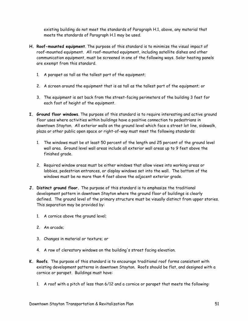
existing building do not meet the standards of Paragraph H.1, above, any material that meets the standards of Paragraph H.1 may be used.
H. Roof-mounted equipment. The purpose of this standard is to minimize the visual impact of roof-mounted equipment. All roof-mounted equipment, including satellite dishes and other communication equipment, must be screened in one of the following ways. Solar heating panels are exempt from this standard.
1. A parapet as tall as the tallest part of the equipment;
2. A screen around the equipment that is as tall as the tallest part of the equipment; or
3. The equipment is set back from the street-facing perimeters of the building 3 feet for each foot of height of the equipment.
I. Ground floor windows. The purpose of this standard is to require interesting and active ground floor uses where activities within buildings have a positive connection to pedestrians in downtown Stayton. All exterior walls on the ground level which face a street lot line, sidewalk, plaza or other public open space or right-of-way must meet the following standards:
1. The windows must be at least 50 percent of the length and 25 percent of the ground level wall area. Ground level wall areas include all exterior wall areas up to 9 feet above the finished grade.
2. Required window areas must be either windows that allow views into working areas or lobbies, pedestrian entrances, or display windows set into the wall. The bottom of the windows must be no more than 4 feet above the adjacent exterior grade.
J. Distinct ground floor. The purpose of this standard is to emphasize the traditional development pattern in downtown Stayton where the ground floor of buildings is clearly defined. The ground level of the primary structure must be visually distinct from upper stories. This separation may be provided by:
1. A cornice above the ground level;
2. An arcade;
3. Changes in material or texture; or
4. A row of clerestory windows on the building's street facing elevation.
K. Roofs. The purpose of this standard is to encourage traditional roof forms consistent with existing development patterns in downtown Stayton. Roofs should be flat, and designed with a cornice or parapet. Buildings must have:
1. A roof with a pitch of less than 6/12 and a cornice or parapet that meets the following:
Downtown Stayton Transportation & Revitalization Plan 51
a. There must be two parts to the cornice or parapet. The top part must project at least 6 inches from the face of the building and be at least 2 inches further from the face of the building than the bottom part of the cornice or parapet.
b. The height of the cornice or parapet is based on the height of the building as follows: 1. Buildings 10 feet or less in height must have a cornice or parapet at least 12 inches
high. 2. Buildings greater than 10 feet and less than 30 feet in height must have a cornice or
parapet at least 18 inches high. 3. Buildings 30 feet or greater in height must have a cornice or parapet at least 24
inches high.
Downtown Stayton Transportation & Revitalization Plan 52