Embed Size (px)
Citation preview
DRAFT BASIC ASSESSMENT REPORT
Pongola Township Development
Application for Environmental Authorisation for the Proposed Township Development on Portion 419 of Farm No. 61, Pongola, Kwazulu-Natal
EDTEA Ref: Pending
May 2017 Prepared by ETC-Africa
ETC-Africa CC Po Box 522 Richards Bay 3900 South Africa Phone: +27 (72) 4760396 Fax: +27 (86) 719 6591 [email protected] www.etc-africa.co.za
1
CONTENTS
SECTION A: DETAILS OF THE ENVIRONMENTAL ASSESSMENT PRACTITIONER AND SPECIALISTS ........................................................................................................... 3
1. NAME AND CONTACT DETAILS OF ENVIRONMENTAL ASSESSMENT
PRACTITIONER (EAP) ............................................................................................. 3 2. NAMES AND EXPERTISE OF REPRESENTATIVES OF THE EAP ................... 3 3. NAMES AND EXPERTISE OF SPECIALISTS ................................................... 4
SECTION B: ACTIVITY INFORMATION................................................................... 4
1. PROJECT TITLE................................................................................................ 4 2. PROJECT DESCRIPTION ................................................................................. 4 3. ACTIVITY APPLIED FOR IN TERMS OF NEMA, EIA REGULATIONS .............. 4 4. ALTERNATIVES CONSIDERED ............................................................................ 5
4.1. Property alternatives 5
4.2. Activity alternatives 6
4.3. Design or layout alternatives 6
4.4. Technology alternatives 6
4.5. No-go alternative 7
5. ACTIVITY POSITION ......................................................................................... 7 6. PHYSICAL SIZE OF THE ACTIVITY .................................................................. 8 7. SITE ACCESS ................................................................................................... 8 8. ACTIVITY MOTIVATION .................................................................................... 8
8.1. Socio-economic value of the activity 8
8.1.1. Quality of life impacts 9
8.1.1.1 Employment opportunities: 9
8.1.1.2. Improved standard of living: 9
8.2. Ecological value of the activity 10
9. APPLICABLE LEGISLATION, POLICIES AND/OR GUIDELINES .................. 10 10. WASTE, EFFLUENT, EMISSION AND NOISE MANAGEMENT ...................... 10
10.1. Solid waste management 10
10.2. Liquid effluent 11
10.3. Emissions into the atmosphere 11
10.4. Generation of noise 11
11. WATER USE .................................................................................................... 11 12. ENERGY EFFICIENCY .................................................................................... 13
SECTION C: SITE/ AREA/ PROPERTY DESCRIPTION ........................................ 13
1. GRADIENT OF THE SITE ................................................................................ 13 2. LOCATION IN LANDSCAPE ........................................................................... 13 3. GROUNDWATER, SOIL AND GEOLOGICAL STABILITY OF THE SITE ........ 13 4. VEGETATION ...................................................................................................... 14
2
4.1. Biome and vegetation type 14
4.2. Species composition 14
4.3. Alien & Alien Invasive Plants 18
4.3.1. Legislative Categorisation 18
4.3.2. Legal Implication 18
4.4. Protected species 19
4.5. Recommendations 20
5. LAND USE CHARACTER OF SURROUNDING AREA .................................... 20 6. CULTURAL/ HISTORICAL FEATURES .......................................................... 20
SECTION D: PUBLIC PARTICIPATION ................................................................. 21
1. ADVERTISEMENTS ........................................................................................ 21 2. COMMENTS AND RESPONSE REPORT ........................................................ 21 3. PARTICIPATION BY DISTRICT, LOCAL AND TRADITIONAL AUTHORITIES21 4. CONSULTATION WITH OTHER STAKEHOLDERS ........................................ 22
SECTION E: IMPACT ASSESSMENT .................................................................... 22
1. ISSUES RAISED BY INTERESTED AND AFFECTED PARTIES ..................... 22 2. IMPACTS THAT MAY RESULT FROM THE PLANNING AND DESIGN, CONSTRUCTION, OPERATIONAL, DECOMMISSIONING AND CLOSURE PHASES AS
WELL AS PROPOSED MANAGEMENT OF IDENTIFIED IMPACTS AND PROPOSED
MITIGATION MEASURES ...................................................................................... 22 2.1. Impacts that may result from the planning and design phase 22
2.2. Impacts that may result from the construction/operational/decommissioning
phases 22
3. MITIGATION MEASURES ............................................................................... 24 4. SIGNIFICANT RECOMMENDATIONS MADE BY SPECIALISTS .................... 26
4.1. Geotechnical-related recommendations (from the Geotechnical Investigation
Report, Appendix A): 26
5. PROPOSED MONITORING AND AUDITING ................................................... 28 6. ENVIRONMENTAL IMPACT STATEMENT ..................................................... 28
SECTION F: REFERENCES ................................................................................... 29
SECTION G: APPENDICES ................................................................................... 29
7. APPENDIX A. GEOTECHNICAL REPORT ................................................................ 29 8. APPENDIX B. STORMWATER MANAGEMENT PLAN ................................................. 29 9. APPENDIX C. SITE LAYOUT ................................................................................. 29 10. APPENDIX D. SITE PHOTOS ................................................................................. 29 11. APPENDIX E. PUBLIC PARTICIPATION .................................................................. 29 12. APPENDIX F. EMPR ........................................................................................... 29 . . . . . ..
3
SECTION A: DETAILS OF THE ENVIRONMENTAL ASSESSMENT PRACTITIONER AND SPECIALISTS
1. NAME AND CONTACT DETAILS OF ENVIRONMENTAL ASSESSMENT PRACTITIONER (EAP)
Business name of EAP: ETC-Africa
Physical address: 10 Warren Rd, Salt Rock
Postal address: Po Box 522, Richards Bay 3900
Postal code: 3900 Cell: 0724760396
Telephone: 0724760396 Fax: 0867196591
E-mail: [email protected]
2. NAMES AND EXPERTISE OF REPRESENTATIVES OF THE EAP
Name of representative of the EAP
Education qualifications
Professional affiliations
Experience at environmental assessments (yrs)
Edward Rice MSc Conservation Biology
International Association of Impact Assessment (IAIA). Carbon Protocol of South Africa. Green Leaf Environmental Standard.
2
Duncan Pritchard Bsc Geography International Association of Impact Assessment (IAIA). Carbon Protocol of South Africa. Green Leaf Environmental Standard.
12+
4
3. NAMES AND EXPERTISE OF SPECIALISTS
Name of specialist
Education qualifications
Field of expertise
Contribution to the basic assessment report
Title of specialist report
Nino Welland
BSc (Hons) Engineering Geology and Geotechnics
Geotechnical engineering
Geotechnical Report
Final NHBRC Phase I Geotechnical Report for the Proposed Township Development, Portion 419 of Farm 61 in uPhongola, KwaZulu-Natal (Appendix A)
SECTION B: ACTIVITY INFORMATION
1. PROJECT TITLE
Proposed Township Development on Portion 419 of Farm No. 61, Pongola.
2. PROJECT DESCRIPTION
uPhongolo Local Municipality is proposing a township development on Portion 419 of Farm No. 61, Pongola. The site is 19 hectares in area and is approximately 7 km (by road) from Pongola town. The development aims to address the dire need for low income housing in the area. The township development will be comprised of:
• High density housing (280 units)
• Public open spaces;
• A crèche;
• A place of worship (church);
• A business centre;
• Associated infrastructure (roads, stormwater, sanitation, electricity) In terms of Listing Notice 1 (GNR R983) promulgated in 2014 under The National Environmental Management Act (Act No. 107 of 1998), EIA Regulations 2014, listed activities will be triggered by this development and therefore requires a Basic Assessment report to be submitted to KZN Department of Economic Development, Tourism and Environmental Affairs.
3. ACTIVITY APPLIED FOR IN TERMS OF NEMA, EIA REGULATIONS
The listed activities triggered by the proposed development are as follows:
• Listing Notice 1: Activity 28; Residential, mixed, retail, commercial, industrial or institutional developments where such land was used for agriculture or afforestation on or after 01 April 1998 and where such development: (ii) will
5
occur outside an urban area, where the total land to be developed is bigger than 1 hectare;
• Listing Notice 1. Activity 24; The development of; (ii) a road with a reserve wider than 13,5 meters, or where no reserve exists where the road is wider than 8 metres;
4. ALTERNATIVES CONSIDERED
Consideration of alternatives is an important element in the EIA process. “Alternatives” are defined in the NEMA EIA regulations, 2014 (GN 982 of 2014) as: “In relation to a proposed activity, means different means of meeting the general purpose and requirements of the activity, which may include alternatives to the: (a) property on which or location where the activity is proposed to be undertaken; (b) type of activity to be undertaken; (c) design or layout of the activity; (d) technology to be used in the activity; or (e) operational aspects of the activity; and includes the option of not implementing the activity.” The role of the EAP is thereof to provide a framework for sound decision-making based on the principles of sustainable development. Potential alternatives that were considered for the proposed Pongola Township Development are detailed below.
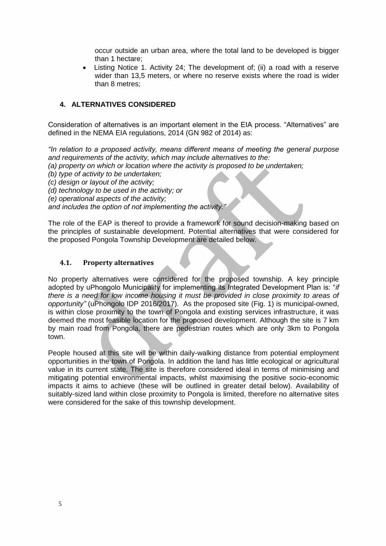
4.1. Property alternatives No property alternatives were considered for the proposed township. A key principle adopted by uPhongolo Municipality for implementing its Integrated Development Plan is: “if there is a need for low income housing it must be provided in close proximity to areas of opportunity” (uPhongolo IDP 2016/2017). As the proposed site (Fig. 1) is municipal-owned, is within close proximity to the town of Pongola and existing services infrastructure, it was deemed the most feasible location for the proposed development. Although the site is 7 km by main road from Pongola, there are pedestrian routes which are only 3km to Pongola town. People housed at this site will be within daily-walking distance from potential employment opportunities in the town of Pongola. In addition the land has little ecological or agricultural value in its current state. The site is therefore considered ideal in terms of minimising and mitigating potential environmental impacts, whilst maximising the positive socio-economic impacts it aims to achieve (these will be outlined in greater detail below). Availability of suitably-sized land within close proximity to Pongola is limited, therefore no alternative sites were considered for the sake of this township development.
6
Figure 1. The preferred site for the proposed development. Property boundary in red
4.2. Activity alternatives This particular property was earmarked for housing by the municipality. The activity is required to meet the need for housing in the area.
4.3. Design or layout alternatives At this stage, no alternative layouts have been drafted. The property is very uniform in term of topography, and there are no significant features on the property. Therefore, there has been no need to consider alternative layouts. The preferred layout includes;
• 280 residential erven with an average size of 450 m2 (15m x 30m).
• A business area of around 1520 m2.
• A church on an erf of 1694 m2.
• Three public open spaces with a total area of 7951 m2.
• A crèche on an erf of 1524 m2.
• A ring road and two perpendicular central roads with a width of 15 m.
• Four roads running through the township with a width of 10 m.
4.4. Technology alternatives Solar geyser installations and traditional electric geysers were alternatives considered in terms of water heating technology. The preferred option is the use of solar geyser technology, as this is in line with sustainable development and will ensure lower energy costs for the residents of the township.
7
Alternatives considered for wastewater management included septic tanks with French drains or using the municipal wastewater infrastructure. Due to space constraints for onsite sanitation systems, the preferred option is the use of the municipal wastewater network. Alternatives still being considered for stormwater disposal include use of nearby existing municipal stormwater infrastructure or construction of a stormwater “flood attenuation pond.” The Stormwater Management Plan (Appendix B) motivates for the flood attenuation pond as the gradient won’t easily allow for gravity feed to the existing municipal stormwater network in Ncotshane (north of the proposed site). However, the flood attenuation pond would be located on a private property (north east of the site) and therefore the applicant (uPhongolo Municipality) is required to enter into negotiations with the property owner before the feasibility of this alternative can be determined.
4.5. No-go alternative The no-go Alternative is the option of not undertaking the proposed township development. The no-go option would result in failure for the municipality to meet the growing need for low income housing in the area. This would have long-term negatively repercussions on the socio-economic structure of the population of uPhongolo Local Municipality. Of course, the no-go option would result in the site remaining undeveloped. Currently the land is not being used for agricultural purposes and it serves very little ecological service due to its degraded state.
5. ACTIVITY POSITION
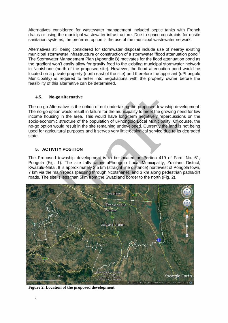
The Proposed township development is to be located on Portion 419 of Farm No. 61, Pongola (Fig. 1). The site falls within uPhongolo Local Municipality, Zululand District, Kwazulu-Natal. It is approximately 2.5 km (straight line distance) northwest of Pongola town, 7 km via the main roads (passing through Ncotshane), and 3 km along pedestrian paths/dirt roads. The site is less than 5km from the Swaziland border to the north (Fig. 2).
Figure 2. Location of the proposed development
8
6. PHYSICAL SIZE OF THE ACTIVITY
The proposed site is approximately 19 hectares. The development footprint (including roads, housing units, public open spaces etc) will cover the full 19 hectares.
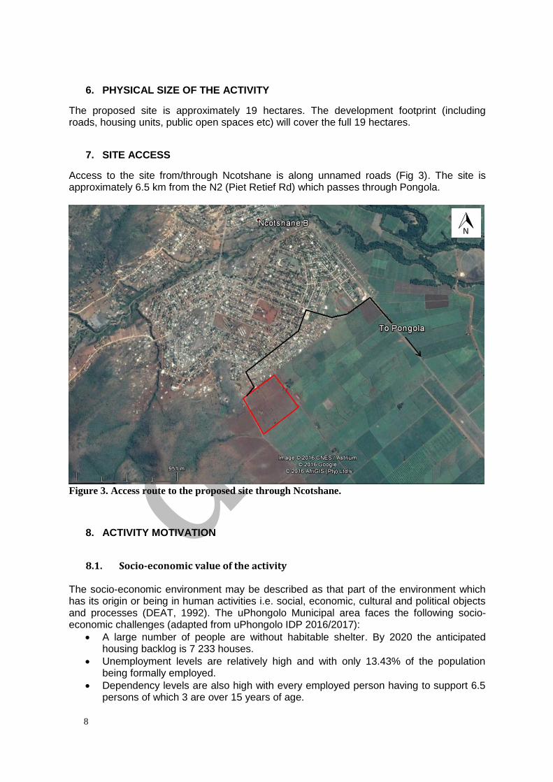
7. SITE ACCESS
Access to the site from/through Ncotshane is along unnamed roads (Fig 3). The site is approximately 6.5 km from the N2 (Piet Retief Rd) which passes through Pongola.
Figure 3. Access route to the proposed site through Ncotshane.
8. ACTIVITY MOTIVATION
8.1. Socio-economic value of the activity The socio-economic environment may be described as that part of the environment which has its origin or being in human activities i.e. social, economic, cultural and political objects and processes (DEAT, 1992). The uPhongolo Municipal area faces the following socio-economic challenges (adapted from uPhongolo IDP 2016/2017):
• A large number of people are without habitable shelter. By 2020 the anticipated housing backlog is 7 233 houses.
• Unemployment levels are relatively high and with only 13.43% of the population being formally employed.
• Dependency levels are also high with every employed person having to support 6.5 persons of which 3 are over 15 years of age.
9
• Income levels are low with 66% of households receiving no income or less than R2 400 per month. The urban communities have access to clean water, sanitation and electricity but in the more rural communities these services are still scarce.
The socio-economic improvements which can be expected from the Pongola Township Development are described below.
8.1.1. Quality of life impacts Quality of life may be best described in terms of value, standard of living, benefits and advantages that a given community may currently have or may receive in the future. The development of the Pongola Township Development would potentially have a significant positive impact on the local residents. The potential quality of life aspects and associated impacts include:
8.1.1.1 Employment opportunities: The construction phase is scheduled to last approximately 2 years and in this time labour will be required for construction activities. Where ever possible labour for construction should be sourced locally. This will ensure people in the area will receive an income from the construction phase. They will also learn construction skills that can be applied to future employment opportunities, thus making them more marketable in the work place. During operation, the township will include areas for establishing businesses, a church and a crèche. These will create business and employment opportunities for those living in the township. Socio-economic upliftment for people in the Ncotshane area will eventually result in growth of the economy of uPhongolo Municipality. No-go alternative: should the development not be approved the employment opportunities will not be realised.
8.1.1.2. Improved standard of living: The present situation for those living in informal settlements nearby includes:
• Uncontrolled stormwater resulting in increased soil erosion.
• A lack of electricity that forces residents to utilise indigenous vegetation for fire wood resulting in a strain on natural resources.
• Limited access to potable water.
• Unsanitary sewerage disposal.
• Lack of communal gathering facilities. The formalisation of housing and associated services for residents will uplift the community, offering an improved standard of living, a healthier lifestyle and a reduction in the pressure on natural resources. The provision of approximately 280 houses for people in a low-income bracket, will see quality housing for between 1100 and 1500 people. Formal housing will directly improve the livelihood for those who are currently living in informal housing. Improved sanitation, running water, electricity and waste removal will result in improved health and hygiene. This housing will be within close proximity to town and subsequently to job opportunities, shops, health care etc. No-go alternative: should the development not be approved the standard of living for those due to move from in informal housing will not be improved. The existing poor living conditions will remain.
10
8.2. Ecological value of the activity
The proposed township development will not add to the ecological value of the area. Implementation of the EMPr, effective mitigation measures, and recommendations by specialists/authorities will ensure minimal adverse impacts on the ecological health of the site and surrounds. Some of the measures that will improve the ecological value of the township include:
• The use of renewable energy by installing solar geysers on each housing unit.
• Only indigenous plants should be used in the public open spaces. These will maintain some ecological functions and generally use less water.
• The township will be kept free of invasive alien plants
• Sufficient waste management will be implemented in the township to encourage recycling and reduce the risk of pollution to the surrounding environment.
• Stormwater Management infrastructure must be maintained to reduce the risk of erosion and degradation of nearby watercourses.
9. APPLICABLE LEGISLATION, POLICIES AND/OR GUIDELINES
The following legislation, policies and/or guidelines are relevant to the application:
• Constitution of South Africa: Act No 108 of 1996
• National Environmental Management Act: Act No 107 of 1998.
• National Environmental Management: Protected areas act
• Environmental Conservation Act: Act No 73 of 1989.
• National Heritage Resources Act: Act No 25 of 1999.
• KZN Heritage Act: Act 4 of 2008.
• National Water Act: Act No 36 of 1998.
• Hazardous Substances Act: Act No 15 of 1973.
• National Environmental Management: Act No 10 of 2004.
• National Environmental Management: Biodiversity Act 10 of 2004.
• Occupational Health and Safety Act: Act No 85 of 1993.
• Natal Nature Conservation Ordinance: Act No 15 of 1974.
• Subdivision of Agricultural Land Act: Act No 70 of 1970.
• Conservation of Agricultural Resources Act: Act No 43 of 1983.
• National Forests Act: Act No 84 of 1998.
• National Environmental Management: Waste Act: No. 59 of 2008.
10. WASTE, EFFLUENT, EMISSION AND NOISE MANAGEMENT These will be referred to in greater detail in the Pongola Township Developments’ Environmental Management Programme (EMPr, Appendix F). An overview is provided below.
10.1. Solid waste management
The site falls within an area covered by municipal service provision. Municipal waste collection will be utilised. A Service Level Agreement still needs to be obtained for refuse collection services. It is important that education around the topic of waste collection and litter be addressed when the township becomes inhabited. If solid waste is to be temporarily stored prior to municipal collection, this storage area is to
11
be constructed and maintained to the satisfaction of the relevant authority and as stipulated by the National Environmental Management: Waste Act of 2008.
10.2. Liquid effluent No liquid effluent, other than normal sewerage, will be produced by the development. The development will require an internal waterborne sewer system that will connect to the existing uPhongolo Water Services bulk sewer lines. Municipal services in the area (Ncotshane and surrounds) are well developed. However, confirmation is still required from the municipality that capacity in the bulk sewer is adequate to cater for the development.
10.3. Emissions into the atmosphere
Very little in terms of emissions will be generated by the proposed development. During construction phase, dust and exhaust emissions are predicted from vehicles on the dirt road. If earth moving is to take place during winter months (when ground cover is reduced and the soils are dry) this may generate excessive dust. Considering the close proximity to residential properties, it is imperative that this dust be controlled. Where possible, clearing of vegetation should take place at a maximum of two months prior to building. Clearing of vegetation should take place sequentially on portions which will be built on next. This will avoid land being cleared of vegetation long before it will be built on. Plots cleared of vegetation are high risk in terms of dust generation and erosion. If the Environmental Control Officer deems dust an issue during construction, surface wetting can be considered as a means of controlling dust emission. Building materials of fine particles must be suitably protected from wind dispersion.
10.4. Generation of noise
Vehicles, construction and workers on site are likely to result in general disturbance and noise generation. It is an important impact to address and mitigate as the site is within close proximity to residential areas. During construction, building activity must be restricted to regular working hours during the week and is to be prohibited over weekends.
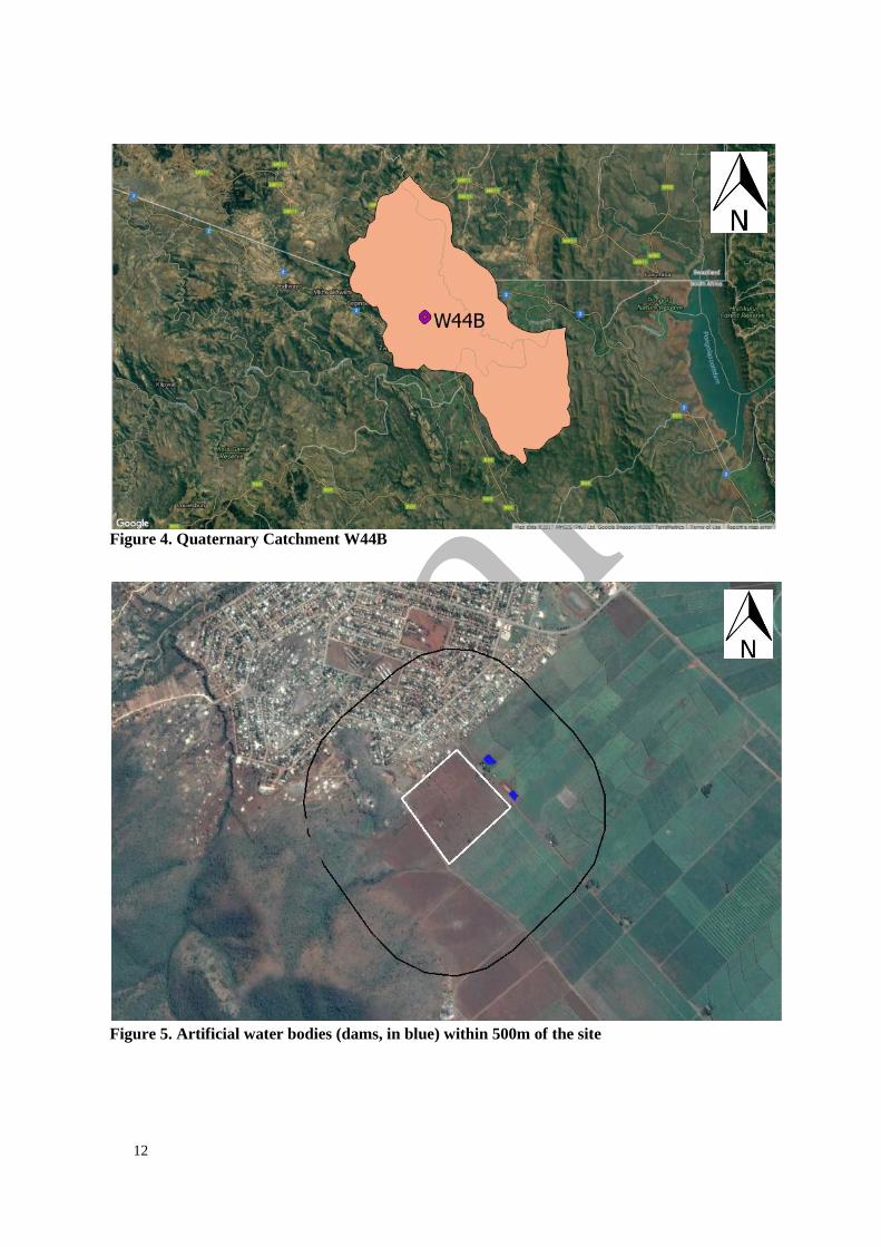
11. WATER USE
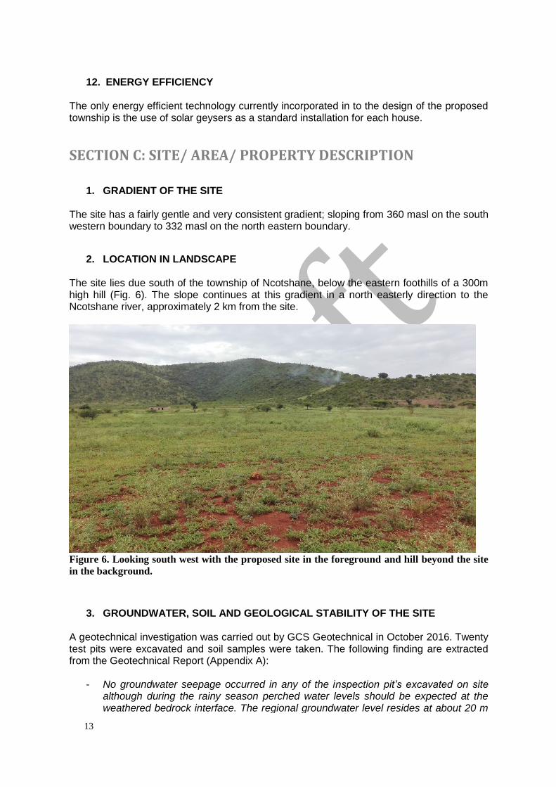
The proposed development falls within Quaternary Catchment W44B (Fig. 4). The development will not involve abstraction or discharge into/from any watercourse during construction and operational phases. The development is not predicted to have serious adverse impacts on surrounding watercourses. Within a 500 m radius of the site, there are no rivers or natural wetlands. There are two dams 40 m and 60 m north east from the edge of the property respectively. SANBI GIS data for NFEPA Wetlands confirmed that these are artificial water bodies. These dams are used for irrigation on the neighbouring sugar cane farms. Although these are artificial water bodies and are not used as potable sources, it is important that the design and engineering infrastructure of the development take into account the presence of these dams. Fortunately the township will make use of municipal sewerage services and as such there is no risk of contamination via septic tanks and/or French drains. Stormwater runoff is to be designed and managed as per the Storm Water Management Plan (Appendix B). All water to be used for the township development will be from the municipal supply. A Service Level Agreement is still to be obtained.
12
Figure 4. Quaternary Catchment W44B
Figure 5. Artificial water bodies (dams, in blue) within 500m of the site
13
12. ENERGY EFFICIENCY The only energy efficient technology currently incorporated in to the design of the proposed township is the use of solar geysers as a standard installation for each house.
SECTION C: SITE/ AREA/ PROPERTY DESCRIPTION
1. GRADIENT OF THE SITE The site has a fairly gentle and very consistent gradient; sloping from 360 masl on the south western boundary to 332 masl on the north eastern boundary.
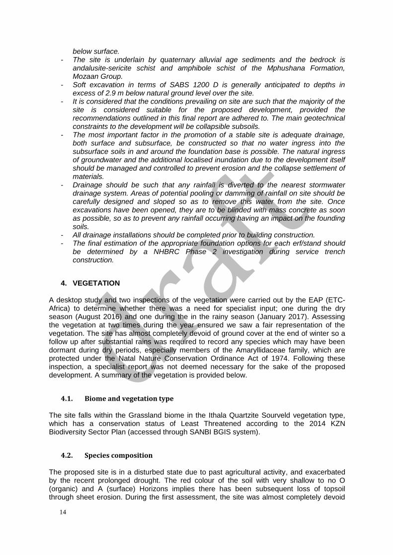
2. LOCATION IN LANDSCAPE The site lies due south of the township of Ncotshane, below the eastern foothills of a 300m high hill (Fig. 6). The slope continues at this gradient in a north easterly direction to the Ncotshane river, approximately 2 km from the site.
Figure 6. Looking south west with the proposed site in the foreground and hill beyond the site
in the background.
3. GROUNDWATER, SOIL AND GEOLOGICAL STABILITY OF THE SITE
A geotechnical investigation was carried out by GCS Geotechnical in October 2016. Twenty test pits were excavated and soil samples were taken. The following finding are extracted from the Geotechnical Report (Appendix A):
- No groundwater seepage occurred in any of the inspection pit’s excavated on site although during the rainy season perched water levels should be expected at the weathered bedrock interface. The regional groundwater level resides at about 20 m
14
below surface. - The site is underlain by quaternary alluvial age sediments and the bedrock is
andalusite-sericite schist and amphibole schist of the Mphushana Formation, Mozaan Group.
- Soft excavation in terms of SABS 1200 D is generally anticipated to depths in excess of 2.9 m below natural ground level over the site.
- It is considered that the conditions prevailing on site are such that the majority of the site is considered suitable for the proposed development, provided the recommendations outlined in this final report are adhered to. The main geotechnical constraints to the development will be collapsible subsoils.
- The most important factor in the promotion of a stable site is adequate drainage, both surface and subsurface, be constructed so that no water ingress into the subsurface soils in and around the foundation base is possible. The natural ingress of groundwater and the additional localised inundation due to the development itself should be managed and controlled to prevent erosion and the collapse settlement of materials.
- Drainage should be such that any rainfall is diverted to the nearest stormwater drainage system. Areas of potential pooling or damming of rainfall on site should be carefully designed and sloped so as to remove this water from the site. Once excavations have been opened, they are to be blinded with mass concrete as soon as possible, so as to prevent any rainfall occurring having an impact on the founding soils.
- All drainage installations should be completed prior to building construction. - The final estimation of the appropriate foundation options for each erf/stand should
be determined by a NHBRC Phase 2 investigation during service trench construction.
4. VEGETATION A desktop study and two inspections of the vegetation were carried out by the EAP (ETC-Africa) to determine whether there was a need for specialist input; one during the dry season (August 2016) and one during the in the rainy season (January 2017). Assessing the vegetation at two times during the year ensured we saw a fair representation of the vegetation. The site has almost completely devoid of ground cover at the end of winter so a follow up after substantial rains was required to record any species which may have been dormant during dry periods, especially members of the Amaryllidaceae family, which are protected under the Natal Nature Conservation Ordinance Act of 1974. Following these inspection, a specialist report was not deemed necessary for the sake of the proposed development. A summary of the vegetation is provided below.
4.1. Biome and vegetation type The site falls within the Grassland biome in the Ithala Quartzite Sourveld vegetation type, which has a conservation status of Least Threatened according to the 2014 KZN Biodiversity Sector Plan (accessed through SANBI BGIS system).
4.2. Species composition The proposed site is in a disturbed state due to past agricultural activity, and exacerbated by the recent prolonged drought. The red colour of the soil with very shallow to no O (organic) and A (surface) Horizons implies there has been subsequent loss of topsoil through sheet erosion. During the first assessment, the site was almost completely devoid
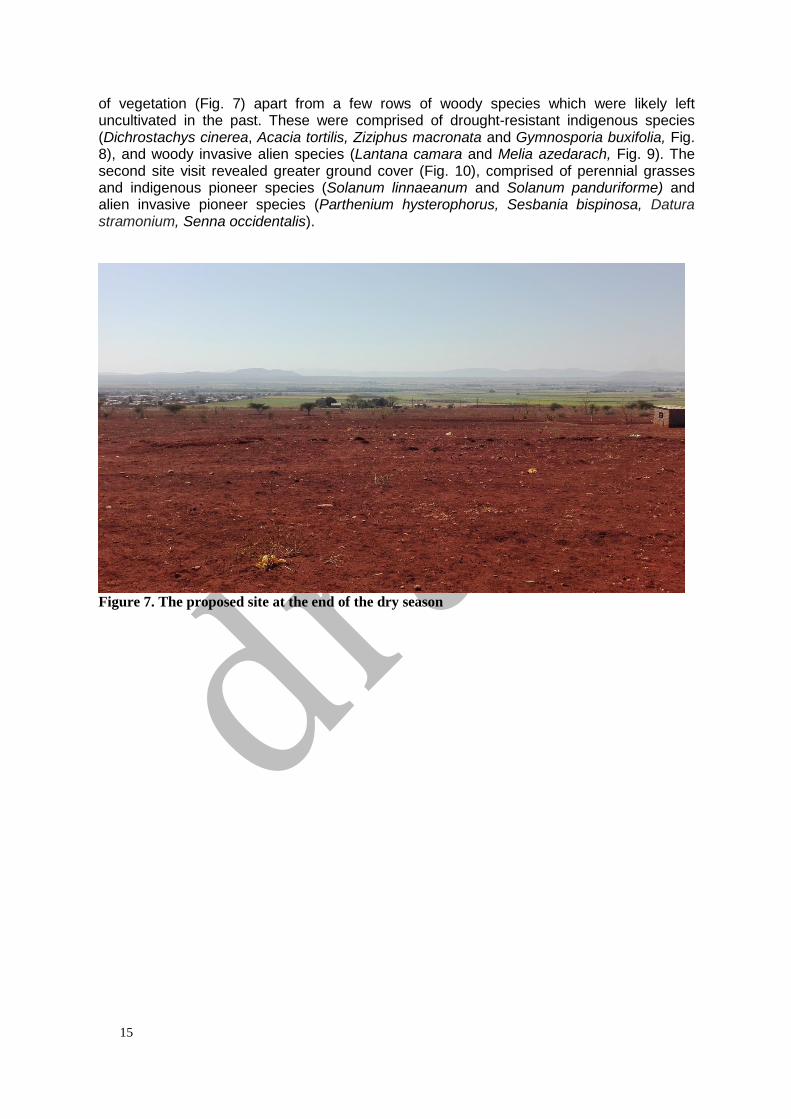
15
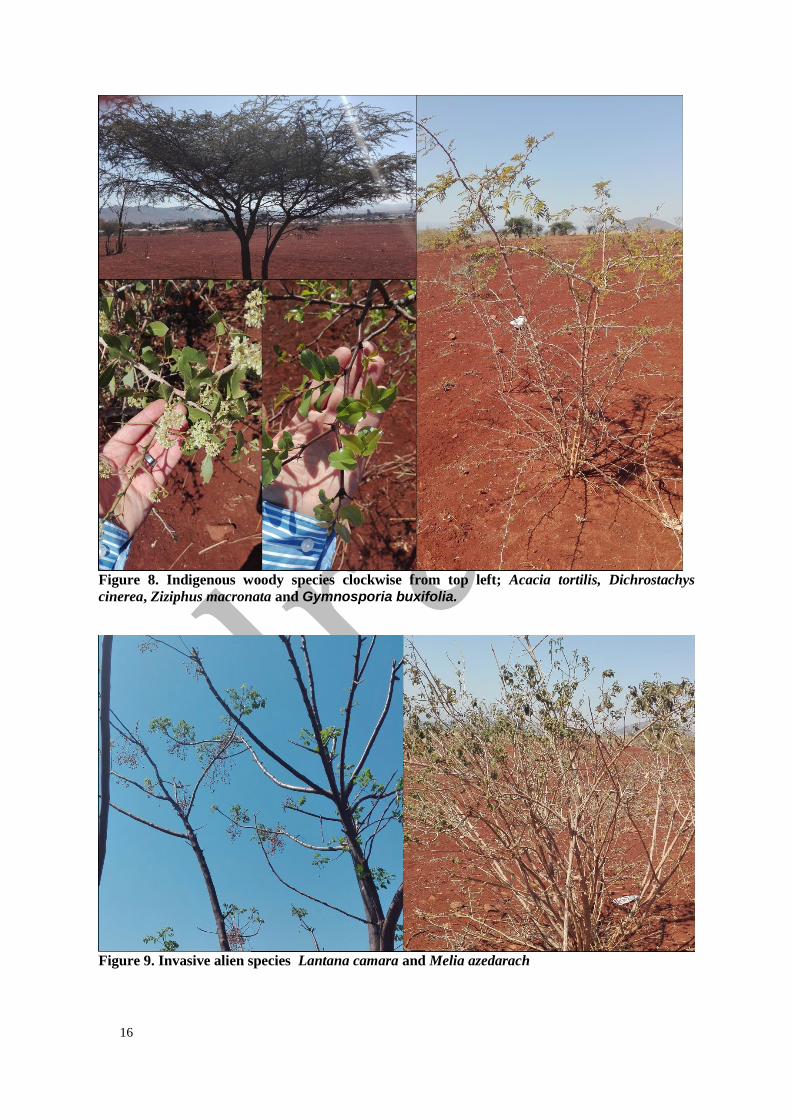
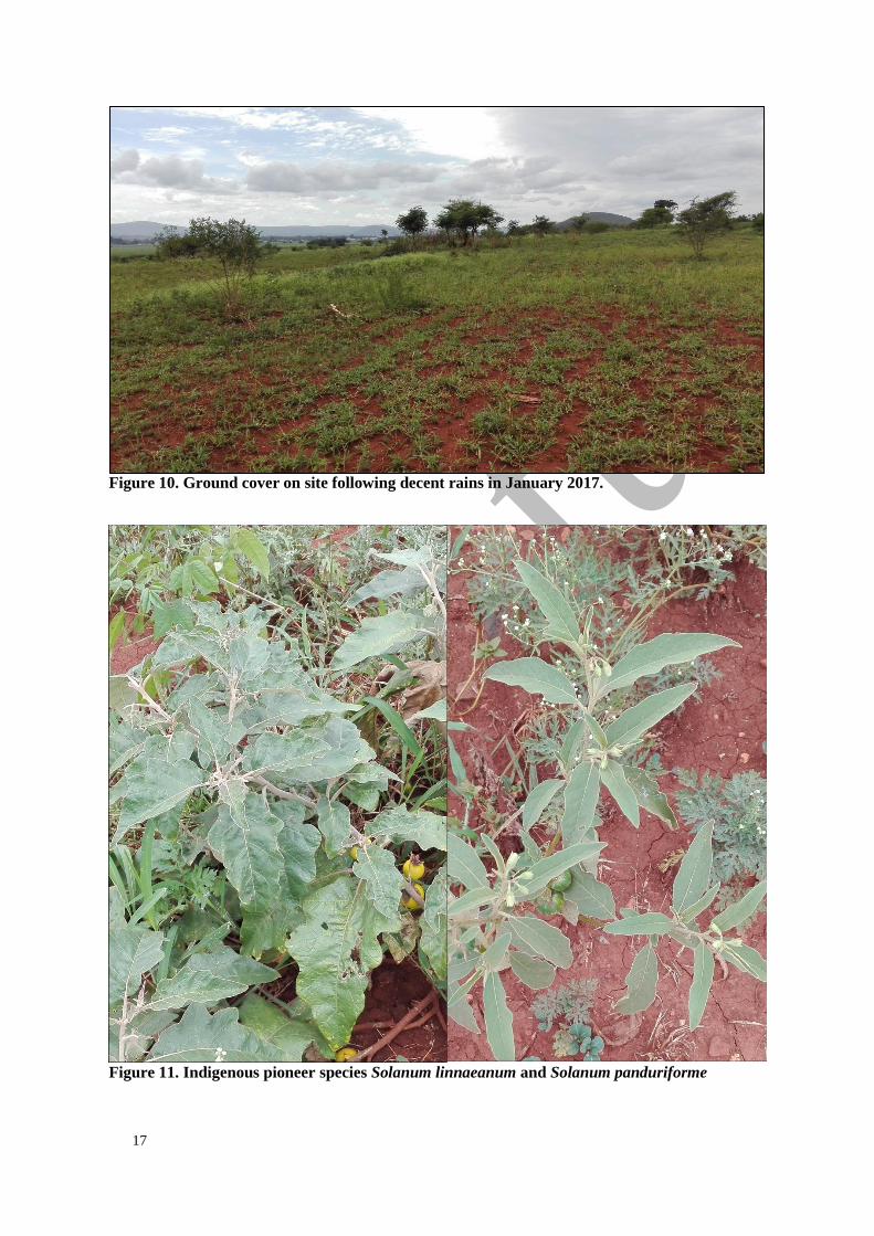
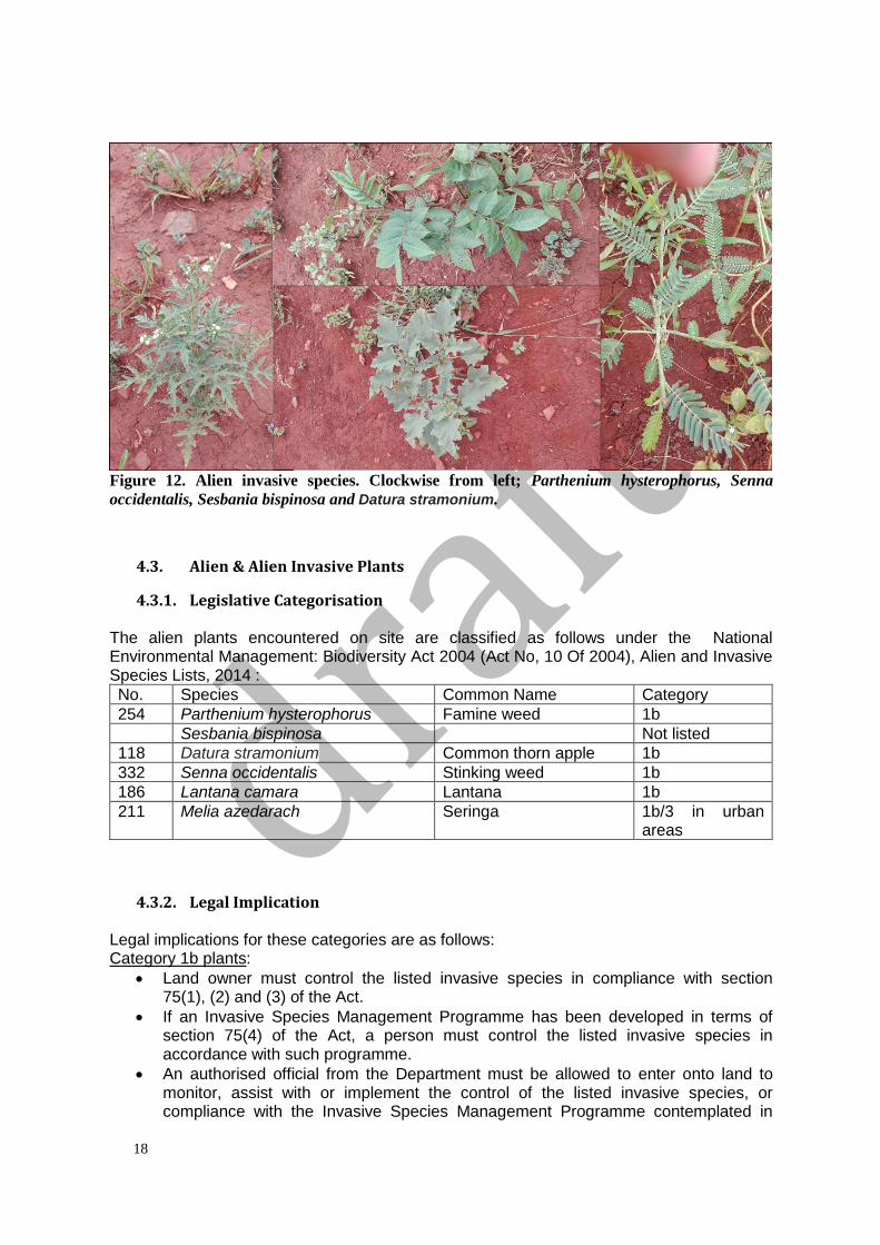
of vegetation (Fig. 7) apart from a few rows of woody species which were likely left uncultivated in the past. These were comprised of drought-resistant indigenous species (Dichrostachys cinerea, Acacia tortilis, Ziziphus macronata and Gymnosporia buxifolia, Fig. 8), and woody invasive alien species (Lantana camara and Melia azedarach, Fig. 9). The second site visit revealed greater ground cover (Fig. 10), comprised of perennial grasses and indigenous pioneer species (Solanum linnaeanum and Solanum panduriforme) and alien invasive pioneer species (Parthenium hysterophorus, Sesbania bispinosa, Datura stramonium, Senna occidentalis).
Figure 7. The proposed site at the end of the dry season
16
Figure 8. Indigenous woody species clockwise from top left; Acacia tortilis, Dichrostachys
cinerea, Ziziphus macronata and Gymnosporia buxifolia.
Figure 9. Invasive alien species Lantana camara and Melia azedarach
17
Figure 10. Ground cover on site following decent rains in January 2017.
Figure 11. Indigenous pioneer species Solanum linnaeanum and Solanum panduriforme
18
Figure 12. Alien invasive species. Clockwise from left; Parthenium hysterophorus, Senna
occidentalis, Sesbania bispinosa and Datura stramonium.
4.3. Alien & Alien Invasive Plants
4.3.1. Legislative Categorisation The alien plants encountered on site are classified as follows under the National Environmental Management: Biodiversity Act 2004 (Act No, 10 Of 2004), Alien and Invasive Species Lists, 2014 :
No. Species Common Name Category
254 Parthenium hysterophorus Famine weed 1b
Sesbania bispinosa Not listed
118 Datura stramonium Common thorn apple 1b
332 Senna occidentalis Stinking weed 1b
186 Lantana camara Lantana 1b
211 Melia azedarach Seringa 1b/3 in urban areas
4.3.2. Legal Implication Legal implications for these categories are as follows: Category 1b plants:
• Land owner must control the listed invasive species in compliance with section 75(1), (2) and (3) of the Act.
• If an Invasive Species Management Programme has been developed in terms of section 75(4) of the Act, a person must control the listed invasive species in accordance with such programme.
• An authorised official from the Department must be allowed to enter onto land to monitor, assist with or implement the control of the listed invasive species, or compliance with the Invasive Species Management Programme contemplated in
19
section 75(4) of the Act. Category 3 plants (ornamentally used plants):
• May no longer be planted; existing plants may remain, as long as all reasonable steps are taken to prevent the spreading thereof.
• Any plant species identified as a Category 3 Listed Invasive Species that occurs in riparian areas, must, for the purposes of these regulations, be considered to be a Category 1b Listed Invasive Species and must be managed accordingly.
• If an Invasive Species Management Programme has been developed in terms of section 75(4) of the Act, a person must control the listed invasive species in accordance with such programme.
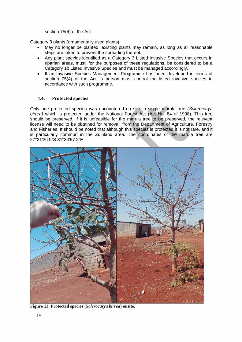
4.4. Protected species Only one protected species was encountered on site; a single marula tree (Sclerocarya birrea) which is protected under the National Forest Act (Act No. 84 of 1998). This tree should be preserved. If it is unfeasible for the marula tree to be preserved, the relevant license will need to be obtained for removal, from the Department of Agriculture, Forestry and Fisheries. It should be noted that although this species is protected it is not rare, and it is particularly common in the Zululand area. The coordinates of the marula tree are 27°21'36.9"S 31°34'57.2"E
Figure 13. Protected species (Sclerocarya birrea) onsite.
20
4.5. Recommendations It is recommended that plots/erven are cleared of vegetation in a step-wise manner shortly before they are developed. Ideally no land should be cleared of vegetation more than two months before development of that land is scheduled to start. This will ensure ground cover is maintained for as long as possible to prevent erosion, reduce dust dispersion (air pollution) and alien plant invasion. It is further recommended that the Environmental Control Officer check the vegetation on each of these plots prior to clearing to confirm there are no protected plants that may have been missed due to seasonality and/or those that may establish between now and development commencing. On-going alien plant control measures are to be incorporated into the management of the development during the construction and operational phases. Alien plant management measures should address the control the spread of plants from the site as much as within the site. The proposed site is currently heavily infested with listed invasive alien species) which the applicant has a legal obligation to clear and control. The Environmental Control Officer should include monitoring of alien plant control (onsite and the periphery) in monthly auditing and reporting. It is important to note that both Parthenium hysterophorus and Datura stramonium are poisonous, so appropriate personal protective wear is necessary when clearing these plants.
5. LAND USE CHARACTER OF SURROUNDING AREA
Land use within 500m of the site includes agriculture, residential (Ncotshane township), education (schools within Ncotshane township) and commercial (shops and small businesses within the township).
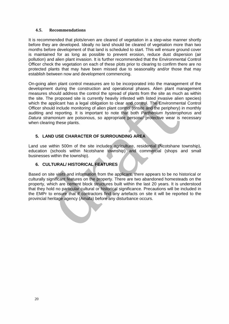
6. CULTURAL/ HISTORICAL FEATURES Based on site visits and information from the applicant, there appears to be no historical or culturally significant features on the property. There are two abandoned homesteads on the property, which are cement block structures built within the last 20 years. It is understood that they hold no particular cultural or historical significance. Precautions will be included in the EMPr to ensure that if contractors find any artefacts on site it will be reported to the provincial heritage agency (Amafa) before any disturbance occurs.
21
Figure 14. Existing structures onsite
SECTION D: PUBLIC PARTICIPATION
See Appendix E for full Public Participation Report.
1. ADVERTISEMENTS Guidelines for public participation were followed according to section 24J of the National Environmental Management Act, 1998:
• A notice to register as an interested and affected party was advertised in the local newspaper, the Zululand Observer 6th February 2017.
• Neighbouring land owners were informed of the development.
• Ward Councillors were given background information on the development.
• Community organisations were contacted via email, direct contact and telephone. • All application documents and other background information was displayed and
publically available on the ETC-Africa website at www.etc-africa.com/public-documents
• The following organisations or individuals registered as interested & affected parties
Name Surname Organisation
TBC- following draft comment period
2. COMMENTS AND RESPONSE REPORT TBC- following draft comment period
3. PARTICIPATION BY DISTRICT, LOCAL AND TRADITIONAL AUTHORITIES TBC- following draft comment period
22
4. CONSULTATION WITH OTHER STAKEHOLDERS No comment has yet been received from stakeholders.
SECTION E: IMPACT ASSESSMENT
1. ISSUES RAISED BY INTERESTED AND AFFECTED PARTIES TBC- following draft comment period
2. IMPACTS THAT MAY RESULT FROM THE PLANNING AND DESIGN, CONSTRUCTION, OPERATIONAL, DECOMMISSIONING AND CLOSURE PHASES AS WELL AS PROPOSED MANAGEMENT OF IDENTIFIED IMPACTS AND PROPOSED MITIGATION MEASURES
2.1. Impacts that may result from the planning and design phase The planning and design phase includes little onsite work or environmental risks, planning and design have largely been desktop exercises.
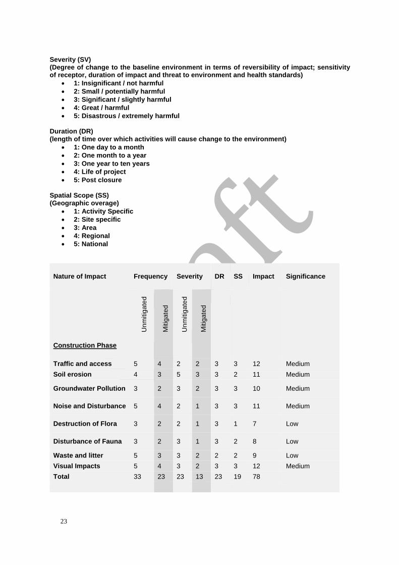
2.2. Impacts that may result from the construction/operational/decommissioning phases
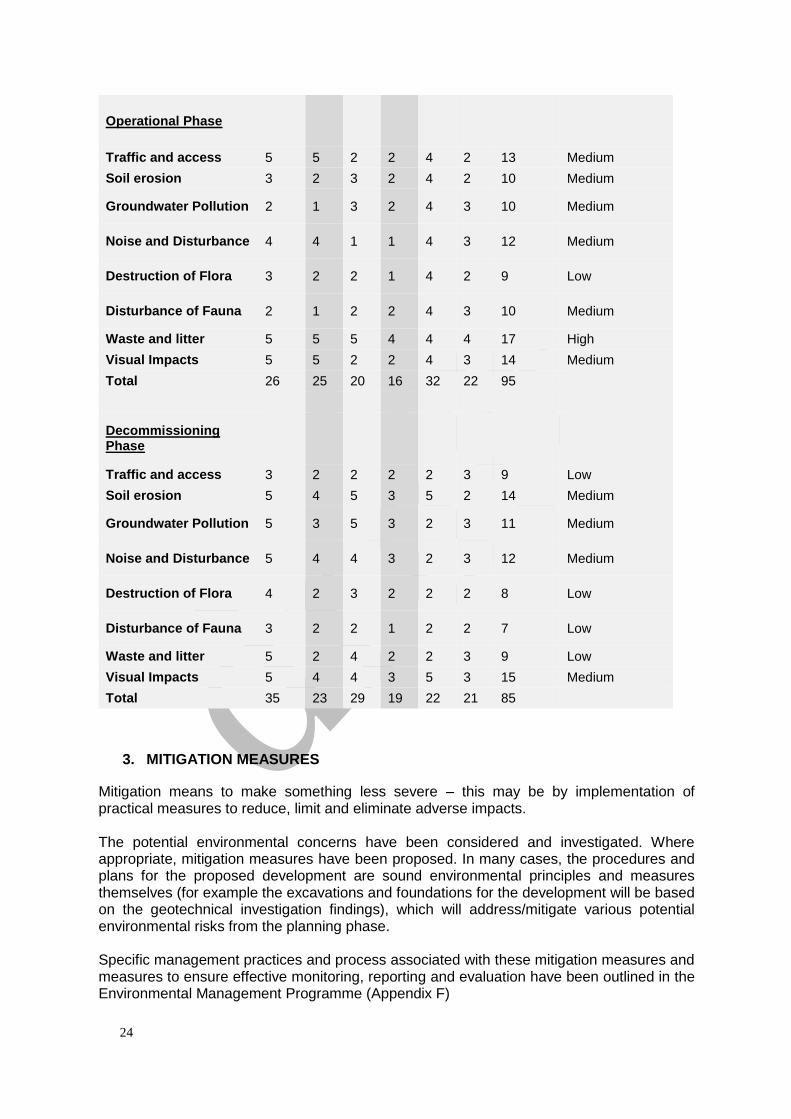
The table below identifies the potential impacts identified for the construction, operation and decommissioning phase of the proposed Pongola Township Development. The potential impacts are described and assessed for significance. Significance is assessed by scoring each impact on the basis of four variables, including probability, severity, duration and spatial implications.
On the understanding that a significant impact is one which, whether in isolation or in combination with other impacts, could have a material influence on the decision making process, including the specification of mitigation measures; significance in this report is scaled according to impact scores as follows:
• Low (scoring 9 or less)
• Medium (scoring between 10 and 15)
• High (Scoring 16 or more) The four variables, with their score criteria are detailed below: Frequency / Probability (FR) (Frequency or likelihood of activities impacting on the environment)
• 1: Almost Never / impossible
• 2: Very seldom / highly unlikely
• 3: Infrequent / Seldom
• 4: Often / Regular
• 5: daily / Highly regular
23
Severity (SV) (Degree of change to the baseline environment in terms of reversibility of impact; sensitivity of receptor, duration of impact and threat to environment and health standards)
• 1: Insignificant / not harmful
• 2: Small / potentially harmful
• 3: Significant / slightly harmful
• 4: Great / harmful
• 5: Disastrous / extremely harmful Duration (DR) (length of time over which activities will cause change to the environment)
• 1: One day to a month
• 2: One month to a year
• 3: One year to ten years
• 4: Life of project
• 5: Post closure Spatial Scope (SS) (Geographic overage)
• 1: Activity Specific
• 2: Site specific
• 3: Area
• 4: Regional
• 5: National
Nature of Impact Frequency Severity DR SS Impact Significance
Unm
itig
ate
d
Mitig
ate
d
Unm
itig
ate
d
Mitig
ate
d
Construction Phase
Traffic and access 5 4 2 2 3 3 12 Medium
Soil erosion 4 3 5 3 3 2 11 Medium
Groundwater Pollution 3 2 3 2 3 3 10 Medium
Noise and Disturbance 5 4 2 1 3 3 11 Medium
Destruction of Flora 3 2 2 1 3 1 7 Low
Disturbance of Fauna 3 2 3 1 3 2 8 Low
Waste and litter 5 3 3 2 2 2 9 Low
Visual Impacts 5 4 3 2 3 3 12 Medium
Total 33 23 23 13 23 19 78
24
Operational Phase
Traffic and access 5 5 2 2 4 2 13 Medium
Soil erosion 3 2 3 2 4 2 10 Medium
Groundwater Pollution 2 1 3 2 4 3 10 Medium
Noise and Disturbance 4 4 1 1 4 3 12 Medium
Destruction of Flora 3 2 2 1 4 2 9 Low
Disturbance of Fauna 2 1 2 2 4 3 10 Medium
Waste and litter 5 5 5 4 4 4 17 High
Visual Impacts 5 5 2 2 4 3 14 Medium
Total 26 25 20 16 32 22 95
Decommissioning Phase
Traffic and access 3 2 2 2 2 3 9 Low
Soil erosion 5 4 5 3 5 2 14 Medium
Groundwater Pollution 5 3 5 3 2 3 11 Medium
Noise and Disturbance 5 4 4 3 2 3 12 Medium
Destruction of Flora 4 2 3 2 2 2 8 Low
Disturbance of Fauna 3 2 2 1 2 2 7 Low
Waste and litter 5 2 4 2 2 3 9 Low
Visual Impacts 5 4 4 3 5 3 15 Medium
Total 35 23 29 19 22 21 85
3. MITIGATION MEASURES
Mitigation means to make something less severe – this may be by implementation of practical measures to reduce, limit and eliminate adverse impacts. The potential environmental concerns have been considered and investigated. Where appropriate, mitigation measures have been proposed. In many cases, the procedures and plans for the proposed development are sound environmental principles and measures themselves (for example the excavations and foundations for the development will be based on the geotechnical investigation findings), which will address/mitigate various potential environmental risks from the planning phase. Specific management practices and process associated with these mitigation measures and measures to ensure effective monitoring, reporting and evaluation have been outlined in the Environmental Management Programme (Appendix F)
25
The mitigation measure below have not been categorised under particular risks they address. Many of them are general in the sense that they address a multitude of potential risks/impacts. Mitigation measures are presented in categories in the Environmental Management Programme (Appendix F). The following mitigation measures and procedures are recommended:
• An Environmental Control Officer (ECO) must be appointed to oversee construction activities and be made responsible for monitoring.
• The ECO must confirm the presence or absence of protected plant species before any site clearing. Trees must be earmarked for preservation to ensure no there is no disturbance to legally protected species (e.g. the marula tree).
• If for any reason a legally protected species needs to removed or relocated, the relevant licenses will need to be obtained. For nationally protected species, in this case, the marula tree (Sclerocarya birrea) the issuing authority would be the Department of Agriculture, Forestry and Fisheries. For provincially protected species which may be encountered, a permit must be obtained from Ezemvelo KZN Wildlife.
• The listed invasive alien plants are to be controlled as stipulated by their category in the National Environmental Management: Biodiversity Act (10/2004): Alien and Invasive Species List, 2014.
• Care must be taken once clearing has begun, as disturbance to the soil creates a habitat for opportunistic invasive plants, which can be detrimental to the ecological integrity of the area.
• In order to reduce erosion risk, reduce alien plant invasion, minimise unnecessary/excessive vegetation clearance and avoid exposing soils, sites should not be cleared of vegetation more than two months prior to being developed. During the rainy season, this period should be shortened to one month as increased rainfall results in accelerated erosion and alien plant establishment.
• The development, as well as associated activities involved (e.g. storage of construction material/equipment, movement/parking of vehicles) must be kept within the boundary of the proposed property.
• No activity is to occur on neighbouring/privately owned land unless written consent and arrangements have been made with land owners prior to commencing the development.
• Areas susceptible to erosion must be protected by installing appropriate temporary or permanent drainage works or water dispersal and water velocity reduction structures. A Stormwater Management Plan has been drafted to address this.
• All materials for construction must be sourced from sustainable and appropriately licenced stock (sand stone etc.).
• Ensure compliance with legislation where applicable such as the Hazardous Substances Act, 1973 (Act No. 15 of 1973), the National Environmental Management: Waste Act, 2008 (Act 59 of 2008, The National Environmental Management: Biodiversity Act, 2004 (Act 10 of 2004)
• Ensure appropriate handling of hazardous substances, any such substances must be stored in bund walls or secondary containment and in an area that can’t be accessed by unauthorised persons.
• Reduce spills by maintaining preventative measures on site and ensure tools, construction vehicles and machinery are well maintained.
• Ensure correct waste management, sorting and recycling of materials used for construction. Waste should be stored in scavenger proof bins. Bins must be secured in an area specifically designed, constructed and maintained for such purpose.
• Ensure appropriate location of concrete mixing areas. Avoid areas susceptible to soil erosion (steep gradients) and water pollution and drainage lines.
• Should artefacts or skeletal remains be found, Amafa must be notified for further investigation and evaluation.
26
• During windy or dry periods, dust suppression techniques should be implemented.
• Mobile toilet facilities should be made available to workers, where possible, dry or compost loos will be preferable.
• Any waste generated on site during the operational phase will be removed from the site. This includes solid waste and effluent.
• Water saving measures must be implemented.
• The EMPr must be adhered to, particularly with regards to mitigating erosion risk and reducing dust and noise disturbance.
• Where possible, locally sourced labour should be used for construction.
• A fire management plan must be drawn up and implemented for construction and operational phase as well as the design and use of the buildings are to satisfy reduced fire hazard.
4. SIGNIFICANT RECOMMENDATIONS MADE BY SPECIALISTS
4.1. Geotechnical-related recommendations (from the Geotechnical Investigation Report, Appendix A):
• Soft excavation in terms of SABS 1200D is generally anticipated from surface to depths in excess of 2.9 m below natural ground level.
• It is advised that the most appropriate foundations options are modified normal strip footings, RC rafts or a compacted soil raft.
• It is important that the design of the storm water management system, allow for the drainage of accumulated surface water from the platform and into the municipal storm water system or natural drainage lines.
• The natural ingress of groundwater and the additional localised inundation due to the development itself should be managed and controlled to prevent erosion and the collapse settlement of materials.
• All drainage installations should be completed prior to building construction.
• Surface drainage of building platforms should be designed to direct water away from fill edges, to prevent overtopping of the fill crest and erosion of fill embankment slopes. Surface water on these platforms should be directed to, and collected in, open lined drains or piped to the natural drainage line.
• It is important that grassing or protection of fill embankments be carried out as soon as possible after construction, to minimise ponding of the water on the cut platforms to reduce slope instability and piping erosion.
• Run-off from building roofs should be piped from gutters, through downpipes, and discharged into the storm water reticulation system. In addition a suitable concrete apron should be provided at least 1.5 m wide and shaped away from the edge of the structure to ensure effective run-off.
• Since the area to be developed is in excess of 0.8 hectares, the storm water received onto and generated on the site will have to be managed and attenuated on site.
• It is strongly recommended that the subsoil drains (if required) be designed according to the specific filter criteria of the in situ soils to prevent piping of the material and subsequent rapid erosion.
• All vegetation should be cleared from the areas over which structures are to be built. Any removal of surface topsoil will probably bring any groundwater seepage closer to the surface and this should be borne in mind and made clear to the contractor.
• Earthworks should commence shortly after vegetation clearing to prevent erosion runoff along the steeply sloping western slope.
• It is recommended that all earthworks be carried out in accordance with SABS 1200
27
D.
• In general, it is recommended that cut slopes and fill embankments have a maximum slope of 1 vertical to 2 horizontal to ensure stability. Excavation with unsupported side walls will remain relatively stable for short periods (less than 24 hours) unless they are destabilized by a storm or a perched groundwater seepage. The need for the subsoil drainage both beneath and in fills will have to be assessed during the earthworks, taking into account the height and locality of individual fills.
• The fills should be placed in layers not exceeding 200mm loose thickness, and compacted to a minimum of 93% Modified AASHTO maximum dry density at 2% wet of optimum moisture content. Cobbles and boulders larger than two thirds of the layer thickness and clayey or organic material must not be included in the fill material.
• Both during and after construction, the site should be well graded to permit water to drain away readily and to prevent ponding anywhere on the ground surface. All terraces and earthworks in general should be sloped to a gradient of not less than 1 vertical in 50 horizontal to prevent ingress of water into the subsoils since these soils might be significantly permeable. Surface drainage should be directed away from the crests of fill embankments to prevent over-topping and erosion of fill slopes.
• Backfill to service trenches must be raised slightly above the surrounding ground level and be properly compacted to avoid the formation of a surface depression as a result of settlement of the backfill. Such depressions will increase the ingress of stormwater runoff into the soils. It is recommended that the number of trenches running at right angles to contours be limited as these often become preferential drainage paths. All service trenches deeper than 1.5m must be shored.
• Based on the laboratory test results, visual and tactile descriptions, the shallow foundation soils (colluvium & talus) have been described as pin-holed and therefore prone to collapse settlements ranging from 6 mm to 84 mm at an average of 30 mm (due to a collapse potential ranging from 0.4 to 7%).
• Under no circumstances should foundations be placed in/on untreated natural subsoils unless it has been specifically engineered to support structural foundations.
• In general, good practice requires that the in situ moisture content of the founding horizons below the structure be maintained, and in this regard the following precautions should be taken:
- No water should be allowed to pond against or within the first meter from the external
perimeter of the structure.
- Gardens located against the external perimeter of the structure are not recommended.
- Leaks in plumbing and associated drainage are attended to without delay.
- No large shrubs and or trees are planted closer than 0.75 x the mature height of the tree.
- Septic tanks and French drains are situated well away down gradient from any
buildings.
• It is not, however, cost effective to construct foundations which totally remove the chance of damage due to soil movements and in this light, some Category 1 damage to the structures may be expected, i.e., fine internal cracks of widths less than 1 mm aperture. To a much lesser extent some Category 2 damage may occasionally occur, with the formation of cracks of less than 5 mm aperture. It is recommended that GCS Geotechnical inspect and approve all foundation excavations to confirm depth of founding and bearing capacity of the underlying founding horizons.
• Given the results of the inspection pits, and the relatively low in situ moisture content (dry to slightly moist), it is clear that the upper 2.4m of the soil profile will have a high collapse potential. A high likelihood thus exists for collapse potential should there be a sudden ingress of water resulting in saturation of the foundation soils. This may occur should services adjacent to walls and foundations rupture or crack, or if water is allowed to pond against the walls of the structure.
28
• The following foundation options should be considered for NHBRC Site Class C1: - Modified normal with articulation joints and reinforced strip footings, or - Compaction of in-situ soils below individual footings with lightly reinforced strip
foundations and light reinforcement in masonry, or - Soil raft by removing in situ material to 1 m beyond perimeter of building to a depth
of 1.5 times widest footing and replace with inert approved (G7) material compacted to 93% MADD. Normal construction with lightly reinforced strip footings and light reinforcement in masonry.
• The following foundation options should be considered for NHBRC Site Class C2: - Stiffened strip footings with articulation joints or solid lightly reinforced masonry.
Bearing pressure not to exceed 50 kPa and fabric reinforcement in floor slab. - RC raft with same details as above. - Compaction of in situ soils below individual footings with lightly reinforced strip
foundations and light reinforcement in masonry. - Soil raft as above
• The upper soils would likely be considered adequate as subgrade materials after compaction. The design value for the modulus of subgrade reaction (k) for floor slab design would normally be between 35 and 65 kPa/mm provided the subgrade beneath surface beds or floor slabs can be ripped to a depth of 300mm and re-compacted to 93% Mod AASHTO dry density.
• Transported materials tend to be highly variable in thickness and composition, and would likely appear as sandy silty clay. However, these materials can be potentially collapsible and therefore it is suggested that the upper 300mm be ripped, wetted to +2% of OMC and compacted to 93% MADD.
• It is unlikely that the situ materials occurring on site would meet the strict bedding specifications, according to the requirements of SABS 1200LB and therefore this commodity should be allowed for in the tender documents.
• It is important that GCS Geotechnical carry out periodic inspections of the site during construction to ensure that any variation in the anticipated ground conditions can be assessed, and revised recommendations made to avoid unnecessary delays and expense.
• NHBRC Phase II investigation is required, which will entail the mapping of individual service trench excavations to provide a more accurate NHBRC Site Classification for each erf/stand after these have been pegged.
5. PROPOSED MONITORING AND AUDITING
Construction phase: It is recommended that monitoring be done by an appointed independent Environmental Control Officer through monthly construction monitoring and audits ensuring compliance with an Environmental Management Programme (EMPr), conditions of the Record of Decision and recommendation made by specialist and authorities. Operation phase: Post construction monitoring/audits should be undertaken quarterly for the first two years or operation to ensure the EMPr requirements have been met. Decommissioning phase: In the possible event of decommissioning, monitoring/audits should be undertaken monthly during the decommissioning process to ensure the EMPr requirements for decommissioning are being adhered to.
6. ENVIRONMENTAL IMPACT STATEMENT
29
It is the opinion of the EAP that the proposed township development should be constructed. This construction would result in minor adverse environmental and social impact, provided the mitigation measures in the Basic Assessment Report and the EMPr are adhered to. The socio-economic opportunities that this development can offer residents are noteworthy. This opinion is based on information in this report and the specialist reports.
SECTION F: REFERENCES uPhongolo Local Municipality (2015). uPhongolo Local Municipality 2016-2017 Final IDP Review
SECTION G: APPENDICES
7. APPENDIX A. GEOTECHNICAL REPORT
8. APPENDIX B. STORMWATER MANAGEMENT PLAN
9. APPENDIX C. SITE LAYOUT
10. APPENDIX D. SITE PHOTOS
11. APPENDIX E. PUBLIC PARTICIPATION
12. APPENDIX F. EMPR


![Teenage Pregnancy in KZN - KwaZulu-Natal€“ Permission from Department of Basic Education and Health ... Pongola “ ... Teenage Pregnancy in KZN [Compatibility Mode]](https://img.pdfslide.net/doc/110x75/5b1a70f47f8b9a3c258daa84/teenage-pregnancy-in-kzn-kwazulu-permission-from-department-of-basic-education.jpg)