Embed Size (px)
Citation preview
1
Draft CBCS Syllabus for
Postgraduate Course in Geography
EFFECTIVE FROM THE ACADEMIC SESSION 2019 –20
West Bengal State University
Berunanpukuria, Malikapur
Barasat, North 24 Parganas
West Bengal – 700126
2
Content
Page
Section 1: PG CBCS Structure for Geography. 3
Section 2: Programme Specific Outcome (PSO) 4
Section 3: Course Outcome (CO) 6
Section 4: Detailed Syllabus of Core and Elective Courses 14
Section 5: Aptitude Enhancement Course 38
Section 6: Skill Enhancement Course for Geography 39
Section 7: Generic Elective Course (GEC) for Other Disciplines 40
3
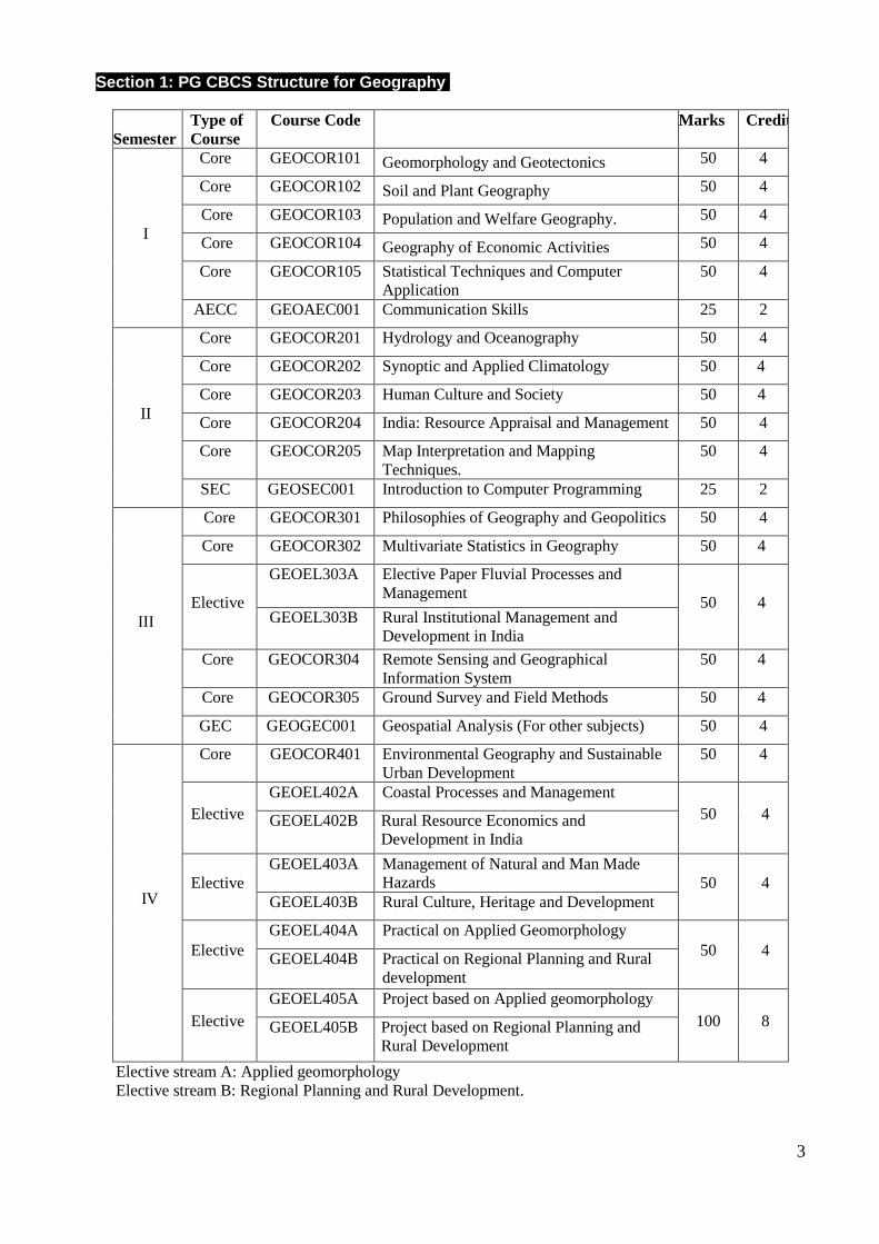
Section 1: PG CBCS Structure for Geography.
Semester
Type of
Course
Course Code Marks Credit
I
Core GEOCOR101 Geomorphology and Geotectonics 50 4
Core GEOCOR102 Soil and Plant Geography 50 4
Core GEOCOR103 Population and Welfare Geography. 50 4
Core GEOCOR104 Geography of Economic Activities 50 4
Core GEOCOR105 Statistical Techniques and Computer
Application
50 4
AECC GEOAEC001 Communication Skills 25 2
II
Core GEOCOR201 Hydrology and Oceanography 50 4
Core GEOCOR202 Synoptic and Applied Climatology 50 4
Core GEOCOR203 Human Culture and Society 50 4
Core GEOCOR204 India: Resource Appraisal and Management 50 4
Core GEOCOR205 Map Interpretation and Mapping
Techniques.
50 4
SEC GEOSEC001 Introduction to Computer Programming 25 2
III
Core GEOCOR301 Philosophies of Geography and Geopolitics 50 4
Core GEOCOR302 Multivariate Statistics in Geography 50 4
Elective
GEOEL303A Elective Paper Fluvial Processes and
Management 50 4
GEOEL303B Rural Institutional Management and
Development in India
Core GEOCOR304 Remote Sensing and Geographical
Information System
50 4
Core GEOCOR305 Ground Survey and Field Methods 50 4
GEC GEOGEC001 Geospatial Analysis (For other subjects) 50 4
IV
Core GEOCOR401 Environmental Geography and Sustainable
Urban Development
50 4
Elective
GEOEL402A Coastal Processes and Management
50 4 GEOEL402B Rural Resource Economics and
Development in India
Elective
GEOEL403A Management of Natural and Man Made
Hazards 50 4
GEOEL403B Rural Culture, Heritage and Development
Elective
GEOEL404A Practical on Applied Geomorphology
50 4 GEOEL404B Practical on Regional Planning and Rural
development
Elective
GEOEL405A Project based on Applied geomorphology
100 8 GEOEL405B Project based on Regional Planning and
Rural Development
Elective stream A: Applied geomorphology
Elective stream B: Regional Planning and Rural Development.
4
Section 2: Programme Specific Outcome (PSO)
The postgraduate syllabus for M.Sc. course in Geography has been framed with the objective of
giving the students a holistic understanding of the subject putting equal weightage on two main
aspects of Geography — Physical and Human and their interactive relationships. The principal
goal of the syllabus is to enable the students to secure a job at the end of the postgraduate
programme. Keeping this in mind and in tune with the changing nature of Geography, adequate
emphasis is rendered on the applied aspects of the subject.
PSO01: Physical Geography
The courses in Physical geography focusses on geography as earth sciences and covers areas such
as biogeography, climatology and meteorology, geomorphology, environment management,
hydrology, oceanography, paleo-geography, and quaternary science. On completion of the
programme, with a specialisation in Physical Geography the students will develop knowledge base
and skills as follows:
Knowledge base:
– Genesis of major geomorphic features and their potential use as indicators of environmental
change.
– Physical processes of tropical ecosystems with focus on soils, vegetation and changing land use.
– The relationship between environmental change and human activity including resilience,
vulnerability and adaptive processes.
– The interplay between atmospheric circulation and energy balance and correlation with global
climate change and hydrology.
– Methods and equipment used in the study of fluvial, estuarine and marine environments, the
potential effect of sea-level and climate change.
Skills:
– Identify and describe key factors that control a range of biogeochemical processes and net
effects in terms of the environmental impact of pollutants and greenhouse gases
– Assess how models at different scales and databases can be used to enhance our understanding
of present and past climate and predict future development in climatic trends.
– Review a scientific literature and communicate results of projects orally and in writing.
– Field methods used in studies of sediment transport in the fluvial, estuarine and marine
environment
PSO02: Human Geography
The courses in Human geography deals more with patterns and processes that shape human society
and covers areas such as culture, development, economy, health, geopolitics, demography, religion,
society, transport and regional development and planning. On completion of the programme, with a
specialisation in Human Geography the students will develop knowledge base and skills as follows:
Knowledge base:
– Conceptualisations of space and place including social, economic and development issues as
well as human environment interactions.
5
– Globalisation processes and their geographical implications, transformation of cities, regions and
landscapes, migration, urbanisation, rural-urban connections and land use change.
– The role of uneven geographical development including its implications for urban and regional
development and planning.
Skills:
– Work at a scientific and application-oriented level with a broad range of theoretical and
methodological approaches to human geography
– Work with interdisciplinary dimensions of human geographical processes and their impacts and
spatial aspects at different scales.
– Work in and understand the implications of cross-cultural contexts.
PSO03: Applied Geographical Aspects
The Applied aspects in Geography include courses in Remote Sensing and GIS, advanced
techniques of mapping and field-based data generation. On completion of the programme, in
Geography the students will develop specific skills as follows:
Skills
– Student will be able to analyse the problems of physical as well as cultural environments of both rural
and urban areas. They will try to find out the possible measures to solve those problems through Social
Survey Project:
– Integrate RS data with other data in a GIS environment for applications in spatial planning,
environmental monitoring and modelling.
– Advanced methods of field mapping and primary data collection.
– Assess data quality, in terms of uncertainty, in order to understand and describe the limitations
of current RS and GIS technology.
– Develop the capability of observation through field experience so that they will be able to
identify the socio-environmental problems of a locality.
PSO04: Development of Communication Skill and Interaction Power
– The students will be efficient in communication skill and social interaction.
– The students will be able to understand and write effective reports and design credentials, make
effective demonstrations and give and receive clear instructions.
PSO05: Understand Environmental Ethics and Sustainability
– The students will understand the impact of their acquired knowledge in societal and
environmental contexts
– Demonstrate their sensitivity towards social responsibility and sustainable development.
6
Section 3: Course Outcome (CO)
GEOCOR101: GEOTECTONICS AND GEOMORPHOLOGY
– Making the students’ aware about the basic concepts of Geomorphology with background
knowledge of geology and environmental sciences.
– Understanding crustal mobility and tectonics; with special emphasis on their role in landform
development. Establishing the relationships between landforms, processes and underlying
structure CO 4 – Overview and critical appraisal of landform development models
– Exploring how landforms and geomorphic processes vary under different climatic regimes.
– Students will be introduced to geomorphic features that are not found on Earth. As
geomorphologists they will know how to use landforms on Earth to understand those on other
solar system bodies.
– Develop understanding of fluvial and other geomorphic processes together with emphasis upon
the applied aspect of Geomorphology and hazard management.
GEOCOR102: SOIL AND PLANT GEOGRAPHY
– To familiarise the students with the basic and fundamental concepts of soil geography and
discuss the processes of soil formation.
– Students will know the concept, causes and controlling factors of soil erosion, soil degradation
and conservation of soils
– Students should know the concept, need and methods soil of management
– To introduce the concept of Phytogeography
– Assess the adaptation of plants in relation to light, temperature, water, wind and fire.
– To provide thorough knowledge about the conditions of plant growth
– Students will be able to understand adaptation, development and behaviour of different plant
groups.
– Evaluate energy sources of ecological system
GEOCOR103: POPULATION AND WELFARE GEOGRAPHY (4 CREDIT)
– Objective of the course is to make the students aware about the basic concepts and theories of
human population and their development.
– Provide an insight into the contemporary and emerging wellbeing issues, based on the
components of welfare
– Address the geographical dimensions of inequality through the Constitutional imperatives
GEOCOR104: GEOGRAPHY OF ECONOMIC ACTIVITIES
– The objectives of this course are to integrate the various factors of economic development and
acquaint the students about the dynamic aspects of Economic Geography
– To familiarise the students with the concept, origin, and development of agriculture
– To examine the role of agricultural determinants towards changing cropping patterns, intensity,
productivity, diversification and specialisation.
7
– To familiarise students to understand the location of major manufacturing activities with the
support of various industrial location theories and models.
– The changing industrial scenario and its impact on the Indian economy along with the
economics of global trade.
GEOCOR105: STATISTICAL TECHNIQUES AND COMPUTER APPLICATION
– Using statistical techniques in order to summarise, represent, analyse and interpret data.
– Introduce basic statistical procedures and train the students to apply these procedures towards
analysing the geographical problems.
– The course also aims to provide training in application of computers in analysis and synthesis of
a variety of quantitative data.
GEOCOR201: HYDROLOGY AND OCEANOGRAPHY
– Understanding the variations of global hydrological cycle and analysing the concept of
Hydrology as an integral part of all living things in the world.
– Developing understanding about the significance of a systematic study on fresh water resources,
their storage and utilisation, emphasising the significance of groundwater quality and its
circulation.
– Introduce students to the physical and chemical properties of sea water, atmospheric and oceanic
linkage.
– Students will be able to understand aquifer properties and its dynamics after the completion of
the course and get an exposure towards the behavior and characteristics of the global oceans and
the national and international laws for governing the coastal area and territorial sea
– Students can be involved in managing, monitoring and protecting water and water resources.
They can be involved in planning, development and sustainable use of natural and domestic
water resources.
GEOCOR202: SYNOPTIC AND APPLIED CLIMATOLOGY
– Developing the understanding about the Earth’s atmosphere and global climate.
– Understanding the major forms of weather disturbances and the dynamics of the Monsoon
– Assessing the phenomenon of climate change and its implications including the role of man in
global climate change.
– Geographers can be absorbed as climate change analysts, studying and interpreting data, maps
reports, photographs and charts to predict long and short scale patterns.
– Exposure of students to the various branches of Applied Climatology
GEOCOR203: HUMAN CULTURE AND SOCIETY:
– An insight into the notion of Cultural Geography will help students in understanding and
comprehending the prevalent social-cultural relations with changing human adaptations.
– To relate these issues through the study on the elements of Indian society and the processes of
their transformations.
– The course is significant to disseminate knowledge on the Indian society with its multicultural
identity as existing in this era of cultural globalization.
8
– It will inculcate in students the pride of universalization of Indian culture and social values
GEOCOR204: INDIA: RESOURCE APPRAISAL AND MANAGEMENT
– The objective of the course is to understand India in terms of various regional divisions, their
important characteristics and to analyse the natural and human resource endowments, their
conservation and management.
– It also aims to sensitize the students with development issues and policies designed for regional
development. The paper also gives an insight into the geography of West Bengal, to acquaint the
students with the state — its problems and prospects.
GEOCOR205: MAP INTERPRETATION AND MAPPING TECHNIQUES
– Acquire knowledge different types of map projection and develop a clear concept of their
properties and applicability.
– Gain knowledge about topographical maps and apply this knowledge in understanding ground
realities.
– Demonstrate competence in fundamental geological skills in identification; interpretation of geologic
maps and cross-sections with basics of three-dimensional conceptualisation
– The course also aims to train the students in various methods of analysing socio-economic data.
GEOCOR301: PHILOSOPHIES OF GEOGRAPHY AND GEOPOLITICS
– Develop an idea about evolution of geographical thinking and disciplinary trends in different
parts of the world.
– Build an idea about the dichotomous nature of Geography.
– Establishing relationship of Geography with other disciplines and man-environment
relationships
– Analysing modern and contemporary philosophies of Post-colonialism, Post-structuralism,
Modernism and Post-modernism in Geography
– Main objective of the course on Geopolitics is to provide insight into the complex relationship
between geographical factors that have a strong bearing on the political scenario at global,
regional and local level.
– To sensitise the students to geopolitical understanding of conflicts and regional cooperation with
respect to borders.
GEOCOR302: MULTIVARIATE STATISTICS IN GEOGRAPHY
– Students should have the understanding of basic concepts associated with matrix algebra,
multivariate normal distributions and their properties with special emphasis on bivariate normal
distribution
– To develop the capability of analysing multivariate data using techniques like Principal
Component Analysis, Factor Analysis.
– Familiarising students to Classification and Clustering methods.
GEOEL303A: FLUVIAL PROCESSES AND MANAGEMENT
– The rivers being the major geomorphic agent of erosion, the course assumes significance as it
mainly deals with an understanding of the fluvial system.
9
– The students are introduced to the forces resisting and driving the flow of water which has its
resultant effect on the flow patterns and sediment load.
– The course also emphasises on anthropogenic disturbance of channel, floodplain and the various
management options.
– The impacts of dams, river training structures are also dealt with.
– The students will be familiarised with the various Management Action Plans adopted in India for
river restoration and management.
– The course also highlights the necessity of watershed management and the application of
geomorphological knowledge in environmental management.
GEOEL303B: RURAL INSTITUTIONAL MANAGEMENT AND DEVELOPMENT IN INDIA
– The course intends to focus on Rural Institutional Management and Development in India at the
micro-regional level.
– Evolution of decentralisation process has led to Community Development Programmes and the
Institutional set-up of the Panchayati Raj Institutions.
– The students will be aware of the various facets of rural development through the various
approaches to rural development, rural reconstruction and the changing rurality as a
consequence.
– The conceptual background and its sound knowledge will guide them in seeking employment in
several of the schemes launched by the government and implemented by it along with the NGOs.
This is an added advantage as most of the students are from the rural background
GEOCOR304: REMOTE SENSING AND GEOGRAPHICAL INFORMATION SYSTEM
– The objective of the course is to introduce to the students the basic principles of remote sensing
and the methods of digital interpretations of satellite images.
– The course provides hands-on-training on the basic elements of GIS and its areas of application.
– Geospatial analysis is a growing field of employment. The role includes analysis of data, design
and use of this database.
– The work of a geospatial analyst varies greatly depending on which sector the student wants to
work
GEOCOR305: GROUND SURVEY AND FIELD METHODS
– Main objective of field method is to provide the students the understanding of ground reality;
mapping of land use and to enhance the skill of the students during field survey.
– On completion of this course students shall be able to understand the advantages of electronic
surveying over conventional surveying methods.
– Students completing this course would have acquired practical knowledge on handling survey
instruments like Theodolite and Total station and have adequate knowledge to carryout
Triangulation surveying including general field marking for various projects.
– The course aims to give hands-on-training in preparation of maps with application of GPS.
– The students should be able to take decisions regarding what measurements to take, and which
instruments to use.
10
– The skill to carry out surveying with Theodolites and Total Station will make the students
eligible for securing jobs as surveyors in various Government and Non-governmnet
organizations.
GEOCOR401: ENVIRONMENTAL GEOGRAPHY AND SUSTAINABLE URBAN DEVELOPMENT
– The importance of conserving the environment to sustain ecological balance has been
emphasised in the course.
– Examples of human-induced social and ecological changes and some environmental issues in
contemporary India have also been highlighted.
– To study the integrated themes and biodiversity, natural resources, pollution control and waste
management
– To study the nature and facts about environment and finding and implementing scientific,
technological, economic and political solutions to environmental problems.
– The course will also enlighten students on environmental issues with special emphasis on urban
sustainability as the world is fast urbanizing.
– Case studies showcasing failure and success stories implemented by the governmental policies
on urban development with local community participation will help in understanding critically
the concept of sustainable development and its management in India.
– Students can find career opportunities in Government ministries and other public and private
sector organisations concerned with policy analysis in the fields of sustainable development and
environmental planning as a sustainability consultant.
GEOEL402A: COASTAL PROCESSES AND MANAGEMENT
– This course includes interpretation of coastal environment and its management and understands
coastal regions as dynamic and contested environment.
– Regional or local case studies will teach the students the techniques of geomorphic assessment
of specific problems.
– This course will give students an understanding of coastal resources management and protection
as a public policy problem.
– The course sensitise students about the issues of coastal vulnerability like sea level change,
coastal erosion, estuarine pollution and unplanned reclamation efforts
– The students will learn to critically assess the impacts of conventional coastal management
options.
– Geomorphologists can find career opportunities as Environmental Consultant in engineering
consulting firms and government agencies.
GEOEL402B: RURAL RESOURCE ECONOMICS AND DEVELOPMENT IN INDIA
– We are to generate livelihoods in the village itself so that people do not have to migrate to urban
areas utilizing the rural resources.
– The students are introduced to the indigenous knowledge of the people in order to bring about
sustainable resource management. Local experiences shape local craft and some of the industrial
products are centuries old which needs to be taken care of.
11
– In the long run, rural tourism can make a significant contribution to arresting migration, making
the villages attractive to their residents, and even result in some reverse migration.
– Establishing a rural tourism network will have a synergistic effect benefitting all players.
Promotion of tourism will be ‘value addition’. Once tourists start coming, local initiative
combined with governmental support can ensure further augmentation of facilities, attractions
and activities, including the development of social welfare measures in the fields of health,
education and employment.
– Knowledge of these issues will benefit the students as they can apply this knowledge at the grass
root level. They can also carry out their own business or get jobs in these sectors instead of
migrating to urban areas as most of them are from the rural background.
GEOEL403A: MANAGEMENT OF NATURAL AND MAN-MADE HAZARDS
– The course elucidates the importance of disaster management, explain the causes and describe
the dimensions of natural and anthropogenic disasters.
– The students will be equipped with the principles and components of disaster management, the
contents of an emergency operational plan and explanation of the role of disaster mitigation and
its role in sustainable development.
– The course will sensitize the students regarding the problems of groundwater and soil.
– The problems of urban geomorphology are gaining relevance in sustainable hazard management
strategies. Case studies will help the students to connect with the real-world issues.
– Geographers can be engaged as Emergency Management Specialists’ who can coordinate disaster
response and crisis management through planning, assessment and vulnerability analysis. With the
introduction of GIS and remote sensing in Geomorphology, preparation of maps for effective
management has been very effective
GEOELC403B: RURAL CULTURE AND HERITAGE AND DEVELOPMENT
– Communal tolerance, mass gathering religious practices and folk music have sustained India’s
peace and development. So a study on such practices will sustain our peace by the younger
generation and inculcate moral value in the students.
– Heritage of rural India encompasses almost all aspects of life: monuments and historic
structures, performing and visual arts, crafts and artisan skills, traditional knowledge in
agriculture, water management and medicine and the heritage and history embedded in
mythology, folklore, ritual, and language. Traditional crafts have survived in India because rural
folk still make and use them. These are visual dialogues between the craftsmen and culture of
the land.
– Case studies on these various facets as an exemplar from India in general and West Bengal in
particular will set new benchmarks for rural development and promotion of local culture.
– Heritage and culture and rural tourism are tools capable to boost local economy, community
mobilization and conservation and in sustainable renewal of resources.
– The course will also provide prospective job opportunities in government and NGO departments
and many can act as independent entrepreneurs themselves
GEOEL404A: PRACTICAL ON APPLIED GEOMORPHOLOGY
12
– The course aims to give hands-on-training on interpretation and quantification of fluvial and
coastal processes.
– The students are trained on water and sediment analysis procedures which are indicators of the
operating geomorphic processes.
– The stress on on-field data collection and monitoring will train the students to identify the
problem areas and give them hand-on experience in management of fluvial or coastal problems.
– Qualitative and quantitative analysis of geomorphic data will facilitate the students to suggest
the suitable management procedure.
GEOEL404B: PRACTICAL ON REGIONAL PLANNING AND RURAL DEVELOPMENT
– Research in Geography involves thinking about the relationships between methods, techniques,
analysis, and interpretation, the important role of which is filled by the research design.
– Method is a technique for gathering evidence, while methodology is a theory of how research
should proceed through its various stages and phases, discussing the philosophical approach to
the work.
– The course includes techniques of collection of primary and secondary data; organising,
processing and analysing the socio-economic data and techniques of formulating rural planning
for its holistic development. Results from qualitative research are more understandable to
people who are not statistically trained and can reveal more insightful geographical thinking
than purely numerical outcomes.
– The study of the same phenomenon through the use of multiple methods of data collection
quantitatively and qualitatively, cross verifying it through two or more sources will help
students learn of validation of the data.
– The course outcome is very promising as students can help in formulating rural plans required
for Regional Planning and Rural development as little focus is on this sphere in our country.
GEOEL 405A: PROJECT BASED ON APPLIED GEOMORPHOLOGY
GEOEL405B: PROJECT BASED ON REGIONAL PLANNING AND RURAL DEVELOPMENT
– The project on optional paper (A or B) will be based on primary data collected from field. The
topic will be based on any problem that has contemporary relevance.
GEOAEC001: COMMUNICATION SKILLS
– In an era of technology and globalization communication plays an important role. Helping
students to develop their communication skills is the need of the day to motivate and help them
through various strategies like to expand vocabulary, to improve fluency, to exhibit confidence
to communicate better.
– The course will focus on developing communication skills as part of academic ability required
by students.
– This will in turn help in improving their research skill and aptitude.
– It will also help them while presenting a paper in a seminar or facing interviews seeking a job.
This course is a scientific approach towards their learning process. It is really promising as it
will develop expertise of the learners
GEOSEC001: INTRODUCTION TO COMPUTER PROGRAMMING
13
– The course will focus on developing basic programming skills using the Python language and
source programming language.
– Python helps to curtail software development cost applying those skills to solve various
problems related to quantitative geography. The course will involve a brief introduction
followed by computer-based tasks.
– Since Python is supported by many operating systems it is suitable for creating prototype of the
software applications. At present the job market for Python developer GIS Analyst is highly
promising
GEOGEC001: GEOSPATIAL ANALYSIS
– Comprehend fundamental concepts and practices of Geographic Information Systems (GIS) and
advances in Geospatial Information Science and Technology.
– Apply basic graphic and data visualization concepts, demonstrate skills in file and database
management.
– Give examples of interdisciplinary applications of Geospatial Analysis.
– Apply GIS analysis to address geospatial problems and/or research questions.
– Demonstrate proficiency in the use of maps, satellite images and GIS tools to create maps that
effectively convey the information they are intended to.
14
Section 4: Detailed Syllabus of Core and Elective Courses
Semester – I
GEOCOR101: GEOMORPHOLOGY AND GEOTECTONICS (4 CREDIT)
Unit1: Geotectonics
1.1 Tectonic Geomorphology and structural landforms: variations in spatial and temporal
scales.
1.2 Relative motion and absolute motion of plates: driving forces, triple junctions and their
surface expressions.
1.3 Structure and form of orogenic belts with reference to the Himalayas: Fore deep basins,
thrust belt, metamorphism and tectonics.
1.4 Neotectonics: geomorphic markers, rates of uplift and erosion, principles of relative and
absolute dating.
Unit 2: Foundation and Branches of Geomorphology
2.1 Principle of Uniformitarianism, Catastrophism, inheritance from the past; Systems
Approach; feedbacks, equilibrium and threshold.
2.2 Morphogenetic regions and their importance. Significance of process studies in
geomorphology
2.3 Applied and anthropogenic geomorphology — emergence and relevance
2.4 Planetary geomorphology with special reference to Mars.
Unit 3: Fluvial Processes and Form
3.1 Significance of drainage basin as a geomorphic unit; channel initiation
3.2 Hydraulics of streamflow: Types of flow, stream velocity and resistance, stream energy
3.3 Thresholds of erosion: entrainment and bed erosion, bank erosion processes
3.4 Sediment transport and deposition: dissolved load, suspended load and bed load
Unit 4: Geomorphic Processes and Resultant Landforms
4.1 Slope evolution models — King, Wood and Young.
4.2 Coastal morphodynamic variables and their influence on evolution of coastal forms.
4.3 Karst processes and landforms in Tropical Humid Environments
4.4 Processes of evolution of periglacial landforms
15
GEOCOR102: SOIL AND PLANT GEOGRAPHY (4 CREDIT)
Unit1: Soil Properties and Processes
1.1 Major components of soil, Weathering processes and products. Catena concept. Physical
properties of soil: Texture, structure, density, soil colour, soil air and temperature.
1.2 Chemical properties of soil: Soil colloids, clay mineralogy, cation and anion exchange
1.3 Soil water: Energy state of soil water, Types of soil water movement, Solute transport.
1.4 .Soil organisms and soil processes: Composition and decomposition of organic matter, soil
micro-organisms, biological nitrogen fixation, ammonification and nitrification,
dentrification
Unit 2: Soil in relation to fertility and environment
2.1 Soil condition and crop production: Provision of nutrients, fertilizer use, organic manures,
nutrient balance, Liebig’s Law of the Minimum; Soil micronutrients, soil irrigation.
2.2 Soil acidification: Process, pH and buffering capacity, base saturation, effect on plants and
ecosystems
2.3 Hazardous elements in soil: Heavy metals: Pb, Zn, Cd, F, treatment of contaminated land,
radionuclides in soil.
2.4 Soil management: Managing sandy soils, saline soils and soils disturbed by surface mining
Unit 3: Plant Geography
3.1 Importance of Soil to plants: Plant development and root growth, water holding capacity,
soil aeration and temperature.
3.2 Importance of water to plants: Effect on evaporation and transpiration, adaptations of
Hydrophytes and Xerophytes, role of water in plant reproduction
3.3 Importance of temperature to plants: Temperature and transpiration, thermo-periodicity and
its effect, temperature and phenology, effects of low temperature.
3.4 Importance of light to plants: Photosynthesis, photoperiodism and its effects, germination.
Unit 4: Plant and Forest Ecology
4.1 Plant habitat factors; adaptation, succession and climax
4.2 Phytogeographical regions; Plant species, family and genera.
4.3 Deforestation and degradation of forest: causes and consequences; measures of
conservation and afforestation.
4.4 Plants as resource: timber and non-timber forest produces and their use.
16
GEOCOR103: POPULATION AND WELFARE GEOGRAPHY (4 CREDIT)
Unit1: Population Theories and Policies
1.1 Theories of population growth: biological, social and economic.
1.2 Fertility and mortality influencing policies; UNO’s World Population Plan of Action
1.3 Migration theories: Ravenstein, Lee and Todaro
1.4 Migration influencing policies: Internal migration, Immigration and Emigration related
policies
Unit 2: Emerging Issues in Population Geography
2.1 Population and vulnerability: Identity crisis in relation to Diaspora, ageing and
displacement due to development process and identity crisis. Unemployment and
Dependency Ratio, food security and hunger
2.2 Population Explosion and Poverty: Causes, effects, and measures of control.
2.3 Deprivations in health care: Reproductive and Child Health Care (RCH), infant and
maternal mortality, geriatric care, HIV/ AIDS.
2.4 Quality of population: Concepts, improved sex ratio, literacy rate, life expectancy
Unit 3: Welfare Significance in Development
3.1 Concept of welfare, social justice and social development
3.2 Components of welfare: Equity, equality, justice and injustice, exclusion and inclusion,
poverty reduction and inclusion.
3.3 Geographical dimensions of Inequality: Deprivation of the backward and minority
communities; gender issues; insecurity of the child labour, unemployed youth and
superannuated persons.
3.4 Social well-being in geography
Unit 4: Sustainable Development and Social Justice
4.1 Goals of sustainable development.
4.2 Indicators of quality of life: definition and indicators of physical quality of life and
standard of living.
4.3 Indicators of social well-being relevant to India: Housing, health and nutrition, literacy and
education, social security.
4.4 Achieving social justice in India: Inclusive growth through Constitutional imperatives
17
GEOCOR104: GEOGRAPHY OF ECONOMIC ACTIVITIES (4 CREDIT)
Unit1: Concept of Economic Resource and Economics
1.1 Concept of economic resource and economic theories: Adequacy and scarcity; sustainable
development, resource base and inequality.
1.2 Conservation and management of land, water and biotic resources.
1.3 Sustainable use of energy resources: renewable and non-renewable.
1.4 Ranking of world economic resources, global conflict on resource use.
Unit 2: Agricultural Geography
2.1 Agricultural region: Concepts, techniques and delineation.
2.2 World agricultural systems and agri-business.
2.3 Role of technological changes in agricultural productivity in India, impact of Green,
White and Blue Revolution.
2.4 Food security scenario in developing countries.
Unit 3: Industrial Geography
3.1 Theories of industrial location: Traditional theories and new concepts
3.2 IT Revolution
3.3 Industrial regions of India; Industrial complexes
3.4 Industrial policies of India.
Unit 4: Geography of Trade and Transport
4.1 Economics of global trade: Balance of payment. Role of World Bank, regional blocks in
international trade: ASEAN
4.2 Significance of trade in national and international economy: G8 countries, TRIPS and
MNC’s
4.3 Contemporary structure of regional economy: Market-centres and their orders; Export
Processing Zone (EPZ). Information technology and its impact on trade.
4.4 Transport networks and their role in national and international trade.
18
GEOCOR105: STATISTICAL TECHNIQUES AND COMPUTER APPLICATION
(4 CREDIT)
Unit1: Sampling, Scales of Measurement and Population Analysis
1.1 Geographical data: Discrete and continuous series, scales of measurements, frequency
distribution.
1.2 Measures of central tendencies and dispersion: Standard deviation, variance and co-
variance, coefficient of variability, skewness and kurtosis.
1.3 Probability: normal, poisson and binomial,; normal probability curve and its application
1.4 Sampling theories and methods; application of random numbers, estimation of sampling
error.
Unit 2: Correlation and Regression
2.1 Correlation and regression; bi-variate analysis and curve fitting — linear, exponential.
power relationship; residuals and mapping of residuals.
2.2 Product moment correlation and rank correlation.
2.3 Hypothesis testing: formulation, rejection rule, significance level and type of errors.
2.4 Test of significance: Students t Test and Chi Square Test
Unit 3: Computer Application for Descriptive Statistics
3.1
Tabulation, frequency distribution, cumulative frequency distribution, mean, median,
mode, standard deviation, mean deviation.
3.2 Histogram, scatter diagram.
3.3 Correlation and regression analysis: fitting of trend line, displaying regression equation
and correlation co-efficient
3.4 Time Series analysis.
Unit 4: Laboratory Note Book and Viva voce
19
Semester – II GEOCOR201: HYDROLOGY AND OCEANOGRAPHY (4 CREDIT)
Unit1: Components of Hydrology
1.1 Hydrological system models and their classification; principles of hydrologic budget
calculation; hydrological measurements and data sources
1.2 Water inputs: Water vapour; precipitation and its variability, Intensity-Duration-
Frequency (IDF) relationships.
1.3 Water storages: Interception, throughfall and depression storage — controlling factors
and estimation.
1.4 Water losses: Evaporation, transpiration and evapotranspiration — controlling factors
and estimation.
Unit 2: Surface and Groundwater Hydrology and Related Applications
2.1 Catchment processes: Generation of direct runoff, streamflow and baseflow.
2.2 Vertical distribution of water: zone of aeration and saturation. Water-bearing properties
of rocks, groundwater flow — Darcy’s law.
2.3 Water harvesting: models and feasibility
2.4 Water management in tropical farmlands: techniques and approaches.
Unit 3: Morphology of Ocean Basins
3.1 Relative and absolute motion of plates; Characteristics of continental margins, ridges,
guyots, trenches, canyons, fracture zones, island arcs and their tectonic settings.
3.2 Marine sediments: Classification, origin, composition and distribution.
3.3 Morphology and evolution of coral islands, conditions for coral growth, distribution of
coral reefs; problem of coral bleaching.
3.4 Evolution and bottom topography of Indian ocean: with respect to submarine ridges,
islands, continental shelf, trenches, straits and marginal seas.
Unit 4: Ocean Circulation and Marine Resources
4.1 Atmosphere-Ocean-Climate coupling: Feedback mechanisms, ocean mixed layer
dynamics, fluxes in the boundary layer, gas exchange.
4.2 Ocean circulation: Sea surface currents, deep ocean circulation; generation of wind-
waves
4.3 Generation of tides: Factors controlling the nature and magnitude of tides,
characteristics of tidal bore.
4.4 Utilisation of the oceanic resources: Nature and types, Regulatory measures like EEZ
and CRZ.
20
GEOCOR202: SYNOPTIC AND APPLIED CLIMATOLOGY (4 CREDIT)
Unit1: Atmospheric Dynamics
1.1 The climate system; the concept of micro, meso and macro-climate.
1.2 Atmospheric temperature; equations for state of ideal gases; First and Second Laws
of Thermodynamics.
1.3 Atmospheric moisture; process of condensation and precipitation; Carnot Cycle and
Clausius-Clapeyron equation, conditions of stability and instability.
1.4 Concepts and equations of pressure, gravity, centripetal and Coriolis forces;
geostrophic and gradient winds; divergence and vertical motion and vorticity
Unit 2: Synoptic Climatology of the Tropics
2.1 Tropical wet and dry climates; Tropical air masses — characteristics, identification
and modification, convergence and divergence.
2.2 Tropical circulations: Hadley and Walker cells, ENSO phenomena
2.3 Mechanism of Indian Monsoon and causes of its variability
2.4 Weather hazards: heat and cold waves, thunderstorm and cyclone — genesis and
forecasting.
Unit–3: Climate Change
3.1 Scientific evidences of climate change; reconstruction of past climates
3.2 Theories of climate change.
3.3 The climate cycle and climate trends.
3.4 Implications and arguments on recent trends of global climate
Unit 4: Applied Climatology
4.1 Bioclimatology: Human comfort in relation to climate.
4.2 Synoptic Climatology in pollution studies, aviation and navigation
4.3 Urban climatology with special reference to urban heat island
4.4 Approaches and techniques of weather forecasting in India: short, medium and long
range
21
GEOCOR203: HUMAN CULTURE AND SOCIETY (4 CREDIT)
Unit1: Concepts in Cultural Geography
1.1 Cultural Geography: Definition, Evolution and Approaches; its nature and content
1.2 Key Concepts of Culture : Material and Non Material Culture; Cultural Diversity and
Cultural Landscape; Cultural Diffusion
1.3 Origin of Culture: Cultural Hearth and Cultural Realm, Cultural Region
1.4 Cultural Processes: Cultural Assimilation, Integration and Acculturation; Cultural
Segregation and Cultural Regeneration; Detribalization and Sanskritization.
Unit 2: Elements of Indian Society
2.1 Concept of Caste, Class, Gender and Race in India
2.2 Perspective of Caste System (M.N Srinibas, M.K.Gandhi and B.R. Ambedkar), Caste
and Social Stratification; Caste Movement and National Integration, Castes,
disadvantaged communities and social justice
2.3 Tribal Communities: Definitional Problems, Distinctive Features and Concentration,
Tribal Problems and effects of Detribalization
2.4 Indian Society and its multicultural identity
Unit 3: Social-Cultural Relations
3.1 Social groups in tribal, traditional and modern society
3.2 Culture and environment; technocentric and ecocentric views of development
3.3 Culture and technology —Industrialization, Migration, Urbanization, Modernization and
Cultural Globalization
3.4 Impacts of technology and mobility on society
Unit 4: Issues of Social Change in India
4.1 Social change– evolving scenario of caste-class divides and rural-urban divides ; Process
of Transformation and rise of Middle Class
4.2 Social problems: social exclusion, poverty, migration ;crime and human trafficking
4.3 Digital society: evolution , global village , global city, digital divide; impact of ict on
human culture and society
4.4 Social Planning: Constitutional provisions and its Implications, Impacts of Five Year
Plans on social change
22
GEOCOR204: INDIA: RESOURCE APPRAISAL AND MANAGEMENT (4 CREDIT)
Unit1: Regions of India
1.1 India as a land of diversities, Historical and political integration.
1.2 Physico-Economic Regions of India
1.3 Agro-climatic regions of India: Delineation and Divisions
1.4 Planning regions of India: Delineation and Divisions
Unit 2: Natural resource appraisal and management
2.1 Water resource management: Potential and uses, big dams, river linkage, utilisation of
ground water.
2.2 Biotic resource management: Biodiversity conservation and participatory forest
management, social forestry.
2.3 Land resource management. Land tenure and land reforms ; wastelands and wetlands
2.4 Mineral and energy resources: conservation and management.
Unit 3: Human and economic Resources
3.1 Quality and composition of population: Concepts, sex ratio, literacy rate, life expectancy;
constitutional directives in improving population quality; Human Development disparity.
3.2 Urban Population in India: problems and policies; rural-urban linkage.
3.3 Industrial Development in India ,Impact of new industries and globalisation on industrial
sector
3.4 Trade and transport policies: growth and development..
Unit 4: Geography of Deltaic West Bengal
4.1 Hydromorphological characteristics: geomorphic units and surface hydrology.
4.2 Problems of flood, drought and ground water contamination
4.3 Population dynamics : growth, migration and changing composition
4.4 Agricultural and industrial scenario: problems and prospects.
23
GEOCOR205: MAP INTERPRETATION AND MAPPING TECHNIQUES (4 CREDIT)
Unit1: Map Projections and Analysis of Geological Maps
1.1 Map projections: Principle, properties, limitations and uses of Polyconic and Sinusoidal
Projection.
1.2 Map projections: Principle, properties, limitations and uses of Gall’s Stereographic and
Mollweide’s Projection and Universal Transverse Mercator’s Projection
1.3 Interpretation of geological maps with faults and/or intrusions.
Unit 2: Interpretation of Topographical Maps
2.1 Morphometric analysis and interpretation of relief aspect of drainage basins:
Hypsometric curve, clinographic curve/ slope determination by Raize and Henry
method, Ruggedness Index, Dissection Index, Constant of Channel Maintenance
2.2 Morphometric analysis and interpretation of linear aspect of drainage basins:
Longitudinal profile of a stream Stream ordering by Strahler and Horton, drainage
density, drainage texture
2.3 Mapping and interpretation of cultural attributes: Nearest neighbour analysis,
accessibility index and detour index.
Unit 3: Mapping Spatial Pattern and Inequality
3.1 Location of mean centre and standard distance measure.
3.2 Population projection using exponential curve and Breaking point analysis
3.3 Location Quotient, Functional classification of urban places by Ternary diagram.
3.4 Lorenz Curve and Gini Coefficient for measuring inequality.
Unit 4: Laboratory Note Book and Viva voce
24
Semester – III
GEOCOR301: PHILOSOPHIES OF GEOGRAPHY AND GEOPOLITICS (4 CREDIT)
Unit1: Paradigm Shift in Geography
1.1 Cultural Landscape: Carl Sauer,
1.2 Colonialism and post-colonialism.
1.3 Structuralism and Post structuralism
1.4 Modernism and postmodernism
Unit 2: Geography as a Social Science
2.1 Welfare Geography, Geography of Gender
2.2 Revival of Environmentalism and ecological approach, Geography as Human
Ecology
2.3 Positivism and Critiques of Positivism, Critical theory and Habermas
2.4 Laws, theories and models in Geography
Unit 3: Political Geography and Geopolitics
3.1 Political Geography as the politics of place; Functional approach; geneticfunctional
theory of Political Geography.
3.2 Changing perspectives of world power: views of Mahan, Spykman and Cohen.
3.3 Concepts and characteristics of Nation, State and nationalism; Buffer States and
Land-locked States, Electoral Geography and Federalism.
3.4 Politics of World Resource with special reference to oil.
Unit 4: Political Geography of Indian Subcontinent
4.1 Changing Political Map of India since Independence; emergence of new states.
4.2 Political Geography of SAARC Region: boundary dispute and trade relations
4.3 Geopolitics of the Indian Ocean; International and interstate water dispute with
reference to Ganga and Kaveri water.
4.4 Geo-political Problems in Border States: Enclaves, exclaves and cross-border
infiltration.
25
GEOCOR302: MULTIVARIATE STATISTICS IN GEOGRAPHY (4 CREDIT)
Unit1: Modelling and inference using the multivariate normal distribution
1.1 Geographical data and multivariate analysis
1.2 Elementary ideas of matrix algebra
1.3 Non-linear bivariate relationships
1.4 Multivariate analysis : multiple regression and correlation
Unit 2: Exploratory techniques based eigenvalue and singular decomposition
2.1 SVD of a data matrix; special decomposition
2.2 Principal Component Analysis
2.3 Factor Analysis
2.4 Canonical Correlation
Unit 3: Classification and Clustering
3.1 Linear Discrimination
3.2 Classification Trees
3.3 Hierarchical Clustering
3.4 K-means Clustering
Unit 4: Project work
4.1 A short project to be submitted which consists of analysis of a real data set using the
techniques covered in class. The data set chosen should be of interest to the student. The
student should be encouraged to find data by themselves for the project or use primary data
from their own field experiences.
26
GEOEL303A: FLUVIAL PROCESSES AND MANAGEMENT (4 CREDIT)
Unit 1: Fluvial Process: Adjustment of Channel Form
1.1 Dominant controls of channel adjustment, concept of equilibrium and stable channel
1.2 At-a-station and downstream adjustments of cross-sectional form and longitudinal profile
1.3 Adjustments in planform: The continuum concept of channel pattern, conditions of meandering
and braiding
1.4 Channel changes: causes of avulsion, capture, bank erosion, cut-offs; evidences of change
Unit 2: Anthropogenic interferences in channel management
2.1 Human interferences and bed level variations in streams: Degradation, scour, aggradation —
causes, effects and management.
2.2 Effects of construction of large dams and reservoirs: Disturbances in stream system, water quality
in reservoirs. Large versus small dams, decommissioning of big dams,
2.3 River stabilization and restoration, River Action Plans
2.4 Management of river discharge — case study of Farakka Barrage Project
Unit 3: Floodplains and flood management
3.1 Floodplain processes, delineation and morphology
3.2 Causes and characteristics of floods, fluvial responses to flood, flood hydrographs and flood
routing.
3.3 Estimation of magnitude and frequency of extreme events. Perception of flood and flood
management
3.4 Management of flood — case study of Kosi
Unit 3: Integrated Watershed Management
41 Concept of integrated watershed management,
42 Identification of different stakeholders, and their relative importance, community
participation, watershed management policies
4.3 Watershed resource appraisal – Physical, hydrological, land use/ land cover.
4.4 Techniques in watershed management: Applications of GIS and RS, role of Decision
Support System and EIA.
27
GEOEL303B: RURAL INSTITUTIONAL MANAGEMENT AND DEVELOPMENT IN
INDIA (4 CREDIT)
Unit 1: Strategies for Rural Planning and Development
1.1 Need for Rural Development in India with special reference to : poverty, illiteracy,
unemployment ,migration, and land issue
1.2 Concept of mechanism of micro-regional planning : Bottom-up, Multi level planning,
Local self governance and PRI
1.3 Evolution of Decentralisation process in India : Works of Balwantrai Mehta, Gadgil, Asok
Mehta, G.V.K. Rao; Community Development Programme
1.4 Panchayati Raj Institutions: Evolution, Framework, Powers, Structure and Functioning at
the Zilla Parishad, Panchayat Samiti , Gram Panchayat and Gram Sansad level through
provisions of 73rd
Constitutional Amendment Act and West Bengal Panchayati Raj Acts
Unit 2: Rural Development in India: Policies and Programmes
2.1 Concept and Approaches to Rural Development: Gandhi’s and Tagore’s perspective;
Sectoral Approach; Area Approach; Target Group Approach; Service Centre Approach
and Rural Livelihood Approach
2.2 Role of Ministry of Rural Development, NABARD, Micro Finance Institutions, NGOs
and Civil Society Organisations: in rural development
2.3 Rural Infrastructure Development: physical and social infrastructures, Smart village
2.4 Major Rural Development Programmes.: achievements and failures with case studies
Unit 3: Target Area and Target Population: Case Studies from West Bengal
3.1 Border Area : vulnerabilities, prospects and potentialities; development policies and
programmes on economy with emphasis on trade
3.2 Drought prone Area : vulnerabilities prospects and potentialities: development policies and
programmes on sustainable livelihood practices
3.3 Hill Area : vulnerabilities, prospects and potentialities ; development policies and
programmes on economy with emphasis on tourism
3.4 Tribal Area: vulnerabilities, prospects and potentialities; development policies and
programmes on tribal economy with emphasis on handicraft
Unit 4: Rural reconstruction and Changing rural life and economy:
4.1 Impact of Co-operative and Self Help Group Movement in rural India
4.2 Development induced displacement and its consequent rehabilitation programme
4.3 Impact of globalization and liberalization on rural development and measures of recovery
and growth
4.4 Programme of rural employment generation and flagship programs.
28
GEOCOR304: REMOTE SENSING AND GEOGRAPHICAL INFORMATION SYSTEM
(4 CREDIT)
Unit1: Fundamentals of Remote Sensing
1.1 Principles of remote sensing: EMR, radiation laws; energy interaction with atmosphere
and earth’s surface.
1.2 Satellite platforms, sensors and their resolutions.
1.3 Georeferencing and mosaicking of maps and satellite images.
1.4 Preparation of colour composites using different band combinations.
Unit 2: Digital Image Processing
2.1 Extraction of spectral signature from satellite data, Contrast enhancement: Linear, non-
linear,
logarithmic, density slicing.
2.2 Unsupervised classification of satellite data:
2.3 Supervised classification of satellite data Training sites selection and statistical information
extraction.
2.4 Generation of signature separability, signature statistics and classification report.
Unit 3: Geographical Information System
3.1 Vector data formats with file extensions, Scanning, on-screen digitization, data attribution
Generation of vector layers and buffers.
3.2 Digitization, error identification, correction. Editing and topology building, line and area
measurements
3.3 Preparation of thematic maps and change detection using multi-dated maps and images.
3.4 Construction of Digital Elevation Models from SRTM data.
Unit 4: Laboratory note book and Viva voce
29
GEOCOR305: GROUND SURVEY AND FIELD METHODS (4 CREDIT)
Unit 1: Global positioning system
1.1 Principles of GPS positioning, applicability of WGS-84 and Everest reference
ellipsoids.
1.2 Different techniques of GPS survey and capability of GPS receivers.
1.3 Generation of on-field vectors using UTM Projection and their plotting. Calculating area
and perimeter of closed and open traverse
1.4 Exporting GPS vectors to GIS programme.
Unit 2: Measuring and Surveying
2.1 Measurement of slope and dip with the help of Abney Level and Clinometer.
2.2 Measurement of height and distance of an inaccessible object by Theodolite.
2.3 Land survey by Theodolite Tacheometric principle
2.4 Preparation of Contour map by Total Station
Unit 3: Laboratory Note Book and Viva Voce
Unit 4: Field Report on Group project
Guidelines for Field Work: 5 to 6 students per group. Topic based on relevant local problem.
Either a rural or an urban area of about 5 km2 is to be selected for study.
The work is to be based mainly on processing of primary data collected from field with the help of
appropriate schedules for physical and socio-economic survey, stressing on any suitable problem or
any contemporary issue.
Duration of the field study should not exceed seven days. The area and supervisor (s) of the Report
are to be determined by the Departmental Committee.
The following are to be taken as base maps, subject to availability: (a) cadastral maps, (b) 1:50,000
and/or 1:25,000 topographical sheets and (c) Satellite imageries and/or data.
Interrelations between different aspects of the study should be the focus of the Report.
Text of the Report should not exceed 6,000 words and should ideally be divided into the following
sections:
Introduction
Statement of problem(s) and Objectives
Materials and methods
Discussions
Conclusion
References / Bibliography and Appendices (if any).
Maps, diagrams and sketches, excluding photographs, should not exceed 15 pages of A4 size paper.
Handwritten Report duly endorsed by the Supervisor(s) is to be produced individually by the
students. Photocopying and computer typing are not to be allowed in any form.

30
Semester – IV GEOCOR401: ENVIRONMENTAL GEOGRAPHY AND SUSTAINABLE URBAN
DEVELOPMENT (4 CREDIT)
Unit1: Environmental Management and Conservation
1.1 Concept of Environmental Geography and perception of degradation, pollution, hazard and
disaster.
1.2 Population Equilibrium, Biodiversity, Biotechnology and economics of biodiversity.
1.3 Ecosystem Management, ecosystem resilience
1.4 Resource conservation and management with special reference to wetlands.
Unit 2: Contemporary Environmental Issues, Problems and Policies
2.1 Solid waste management and ecological consequences, MSWM Rules 2016
2.2 Environmental Movements in India
2.3 Environmental refugees: Problems related to displacement, rehabilitation and compensation
2.4 National Environmental Policies and Sustainable Development Goals 2015.
Unit 3: Unit 3: Principles of Sustainable Urban Development:
3.1 Need for Sustainability of Urban areas : Megalopolis, Satellite Towns, Metropolitan Areas
and Urban Agglomerations
3.2 Concept of sustainable urban development, policies at the global level with its implications
3.3 Urban environment in India: Physical and social
3.4 Policies of urban development at the national level and its implications : National
Commission on Urbanization(NCU), Integrated Development of Small and Medium Towns
(IDSMT),Jawaharlal Nehru National Urban Renewal Mission (JNNURM);National Urban
Poverty Alleviation Mission (NUPAM), Real Estate Development
Unit 4: Unit 4: Sustainable Urban Management Practices in India: Failure and success stories
4.1 Social Sustainability practices in India
4.2 Economic Sustainability practices in India
4.3 Environmental Sustainability practices in India
4.4 Political Sustainability practices in India
31
GEOEL402A: COASTAL PROCESSES AND MANAGEMENT (4 CREDIT)
Unit 1: Coastal Morphological Components, Ecological Significance and Coastal vulnerability
1.1 Significance of mangroves in ecological and geomorphological character of muddy coasts,
process of bio-tidal accretion/: threats and management.
1.2 Formation, system of change and classification of coastal landforms with special reference
to beach topography and coastal dunes, beach-dune interactions in sandy coasts
1.3 Geomorphic response to Sea level change: Quaternary sea level variations, patterns,
consequences and management.
1.4 Tropical storms: Risk, vulnerability and management
Unit 2: Deltaic-Estuarine problems and management
2.1 Deltaic-Estuarine morphology and sedimentary environment. ;
2.2 Estuarine hydrodynamics; influence of tide and estuarine sedimentation.
2.3 Anthropogenic impact, estuarine problems and their management
2.4 Management of Reclaimed Coastal areas with special reference to Indian Sundarbans
Unit 3 Coastal Processes and Coastal Engineering
3.1 Mechanics of wind generated waves: Linear (Airy) wave theory. Waves in shallow waters
— Wave refraction, shoaling and wave breaking
3.2 Coastal sediment transport: Dynamic beach profile; cross-shore rip currents, along shore
littoral transport, coastal cells
3.3 Coastal protection structures: offshore breakwaters, sea walls, groins, artificial bays and
beach nourishment — advantages and limitations
3.4 Management of coastal erosion with special reference to Digha township
Unit 4 Integrated Coastal Zone Management (ICZM)
4.1 Concept, objectives, administrative component — Policy and legislation, Zoning,
Regulation and Enforcement. Types of management plans
4.2 Social component — Traditional practices, Community-based management, Capacity
building, Recreation and Tourism management, Conflict management
4.3 Technical component — EIA, Risk and Hazard Assessment, Landscape and Visual
Resource Analysis, Economic analysis
4.4 Plan Implementation, monitoring and evaluation.
32
GEOEL402B: RURAL RESOURCE ECONOMICS AND DEVELOPMENT IN INDIA
(4 CREDIT)
Unit1: Rural Resource Economics and Sustainable Development at Global, National and
Local levels
1.1 Gender and rural resource economics
1.2 Sustainable development: the role of rural resources
1.3 Sustainable development policies on rural agrarian and industrial economy
1.4 Sustainable Development Policies on tertiary services in rural areas: health, education,
transport and trade
Unit 2: Indigenous Knowledge and Sustainable Resource Management
2.1 Indigenous Traditional knowledge(ITK) in agriculture, fishing, forestry and food
processing
2.2 Community participation and resource management with respect to Common Property
Resources
2.3 Forest Resource management through Community participation (with particular reference
to women)
2.4 Water Resource management through Community participation(with particular reference
to women)
Unit 3: Industrial products and its marketing
3.1 Earthen craft industry ,Cottage industry : Gandhian and Tagorian perspective
3.2 Forest based :Honey, medicines, handicraft
3.3 Agro based : Food crop(rice, puffed rice, chira) and cash crop based(edible oil), livestock
based (dairy and poultry), floriculture and horticulture based
3.4 Transportation, Trade and commerce :Significance of Fair, mela, hat, rural service centre
and connectivity
Unit 4: Value Addition through Rural Tourism in India :
4.1 Tourism Circuits Tourism Planning and Policies at National, Regional and Local levels
with special emphasis on Incredible India Campaign and Biswa Bangla Campaign
4.2 Role of Central Government Ministries, State Government Departments of Rural
Development, Panchayati Raj, Tribal welfare, Transport (both road and rail),
Communications, and Finance in development of Rural Tourism
4.3 Beach Tourism ,trekking and adventure tourism in India : Tourism Infrastructure,
Community participation
4.4 Product based tourism and its impact on local rural economy in India
33
GEOEL 403A: MANAGEMENT OF NATURAL AND MAN-MADE HAZARDS
(4 CREDIT)
Unit 1: Soil Erosion Problems and Management
2.1 Processes of soil erosion by raindrop and runoff, factors governing soil erosivity and
erodibility
2.2 Soil erosion and degradation: Economic and Productivity Implications, management
options
2.3 Formation of badlands on lateritic terrain
2.4 Strategies for reclamation of rills and gullies
Unit 2: Groundwater Problems and Management
2.1 Groundwater accumulation and flow mechanics.
2.2 Fluctuations of groundwater levels due to meteorological phenomenon, tides, urbanization;
land subsidence and groundwater
2.3 Groundwater quality: Sources of salinity and pollution
2.4 Management of groundwater: Monitoring of quality, control of saline water intrusion,
groundwater basin investigations, basin management by conjunctive use
Unit 3: Urban Geomorphic Problems and Management
3.1 Concept of urban geomorphology and nature of urban geomorphic problems
3.2 Approaches to urban hydrology; Effects of urbanisation on runoff generation
3.3 Urban water cycle, urban wastewater and urban nutrient dynamics
3.4 Sustainable management of urban wastewater – Case study of East Kolkata Wetlands
Unit 4: Geological Hazard Management and Planning
4.1 Hazard monitoring, tracking and modeling, Early warning systems, warning protocols,
India Disaster Resource Network
4.2 Earthquakes - causes, characteristics, effects and damage potential, associated hazards,
response; Potential Earthquake Sites in India; Case Study of any one major earthquake
4.3 Tsunamis - mechanism, potential areas, damaging effects, associated hazards,
preparedness; Case Study of the 2004 Indian Ocean Tsunami
4.4 Disaster mitigation: Structural and Non-structural; Disaster Management Policy in India
34
GEOEL403B: RURAL CULTURE AND HERITAGE AND DEVELOPMENT (4 CREDIT)
Unit1: Impact of Rural Socio-cultural practices in India :
1.1 Facets of Religion: Religion and nature: Religion and water bodies/river; Religion
and forest ; Role of sacred groves in tribal communities.
1.2 Customs and Rituals of Hindu ,Muslim and other communities: Birth, marriage, death;
Occupational (Nabanna, Bihu, Pongal); Pilgrimage during Sankranti, Snan Jatra and Haj
Yatra
1.3 Peace and Development : Mass gathering religious practices: Jatra, Kirtan, Bhajan, Ram
Lila, Jalsha, Karbala ; Fusion of religious practices (Bon -Bibi, Dakshin –Ray, Panch Pir)
1.4 Folk heritage and culture: Oral Traditions through song and music (Bengal’s folk music:
Bauls, Bhatiali and Bhawaiya); Ballads (Mangal kavya); empowerment and
emancipation of the subaltern classes of people.
Unit 2: Indigenous products of Rural West Bengal
2.1 Individual level integration : Potters (Terracotta) metalsmiths (Dokra); Chitrakars;
Weavers, handloom (Tant cotton and silk); Chou Mask making
2.2 Community level integration: Boat making ( in Balagarh), bidi (in Murshidabad).
2.3 Economic Empowerment through: agricultural practices, local music, food, dances,
rituals, festivals, and arts and crafts.
2.4 Social welfare measures by Govt. of West Bengal towards the artisans: tool kit,
health, education, employment and social security.
Unit 3: Rural regeneration through Tourism in West Bengal
3.1 Scope and Nature of Rural Tourism in West Bengal : Gender and Tourism, Eco
tourism, Handicraft tourism, Religious tourism, Home stay tourism, Heritage
Tourism
3.2 Craft and Handicraft based tourism : Problems , Potentialities and intervention measures
3.3 Nature based tourism : Problems , Potentialities and intervention measures
3.4 Disaster and Tourism: Implications in vulnerable areas on habitat and society
Unit 4: Tourism planning based on Cultural Hubs of Rural West Bengal:
4.1 Intervention Policies at the state level since 2000: Tourism Policy of 2008 & 2016; Role
of WBTDCL
4.2 Western districts: Art and craft village tourism
4.3 Northern districts: Nature and wild life tourism ;Public Private Partnership (PPP) model
in Gajoldoba
4.4 Southern districts: Integrated Ecotourism Development Plan
35
GEOEL404A: APPLIED GEOMORPHOLOGY PRACTICAL (4 CREDIT)
Unit 1: Quantification and interpretation of fluvial processes and forms
1.1 Measurement of channel planform: Braiding index, Sinuosity index, Meander
wavelength and Radius of curvature.
1.2 Calculation of hydraulic geometry equations from field data
1.3 Calculation of velocity and discharge using Manning’s equation, measurement of
velocity by using current meter.
1.4 Analysis and interpretation of Thiessen polygon of drainage basins, Flow Duration
Curves and Stage-discharge rating curves.
Unit 2: Quantification and interpretation of coastal processes and forms
2.1 Preparation of wave refraction diagram and interpretation
2.2 Monitoring tide in field and its interpretation
2.3 Determination of breaker types and computation of breaking wave energy by empirical
equations. Mapping of coastal vulnerability.
2.4 Identification of sedimentary structures and biogenic forms in beach environment.
Unit 3: Sediment and water analysis
3.1 Measurement of suspended sediment concentration
3.2 Analyses of Pebbles: Shape Indices,
3.3 Textural analysis by sieving and pipette method.
3.4 Measurement of salinity
Unit 4: Practical Note Book and viva voce:
36
GEOEL404B: REGIONAL PLANNING AND RURAL DEVELOPMENT PRACTICAL (4
CREDIT)
Unit 1: Rural Research Method and Methodology
1.1 Pre-field Issues on rural research: Contemporary research trends, literature search on
research problem stated, framing research question and hypothesis, selecting study area
and target population, identifying and collecting relevant secondary data , preparing
survey schedule and questionnaire.
1.2 Issues on Field research: Pilot study based on questionnaire, Ethnographic Field diary ;
Longitudinal study and case study research; Ethical Issues in collection of primary data
1.3 Field Techniques: Participatory Rural Appraisal (PRA) and Focus Group Discussion
(FGD)
1.4 Post Field Techniques :Methods of report writing: Transcription from ethnographic
field notes, audio-video recordings, participant observation , PRA and FGD
Unit2: Students’ perception study through field-based visual observations
2.1 Rural communities and Natural resource management: land/ water/ biotic resources
2.2 Rural communities and disaster resilience: floods/ river bank erosion/ cyclones /droughts/
landslide
2.3 Rural marketing and farm management: hat, mela or fair
2.4 Rural entrepreneurship development : Tourism/ Handicraft industry
Unit 3: Techniques and formulation of Rural Planning through Data Analysis:
3.1 Application of qualitative research techniques: Stakeholder Analysis and identification of
problems and priorities; SWOT Analysis of a rural development scheme or any sector
3.2 Application of statistical techniques in Demographic Data Analysis: Population
Composition, Occupational Structure, Dependency Ratio and Measurement of Migration
based on Census
3.3 Application of GIS and RS: preparation of land use map using open soft ware, mapping of
human habitation and detection of change from multi-dated maps and/ or images
3.4 Spatial plan formulation and layout for a Gram Panchayat/ Gram Sabha/ village level
planning based on the above techniques and on available information from PRI
Unit 4: Practical Note Book and viva voce
37
GEOEL405A: PROJECT WORK ON APPLIED GEOMORPHOLOGY OR
GEOEL405B: PROJECT WORK ON REGIONAL PLANNING AND RURAL
DEVELOPMENT (8CREDIT)
Unit 1: Dissertation based on optional paper and viva
Each Examinee shall prepare a Dissertation Paper under the supervision of a Departmental Faculty
on his / her own chosen Theme.
The Report must be documented in duplicate (1 for examinee, 1 for seminar library) under the
following Heads:
• Introduction and Conceptual Background; • Statement of the Problem; • Objectives of Study; •
Literature Review; • Methodology including data / information / map collection; • Location of the
Study Area; • Analysis, Display and Interpretation of Data (relating to each objective separately);
and • Conclusion.
The Dissertation Paper should contain • Acknowledgement, • Preface, • Table of Content, • List of
Tables, • List of Figures, • List of Plates, • References and • Appendix.
Pages containing Illustrations (maps, diagrams, graphs and photographs) = 40 (maximum).
Word Limit = 10000 (maximum) excluding tables and appendix (Computer typed,
Line Spacing = 1.5;
Font = Arial font size 11/ Times New Roman font size = 12 / 11).
Each Examinee shall submit a copy of the Report before the actual day of Examination.
Each Examinee shall present his / her Paper before an audience comprising Internal / External
Examiners and others on the day of Examination using LCD Projector (maximum 25 slides about -
concept / idea / theme; major objectives; methodology; study area; observations and analysis;
conclusion).
Time allotted for each presentation = 20 minutes (maximum) Marks on performance of individual
students (= 6) during preparation of the Dissertation Report and its content (= 6) shall be awarded
by the Internal Examiner(s) and on the Research and Academic Quality of the Report (= 12)
followed by the Presentation and Viva Voce (= 16) by the External Examiner(s).
38
Section 5: Aptitude Enhancement Course
GEOAEC001: COMMUNICATION SKILLS (2 CREDIT)
.
Unit1 Non-verbal and Oral Communication
1.1 Importance and purpose of communication, process of communication, types and
techniques communication, barriers to communication
1.2 Non-verbal communication: body language, tips for improving non-verbal
communication
1.3 Academic listening: listening to lectures and presentations, tips for taking down points
1.4 Reading skills: purpose, process, methodologies, academic reading tips
1.5 Speaking skills: pronunciation, communication protocols, expressing opinions and
command over language, self confidence
Unit 2: Writing Capability and Communication Skill for Career Building
2.1 Elements of effective writing, the sentence, phrases and clauses, types of sentences
2.2 Main forms of written communication: Summarising and elaboration, as per requirement
2.3 Remedial English grammar and usage: Articles, tenses, prepositions, correction of errors
in a given sentence, errors in the use of words, errors in punctuation, preparing a CV
2.4 Presentation skills: Preparing a PowerPoint presentation, presenting a paper, group
discussions, preparing for and facing a job interview
2.5 Time and stress management: Identifying time wasting elements, time management tips,
identifying factors responsible for stress, stress management tips.
39
Section 6: Skill Enhancement Course for Geography
GEOSEC001: INTRODUCTION TO COMPUTER PROGRAMMING (2 CREDITS)
Unit1: Concepts of hardware, Software and Programming
1.1 Introduction to computer system: hardware and software
1.2 Introduction to programming methodology, logic of computer program: algorithmic approach
1.3 Algorithm: definition, characteristics, advantages and limitations
1.4 Flowcharts: definition, symbols of flow chart Pseudocode: definition and basic logic
structures (sequence logic, selection logic and iteration logic), advantages and limitations)
1.5 Elements of computer programming, programming language and its types
Unit 2: Working with Python Programming Language
2.1 Rationale for using Python language.
2.2 Data types and lists; writing simple programs
2.3 Programming with loops; Conditional statements
2.4 Using Spyder; Functions and Modules.
2.5 Reading and writing data files
2.6 Dealing with numerical data using NumPy
2.7 Plotting data with Python using Matplotlib and Plotly
40
Section 7: Generic Elective Course (GEC) for Other Disciplines
GEOGEC001: GEOSPATIAL ANALYSIS (4 CREDIT)
Unit 1: Cartography and Map Interpretation
1.1 Concept of Map scale, enlargement, reduction, vertical exaggeration.
1.2 Introduction to Survey of India topographical maps, numbering, scales, grid reference,
signs and symbols.
1.3 Relief representation techniques: Profiles, identification and representation of
landforms from topographical sheets
1.4 Map projections Concept, Classification, types and uses
Unit 2: Satellite Remote Sensing
2.1 Concept of Remote Sensing: remote sensing process, sources of energy, advantages and
limitations of remote sensing.
2.2 Remote sensing platforms and sensors: Active and Passive Remote Sensing; PAN /
Multispectral / Hyperspectral Imaging; Thermal / Microwave / Radar data
2.3 Digital image formats, radiometric correction, geometric correction, image enhancement,
filtering; image transformation
2.4 Digital image classification methods and algorithms: supervised and unsupervised;
accuracy assessment; interpretation of error matrix
Unit 3: Introduction to GIS
3.1 GIS: evolution and components; concept of datum and spheroid, mean sea level, geoid
models; Formats of storing GIS Data Georeferencing a raster layer with GPS Points and an
existing georeferenced layer, defining projection
3.2 Creating attribute tables: data definition, data input, data updating, queries on tables
3.3 Vector based spatial analysis: Vector data formats with file extensions, digitization,
editing, topology creation, line and area measurements.
3.4 Raster data manipulation: Resampling, Mathematical operations using raster layers
Unit 4: Global Navigation Satellite System
4.1 1.1 Principles of GNSS positioning with special reference to GPS, different GNSS Systems
in Operation; how a GNSS system works; sources of error in a GNSS system
4.2 3.2 Preparation of maps from GNSS data.
3.3 Length and area measurements from GNSS data.
4.3 Collection and retrieval of GNSS positions
4.4 Mapping exercise with hand-held GPS, data downloading and visualization, import GPS
data in Google Earth