Embed Size (px)
Citation preview
DRAFT KELLEY BRANCH AND ROCKY FORK TMDL PUBLIC COMMENTS
Public Notice Aug. 15 – Sept. 14, 2003
Kelley Branch - WBID # 1016
Rocky Fork - WBID # 1014
Boone County, Mo.
Missouri Department of Natural Resources Water Protection Program
PO Box 176 Jefferson City, MO 65102-0176 800-361-4827 / 573-751-1300
OFFICE OF THE NATI ONAL CLEAN WATER CAMPAIGN
KEN MIDBIFF, DIRECTOR 1007 NORTH COLLEGE AVENUE
COLlj'MBLA, MO 65201
F O U N O E O 1 8 9 2 8FFICE: 573-256-5705 CELL 573-881-0553 FAX: 573-256-8816 [email protected]~
Sharon Clifford August 19,2003 TmT, Cnnrdinatnr Water Pollution Program, Planning Section
CElVED PO Rnx 176 AUG 2 0 2003 Jefferson City, MO 65 102-0 1 76
RE: Kelley Branch-Rocky Fork draft TMDL
While the TMDL is probably as appropriate as could be expected given the situation, it is strongly suspected that not much will be done to restore the integrity of these streams, unless the Division of State Parks is willing to admit that their policies are the source of the problem and take actions to solve these:
1. Finger Lakes State Park is composed primarily of abandoned and.partially-reclaimed mining lands. Re-vegetation has been dBcult on some of the steeper slopes and on thin to non-existent soils and consequently, State Parks personnel have made little or no effort to reclaim these lands. Some of these areas, as noted in the TMDL, are prone to erosion during unremarkable rahhll events.
2. Due to the abandoned mining lands aspects of this State Park, the decision was made years ago to create an ATV playground. ATVers are notorious for anarchistic behavior, and are likely to ignore any and all attempts to restrict their activities. Barriers will be viewed as challenges.
The only ways that sediments can be reduced to non-significance in Kelley Branch and Rocky Fork would be to:
1. Convert the terrain to milder slopes, and undertake what would likely amount to years of reclamation and re-vegetation, and,
2. Prnhihit ATV use in this ares
Since neither of these are likely to occur, TMDL st& would be better advised to spend their time on waterbodies where restoration can happen.
Sincerely, A
n Midkiff .".4uY
. - - , ;. . . . . . ' - . - . - . . . . . . . . . ,/:+: :< s?. ..,;.-:
' ,->. ' ': '.d /* ,,>> -w7-$2e , * j < T ,
$rnTA-& 6~: g2~SdURf: Bob Holden, Governor Stephen M. Mahfood, Director
DEPARTMENT kx ,7i.r, eL____. ,d- f OF NATURAL RESOURCES , \ , ? --. . .*. , . .n'/..z.,b./ ;\.
1- , -, -.. ., , , s , .. 2 .>.,F<>,-$:,& .;; www.dnr.state.rno.us
. ---.. .- &?> - :;;<. ,>:y:-2> ,. & .,::., . , .*-d. . $>,.:- .;.- , -.'. .,' .
;?jj*.~ ,<; .
Mr. Ken Midluff, Director Ozark ChapterISierra Club 1007 North College Avenue, Suite # 1 Columbia, MO 6520 1-4794
Dear Mr. Midkiff
Thank you for reviewing the Kelley Branch and Rocky Fork Total Maximum Daily Load (TMDL) documents and taking the time to comment.
As stated in your letter, Finger Lakes State Park is composed primarily of mined land. The actions outlined in the TMDL are expected to substantially improve the sedimentation problem in the fbture. Adaptive management will be used to evaluate progress and respond to unexpected problems that arise. Your suggestions of converting the terrain to milder slopes, conducting extensive reclamation and re- vegetation efforts, and prohibiting All-Terrain Vehicle (ATV) use in the park will be retained for consideration should the need for additional, more stringent measures prove necessary. In addition, I will provide a copy of your letter to the Department of Natural Resources' Division of State Parks.
I might also mention that the department is working with Dr. Charles Rabeni at the University of Missouri-Columbia to conduct a study on Kelley Branch and Rocky Fork that will help us determine impacts on and improvements in water quality as it relates to sediment. Also, restoration activities that the park has completed and will undertake in the fbture will over time change Kelley Branch from a channelized stream to a more natural Ozark Border stream.
Integrity and excellence in evq th ing we do
Mr. Ken Midkiff Page 2
Thank you for taking time to comment on the Kelley Branch and Rocky Fork TMDL and for caring about Missouri's natural resources. If you have any questions, please contact me at (573) 75 1-7428 or by mail at Missouri Department of Natural Resources, Water Pollution Control Program, Water Quality Section, P. 0 . Box 176, Jefferson City, MO 65 102-0 176.
Sincerely,
WATER POLLUTI CONTROL PROGRAM
A&&- Becky L. ~ f d k o n , Chief Water Quality Section
SEP 08 3{ i i ! l
September 6,2003 Department of Natural Resources WPCPPlanning Section
Attn. Gail Wilson P.O. Box 176 Jefferson City, MO 65 102-0 176
Dear DNR:
Thank you for the chance to comment on the TMDL plans for Rocky Fork and Kelley Branch in Boone County. And thank you for the efforts you make to clean up streams on the 303(d) list of impaired waters.
First, I am a little confused about the Kelley Branch described in these plans. The Kelley Branch I am familiar with is a little north of this area, and runs parallel to Highway 1 24 into Silver Fork at the Pinnacles. Is the impaired stream in Finger Lakes State Park also named Kelley Branch?
The Ozark Chapter of the Sierra Club is heartily in support of any efforts to protect these streams and repair damage caused by ATV and motorcycle use at Finger Lakes. We would go fiuther, and urge that if significant improvement isn't achieved with the proposed management plan and education efforts, that motorized recreation be prohibited in the park.
incerely
k h L k Dee Dokken - for the Ozark Chapter of the Sierra Club 1007 N. College, Suite 1 Columbia, MO 65201
. . - * . - - J .
STATE OF MISSOUR; Bob Hoiden, Governor . Stephen M. Mahfood, D~rector
DEPARTMENT OF NATURAL RESOURCES
October 2 1,2003
Ms. Dee Dokken Ozark Chapter of Sierra Club 1007 N. College, Suite 1 Columbia, MO 65201
Dear Ms. Dokken:
Thank you for reviewing the Kelley Branch and Rocky Fork Total Maximum Daily Load (TMDL) documents and taking the time to comment in your letter of September 6,2003.
Your confusion regarding Kelley Branch is understandable. According to "Missouri's Conservation Atlas," there is another Kelly Branch (without the second e) in Boone County that is a tributary of Silver Fork. The stream of the TMDL document is the one that arises just north of the Finger Lakes State Park, winds through the park and joins Rocky Fork as it leaves the park under Peabody Haul Road.
I appreciate your support for the TMDL process and remedies for the mining damage done in the past, as well as the ongoing impact off-road vehicles are causing on Kelley Branch and Rocky Fork. The department anticipates that the best management practices (BMPs) undertaken by the Park will address the problems. Should the sedimentation and habitat loss problems not respond to the BMPs, the TMDL document outlines additional plans-for a wetland to trap sediment and fencing off the riparian corridor to preserve riparian stability except in authorized crossings. Few public places exist to ride off-road vehicles, and since the Park was created specifically to provide a place to ride them, banning motorized vehicles in the Park probably would not happen. The implementation activities that the Park is already undertaking will be studied to assess what works and what more needs to be done.
Integrity nnd excellence in everything we do
Q Rec?cled P a p r
Ms. Dee Dokken Page 2
Once again, thank you for your interest in the Kelley BranchfRocky Fork TMDL. If you have any questions, you may contact Gail Wilson at (573) 526-1 535 or at the Missouri Department of Natural Resources, Water Pollution Control Program, P. 0. Box 176, Jefferson City, MO 65 102- 0176.
Sincerely,
WATER P LLU I 0 CONTROL PROGRAM d d Becky i. ,I$hnnnon, Chief Planning Section
mbta JVUCD I ~ m v I s o n 6600 N. O'Ncal Rd.
Columbia, M O 65202
September 12,2003 SEP 1 5 2003 Department of Natural Resources WPCP Section PO Box 176 Jefferson City MO 65 102-0 176
We are writing to you concerning the TMDLs for Kelley Branch and Rocky Fork in Boone County. We thank and applaud you for the work you have done on these streams.
We have several comments and suggested changes for the TMDL.
Page 4,4& paragraph. MDC found a variety of fish in the creek. This is misleading and implies that the fish community is healthy. This is not the case. The fish community is indicative of a highly impacted stream. The word variety should be removed and verbiage used that states the fish community is representative of an impacted stream. Several of the fish species are typically found in impoundments and probably washed into the stream from impoundments in the upper portion of the watershed.
Page 7, last paragraph. The best available science does not provide a conclusive link between sediment delivery and the quality of aquatic habitat This statement is false.
Thomas Waters authored a comprehensive review of the literature pertaining to the effects of sediment on benthic macroinvertebrates, fish, and stream habitat. In it, he clearly links sedimentation to reduced fish and invertebrate populations and to degraded aquatic habitat. We encourage you to get a copy of this book and read it before you finalize this TMDL. The reference for this book is listed below:
Waters, T.F. 1995. Sediment in streams: sources; biological effects, and control. American Fisheries Society Monograph 7. 25 1 pp.
We suggest that you plan on implementing adaptive management practices H and I listed on page 14 immediately. Practices A through G will help reduce sediment loading, but we seriously doubt that they will reduce the sediment load to your stated goals.
We also suggest that you change the priority of adaptive management practices H and I on Page 14. Construction of impassable boundrlry between the riparian conidor and ORV M i c should be in conjunction with construction of a wetland A significant source of sediment is from ORV traffic and everything should be done to keep ORVs out of the stream while other measures are implemented.
The Long Term Goals listed on page 10 and listed in the second paragraph on page 8 appear to be contradictory. We believe more than a 50% reduction in sediment loading will be required to get the habitat quality within 10% of the reference stream. Our understanding is the Wetland (a 40 acre impoundment) on Rocky Fork traps most of the sediment entering this stream, which is being used as a reference. If you want the quality
of aquatic habitat in Kelley Branch to be within 10% of that in Upper Rocky Fork you will need to remove most of the sediment load from Kelley Branch, not 50% of it.
Thank you for the opportunity to comment on this TMDL and please keep up the great work you are doing for our aquatic resources.
Sincerely
The Rocky ForWSlacks Branch Watershed Partnership
Columbia, MO 65202
STATE O F MISSOURI Bob Holdcn. <;overnor . Stephen M. Mahfood. Dlrecror
DEPARTMENT OF NATURAL RESOURCES
November 25,2003
Ms. Reta Nicholson Rocky ForkISlacks Branch Watershed Partnership 6600 N. O'Neal Road Columbia, MO 65202
Dear Ms. Nicholson:
Thank you for reviewing the Kelley Branch and Rocky Fork Total Maximum Daily Load (TMDL) documents and taking the time to comment. I will respond to your comments point by point as you outlined them in your letter.
You objected to the use of the word "variety" in describing kinds of fish in Kelley Branch. In response to your request, we have replaced the word "variety" with "seven species." The habitat survey discussed in the document lists seven kinds of fish in tne stream, which would constitute a variety. It also noted that the presence of fish in Kelle:,, Branch was probably due to their washing into the stream fiom upstream lakes. The document goes on in the next several sentences to describe the deficiencies found in the creek and concludes that the site is "very degraded." Because this was Steve Fischer7s study, verbiage was limited to what was actually written in his report.
You indicated the following statement is false, "The best available science does not provide a conclusive link between sediment delivery and the quality of aquatic habitat." This statement is a direct quotation from Lisle and Hilton is affecting a stream channel; Fish Habitat Relationship Technical Bulletin Number 6, 12/91 .), a publication recommended by staff from Region 7, Environmental Protection Agency. You also advised the reading of T. F. Waters book, Sediment: Sources, Biolo~cal Effects and Control prior to finalizing the TMDL. My staff did read the book as you suggested and found it useful. However, the information found.in the literature search done in preparing the TMDL indicated that linkages between sediment delivery and aquatic habitat are not conclusive. Sediment delivery is talking about watershed conditions, which can involve variables like slopes and gradients, rainfall patterns, or filtering effects of the forest floor, among others. On page 174, Mr. Waters makes the following statement:
Integrity and excellence in everything zue do
Q Rrr?c ld Pdper

Ms. Reta Nicholson Page 2
"Many reports indicate a positive relationship between benthic invertebrate productivity and fish productivity, but direct observational or experimental research on this relationship, as affected by sedimentation, has not been done. Long-term research on the effects of anthropogenic sediment on invertebrate production-and its relationship to fish production-is badly needed; especially in warmwater streams."
Because of the complexity of this issue, Missouri has no numeric criteria for sedimentation or habitat loss and must rely on surrogate measurements to assess progress toward meeting water quality standards. Research on the stream, however, will be performed to assess the effects of sedimentation on the stream community, and will in that way help to further knowledge in this area. A change in wording was made to clarify that sediment delivery, meaning watershed conditions, is variable and that it affects stream habitat but that a conclusive link is not quantifiable.
You suggested that Management Practices H and I be implemented immediately because you seriously doubt that Practices A - G would reduce the sediment loads adequately. Implementation Items A-G were a listing of the best management practices that the park staff had already scheduled, and is in the process of doing. It seems most practical to allow the park staff to finish implementation of work already in progress before assessing whether improvements have occurred. Practices H and I were not intended to be done in order of intended implementation. These two management practices were actually envisioned as being done concurrently. Once implemented, the wetland would need to be protected fiom disruption and some barrier would be needed in any case.
While I respect your view regarding the adequacy of Practices A-G, I did not find supporting data or information in your comments. Given this absence of data or information, we are not recommending any changes to the order of the management options. However, given the challenges in quantifying anticipated reductions in pollutant load, we recognize the potential that the management practices outlined may not achieve the necessary outcome. For thls reason, we will be monitoring the impacts of the implementation. My staff is working with Dr. Charles Rabeni of the University of Missouri to evaluate impact on and improvements in water quality related to sediment. I assure you that we will continue to work toward restoration of water quality in these streams.
You stated you thought a 50% reduction in sediment load fiom Kelley Branch would not result in a sediment load within 10% of the reference stream. The 50% figure is an approximation of what would be required to meet the ultimate goal of within 10% of the reference stream value. I presume from your comments that you have no objection to the 10% goal. Unfortunately, Kelley Branch and Rocky Fork are streams that have not been adequately studied in the past and little research information exists detailing what percent reduction would be needed to achieve water quality standards in these streams. Because links such as you desire are not yet available, quantifying the amount of sediment reduction
Ms. Reta Nicholson Page 3
needed is not currently possible. (For additional information, see Evaluation of Sediment Transport Data for Clean Sediment TMDLs, NSL Report #17, National Sedimentation Laboratory.) Unfortunately, the science is still in its infancy and doesn't provide much guidance in this problem.
Because this is an ongoing process, we will evaluate the appropriateness of targeting a 50% reduction in sediment load in reaching the goal. In the absence of specific data or information to support a change fiom the 50% reduction, no change was made to the TMDL. However, the comment will be retained for consideration if monitoring indicates there is a need to revise the TMDL.
Thank you for taking time to comment on the Kelley Branch and Rocky Fork TMDL and for caring about Missouri's natural resources. If you have any questions, please contact me at (573) 75 1-7428 or at Missouri Department of Natural Resources, Water Pollution Control Program, P. 0. Box 176, Jefferson City, MO 65 102-01 76.
Sincerely,
WATER POLLU I 0 CONTROL PROGRAM
.R.~W@- Becky ~.'Sk6annon, Chief Water Quality Section
SHOW ME CLEAN STBEMS
September 12,2003
Department of Natural Resources WPCP Section PO Box 176 Jefferson City MO 65 102-0 1 76
I am writing to you concerning the TMDLs for Kelley Branch and Rocky Fork in Boone County. I thank and applaud you for the work you have done on these streams.
I have several comments and suggested changes for the TMDL.
Page 4,4' paragraph. MDC found a variety of fish in the creek. This is misleading and implies that the fish community is healthy. This is not the case. The fish community is indicative of a highly impacted stream. The word variety should be removed and verbiage used that states the fish community is representative of an impacted stream. Several of the fish species are typically found in impoundments and probably washed into the stream from impoundments in the upper portion of the watershed.
Page 7, last paragraph. The best available science does not provide a conclusive link between sediment delivery and the quality of aquatic habitat. This statement is false.
Thomas Waters authored a comprehensive review of the literature pertaining to the effects of sediment on benthic macroinvertebrates, fish, and stream habitat. In it, he clearly links sedimentation to reduced fish' and invertebrate populations and to degraded aquatic habitat. I encourage you to get a copy of this book and read it before you finalize this TMDL. The reference for this book is listed below:
Waters, T.F. 1995. Sediment in streams: sources, biological effects, and control. American Fisheries Society Monograph 7. 25 1 pp.
I suggest that you plan on implementing adaptive management practices H and I listed on page 14 immediately. Practices A through G will help reduce sediment loading, but I seriously doubt that they will reduce the sediment load to your stated goals.
1 also suggest that you change the priority of adaptive management practices H and I on Page 14. Construction of an impassable boundary between the riparian corridor and ORV traffic should be done before a wetland is constructed. A significant source of sediment is from ORV W c and everything should be done to keep ORVs out of the stream before other measures are considered.
-saamosar 3gnbo mo roj 8yop are noL yro~ pad3 aq dn daay amald prrt? 7- sw uo luaunu03 03 Qurq.~oddo aq roj noA qaeu
-1' jo NOS IOU 'q3uerg Lallax urq pvol luaqas aq jo )sour aAouraJ 01 pu n0A '1'06 10130~ Adn y wqjo NOT WF aq 01 q3wg Xallax m lqqq 3p~jo
Qg~mb aq lm~ noL 31 -a3uarajai o SE psn 8vaq st y3y~ 'umr~s sw 8qalua luaunps aqjo lsour sdm y~oj 430~ uo (luampunoduq am of v) ppnapafi aq SI 8u1pu~s.rapun
AN .ma.qs muaqal aqjo q+ &@nb p~qoy aq la3 01 pa-bar aq II* ~~o~ luaqas y uopnpaJ NOS o uaq) am aAagaq I .L.IO~~FPW,U~ aq 01 readdo
g a%d uo qd&red puoms aq v pap11 pm 01 a%d no palsy spo~ maL 81107 a=

STATE OF MISSOURI Bob I-lolcisn. G'o\,ernor Scephen M. hlahfood, Direccor
DEPARTMENT OF NATURAL RESOURCES
November 25,2003
Mr. James Czarnezki President, Show Me Clean Streams 4820 N. O'Neal Road Columbia, MO 65202
Dear ~ r F i :
Thank you for reviewing the Kelley Branch and Rocky Fork Total Maximum Daily Load (TMDL) documents and taking the time to comment. I will respond to your comments point by point as you outlined them in your letter.
You objected to the use of the word "variety" in describing kinds of fish in Kelley Branch. In response to your request, we have replaced the word "variety" with "seven species." The habitat survey discussed in the document lists seven kinds of fish in the stream, which would constitute a variety. It also noted that the presence of fish in Kelley Branch was probably due to their washing into the stream from upstream lakes. The document goes on in the next several sentences to describe the deficiencies found in the creek and concludes that the site is "very degraded." Because this was Steve Fischer's study, verbiage was limited to what was actually written in his report.
You indicated the following statement is false, "The best available science does not provide a conclusive link between sediment delivery and the quality of aquatic habitat." This statement is a direct quotation from Lisle and Hilton (Fine sediment in pools: an index of how sediment is affecting a stream channel; Fish Habitat Relationship Technical Bulletin Number 6, 1219 1 .), a publication recommended by staff from Region 7, Environmental Protection Agency. You also advised the reading of T. F. Waters book, Sediment: Sources. Biolo~cal Effects and Control prior to finalizing the TMDL. My staff did read the book as you suggested and found it useful. However, the information found in the literature search done in preparing the TMDL indicated that linkages between sediment delivery and aquatic habitat are not conclusive. Sediment delivery is talking about watershed conditions, which can involve variables like slopes and gradients, rainfall patterns, or filtering effects of the forest floor, among others. On page 174, Mr. Waters makes the following statement:
Integriq and excellence in everything zue do
Mr. James Czarnezki Page 2
"Many reports indicate a positive relationship between benthic invertebrate productivity and fish productivity, but direct observational or experimental research on this relationship, as affected by sedimentation, has not been done. Long-term research on the effects of anthropogenic sediment on invertebrate production-and its relationship to fish production-is badly needed; especially in warmwater streams."
Because of the complexity of this issue, Missouri has no numeric criteria for sedimentation or habitat loss and must rely on surrogate measurements to assess progress toward meeting water quality standards. Research on the stream, however, will be performed to assess the effects of sedimentation on the stream community, and will in that way help to further knowledge in this area. A change in wording was made to clarify that sediment delivery, meaning watershed conditions, is variable and that it affects stream habitat but that a conclusive link is not quantifiable.
You suggested that Management Practices H and I be implemented immediately because you seriously doubt that Practices A - G would reduce the sediment loads adequately. Implementation Items A-G were a listing of the best management practices that the park staff had already scheduled, and is in the process of doing. It seems most practical to allow the park staff to finish implementation of work already in progress before assessing whether improvements have occurred. Practices H and I were not intended to be done in order of intended implementation. These two management practices were actually envisioned as being done concurrently. Once implemented, the wetland would need to be protected from disruption and some barrier would be needed in any case.
While I respect your view regarding the adequacy of Practices A-G, I did not find supporting data or information in your comments. Given this absence of data or information, we are not recommending any changes to the order of the management options. However, given the challenges in quantifying anticipated reductions in pollutant load, we recognize the potential that the management practices outlined may not achieve the necessary outcome. For this reason, we will be monitoring the impacts of the implementation. My staff is working with Dr. Charles Rabeni of the University of Missouri to evaluate impact on and improvements in water quality related to sediment. I assure you that we will continue to work toward restoration of water quality in these streams.
You stated you thought a 50% reduction in sediment load £i-om Kelley Branch would not result in a sediment load within 10% of the reference stream. The 50% figure is an approximation of what would be required to meet the ultimate goal of within 10% of the reference stream value. I presume from your comments that you have no objection to the 10% goal. Unfortunately, Kelley Branch and Rocky Fork are streams that have not been adequately studied in the past and little research information exists detailing what percent reduction would be needed to achieve water quality standards in these streams. Because links such as you desire are not yet available, quantifying the amount of sediment reduction
Mr. James Czarnezki Page 3
needed is not currently possible. (For additional information, see Evaluation of Sediment Transport Data for Clean Sediment TMDLs, NSL Report #17, National Sedimentation Laboratory.) Unfortunately, the science is still in its infancy and doesn't provide much guidance in this problem.
Because this is an ongoing process, we will evaluate the appropriateness of targeting a 50% reduction in sediment load in reaching the goal. In the absence of specific data or information to support a change fiom the 50% reduction, no change was made to the TMDL. However, the comment will be retained for consideration if monitoring indicates there is a need to revise the TMDL.
Thank you for taking time to comment on the Kelley Branch and Rocky Fork TMDL and for caring about Missouri's natural resources. If you have any questions, please contact me at (573) 75 1-7428 or at Missouri Department of Natural Resources, Water Pollution Control Program, P. 0 . Box 176, Jefferson City, MO 65 102-01 76.
Sincerely,
POLLUTION CONTROL PROGRAM
Becky ~.$annon, Chief Water Quality Section
BLS :gwd
. . . .--- . .:2:. :.-. . . . , I -.-. .- . , . ..< ..,-, .- >,./ ..,,: .-
~ T A T % OF.M~SSOURI Bob Holden, Governor Stephen M. Mahfood, Direcror
DEPARTMENT . - . . . . . . -. . - . . -.. . . OF NATURAL RESOURCES '\ ; = ..
. > - T . : , , . . . -- L. ; ,:
, ,- . - - . . .,
s ..- . . I : ' . .
' .- /'. - .:>--+ ;;,, . - . -:.-->,._., . . . . , . . www.dnr.state.mo.us
; .-- . ..
. .. .-;-:- -. .. -' *<-.* \. -:- , .: . .
\., . . . . ( ; ' '
October 21,2003
Mr. Stuart Miller Missouri Department of Natural Resources Land Reclamation Program P.O. Box 176 Jefferson City, MO 65 102
Dear Mr. Miller:
Thank you for reviewing the Kelley Branch and Rocky Fork TMDLs and taking the time to comment in your phone call and e-mail.
Thanks so much for bringing the sedimentation problem in Rocky Fork to our attention. We were not previously aware of the lake in Rocky Fork Conservation Area being in any danger from sediment from a slurry pitfgob pile near the lake. The information you sent made the point that there is a potential danger to water quality in Rocky Fork. We have passed copies of this information to Missouri Department of Conservation staff and they are interested in touring the site when DNR staff go out there this fall. If you would like to be included in the site visit, please contact Gail Wilson at 526-1535, by ernail at nrwilsg;@,dnr.state.mo.us or at this department's Water Pollution Control Program in the Jefferson Building, 9" floor.
Once again, thank you for your input in the Kelley BranchlRocky Fork TMDL.
Sincerely,
WATER POLLUTaN CONTROL PROGRAM
Becky L. ~ $ y b n , Chief Planning Section
Integrity and excellence in everything zue do
0 Rs)t led Paper
Stuart Miller Missouri DNR
THE ROCKY FORIUFINGER LAKES MINING AREA BOONE COUNTY, MISSOURI AFMIAML Workshop Field Site
May 2 1,2002
The Finger LakesIRocky Fork area was strip-mined by the Peabody Coal Company from the late 1950s until 1972. Approximately 3500 acres of the Bevier coal seam were mined by a truck and
, shovel operation based around the tipple and shop site south of Rocky Fork Lake. Peabody called this the "Mark Twain" mine. Haul roads brought the raw coal from areas as far away as 7 miles.
Approximately 5275 acres were strip-mined in Boone County by various mining companies from the late 1940s until 1972. The main mining areas lay in a line from the Harrisburg area in the northwest part of the county, through the Rocky ~ork/Prathersville area in the center, to the Upper Cedar Creek area in the east. Numerous small, underground mines worked the coal measures throughout the region from the 1870s until the 1930s for local use. Fire clay often was removed as well. The Cheltingham clay east of Columbia (the Walmart Supercenter is built on a backfilled clay pit) is an almost pure deposit of kaolinite, high-quality refractory clay greatly valued in the production of industrial ceramics. Much of the coal was mined to fire'the kilns to process the clay.
The Mark Twain mine suffered from numerous environmental problems. An inconsistent, 3-to-4-foot-thick, acid-forming black shale above the Bevier coal seam that limits plant growth. Ranging from 5- to 1 O-foot thick "fire clay" shale of the Lagonda formation also is acid-forming. Therefore, portions of the Rocky Fork area limited plant invasion and soil development. As a result, erosion and deposition of acidic mine spoils degraded Rocky Fork and associated tributaries. Deep glacial till deposits up to 25-30 feet deep are found on broad ridges, foot slopes and ancient terraces. Often this till was spoiled by Peabody in the mining process, mixing and diluting the effects of the acid-forming overburden by sheer volume and the calcareous nature of the deepest layers of the till. At Upper Cedar Creek, the Marriot-Reed Coal Company appears to have piled most of the glacial till in central locations and buried alluvium under the acidic mine spoils. Its equipment was much smaller than Peabody's. Therefore, it had to be very deliberate in sequencing its overburden removal. AS a consequence, most of the "good" overburden was segregated into piles or buried, with very little being mixed with the "bad." In contrast, at the Perche Creek1 Harrisburg area to the west, very little glacial till, or "good" overburden, was present to ameliorate the bad minespoil.
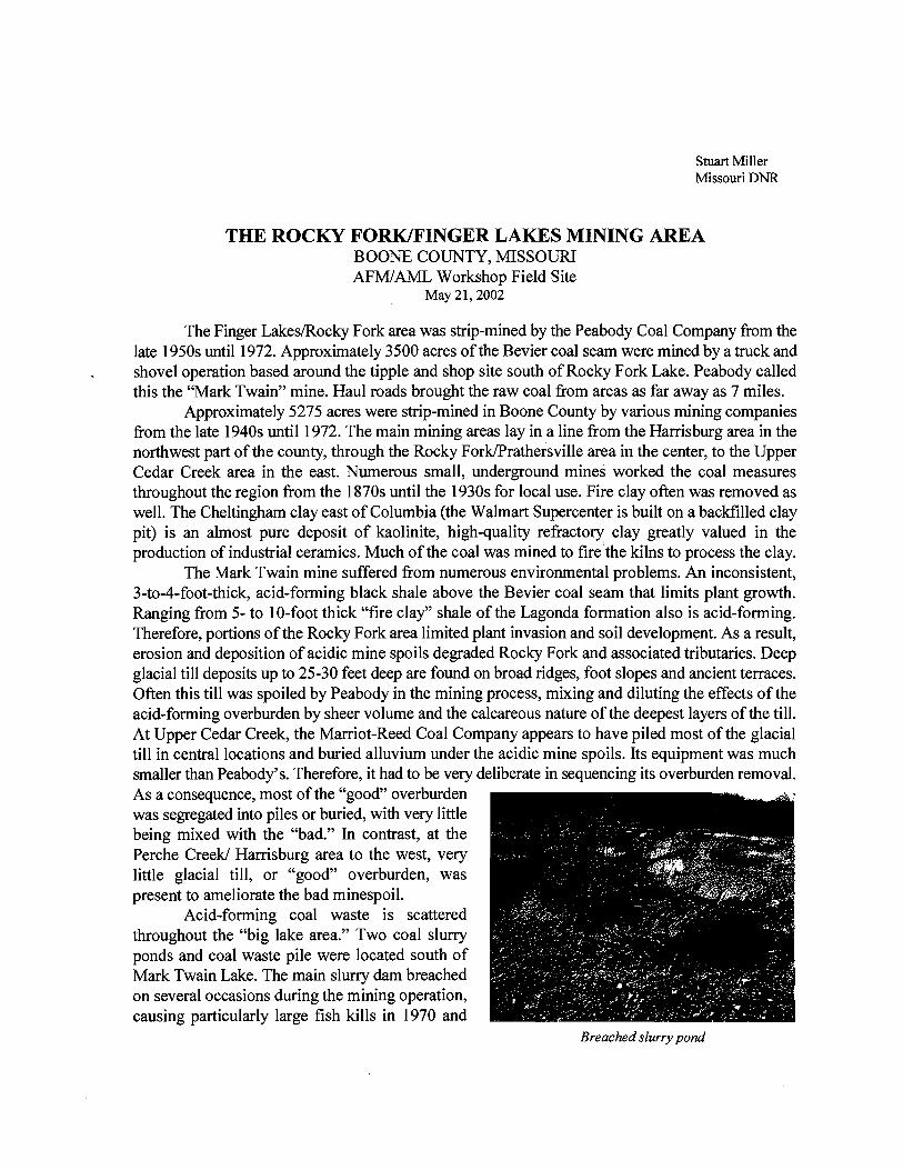
Acid-forming coal waste is scattered throughout the "big lake area." Two coal slurry ponds and coal waste pile were located south of Mark Twain Lake. The main slurry dam breached on several occasions during the mining operation, causing particularly large fish kills in 1970 and
Breached slurry pond

1972. In the rush to close the breach and stop the release of AFM and AMD, the coal company dumped gob into the breach from the pile near the tipple since it was closest and the most easily obtainable fill. Most of the haul roads and railroad sidings were constructed with gob because it compacts well and dries like concrete. Some of the gob and slurry is now uncovered and is once again eroding through a new breach in the dam. Coal slurry was pumped into the bottoms of nearby strip pits when the sluny pond became filled. Much of this slurry remains on the strip pit floors but is now flooded. Near surface groundwater quality is very poor and mineralized. Occasionally, AMD seeps downslope fiom these pits, killing vegetation and degrading surface waters. Acidic seeps and acidified pits are often the legacies of spreading coal slurry throughout the area. The acid pits to the north of the "Big Lake" illustrate the problem.
The coal mining ceased at Mark Twain Mine in 1972. Political pressure was rising against strip mining in Missouri as elsewhere prior to the passage of SMCRA in 1977. Columbia and the
University of Missouri community had a strong and active environmental movement. The Rocky Fork fish kills combined with the Cedar Creek fish kills made Peabody a statewide lightning rod for protest. The close proximity of the state capital to these mining areas, and additional fish kills fiom other coal mining regions around the state, made state lawmakers very aware of the political nature of the problem. In 1971, the Missouri General Assembly passed its first state reclamation law for coal mining. While the "Old Law" reclamation requirements were minimal compared to SMCRA, Peabody management
Eroding gob pile decided to close the Mark Twain Mine rather than comply
with regulation of fbture mining so close to Columbia. Peabody's coal reserves in the area were played out as many landowners decided not to sell their mineral rights. Much of this land was wooded and not actively f m e d , being largely owned by Columbia residents for recreational reasons. The bad publicity and the protests at the mine site were compelling reasons as well to close the mine. Peabody continued to mine in western Missouri until 1987-88.
Several fish kills occurred in the Rocky Fork watershed in the 1960s as a result of coal mining, with 1970 and 1972 as notoriously bad years. The 1970 and 1972 fish kills affected 5 and 3 miles of Rocky Fork Creek respectively. These were dwarfed by the huge fish kills occurring in the same years in the Cedar Creek watershed (the location of Missouri AML7s Upper Cedar Creek, Manacle Creek, and Cross- Mitchell and Tipple reclamation projects). These environmental catastrophes were associated with Erosion ditch exposes root-inhibiting coal Peabody by Columbia media and activists. Throughout waste below the cover saoil. the period, Peabody planted trees and shrubs to stabilize the areas to counter prevailing public opinion. Hence, these plantings account for the large number of introduced tree and shrub species
found on both Finger Lakes and Rocky Fork. The Missouri Old Law required Peabody to reclaim the slurry ponds and coal waste pile by
placing at least two feet of cover and establishing "permanent vegetation." Mine spoil was taken fiom the east, and glacial till and alluvium fiom unmined areas to the west to provide the cover material. In the mid-1980s, the slurry pond once again breached, resulting in erosion of coal waste from the pond and deposition of acidic sediments in the Rocky Fork flood plain. The long-term success of the reclamation is questionable. Much of this work south of Rocky Fork Lake is being "burned out" by acid-forming materials 25 years afterward.
In 1973, Peabody donated 1,100 acres to Missouri State Parks (a division of the Department of Natural Resources), which was named Finger Lakes State Park. It was converted into an off-the- road vehicle facility with 70 miles of "groomed" trails and raceways. The extensive and largely uncounted trails through the mine spoils are easily eroded, causing a huge discharge of sediments into an unnamed tributary of Rocky Fork Creek. Several strip pits have been improved for public use by building new dams, disabled fishing access, boat ramps and swimming beaches. Hunting is not allowed in Missouri state parks. From the mid-1970s into the mid-1980s, the City of Columbia operated a landfill on 109 acres of mine lands donated by Peabody. Today, vegetation is poorly established on the landfill. Columbia owns a 600-acre tract of mined lands 3 miles to the southeast that is being used as a landfill.
In 198 1, Peabody sold 2,024 acres to the Missouri Department of Conservation to create the Rocky Fork Conservation Area. There are 25 large strip pits and lakes totaling more than 200 surface acres of water, with the "Big Lake" being the largest at 50 acres. Fishing, hunting, hiking and target shooting are the main activities, with no vehicles allowed off the public roads. Public use of both Rocky Fork and Finger Lakes is very high due to their proximity to Columbia, the large numbers of strip pits in which to fish, and to the regional motorcycle races held at Finger Lakes.
uwpnrwmc va~cru ~qld rm haan0 moqp rwwa,unovvc ,mnd rma u ~.rrjrr .mu 61~y31po lye UI 1&~00 ~VI 10 CIWWI ax0 'wm WI 01
apwq uwwf 66~6rrwiov'ulu!xl3~0~a!u! Dwurdw x nu Imu puer~w~;~no;arrlr~w~w:wrwpp~ialualuru~wi pun rm%lina
wlwwr 15idW.-r w 0: 4u, Ardar sricriui.rrA,vucafim# +yl
IAX aisvl IFCI SJZH IX;~OSSIW S~OHI~K -110s mnossliv sa0HJ.w 110s lanosslw
c1.m N 10'0 WW~ 3uvd axw:uvs
SKOJ. IKP t'03V3 HO O't SS31 Ild a31wnmv3 a3~vin31~3
tSO-HP3WIWd3 ClUV1.13lV3
*SO-XL-UOOPVd3 a~wm~v3
LC'IJS 0337 3~Sv.4 a3~mn1vs
!'!X'" L'
8't WE 01 E s>.{ II-
O't- 95'9 1e.o *'TI EP'O 1.h
-20199 OW AID NOSMJJar 9LL X08
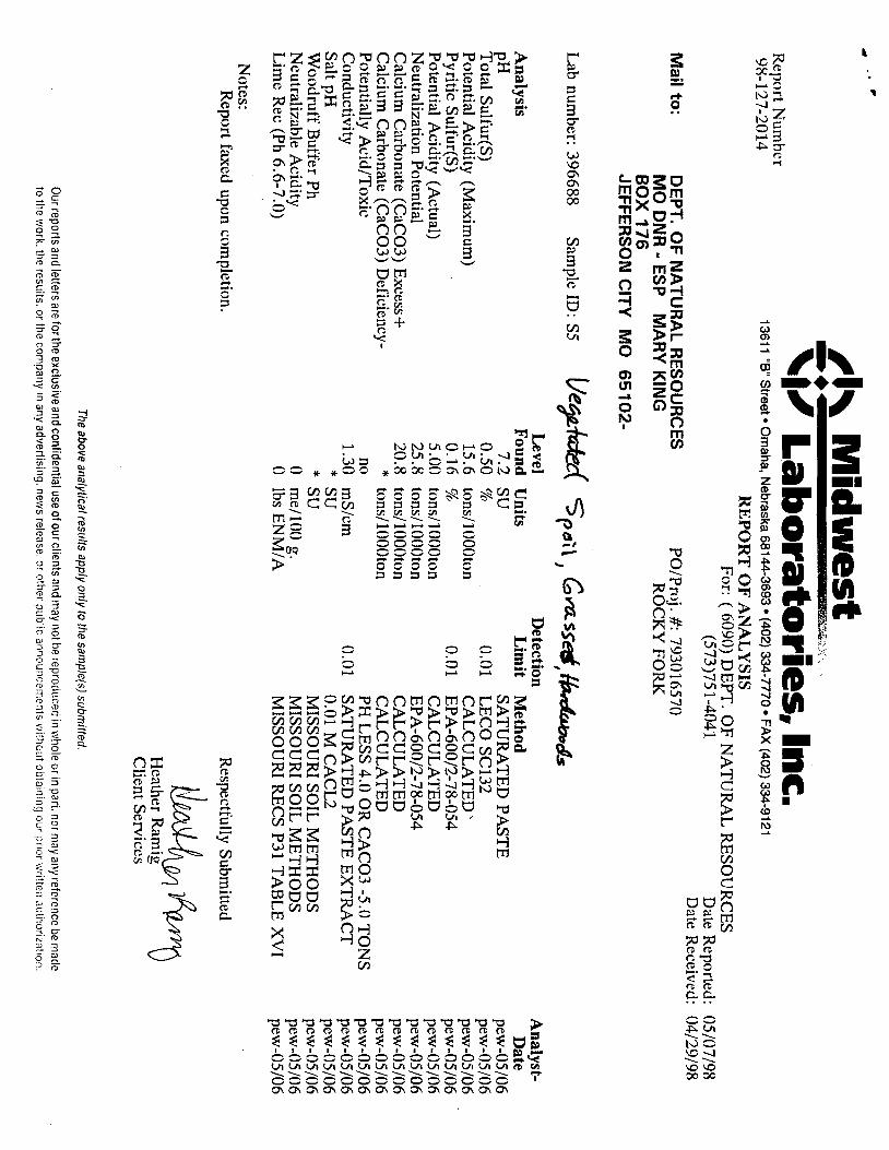
V3UV K3'180Ud XYOJ AX301 DNM ALlW dS3 - tlNa OR ~SS~IIIC~L :# '1n~d:od WXI~OS~LI ~WIUVN 30 'ld3 :4 I!~W
X6IlZitO :p"A!aXH ""a 96jLUisi) :P>uI*IJH Xru I~IIP-I ELICLZ) 7pf/3/: ,$9 S33HnOS3H 1VUIILVX dO 'Id30 ((h0~ J
SISA'IVSV JO LIWB LZLB-DCC lm) XVJ-OUPEE (m).wsw?169 ~WWN WB~YO ~l~0PellS.8. l1WL YlOi-itl-Xf~
JaqUIlIK IJ~X~>~

IAX 3lW.L IFd 5)- MIOSSIR V/WN3 'irll Wf'B (0119'9 9d) -1 JVl saowfi 710s ~IOSSIA '~OOI/Jm II AI!P!JV a~qqpmna~ SaOH13K llOS MlOSSIK 17s h'f 9d '*UW U"Jpocl&
z9m A 10'0 ns o-r ~d 11"s WMILY3 Wd ~UW%IlVS 10'0 WYSLU MI'£ .(l~u~%puOj
SKOl O'P E03V3 10 O't SSII Hd sal >!xnupw l61~enualod auv-~mw3 UOKKY)I/NC~I H'E- -Loq~g~a (£03~3) aleucrqy) wnpp3 au~~w-1~3 ~~YXKII/E~~ . +=ax3 (£035)) amuoqq mnu~r;)
PEO-XL-~OO9-Vd3 ur~nllmol ST- pguqod UO!W~..IEJI~DN axmi~~w3 UWXKII~N~I IE.~ (Imlw) ~PPV ~nuaod
PSO-SL-ZIWVd3 10'0 t 10'0 (S)~IFS TI!J~~ 03-LWa3WJ uam~,%uo~ E'OZ (mnm!re~) io!p!.v PYRJIO~
LEISS 0331 111'0 ?i 59'0 (S)mll"S P'?L 3UVd 09LWIllVS flS IT Hd
31!d 403 E-S :m W~PS
IAX 31~1 IE~ SXRI M~OSSIW V!WK3 IWFIU (u'L++'Y 9d) >J?i JWl S~OW 710s MOSSIW 3 0OllJm Pi dl!F!JY olV!leMaN saoi~zaw -110s ~IIOSSIW ns Y.P 9a JW~ UNI""~
i7~tr3 A 10.0 ns 1.i Hd ales ~7~~3 a~wd a~1wm.v~ 10.0 wxsm oz.6 61 wmpucy)
SKOL 0's- E03V3 10 o'P Hd sa.4 J~~~UPOV A~pnuaoa [IU.V7~3-IV3 U~IoOolPUol Z1- -Kaoa!~!ja~ (C03j) aimople~ inple3 aa1mn3rn o~l0011~w . +wmxq (~03~) aeuuyrc3 mnpm
fSO-BI-Z/UOY-vd3 uUlg(X)lb'J'-I E'8- @!1U310d Uo~!lall3~ a3~v-1ns-m U~I(~~PUOI YWP (len~.w) iip!.v gos sod
851W~-ZdWVd3 10'0 % €1'0 (S)J~?IIW SY!J&I aum~m U~ILUX)I/=OI ['w (mnmnw) Q!P!w ppuaod
ZEISS 0331 10'0 L IP'I (~MJPS lslo~ 31wd ~~LMIIUVS ns z'z ~d
paLjnl~ Z-S :a1 Jlomg; poqraw almll s!~;! ponad
3)-m m QS~~IIV
uot~ma 13*al
\i/ L
ab
ora
torie
s, In
c. 1361 1
"B" S
tree
t O
ma
ha
, Ne
bra
ska 68144-3693
(402) 334-7770 F
AX
(402) 334-9121
RE
PO
RT
OF
AN
AL
YS
IS
Acco~
lnt: A090 D
EP
T. O
F N
AT
UIiA
L R
ES0U
RC
:ES
Pagc: 3
R
eport Num
ber: 98- 127-20 16
Level
Detection
Analvst-
Analysis
Sam
ple ID: S
-4 beg c*ed S
pe
; \ ;Pi aes
r,H
~o
tal S
ulfur(S)
Potential A
cidity (Maxim
um)
Pyritic S
ulfur(S)
Potential A
cidity (Actual)
Neutralizntion Potential
Calcium
Carbonate (C
aC03) E
xcess + C
alcium C
arbonate (CaC
03) Deficiency-
Po tentially AcidIT
oxic C
onductivity S
alt pH
Woodruff B
uffer Ph N
eutralizable Acidity
Lim
e Rec (P
h 6.6-7.0)
Notes:
Report C
axed upon completion.
Found
Units
5.5 su 0.27
%,
8.44 tons/1000ton
0.04 %
1.25
tons/1000ton 4.50
tons/1000ton 3.25
tons/1000ron *
tons/1000ton no
2.30 m
S/cm
5.3 SU
6.6
SU
4
mel100 g.
1,600 lbs E
NM
IA
Lim
it M
ethod ~
it
e
SA
TU
RA
TE
D PA
STE
0.01
LE
CO
SC
132 C
AL
CU
LA
TE
D
0.0 1 E
PA
-600/2-78-054 C
AL
CU
LA
TE
D
EP
A-600/2-78-054
CA
LC
UL
AT
ED
C
AL
CU
LA
TE
D
PH L
ESS 4.0 O
R C
AC
03 -5.0 TO
NS
0.01
SA
TU
RA
TE
D PA
STE
EX
TR
AC
T
0.01 M C
AC
L2
MISSO
UR
I SO
IL M
ET
HO
DS
M
ISSOU
RI S
OIL
ME
TH
OD
S
MISSO
UR
I RE
CS P31 T
AB
LE
XVI
Respectfully S
ubmitted
Heatl~
er Ramig
Client S
ervices
The above analytical results apply only to the sample(s) subm
itted.
Our reports and letters are for the excli~
sive and confidential use of our clients and may not be reproduced in w
hole or in part, nor may any reference be m
ade to the w
ork. the results. or the company in any advertising. new
s release, or other public announce~rlents without obtaining our prior written a
utl~
oriza
tio~
~.
#I\ M
idw
es
t R
elx~
f Number
98-127-2014 1361 1 "8
" Street rn Om
aha, Nebraska 681 44-3693
(402) 334-7770 FA
X (402) 334-91 21
RE
PO
RT
OF
AN
AL
YSIS
For: ( 6090) D
EP
T. O
F N
AT
UR
AL
RE
SOU
RC
ES
(573)75 1-4041 D
ate Reported: 05/07/98
Date R
eceived: 04/29/98
Mail to
: D
EP
T. OF
NA
TUR
AL R
ES
OU
RC
ES
PO
/Pro.j. #: 793016570 M
O D
NR
- ESP M
AR
Y K
ING
R
OC
KY
FOR
K
BO
X 176
JEFFE
RS
ON
CITY
M
O
65
102-
Lab num
ber: 396688 S
ample ID
: S5
Analysis
pH
Total S
ulfur(S)
Potential A
cidity (Maxim
um)
Pyritic S
ulfur(S)
Potential A
cidity (Actual)
Neutralization P
otential C
alcium C
arbonate (CaC
03) Excess +
Calcium
Carbonate (C
aC03) D
eficiency- P
otentially AcidIT
oxic C
onductivity S
alt pH
Woodruff B
uffer Ph N
eutralizable Acidity
Lim
e Rec (Ph 6.6-7.0)
Notes:
Report faxed upon com
pletion.
Pe
pW
sc.t9;
\ , Gassid
, hd
S
Level
Detection
Found U
nits L
imit
Method
7.2 SU
S
AT
UR
AT
ED
PAST
E
0.50 %
0.01
LE
CO
SC
132 15.6
tons/1000ton C
AL
CU
LA
TE
D'
0.16 %,
0.0 1 E
PA-60012-78-054
5.00 tons/1000ton
CA
LC
UL
AT
ED
25.8
tons/1000ton E
PA-60012-78-054
20.8 tons/1000ton
CA
LC
UL
AT
ED
*
tonsl1000ton C
AL
CU
LA
TE
D
no PH
LE
SS 4.0 OR
CA
C03 -5.0 T
ON
S
1.30 m
S/cm
0.01 S
AT
UR
AT
ED
PAST
E E
XT
RA
CT
*
SU
0.01 M C
AC
L2
* SU
MISSO
UR
I SO
IL M
ET
HO
DS
0 m
e/lOO
g. M
ISSOU
RI S
OIL
ME
TH
OD
S 0
lbs EN
M/A
M
ISSOU
RI R
EC
S P31 TA
BL
E X
VI
Respectfully S
ubmitted
Client S
ervices
The above analytical results apply only to the sample(s) subm
itted.
Analyst- D
ate pew
-05/06 pew
-05/06 pew
-05/06 pew
-05/06 pew
-05/06 pew
-05/06 pew
-05/06 pew
-05/06 pew
-05/06 pew
-05/06 pew
-05/06 pew
-05/06 pew
-05/06 pew
-05/06
Our reports and letters are for the exclusive and confidential use of our clients and m
ay not be reproduced in whole or in
pari, nor may any reference be niacle
to the work. tile results. or the com
pany in any advertising. new
s release. or other pilblic anno~!ncel::ents withaiit obtairiing our prior \i'rit!eii
auil?orization.

Rocky Fork Field Exercise May 2 1,2002
In your groups, answer the following questions and develop a reclamation plan for the Rocky Fork Slurry pond and gob pile. Soil data is attached.
Stor, 1 Pond Embankment 1. What is the pH of the ponds? 2. What AFM indicators are present in the embankment? 3. What is the pH of the spoil? 4. What is the pH of the water entering the Big Lake? 5. Are there signs of AMD in the lake? 6 . ' What plants are living on the embankment? 7. What relationships between plants and soil quality can you see? 8. How would your group address these problems? 9. How much lime would you add to neutralize the AFM in the embankment? Are you concerned about water quality of
the ponds and the AMD seepage? How would you address this?
Stor, 2 Slurrv Pond 1. What is killing the vegetation? 2. What AFM indicators are present? 3. What is the pH of the barren material? 4. Does it have a sulfur smell? 5. What is the pH of the vegetated material? 6 . What plants are living on the site? 7. What relationships between plants and soil quality do you see? 8. How does AFM affect the geomorphic stability of this site? 9. What downstream impacts could this problem cause in the future? 10. How would your group address these problems? 1 1. How much lime would you add to neutralize the AFM?
Stor, 3 Gob Pile 1 . What is killing the vegetation? 2. What AFM indicators are present? 3. What is the pH of the barren material? 4. Does it have a sulfur smell? 5. What is the pH of the vegetated material? 6 . How much cover material was placed on site 20+ years ago? 7. What plants are living on the site? 8. What relationships between plants and soil quality do you see? 9. How does AFM affect the geomorphic stability of this site? 10. What is the pH of the pond? 11. Are there fish or aquatic organisms present? 12. Why do you suppose the Missouri Department of Conservation has had to replace the culvert pipe? 13. How would your group address these problems? 14. How much lime would you add to neutralize the AFM? 15. What are the downstream impacts?
General Ouestion What does this preSMCRA, 25 year old site suggest about the potential long-term success of many slurry and gob pile reclamation projects throughout the country?