Embed Size (px)
Citation preview
The Duhamel reef
CREWES Research Report – Volume 7 (1995) 20-1
Duhamel: A seismic analysis of differential compaction ina Leduc reef
R.J. Brown, N.L. Anderson1, D.A. Cederwall2, Z. Sun, P.M. Manning3, and Q.
Zhang
ABSTRACT
The Duhamel reef is an isolated Frasnian limestone bioherm of the Leduc Formationin south-central Alberta. Although Duhamel has a relatively small basal area (less than12 km2), the reef rises some 275 m above the platform facies. The seismic data showwhat we interpret to be a raised peripheral reef rim, which appears to be elevated about25 m relative to the interior of the reef. Raised rims are commonly considered to bediagenetic in origin, and attributed to differential compaction within reef complexes.Although late-stage accretionary growth about the periphery of the reef complex mayhave contributed to its development, we interpret the raised rim at Duhamel to beprincipally of secondary origin. This thesis is supported by the incorporated seismicand well-top data.
The seismic data also suggest that the facies within the reef rim have a lower seismicvelocity than the facies within the structurally lower reef interior, consistent with theobservation that raised rims are generally more porous than the encircled andstructurally lower lagoon and, therefore, constitute a preferred well-completion site.Optimal hydrocarbon recovery could be realized if all producing wells were drilled intothe raised reef rim. Our data for Duhamel show that even relatively small reefs canexhibit raised rims and that these rims may be seismically visible, especially if one canincorporate multicomponent and/or 3-D data. Such data should be acquired prior todrilling across similar reefs with a view to imaging and locating the complete raisedrim, not simply its updip side, so that all parts of the rim can be targeted for the drill.
INTRODUCTION
Within the Frasnian-age Woodbend Group, the Leduc Formation of Alberta (Figures1 to 3) developed as fringing reef complexes, linear chains of reefs, and isolated reefsof various shapes and sizes (Klovan, 1964; Mountjoy, 1980; Stoakes, 1980; Stoakesand Wendte, 1987; Andrews, 1988; Anderson et al., 1989a, b; McNamara andWardlaw, 1991; Switzer et al., 1994). In central Alberta, the Leduc overlies a regionalplatform facies, the Cooking Lake Formation and is encased in the impermeable shalesof the Duvernay and Ireton Formations.
In a study of the isolated Leduc Formation limestone reef complex at Redwater,Mossop (1972) described raised peripheral rims as primarily the result of thedifferential compaction of rigid reef-rim facies and central lagoonal facies. The rigidreef-rim facies are sediments deposited in the high-energy environment about theseaward edge of the reef complex, while the central lagoonal facies are fine-grainedsediments deposited within the encircled and sheltered, relatively low-energyenvironment of the reef interior. Mossop (1972) concluded that, at the time ofdeposition, the interior of Redwater was about 12 m higher than the encircling rim. He
1University of Missouri–Rolla, Rolla, Missouri2Lorrac Energy Ltd., Calgary3Mobil Oil Canada, Calgary
Brown, Anderson, Cederwall, Sun, Manning, and Zhang
20-2 CREWES Research Report – Volume 7 (1995)
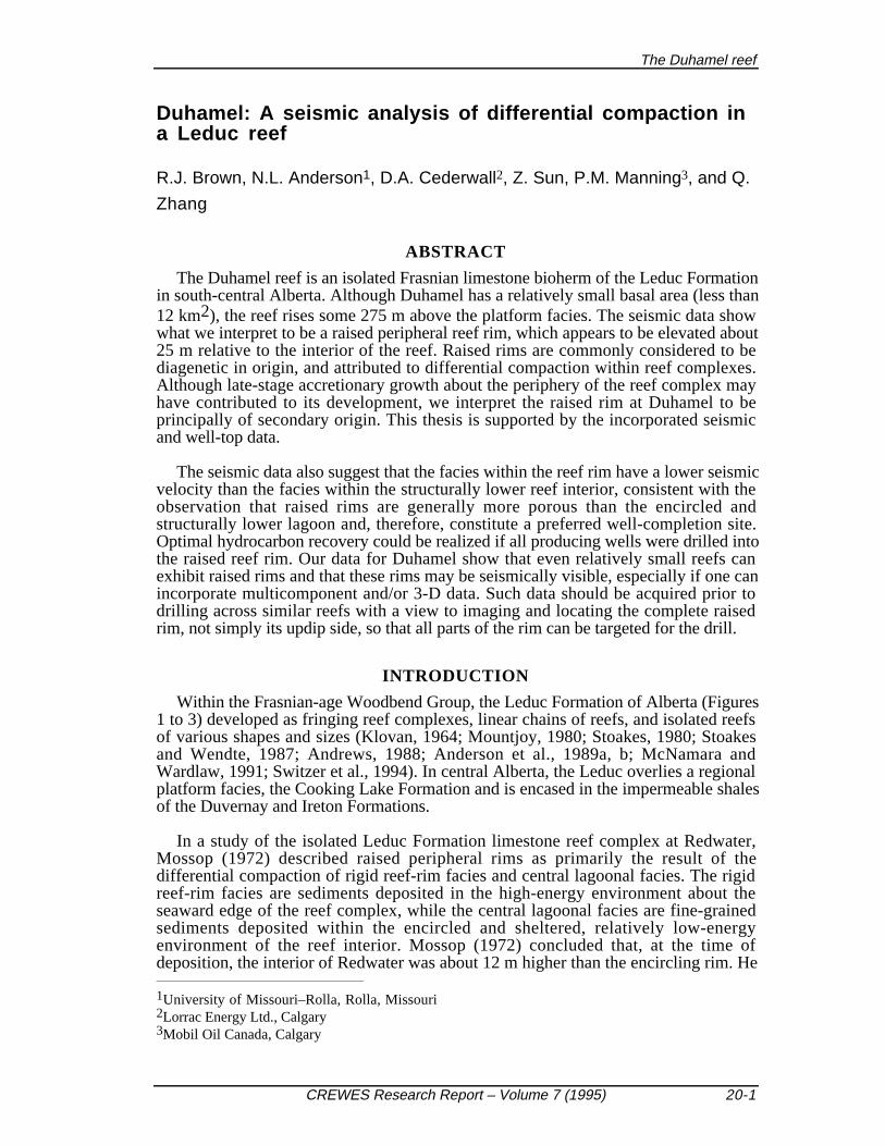
further pointed out that compaction by stylolitization through pressure-solution ofcarbonate mineral matter is an important process resulting in volume loss in carbonaterocks. As a result of such postdepositional differential compaction, the Redwater rim isnow structurally elevated by some 34 m. Mossop estimated that the rigid reef-rim faciesand the interior lagoonal facies were compacted by at least 13% and 24%, respectively.He cautioned that these percentages were likely minimum estimates and that numerousfactors bias their reliability as precise indicators of the amount of carbonate removed.These different values in Mossop's (1972) estimates of compaction are also attributableto the differences in susceptibility to compaction of the rigid reef-rim and interiorlagoonal facies.
Fig. 1. Stratigraphic chart for south-central Alberta (modified after AGAT Laboratories, 1988).
Anderson and Franseen (1991), in a seismic study of a relatively small westernCanadian reef (~1.5 km wide) of the Givetian Elk Point Group, report highercompaction values, 30% and 44% for the rigid reef-rim and interior lagoon,respectively, than for Redwater. They conclude that the raised rim is essentially asecondary compactional feature, characteristic of Devonian Elk Point and Woodbendreefs in western Canada (Anderson and Brown, 1987; Andrews, 1988; Anderson etal., 1989a,b,c; Brown and Anderson, 1991; Brown et al., 1990) and at least partly due
The Duhamel reef
CREWES Research Report – Volume 7 (1995) 20-3
to the cementation or lithification history (early cements being more likely in the reef-rim facies), selective dolomitization (possibly more dolomite in the interior reef area),and/or the presence of relatively more noncarbonate mud (or other insoluble material) inthe reef-interior facies. Anderson and Franseen (1991) acknowledge that the raised rimcould also reflect an original buildup morphology with a margin that wastopographically higher than the interior, possibly due to frame-building organisms andpossibly preserved by submarine cementation.
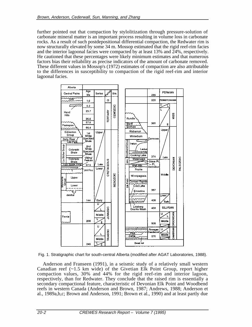
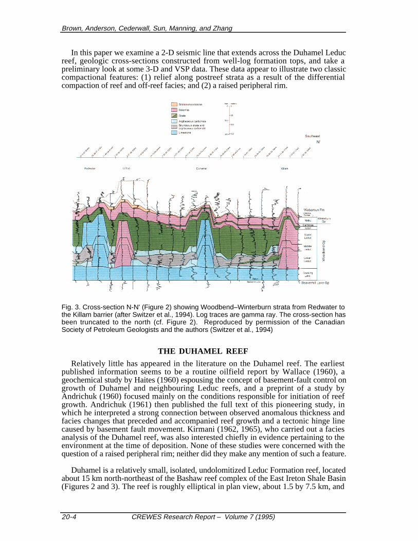
Fig. 2. Distribution of Upper Devonian Woodbend Group (Frasnian) reef complexes,intervening shale basins, oil and gas pools, and line of cross-section N-N' (after Switzer et al.,1994, with input from Andrews, 1988). The map has been truncated to the west (cf. insetkey). Reproduced by permission of the Canadian Society of Petroleum Geologists and theauthors (Switzer et al., 1994)
As a result of differential compaction between the reefal carbonate facies and the off-reef shale facies, overlying strata typically drape across Leduc buildups (Mossop,1972; O'Connor and Gretener, 1974; Wirnkar and Anderson, 1989). The amount ofdrape is a function of the thickness of the overlying sedimentary section and of therelative compactabilities of these reef and off-reef facies through all postdepositionalvolume changes, whether chemical or physical in origin.
Brown, Anderson, Cederwall, Sun, Manning, and Zhang
20-4 CREWES Research Report – Volume 7 (1995)
In this paper we examine a 2-D seismic line that extends across the Duhamel Leducreef, geologic cross-sections constructed from well-log formation tops, and take apreliminary look at some 3-D and VSP data. These data appear to illustrate two classiccompactional features: (1) relief along postreef strata as a result of the differentialcompaction of reef and off-reef facies; and (2) a raised peripheral rim.
Fig. 3. Cross-section N-N' (Figure 2) showing Woodbend–Winterburn strata from Redwater tothe Killam barrier (after Switzer et al., 1994). Log traces are gamma ray. The cross-section hasbeen truncated to the north (cf. Figure 2). Reproduced by permission of the CanadianSociety of Petroleum Geologists and the authors (Switzer et al., 1994)
THE DUHAMEL REEF
Relatively little has appeared in the literature on the Duhamel reef. The earliestpublished information seems to be a routine oilfield report by Wallace (1960), ageochemical study by Haites (1960) espousing the concept of basement-fault control ongrowth of Duhamel and neighbouring Leduc reefs, and a preprint of a study byAndrichuk (1960) focused mainly on the conditions responsible for initiation of reefgrowth. Andrichuk (1961) then published the full text of this pioneering study, inwhich he interpreted a strong connection between observed anomalous thickness andfacies changes that preceded and accompanied reef growth and a tectonic hinge linecaused by basement fault movement. Kirmani (1962, 1965), who carried out a faciesanalysis of the Duhamel reef, was also interested chiefly in evidence pertaining to theenvironment at the time of deposition. None of these studies were concerned with thequestion of a raised peripheral rim; neither did they make any mention of such a feature.
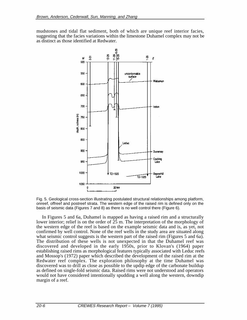
Duhamel is a relatively small, isolated, undolomitized Leduc Formation reef, locatedabout 15 km north-northeast of the Bashaw reef complex of the East Ireton Shale Basin(Figures 2 and 3). The reef is roughly elliptical in plan view, about 1.5 by 7.5 km, and
The Duhamel reef
CREWES Research Report – Volume 7 (1995) 20-5
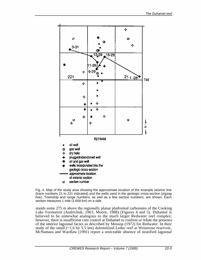
Fig. 4. Map of the study area showing the approximate location of the example seismic line(trace numbers 21 to 221 indicated) and the wells used in the geologic cross-section (zigzagline). Township and range numbers, as well as a few section numbers, are shown. Eachsection measures 1 mile (1.609 km) on a side.
stands some 275 m above the regionally planar platformal carbonates of the CookingLake Formation (Andrichuk, 1961; Moore, 1988) (Figures 4 and 5). Duhamel isbelieved to be somewhat analogous to the much larger Redwater reef complex;however, there is insufficient core control at Duhamel to confirm or refute the presenceof the interior lagoonal facies as described by Mossop (1972) for Redwater. In theirstudy of the small (~1.6 by 5.5 km) dolomitized Leduc reef at Westerose reservoir,McNamara and Wardlaw (1991) report a noticeable absence of stratified lagoonal
Brown, Anderson, Cederwall, Sun, Manning, and Zhang
20-6 CREWES Research Report – Volume 7 (1995)
mudstones and tidal flat sediment, both of which are unique reef interior facies,suggesting that the facies variations within the limestone Duhamel complex may not beas distinct as those identified at Redwater.
Fig. 5. Geological cross-section illustrating postulated structural relationships among platform,onreef, offreef and postreef strata. The western edge of the raised rim is defined only on thebasis of seismic data (Figures 7 and 8) as there is no well control there (Figure 6).
In Figures 5 and 6a, Duhamel is mapped as having a raised rim and a structurallylower interior; relief is on the order of 25 m. The interpretation of the morphology ofthe western edge of the reef is based on the example seismic data and is, as yet, notconfirmed by well control. None of the reef wells in the study area are situated alongwhat seismic control suggests is the western part of the raised rim (Figures 5 and 6a).The distribution of these wells is not unexpected in that the Duhamel reef wasdiscovered and developed in the early 1950s, prior to Klovan's (1964) paperestablishing raised rims as morphological features typically associated with Leduc reefsand Mossop's (1972) paper which described the development of the raised rim at theRedwater reef complex. The exploration philosophy at the time Duhamel wasdiscovered was to drill as close as possible to the updip edge of the carbonate buildupas defined on single-fold seismic data. Raised rims were not understood and operatorswould not have considered intentionally spudding a well along the western, downdipmargin of a reef.
The Duhamel reef
CREWES Research Report – Volume 7 (1995) 20-7
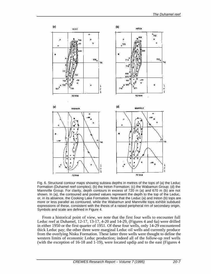
Fig. 6. Structural contour maps showing subsea depths in metres of the tops of (a) the LeducFormation (Duhamel reef complex); (b) the Ireton Formation; (c) the Wabamun Group; (d) theMannville Group. For clarity, depth contours in excess of 720 m (a) and 670 m (b) are notshown. In (a), the contoured and posted values represent the depth to the top of the Leduc,or, in its absence, the Cooking Lake Formation. Note that the Leduc (a) and Ireton (b) tops aremore or less parallel as contoured, while the Wabamun and Mannville tops exhibit subduedexpressions of these, consistent with the thesis of a raised peripheral rim of secondary origin.Symbols and scale are defined in Figure 4.
From a historical point of view, we note that the first four wells to encounter fullLeduc reef at Duhamel, 12-17, 13-17, 4-20 and 14-29, (Figures 4 and 6a) were drilledin either 1950 or the first quarter of 1951. Of these four wells, only 14-29 encounteredthick Leduc pay; the other three were marginal Leduc oil wells and currently producefrom the overlying Nisku Formation. These latter three wells were thought to define thewestern limits of economic Leduc production; indeed all of the follow-up reef wells(with the exception of 16-18 and 1-19), were located updip and to the east (Figures 4
Brown, Anderson, Cederwall, Sun, Manning, and Zhang
20-8 CREWES Research Report – Volume 7 (1995)
and 6). Note that wells 16-18, 1-19 and 8-19 were probably drilled more in order toevaluate land holdings than with high expectations of encountering full Leduc reef.
The top of the Ireton Formation is also about 25 m higher across the raised rim thanabove the reef interior (Figure 6b). The thickness of the Ireton interval is relativelyuniform on-reef, 38 to 44 m, with the exception of a 32-m thickness at the 3-32 well .These relationships suggest that, on the whole, the top of the Duhamel complex wasrelatively planar at the end of Leduc time and that the postulated raised rim is asecondary compactional feature. The slight variations in the thickness of the Iretoninterval could partially reflect the original buildup morphology.
Principally as a consequence of differential compaction between reef and off-reeffacies, overlying strata are draped across the Duhamel complex. In Figure 6, the Ireton,Wabamun and Mannville are shown to be up to 75, 20 and 15 m, respectively, higheron-reef than off-reef. Thus, significantly greater drape is observed below the pre-Cretaceous subcrop, that is, below the Wabamun, than above. This relationship is dueto the erosion of a thick section of upper Paleozoic and Mesozoic strata prior to theonset of Cretaceous deposition. Significant rates of compaction within the WoodbendGroup (which resulted in drape within the Cretaceous section), were not reestablisheduntil the weight of the Cretaceous strata exceeded that of the eroded sediment(O'Connor and Gretener, 1974).
2-D SEISMIC DATA
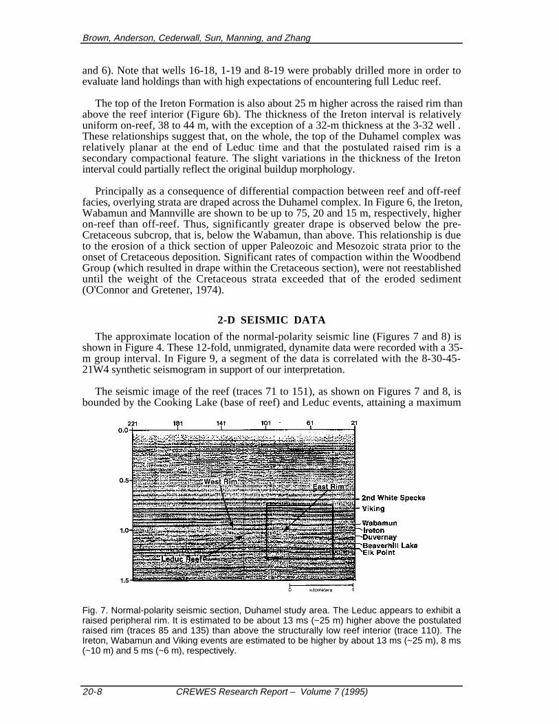
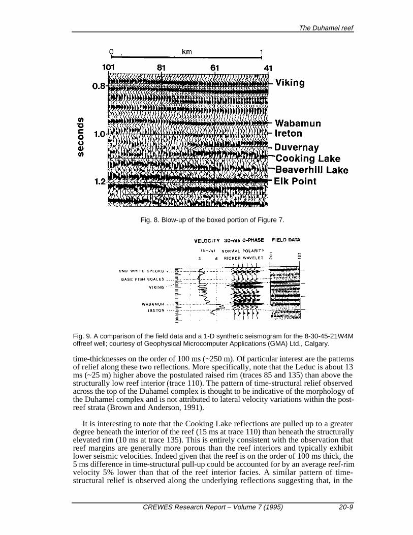
The approximate location of the normal-polarity seismic line (Figures 7 and 8) isshown in Figure 4. These 12-fold, unmigrated, dynamite data were recorded with a 35-m group interval. In Figure 9, a segment of the data is correlated with the 8-30-45-21W4 synthetic seismogram in support of our interpretation.
The seismic image of the reef (traces 71 to 151), as shown on Figures 7 and 8, isbounded by the Cooking Lake (base of reef) and Leduc events, attaining a maximum
Fig. 7. Normal-polarity seismic section, Duhamel study area. The Leduc appears to exhibit araised peripheral rim. It is estimated to be about 13 ms (~25 m) higher above the postulatedraised rim (traces 85 and 135) than above the structurally low reef interior (trace 110). TheIreton, Wabamun and Viking events are estimated to be higher by about 13 ms (~25 m), 8 ms(~10 m) and 5 ms (~6 m), respectively.
The Duhamel reef
CREWES Research Report – Volume 7 (1995) 20-9
Fig. 8. Blow-up of the boxed portion of Figure 7.
Fig. 9. A comparison of the field data and a 1-D synthetic seismogram for the 8-30-45-21W4Moffreef well; courtesy of Geophysical Microcomputer Applications (GMA) Ltd., Calgary.
time-thicknesses on the order of 100 ms (~250 m). Of particular interest are the patternsof relief along these two reflections. More specifically, note that the Leduc is about 13ms (~25 m) higher above the postulated raised rim (traces 85 and 135) than above thestructurally low reef interior (trace 110). The pattern of time-structural relief observedacross the top of the Duhamel complex is thought to be indicative of the morphology ofthe Duhamel complex and is not attributed to lateral velocity variations within the post-reef strata (Brown and Anderson, 1991).
It is interesting to note that the Cooking Lake reflections are pulled up to a greaterdegree beneath the interior of the reef (15 ms at trace 110) than beneath the structurallyelevated rim (10 ms at trace 135). This is entirely consistent with the observation thatreef margins are generally more porous than the reef interiors and typically exhibitlower seismic velocities. Indeed given that the reef is on the order of 100 ms thick, the5 ms difference in time-structural pull-up could be accounted for by an average reef-rimvelocity 5% lower than that of the reef interior facies. A similar pattern of time-structural relief is observed along the underlying reflections suggesting that, in the
Brown, Anderson, Cederwall, Sun, Manning, and Zhang
20-10 CREWES Research Report – Volume 7 (1995)
Duhamel area, the Cooking Lake Formation was relatively planar at the time the Leducwas deposited.
Significant time-structural relief is also observed along post-reef horizons. Forexample, the Ireton, Wabamun and Viking events are up to 40 ms (~75 m), 12 ms (~20m) and 10 ms (~15 m), respectively, higher on-reef than off-reef. The Leduc, Ireton,Wabamun, and Viking are interpreted to be respectively 13 ms (~25 m), 13 ms (~25m), 6 ms (~10 m), and 4 ms (~6 m) higher above the rim than above the interior. Theobservation that the Leduc and Ireton are effectively time-structurally parallel and loweracross the reef interior than above the rim, supports the thesis that the raised rim ismostly a secondary compactional feature. If the rim were mostly a primary feature, theIreton would be thicker and higher across the reef interior. The example seismic datasuggest that on the basis of morphology, Duhamel can be subdivided into a structurallylow interior and an elevated periphery. On the example seismic line, the periphery ofthe reef complex appears to be elevated by about 25 m relative to the interior of the reef.
VSP, CONVERTED-WAVE, AND 3-D SEISMIC DATA
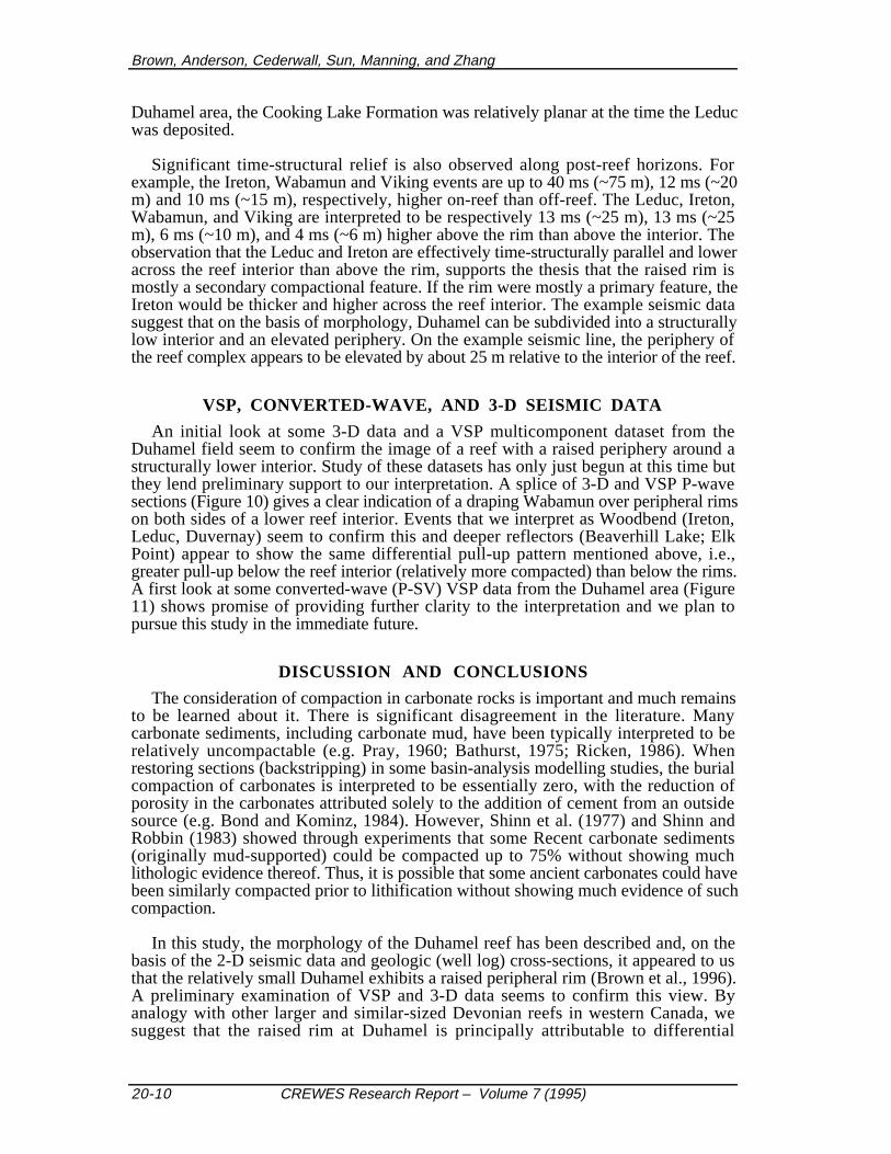
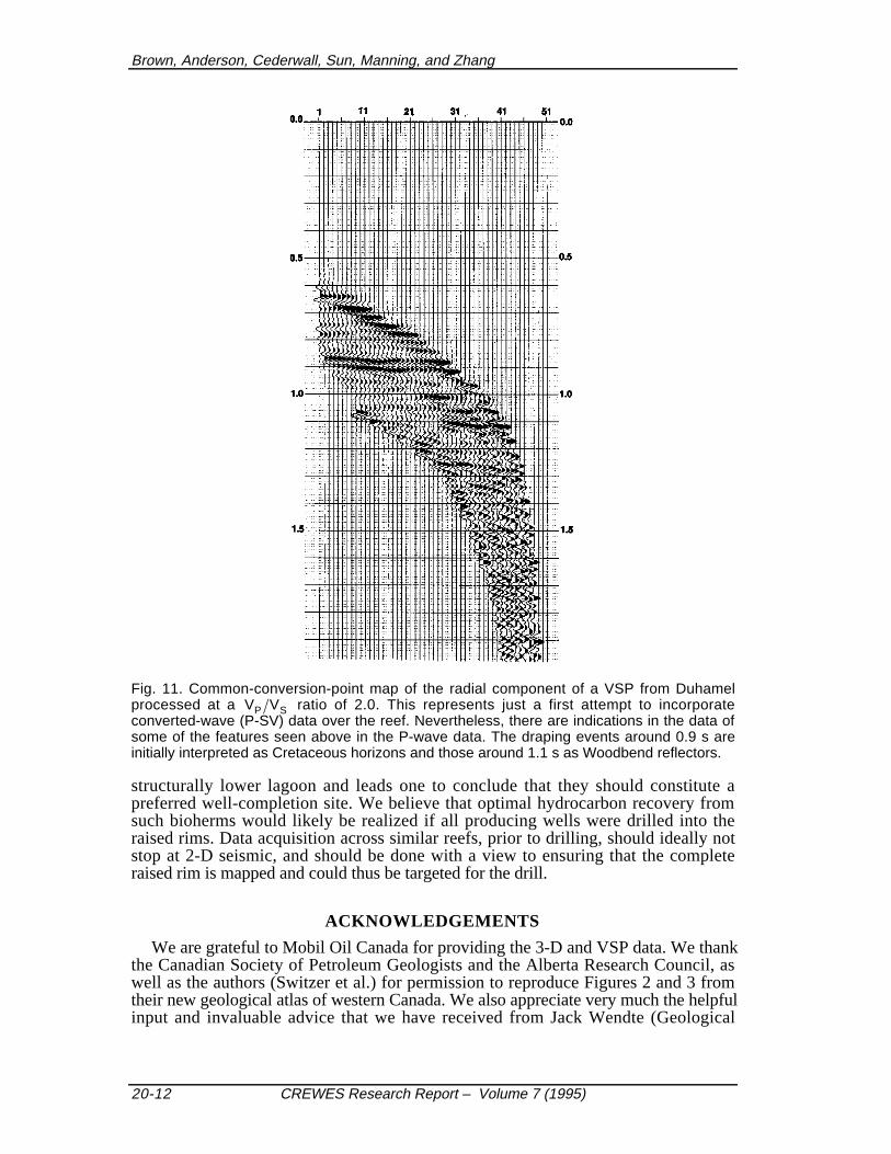
An initial look at some 3-D data and a VSP multicomponent dataset from theDuhamel field seem to confirm the image of a reef with a raised periphery around astructurally lower interior. Study of these datasets has only just begun at this time butthey lend preliminary support to our interpretation. A splice of 3-D and VSP P-wavesections (Figure 10) gives a clear indication of a draping Wabamun over peripheral rimson both sides of a lower reef interior. Events that we interpret as Woodbend (Ireton,Leduc, Duvernay) seem to confirm this and deeper reflectors (Beaverhill Lake; ElkPoint) appear to show the same differential pull-up pattern mentioned above, i.e.,greater pull-up below the reef interior (relatively more compacted) than below the rims.A first look at some converted-wave (P-SV) VSP data from the Duhamel area (Figure11) shows promise of providing further clarity to the interpretation and we plan topursue this study in the immediate future.
DISCUSSION AND CONCLUSIONS
The consideration of compaction in carbonate rocks is important and much remainsto be learned about it. There is significant disagreement in the literature. Manycarbonate sediments, including carbonate mud, have been typically interpreted to berelatively uncompactable (e.g. Pray, 1960; Bathurst, 1975; Ricken, 1986). Whenrestoring sections (backstripping) in some basin-analysis modelling studies, the burialcompaction of carbonates is interpreted to be essentially zero, with the reduction ofporosity in the carbonates attributed solely to the addition of cement from an outsidesource (e.g. Bond and Kominz, 1984). However, Shinn et al. (1977) and Shinn andRobbin (1983) showed through experiments that some Recent carbonate sediments(originally mud-supported) could be compacted up to 75% without showing muchlithologic evidence thereof. Thus, it is possible that some ancient carbonates could havebeen similarly compacted prior to lithification without showing much evidence of suchcompaction.
In this study, the morphology of the Duhamel reef has been described and, on thebasis of the 2-D seismic data and geologic (well log) cross-sections, it appeared to usthat the relatively small Duhamel exhibits a raised peripheral rim (Brown et al., 1996).A preliminary examination of VSP and 3-D data seems to confirm this view. Byanalogy with other larger and similar-sized Devonian reefs in western Canada, wesuggest that the raised rim at Duhamel is principally attributable to differential
The Duhamel reef
CREWES Research Report – Volume 7 (1995) 20-11
compaction of facies within the reef. Other case studies would be desirable in order toadd to our knowledge of what types of carbonates are most susceptible to compactionand to provide more details on the timing and mechanisms of compaction. Our intent isto carry out a more extensive analysis of converted-wave, 3-D and VSP data in order toclarify this interpretation further.
0.5
1.0
1.5
300 100 200100 300 400
Fig. 10. Tie between 3-D (left) and VSP (right) P-wave sections over Duhamel. Seconds areplotted on the vertical axis and metres on the horizontal axis. The strong event just above 1.0s, which we interpret as the Wabamun, appears to drape over peripheral rims on both sides ofthe reef. Woodbend events between 1.0 and 1.1 s also seem to show rims that are higherthan the reef interior. Deeper horizons around 1.2 to 1.3 s (Beaverhill Lake; Elk Point) appearpulled up more below the relatively more compacted reef interior than below the rims.
The seismic data also suggest that the facies within the reef rim have lower seismicvelocities than those within the structurally lower reef interior. This is wholly consistentwith the observation that raised rims are generally more porous than the encircled and
Brown, Anderson, Cederwall, Sun, Manning, and Zhang
20-12 CREWES Research Report – Volume 7 (1995)
Fig. 11. Common-conversion-point map of the radial component of a VSP from Duhamelprocessed at a VP VS ratio of 2.0. This represents just a first attempt to incorporateconverted-wave (P-SV) data over the reef. Nevertheless, there are indications in the data ofsome of the features seen above in the P-wave data. The draping events around 0.9 s areinitially interpreted as Cretaceous horizons and those around 1.1 s as Woodbend reflectors.
structurally lower lagoon and leads one to conclude that they should constitute apreferred well-completion site. We believe that optimal hydrocarbon recovery fromsuch bioherms would likely be realized if all producing wells were drilled into theraised rims. Data acquisition across similar reefs, prior to drilling, should ideally notstop at 2-D seismic, and should be done with a view to ensuring that the completeraised rim is mapped and could thus be targeted for the drill.
ACKNOWLEDGEMENTS
We are grateful to Mobil Oil Canada for providing the 3-D and VSP data. We thankthe Canadian Society of Petroleum Geologists and the Alberta Research Council, aswell as the authors (Switzer et al.) for permission to reproduce Figures 2 and 3 fromtheir new geological atlas of western Canada. We also appreciate very much the helpfulinput and invaluable advice that we have received from Jack Wendte (Geological
The Duhamel reef
CREWES Research Report – Volume 7 (1995) 20-13
Survey of Canada. Finally, we wish to thank the sponsors of the CREWES Project forenabling us to continue this work.
REFERENCES
AGAT Laboratories, 1988, Table of formations of Alberta: AGAT Laboratories, Calgary.Anderson, N.L. and Brown, R.J., 1987, The seismic signatures of some western Canadian Devonian
reefs: Journal of the Canadian Society of Exploration Geophysicists 23, 7–26.Anderson, N.L. and Franseen, E.K., 1991, Differential compaction of Winnipegosis reefs: A seismic
perspective: Geophysics 56, 142–147.Anderson, N.L., Brown, R.J., Gendzwill, D.J., Hinds, R.C. and Lundberg, R.N., 1989a, Elk Point
carbonate reservoirs, in Anderson, N.L., Hills, L.V. and Cederwall, D.A., Eds., Geophysicalatlas of western Canadian hydrocarbon pools: Canadian Society of Exploration Geophysicistsand Canadian Society of Petroleum Geologists, 27-66.
Anderson, N.L., Brown, R.J. and Hinds, R.C., 1989b, Low- and high-relief Leduc formation reefs: Aseismic analysis: Geophysics 54, 1410–1419.
Anderson, N.L., White, D.G. and Hinds, R.C., 1989c, Woodbend Group reservoirs, in Anderson, N.L.,Hills, L.V. and Cederwall, D.A., Eds., Geophysical Atlas of Western Canadian hydrocarbonpools: Canadian Society of Exploration Geophysicists and Canadian Society of PetroleumGeologists, 101-132.
Andrews, G.D., 1988, Devonian Leduc outcrop reef-edge models and their potential seismic expression:in McMillan, N.J., Embry, A.F., and Glass, D.J., Eds., Devonian of the world, Vol. II:Sedimentation: Canadian Society of Petroleum Geologists, Memoir 14, 427-450.
Andrichuk, J.M., 1960, Stratigraphic evidence for tectonic and current control of Upper Devonian reefsedimentation, Duhamel area, Alberta: Frontiers of exploration in Canada, American Societyof Petroleum Geologists and Alberta Society of Petroleum Geologists, Regional Meeting,Preprints of papers,
Andrichuk, J.M., 1961, Stratigraphic evidence for tectonic and current control of Upper Devonian reefsedimentation, Duhamel area, Alberta, Canada: American Society of Petroleum GeologistsBulletin 45, 612-632.
Bathurst, R.G.C., 1975, Carbonate sediments and their diagenesis: Developments in Sedimentology12, Elsevier, 658 pp.
Bond, G.C. and Kominz, M.A., 1984, Construction of tectonic subsidence curves for the earlyPaleozoic miogeocline, southern Canadian Rocky Mountains: Implications for subsidencemechanisms, age of breakup, and crustal thinning: Bulletin of the Geological Society ofAmerica 95, 155-173.
Brown, R.J. and Anderson, N.L., 1991, On the question of lateral velocity variations over Leduc andRainbow reefs: Canadian Journal of Exploration Geophysics 27, 43–52.
Brown, R.J., Anderson, N.L. and Hills, L.V., 1990, Seismic interpretation of Upper Elk Point(Givetian) carbonate reservoirs of western Canada: Geophysical Prospecting 38, 719–736.
Brown, R.J., Anderson, N.L. and Cederwall, D.A., 1996, A seismic analysis of differential compactionin the Frasnian Duhamel reef, south-central Alberta: Computers & Geosciences 22 (in press).
Haites, T.B., 1960, Transcurrent faults in western Canada: Alberta Society of Petroleum GeologistsJournal 8, 33-78.
Kirmani, K-U., 1962, The Duhamel reef, Alberta: M.Sc. thesis, University of Alberta.Kirmani, K-U., 1965, The Duhamel reef, Alberta (abstract): Bulletin of Canadian Petroleum Geology
13, 451-452.Klovan, J.E., 1964, Facies analysis of the Redwater reef complex, Alberta, Canada: Bulletin of
Canadian Petroleum Geology 12, 1-100.McNamara, L.B. and Wardlaw, N.C., 1991, Geological and statistical description of the Westerose
reservoir, Alberta: Bulletin of Canadian Petroleum Geology 39, 332-351.Moore, P.F., 1988, Devonian reefs in Canada and some adjacent areas, in Geldsetzer, H.H.J., James,
N.P. and Tebbutt, G.E., Eds., Reefs, Canada and adjacent areas: Canadian Society ofPetroleum Geologists, Memoir 13, 367-390.
Mossop, G.D., 1972, Origin of the peripheral rim, Redwater reef, Alberta: Bulletin of CanadianPetroleum Geology 20, 238-280.
Mountjoy, E., 1980, Some questions about the development of Upper Devonian carbonate buildups(reefs), western Canada: Bulletin of Canadian Petroleum Geology 28, 315-344.
Brown, Anderson, Cederwall, Sun, Manning, and Zhang
20-14 CREWES Research Report – Volume 7 (1995)
O'Connor, M.J. and Gretener, P.E., 1974, Differential compaction within the Woodbend Group ofcentral Alberta: Bulletin of Canadian Petroleum Geology 22, 269-304.
Pray, L.C., 1960, Compaction in calcilutites (abstract): Bulletin of the Geological Society of America71, 1946.
Ricken, W., 1986, Diagenetic bedding: A model for marl-limestone alternations: Lecture Notes inEarth Sciences, Springer-Verlag, 210 pp.
Shinn, E.A. and Robbin, D.M., 1983, Mechanical and chemical compaction in fine-grained shallow-water limestones: Journal of Sedimentary Petrology 53, 595-618.
Shinn, E.A, Halley, R.B., Hudson, J.H. and Lidz, B.H., 1977, Limestone compaction: An enigma:Geology 5, 21-24
Stoakes, F.A., 1980, Nature and control of shale basin fill and its effect on reef growth andtermination: Upper Devonian Duvernay and Ireton formations of Alberta, Canada: Bulletin ofCanadian Petroleum Geology 28, 345-410.
Stoakes, F.A. and Wendte, J.C., 1987, The Woodbend Group, in Krause, F.F. and Burrowes, O.G.,Eds., Devonian lithofacies and reservoir styles in Alberta: Second International Symposiumon the Devonian System, 153-170.
Switzer, S.B., Holland, W.G., Christie, D.S., Graf, G.C., Hedinger, A.S., McAuley, R.J.,Wierzbicki, R.A., and Packard, J.J., 1994, Devonian Woodbend–Winterburn strata of theWestern Canada Sedimentary Basin, in Mossop, G.D. and Shetsen, I., Eds., Geological atlasof the Western Canada Sedimentary Basin: Canadian Society of Petroleum Geologists andAlberta Research Council, 165-202.
Wallace, K.A., 1960, Duhamel field, in White, R.J., ed., Oil fields of Alberta: Alberta Society ofPetroleum Geologists, 94-97.
Wirnkar, F.T. and Anderson, N.L., 1989, Seismic analysis of the differential compaction of reef andoff-reef sediments: 59th Annual International Meeting, Society of Exploration Geophysicists,Expanded Abstracts, 888-890.