Embed Size (px)
Citation preview
Photo: Christopher T. Martin
Inman Park / Reynoldstown MARTA
TRAIL MAPSEXPLORE THE ATLANTA BELTLINE
EASTSIDE TRAIL
QUICK FACTS
The Eastside Trail is 2 miles in length from 10th Street & Monroe Drive to Irwin Street.
The Northeast Hiking Trail is 1 mile in length from 10th Street, north to Montgomery Ferry Rd.
Connects Piedmont Park, Atlanta Botanical Garden, Historic Fourth Ward Park, the Stone Mountain Trail, and Freedom Park.
The southern extension, between Irwin Street and Kirkwood Avenue, is under construction through 2017.
To learn more, scan the QR code below or visit:beltline.org/trails
For an interactive map of the entire Atlanta BeltLine, please visit: beltline.org/maps
Atlanta BeltLine Partnership112 Krog Street, Suite 14
Atlanta, GA 30307404.446.4404
Atlanta BeltLine, Inc.100 Peachtree Street NW, Suite 2300Atlanta, GA 30303 404.477.3003 // beltline.org
Get up-close and personal with The Atlanta BeltLine – sign up for a tour today!
Whether you enjoy riding, walking, or biking, we have tour options to suit your interests. Read more about our Bus Tours, Arboretum Walking Tours, and Bike Tours at: beltline.org/tours
And, for more information on how to plan your visit, download our “On the Atlanta BeltLine” mobile app on the App Store or Google Play.
TOURS & MORE...
Beecher Rd
LIONEL HAMPTONNATURE PRESERVE
Lion
el H
ampt
on T
rail
Westwood Ave
Rogers Ave
WESTVIEW CEMETERY
BeecherHillsElem.
Bollingbrook Dr
Beecher CirFlamingo DrW
ills
Mill
Dr
West LakeMARTA
Fleetwood Cir
S. G
ordo
n St
Wes
tmea
th D
r
Stokes Ave McA
llist
er S
t
Derry Ave
Peep
les St
URBANFARM
WestEnd MARTA
Ashby MARTA
WASHINGTON PARK
Peep
les
St
Ralph David Abernathy Blvd
Oakland CityMARTA
Greenwich St
Mus
e St
Lucile Ave
Westview Dr
Jose
ph E
. Low
ery
Blvd
W. O
ntar
io A
ve
E. O
ntar
io A
ve
S. Gordon St
ROSE CIRCLEPARK
BROWNMIDDLESCHOOL
Lawto
n St
Lang
horn
St
White StDonnelly Ave
Oakl
and
Dr
Sylv
an R
d
Oak St
Harwell St
Lena St
Mur
phy
Ave
Catherine St
ADAIR PARK I
MURPHY CROSSING
Lionel H ampton Trail
Avon Ave
Hold
erne
ss S
tStaff
ord S
t
Chic
mau
ga A
ve
Martin Luther King, Jr. Blvd
Burb
ank
Dr
Ollie
St
Fount
ain Dr
Staf
ford
St
W. Fair St
MOZLEY PARK
Mat
thew
son
Pl
DISCOVER A NEW WAY
FORWARDUsing a 33-mile network of multi-use
trails, the Atlanta BeltLine is creating a new
public realm – offering a pedestrian-friendly
environment which promotes walking, jogging,
biking, and affordable housing. In its final
phases, it will include a 22-mile continuous
corridor, as well as numerous other extensions
that link to many of Atlanta’s existing parks
and trails. Though currently still in the
development phase, there are many trail
segments and parks to explore.
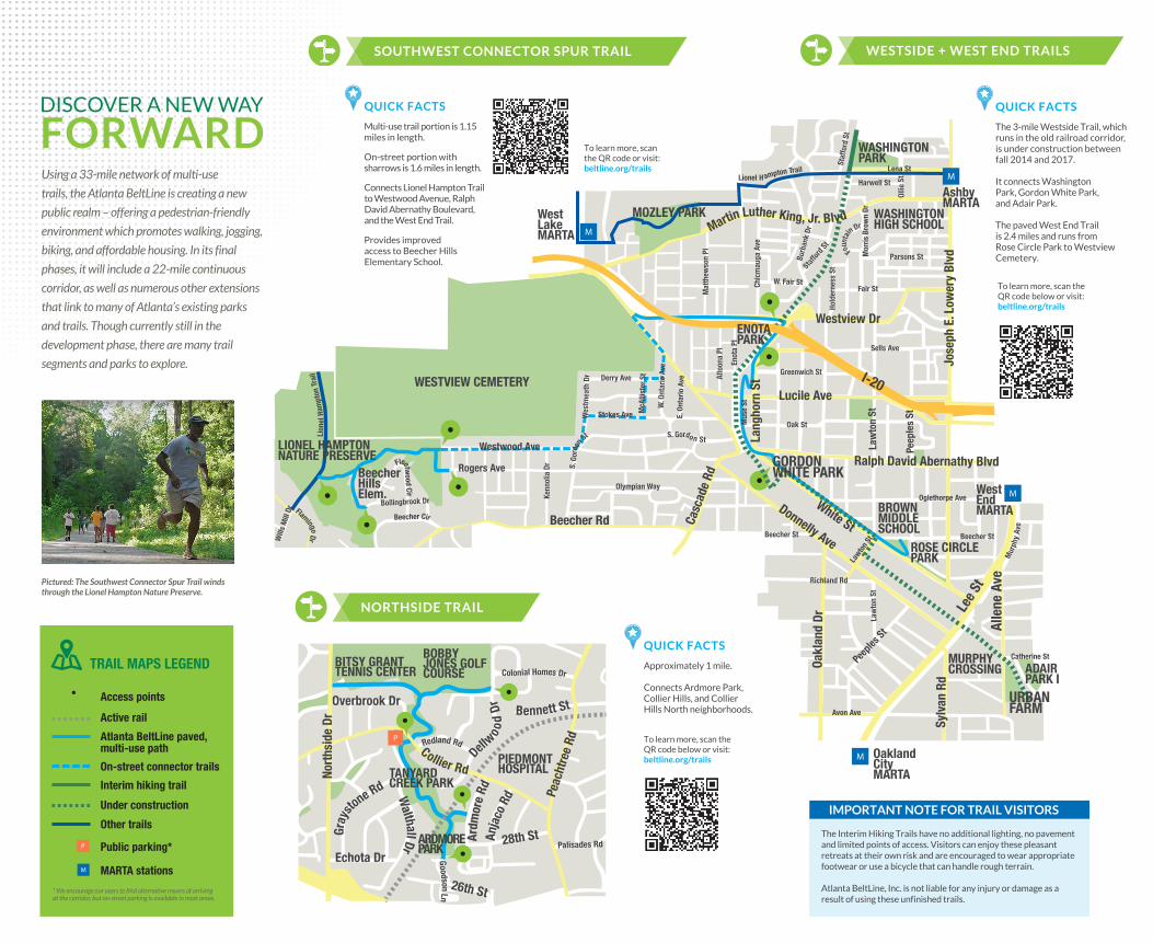
WESTSIDE + WEST END TRAILSSOUTHWEST CONNECTOR SPUR TRAIL
NORTHSIDE TRAIL
Sells Ave
Fair St
Mor
ris B
row
n Dr WASHINGTON
HIGH SCHOOL
Parsons St
Law
ton
St
Beecher St
Richland Rd
Law
ton
St
Beecher St
Oglethorpe AveOlympian Way
Kenn
olia
Dr
Enot
a Pl
Alto
ona
Pl
ENOTAPARK
Casc
ade
Rd
QUICK FACTS
The 3-mile Westside Trail, which runs in the old railroad corridor, is under construction between fall 2014 and 2017.
It connects Washington Park, Gordon White Park, and Adair Park.
The paved West End Trail is 2.4 miles and runs from Rose Circle Park to Westview Cemetery.
To learn more, scan the QR code below or visit:beltline.org/trails
To learn more, scan the QR code below or visit:beltline.org/trails
QUICK FACTS
Approximately 1 mile.
Connects Ardmore Park, Collier Hills, and Collier Hills North neighborhoods.
To learn more, scan the QR code or visit:beltline.org/trails
QUICK FACTS
Multi-use trail portion is 1.15 miles in length.
On-street portion with sharrows is 1.6 miles in length.
Connects Lionel Hampton Trail to Westwood Avenue, Ralph David Abernathy Boulevard, and the West End Trail.
Provides improved access to Beecher Hills Elementary School.
TRAIL MAPS LEGEND
* We encourage our users to find alternative means of arrivingat the corridor, but on-street parking is available in most areas.
Active rail
Access points
Atlanta BeltLine paved, multi-use path
Interim hiking trail
Under construction
Other trails
On-street connector trails
Public parking*
MARTA stations
IMPORTANT NOTE FOR TRAIL VISITORS
The Interim Hiking Trails have no additional lighting, no pavement and limited points of access. Visitors can enjoy these pleasant retreats at their own risk and are encouraged to wear appropriate footwear or use a bicycle that can handle rough terrain.
Atlanta BeltLine, Inc. is not liable for any injury or damage as a result of using these unfinished trails.
Pictured: The Southwest Connector Spur Trail winds through the Lionel Hampton Nature Preserve.