Embed Size (px)
Citation preview

European Journal of Geography Volume 5, Number 1:8 -31 March 2014 ©Association of European Geographers
EDGE EFFECTS AND EXTERIOR INFLUENCES ON BUKIT TIMAH FOREST, SINGAPORE
Kalyani CHATTERJEA National Institute of Education, Nanyang Technological University
Singapore, 1, Nanyang Walk Singapore 637616
www.nie.edu.sg [email protected]
Abstract
Bukit Timah Nature Reserve in Singapore, a 163 sq km lowland tropical rainforest, is surrounded by dense urban residential development. The forest peripheral areas are characterized by open, concrete-covered surfaces of car parks, high-rise buildings, and wide highways. Although some areas around the peripheries are covered with buffer vegetation, the forest interior environment is influenced by the non-forested landcovers around. This research investigates four specific factors, such as atmospheric temperature, relative humidity, soil temperature, and wind velocities in the interior forests, buffer areas as well as the forest boundaries. The aim is to ascertain the degree of changes in these factors due to landcover changes and also to determine the extent of influences these exert on the forest interiors. Steep gradients of environmental changes across the forest have been established and several hot spots with intense alterations of environment have been demarcated, although the forest interiors still retain the original microclimatic conditions of a typical rainforest. Such assessments are useful in efforts to manage and maintain forest interior integrity.
Key words: Forest boundary environment, Forest micro-climate, Edge effects, Edge-interior relationships, Forest buffer zone , Forest fragmentation
1. INTRODUCTION
Bukit Timah forest, a designated nature reserve, is the only remnant primary tropical rainforest in Singapore. Located about 12 kms from the city centre, in the midst of a high density urban residential area, the forest is, however, under constant threat from encroaching development. Major highways have severed the forest from a larger forest body, fragmenting it to a small area (Chatterjea, 2007). Much of the landuse in the surrounding areas of the forest have been drastically altered through urban residential and infrastructural development, while high-rise buildings have been constructed within walking distance from the forest edges. Such encroachments have given rise to a wide belt of non-forested environment in the near vicinity of the forest boundary. In some places, with little or no buffer area, the forest
European Journal of Geography - ISSN 1792-1341 © All rights reserved 8
Chatterjea K./European Journal of Geography 5 1 8-31
comes close to main arterial roads and residential developments. This puts the interior stands at risk of being permanently affected.
While the issue has been raised earlier (Chatterjea, 2006, 2007), there is an urgent need to measure and analyze the actual dimension of the problem and the extent of the impact within the forest. This paper looks at the latest environmental data measured from both peripheral and interior segments of the forest and analyzes the degree of possible impact of the surrounding urban development on the forest micro-climate and the pattern of change from outside to the forest interior. Such assessments are important in demarcating areas of potential hazard. This may be useful in managing the forest to maintain its integrity in the face of steep competition for space in an increasingly urbanizing situation. Results of measurements and observations can be used to plan the forest management while maintaining its role as a nature park without affecting the aspirations and demands of the growing population in the area.
2. BACKGROUND OF BUKIT TIMAH FOREST AS A NATURE RESERVE
Since the British colonization of the island of Singapore in 1819, then a thickly vegetated undisturbed low-land tropical rainforest, nature conservation and expansion of human settlement have gone through much change. After the initial clearance of forests, efforts to conserve parts of the forested areas started to evolve. In 1951 legal protection was given to Bukit Timah, Pandan, Labrador and the water catchment areas. When Singapore became independent in1965, there were five nature reserves in all (Wee & Corlett, 1986). Till the 90’s nature conservation was a mere governmental task to maintain the forested areas of the island.
In 1990 National Parks Board was established to plan, develop and manage parks and greenery in Singapore. By then the demand on land had sky-rocketed and so had the changes in the lifestyles of the people. Bukit Timah Nature Reserve (BTNR) and Central Catchment were declared as nature reserves. This started a journey towards a more organized management of the remnant forest segments in the island. As Wee and Hale (2008) mention, while in 1965 total area under protection was 1,940 ha, pressure of land resulted in release of some areas such as Pandan, Kranji and even some outlying pockets of the Central Water Catchment were slated for development.
The boundaries of BTNR have undergone extensive changes since independence. Scattered wooded areas, small orchards, low-rise rural residential structures, low-impact food processing industries have been replaced by high-density residential areas in the past fifty years of urban development. In 1985 a section of the forested corridor between Central Catchment and Bukit Timah Nature Reserve had given way to development of transport infrastructure, to build Bukit Timah Expressway (BKE) connecting the north to the south of the island. This delivered a major blow to the nature conservation efforts in Singapore. While severe dissection was created by the North-South running expressway through the heart of the central forested area, some surrounding buffer areas of mixed vegetation were brought under some protection and the area under the now-truncated Bukit Timah Nature Reserve (BTNR) was actually enlarged from 75 hectares to around 163 ha. But the competition for land did not stop there and surrounding areas continued to be under threat of development. High-rise residential developments rapidly closed in on the forest boundaries when this area was slated to be a condominium belt and several condominiums have been developed even within walking distance of the forest boundaries (Chatterjea, 2012), housing several thousands of residents and more importantly, introducing non-forested environments, such as
European Journal of Geography - ISSN 1792-1341 © All rights reserved 9

Chatterjea K./European Journal of Geography 5 1 8-31
car parks, concrete-covered walkways, grass-covered lawns, concrete high-rise buildings with high radiation potentials and high light intensities, close to the forest boundaries.
In addition to this change in landuse, more major expressways and wide multi-lane roads continue to take up much of the peripheral areas. A water pipeline, along with the usual cleared forested segment run along one margin of the forest, though recently, the Malayan Railway line, previously running along another boundary of the forest, has stopped operating, and track areas have, so far, been left to get naturally revegetated. This has released a linear break to the non-forested environment, though the revegetated areas are not similar to the original forest cover yet. But the overall impact of the landuse change in the area around the forest, that has the only primary rainforest of the island, has generally led to increased open spaces, concrete-covered car parks, concrete vertical surfaces of high-rise buildings, all with high potentials of increasing heat radiation, lowering relative humidity, increasing incidences of blasts of strong wind.
Designation of the surrounding areas as a condominium belt, sharp increase in the number of people living in high-rise apartments over the decades, a very hectic urban lifestyle, increasing interests in outdoor activities, more emphasis in experiential learning in schools all concertedly led to sharp rise in interests in nature. Nature areas in Singapore suddenly were forced out of their earlier secluded and almost obscure existence. More than 12 km of forest trails on fairly steep slopes (25-30°) are laid down to make inroads into previously unchartered forest segments and these were classified according to the degree of difficulty to cater to an increasing number of visitors who frequent the forest for strenuous physical exercise. Some 6 km of mountain bike trails are laid out along the outer peripheries of the forest to ensure that bikers stay away from locations where visitors on foot frequent. Some facilities are created for school educational groups to study nature first-hand and most importantly, car parks are kept free to ensure that visitors are not unhappy with the new state of things at this very important and frequently visited forest. Development of high-rise residential buildings with densely spaced apartment blocks have mushroomed close to the forest, some within 200m from the main entrance and ownerships to such developments are usually 100%. With all these, along with the heavy network of roads and public transport infrastructure, annual visitorship to BTNR alone has seen figures as high as 400,000 and that does not include many who visit the forests from undesignated entrances and those who frequent the forest for the sheer exhilaration of mountain biking on the steep slopes at the forest outer edges. Chatterjea (2007) has recorded the adverse effects of such high turnovers on the forest interior surface conditions and on the resultant alteration of forest hydrology during the frequent rainy episodes.
This paper looks at the trend of development around the BTNR in the recent decade and the changes these new developments have already made to the forest’s original conditions, both in terms of the forest interior micro-climate as well as to the gradient of transition from the non-forested outer boundaries, through the buffer areas to the core forest. Objectives of this research are to:
a. Assess the changes in specific environmental parameters, constituting the interior and exterior micro-climate in and around BTNR, as well as changes to the soil temperature to establish the impact of such peripheral interferences on the characteristics of the forest.
b. Assess the extent of the impacted areas through detailed mapping of the impacted locations within the forest and along the forest boundaries, to delineate areas of different grades of impact. This will provide resource for effective management, through landuse planning.
European Journal of Geography - ISSN 1792-1341 © All rights reserved 10
Chatterjea K./European Journal of Geography 5 1 8-31
While more intensive studies are in the pipeline, the preliminary study suggests a significant trend of alteration and several hotspots emerge at the boundaries, creating hazardous pockets that need to be looked into, to ameliorate some of the adverse effects of rapid and intensive development around this forest.
3.SOME RELEVANT STUDIES ON THREATS FACING URBAN FORESTS
Isolation of forests due to landuse change and land conversions is considered to be the biggest threat to biodiversity (Collinge, 1996). The degree of such a threat is dependent on the extent of the break between fragments and the surrounding habitats. The newly created forest fringes experience changes in micro-climatic conditions which may have significant effects on the forest interior and on the forest inhabitants in the long run. While the size of the habitat fragment influences the degree of such changes, with larger impacts faced by smaller fragments, the nature of the edges influence the degree of changes. According to many researchers, landuse change is responsible for loss of native species, invasion of exotic species, pronounced soil erosion, and decreased water quality and collectively severely affects the integrity of ecological systems (Harris, 1984; Forman and Godron, 1986; Wilcove et al., 1986; Hunter, 1990; Bierregaard et al., 1992).
In the research on relationships between the natural resources, ecosystem functions, and ecosystem services, Tobias (2013) conceptualized a model of inter-relationships and dependences among the various factors within the forest, such as air, water, soil, biodiversity with the processes and the resultant services. The inter-connections of the operations emphasize and explain the complex processes and services within a forest. Thus it may be assumed that any change in any of the resources mentioned in the model (such as air, water or soil) will have some significant impact on the environment and thus lead to some visible alterations of the created environment.
In Tobias’ (2013) model, the socio-cultural services of ecosystems, particularly in an urban setting, are essential for human well-being, recreation, and sense of spatial association. Demand for such services is increasing and putting pressure on the forested areas. While other amenities such as easy access and proximity to infrastructure still are the main criteria influencing people’s choice of where to live, landscape amenities increasingly become more important (Vogt and Marans 2004). Numerous studies demonstrate that the availability of sunny and quiet places, with open view of natural landscape features, particularly open bodies of water, or of urban parks and traditional buildings, lead to higher housing prices (Schaerer et al. 2008; Waltert and Schläpfer 2010). An increasing number of people are settling in such attractive places on the fringes of nature areas, leading to encroaching or enveloping fragmentation of urban forests.
One direct result of this will be urban sprawl, which is listed as a major impact factor in biodiversity degradation by Gayton (2007). Two measurements were considered in the research done by Gayton (2007), (i) population density in the vicinity, and (ii) the amount of impermeable surfaces such as buildings, paved streets, carpark lots. Such landuse alterations bring about drastic changes to the surrounding environment and emphasize the importance of managing the forest peripheries, so that the forest interiors are protected from this rapidly expanding non-forested landuse.
One impact of such urban expansion is the ‘Edge effect’ phenomenon. Expansions of non-forested landuse around the forest usually increase the length of the border between fragments and their surrounding habitats. Murcia (1995) mentions that, because of the dominant vertical structure of forests, removal of vegetation from an area results in dramatic changes in the structural characteristics of the habitat. There are increases in light penetration
European Journal of Geography - ISSN 1792-1341 © All rights reserved 11
Chatterjea K./European Journal of Geography 5 1 8-31
at the edge of a forest fragment than in the forest interior. As a result, temperature increases and relative humidity decreases at the forest edge. Wind velocities are higher at the edge than in the interior of the forest (Harris, 1984). Ghosh (2004) also commented that edge effect can include elevated wind turbulence and temperature variability, lateral light penetration and reduced humidity (Ghosh, 2004). There are changes in soil moisture as well and collectively these may lead to alteration of the growth environment of the forest at the edges. Temperature ranges in tropical forested areas have been recorded to be around 25.7° C with a mean monthly range of 1.7° C. (Pendry and Proctor, 1996; Dykes, 2000).
The altered environment around the forest presents an environment in sharp contrast to the closed, low-light, wind deficient, and perpetually high humidity conditions of the forest interior. In addition, in the absence of any well-established buffer area, forest interiors are at risk of being in direct contact with urban landuse, without the benefit of having any transition areas. Thus the core forested areas are left to lie within short distances of the drastically modified environments, causing an expected high intrusion of fluctuating and extreme non-forest environment all around the forest.
Much research has been carried out to establish that fragmentation usually has adverse effects on the biological as well as the environmental conditions of native forest interiors and the degree of such impact can be substantial to endanger the original characteristics of the forest. Microclimatic changes, pedological changes as well as biomass changes are well-documented for forests in different parts of the world (Beer and Fox, 1997; Gehlhausen et al. 2000; Ghose, 2004). Gradients of change in abiotic and biotic environments seem to extend inwards from the forest edges. In deciduous forest patches of Wisconsin, USA, micro-environmental changes were estimated to extend at least 15 m from the forest edge to the interior (Ranney et al., 1981). Studies in old-growth forest remnants in Indiana, USA, recorded significant increases in light levels and temperature, and a significant decrease in humidity at the forest/ field edge (Brothers and Spingam, 1992). These microclimatic differences extended till 8m into the forest for the studied 8-23 ha forest fragments.
But humidity and leaf litter moisture continued to change for 50m into the forest interior. Increased wind velocities at the forest edge may also lead to increased incidences of treefall, especially for shallow-rooted tropical trees. Studies in a remnant 10 ha forest patch in Brazil recorded an overwhelming number of tree mortality along the windward margin (Lovejoy et al., 1984; Bierregaard et al., 1992). The annual rate estimated was 2.6% at the edges while it was only 1.5% for continuous forest. Several other studies on edge effects have also shown that the zone of impact penetrate more than 50 m (Chen et al., 1995; Didham and Lawton, 1999; Davies-Colley et al., 2000; Herbst et al., 2007), depending on forest structure and the meteorological variable in question.
All these studies point to the need to assign peripheral areas which can be used as a transition zone where drastic changes in environments can be controlled through management, so that forest interiors are less impacted. Collinge (1996) discussed design and planning proposals for an array of landscape management interventions aimed at preserving and enhancing biological diversity, minimizing soil erosion and sedimentation, and reducing exotic species invasions (Thome et al., 1991; Knaapen et al., 1992; Federowick, 1993; Sauer, 1993; Rodiek and DelGuidice, 1994; Carr et al., 1994; Yahner et al., 1995).
These peripheral areas surrounding the remnant forests and demarcating the change in landuse from forested to urban is often referred to as the ‘Buffer’ region. This area is significant in terms of its services in maintaining forest characteristics. Collinge (1996) comments that adjacent habitats, landuse management regimes, nature and intensity of human activities in the boundary areas, can all influence the boundary conditions and its vulnerability to degradation. Research has been done on the issue of buffer zones and their contributions towards maintaining the integrity of the forest interior environment (Martino, European Journal of Geography - ISSN 1792-1341 © All rights reserved 12
Chatterjea K./European Journal of Geography 5 1 8-31
2001). Two major thoughts are (i) buffer zones are extensions of the natural forests and (ii) buffer zones are areas outside the forest where community services are provided through space for recreation, education, and other such activities. Whether the surrounding zone is an extension of the existing forest patch or a land area that allows social interactions with the natural environment, it essentially creates a boundary around the forest interior that reduces the impact of the drastically altered surroundings. Therefore, with both these notions, buffer areas are the intermediate areas where forest and non-forest environments have a zone of transition which may, through proper handling, protect forest interiors from impact of use by the population around.
Generally, in larger forests the buffer areas, covering a large area may reduce the ill effects of extreme boundary conditions. However, BTNR being a small forest with a total area of only about 163ha does not have that protection. Edge effect can extend to forest interiors and cause changes in both abiotic and biotic environment. This may result in loss of natural rainforest conditions and ultimately make the habitat unsuitable and unsustainable for the original ecosystem. Research shows that edge effects can have an unexpected and large effect on biomass accumulation in tropical forest trees. While interior conditions generally remain stable, edge areas have been seen to lose 1-2% biomass per year (Laurance et al. 1997) and such vegetational effects are detectable at least 10-30m inside from the forest edge. As Bukit Timah Nature Reserve is a small forest, such inroads of inhospitable conditions may alter the original forest conditions irrevocably.
If existing research on related conditions are summed up, there is conscientious that small urban forests are in danger of losing their original conditions and characteristics due to high demands of land from urban development and human use of land. Such exposures of formerly forested sections to these environmental changes not only affect the outer boundaries but tend to extend inwards, thus affecting larger areas of forest. Peripheral sections, termed ‘Buffer areas’ seem to lend a transition to these changes, as well as can be used to offer social and community services such as recreation, education, so that the forest interior is spared from intensive intrusions of human influences. This is significant for managing small urban forests such as BTNR.
The case of Bukit Timah forest is of major importance in the Singapore context, as this small fragmented forest is the last remnant of primary tropical rainforest in the island and is home to many indigenous species of flora and fauna and as such, has a significant position in the conservation map of Singapore. According to a Smithsonian Institution study, a 2-ha plot at Bukit Timah Nature Reserve consists of 15,000 trees of 312 species (Smithsonian Tropical Research Institute, 2005), which underlines the health and diversity of the forest. It has been classified as a nature reserve, for conserving indigenous forest species. Conservation of the natural forest environment at BTNR is of primary importance in view of the recent spate of extension of urban landscapes around the forest, leading to concerns that such development may actually cause irreversible damage to the forest.
4.METHODOLOGY
So far no studies have been done on changes in the forest environment as a result of the intensive urban development around BTNR. Some preliminary data collected from BTNR boundaries points to significant changes in the forest boundary environmental parameters (Chatterjea, 2012). Environmental gradients are significantly steep from periphery to the forest interior, which can be detrimental to the sustainability of the forest interior conditions, as well as to the boundary vegetation, buffering the forest interior. This change in environmental conditions and extent of influence of 8-15m into the forest is already observed
European Journal of Geography - ISSN 1792-1341 © All rights reserved 13

Chatterjea K./European Journal of Geography 5 1 8-31
in deciduous forests, as mentioned by researchers (Ranney et al., 1981; Brothers and Spingam, 1992). As Collinge (1996) mentions, the nature of the boundaries influence the profile of these gradients and different edges may experience different degrees of change. For the present research, data was collected to examine the extent of impact created by the large-scale change in the surrounding land cover due to heavy build-up of high-rise residential areas, wide roads, and open spaces around the peripheries of BTNR. Figure 1 shows the range of factors that affect the forest environment and the various parameters that are measured and analyzed in this research.
Figure 1. The parameters measured, observed, and analyzed in the research
(on the left are factors that affect the forest conditions, on the right are factors that are altered)
To establish the magnitude of changes resulting from altered landscapes, measurements were taken for various aspects and these are explained in Table 1 below:
European Journal of Geography - ISSN 1792-1341 © All rights reserved 14

Chatterjea K./European Journal of Geography 5 1 8-31
Table 1. Field data collected to record environmental conditions in and around BTNR
Type of observation/ survey/ measurement
Objective Source
Landuse map To establish the existing landuse pattern, infrastructural distribution, landcover characteristics To select measurement sites for environmental data collection
Google Earth, topographic maps, maps generated from field surveys
Environmental data on air temperature, relative humidity, soil temperature, and wind velocity
To record status of these parameters across different sections of the forest, including forest interior sections as well as along the different types of landuse/ landcovers. To investigate the pattern of distribution of each of these parameters, to examine the presence of any hot spots To establish the gradients of change of each of these parameters from outside peripheral areas to the forest interiors: to establish the range and extent of influence of the surrounding landcover on the forest interior microclimate
Three sets of on-site field data collected from a total of 700 locations (259 in forest interiors, 132 in forest buffers, and 309 at locations along the forest boundaries) Data were all collected between 9am and 12 noon, but on different dates, with similar clear and dry weather conditions, for different sets of data
Environmental data was collected from sites in and around the forest, as shown in Fig. 2 below:
European Journal of Geography - ISSN 1792-1341 © All rights reserved 15

Chatterjea K./European Journal of Geography 5 1 8-31
Figure. 2: Location of all field sites
There are a total of 700 sites for data collection, so far. In all, three sets of data have so far been collected between Feb 2012 and Feb 2013. These data sets are used to establish the characteristic environmental conditions in and around the forest in BTNR. Several transects are drawn across the locations from peripheral urban built-up areas to interior forests and also along drastic changes in land cover, such as from major highways to forest interiors (Fig. 2). These show the degree of changes encountered across changes in landuse. The data is analyzed to locate zones of major impact, as well as the magnitudes of such impact. The data also demarcates discreet zones of interior forest environment, for the first time. These demarcations are aimed at providing management tools for maintaining the forest environment.
The field data was used for calculations of environmental gradients and locations of impacts, if any. Subsequently, isolines and various other maps were generated using ArcGIS and mGeo (a mobile application on iPad called mGeo, developed by author: Chatterjea, 2012). to examine the pattern of environmental parametric changes along various lines of interest. Data for this research is part of an ongoing bigger study on the environmental changes around the BTNR and the current report is based on the pilot surveys conducted to establish locations for further examination.
Bukit Timah Nature Reserve Data points (n=700)
All Data points March 2012, May 2012,
and Feb 2013
European Journal of Geography - ISSN 1792-1341 © All rights reserved 16

Chatterjea K./European Journal of Geography 5 1 8-31
5. DATA ANALYSIS
Field data collected from 700 locations are analyzed to establish the existing conditions on the various landcover types ranging from interior forest (FI), forest buffer (FB) areas, as well as open exterior locations (OE), typically in open, paved car parks, construction sites, metalled roads of varying widths. The data is used to examine the degrees of difference between contrasting landcovers and also to demarcate areas of high, medium and low impact of landcover change within and around the forest. Parameters looked at are atmospheric temperature, relative humidity, soil temperature, and wind velocities in and around forested sections, along major road networks around the forest, and on open, concrete-covered surfaces of car parks and construction sites. Isolines have been drawn, based on measured values and distributions of relevant parameters are then used to demarcate zones of impact and their grades. Table 3 below gives details of the data recorded.
Table 3. Data of various parameters from different sections of landcover types
Land use type Atmospheric temperature (°C)
Relative humidity (%)
Soil temperature (°C)
Wind speed (m/s)
FI Interior Forest (n=259) Maximum 29.5 94.10 30.0 1.80 Minimum 24.5 77.10 22.0 0.0
FB Forest Buffer (n=132)
Maximum 34.7 97.3 36 0.9 Minimum 27.6 58.5 26 0.7
OE Highway (BKE) (n=70)
Maximum 33.0 92.7 34.0 5.3 Minimum 28.8 64.2 27.5
Major Roads (n=109)
Maximum 34.0 92.7 35.0 5.7 Minimum 29.0 64.2 27.5
Dairy Farm Road (n=70)
Maximum 34.2 88.5 35.0 5.7 Minimum 30.3 68.2 30.5
Condominium (Completed) (n=20)
Maximum 37.0 85.3 NA 2.3 Minimum 30.0 60.6 NA
Condominium (Under construction) (n=20)
Maximum 37.0 73.2 37.0 2.3 Minimum 32.1 60.6 29.5 0.3
Car Park (n=20) Maximum 37.8 72.5 38.0 1.9 Minimum 31.3 57.3 30.5 0.4
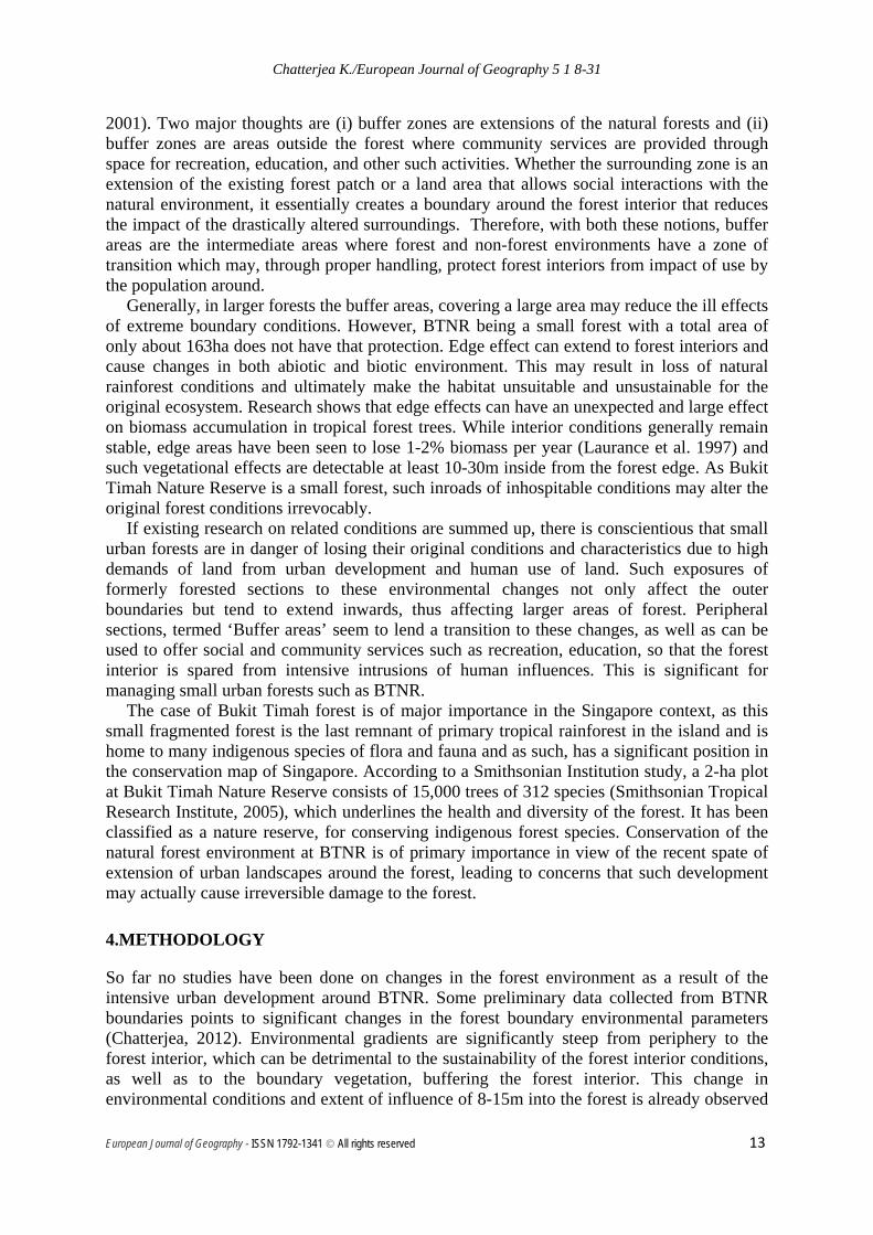
5.1 Temperature distribution Temperature distributions in and around the forest show a very close relationship with the landcover, with sharp increases from inner forest locations to outside along all major roads and highways (Fig 3).
European Journal of Geography - ISSN 1792-1341 © All rights reserved 17
Chatterjea K./European Journal of Geography 5 1 8-31
Figure. 3. Isotherm map, based on temperature readings at BTNR (n=700)
Day-time temperature data from 259 sites within the inner forested areas ranges from 24.5-29.5° C, which is quite characteristic of tropical forest interiors such as BTNR. Temperature, however, rises to a high of 37.8° C in areas with concrete cover at constructions sites as well as along major expressways outside the forest boundaries (n=309). Mean temperatures in forest interior and exterior boundaries showed a difference of 7.3° C (Table 4) and this was taken as the key parametric criterion to examine areas of boundary influences in and around the forest. Table 4 shows the temperatures observed and the changes recorded along selected transects drawn across forested to open, exterior boundary areas. There is a mean increase in air temperature of 7.3° C from inside to outside the forest boundaries.
Table 4A gives the rates of change along certain locations and it is evident that the sharpest change occurs along the boundary of the forest with the major highway (BKE), while rates of change are negligible across the interior forest sections. This exemplifies the drastic environmental gradients faced by forest peripheral areas when such drastic alterations are made due to urbanization so close to forest boundaries. Figure 6 shows the temperature changes along transects and clearly defines areas of high impacts, which invariably lie along major roads such as the 8-lane high way (BKE) as well as the major 4-lane dual carriageway (Dairy Farm Road) and the adjacent construction site and concrete paved car park.
Zone I
Zone IV
Zone V
Zone III
Zone II
European Journal of Geography - ISSN 1792-1341 © All rights reserved 18

Chatterjea K./European Journal of Geography 5 1 8-31
Table 4. Temperature changes in the various study sites in forested and open exterior areas
A. Maximum, Minimum and Range of temperature changes temperature recorded Forest
Interior (FI) n=259
Forest Buffer (FB) n= 132
Open Exterior (OE) n=309
Transect I
Transect II
Transect III
Transect IV
Transect V
Maximum temperature (deg C)
28 28.1 37.8 33.5 34 37.8 33.5 28
Minimum temperature (deg C)
24.5 31 32.2 29.5 29 29 28.5 24.5
Mean temperature (deg C)
26 29 33.3 - - - - -
Range (deg C) Mean from FI to OE= 7.3 deg C 4 5 8.8 5 3.5
B. Pattern of Temperature change in different sections of the study locations
Locations Ranges observed (deg C change per meter distance) From FI to BKE (recorded across 62 m distance) (Transect I)
0.065
From FI to Dairy Farm Road (recorded across 300m distance) (Transect II)
0.03
From forest margin along Dairy Farm Road to paved carpark, construction site (recorded across 500m distance) (Transect III)
0.03
From FI to Rifle Range Road (recorded across 180m distance) (Transect IV)
0.03
Inside forest interior (recorded across 1300m) (Transect V)
0.0002
The highest temperature ranges are observed at Zone I (Fig. 3), a difference of 4° C within a space of only 62 m over land. The same trend is observed along all road margins (Table 4B), confirming that steep environmental gradients are characteristic of areas that are exposed to highways and open concrete covered surfaces. Specifically, highways/ wider roads, car park surfaces demonstrated significantly higher temperature gradients than narrower roads, and this is in line with previous research which showed that the road width is a significant factor in determining microclimate given the variance in road edge effect (Nyandwi, 2008). Some comparisons can be drawn among the data recorded along major roads and it is observed that not only are the atmospheric temperatures along these stretches of landcovers high, but the surface temperatures on concrete surfaces and radiation temperatures are very high (Table 5).
European Journal of Geography - ISSN 1792-1341 © All rights reserved 19

Chatterjea K./European Journal of Geography 5 1 8-31
Table 5. Recorded maximum, minimum and mean temperatures along major roads and road surfaces around BTNR
(Maximum values are highlighted) Dairy
Farm Road
Condominium (Completed)
Condominium (under
construction)
Car Park
Atmospheric Temperature
(°C)
Maximum 34.2 37.0 37.0 37.80 Minimum 30.3 30.0 32.1 31.3
Range 3.9 7.0 4.9 6.5 Concrete surface
temperature (°C)
Maximum 38.5 39.0 39.0 45.0 Minimum 30.5 31.0 35.0 33.5
Range 8 8.0 4.0 11.5 Radiation
temperature (°C)
Maximum 35.2 35.7 35.7 38.2 Minimum 30.8 29.9 29.9 31.8
Range 4.4 5.8 5.8 6.4
Based on data recorded across the all types of landcovers, e.g., forest interior areas (FI), forest boundary buffer vegetated areas (FB), and the open exterior concrete-covered/ metalled areas (OE), ANOVA tests are done and the results show very clearly that there is statistically significant difference (F= < .0005) among the three types of landcover in terms of temperatures recorded (Table 6). This is evident in raw data as well, as the highest temperatures recorded on car parks, construction sites, and roads show an increase of 9.3°C from the forest interiors and such increases are consistent around the entire forest boundary.
Table 6. ANOVA for temperatures recorded in the three categories of landcover: Forest Interior, Forest Buffer, and Open Exterior OE
Descriptives
Temperature
N Mean Std. Deviation
Std. Error
95% Confidence Interval for Mean
Minimum Maximum
Lower Bound Upper Bound
FI 107 26.0850 .92255 .08919 25.9082 26.2619 24.50 27.50
FB 107 29.0299 .64064 .06193 28.9071 29.1527 28.10 31.00
OE 107 33.2776 1.00511 .09717 33.0849 33.4702 32.20 37.80
Total 321 29.4642 3.08158 .17200 29.1258 29.8026 24.50 37.80
ANOVA
Temperature
Sum of Squares df Mean Square F Sig.
Between Groups 2797.951 2 1398.976 1847.434 .000
Within Groups 240.807 318 .757
Total 3038.758 320
European Journal of Geography - ISSN 1792-1341 © All rights reserved 20
Chatterjea K./European Journal of Geography 5 1 8-31
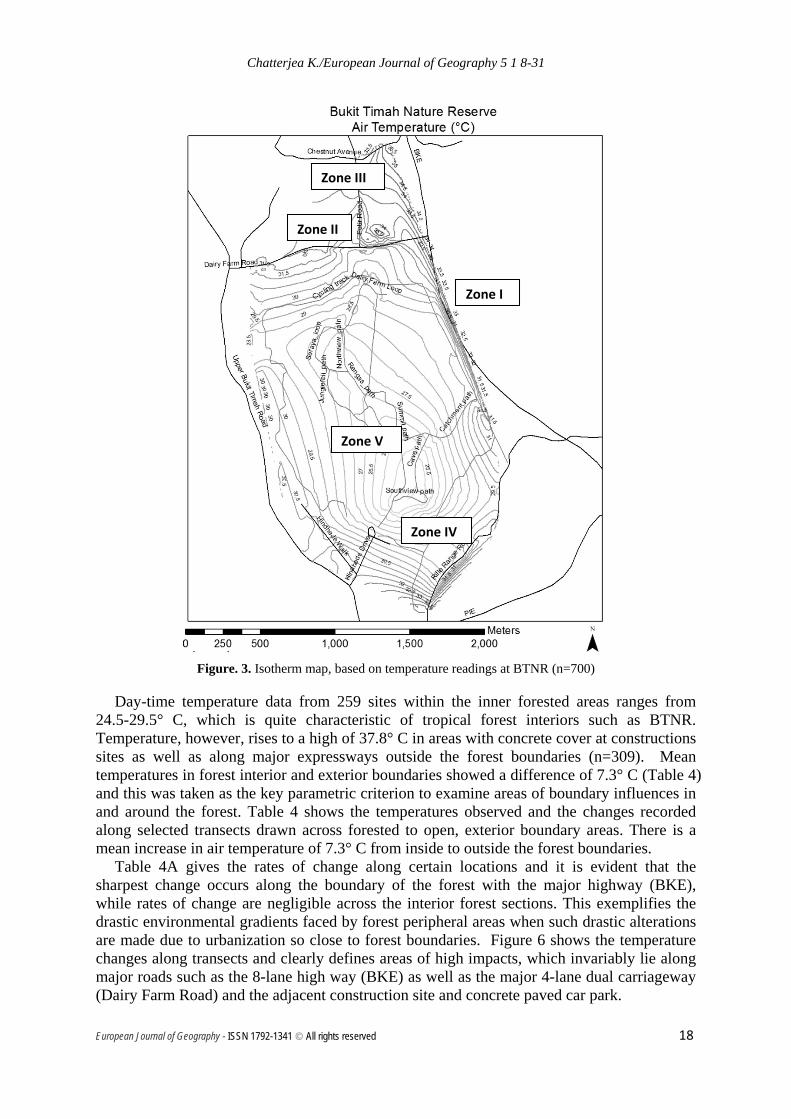
Since temperature differences across the various parts of the forest and forest exterior sections are significant, a classification of landcover categories is drawn up based on recorded temperature data and this is shown in Table 7.
Table 7. Categories of landcovers, based on observed temperature readings recorded from 700 locations
Field locations Descriptions # of data sites
Forest interior and interior trail area (Forest interior or FI)
(24.5 – 28 Deg C)
Areas in the interior forest 155
Forest Buffer area (FB) (28.1 – 31 Deg C)
Areas at the edge of the forest covered by some vegetation (trees, shrubs, grass)
227
Forest outer boundary impacted area (Open Exterior or OE)
(> 31 Deg C)
Areas located along major highways, major roads, at concrete-covered car parks, at
construction sites around the forest boundaries
311
With this classification, the areas in and around BTNR are mapped to ascertain extent of area impacted by the boundary landcover changes (Fig. 4).
Zone Zone 1 (FI) Low/ No impact zone
Zone II (FB) Medium impact zone
Zone III (OE) High impact zone
Area covered 0.6355 km2 1.5581 km2
2.103 km2
Fig. 4. Map of zones FI, FB, and OE and the respective areal extent of each zone
Some studies on edge effects on forest interior environments established that edge effects of boundary changes are reflected in forest interior microclimate up to a distance of 25-30 meters from the edge of the forest and that beyond that the microclimatic conditions are European Journal of Geography - ISSN 1792-1341 © All rights reserved 21

Chatterjea K./European Journal of Geography 5 1 8-31
similar to forest interiors (Pohlman et al, 2007; Goosem, 2007; Laurence et al, 2008), though Laurence et al (2002) observed that in tropical Australia, forests within 50-100m of edges with linear clearings experience greater diurnal fluctuations in light, temperature and humidity, with edges being drier, hotter than forest interiors.
In the present study gradients of change in atmospheric temperature were steep for as far as 60 m into the forest in places where expressways ran close to the forest edge. At boundaries with narrower roads the gradient was much gentler, while it became very gradual inside the forest, indicating that edge effects are different at different types of interfaces (Table 4B), reiterating Pohlman et al’s (2007) and Laurence et al’s (2007) observation that edge effects varied with edge types, with wider linear breaks such as expressways imposing more intense impacts than narrower linear breaks with over-hanging vegetation covers. The seasonal variations observed by Pohlman et al (2007) are not relevant in Singapore, because of its humid tropical climate and small annual variations in climatic conditions.
Figure 4 shows the computed areas that will fall under each of the landcover categories, if the current format of classification is used and this shows an alarming reduction in the area under forest interior environment. Impact of exterior open landcover (OE) stretches as much as 700 m inside along some boundaries, leaving a very thin linear zone as buffer forest to protect the inner forest from external adverse impacts.
5.2 Relative humidity distribution
Effects of the peripheral changes in landcover on the relative humidity (RH) values both inside and at the forest boundary areas were also recorded at the same locations where atmospheric temperatures were measured (Table 3: n=700). Figure 5 shows the isohume map of the study area. Similar to the temperature distributions, isohume map also shows the same forest interior location to have the highest RH values (77-94%), while it dips to lows of 52.2% on some OE sections of the study area, along expressways.
Figure 5. Isohume map of study area showing distribution of RH
European Journal of Geography - ISSN 1792-1341 © All rights reserved 22

Chatterjea K./European Journal of Geography 5 1 8-31
T-Test performed on the RH values suggests that the differences between the FI sites and the OE sites are statistically significant (Table 8). The observations given below clearly shows that the outer boundaries are exposed not just to higher temperatures, as seen earlier, but also to much drier conditions, with a significantly high drop in RH (average of 20%).
Table 8. Statistical analysis of RH values measured in BTNR
• t(306)=36.02, p<.000, d=115.94
• The forest interior (M =89.01, SD=2.08) has (on average) significantly higher RH than the forest exterior (M = 69.13, SD = 6.53).
Group Statistics
Distance N Mean Std. Deviation Std. Error Mean
Relative Humidity Interior 154 89.0130 2.08197 .16777
Exterior 154 69.1331 6.52566 .52585
Independent Samples Test
Levene's Test for Equality of Variances
t-test for Equality of Means
F Sig. t df Sig. (2-tailed)
Mean Difference
Std. Error Difference
95% Confidence Interval of the Difference
Lower Upper
Relative
Humidity
Equal variances assumed
115.944 .000 36.016 306 .000 19.87987 .55197 18.79374 20.96600
Equal variances not assumed
36.016 183.828 .000 19.87987 .55197 18.79087 20.96887
• As seen in Fig. 5, however, such drastic changes are most characteristic of locations
along the major highway, the same location that sees sharp change in temperatures as well. Along the more vegetated peripheral areas in the northeastern sections, along Jalan Asas, however, RH values are very similar to the FI zone, indicating that even when forest is exposed to non-forested boundaries, denser vegetation quite dramatically retains the high humidity conditions, thus protecting the inner forested areas from the desiccating effects of exposure to direct sun light. Different RH gradients as recorded along different sections of the forest to outside boundaries are shown in Table 10.
European Journal of Geography - ISSN 1792-1341 © All rights reserved 23

Chatterjea K./European Journal of Geography 5 1 8-31
Table 9. Rate of change in RH values along selected boundaries around BTNR
Locations Ranges observed (percentage change per meter distance)
At FI to BKE boundary (decrease of 10% RH across 30 m distance)
33
At FI to Dairy Farm Road boundary (decrease of 10% RH across 40 m distance)
25
At Dairy Farm Road to paved carpark, construction site boundary (decrease of 18% RH across 80 m distance)
22.5
At FI to Rifle Range Road boundary (decrease of 6% RH across 80 m distance)
7.5
At FI to Jalan Asas (vegetated) boundary (No RH decrease recorded)
0
Clearly, types of edge differences play a role in determining the rate of increase in RH values, with important consequences on the forest edge characteristics that require further investigation. The results are largely due to the open environments as well as due to the differences in the surface conditions with the heat storing qualities of road surfaces contributing to the reduction of RH values (Pohlman et al, 2007). This is evident from the different readings observed at the Jalan Asas sites, where the exposed segments are narrow and in many places vegetation cover fills the gaps in between the trees.
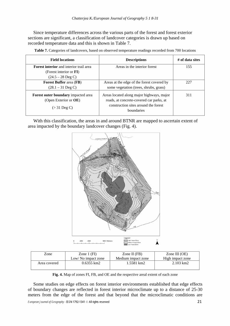
5.3 Soil temperature distribution
Alongside increased atmospheric temperature and lowered RH along outer edges of BTNR, soil temperatures also recorded significant changes. Figure 6 and Table 10 shows the values returned from the three categories of landcovers in and around BTNR. Soil temperatures from OE category could only be taken from exposed soil surfaces at carpark and road verges, and were not representing concrete/ tarmac covered areas. Although Pohlman et al (2007) did not record a significant change in soil temperature with distance from the forest edge, the present study recorded a significant rise of more than 8°C from forest interior to the open forest edge (Table 10). With associated environmental conditions of higher atmospheric temperatures, lower RH values, and exposure to direct sunlight, such high soil temperatures do pose a significant threat to maintenance of forest environmental conditions.
European Journal of Geography - ISSN 1792-1341 © All rights reserved 24
Chatterjea K./European Journal of Geography 5 1 8-31
Figure 6. Soil temperature distribution in the study site
Table 10. Soil temperatures (° C) recorded from various categories of landcovers (n=399)
FI FB OE
Maximum Soil temp (°C) 30 36 38
Minimum Soil temp (° C) 22 27 29.5
Mean Soil temp (° C) 25.6 29.4 33.8
5.4 Wind velocity While atmospheric temperature, RH, and soil temperature variations were consistently different in the three categories of landcovers, wind velocities recorded in and around forest areas did not return consistent results. Figure 7 shows the wind velocity distributions in and around BTNR study site. Tropical rainforest areas generally do not show significant variations in wind velocities under normal conditions, except during sudden thunderstorms. Many data sites did not return any readings at all and forest interiors recorded ‘0’ velocities at 92% of the sites (Table 11).
European Journal of Geography - ISSN 1792-1341 © All rights reserved 25

Chatterjea K./European Journal of Geography 5 1 8-31
However, along BKE as well as in the car parks and construction sites along Dairy Farm Road, all outside the forest fringes, there were some variations recorded. These are thought to be due to the open space available for increase in the velocity of the wind. Maximum velocity recorded was 5.7m/sec, along major roads and highway.
Table 11. Wind Velocity in and around BTNR
Figure. 7. Isotach map showing wind velocities in the study area in BTNR
Goosem (2007) commented that under normal circumstances, gradients in wind velocities from highway edges to the forest interiors are minimal. In case of BTNR, although there were sites that did not record any measurable wind velocities, 76.2% sites in the outer exterior locations did record some wind. In contrast, this figure was only 8.1% in the FI sections. So there is some measurable difference between the forest interior and the outer boundaries.
However, it may be added that sudden changes in conditions during thunderstorms which happen several times during the year, these exposed areas along major roads and highways may expose forest edges to increased risks of wind throws and may lead to uprooting of mature trees at the forest verges. During a recent violent thunderstorm (25 June, 2013) several trees were uprooted both inside and outside BTNR. But records show that along 4
Landcover categories
Velocities (m/sec) #Sites with velocity >0m/sec Max.
Min.
Mean
FI
(n=172) 1.8 0 0.153 8.1
FB (n=80)
4.8 0 0.973 45
OE: Minor Roads (n=80) 3 0 0.9 57.5 OE: Major Roads, Highways, Car parks, Construction sites
(n=340)
5.7 0 0.92 76.2
European Journal of Geography - ISSN 1792-1341 © All rights reserved 26
Chatterjea K./European Journal of Geography 5 1 8-31
trails within FI there were only 1 treefall each, the mountain bike track as well as a trail in the buffer zone, with considerable vegetation density also suffered only 1 treefall each, while the open section of Rifle Range Road had 10 treefalls, while locations along Dairy Farm Road had 5 treefalls (0.8-1m girth size) (Gan, J, Pers. Comm. Dated 9.7.2013). This clearly shows that sudden stormy weather can adversely affect open stretches of the forest boundaries while buffer zones may still provide similar protection to the vegetation as in the forest interiors.
Current figures show that there is significant increase in wind activity along road boundaries, while wind velocities in the interior locations do not seem to have much pattern (Fig. 7). How far the effect of such disturbances extend inside the forest needs to be ascertained through further research.
6. DISCUSSION AND CONCLUSION
The various parameters measured in both interior forested segments, buffer forest areas and the exterior boundary environments reveal the extent of changes in environment that have been introduced and imposed on the forest due to dense urban development around the fragmented forest of BTNR. Forest interior temperatures, while remaining very characteristic of tropical rainforests, increase quite substantially, with associated reduction in relative humidity along transects across the buffer and to the exterior areas.
If temperature distribution patterns within the study areas are superimposed with RH values, a very close pattern can be discerned and locations with highest RH coincide with areas recording lowest temperatures, which happen to be in the inner forest zones along Fern Valley, Jungle Fall Valley, Jungle Fall Path, Rengas Path, Seraya Loop, and South View Path. This forest interior area can be demarcated as the zone of least impact (Fig 4). These coincide with the areas dubbed as still retaining ‘the authentic “feel” of primaeval rainforest’ by Wee and Corlett in 1986 and the environment appears to have remained so (Wee and Corlett, 1986: p16).
However, while the surrounding areas were covered by scattered forests and low-rise bungalow-style residential buildings till the mid-80s, the next few decades have seen massive changes in the landcover (Chatterjea, 2006) and currently there are 27 condominiums, wide road networks, and spacious open car parks, all within 300 m from the forest boundaries (Chatterjea, 2012). These non-forested landcovers have since altered much of the peripheral environments, with consequent sharp increase in atmospheric and soil temperatures and a steep drop in relative humidity along the boundary zones. Figure 8 shows how the gradients for each of these parameters change along the impacted boundary zones.
The preliminary results from this study reveal for the first time, zones that can be demarcated as (i) least altered and, hence, near original (requiring no management intervention), (ii) moderately impacted (areas requiring regular monitoring), and (iii) highly impacted (areas that require immediate ameliorating steps) (Fig 4). While it is confirmed that forest interior segments in BTNR still retain the authentic tropical rainforest environment of warm temperature, high humidity, and low wind conditions, the drastic changes at the peripheral areas are alarming. Already the effects of such exposure are seen in higher incidences of treefalls at the edges during strong wind conditions. The leveling effects of the surrounding buffer forest are encouraging and can be taken as a way to control and manage the health and sustenance of the forest. While currently these buffer areas form a narrow band around, some boundary segments do not have the transition and the protection of these buffer zones, such as the verges along BKE.
Moreover, these categories are drawn up only on the basis of the environmental factors measured. Added to these are several other factors that affect the forest conditions, such as
European Journal of Geography - ISSN 1792-1341 © All rights reserved 27

Chatterjea K./European Journal of Geography 5 1 8-31
visitor impacts (Chatterjea, 2012). Inclusion of these might fine tune the zones of impacted forest segments. Further research is, therefore, required to delineate actual extent of impacts and the degree of such impact, if this piece of nature reserve is to be protected and managed in an effective way. Another point to consider is the ecosystem services a forest is supposed to provide. Bukit Timah Nature Reserve is an important forest reserve with the authentic forest feel and thus a great attraction for its inherent natural attributes. This is appealing to the many urban dwellers who pay higher premiums to live in the vicinity.
Figure 8. Observed gradients of change of various parameters from Forest Interior to Open Exterior boundaries of BTNR
However, as Tobias (2013) points out, ecosystems can have compatible ecosystem services. For example, the dense forested slopes of BTNR are currently used as a recreation space by the many visitors. But because of the complex relationships that exist among the many attributes of an ecosystem (the interrelationships that sustain the ecosystem functions), mishandling of some aspects, ‘without paying attention to the natural prerequisites for other ecosystem services’ may have fatal effects (Tobias, 2013: p245). Boundary environments that shape and sustain integrity of forest interior processes and operations, therefore, need to be managed, in order to maintain the characteristics of the forest intact. Increasing interferences and inroads of urban development in the peripheral areas of the forest need to be controlled and managed if forest reserves are to be kept as ecosystem service providers.
ACKNOWLEDGEMENTS
This research is funded by NIE AcRF Research Fund (RI 1/12KC). Acknowledgement is due to Mr. Ahmad Zakir, Ms. Elfy Lee, and Mr. A.R. Mansoor, students of National Institute of Education, for their assistance in some data collection and mapping. Verification of statistical analysis was done by Ms. Liberty Pascua. Support from officers Ms Sharon Chan and Mr,
Based on values from isotachs: 5.2m/s difference
Based on values from isohumes: 36% difference diff
Based on values of isotherms showing Soil Temperature: 13°C difference
European Journal of Geography - ISSN 1792-1341 © All rights reserved 28

Chatterjea K./European Journal of Geography 5 1 8-31
Joey Gan of Bukit Timah Nature Reserve, National Parks Board for providing some vital information regarding the forest is acknowledged.
REFERENCES
Beer, J., & Fox, M. 1997. Conserving Vegetation in Fragmented Rural Landscapes: Edge Effects and Eucalypt Forest Remnants. Conservation Outside Nature Reserves: 60: 313-18.
Bierregaard, R.O., Jr., Lovejoy, T.E., Kapos, V., Augusto dos Santos, A. and Hutchings, R.W. 1992. The biological dynamics of tropical rainforest fragments. Bioscience. 42: 859-866.
Brothers, T.S. and Spingam, A., 1992. Forest fragmentation and alien plant invasion of central Indiana old-growth forests. Conservation Biology. 6: 91-100.
Carr, M.H., Lambert, J.D. and Zwick, P.D. 1994. Mapping of continuous biological corridor potential in Central America. Final Report, Paseo Pantera, University of Florida, Gainesville, Florida. USA.
Chatterjea, K. 2006. Public Use of Urban Forest, its Impact, and related Conservation Issues: The Singapore Experience. In Challenging Sustainability: Urban Development and Change in Southeast Asia, ed. Wong T.C. et al, 53-79, Marshall Cavendish Academic, Singapore.
Chatterjea, K. 2007. Development and environment: the constant battle. In Geographies of a Changing World: Global Issues in the Early 21st Century, Ooi, G.L., Chatterjea, K., Chang, C.H.and Lim. 585-607. K.Y.T. Prentice Hall: Singapore.
Chatterjea, K. 2012. Sustainability of an Urban Forest: Bukit Timah Nature Reserve, Singapore in Sustainable Forest Management – Case Studies, eds. Jorge Martin-Garcia and Julio Javier Diez: 143-160. InTech.
Chen, J., Franklin, J.F., and Spies, T.A. 1995. Growing season microclimatic gradients from clearcut edges into old-growth Douglas fir forests: Ecological Applications. 5. 74-86.
Collinge, S.K. 1996. Ecological consequences of habitat fragmentation: implications for landscape architecture and planning. Landscape and Urban Planning: 36:59-77.
Davies-Colley, R.J., Payne, G.W., van Elswijk, M. 2000. Microclimate gradients across a forest edge. New Zealand Journal of Ecology : 24: 111-21.
Didham R.K., Lawton, J.H. 1999. Edge structure determines the magnitude of changes in microclimate and vegetation structure in tropical forest fragments. Biotropica: 31: 17-30.
Dykes, A.P. 2000. Climatic Patterns in a Tropical Rainforest in Brunei. The Geographical Journal: 166 (1): 63-80.
Federowick, J.M. 1993. A landscape restoration framework for wildlife and agriculture in the rural landscape. Landscape Urban Planning: 27: 7-17.
Gan, J. (Pers. Comm) National Parks Board, Singapore. 2013. Gayton, D. 2007. Major impacts to biodiversity in British Columbia: a report to the conservation planning tools committee, May, 2007. Biodiversity British Columbia Technical Subcommittee.131.Retrievedfrom:http://www.biodiversitybc.org/assets/Default/BBC%20Major%20Impacts%20Other.pdf Gehlhausen, S. M., Schwartz, M. W., & Augspurger, C. K. (2000). Vegetation and
Microclimatic Edge Effects in Two Mixed-mesophytic Forest Fragments. Plant Ecology: 147, 21-35.
European Journal of Geography - ISSN 1792-1341 © All rights reserved 29
Chatterjea K./European Journal of Geography 5 1 8-31
Ghosh, P. 2004. Forest Fragmentation: A Threat to Global Bio-diversity. ENVIS Bulletin: Himalayan Ecology, 12(2): 17-26.
Goosem, M. 2007. Fragmentation impacts caused by roads through rainforests. Current Science, 93 (10):1587-95.
Harris, L.D. 1984. The Fragmented Forest: Island Biogeography . Theory and the Preservation of Biotic Diversity. University of Chicago Press, Chicago, IL.
Herbst, M., Roberts, J.M., Rosier, P.T.W., Taylor, M.E., Gowing, D.J. 2007. Edge effects and forest water use: a field study in a mixed deciduous woodland. Forest Ecology and Management :250: 176-186.
Hunter, M.L., Jr., 1990. Wildlife, Forests, and Forestry. Prentice-Hall, Englewood Cliffs, NJ. Knaapen, J.P., Scheffer, M. and Harms, B. 1992. Estimating habitat isolation in landscape
planning. Landscape Urban Planning: 23: 1-16. Laurance, W. F. 2009. Roads to ruin. New Scientist, 29 August, pp. 24-25. Laurance, W.F. 1997. Hyper-disturbed parks: Edge effects and the ecology of isolated
rainforest reserves in tropical Australia, In Tropical Forest remnants, ecology, management, and conservation of fragmented communities. ed. W.F. Lawrence and R.O. Bierregaard, 71-82. The University of Chicago Press, Chicago.
Laurance, W.F., Goosem, M. 2008. Impacts of Habitat Fragmentation and Linear Clearings on Australian Rainforest Biota. In Living in a dynamic forest landscape, ed. Stork, N. and Turton, S. 295-306. Blackwell.
Laurance, W.F., Lovejoy, T.E., Vasconcelos, H.L., Bruna, E.M., Didham, R.K., Stouffer, P.C., Gascon, C., Bierregaard, R.O., Sampaio, E. 2002. Ecosystem Decay of Amazonian Forest Fragments: a 22-Year Investigation. Conservation Biology. 16 (3): 605–18.
Lovejoy, T.E., Rankin, J.M., Bierregard, R.O., Jr., Brown, K.S., Jr., Emmons, L.H. and van der Voort, M.E.1984. Ecosystem decay of Amazon forest remnants. In Extinctions, ed. M.H. Nitecki. University of Chicago Press, Chicago, IL: 295-325.
Martino, D. 2001. Buffer Zones around protected areas: A brief literature review. Electronic Green Journal, 1(15).Retrieved from: http://www.escholarship.org/uc/item/02n4v17n
Murcia, C. 1995. Edge effects in fragmented forests: implications for conservation. Trends in Ecology and Evolution: 10: 58-62.
Nyandwi, E. 2008. Road edge effect on forest canopy structure and epiphyte biodiversity in a tropical mountainous rainforest, Nyungwe National Park, Rwanda, International Institute for Geo-Information Science and Earth Observation, Enschede, Netherlands.
Pendry, C.A. and Proctor, J. 1996. The causes of altitudinal zonation of rainforests on Bukit Belalong, Brunei, Journal of Ecology: 84: 407-418.
Pohlman, C.L., Turton, S. M. and Goosem, M. 2007. Edge effects of linear canopy openings on tropical rain forest understory microclimate. Biotropica. 39 (1): 62-71.
Ranney, J.W., Bruner, M.C. and Levenson, J.B. 1981. The importance of edge in the structure and dynamics of forest islands. In Forest Island Dynamics in Man-Dominated Landscapes, ed. R.L. Burgess and D.M. Sharpe. Springer, New York, 68-95.
Rodiek, J.E. and DclGuidice, G. 1994. Wildlife habitat conservation: its relationship to biological diversity and landscape sustainability. Landscape Urban Planner, Special Issue, 28.
Sauer, L., 1993. The North Woods of Central Park. Landscape Architecture. March: 55-57. Schaerer C, Baranzini A, Ramirez J, Thalmann P. 2008. Using the hedonic approach
European Journal of Geography - ISSN 1792-1341 © All rights reserved 30

Chatterjea K./European Journal of Geography 5 1 8-31
to value natural land uses in an urban area: An application to Geneva and Zurich. Public Econ : 20:147- 67.
Smithsonian Tropical Research Institute 2005, Center for Tropical Forest Science, Asia Program[online], accessed on 10 Jul 2013.
Retrieved from: http://striweb.si.edu/ctfs_global/doc/asiaprogram_bukit-tamah.htm Thome, J., Huang, C.S., Hatley, M.T., and Mathur. A. 1991. Applying the landscape
ecological aesthetic to land acquisition planning in the Upper Schoharie Watershed, Catskill Mountains, New York. CELA Conference Proceedings, 3. Landscape Architecture Foundation, Washington, DC.
Tobias, S. 2013. Preserving Ecosystem Services in Urban Regions: Challenges for Planning and Best Practice Examples from Switzerland, Integrated Environmental Assessment and Management. 9 (2): 243–251.
Vogt CA, Marans RW. 2004. Natural resources and open space in the residential decision process: a study of recent movers to fringe counties in southeast Michigan. Landscape and Urban Plan : 69:255–269.
Waltert F, Schläpfer F. 2010. Landscape amenities and local development: A review of migration, regional economic and hedonic pricing studies. Ecological Economics : 70:141–152.
Wee, Y. C. and Hale, R. 2008. The nature society (Singapore) and the struggle to conserve Singapore’s nature areas. Nature in Singapore: 1: 41–49.
Wee, Y.C., Corlett, R. 1986. The city and the forest, Singapore University Press, Singapore. Wilcove, D.S., McLellan, C.H. and Dobson, A.P., 1986. Habitat fragmentation in the
temperate zone. In Conservation Biology: The Science of Scarcity and Diversity. ed. M.E. Soul, Sinauer Associates, Sunderland, MA, 237-256.
Yahner, T.G., Korostoff, N., Johnson, T.P., Battaglia, A.M. and Jones, D.R., 1995. Cultural landscapes and landscape ecology in contemporary greenway planning, design and management: a case study. Landscape Urban Planning: 33: 295-316.
European Journal of Geography - ISSN 1792-1341 © All rights reserved 31


![[SUPP1 - 20] BT/NEWS/PAGES 23/02/12 · Ang Mo Kio Bishan Bukit Panjang Bukit Batok Bukit Timah Jurong West Tuas Ghim Moh Marina South Marina East Kallang ... Frasers](https://img.pdfslide.net/doc/110x75/5f0be7107e708231d432c864/supp1-20-btnewspages-230212-ang-mo-kio-bishan-bukit-panjang-bukit-batok.jpg)