Embed Size (px)
DESCRIPTION
An animation of the formation of open water in the coastal marsh caused by the vertical movement on the Empire Fault
Citation preview
Subsidence on the Empire and Bastian Bay Faults from 1941 to 2013
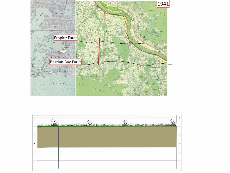
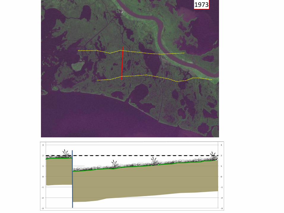
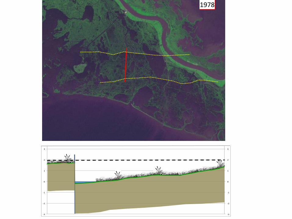
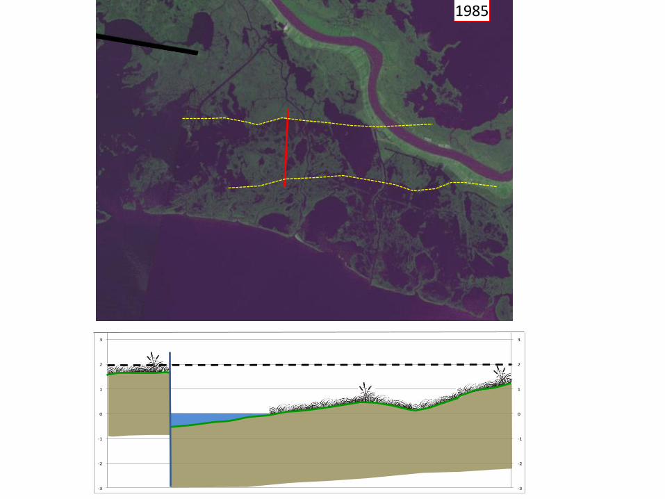
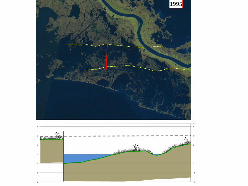
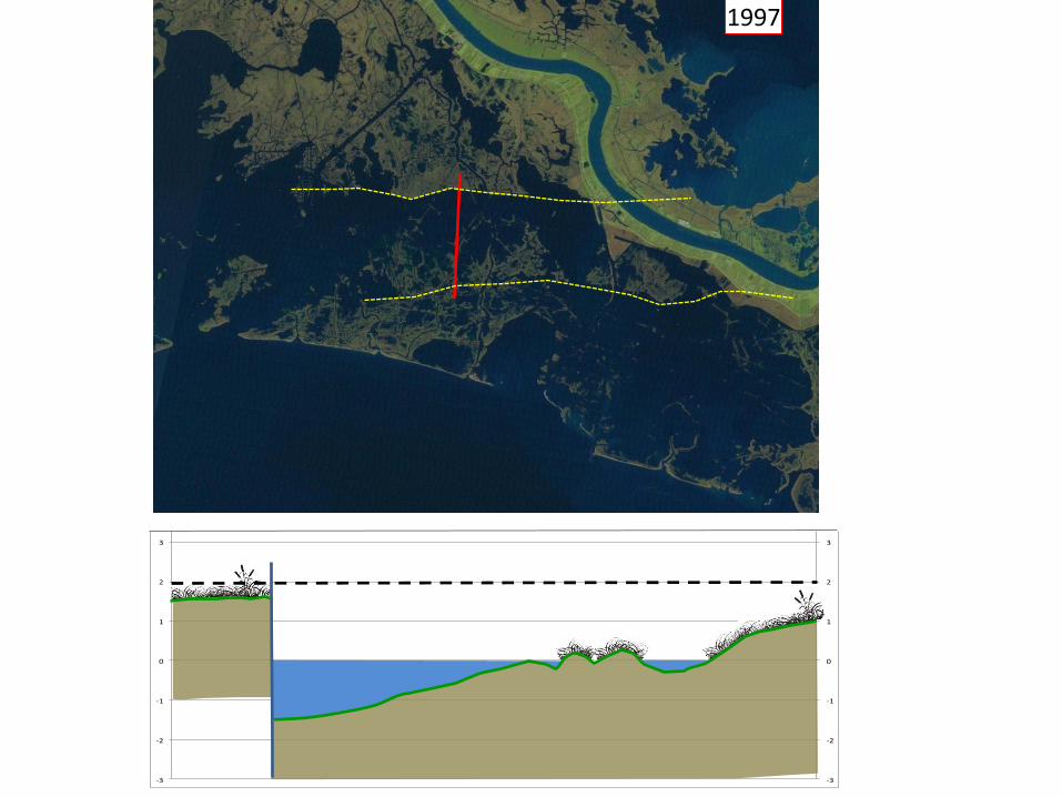
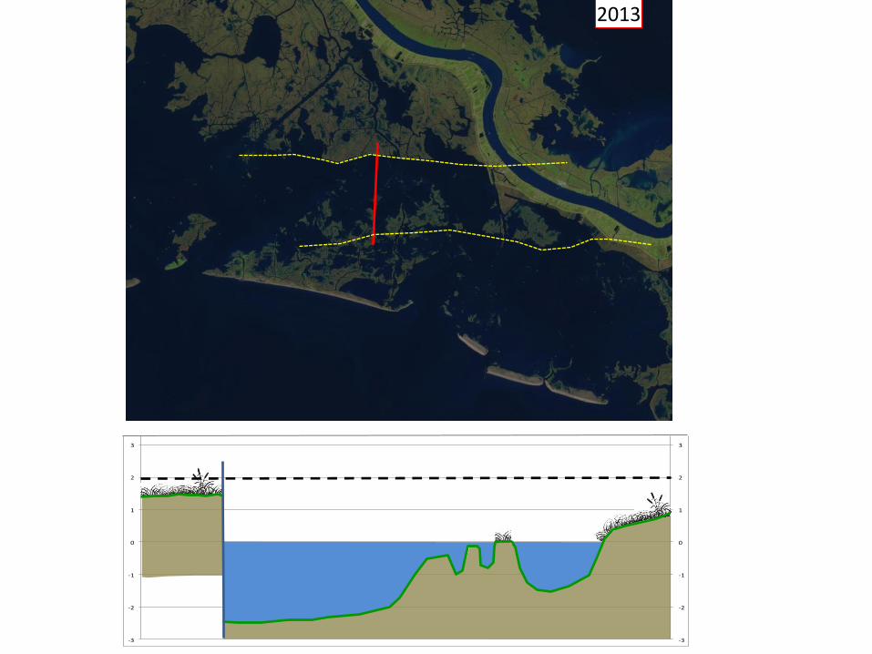
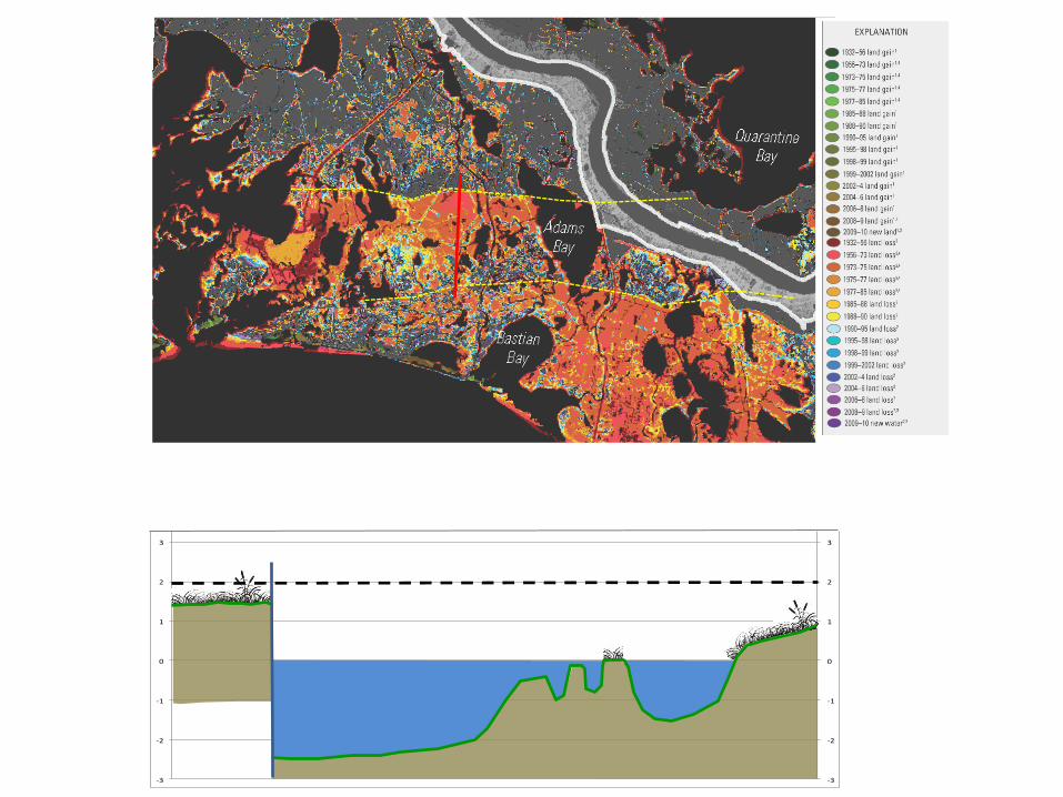
The following set of images illustrates the effects of the vertical movement on the Empire Fault between 1941 and 2013. Each year in the sequence includes a map or Landsat satellite image that shows the extend of marsh coverage, and a reconstruction of a profile across the fault that was made by Dr. Woody Gagliano and published in his 2003 study done for the Corps of Engineers titled “Active Geological Faults and Land Change in Southeastern Louisiana”. The profile was made in 1998 from shallow core borings, and it showed the vertical offset of the fault, and the formation of open body of water that Gagliano called a “fault bay”. On each page the profile has been adjusted to the configuration that it would have been in at that time to show how the vertical movement of the fault formed the open body of water that exists there today. It is important to note that subsidence due to the fault has probably been ongoing for thousands of years. As long as the river was in a natural flood cycle, adequate sediments would have been delivered to maintain the elevation of the marsh even though the fault was moving and causing subsidence. As soon as the sediment supply was cut off, the subsidence caused a change in elevation of the marsh surface, but it took until the mid-1970s for that subsidence to submerge the marsh surface on the “downthrown” side of the fault. The U.S.G.S. Land Area Change Map on the last page shows that this area of “land loss” was submerged between 1956 and 1985. The sequence of Landsat images shows that most of that submergence occurred in the 1970s. It can be reasonably estimated that the surface of the marsh is subsiding at a rate of about one foot per decade. Subsidence has continued until today, and the size of the bay being formed has continued to grow. The suspended sediment load of the river is a small fraction of what is was when the river was able to maintain the marsh elevation, and there is no hope that an artificial diversion of the river could rebuild the subsided marsh surface. Any small patches of land that may be built by a diversion would be immediate subjected to the effects of subsidence.
-3
-2
-1
0
1
2
3
4
5
-3
-2
-1
0
1
2
3
4
5
1941
Empire Fault
Bastian Bay Fault
-3
-2
-1
0
1
2
3
4
5
-3
-2
-1
0
1
2
3
4
5
1973

-3
-2
-1
0
1
2
3
4
5
-3
-2
-1
0
1
2
3
4
5
1973
-3
-2
-1
0
1
2
3
4
5
-3
-2
-1
0
1
2
3
4
5
1978
-3
-2
-1
0
1
2
3
4
5
-3
-2
-1
0
1
2
3
4
5
1985
-3
-2
-1
0
1
2
3
4
5
-3
-2
-1
0
1
2
3
4
5
1995
-3
-2
-1
0
1
2
3
4
5
-3
-2
-1
0
1
2
3
4
5
1997
-3
-2
-1
0
1
2
3
4
5
-3
-2
-1
0
1
2
3
4
5
2013
-3
-2
-1
0
1
2
3
4
5
-3
-2
-1
0
1
2
3
4
5