Embed Size (px)
Citation preview
Bodmin CNA
Employment Evidence Report
April 2017

2
(THIS PAGE IS INTENTIONALLY BLANK)
3
Contents
1. Introduction .................................................................................................................................. 4
2. Bodmin Background ..................................................................................................................... 5
3. Required Employment Space at Bodmin (2010-2030) ................................................................. 6
a) LP:SP Employment Requirement (2010-2030) ............................................................................. 6
b) Employment developments completed (2010-2016)................................................................... 6
c) Permitted employment developments (31st March 2016) ........................................................... 7
d) Other capacity .............................................................................................................................. 8
e) The amount of space that needs to be accommodated through site allocation(s) ................... 10
4. Safeguarded Employment Sites .................................................................................................. 11
5. Urban Extension Employment Site Identification ...................................................................... 12
i. The Urban Extension Assessment............................................................................................... 13
ii. Sustainability Appraisal (SA) ....................................................................................................... 20
iii. Site Prioritisation Assessment .................................................................................................... 20
iv. Proposed Sites ............................................................................................................................ 24
6. Site Allocations (Employment Space) at Bodmin ....................................................................... 25
Beacon Technology Park (Bd-E1) ...................................................................................................... 25
Cooksland Extension (Bd-E6) ............................................................................................................ 25
Callywith Urban Village (Bd-UE4) ...................................................................................................... 25
7. Bodmin’s Employment Trajectory .............................................................................................. 27
Appendix 1: Sustainability Appraisal Tables ..................................................................................... 28
4
1. Introduction Cornwall’s Local Plan: Strategic Policies Development Plan Document (LP:SP) sets out that the
Bodmin Community Network Area (CNA) should plan to accommodate 47,500sqm of employment
space (B1, B2 and B8 use classes only), through the plan period (2010-30), with this equating to
22,833sqm of office space and 24,667sqm of industrial space. In support of this, the Site Allocations
Development Plan Document (DPD) (and associated Bodmin Town Framework), sets out how
Bodmin plans to accommodate this strategic employment growth for the CNA. This employment
evidence report documents the evidence, setting out how the strategic employment growth
requirement for the Bodmin CNA is planned to be accommodated in and adjoining the conurbation
of Bodmin. In identifying how this growth will be accommodated consideration is given to two
aspects:
i. Whether the sites identified meet the required capacity, set by the LP:SP; and,
ii. Whether the sites identified are compatible with the economic strategy for the conurbation
(e.g. sites located at the end of a narrow road network would not be ideally suited for a
town wishing to attract more distribution companies to the area).
It is important to note that this work focuses on sites appropriate to accommodate strategic growth
and does not consider smaller scale sites (e.g. less than 0.5 Hectare1). Smaller scale sites will also
contribute to growth and can be either identified through a local level Neighbourhood Development
Plan (NDP) or proposals addressed through the usual planning application procedure.
The structure of this report is as follows:
Section 2 of this report presents background information, providing the context to Bodmin and
the aspirations for its local economy.
Section 3 sets out an employment capacity review for the conurbation. By establishing this
capacity, it is then possible to calculate how much additional land needs to be identified to
accommodate employment uses as site allocations, within the Site Allocations DPD. This section
includes a consideration of, where urban sites are identified, whether these are appropriate for
the types of employment envisaged.
Section 4 sets out the existing strategic level employment sites within Bodmin that meet the
criteria within Policy 5 of the Cornwall Local Plan Strategic Policies document, which should be
safeguarded within the Cornwall Allocations DPD.
Section 5 of this report considers the identification of appropriate sites to be allocated for
employment growth to meet the requirement arrived at in Section 3. This section refers to work
previously undertaken as part of an Urban Extension Assessment for Bodmin (which was also
used to determine appropriate sites to accommodate future housing and mixed use
1 The threshold of 0.5Ha is chosen in order that no site is assessed that does not present an opportunity to
deliver at least 2,000sqm of employment space as, for the purposes of this work, a site which would deliver less than 2,000sqm is not considered to be of a significant enough scale to be classed as a Strategic Employment Site Allocation (the Cornwall Employment Land Review 2010 (available at www.cornwall.gov) sets out that 1Ha of land can be assumed to deliver 4,000sqm of employment space (either industrial or office) and, following means testing by the Council in 2016, this assumption is considered to remain a robust position for Cornwall).
5
developments); reviews aspects which may influence the potential of a site to accommodate
employment uses (for example, if recent planning approvals impact a site); and, considers the
Sustainability Appraisal (SA) of the potential sites in order to help determine the most
appropriate areas to be allocated.
Section 6 then examines the employment sites arrived at through Section 5, considering these in
more detail. Specific constraints, opportunities and mitigation aspects for each site are
highlighted, which should inform both policy development and future planning proposals on
these sites.
Section 7 concludes this report and presents the employment trajectory for Bodmin, setting out
how the target of 47,500sqm of employment space (2010-2030) is planned to be delivered.
2. Bodmin Background Bodmin’s ambition is to become a key economic centre for Cornwall, taking advantage of its central
location within the county and being uniquely located on both the A30 and A38 trunk roads.
Manufacturing has represented a significant employer for Bodmin and the town’s location and
transport links means it still represents one of Cornwall’s most attractive locations for manufacturing
and distribution companies. As a result, ensuring land is available to industry, particularly land with
good access to the A30 / A38, forms a key element of this strategy. Furthermore, Bodmin already
has a cluster of food related manufacturing / distribution companies and this represents a sector
that it wishes to expand upon. The Cornwall ‘Agri-Food’ industry, which ranges from production
through to processing and distribution, has almost doubled in turnover in the past 12 years. Bodmin
represents a central location where the agri-food industry can rationalise Cornwall’s supply chains;
plus develop agri-tech research & development facilities, as well as linked innovation centre for new
and growing businesses.
There is an aspiration for Bodmin to develop more office space and in doing so higher quality
employment. As well as the agri-tech sector, this can be stimulated in part by Cornwall Council using
the town as one of its hub locations, with their recent develop of new premises at Beacon
Technology Park. This could in turn offer other opportunities to create a public sector hub in the
centre of Cornwall.
Bodmin has a number of tourist attractions, such as Lanhydrock House, Bodmin & Wenford Railway,
the Military Museum, St Petroc’s Church, Bodmin Jail, Bodmin Town Museum; and the Courtroom
Experience at Shire Hall. The historic focus of all of these attractions represents a key opportunity to
further enhance their collective promotion as a day’s experience and in doing so attracting more
visitors; plus with the regeneration / enhancement of the town centre offer and improved cycling
facilities, it can help to increase the tourism spend captured within the town.
6
3. Required Employment Space at Bodmin (2010-2030) This section of the report establishes the amount of land which needs to be planned to
accommodate employment space through site allocations in the Site Allocations DPD. It takes into
account:
a) The LP:SP Employment Requirement (2010-2030);
b) Employment developments completed in the Bodmin CNA(2010-2015);
c) Permitted employment developments and under construction in the Bodmin CNA (1st April
2015); and,
d) Other capacity (i.e. vacant land within existing employment sites; Any SHLAA sites more
appropriate for employment uses; and any other urban site opportunities). Within this
aspect, consideration is given to whether any of the other sites identified are appropriate for
the types of employment envisaged for Bodmin (if not, they are not included in the
calculation).
Where:
a) LP:SP Employment Requirement (2010-2030) Cornwall’s LP:SP sets out that Bodmin CNA should plan to accommodate 47,500sqm of employment
space (B1, B2 and B8 use classes only), through the plan period (2010-30), with this equating to
22,833sqm of office space and 24,667sqm of industrial space. Whilst the LP:SP target relates to the
amount of employment space required in the CNA, it is assumed that the focus of new employment
space provision will be at the main town within the CNA, this being Bodmin. In calculating the
additional employment space required at Bodmin, existing vacant employment land and permitted
employment developments within the wider CNA area are taken into consideration.
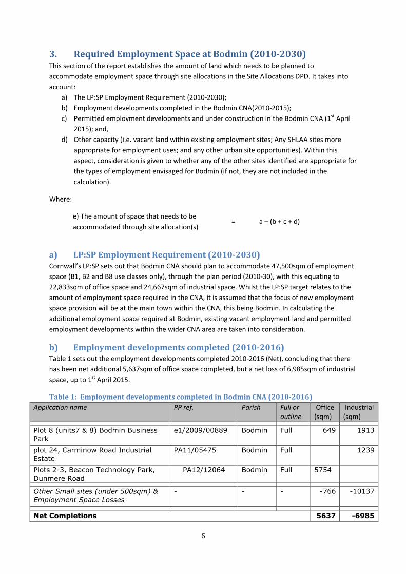
b) Employment developments completed (2010-2016) Table 1 sets out the employment developments completed 2010-2016 (Net), concluding that there
has been net additional 5,637sqm of office space completed, but a net loss of 6,985sqm of industrial
space, up to 1st April 2015.
Table 1: Employment developments completed in Bodmin CNA (2010-2016)
Application name PP ref. Parish Full or outline
Office (sqm)
Industrial (sqm)
Plot 8 (units7 & 8) Bodmin Business
Park
e1/2009/00889 Bodmin Full 649 1913
plot 24, Carminow Road Industrial
Estate
PA11/05475 Bodmin Full 1239
Plots 2-3, Beacon Technology Park,
Dunmere Road
PA12/12064 Bodmin Full 5754
Other Small sites (under 500sqm) &
Employment Space Losses
- - - -766 -10137
Net Completions 5637 -6985
e) The amount of space that needs to be
accommodated through site allocation(s) = a – (b + c + d)
7
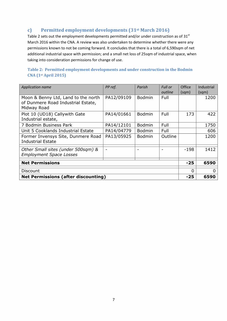
c) Permitted employment developments (31st March 2016) Table 2 sets out the employment developments permitted and/or under construction as of 31st
March 2016 within the CNA. A review was also undertaken to determine whether there were any
permissions known to not be coming forward. It concludes that there is a total of 6,590sqm of net
additional industrial space with permission; and a small net loss of 25sqm of industrial space, when
taking into consideration permissions for change of use.
Table 2: Permitted employment developments and under construction in the Bodmin
CNA (1st April 2015)
Application name PP ref. Parish Full or outline
Office (sqm)
Industrial (sqm)
Moon & Benny Ltd, Land to the north
of Dunmere Road Industrial Estate, Midway Road
PA12/09109 Bodmin Full 1200
Plot 10 (UD18) Callywith Gate Industrial estate,
PA14/01661 Bodmin Full 173 422
7 Bodmin Business Park PA14/12101 Bodmin Full 1750
Unit 5 Cooklands Industrial Estate PA14/04779 Bodmin Full 606
Former Invensys Site, Dunmere Road
Industrial Estate
PA13/05925 Bodmin Outline 1200
Other Small sites (under 500sqm) &
Employment Space Losses
- - - -198 1412
Net Permissions -25 6590
Discount 0 0
Net Permissions (after discounting) -25 6590
8
d) Other capacity This section seeks to determine whether there is land available within the existing urban area (including
existing industrial estates) that has not yet been developed and which would be suitable for
employment uses, including consideration as to whether the sites present reasonable opportunities to
deliver the particular economic aspirations for the town. In order to assess this, a number of existing
sites have been reviewed:
i. Vacant land within existing industrial estates, without planning permission
ii. Sites submitted through the Strategic Housing Land Availability Assessment (SHLAA); and,
iii. Other potential sites within the existing urban area
This section only considers potential sites within the existing urban area; only if there is insufficient land
to deliver the targeted level of growth will greenfield land adjoining the edge of the town be
considered.
i. Vacant land with existing industrial estates
Bodmin contains various industrial estates and the following table highlights the land still available for
development within the larger estates that are intended to be safeguarded by the Allocations DPD – see
later section. The figures below relate to vacant land that did not contain an extant planning permission
at the end of March 2016.
Table 3a: Review of existing industrial estates within the CNA that will be safeguarded
Name Additional Land Available
Ha Potential sqm of employment space (at 1/3/16)
Walker Lines Industrial Estate 0 0
Bodmin Business Park 0.76 3040
Cooklands Industrial Estate 0 0
Callywith Gate 0.39 1560
4600
The assessment shows that existing industrial estates could accommodate approximately 4,600sqm of
employment space. Due to the nature of the sites, it is assumed that this is most likely to come forward
as industrial space (B1c / B2 / B8).
9
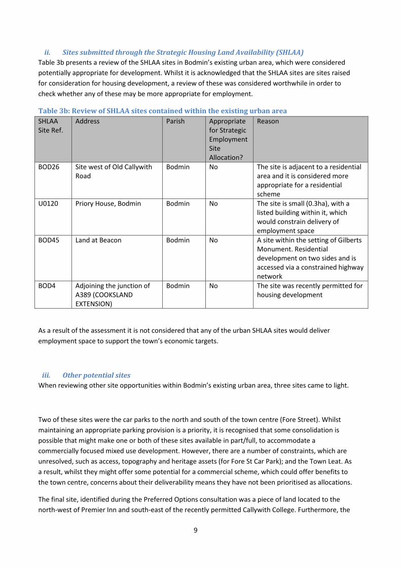
ii. Sites submitted through the Strategic Housing Land Availability (SHLAA)
Table 3b presents a review of the SHLAA sites in Bodmin’s existing urban area, which were considered
potentially appropriate for development. Whilst it is acknowledged that the SHLAA sites are sites raised
for consideration for housing development, a review of these was considered worthwhile in order to
check whether any of these may be more appropriate for employment.
Table 3b: Review of SHLAA sites contained within the existing urban area
SHLAA Site Ref.
Address Parish Appropriate for Strategic Employment Site Allocation?
Reason
BOD26 Site west of Old Callywith Road
Bodmin No The site is adjacent to a residential area and it is considered more appropriate for a residential scheme
U0120 Priory House, Bodmin Bodmin No The site is small (0.3ha), with a listed building within it, which would constrain delivery of employment space
BOD45 Land at Beacon Bodmin No A site within the setting of Gilberts Monument. Residential development on two sides and is accessed via a constrained highway network
BOD4 Adjoining the junction of A389 (COOKSLAND EXTENSION)
Bodmin No The site was recently permitted for housing development
As a result of the assessment it is not considered that any of the urban SHLAA sites would deliver
employment space to support the town’s economic targets.
iii. Other potential sites
When reviewing other site opportunities within Bodmin’s existing urban area, three sites came to light.
Two of these sites were the car parks to the north and south of the town centre (Fore Street). Whilst
maintaining an appropriate parking provision is a priority, it is recognised that some consolidation is
possible that might make one or both of these sites available in part/full, to accommodate a
commercially focused mixed use development. However, there are a number of constraints, which are
unresolved, such as access, topography and heritage assets (for Fore St Car Park); and the Town Leat. As
a result, whilst they might offer some potential for a commercial scheme, which could offer benefits to
the town centre, concerns about their deliverability means they have not been prioritised as allocations.
The final site, identified during the Preferred Options consultation was a piece of land located to the
north-west of Premier Inn and south-east of the recently permitted Callywith College. Furthermore, the
10
site is adjacent to a proposed housing site (Castle St). The site has development, or development
proposals on all sites, so would be appropriate to come forward; plus with Premier Inn and a College on
either site, it would be appropriate to deliver employment space and/or support the expansion of the
College. The site is 1.6ha in size, so could deliver in the region of 6,000sqm of employment space (at this
stage assumed to be evenly split between office and light industrial space). Finally, as the site is
adjacent to Castle St, the land will be incorporated into that allocation, creating a mixed use site.
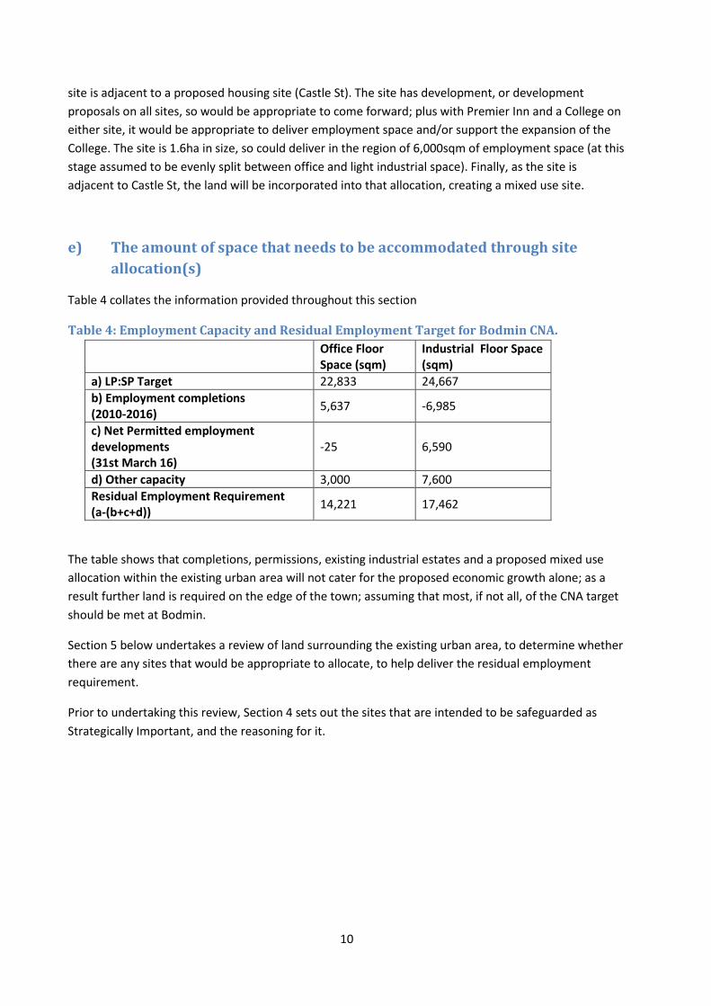
e) The amount of space that needs to be accommodated through site
allocation(s)
Table 4 collates the information provided throughout this section
Table 4: Employment Capacity and Residual Employment Target for Bodmin CNA.
Office Floor Space (sqm)
Industrial Floor Space (sqm)
a) LP:SP Target 22,833 24,667
b) Employment completions (2010-2016)
5,637 -6,985
c) Net Permitted employment developments (31st March 16)
-25 6,590
d) Other capacity 3,000 7,600
Residual Employment Requirement (a-(b+c+d))
14,221 17,462
The table shows that completions, permissions, existing industrial estates and a proposed mixed use
allocation within the existing urban area will not cater for the proposed economic growth alone; as a
result further land is required on the edge of the town; assuming that most, if not all, of the CNA target
should be met at Bodmin.
Section 5 below undertakes a review of land surrounding the existing urban area, to determine whether
there are any sites that would be appropriate to allocate, to help deliver the residual employment
requirement.
Prior to undertaking this review, Section 4 sets out the sites that are intended to be safeguarded as
Strategically Important, and the reasoning for it.
11
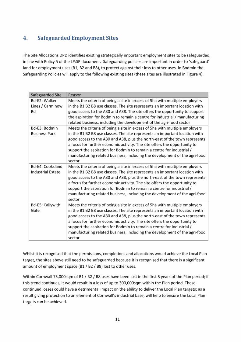
4. Safeguarded Employment Sites
The Site Allocations DPD identifies existing strategically important employment sites to be safeguarded,
in line with Policy 5 of the LP:SP document. Safeguarding policies are important in order to ‘safeguard’
land for employment uses (B1, B2 and B8), to protect against their loss to other uses. In Bodmin the
Safeguarding Policies will apply to the following existing sites (these sites are illustrated in Figure 4):
Safeguarded Site Reason
Bd-E2: Walker Lines / Carminow Rd
Meets the criteria of being a site in excess of 5ha with multiple employers in the B1 B2 B8 use classes. The site represents an important location with good access to the A30 and A38. The site offers the opportunity to support the aspiration for Bodmin to remain a centre for industrial / manufacturing related business, including the development of the agri-food sector
Bd-E3: Bodmin Business Park
Meets the criteria of being a site in excess of 5ha with multiple employers in the B1 B2 B8 use classes. The site represents an important location with good access to the A30 and A38, plus the north-east of the town represents a focus for further economic activity. The site offers the opportunity to support the aspiration for Bodmin to remain a centre for industrial / manufacturing related business, including the development of the agri-food sector
Bd-E4: Cooksland Industrial Estate
Meets the criteria of being a site in excess of 5ha with multiple employers in the B1 B2 B8 use classes. The site represents an important location with good access to the A30 and A38, plus the north-east of the town represents a focus for further economic activity. The site offers the opportunity to support the aspiration for Bodmin to remain a centre for industrial / manufacturing related business, including the development of the agri-food sector
Bd-E5: Callywith Gate
Meets the criteria of being a site in excess of 5ha with multiple employers in the B1 B2 B8 use classes. The site represents an important location with good access to the A30 and A38, plus the north-east of the town represents a focus for further economic activity. The site offers the opportunity to support the aspiration for Bodmin to remain a centre for industrial / manufacturing related business, including the development of the agri-food sector
Whilst it is recognised that the permissions, completions and allocations would achieve the Local Plan
target, the sites above still need to be safeguarded because it is recognised that there is a significant
amount of employment space (B1 / B2 / B8) lost to other uses.
Within Cornwall 75,000sqm of B1 / B2 / B8 uses have been lost in the first 5 years of the Plan period; if
this trend continues, it would result in a loss of up to 300,000sqm within the Plan period. These
continued losses could have a detrimental impact on the ability to deliver the Local Plan targets; as a
result giving protection to an element of Cornwall’s industrial base, will help to ensure the Local Plan
targets can be achieved.
12
5. Urban Extension Employment Site Identification Having completed the search for appropriate employment sites within the existing urban area, there
remains a relatively significant need for both office and industrial space. This section of the report
considers whether there are appropriate sites to be allocated for employment space on the edge of the
existing settlement, to support the delivery of the residual requirement.
In working towards developing the Site Allocations DPD and Town Framework Plans (TFPs)2 for some of
the main towns across Cornwall, an Urban Extension Assessment was carried out. Bodmin’s Urban
Extension Assessment is set out in detail within the Bodmin Housing Evidence Report3.
In considering the suitability of areas for employment uses, the Urban Extension Assessment provides a
robust foundation and an understanding of the advantages and limitations of land surrounding the
conurbation. It contributes to this report by informing why some areas have been discounted as site
options and why others have been considered more appropriate. Some elements of the Urban
Extension Assessment, such as Access to Services and Facilities and the Urban Design Assessment
(which considered issues such as connectivity to facilities, such as schools) are arguably of limited
importance when considering the suitability of land for employment. Therefore, this report draws only
information which is pertinent to employment uses, from the Urban Extension Assessment, and uses
this in order to outline which sites are appropriate for consideration as ‘option sites’ with potential to
accommodate employment growth (Section 5i and Figure 3).
A Sustainability Appraisal (SA) is then applied to these option sites (Section 5ii), which is used to inform
a Site Prioritisation exercise (Section 5iii). The Site Prioritisation exercise compares the option sites
according to how sustainable a proposed development would be in each location; whether there is land
owner/developer interest in the site; and how development of the site for employment purposes would
benefit the wider town and economic strategies. The amount of space each site offers is also
considered. This section then concludes by arriving at the sites which are to be allocated for
employment uses within Cornwall’s Site Allocations DPD (Section 5iv). Section 6 of this report then
continues to consider these individual sites in more detail.
Two key maps are presented within this section:
- A map illustrating the Study Cells resulting from Step 2 of the Urban Extension Assessment
(Figure 2); and,
- Employment Site Options, 2016 (Figure 3).
2 Not all towns are finalising TFPs, with some opting instead to develop Neighbourhood Development Plans.
3 Available at www.cornwall.gov.uk.
13
i. The Urban Extension Assessment The Urban Extension Assessment was undertaken in order to gain an understanding of the advantages
and limitations of land surrounding the town, with a view to establishing sites which would be allocated
for future development. The first steps of the process packaged the land surrounding the town into
suitable ‘Cells’, with these cells being manageable areas of land where assessments could be applied. In
determining the extent of the individual Cells, consideration was given to features that would
potentially create barriers between Cells, such as significant transport corridors and landform features,
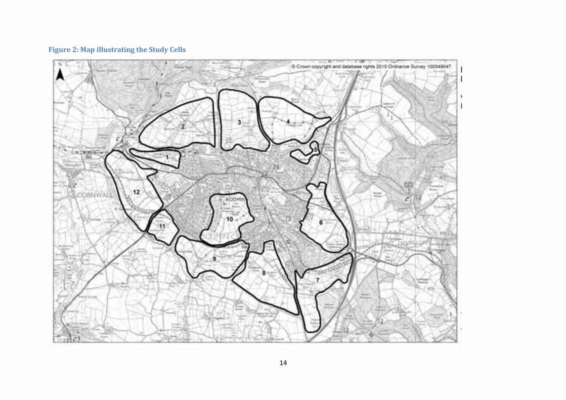
for instance topography and watercourses. The Cells identified for Bodmin are illustrated in Figure 2.
The Urban Extension Assessment subjected these cells to a series of assessments in order to determine
a smaller number of potentially suitable site options which could then be subject to public consultation.
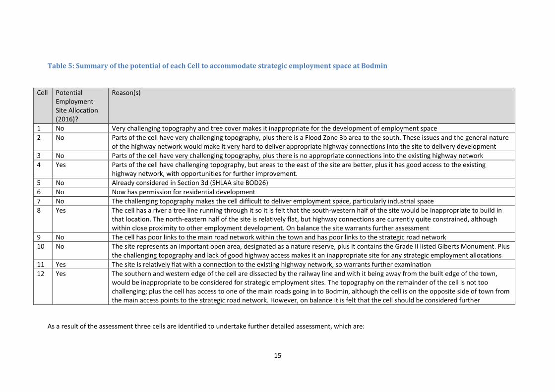
Table 5 sets out a summary of how each of these Cell’s are considered in relation to potential suitability
as a strategic employment allocation (whether they are now proposed as a Strategic Employment Site
Allocation and the reasons for/against this).
14
Figure 2: Map illustrating the Study Cells
15
Table 5: Summary of the potential of each Cell to accommodate strategic employment space at Bodmin
Cell Potential Employment Site Allocation (2016)?
Reason(s)
1 No Very challenging topography and tree cover makes it inappropriate for the development of employment space
2 No Parts of the cell have very challenging topography, plus there is a Flood Zone 3b area to the south. These issues and the general nature of the highway network would make it very hard to deliver appropriate highway connections into the site to delivery development
3 No Parts of the cell have very challenging topography, plus there is no appropriate connections into the existing highway network
4 Yes Parts of the cell have challenging topography, but areas to the east of the site are better, plus it has good access to the existing highway network, with opportunities for further improvement.
5 No Already considered in Section 3d (SHLAA site BOD26)
6 No Now has permission for residential development
7 No The challenging topography makes the cell difficult to deliver employment space, particularly industrial space
8 Yes The cell has a river a tree line running through it so it is felt that the south-western half of the site would be inappropriate to build in that location. The north-eastern half of the site is relatively flat, but highway connections are currently quite constrained, although within close proximity to other employment development. On balance the site warrants further assessment
9 No The cell has poor links to the main road network within the town and has poor links to the strategic road network
10 No The site represents an important open area, designated as a nature reserve, plus it contains the Grade II listed Giberts Monument. Plus the challenging topography and lack of good highway access makes it an inappropriate site for any strategic employment allocations
11 Yes The site is relatively flat with a connection to the existing highway network, so warrants further examination
12 Yes The southern and western edge of the cell are dissected by the railway line and with it being away from the built edge of the town, would be inappropriate to be considered for strategic employment sites. The topography on the remainder of the cell is not too challenging; plus the cell has access to one of the main roads going in to Bodmin, although the cell is on the opposite side of town from the main access points to the strategic road network. However, on balance it is felt that the cell should be considered further
As a result of the assessment three cells are identified to undertake further detailed assessment, which are:
16
The north-eastern element of Cell 4;
The north-eastern element of Cell 8
Cell 11
Cell 12 (excluding the area to the south/west of the railway line
These sites will be considered further through the sustainability appraisal
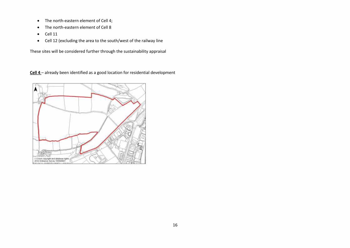
Cell 4 – already been identified as a good location for residential development
17
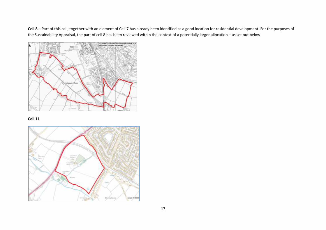
Cell 8 – Part of this cell, together with an element of Cell 7 has already been identified as a good location for residential development. For the purposes of
the Sustainability Appraisal, the part of cell 8 has been reviewed within the context of a potentially larger allocation – as set out below
Cell 11
18
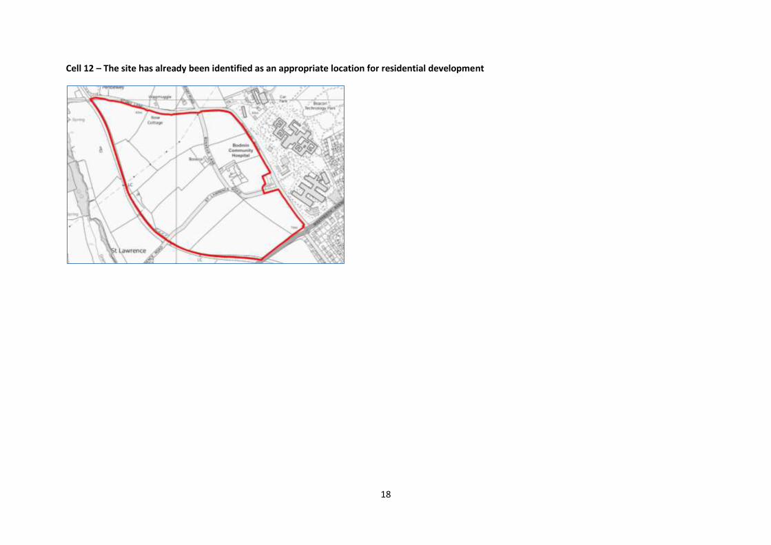
Cell 12 – The site has already been identified as an appropriate location for residential development
19
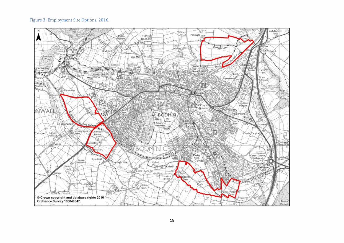
Figure 3: Employment Site Options, 2016.
20
ii. Sustainability Appraisal (SA) A SA for the option sites (see Figure 3) has been carried out and the SA tables for the sites are presented
in Appendix 1. The SA incorporates information obtained throughout all previous stages of the site
selection process. Summary SA scores have been extracted from the SA Tables in Appendix 1 to inform
the Site Prioritisation Assessment – see below. Further supporting information around the SA, carried out
as part of the Site Allocations DPD process, can be found on www.cornwall.gov.uk.
iii. Site Prioritisation Assessment This step involved an assessment of how the option sites perform against the SA criteria and also an
assessment of how these perform in relation to availability and benefit to the wider town strategy.
The purpose of the Prioritisation Assessment is to compare the option sites in order to determine which should be prioritised to feature in the Site Allocations DPD. This is necessary, as the allocation of all sites would result in land being allocated for far in excess of the requirement sought. The SA forms a large component of the Prioritisation Assessment – it is considered a useful element to inform this as, by its nature, it is assessing how sustainable the site options are and, in doing so, it picks up on aspects of work carried out throughout the assessment process.
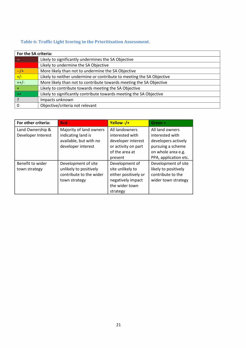
Tables 6-9 present the Prioritisation Assessment: Table 6 sets out the scoring used in the Prioritisation Assessment (i) (Table 7); Table 7 sets out the Prioritisation Assessment (i) which incorporates a summary of the SA scores using the traffic light system (as set out in Table 6). Land owner and developer interest; and benefit to wider town/economic strategies are additional aspects considered within this element of the assessment:
- Land ownership information/developer interest is relevant to this assessment as site allocations need to be deliverable and landowners need to be willing to develop their land for employment purposes. Information contributing to this element of the assessment has been gained from on-line planning records and/or through landowner contact;
- Benefit to wider town/economic strategies is a key element of this assessment. Whilst a site may demonstrate it is a sustainable option, presents limited infrastructure costs and has a landowner keen to develop it for employment, if the site would not serve to contribute to the wider town and economic strategies (or worse, work against these) then this needs to be taken into account.
Table 8 sets out the next step in the Prioritisation Assessment (ii), which provides a summary of the site options Table 9 sets out the final stage of the Prioritisation Assessment (iii) and presents the order in which the sites have been prioritised as a result of the previous steps (i-ii).
21
Table 6: Traffic Light Scoring in the Prioritisation Assessment.
For the SA criteria:
-- Likely to significantly undermines the SA Objective
- Likely to undermine the SA Objective
--/+ More likely than not to undermine the SA Objective
+/- Likely to neither undermine or contribute to meeting the SA Objective
++/- More likely than not to contribute towards meeting the SA Objective
+ Likely to contribute towards meeting the SA Objective
++ Likely to significantly contribute towards meeting the SA Objective
? Impacts unknown
0 Objective/criteria not relevant
For other criteria: Red - Yellow -/+ Green +
Land Ownership & Developer Interest
Majority of land owners indicating land is available, but with no developer interest
All landowners interested with developer interest or activity on part of the area at present
All land owners interested with developers actively pursuing a scheme on whole area e.g. PPA, application etc.
Benefit to wider town strategy
Development of site unlikely to positively contribute to the wider town strategy
Development of site unlikely to either positively or negatively impact the wider town strategy
Development of site likely to positively contribute to the wider town strategy
22
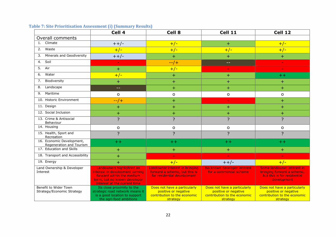
Table 7: Site Prioritisation Assessment (i) (Summary Results)
Cell 4 Cell 8 Cell 11 Cell 12
Overall comments 1. Climate ++/- +/- + +/- 2. Waste +/- +/- +/- +/- 3. Minerals and Geodiversity ++/- + + + 4. Soil - --/+ -- - 5. Air + +/- - - 6. Water +/- + + ++ 7. Biodiversity + + + + 8. Landscape -- + + + 9. Maritime o o o o 10. Historic Environment --/+ + - + 11. Design + + + + 12. Social Inclusion + + + + 13. Crime & Antisocial
Behaviour ? ? ? ?
14. Housing o o o o 15. Health, Sport and
Recreation ? ? ? ?
16. Economic Development, Regeneration and Tourism
++ ++ ++ ++
17. Education and Skills + + + + 18. Transport and Accessibility + - - - 19. Energy + +/- ++/- +/-
Land Ownership & Developer Interest
Landowners highlighted an interest in development coming
forward within the medium term, but no known developer
interest at the current time
Landowner interest in bringing forward a scheme, but this is for residential development
No known developer interest for a commercial scheme
Some landowner interest in bringing forward a scheme,
but this is for residential development
Benefit to Wider Town Strategy/Economic Strategy
Its close proximity to the strategic road network means it
is a good location to support the agri-food ambitions
Does not have a particularly positive or negative
contribution to the economic strategy
Does not have a particularly positive or negative
contribution to the economic strategy
Does not have a particularly positive or negative
contribution to the economic strategy
23
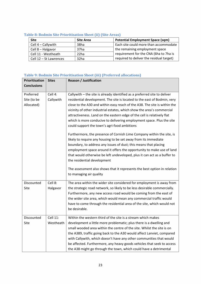
Table 8: Bodmin Site Prioritisation Sheet (ii) (Site Areas)
Site Site Area Potential Employment Space (sqm)
Cell 4 – Callywith 38ha Each site could more than accommodate the remaining employment space requirement for the CNA (6ha to 7ha is required to deliver the residual target)
Cell 8 – Halgavor 37ha
Cell 11 - Westheath 22ha
Cell 12 – St Lawrences 32ha
Table 9: Bodmin Site Prioritisation Sheet (iii) (Preferred allocations)
Prioritisation
Conclusions
Sites Reason / Justification
Preferred
Site (to be
Allocated)
Cell 4:
Callywith
Callywith – the site is already identified as a preferred site to deliver
residential development. The site is located to the east of Bodmin, very
close to the A30 and within easy reach of the A38. The site is within the
vicinity of other industrial estates, which show the area’s commercial
attractiveness. Land on the eastern edge of the cell is relatively flat
which is more conducive to delivering employment space. Plus the site
could support the town’s agri-food ambitions
Furthermore, the presence of Cornish Lime Company within the site, is
likely to require any housing to be set away from its immediate
boundary, to address any issues of dust; this means that placing
employment space around it offers the opportunity to make use of land
that would otherwise be left undeveloped, plus it can act as a buffer to
the residential development
The assessment also shows that it represents the best option in relation
to managing air quality
Discounted
Site
Cell 8:
Halgavor
The area within the wider site considered for employment is away from
the strategic road network, so likely to be less desirable commercially.
Furthermore, any new access road would be coming from the east of
the wider site area, which would mean any commercial traffic would
have to come through the residential area of the site, which would not
be desirable.
Discounted
Site
Cell 11:
Westheath
Within the western third of the site is a stream which makes
development a little more problematic; plus there is a dwelling and
small wooded area within the centre of the site. Whilst the site is on
the A389, traffic going back to the A30 would affect Lanviet, compared
with Callywith, which doesn’t have any other communities that would
be affected. Furthermore, any heavy goods vehicles that seek to access
the A38 might go through the town, which could have a detrimental
24
Prioritisation
Conclusions
Sites Reason / Justification
impact upon the air quality within the town centre
Discounted
Site
Cell 12: St
Lawrences
Whilst the site is on the A389, traffic going back to the A30 would affect
Lanviet, compared with Callywith, which doesn’t have any other
communities that would be affected. Furthermore, any heavy goods
vehicles that seek to access the A38 might go through the town, which
could have a detrimental impact upon the air quality within the town
centre
iv. Proposed Sites As a result of the assessment, it is proposed that the Callywith site is prioritised to deliver the
residual employment space target, as part of a mixed use scheme. The precise area of land should
not be fixed, but it should be on the east of the site, involving the land surrounding the edge of the
site of the Cornish Lime Company.
25
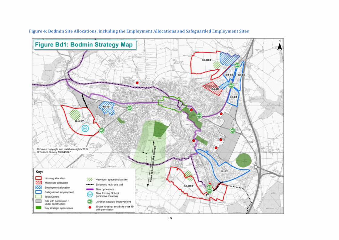
6. Site Allocations (Employment Space) at Bodmin The land to be allocated to accommodate future employment space site at Bodmin, in Cornwall’s
Site Allocations DPD, is illustrated within Figure 4. More detailed information relating to these sites is
presented below:
Beacon Technology Park (Bd-E1) The site should deliver approximately 3,600sqm (GIA) of B1a office space, in addition to the completed office scheme (PA12/12064). The scale and massing of any scheme should give due regard to the existing residential development surrounding the site, plus the proposed residential development set out within the permitted development to its south-west (PA14/09274).
Cooksland Extension (Bd-E6) The site should deliver approximately 12,000sqm of B1 / B2 / B8 employment space, assumed
approximately 25% office, 75% industrial. The main access should be from Cooksland Road; plus due
regard should be given to Castle Canyke, a scheduled Ancient Monument.
Callywith Urban Village (Bd-UE4) Approximately 6-7ha of land should set aside to deliver employment space (B1 / B2 / B8), which
should provide for approximately 26,000sqm of built space. This will form part of a larger allocation
that will accommodate residential development. The employment space should be primarily focused
to the north-east of the site, wrapping around the Cornish Lime Company site. Employment space on
the southern and western edges of the designated employment area should be designed to
represent an appropriate neighbour to residential development.
26
Figure 4: Bodmin Site Allocations, including the Employment Allocations and Safeguarded Employment Sites
27
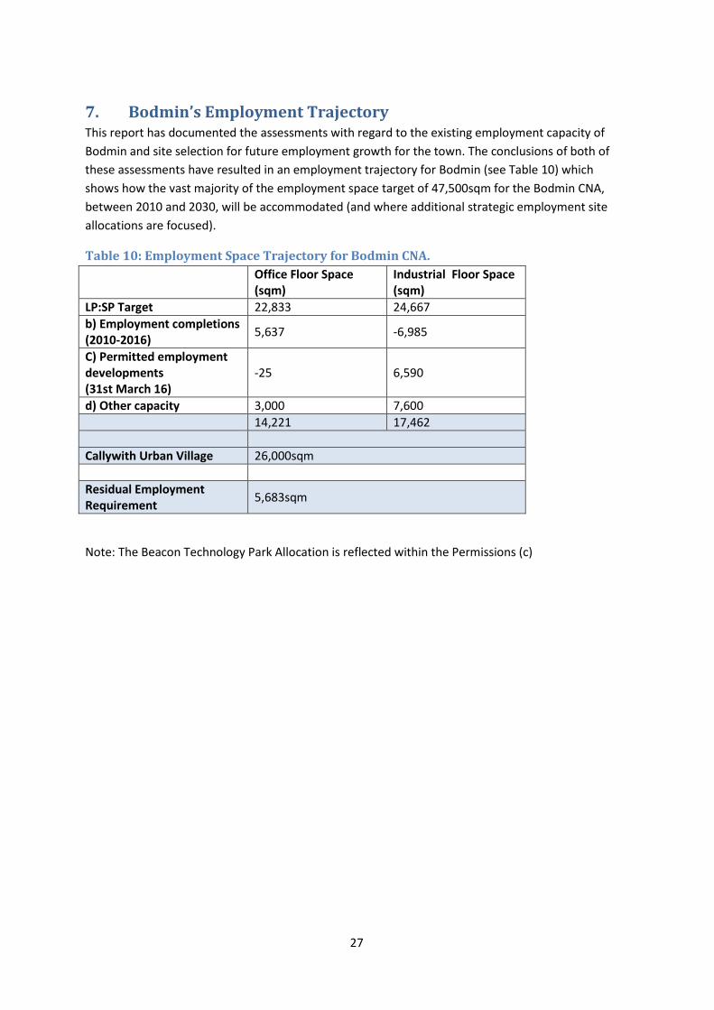
7. Bodmin’s Employment Trajectory This report has documented the assessments with regard to the existing employment capacity of
Bodmin and site selection for future employment growth for the town. The conclusions of both of
these assessments have resulted in an employment trajectory for Bodmin (see Table 10) which
shows how the vast majority of the employment space target of 47,500sqm for the Bodmin CNA,
between 2010 and 2030, will be accommodated (and where additional strategic employment site
allocations are focused).
Table 10: Employment Space Trajectory for Bodmin CNA.
Office Floor Space (sqm)
Industrial Floor Space (sqm)
LP:SP Target 22,833 24,667
b) Employment completions (2010-2016)
5,637 -6,985
C) Permitted employment developments (31st March 16)
-25 6,590
d) Other capacity 3,000 7,600
14,221 17,462
Callywith Urban Village 26,000sqm
Residual Employment Requirement
5,683sqm
Note: The Beacon Technology Park Allocation is reflected within the Permissions (c)

28
Appendix 1: Sustainability Appraisal Tables

Bodmin Allocations Prioritisation SA
Employment
Cell 4: Callywith
30
LDF SA Objectives Score Impacts of proposal Proposed mitigation measures and
considerations
1. Climatic Factors
1. To reduce our contribution to climate change
through a reduction in greenhouse gas
emissions.
2. To increase resilience to climate change, and
reduce vulnerability.
a) Does it limit greenhouse gas emissions?
b) Does it secure the highest viable resource and
energy efficiency?
c) Does it encourage the use of renewable
energy technologies?
d) Does it minimise vulnerability and encourage
resilience to the effects of climate change?
++/- The site is more peripheral to the existing urban area
of Bodmin in comparison to other areas, and it does
not offer a location which could optimise use of more
sustainable modes of transport for residents.
However, the site has good access from the A30,
which will minimise heavy goods vehicles from going
through the town ++/-
The site has a varying southerly and westerly aspect.
This would allow some degree of solar gain and would
enable the use of renewable technologies.+/-
New development should seek to maximise use of sustainable
modes of transport and reduce reliance on private vehicles for
short trips.
Where possible linkages for walking and cycling between the
new development, residential areas and facilities outside of the
site area should be encouraged.
For public bus services, when road links are built a cul de sac
arrangement should be avoided as this will discourage bus
operators from operating services through the future site.
Roads that allow buses to run through a site using separate
access and egress are preferred as this will encourage bus
services to be routed through areas.
2. Waste
1. To minimise the generation of waste and
encourage greater re-use and recycling of
materials in accordance with the waste
hierarchy.
a) Will it reduce the amount of waste produced,
collected, and or land filled?
b) Will it increase levels of composting or
anaerobic digestion?
c) Has space for storage of recycled materials
been planned for?
d) Will it reduce the waste management
industry’s contribution to climate change?
+/-
Site location unlikely to have any positive or negative
impact on the overall amount of waste produced,
collected and or land filled.
New development will seek to reduce waste by increasing
recycling, the provision of sufficient storage and collection
areas for recycling, composting and waste and addressing
waste as a resource and looking to disposal as the last option.
3. Minerals and Geodiversity ++/- A small area of the site is within a mineral
consultation area.--/+
31
LDF SA Objectives Score Impacts of proposal Proposed mitigation measures and
considerations
1. To minimise the consumption of mineral
resources and ensure the sustainable
management of these resources
2. To conserve, enhance and restore the
condition of geodiversity in the county.
a) Will it minimise the consumption of primary
mineral resources and encourage re-use of
secondary resources?
b) Will it ensure development does not
irreversibly sterilise important mineral resources?
c) Will it prevent harm to and, where
appropriate, enhance geological conservation
interests in the county?
d) Will mineral working impact on designated
land?
The site is not in proximity to a County Geology
(RIGS) site.+
4. Soil
1. To minimise the use of undeveloped land and
protect and enhance soil quality.
2. To encourage and safeguard local food
production.
a) Will it protect, enhance and improve soil
quality in Cornwall?
b) Will it avoid development that leads to the
loss of productive soil?
- Only a small part of the site was covered by the post
88 survey. The site consists of Grade 3a and 3b
agricultural land so if developed would lead to the loss
of some of the best and most versatile agricultural
land.-
* Source Agricultural Land Classification field survey
pre 88 and post 88
5. Air
1. To reduce air pollution and ensure air quality
continues to improve.
a) Will it reduce pollution including greenhouse
gas emissions?
b) Will it maintain or improve air quality in
Cornwall?
+ Any development will have an impact on air pollution
the extent to which can be minimised through careful
design and construction.
Bodmin Town Centre was designated as an Air Quality
Management Area in 2008. However, development of
the site close to the strategic road network means
most heavy goods vehicles are unlikely to go through
the town centre, which is where the air quality issues
are located. +
The extent of air pollution resulting from the proposal can be
minimised through careful design and construction
32
LDF SA Objectives Score Impacts of proposal Proposed mitigation measures and
considerations
6. Water
1. To reduce and manage the risk of flooding and
reduce vulnerability to flooding, sea level rise
and coastal erosion.
2. To maintain and enhance water quality and
reduce consumption and increase efficiency of
water use?
a) Does the proposal reduce, or avoid increasing
the risk of flooding overall?
b) Does the proposal reduce the overall demand
for water?
c) Will the proposal provide for greater
integrated water catchment management and
strengthen links between habitats to increase the
likelihood of adaptation to climate change?
d) Will the proposal increase the risk of water
pollution events?
+/- All development will increase the overall demand for
water.
Flood Risk assessment demonstrates the proposed
use is compatible with the Flood Zone status of the
majority of the site.+
Over half of the site is covered by a Critical Drainage
Area.-
Development will have potential negative impacts on water
related issues, however appropriate implementation of SUDS
can mitigate these issues.
The SFRA made the following recommendations :
SuDS are likely to be infiltration based or with surface
attenuation features (ponds) leading southward across the site
to the Flaxmoor Stream. Surface water drainage will need to be
designed in accordance with the SUDS principles and standards
set out in the Drainage Guidance for Cornwall to ensure surface
water run-off from development is managed appropriately so
that flood risk is not increased.
7. Biodiversity
1. To conserve, enhance and restore the
condition and extent of biodiversity in the county
and allow its adaptation to climate change.
a) Does the proposal protect, enhance or restore
biodiversity interest of BAP habitats, Cornwall
wildlife sites, SSSI’s, and internationally,
nationally and regionally designated areas?
b) Does the proposal allow adaptation to climate
change through the connection of habitats
(wildlife corridors)?
c) Does it protect not only designated areas but
also of wildlife interest everywhere?
d) Will it encourage the provision of new or
improved wildlife habitats?
+ At this stage it is not possible to assess whether any
proposal could have a positive impact on biodiversity.
The area does not fall within a Special Area of
Conservation, Site of Special Scientific Interest, or
other designated site of international, national or
regional significance. +
The site does not fall within or is adjacent to a
Cornwall Wildlife Site.+
The site does not fall within or is adjacent to a BAP
habitat.+
Development in this area could be accompanied by the
provision of some wildlife habitats and these could be an
improvement to some areas within the site however overall
provisions would be unlikely to improve what already exists.
33
LDF SA Objectives Score Impacts of proposal Proposed mitigation measures and
considerations
8. Landscape
1. To protect and enhance the quality of the
natural, historic and cultural landscape and
seascape.
a) Will it sustain and enhance and/or restore the
distinctive qualities and features of the natural,
historic and cultural landscape and seascape
character?
b) Will it conserve and enhance the natural
beauty of the Cornwall AONB and the Tamar
Valley AONB, and increase understanding and
enjoyment of the special qualities of the AONBs?
c) Will it protect, enhance and promote
opportunities for green infrastructure within and
between urban settlements.
d) Will it maintain and enhance a high quality
living environment?
e) Will it encourage the location and design of
development to respect and improve landscape
character and the landscape setting of
settlements?
-- At this stage it is not possible to assess whether any
proposal could have a positive impact on green
infrastructure.
The site is not within or in proximity to a designated
AONB, however the northern half of the proposed
allocation is within a designated AGLV. Although there
is an area of land around an existing business,
Cornish Lime, which has a lower landscape value -
The landscape assessment for the site assessed it as
having a high landscape value. --
Mitigation will be required if the site option is developed and
this will be looked at in more detail at a later stage to reduce
harm to the higher quality landscape in particular.
9. Maritime
1. To encourage clean, healthy, productive and
diverse waters; To protect coastal areas and
ensure sustainable maritime environments.
a) Will the proposal protect, enhance or restore
maritime heritage, habitat and biodiversity, both
designated and undesignated?
b) Will the proposal incorporate adaptation to
climate change and its likely effects on the sea,
coast and estuaries?
c) Will the proposal operate within the carrying
capacity of the receiving environment, without
adverse effect on its sustainability?
d) Will the proposal operate within safe
o The site is in not in proximity to the coast.
None required
34
LDF SA Objectives Score Impacts of proposal Proposed mitigation measures and
considerations
biological, chemical and physical limits?
10. Historic Environment
1. To protect and enhance the quality and local
distinctiveness of the historic environment.
a) Does the proposal reinforce the distinctive
character of Cornwall?
b) Does the proposal have an
acceptable/unacceptable level of impact on the
historic environment?
c) Does the proposal preserve and enhance the
cultural and social significance of the historic
asset?
d) Will it result in development which is
sympathetic towards the need to promote the
Cornwall's unique heritage value, historic
environment and culture?
e) Have flood mitigation measures been designed
to be compatible with the immediate historic
environment?
f) Has a balance been struck between the level of
risk (e.g. in adaptation to climate change or
flood risk) and the aspiration to preserve the
distinctive qualities of the historic environment?
--/+ All development is likely to have some effect on the
historic environment.
Outcome of Historic Environment Assessment implies
less than substantial harm and the potential for
mitigation.--/+
The proposed site contains two features recorded on
the Cornwall Sites and Monuments Register, with
evidence for a post medieval field boundary and post
medieval quarry in the east of the site.--/+
The site is partly classed as Ancient Enclosed Land
and partly as Post Medieval Enclosed Land.-
The HIA assessment of the area recommended the following
mitigation measures
1. Assessments to be done to inform masterplan stage:
• Desk Based Assessment & Walk Over Survey
• Impact Assessment
• Geophysical survey to minimise impact & target
excavation
• Assessment of impact on setting & context of HE
assets/historic landscapes
2. Assessment /HE issues must inform extent of
development and design solutions within the allocation cell
3. Management solution to be agreed for site and setting
of scheduled cross on Old Callywith Road
In addition the following was recommended for the
employment area:
Management protocols for setting/location of cross needs to be
built into any development/ assessment proposals
11. Design
1. To promote and achieve high quality design in
development, sustainable land use and
sustainable built development.
a) Will it encourage developers to build to higher
environmental standards?
b) Will it help to promote local distinctiveness?
c) Does the proposal meet targets for renewable
+ Topography is unlikely to impede the sustainable
design of development in this area.+
None required
35
LDF SA Objectives Score Impacts of proposal Proposed mitigation measures and
considerations
energy capture and sustainable construction
using BREEAM or Code for Sustainable Homes?
d) Will it promote high quality, sustainable and
sympathetic design that takes account of
sustainable construction and transport modes,
and green infrastructure?
12. Social Inclusion
1. To reduce poverty and social exclusion and
provide opportunities for all to participate fully in
society.
a) Will it improve access to and provision of
services, health and community facilities
(including community youth facilities) especially
in rural areas and for the socially excluded?
b) Will it reduce poverty, deprivation,
discrimination, social exclusion and inequalities?
+ Development of this site for employment purposes will
improve access to employment opportunities
contributing to reducing poverty and social
exclusion.+
At the scheme design stage, efforts should be made to
incorporate elements that will reduce poverty and social
exclusion. Access to services and facilities need to be
considered.
13. Crime & Anti Social
Behaviour
1. To reduce crime, anti-social behaviour and
fear of crime.
a) Will it reduce crime and anti-social activity,
and in turn, provide safer communities in
Cornwall (particularly in the most deprived
neighbourhoods and identified hot spots)
b) Will it help reduce the fear of crime?
? At this stage, it is difficult to establish what impacts
development in this area will have on crime and
antisocial behaviour.
At the scheme design stage, crime and safety issues need to be
considered eg overlooking of public spaces and well lit
footpaths in order to design out crime.
14. Housing
1. To meet the needs of the local community as
a whole in terms of general market, affordable,
adaptable and decent housing.
a) Will it provide an appropriate mix of housing
to ensure delivery of long-term regeneration
schemes for the county?
o This allocation is for employment uses and so this
criteria is not relevant None required
36
LDF SA Objectives Score Impacts of proposal Proposed mitigation measures and
considerations
b) Will it reduce the number of people homeless
or in temporary accommodation?
c) Will it contribute towards the provision of
affordable, social and key worker housing?
d) Will it reduce the number of unfit homes, and
those falling below the decent homes standards?
e) Will it deliver adaptable housing to meet the
lifelong needs of the population?
f) Will it provide a well integrated mix of decent
homes of different types and tenures to support
a range of household sizes, ages and incomes?
g) Will it provide energy efficient development
which reduces the annual cost of heating/lighting
and helps reduce greenhouse gas emissions?
h) Will it make the best use of land?
15. Health, Sport and Recreation
1. To improve health through the promotion of
healthier lifestyles and improving access to open
space and health, recreation and sports facilities.
a) Will it improve health and well-being and
reduce inequalities in health?
b) Will it improve access to health services?
c) Will it improve access to the countryside,
coast, recreation and open spaces?
d) Will it increase participation and engagement
in physical activity and sport?
e) Will it lead to unacceptable noise levels?
? This allocation is for employment uses and so this
criteria is not relevant. At this stage future occupiers
of the proposed employment units are unknown and
noise impacts uncertain
16. Economic Development,
Regeneration and Tourism
1. To support a balanced and low carbon
economy that meets the needs of the area and
promotes a diverse range of quality employment
opportunities.
++ The site will be allocated for employment uses ++

37
LDF SA Objectives Score Impacts of proposal Proposed mitigation measures and
considerations
a) Will it promote a diverse range of employment
opportunities?
b) Will it provide affordable, small scale,
managed workspace to support local need?
c) Will it support the development of access to
ICT facilities including Broadband, particularly in
rural areas?
d) Will it raise the quality of employment and
reduce seasonality?
17. Education & Skills
1. To maximise accessibility for all to the
necessary education, skills and knowledge to
play a full role in society.
a) Will it help improve the qualifications and
skills of young people?
b) Will it improve facilities and opportunities for
lifelong learning (particularly for those with
greatest need)?
c) Will it help increase the County's skilled and
professional workforce?
d) Will it support a viable future for rural
communities?
e) Will it encourage a greater diversity of choice
in skills training as part of regeneration efforts?
f) Will it increase accessibility to training
facilities?
+
This site is allocated for employment uses and may
provide opportunities for work placed training facilities
+
18. Transport and Accessibility
1. To improve access to key services and
facilities by reducing the need to travel and by
providing safe sustainable travel choices.
2. To reduce traffic congestion and minimise
+ It is acknowledged that realistically development
increases use of motor vehicles.
The site is not conveniently located for residential
Future transport arrangements and accessibility issues need to
be considered as part of any policy development. Sustainable
linkages through the site to existing and planned facilities will
be required.
38
LDF SA Objectives Score Impacts of proposal Proposed mitigation measures and
considerations
transport related greenhouse gas emissions.
a) Will it promote sustainable forms of transport
(public transport including bus and rail, cycle and
pedestrian routes) and ensure the necessary
associated infrastructure is made available?
b) Will it reduce traffic congestion by promoting
alternative modes of transport?
c) Will it reduce the need to travel by seeking to
balance homes, jobs, services and facilities?
d) Will it lead to a reduction in greenhouse gas
emissions?
e) Will it improve service provision or provide a
service or facility which is accessible to all,
including those with disabilities and those in the
more rural areas?
f) Will it transfer freight from road to rail and/or
sea?
areas and a number of facilities, in comparison to
other areas. It does not therefore offer a location
which could optimise use of more sustainable modes
of transport including walking and cycling.-
The development of the area is of a scale to provide
linkages where public transport services could be
encouraged to operate.+
The site’s location on the east of the town ensures it
has good connection to the existing strategic highway
network, this means heavy goods vehicles would need
to go through the town to access the site. ++
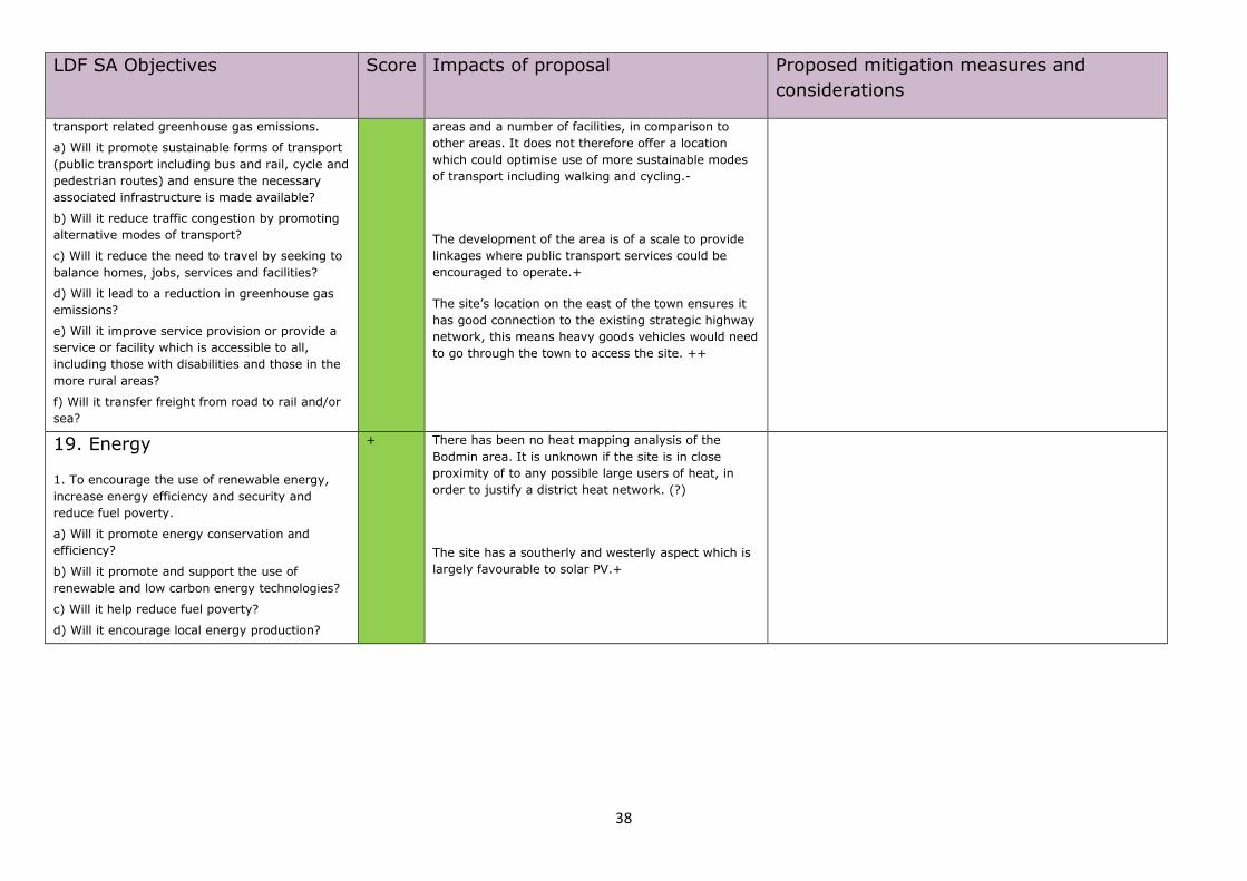
19. Energy
1. To encourage the use of renewable energy,
increase energy efficiency and security and
reduce fuel poverty.
a) Will it promote energy conservation and
efficiency?
b) Will it promote and support the use of
renewable and low carbon energy technologies?
c) Will it help reduce fuel poverty?
d) Will it encourage local energy production?
+ There has been no heat mapping analysis of the
Bodmin area. It is unknown if the site is in close
proximity of to any possible large users of heat, in
order to justify a district heat network. (?)
The site has a southerly and westerly aspect which is
largely favourable to solar PV.+
39
Bodmin Allocations Prioritisation SA Employment Cell 8: Halgavor
40
LDF SA Objectives Score Impacts of proposal Proposed mitigation measures and
considerations
1. Climatic Factors
1. To reduce our contribution to climate change
through a reduction in greenhouse gas
emissions.
2. To increase resilience to climate change, and
reduce vulnerability.
a) Does it limit greenhouse gas emissions?
b) Does it secure the highest viable resource and
energy efficiency?
c) Does it encourage the use of renewable
energy technologies?
d) Does it minimise vulnerability and encourage
resilience to the effects of climate change?
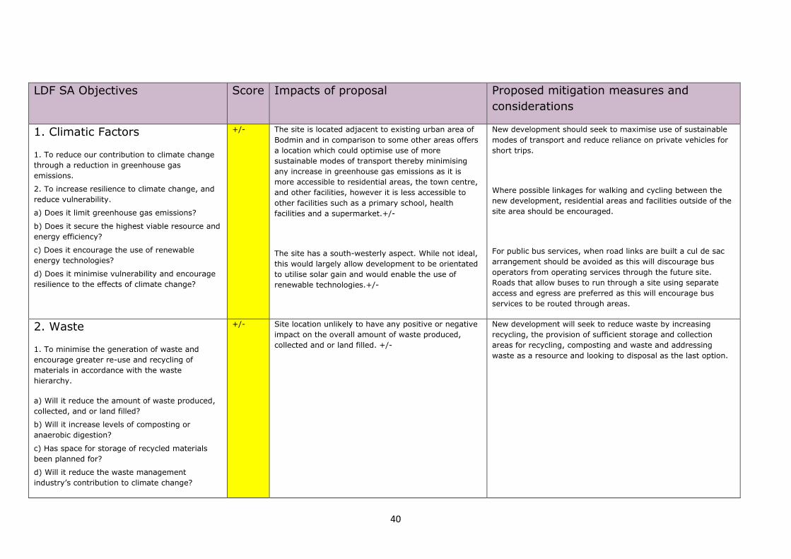
+/- The site is located adjacent to existing urban area of
Bodmin and in comparison to some other areas offers
a location which could optimise use of more
sustainable modes of transport thereby minimising
any increase in greenhouse gas emissions as it is
more accessible to residential areas, the town centre,
and other facilities, however it is less accessible to
other facilities such as a primary school, health
facilities and a supermarket.+/-
The site has a south-westerly aspect. While not ideal,
this would largely allow development to be orientated
to utilise solar gain and would enable the use of
renewable technologies.+/-
New development should seek to maximise use of sustainable
modes of transport and reduce reliance on private vehicles for
short trips.
Where possible linkages for walking and cycling between the
new development, residential areas and facilities outside of the
site area should be encouraged.
For public bus services, when road links are built a cul de sac
arrangement should be avoided as this will discourage bus
operators from operating services through the future site.
Roads that allow buses to run through a site using separate
access and egress are preferred as this will encourage bus
services to be routed through areas.
2. Waste
1. To minimise the generation of waste and
encourage greater re-use and recycling of
materials in accordance with the waste
hierarchy.
a) Will it reduce the amount of waste produced,
collected, and or land filled?
b) Will it increase levels of composting or
anaerobic digestion?
c) Has space for storage of recycled materials
been planned for?
d) Will it reduce the waste management
industry’s contribution to climate change?
+/-
Site location unlikely to have any positive or negative
impact on the overall amount of waste produced,
collected and or land filled. +/-
New development will seek to reduce waste by increasing
recycling, the provision of sufficient storage and collection
areas for recycling, composting and waste and addressing
waste as a resource and looking to disposal as the last option.
41
LDF SA Objectives Score Impacts of proposal Proposed mitigation measures and
considerations
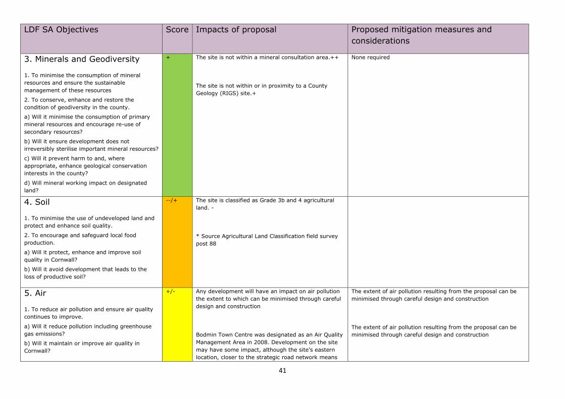
3. Minerals and Geodiversity
1. To minimise the consumption of mineral
resources and ensure the sustainable
management of these resources
2. To conserve, enhance and restore the
condition of geodiversity in the county.
a) Will it minimise the consumption of primary
mineral resources and encourage re-use of
secondary resources?
b) Will it ensure development does not
irreversibly sterilise important mineral resources?
c) Will it prevent harm to and, where
appropriate, enhance geological conservation
interests in the county?
d) Will mineral working impact on designated
land?
+ The site is not within a mineral consultation area.++
The site is not within or in proximity to a County
Geology (RIGS) site.+
None required
4. Soil
1. To minimise the use of undeveloped land and
protect and enhance soil quality.
2. To encourage and safeguard local food
production.
a) Will it protect, enhance and improve soil
quality in Cornwall?
b) Will it avoid development that leads to the
loss of productive soil?
--/+ The site is classified as Grade 3b and 4 agricultural
land. -
* Source Agricultural Land Classification field survey
post 88
5. Air
1. To reduce air pollution and ensure air quality
continues to improve.
a) Will it reduce pollution including greenhouse
gas emissions?
b) Will it maintain or improve air quality in
Cornwall?
+/- Any development will have an impact on air pollution
the extent to which can be minimised through careful
design and construction
Bodmin Town Centre was designated as an Air Quality
Management Area in 2008. Development on the site
may have some impact, although the site’s eastern
location, closer to the strategic road network means
The extent of air pollution resulting from the proposal can be
minimised through careful design and construction
The extent of air pollution resulting from the proposal can be
minimised through careful design and construction
42
LDF SA Objectives Score Impacts of proposal Proposed mitigation measures and
considerations
the impact is likely to be limited. +/-
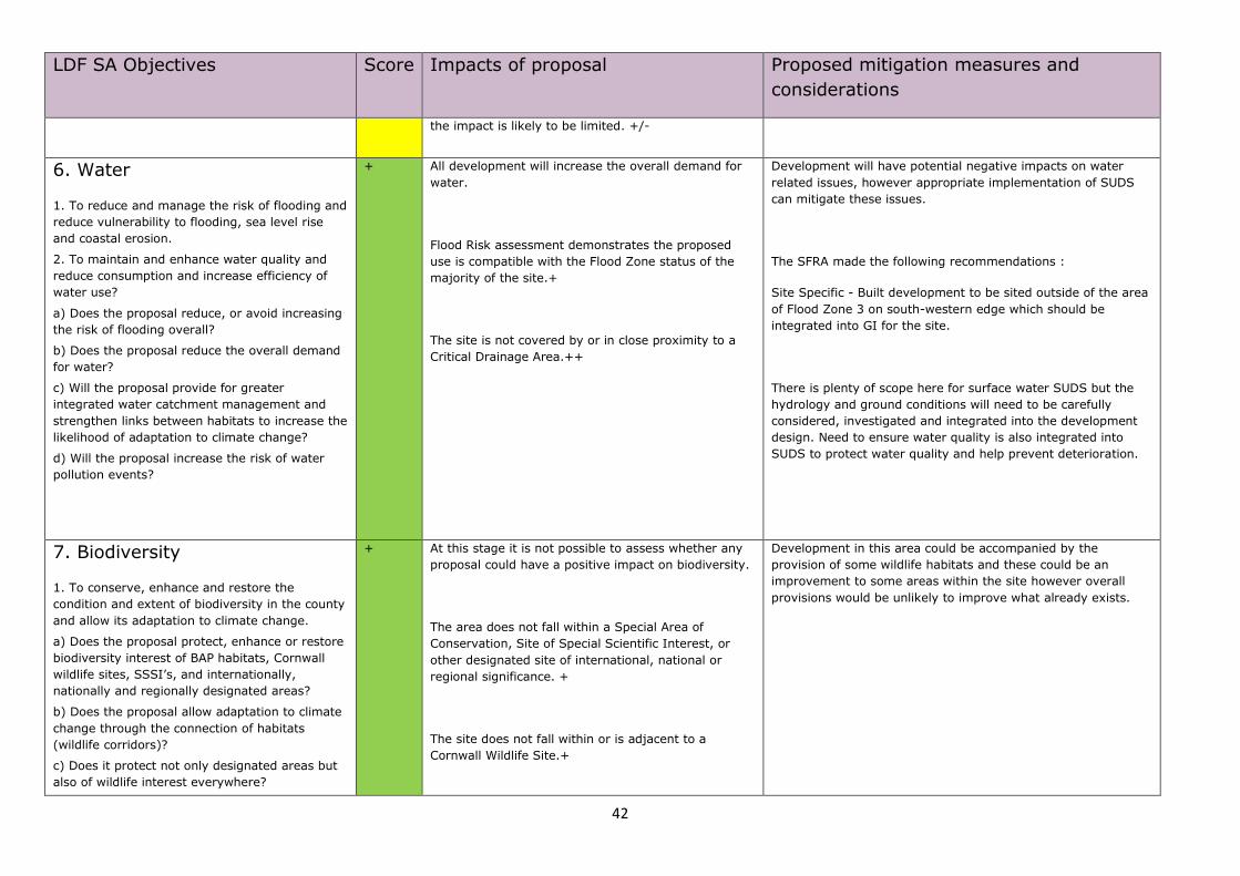
6. Water
1. To reduce and manage the risk of flooding and
reduce vulnerability to flooding, sea level rise
and coastal erosion.
2. To maintain and enhance water quality and
reduce consumption and increase efficiency of
water use?
a) Does the proposal reduce, or avoid increasing
the risk of flooding overall?
b) Does the proposal reduce the overall demand
for water?
c) Will the proposal provide for greater
integrated water catchment management and
strengthen links between habitats to increase the
likelihood of adaptation to climate change?
d) Will the proposal increase the risk of water
pollution events?
+ All development will increase the overall demand for
water.
Flood Risk assessment demonstrates the proposed
use is compatible with the Flood Zone status of the
majority of the site.+
The site is not covered by or in close proximity to a
Critical Drainage Area.++
Development will have potential negative impacts on water
related issues, however appropriate implementation of SUDS
can mitigate these issues.
The SFRA made the following recommendations :
Site Specific - Built development to be sited outside of the area
of Flood Zone 3 on south-western edge which should be
integrated into GI for the site.
There is plenty of scope here for surface water SUDS but the
hydrology and ground conditions will need to be carefully
considered, investigated and integrated into the development
design. Need to ensure water quality is also integrated into
SUDS to protect water quality and help prevent deterioration.
7. Biodiversity
1. To conserve, enhance and restore the
condition and extent of biodiversity in the county
and allow its adaptation to climate change.
a) Does the proposal protect, enhance or restore
biodiversity interest of BAP habitats, Cornwall
wildlife sites, SSSI’s, and internationally,
nationally and regionally designated areas?
b) Does the proposal allow adaptation to climate
change through the connection of habitats
(wildlife corridors)?
c) Does it protect not only designated areas but
also of wildlife interest everywhere?
+ At this stage it is not possible to assess whether any
proposal could have a positive impact on biodiversity.
The area does not fall within a Special Area of
Conservation, Site of Special Scientific Interest, or
other designated site of international, national or
regional significance. +
The site does not fall within or is adjacent to a
Cornwall Wildlife Site.+
Development in this area could be accompanied by the
provision of some wildlife habitats and these could be an
improvement to some areas within the site however overall
provisions would be unlikely to improve what already exists.
43
LDF SA Objectives Score Impacts of proposal Proposed mitigation measures and
considerations
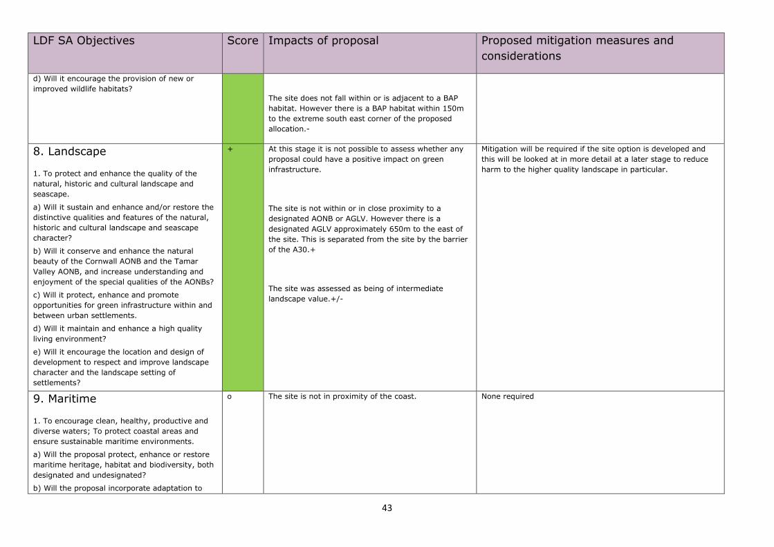
d) Will it encourage the provision of new or
improved wildlife habitats?
The site does not fall within or is adjacent to a BAP
habitat. However there is a BAP habitat within 150m
to the extreme south east corner of the proposed
allocation.-
8. Landscape
1. To protect and enhance the quality of the
natural, historic and cultural landscape and
seascape.
a) Will it sustain and enhance and/or restore the
distinctive qualities and features of the natural,
historic and cultural landscape and seascape
character?
b) Will it conserve and enhance the natural
beauty of the Cornwall AONB and the Tamar
Valley AONB, and increase understanding and
enjoyment of the special qualities of the AONBs?
c) Will it protect, enhance and promote
opportunities for green infrastructure within and
between urban settlements.
d) Will it maintain and enhance a high quality
living environment?
e) Will it encourage the location and design of
development to respect and improve landscape
character and the landscape setting of
settlements?
+ At this stage it is not possible to assess whether any
proposal could have a positive impact on green
infrastructure.
The site is not within or in close proximity to a
designated AONB or AGLV. However there is a
designated AGLV approximately 650m to the east of
the site. This is separated from the site by the barrier
of the A30.+
The site was assessed as being of intermediate
landscape value.+/-
Mitigation will be required if the site option is developed and
this will be looked at in more detail at a later stage to reduce
harm to the higher quality landscape in particular.
9. Maritime
1. To encourage clean, healthy, productive and
diverse waters; To protect coastal areas and
ensure sustainable maritime environments.
a) Will the proposal protect, enhance or restore
maritime heritage, habitat and biodiversity, both
designated and undesignated?
b) Will the proposal incorporate adaptation to
o The site is not in proximity of the coast.
None required
44
LDF SA Objectives Score Impacts of proposal Proposed mitigation measures and
considerations
climate change and its likely effects on the sea,
coast and estuaries?
c) Will the proposal operate within the carrying
capacity of the receiving environment, without
adverse effect on its sustainability?
d) Will the proposal operate within safe
biological, chemical and physical limits?
10. Historic Environment
1. To protect and enhance the quality and local
distinctiveness of the historic environment.
a) Does the proposal reinforce the distinctive
character of Cornwall?
b) Does the proposal have an
acceptable/unacceptable level of impact on the
historic environment?
c) Does the proposal preserve and enhance the
cultural and social significance of the historic
asset?
d) Will it result in development which is
sympathetic towards the need to promote the
Cornwall's unique heritage value, historic
environment and culture?
e) Have flood mitigation measures been designed
to be compatible with the immediate historic
environment?
f) Has a balance been struck between the level of
risk (e.g. in adaptation to climate change or
flood risk) and the aspiration to preserve the
distinctive qualities of the historic environment?
+ All development is likely to have some effect on the
historic environment.
Outcome of Historic Environment Assessment implies
no harm to heritage assets +
The proposed site contains one feature recorded on
the Cornwall Sites and Monuments Register, with a
medieval field system. It also adjoins the medieval
settlement of Halgavor.
The site is classed as Post Medieval Enclosed land with
a small section classed as Upland Rough Ground.
The HIA assessment of the area recommended the following
mitigation measures :
Assessments to be done to inform masterplan stage in order to
inform precise layouts, densities etc.:
• Desk Based Assessment & Walk Over Survey
• Impact Assessment
• Geophysical survey to minimise impact & target
excavation
• Assessment of impact on setting, context and inter-
relationship of HE assets/historic landscapes
2. Assessment /HE issues must inform extent of
development and design solutions within the allocation cell.
3. Mitigation to include appropriate design responding to
historic landscape context
11. Design
1. To promote and achieve high quality design in
development, sustainable land use and
sustainable built development.
a) Will it encourage developers to build to higher
+ Topography is unlikely to impede the sustainable
design of development over this area.+ None required
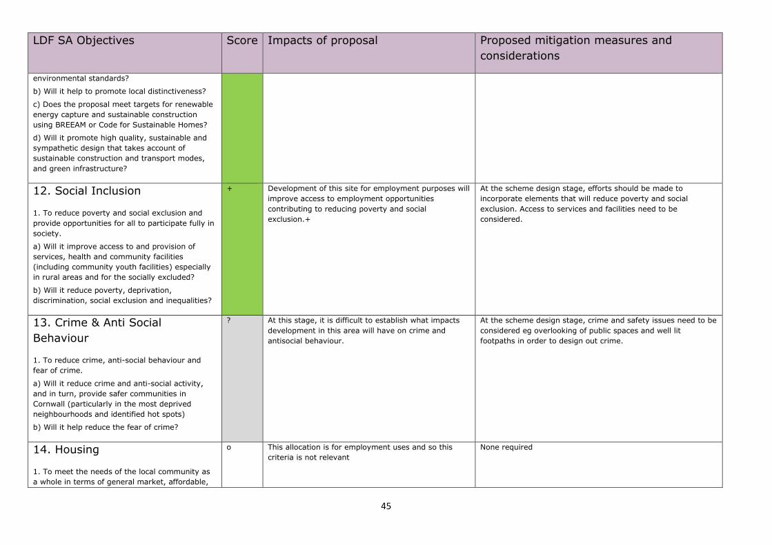
45
LDF SA Objectives Score Impacts of proposal Proposed mitigation measures and
considerations
environmental standards?
b) Will it help to promote local distinctiveness?
c) Does the proposal meet targets for renewable
energy capture and sustainable construction
using BREEAM or Code for Sustainable Homes?
d) Will it promote high quality, sustainable and
sympathetic design that takes account of
sustainable construction and transport modes,
and green infrastructure?
12. Social Inclusion
1. To reduce poverty and social exclusion and
provide opportunities for all to participate fully in
society.
a) Will it improve access to and provision of
services, health and community facilities
(including community youth facilities) especially
in rural areas and for the socially excluded?
b) Will it reduce poverty, deprivation,
discrimination, social exclusion and inequalities?
+ Development of this site for employment purposes will
improve access to employment opportunities
contributing to reducing poverty and social
exclusion.+
At the scheme design stage, efforts should be made to
incorporate elements that will reduce poverty and social
exclusion. Access to services and facilities need to be
considered.
13. Crime & Anti Social
Behaviour
1. To reduce crime, anti-social behaviour and
fear of crime.
a) Will it reduce crime and anti-social activity,
and in turn, provide safer communities in
Cornwall (particularly in the most deprived
neighbourhoods and identified hot spots)
b) Will it help reduce the fear of crime?
? At this stage, it is difficult to establish what impacts
development in this area will have on crime and
antisocial behaviour.
At the scheme design stage, crime and safety issues need to be
considered eg overlooking of public spaces and well lit
footpaths in order to design out crime.
14. Housing
1. To meet the needs of the local community as
a whole in terms of general market, affordable,
o This allocation is for employment uses and so this
criteria is not relevant
None required
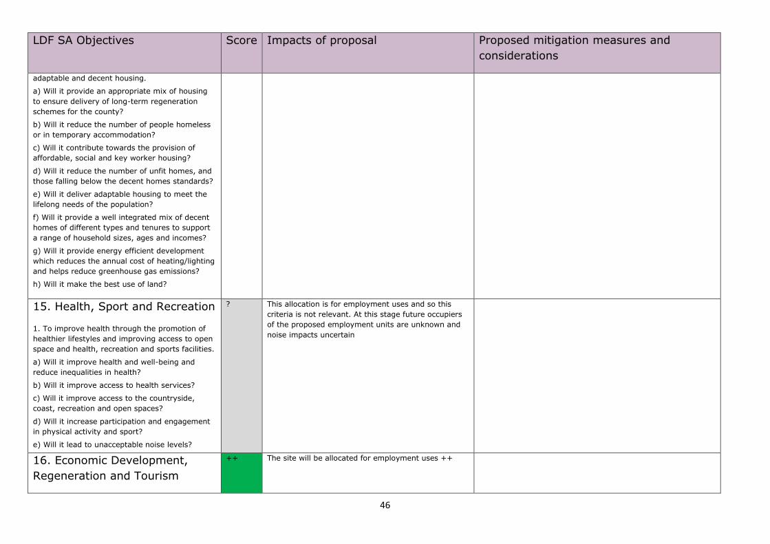
46
LDF SA Objectives Score Impacts of proposal Proposed mitigation measures and
considerations
adaptable and decent housing.
a) Will it provide an appropriate mix of housing
to ensure delivery of long-term regeneration
schemes for the county?
b) Will it reduce the number of people homeless
or in temporary accommodation?
c) Will it contribute towards the provision of
affordable, social and key worker housing?
d) Will it reduce the number of unfit homes, and
those falling below the decent homes standards?
e) Will it deliver adaptable housing to meet the
lifelong needs of the population?
f) Will it provide a well integrated mix of decent
homes of different types and tenures to support
a range of household sizes, ages and incomes?
g) Will it provide energy efficient development
which reduces the annual cost of heating/lighting
and helps reduce greenhouse gas emissions?
h) Will it make the best use of land?
15. Health, Sport and Recreation
1. To improve health through the promotion of
healthier lifestyles and improving access to open
space and health, recreation and sports facilities.
a) Will it improve health and well-being and
reduce inequalities in health?
b) Will it improve access to health services?
c) Will it improve access to the countryside,
coast, recreation and open spaces?
d) Will it increase participation and engagement
in physical activity and sport?
e) Will it lead to unacceptable noise levels?
? This allocation is for employment uses and so this
criteria is not relevant. At this stage future occupiers
of the proposed employment units are unknown and
noise impacts uncertain
16. Economic Development,
Regeneration and Tourism
++ The site will be allocated for employment uses ++
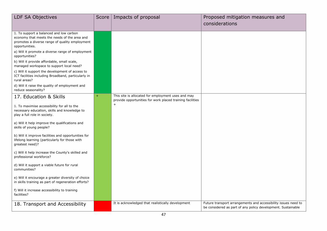
47
LDF SA Objectives Score Impacts of proposal Proposed mitigation measures and
considerations
1. To support a balanced and low carbon
economy that meets the needs of the area and
promotes a diverse range of quality employment
opportunities.
a) Will it promote a diverse range of employment
opportunities?
b) Will it provide affordable, small scale,
managed workspace to support local need?
c) Will it support the development of access to
ICT facilities including Broadband, particularly in
rural areas?
d) Will it raise the quality of employment and
reduce seasonality?
17. Education & Skills
1. To maximise accessibility for all to the
necessary education, skills and knowledge to
play a full role in society.
a) Will it help improve the qualifications and
skills of young people?
b) Will it improve facilities and opportunities for
lifelong learning (particularly for those with
greatest need)?
c) Will it help increase the County's skilled and
professional workforce?
d) Will it support a viable future for rural
communities?
e) Will it encourage a greater diversity of choice
in skills training as part of regeneration efforts?
f) Will it increase accessibility to training
facilities?
+ This site is allocated for employment uses and may
provide opportunities for work placed training facilities
+
18. Transport and Accessibility - It is acknowledged that realistically development Future transport arrangements and accessibility issues need to
be considered as part of any policy development. Sustainable
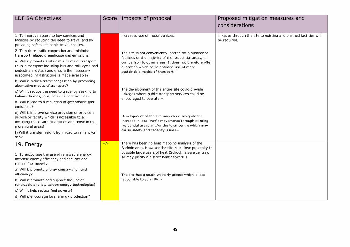
48
LDF SA Objectives Score Impacts of proposal Proposed mitigation measures and
considerations
1. To improve access to key services and
facilities by reducing the need to travel and by
providing safe sustainable travel choices.
2. To reduce traffic congestion and minimise
transport related greenhouse gas emissions.
a) Will it promote sustainable forms of transport
(public transport including bus and rail, cycle and
pedestrian routes) and ensure the necessary
associated infrastructure is made available?
b) Will it reduce traffic congestion by promoting
alternative modes of transport?
c) Will it reduce the need to travel by seeking to
balance homes, jobs, services and facilities?
d) Will it lead to a reduction in greenhouse gas
emissions?
e) Will it improve service provision or provide a
service or facility which is accessible to all,
including those with disabilities and those in the
more rural areas?
f) Will it transfer freight from road to rail and/or
sea?
increases use of motor vehicles.
The site is not conveniently located for a number of
facilities or the majority of the residential areas, in
comparison to other areas. It does not therefore offer
a location which could optimise use of more
sustainable modes of transport -
The development of the entire site could provide
linkages where public transport services could be
encouraged to operate.+
Development of the site may cause a significant
increase in local traffic movements through existing
residential areas and/or the town centre which may
cause safety and capacity issues.-
linkages through the site to existing and planned facilities will
be required.
19. Energy
1. To encourage the use of renewable energy,
increase energy efficiency and security and
reduce fuel poverty.
a) Will it promote energy conservation and
efficiency?
b) Will it promote and support the use of
renewable and low carbon energy technologies?
c) Will it help reduce fuel poverty?
d) Will it encourage local energy production?
+/- There has been no heat mapping analysis of the
Bodmin area. However the site is in close proximity to
possible large users of heat (School, leisure centre),
so may justify a district heat network.+
The site has a south-westerly aspect which is less
favourable to solar PV. -

49
Bodmin Allocations Prioritisation SA Employment Cell 11 - Westheath
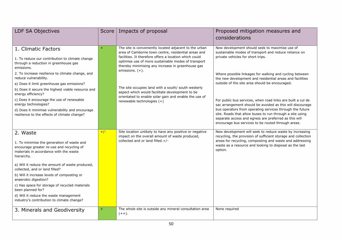
50
LDF SA Objectives Score Impacts of proposal Proposed mitigation measures and
considerations
1. Climatic Factors
1. To reduce our contribution to climate change
through a reduction in greenhouse gas
emissions.
2. To increase resilience to climate change, and
reduce vulnerability.
a) Does it limit greenhouse gas emissions?
b) Does it secure the highest viable resource and
energy efficiency?
c) Does it encourage the use of renewable
energy technologies?
d) Does it minimise vulnerability and encourage
resilience to the effects of climate change?
+ The site is conveniently located adjacent to the urban
area of Camborne town centre, residential areas and
facilities. It therefore offers a location which could
optimise use of more sustainable modes of transport
thereby minimising any increase in greenhouse gas
emissions. (+).
The site occupies land with a south/ south westerly
aspect which would facilitate development to be
orientated to enable solar gain and enable the use of
renewable technologies (+)
New development should seek to maximise use of
sustainable modes of transport and reduce reliance on
private vehicles for short trips.
Where possible linkages for walking and cycling between
the new development and residential areas and facilities
outside of the site area should be encouraged.
For public bus services, when road links are built a cul de
sac arrangement should be avoided as this will discourage
bus operators from operating services through the future
site. Roads that allow buses to run through a site using
separate access and egress are preferred as this will
encourage bus services to be routed through areas.
2. Waste
1. To minimise the generation of waste and
encourage greater re-use and recycling of
materials in accordance with the waste
hierarchy.
a) Will it reduce the amount of waste produced,
collected, and or land filled?
b) Will it increase levels of composting or
anaerobic digestion?
c) Has space for storage of recycled materials
been planned for?
d) Will it reduce the waste management
industry’s contribution to climate change?
+/-
Site location unlikely to have any positive or negative
impact on the overall amount of waste produced,
collected and or land filled.+/-
New development will seek to reduce waste by increasing
recycling, the provision of sufficient storage and collection
areas for recycling, composting and waste and addressing
waste as a resource and looking to disposal as the last
option.
3. Minerals and Geodiversity + The whole site is outside any mineral consultation area
(++).
None required
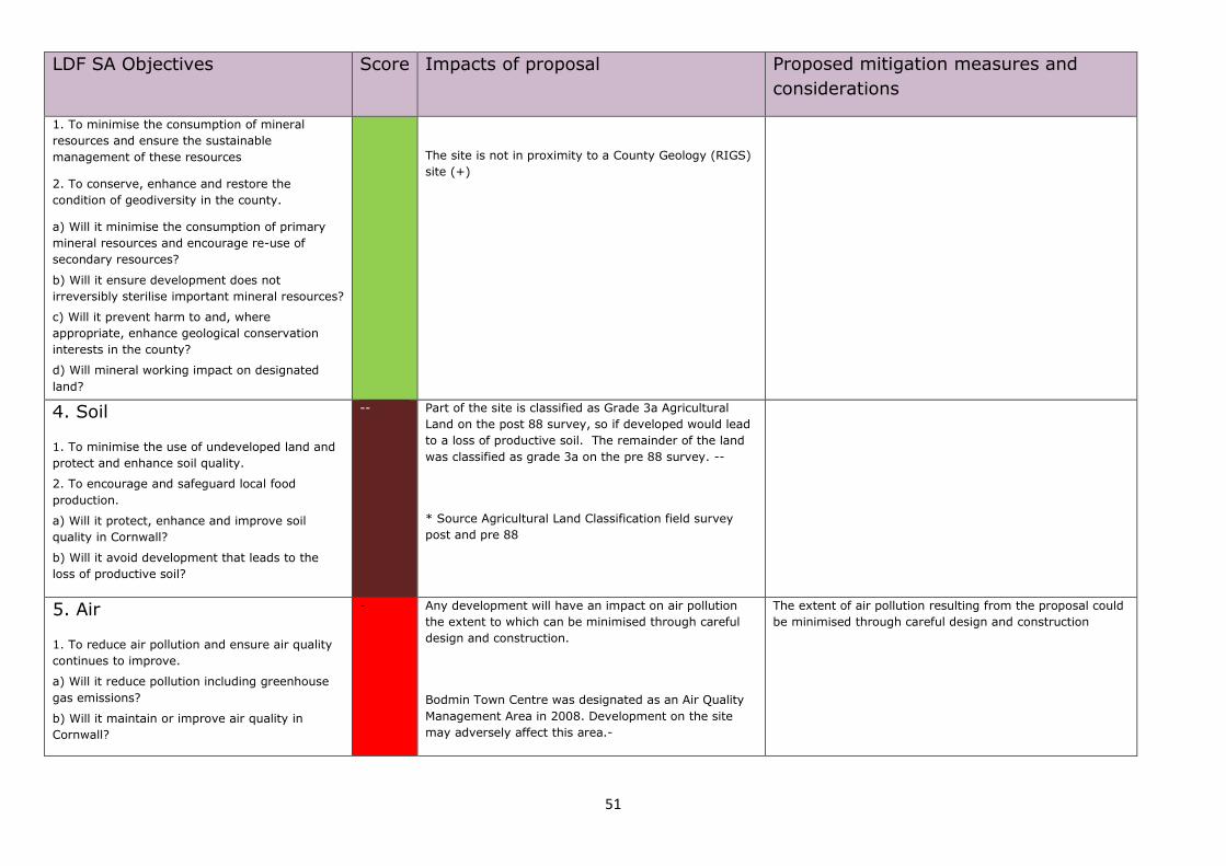
51
LDF SA Objectives Score Impacts of proposal Proposed mitigation measures and
considerations
1. To minimise the consumption of mineral
resources and ensure the sustainable
management of these resources
2. To conserve, enhance and restore the
condition of geodiversity in the county.
a) Will it minimise the consumption of primary
mineral resources and encourage re-use of
secondary resources?
b) Will it ensure development does not
irreversibly sterilise important mineral resources?
c) Will it prevent harm to and, where
appropriate, enhance geological conservation
interests in the county?
d) Will mineral working impact on designated
land?
The site is not in proximity to a County Geology (RIGS)
site (+)
4. Soil
1. To minimise the use of undeveloped land and
protect and enhance soil quality.
2. To encourage and safeguard local food
production.
a) Will it protect, enhance and improve soil
quality in Cornwall?
b) Will it avoid development that leads to the
loss of productive soil?
-- Part of the site is classified as Grade 3a Agricultural
Land on the post 88 survey, so if developed would lead
to a loss of productive soil. The remainder of the land
was classified as grade 3a on the pre 88 survey. --
* Source Agricultural Land Classification field survey
post and pre 88
5. Air
1. To reduce air pollution and ensure air quality
continues to improve.
a) Will it reduce pollution including greenhouse
gas emissions?
b) Will it maintain or improve air quality in
Cornwall?
- Any development will have an impact on air pollution
the extent to which can be minimised through careful
design and construction.
Bodmin Town Centre was designated as an Air Quality
Management Area in 2008. Development on the site
may adversely affect this area.-
The extent of air pollution resulting from the proposal could
be minimised through careful design and construction
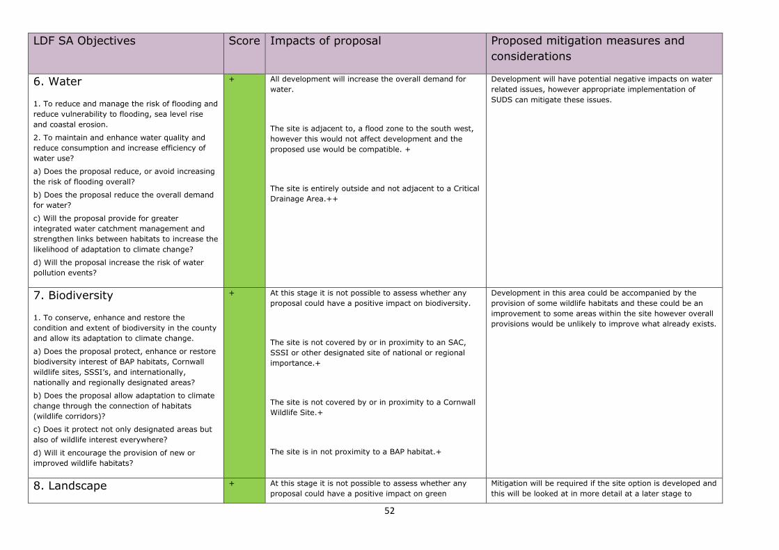
52
LDF SA Objectives Score Impacts of proposal Proposed mitigation measures and
considerations
6. Water
1. To reduce and manage the risk of flooding and
reduce vulnerability to flooding, sea level rise
and coastal erosion.
2. To maintain and enhance water quality and
reduce consumption and increase efficiency of
water use?
a) Does the proposal reduce, or avoid increasing
the risk of flooding overall?
b) Does the proposal reduce the overall demand
for water?
c) Will the proposal provide for greater
integrated water catchment management and
strengthen links between habitats to increase the
likelihood of adaptation to climate change?
d) Will the proposal increase the risk of water
pollution events?
+ All development will increase the overall demand for
water.
The site is adjacent to, a flood zone to the south west,
however this would not affect development and the
proposed use would be compatible. +
The site is entirely outside and not adjacent to a Critical
Drainage Area.++
Development will have potential negative impacts on water
related issues, however appropriate implementation of
SUDS can mitigate these issues.
7. Biodiversity
1. To conserve, enhance and restore the
condition and extent of biodiversity in the county
and allow its adaptation to climate change.
a) Does the proposal protect, enhance or restore
biodiversity interest of BAP habitats, Cornwall
wildlife sites, SSSI’s, and internationally,
nationally and regionally designated areas?
b) Does the proposal allow adaptation to climate
change through the connection of habitats
(wildlife corridors)?
c) Does it protect not only designated areas but
also of wildlife interest everywhere?
d) Will it encourage the provision of new or
improved wildlife habitats?
+ At this stage it is not possible to assess whether any
proposal could have a positive impact on biodiversity.
The site is not covered by or in proximity to an SAC,
SSSI or other designated site of national or regional
importance.+
The site is not covered by or in proximity to a Cornwall
Wildlife Site.+
The site is in not proximity to a BAP habitat.+
Development in this area could be accompanied by the
provision of some wildlife habitats and these could be an
improvement to some areas within the site however overall
provisions would be unlikely to improve what already exists.
8. Landscape + At this stage it is not possible to assess whether any
proposal could have a positive impact on green
Mitigation will be required if the site option is developed and
this will be looked at in more detail at a later stage to
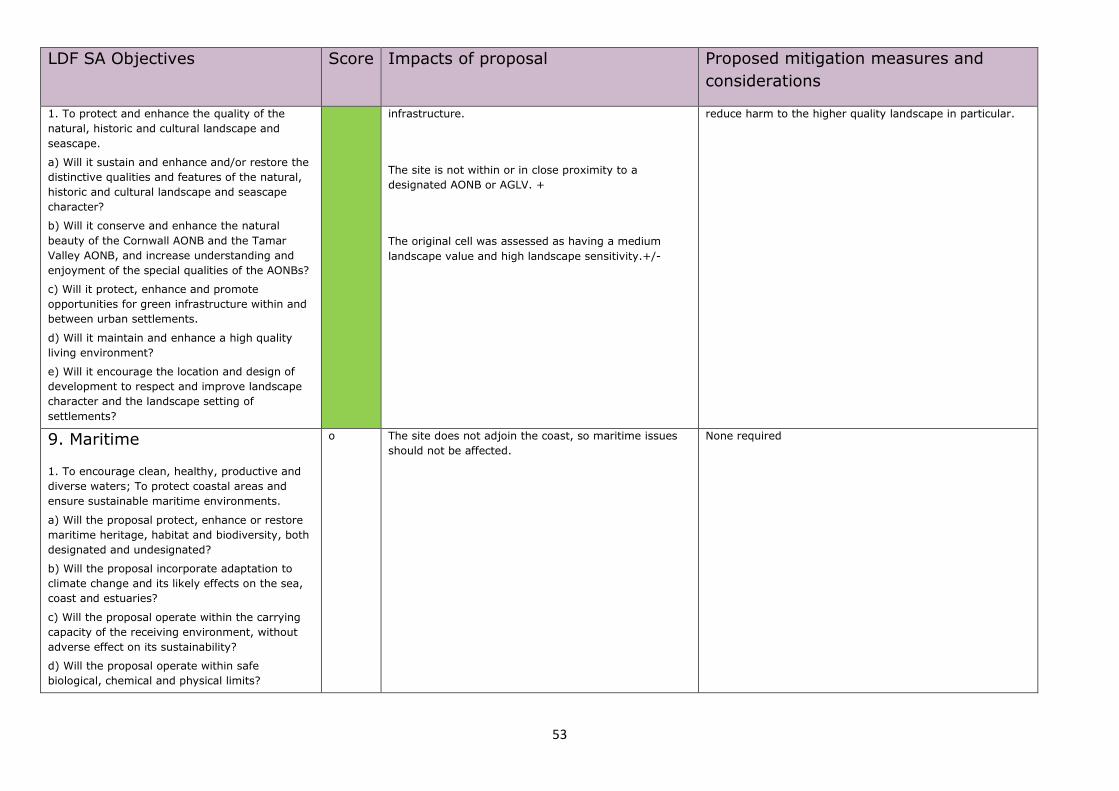
53
LDF SA Objectives Score Impacts of proposal Proposed mitigation measures and
considerations
1. To protect and enhance the quality of the
natural, historic and cultural landscape and
seascape.
a) Will it sustain and enhance and/or restore the
distinctive qualities and features of the natural,
historic and cultural landscape and seascape
character?
b) Will it conserve and enhance the natural
beauty of the Cornwall AONB and the Tamar
Valley AONB, and increase understanding and
enjoyment of the special qualities of the AONBs?
c) Will it protect, enhance and promote
opportunities for green infrastructure within and
between urban settlements.
d) Will it maintain and enhance a high quality
living environment?
e) Will it encourage the location and design of
development to respect and improve landscape
character and the landscape setting of
settlements?
infrastructure.
The site is not within or in close proximity to a
designated AONB or AGLV. +
The original cell was assessed as having a medium
landscape value and high landscape sensitivity.+/-
reduce harm to the higher quality landscape in particular.
9. Maritime
1. To encourage clean, healthy, productive and
diverse waters; To protect coastal areas and
ensure sustainable maritime environments.
a) Will the proposal protect, enhance or restore
maritime heritage, habitat and biodiversity, both
designated and undesignated?
b) Will the proposal incorporate adaptation to
climate change and its likely effects on the sea,
coast and estuaries?
c) Will the proposal operate within the carrying
capacity of the receiving environment, without
adverse effect on its sustainability?
d) Will the proposal operate within safe
biological, chemical and physical limits?
o The site does not adjoin the coast, so maritime issues
should not be affected. None required
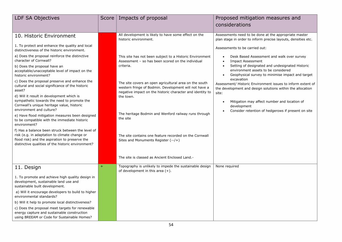
54
LDF SA Objectives Score Impacts of proposal Proposed mitigation measures and
considerations
10. Historic Environment
1. To protect and enhance the quality and local
distinctiveness of the historic environment.
a) Does the proposal reinforce the distinctive
character of Cornwall?
b) Does the proposal have an
acceptable/unacceptable level of impact on the
historic environment?
c) Does the proposal preserve and enhance the
cultural and social significance of the historic
asset?
d) Will it result in development which is
sympathetic towards the need to promote the
Cornwall's unique heritage value, historic
environment and culture?
e) Have flood mitigation measures been designed
to be compatible with the immediate historic
environment?
f) Has a balance been struck between the level of
risk (e.g. in adaptation to climate change or
flood risk) and the aspiration to preserve the
distinctive qualities of the historic environment?
- All development is likely to have some effect on the
historic environment.
This site has not been subject to a Historic Environment
Assessment – so has been scored on the individual
criteria.
The site covers an open agricultural area on the south
western fringe of Bodmin. Development will not have a
negative impact on the historic character and identity to
the town.
The heritage Bodmin and Wenford railway runs through
the site
The site contains one feature recorded on the Cornwall
Sites and Monuments Register (--/+)
The site is classed as Ancient Enclosed Land.-
Assessments need to be done at the appropriate master
plan stage in order to inform precise layouts, densities etc.
Assessments to be carried out:
Desk Based Assessment and walk over survey
Impact Assessment
Setting of designated and undesignated Historic
environment assets to be considered
Geophysical survey to minimise impact and target
excavation
Assessment/ Historic Environment issues to inform extent of
the development and design solutions within the allocation
site:
Mitigation may affect number and location of
development
Consider retention of hedgerows if present on site
11. Design
1. To promote and achieve high quality design in
development, sustainable land use and
sustainable built development.
a) Will it encourage developers to build to higher
environmental standards?
b) Will it help to promote local distinctiveness?
c) Does the proposal meet targets for renewable
energy capture and sustainable construction
using BREEAM or Code for Sustainable Homes?
+ Topography is unlikely to impede the sustainable design
of development in this area (+).
None required
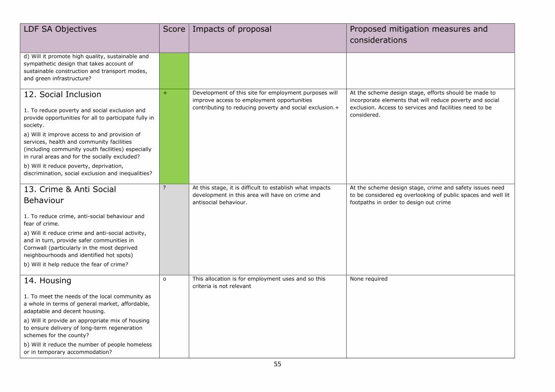
55
LDF SA Objectives Score Impacts of proposal Proposed mitigation measures and
considerations
d) Will it promote high quality, sustainable and
sympathetic design that takes account of
sustainable construction and transport modes,
and green infrastructure?
12. Social Inclusion
1. To reduce poverty and social exclusion and
provide opportunities for all to participate fully in
society.
a) Will it improve access to and provision of
services, health and community facilities
(including community youth facilities) especially
in rural areas and for the socially excluded?
b) Will it reduce poverty, deprivation,
discrimination, social exclusion and inequalities?
+ Development of this site for employment purposes will
improve access to employment opportunities
contributing to reducing poverty and social exclusion.+
At the scheme design stage, efforts should be made to
incorporate elements that will reduce poverty and social
exclusion. Access to services and facilities need to be
considered.
13. Crime & Anti Social
Behaviour
1. To reduce crime, anti-social behaviour and
fear of crime.
a) Will it reduce crime and anti-social activity,
and in turn, provide safer communities in
Cornwall (particularly in the most deprived
neighbourhoods and identified hot spots)
b) Will it help reduce the fear of crime?
? At this stage, it is difficult to establish what impacts
development in this area will have on crime and
antisocial behaviour.
At the scheme design stage, crime and safety issues need
to be considered eg overlooking of public spaces and well lit
footpaths in order to design out crime
14. Housing
1. To meet the needs of the local community as
a whole in terms of general market, affordable,
adaptable and decent housing.
a) Will it provide an appropriate mix of housing
to ensure delivery of long-term regeneration
schemes for the county?
b) Will it reduce the number of people homeless
or in temporary accommodation?
o This allocation is for employment uses and so this
criteria is not relevant None required
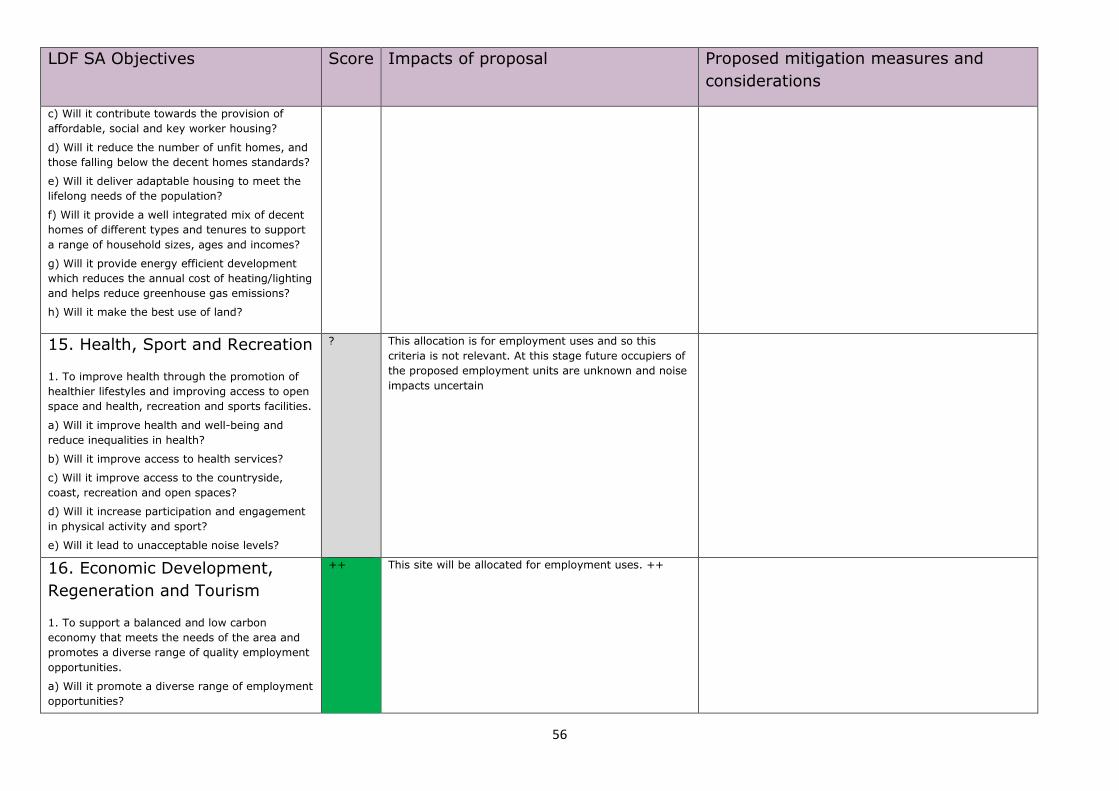
56
LDF SA Objectives Score Impacts of proposal Proposed mitigation measures and
considerations
c) Will it contribute towards the provision of
affordable, social and key worker housing?
d) Will it reduce the number of unfit homes, and
those falling below the decent homes standards?
e) Will it deliver adaptable housing to meet the
lifelong needs of the population?
f) Will it provide a well integrated mix of decent
homes of different types and tenures to support
a range of household sizes, ages and incomes?
g) Will it provide energy efficient development
which reduces the annual cost of heating/lighting
and helps reduce greenhouse gas emissions?
h) Will it make the best use of land?
15. Health, Sport and Recreation
1. To improve health through the promotion of
healthier lifestyles and improving access to open
space and health, recreation and sports facilities.
a) Will it improve health and well-being and
reduce inequalities in health?
b) Will it improve access to health services?
c) Will it improve access to the countryside,
coast, recreation and open spaces?
d) Will it increase participation and engagement
in physical activity and sport?
e) Will it lead to unacceptable noise levels?
? This allocation is for employment uses and so this
criteria is not relevant. At this stage future occupiers of
the proposed employment units are unknown and noise
impacts uncertain
16. Economic Development,
Regeneration and Tourism
1. To support a balanced and low carbon
economy that meets the needs of the area and
promotes a diverse range of quality employment
opportunities.
a) Will it promote a diverse range of employment
opportunities?
++ This site will be allocated for employment uses. ++
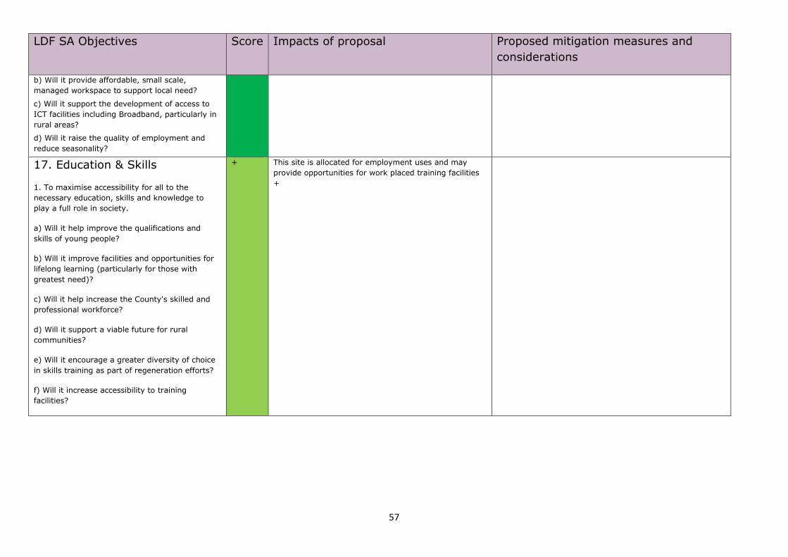
57
LDF SA Objectives Score Impacts of proposal Proposed mitigation measures and
considerations
b) Will it provide affordable, small scale,
managed workspace to support local need?
c) Will it support the development of access to
ICT facilities including Broadband, particularly in
rural areas?
d) Will it raise the quality of employment and
reduce seasonality?
17. Education & Skills
1. To maximise accessibility for all to the
necessary education, skills and knowledge to
play a full role in society.
a) Will it help improve the qualifications and
skills of young people?
b) Will it improve facilities and opportunities for
lifelong learning (particularly for those with
greatest need)?
c) Will it help increase the County's skilled and
professional workforce?
d) Will it support a viable future for rural
communities?
e) Will it encourage a greater diversity of choice
in skills training as part of regeneration efforts?
f) Will it increase accessibility to training
facilities?
+ This site is allocated for employment uses and may
provide opportunities for work placed training facilities
+
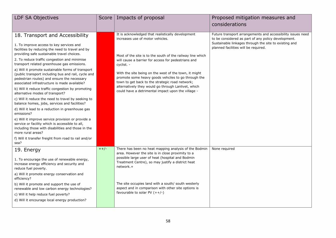
58
LDF SA Objectives Score Impacts of proposal Proposed mitigation measures and
considerations
18. Transport and Accessibility
1. To improve access to key services and
facilities by reducing the need to travel and by
providing safe sustainable travel choices.
2. To reduce traffic congestion and minimise
transport related greenhouse gas emissions.
a) Will it promote sustainable forms of transport
(public transport including bus and rail, cycle and
pedestrian routes) and ensure the necessary
associated infrastructure is made available?
b) Will it reduce traffic congestion by promoting
alternative modes of transport?
c) Will it reduce the need to travel by seeking to
balance homes, jobs, services and facilities?
d) Will it lead to a reduction in greenhouse gas
emissions?
e) Will it improve service provision or provide a
service or facility which is accessible to all,
including those with disabilities and those in the
more rural areas?
f) Will it transfer freight from road to rail and/or
sea?
- It is acknowledged that realistically development
increases use of motor vehicles.
Most of the site is to the south of the railway line which
will cause a barrier for access for pedestrians and
cyclist. -
With the site being on the west of the town, it might
promote some heavy goods vehciles to go through the
town to get back to the strategic road network;
alternatively they would go through Lanlivet, which
could have a detrimental impact upon the village -
Future transport arrangements and accessibility issues need
to be considered as part of any policy development.
Sustainable linkages through the site to existing and
planned facilities will be required.
19. Energy
1. To encourage the use of renewable energy,
increase energy efficiency and security and
reduce fuel poverty.
a) Will it promote energy conservation and
efficiency?
b) Will it promote and support the use of
renewable and low carbon energy technologies?
c) Will it help reduce fuel poverty?
d) Will it encourage local energy production?
++/- There has been no heat mapping analysis of the Bodmin
area. However the site is in close proximity to a
possible large user of heat (hospital and Bodmin
Treatment Centre), so may justify a district heat
network.+
The site occupies land with a south/ south westerly
aspect and in comparison with other site options is
favourable to solar PV (++/-)
None required
59
Bodmin Allocations Prioritisation SA Employment Cell 12 – St Lawrences
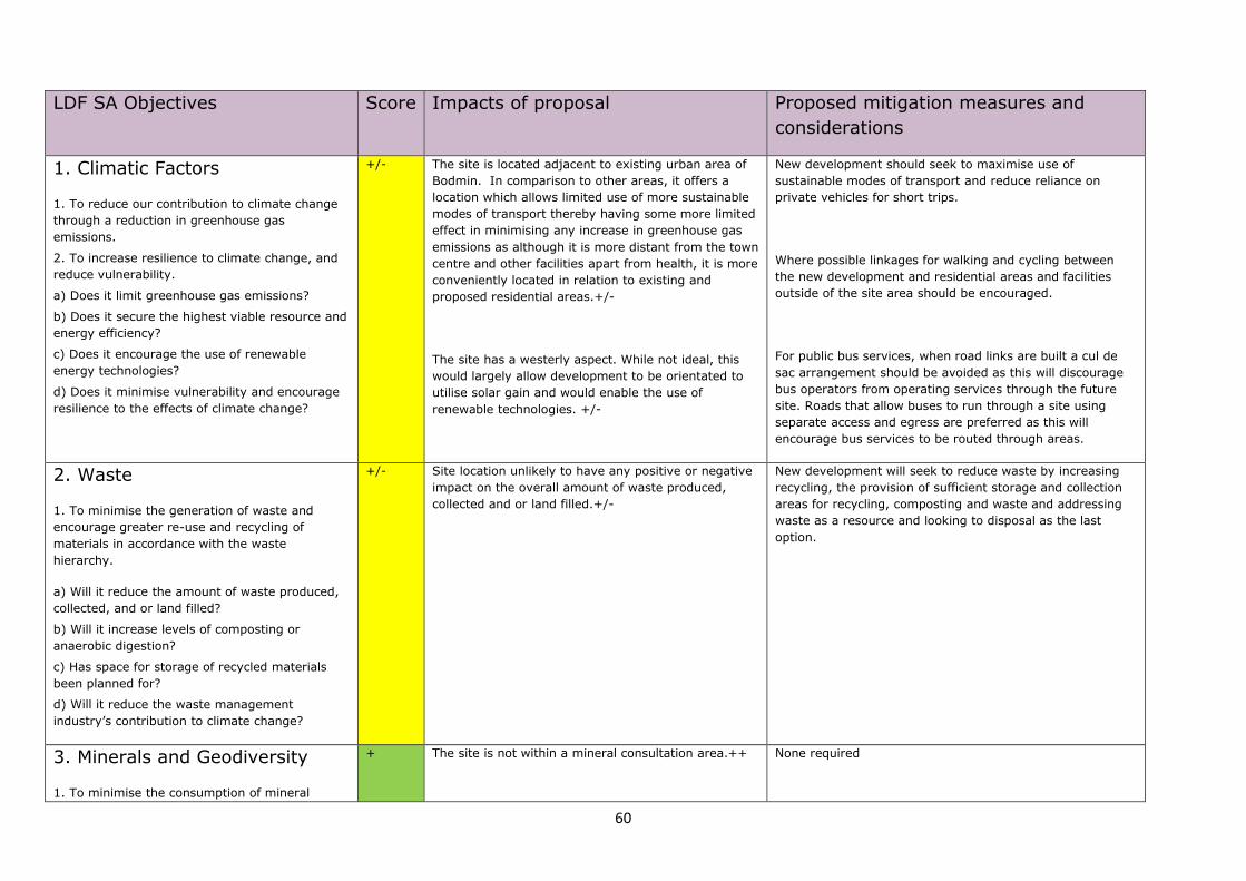
60
LDF SA Objectives Score Impacts of proposal Proposed mitigation measures and
considerations
1. Climatic Factors
1. To reduce our contribution to climate change
through a reduction in greenhouse gas
emissions.
2. To increase resilience to climate change, and
reduce vulnerability.
a) Does it limit greenhouse gas emissions?
b) Does it secure the highest viable resource and
energy efficiency?
c) Does it encourage the use of renewable
energy technologies?
d) Does it minimise vulnerability and encourage
resilience to the effects of climate change?
+/- The site is located adjacent to existing urban area of
Bodmin. In comparison to other areas, it offers a
location which allows limited use of more sustainable
modes of transport thereby having some more limited
effect in minimising any increase in greenhouse gas
emissions as although it is more distant from the town
centre and other facilities apart from health, it is more
conveniently located in relation to existing and
proposed residential areas.+/-
The site has a westerly aspect. While not ideal, this
would largely allow development to be orientated to
utilise solar gain and would enable the use of
renewable technologies. +/-
New development should seek to maximise use of
sustainable modes of transport and reduce reliance on
private vehicles for short trips.
Where possible linkages for walking and cycling between
the new development and residential areas and facilities
outside of the site area should be encouraged.
For public bus services, when road links are built a cul de
sac arrangement should be avoided as this will discourage
bus operators from operating services through the future
site. Roads that allow buses to run through a site using
separate access and egress are preferred as this will
encourage bus services to be routed through areas.
2. Waste
1. To minimise the generation of waste and
encourage greater re-use and recycling of
materials in accordance with the waste
hierarchy.
a) Will it reduce the amount of waste produced,
collected, and or land filled?
b) Will it increase levels of composting or
anaerobic digestion?
c) Has space for storage of recycled materials
been planned for?
d) Will it reduce the waste management
industry’s contribution to climate change?
+/-
Site location unlikely to have any positive or negative
impact on the overall amount of waste produced,
collected and or land filled.+/-
New development will seek to reduce waste by increasing
recycling, the provision of sufficient storage and collection
areas for recycling, composting and waste and addressing
waste as a resource and looking to disposal as the last
option.
3. Minerals and Geodiversity
1. To minimise the consumption of mineral
+ The site is not within a mineral consultation area.++ None required
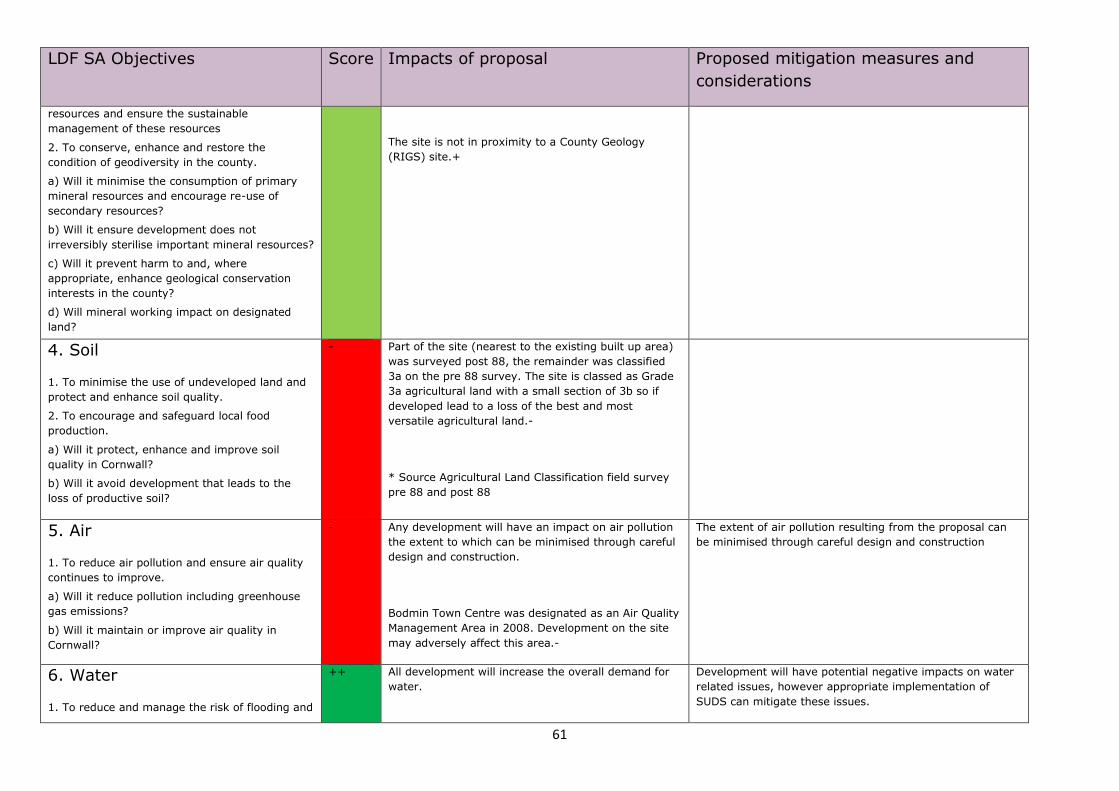
61
LDF SA Objectives Score Impacts of proposal Proposed mitigation measures and
considerations
resources and ensure the sustainable
management of these resources
2. To conserve, enhance and restore the
condition of geodiversity in the county.
a) Will it minimise the consumption of primary
mineral resources and encourage re-use of
secondary resources?
b) Will it ensure development does not
irreversibly sterilise important mineral resources?
c) Will it prevent harm to and, where
appropriate, enhance geological conservation
interests in the county?
d) Will mineral working impact on designated
land?
The site is not in proximity to a County Geology
(RIGS) site.+
4. Soil
1. To minimise the use of undeveloped land and
protect and enhance soil quality.
2. To encourage and safeguard local food
production.
a) Will it protect, enhance and improve soil
quality in Cornwall?
b) Will it avoid development that leads to the
loss of productive soil?
- Part of the site (nearest to the existing built up area)
was surveyed post 88, the remainder was classified
3a on the pre 88 survey. The site is classed as Grade
3a agricultural land with a small section of 3b so if
developed lead to a loss of the best and most
versatile agricultural land.-
* Source Agricultural Land Classification field survey
pre 88 and post 88
5. Air
1. To reduce air pollution and ensure air quality
continues to improve.
a) Will it reduce pollution including greenhouse
gas emissions?
b) Will it maintain or improve air quality in
Cornwall?
- Any development will have an impact on air pollution
the extent to which can be minimised through careful
design and construction.
Bodmin Town Centre was designated as an Air Quality
Management Area in 2008. Development on the site
may adversely affect this area.-
The extent of air pollution resulting from the proposal can
be minimised through careful design and construction
6. Water
1. To reduce and manage the risk of flooding and
++ All development will increase the overall demand for
water.
Development will have potential negative impacts on water
related issues, however appropriate implementation of
SUDS can mitigate these issues.
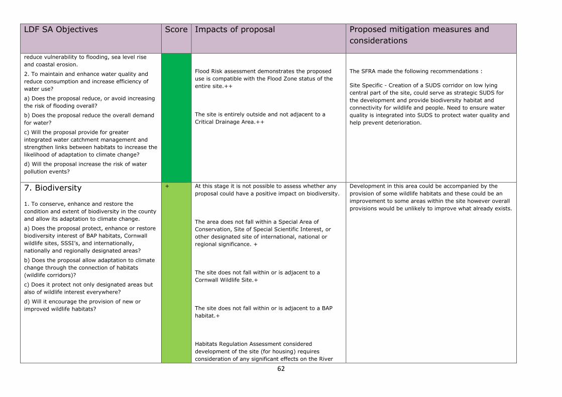
62
LDF SA Objectives Score Impacts of proposal Proposed mitigation measures and
considerations
reduce vulnerability to flooding, sea level rise
and coastal erosion.
2. To maintain and enhance water quality and
reduce consumption and increase efficiency of
water use?
a) Does the proposal reduce, or avoid increasing
the risk of flooding overall?
b) Does the proposal reduce the overall demand
for water?
c) Will the proposal provide for greater
integrated water catchment management and
strengthen links between habitats to increase the
likelihood of adaptation to climate change?
d) Will the proposal increase the risk of water
pollution events?
Flood Risk assessment demonstrates the proposed
use is compatible with the Flood Zone status of the
entire site.++
The site is entirely outside and not adjacent to a
Critical Drainage Area.++
The SFRA made the following recommendations :
Site Specific - Creation of a SUDS corridor on low lying
central part of the site, could serve as strategic SUDS for
the development and provide biodiversity habitat and
connectivity for wildlife and people. Need to ensure water
quality is integrated into SUDS to protect water quality and
help prevent deterioration.
7. Biodiversity
1. To conserve, enhance and restore the
condition and extent of biodiversity in the county
and allow its adaptation to climate change.
a) Does the proposal protect, enhance or restore
biodiversity interest of BAP habitats, Cornwall
wildlife sites, SSSI’s, and internationally,
nationally and regionally designated areas?
b) Does the proposal allow adaptation to climate
change through the connection of habitats
(wildlife corridors)?
c) Does it protect not only designated areas but
also of wildlife interest everywhere?
d) Will it encourage the provision of new or
improved wildlife habitats?
+ At this stage it is not possible to assess whether any
proposal could have a positive impact on biodiversity.
The area does not fall within a Special Area of
Conservation, Site of Special Scientific Interest, or
other designated site of international, national or
regional significance. +
The site does not fall within or is adjacent to a
Cornwall Wildlife Site.+
The site does not fall within or is adjacent to a BAP
habitat.+
Habitats Regulation Assessment considered
development of the site (for housing) requires
consideration of any significant effects on the River
Development in this area could be accompanied by the
provision of some wildlife habitats and these could be an
improvement to some areas within the site however overall
provisions would be unlikely to improve what already exists.
63
LDF SA Objectives Score Impacts of proposal Proposed mitigation measures and
considerations
Camel SAC. However it was considered this could be
mitigated.
8. Landscape
1. To protect and enhance the quality of the
natural, historic and cultural landscape and
seascape.
a) Will it sustain and enhance and/or restore the
distinctive qualities and features of the natural,
historic and cultural landscape and seascape
character?
b) Will it conserve and enhance the natural
beauty of the Cornwall AONB and the Tamar
Valley AONB, and increase understanding and
enjoyment of the special qualities of the AONBs?
c) Will it protect, enhance and promote
opportunities for green infrastructure within and
between urban settlements.
d) Will it maintain and enhance a high quality
living environment?
e) Will it encourage the location and design of
development to respect and improve landscape
character and the landscape setting of
settlements?
+ At this stage it is not possible to assess whether any
proposal could have a positive impact on green
infrastructure.
The site is not within or is in proximity to a designated
AONB, however while the site is not within an AGLV
there is an AGLV approximately 550m the north. +
The site was assessed as having an intermediate
landscape value in the landscape assessment.+/-
Mitigation will be required if the site option is developed and
this will be looked at in more detail at a later stage to
reduce harm to the higher quality landscape in particular.
9. Maritime
1. To encourage clean, healthy, productive and
diverse waters; To protect coastal areas and
ensure sustainable maritime environments.
a) Will the proposal protect, enhance or restore
maritime heritage, habitat and biodiversity, both
designated and undesignated?
b) Will the proposal incorporate adaptation to
climate change and its likely effects on the sea,
coast and estuaries?
c) Will the proposal operate within the carrying
capacity of the receiving environment, without
o The site is not in proximity to the coast. None required
64
LDF SA Objectives Score Impacts of proposal Proposed mitigation measures and
considerations
adverse effect on its sustainability?
d) Will the proposal operate within safe
biological, chemical and physical limits?
10. Historic Environment
1. To protect and enhance the quality and local
distinctiveness of the historic environment.
a) Does the proposal reinforce the distinctive
character of Cornwall?
b) Does the proposal have an
acceptable/unacceptable level of impact on the
historic environment?
c) Does the proposal preserve and enhance the
cultural and social significance of the historic
asset?
d) Will it result in development which is
sympathetic towards the need to promote the
Cornwall's unique heritage value, historic
environment and culture?
e) Have flood mitigation measures been designed
to be compatible with the immediate historic
environment?
f) Has a balance been struck between the level of
risk (e.g. in adaptation to climate change or
flood risk) and the aspiration to preserve the
distinctive qualities of the historic environment?
+ All development is likely to have some effect on the
historic environment.
Outcome of Historic Environment Assessment implies
no harm to heritage assets with mitigation in place+
The site covers an open agricultural area on the
western fringe of Bodmin. Development will not have
a negative impact on the historic character and
identity to the town as it is adjoining a modern estate
development, however it adjoins the tracks of the
Bodmin and Wenford heritage railway
The proposed site contains two features recorded on
the Cornwall Sites and Monuments Register, with an
early medieval settlement at Higher Boskear and an
iron age round at Boskear.
The site is partly classed as Ancient Enclosed Land
and partly as Post Medieval Enclosed Land.-
The HIA assessment of the site recommended the following
mitigation measures :
1. Assessments to be done to inform masterplan
stage:
• Desk Based Assessment & Walk Over Survey
• Impact Assessment
• Geophysical survey to minimise impact & target
excavation
• Assessment of impact on setting, context and
inter-relationship of HE assets/historic landscapes
2. Assessment /HE issues must inform extent of
development and design solutions within the allocation cell.
11. Design
1. To promote and achieve high quality design in
development, sustainable land use and
sustainable built development.
a) Will it encourage developers to build to higher
environmental standards?
b) Will it help to promote local distinctiveness?
+ The site has a westerly gradient, however although
topography may have an impact on some sustainable
features eg solar gain, it should not impede the
overall sustainable design of development in this
area.+
None required
65
LDF SA Objectives Score Impacts of proposal Proposed mitigation measures and
considerations
c) Does the proposal meet targets for renewable
energy capture and sustainable construction
using BREEAM or Code for Sustainable Homes?
d) Will it promote high quality, sustainable and
sympathetic design that takes account of
sustainable construction and transport modes,
and green infrastructure?
12. Social Inclusion
1. To reduce poverty and social exclusion and
provide opportunities for all to participate fully in
society.
a) Will it improve access to and provision of
services, health and community facilities
(including community youth facilities) especially
in rural areas and for the socially excluded?
b) Will it reduce poverty, deprivation,
discrimination, social exclusion and inequalities?
+ Development of this site for employment purposes will
improve access to employment opportunities
contributing to reducing poverty and social exclusion.
At the scheme design stage, efforts should be made to
incorporate elements that will reduce poverty and social
exclusion. Access to services and facilities need to be
considered.
13. Crime & Anti Social
Behaviour
1. To reduce crime, anti-social behaviour and
fear of crime.
a) Will it reduce crime and anti-social activity,
and in turn, provide safer communities in
Cornwall (particularly in the most deprived
neighbourhoods and identified hot spots)
b) Will it help reduce the fear of crime?
? At this stage, it is difficult to establish what impacts
development in this area will have on crime and
antisocial behaviour.
At the scheme design stage, crime and safety issues need
to be considered eg overlooking of public spaces and well lit
footpaths in order to design out crime.
14. Housing
1. To meet the needs of the local community as
a whole in terms of general market, affordable,
adaptable and decent housing.
a) Will it provide an appropriate mix of housing
to ensure delivery of long-term regeneration
o This allocation is for employment uses and so this
criteria is not relevant None required
66
LDF SA Objectives Score Impacts of proposal Proposed mitigation measures and
considerations
schemes for the county?
b) Will it reduce the number of people homeless
or in temporary accommodation?
c) Will it contribute towards the provision of
affordable, social and key worker housing?
d) Will it reduce the number of unfit homes, and
those falling below the decent homes standards?
e) Will it deliver adaptable housing to meet the
lifelong needs of the population?
f) Will it provide a well integrated mix of decent
homes of different types and tenures to support
a range of household sizes, ages and incomes?
g) Will it provide energy efficient development
which reduces the annual cost of heating/lighting
and helps reduce greenhouse gas emissions?
h) Will it make the best use of land?
15. Health, Sport and Recreation
1. To improve health through the promotion of
healthier lifestyles and improving access to open
space and health, recreation and sports facilities.
a) Will it improve health and well-being and
reduce inequalities in health?
b) Will it improve access to health services?
c) Will it improve access to the countryside,
coast, recreation and open spaces?
d) Will it increase participation and engagement
in physical activity and sport?
e) Will it lead to unacceptable noise levels?
? This allocation is for employment uses and so this
criteria is not relevant. At this stage future occupiers
of the proposed employment units are unknown and
noise impacts uncertain
16. Economic Development,
Regeneration and Tourism
1. To support a balanced and low carbon
economy that meets the needs of the area and
promotes a diverse range of quality employment
++ The site will be allocated for employment uses ++

67
LDF SA Objectives Score Impacts of proposal Proposed mitigation measures and
considerations
opportunities.
a) Will it promote a diverse range of employment
opportunities?
b) Will it provide affordable, small scale,
managed workspace to support local need?
c) Will it support the development of access to
ICT facilities including Broadband, particularly in
rural areas?
d) Will it raise the quality of employment and
reduce seasonality?
17. Education & Skills
1. To maximise accessibility for all to the
necessary education, skills and knowledge to
play a full role in society.
a) Will it help improve the qualifications and
skills of young people?
b) Will it improve facilities and opportunities for
lifelong learning (particularly for those with
greatest need)?
c) Will it help increase the County's skilled and
professional workforce?
d) Will it support a viable future for rural
communities?
e) Will it encourage a greater diversity of choice
in skills training as part of regeneration efforts?
f) Will it increase accessibility to training
facilities?
+ This site is allocated for employment uses and may
provide opportunities for work placed training facilities
+
18. Transport and Accessibility
1. To improve access to key services and
facilities by reducing the need to travel and by
- It is acknowledged that realistically development
increases use of motor vehicles.
Future transport arrangements and accessibility issues need
to be considered as part of any policy development.
Sustainable linkages through the site to existing and
planned facilities as well as residential areas will be
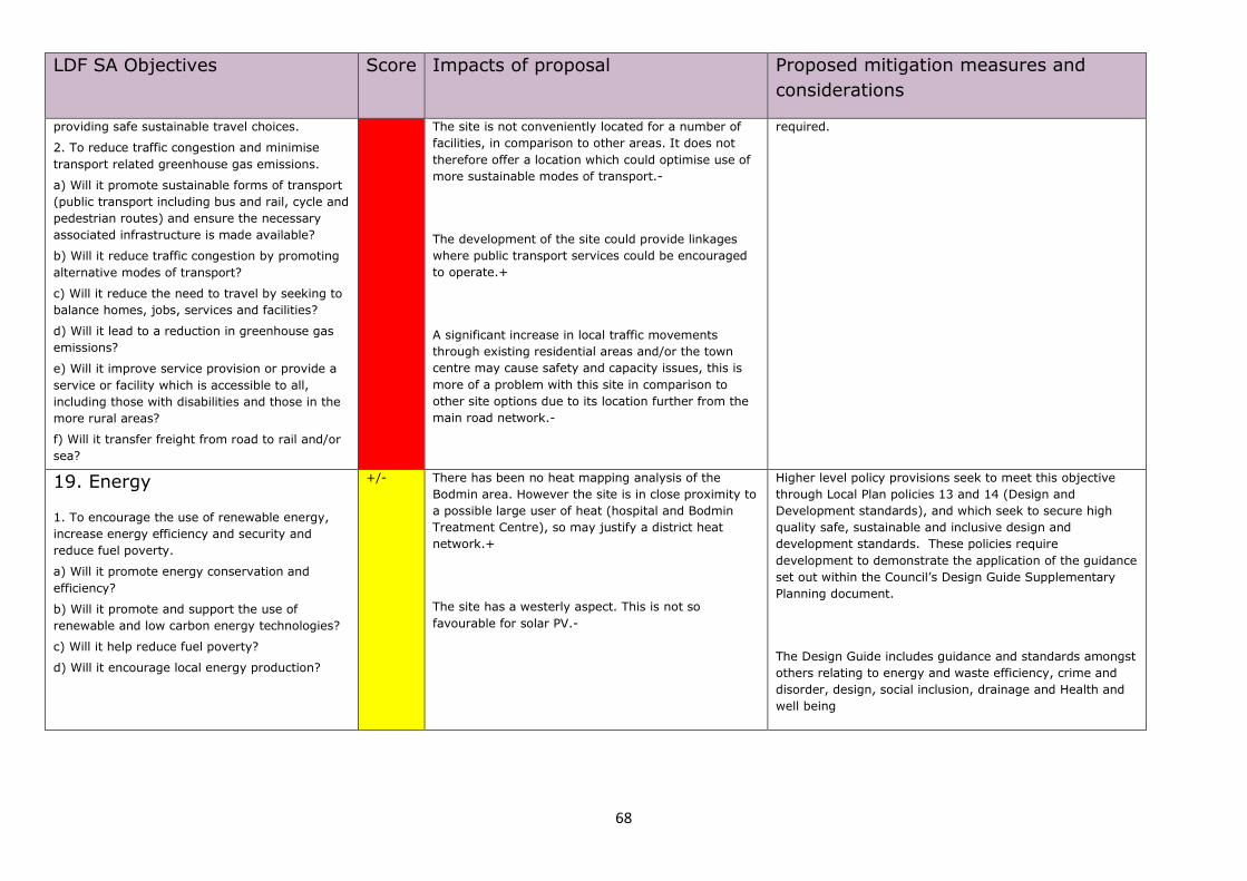
68
LDF SA Objectives Score Impacts of proposal Proposed mitigation measures and
considerations
providing safe sustainable travel choices.
2. To reduce traffic congestion and minimise
transport related greenhouse gas emissions.
a) Will it promote sustainable forms of transport
(public transport including bus and rail, cycle and
pedestrian routes) and ensure the necessary
associated infrastructure is made available?
b) Will it reduce traffic congestion by promoting
alternative modes of transport?
c) Will it reduce the need to travel by seeking to
balance homes, jobs, services and facilities?
d) Will it lead to a reduction in greenhouse gas
emissions?
e) Will it improve service provision or provide a
service or facility which is accessible to all,
including those with disabilities and those in the
more rural areas?
f) Will it transfer freight from road to rail and/or
sea?
The site is not conveniently located for a number of
facilities, in comparison to other areas. It does not
therefore offer a location which could optimise use of
more sustainable modes of transport.-
The development of the site could provide linkages
where public transport services could be encouraged
to operate.+
A significant increase in local traffic movements
through existing residential areas and/or the town
centre may cause safety and capacity issues, this is
more of a problem with this site in comparison to
other site options due to its location further from the
main road network.-
required.
19. Energy
1. To encourage the use of renewable energy,
increase energy efficiency and security and
reduce fuel poverty.
a) Will it promote energy conservation and
efficiency?
b) Will it promote and support the use of
renewable and low carbon energy technologies?
c) Will it help reduce fuel poverty?
d) Will it encourage local energy production?
+/- There has been no heat mapping analysis of the
Bodmin area. However the site is in close proximity to
a possible large user of heat (hospital and Bodmin
Treatment Centre), so may justify a district heat
network.+
The site has a westerly aspect. This is not so
favourable for solar PV.-
Higher level policy provisions seek to meet this objective
through Local Plan policies 13 and 14 (Design and
Development standards), and which seek to secure high
quality safe, sustainable and inclusive design and
development standards. These policies require
development to demonstrate the application of the guidance
set out within the Council’s Design Guide Supplementary
Planning document.
The Design Guide includes guidance and standards amongst
others relating to energy and waste efficiency, crime and
disorder, design, social inclusion, drainage and Health and
well being