Embed Size (px)
Citation preview
ENBE | Final Project | Part A – Report | The Better Livable Town Representation
Teo Vi Vien | 0321645
Foundation in Natural and Built Environment FNBE August 2014
Content:Teo Vi Vien| 0321645| Miss Ida| FNBE AUG 2014 | Taylor’s University
1
Better Livable Town
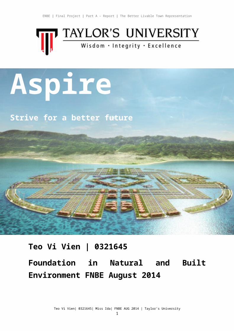
AspireStrive for a better future
ENBE | Final Project | Part A – Report | The Better Livable Town Representation
1. Introduction
2. A Town
3. Investigation & Data Collection: Ancient and old cities/town
4. Investigation & Data Collection: The present towns/cities
5. Investigation & Data Collection: The future and better township
6. Aspire Town
7. Conclusion
8. References list
IntroductionFor our final project for ENBE, we are required to design our own future town where we have to consider the zoning, transportation, activities and networking infrastructures and sustainable initiatives for better living. The first step in
Teo Vi Vien| 0321645| Miss Ida| FNBE AUG 2014 | Taylor’s University2
ENBE | Final Project | Part A – Report | The Better Livable Town Representation
planning a project is to conduct thorough research on the needs of the people, the facilities, infrastructures, and how it will sustain itself in the future by understanding historical towns, present towns and also future towns that has or will be developed.
To plan a future is to look back on the past. There are many beautiful historical towns that have existed for centuries. We can propose a better future town through understanding and learning from the history of the towns while incorporating the elements instilled in these beautiful towns.
Through this project, we are able to understand the basic form, unit and function of the elements of the natural and built environment to create a town with a sustainable and livable environment.
The CityA city is a relatively large and permanent human settlement.[1][2] Although there is no agreement on how a city is distinguished from a town within general English language meanings, many cities have a particular administrative, legal, or historical status based on local law.
Teo Vi Vien| 0321645| Miss Ida| FNBE AUG 2014 | Taylor’s University3
ENBE | Final Project | Part A – Report | The Better Livable Town Representation
History
The first true urban settlements appeared around 3,000 B.C. in ancient Mesopotamia, Egypt, and the Indus Valley. Ancient cities displayed both "organic" and "planned" types of urban form. These societies had elaborate religious, political, and military hierarchies. Precincts devoted to the activities of the elite were often highly planned and regular in form. In contrast, residential areas often grew by a slow process of accretion, producing complex, irregular patterns that we term "organic." Two typical features of the ancient city are the wall and the citadel: the wall for defense in regions periodically swept by conquering armies, and the citadel -- a large, elevated precinct within the city -- devoted to religious and state functions.
During the Renaissance, architects began to systematically study the shaping of urban space, as though the city itself were a piece of architecture that could be given an aesthetically pleasing and functional order. Many of the great public spaces of Rome and other Italian cities date from this era. Parts of old cities were rebuilt to create elegant squares, long street vistas, and symmetrical building arrangements. Responding to advances in firearms during the fifteenth century, new city walls were designed with large earthworks to deflect artillery, and star-shaped points to provide defenders with sweeping lines of fire. Spanish colonial cities in the New World were built according to rules codified in the Laws of the Indies of 1573, specifying an orderly grid of streets with a central plaza, defensive wall, and uniform building style.
Cities have changed more since the Industrial Revolution than in all the previous centuries of their existence. New York had a population of about 313,000 in 1840 but had reached 4,767,000 in 1910. Chicago exploded from 4.000 to 2,185,000 during the same period. Millions of rural dwellers no longer needed on farms flocked to the cities, where new factories churned out products for the new markets made accessible by railroads and steamships. In the United States, millions of immigrants from Europe swelled the urban populations. Increasingly, urban economies were being woven more rightly into the national and international economies.
What makes a cityCities generally have complex systems for sanitation, utilities, land usage, housing, and transportation. The concentration of development greatly facilitates interaction between people and businesses, benefiting both parties in the process, but it also presents challenges to managing urban growth.[3] A big city or metropolis usually has associated suburbs and exurbs. Such cities are usually associated with metropolitan areas and urban areas, creating numerous business commuters traveling to urban centers for employment. Once a city expands far
Teo Vi Vien| 0321645| Miss Ida| FNBE AUG 2014 | Taylor’s University4
ENBE | Final Project | Part A – Report | The Better Livable Town Representation
enough to reach another city, this region can be deemed a conurbation or megalopolis. In terms of population, the largest city proper is Shanghai, while the fastest growing is Dubai.
What makes a good cityEvery modern city contains an amazing array of pathways to carry flows of people, goods, water, energy, and information. Transportation networks are the largest and most visible of these.
UtilitiesModern cities rely on complex networks of utilities. When cities were small, obtaining pure water and disposing of wastes was not a major problem, but cities with large populations and high densities require expensive public infrastructure. During the nineteenth century, rapid urban growth and industrialization caused overcrowding, pollution, and disease in urban areas. Since the late nineteenth century, cities have also been laced with wires and conduits carrying electricity, gas, and communications signals.
BuildingsBuildings are the most visible elements of the city, the features that give each city its unique character. Residential structures occupy almost half of all urban land, with the building types ranging from scattered single-family homes to dense high-rise apartments. Commercial buildings are clustered downtown and at various subcenters, with skyscrapers packed into the central business district and low-rise structures prevailing elsewhere, although tall buildings are becoming more common in the suburbs. Industrial buildings come in many forms ranging from large factory complexes in industrial districts to small workshops.
Land UseCity planners engage in a constant search for the proper arrangement of these different types of land use, paying particular attention to the compatibility of different activities, population densities, traffic generation, economic efficiency, social relationships, and the height and bulk of buildings.
Open SpacesOpen space is sometimes treated as a leftover, but it contributes greatly to the quality of urban life. "Hard" spaces such as plazas, malls, and courtyards provide settings for public activities of all kinds. "Soft" spaces such as parks, gardens, lawns, and nature preserves provide essential relief from harsh urban conditions and serve as space for recreational activities. These "amenities" increasingly influence which cities will be perceived as desirable places to live.
ZoningZoning is one the elements that gives a sense of the intent of the body politic. It is driven in part by public realm interests. It provides guidelines for a good public
Teo Vi Vien| 0321645| Miss Ida| FNBE AUG 2014 | Taylor’s University5
ENBE | Final Project | Part A – Report | The Better Livable Town Representation
realm as determined for a specific district. Greater height and density are often allowed in areas where new construction is encouraged (e.g. the North and South Station areas), more restrictive heights and densities where the character of historic districts are to be maintained or the infrastructure too delicate to support greater density (e.g. the Leather District, Beacon Hill).
Residential, commercial, industrial/transportation, and public facility uses currently occupy about 65 percent of the city’s total lot area. Another 10 percent is vacant or occupied by parking or miscellaneous uses. The remaining lot area, about 25 percent, is parkland or other open space, most of which is not subject to zoning regulations. (Lot area is exclusive of streets, which comprise about 21 percent of the city’s gross land area.)
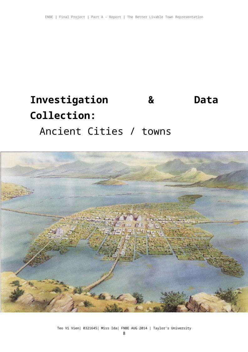
Investigation & Data Collection:Ancient Cities / towns
Teo Vi Vien| 0321645| Miss Ida| FNBE AUG 2014 | Taylor’s University6
ENBE | Final Project | Part A – Report | The Better Livable Town Representation
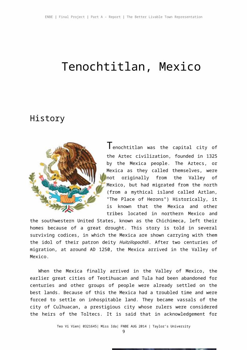
Tenochtitlan, Mexico
History
Tenochtitlan was the capital city of the Aztec
civilization, founded in 1325 by the Mexica people. The Aztecs, or Mexica as they called themselves, were not originally from the Valley of Mexico, but had migrated from the north (from a mythical island called Aztlan, "The Place of Herons") Historically, it is known that the Mexica and other tribes located in northern Mexico and the southwestern United States, known as the Chichimeca, left their homes because of a great drought. This story is told in several surviving codices, in which the Mexica
are shown carrying with them the idol of their patron deity Huitzilopochtli. After two centuries of migration, at around AD 1250, the Mexica arrived in the Valley of Mexico.
When the Mexica finally arrived in the Valley of Mexico, the earlier great cities of Teotihuacan and Tula had been abandoned for centuries and other groups of people were already settled on the best lands. Because of this the Mexica had a troubled time and were forced to settle on inhospitable land. They became vassals of the city of Culhuacan, a prestigious city whose rulers were considered the heirs of the Toltecs. It is said that in acknowledgement for their assistance during battle, the Mexica were given one of the daughters of the King of Culhuacan to be worshipped as a goddess/priestess. When the king arrived to attend the ceremony, he found one of the Mexica priests dressed in the flayed skin of his daughter: the Mexica reported to the king that their God Hutzilopochtli had asked for the sacrifice of the princess. The sacrifice and flaying of the Culhua Princess provoked a ferocious battle, which the Mexica lost. After they were forced out of Chapultepec, according to Mexica myth, the Aztecs wandered for weeks, searching for a place to settle. Huitzilopochtli appeared to
Teo Vi Vien| 0321645| Miss Ida| FNBE AUG 2014 | Taylor’s University7
ENBE | Final Project | Part A – Report | The Better Livable Town Representation
the Mexica leaders and indicated a place where a great eagle was perched on a cactus killing a snake. This place, in the middle of a marsh with no ground-rock at all, was where the Mexica founded their capital city, Tenochtitlan. The year was 2 Calli (Two House) in the Aztec calendar, which translates to AD 1325.
The vision is immortalized in Mexico's coat of arms and the centre of the Mexican flag. A thriving culture developed, and the Aztec civilization came to dominate other tribes all around Mexico. The small natural island was perpetually enlarged as Tenochtitlan grew to become the largest and most powerful city in Mesoamerica. Commercial routes were developed that brought goods
from places as far as the Gulf of Mexico, the Pacific Ocean and even the Inca Empire. Only 100 years after its conception, Tenochtitlan had become a city that rivalled any of its European contemporaries and perhaps any in the world. Scholars estimate that between 200,000 and 250,000 people lived in Tenochtitlan in 1500, more than four times the population of London at that time.
Layout of Tenochtitlán
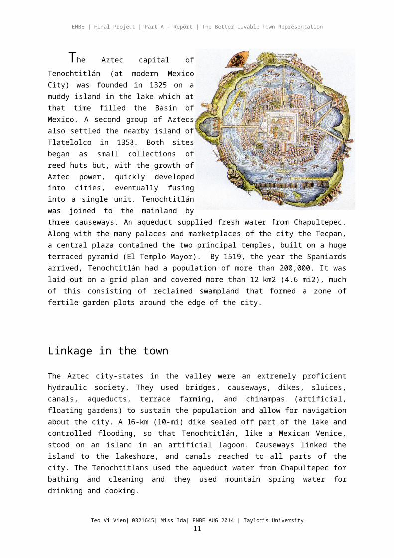
The Aztec capital of Tenochtitlán (at
modern Mexico City) was founded in 1325 on a muddy island in the lake which at that time filled the Basin of Mexico. A second group of Aztecs also settled the nearby island of Tlatelolco in 1358. Both sites began as small collections of reed huts but, with the growth of Aztec power, quickly developed into cities, eventually fusing into a single unit. Tenochtitlán was joined to the mainland by three causeways. An aqueduct supplied fresh water from Chapultepec. Along with the many palaces and marketplaces of the city the Tecpan, a central plaza contained the two principal temples, built on a huge terraced pyramid (El Templo Mayor). By 1519, the year the Spaniards arrived, Tenochtitlán had a population
Teo Vi Vien| 0321645| Miss Ida| FNBE AUG 2014 | Taylor’s University8
ENBE | Final Project | Part A – Report | The Better Livable Town Representation
of more than 200,000. It was laid out on a grid plan and covered more than 12 km2 (4.6 mi2), much of this consisting of reclaimed swampland that formed a zone of fertile garden plots around the edge of the city.
Linkage in the town
The Aztec city-states in the valley were an extremely proficient hydraulic society. They used bridges, causeways, dikes, sluices, canals, aqueducts, terrace farming, and chinampas (artificial, floating gardens) to sustain the population and allow for navigation about the city. A 16-km (10-mi) dike sealed off part of the lake and controlled flooding, so that Tenochtitlán, like a Mexican Venice, stood on an island in an artificial lagoon. Causeways linked the island to the lakeshore, and canals reached to all parts of the city. The Tenochtitlans used the aqueduct water from Chapultepec for bathing and cleaning and they used mountain spring water for drinking and cooking.
Floating Garden
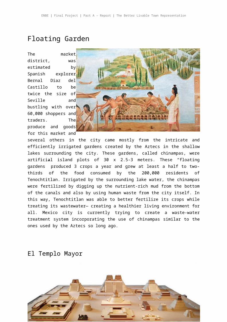
The market district, was estimated by Spanish explorer Bernal Diaz del Castillo to be twice the size of Seville and bustling with over 60,000 shoppers and traders. The produce and goods for this market and several others in the city came mostly from the intricate and efficiently irrigated gardens created by the Aztecs in the shallow lakes surrounding the city. These gardens, called chinampas, were artificial island plots of 30 x 2.5-3 meters. These “floating gardens” produced 3 crops a year and grew at least a half to two-thirds of the food consumed by the 200,000 residents of Tenochtitlan. Irrigated by the surrounding lake water, the chinampas were fertilized by digging up the nutrient-rich mud from the bottom of the canals and also by using human waste from the city itself. In this way, Tenochtitlan was able to better fertilize its crops while treating its wastewater― creating a healthier living environment for all. Mexico city is currently trying to create a waste-water treatment system
Teo Vi Vien| 0321645| Miss Ida| FNBE AUG 2014 | Taylor’s University9

ENBE | Final Project | Part A – Report | The Better Livable Town Representation
incorporating the use of chinampas similar to the ones used by the Aztecs so long ago.
El Templo Mayor
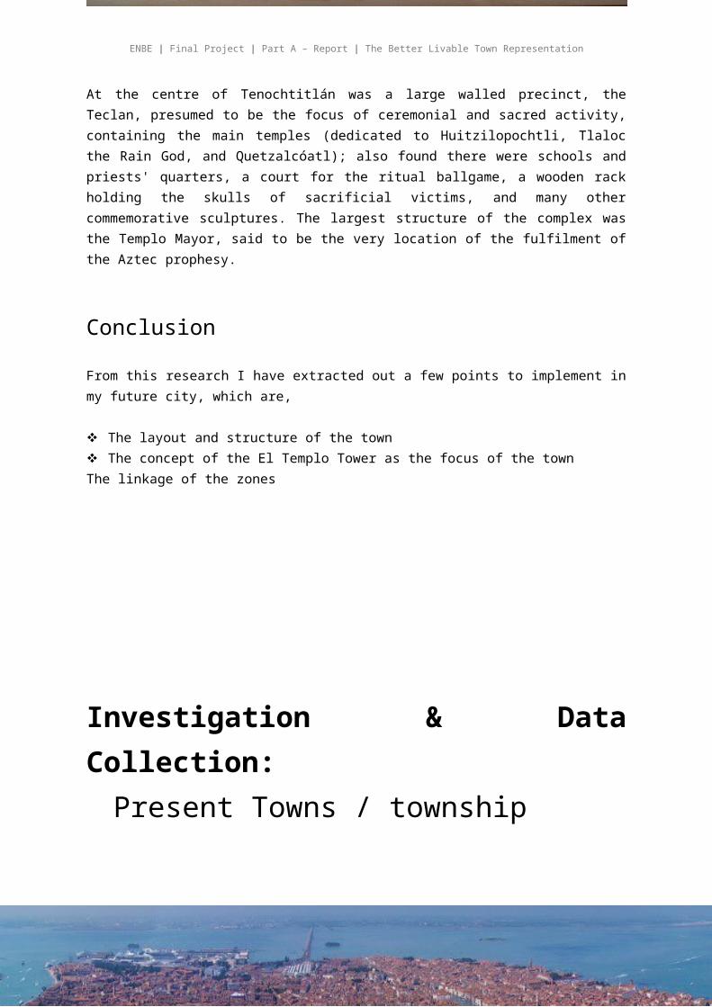
At the centre of Tenochtitlán was a large walled precinct, the Teclan, presumed to be the focus of ceremonial and sacred activity, containing the main temples (dedicated to Huitzilopochtli, Tlaloc the Rain God, and Quetzalcóatl); also found there were schools and priests' quarters, a court for the ritual ballgame, a wooden rack holding the skulls of sacrificial victims, and many other commemorative sculptures. The largest structure of the complex was the Templo Mayor, said to be the very location of the fulfilment of the Aztec prophesy.
Conclusion
From this research I have extracted out a few points to implement in my future city, which are,
The layout and structure of the town The concept of the El Templo Tower as the focus of the townThe linkage of the zones
Teo Vi Vien| 0321645| Miss Ida| FNBE AUG 2014 | Taylor’s University10
ENBE | Final Project | Part A – Report | The Better Livable Town Representation
Investigation & Data Collection:Present Towns / township
Venice, Italy
History
Teo Vi Vien| 0321645| Miss Ida| FNBE AUG 2014 | Taylor’s University11
ENBE | Final Project | Part A – Report | The Better Livable Town Representation
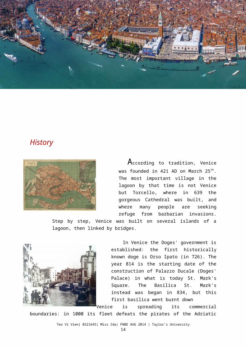
According to tradition, Venice was
founded in 421 AD on March 25th. The most important village in the lagoon by that time is not Venice but Torcello, where in 639 the gorgeous Cathedral was built, and where many people are seeking refuge from barbarian invasions. Step by step, Venice was built on several islands of a lagoon, then linked by bridges.
In Venice the Doges' government is established: the first historically known doge is Orso Ipato (in 726). The year 814 is the starting date of the construction of Palazzo Ducale (Doges' Palace) in what is today St. Mark's Square. The Basilica St. Mark's instead was began in 834, but this first basilica went burnt down
Venice is spreading its commercial boundaries: in 1000 its fleet defeats the pirates of the Adriatic sea. Then Venice takes part to the Crusades, the war campaigns aimed to free Jerusalem. For Venice this
is a business opportunity and expansion chance as well. Many works of art are taken to Venice as a booty: for instance, the four bronze horses of St. Mark's. The original bronzes can now be seen in St.Mark's museum, whilst the four horses on the Basilica's facade are perfect copies.
At the beginning of the XIV century, Venice started to rapidly expand toward the interior part of the Veneto, Friuli, and the Lombard cities of Brescia and Bergamo.Due to the attacks moved by other European countries, between the end of the 14th Century and the beginning of the 15th century, Venice started its decline and expansionism either in Italy and in East while the discovery of the American turned the attention of many merchants to the new world. But we have to wait till 1866 to see Venice jointed together with Italy after the 3rd independence war.
Teo Vi Vien| 0321645| Miss Ida| FNBE AUG 2014 | Taylor’s University12
ENBE | Final Project | Part A – Report | The Better Livable Town Representation
Venice is a city in northeastern Italy sited on a group of 118 small islands separated by canals and linked by bridges.It is located in the marshy Venetian Lagoon which stretches along the shoreline, between the mouths of the Po and the Piave Rivers. Venice is renowned for the beauty of its setting, its architecture and its artworks.
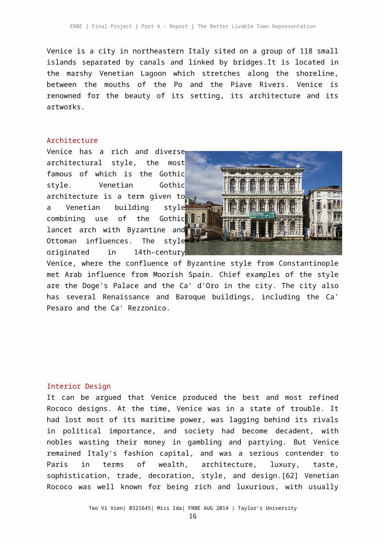
Architecture Venice has a rich and diverse architectural style, the most famous of which is the Gothic style. Venetian Gothic architecture is a term given to a Venetian building style combining use of the Gothic lancet arch with Byzantine and Ottoman influences. The style originated in 14th-century Venice, where the confluence of Byzantine style from Constantinople met Arab influence from Moorish Spain. Chief examples of the style are the Doge's Palace and the Ca' d'Oro in the city. The city also has several Renaissance and Baroque buildings, including the Ca' Pesaro and the Ca' Rezzonico.
Interior DesignIt can be argued that Venice produced the best and most refined Rococo designs. At the time, Venice was in a state of trouble. It had lost most of its maritime power, was lagging behind its rivals in political importance, and society had become decadent, with nobles wasting their money in gambling and partying. But Venice remained Italy's fashion capital, and was a serious contender to Paris in terms of wealth, architecture, luxury, taste, sophistication, trade, decoration, style, and design.[62] Venetian Rococo was well known for being rich and luxurious, with usually very extravagant designs. Unique Venetian furniture, such as the divani da portego, or long Rococo couches and pozzetti, objects meant to be placed against the wall. Venetian bedrooms were usually sumptuous and grand, with rich damask, velvet, and silk drapery and curtains, a beautifully carved Rococo beds with statues of putti, flowers and angels.[62] Venice was especially famous for its beautiful girandole mirrors, which remained among, if not, the finest in Europe. Chandeliers were usually very colourful, using Murano glass to make them look more vibrant and stand out from others, and precious stones and materials from abroad were used, since Venice still held a vast trade empire. Lacquer was very common, and many items of furniture were
Teo Vi Vien| 0321645| Miss Ida| FNBE AUG 2014 | Taylor’s University13
ENBE | Final Project | Part A – Report | The Better Livable Town Representation
covered with it, the most famous being lacca povera (poor lacuqer), in which allegories and images of social life were painted. Lacquerwork and Chinoiserie were particularly common in bureau cabinets.
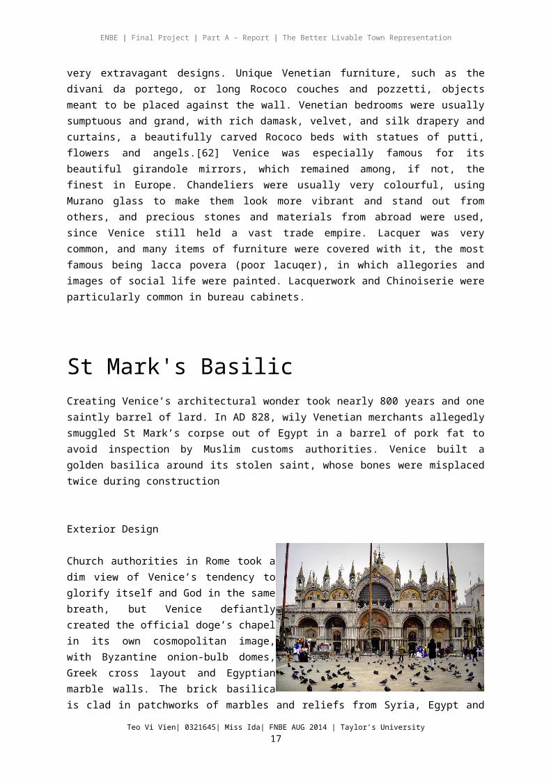
St Mark's BasilicCreating Venice’s architectural wonder took nearly 800 years and one saintly barrel of lard. In AD 828, wily Venetian merchants allegedly smuggled St Mark’s corpse out of Egypt in a barrel of pork fat to avoid inspection by Muslim customs authorities. Venice built a golden basilica around its stolen saint, whose bones were misplaced twice during construction
Exterior Design
Church authorities in Rome took a dim view of Venice’s tendency to glorify itself and God in the same breath, but Venice defiantly created the official doge’s chapel in its own cosmopolitan image, with Byzantine onion-bulb domes, Greek cross layout and Egyptian marble walls. The brick basilica is clad in patchworks of marbles and reliefs from Syria, Egypt and Palestine – priceless trophies from Crusades conquests and battles with Genoa. At the southwestern corner is the Four Tetrarchs , an Egyptian porphyry statue supposedly representing four emperors of ancient Rome looted from Constantinople.
Interior Design
The interior is based on a Greek cross, with each arm divided into three naves with a dome of its own as well as the main dome above the crossing. The dome above the crossing and the western dome are bigger than the other three. This is based on Constantine's Church of the Holy Apostles in Constantinople. The marble floor (12th century, but underwent many restorations) is entirely tessellated in geometric patterns and animal designs. One particular panel in the
pavement shows two cocks carrying a trussed-up fox has been interpreted politically by some, as a reference to the French conquest of Milan in the Italian Wars. Others
Teo Vi Vien| 0321645| Miss Ida| FNBE AUG 2014 | Taylor’s University14

ENBE | Final Project | Part A – Report | The Better Livable Town Representation
see it as a sacred symbol of the faithful wish for immortality, with the victory of the cock and "analogous to the hope of resurrection, the victory of the soul over death". The techniques used were opus sectile and opus tessellatum. The lower register of walls and pillars is completely covered with polychrome marble slabs. The transition between the lower and the upper register is delimited all around the basilica by passageways which largely substituted the former galleries.
Rialto BridgeThe Rialto Bridge (Ponte di Rialto) opened in 1591. For nearly three hundred years, it was the only way to cross the Grand Canal on foot. The bridge replaced various wooden bridges that had occupied the same location since the 12th century.Design
The Rialto Bridge is formed by two inclined ramps covered by a portico with shops on either side. (This area has long been a market place for Venetians.) There are three walkways that cross the bridge - two along the outer balustrades and a wider one in the center. Because galley ships passed under the bridge in days gone by, the bridge's arch is higher than many - reaching about 7.5 meters (24 feet). About 12,000 wooden pilings support this bridge with a single span of 48 meters (158 feet). As a top tourist attraction, the Rialto Bridge is generally included on most tours of the city and is easily photographed while riding a vaporetto (water bus) along the Grand Canal.
Transportation
Vaporetto
A vaporetto (plural: vaporetti) is a water bus that takes both locals and visitors to the places they want and need to go throughout Venice. Because traveling the canals is the easiest way to get around the city, the vaporetto have long been the most efficient and cost-effective
Teo Vi Vien| 0321645| Miss Ida| FNBE AUG 2014 | Taylor’s University15
ENBE | Final Project | Part A – Report | The Better Livable Town Representation
modes of transportation, aside from walking. Like a bus, vaporetti hold a number of passengers and it's not unusual to see travelers carrying their luggage on board in order to get to or from their hotel. The water bus system will take you up and down the Grand Canal, to the islands, and around the lagoon.
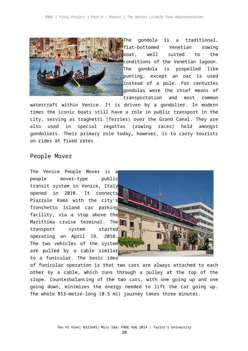
Gondola
The gondola is a traditional, flat-bottomed Venetian rowing boat, well suited to the conditions of the Venetian lagoon. The gondola is propelled like punting, except an oar is used instead of a pole. For centuries gondolas were the chief means of transportation and most common watercraft within Venice. It is driven by a gondolier. In modern times the iconic boats still have a role in public
transport in the city, serving as traghetti (ferries) over the Grand Canal. They are also used in special regattas (rowing races) held amongst gondoliers. Their primary role today, however, is to carry tourists on rides at fixed rates
People Mover
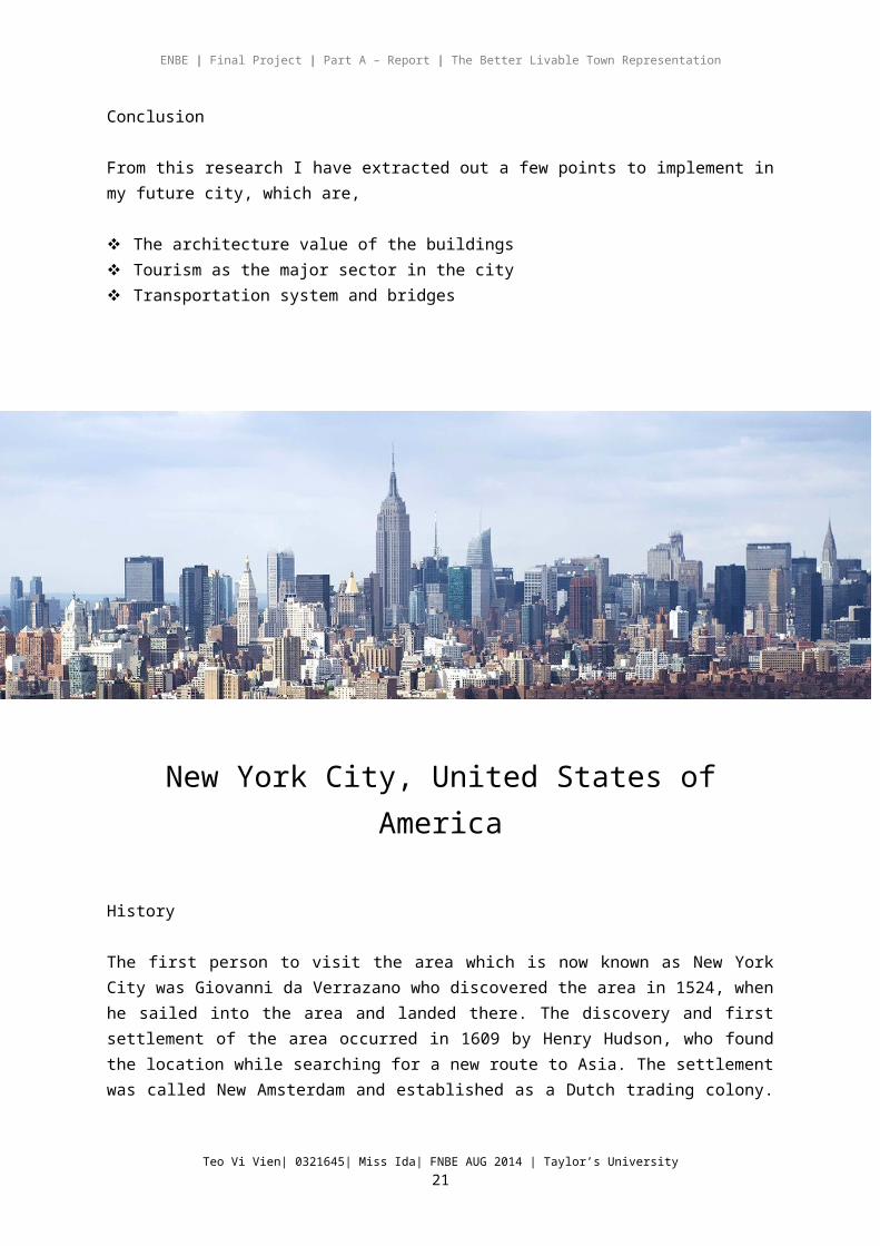
The Venice People Mover is a people mover-type public transit system in Venice, Italy opened in 2010. It connects Piazzale Roma with the city's Tronchetto island car parking facility, via a stop above the Marittima cruise terminal. The transport system started operating on April 19, 2010. The two vehicles of the system are pulled by a cable similar to a funicular. The basic idea of funicular operation is that two cars are always attached to each other by a cable, which runs through a pulley at the top of the slope. Counterbalancing of the two cars, with one going up and one going down, minimizes the energy needed to lift the car going up. The whole 853-metre-long (0.5 mi) journey takes three minutes.
Conclusion
Teo Vi Vien| 0321645| Miss Ida| FNBE AUG 2014 | Taylor’s University16
ENBE | Final Project | Part A – Report | The Better Livable Town Representation
From this research I have extracted out a few points to implement in my future city, which are,
The architecture value of the buildings Tourism as the major sector in the city Transportation system and bridges
New York City, United States of America
History
The first person to visit the area which is now known as New York City was Giovanni da Verrazano who discovered the area in 1524, when he sailed into the area and landed there. The discovery and first settlement of the area occurred in 1609 by Henry Hudson, who found the location while searching for a new route to Asia. The settlement was called New Amsterdam and established as a Dutch trading colony. The name of the settlement would eventually become New York in 1664, when the British took control of the colonies.
New York City became an important city during the Revolutionary War period and for a brief time period, it was Capital of the new United States after the colonies declared their independence. In the 1800's, with the opening of the Erie Canal providing passage to the Great Lakes, New York became one of the most important sea ports on the Atlantic Ocean, and became a center of trade. This lead to a substantial population growth into the largest city in the United States.
Teo Vi Vien| 0321645| Miss Ida| FNBE AUG 2014 | Taylor’s University17

ENBE | Final Project | Part A – Report | The Better Livable Town Representation
New York City also became a destination for immigrants coming in to the country to begin a new life. In the early 1900's millions of people came though Ellis Island seeking citizenship in the United States. A vast majority of these immigrants settled in New York City, which today is still one of the most diverse populations in the world.
Over time the city has grown to be a population center in the United States as well as a center for various activities. New York City is known for Broadway, the fabulous skyline, Central Park, Times Square, the Statue of Liberty, top sports venues and teams, and is one of the top destinations for tourists around the world.Landmarks
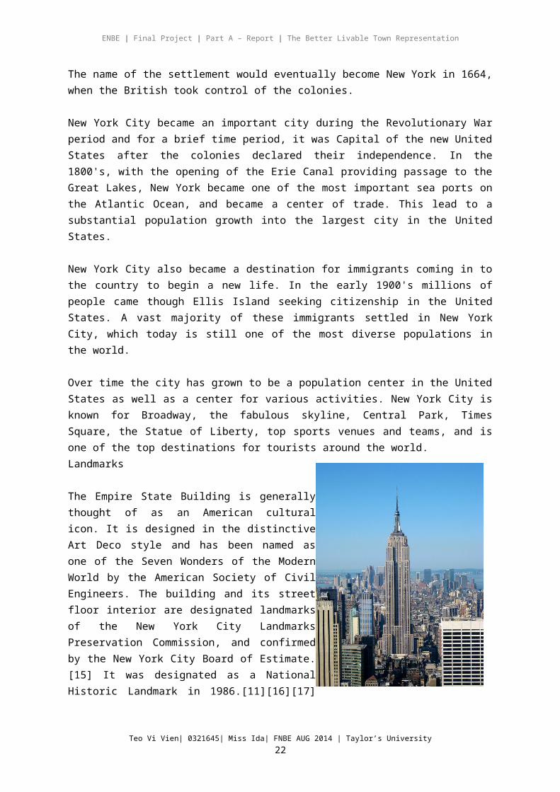
The Empire State Building is generally thought of as an American cultural icon. It is designed in the distinctive Art Deco style and has been named as one of the Seven Wonders of the Modern World by the American Society of Civil Engineers. The building and its street floor interior are designated landmarks of the New York City Landmarks Preservation Commission, and confirmed by the New York City Board of Estimate.[15] It was designated as a National Historic Landmark in 1986.[11][16][17] In 2007, it was ranked number one on the AIA's List of America's Favorite Architecture.
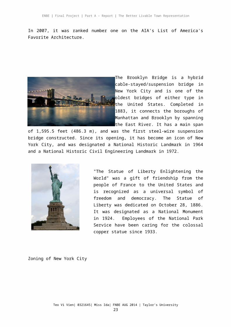
The Brooklyn Bridge is a hybrid cable-stayed/suspension bridge in New York City and is one of the oldest bridges of either type in the United States. Completed in 1883, it connects the boroughs of Manhattan and Brooklyn by spanning the East River. It has a main span of 1,595.5 feet (486.3 m), and was the first steel-wire suspension bridge constructed. Since its opening, it has
become an icon of New York City, and was designated a National Historic Landmark in 1964 and a National Historic Civil Engineering Landmark in 1972.
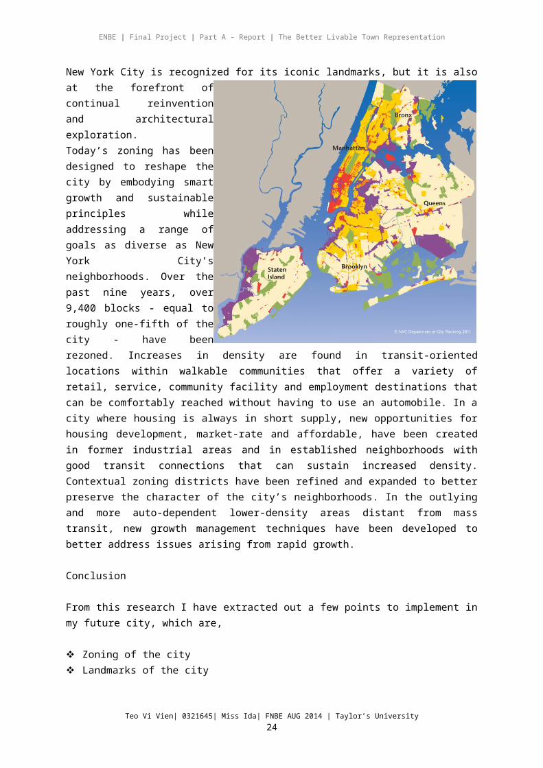
"The Statue of Liberty Enlightening the World" was a gift of friendship from the people of France to
Teo Vi Vien| 0321645| Miss Ida| FNBE AUG 2014 | Taylor’s University18

ENBE | Final Project | Part A – Report | The Better Livable Town Representation
the United States and is recognized as a universal symbol of freedom and democracy. The Statue of Liberty was dedicated on October 28, 1886. It was designated as a National Monument in 1924. Employees of the National Park Service have been caring for the colossal copper statue since 1933.
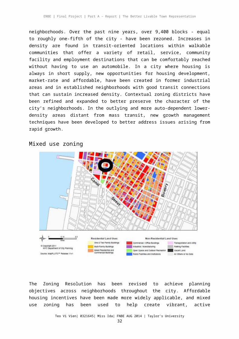
Zoning of New York City
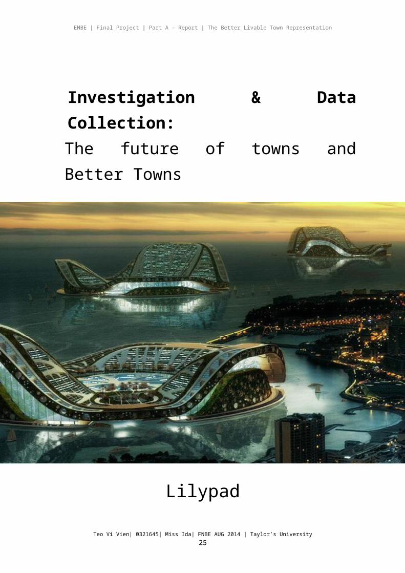
New York City is recognized for its iconic landmarks, but it is also at the forefront of continual reinvention and architectural exploration.Today’s zoning has been designed to reshape the city by embodying smart growth and sustainable principles while addressing a range of goals as diverse as New York City’s neighborhoods. Over the past nine years, over 9,400 blocks - equal to roughly one-fifth of the city - have been rezoned. Increases in density are found in transit-oriented locations within walkable communities that offer a variety of retail, service, community facility and employment destinations that can be comfortably reached without having to use an automobile. In a city where housing is always in short supply, new opportunities for housing development, market-rate and affordable, have been created in former industrial areas and in established neighborhoods with good transit connections that can sustain increased density. Contextual zoning districts have been refined and expanded to better preserve the character of the city’s neighborhoods. In the outlying and more auto-dependent lower-density areas distant from mass transit, new growth management techniques have been developed to better address issues arising from rapid growth.
Conclusion
From this research I have extracted out a few points to implement in my future city, which are,
Teo Vi Vien| 0321645| Miss Ida| FNBE AUG 2014 | Taylor’s University19
ENBE | Final Project | Part A – Report | The Better Livable Town Representation
Zoning of the city Landmarks of the city
Investigation & Data Collection:The future of towns and Better Towns
Lilypad
Teo Vi Vien| 0321645| Miss Ida| FNBE AUG 2014 | Taylor’s University20
ENBE | Final Project | Part A – Report | The Better Livable Town Representation
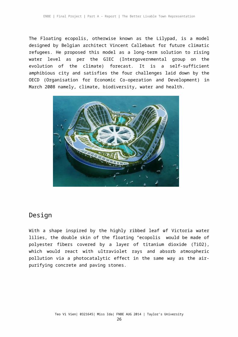
The Floating ecopolis, otherwise known as the Lilypad, is a model designed by Belgian architect Vincent Callebaut for future climatic refugees. He proposed this model as a long-term solution to rising water level as per the GIEC (Intergovernmental group on the evolution of the climate) forecast. It is a self-sufficient amphibious city and satisfies the four challenges laid down by the OECD (Organisation for Economic Co-operation and Development) in March 2008 namely, climate, biodiversity, water and health.
Design
With a shape inspired by the highly ribbed leaf of Victoria water lilies, the double skin of the floating “ecopolis” would be made of polyester fibers covered by a layer of
titanium dioxide (TiO2),
which would react with
ultraviolet rays and absorb atmospheric pollution via a photocatalytic effect in the same way as the air-purifying concrete and paving stones.
Teo Vi Vien| 0321645| Miss Ida| FNBE AUG 2014 | Taylor’s University21
ENBE | Final Project | Part A – Report | The Better Livable Town Representation
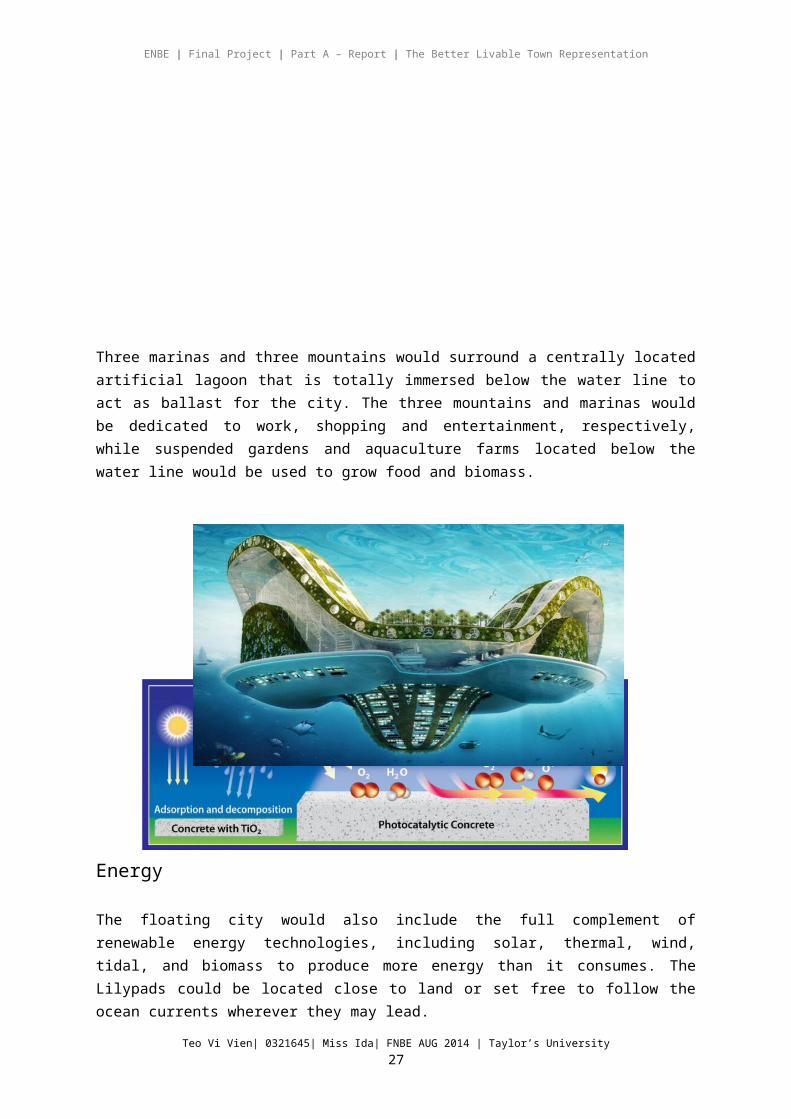
Three marinas and three mountains would surround a centrally located artificial lagoon that is totally immersed below the water line to act as ballast for the city. The three mountains and marinas would be dedicated to work, shopping and entertainment, respectively, while suspended gardens and aquaculture farms located below the water line would be used to grow food and biomass.
Energy
The floating city would also include the full complement of renewable energy technologies, including solar, thermal, wind, tidal, and biomass to produce more energy than it consumes. The Lilypads could be located close to land or set free to follow the ocean currents wherever they may lead.
Teo Vi Vien| 0321645| Miss Ida| FNBE AUG 2014 | Taylor’s University22
ENBE | Final Project | Part A – Report | The Better Livable Town Representation
The New “X” TownAspire Town
Teo Vi Vien| 0321645| Miss Ida| FNBE AUG 2014 | Taylor’s University23
ENBE | Final Project | Part A – Report | The Better Livable Town Representation
Concept : Grid System Zoning
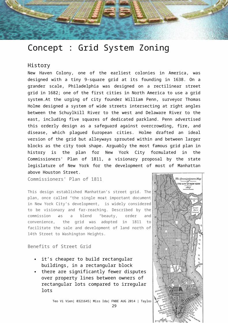
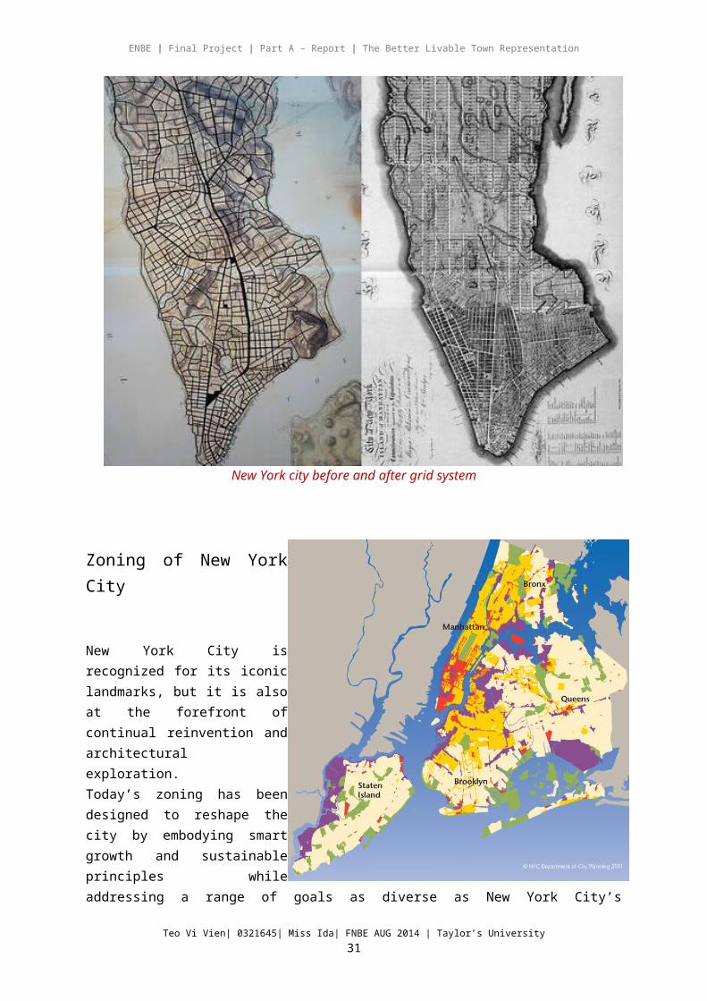
History New Haven Colony, one of the earliest colonies in America, was designed with a tiny 9-square grid at its founding in 1638. On a grander scale, Philadelphia was designed on a rectilinear street grid in 1682; one of the first cities in North America to use a grid system.At the urging of city founder William Penn, surveyor Thomas Holme designed a system of wide streets intersecting at right angles between the Schuylkill River to the west and Delaware River to the east, including five squares of dedicated parkland. Penn advertised this orderly design as a safeguard against overcrowding, fire, and disease, which plagued European cities. Holme drafted an ideal version of the grid but alleyways sprouted within and between larger blocks as the city took shape. Arguably the most famous grid plan in history is the plan for New York City formulated in the Commissioners' Plan of 1811, a visionary proposal by the state legislature of New York for the development of most of Manhattan above Houston Street.Commissioners’ Plan of 1811
This design established Manhattan’s street grid. The plan, once called “the single most important document in New York City’s development,” is widely considered to be visionary and far-reaching. Described by the commission as a blend “beauty, order and convenience,” the grid was adopted in 1811 to facilitate the sale and development of land north of 14th Street to Washington Heights.
Benefits of Street Grid
it’s cheaper to build rectangular buildings, in a rectangular block
there are significantly fewer disputes over property lines between owners of rectangular lots compared to irregular lots
a grid system promotes greater social interconnection and interaction
The grid is inherently walkable. By its very geometry, the grid provides the connectivity necessary for good urbanism.
It is Navigatable as the grid gives you an immediate sense of where you are in the world: left-right, east-west, uptown-downtown.
The grid is adaptable as land uses change constantly. With rectilinear lots and blocks, old land uses can move out and new land uses can simply plug in.
Teo Vi Vien| 0321645| Miss Ida| FNBE AUG 2014 | Taylor’s University24
ENBE | Final Project | Part A – Report | The Better Livable Town Representation
New York city before and after grid system
Zoning of New York City
Teo Vi Vien| 0321645| Miss Ida| FNBE AUG 2014 | Taylor’s University25
ENBE | Final Project | Part A – Report | The Better Livable Town Representation
New York City is recognized for its iconic landmarks, but it is also at the forefront of continual reinvention and architectural exploration.Today’s zoning has been designed to reshape the city by embodying smart growth and sustainable principles while addressing a range of goals as diverse as New York City’s neighborhoods. Over the past nine years, over 9,400 blocks - equal to roughly one-fifth of the city - have been rezoned. Increases in density are found in transit-oriented locations within walkable communities that offer a variety of retail, service, community facility and employment destinations that can be comfortably reached without having to use an automobile. In a city where housing is always in short supply, new opportunities for housing development, market-rate and affordable, have been created in former industrial areas and in established neighborhoods with good transit connections that can sustain increased density. Contextual zoning districts have been refined and expanded to better preserve the character of the city’s neighborhoods. In the outlying and more auto-dependent lower-density areas distant from mass transit, new growth management techniques have been developed to better address issues arising from rapid growth.
Mixed use zoning
The Zoning Resolution has been revised to achieve planning objectives across neighborhoods throughout the city. Affordable housing incentives have been made more widely applicable, and mixed use zoning has been used to help create vibrant, active neighborhoods, particularly in areas where residential uses were previously prohibited. Special incentives have been created to promote fresh food stores in underserved areas, and a range of zoning amendments have been adopted to ensure a more sustainable city through requirements for bicycle parking, mandatory street trees, improved streetscapes with more green space
Teo Vi Vien| 0321645| Miss Ida| FNBE AUG 2014 | Taylor’s University26
ENBE | Final Project | Part A – Report | The Better Livable Town Representation
in front yards, and landscaping in parking lots. New rules have also been adopted to assure a more open, accessible and inviting waterfront.
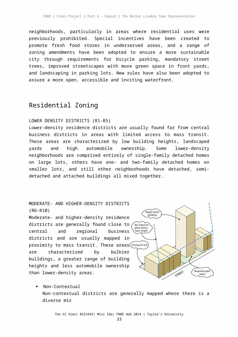
Residential Zoning
LOWER DENSITY DISTRICTS (R1-R5)Lower-density residence districts are usually found far from central business districts in areas with limited access to mass transit. These areas are characterized by low building heights, landscaped yards and high automobile ownership. Some lower-density neighborhoods are comprised entirely of single-family detached homes on large lots, others have one- and two-family detached homes on smaller lots, and still other neighborhoods have detached, semi-detached and attached buildings all mixed together.
MODERATE- AND HIGHER-DENSITY DISTRICTS (R6-R10)Moderate- and higher-density residence districts are generally found close to central and regional business districts and are usually mapped in proximity to mass transit. These areas are characterized by bulkier buildings, a greater range of building heights and less automobile ownership than lower-density areas.
Non-ContextualNon-contextual districts are generally mapped where there is a diverse mix of building types and no predominant context.
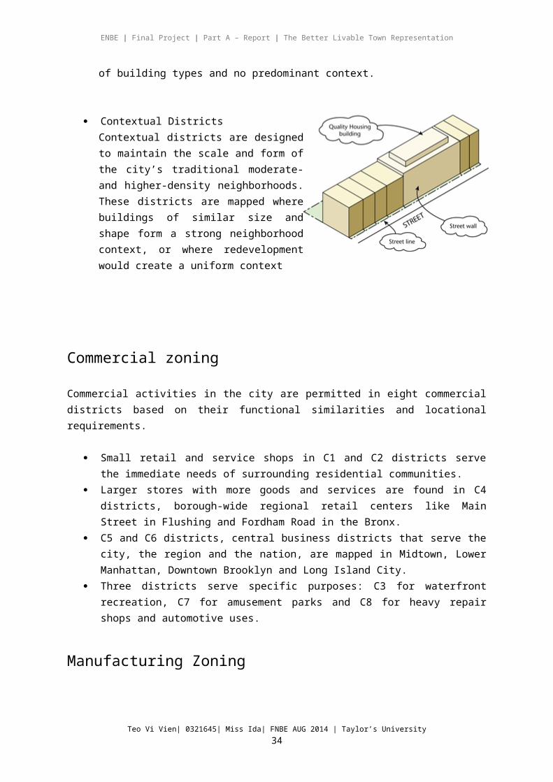
Contextual DistrictsContextual districts are designed to maintain the scale and form of the city’s traditional moderate- and higher-density neighborhoods. These districts are mapped where buildings of similar size and shape form a strong neighborhood context, or where redevelopment would create a uniform context
Teo Vi Vien| 0321645| Miss Ida| FNBE AUG 2014 | Taylor’s University27

ENBE | Final Project | Part A – Report | The Better Livable Town Representation
Commercial zoning
Commercial activities in the city are permitted in eight commercial districts based on their functional similarities and locational requirements.
Small retail and service shops in C1 and C2 districts serve the immediate needs of surrounding residential communities.
Larger stores with more goods and services are found in C4 districts, borough-wide regional retail centers like Main Street in Flushing and Fordham Road in the Bronx.
C5 and C6 districts, central business districts that serve the city, the region and the nation, are mapped in Midtown, Lower Manhattan, Downtown Brooklyn and Long Island City.
Three districts serve specific purposes: C3 for waterfront recreation, C7 for amusement parks and C8 for heavy repair shops and automotive uses.
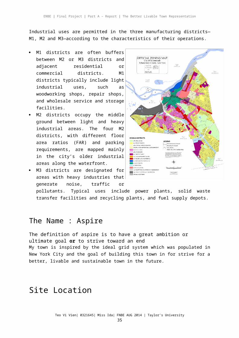
Manufacturing Zoning
Industrial uses are permitted in the three manufacturing districts—M1, M2 and M3—according to the characteristics of their operations.
M1 districts are often buffers between M2 or M3 districts and adjacent residential or commercial districts. M1 districts typically include light industrial uses, such as woodworking shops, repair shops, and wholesale service and storage facilities.
M2 districts occupy the middle ground between light and heavy industrial areas. The four M2 districts, with different floor area ratios (FAR) and parking requirements, are mapped mainly in the city’s older industrial areas along the waterfront.
M3 districts are designated for areas with heavy industries that generate noise, traffic or pollutants. Typical uses include power plants, solid waste transfer facilities and recycling plants, and fuel supply depots.
Teo Vi Vien| 0321645| Miss Ida| FNBE AUG 2014 | Taylor’s University28
ENBE | Final Project | Part A – Report | The Better Livable Town Representation
The Name : Aspire
The definition of aspire is to have a great ambition or ultimate goal or to strive toward an endMy town is inspired by the ideal grid system which was populated in New York City and the goal of building this town in for strive for a better, livable and sustainable town in the future.
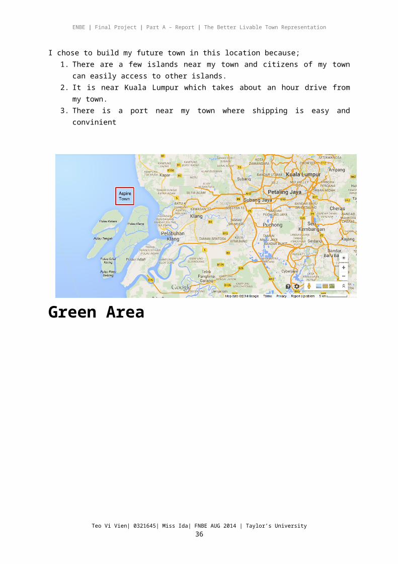
Site Location
I chose to build my future town in this location because;1. There are a few islands near my town and citizens of my town can easily
access to other islands.2. It is near Kuala Lumpur which takes about an hour drive from my town.3. There is a port near my town where shipping is easy and convinient
Green Area
Teo Vi Vien| 0321645| Miss Ida| FNBE AUG 2014 | Taylor’s University29
ENBE | Final Project | Part A – Report | The Better Livable Town Representation
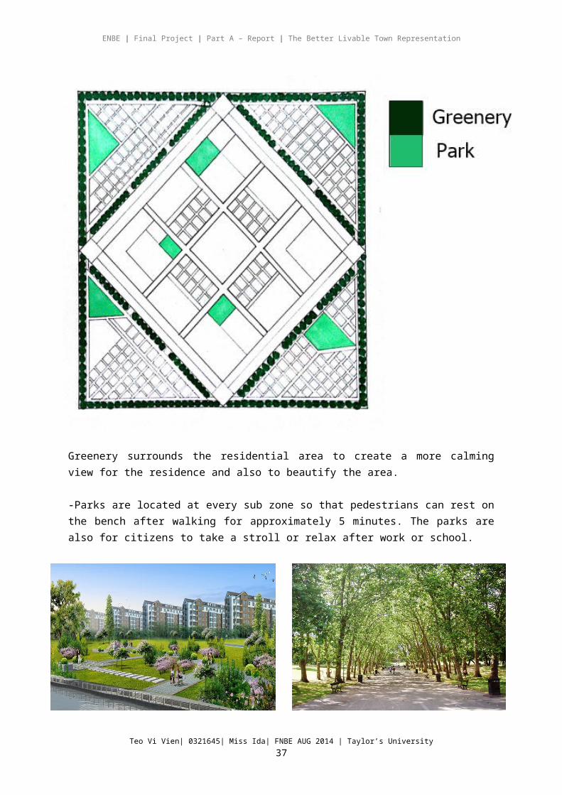
Greenery surrounds the residential area to create a more calming view for the residence and also to beautify the area.
-Parks are located at every sub zone so that pedestrians can rest on the bench after walking for approximately 5 minutes. The parks are also for citizens to take a stroll or relax after work or school.
Teo Vi Vien| 0321645| Miss Ida| FNBE AUG 2014 | Taylor’s University30
ENBE | Final Project | Part A – Report | The Better Livable Town Representation
Zoning
Commercial area- Main commercial centres are located at the heart
of the city with larger retail shops because it is near the business and service centre. It is easily accessed by bus and near walking distance.
- Each residential area has small retial shops so that residence of that particular area can walk or cycle to the shops without taking the public transport of the their area.
Residential Area
- Mid rise residential area consist of town houses, terrace houses and semi detached houses. Each house is equipped with a underwater basement where they can enjoy the underwater world and it’s calming effect with cooling temperature.
- High-rise residential area consist of apartments and condominiums. Each building is equipped with public facilities such as a gym, movie
theater, underwater lounge, swimming pool and rooftop garden with water features
Teo Vi Vien| 0321645| Miss Ida| FNBE AUG 2014 | Taylor’s University31
Energy source
ENBE | Final Project | Part A – Report | The Better Livable Town Representation
Industrial areaManufacturing factories are located near the train stations so that it is easily accessed.
EducationPrimary and Secondary schools are located at the North side of town while Universities are located at the South side of town. A park/field is located beside the campus for students to carry out sports or activities.
Government and service centreThis building is in the core of the town because a government is essential to maintain the sustainability of the town. It is easily located when citizen face any problems or ask for enquiries.
The structure of the building is inspired by the core of the lily pad floating city which is underwater.
Business area The office buidings are located at different zone near the heart of the town. It is located beside the railways for easy access for citizens and shorther walking distance.
Medical and Research centreThe hospital and research centres are located next to each other so that scientist and doctors can work together to improve on the latest medical techonology.
Research centre is also important to improve and maintain the town to benefit the citizens more in the future.
Teo Vi Vien| 0321645| Miss Ida| FNBE AUG 2014 | Taylor’s University32
ENBE | Final Project | Part A – Report | The Better Livable Town Representation
Energy sourceEnergy source plants are located at different areas so that the town can sustain on it’s own by producing renewable energy. This includes renewable energy source technologies such as Biomass, Osmotic power, Solar thermal, Tidal power and Wind energy.
Transportation
Teo Vi Vien| 0321645| Miss Ida| FNBE AUG 2014 | Taylor’s University33
Station
ENBE | Final Project | Part A – Report | The Better Livable Town Representation
1. Light Rail TransitLRTs were favoured over buses because trains run on dedicated elevated guideways, bypassing any traffic congestion and traffic lights on the roads, and do not add to road traffic. Train arrival and departure times are also almost guaranteed this way. It is also cleaner as the trains are electrically powered, and therefore lessens the effects of air pollution
2. Solar BusSolar buses are battery electric vehicles or (in the case of hybrid solar buses) hybrid vehicles equipped with batteries which are recharged from solar.
3. Bicyle PathBicycle paths are located beside the pedestrian walkways and bus lanes where citizens are encouraged to cycle to improve on their health and will not cause traffic congestion.
4. Pedestrian WalkwayPedestrian walkways are located around the residential area and heart of the town next to the bicycle path and near the train stations so that citizens only have to walk at a maximum of 10 minutes per stop.
Pedestrian Walking Radius
Teo Vi Vien| 0321645| Miss Ida| FNBE AUG 2014 | Taylor’s University34
ENBE | Final Project | Part A – Report | The Better Livable Town Representation
-The walking radius starts from every LRT transit and bus stops in the town.-The transportation is designed as near as possible for the convenience of the citizens to walk from one place to another at a maximum time of 10 minutes.
Conclusion
From this project, I’ve learnt the requirements of building a town by considering the structure of the layout, zoning of the areas, walkability, sustainability with a balance of open spaces and greenery. I’ve learnt that a sensible city is organized so that its residents can perceive and understand the city's form and function.
A city with good fit provides the buildings, spaces, and networks required for its residents to pursue their projects successfully. An accessible city allows people of all ages and background to gain the activities, resources, services, and information that they need. A city with good control is arranged so that its citizens have a say in the management of the spaces in which they work and reside.
Teo Vi Vien| 0321645| Miss Ida| FNBE AUG 2014 | Taylor’s University35
ENBE | Final Project | Part A – Report | The Better Livable Town Representation
Reference Links1. Whitaker, (2014). Tenochtitlan, Mexcio.. [online] Ancient-wisdom.co.uk.
Available at: http://www.ancient-wisdom.co.uk/mexicotenochtitlan.htm 2. Ancient Origins, (2014). Chinampas, The Floating Gardens of Mexico.
[online] Available at: http://www.ancient-origins.net/ancient-places-americas/chinampas-floating-gardens-mexico-001537
3. Europeforvisitors.com, (2014). Venice Transportation and Parking. [online] Available at: http://europeforvisitors.com/venice/articles/vi-transport.htm
4. Buildings/Structures, V., Marciana, B., House, B., d'Oro, C., Rezzonico, C., Maggiore, C., Venice, H., South, H., Redentore, I., House, L., Grassi, Bridge, R., Salute, B., Malibran, T., Inn, T., Arcade, V., Depot, V., House, Regina, and Venezia, (2014). Venice Buildings/Structures. [online] Ranker. Available at: http://www.ranker.com/list/venice-buildings-and-structures/reference
5. Ermengem, K. (2014). St. Mark's Basilica, Venice. [online] Aviewoncities.com. Available at: http://www.aviewoncities.com/venice/basilicadisanmarco.htm
6. Art.net, (2014). History Of Cities And City Planning. [online] Available at: http://www.art.net/~hopkins/Don/simcity/manual/history.html
7. Bettercities.net, (2014). Benefits of the grid. [online] Available at: http://bettercities.net/news-opinion/blogs/paul-knight/20235/benefits-grid
8. Tatasteelconstruction.com, (2014). The advantages and disadvantages of using space grids | Tata Steel Construction. [online] Available at: http://www.tatasteelconstruction.com/en/reference/teaching-resources/architectural-teaching-resource/design/space-grid-structures/the-advantages-and-disadvantages-of-using-space-grids
Teo Vi Vien| 0321645| Miss Ida| FNBE AUG 2014 | Taylor’s University36
ENBE | Final Project | Part A – Report | The Better Livable Town Representation
9. Humantransit.org, (2014). Human Transit: basics: walking distance to transit. [online] Available at: http://www.humantransit.org/2011/04/basics-walking-distance-to-transit.html
10.EVstudio, Architect Engineer Denver Evergreen Colorado, Austin Texas Architect, (2010). The Five Minute Walk: Calibrated to the Pedestrian. [online] Available at: http://evstudio.com/the-five-minute-walk-calibrated-to-the-pedestrian/
11.About, (2014). Venice Transportation - Getting Around and To Venice Italy. [online] Available at: http://goitaly.about.com/od/transportation/
12.Encyclopedia Britannica, (2014). Venice (Italy). [online] Available at: http://global.britannica.com/EBchecked/topic/625298/Venice
13.Geography.parkfieldprimary.com, (2014). Venice - Primary School Geography Encyclopedia. [online] Available at: http://geography.parkfieldprimary.com/the-european-union/italy/venice
14.Empire State Building, (2014). Empire State Building. [online] Available at: http://www.esbnyc.com/ [Accessed 6 Nov. 2014].
15.Curbed National, (2014). Bob in the Sea in This Untethered 'Lily Pad' City of the Future. [online] Available at: http://curbed.com/archives/2012/11/05/bob-in-the-sea-in-this-untethered-lily-pad-city-of-the-future.php
16.http://www.netplan.it, N. (2014). Venice history - Venice culture - Venice - attractions in Venice - art Venice - Serenissima Republic Venice. [online] Veniceworld.com.Availableat:http://www.veniceworld.com/venice_guide_history_culture.htm
17.Venicehistorical.org, (2014). Venice Historical Society - Venice, California. [online] Available at: http://www.venicehistorical.org/[
18.Geography.parkfieldprimary.com, (2014). Venice - Primary School Geography Encyclopedia. [online] Available at: http://geography.parkfieldprimary.com/the-european-union/italy/venice
19.hapa, J. (2014). LILYPAD: Floating City for Climate Change Refugees. [online] Inhabitat.com. Available at: http://inhabitat.com/lilypad-floating-cities-in-the-age-of-global-warming/
20.HISTORY.com, (2014). New York City - Facts & Summary - HISTORY.com. [online] Available at: http://www.history.com/topics/new-york-city
21.Ny.com, (2014). NYC Information: Geography and Origins. [online] Available at: http://www.ny.com/histfacts/geography.html
22.Nyc.gov, (2014). NYC Zoning - About New York City Zoning. [online] Available at: http://www.nyc.gov/html/dcp/html/zone/zonehis.shtml
23.Nyc-grid.com, (2014). NYC Grid - Map. [online] Available at: http://www.nyc-grid.com/map/
24.Mta.info, (2014). MTA Home. [online] Available at: http://www.mta.info/25.nycgo.com, (2014). New York City Transportation: Getting to NYC and
Getting Around NYC. [online] Available at: http://www.nycgo.com/transportation/
Teo Vi Vien| 0321645| Miss Ida| FNBE AUG 2014 | Taylor’s University37