Embed Size (px)
Citation preview
9th
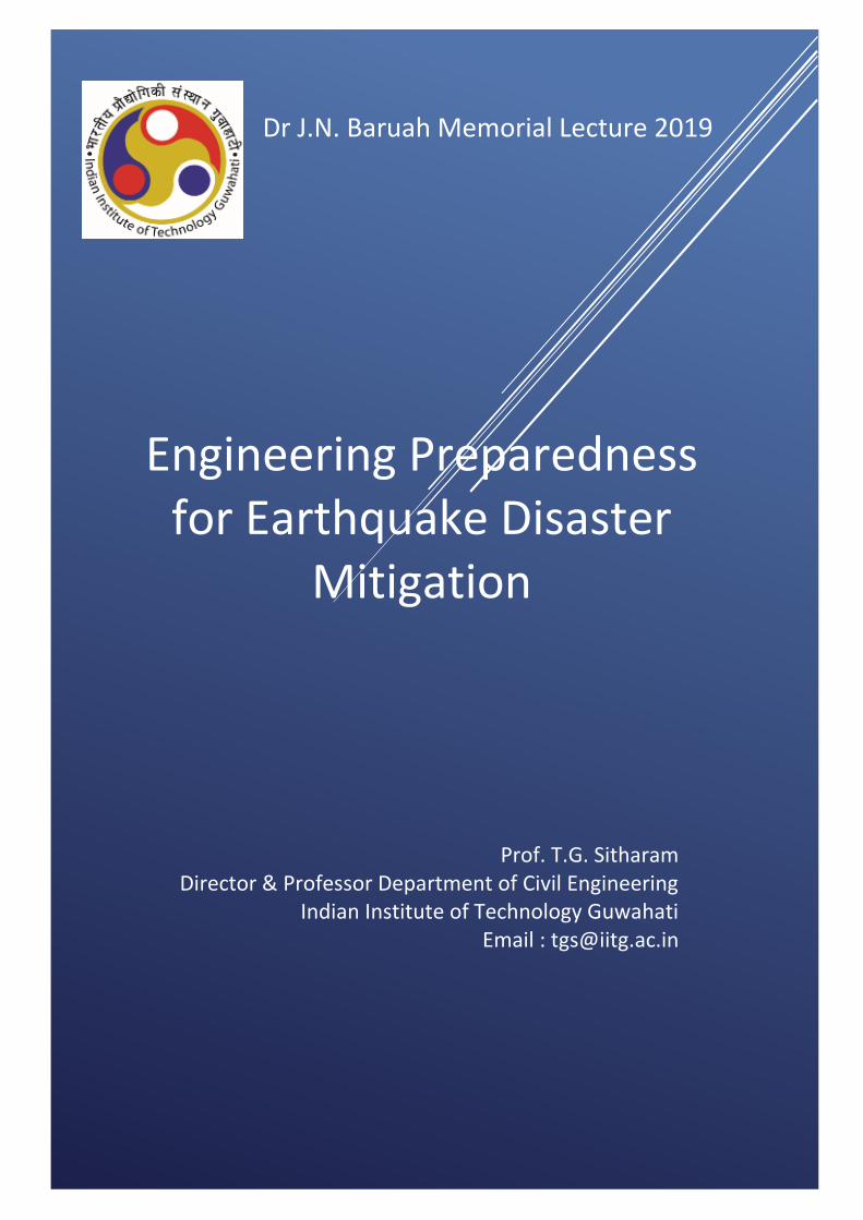
Dr J.N. Baruah Memorial Lecture 2019
Engineering Preparedness
for Earthquake Disaster Mitigation
Prof. T.G. Sitharam Director & Professor Department of Civil Engineering
Indian Institute of Technology Guwahati Email : [email protected]
Engineering Preparedness
for Earthquake Disaster
Mitigation
Contents
Page
1. Lecture Notes 01-41
2. Resume of Prof. T.G. Sitharam 47
3. Salient Achievements of 49
Dr J.N.Baruah
4. Invitation Letter 50
5. List of Speakers till 2018 51
Engineering Preparedness for Earthquake Disaster Mitigation
1
1. INTRODUCTION
Many natural processes are looked upon as natural disasters mainly because human beings have not
been able to respond to them appropriately. Earthquake is one such disaster that has affected the
mankind the most. Due to lack of knowledge and unsafe construction practices, earthquakes still
cause widespread destruction leading to loss of lives and property. Earthquake can cause multi-level
hazards resulting from ground motion, ground shaking, site effects, ground displacement, fire, floods,
liquefaction, landslide and tsunami. When an earthquake hits, urban centres and cities experience
more loss mostly because of high population density, improper planning, poor land use, substandard
construction practices and quality of construction material.
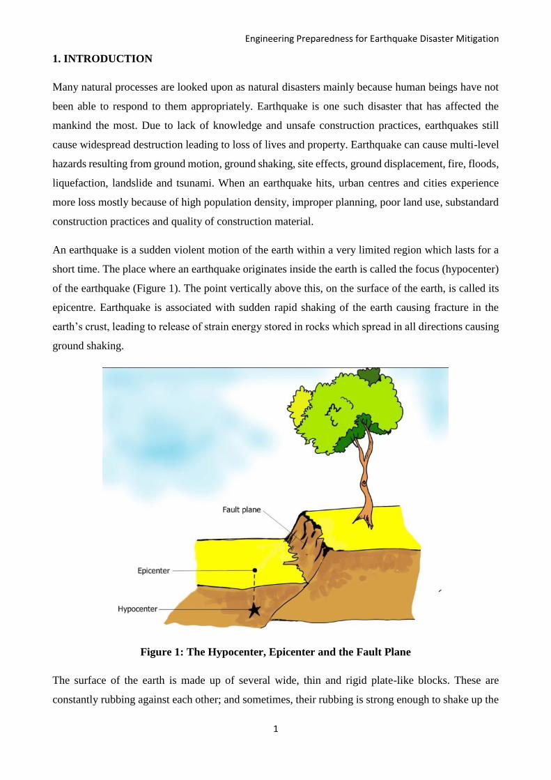
An earthquake is a sudden violent motion of the earth within a very limited region which lasts for a
short time. The place where an earthquake originates inside the earth is called the focus (hypocenter)
of the earthquake (Figure 1). The point vertically above this, on the surface of the earth, is called its
epicentre. Earthquake is associated with sudden rapid shaking of the earth causing fracture in the
earth’s crust, leading to release of strain energy stored in rocks which spread in all directions causing
ground shaking.
Figure 1: The Hypocenter, Epicenter and the Fault Plane
The surface of the earth is made up of several wide, thin and rigid plate-like blocks. These are
constantly rubbing against each other; and sometimes, their rubbing is strong enough to shake up the
Engineering Preparedness for Earthquake Disaster Mitigation
2
earth, release tremendous amounts of energy, and cause havoc. The current movement of the Indian
plate is estimated to be around 50 mm/year. Of course, in our day to day lives, this kind of movement
is negligible. However, a plate beneath the earth's surface, moving at this rate for a long enough time,
can have a strong influence on the structure of the earth itself.
Earthquakes are more frequent in regions that lie directly above the edge of the plates. Volcanic
activity and human activities like blasting, quarrying, mining and underground nuclear explosions
can also cause quakes. Irrespective of the cause, enough precautions have to be taken to protect human
dwellings when an earthquake strikes. The size of an earthquake depends on the size of the fault and
the amount of slip on the fault. Scientists use an instrument called the seismograph to measure the
magnitude of an earthquake. Earthquake size can be expressed qualitatively (non-instrumental) or
quantitatively (instrumental). It is commonly expressed in terms of Intensity or Magnitude.
Intensity
Intensity is a measure of how strong the earthquake feels to an observer. It is the qualitative
assessment of the kind of damage done by an earthquake. Intensity depends on distance to epicenter,
strength of earthquake and local geology. It is determined from the intensity of shaking and the
damage from the earthquake.
Magnitude
Magnitude is the quantitative measurement of the amount of energy released by an earthquake. Such
a quantitative measure is needed to compare the size of earthquakes worldwide, which is independent
of the density of population and the type of construction.
2. EARTHQUAKES IN AND AROUND INDIA
More than 50% of India's land area is vulnerable to earthquakes, and the Indian subcontinent has
experienced earthquakes since ancient times. The northern region of India, which is along the
boundary of the Indian plate and the Eurasian plate, is seismically very active. The north eastern
movement of the Indian plate has caused deformation in the Himalayan region, Tibet and the North
Eastern India. The North East Indian (NEI) region is known as one of the most seismically active
regions in the world. However, the peninsular India, which is far away from the plate boundary, is a
stable continental region, which is considered to be of moderate seismic activity. Even though the
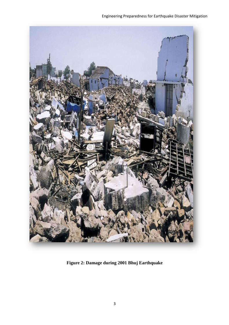
activity is considered to be moderate in the Peninsular India, one of the world’s deadliest earthquakes
occurred in this region (Bhuj earthquake 2001). The Table below shows major earthquakes that
triggered in and around India in last few decades.
Engineering Preparedness for Earthquake Disaster Mitigation
3
Figure 2: Damage during 2001 Bhuj Earthquake
Engineering Preparedness for Earthquake Disaster Mitigation
4
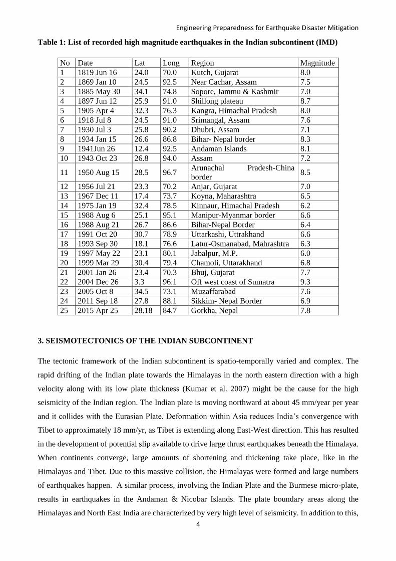
Table 1: List of recorded high magnitude earthquakes in the Indian subcontinent (IMD)
No Date Lat Long Region Magnitude
1 1819 Jun 16 24.0 70.0 Kutch, Gujarat 8.0
2 1869 Jan 10 24.5 92.5 Near Cachar, Assam 7.5
3 1885 May 30 34.1 74.8 Sopore, Jammu & Kashmir 7.0
4 1897 Jun 12 25.9 91.0 Shillong plateau 8.7
5 1905 Apr 4 32.3 76.3 Kangra, Himachal Pradesh 8.0
6 1918 Jul 8 24.5 91.0 Srimangal, Assam 7.6
7 1930 Jul 3 25.8 90.2 Dhubri, Assam 7.1
8 1934 Jan 15 26.6 86.8 Bihar- Nepal border 8.3
9 1941Jun 26 12.4 92.5 Andaman Islands 8.1
10 1943 Oct 23 26.8 94.0 Assam 7.2
11 1950 Aug 15 28.5 96.7 Arunachal Pradesh-China
border 8.5
12 1956 Jul 21 23.3 70.2 Anjar, Gujarat 7.0
13 1967 Dec 11 17.4 73.7 Koyna, Maharashtra 6.5
14 1975 Jan 19 32.4 78.5 Kinnaur, Himachal Pradesh 6.2
15 1988 Aug 6 25.1 95.1 Manipur-Myanmar border 6.6
16 1988 Aug 21 26.7 86.6 Bihar-Nepal Border 6.4
17 1991 Oct 20 30.7 78.9 Uttarkashi, Uttrakhand 6.6
18 1993 Sep 30 18.1 76.6 Latur-Osmanabad, Mahrashtra 6.3
19 1997 May 22 23.1 80.1 Jabalpur, M.P. 6.0
20 1999 Mar 29 30.4 79.4 Chamoli, Uttarakhand 6.8
21 2001 Jan 26 23.4 70.3 Bhuj, Gujarat 7.7
22 2004 Dec 26 3.3 96.1 Off west coast of Sumatra 9.3
23 2005 Oct 8 34.5 73.1 Muzaffarabad 7.6
24 2011 Sep 18 27.8 88.1 Sikkim- Nepal Border 6.9
25 2015 Apr 25 28.18 84.7 Gorkha, Nepal 7.8
3. SEISMOTECTONICS OF THE INDIAN SUBCONTINENT
The tectonic framework of the Indian subcontinent is spatio-temporally varied and complex. The
rapid drifting of the Indian plate towards the Himalayas in the north eastern direction with a high
velocity along with its low plate thickness (Kumar et al. 2007) might be the cause for the high
seismicity of the Indian region. The Indian plate is moving northward at about 45 mm/year per year
and it collides with the Eurasian Plate. Deformation within Asia reduces India’s convergence with
Tibet to approximately 18 mm/yr, as Tibet is extending along East-West direction. This has resulted
in the development of potential slip available to drive large thrust earthquakes beneath the Himalaya.
When continents converge, large amounts of shortening and thickening take place, like in the
Himalayas and Tibet. Due to this massive collision, the Himalayas were formed and large numbers
of earthquakes happen. A similar process, involving the Indian Plate and the Burmese micro-plate,
results in earthquakes in the Andaman & Nicobar Islands. The plate boundary areas along the
Himalayas and North East India are characterized by very high level of seismicity. In addition to this,
Engineering Preparedness for Earthquake Disaster Mitigation
5
there are earthquakes occurring within the Indian shield region, in the Indian peninsula and in
adjoining parts of the Arabian Sea or the Bay of Bengal.
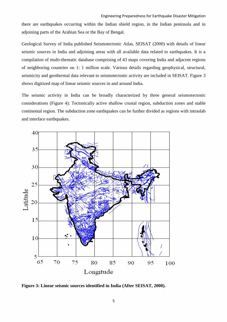
Geological Survey of India published Seismotectonic Atlas, SEISAT (2000) with details of linear
seismic sources in India and adjoining areas with all available data related to earthquakes. It is a
compilation of multi-thematic database comprising of 43 maps covering India and adjacent regions
of neighboring countries on 1: 1 million scale. Various details regarding geophysical, structural,
seismicity and geothermal data relevant to seismotectonic activity are included in SEISAT. Figure 3
shows digitized map of linear seismic sources in and around India.
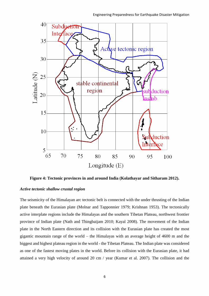
The seismic activity in India can be broadly characterized by three general seismotectonic
considerations (Figure 4): Tectonically active shallow crustal region, subduction zones and stable
continental region. The subduction zone earthquakes can be further divided as regions with intraslab
and interface earthquakes.
Figure 3: Linear seismic sources identified in India (After SEISAT, 2000).
Engineering Preparedness for Earthquake Disaster Mitigation
6
Figure 4: Tectonic provinces in and around India (Kolathayar and Sitharam 2012).
Active tectonic shallow crustal region
The seismicity of the Himalayan arc tectonic belt is connected with the under thrusting of the Indian
plate beneath the Eurasian plate (Molnar and Tapponnier 1979; Krishnan 1953). The tectonically
active interplate regions include the Himalayas and the southern Tibetan Plateau, northwest frontier
province of Indian plate (Nath and Thingbaijam 2010; Kayal 2008). The movement of the Indian
plate in the North Eastern direction and its collision with the Eurasian plate has created the most
gigantic mountain range of the world – the Himalayas with an average height of 4600 m and the
biggest and highest plateau region in the world - the Tibetan Plateau. The Indian plate was considered
as one of the fastest moving plates in the world. Before its collision with the Eurasian plate, it had
attained a very high velocity of around 20 cm / year (Kumar et al. 2007). The collision and the

Engineering Preparedness for Earthquake Disaster Mitigation
7
subsequent formation of the Himalayas and the Tibetan Plateau are associated with very high
seismicity.
The entire North East Region is put under zone V of the Indian seismic zonation code (IS-1893,
2002). This region falls at the junction of N-S trending Burmese arc and E-W trending Himalayan
Arc. Due to this, the entire region has suffered multiple phases of deformation processes and this has
resulted in numerous geological structures.
Subduction zones
The subduction zones include that of Hindukush- Pamir in the northwest frontier province, Indo-
Myanmar arc, and Andaman-Sumatra seismic belt. The North East India, especially the region
bordering China and Myanmar, is seismically very active. The seismicity of Indo-Burmese arc is
related to the subduction of the Indian plate underneath the Southeast Asian plate due to north-
eastward motion of India (Deshikachar 1974). The north-eastern corner of India, lying between the
Himalayan and Burmese arcs, has a complex seismotectonic setup and very high seismic activity
(Evans 1964). The earthquakes in this area are of intraslab in nature.
The Andaman Nicobar Islands (ANI), which is situated on the south eastern side of the Indian land
mass, consists of about 527 islands. Andaman and Nicobar Islands (ANI) is the largest group of
islands in the Bay of Bengal formed due to the thrust faulting between Indo-Australian plate and
Burmese plate. These islands are branches of submarine mountains (Rai and Murty 2003). The
southernmost tip of the Great Nicobar Island is only 150 km away from Sumatra, Indonesia. The
region is regarded as one of the most seismically active regions in the world. The islands are
associated with various geological issues such as subduction tectonics and earthquake processes,
crustal deformation, active tectonics, volcanism, etc. The seismotectonic setting of the Andaman
Nicobar Islands (ANI) was studied and well documented by various researchers (Eguchi et al 1979;
Mukhopadhyay 1984, 1988; Dasgupta and Mukhopadhyay 1993, 1997; Dasgupta et al 2003; Curray
2005 and Dasgupta et al 2007a). The Andaman trench, west Andaman fault, Sumatra Fault System,
Ranong Fault and Khlong Marui Fault are the active tectonic features in and around ANI (Dasgupta
et al. 2003, Curray 2005). The entire island chain is along the plate boundary between the Indian plate
and the Burmese plate. These regions come under subduction zones with interface earthquakes. The
Andaman and Nicobar Islands, said to be located on a small tectonic plate which forms the ridges of
the islands, is packed in between the Indo-Australian plate on the west side and the Eurasian plate in
the north and the east (Dasgupta et al. 2007b). Spreading centres lie on the eastern side of the Islands
and the Indian lithosphere on the western side subducts below the Andaman (Sunda) Plate making
this region seismically active (Rajendran and Gupta 1989). Several damaging earthquakes and
Engineering Preparedness for Earthquake Disaster Mitigation
8
Tsunamis have hit the Andaman-Nicobar Islands in the past. The Sumatran earthquake of Dec 26,
2004 had also occurred along the same source and ANI was one of the worst affected regions during
the Tsunami. ANI has been placed in zone V, the highest level of seismic hazard potential, according
to the seismic zonation map of India (IS 1893-2002).
Stable continental shield region
Peninsular India is delineated as Stable Continental Region (SCR) with low to moderate seismic
activity (Chandra 1977). The seismicity of this region is of intraplate nature and appears to be
associated with some local faults and weak zones (Rao and Murty 1970). The ENE–WSW trending
Son-Narmada-Tapti zone is an important tectonic province in the northern edge of the peninsular
shield. The major tectonic features in the southern part of the peninsula are the Deccan Volcanic
Province, the Southern Indian Granulite Terrain, the Dharwar Craton, the Cuddapah Basin, the
Godavari and the Mahanadi Grabens, and the Eastern and Western Ghats (Gupta 2006). The Bhuj
earthquake (26 January 2001; Causality around 19000) and the Latur earthquake (30 September 1993;
Causality around 7928) are the deadliest earthquakes in this region. There were about 10 earthquakes
with magnitude 6.0 and above reported in this region.
4. A GLANCE THROUGH INDIAN SEISMIC DESIGN CODES
Seismic codes give guidelines to improve the performance of structures so that they may endure the
earthquake effects without significant loss of life and property. Countries around the world have
procedures outlined in seismic codes to help design engineers in the planning, designing, detailing
and constructing of structures. Structures must be designed to withstand the forces and deformations
induced during earthquakes.
Engineering Preparedness for Earthquake Disaster Mitigation
9
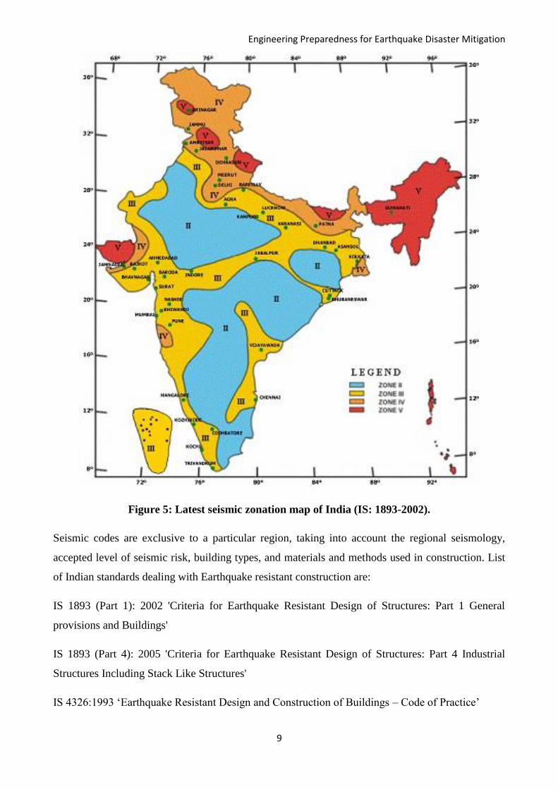
Figure 5: Latest seismic zonation map of India (IS: 1893-2002).
Seismic codes are exclusive to a particular region, taking into account the regional seismology,
accepted level of seismic risk, building types, and materials and methods used in construction. List
of Indian standards dealing with Earthquake resistant construction are:
IS 1893 (Part 1): 2002 'Criteria for Earthquake Resistant Design of Structures: Part 1 General
provisions and Buildings'
IS 1893 (Part 4): 2005 'Criteria for Earthquake Resistant Design of Structures: Part 4 Industrial
Structures Including Stack Like Structures'
IS 4326:1993 ‘Earthquake Resistant Design and Construction of Buildings – Code of Practice’
Engineering Preparedness for Earthquake Disaster Mitigation
10
IS 13827:1993 ‘Improving Earthquake Resistance of Earthen Buildings – Guidelines’
IS 13828:1993 ‘Improving Earthquake Resistance of Low Strength Masonry Buildings – Guidelines’
IS 13920:1993 ‘Ductile Detailing of Reinforced Concrete Structures Subjected to Seismic Forces –
Code of Practice’
IS 13935:1993 ‘Repair and Seismic Strengthening of Buildings – Guidelines’
The regulations in these standards ensure that the structures are able to respond to earthquakes of
moderate intensities without structural damage and of heavy intensities without total collapse. IS 1893
is the main code that provides the seismic zone map and specifies seismic design force. The seismic
design force depends on the mass and seismic coefficient of the structure; the latter in turn depends
on properties like the seismic zone in which the structure lies, the importance of the structure, its
stiffness, the soil on which it rests, and its ductility.
IS 1893 illustrated a seismic zonation map in 1962 and revised it in 1966, 1970, 1984 and in 2002.
The latest version of earthquake zoning map of India divides the country into four seismic zones
(Zone II to V) as shown in Figure 5, unlike its previous version which consisted of five or six zones
in the country. According to the present zoning map, Zone - V expects the highest level of seismicity
whereas Zone - II is associated with the lowest level of seismicity. There is immediate need to educate
and empower the community residing in zones IV & V to face an eventual earthquake. The brief
guidelines for constructing safe houses in the various areas lying in different seismic zones of the
country and also about retrofitting etc. are given at the NIDM website
http://nidm.gov.in/safety_earthquake.asp.
5. SEISMIC HAZARD IN INDIA
The BIS-1893 (2002) delineates different seismic zones based on the past seismic activity and hence
gets updated after a major earthquake event. For a developing country like India, the steps towards
scientific seismic hazard evaluation are very essential to estimate an optimal and reliable value of
possible earthquake ground motion during a specific time period. These predicted values will be an
input to assess the seismic vulnerability of an area, based on which new construction and the
restoration works of existing structures can be carried out.
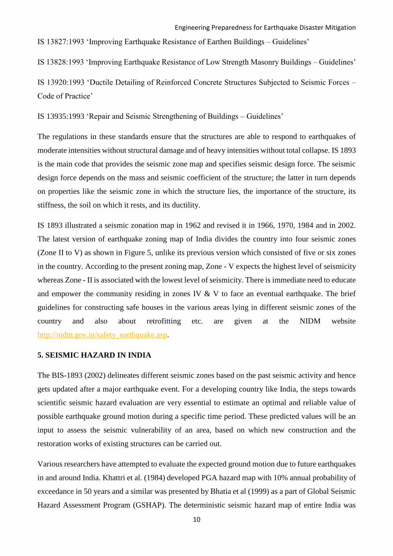
Various researchers have attempted to evaluate the expected ground motion due to future earthquakes
in and around India. Khattri et al. (1984) developed PGA hazard map with 10% annual probability of
exceedance in 50 years and a similar was presented by Bhatia et al (1999) as a part of Global Seismic
Hazard Assessment Program (GSHAP). The deterministic seismic hazard map of entire India was
Engineering Preparedness for Earthquake Disaster Mitigation
11
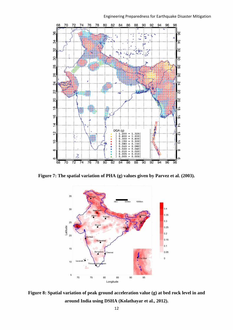
prepared by Parvez et al. (2003). Kolathayar et al. (2012) estimated seismic hazard for India using
deterministic approach with different source models and attenuation relations in a logic tree
framework. Iyengar et al. (2010) and Nath and Thingbaijam (2012) developed the Probabilistic
Seismic hazard map for Indian landmass. Kolathayar and Sitharam (2013) developed probabilistic
maps for seismic hazard both at bedrock level and at surface level for the Indian land mass using
different sets of attenuation relations to suit varied tectonic provinces in India and with different
source models combined in a logic tree framework. Various seismic hazard maps developed for entire
India are presented in Figures 6 to 12.
Figure 6: The seismic hazard map of India for 10 % probability of exceedance in 50 years
(Bhatia et al., 1999).
Engineering Preparedness for Earthquake Disaster Mitigation
12
Figure 7: The spatial variation of PHA (g) values given by Parvez et al. (2003).
Figure 8: Spatial variation of peak ground acceleration value (g) at bed rock level in and
around India using DSHA (Kolathayar et al., 2012).
Engineering Preparedness for Earthquake Disaster Mitigation
13
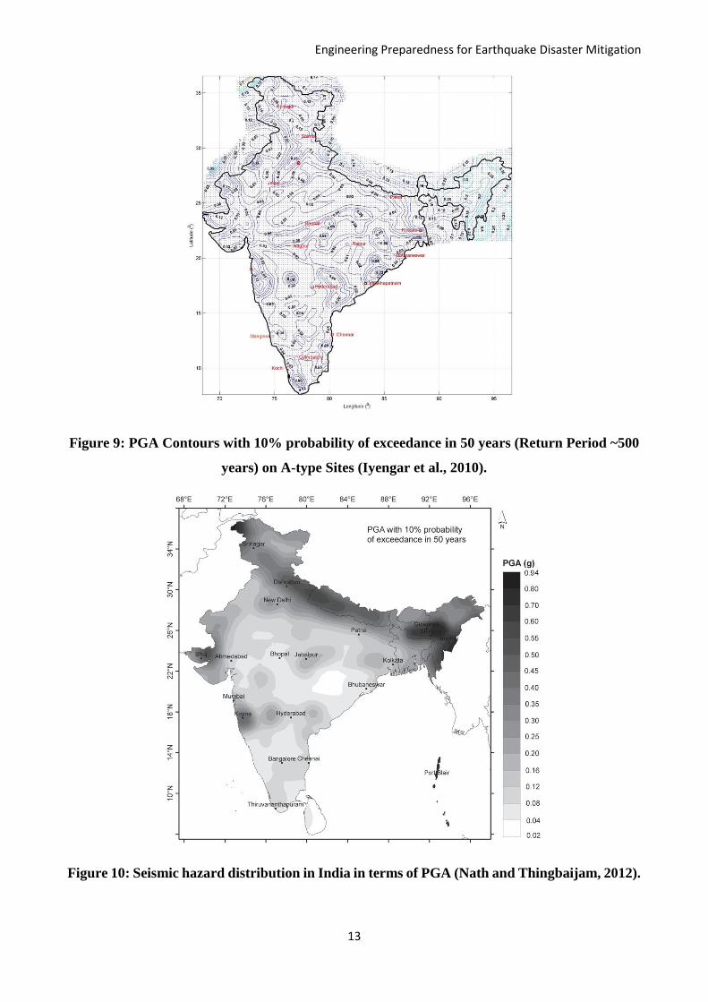
Figure 9: PGA Contours with 10% probability of exceedance in 50 years (Return Period ~500
years) on A-type Sites (Iyengar et al., 2010).
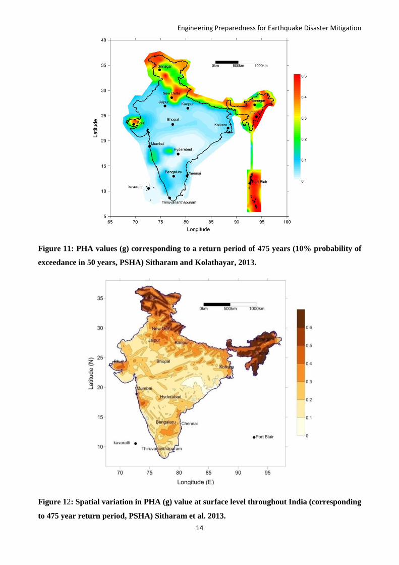
Figure 10: Seismic hazard distribution in India in terms of PGA (Nath and Thingbaijam, 2012).
Engineering Preparedness for Earthquake Disaster Mitigation
14
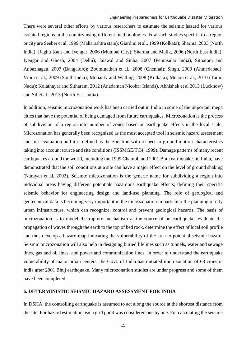
Figure 11: PHA values (g) corresponding to a return period of 475 years (10% probability of
exceedance in 50 years, PSHA) Sitharam and Kolathayar, 2013.
Figure 12: Spatial variation in PHA (g) value at surface level throughout India (corresponding
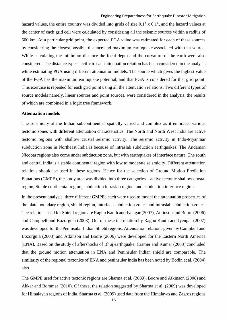
to 475 year return period, PSHA) Sitharam et al. 2013.
Engineering Preparedness for Earthquake Disaster Mitigation
15
There were several other efforts by various researchers to estimate the seismic hazard for various
isolated regions in the country using different methodologies. Few such studies specific to a region
or city are Seeber et al, 1999 (Maharashtra state); Giardini et al., 1999 (Kolkata); Sharma, 2003 (North
India); Raghu Kant and Iyengar, 2006 (Mumbai City); Sharma and Malik, 2006 (North East India);
Iyengar and Ghosh, 2004 (Delhi); Jaiswal and Sinha, 2007 (Peninsular India); Sitharam and
Anbazhagan, 2007 (Bangalore); Boominathan et al., 2008 (Chennai); Singh, 2009 (Ahmedabad);
Vipin et al., 2009 (South India); Mohanty and Walling, 2008 (Kolkata); Menon et al., 2010 (Tamil
Nadu); Kolathayar and Sitharam, 2012 (Anadaman Nicobar Islands), Abhishek et al 2013 (Lucknow)
and Sil et al., 2013 (North East India).
In addition, seismic microzonation work has been carried out in India in some of the important mega
cities that have the potential of being damaged from future earthquakes. Microzonation is the process
of subdivision of a region into number of zones based on earthquake effects in the local scale.
Microzonation has generally been recognized as the most accepted tool in seismic hazard assessment
and risk evaluation and it is defined as the zonation with respect to ground motion characteristics
taking into account source and site conditions (ISSMGE/TC4, 1999). Damage patterns of many recent
earthquakes around the world, including the 1999 Chamoli and 2001 Bhuj earthquakes in India, have
demonstrated that the soil conditions at a site can have a major effect on the level of ground shaking
(Narayan et al, 2002). Seismic microzonation is the generic name for subdividing a region into
individual areas having different potentials hazardous earthquake effects; defining their specific
seismic behavior for engineering design and land-use planning. The role of geological and
geotechnical data is becoming very important in the microzonation in particular the planning of city
urban infrastructure, which can recognize, control and prevent geological hazards. The basis of
microzonation is to model the rupture mechanism at the source of an earthquake, evaluate the
propagation of waves through the earth to the top of bed rock, determine the effect of local soil profile
and thus develop a hazard map indicating the vulnerability of the area to potential seismic hazard.
Seismic microzonation will also help in designing buried lifelines such as tunnels, water and sewage
lines, gas and oil lines, and power and communication lines. In order to understand the earthquake
vulnerability of major urban centers, the Govt. of India has initiated microzonation of 63 cities in
India after 2001 Bhuj earthquake. Many microzonation studies are under progress and some of them
have been completed.
6. DETERMINISTIC SEISMIC HAZARD ASSESSMENT FOR INDIA
In DSHA, the controlling earthquake is assumed to act along the source at the shortest distance from
the site. For hazard estimation, each grid point was considered one by one. For calculating the seismic
Engineering Preparedness for Earthquake Disaster Mitigation
16
hazard values, the entire country was divided into grids of size 0.1° x 0.1°, and the hazard values at
the center of each grid cell were calculated by considering all the seismic sources within a radius of
500 km. At a particular grid point, the expected PGA value was estimated for each of these sources
by considering the closest possible distance and maximum earthquake associated with that source.
While calculating the minimum distance the focal depth and the curvature of the earth were also
considered. The distance type specific to each attenuation relation has been considered in the analysis
while estimating PGA using different attenuation models. The source which gives the highest value
of the PGA has the maximum earthquake potential, and that PGA is considered for that grid point.
This exercise is repeated for each grid point using all the attenuation relations. Two different types of
source models namely, linear sources and point sources, were considered in the analysis, the results
of which are combined in a logic tree framework.
Attenuation models
The seismicity of the Indian subcontinent is spatially varied and complex as it embraces various
tectonic zones with different attenuation characteristics. The North and North West India are active
tectonic regions with shallow crustal seismic activity. The seismic activity in Indo-Myanmar
subduction zone in Northeast India is because of intraslab subduction earthquakes. The Andaman
Nicobar regions also come under subduction zone, but with earthquakes of interface nature. The south
and central India is a stable continental region with low to moderate seismicity. Different attenuation
relations should be used in these regions. Hence for the selection of Ground Motion Prediction
Equations (GMPE), the study area was divided into three categories – active tectonic shallow crustal
region, Stable continental region, subduction intraslab region, and subduction interface region.
In the present analysis, three different GMPEs each were used to model the attenuation properties of
the plate boundary region, shield region, interface subduction zones and intraslab subduction zones.
The relations used for Shield region are Raghu Kanth and Iyengar (2007), Atkinson and Boore (2006)
and Campbell and Bozorgnia (2003). Out of these the relation by Raghu Kanth and Iyengar (2007)
was developed for the Peninsular Indian Shield regions. Attenuation relations given by Campbell and
Bozorgnia (2003) and Atkinson and Boore (2006) were developed for the Eastern North America
(ENA). Based on the study of aftershocks of Bhuj earthquake, Cramer and Kumar (2003) concluded
that the ground motion attenuation in ENA and Peninsular Indian shield are comparable. The
similarity of the regional tectonics of ENA and peninsular India has been noted by Bodin et al. (2004)
also.
The GMPE used for active tectonic regions are Sharma et al. (2009), Boore and Atkinson (2008) and
Akkar and Bommer (2010). Of these, the relation suggested by Sharma et al. (2009) was developed
for Himalayan regions of India. Sharma et al. (2009) used data from the Himalayas and Zagros regions
Engineering Preparedness for Earthquake Disaster Mitigation
17
on the premises that seismotectonics of the two regions have a considerable similarity (Ni and
Barazangi 1986). On the other hand, the relation by Boore and Atkinson (2008) was developed for
active tectonic regions across the world and Akkar, and Bommer (2010) was developed for the active
tectonic regions of Europe and the Middle East.
For Indo-Myanmar Subduction zone, we used the attenuation relations suggested by Gupta (2010),
Zhao et al. (2006) and Lin and Lee (2008) as all the three are capable of predicting ground motion
from intraslab subduction earthquakes. For the subduction zone with interface earthquakes, the
GMPEs used were of Lin and Lee (2008), Atkinson and Boore (2003) and Gregor et al. (2002). The
GMPE by Gupta (2010) is explicitly developed for Indo-Myanmar subduction zone whereas GMPEs
given by Zhao (2006) and Lin and Lee (2008) were designed for the subduction regions (both intraslab
and interface) of Japan and Taiwan respectively. Attenuation relations given by Gregor at al. (2002)
and Atkinson and Boore (2003) were developed for the Cascadia subduction zone.
Attenuation relation by Akkar and Bommer (2010)
2 2 2
1 2 3 4 5 6 7 8 9 10log( ) ( ) log s A N RPSA b b M b M b b M R b b S b S b F b F
where SS and SA take the value of 1 for soft (Vs30 < 360 m/s) and stiff soil sites, otherwise zero, rock
sites being defined as having Vs30 > 750 m/s; similarly FN and FR take the value of unity for normal
and reverse faulting earthquakes respectively, otherwise zero; e is the number of standard deviations
Attenuation relation by Atkinson and Boore (2003)
1 2 3 4 5 6 7log( ) log c D EY c c M c h c R g R C slS c slS c slS
Here, Y represents the random horizontal component of the peak ground acceleration, M the moment
magnitude (limited to 8.5 for interface and to 8.0 for in-slab events with larger magnitude), h the focal
depth in km (limited to 100km for deeper events), R a distance metric with near-source saturation
effects taken into account, and g the geometric attenuation factor.
Attenuation relation by Atkinson and Boore (2006)
2
1 2 3 4 5 1 6 7 2 8 9 10log( ) ( ) ( ) ( ) o cdPSA c c M c M c c M f c c M f c c M f c R S
where
00 max(log( ),0)
cd
Rf
R
, 1 1min(log ,log )cdf R R,
22
max(log( ),0)cdRf
R
0 1 210, 70, 140R R R and S=0 for hard rock sites.
Attenuation relation by Boore and Atkinson (2008)
30ln( ) ( ) ( ) ( , , )M D JB S S JB TY F M F R M F V R M
Engineering Preparedness for Earthquake Disaster Mitigation
18
In this equation, FM, FD, and FS represent the magnitude scaling, distance function, and site
amplification, respectively. M is moment magnitude, RJB is the Joyner-Boore distance (defined as
the closest distance to the surface projection of the fault, which is approximately equal to the
epicentral distance for events of M<6)
Attenuation relation by Gupta (2010)
1 2 3 4 5 6 7log( ) log c D EY c c M c h c R g R C slS c slS c slS
Here, Y represents the random horizontal component of the peak ground acceleration, M is the
moment magnitude (limited to 8.5 for interface and 8.0 for in-slab events with larger magnitude), h
the focal depth in km (limited to 100km for deeper events), R a distance metric with near-source
saturation effects taken into account, and g the geometric attenuation factor.
Attenuation relation by Sharma et al. (2009)
2 2
1 2 3 4 5 6log log JBA b b M b R b b S b H
where b1, b2, b3, b4, b5, and b6 are the regression coefficients, A is the spectral acceleration in terms
of m/s2, and S is 1 for a rock site and 0 otherwise, and H is 1 for a strike-slip mechanism and 0 for a
reverse mechanism.
Attenuation relation by Lin and Lee (2008)
0.6325ln( ) 2.5 1.205 1.905ln( 0.516 ) 0.0075 0.275M
tPGA M R e H Z
Attenuation relation by Zhao et al. (2006)
, , , ,log( ) log ( , ) ( ) log ( )i j i i j e i c h R I S SL e i j k i j iy AMw bx r j e h h F S S S x C where y
is the PGA, MW the moment magnitude, x source to site distance and h is the focal depth in kilometers.
Attenuation relation by Campbell and Bozorgnia (2003
1 1 4 2 3 4 5ln ( ) ln ( , , ( ) ( ) ( , , , )W W seis W seis rY c f M c f M r S f F f S f HW F M r
where f1, f2, f3, f4, f5 denote magnitude scaling characteristics, distance scaling characteristics, faulting
mechanism, far source effect and effect of hanging wall respectively.
Logic Tree Structure
There are lots of uncertainties involved in models used for seismic hazard assessment, and this makes
the selection of a seismic hazard model difficult. The use of the logic tree approach allows
characterization of epistemic uncertainties in various models by including alternative models in the
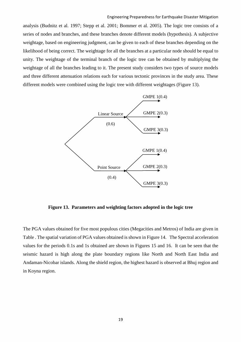
Engineering Preparedness for Earthquake Disaster Mitigation
19
analysis (Budnitz et al. 1997; Stepp et al. 2001; Bommer et al. 2005). The logic tree consists of a
series of nodes and branches, and these branches denote different models (hypothesis). A subjective
weightage, based on engineering judgment, can be given to each of these branches depending on the
likelihood of being correct. The weightage for all the branches at a particular node should be equal to
unity. The weightage of the terminal branch of the logic tree can be obtained by multiplying the
weightage of all the branches leading to it. The present study considers two types of source models
and three different attenuation relations each for various tectonic provinces in the study area. These
different models were combined using the logic tree with different weightages (Figure 13).
Figure 13. Parameters and weighting factors adopted in the logic tree
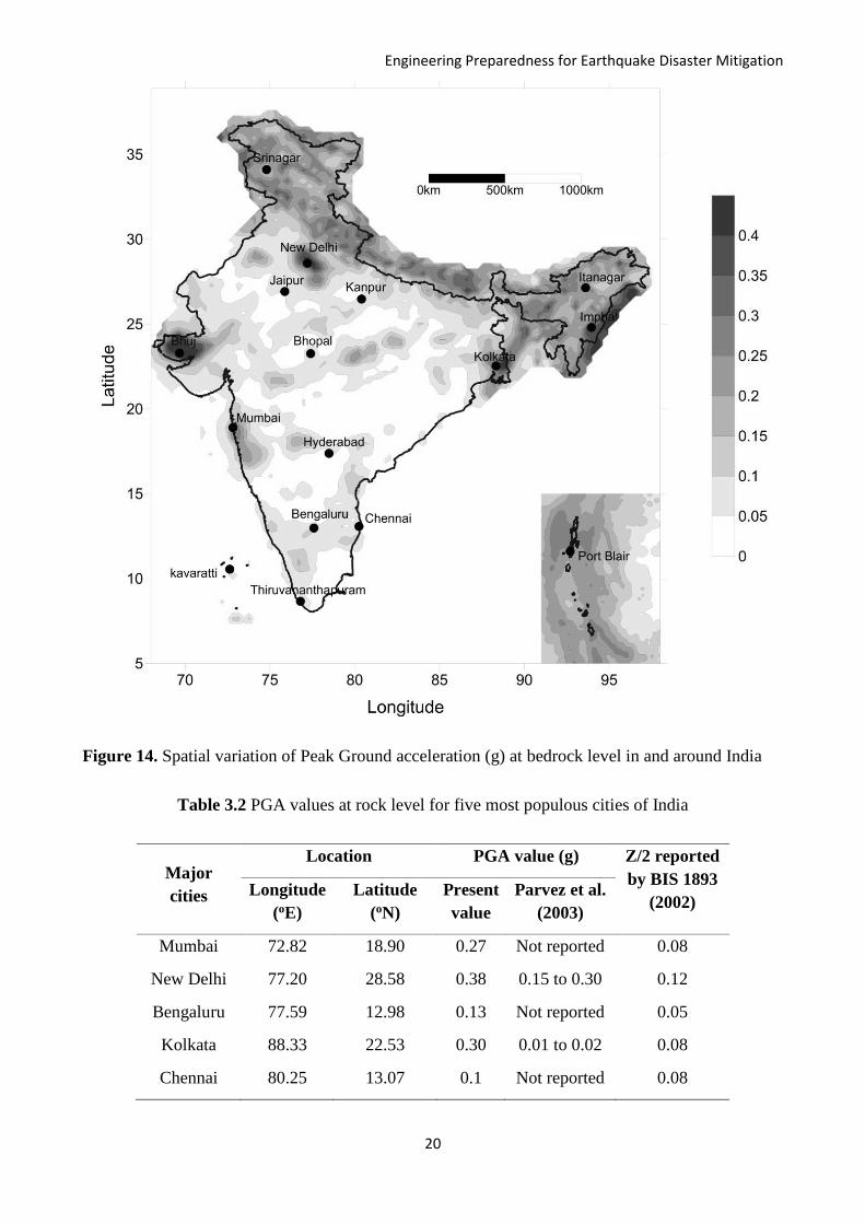
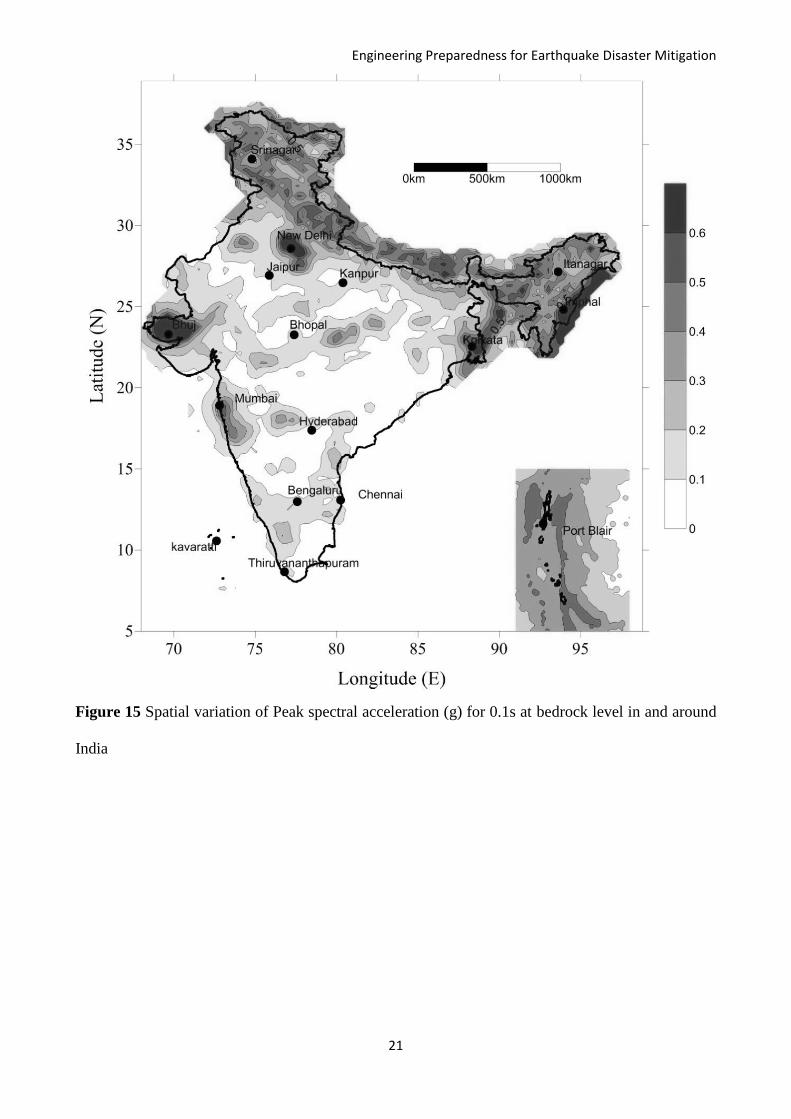
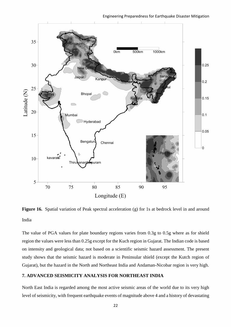
The PGA values obtained for five most populous cities (Megacities and Metros) of India are given in
Table . The spatial variation of PGA values obtained is shown in Figure 14. The Spectral acceleration
values for the periods 0.1s and 1s obtained are shown in Figures 15 and 16. It can be seen that the
seismic hazard is high along the plate boundary regions like North and North East India and
Andaman-Nicobar islands. Along the shield region, the highest hazard is observed at Bhuj region and
in Koyna region.
Linear Source
(0.6)
Point Source
(0.4)
GMPE 1(0.4)
GMPE 2(0.3)
GMPE 3(0.3)
GMPE 1(0.4)
GMPE 2(0.3)
GMPE 3(0.3)
Engineering Preparedness for Earthquake Disaster Mitigation
20
Figure 14. Spatial variation of Peak Ground acceleration (g) at bedrock level in and around India
Table 3.2 PGA values at rock level for five most populous cities of India
Major
cities
Location PGA value (g) Z/2 reported
by BIS 1893
(2002) Longitude
(oE)
Latitude
(oN)
Present
value
Parvez et al.
(2003)
Mumbai 72.82 18.90 0.27 Not reported 0.08
New Delhi 77.20 28.58 0.38 0.15 to 0.30 0.12
Bengaluru 77.59 12.98 0.13 Not reported 0.05
Kolkata 88.33 22.53 0.30 0.01 to 0.02 0.08
Chennai 80.25 13.07 0.1 Not reported 0.08
Engineering Preparedness for Earthquake Disaster Mitigation
21
Figure 15 Spatial variation of Peak spectral acceleration (g) for 0.1s at bedrock level in and around
India
Engineering Preparedness for Earthquake Disaster Mitigation
22
Figure 16. Spatial variation of Peak spectral acceleration (g) for 1s at bedrock level in and around
India
The value of PGA values for plate boundary regions varies from 0.3g to 0.5g where as for shield
region the values were less than 0.25g except for the Kuch region in Gujarat. The Indian code is based
on intensity and geological data; not based on a scientific seismic hazard assessment. The present
study shows that the seismic hazard is moderate in Peninsular shield (except the Kutch region of
Gujarat), but the hazard in the North and Northeast India and Andaman-Nicobar region is very high.
7. ADVANCED SEISMICITY ANALYSIS FOR NORTHEAST INDIA
North East India is regarded among the most active seismic areas of the world due to its very high
level of seismicity, with frequent earthquake events of magnitude above 4 and a history of devastating
Engineering Preparedness for Earthquake Disaster Mitigation
23
earthquakes of magnitude above 8. In the present scenario, a revision of prevalent zoning and building
codes for the region is of utmost importance and is mandatory. Various researchers have reported the
shortcomings of the current zonation of the region which is based on the BIS-1893 (2016) codes, the
major drawback being that it was developed based on past seismic events alone, and not based on a
scientific seismic hazard analysis. The deterministic and probabilistic seismic hazard assessment
studies conducted recently highlighted that the macro level zonation based on geology and past
earthquake events in the present seismic code (IS 1893 2002) was erroneous. Poorly designed and
built structures are always prone to high seismic risk due to failure caused by high levels of ground
shaking during a high magnitude event. The current design and building codes are to be revamped
based on proper hazard assessment and reliable zoning of these regions.
Development of New GMPEs:
Ground Motion Prediction Equations are used to estimate the extent of ground acceleration during an
event and is the most important input required for hazard analysis. Seismic hazard analysis of India
and adjoining regions have been attempted by various researchers in the past, but, a more reliable and
realistic one incorporating region specific GMPEs hasn’t been conducted yet. Few region-specific
attenuation relations were developed for the Himalayas by researchers in the past using limited
ground motion data. Most of these were not considered in the seismic hazard analysis and zonation
of the region due to their various limitations. Attenuation relations used so far were those which were
developed for regions with similar tectonic environments or those developed using limited ground
motion data along with simulated data. Development of a new GMPE for the area based on actual
recorded ground motion data is mandatory now for carrying out a more reliable hazard assessment.
PGA (Peak Ground Acceleration) is used to quantify the level of ground shaking during an earthquake
event in seismic hazard analyses. Deterministic and Probabilistic Seismic Hazard Analysis are the
most commonly used methods of hazards analysis and it estimates the level of ground shaking in an
area, represented in terms of ground acceleration and spectral acceleration, both at bedrock and
surface levels.
In India, however, the major challenge being lack of adequate data pertaining to earthquake events
various attenuation relations have been developed in the past. These were developed either based on
a limited dataset or by expanding the dataset by adding data from other regions, which show similar
tectonic characteristics. An assessment of the currently available region-specific attenuation relations
for the North East Himalayas exposed its advantages and disadvantages. As expected, due to the
limited dataset used to develop the GMPE, the major disadvantage of the existing equations was
Engineering Preparedness for Earthquake Disaster Mitigation
24
found to be its restricted reliability and accuracy along with the limitations it has with the magnitude
and distance range over which it can be used. The limited data used for GMPE development in the
past lacked enough near source data, PGA of higher magnitude earthquakes, and PGA recorded at
larger distances. Past studies combined this limited data with data from regions having comparable
tectonic settings, or generated data using simulated events based on point source or stochastic
seismological models, which further diluted the relevance of actual site-specific data, and reliability
of the new equations. As a larger dataset with a wider source to site distance and magnitude range is
now available, it can be effectively used for developing a more realistic and reliable GMPE for North
East India.
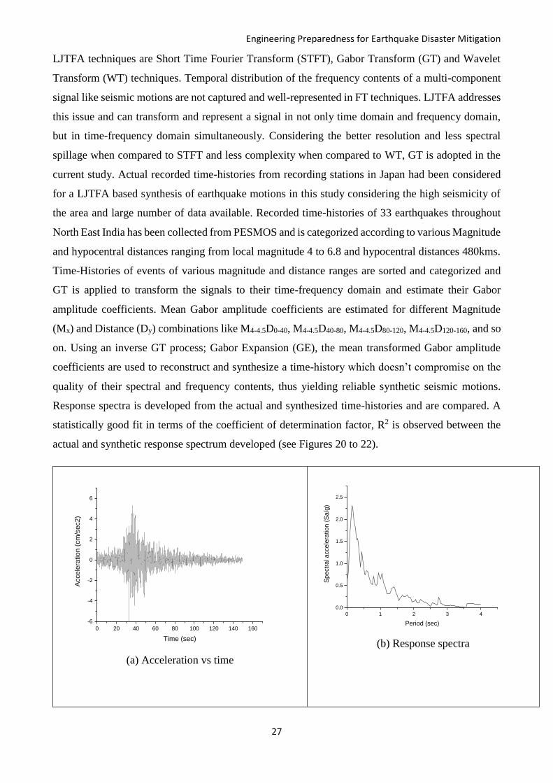
The new region-specific GMPE is established for North East India, considering a moment magnitude
range of 4.2 to 6.9 and hypocentral distances till 640km. Recorded ground acceleration data of
earthquakes events in the region from 1986 to 2014 were used for developing the new GMPE. Linear
regression on the compiled dataset containing moment magnitude, hypocentral distances and PGA
values recorded was carried out to estimate the decay parameter to be considered in further analysis.
Non-linear regression using a well-established attenuation model was then carried out to estimate the
regression parameters and the standard deviation term to develop the new GMPE. The newly
developed region-specific GMPE for North East India was found to be as follows;
log Y = -2.607 + 0.580M – 1004 log (X + 𝐞−𝟏.𝟑𝟑𝟐𝐌) ± 0.477
It was observed that the new GMPE was applicable for a larger distance and magnitude range and
was able to predict PGA values more precisely than the existing ones (see figures 17 to 19).
Engineering Preparedness for Earthquake Disaster Mitigation
25
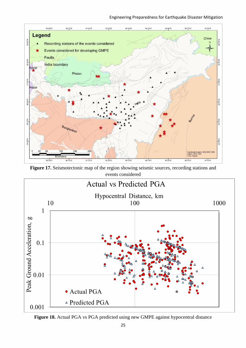
Figure 17. Seismotectonic map of the region showing seismic sources, recording stations and
events considered
Figure 18. Actual PGA vs PGA predicted using new GMPE against hypocentral distance

Engineering Preparedness for Earthquake Disaster Mitigation
26
.
Figure 19. Original recorded data of India-Burma Border earthquake of May 5, 1987, vs PGA,
predicted using new GMPE and previous GMPEs
TFA Based Synthesis of Earthquake Motions:
Unavailability of actual recorded ground motion data have instigated engineers and seismologists to
modify the spectral content to suite its applications or model and synthesize ground motions in the
past. Modifying the spectral content may cause the signals to lose its reliability in dynamic studies or
can create possibly unrealistic representations of ground motions. Synthesizing earthquake motions
can up to an extent realistically simulate the wave propagation and tectonic characteristics of the
region and can be used in dynamic analyses, structural response studies and study the rupture
mechanisms during an earthquake event. The non-stationarity character of earthquake motions causes
them to have time dependant variables like frequency and amplitude. For developing reliable
synthetic ground motions that can be used in dynamic analyses, an in-depth understanding of this
non-stationary character of seismic signals are indispensable. This had been generally neglected in
the past and seismic signals had been considered stationary in widely used Fourier analyses and
transforms (FT), which break down a signal in to its principal frequency components and represent
them in time series alone. To understand the non-stationary behaviour in terms of the temporal
variations of amplitude and frequency contents, a Linear Joint Time-Frequency Analysis (LJTFA)
technique is advocated. LJTFA techniques which are widely used in signal processing have recently
generated interest in analyses of similar non-stationary signals like seismic motions. Widely used
Engineering Preparedness for Earthquake Disaster Mitigation
27
LJTFA techniques are Short Time Fourier Transform (STFT), Gabor Transform (GT) and Wavelet
Transform (WT) techniques. Temporal distribution of the frequency contents of a multi-component
signal like seismic motions are not captured and well-represented in FT techniques. LJTFA addresses
this issue and can transform and represent a signal in not only time domain and frequency domain,
but in time-frequency domain simultaneously. Considering the better resolution and less spectral
spillage when compared to STFT and less complexity when compared to WT, GT is adopted in the
current study. Actual recorded time-histories from recording stations in Japan had been considered
for a LJTFA based synthesis of earthquake motions in this study considering the high seismicity of
the area and large number of data available. Recorded time-histories of 33 earthquakes throughout
North East India has been collected from PESMOS and is categorized according to various Magnitude
and hypocentral distances ranging from local magnitude 4 to 6.8 and hypocentral distances 480kms.
Time-Histories of events of various magnitude and distance ranges are sorted and categorized and
GT is applied to transform the signals to their time-frequency domain and estimate their Gabor
amplitude coefficients. Mean Gabor amplitude coefficients are estimated for different Magnitude
(Mx) and Distance (Dy) combinations like M4-4.5D0-40, M4-4.5D40-80, M4-4.5D80-120, M4-4.5D120-160, and so
on. Using an inverse GT process; Gabor Expansion (GE), the mean transformed Gabor amplitude
coefficients are used to reconstruct and synthesize a time-history which doesn’t compromise on the
quality of their spectral and frequency contents, thus yielding reliable synthetic seismic motions.
Response spectra is developed from the actual and synthesized time-histories and are compared. A
statistically good fit in terms of the coefficient of determination factor, R2 is observed between the
actual and synthetic response spectrum developed (see Figures 20 to 22).
(a) Acceleration vs time
(b) Response spectra
0 20 40 60 80 100 120 140 160
-6
-4
-2
0
2
4
6
Acce
lera
tio
n (
cm
/se
c2)
Time (sec)
0 1 2 3 4
0.0
0.5
1.0
1.5
2.0
2.5
Spectr
al accele
ration (
Sa/g
)
Period (sec)
Engineering Preparedness for Earthquake Disaster Mitigation
28
(c) Gabor coefficients (d) Physiogram
Figure 20. Actual seismogram of 2009 Bhutan earthquake of magnitude 6.2
(a) Synthesized acceleration time history
0 20 40 60 80 100 120 140 160
-6
-4
-2
0
2
4
6
Acce
lera
tio
n (
cm
/se
c2)
Time (sec)
0 50 100 150 200 250
-6
-4
-2
0
2
4
6
Ga
bo
r C
oeff
icie
nts
Time (sec)
20
40
60
80
100
120
140 0
10
2 0
3 0
4 0
5 0
0.0
0.5
1.0
1.5
2.0
2.5
Freque
ncy
Am
plitu
de
Time
Engineering Preparedness for Earthquake Disaster Mitigation
29
(b) Spectrogram showing frequency content (c) Physiogram of the synthesised signal
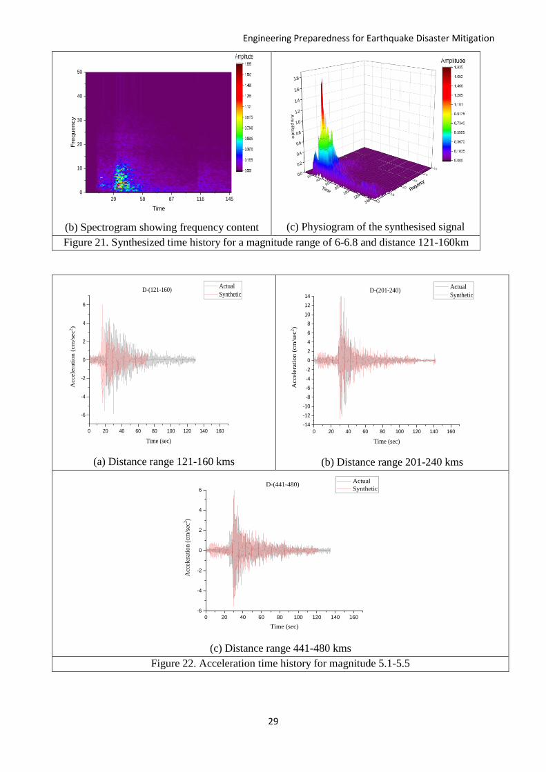
Figure 21. Synthesized time history for a magnitude range of 6-6.8 and distance 121-160km
(a) Distance range 121-160 kms (b) Distance range 201-240 kms
(c) Distance range 441-480 kms
Figure 22. Acceleration time history for magnitude 5.1-5.5
0 20 40 60 80 100 120 140 160
-6
-4
-2
0
2
4
6
Acc
eler
atio
n (
cm/s
ec2)
Time (sec)
Actual
SyntheticD-(441-480)
29 58 87 116 145
0
10
20
30
40
50F
requ
en
cy
Time
20
40
60
80
100
120
140 0
10
2 0
3 0
4 0
5 0
0.0
0.2
0.4
0.6
0.8
1.0
1.2
1.4
1.6
1.8
Freque
ncy
Am
plitu
de
Time
0 20 40 60 80 100 120 140 160
-6
-4
-2
0
2
4
6
Accele
rati
on
(cm
/sec
2)
Time (sec)
Actual
SyntheticD-(121-160)
0 20 40 60 80 100 120 140 160
-14
-12
-10
-8
-6
-4
-2
0
2
4
6
8
10
12
14A
ccele
rati
on (
cm
/sec
2)
Time (sec)
Actual
SyntheticD-(201-240)

Engineering Preparedness for Earthquake Disaster Mitigation
30
8. DO’S AND DON’TS BEFORE, DURING AND AFTER EARTHQUAKE
Someday, an earthquake may strike the place you live in. Scientists cannot tell you when this will
happen, whether it will be next year or during your grandchildren’s lifetime. When that day comes,
your community must be ready to face it. Seismic safety must not only be integrated into construction
practices, but preparedness, emergency response, recovery, and long-term risk reduction efforts as
well. It is a well-known fact that it is poorly planned infrastructures which cause disaster during an
earthquake, not earthquakes as such. Identifying potential hazards in advance and appropriate
planning can reduce the dangers of serious injury or loss of life from an earthquake.
Guidelines for individuals and families
Unlike other natural hazards, earthquakes strike suddenly and without warning. For people residing
in regions vulnerable to earthquakes, there are certain measures that can be taken to reduce the
chances of people being injured, and property being damaged. An earthquake does not cause death
or injury by itself. People are hurt by collapsing building components or falling of heavy objects.
Collapsing buildings and vibrations can cause short circuits and electric fires. All this leads to panic
and confusion. With some precautions, it is possible to avoid such confusion.
Possible measures before an Earthquake
Undergoing a seismic evaluation is important to assess the earthquake resistance of one’s home.
Depending on when and how it was designed and built, the structure may have weaknesses that make
it more susceptible to earthquakes. Common examples include structures not anchored to their
foundations or having weak crawl space walls, unbraced pier-and-post foundations, or unreinforced
masonry walls or foundations. Homes that are judged to have poor quake resistance should undergo
seismic retrofitting with professional help. Before constructing, renting or buying a home, ensure that
it complies with the seismic resistant provisions of building code for the particular region. In case
family members get separated from one another during an earthquake, develop a plan for reuniting
after the disaster. Ask a relative or friend in another district or state to serve as the family contact as
it is easier to call long distance during a disaster.
During the earthquake
If you are caught indoors at the time of an earthquake
Be peaceful. Do not lose mental balance.
Stay away from glass windows, doors, cupboards (almirahs), mirrors etc.

Engineering Preparedness for Earthquake Disaster Mitigation
31
Stay away from falling plaster, bricks or stones.
Get under a table or a strong cot so that you are not hurt by falling objects.
If open space is available nearby, go there.
Do not use candles, matches or other open flames. Leaking gas or other flammable chemicals may
accidentally light on fire.
If trapped under debris, tap on a pipe or wall so rescuers can locate you. Use a whistle if available.
If you are caught outdoors at the time of an earthquake:
Keep away from tall chimneys, buildings, balconies and other projections.
Check if you or anyone else is hurt. Use first aid at least on the cuts.
Keep the streets clear for emergency services.
A battery operated radio will help you to get important messages.
Once in the open, stay there till the vibrations stops.
If you are in a moving vehicle, stop as quickly as possible (in a clear area) and stay in the vehicle.
Once the shaking has stopped, proceed with caution. Avoid bridges or ramps that might have been
damaged by the quake.
What to do after an earthquake
Check yourself for injuries.
Help injured or trapped persons. Don't try to move seriously injured people unless they are in
immediate danger of further injury. Wait for medical help to arrive.
While entering buildings, be extremely cautious. Building damage may have occurred where you
least expect it. Carefully watch every step you take.
Examine walls, floor, doors, staircases and windows to make sure that the building is not in danger
of collapsing.
Look for and extinguish small fires. Eliminate fire hazards. Putting out small fires quickly, using
available resources, will prevent them from spreading. Fire is the most common hazard following
earthquakes.
Engineering Preparedness for Earthquake Disaster Mitigation
32
Check for gas leaks. If you smell gas or hear a blowing or hissing noise, open a window and quickly
leave the building. Turn off the gas, using the outside main valve if you can, and call the gas company
from a neighbours’ home.
Clean up spilled medicines, bleaches, gasoline, or other flammable liquids immediately.
Open the closet and cabinet doors cautiously. Contents may have shifted because of shaking during
the earthquake and could fall, creating further damage or injury.
Inspect your home for damage. Get everyone out if your home is unsafe. Aftershocks following
earthquakes can cause further damage to unstable buildings. If your home has experienced damage,
get out before aftershocks happen.
Help neighbours who may require special assistance. Elderly people and people with disabilities may
require additional assistance. People who care for them or who have large families may need
additional assistance in emergency situations.
Listen to a portable, battery-operated radio (or television) for updated emergency information and
instructions. If the electricity is out, this may be your main source of information. Local radio and
local officials provide the most appropriate advice for your particular situation.
Watch out for fallen power lines or broken gas lines, and stay out of damaged areas. Hazards caused
by earthquakes are often difficult to see, and you could be easily injured.
Stay out of damaged buildings. If you are away from home, return only when authorities say it is safe.
Damaged buildings may be destroyed by aftershocks following the main quake.
Check for sewage and water line damage. If you suspect sewage lines are damaged, avoid using the
toilets and call a plumber.
Watch animals closely. Tie dogs and place them in a fenced yard. The behaviour of pets may change
dramatically after an earthquake. Normally quiet and friendly cats and dogs may become aggressive
or defensive.
Do not spread and believe rumours.
Do not waste water. Do not crowd around damaged areas or buildings.
Stay as safe as possible during an earthquake. Although smaller than the main shock, aftershocks
cause additional damage and may bring weakened structure down. Aftershocks can occur in the first
hours, days, weeks, or even months after the quake.
Engineering Preparedness for Earthquake Disaster Mitigation
33
School Emergency Plan
At schools, regular earthquake drills should be performed to prepare students for an evacuation in the
event of an earthquake. The school should have a system set up to communicate with families during
a crisis. The school must store adequate food, water, and other basic supplies. The school should be
prepared to be a shelter-in-place if need be, and a safe place near should be identified, to go if they
must get away. In case where schools institute procedures to shelter-in-place, parents may not be
permitted to drive to the school to pick up their children. They should monitor local media outlets for
announcements about changes in school openings and closings, and follow the directions of local
emergency officials.
Model school designs for construction in various seismic zones in India were published by the Govt.
of India under UNDP Disaster Risk Management Program in 2006 and Guidelines for School during
various disasters were published by NIDM, which can be accessed from below links.
http://nidm.gov.in/PDF/safety/school/link2.pdf
http://nidm.gov.in/safety_school.asp
Approach for business organizations
Business organizations located in earthquake prone areas can do many things to reduce the loss of
life and property, and to ensure least disturbance to day-to-day function if an earthquake occurs.
Workplace preparedness requires the participation of owners, managers, workers, and designers of
the buildings.
Before the earthquake
Following are activities that can be undertaken before the earthquake:
Check with local building-regulatory agency to find out whether, and for how long, structures in the
area have been subject to building codes containing seismic design provisions.
Make sure that all non-structural items are effectively anchored, braced, reinforced, or otherwise
secured. Design and construction professionals should properly secure some of these components,
while others can be made safe by maintenance staff or other employees.
Every employee, from top managers to part-time and temporary workers, needs to learn what to do
during an earthquake. Safety orientations should emphasize safe places to drop, cover, and hold on
during earthquake shaking and safe locations where people can meet after the shaking has stopped.

Engineering Preparedness for Earthquake Disaster Mitigation
34
Conduct regular compulsory earthquake drills to employees for them to practice what they know
about what to do during earthquake shaking and to react spontaneously and safely. To help protect
workers in the immediate aftermath of earthquakes or other disasters, arrange for employees to be
trained in first aid and the use of fire extinguishers. Earthquakes should be thoroughly integrated into
the organization’s emergency preparedness, response, and recovery planning.
The employers can play an important role to contribute to the well-being of the communities from
which they recruit employees, clients, and customers. There are many ways that businesses
organizations can help strengthen the disaster resilience of their communities. Some of these ways
include promoting preparedness among suppliers, clients, and other business contacts; and sponsoring
or participating in local earthquake drills, preparedness events, or awareness and education
campaigns.
After the Earthquake
Once the shaking stops, workplaces should be prepared to implement pre-arranged, earthquake-
specific emergency response and recovery plans. Employees must keep in mind that aftershocks may
strike at any time; exacerbating hazards created by earlier shaking and requiring that everyone again
drop, cover, and hold on. Regardless of the severity of this earthquake, learn from the experience. If
structures must be repaired or rebuilt, use this opportunity to ensure that weaknesses are addressed
and that new facilities are compliant with seismic building standards. If building contents were
damaged, improve how such items are secured. If employees were insufficiently prepared to react
safely, safety training and the frequency of drills must be increased.
9. NOTE FOR PUBLIC POLICY MAKERS
Current Status
The Central Government has enacted Disaster Management Act 2005 which provides institutional
mechanism for responding to disasters including earthquake. The National Disaster Management
Authority (NDMA) has been constituted which is broadly mandated with preparation of guidelines
for management of disasters. NDMA has already published the guidelines on management of
earthquakes and conducted few mock drills for earthquakes. The Central Government has also raised
National Disaster Response Force (NDRF) and equipped NDRF with Collapse Structures Search and
Rescue (CSSR) equipment for responding to earthquakes.
NDMA Guidelines (2007) listed critical areas of concern for the management of earthquakes in India
and addressed various techno-legal and techno-financial issues pertaining to earthquake disaster
Engineering Preparedness for Earthquake Disaster Mitigation
35
management. Therein timeframes have been given for Important Milestones for the Implementation
of the Guidelines. The activities were envisaged to be implemented in two phases. Phase to be
concluded by 31 December 2008 and be reviewed by 30 June 2009. Based on this review, the
activities in Phase II were supposed to be designed in the second half of 2009 and Phase II to begin
by 1 January 2010. It is imperative that these milestones are implemented at the earliest.
National Centre for Seismology maintains operation of a countrywide national seismological
network, to detect and locate earthquakes occurring in and around the country as well as dissemination
of earthquake information to the user agencies including media in least possible time to help take
appropriate follow up actions. The seismic microzonation studies of some of the major cities in the
country such as Jabalpur, Guwahati, Bangalore, Sikkim, Ahmedabad, Gandhidham-Kandla, Kolkata
and Delhi has been completed. As a part of 12th Five year plan, a project has been initiated for seismic
microzonation of 30 more cities. The seismic microzonation maps/results are used by various
agencies as mitigative measures for design and construction of earthquake resistant structures, land
use planning and for enacting building bye-laws towards minimizing damage to property and loss of
lives due to earthquakes.
In addition, efforts are being made to develop an Early Earthquake Warning system. In this direction,
a pilot study has been initiated through Department of Earthquake Engineering, IIT Roorkee. In this
project, one hundred sensors will be installed in Uttarakhand, which will be connected with central
receiving station. One such system is tested and has become operational which can provide a lead
time of about 30-60 seconds for issuing warnings to cities like Delhi, located about 300km from
Himalayan source. Such warning, if successful, can enable people to move to safer places and
emergency shutdown of critical installations, to an extent.
Earthquake resistant building construction codes have already been published by the Bureau of Indian
Standards, and are updated from time to time.
Way Forward
Seismic activity in India is spatially varied and complex with various tectonic provinces of different
characteristics. Also, India is a very large country with a huge population. Hence there is a need for
decentralization for effective management of earthquakes, empowering local bodies to take needful
actions in accordance with the seismic vulnerability of respective regions.
Public awareness should be enhanced through mass communication, media houses and by all means.
It is recommended that the Prime Minister himself take lead in the awareness campaign for
Earthquake Preparedness like it was done for ‘Swachh Bharat’ campaign.

Engineering Preparedness for Earthquake Disaster Mitigation
36
For apartment buildings and other such dwellings, earthquake preparations should be made through
the owners’ association, including appropriate seismic evaluations, earthquake-proofing, repairs, and
functional upgrades through renovation.
Important buildings such as schools and hospitals which are needed to secure emergency shelter and
medical functions should receive financial and technical support to proceed with earthquake proofing
efforts.
Measures should be advanced to prevent the fall of non-structural elements such as ceiling materials
and lighting fixtures in schools, etc.
Extend financial and technical support needed for earthquake proofing and rebuilding of apartment
buildings.
Promote public awareness of regional risk levels, information on potential damage and examples of
earthquake proofing initiatives.
Work to encourage the spread of multiunit housing equipped to enable continued living even in the
event of a disaster.
By systematically conducting seismic retrofitting and rebuilding, advance the earthquake proofing of
publicly-owned housing.
Encourage the rebuilding and upgrade of ageing buildings through urban re-development.
Encourage State Governments to actively participate in Earthquake disaster preparedness plan. State
Governments should involve local bodies like corporations, Municipalities and Panchayats to carry
out the plans effectively and systematically reaching out to all regions vulnerable to earthquakes.
Earthquake safety aspects should be incorporated in the building by-laws and it should be made
mandatory. (Eg: Gujarat State Disaster Management Authority).
There is a need to create awareness and confidence among architects and town planners. Open space
is required for rehabilitation which should be looked upon by town planners.
Normally, resistance towards incorporating earthquake safety features come from architects, builders
and clients because of extra cost and effort. There is a need to educate them that life is more important
than extra cost.
Engineering Preparedness for Earthquake Disaster Mitigation
37
With regard to Design and Details, in most of the cases, the earthquake safety features are not given
in distributed drawings. It should be made very clear so that a site engineer should be able to follow.
Supervisors, site engineers and craftsmen should be trained. This is especially relevant in rural areas.
Construction activities in rural areas must be given special attention.
All parts of IS 1893 should be made available at the earliest.
Educational institutions starting from Kindergarten should be made aware of earthquake safety and
basic safety aspects should get into school books. Mock drills must be conducted in schools situated
in vulnerable regions.
The country needs a comprehensive law and policy that address all aspects of disaster management
under one roof to balance mitigation and preparedness efforts more evenly.
Restoration Strategy
The following guiding principles can form the basis of strategy and planning of post disaster recovery:
Participation of the community by empowering them to take control of reconstruction of their
own houses and ensuring facilitation of owner‐driven reconstruction.
Housing reconstruction must include holistic habitat development including basic services
and community set-up.
Reconstruction should be a platform to build long‐term community resilience, strengthening
community capacities to mitigate future disasters by improving construction practices for
majority of the buildings in the country.
Strengthening the local economy through practices favorable to the poor, marginalized and
informal sector. Reconstruction should provide an opportunity for the poor to upgrade their
living conditions.
Ensuring sustainable reconstruction processes, taking account of climate change, natural
resource management and scientific risk assessments.
10. RESILIENT COMMUNITY FOR EARTHQUAKE PREPAREDNESS
Earthquake preparedness is not a part of the public consciousness even in the vulnerable regions of
India. There are many things that individuals and communities residing in seismically active regions
can do that will reduce the havoc and loss during a quake. These steps can be a complementary
measure, alongside other activities that focus on the overall development of the community; with a
team spirit. Usually the aftermaths of a disaster bring solidarity among the members of the
Engineering Preparedness for Earthquake Disaster Mitigation
38
community. There is a need to bring this spirit of togetherness and solidarity well before a disaster so
that a community can be prepared well to face the disaster and thus reduce the loss of life and
properties.
Common arguments against preparing for disasters include:
It will harm the economy with adverse effects on business and tourism
People will panic if future hazard is discussed openly
The community is too poor to prepare for earthquakes, and
There are too many other high priority problems in the community
Worldwide experience shows that none of these arguments are valid. Some of the world’s strongest
economies and favorite tourist destinations, have been publicly discussing and planning earthquake
preparedness for decades with no harm to business or tourism. Hundreds of communities can point
to experiences in which openly focusing on how to reduce disaster risk built confidence in their
population and business community, rather than causing problems. Poor communities around the
world have focused on disaster preparedness: many risk-reducing activities require people-power, not
financial resources. People often think of emergency planning and preparedness as the government’s
job, but the best prepared communities involve every sector of society in disaster planning.
Earthquake safety programs need to affect everyone in a community, which requires involving a wide
range of people from every element of society in developing those programs.
Anyone can be an activist for earthquake safety and preparedness: be it government officials, business
leaders, members of community organizations, or any concerned citizens. All that is required is a
commitment to making your community safer and a willingness to learn. People from every sector of
society have critical roles to play in earthquake safety. Some aspects of earthquake preparedness
generally need to be led by governments, such as developing official warning systems and evacuation
plans as discussed in earlier sections. Other equally critical preparedness activities can be led by
community members outside of the government. Someday, an earthquake may strike your
community. Scientists cannot tell you when this will happen, whether it will be next year or in your
grandchildren’s lifetime, for example. When that day comes, you want your community to be ready.
After forming a good team, develop a structure that is suitable for your community and the resources
available. The level of structure of teams can vary significantly, from lose networks of volunteers
with advisory committees to legally integrated organizations. Different organizational forms make
sense at different times during the preparedness efforts.
Engineering Preparedness for Earthquake Disaster Mitigation
39
Understand the hazard in the locality
It is important that the team is aware of the level of seismic hazard potential at their locality. Best
way to learn is to refer scientific seismic hazard maps prepared by experts (Refer Part 1 of this
document). These hazard maps can give a broad idea on the expected risk at your region. Conduct
workshops, seminars and regular meetings discussing about the hazard at your region so that the idea
of earthquake is transmitted to public consciousness. This should be done without inculcating a sense
of with fear but with a positive outlook that working together towards earthquake preparedness can
make the community ready to face any disaster. This will bring a spirit of togetherness and vibrancy
among the people which may pave way for other developmental activities in the community as well.
Create Awareness
It is important to remember that disasters like earthquakes destroy all progress a community has been
making in every area. With time and persistence of campaigners, community leaders will learn that
earthquake preparedness is not just good for the community, it is essential to its long-term survival
and stability. This awareness will slowly transmit through generations.
The community can carry out lot of preparatory planning after discussion with the members of the
community.
A special section in the local newspaper can be published with emergency information on
earthquakes. The information can be localized by printing the phone numbers of local emergency
services offices and hospitals.
A week-long series on locating hazards in the home can be conducted.
The information on what to do during an earthquake can be distributed to individuals and families.
Tips on conducting earthquake drills in the home can be provided.
Community can identify or even build open playground which can serve dual purposes. The ground
can be used for games or social functions during safe period and the same ground can act as a shelter
for people to camp in the event of a disaster or to land helicopters during emergency.
Interview representatives of the gas, electric, and water companies about shutting off utilities.
Work together in your community to apply your knowledge to building codes, retrofitting program,
hazard hunts, and family emergency plans.

Engineering Preparedness for Earthquake Disaster Mitigation
40
When respected, trustworthy and influential people in your community take earthquake preparedness
seriously, others are inspired to be prepared. It’s a good idea to get this type of ‘inspirational’ person
involved in the outreach efforts.
Encourage community members to participate through providing a range of activities, questions and
discussions. People learn better through activities and tend not to learn much from lectures. Activities
should be led, whenever possible, by people who are from or who are well-known in the local
community where you are focusing.
Review the Plan and Improve the Efforts
Reviewing the success of the programs in preparing community members will allow to learn from
mistakes and to escalate the effectiveness of future programs. Some ideas on how to evaluate the
programs include:
Distribute questionnaires at events such as community meetings or drills. How did people learn about
the event? Did people learn from it? What aspects did they find most useful?
Collect informal feedback from people working with the team. Everyone who attends community
meetings or interacts with the public in other ways will have thoughts about how people are
responding to the preparedness efforts; what they understand and misinterpret, and whether people
will be ready to prepare for the earthquake.
Conduct formal polling on awareness and preparedness rates in the community before and after the
outreach efforts. This approach, while most expensive, gives the most objective feedback on how
successful the outreach program has been.
Keep Preparedness alive for Long-Term
The earthquake preparedness aspects must peep into people’s mind and must continue throughout
generations to create a well prepared and alert community. Persuading people in this regard takes
time. People, governments and other groups need to be continually reminded to keep their
preparedness efforts up-to-date and ongoing. Every family should update their knowledge and
preparedness plans based on changes in where they work, live or go to school.
Governments need to update their plans to accommodate changes in the community’s growth. The
new members entering the community should be educated.
Some approaches that communities can keep disaster preparedness activities ongoing include:
Engineering Preparedness for Earthquake Disaster Mitigation
41
Create an organization to focus on disaster preparedness issues. The structure of an organization
spreads the momentum for preparedness activities away from individuals or temporary groups to a
permanent entity.
Integrate earthquake preparedness into government programs. Government officials can make sure
that development activities are earthquake-resistant.
Integrate earthquake preparedness into programs of other institutions, such as schools and businesses.
Schools can add earthquake preparedness to their curricula.
Communities can survive earthquakes if they prepare. How important the public and policy makers
feel about the need for earthquake preparedness at any given moment will fluctuate over time, based
on world events and local issues. As an activist, one should be ready to take advantage of events that
raise the publics’ interest in earthquakes. These events could be large earthquakes elsewhere in the
world, or other types of natural disasters. These events can be as opportunities to conduct community
awareness events. When an earthquake hits, we should be ready not only to survive but to bounce
back to be more lively with great hopes. This makes our efforts meaningful.
11. REFERENCES
1. Abhishek Kumar, Anbazhagan P., Sitharam T. G. (2013) Seismic Hazard Analysis of Lucknow
Considering Local and Active Seismic Gaps Natural Hazards, Vol. 69, 327-350
2. Algermissen S T and Perkins D M (1976). A probabilistic estimate of maximum acceleration in
rock in the contiguous United States, U.S. Geological Survey. Open-file Report, 76–416, 45 pp.
3. Bhatia S C, Kumar M R and Gupta H K (1999). A probabilistic seismic hazard map of India and
adjoining regions, Annali di Geofisica 42:1153-1166.
4. Bilham R (2004). Earthquakes in India and the Himalaya: tectonics, geodesy and history. Annals
of Geophysics47, 839–858.
5. IS-1893 (2002). Indian Standard criteria for earthquake resistant design of structures, Part 1 –
General provisions and buildings, Bureau of Indian Standards New Delhi.
6. Boominathan A, Dodagoudar G R, Suganthi A and Uma Maheswari R (2008). Seismic hazard
assessment of Chennai city considering local site effects. Journal of Earth System Sciences
117(S2) 853 - 863.
Engineering Preparedness for Earthquake Disaster Mitigation
42
7. Chandra U (1977). Earthquakes of Peninsula India-a seismotectonic study. Bulletin of the
Seismological Society of America 67, pp. 1387–1413.
8. Curray J R (2005). Tectonics and history of the Andaman Sea region, Asian Journal of Earth
Sciences 25, 187–228.
9. Dasgupta S and Mukhopadhyay M (1993). Seismicity and plate deformation below the Andaman
Arc, Northeast Indian Ocean; Tectonophysics 225 529–542.
10. Dasgupta S and Mukhopadhyay M (1997). Aseismicity of the Andaman subduction zone and
recent volcanism, Journal of geological Society of India, 49 513–521.
11. Dasgupta S, Mukhopadhyay B and Acharyya A (2007a). Seismotectonic of Andaman-Nicobar
region: constraints from aftershocks within 24 hours of the Great 26 December 2004 earthquake,
Geological Survey of India Special Publication, v. 89, p. 95-104.
12. Dasgupta S, Mukhopadhyay B and Bhattacharya A (2007b). Seismicity pattern in north Sumatra–
Great Nicobar region: In search of precursor for the 26 December 2004 earthquake, Journal of
Earth System Science 116, No. 3, June, pp. 215–223
13. Dasgupta S, Mukhopadhyay M, Bhattacharya A and Jana T K (2003). The geometry of the
Burmese–Andaman subducting lithosphere, Journal of Seismology, 7 155–174.
14. Deshikachar S V (1974). A review of the tectonic and geological history of eastern India in terms
of ‘‘plate tectonics’’ theory. Journal of Geological Society of India 15:137–49.
15. Eguchi T, Uyeda S and Maki T (1979). Seismotectonics and tectonic history of Andaman sea;
Tectonophysics, 57 35–51.
16. Evans P (1964). The tectonic framework of Assam. Journal of Geological Society of India 5:80–
96.
17. Gangrade B K and Arora S K (2000). Seismicity of the Indian Peninsular Shield from regional
earthquake data, Pure and Applied Geophysics157 1683 - 1705.
18. http://www.geohaz.org/
19. Giardini D (1984). Systematic analysis of deep seismicity – 200 centroid-moment tensor solutions
for earthquakes between 1977 and 1980. Geophysical Journal. Royal Astronomical Society 77,
883–914.
Engineering Preparedness for Earthquake Disaster Mitigation
43
20. Gupta I D (2006). Delineation of probable seismic sources in India and neighbourhood by a
comprehensive analysis of seismotectonic characteristics of the region, Soil Dynamics and
Earthquake Engineering, 26,766–790.
21. Gupta I D (2006). Delineation of probable seismic sources in India and neighbourhood by a
comprehensive analysis of seismotectonic characteristics of the region, Soil Dynamics and
Earthquake Engineering, 26,766–790.
22. Iyengar et al. (2010). Development of probabilistic seismic hazard map of india, technical report
of the Working Committee of Experts (WCE) constituted by the National Disaster Management
Authority, Govt. of India, New Delhi.
23. Iyengar R N and Ghosh S (2004). Microzonation of earthquake hazard in greater Delhi area,
Current Science87 1193 - 1202.
24. Jaiswal K and Sinha R (2007). Probabilistic seismic-hazard estimation for peninsular India,
Bulletin of the Seismological Society of America, 97(1B) 318 - 330.
25. Joyner W B and Boore D M (1981). Peak horizontal acceleration and velocity from strong-motion
records including records from the 1979 Imperial Valley, California, Earthquake, Bulletin of the
Seismological Society of America, 71:2011–2038.
26. Kayal J R (2008). Microearthquake seismology and seismotectonics of south Asia, 1st edn.
Springer Verlag and Capital Publishing Company, India, ISBN: 978–1–4020–8179–8
27. Khattri K N, Rogers A M, Perkins D M and Algermissen S T (1984). A seismic hazard map of
India and adjacent areas, Tectonophysics, 108:93–134.
28. Kolathayar S and Sitharam T G (2012) Characterization of Regional Seismic Source Zones in and
around India Seismological Research Letters (Seismological Society of America) Vol. 83 No. 1
p. 77-85
29. Kolathayar S and Sitharam T G (2012) Comprehensive Probabilistic Seismic Hazard Analysis of
Andaman-Nicobar Regions Bulletin of Seismological Society of America (SSA) Vol. 102, No. 5,
pp. 2063-2076
30. Kolathayar S, Sitharam T G and Vipin K S (2011) Spatial variation of seismicity parameters
across India and adjoining areas Natural Hazards (Springer Publications) Vol 60, Issue 3, pp
1365-1379
Engineering Preparedness for Earthquake Disaster Mitigation
44
31. Kolathayar S, Sitharam T G and Vipin K S(2012) Deterministic seismic hazard macrozonation of
India Journal of Earth System Sciences (Springer)Vol. 121, No. 5, pp. 1351-1364
32. Krishnan M S (1953). The structure and tectonic history of India; Memoir of Geological Survey
of India, 81: 137.
33. Kumar P, Yuan X, Ravi Kumar M, Kind R, Li X and Chadha R K (2007). The rapid drift of Indian
tectonic plate, Nature 449: 894 – 897.
34. Menon A, Ornthammarath T, Corigliano M and Lai CG (2010). Probabilistic seismic hazard
macrozonation of Tamil Nadu in Southern India, Bulletin of the Seismological Society of
America 100 1320–1341
35. Mohanty W K and Walling M Y (2008). First order seismic microzonation of Haldia, Bengal
basin (India) using a GIS platform. Pure and Applied Geophysics 165, 1,325–1,350.
36. Molnar P and Tapponnier P (1979). The collision between India and Eurasia. In: Earthquakes and
Volcanoes, Procs., from Scientific American. San Francisco: WH Freeman and Company, p. 62–
73.
37. Mukhopadhyay M (1984). Seismotectonics of subduction and backarc rifting under the Andaman
Sea; Tectonophysics, 108 229–239.
38. Mukhopadhyay M (1988). Gravity anomalies and deep structure of Andaman arc; Marine
Geophys. Res. 9 197–210. Scholz C H Mechanisms of Seismic Quiescences; PAGEOPH 126
701–718.
39. Narayan J P, Sharma M L and Ashwani Kumar (2002) A seismological report on the January 26,
2001 Bhuj, India earthquake, Seismological Research Letters, Vol. 73, Number 3, May/June
2002, 343-355.
40. Nath S K and Thingbaijam K KS (2012) Probabilistic Seismic Hazard Assessment of India,
Seismological Research Letters 83 (1), 135-149.
41. Nath S K and Thingbaijam K K S (2010). Peak ground motion predictions in India: an appraisal
for rock sites. Journal of Seismology 15, 2, 295-315.
42. Parvez I A, Vaccari F and Panza G F (2003). A deterministic seismic hazard map of India and
adjacent areas; Geophysics Journal International, 155: 489 - 508.
Engineering Preparedness for Earthquake Disaster Mitigation
45
43. Purnachandra Rao N (1999). Single station moment tensor inversion for focal mechanisms of
Indian intra-plate earthquakes, Current Science, 77, 1184 – 1189.
44. Raghu Kanth S T G and Iyengar R N (2006). Seismic hazard estimation for Mumbai city. Current
Science, 91 (11) 1486 - 1494.
45. Rai D C and Murty C V R. (2003). Reconnaissance report: North Andaman (Diglipur) earthquake
of 14 September 2002, Dept. of Science and Technology, Government of India, New Delhi,
United Nations Development Programme, New Delhi, India, and NICEE, IIT Kanpur, India.
46. Rajendran K and Gupta H K (1989). Seismicity and tectonic stress field of a part of the Burma-
Andaman-Nicobar Arc. Bulletin of the Seismological Society of America 79, 989-1005.
47. Rao B V and Murty B V S (1970). Earthquakes and tectonics in peninsular India. Journal of Indian
Geophysical Union 7:1–8.
48. Reddy P R (2003). Need for high-resolution deep seismic reflection studies in strategic locales of
South India, Current Science 84(8) 973 - 974.
49. Seeber L, Armbruster J G and Jacob K H (1999). Probabilistic assessment of earthquake hazard
for the state of Maharashtra. Report to Government of Maharashtra Earthquake Rehabilitation
Cell, Mumbai.
50. Sharma M L (2003) Seismic hazard in Northern India region Seismological Research Letters,
Vol. 74, Number 2, March/April 2003, 140-146.
51. Sharma M L and Malik S (2006). Probabilistic seismic hazard analysis and estimation of spectral
strong ground motion on Bed rock in North East India, 4th Int. Conf. Earthquake Engineering,
Taipei, Taiwan, Oct 12-13, 2006.
52. Sil A, Sitharam TG, Kolathayar S (2013) Probabilistic seismic hazard analysis of Tripura and
Mizoram states, Natural hazards 68 (2), 1089-1108
53. Singh R K (2009). Probabilistic Seismic Hazard and Risk Analysis: A Case Study for Ahmedabad
City, PhD Thesis, Indian Institute of Technology, Kanpur.
54. Sitharam T G and Anbazhagan P (2007). Seismic hazard analysis for the Bangalore region.
Natural Hazards, 40, 261 - 278.
Engineering Preparedness for Earthquake Disaster Mitigation
46
55. TC4-ISSMGE (1999) ― Manual for Zonation on Seismic Geotechnical Hazard, Revised edition,
Technical Committee for Earthquake Geotechnical Engineering (TC4) of the International
Society of Soil Mechanics and Geotechnical Engineering (ISSMGE) 209.
56. Vipin K S, Anbazhagan P and Sitharam T G (2009). Estimation of peak ground acceleration and
spectral acceleration for South India with local site effects: probabilistic approach. Natural
Hazards Earth System Science 9 865–878.
12. ACKNOWLEDGEMENT
I thank all my students who have contributed to this area of research and in particular Dr.
Sreevalsa Kolthayar, Associate Professor at VIT, Vellore, Tamilnadu and Dr. Naveen James from IIT
Ropar, Punjab.
Engineering Preparedness for Earthquake Disaster Mitigation
47
RESUME OF Prof. T G Sitharam. Director, IITG, Guwahati, Assam
Prof. Dr. T.G.Sitharam has taken over as the Director, Indian Institute of Technology, Guwahati,
Assam on July 01, 2019 and also holding additional position as Chairman, BOG of IITG. He was a
Senior Professor, Department of Civil Engineering, Indian Institute of Science, Bangalore, India (he
is on deputation from IISc from July 01, 2019). He was formerly a Chair professor in the area of
Energy and Mechanical Sciences at Indian Institute of Science (IISc), a premier research and
education Institute in India. He was former founder Chairman of a Centre for Infrastructure,
Sustainable Transport and Urban Planning (CiSTUP) at IISc, Bengaluru. Presently, he is the
Honorary Professorial Fellow at University of Wollongong, Wollongong, Australia from 2019 to
2022 and Distinguished professor at Hankou University International Innovation Centre, China.
Presently, He is the Chairman, Research Council, CSIR-Central Building Research Institute (CBRI),
Roorkee. He is the chairman, Executive council of Visvesvaraya Industrial & Technological Museum
Bangalore India. He is governing council member of National council for Science Museums (NCSM),
Govt of India and EC member of AICTE, Govt of India, New Delhi. He is the founder President of
International Association for Coastal Reservoir Research (IACRR), registered in NSW, Australia. He
is the President, Indian Society for Earthquake Technology (ISET), Roorkee. He is presently the
Chairman, AICTE South western zonal committee, Regional office at Bengaluru. Formerly, he was
a visiting professor at Dalhousie University, Canada; Yamaguchi University, Japan; Indian School of
Mines (IIT-ISM), Dhanbad; and William Mong fellow at University of Hongkong, Hongkong. He
was the vice president of Indian Society for Earthquake Technology (ISET) and Vice President of
Indian Society of Earthquake Science (ISES).
He obtained his bachelor’s in civil engineering from Mysore University, India, master’s in civil
engineering from Indian Institute of Science, India (1986) and Ph.D. in Civil Engineering from
University of Waterloo, Waterloo, Ontario, Canada (1991). Further, he served as a Research Scientist
(for his post-doctoral work) at centre for earth sciences and engineering in the Department of
Petroleum Engineering, University of Texas at Austin, Texas, USA until 1994. During this time, he
has lead research on sand production, wellbore stability and hydraulic fracturing in petroleum wells
supported by many oil companies. Earlier to that, He served as a lecturer for six months in 1991 at
University of Waterloo, Ontario, Canada and he taught Geotechnical engineering. Over the last 35
years, he has carried out research and development extensively in the area of geotechnical and
infrastructure engineering, and has developed innovative technologies in the area of fracturing and
geotechnical applications, leading to about 500 technical papers, 12 books with an H-index of 38 and
I-10 index 101with >4375 citations. He has 5 patents, more than 120 consulting projects and 2 start-
up companies to his credit. He is responsible for designing, restoration and expansion of several earth
dams for raw water ponds, tailing ponds, ash ponds and red mud ponds across India. He has guided
30 Ph.D. students at IISc and 30 Masters Students and trained several postdoctoral and several
thousand industry professionals and teachers through continuing education workshops. Presently he
has another 9 Ph D students at IISc, Bangalore. He is the chief editor of international journal of
Geotechnical Earthquake Engineering, (IJGEE), PA, USA. He is the Editor-in-chief, Springer
Engineering Preparedness for Earthquake Disaster Mitigation
48
Transactions in Civil and Environmental Engg series, Book Series, Singapore. He is also fellow of
many societies and actively engaged in socially relevant projects.
He has received many awards and credits. In 2015, he is a recipient of IGS Kuckleman Award for his
life time contributions in Geotechnical Engineering. In 2014, he is a recipient of Prof. Gopal Ranjan
research award from IIT Roorkee for his excellent contributions to Geotechnical Engineering in the
country. This was given to Prof. Sitharam for his pioneering work in Geotechnical engineering.
Amulya and Vimala Reddy Lecture Award at Indian Institute of Science, Bangalore in the field of
Sustainable Development for the year 2014 was conferred on Prof. Sitharam. Earlier, he is recipient
of Sir C.V. Raman State Award for Young Scientists, Government of Karnataka, in the year 2002
in recognition and appreciation of exceptional contributions to Engineering Sciences. He was also the
recipient of 1998 S.P. Research award (SAARC) from SP research foundation, USA for his
contributions to geotechnical Engineering in SAARC countries. He has also received many best
paper awards for his papers published in conferences and journals. He is the fellow of Institution of
Civil engineers, UK and many other societies.
-----
Salient Achievements of Dr. J. N. Baruah
Born on 02 March 1931, Dr. J. N. Baruah did his M.Sc. in Chemistry from Presidency College,
Calcutta, he earned his Ph.D. in Biochemistry from Agricultural and Mechanical University, Texas,
USA, where he continued his post-doctoral research. On his return to India in 1960, Dr Baruah was for
a short while, Professor of Chemistry and Biochemistry at Assam Medical College, Dibrugarh before he
joined RRL (Present CSIR-NEIST), Jorhat, in 1961 as scientist. At RRL, he initiated research in
bio-chemistry and utilization of forest resources of the North Eastern region. His team has successfully
carried out research on production of single-cell protein from hydrocarbons, microbial production of
enzymes, kinetics and scale-up of reactors, and geo-microbiological production of oil. Later on Dr. J. N.
Baruah was appointed as Director of the Regional Research Laboratory (RRL), Jorhat with effect from
06 January 1982 and completed two tenures as Director till his retirement at 1991. Late Dr Baruah was
Emeritus Scientist (CSIR) at Assam AgriculturalUniversity, Jorhat (1991-93) in post-retirement period.
On being awarded Andre Meyer fellowship of FAO during 1966-77, he worked on single cell
protein at Massachusetts Institute of Technology, USA. Under National Science Foundation Fellowship
in 1978, he carried out toxicological evaluation of pesticides and worked on third-generation pesticides
at U.S. Department of Agricultural Research Station, Beltsville, Maryland, and Environmental Research
Institute, North Carolina.
Dr.Baruah has published more than 200 research papers/reviews and had over 20 technologies
and 20 patents to his credit. Dr.Baruah was the Fellow of Royal Institute of Chemistry, London, Fellow
of Chemical Society, London and Member ofAmerican Chemical Society, American Society of
Microbiology,Fermentation Technology & Chemistry, India and some other bodies.
Dr.Baruah was the project Co-coordinator for the Chemistry group working on production of
Caffeine from tea waste, triphenyl, tricresyl and tributyl phosphates, oxyphenylbutazone, DPT, p-
toluidine steroids from Solanum khasianum, ethanolamines and chemicals based on chlorobenzenes.
Most of these processes have been licensed and are under commercial production. His team has also
developed processes for several important pesticides.
Dr.Baruah was a member of the R&D group on pesticides, constituted by Union Ministry of
Petroleum and Chemicals (1976-79). Dr.Baruah was also the National Coordinator of the inter-country
collaborative project on management of water hyacinth. He was also coordinating the work on a multi-
institutional project relating to the manufacture of paper and board from this weed.
Dr J N Baruah was the Founder & Honorary Director of Assam Science Technology &
Environment Council (ASTEC) during 1988-91. He also served as Editor in Chief, DainikJanambhumi,
Jorhat (1992-93) a popular Assamese Daily New paper.
He was recipient of FICCI Award (Institutional) 1982, 1985, Udbhavan Bikash Prize
(Institutional) 1986 and his Biography was included in “World’s Who’s Who”published by Cambridge
Biograp.
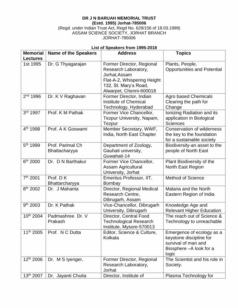
DR J N BARUAH MEMORIAL TRUST (Estd. 1995) Jorhat-785006
(Regd. under Indian Trust Act, Regd No. 629/156 of 18.03.1999) ASSAM SCIENCE SOCIETY, JORHAT BRANCH
JORHAT-785006
List of Speakers from 1995-2018
Memorial Lectures
Name of the Speakers Address Topics
1st 1995 Dr. G Thyagarajan Former Director, Regional Research Laboratory, Jorhat,Assam Flat-A-2, Whispering Height 132, St. Mary’s Road, Alwarpet, Chenni-600018
Plants, People, Opportunities and Potential
2nd 1996 Dr. K V Raghavan Former Director, Indian Institute of Chemical Technology, Hyderabad
Agro based Chemicals Clearing the path for Change
3rd 1997 Prof. K M Pathak
Former Vice Chancellor, Tezpur University, Napam, Tezpur
Ionizing Radiation and its application in Biological Sciences
4th 1998 Prof. A K Goswami Member Secretary, WWF, India, North East Chapter
Conservation of wilderness the key to the foundation for a sustainable society
5th 1999 Prof. Parimal Ch Bhattacharyya
Department of Zoology, Gauhati university, Guwahati-14
Biodiversity-an asset to the people of North East
6th 2000 Dr. D N Barthakur Former Vice Chancellor, Assam Agricultural University, Jorhat
Plant Biodiversity of the North East Region
7th 2001 Prof. D K Bhattarcharyya
Emeritus Professor, IIT, Bombay
Method of Science
8th 2002 Dr. J Mahanta Director, Regional Medical Research Centre, Dibrugarh, Assam
Malaria and the North Eastern Region of India
9th 2003 Dr. K Pathak Vice-Chancellor, Dibrugarh University, Dibrugarh
Knowledge Age and Relevant Higher Education
10th 2004 Padmashree Dr. V Prakash
Director, Central Food Technological Research Institute, Mysore-570013
The reach out of Science & Technology to unreachable
11th 2005 Prof. N C Dutta Editor, Science & Culture, Kolkata
Emergence of ecology as a keystone discipline for survival of man and Biosphere –A look for a logic
12th 2006 Dr. M S Iyenger, Former Director, Regional Research Laboratory, Jorhat
The Scientist and his role in Society.
13th 2007 Dr. Jayanti Chutia Director, Institute of Plasma Technology for
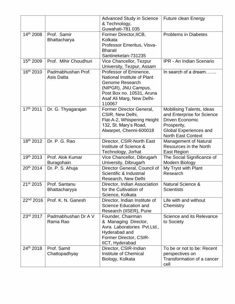
Advanced Study in Science & Technology, Guwahati-781 035
Future clean Energy
14th 2008
Prof. Samir Bhattacharya
Former Director,IICB, Kolkata Professor Emeritus, Visva-Bharati Santineketan-731235
Problems in Diabetes
15th 2009 Prof. Mihir Choudhuri Vice Chancellor, Tezpur University, Tezpur, Assam
IPR - An Indian Scenario
16th 2010 Padmabhushan Prof. Asis Datta
Professor of Eminence, National Institute of Plant Genome Research (NIPGR), JNU Campus, Post Box no. 10531, Aruna Asaf Ali Marg, New Delhi- 110067
In search of a dream…….
17th 2011 Dr. G. Thyagarajan Former Director General, CSIR, New Delhi, Flat-A-2, Whispering Height 132, St. Mary’s Road, Alwarpet, Chenni-600018
Mobilising Talents, Ideas and Enterprise for Science Driven Economic Prosperity, Global Experiences and North East Context
18th 2012 Dr. P. G. Rao Director, CSIR-North East Institute of Science & Technology, Jorhat
Management of Natural Resources in the North East Region
19th 2013 Prof. Alok Kumar Buragohain
Vice Chancellor, Dibrugarh University, Dibrugarh
The Social Significance of Modern Biology
20th 2014 Dr. P. S. Ahuja Director General, Council of Scientific & Industrial Research, New Delhi
My Tryst with Plant Research
21st 2015 Prof. Santanu Bhattacharyya
Director, Indian Association for the Cultivation of Science, Kolkata
Natural Science & Scientists
22nd 2016 Prof. K. N. Ganesh Director, Indian Institute of Science Education and Research (IISER), Pune
Life with and without Chemistry
23rd 2017 Padmabhushan Dr A V Rama Rao
Founder, Chairman & Managing Director, Avra Laboratories Pvt.Ltd., Hyderabad and Former Director, CSIR-IICT, Hyderabad
Science and its Relevance to Society
24th 2018 Prof. Samit Chattopadhyay
Director, CSIR-Indian Institute of Chemical Biology, Kolkata
To be or not to be: Recent perspectives on Transformation of a cancer cell