Embed Size (px)
Citation preview
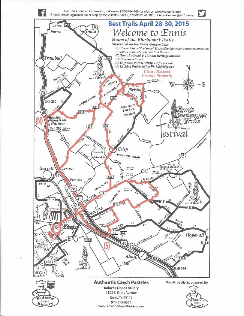
THE BEST DRIVING DIRECTIONS FOR THE 64th ANNUAL ENNIS BLUEBONNET TRAILS! SPONSORED BY ENNIS GARDEN CLUB!
BEST DRIVING TRAILS- April 28-30, 2015
Please use these directions with the map and follow the (N) Trail and the (S) South Trail. These directions are written from Ennis Convention and Visitors Bureau at 002 East Ennis Ave., Ennis, Texas 75119. There are not many flowers left but there are still some on these trails. BEST TRAIL: North Trail (N) – Go (L) (east) on Ennis Ave to IH-45. Turn (L) on IH-45. Go north on IH-45 and take Exit #259 (Jefferson Street Exit), Turn (R) on FM 813 and drive east. FM 813 becomes FM 660. Turn (L) on FM 660 to BRISTOL. In BRISTOL, turn (R) on Union Hill. Follow Union Hill Road to Andrews Rd. Turn (L) on Andrews Rd and follow to Slate Rock Rd. Turn (L) on Slate Rock and (L) on Stacks Rd. Turn (R) at stop sign on FM 660 to Sugar Ridge Rd. Turn (L) on Sugar Ridge. At the end of Sugar Ridge, turn (R) on FM 813 to FM 879. Turn (L) onto FM 879 to return to I-45 (OR) at end of Sugar Ridge, turn (L) on FM 813 and keep straight at curve on Hwy 660 through CRISP and return to Hwy 34 in Ennis.
South Trail (S) - Go (L) east on Ennis Ave., turn (R) at Business IH-45/Kaufman Street. Turn (L) East on FM 85, travel less than 1 mile, then (L) on Valek Rd, then sharp (R) on Hornik Rd. to FM 1181. *Turn (R) on FM 1181. In 3.5 miles turn (L) onto Cody Rd. to Old Telico Rd. Turn (L) on Old Telico Rd, then (R) on Lone Oak back to Hwy 34. Turn (L) on Hwy 34 back to Ennis. You can also Exit #249 on IH-45 for South Trail. *OR at end of Hornik Road, turn (L) on FM 1181 and return to IH-45 as best bluebonnets on South Trail are on Valek and Hornik. Places to take photos “in” the bluebonnets: Bluebonnet Park bluebonnets have peaked and there are not many bluebonnets left but it is a great place to hike and have a picnic. It has a great playground area, too. DIRECTIONS TO BLUEBONNET PARK: Travel west on Ennis Ave., turn (L) on Ennis Pkwy, cross over Hwy 287, turn (L) at stop sign. Bluebonnet Park is on the (R) and the bluebonnets are across the lake. When leaving the park, turn (R) on Hwy 287, exit Lampasas then (L) on Lampasas, and (L) on Jeter Dr. back to W. Ennis Ave. Other great areas to take photos “in” the bluebonnets: Big Blue House- 1404 Neck Rd., Palmer, Texas 75152 and across from 1000 Sugar Ridge Rd. (13 acres) and on Andrews Rd on North Trail. Please respect private property! BLUEBONNET SOUVENIRS! Stop by Bohemian Railway Antiques and Gifts to get your “Official” Ennis Bluebonnet Trails Souvenirs from Ennis Garden Club and other gifts. The shop is located across the railroad tracks from the Ennis Visitor Center (105 NW Main Street) Mon-Sat- 9 am-6 pm, Sun- Noon-5pm 972-878-4748 www.visitennis.org