Embed Size (px)
Citation preview
www.mintoplanning.com.au address: 14/265-271 pennant hills road, thornleigh postal address: po box 225 thornleigh 2120
telephone: 9875 4788 facsimile: 9875 4799 email: [email protected] abn 68 091 465 271
NOTE: This document is Copyright. Apart from any fair dealings for the purposes of private study, research, criticism or review, as permitted under the Copyright Act, no part may be reproduced in whole or in part, without the written permission of Minto Planning Services Pty Ltd, Suite 14, 265-271 Pennant Hills Road, Thornleigh, NSW 2120.
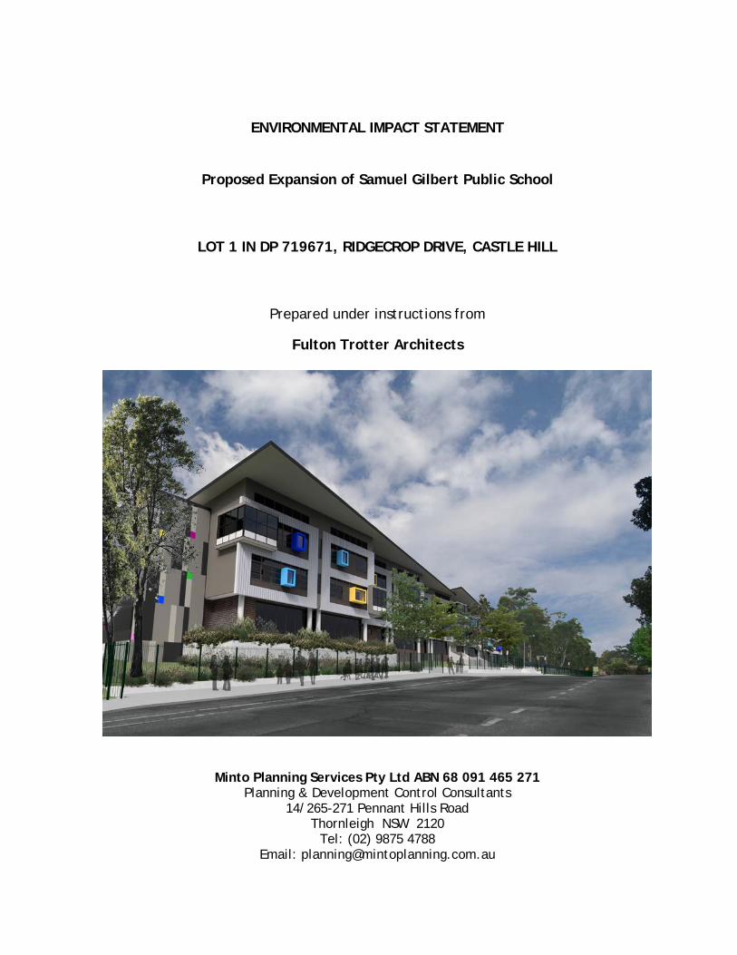
ENVIRONMENTAL IMPACT STATEMENT
PROPOSED EXPANSION OF SAMUEL GILBERT PUBLIC SCHOOL
LOT 1 IN DP 719671, RIDGECROP DRIVE, CASTLE HILL
On behalf of Department of Education
14th November 2018
ENVIRONMENTAL IMPACT STATEMENT
Proposed Expansion of Samuel Gilbert Public School
LOT 1 IN DP 719671, RIDGECROP DRIVE, CASTLE HILL
Prepared under instructions from
Fulton Trotter Architects
Minto Planning Services Pty Ltd ABN 68 091 465 271 Planning & Development Control Consultants
14/265-271 Pennant Hills Road Thornleigh NSW 2120
Tel: (02) 9875 4788 Email: [email protected]
Minto Planning Services Pty Ltd
3
DECLARATION
This Environmental Impact Statement (EIS) has been prepared by Andrew John Minto of Minto Planning Services P/L, 14/265-271 Pennant Hills Road, Thornleigh. It is advised that I possess the following qualifications, Graduate Diploma (Urban & Regional Planning) and an Associate Diploma (Health & Building Surveying). I declare that:
i) this Environmental Impact Statement has been prepared in accordance with Clauses 6 and 7 of Schedule 2 of the Environmental Planning & Assessment Regulation 2000;
ii) this Environmental Impact Statement contains all available information that is relevant to the environmental assessment of the development to which the Statement relates;
iii) that the information contained in this statement is neither false nor misleading.
Andrew Minto Graduate Diploma (Urban & Regional Planning), Associate Diploma (Health & Building Surveying). MPIA. MINTO PLANNING SERVICES PTY LTD 14th November 2018
Minto Planning Services Pty Ltd
4
TABLE OF CONTENTS
1. EXECUTIVE SUMMARY 10 2. INTRODUCTION 12
2.1 Proponent & Team 12 2.2 Project Overview 13 2.3 Project Objectives 14 2.4 Site & Project History 14 2.5 Analysis of Feasible Alternatives 14 2.6 Consequence of Not Carrying Out the Development 15 2.7 Response to SEARs 16
3. SITE CONTEXT 24
3.1 Site Location 24 3.2 Site Description 25 3.3 Surrounding Development 29
4. DETAILED DESCRIPTION OF THE PROPOSAL 32
4.1 Overview 32 4.2 Demolition Works 33 4.3 Buildings N & P 33 4.4 Building A 34 4.5 Building B 34 4.6 Building Q 34 4.7 Student Numbers 34 4.8 Civil Works 34 4.9 Car Parking 35 4.10 Signage 35 4.11 Construction Phasing 35
5. CONSULTATION 37
5.1 General 37 5.2 The Hills Shire Council 37 5.3 Government Architect NSW 40 5.4 Roads and Maritime Services 41 5.5 Transport for NSW 41 5.6 NSW Rural Fire Service 41 5.7 Community Consultation 41 5.8 Special Interest Group Consultation 42
Minto Planning Services Pty Ltd
5
6. ENVIRONMENTAL IMPACT ASSESSMENT 43
6.1 Statutory Planning Controls 43
6.1.1 – Environmental Planning & Assessment Act 1979 43 6.1.2 – Environmental Planning & Assessment Regulation 2000 43 6.1.3 - Biodiversity Conservation Act 45 6.1.4 – SEPP (State & Regional Development) 2011 48 6.1.5 – SEPP (Educational Establishments & Child Care Centres) 48 6.1.6 – SEPP No.55 – Remediation of Land 53 6.1.7 – Draft SEPP (Remediation of Land) 54 6.1.8 - SEPP No. 64 – Advertising and Signage 55 6.1.9 – Draft SEPP (Environment) 58 6.1.10 – The Hills Local Environmental Plan 2012 59
6.2 Policies 61
NSW State Priorities 61 The Greater Sydney Regional Plan 61 NSW Future Transport Strategy 2056 62 State Infrastructure Strategy 2018 – 2038 62 Sydney’s Cycling Future 2013 62 Sydney’s Walking Future 2013 62 Sydney’s Bus Future 63 Crime Prevention Through Environmental Design Principles 63 Healthy Urban Development Checklist 64 Better Placed – An integrated design policy for 65 the built environment of NSW Greater Sydney Commission’s Central District Plan 65 The Hills Development Control Plan 2012 65
6.3 Operation 67
Existing and Proposed Uses 67 Suitability of the Site to Accommodate the Proposal 68 School Operation - During Construction 69
6.4 Built Form & Urban Design 70 6.5 Environmental Amenity 72 6.6 Staging 73 6.7 Transport and Accessibility 74 6.8 Ecologically Sustainable Development 78
Minto Planning Services Pty Ltd
6
6.9 Social Impacts 79 6.10 Heritage 80 6.11 Aboriginal Heritage 81 6.12 Noise & Vibration 81 6.13 Sediment, Erosion and Dust Controls 83 6.14 Contamination 84 6.15 Utilities 85 6.16 Contributions 86 6.17 Drainage 86 6.18 Flooding 87 6.19 Bushfire 87 6.20 Biodiversity 90 6.21 Waste 93 6.22 Construction Hours 94
7. MITIGATION MEASURES 95 8. EVALUATION & CONCLUSION 99
Minto Planning Services Pty Ltd
7
APPENDIX LIST (Separate Documents)
Appendix Document Prepared by Date A Secretary’s
Environmental Assessment Requirements (SEARs)
NSW Planning & Environment
11/5/18
B Survey Plan Land Partners Limited
6/12/17
C Architectural Plans Fulton Trotter Architects
12/11/18
D Architectural Design Report
Fulton Trotter Architects
12/11/18
E Civil Engineering Plans Henry and Hymas 5/10/18 F Capital Investment Value
(CIV) Report Altus Group 8/11/18
G Landscape Plan Ground Ink Landscape Architects
12/11/18
H Arboricultural Impact Assessment Report
Tree Talk Arboricultural Consulting
November 2018
I Biodiversity Assessment Report
Travers Bushfire & Ecology
9/11/18
J Bushfire Protection Assessment Report
Australian Bushfire Protection Planners Pty Ltd
8/10/18
K Traffic & Transport Impact Statement
TSA 12/11/18
L Access Review Funktion 12/11/18 M BCA Compliance Report Formiga1 8/10/18 N Statement of Heritage
Impact Heritage 21 8/10/18
O Environmental Noise Assessment
Day Design Pty Ltd 8/11/18
P Construction Noise & Vibration Management Plan
Day Design Pty Ltd 9/10/18
Q Flood Assessment Henry and Hymas 13/9/18
R Civil Design Report Henry & Hymas October 2018

Minto Planning Services Pty Ltd
8
Appendix Document Prepared by Date
S Structural Design Report Henry & Hymas 4/9/18
T Infrastructure Management Report
Northrop Consulting Engineers
12/11/18
U Preliminary Site Inspection (PSI) & Detailed Site Inspection (DSI)
WSP 4/10/18
V Non-Destructive Hazardous Building Materials Survey
WSP 14/8/18
W Construction Management Plan
Mace Australia P/L 9/11/18
X Geotechnical Investigation
JK Geotechnics 19/6/18
Y Ecologically Sustainable Design Report
JHA Consulting Engineers
9/10/18
Z Demolition & Construction Waste Management Plan
TTM 9/10/18
AA Operational Waste Management Plan
TTM 9/10/18
BB Consultation Documentation
Various Various
CC Aboriginal Cultural Heritage Assessment Report
Cultural Heritage Connections
October 2018
DD Historical Archaeological Assessment Report
Cultural Heritage Connections
October 2018
Minto Planning Services Pty Ltd
9
TABLE OF FIGURES
Figure/Table Title Source Table 1 Proponent & Team Minto Planning
Services Table 2 Response to SEARs Minto Planning
Services Figure 1 Aerial Photograph SIX Maps Figure 2 Site Location Map SIX Maps Figure 3 Streetscape located opposite the site Figure 4 Streetscape located opposite the site Figure 5 Streetscape located opposite the site Figure 6 Aerial Photograph of Surrounding Locality SIX Maps Table 3 Response to Design Quality Principles Minto Planning
Services Figure 7 Councils Land Zoning Map The Hills Shire Council Figure 8 Council Bushfire Prone Map The Hills Shire Council Table 4 Existing and Proposed Uses Minto Planning
Services Table 5 Hazardous Material Inspection Results WSP Figure 9 Bushfire Prone Land Australian Bushfire
Protection Planners P/L
Figure 10 Asset Protection Zone Plan Australian Bushfire Protection Planners P/L
Table 6 Mitigation Measures Minto Planning Services
-
Minto Planning Services Pty Ltd
10
1. EXECUTIVE SUMMARY This Environmental Impact Statement has been prepared in support of the proposed carrying out of alterations and additions to the existing Samuel Gilbert Public School located at Ridgecrop Drive, Castle Hill. The proposed alterations and additions to the existing school have a Capital Investment Value (CIV) over $20 million and is therefore classified as State Significant Development (SSD) pursuant to Schedule 1 of the State Environmental Planning Policy (State and Regional Development) 2011 (SEPP SRD). This Environmental Impact Statement has been prepared in accordance with the requirements of the Department of Planning & Environment Secretary’s Environmental Assessment Requirements (SEARs) and the Department’s guidelines for SSD applications. This application seeks approval for the expansion of Samuel Gilbert Public School to increase the capacity of the school to a maximum of 1000 students and to upgrade the existing core facilities to suit this increased population. The responsible person for this project is Mr Michael Jarman, Program Manager, School Infrastructure NSW. The proposal includes the construction of:
1. A new three storey facility along Ridgecrop Rd which houses: • New Staff and Administration Offices (including Staff Toilets) • New Library • 23 new permanent teaching spaces • New entry forecourt with lift to address accessible access to a sloping
site. 2. Alterations to existing Administration Building to convert it to 3 new home
bases 3. Alterations to the existing Library Building to convert it to 3 new home
bases 4. New Hall Building with separate entrance for out of school hours and
community use. 5. Removal of 12 demountable teaching spaces and relocation of 1
demountable provided by the Parents & Community Association. 6. Demolition of a number of outdated existing classroom spaces to create a
new circulation axis between the new entry and facilities and the existing campus through to the existing school playing fields.
7. Increase student numbers from 780 to 1000 and staff from 45 to 58. 8. Ancillary Signage to south elevation of Building P, east elevation of
Building Q (Hall) and on the base of the fencing to both Ridgecrop Drive and Gilbert Road.
Minto Planning Services Pty Ltd
11
This report provides for a detailed description and assessment of the proposal against the requirements of the Department of Planning & Environment Secretary’s Environmental Assessment Requirements (SEARs), the Environmental Planning & Assessment Act 1979, the Environmental Planning & Assessment Regulation 2000, applicable State Environmental Planning Polices and applicable Council LEP & DCP. It is not considered that this assessment has identified any matters which would warrant the refusal or significant modification of the application. Minto Planning Services recommends the approval of the application given that the proposal will not result in any adverse environmental, economic and social impacts taking into consideration the need to increase the student population of Samuel Gilbert Public School having regard to existing and projected demand for public school places in this area.
Minto Planning Services Pty Ltd
12
2. INTRODUCTION This Environmental Impact Statement accompanies a State Significant Development application that is submitted to the Department of Planning & Environment on behalf of the Department of Education for the expansion of Samuel Gilbert Public School. The proposed alterations and additions to the existing school have a Capital Investment Value over $20 million and is therefore classified as State Significant Development pursuant to Schedule 1 of the State Environmental Planning Policy (State and Regional Development) 2011 (SEPP SRD). The EIS responds to the Environmental Assessment Requirements of the Secretary of the Department of Planning & Environment issued pursuant to Part 4 of the Environmental Planning and Assessment Act and Schedule 2 of the Environmental Planning and Assessment Regulation 2000. 2.1 Proponent & Team The proponent and project team are identified in the table below: Contribution Consultant Proponent Department of Education Project Manager Mace Australia P/L Town Planning Minto Planning Services P/L Architectural Plans and Report Fulton Trotter Architects Site Survey Land Partners Limited Landscaping Ground Ink Landscape Architects Hydraulic Services JHA Services Stormwater & Civil Engineering Henry & Hymas Structural Design Henry & Hymas Geotechnical Report JK Geotechnics Traffic Report TSA Flood Report Henry & Hymas Electrical Services Northrop Consulting Engineers Infrastructure Management Report Northrop Consulting Engineers Bushfire Report Australian Bushfire Protection Planners
P/L BCA Compliance Formiga1 Access Report Funktion Biodiversity Assessment Report Travers Bushfire & Ecology Arboricultural Report Tree Talk Arboricultural Consulting Non-Destructive Hazardous Building Materials Survey
WSP
Minto Planning Services Pty Ltd
13
Contribution Consultant Heritage Consultants Heritage 21 Acoustic consultants Day Design P/L Contamination – Preliminary & Detailed Site Inspection
WSP
Construction Noise & Vibration Management
TTM
Operational Waste Management TTM
Aboriginal Heritage Impact Assessment Report
Cultural Heritage Connections
Historical Archaeological Assessment Report
Cultural Heritage Connections
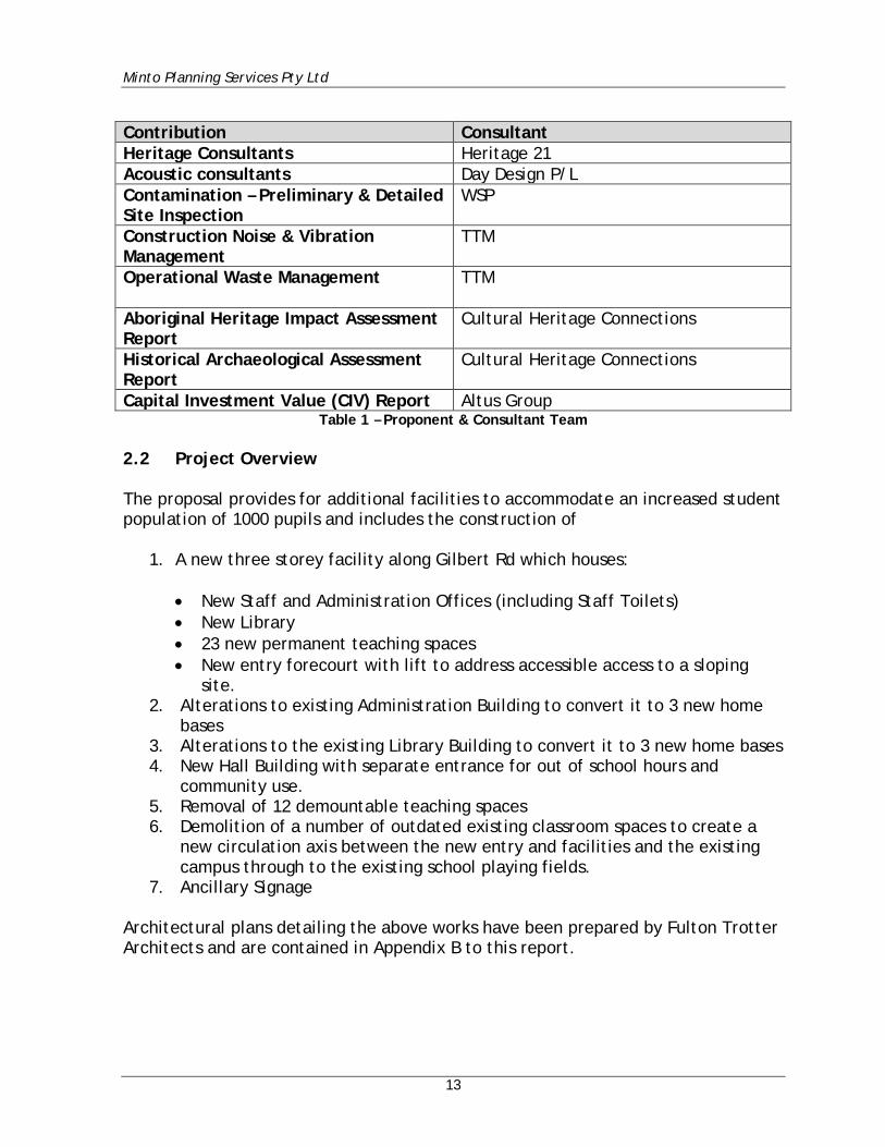
Capital Investment Value (CIV) Report Altus Group Table 1 – Proponent & Consultant Team
2.2 Project Overview The proposal provides for additional facilities to accommodate an increased student population of 1000 pupils and includes the construction of
1. A new three storey facility along Gilbert Rd which houses:
• New Staff and Administration Offices (including Staff Toilets) • New Library • 23 new permanent teaching spaces • New entry forecourt with lift to address accessible access to a sloping
site. 2. Alterations to existing Administration Building to convert it to 3 new home
bases 3. Alterations to the existing Library Building to convert it to 3 new home bases 4. New Hall Building with separate entrance for out of school hours and
community use. 5. Removal of 12 demountable teaching spaces 6. Demolition of a number of outdated existing classroom spaces to create a
new circulation axis between the new entry and facilities and the existing campus through to the existing school playing fields.
7. Ancillary Signage Architectural plans detailing the above works have been prepared by Fulton Trotter Architects and are contained in Appendix B to this report.
Minto Planning Services Pty Ltd
14
2.3 Project Objectives The proposal relates to an established school (Samuel Gilbert Public School) which has been identified by the Department of Education as requiring additional facilities to meet a growing population. The School already houses a number of its teaching spaces within temporary demountable buildings as a result of recent growth in the area. The proposal is to update the facilities to meet NSW Dept of Education Core 35 guidelines for a student population of 1000 pupils. 2.4 Site & Project History The subject site has been be occupied by Samuel Gilbert Public School since 29th May 1987. Samuel Gilbert Public School provides State based education by the NSW Department of Education for Kindergarten through to Year 6. Recent Development Consents granted for the subject site include the following:
• 499/2008 – Shade Structure for Outdoor Learning Area approved 22 October 2007.
• 1855/2016 – Signage on Gilbert Road. The existing school currently has 780 students enrolled, 45 staff and comprises of 30 existing learning spaces incorporating 12 housed within demountable buildings. The proposed additions to the existing school will enable a total of 1000 students and 58 staff to be accommodated to meet the current guidelines of the NSW Department of Education. 2.5 Analysis of Feasible Alternatives The subject site is currently occupied by the Samuel Gilbert Public School and which provides for primary school education to approximately 780 students. The NSW Department of Education have identified that as a result of increased population growth within this area that there will be an additional demand for public primary school places within the area and at Samuel Gilbert Public School. The site has been identified as a site capable of supporting an increased population so as to provide for up to 1000 students as demonstrated by this report.
Minto Planning Services Pty Ltd
15
The following alternatives have been considered: No Development: The consequence of not carrying out the development will include:
• An inability to meet current and projected demand for public primary school places within this catchment area.
• The continued provision of inadequate and below standard teaching and learning facilities upon the subject site.
• Extended travel distances and increased vehicle usage for students residing within the area as students will be required to travel further for education.
Increase the Existing Site: This option to enable an increase in student numbers on the existing site is considered the most appropriate. It is considered that there is sufficient area on site for the proposed buildings to cater for the additional numbers in a manner which will not result in any unreasonable impacts. Increase at another existing site: This option would not meet the NSW Department of Education guidelines for student numbers. The increase of students at another site would require students within this catchment to travel further for schooling and require increased vehicle usage to enable such travel. The existing inadequate and below standard teaching and learning facilities on the subject site would not be improved. Development of a New Site: There is no other feasible site within the vicinity that is owned by the NSW Department of Education that could support the required development. 2.6 Consequence of Not Carrying Out the Development The consequence of not carrying out the development will include:
• An inability to meet current and projected demand for public primary school places within this catchment area.
• The continued provision of inadequate and below standard teaching and learning facilities upon the subject site.
• Extended travel distances and increased vehicle usage for students residing within the area as students will be required to travel further for education.
Minto Planning Services Pty Ltd
16
2.7 Response to SEARs The Secretary of the Department of Planning and Environments Environmental Assessment Requirements (SEARs) were issued on the 11th May 2018. A copy of those requirements are included at Appendix A to this report. The following table provides a detailed summary of the individual matters listed in the SEARs and identifies where each of these requirements has been addressed in this report and the accompanying consultant plans and reports.
Secretary’s Requirements Location Where Addressed
The Environmental Impact Statement (EIS) must be prepared in accordance with, and meet the minimum requirements of clauses 6 and 7 of Schedule 2 the Environmental Planning and Assessment Regulation 2000 (the Regulation). Notwithstanding the key issues specified below, the EIS must include an environmental risk assessment to identify the potential environmental impacts associated with the development.
Part 6
Where relevant, the assessment of the key issues below, and any other significant issues identified in the risk assessment, must include:
• adequate baseline data; • consideration of potential cumulative impacts due to other
development in the vicinity (completed, underway or proposed); and • measures to avoid, minimise and if necessary, offset the predicted
impacts, including detailed contingency plans for managing any significant risks to the environment.
All Documentation
The EIS must be accompanied by a report from a qualified quantity surveyor providing:
• a detailed calculation of the capital investment value (CIV) (as defined in clause 3 of the Environmental Planning and Assessment Regulation 2000) of the proposal, including details of all assumptions and components from which the CIV calculation is derived;
• an estimate of the jobs that will be created by the future development during the construction and operational phases of the development; and
• certification that the information provided is accurate at the date of preparation.
Appendix F
Minto Planning Services Pty Ltd
17
Secretary’s Requirements Location Where
Addressed The EIS must address the following specific matters: 1. Statutory and Strategic Context – including: Address the statutory provisions contained in all relevant environmental planning instruments, including:
• Biodiversity Conservation Act 2016; • State Environmental Planning Policy (State & Regional Development)
2011; • State Environmental Planning Policy (Educational Establishments and
Child Care Facilities) 2017; • State Environmental Planning Policy No.55 – Remediation of Land; • Draft State Environmental Planning Policy (Remediation of Land); • State Environmental Planning Policy No. 64 – Advertising and Signage; • Draft State Environmental Planning Policy (Environment); and, • The Hills Local Environmental Plan 2012.
Permissibility Detail the nature and extent of any prohibitions that apply to the development. Development Standards Identify compliance with the development standards applying to the site and provide justification for any contravention of the development standards.
Section 6.1
2. Policies Address the relevant planning provisions, goals and strategic planning objectives in the following:
• NSW State Priorities; • The Greater Sydney Regional Plan, A Metropolis of Three Cities; • NSW Future Transport Strategy 2056; • State Infrastructure Strategy 2018 – 2038; • Sydney’s Cycling Future 2013; • Sydney’s Walking Future 2013; • Sydney’s Bus Future 2013; • Crime Prevention Through Environmental Design (CPTED) Principles; • Healthy Urban Development Checklist, NSW Health; • Better Placed – an integrated design policy for the build environment
of NSW; • Greater Sydney Commission’s Central City District Plan; • The Hills LEP 2012; and, • The Hills Development Control Plan 2012.
Section 6.2
3. Operation • Provide details of the existing and proposed school operations,
including staff and student numbers, school hours of operation, and operational details of any proposed before/after school care services and/or community use of school facilities.
• Provide a detailed justification of suitability of the site to accommodate the proposal.
• Provide details of how the school will continue to operate during construction activities of the new primary and secondary school, including proposed mitigation measures.
Section 6.3
Minto Planning Services Pty Ltd
18
Secretary’s Requirements Location Where
Addressed 4. Built Form and Urban Design
• Address the height, density, bulk and scale, setbacks of the proposal in relation to the surrounding development, topography, streetscape and any public open spaces.
• Address design quality, with specific consideration of the overall site layout, streetscape, open spaces, façade, rooftop, massing, setbacks, building articulation, materials, colours and Crime Prevention Through Environmental Design Principles.
• Develop a design report that includes diagrams, illustrations and drawings to clarify the design intent of the proposal that clearly demonstrates how design quality will be achieved in accordance with Schedule 4 Schools – Design Quality Principles of State Environmental Planning Policy (Educational Establishments and Child Care Facilities) 2017 and the Design Guide for Schools.
• Detail how services, including but not limited to waste management, loading zones, and mechanical plant are integrated into the design of the development.
• Provide detailed site and context analysis to justify the proposed site planning and design approach.,
• Provide a detailed site-wide landscape strategy.
Section 6.4
5. Environmental Amenity • Assess amenity impacts on the surrounding locality, including solar
access, visual privacy, overshadowing and acoustic impacts. • Identify any proposed use of the school outside of school hours
(including weekends) and assess any resultant amenity impacts on the immediate locality and proposed mitigation measures.
• Detailed outline of the nature and extent of the intensification of use associated with the increased floor space, particularly in relation to the proposed increase in staff and student numbers.
• Detail amenity impacts including solar access, acoustic impacts, visual privacy, view loss, overshadowing and wind impacts. A high level of environmental amenity for any surrounding residential land uses must be demonstrated.
• Detail any proposed use of the school grounds out of school hours (including weekends) and any resultant amenity impacts on the immediate locality and proposed mitigation measures.
Section 6.5
6. Staging • Provide details regarding any staging of the proposed development.
Section 6.6
7. Transport and Accessibility • Include a transport and accessibility impact assessment, which details,
but not limited to the following: • accurate details of the current daily and peak hour vehicle, existing
and future public transport networks and pedestrian and cycle movement provided on the road network located adjacent to the proposed development;
• details of estimated total daily and peak hour trips generated by the proposal, including vehicle, public transport, pedestrian and bicycle trips based on surveys of the existing and similar schools within the local area;
• the adequacy of existing public transport or any future public transport infrastructure within the vicinity of the site, pedestrian and bicycle networks and associated infrastructure to meet the likely
Section 6.7 & Appendix K
Minto Planning Services Pty Ltd
19
future demand of the proposed development; • measures to integrate the development with the existing/future public
transport network; • the impact of trips generated by the development on nearby
intersections (including but not limited to both roundabout intersections of Gilbert Road and Ridgecrop Drive), with consideration of the cumulative impacts from other approved developments in the vicinity, and the need/associated funding for, and details of, upgrades or road improvement works, if required (Traffic modelling is to be undertaken using SIDRA network modelling for current and future years);
• the identification of infrastructure required to ameliorate any impacts on traffic efficiency and road safety impacts associated with the proposed development, including details on improvements required to affected intersections, additional school bus routes along bus capable roads (i minimum 3.5 m wide travel lanes), additional bus stops or bus bays;
• details of travel demand management measures to minimise the impact on general traffic and bus operations, including details of a location-specific sustainable travel plan (Green Travel Plan and specific Workplace travel plan) and the provision of facilities to increase the non-car mode share for travel to and from the site;
• the proposed walking and cycling access arrangements and connections to public transport services;
• the proposed access arrangements, including car and bus pick-up/drop-off facilities, and measures to mitigate any associated traffic impacts and impacts on public transport, pedestrian and bicycle networks, including pedestrian crossings and refuges and speed control devices and zones;
• details of any traffic management measures to ensure the safe and efficient operation of student pick-up/drop-off;
• proposed bicycle parking provision, including end of trip facilities, in secure, convenient, accessible areas close to main entries incorporating lighting and passive surveillance;
• proposed number of on-site car parking spaces for teaching staff and visitors and corresponding compliance with existing parking codes and justification for the level of car parking provided on-site;
• an assessment of the cumulative on-street parking impacts of cars and bus pick-up/drop-off, staff parking and any other parking demands associated with the development;
• an assessment of road and pedestrian safety adjacent to the proposed development and the details of required road safety measures and personal safety in line with CPTED;
• emergency vehicle access, service vehicle access, delivery and loading arrangements and estimated service vehicle movements (including vehicle type and the likely arrival and departure times);
• the preparation of a draft Construction Traffic Management Plan to demonstrate the proposed management of the impact.in relation to construction traffic addressing the following:
o assessment of cumulative impacts associated with other construction activities (if any);
o an assessment of road safety at key intersection and locations subject to heavy vehicle construction traffic movements and high pedestrian activity;
o details of construction program detailing the anticipated
Minto Planning Services Pty Ltd
20
construction duration and highlighting significant and milestone stages and events during the construction process;
o details of anticipated peak hour and daily construction vehicle movements to and from the site;
o details of on-site car parking and access arrangements of construction vehicles, construction workers to and from the site, emergency vehicles and service vehicle; and,
o details of temporary cycling and pedestrian access during construction;
8. Ecologically Sustainable Development (ESD) • Detail how ESD principles (as defined in clause 7(4) of Schedule 2 of
the Environmental Planning and Assessment Regulation 2000) will be incorporated in the design and ongoing operation phases of the development.
• Include a framework for how the development will be designed to consider and reflect national best practice sustainable building principles to improve environmental performance and reduce ecological impact. This should be based on a materiality assessment and include waste reduction design measures, future proofing, use of sustainable and low-carbon materials, energy and water efficient design (including water sensitive urban design) and technology and use of renewable energy.
• Include preliminary consideration of building performance and mitigation of climate change, including consideration of Green Star Performance.
• Provide a statement regarding how the works are responsive to the CSIRO projected impacts of climate change. Specifically:
o hotter days and more frequent heatwave events; o extended drought periods; o more extreme rainfall events; o gustier wind conditions; and o how these will inform material selection and social equity
aspects (respite/shelter areas).
Section 6.8 & Appendix Y
9. Social Impacts Include an assessment of the social consequences of the schools’ relative location.
Section 6.9
10. Heritage • The EIS must include a Heritage Impact Statement (HIS), prepared by a
suitably qualified heritage consultant in accordance with the guidelines in the NSW Heritage Manual. The HIS should identify any State and local heritage items and heritage conservation areas with the SSD site and in the vicinity and provide an assessment of heritage impacts. Where impacts are identified, the HIS should outline the proposed mitigation measures.
• The EIS must include a Heritage Archaeological Assessment (HAA), prepared by a suitably qualified historical archaeologist. The HAA should identify what relics, if any, are likely to be present within the SSD site or in the vicinity, assess their significance and consider the impacts from the proposal on this potential resource. Where harm is likely to occur, it is recommended that the significance of the relics be considered in determining an appropriate mitigation strategy. If harm cannot be avoided in whole or part, an appropriate Research Design and Excavation Methodology should also be prepared to guide any proposed excavations.
Section 6.10 & Appendices DD and
N
Minto Planning Services Pty Ltd
21
Secretary’s Requirements Location Where
Addressed 11. Aboriginal Heritage
• Identify and describe the Aboriginal cultural heritage values that exist across the whole area that would be affected by the development and document these in an Aboriginal Cultural Heritage Assessment Report (ACHAR). This may include the need for surface survey and test excavation. The identification of cultural heritage values must be conducted in accordance with the Code of Practice for Archaeological Investigations of Aboriginal Objects in NSW (OEH 2010), and guided by the Guide to investigating, assessing and reporting on Aboriginal Cultural Heritage in NSW (DECCW, 2011).
• Consultation with Aboriginal people must be undertaken and documented in accordance with the Aboriginal cultural heritage consultation requirements for proponents 2010 (DECCW). The significance of cultural heritage values for Aboriginal people who have a cultural association with the land must be documented in the ACHAR.
• Impacts on Aboriginal cultural heritage values are to be assessed and documented in the ACHAR. The ACHAR must demonstrate attempts to avoid impact upon cultural heritage values and identify any conservation outcomes. Where impacts are unavoidable, the ACHAR must outline measures proposed to mitigate impacts. Any objects recorded as part of the assessment must be documented and notified to OEH.
Section 6.11 & Appendix CC
12. Noise and Vibration • Identify and provide a quantitative assessment of the main noise and
vibration generating sources during demolition, site preparation, bulk excavation, construction.
• Identify and assess operational noise, including consideration of any public-address system, school bell, mechanical services (e.g. air conditioning plant), use of any school hall for concerts etc. (both during and outside school hours) and any out of hours community use of school facilities.
• Outline measures to minimise and mitigate the potential noise impacts during construction and from operations on surrounding occupiers of land.
Section 6.12 & Appendix O & P
13. Sediment, Erosion and Dust Controls Detail measures and procedures to minimise and manage the generation and off-site transmission of sediment, dust and fine particles.
Section 6.13 & Appendix E
14. Contamination • Assess and quantify any soil and groundwater contamination and
demonstrate that the site is suitable for the proposed use in accordance with SEPP 55.
• Undertake a hazardous materials survey of all existing structures and infrastructure prior to any demolition or site preparation works.
• Include an assessment of the effectiveness and reliability of the measures and any residual impacts after these measures are implemented.
Section 6.14 & Appendix U
Minto Planning Services Pty Ltd
22
Secretary’s Requirements Location Where
Addressed 15. Utilities
• Prepare an Infrastructure Management Plan in consultation with relevant agencies, detailing information on the existing capacity and any augmentation and easement requirements of the development for the provision of utilities including staging of infrastructure based on the projected service demand.
• Prepare an Integrated Water Management Plan detailing any proposed alternative water supplies, proposed end uses of potable and non-potable water, and water sensitive urban design.
Section 6.15 & Appendix T
16. Contributions Address Council’s Section 94 Contribution Plan and/or details of any Voluntary Planning Agreement, which may be required to be amended because of the proposed development.
Section 6.16
17. Drainage • Detail drainage associated with the proposal, including stormwater
and drainage infrastructure. • Detail measures to minimise operational water quality impacts on
surface waters and groundwater. • Stormwater plans detailing the proposed methods of drainage without
impacting on the downstream properties.
Section 6.17 & Appendix E & R
18. Flooding Assess any flood risk on site (detailing the most recent flood studies for the project area) and consideration of any relevant provisions of the NSW Floodplain Development Manual (2005), including the potential effects of climate change, sea level rise and an increase in rainfall intensity.
Section 6.18 & Appendix Q
19. Bush fire Address the bush fire hazard including through the preparation of a report that addresses the requirements for Special Fire Protection Purpose development as detailed in Planning for Bush Fire Protection 2006.
Section 6.19 & Appendix J
20. Biodiversity Assess and document the biodiversity impacts related to the proposal, by a suitably qualified person.
Section 6.20 & Appendix I
21. Waste • Identify, quantify and classify the likely waste streams to be generated during construction and operation and describe the measures to be implemented to manage, reuse, recycle and safely dispose of this waste. • Identify appropriate servicing arrangements (including but not limited to, waste management, loading zones, mechanical plant) for the site.
Section 6.21 & Appendix Z & AA
22. Construction Hours Identify proposed construction hours and provide details of the instances where it is expected that works will be required to be carried out outside the standard construction hours.
Section 6.22 & Appendix W
Minto Planning Services Pty Ltd
23
Secretary’s Requirements Location Where
Addressed The EIS must include all relevant plans, architectural drawings, diagrams and relevant documentation required under Schedule 1 of the Environmental Planning and Assessment Regulation 2000. Provide these as part of the EIS rather than as separate documents. In addition, the EIS must include the following:
• Architectural drawings (dimensioned and including RLs); • Site Survey Plan, showing existing levels, location and height of
existing and adjacent structures / buildings and boundaries; • Site Analysis Plan; • Sediment and Erosion Control Plan; • Draft Construction Environmental Management Plan, including relevant
sub plans. • Shadow Diagrams; • View Analysis / Photomontages, including from public vantage points; • Landscape Plan (identifying any trees to be removed, retained or
transplanted and using a diversity of native trees, shrubs and groundcover species from the relevant native vegetation community to improve biodiversity);
• Geotechnical and Structural Report; • Accessibility Report; • Arborist Report; • Salinity Investigation Report (if required); • Acid Sulphate Soils Management Plan (if required); and • Schedule of materials and finishes. Consultation
Refer to Appendices
During the preparation of the EIS, you must consult with the relevant local, State or Commonwealth Government authorities, service providers, community groups, special interest groups including local Aboriginal land councils and registered Aboriginal stakeholders, and affected landowners. In particular, you must consult with:
• The Hills Shire Council; • Government Architect NSW (through the NSW State Design Review
Panel process); • Roads and Maritime Services; • Transport for NSW; and, • NSW Rural Fire Service.
Consultation with Council, Transport for NSW, Road and Maritime Services, Government Architect NSW and NSW Rural Fire Service should commence as soon as practicable. The EIS must describe the consultation process and the issues raised, and identify where the design of the development has been amended in response to these issues. Where amendments have not been made to address an issue, a short explanation should be provided.
Part 5
If you do not lodge a development application and EIS for the development within two years of the issue date of these SEARs, you must consult further with the Secretary in relation to the preparation of the EIS.
Not Applicable
The assessment of the key issues listed above must consider relevant guidelines, policies, and plans as identified.
All documentation
Table 2 – Response to SEARs
Minto Planning Services Pty Ltd
24
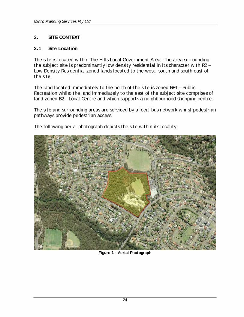
3. SITE CONTEXT 3.1 Site Location The site is located within The Hills Local Government Area. The area surrounding the subject site is predominantly low density residential in its character with R2 – Low Density Residential zoned lands located to the west, south and south east of the site. The land located immediately to the north of the site is zoned RE1 – Public Recreation whilst the land immediately to the east of the subject site comprises of land zoned B2 – Local Centre and which supports a neighbourhood shopping centre. The site and surrounding areas are serviced by a local bus network whilst pedestrian pathways provide pedestrian access. The following aerial photograph depicts the site within its locality:
Figure 1 - Aerial Photograph
Minto Planning Services Pty Ltd
25
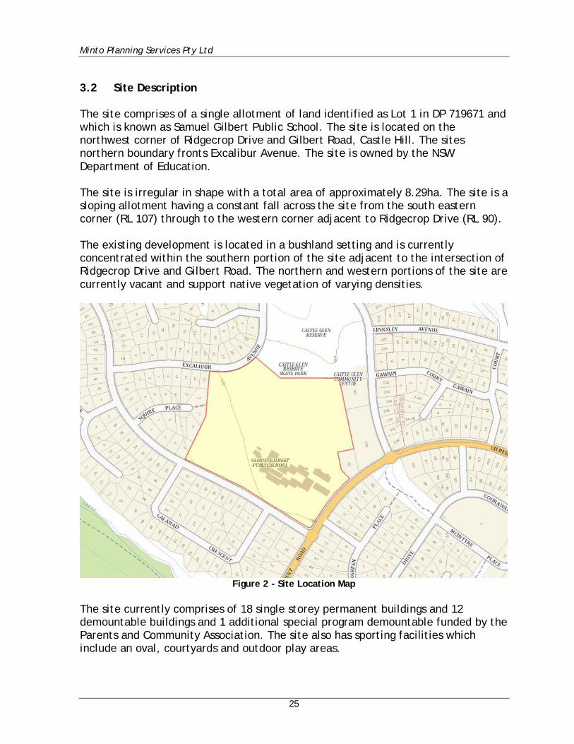
3.2 Site Description The site comprises of a single allotment of land identified as Lot 1 in DP 719671 and which is known as Samuel Gilbert Public School. The site is located on the northwest corner of Ridgecrop Drive and Gilbert Road, Castle Hill. The sites northern boundary fronts Excalibur Avenue. The site is owned by the NSW Department of Education. The site is irregular in shape with a total area of approximately 8.29ha. The site is a sloping allotment having a constant fall across the site from the south eastern corner (RL 107) through to the western corner adjacent to Ridgecrop Drive (RL 90). The existing development is located in a bushland setting and is currently concentrated within the southern portion of the site adjacent to the intersection of Ridgecrop Drive and Gilbert Road. The northern and western portions of the site are currently vacant and support native vegetation of varying densities.
Figure 2 - Site Location Map
The site currently comprises of 18 single storey permanent buildings and 12 demountable buildings and 1 additional special program demountable funded by the Parents and Community Association. The site also has sporting facilities which include an oval, courtyards and outdoor play areas.
Minto Planning Services Pty Ltd
26
The subject site and the existing buildings are not heritage listed and are not considered to have any heritage significance which would be impacted upon by the proposal. Vehicular access to the property is currently provided via a bitumen driveway which enters the site mid-way along the Ridgecrop Drive frontage. The driveway provides access to a vehicle parking area comprising 26 staff parking spaces and a turning area for delivery vehicles. Parents/guardians utilise on-street parallel parking within Ridgecrop Drive, with pick up/drop off in Gilbert Road. Pedestrian access to the site is provided via both Ridgecrop Drive and Gilbert Road. A public car park servicing the recreational fields to the north is also utilised by parents/guardians with a pedestrian link provided to the school from this carpark. Stormwater from the site is currently disposed of to the street drainage system in Ridgecrop Drive. The site comprises a large number of trees with over 600 trees and tree groups identified. An assessment of the existing trees and the relationship of the trees to the proposal and the associated works has been undertaken by Tree Talk Arboricultural Consulting and their report is included as Appendix H to this report. In association with the existing trees located upon the site two areas of Sydney Turpentine-Ironbark Forest (STIF) have been identified as occurring upon the site. Reference is made to the Biodiversity Assessment Report prepared by Travers Bushfire & Ecology (Appendix I) and which identifies these communities as STIF North and STIF South. The Travers report in relation to the proposal identifies that:
Recorded Biodiversity Ecological survey and assessment has been undertaken in accordance with relevant legislation including the Environmental Planning and Assessment Act 1979 (EP&A Act), the Biodiversity Conservation Act 2016 (BC Act), the Environment Protection and Biodiversity Conservation Act 1999 (EPBC Act) and the Fisheries Management Act 1994 (FM Act). In respect of matters required to be considered under the EP&A Act and relating to the species / provisions of the BC Act, six (6) state listed threatened fauna species including Square-tailed Kite (Lophoictinia isura), Glossy Black-Cockatoo (Calyptorhynchus lathami), Grey-headed Flying-fox (Pteropus poliocephalus), Eastern Bentwing-bat (Miniopterus orianae oceanensis), Greater Broad-nosed Bat (Scoteanax rueppellii) and Eastern Falsistrelle (Falsistrellus tasmaniensis), no threatened flora species, and one (1) endangered ecological community (EEC), Sydney Turpentine-Ironbark Forest (STIF), were recorded within the study area. One (1) tree of high foraging use by Glossy Black-Cockatoo was found within the proposed development area and will be removed by the proposal.
Minto Planning Services Pty Ltd
27
In respect of matters required to be considered under the Environment Protection and Biodiversity Conservation Act 1999 (EPBC Act), no threatened flora species, one critically endangered ecological community (CEEC) known as Turpentine-Ironbark Forest of the Sydney Basin Bioregion, one (1) threatened fauna species Grey-headed Flying-fox (Pteropus poliocephalus) and no protected migratory bird species listed under this Act were recorded within the subject site. In respect of matters relative to the FM Act, no suitable habitat for threatened marine or aquatic species was observed within the subject site and there are no matters requiring further consideration under this Act. Impact assessment The direct, indirect and cumulative impacts of the proposal have been carefully considered in Section 6.2 of this report. Recommendations have been outlined within Section 5.4 to avoid/minimise/offset the identified potential ecological impacts of the proposal, to address threatening processes and to create a more positive ecological outcome for threatened species and their associated habitats. The principles for determining serious and irreversible impacts are set out under Section 6.7.2 of the Biodiversity Conservation Regulation 2017 (BCR). These principles have been reviewed and it is considered that the proposal will not cause any serious and irreversible impacts (SAII) on threatened biodiversity. There will be no significant impact on matters listed under the FM Act. The proposed development was not considered to have a significant impact on matters of national environmental significance (NES). As such, a referral to Department of Environment and Energy (DOEE) is not required.
Subject to compliance with the recommendations of the Biodiversity Assessment Report it is not considered that the proposal will result in any unreasonable impact upon the existing STIF communities which exist upon the site.
Minto Planning Services Pty Ltd
28
The subject site is identified as containing Category 1 Bushfire Prone Vegetation on the Council’s Bushfire Prone Land Map. A Bushfire Protection Assessment Report has been prepared for the site by Australian Bushfire Protection Planners P/L and their report is included as Appendix J to this report. That report within its conclusion states that:
This report has reviewed the proposed development against the Section 19 – ‘Bushfire’ of the Secretary’s Environmental Assessment Requirements [SEARS] which states that the Environmental Impact Statement [EIS] shall address the bush fire hazard including through the preparation of a report that addresses the requirements for Special Fire Protection Purpose development as detailed in Planning for Bushfire Protection 2006. Section 4.2.5 of Planning for Bushfire Protection 2006 identifies that in circumstances where alterations and additions to existing ‘Special Fire Protection Purpose Development’ are planned the NSW Rural Fire Service require an appropriate combination of bushfire protection measures and compliance with the intent and performance criteria of each measure within Section 4.3.5 of Planning for Bushfire Protection 2006. The report has examined the vegetation within the school site and confirms that the only vegetation which presents a hazard to the school is the woodland vegetation retained within the western and north-western portion of the school site. The report notes that the retained pockets of Turpentine-Ironbark Forest do not constitute bushfire prone vegetation due to the small area of vegetation and the separation to bushfire prone vegetation. The report has also confirmed that, with the exception of the existing After Hours Care Building J, all existing and proposed building locations satisfy the separation widths of Asset Protection Zones as required by Table A2.6 of Planning for Bushfire Protection 2006. The proposed development therefore satisfies the aim and objectives of Planning for Bushfire Protection 2006 addresses Section 19 of the Key Issues of the Secretary’s Environmental Assessment Requirements of the State Significant Development No. 9274.
On this basis it is not considered that there will be any unreasonable bushfire impacts associated with the proposal and that compliance is capable of being achieved with the applicable bushfire legislation and controls.
Minto Planning Services Pty Ltd
29
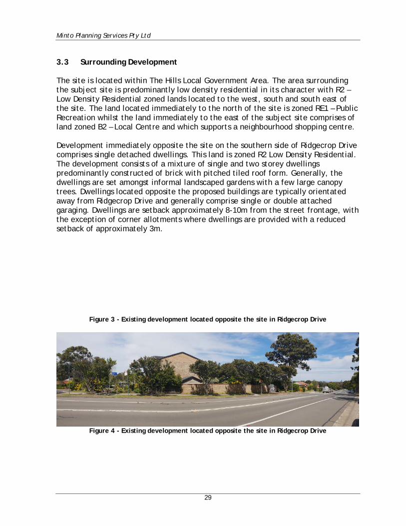
3.3 Surrounding Development The site is located within The Hills Local Government Area. The area surrounding the subject site is predominantly low density residential in its character with R2 – Low Density Residential zoned lands located to the west, south and south east of the site. The land located immediately to the north of the site is zoned RE1 – Public Recreation whilst the land immediately to the east of the subject site comprises of land zoned B2 – Local Centre and which supports a neighbourhood shopping centre. Development immediately opposite the site on the southern side of Ridgecrop Drive comprises single detached dwellings. This land is zoned R2 Low Density Residential. The development consists of a mixture of single and two storey dwellings predominantly constructed of brick with pitched tiled roof form. Generally, the dwellings are set amongst informal landscaped gardens with a few large canopy trees. Dwellings located opposite the proposed buildings are typically orientated away from Ridgecrop Drive and generally comprise single or double attached garaging. Dwellings are setback approximately 8-10m from the street frontage, with the exception of corner allotments where dwellings are provided with a reduced setback of approximately 3m.
Figure 3 - Existing development located opposite the site in Ridgecrop Drive
Figure 4 - Existing development located opposite the site in Ridgecrop Drive
Minto Planning Services Pty Ltd
30
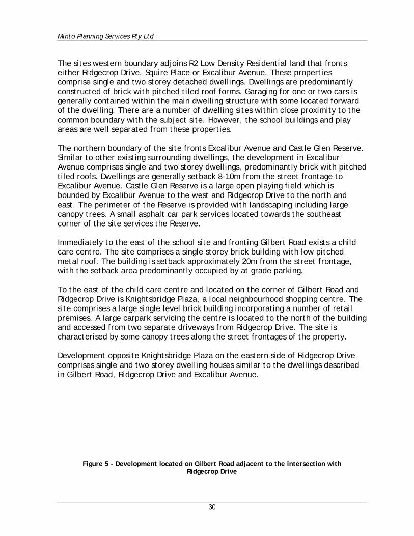
The sites western boundary adjoins R2 Low Density Residential land that fronts either Ridgecrop Drive, Squire Place or Excalibur Avenue. These properties comprise single and two storey detached dwellings. Dwellings are predominantly constructed of brick with pitched tiled roof forms. Garaging for one or two cars is generally contained within the main dwelling structure with some located forward of the dwelling. There are a number of dwelling sites within close proximity to the common boundary with the subject site. However, the school buildings and play areas are well separated from these properties. The northern boundary of the site fronts Excalibur Avenue and Castle Glen Reserve. Similar to other existing surrounding dwellings, the development in Excalibur Avenue comprises single and two storey dwellings, predominantly brick with pitched tiled roofs. Dwellings are generally setback 8-10m from the street frontage to Excalibur Avenue. Castle Glen Reserve is a large open playing field which is bounded by Excalibur Avenue to the west and Ridgecrop Drive to the north and east. The perimeter of the Reserve is provided with landscaping including large canopy trees. A small asphalt car park services located towards the southeast corner of the site services the Reserve. Immediately to the east of the school site and fronting Gilbert Road exists a child care centre. The site comprises a single storey brick building with low pitched metal roof. The building is setback approximately 20m from the street frontage, with the setback area predominantly occupied by at grade parking. To the east of the child care centre and located on the corner of Gilbert Road and Ridgecrop Drive is Knightsbridge Plaza, a local neighbourhood shopping centre. The site comprises a large single level brick building incorporating a number of retail premises. A large carpark servicing the centre is located to the north of the building and accessed from two separate driveways from Ridgecrop Drive. The site is characterised by some canopy trees along the street frontages of the property. Development opposite Knightsbridge Plaza on the eastern side of Ridgecrop Drive comprises single and two storey dwelling houses similar to the dwellings described in Gilbert Road, Ridgecrop Drive and Excalibur Avenue.
Figure 5 - Development located on Gilbert Road adjacent to the intersection with
Ridgecrop Drive
Minto Planning Services Pty Ltd
31
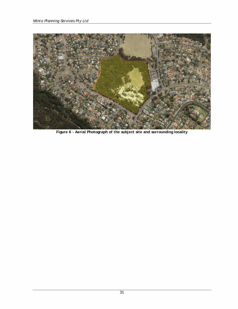
Figure 6 - Aerial Photograph of the subject site and surrounding locality
Minto Planning Services Pty Ltd
32
4. DETAILED DESCRIPTION OF THE PROPOSAL This section provides a detailed description of the proposed development 4.1 Overview The proposal includes the construction of:
1. A new three storey facility adjacent to Ridgecrop Drive which houses:
• New Staff and Administration Offices (including Staff Toilets) • New Library • 23 new permanent teaching spaces • New entry forecourt with lift to address accessible access to a sloping
site. 2. Alterations to existing Administration Building to convert it to 3 new
home bases. 3. Alterations to the existing Library Building to convert it to 3 new home
bases. 4. New Hall Building with separate entrance for out of school hours and
community use. 5. Removal of 12 demountable teaching spaces and relocation of 1
demountable provided by the Parents & Community Association. 6. Demolition of a number of outdated existing classroom spaces to create a
new circulation axis between the new entry and facilities and the existing campus through to the existing school playing fields.
7. Increase student numbers from 780 to 1000 and staff from 45 to 58. 8. Ancillary Signage to south elevation of Building P, east elevation of
Building Q (Hall) and on the base of the fencing to both Ridgecrop Drive and Gilbert Road.
Minto Planning Services Pty Ltd
33
4.2 Demolition Works The proposal provides for the removal of the majority of the sites existing demountable buildings together with the demolition of part of buildings identified as D & F (excluding the existing toilets which are to be refurbished) as well as Buildings K & J. The removal of buildings D and F allows for the provision of a new central pedestrian access and circulation throughout the school and which will provide access to the existing playing fields. The existing pedestrian access zones from Ridgecrop Drive and Gilbert Road are to be replaced by the new formal entry on Ridgecrop Drive. 4.3 Proposed New Three Storey Building (Buildings N & P) The proposal provides for the construction of a new three storey building comprising of two distinct components (Buildings N & P) separated by a covered entry at ground floor level and covered outdoor learning areas at the first and second floor levels. The buildings are to be erected adjacent to the boundary fronting Ridgecrop Drive and are provided with varying setbacks ranging from 8.6m to 15m for Building N and from 18.774m to 24m for Building P. The proposed setbacks allow for the retention of the existing vegetation located within the southern corner of the site fronting both Ridgecrop Drive and Gilbert Road. The building has a height of 17m measured from existing ground level. The building is to be constructed of a mixture of masonry, corrugated iron cladding, pre-finished CFC cladding, concrete and glass and is a to have a low-pitched metal roof. The building is orientated towards Ridgecrop Drive and provides for a new formal covered entry to the school. The entry incorporates a combination of stairs, graded ramps and a lift and has been designed so as to provide equitable access to the school site and buildings. In addition to providing improved disabled persons access to the entry of the site, the proposal also seeks to provide improved access for disabled persons access for all aspects of the school facility. The western portion of the new building (Building N) comprises a staff room and administration offices and related facilities to the ground floor with the upper levels providing new teaching spaces. The eastern portion of the new building (Building P) comprises a new library to the ground floor with the upper levels also providing new teaching spaces.
Minto Planning Services Pty Ltd
34
4.4 Alterations and Additions to Existing Administration Building (Building A) The existing administration building (Building A) is located to the north of the proposed new building will be refurbished to provide 3 new home bases including storage rooms and withdrawal spaces. All works with this building are contained within the existing building footprint and envelope. 4.5 Alterations to Existing Library (Building B) The existing library building (Building B) is to be refurbished to provide for an additional new 3 home bases with storage rooms and withdrawal areas. All works within this building are contained within the existing building footprint and envelope. 4.6 New Hall & OOSH Building (Building Q) A new building is to be constructed to the north of proposed Building Q and is provided with a setback of 13.796m to Gilbert Road. The building is to be single storey and is to be constructed of pre-cast concrete panels with a low-pitched metal roof. The building comprises a main enclosed hall area with stage, amenities, storage rooms and kitchen. Immediately to the west of the Hall is a new Covered Outdoor Learning Area which is located under the same roof plane as the hall and which can be linked with the hall by the opening of large panel lift doors located within the western elevation of the hall. Adjoining the hall building to the east is a proposed Out of School Hours Care Facility (OOSH). 4.7 Student Numbers The existing student population is proposed to be increased from 780 to 1000. The school currently provides for the equivalent of 45 full time staff which will be increased to 58 staff as part of this application. 4.8 Civil Works The woks will include the upgrading of the existing stormwater system. As detailed in the plans prepared by Henry & Hymas the proposal will provide for a new on-site detention tank to be located immediately to the north of the proposed library building. All collected stormwater will then ultimately discharge to the existing drainage infrastructure located in Ridgecrop Drive.
Minto Planning Services Pty Ltd
35
4.9 Car Parking The site currently provides for 26 formal off-street parking spaces. There is no change proposed to the existing parking space or the vehicular access to the site. It is noted that in order to offset the parking shortfall proposed by this application reference is made to the Traffic & Transport Impact Assessment Report (Appendix K) and the proposed Green Travel Plan and Operational Traffic & Pedestrian Management Plan. 4.10 Signage The proposal provides for new identification signage on Buildings P and Q and along the street frontage fencing. The signage to Building P is proposed on the southern elevation and centred on the lift shaft and adjacent to the main pedestrian entry from Ridgecrop Drive. This sign is a wall sign that will be illuminated from a soffit mounted light. The proposal also provides for signage on the eastern elevation of Building Q (the hall). The sign is a wall sign and will be positioned towards the southern end of this elevation and is located below the eave height and above the main entry to the hall from Gilbert Road. This sign is to be illuminated from a soffit mounted light. The proposal also provides for signage adjacent to the main pedestrian entry points from both Ridgecrop Drive and Gilbert Road. These wall signs are attached to the low masonry boundary wall and are not illuminated. An assessment of the proposal against the requirements of SEPP No. 64 - Advertising and Signage is included at Section 6.1.8 of this report. 4.11 Construction Phasing The proposed order of works and staging for the project is as follows –
Stage 1 – Temporary School and Establishment Works (Subject to a separate approval) This includes the following works:
• 8 of the existing demountables on the site will be relocated from the South-Eastern corner of the site (from within the proposed construction zone) onto the playing field to create a temporary school as part of a separate approval process.
Minto Planning Services Pty Ltd
36
• A new, temporary entrance path is created from Ridgecrop Drive to
the Administration Building to maintain access during the construction period.
• Services works are undertaken in order to create temporary services connections in order to maintain power, data and other services connections to the site.
Stage 2 – New Buildings – Buildings N, P and Q This includes the following works:
• Construction of the new buildings – N, P and Q Stage 3 – Refurbishment Works – Buildings A and E This stage occurs following the occupation of Buildings N, P and Q and includes the following works:
• Refurbishment of Buildings A and E • Demolition of existing Buildings D and F • Landscaping works in order to create the ‘Concourse’ area
Following completion and occupation of Stage 3 of the works the remaining demountable buildings are to be removed from the site.
Minto Planning Services Pty Ltd
37
5. CONSULTATION 5.1 General A consultation process has occurred throughout the development of the current design and will continue as the assessment of the application progresses as well as throughout the entire development project. The purpose of the consultation process to date has been to inform and seek feedback from key stakeholders. The key stakeholders with which consultation has occurred to date are:
• The Hills Shire Council • Government Architect NSW (via the NSW State Design Review Panel Process) • Roads and Maritime Services • Transport for NSW • NSW Rural Fire Service • Community Consultation • Special Interest Group Consultation
5.2 The Hills Shire Council A Pre-Lodgement Meeting was held with The Hills Shire Council on the 27th July 2018. A copy of the Minutes of that meeting are included at Appendix BB of this report. The key issues identified by the Council as part of that meeting were:
• State Environmental Planning Policy (Educational Establishments and Child Care Facilities) 2017 – The proposal is required to demonstrate compliance with Clause 35 and Schedule 4 of the SEPP.
Comment A detailed assessment of the proposal against the requirements of the SEPP is contained at Section 6.1.5 of this report. The proposal is considered to achieve compliance with the SEPP.
• Height – The proposal exceeds the 9.0m height control of The Hills LEP and
is required to be supported by a well-founded Clause 4.6 variation.
Comment The proposal will result in a maximum building height of 17m.
Minto Planning Services Pty Ltd
38
Pursuant to Clause 42 of the SEPP it is noted that:
Development consent may be granted for development for the purpose of a school that is State significant development even though the development would contravene a development standard imposed by this or any other environmental planning instrument under which the consent is granted.
As discussed at Sections 6.1.5 & 6.4 of this report the proposed building height is considered to be acceptable in the circumstances of this case and is worthy of support.
• Visual & Acoustic Amenity – Consideration to be given the impacts to the
adjoining residential dwellings to the southern side of Ridgecrop Drive.
Comment The issue of the appearance of the development from Ridgecrop Drive is discussed at Section 6.4 of this report.
• NSW RMS – Any Development Application will require concurrence from the
NSW Roads and Maritime Services.
Comment Pursuant to Clause 104 of SEPP (infrastructure) 2007 there is a requirement of the consent authority to give notice of the Application and to take into consideration any comments of the RMS. Notwithstanding this requirement, the applicant has been liaising with the RMS during the preparation of this application. TSA have advised by way of correspondence dated 27th September 2018 (Appendix K) the following in relation to consultation that they have participated in: Formal meeting with Roads and Maritime Services (RMS) and representatives
from Mace and Fulton Trotter Architects on 15 May 2018, where issues relating to traffic on the surrounding road network in the immediate vicinity of the school site was discussed;
Minto Planning Services Pty Ltd
39
• Car Parking – The proposal does not seek to increase on site parking spaces
but relies on the existing 26 car spaces currently on site. It was recommended that an additional 30 car spaces be provided.
Comment The issue of car parking is discussed within the Traffic & Transport Impact Statement prepared by TSA and which is included as Appendix K to this report.
• Section 7.12 Contributions – Contributions are applicable as per The Hills
Section 94A Contributions Plan.
Comment The Hills Section 94A Contributions Plan ordinarily applies to the subject site. Relevant to the subject application the Plan would require the payment of a levy equal to 1% of the proposed cost of the development. The Plan contains a number of exceptions to the Plan however none of those exceptions are considered to be relevant to the proposal. • Environmental Health – Concern was raised regarding generation of dust
during the construction given the locality of the proposed site and proximity to residents.
Comment It is advised that a Plan detailing measures and procedures to minimise and manage the generation and off-site transmission of sediment, dust and fine particles has been prepared by Henry & Hymas and is included at Appendix E of this report.
• Engineering Comments: An upgrade to the drainage and OSD will be required
and the applicant was encouraged to consider the use of rain water tanks.
Comment A Stormwater Management Strategy has been developed for the site by Henry & Hymas and is included at Appendix E & R to this application.
Minto Planning Services Pty Ltd
40
• Traffic Comments: An additional 30 car parking spaces is recommended to
cater for the increase in the number of students to 1000. A Plan of Management is to be developed for the kiss & drop area. Council was to consult with school P & C and NSW Police to investigate removal of the ‘No Parking 8-9:30am’ to determine a solution for vehicles blocking Ridgecrop Drive at pick up and drop off times.
Comment The issue of car parking is discussed within the Traffic & Transport Impact Statement prepared by TSA and which is included as Appendix K to this report.
• Environment & Ecology: Council’s mapping identifies the site as containing
Shale/Sandstone Transition Forest and Sandstone Heath and the proposal should address the relevant provisions under the Biodiversity Conservation Act 2016.
Comment A Biodiversity Assessment Report has been prepared by Travers Bushfire & Ecology and is included at Appendix I to this report.
5.3 Government Architect NSW (via the NSW State Design Review Panel
Process) Mace Group and Fulton Trotter Architects met with the Office of the Government Architects and the Department of Planning on Tuesday the 27th March 2018 to review the initial concept plans for the project prior to a Sears Application being lodged. An overview of the project was provided to and general comments and feedback were received from representatives of the Office of the Government Architects. A pre-briefing session was then held ahead of the State Design Review Panel (SDRP) presentation for the project to review the developed design and provide comments and feedback about what should be presented at the SDRP. The SDRP for SGPS took place on the 10th October 2018. The comments of the SDRP are contained within Appendix BB of this report. A formal response to the comments of the SDRP has been prepared by the Architects and is included within their Architectural Design Report (Appendix D).
Minto Planning Services Pty Ltd
41
5.4 Roads and Maritime Services TSA have advised by way of correspondence dated 27th September 2018 (Appendix BB) the following in relation to consultation that they have participated in: Formal meeting with Roads and Maritime Services (RMS) and representatives
from Mace and Fulton Trotter Architects on 15 May 2018, where issues relating to traffic on the surrounding road network in the immediate vicinity of the school site was discussed;
• Formal meeting with Cumberland Council and representatives from Mace, Minto
Planning Services, Department of Education (NSW) and Fulton Trotter Architects on 23 July 2018, where traffic and parking matters was one of many issues discussed; and
• We endeavoured to contact Transport for NSW on a number of occasions
regarding school bus routes. Information on these services was eventually obtained through liaisons with the school bus operator (i.e. Hillsbus).
5.5 Transport for NSW Refer to comments above. 5.6 NSW Rural Fire Service Consultation with the NSW Rural Fire Service is detailed at Section 1.6 of the Bushfire Protection Assessment Report prepared by Australian Bushfire Protection Planners (Appendix J) and states:
An email copy of the Bushfire Protection Assessment Report prepared by ABPP was forwarded to the NSW Rural Fire Service on the 2nd October 2018. An email response was received on the 3rd October 2018 and follow-up telephone confirmed that the RFS will respond directly to the Departments (formal) request.
5.7 Community Consultation Consultation with the community has been undertaken in a number of forms. Extensive consultation has been undertaken with the school community (teachers, students and parents) as part of developing the design. These consultations are outlined in the Consultation Schedule prepared by Fulton Trotter Architects (Appendix BB). Further to this, a number of Information Booth sessions have been undertaken by Mace Group to engage with the wider community around the school. Details of these sessions are provided in the Communication and Consultation Report prepared by Mace Group. (Appendix BB).
Minto Planning Services Pty Ltd
42
5.8 Special Interest Group Consultation It is advised that as part of the preparation of the Aboriginal Cultural Heritage Assessment Report by Cultural Heritage connections that an extensive consultation process was undertaken with a total of 17 Registered Aboriginal Parties. Details and feedback following that consultation report is contained within the Aboriginal Cultural Heritage Assessment Report (Appendix CC).
Minto Planning Services Pty Ltd
43
6. ENVIRONMENTAL IMPACT ASSESSMENT This section provides an environmental assessment of the proposed development in respect of relevant State policies and matters for consideration under the Environmental Planning & Assessment Act. This section also describes in detail how the Key Issues identified in the SEARs have been assessed, and how any potential impacts have been avoided, minimised or offset. 6.1 Statutory & Strategic Context 6.1.1 Environmental Planning & Assessment Act, 1979 The EP&A Act provides, the legislative framework for the assessment and approval of development in NSW. In accordance with Division 4.7 of Part 4 of the EP&A Act, this Environmental Impact Statement has been prepared in to address both the Secretary’s Environmental Assessment Requirements and the general provisions of Schedule 2 of the EP&A Regulations. Section 1.7 sets out matters which must be considered in deciding whether a proposed development is likely to have a significant effect on threatened species, populations or ecological communities, or their habitats. The site does in part contain areas of Sydney Turpentine Ironbark Forest (STIF). An assessment of significance test in accordance with Section 7.3 of the BC Act concluded that the proposed development will not have a significant effect on any threatened species, endangered communities, or their habitat. Therefore, a species impact statement is not required for the proposed activity. On this basis the proposal is considered to satisfy Section 1.7 of the Act. 6.1.2 Environmental Planning & Assessment Regulation 2000 This EIS has addressed the specific criteria within Clauses 6 and 7 of Schedule 2 of the EP&A Regulation including the principles of ecologically sustainable development in Section 7. As required by Clause 7(1)(d)(v) of Schedule 2 of the Regulations, an approval is also required in order to permit the proposed development to occur.
Minto Planning Services Pty Ltd
44
The additional approval required under other legislation for the proposal is set out below.
Rural Fires Act 1997 The proposal is identified as a “Special Fire Protection Purpose” under the provisions of the Rural Fires Act and pursuant to Section 100B of the Act requires the issuing of a Bushfire Safety Authority by the NSW Rural Fire Service. A Bushfire Protection Assessment has been prepared in support of this requirement by Australian Bushfire Protection Planners and is included as Appendix K to this report. A discussion regarding the issue of bushfire safety is included at Section 6.19 of this report.
Regulation 94 Request
Reference is also made to the accompanying Building Code of Australia Report (Appendix M). That report states that:
“The proposed work involves the conversion of the existing Staff/Admin Building (Class 5 Building) into a Home Base Building (Class 9b Building). As this change in classification is proposed, the building needs to comply with all requirements of the current BCA. This can be quite an onerous task to upgrade an existing building and a concession request to Consent Authority under Clause 94 of the EP&A Reg should be considered. This report will need to be included as part of the Development Application submission to the Consent Authority to request that they take into consideration whether it would be appropriate to only partially conform with the currently enforced BCA, as per the advice provided in the report.”
Pursuant to Regulation and the BCA Report the applicable concession is sought as part of this application.

Minto Planning Services Pty Ltd
45
6.1.3 Biodiversity Conservation Act 2016 A Biodiversity Assessment Report has been prepared by Travers Bushfire & Ecology (Appendix I) in accordance with the Biodiversity Conservation Act 2016. The study area included the existing Samuel Gilbert Public School Grounds, adjoining day care centre, shops, car park and the Castle Glen Centre and Playground. The ecological survey and assessment have been undertaken in accordance with relevant legislation including the Environmental Planning and Assessment Act 1979, the Biodiversity Conservation Act 2016, the Environment Protection and Biodiversity Conservation Act 1999 and the Fisheries Management Act 1994. The report notes that 6 state listed threatened fauna species, one EEC (Endangered Ecological Community) – Sydney Turpentine Ironbark Forest and one CEEC (Critically Endangered Ecological Community) – Turpentine-Ironbark Forest of the Sydney Basin Bioregion were recorded in the Study Area. The report noted the potential ecological impacts as follows:
The potential direct impacts of the proposal within the subject site are considered as:
• Potential removal/modification of 0.01ha of Sydney Turpentine-Ironbark Forest EEC
• Removal/modification of 0.12ha of Sandstone Ridgetop Woodland • Subsequent removal of threatened fauna species foraging habitat • Removal of at least one (1) and perhaps two (2) small hollows.
The potential indirect impacts of the proposal are considered as:
• Further edge to width effect on the remaining remnant including reduced arboreal connectivity and foraging for arboreal mammals.
• Reduced areas of island vegetation for cross-site movements by small bird species such as passerines.
• Edge effects such as weed incursions caused from soil disturbance, repeated clearing and landscaping species becoming a nuisance in the adjacent remnant bushland.
The potential cumulative impacts (combined results of past, current and future activities) of the proposal are considered as:
• Increased risk of weed invasion and fungal mobilisation or infections • Cumulative loss of Sandstone Ridgetop Woodland within the locality • Cumulative loss of Turpentine-Ironbark Forest (STIF) within the locality

Minto Planning Services Pty Ltd
46
The report provided a detailed list of recommendations made to avoid, minimise or ameliorate the potential identified ecological impacts, address threatening processes and to create a positive ecological outcome for threatened species and their associated habitats. These recommendations which are summarised as follows, will be incorporated into the development:
• Removal of any portion of the Turpentine Ironbark Forest may constitute a SAII upon the candidate listed STIF. Development has generally avoided 97% of the extent within the site. It is recommended that the area of STIF be protected by permanent fencing or other demarcation measures, with temporary fencing.
• It is recommended that a Vegetation Management Plan (VMP) be prepared to identify the ongoing management of retained habitat resources, weeds, future landscaping and site works to retain mature trees and habitat movement corridors.
• Landscaping within the property is to use locally occurring (endemic) native species commensurate with STIF.
• Target weed control is to be undertaken within 10m of any works to control the invasion or spread of invasive environmental weed species.
• Standard Phytophthora cinnamomi protocol applies to the cleaning of all plant, equipment, hand tools and work boots prior to delivery onsite to ensure that there is no loose soil or vegetation material caught under or on the equipment and within the tread of vehicle tyres. Any equipment onsite found to contain soil or vegetation material is to be cleaned in a quarantined work area or wash station and treated with anti-fungal herbicides.
• Erosion control measures are to be in place to reduce temporary erosion and sedimentation risks to adjacent TEC vegetation.
• All areas containing natural habitat features which have been identified for retention are to be protected with fencing prior to construction.
• Hollow-bearing trees are to be clearly marked prior to clearing. Where the felling of hollow-bearing trees is required, this is to be conducted under the supervision of a fauna ecologist to ensure appropriate animal welfare procedures are taken, particularly for threatened species. Hollows of high quality or with fauna recorded residing within should be sectionally dismantled for relocation and all hollows should be inspected for occupation, signs of previous activity and potential for reuse.
• If a threatened species is found to be occupying the hollow then the hollow section is to be reattached to a recipient tree within the nearby conservation areas as selected and directed by the fauna ecologist. The welfare and temporary holding of the residing animal(s) is at the discretion of the fauna ecologist. The hollow section should be well secured in the recipient tree in a manner that will not compromise the current or future health of that tree.
Minto Planning Services Pty Ltd
47
• Given the recording of subterranean threatened microbat species it is
recommended that that if any fauna species, a nest or roost is located during development works, then works should cease until safe relocation can be advised by a fauna ecologist.
• Pathways within STIF are to be avoided, and where not possible to redirect, be constructed to minimise root damage
• The ground surrounding all STIF trees are to be protected with fencing for the combined tree protection zones to minimise compaction
• Revegetation of native understorey commensurate with STIF is to be undertaken to achieve a maximum of 15% by cover for APZ compliance
Biodiversity Offsets Scheme (BOS) – Threshold Assessment Section 7.14 (State significant development or infrastructure), clause 4, of the BC Act states:
“A condition to retire biodiversity credits is required to be complied with before any development is carried out that would impact on biodiversity values.”
The proposed development is a state significant development that impacts on biodiversity values. Under Section 7.14 of the BC Act, state significant developments are required to enter the Biodiversity Offsets Scheme (BOS). Therefore, biodiversity offsets are required under the BOS.
The report concludes that a credit payment of $77,239.26 is applicable to the development. On the basis of the findings and recommendations of the Biodiversity Assessment Report it is not considered that the proposal will result in any unreasonable ecological impacts and satisfies the requirements of the Biodiversity Conservation Act.
Minto Planning Services Pty Ltd
48
6.1.4 SEPP (State & Regional Development) 2011 In accordance with Clause 15 of Schedule 1 of State Environmental Planning Policy (State and Regional Development) 2011 the proposal is considered to be State Significant Development as it seeks approval for alterations and additions to an existing school (Educational Establishment) with a Capital investment Value of more than $20 million. As outlined in the Quantity Surveyor Report prepared by Altus Group the proposed development has a CIV of greater than $20 million. Clause 11 of the SEPP outlines that DCPs (whether made before or after the commencement of the SEPP) do not apply to State Significant Development. The consent authority for the subject application will be the Department of Planning & Environment. 6.1.5 SEPP (Educational Establishments & Child Care Centres) 2017 The SEPP applies to development for the purpose of an Educational Establishment. The existing use of the site is defined as an educational establishment which means a building or place used for education (including teaching). Part 4 of the SEPP relates specifically to Schools. The subject site is zoned R2 Low Density Residential which is identified as a ‘prescribed zone’ under Clause 33 of the SEPP. Clause 35(1) permits the development for the purposes of a school on land within the prescribed zone. Therefore, the proposal which seeks approval for the carrying out of alterations and additions to an existing school is permissible with consent. Sub-clause 35(6) of the SEPP states:
Before determining a development application for development of a kind referred to in subclause (1), (3) or (5), the consent authority must take into consideration:
(a) the design quality of the development when evaluated in accordance with the design quality principles set out in Schedule 4, and
(b) whether the development enables the use of school facilities (including recreational facilities) to be shared with the community.
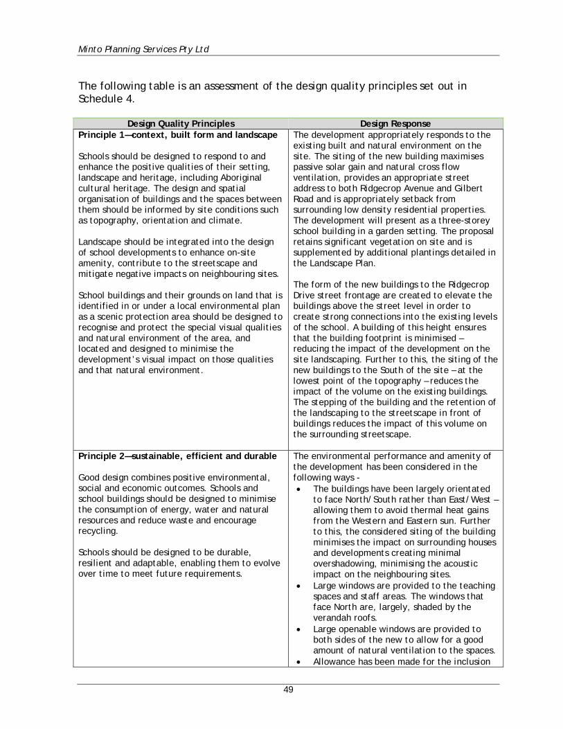
Minto Planning Services Pty Ltd
49
The following table is an assessment of the design quality principles set out in Schedule 4.
Design Quality Principles Design Response Principle 1—context, built form and landscape Schools should be designed to respond to and enhance the positive qualities of their setting, landscape and heritage, including Aboriginal cultural heritage. The design and spatial organisation of buildings and the spaces between them should be informed by site conditions such as topography, orientation and climate. Landscape should be integrated into the design of school developments to enhance on-site amenity, contribute to the streetscape and mitigate negative impacts on neighbouring sites. School buildings and their grounds on land that is identified in or under a local environmental plan as a scenic protection area should be designed to recognise and protect the special visual qualities and natural environment of the area, and located and designed to minimise the development’s visual impact on those qualities and that natural environment.
The development appropriately responds to the existing built and natural environment on the site. The siting of the new building maximises passive solar gain and natural cross flow ventilation, provides an appropriate street address to both Ridgecrop Avenue and Gilbert Road and is appropriately setback from surrounding low density residential properties. The development will present as a three-storey school building in a garden setting. The proposal retains significant vegetation on site and is supplemented by additional plantings detailed in the Landscape Plan. The form of the new buildings to the Ridgecrop Drive street frontage are created to elevate the buildings above the street level in order to create strong connections into the existing levels of the school. A building of this height ensures that the building footprint is minimised – reducing the impact of the development on the site landscaping. Further to this, the siting of the new buildings to the South of the site – at the lowest point of the topography – reduces the impact of the volume on the existing buildings. The stepping of the building and the retention of the landscaping to the streetscape in front of buildings reduces the impact of this volume on the surrounding streetscape.
Principle 2—sustainable, efficient and durable Good design combines positive environmental, social and economic outcomes. Schools and school buildings should be designed to minimise the consumption of energy, water and natural resources and reduce waste and encourage recycling. Schools should be designed to be durable, resilient and adaptable, enabling them to evolve over time to meet future requirements.
The environmental performance and amenity of the development has been considered in the following ways - • The buildings have been largely orientated
to face North/South rather than East/West – allowing them to avoid thermal heat gains from the Western and Eastern sun. Further to this, the considered siting of the building minimises the impact on surrounding houses and developments creating minimal overshadowing, minimising the acoustic impact on the neighbouring sites.
• Large windows are provided to the teaching spaces and staff areas. The windows that face North are, largely, shaded by the verandah roofs.
• Large openable windows are provided to both sides of the new to allow for a good amount of natural ventilation to the spaces.
• Allowance has been made for the inclusion
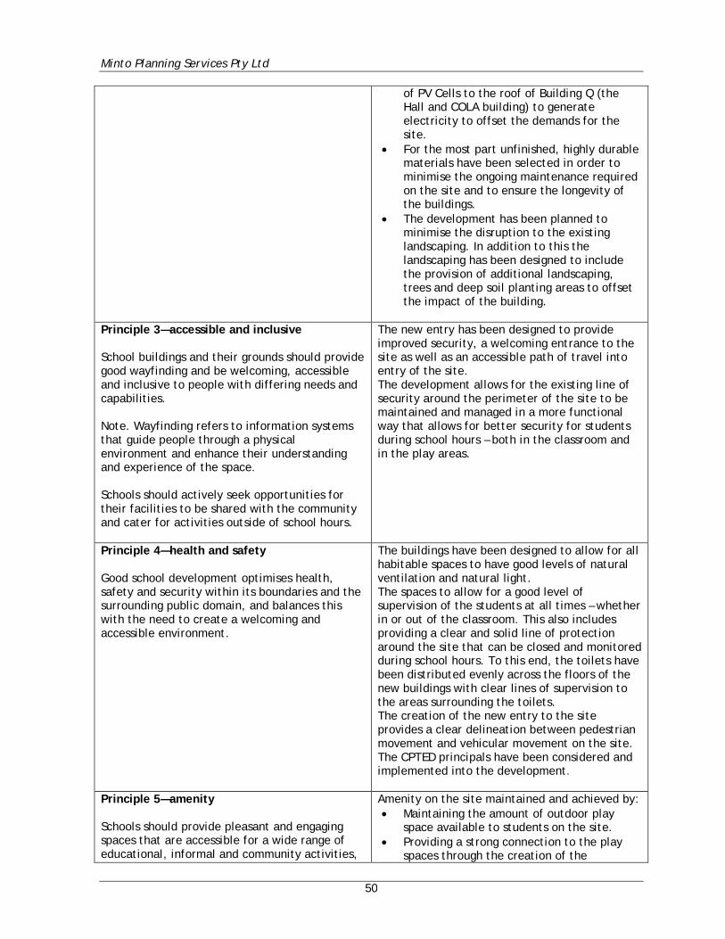
Minto Planning Services Pty Ltd
50
of PV Cells to the roof of Building Q (the Hall and COLA building) to generate electricity to offset the demands for the site.
• For the most part unfinished, highly durable materials have been selected in order to minimise the ongoing maintenance required on the site and to ensure the longevity of the buildings.
• The development has been planned to minimise the disruption to the existing landscaping. In addition to this the landscaping has been designed to include the provision of additional landscaping, trees and deep soil planting areas to offset the impact of the building.
Principle 3—accessible and inclusive School buildings and their grounds should provide good wayfinding and be welcoming, accessible and inclusive to people with differing needs and capabilities. Note. Wayfinding refers to information systems that guide people through a physical environment and enhance their understanding and experience of the space. Schools should actively seek opportunities for their facilities to be shared with the community and cater for activities outside of school hours.
The new entry has been designed to provide improved security, a welcoming entrance to the site as well as an accessible path of travel into entry of the site. The development allows for the existing line of security around the perimeter of the site to be maintained and managed in a more functional way that allows for better security for students during school hours – both in the classroom and in the play areas.
Principle 4—health and safety Good school development optimises health, safety and security within its boundaries and the surrounding public domain, and balances this with the need to create a welcoming and accessible environment.
The buildings have been designed to allow for all habitable spaces to have good levels of natural ventilation and natural light. The spaces to allow for a good level of supervision of the students at all times – whether in or out of the classroom. This also includes providing a clear and solid line of protection around the site that can be closed and monitored during school hours. To this end, the toilets have been distributed evenly across the floors of the new buildings with clear lines of supervision to the areas surrounding the toilets. The creation of the new entry to the site provides a clear delineation between pedestrian movement and vehicular movement on the site. The CPTED principals have been considered and implemented into the development.
Principle 5—amenity Schools should provide pleasant and engaging spaces that are accessible for a wide range of educational, informal and community activities,
Amenity on the site maintained and achieved by: • Maintaining the amount of outdoor play
space available to students on the site. • Providing a strong connection to the play
spaces through the creation of the
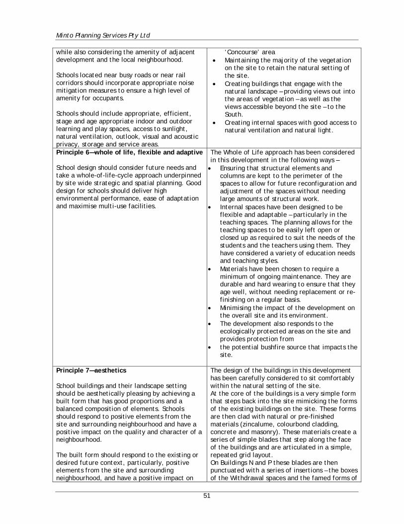
Minto Planning Services Pty Ltd
51
while also considering the amenity of adjacent development and the local neighbourhood. Schools located near busy roads or near rail corridors should incorporate appropriate noise mitigation measures to ensure a high level of amenity for occupants. Schools should include appropriate, efficient, stage and age appropriate indoor and outdoor learning and play spaces, access to sunlight, natural ventilation, outlook, visual and acoustic privacy, storage and service areas.
‘Concourse’ area • Maintaining the majority of the vegetation
on the site to retain the natural setting of the site.
• Creating buildings that engage with the natural landscape – providing views out into the areas of vegetation – as well as the views accessible beyond the site – to the South.
• Creating internal spaces with good access to natural ventilation and natural light.
Principle 6—whole of life, flexible and adaptive School design should consider future needs and take a whole-of-life-cycle approach underpinned by site wide strategic and spatial planning. Good design for schools should deliver high environmental performance, ease of adaptation and maximise multi-use facilities.
The Whole of Life approach has been considered in this development in the following ways – • Ensuring that structural elements and
columns are kept to the perimeter of the spaces to allow for future reconfiguration and adjustment of the spaces without needing large amounts of structural work.
• Internal spaces have been designed to be flexible and adaptable – particularly in the teaching spaces. The planning allows for the teaching spaces to be easily left open or closed up as required to suit the needs of the students and the teachers using them. They have considered a variety of education needs and teaching styles.
• Materials have been chosen to require a minimum of ongoing maintenance. They are durable and hard wearing to ensure that they age well, without needing replacement or re-finishing on a regular basis.
• Minimising the impact of the development on the overall site and its environment.
• The development also responds to the ecologically protected areas on the site and provides protection from
• the potential bushfire source that impacts the site.
Principle 7—aesthetics School buildings and their landscape setting should be aesthetically pleasing by achieving a built form that has good proportions and a balanced composition of elements. Schools should respond to positive elements from the site and surrounding neighbourhood and have a positive impact on the quality and character of a neighbourhood. The built form should respond to the existing or desired future context, particularly, positive elements from the site and surrounding neighbourhood, and have a positive impact on
The design of the buildings in this development has been carefully considered to sit comfortably within the natural setting of the site. At the core of the buildings is a very simple form that steps back into the site mimicking the forms of the existing buildings on the site. These forms are then clad with natural or pre-finished materials (zincalume, colourbond cladding, concrete and masonry). These materials create a series of simple blades that step along the face of the buildings and are articulated in a simple, repeated grid layout. On Buildings N and P these blades are then punctuated with a series of insertions – the boxes of the Withdrawal spaces and the famed forms of
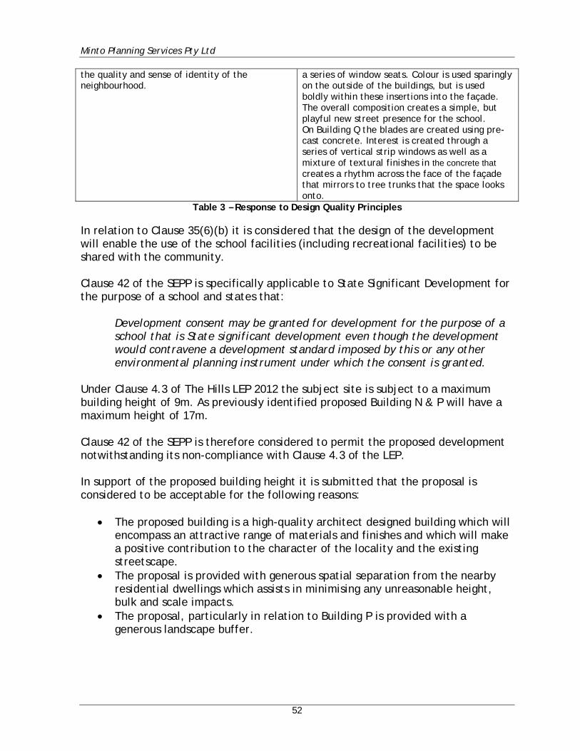
Minto Planning Services Pty Ltd
52
the quality and sense of identity of the neighbourhood.
a series of window seats. Colour is used sparingly on the outside of the buildings, but is used boldly within these insertions into the façade. The overall composition creates a simple, but playful new street presence for the school. On Building Q the blades are created using pre-cast concrete. Interest is created through a series of vertical strip windows as well as a mixture of textural finishes in the concrete that creates a rhythm across the face of the façade that mirrors to tree trunks that the space looks onto.
Table 3 – Response to Design Quality Principles
In relation to Clause 35(6)(b) it is considered that the design of the development will enable the use of the school facilities (including recreational facilities) to be shared with the community. Clause 42 of the SEPP is specifically applicable to State Significant Development for the purpose of a school and states that:
Development consent may be granted for development for the purpose of a school that is State significant development even though the development would contravene a development standard imposed by this or any other environmental planning instrument under which the consent is granted.
Under Clause 4.3 of The Hills LEP 2012 the subject site is subject to a maximum building height of 9m. As previously identified proposed Building N & P will have a maximum height of 17m. Clause 42 of the SEPP is therefore considered to permit the proposed development notwithstanding its non-compliance with Clause 4.3 of the LEP. In support of the proposed building height it is submitted that the proposal is considered to be acceptable for the following reasons:
• The proposed building is a high-quality architect designed building which will encompass an attractive range of materials and finishes and which will make a positive contribution to the character of the locality and the existing streetscape.
• The proposal is provided with generous spatial separation from the nearby residential dwellings which assists in minimising any unreasonable height, bulk and scale impacts.
• The proposal, particularly in relation to Building P is provided with a generous landscape buffer.
Minto Planning Services Pty Ltd
53
It is also considered that the additional building height provides the following benefits:
• The increased building height allows for the provision of a reduced building footprint which in turn assists in minimising impacts upon existing trees and critically endangered ecological communities.
• The increased building height allows for the provision of a reduced building footprint which assists in maximising outdoor play areas.
• The reduced building footprint also allows for the provision of an increased Asset Protection Zone from the subject hazard.
• The increased building height allows for the provision of a primary building within which a large number of students can be located as well as support services therefore minimising the need for a decentralised school community.
On the basis of the above the proposal is considered to be compliant with the requirements of SEPP (Educational Establishments & Child Care Centres) 2017. 6.1.6 SEPP No.55 – Remediation of Land Clause 7 of SEPP 55 provides:
(1) A consent authority must not consent to the carrying out of any development on land unless:
(a) it has considered whether the land is contaminated, and (b) if the land is contaminated, it is satisfied that the land is suitable in its
contaminated state (or will be suitable, after remediation) for the purpose for which the development is proposed to be carried out, and
(c) if the land requires remediation to be made suitable for the purpose for which the development is proposed to be carried out, it is satisfied that the land will be remediated before the land is used for that purpose.
A Preliminary Site Investigation (PSI) and Detailed Site Investigation (DSI) has been prepared by Mr Beejal Patel of WSP to determine the current contamination status of soil beneath the site. The stated objectives of the investigation were to:
• assess the current contamination status of the site, with respect to soil contamination, within the identified design footprint to meet the requirements of the SSD
• assess the potential risks associated with contamination at the site (if identified), with respect to demonstrating the site’s suitability for proposed use in accordance with the SSD.
Minto Planning Services Pty Ltd
54
The study comprised a desktop review of current and historical available information and soil investigations at 20 locations, including 11 test pit locations and hand augering at 9 locations, and analysis of selected soil samples for contaminants of concern. In summary, the reports concluded:
Concentrations of TRH C16-C34 were reported in some primary samples (HA03-0.1, HA03-0.9 and HA04-0.1) marginally above the PQL and accompanied by low PID readings. Concentrations were not considered to be significant and were generally below the adopted site criteria, although one result exceeded the ecological criteria. All results for BTEXN and PAHs were below the laboratory PQLs. Concentrations of some heavy metals were reported in soil samples for the site, with results generally consistent between locations and were reported below the adopted site criteria. No asbestos was observed in soil during the on-site work or detected by the laboratory in soil samples submitted for analysis. The results of the investigation indicate the identified design footprint at the school is suitable for development and future use as a primary school under the SSD.
There are no mitigation measures or recommendations proposed. On the basis of the above the proposal is considered to satisfy the requirements of SEPP No.55 - Remediation of Land. 6.1.7 Draft SEPP (Remediation of Land) The Draft SEPP was exhibited between 25 January 2018 and 14 April 2018 by the Department of Planning and Environment. As the PSI and DSI Reports prepared by Mr Beejal Patel of WSP did not identify any contaminants that required remediation it is considered that there are no provisions of the Draft SEPP that would be applicable to the proposal.
Minto Planning Services Pty Ltd
55
6.1.8 SEPP No. 64 – Advertising and Signage The proposal provides for new ancillary school and building identification signage and therefore the provisions of SEPP 64 apply. Clause 13 of the SEPP requires:
(2) If the Minister for Planning is the consent authority or clause 18 or 24 applies to the case, the consent authority must not grant consent to an application to display an advertisement to which this Policy applies unless the advertisement or the advertising structure, as the case requires:
(a) is consistent with the objectives of this Policy as set out in clause 3 (1)
(a), and (b) has been assessed by the consent authority in accordance with the
assessment criteria in Schedule 1 and in the Guidelines and the consent authority is satisfied that the proposal is acceptable in terms of: (i) design, and (ii) road safety, and (iii) the public benefits to be provided in connection with the display of
the advertisement, and (c) satisfies any other relevant requirements of this Policy.
It is considered that the proposal is consistent with the objectives of the Policy (Clause 3 (1)(a)) as the signage provides effective communication that is of a high-quality design and finish. The signage does not detract from the residential character of the locality and as such is compatible with the desired amenity and visual character of the area. The following provides for an assessment of the proposed signage against the requirements of Schedule 1 of the SEPP. Schedule 1 – Assessment Criteria Schedule 1 of the SEPP provides the Matters for Consideration and Assessment Criteria for advertising signs. This Schedule is summarised below: 1 Character of the area
• Is the proposal compatible with the existing or desired future character of the area or locality in which it is proposed to be located?
• Is the proposal consistent with a particular theme for outdoor advertising in the area or locality?
Comment: It is considered that the proposed signage is consistent with the existing and desired future character for the area. Whilst the subject site is located within a
Minto Planning Services Pty Ltd
56
residential locality it is located immediately adjacent to a local neighbourhood shopping centre with a range of signage structures. The proposed signage which provides for the clear identification of the site and the proposed buildings will not detract from the residential character of the locality and is considered to positively contribute to the existing streetscape. 2 Special areas
• Does the proposal detract from the amenity or visual quality of any environmentally sensitive areas, heritage areas, natural or other conservation areas, open space areas, waterways, rural landscapes or residential areas?
Comment: The building is not identified as a heritage item and is not located within a heritage conservation area. The signage will not have any significant impact on any residential zoned land or open space areas. 3 Views and vistas
• Does the proposal obscure or compromise important views? • Does the proposal dominate the skyline and reduce the quality of vistas? • Does the proposal respect the viewing rights of other advertisers?
Comment: The proposed signage is not considered to impede on any existing important views or vistas and is not considered to dominate the skyline. Further the proposal provides for wall signage that does not extend above existing or proposed building heights and as such it will not dominate the skyline. 4 Streetscape, setting or landscape
• Is the scale, proportion and form of the proposal appropriate for the streetscape, setting or landscape?
• Does the proposal contribute to the visual interest of the streetscape, setting or landscape?
• Does the proposal reduce clutter by rationalising and simplifying existing advertising?
• Does the proposal screen unsightliness? • Does the proposal protrude above buildings, structures or tree canopies
in the area or locality? Comment: The proposed signage is considered to be appropriate having regard to the scale of the proposed development on site. The proposed signage does not dominate the façade of the building and is considered to complement the existing surrounding streetscape which comprises primarily residential development together with neighbourhood shops which immediately adjoin the site. The signage is considered to be simplistic and minimal.
Minto Planning Services Pty Ltd
57
5 Site and building
• Is the proposal compatible with the scale, proportion and other characteristics of the site or building, or both, on which the proposed signage is to be located?
• Does the proposal respect important features of the site or building, or both?
• Does the proposal show innovation and imagination in its relationship to the site or building, or both?
Comment: The proposed signage is considered to relate well to the characteristics of the buildings and does not detract from any important features of the building or surrounding area. The scale of signage is considered appropriate to the building and the locality. The signage directs people to the main entry points and is clear and concise. 6 Associated devices and logos with advertisements and advertising structures
• Have any safety devices, platforms, lighting devices or logos been designed as an integral part of the signage or structure on which it is to be displayed?
Comment: The proposed signage relates only to the existing school use and does not contain any additional logos. 7 Illumination
• Would illumination result in unacceptable glare? • Would illumination affect safety for pedestrians, vehicles or aircraft? • Would illumination detract from the amenity of any residence or other
form of accommodation? • Can the intensity of the illumination be adjusted, if necessary? • Is the illumination subject to a curfew?
Comment: The proposal incorporates soffit mounted illumination for the proposed wall signs on Block P and Block Q. This lighting is directional and will not detract from the amenity of the surrounding residential properties and will not result in unacceptable glare. The illumination will not affect the safety of pedestrians, vehicles or aircraft.
Minto Planning Services Pty Ltd
58
8 Safety
• Would the proposal reduce the safety for any public road? • Would the proposal reduce the safety for pedestrians or bicyclists? • Would the proposal reduce the safety for pedestrians, particularly
children, by obscuring sightlines from public areas? Comment: It is not considered that the proposed signage will cause any adverse impact or nuisance to road users or pedestrians. The signage does not obscure any important sight lines. The signage is attached to the either the external wall of the proposed buildings or the boundary fencing. As the signs are wall mounted they will not obscure sightlines. There are no other provisions of the SEPP that apply to the proposed development. It is considered that the proposal complies with the requirements and objectives of the SEPP. 6.1.9 Draft SEPP (Environment) The Draft SEPP was exhibited between 31 October 2017 and 31 January 2018 by the Department of Planning and Environment. This SEPP proposes to consolidate the following existing seven SEPP’s:
• State Environmental Planning Policy No. 19 – Bushland in Urban Areas • State Environmental Planning Policy (Sydney Drinking Water Catchment) 2011 • State Environmental Planning Policy No. 50 – Canal Estate Development • Greater Metropolitan Regional Environmental Plan No. 2 – Georges River
Catchment • Sydney Regional Environmental Plan No. 20 – Hawkesbury-Nepean River
(No.2-1997) • Sydney Regional Environmental Plan (Sydney Harbour Catchment) 2005 • Willandra Lakes Regional Environmental Plan No. 1 – World Heritage
Property. Whilst the majority of the subject SEPP’s are not applicable to the proposal it is considered that the assessment of the various issues contained within this report results in an outcome whereby the proposal is consistent with the relevant considerations of the above instruments.
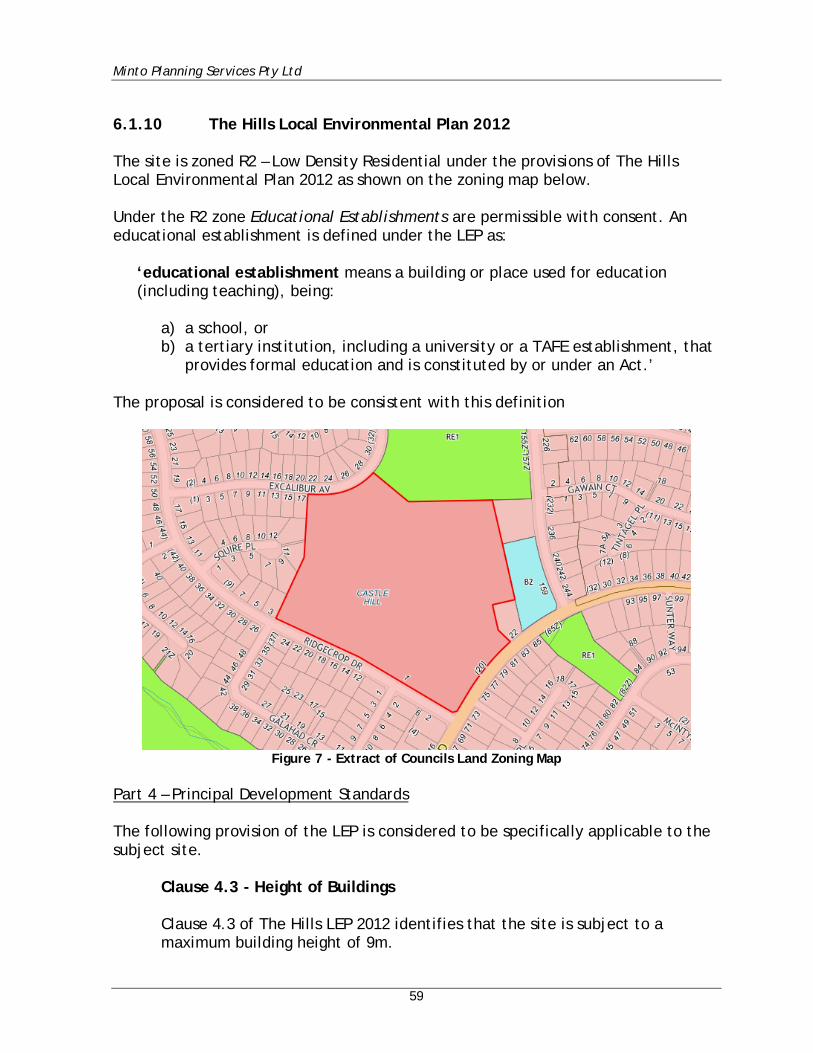
Minto Planning Services Pty Ltd
59
6.1.10 The Hills Local Environmental Plan 2012 The site is zoned R2 – Low Density Residential under the provisions of The Hills Local Environmental Plan 2012 as shown on the zoning map below. Under the R2 zone Educational Establishments are permissible with consent. An educational establishment is defined under the LEP as:
‘educational establishment means a building or place used for education (including teaching), being:
a) a school, or b) a tertiary institution, including a university or a TAFE establishment, that
provides formal education and is constituted by or under an Act.’ The proposal is considered to be consistent with this definition
Figure 7 - Extract of Councils Land Zoning Map
Part 4 – Principal Development Standards The following provision of the LEP is considered to be specifically applicable to the subject site.
Clause 4.3 - Height of Buildings Clause 4.3 of The Hills LEP 2012 identifies that the site is subject to a maximum building height of 9m.
Minto Planning Services Pty Ltd
60
The proposal will result in a maximum building height of 17m. In relation to the proposed non-compliance with Clause 4.3 of the LEP reference is made to Clause 42 of SEPP (Educational Establishments & Child Care Centres) 2017 which starts that:
Development consent may be granted for development for the purpose of a school that is State significant development even though the development would contravene a development standard imposed by this or any other environmental planning instrument under which the consent is granted.
On this basis it is submitted that compliance with Clause 4.3 of the Hills LEP is not required in this instance. The proposed building height is considered to be acceptable in the circumstances of this case for the reasons as set out at Section 6.1.5 of this report.
Part 5 - Miscellaneous provisions & Part 7 - Additional Local Provisions It is considered that all relevant Clauses of Part 5 & 6 of the LEP have been appropriately dealt with in the responses to the SEARs as contained within this report. Clause 7.1 Acid Sulfate Soils – The subject is not identified on Council’s Acid Sulfate Soil map as comprising acid sulfate soils. Therefore, there is no information required in this regard. Planning for Bushfire Protection The subject site is identified as comprising bushfire prone land on Council’s Bushfire Prone Lands Map. Therefore, the provisions of Planning for Bushfire Protection apply to the subject application. A Bushfire Protection Assessment has been prepared in support of this requirement by Australian Bushfire Protection Planners and is included as Appendix J to this report. A discussion regarding the issue of bushfire safety is included at Section 6.19 of this report.
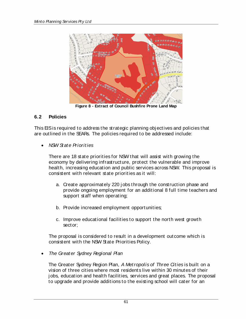
Minto Planning Services Pty Ltd
61
Figure 8 - Extract of Council Bushfire Prone Land Map
6.2 Policies This EIS is required to address the strategic planning objectives and policies that are outlined in the SEARs. The policies required to be addressed include:
• NSW State Priorities There are 18 state priorities for NSW that will assist with growing the economy by delivering infrastructure, protect the vulnerable and improve health, increasing education and public services across NSW. This proposal is consistent with relevant state priorities as it will:
a. Create approximately 220 jobs through the construction phase and provide ongoing employment for an additional 8 full time teachers and support staff when operating;
b. Provide increased employment opportunities;
c. Improve educational facilities to support the north west growth sector;
The proposal is considered to result in a development outcome which is consistent with the NSW State Priorities Policy.
• The Greater Sydney Regional Plan
The Greater Sydney Region Plan, A Metropolis of Three Cities is built on a vision of three cities where most residents live within 30 minutes of their jobs, education and health facilities, services and great places. The proposal to upgrade and provide additions to the existing school will cater for an
Minto Planning Services Pty Ltd
62
additional 220 students (total of 1000 students). This will assist in ensuring children can be educated in close proximity to their place of residence.
• NSW Future Transport Strategy 2056
This strategy has been prepared to ensure that NSW is prepared for rapid changes in technology and innovation to create and maintain a safe, efficient and reliable transport system over the next 40 years. This strategy does not have any impact on the proposed development.
• State Infrastructure Strategy 2018-2038 The strategy sets out the government’s priorities for the next 20 years, and combined with the Future Transport Strategy 2056, the Greater Sydney Region Plan and the Regional Development Framework, brings together infrastructure investment and land-use planning for our cities and regions. The proposed development to upgrade the existing ‘home bases’ is consistent with the key recommendations of the Strategy that relate to education by ‘Progressively upgrade all existing permanent learning spaces to Future Learning environments over the long term’.
• Sydney’s Cycling Future 2013 The Sydney’s Cycling Future 2013 does not apply to the upgrade of existing school facilities and the subject site and locality. Notwithstanding, students of the school will be encouraged and provided with facilities to assist with riding bicycles to the school.
• Sydney’s Walking Future 2013 The NSW Government’s goal is to get people in Sydney walking more through actions that make it a more convenient, better connected and safer mode of transport. The more people walk, the more socially engaged the community becomes and the safer people feel when walking for transport. The actions set out in Sydney’s Walking Future will make walking the transport choice for quick trips under two kilometres and will help people access public transport. Increasing the number of people walking will help to reduce the burden of congestion on our roads and free up capacity on key public transport corridors. The school will assist with achieving these goals by providing opportunities for parents and caregivers to walk to a school that is surrounded by residential development.
Minto Planning Services Pty Ltd
63
• Sydney’s Bus Future 2013
Buses are a key part of Sydney’s growing and evolving public transport network. Sydney’s Bus Future is the NSW Government’s long-term plan to redesign our city’s bus network to meet customer needs now and into the future. The school is located adjacent to a number of bus routes and will encourage students to utilise these services where possible.
• Crime Prevention Through Environmental Design (CPTED) Principles
The Design Report prepared by Fulton Trotter Architects provides a detailed assessment of the proposal against the CPTED Principles which is summarised below:
Surveillance The entrance points and circulation areas are easily identifiable and visible. The pedestrian entries are appropriately fenced to allow for them to be closed when not in use. The proposal provides good views of the street and approach to the development. Access Control The new main site entrance that is created as part of this work is designed to allow for a free flow of students and parents at pick up and drop off time. However, during school operating hours the entrance is closed off and visitors are directed to the Administration Reception. A security gate is added to the existing car park area to restrict access to the area out of hours. Further to this, fencing is provided to ensure that vehicular movement is kept separated from pedestrians (students in particular) at all times. Territorial Reinforcement The security fence will be maintained around the perimeter of the site. Space Management The site will be maintained on a regular basis and repairs will be undertaken promptly when required.
Minto Planning Services Pty Ltd
64
• Healthy Urban Development Checklist
The Healthy Urban Development Checklist, prepared by NSW Health, identifies that the relationship between health and urban development is multi-faceted and involves a wide range of possible interventions at numerous policy and plan making levels. The checklist seeks to ensure built environments are created within NSW that are sustainable and promote healthy habits. The most relevant aspects of the checklist are discussed below.
i. Healthy Food: The proposed school development will not result in any
significant issues related to access to fresh, nutritious and affordable food, preservation of agricultural lands, and support for local food production. The NSW Department of Education has developed a ‘Nutrition in Schools Policy’. All schools are expected to promote and model healthy eating and good nutrition in school programs and activities relating to or involving food and drink. School canteens are also required to implement the Fresh Tastes @ School – NSW Healthy School Canteen Strategy. The school will continue to implement the abovementioned policies.
ii. Physical Activity: The proposed development will promote encouragement of incidental physical activity, including opportunities for walking and providing students with access to usable and quality outdoor spaces and recreational facilities. The proposed development includes formal and informal recreation areas and spaces including, playgrounds and a new hall. The proposal also incorporates bicycle parking to encourage students and teachers to cycle to and from school.
iii. Public Open Space: A key driver of this proposal is to maximise open space availability through the removal of single storey portables. This will increase ground level active and passive open space opportunities for students.
iv. Transport and Physical Connection: The school is located within an area that is appropriate for walking and has access to footpaths and bicycle paths. The existing site is located within a suburb that benefits from public transport networks that reduces reliance on cars.
v. Social Cohesion and Social Connectivity: The school will continue to serve as a hub for social cohesion and social connectivity, and will provide an informal meeting place for residents to engage in social interaction.
vi. Environmental Health: The proposed works to the existing school will not have a detrimental impact on air or water quality subject to the implementation of the recommendations of the consultant reports.
Minto Planning Services Pty Ltd
65
• Better Placed – An integrated design policy for the built environment of NSW
The upgrade of an existing educational establishment is consistent with the aims and objectives of this policy.
• Greater Sydney Commission’s Central City District Plan The Central City District Plan sets out the priorities and actions for this District and these are structured around 3 key themes of a Productive City, a Liveable City and a Sustainable City. The Central City District Plan includes a range of priorities and actions to appropriately support the strategic growth of Sydney’s Central District. The Plan identifies the need to Plan to meet the demand for school facilities, and states:
The NSW Department of Education estimates an extra 89,360 students will need to be accommodated in both government and non-government schools in the Central City District by 2036. Blacktown and Parramatta local government areas will each take up 32 per cent of the District’s increase in school-aged children, followed by The Hills (23 per cent) and Cumberland (14 per cent) local government areas.
Accordingly, this proposal is consistent with the District Plan and will assist in catering for the areas growing population.
• The Hills Development Control Plan The Hills Development Control Plan applies to the Shire and provides a guide to the preparation and assessment of development applications. The following provisions are relevant to the proposal. Part B Section 2 – Residential This part applies to all residential zoned land and to land where residential accommodation is permissible. The controls do not apply to development for an educational establishment, however the following clause is considered to be relevant:
2.1.2 - Stormwater Management – The proposal provides for a detailed Stormwater Plan prepared by Henry & Hymas. This plan provides for all collected stormwater to be discharged to the existing stormwater infrastructure in Ridgecrop Drive via a new on-site detention tank in accordance with the requirements of this clause.
Minto Planning Services Pty Ltd
66
Part C Section 1 – Parking This part provides parking controls for all forms of development. The requirements for on site parking for an educational establishment (school) are as follows:
1 space per employee plus 1 space per 8 year 12 students, plus 1 space per 30 students enrolled for visitors and/or parent parking
Based on a proposed future student and employee population of 1000 students and 58 staff, a total of 92 car parking spaces comprising 58 staff and 34 visitor spaces are required to be provided in accordance with Council’s DCP. A Traffic and Transport Impact Assessment has been prepared by TSA and is included as Appendix K to this report. That report in relation to on-site parking provides:
Whilst the current on-site parking provision represents a shortfall with respect to Council’s numerical parking requirements, the surrounding public off-street parking facilities associated with the adjoining land uses including the future provision of new off-street car parking areas associated with the school sports oval and adjoining recreational reserve, is expected to assist with servicing the additional parking demand generated by the proposed expansion of the school. Further, the Practice notes that one of the conditions of the SEARs issued by the DPE in relation to Transport and Accessibility is the provision of a Green Travel Plan (GTP) as part of the DA to promote more sustainable forms of travel that reduces reliance on private car. In response to this requirement, this Practice has prepared a GTP within Section 7 of this report, intended to ensure that the transport infrastructure, services and policies within and outside the site are tailored to the future site users, being coordinated to achieve sustainable outcomes aimed at minimising traffic and parking impacts within the surrounding road network.
Based upon the findings and recommendations of the Traffic and Transport Impact Assessment prepared by TSA a variation to the car parking requirements of the Council is considered to be appropriate in this instance.
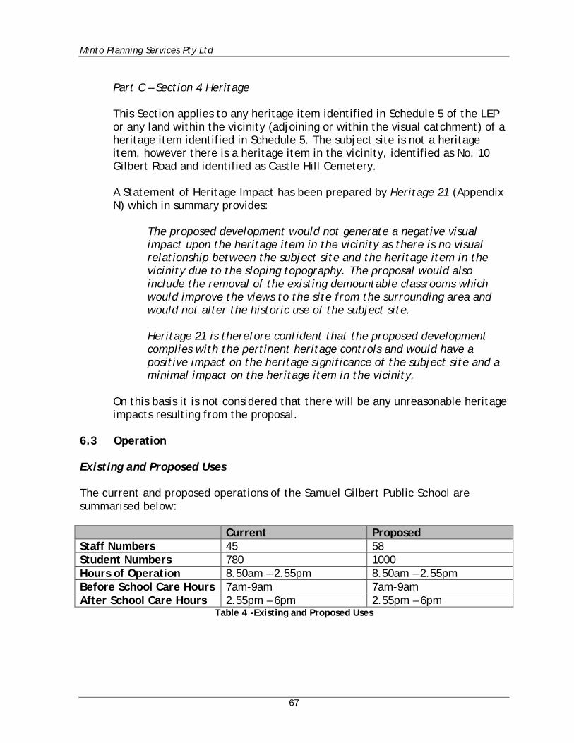
Minto Planning Services Pty Ltd
67
Part C – Section 4 Heritage This Section applies to any heritage item identified in Schedule 5 of the LEP or any land within the vicinity (adjoining or within the visual catchment) of a heritage item identified in Schedule 5. The subject site is not a heritage item, however there is a heritage item in the vicinity, identified as No. 10 Gilbert Road and identified as Castle Hill Cemetery. A Statement of Heritage Impact has been prepared by Heritage 21 (Appendix N) which in summary provides:
The proposed development would not generate a negative visual impact upon the heritage item in the vicinity as there is no visual relationship between the subject site and the heritage item in the vicinity due to the sloping topography. The proposal would also include the removal of the existing demountable classrooms which would improve the views to the site from the surrounding area and would not alter the historic use of the subject site. Heritage 21 is therefore confident that the proposed development complies with the pertinent heritage controls and would have a positive impact on the heritage significance of the subject site and a minimal impact on the heritage item in the vicinity.
On this basis it is not considered that there will be any unreasonable heritage impacts resulting from the proposal.
6.3 Operation Existing and Proposed Uses The current and proposed operations of the Samuel Gilbert Public School are summarised below: Current Proposed Staff Numbers 45 58 Student Numbers 780 1000 Hours of Operation 8.50am – 2.55pm 8.50am – 2.55pm Before School Care Hours 7am-9am 7am-9am After School Care Hours 2.55pm – 6pm 2.55pm – 6pm
Table 4 -Existing and Proposed Uses
Minto Planning Services Pty Ltd
68
The site is also currently utilised for the following community services, and these uses will continue unchanged:
• Key Martial Arts (Hall) Mon 3.15 - 7pm • Rouse Hill Physie (Hall) Mon 7.15 - 9.30pm • Shine Chinese School (Classroom) Mon 3.30pm - 5.30pm • Helen O’Grady Drama (Hall) Tues 4pm - 7pm • J&E Piano (Hall) Wed 3.15pm - 4.45pm • Sydney Academy of Chess (Classroom) Wed 3pm - 4pm • VIP Music (Burragali) Thurs 3.05pm - 3.45pm • Association of Brazilian Children’s Development (Classroom) Fri 4pm - 6pm • Soccajoeys (Hall) Sat 9am - 12pm
It is not considered that for the reasons as detailed within this report that the existing and proposed use of the site as proposed by this application will result in any unreasonable impacts upon either adjoining or nearby properties or upon the character of the surrounding locality. Suitability of the Site to accommodate the Proposal The subject site currently supports an existing primary school supporting an existing student population of 780 students and 45 staff. The site has an area of 8.29ha with only a small portion currently occupied by buildings. An area was identified as being suitable for additional development towards the southern corner of the site. This ensures the retention of the majority of the existing vegetation with all new buildings satisfying the Asset Protection Zone and construction requirements of Planning for Bushfire Protection 2006. The proposed building works are separated from the nearby residential development by the adjoining public roads which enables appropriate visual separation and privacy for the residents of the surrounding dwellings. It is considered that the proposed spatial separation also assists in offsetting any issues associated with the proposed building heights. It is considered that this report and the supporting documentation has successfully demonstrated that the site is capable of supporting the proposed increased student population of 1000 students and 58 staff.
Minto Planning Services Pty Ltd
69
Provide details of how the school will continue to operate during construction activities of the new primary and secondary school, including proposed mitigation measures The Design Report prepared by Fulton Trotter Architects provides detail of the staging of the development to ensure the continued operation of the school during construction. The proposed staging is as follows:
• Stage 1 – Temporary School and Establishment Works (Subject to separate approval) This includes the following works: o 8 of the existing demountables on the site will be relocated from the
South-Eastern corner of the site (from within the proposed construction zone) onto the playing field to create a temporary school.
o A new, temporary entrance path is created from Ridgecrop Drive to the Administration Building to maintain access during the construction period.
o Services works are undertaken in order to create temporary services connections in order to maintain power, data and other services connections to the site.
• Stage 2 – New Buildings – Buildings N, P and Q This includes the following works:
o Construction of the new buildings – N, P and Q • Stage 3 – Refurbishment Works – Buildings A and E This stage occurs following the occupation of Buildings N, P and Q and includes the following works:
o Refurbishment of Buildings A and E o Demolition of existing Buildings D and F o Landscaping works in order to create the ‘Concourse’ area
Following completion and occupation of Stage 3 of the works the demountable buildings are to be removed from the site.
Minto Planning Services Pty Ltd
70
6.4 Built Form and Urban Design The site is bounded to the South by Ridgecrop Drive and to the East by Gilbert Road. The Castle Glen Child Care Centre and the Knightsbridge Shopping Centre and the council playing fields directly neighbour the site to the North. The site sits within a predominantly residential suburb characterised by low density single and double storey post-war housing. This housing neighbours the site directly to the East as well as the opposite side of Gilbert Road and Ridgecrop Drive. The vegetation and landscaping are the prevailing character of the site. The proposed development has been designed to retain as much of the existing landscaping as possible. The new buildings are located to the southeast corner of the site to allow the buildings to present directly to Ridgecrop Drive and create a new accessible pedestrian entrance. The proposal provides for a new three storey building which ensures the building footprint is minimised and reducing the impact on existing landscaping. The stepping of the building and retention of landscaping reduces the impact of the building on the streetscape. Additional landscaping is also proposed to the entry of the site and around the proposed new buildings as depicted in the Landscape Plan prepared by Ground Ink Landscape Architects. In support of the proposed building height it is submitted that the proposal is considered to be acceptable for the following reasons:
• The proposed building is a high-quality architect designed building which will encompass an attractive range of materials and finishes and which will make a positive contribution to the character of the locality and the existing streetscape.
• The proposal is provided with generous spatial separation from the nearby residential dwellings which assists in minimising any unreasonable height, bulk and scale impacts.
• The proposal, particularly in relation to Building P is provided with a generous landscape buffer.
It is also considered that the additional building height provides the following benefits:
• The increased building height allows for the provision of a reduced building footprint which in turn assists in minimising impacts upon existing trees and critically endangered ecological communities.
• The reduced building footprint also allows for the provision of an increased Asset Protection Zone from the subject hazard.
Minto Planning Services Pty Ltd
71
• The increased building height allows for the provision of a primary building
within which a large number of students can be located as well as support services therefore minimising the need for a decentralised school community.
The simple building forms compliment the character of the existing buildings on site. The proposed buildings are to be clad of natural and pre-finished materials including zincalume, colourbond cladding, concrete and masonry. These materials and the design of the buildings create simple blades that step along the face of the building and are articulated in a simple, repeated grid layout. The proposed 3 storey building is well articulated through the stepped design which is further modulated through the use of the ‘boxed withdrawal spaces and window seats. The proposed hall is constructed with pre-cast concrete panels with the vertical strip windows and a mixture of textural finishes to the concrete providing a façade that compliments the tree trunks that surrounds the development. Reference is also made to the Design Report prepared by Fulton Trotter Architects (Appendix D) which also contains commentary regarding the proposed built form. As detailed at Page 14 of that report the architects have advised that:
The new facilities are positioned to the South and South-East of the existing cluster of buildings. This allows the buildings to create a new entry and street presence for the school while also avoiding over-shadowing of the existing buildings. A number of existing buildings on the site are then removed in order to create a landscaped pedestrian connection from the new buildings to the playing field to the North. This connection is known as The Concourse. Architecturally the new buildings on the site are designed to sit as simple insertions into the natural vegetation on the site. The forms step back into the site – mimicking the layout of the existing buildings. This form allows the new buildings to open onto Ridgecrop Drive to the Western end, but then sit in behind the existing trees and the protected area of vegetation on the corner of Ridgecrop Drive and Gilbert Road. The buildings are clad with a simple palette of pre-finished or naturally finished materials – corrugated iron cladding, concrete, glass and brickwork. This will allow them to sit comfortably within the natural setting of the site.
For the reasons as described above the proposed built form and urban design are considered to be appropriate in the circumstances of this case.
Minto Planning Services Pty Ltd
72
Services infrastructure plans have been developed for Civil, Electrical, Mechanical and Hydraulic services. The strategies in place for managing these services are outlined in the Infrastructure Management Plan that is included with this submission as Appendix T. 6.5 Environmental Amenity It is my opinion that the proposal will not result in any unreasonable amenity impacts particularly upon the adjoining and nearby properties. In forming this opinion reference is made to the reports which accompany this submission and particularly those relating to acoustic and traffic and parking related impacts. It is noted that historically the site has been used as a school since 1987 and as such adjoining and nearby residents would be familiar with this use and any existing impacts associated with it. It is noted that the existing school has a student population of 780 and 45 staff and which is proposed to be increased by an additional 220 students and 13 staff. It is not considered that this increase based upon the supporting reports will result in any unreasonable impacts. In relation to the proposed built form it is considered that the proposed buildings will provide for a high-quality architect designed outcome and which incorporates a range of building materials and finishes which will make a positive contribution to the streetscape and character of the locality. It is considered that generous spatial separation is provided for the proposed buildings from the adjoining and nearby dwellings such that their amenity will not be unreasonably impacted by a loss of privacy or overshadowing. Shadow Diagrams have been prepared by Fulton Trotter Architects and are included at Appendix C (Drawing No. SD1602). These diagrams clearly indicate that any shadow cast by the proposed development is over the adjacent public road. Therefore, the proposal does not result in any overshadowing to surrounding residential land. In terms of privacy an inspection of the site and surrounds was carried out. The proposed development is separated from the nearest residential properties by a public road with a width of approximately 13m. The proposed buildings are therefore setback at least 20m from the property boundaries of the surrounding residential development. This is considered to be sufficient visual separation to ensure that the visual privacy of the surrounding properties is maintained. In relation to acoustic privacy an Environmental Noise Assessment (Appendix O) and a Construction Noise and Vibration Management Plan (Appendix P) have been prepared by Day Design Acoustical Engineers.
Minto Planning Services Pty Ltd
73
The subject and surrounding sites do not currently enjoy any significant views over or through the subject site and as such the proposed development will not obstruct any significant views. It is also considered that the proposal will not unreasonably impact on the existing visual amenity from the surrounding properties or the public domain. The buildings fronting both Ridgecrop Drive and Gilbert Road are appropriately articulated with varied front setbacks to ensure landscaping is both maintained and enhanced. The proposed development has been designed to maintain the majority of vegetation on the site. An Arboricultural Assessment including a Tree Management Plan has been prepared and is included in Appendix H. This Assessment identifies that the significant vegetation zone located towards the southern corner (adjoining the intersection of Ridgecrop Drive and Gilbert Road) will be retained. The proposal also provides for an appropriate setback to both street frontages to enable landscaping within these setback areas. It is noted that the school is proposed to continue to be utilised for a range of existing out of hours activities. It is considered that given that these uses are existing that there will not be any new impacts occurring as a result of these uses. 6.6 Staging The Design Report prepared by Fulton Trotter Architects (Appendix D) provides detail of the staging of the development to ensure the continued operation of the school during construction. The proposed staging is as follows:
• Stage 1 – Temporary School and Establishment Works (Subject to separate approval) This includes the following works: o 8 of the existing demountables on the site will be relocated from the
South-Eastern corner of the site (from within the proposed construction zone) onto the playing field to create a temporary school.
o A new, temporary entrance path is created from Ridgecrop Drive to the Administration Building to maintain access during the construction period.
o Services works are undertaken in order to create temporary services connections in order to maintain power, data and other services connections to the site.
• Stage 2 – New Buildings – Buildings N, P and Q
Minto Planning Services Pty Ltd
74
This includes the following works:
o Construction of the new buildings – N, P and Q • Stage 3 – Refurbishment Works – Buildings A and E This stage occurs following the occupation of Buildings N, P and Q and includes the following works:
o Refurbishment of Buildings A and E o Demolition of existing Buildings D and F o Landscaping works in order to create the ‘Concourse’ area
Following completion and occupation of Stage 3 of the works the demountable buildings are to be removed from the site. 6.7 Transport and Accessibility Existing Road Network A Traffic & Transport Impact Statement has been prepared by TSA (Appendix K). To obtain an indication of the performance of the existing road network, peak hour morning and afternoon weekday traffic surveys were undertaken at both Ridgecrop Drive junctions with Gilbert Road which in summary depicted the following:
• Gilbert Road accommodates bidirectional traffic flows of between 1,200 – 1,400 vehicles per hour during peak periods;
• Through traffic flows within Gilbert Road is identified to be tidal with westbound movements dominating during the morning peak and eastbound movements dominating during the afternoon peak;
• Ridgecrop Drive accommodates two-way traffic demands in the order of between 150 – 300 vehicles per hour during peak period.
Proposed Traffic A SIDRA Analysis was undertaken by TSA as detailed within their report. SIDRA is a computerised traffic arrangement program which, when volume and geometrical configurations of a network of intersections are imputed, provides an objective assessment of the operation efficiency under varying types of control. Under the SIDRA Analysis the surrounding road network (intersections of Gilbert Road and Ridgecrop Drive) is assessed to currently operate with a predominantly good level of service ‘A’ during peak school start/finish periods, with the exception of the southernmost junction, which is assessed to operate with a level of service
Minto Planning Services Pty Ltd
75
‘D’ during the afternoon peak period coinciding with the finishing time of the school. The school has been projected to generate an additional 171 peak hour vehicle trips to and from the site during school start and finish periods. The remodelled SIDRA output generally indicates no changes to the existing level of service due to the additional traffic generated by the subject proposal, with the exception of the southernmost junction of Gilbert Road and Ridgecrop Drive, which is expected to reduce from its current level of service ‘D’ to ‘E’, signifying that the intersection is at capacity. It was recommended that an Operational Traffic & Pedestrian Management Plan (OTMP) and a Green Traffic Plan (GTP) be implemented as detailed within the Traffic and Transport Impact Statement. This will assist in ensuring that the additional traffic generating potential of the proposed school expansion will not result in any unreasonable impacts on the surrounding road network and improve the overall efficiency and safety of internal roads servicing the school during peak school start and finish periods. On Site Parking The Hills Development Control Plan 2012 with Part C Section 1 provides on site parking requirements for educational establishments as follows:
1 space per employee, plus 1 car parking space per 8 Year 12 students, plus 1 car parking space per 30 students enrolled for visitors and/or parent parking
In this regard the Traffic Report notes:
Based on a proposed future student and employee population of 1000 students (no Year 12’s, being a primary school) and 58 staff, a total of 92 car parking spaces comprising 58 staff and 34 visitor spaces are required to be provided in accordance with Council’s DCP. Whilst the current on-site parking provision represents a shortfall with respect to Council’s numerical parking requirements, the surrounding public off-street parking facilities associated with the adjoining land uses including the future provision of new off-street car parking areas associated with the school sports oval and adjoining recreational reserve, is expected to assist with servicing the additional parking demand generated by the proposed expansion of the school.
Minto Planning Services Pty Ltd
76
Further, this Practice notes that one of the conditions of the SEARs issued by the DPE in relation to Transport and Accessibility is the provision of a Green Travel Plan (GTP) as part of the DA to promote more sustainable forms of travel that reduces reliance on private car. In response to this requirement, this Practice has prepared a GTP within Section 7 of this report, intended to ensure that the transport infrastructure, services and policies within and outside the site are tailored to the future site users, being coordinated to achieve sustainable outcomes aimed at minimising traffic and parking impacts within the surrounding road network.
Bicycle Parking As detailed at Section 4.2.2 of the Traffic & Transport Impact Assessment Report:
Part C Section 1 of DCP 2007 specify that schools are required to be provided with the following minimum bicycle parking provision:
1 space per 5 pupils over year 4 It is understood that around 286 out of the 1,000 primary school students are currently or anticipated to be in Years 5 and 6. Based on these student numbers, the primary school is required to be supported by a minimum bicycle parking provision of up to 58 spaces. The subject proposal involves the provision of 30 double sided bicycle racks on site, designed in accordance with AS2890.3-2015, which is capable of accommodating up to 60 bicycles. Compliance with Council’s bicycle parking requirements is therefore readily achieved. Recent observations have indicated that bicycle trips to and from the site associated with staff, students and general visitors was found to be currently negligible. However, as outlined within the Green Travel Plan (GTP) in Section 7 of this report, there is an expectation that parents, students and staff travel characteristics/behaviour are encouraged to change, as alternative forms of transport to private vehicle usage are contemplated and actioned. The proposed bicycle parking provision is expected to also assist with facilitating greater bicycle trips, consistent with this GTP objective.
Minto Planning Services Pty Ltd
77
Public Transport Hillsbus operates two bus services (Route 603 and 652X). Route 603 provides 2 services during the morning peak period and 1 service during the afternoon peak, with Route 652X providing 1 service during these peak school periods. Two ‘school’ buses currently service the school, being Route 2550 and 3610. The Traffic Consultant observed that these buses were underutilised with only a limited number of students (approximately 30 students) using these services. The bus times are also staggered so that at no time were buses observed to be queuing out of the sign posted zones and therefore no unreasonable impedance on adjoining traffic flow. The existing bus services are capable of supporting the increase in student numbers. Service Vehicle/Emergency Access The existing driveway from Ridgecrop Drive and the associated parking area is being maintained. This includes a turning delivery area for delivery vehicles. There is sufficient area for manoeuvring to ensure all vehicles can enter and leave the site in a forward direction. This arrangement will be retained. Construction Issues The Traffic Report also addresses potential construction issues. The report suggests a number of measures to ensure appropriate safe traffic access associated with the construction works. In this regard the report includes a preliminary Construction Traffic Management Plan (CTMP) and include the following:
• All areas of demolition/construction are to be fenced so there is no unreasonable interaction between construction activities and the surrounding public roads.
• Should work zones be required adjacent to the street frontages of the site application is to be made to The Hills Shire Council.
• Site ingress/egress to be in a forward direction and controlled by qualified traffic controllers
• Construction vehicle movements be minimised during peak periods. • Construction workers vehicle parking to be avoided on public streets
surrounding the school. • Perimeter scaffolding around the staged construction compounds, combined
with chain wire mesh and shade cloth to protect pedestrians from dust and debris.
Minto Planning Services Pty Ltd
78
Equitable Access An Access Report has been prepared in support of the proposal by Funktion and is included at Appendix L to this report. That report within its conclusion states that:
Having reviewed the listed drawings, it is our opinion that at this stage of the design, and with the inclusion of the recommendations in ongoing detailed design, the access provisions for people with physical and sensory disabilities in the proposed new work can comply with the functional accessibility requirements of BCA (2016) sections D3, E3.6 and F2.4; AS1428.1, AS1735.12 and the Disability (Access to Premises - Buildings) Standards 2010 for accessibility and equity. With the development and implementation of the recommended operational management strategies, the provision of access for people with a disability in the proposed new and refurbished school facilities at Samuel Gilbert Public School, Castle Hill, can provide continuous accessible paths of travel and the equitable provision of accessible facilities to provide inclusive design to meet the anticipated requirements of staff, students and visitors.
On this basis the proposal is considered to provide for an appropriate response to the provision of equitable access within the existing and proposed school buildings and grounds. Summary Based upon the above it is not considered that there will be any unreasonable transport or access issues associated with the proposal. 6.8 Ecologically Sustainable Development (ESD) JHA Consulting Engineers has prepared an Ecologically Sustainable Development (ESD) Report (Appendix Y) which identifies the relevant SEARs requirements and planning regulations (such as the EFSG and EP&A Regulations), as well as the ESD objectives of the proposed development and details all sustainability initiatives, including:
• Sufficient exposure to daylight • Well-designed openings to promote natural ventilation • Appropriate construction and glazing selection • Energy efficient air-conditioning systems • LED luminaires • Rainwater recycle tank • Efficient water fixtures • Waste management plan
Minto Planning Services Pty Ltd
79
• Landscaping
The ESD Report identifies how the ESD principles will be incorporated into the design and on-going operation of the proposed development, as required under Clause 7(1)(f) of Schedule 2 of the EP&A Regulation 2000. Based upon the findings of the above report the proposal is considered to provide for an appropriate outcome in relation to Ecologically Sustainable Development. 6.9 Social Impacts The Design Report prepared by Fulton Trotter Architects (Appendix D) has addressed the social impacts associated with the proposal. The increase in student numbers and school facilities is considered to have a positive social benefit. The improved public education facilities will continue to serve the local community and population growth whilst also providing for the space for utilisation by the community. The Design Report provides:
Samuel Gilbert Public School is an existing public school located within the suburb of Castle Hill in the north western region of Sydney. It’s within a region that is undergoing significant redevelopment and densification. The established school has been identified as being in need of additional facilities to meet a growing population. The School already houses a number of its teaching spaces within temporary demountable buildings as a result of recent growth in the area. The proposal is to update the facilities to meet NSW Dept of Education Core 35 guidelines for a student population of 1000.
It is advised that during the construction period that all reasonable efforts will be made to accommodate all existing school users and the provision of community facilities although noting that there may be periods whereby restricted or limited access is available. Long term it is not considered that there will eb a reduction in the availability of Community facilities with the proposal ultimately providing for improved community facilities.
Minto Planning Services Pty Ltd
80
6.10 Heritage A Heritage Impact Statement has been prepared by Heritage 21 (Appendix N). The HIS is consistent with the Statements of Heritage Impact (1996) and Assessing Heritage Significance (2001) published by the Heritage Division of the NSW Office of Environment and Heritage and is prepared in accordance with The Burra Charter: The Australian ICOMOS Charter for Places of Cultural Significance 2013. The subject and adjoining properties are not identified as heritage items, nor is the site located within a heritage conservation area. The site is located within proximity to a local heritage item, known as the Castle Hill Cemetery. The Heritage Impact Statement in this regard notes:
Due to the sloping topography of Castle Hill, Heritage 21 has ascertained that there is not a visual relationship between the cemetery located at 10 Gilbert Road, Castle Hill and Samuel Gilbert Public School.
In conclusion the Statement provides:
The proposed development would not generate a negative visual impact upon the heritage item in the vicinity as there is no visual relationship between the subject site and the heritage item in the vicinity due to the sloping topography. The proposal would also include the removal of the existing demountable class rooms which would improve the views to the site from the surrounding area and would not alter the historic use of the subject site. Heritage 21 is therefore confident that the proposed development complies with pertinent heritage controls and would have a positive impact on the heritage significance of the subject site and a minimal impact on the heritage item in the vicinity.
The report also indicates that there are no solutions of greater sympathy with the significance of the subject site or heritage in the vicinity. There are no mitigation measures required or proposed. It is therefore considered that there will be no unreasonable heritage impacts associated with the proposal.
Minto Planning Services Pty Ltd
81
6.11 Aboriginal Heritage An Aboriginal Cultural Heritage Assessment Report has been prepared in support of the proposal by Cultural Heritage Connections and that report is included as Appendix CC to this report. That report identified that:
Seventeen Aboriginal stakeholder groups registered interest for the project. No Aboriginal objects have been recorded in the project impact area and the archaeological assessment has concluded that there is a low to negligible potential for unrecorded object to occur. None of the RAP’s identified specific issues or concerns about the proposed development or any impacts on cultural heritage. The proposed development is unlikely to have an impact on Aboriginal objects or cultural heritage values.
Their report also included a number of recommendations in relation to the undertaking of the development upon the site. It is considered that subject to compliance with those recommendations that the proposal will provide for an appropriate outcome in relation to the issue of protecting Aboriginal heritage. 6.12 Noise and Vibration The proposal is supported by a Construction Noise & Vibration Management Plan (Appendix P) and an Environmental Noise Assessment Report (Appendix O) both prepared by Day Design P/L. Those reports provide for the following: Excavation, demolition and construction noise The Construction Noise & Vibration Management Plan identifies the main noise and vibration generating noise sources during demolition and construction phase as follows:
Excavation and Bulk Earthworks – removal of demountables, excavation and bulk earth works will involve the use of excavators, rock hammers/saws, pile bores and regular truck movements. Construction – The construction of the new buildings will involve heavy vehicles, power tools and portable mechanical plant such as generators and compressors.
Minto Planning Services Pty Ltd
82
The report recommends a number of mitigation measures to minimise the noise impact from all excavation and construction activities which are detailed in Section 6.1 of the Construction Noise and Vibration Management Plan and summarised below:
• Distance – locate all mechanical towards the centre of the site to maximise separation to the adjoining residences.
• Enclosure – Construct acoustic enclosures around items of mobile plant where there is extended use.
• Silencing – Select plant and machinery with consideration to low noise options where practical and available.
• Periods of respite – Noisy construction activities such as rock hammering only operate for 2-3 hours at a time.
• Work practices – Training be provided to workers/contractors to minimise noise emission, such as avoid dropping materials from heights, avoid shouting, avoid use of radios that can be heard at the boundary of residences, turn of equipment when not in use, work only in proposed hours of operation.
• Heavy vehicle and staff vehicle usage – inform drivers of vehicle routes, acceptable practices, store vehicles away from residences, vehicles not to enter site or park within residential areas before 7am.
• Community Liaison – appoint a community liaison officer to liaise with potentially affected residents and provide contact details to residents.
Vibration during construction The report also addresses potential vibration impacts. Vibration can occur during rock hammering. To mitigate potential issues, it is recommended an unattended vibration monitor should be fitted with an alarm in the form of a strobe light or siren to alert the plant operator immediately when the vibration limit is exceeded. It is also recommended that dilapidation reports be commissioned for potentially affected properties prior to any works being undertaken. Operational Noise The Environmental Noise Assessment prepared by Day Design Pty Ltd assesses the operational noise impacts. The mains sources of noise from the ongoing operation of the school are identified as follows:
• Students playing in outdoor areas. • Students inside home bases. • Public address system and school bell. • Mechanical plant. • Use of hall.
Minto Planning Services Pty Ltd
83
The report recommends a number of mitigation measures which are summarised below:
Outdoor play – The increase of 220 students has negligible impacts on existing noise levels and no further mitigations measures are required. Mechanical Plant – A detailed acoustic assessment should be made prior to the issue of a Construction Certificate. Plant equipment with the lowest sound power levels should be selected. Use of School Hall – A detailed acoustic assessment of the hall shall be carried out once the design is finalised. Noise controls should be incorporated which may include:
• Closing external windows during noisy events. • Limiting the noise level of any amplification system inside the hall. • Limiting the noise level of any live instruments to be used in the hall.
It is considered that subject to compliance with the recommendations detailed above it is not considered that the proposal will result in any unreasonable noise or vibration impacts. 6.13 Sediment, Erosion and Dust Controls A Sediment and Erosion Control Plan is contained within the Civil Engineering Plans has been prepared by Henry & Hymas which is included at Appendix E . This Plan includes:
• A sedimentation fence adjacent to the boundaries fronting both Ridgecrop Drive and Gilbert Road at the southeast corner of the site.
• A designated vehicle entry point with shaker grid and manoeuvring area. • Stockpile area for storage of materials. • Catchment diversion drain with hay bale filter and sediment basin. • Inlet filter around the street drainage grate. • Geotextile inlet filter to protect existing drainage grates on site.
Appropriate measures including the wetting down of disturbed areas of the site and buildings to be demolished will be undertaken so as to minimise dust associated with the demolition and construction phases. These measures will be incorporated and implemented prior to the commencement of any works on site.
Minto Planning Services Pty Ltd
84
6.14 Contamination Soil & Groundwater Contamination A Preliminary Site Investigation (PSI) and Detailed Site Investigation (DSI) (Appendix U) and a Hazardous Building Materials Assessment Report (Appendix V) have been prepared by WSP. The objectives of the investigation were to:
• assess the current contamination status of the site, with respect to soil contamination, within the identified design footprint to meet the requirements of the SSD
• assess the potential risks associated with contamination at the site (if identified), with respect to demonstrating the site’s suitability for proposed use in accordance with the SSD
The scope of works comprised a desktop review and soil investigations at 20 locations including 11 test pits and hand augering at 9 locations. The historical review of the site indicates that the site has heavily vegetated prior to the school being constructed in 1986. In summary the Report provided:
No field indicators of contamination were observed. Subsurface material generally consisted of fill described as silty sand and silty clay to approximately 0.1 m below ground level (mBGL) to 0.5 mBGL, then natural silty clays, silty sand or clayey sand, then sandstone from approximately 0.6 mBGL to the extent of the investigation. Concentrations of total recoverable hydrocarbons (TRH) were reported in primary samples from test pit TP03 and hand augers HA03, HA04 and HA08. The majority of the detections were only marginally above the practical quantitation limits (PQLs). Concentrations were not considered to be significant and were reported below the health-based adopted site criteria. All results for volatile hydrocarbons and polycyclic aromatic hydrocarbons were below the laboratory PQLs. Concentrations of some heavy metals were reported in soil samples for the site, with results generally consistent between locations and below the adopted site criteria. No asbestos was observed in soil during the on-site work or detected by the laboratory in soil samples submitted for analysis. The results of the investigation indicate the identified design footprint at the school is suitable for development and future use as a primary school under the SSD.
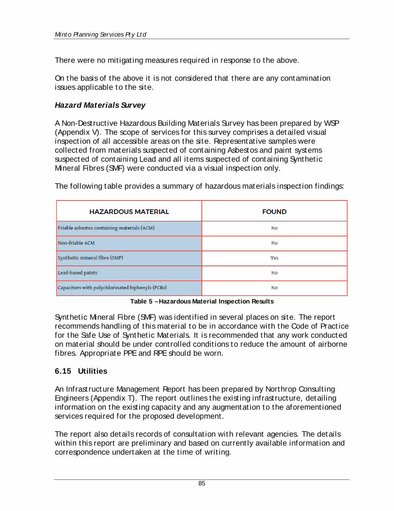
Minto Planning Services Pty Ltd
85
There were no mitigating measures required in response to the above. On the basis of the above it is not considered that there are any contamination issues applicable to the site. Hazard Materials Survey A Non-Destructive Hazardous Building Materials Survey has been prepared by WSP (Appendix V). The scope of services for this survey comprises a detailed visual inspection of all accessible areas on the site. Representative samples were collected from materials suspected of containing Asbestos and paint systems suspected of containing Lead and all items suspected of containing Synthetic Mineral Fibres (SMF) were conducted via a visual inspection only. The following table provides a summary of hazardous materials inspection findings:
Table 5 – Hazardous Material Inspection Results
Synthetic Mineral Fibre (SMF) was identified in several places on site. The report recommends handling of this material to be in accordance with the Code of Practice for the Safe Use of Synthetic Materials. It is recommended that any work conducted on material should be under controlled conditions to reduce the amount of airborne fibres. Appropriate PPE and RPE should be worn. 6.15 Utilities An Infrastructure Management Report has been prepared by Northrop Consulting Engineers (Appendix T). The report outlines the existing infrastructure, detailing information on the existing capacity and any augmentation to the aforementioned services required for the proposed development. The report also details records of consultation with relevant agencies. The details within this report are preliminary and based on currently available information and correspondence undertaken at the time of writing.
Minto Planning Services Pty Ltd
86
6.16 Contributions The Hills Section 94A Contributions Plan ordinarily applies to the subject site. Relevant to the subject application the Plan would require the payment of a levy equal to 1% of the proposed cost of the development. The Plan contains a number of exceptions to the Plan however none of those exceptions are considered to be relevant to the proposal. Notwithstanding the above, it is understood that the Department of Education is not normally subject to such contributions. In support of such an exemption it is submitted that legislation such as the council’s Contributions Plan has been developed over time in recognition of the role Crown Development plays in providing essential community services. Crown Development such as that undertaken by the Department of Education involves the provision of a public service or facility which will lead to significant benefits for the public in terms of essential community services and employment opportunities. These activities are not likely to require the provision of public services and amenities in the same way as development undertaken with a commercial objective. 6.17 Drainage Civil Engineering Works Plans (Appendix E) and a Civil Stormwater Design Report (Appendix R) have been prepared by Henry and Hymas which provide for all collected stormwater to be discharged to the existing drainage infrastructure in Ridgecrop Drive via a new on-site detention system. Water quality measures are to be provided including pit baskets for all grated pits within the walkways. These pit baskets collect a large portion of gross pollutants, large sediment particles and organic matter. In conclusion the report provides:
Appropriate stormwater management practices will be implemented that minimise the impact of development on the existing stormwater system in terms of water quality whilst ensuring safe and efficient conveyance of runoff.
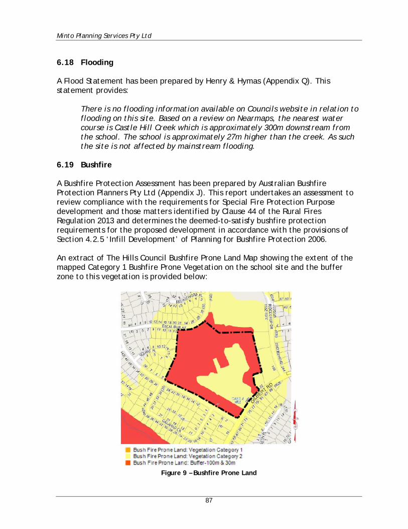
Minto Planning Services Pty Ltd
87
6.18 Flooding A Flood Statement has been prepared by Henry & Hymas (Appendix Q). This statement provides:
There is no flooding information available on Councils website in relation to flooding on this site. Based on a review on Nearmaps, the nearest water course is Castle Hill Creek which is approximately 300m downstream from the school. The school is approximately 27m higher than the creek. As such the site is not affected by mainstream flooding.
6.19 Bushfire A Bushfire Protection Assessment has been prepared by Australian Bushfire Protection Planners Pty Ltd (Appendix J). This report undertakes an assessment to review compliance with the requirements for Special Fire Protection Purpose development and those matters identified by Clause 44 of the Rural Fires Regulation 2013 and determines the deemed-to-satisfy bushfire protection requirements for the proposed development in accordance with the provisions of Section 4.2.5 ‘Infill Development’ of Planning for Bushfire Protection 2006. An extract of The Hills Council Bushfire Prone Land Map showing the extent of the mapped Category 1 Bushfire Prone Vegetation on the school site and the buffer zone to this vegetation is provided below:
Figure 9 – Bushfire Prone Land
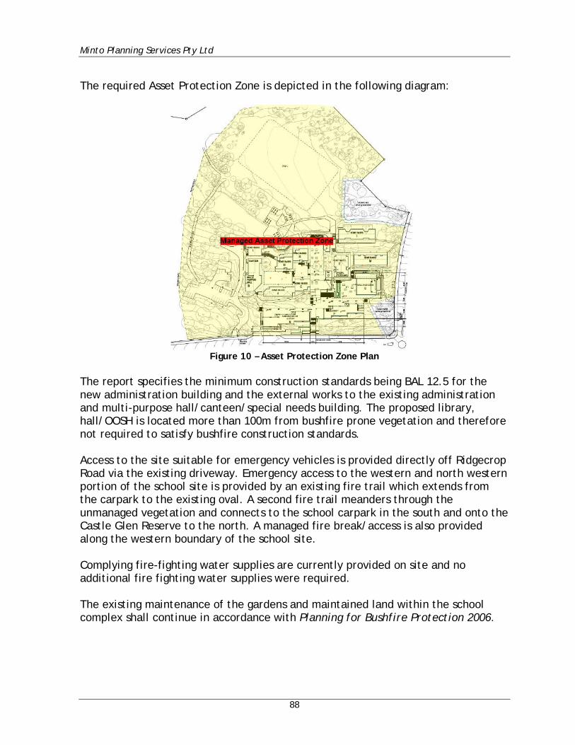
Minto Planning Services Pty Ltd
88
The required Asset Protection Zone is depicted in the following diagram:
Figure 10 – Asset Protection Zone Plan
The report specifies the minimum construction standards being BAL 12.5 for the new administration building and the external works to the existing administration and multi-purpose hall/canteen/special needs building. The proposed library, hall/OOSH is located more than 100m from bushfire prone vegetation and therefore not required to satisfy bushfire construction standards. Access to the site suitable for emergency vehicles is provided directly off Ridgecrop Road via the existing driveway. Emergency access to the western and north western portion of the school site is provided by an existing fire trail which extends from the carpark to the existing oval. A second fire trail meanders through the unmanaged vegetation and connects to the school carpark in the south and onto the Castle Glen Reserve to the north. A managed fire break/access is also provided along the western boundary of the school site. Complying fire-fighting water supplies are currently provided on site and no additional fire fighting water supplies were required. The existing maintenance of the gardens and maintained land within the school complex shall continue in accordance with Planning for Bushfire Protection 2006.
Minto Planning Services Pty Ltd
89
The report recommends that a ‘Bushfire Management Plan’ which establishes protocols for the maintenance of the retained vegetations be prepared. It is also recommended that the existing Emergency Management Evacuation Plan for the school shall be reviewed to include potential risk of bushfire occurrence in the unmanaged vegetation. In conclusion the report provides:
This report has reviewed the proposed development against the Section 19 – ‘Bushfire’ of the Secretary’s Environmental Assessment Requirements [SEARS] which states that the Environmental Impact Statement [EIS] shall address the bush fire hazard including through the preparation of a report that addresses the requirements for Special Fire Protection Purpose development as detailed in Planning for Bushfire Protection 2006. Section 4.2.5 of Planning for Bushfire Protection 2006 identifies that in circumstances where alterations and additions to existing ‘Special Fire Protection Purpose Development’ are planned the NSW Rural Fire Service require an appropriate combination of bushfire protection measures and compliance with the intent and performance criteria of each measure within Section 4.3.5 of Planning for Bushfire Protection 2006. The report has examined the vegetation within the school site and confirms that the only vegetation which presents a hazard to the school is the woodland vegetation retained within the western and north-western portion of the school site. The report notes that the retained pockets of Turpentine-Ironbark Forest do not constitute bushfire prone vegetation due to the small area of vegetation and the separation to bushfire prone vegetation. The report has also confirmed that, with the exception of the existing After Hours Care Building J, all existing and proposed building locations satisfy the separation widths of Asset Protection Zones as required by Table A2.6 of Planning for Bushfire Protection 2006. The proposed development therefore satisfies the aim and objectives of Planning for Bushfire Protection 2006 addresses Section 19 of the Key Issues of the Secretary’s Environmental Assessment Requirements of the State Significant Development No. 9274.
It is considered that subject to compliance with the recommendations of the above report that there will not be any unreasonable bushfire impacts applicable to the subject site and the proposal.
Minto Planning Services Pty Ltd
90
6.20 Biodiversity In association with the existing trees located upon the site two areas of Sydney Turpentine-Ironbark Forest (STIF) have been identified as occurring upon the site. Reference is made to the Biodiversity Assessment Report prepared by Travers Bushfire & Ecology (Appendix I) and which identifies these communities as STIF North and STIF South. The Travers report in relation to the proposal identifies that:
Recorded Biodiversity Ecological survey and assessment has been undertaken in accordance with relevant legislation including the Environmental Planning and Assessment Act 1979 (EP&A Act), the Biodiversity Conservation Act 2016 (BC Act), the Environment Protection and Biodiversity Conservation Act 1999 (EPBC Act) and the Fisheries Management Act 1994 (FM Act). In respect of matters required to be considered under the EP&A Act and relating to the species / provisions of the BC Act, six (6) state listed threatened fauna species including Square-tailed Kite (Lophoictinia isura), Glossy Black-Cockatoo (Calyptorhynchus lathami), Grey-headed Flying-fox (Pteropus poliocephalus), Eastern Bentwing-bat (Miniopterus orianae oceanensis), Greater Broad-nosed Bat (Scoteanax rueppellii) and Eastern Falsistrelle (Falsistrellus tasmaniensis), no threatened flora species, and one (1) endangered ecological community (EEC), Sydney Turpentine-Ironbark Forest (STIF), were recorded within the study area. One (1) tree of high foraging use by Glossy Black-Cockatoo was found within the proposed development area and will be removed by the proposal. In respect of matters required to be considered under the Environment Protection and Biodiversity Conservation Act 1999 (EPBC Act), no threatened flora species, one critically endangered ecological community (CEEC) known as Turpentine-Ironbark Forest of the Sydney Basin Bioregion, one (1) threatened fauna species Grey-headed Flying-fox (Pteropus poliocephalus) and no protected migratory bird species listed under this Act were recorded within the subject site. In respect of matters relative to the FM Act, no suitable habitat for threatened marine or aquatic species was observed within the subject site and there are no matters requiring further consideration under this Act. Impact assessment The direct, indirect and cumulative impacts of the proposal have been carefully considered in Section 6.2 of this report.
Minto Planning Services Pty Ltd
91
Recommendations have been outlined within Section 5.4 to avoid/minimise/offset the identified potential ecological impacts of the proposal, to address threatening processes and to create a more positive ecological outcome for threatened species and their associated habitats. The principles for determining serious and irreversible impacts are set out under Section 6.7.2 of the Biodiversity Conservation Regulation 2017 (BCR). These principles have been reviewed and it is considered that the proposal will not cause any serious and irreversible impacts (SAII) on threatened biodiversity. There will be no significant impact on matters listed under the FM Act. The proposed development was not considered to have a significant impact on matters of national environmental significance (NES). As such, a referral to Department of Environment and Energy (DOEE) is not required.
The report noted the potential ecological impacts as follows:
The potential direct impacts of the proposal within the subject site are considered as:
• Potential removal/modification of 0.01ha of Sydney Turpentine-Ironbark Forest EEC
• Removal/modification of 0.12ha of Sandstone Ridgetop Woodland • Subsequent removal of threatened fauna species foraging habitat • Removal of at least one (1) and perhaps two (2) small hollows.
The potential indirect impacts of the proposal are considered as:
• Further edge to width effect on the remaining remnant including reduced arboreal connectivity and foraging for arboreal mammals.
• Reduced areas of island vegetation for cross-site movements by small bird species such as passerines.
• Edge effects such as weed incursions caused from soil disturbance, repeated clearing and landscaping species becoming a nuisance in the adjacent remnant bushland.
The potential cumulative impacts (combined results of past, current and future activities) of the proposal are considered as:
• Increased risk of weed invasion and fungal mobilisation or infections • Cumulative loss of Sandstone Ridgetop Woodland within the locality • Cumulative loss of Turpentine-Ironbark Forest (STIF) within the locality
Minto Planning Services Pty Ltd
92
The report provided a detailed list of recommendations made to avoid, minimise or ameliorate the potential identified ecological impacts, address threatening processes and to create a positive ecological outcome for threatened species and their associated habitats. These recommendations which are summarised as follows, will be incorporated into the development:
• Removal of any portion of the Turpentine Ironbark Forest may constitute a SAII upon the candidate listed STIF. Development has generally avoided 97% of the extent within the site. It is recommended that the area of STIF be protected by permanent fencing or other demarcation measures, with temporary fencing.
• It is recommended that a Vegetation Management Plan (VMP) be prepared to identify the ongoing management of retained habitat resources, weeds, future landscaping and site works to retain mature trees and habitat movement corridors.
• Landscaping within the property is to use locally occurring (endemic) native species commensurate with STIF.
• Target weed control is to be undertaken within 10m of any works to control the invasion or spread of invasive environmental weed species.
• Standard Phytophthora cinnamomi protocol applies to the cleaning of all plant, equipment, hand tools and work boots prior to delivery onsite to ensure that there is no loose soil or vegetation material caught under or on the equipment and within the tread of vehicle tyres. Any equipment onsite found to contain soil or vegetation material is to be cleaned in a quarantined work area or wash station and treated with anti-fungal herbicides.
• Erosion control measures are to be in place to reduce temporary erosion and sedimentation risks to adjacent TEC vegetation.
• All areas containing natural habitat features which have been identified for retention are to be protected with fencing prior to construction.
• Hollow-bearing trees are to be clearly marked prior to clearing. Where the felling of hollow-bearing trees is required, this is to be conducted under the supervision of a fauna ecologist to ensure appropriate animal welfare procedures are taken, particularly for threatened species. Hollows of high quality or with fauna recorded residing within should be sectionally dismantled for relocation and all hollows should be inspected for occupation, signs of previous activity and potential for reuse.
• If a threatened species is found to be occupying the hollow then the hollow section is to be reattached to a recipient tree within the nearby conservation areas as selected and directed by the fauna ecologist. The welfare and temporary holding of the residing animal(s) is at the discretion of the fauna ecologist. The hollow section should be well secured in the recipient tree in a manner that will not compromise the current or future health of that tree.
Minto Planning Services Pty Ltd
93
• Given the recording of subterranean threatened microbat species it is recommended that that if any fauna species, a nest or roost is located during development works, then works should cease until safe relocation can be advised by a fauna ecologist.
• Pathways within STIF are to be avoided, and where not possible to redirect, be constructed to minimise root damage
• The ground surrounding all STIF trees are to be protected with fencing for the combined tree protection zones to minimise compaction
• Revegetation of native understorey commensurate with STIF is to be undertaken to achieve a maximum of 15% by cover for APZ compliance
Biodiversity Offsets Scheme (BOS) – Threshold Assessment Section 7.14 (State significant development or infrastructure), clause 4, of the BC Act states:
“A condition to retire biodiversity credits is required to be complied with before any development is carried out that would impact on biodiversity values.”
The proposed development is a state significant development that impacts on biodiversity values. Under Section 7.14 of the BC Act, state significant developments are required to enter the Biodiversity Offsets Scheme (BOS). Therefore, biodiversity offsets are required under the BOS.
The report concludes that a credit payment of $77,239.26 is applicable to the development. Subject to compliance with the recommendations of the Biodiversity Assessment Report it is not considered that the proposal will result in any unreasonable impact upon the existing STIF communities which exist upon the site. 6.21 Waste The application is accompanied by a Construction and Demolition Waste Management Plan (Appendix Z) and an Operational Waste Management Plan (Appendix AA) both of which have been prepared by TTM Consulting Pty Ltd. These reports identify and classify the likely waste streams to be generated during construction and operation and describes the measures to be implemented.

Minto Planning Services Pty Ltd
94
6.22 Construction Hours As detailed at Section 4.3 of the Preliminary Construction Management Plan prepared by Mace Australia P/L (Appendix W) the proposed construction hours for the proposed development are to be:
• Monday to Friday - 7.00am to 6.00pm • Saturdays - 8.00am to 1.00pm • Sundays & Public Holidays - No works
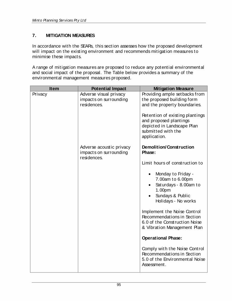
Minto Planning Services Pty Ltd
95
7. MITIGATION MEASURES In accordance with the SEARs, this section assesses how the proposed development will impact on the existing environment and recommends mitigation measures to minimise these impacts. A range of mitigation measures are proposed to reduce any potential environmental and social impact of the proposal. The Table below provides a summary of the environmental management measures proposed.
Item Potential Impact Mitigation Measure Privacy Adverse visual privacy
impacts on surrounding residences. Adverse acoustic privacy impacts on surrounding residences.
Providing ample setbacks from the proposed building form and the property boundaries. Retention of existing plantings and proposed plantings depicted in Landscape Plan submitted with the application. Demolition/Construction Phase: Limit hours of construction to
• Monday to Friday - 7.00am to 6.00pm
• Saturdays - 8.00am to 1.00pm
• Sundays & Public Holidays - No works
Implement the Noise Control Recommendations in Section 6.0 of the Construction Noise & Vibration Management Plan Operational Phase: Comply with the Noise Control Recommendations in Section 5.0 of the Environmental Noise Assessment.
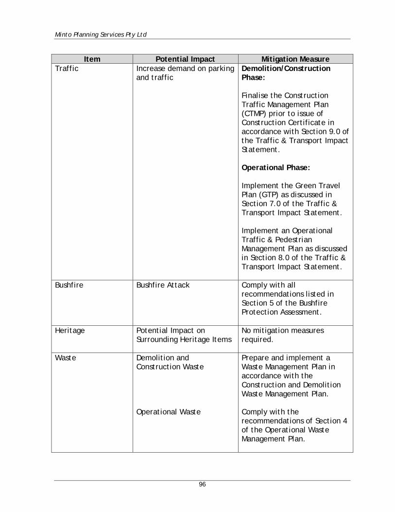
Minto Planning Services Pty Ltd
96
Item Potential Impact Mitigation Measure
Traffic Increase demand on parking and traffic
Demolition/Construction Phase: Finalise the Construction Traffic Management Plan (CTMP) prior to issue of Construction Certificate in accordance with Section 9.0 of the Traffic & Transport Impact Statement. Operational Phase: Implement the Green Travel Plan (GTP) as discussed in Section 7.0 of the Traffic & Transport Impact Statement. Implement an Operational Traffic & Pedestrian Management Plan as discussed in Section 8.0 of the Traffic & Transport Impact Statement.
Bushfire Bushfire Attack Comply with all recommendations listed in Section 5 of the Bushfire Protection Assessment.
Heritage Potential Impact on Surrounding Heritage Items
No mitigation measures required.
Waste Demolition and Construction Waste Operational Waste
Prepare and implement a Waste Management Plan in accordance with the Construction and Demolition Waste Management Plan. Comply with the recommendations of Section 4 of the Operational Waste Management Plan.
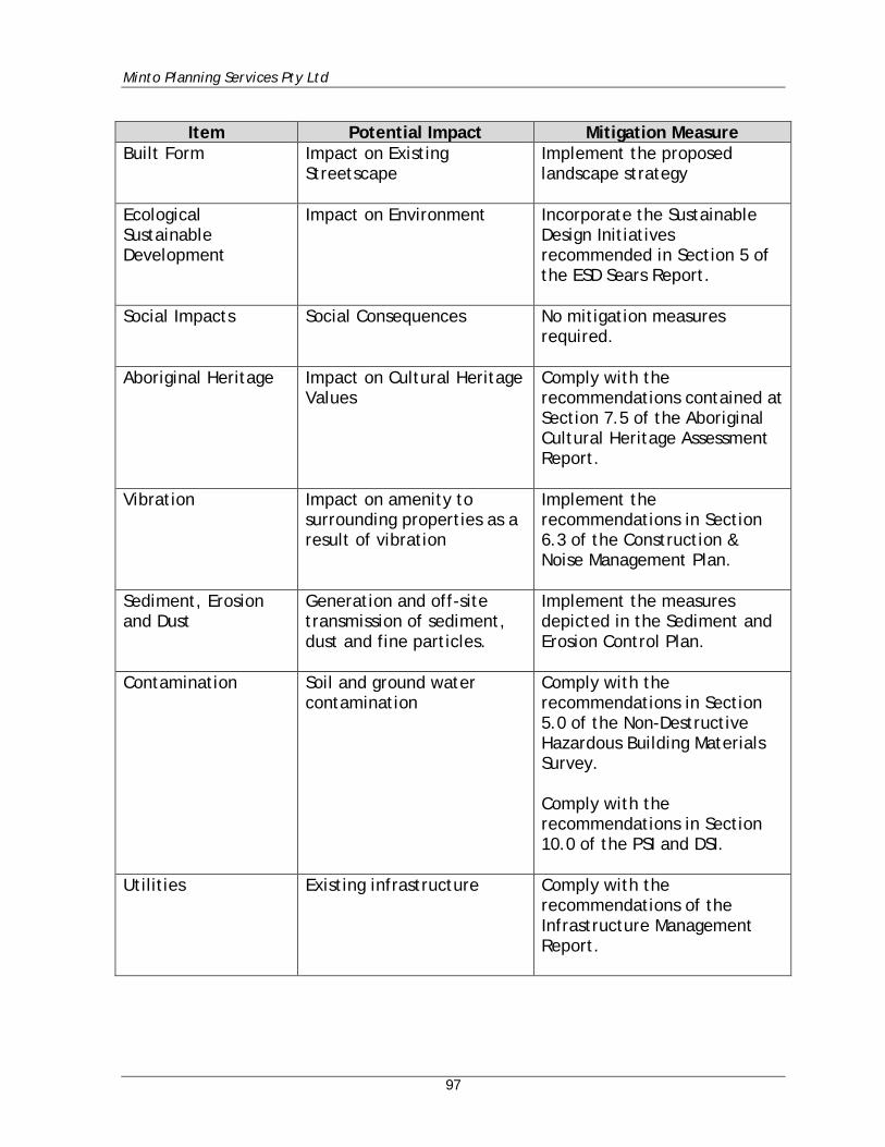
Minto Planning Services Pty Ltd
97
Item Potential Impact Mitigation Measure
Built Form Impact on Existing Streetscape
Implement the proposed landscape strategy
Ecological Sustainable Development
Impact on Environment Incorporate the Sustainable Design Initiatives recommended in Section 5 of the ESD Sears Report.
Social Impacts Social Consequences No mitigation measures required.
Aboriginal Heritage Impact on Cultural Heritage Values
Comply with the recommendations contained at Section 7.5 of the Aboriginal Cultural Heritage Assessment Report.
Vibration Impact on amenity to surrounding properties as a result of vibration
Implement the recommendations in Section 6.3 of the Construction & Noise Management Plan.
Sediment, Erosion and Dust
Generation and off-site transmission of sediment, dust and fine particles.
Implement the measures depicted in the Sediment and Erosion Control Plan.
Contamination Soil and ground water contamination
Comply with the recommendations in Section 5.0 of the Non-Destructive Hazardous Building Materials Survey. Comply with the recommendations in Section 10.0 of the PSI and DSI.
Utilities Existing infrastructure Comply with the recommendations of the Infrastructure Management Report.
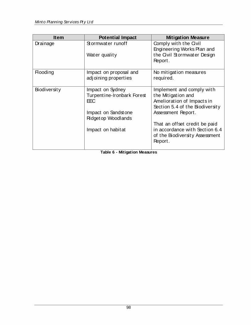
Minto Planning Services Pty Ltd
98
Item Potential Impact Mitigation Measure
Drainage Stormwater runoff Water quality
Comply with the Civil Engineering Works Plan and the Civil Stormwater Design Report.
Flooding Impact on proposal and adjoining properties
No mitigation measures required.
Biodiversity Impact on Sydney Turpentine-Ironbark Forest EEC Impact on Sandstone Ridgetop Woodlands Impact on habitat
Implement and comply with the Mitigation and Amelioration of Impacts in Section 5.4 of the Biodiversity Assessment Report. That an offset credit be paid in accordance with Section 6.4 of the Biodiversity Assessment Report.
Table 6 - Mitigation Measures
Minto Planning Services Pty Ltd
99
8. EVALUATION AND CONCLUSION The proposed development is State Significant Development under the terms of the Environmental Planning and Assessment Act 1979 and has been assessed against the requirements of Section 4.15(1) of the Act, the relevant State Environmental Planning Policies, Biodiversity Conservation Act 2016 and The Hills Local Environmental Plan 2012. In this regard it is considered that this Environmental Impact Statement has demonstrated that the proposal satisfies the aims and objectives as well as the prescriptive requirements of the above controls. It is considered that the proposal will not unreasonably impact upon the amenity of adjoining properties or upon the character of the surrounding area. It is my opinion that the proposal to expand to educational establishment identified as Lot 1 in DP 719671 which is known as Samuel Gilbert Public School is worthy of the support of the Department of Planning. Andrew Minto Graduate Diploma (Urban & Regional Planning), Associate Diploma (Health & Building Surveying). MPIA. MINTO PLANNING SERVICES PTY LTD 14th November 2018