Embed Size (px)
Citation preview

EXCAVATIONS AT THE HARBOR OF PHALASARNA
IN CRETE: THE 1988 SEASON
(PLATES 79-82)
PHALASARNA WAS A HARBOR TOWN lying on the extreme northwest cape of Crete. 1 Because of the impressive size and extent of the fortifications around its harbor,
it is often assumed to have been one of the many Cretan cities whose revenues were pri- marily derived from piracy during the Hellenistic period. The working hypothesis of the ex- cavators is that Phalasarna was put out of business by the Romans during the campaigns of Metellus Creticus in 68-66 B.C., possibly by a physical closing of its harbor.2 The geology of the site is also of interest. Excavation by Elpida Hadjidaki in 1986 and 1987 confirmed what early travelers had suspected: a massive tectonic movement had raised this coast of western Crete from six to nine meters above the present sea level.3
The work at Phalasarna during 1988 (Fig. 1) had three objectives: 1) excavation of the northwestern quadrant of the southern tower complex, of which the other quadrants had been cleared in 1986 and 1987; 2) the clearing of a mound, thought to be another tower, in the northern line of the harbor fortifications; and 3) an exploratory trench north of the main harbor, an area suspected to be a secondary harbor of some sort. Each of these projects yielded unexpected results.
Major excavations in the harbor area began in 1986 and were continued through the summer of 1987 by the Department of Prehistoric and Classical Antiquities of West Crete. They were undertaken with the spon- sorship of the Governor of Chania and directed by archaeologist Elpida Hadjidaki, her crew consisting of members of the Department. In 1988 Dr. Hadjidaki and Professor Frank Frost of the University of California at Santa Barbara received a permit from the Greek Archaeological Council through the American School of Classical Studies at Athens for a three-year joint project. Financial support came from the Greek Ministry of Culture (through its expropriation of land around the site) and from the University of California, Santa Barbara. Staff members during the 1988 excavation were Elpida Hadjidaki and Professor Frost, directors; archaeologists Anastasia Tzigounaki and loanna Vourexaki, and Ph.D. candidate Louis Ruprecht, trench masters; Ellie Cassese and Dominic Montagu, in charge of architectural drawings; Dan Wright, pottery draftsman; Dina Athanassopoulou, in charge of photography, assisted by Dimitris Sotirakis; Antonis Pen- taris, topographer, assisted by Gareth Russell. Once more we relied on the great expertise of workers from the Archaeological Museum of Chania. Stavros Polychronakis, Manolis Bouzoukakis, and Yiannis Hiotakis were the foremen in charge of ten local workmen. Robert Frakes, Victoria Frost, Eugenia Fitzgerald, Stephanie Frank, and David Toye assisted with the cleaning and cataloguing of pottery as well as other duties. Finally, we thank Lucy Galbraith for helping correct some of our maps.
For the research to date, see E. Hadjidaki, "Preliminary Report of Excavations at the Harbor of Pha- lasarna in West Crete," AJA 92, 1988, pp. 463-479 (= 'Phalasarna," 1988).
2 "Phalasarna," 1988, p. 476; cf. F. J. Frost, "The Last Days of Phalasarna," Ancient History Bulletin 3, 1989, pp. 15-17.
I For the tectonic displacement: "Phalasarna," 1988, p. 466; it is dated to the late 5th century after Christ by P. A. Pirazzoli in "Late Holocene Shoreline Changes and Seismo-tectonic Displacements in Western Crete," Zeitschriftfifr Geomorphologie, Suppl. 40, 1981, pp. 127-149.
American School of Classical Studies at Athensis collaborating with JSTOR to digitize, preserve, and extend access to
Hesperiawww.jstor.org
®
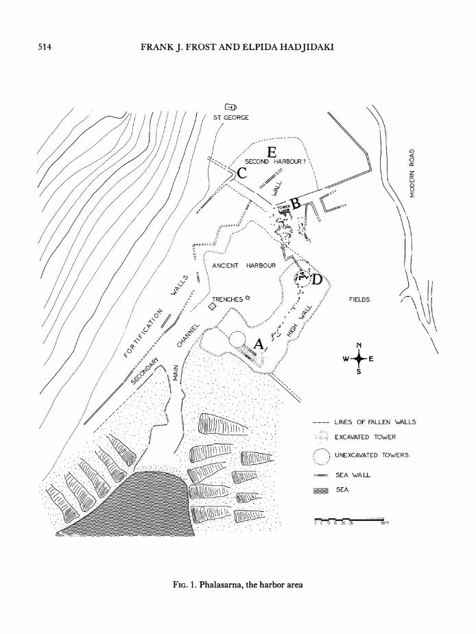
514 FRANK J. FROST AND ELPIDA HADJIDAKI
ST GEORGE
'&9, SECOND HARBOUR?"
z LId
0
ANCIENT HARBOUR
TRENCHES, FIELDS L N J!
0 AjUE A'4
FC, 1. Zr
C-,~~~~~~~~~~~,t
LINES OF FALLEN WALLS
EXCAVATED TOWER
7; UNEXCAVATED TOWERS
Wo~~~~ SEA WA LL
_ _~~~~~SEA
0 5 ' 20 25 5
FIG. 1. Phalasarna, the harbor area
EXCAVATIONS AT THE HARBOR OF PHALASARNA (CRETE) 515
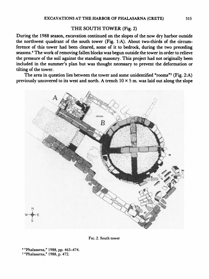
THE SOUTH TOWER (Fig. 2)
During the 1988 season, excavation continued on the slopes of the now dry harbor outside the northwest quadrant of the south tower (Fig. 1:A). About two-thirds of the circum- ference of this tower had been cleared, some of it to bedrock, during the two preceding seasons.4 The work of removing fallen blocks was begun outside the tower in order to relieve the pressure of the soil against the standing masonry. This project had not originally been included in the summer's plan but was thought necessary to prevent the deformation or tilting of the tower.
The area in question lies between the tower and some unidentified "rooms"5 (Fig. 2:A) previously uncovered to its west and north. A trench 10 x 5 m. was laid out along the slope
FIG. 2. South tower
4 "Phalasarna," 1988, pp. 463-474. 5 "Phalasarna," 1988, p. 472.
516 FRANK J. FROST AND ELPIDA HADJIDAKI
just northwest of the tower, which was covered with huge tumbled blocks, all fallen from the upper courses of the tower. After the area had been mapped, the top stones were marked and removed by crane to a storage area. As excavation continued, the blocks were removed in this way every three days. Fallen masonry was found from the surface down to the foun- dations of the tower. There was no real stratigraphy in this exterior area: the soil seemed to have been greatly disturbed, possibly by waves generated by the seismic events that raised western Crete to the present height above sea level. Half a meter below the surface, sea shells and associated debris were encountered four meters above the ancient sea level. The first two meters of this debris consisted of broken sandstone, sand, gravel, Ostrea shells, and a few black-glazed sherds. Below the debris was a meter and a half of sand mixed with isolated sherds of black-glazed pottery. The relative position of these two layers seemed to indicate that the final destruction of the tower was more or less contemporary with its use, not centuries later.6
At a depth of 1.35 to 1.90 m. from the top of the tower's surviving stonework, the first course of a single wall emerged, 50 cm. wide, and trending northwesterly parallel to the previously excavated fortification wall that abuts the western curve of the tower. Where this new wall approached the tower it curved slightly so as to join the tower perpendicularly (Fig. 2:B, P1. 79:b). The chamber formed by this wall, the tower, and two previously exca- vated walls was roughly rectangular, measuring 3.75 x 2.75 m., and at first seemed to re- semble the smaller "rooms" to the west.7
As excavation proceeded we found the interior of this chamber to have been plastered with hydraulic mortar. At a depth of two meters from the present top of the tower we reached the level at which the tower elsewhere was ornamented with a kymation that also served to increase the diameter of the tower base by 0.40 m.8 To our surprise the broadening of the base in this chamber was accomplished with a simple linear angle rather than the elegant inverted kyma found elsewhere, seeming to show that at the time of original con- struction of the tower this section had been planned for a specific purpose. The plaster covered the lower part of this angle as well (P1. 79:a). We soon realized we had uncovered some kind of a cistern; Hadjidaki had previously suspected a fish tank.9 The plaster itself had been painted with a black substance, perhaps a sealant, as yet unidentified. In addition, the floor of the cistern is made of colored pebbles set in mortar (P1. 79:c). A fish tank is now ruled out because the bottom lies 1.5 m. above the ancient sea level, preventing the normal circulation of sea water. On the west wall of the tank there are two small holes mortared shut. Apparently the holes had once accommodated pipes to release water but had been closed for some reason. Fifteen centimeters below these holes was a circular depression,
6 The working hypothesis of the excavators is that the tower was destroyed during the Roman siege of 68/67 B.C.: see footnote 2 above. The catastrophic displacement of west Crete is dated more than five centuries later by Pirazzoli: footnote 3 above.
7 "Phalasarna," 1988, p. 472. 8 "Phalasarna," 1988, p. 471-472. 9 E. Hadjidaki, The Classical and Hellenistic Harbor of Phalasarna in Western Crete (diss. University of
California, Santa Barbara 1988), p. 42.
EXCAVATIONS AT THE HARBOR OF PHALASARNA (CRETE) 517
0.65 m. in diameter and 0.10 m. deep, that may have served as a silt trap (P1. 79:b). Among the several tumbled blocks that were removed from inside the cistern, two were discovered to have channels, 0.11-0.14 m. deep, cut across their tops. These blocks were huge, 1.22- 1.75 m. in length, 0.75 m. wide, and 0.50 m. high, and had the same curvature as the outside circumference of the tower. They came therefore from the original upper courses of the tower and were probably part of a rainwater collection system draining into the cistern. The cistern was probably a fresh-water reservoir for the garrison in this quarter of the fortified harbor; possibly it was used in resupplying ships as well. It was probably covered with a wooden roof, as seems indicated by 64 bronze nails, as much as 0.1 1 m. long, found within the cistern, many resting on its floor. Pieces of charcoal were also found trapped between the tumbled blocks that had fallen into the tank.
The upper portions of the north and west walls of the cistern postdate the walls on the east and south; they bear signs of irregular building and reconstruction, possibly in late Hellenistic times. The present cistern may have been modified at this time even though it was almost certainly originally planned and built at the same time as the tower.
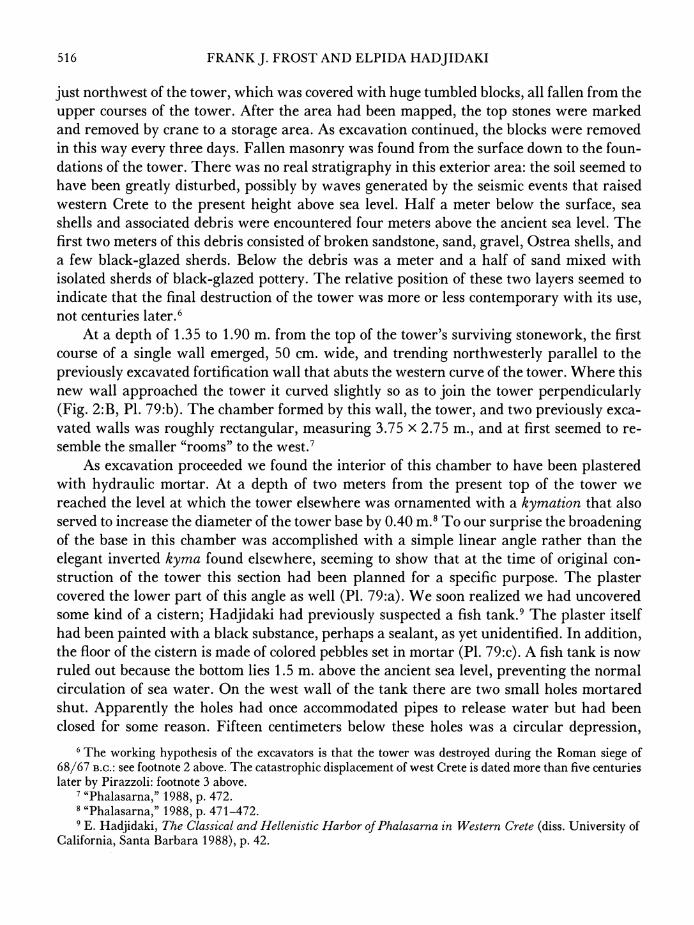
In the area north of the cistern other late Hellenistic buildings have begun to emerge. Since excavation is incomplete, only certain features are mentioned here. A.broken mono- lithic sandstone column stands, probably in situ, west of the cistern. Three catapult stones were recovered from the area around the column, the largest weighing over twenty kilo- grams. It is interesting that the catapult stones uncovered in 1987 came from the same general area.10 Another architectural feature is a handsome square-cut block measuring 0.55 x 0.55 x 0.50 m.; it is covered with plaster on all its finished sides (Fig. 3) and was probably intended as a pedestal cap. Finally, we found a Doric capital for an unfluted stone column, now broken. Clearly an important monument stood here which further excavation should uncover.
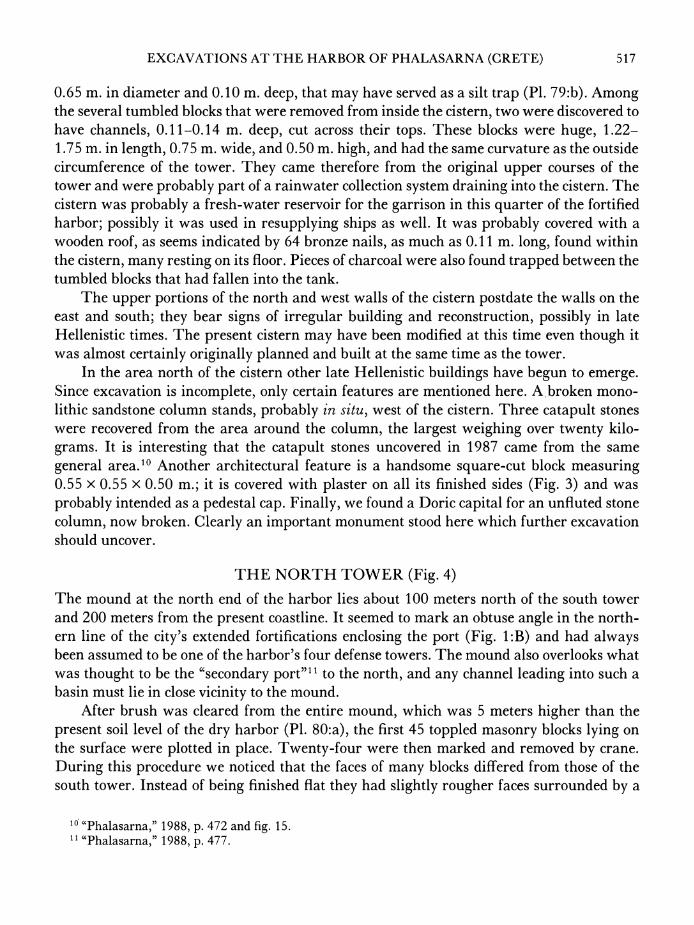
THE NORTH TOWER (Fig. 4)
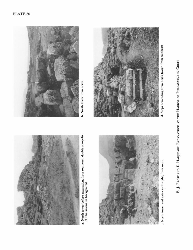
The mound at the north end of the harbor lies about 100 meters north of the south tower and 200 meters from the present coastline. It seemed to mark an obtuse angle in the north- ern line of the city's extended fortifications enclosing the port (Fig. 1:B) and had always been assumed to be one of the harbor's four defense towers. The mound also overlooks what was thought to be the "secondary port" 11 to the north, and any channel leading into such a basin must lie in close vicinity to the mound.
After brush was cleared from the entire mound, which was 5 meters higher than the present soil level of the dry harbor (P1. 80:a), the first 45 toppled masonry blocks lying on the surface were plotted in place. Twenty-four were then marked and removed by crane. During this procedure we noticed that the faces of many blocks differed from those of the south tower. Instead of being finished flat they had slightly rougher faces surrounded by a
10 "Phalasarna," 1988, p. 472 and fig. 15. 4"Phalasarna," 1988, p. 477.
518 FRANK J. FROST AND ELPIDA HADJIDAKI
FIG. 3. Plastered pedestal cap
periteneia. When 20 cm. of deposit had been removed the first stratigraphic layers ap- peared, filled with ancient pottery. Unlike excavation at the south tower, where everything was mixed with sand and sea deposits, here we uncovered clear stratigraphic levels. Directly to the south of the tower the levels uncovered to date are as follows: 0-0.20 m. surface soil 0.20-1.45 m. reddish pink earth mixed with chipped sandstone, Ostrea shells, bronze
nails, charcoal, and layers of Hellenistic pottery 1.45-1.75 m. faded, light brown earth mixed with small gravel and stones, burnt wood,
many bronze and iron nails, scattered bones, small corroded metal objects, and 3rd- to 2nd-century B.C. Hellenistic pottery under which an earthen floor emerged
The new tower was thus gradually uncovered, but to our surprise it was rectangular rather than circular, its interior filled with earth and stones (P1. 80:b, c). Excavation has so far revealed only the first three courses, consisting of large re-used ashlar blocks. Certain blocks had chiseled faces finished with a periteneia; others were simply smoothed flat with fine chisels. The decorated blocks were probably the remains of an earlier tower that stood here before being leveled and partly reconstructed. The present total length is 5.50 m., the width 2.50 m., and the uncovered height 2.00 m. We calculate, however, that the tower construction continues down at least another 2.50 m.
On the southwest corner of the tower, excavation has begun to reveal a small square room with walls 1.50 m. in length. It is clearly a late addition, as it is built of small rough stones.
EXCAVATIONS AT THE HARBOR OF PHALASARNA (CRETE) 519
FiG. 4. North tower from the west (D. Montagu)
520 FRANK J. FROST AND ELPIDA HADJIDAKI
~~~~11oc ~ ~ ~ ~ ~ ~ ~ ~ ~ IO FIG. 5... Fragment ofbowlwithEr e. Se 1
/a^ .... . . ......................... ....,_
A,'., ",',,V,~~~~..,'',<............'t"-;'
follo~~~Xw thbs of th acools ths enlsn the por on all_ sids Whr the walls* meet
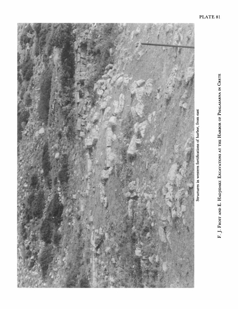
unexcavated (Fig. 1 :C, P1. 81). To the east of the tower and adjoining it is a mound of small~~~~~~~~~~~~~~~~~~~~~~~~~~~~~~~~~~~~~I-.<+ F-FO-wst
...........~~~~~~~~~~~~~~~~~~~~~~~~~~~~~~~~~~~~~~~~~~~~~~~~~ ......
170 C ...... ........0
blocks and unworked stones,, also unexcavated, giving the impression of a hasty attempt to shore up defenses. At the southeast corner of the tower we discovered the remains of a third connecting wall, 4.50 m. long and running southeastward towards a juncture in the perim- eter walls where we suspect another tower lies (Fig. I1:D). The upper preserved course of this wall consists of four rectangular blocks supported on the east side by the aforemen- tioned mound of rubble. Where this wall ended we found four steps of a large staircase that presumably continues downward to the southeast. The steps are long, rectangular blocks measuring 1.60 x 0.40 x 0.25 m. (P1. 80:d). At the top of the stairs and underneath the rubble mound, the corner of a monumental structure began to appear only two hours before the excav7ation season ended (P1. 82:a). The visible end consisted of three flat, rectangular blocks 0.46 m. thick and 1.07 m. long. On their southwest side there is an elaborate torus molding, similar to the kymationz of the south tower. The uncovered length of these blocks is 2.40 in., but it seems to continue north under the rubble wall. The structure seems to form the base of a monument of some sort, or even an altar, but no definite statements can be made before the excavation is continued.
On the southern face of the north tower, facing the harbor and the sea, there is a rec- tangular opening 1.20 m. wide that probably belongs to a doorway. Its lintel, however, has
EXCAVATIONS AT THE HARBOR OF PHALASARNA (CRETE) 521
~~~~~~~~~~~~~~~~~~~~~~~~~~~~~~~~~~~~~~. .. ^ .... .. ... . ..
.. '_,,
. I
, . ..
.. ,,X. . ...
, ,.:
.... . .. . . ....
. .. . . .. . . .. . .-
FIG. 6 ... Frgmnt.o bol w.t duk ep.g oseEosSae.:
ceed (P1. 80:c). In the immediate~~~~~~~~~~~~~~~~~~~~~~~~.. .. vicinity, to th south at. dept.of. .00- .70m.frm.th
.. ............ ..... _~~~~~~~~~~~~~~. . . .. . . . .....;,_.--.-,_
z - ~~~~~~~~~~~~~~~~~~~~~~~~~~. ). - ;...v.-.....--
running sothas an paale totesaraewlopex rudteewlsmc
....~~~~ ~~~~ ~~~~~~~~~.. ... ......
,--
0 Lt925 0 L{42-+
FIG. 6s Fragments of bowls with duck leaping horset Eros. Scale 1:l1
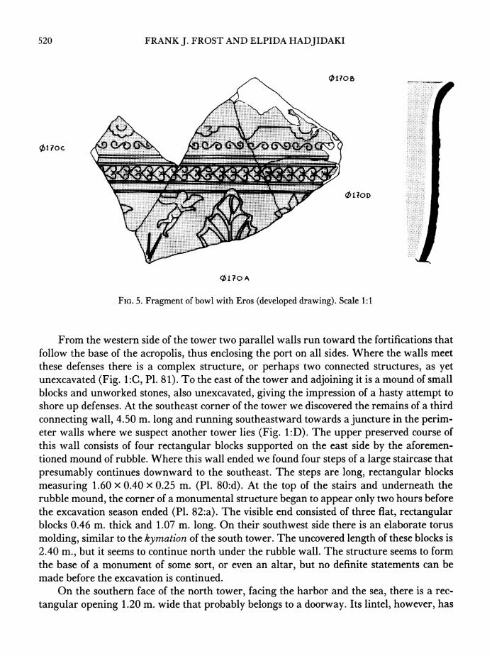
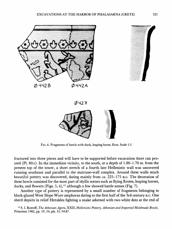
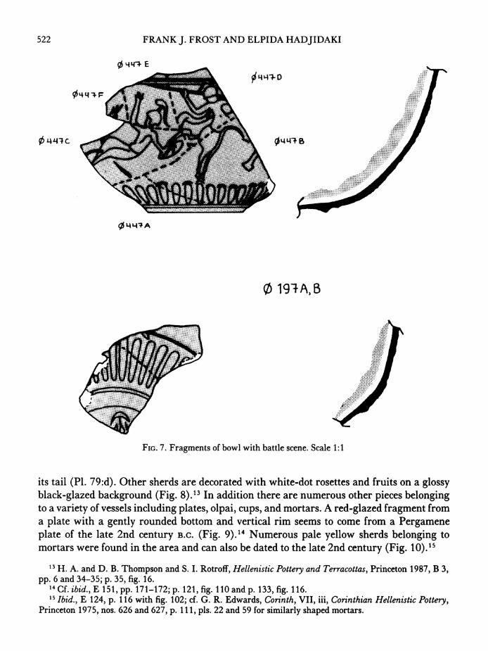
fractured into three pieces and will have to be supported before excavation there can pro- ceed (PI. 80:c). In the immediate vilcinilty, to the south, at a depth of 1.00-1.70 m. from the present top of the tower, a short stretch of a fourth late Hellenistic wall was uncovered running southeast and parallel to the staircase-wall complex. Around these walls much beautiful pottery was discovered, dat'ing mainly from ca. 225-175 B.C. The decoratilon of these bowls consisted for the most part of idyll-ic scenes such as flying Erotes, leaping horses, ducks, and flowers (Figs. 5, 6),1 2although a few showed battle scenes (Fig. 7).
Another type of pottery is represented by a small number of fragments belonging to black-glazed West Slope Ware amphoras dating to the first half of the 3rd century B.C. One sherd depicts in relief Herakles fighting a snake adorned with two white dots at the end of
I2 S. I. Rotroff, The Athenian Agora, XXII, Hellenistic Pottery. Athenian and Imported Moldmade Bowls, Princeton 1982, pp. 19, 54; pls. 15, 94:87.
522 FRANK J. FROST AND ELPIDA HADJIDAKI
0~~~~~ ~ 1971AE
4 4
14 APC 014q1
............
FIG. 7. Fragments of bowl with battle scene. Scale 1:1
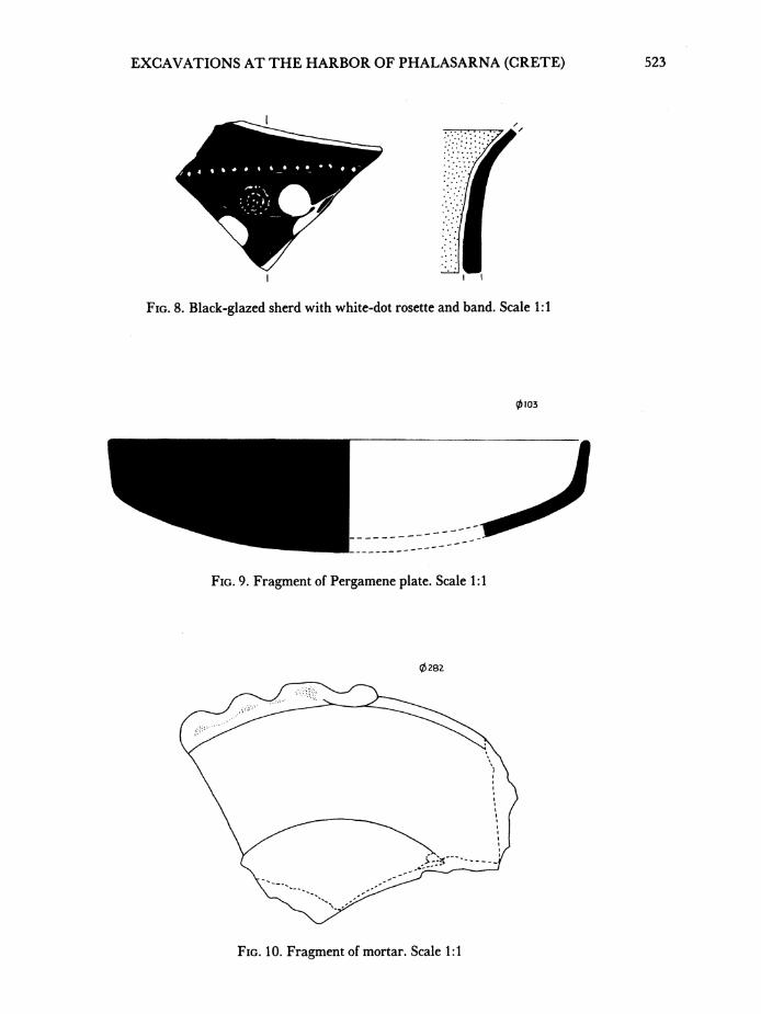
its tail (P1. 79d). Other sherds are decorated with white-dot rosettes and fruits on a glossy black-glazed background (Fig. 8). 13 In addition there are numerous other pieces belonging to a variety of vessels including plates, olpai, cups, and mortars. A red-glazed fragment from a plate with a gently rounded bottom and vertical rim seems to come from a Pergamene plate of the late 2nd century B.C. (Fig. 9).14 Numerous pale yellow sherds belonging to mortars were found in the area and can also be dated to the late 2nd century (Fig. 10)2
II H. A. and D. B. Thompson and S. I. Rotroff, Hellenistic Pottery and Terracottas, Princeton 1987, B 3, pp. 6 and 34-35; p. 35, fig. 16.
14 Cf. ibid., E 151, pp. 171-172; p. 121, fig. 110 and p. 133, fig. 116. '5 Ibid., E 124, p. 116 with fig. 102; cf. G. R. Edwards, Corinth, VII, iii, Corinthian Hellenistic Pottery,
Princeton 1975, nos. 626 and 627, p. 111, pls. 22 and 59 for similarly shaped mortars.
EXCAVATIONS AT THE HARBOR OF PHALASARNA (CRETE) 523
FIG. 8. Black-glazed sherd with white-dot rosette and band. Scale 1 :1
0103
FIG. 9. Fragment of Pergamene plate. Scale 1 :1
0282
FIG. 1 0. Fragment of mortar. Scale 1: 1
524 FRANK J. FROST AND ELPIDA HADJIDAKI
This ceramic evidence, together with the various walls uncovered around the first three layers of the north tower, suggests that some 2nd-century buildings stood here. They were built on earlier construction, possibly of the 4th and 3rd centuries, levels which have not yet been cleared.
The tower, staircase, and monument base above it are probably contemporary with the original harbor buildings, which date to the 4th century B.C. They were, however, rebuilt and extended in increasingly degenerate fashion until the 2nd or early 1st century B.C., as shown by the clumsy late walls that surround them. A more certain interpretation of ar- chitectural sequences must await excavation of the tower foundations.
THE "SECONDARY PORT"
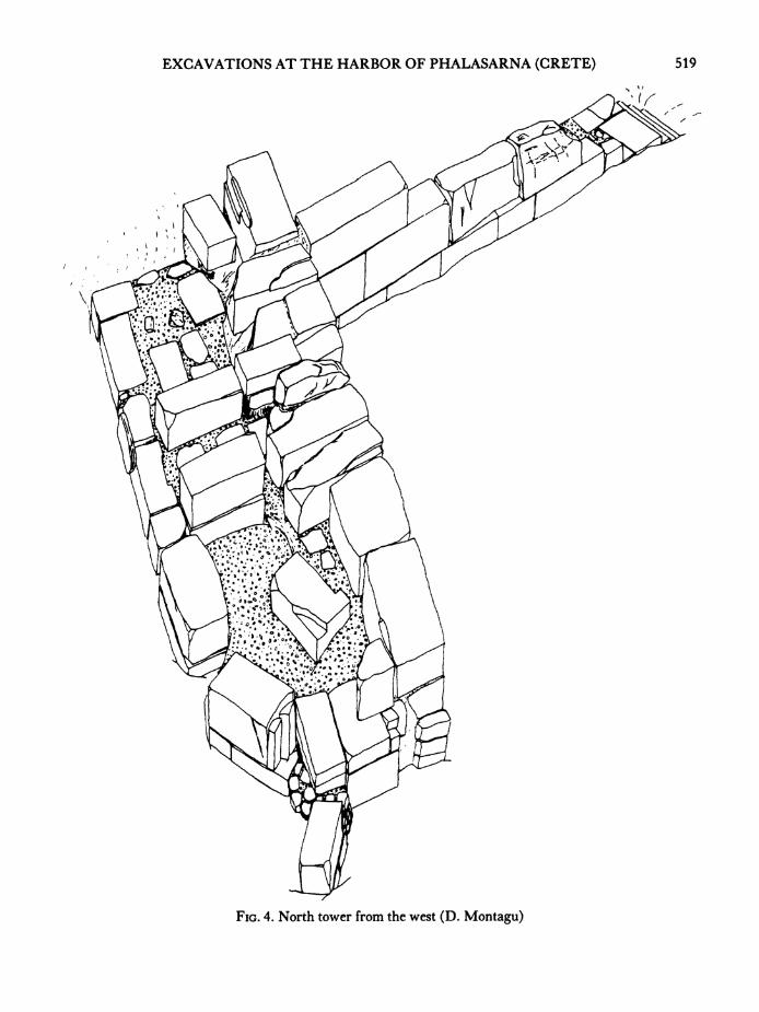
To the north of the big harbor there is a flat, circular meadow whose present surface is 1.20 m. above the ancient sea level (Fig. 1:E). Preliminary results of a geophysical survey showed a layer of at least 0.70 m. of soil deposited since antiquity. It was thought that this area might have been a secondary port. On the south the basin is bounded by the north tower and the walls extending from it; on the north and east, it ends at the remains of struc- tures that have been called "shipsheds".16
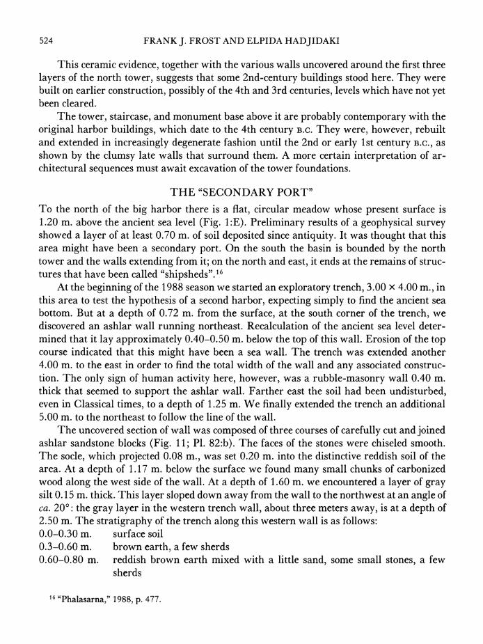
At the beginning of the 1988 season we started an exploratory trench, 3.00 x 4.00 m., in this area to test the hypothesis of a second harbor, expecting simply to find the ancient sea bottom. But at a depth of 0.72 m. from the surface, at the south corner of the trench, we discovered an ashlar wall running northeast. Recalculation of the ancient sea level deter- mined that it lay approximately 0.40-0.50 m. below the top of this wall. Erosion of the top course indicated that this might have been a sea wall. The trench was extended another 4.00 m. to the east in order to find the total width of the wall and any associated construc- tion. The only sign of human activity here, however, was a rubble-masonry wall 0.40 m. thick that seemed to support the ashlar wall. Farther east the soil had been undisturbed, even in Classical times, to a depth of 1.25 m. We finally extended the trench an additional 5.00 m. to the northeast to follow the line of the wall.
The uncovered section of wall was composed of three courses of carefully cut and joined ashlar sandstone blocks (Fig. 11; P1. 82:b). The faces of the stones were chiseled smooth. The socle, which projected 0.08 m., was set 0.20 m. into the distinctive reddish soil of the area. At a depth of 1.17 m. below the surface we found many small chunks of carbonized wood along the west side of the wall. At a depth of 1.60 m. we encountered a layer of gray silt 0.15 m. thick. This layer sloped down away from the wall to the northwest at an angle of ca. 200: the gray layer in the western trench wall, about three meters away, is at a depth of 2.50 m. The stratigraphy of the trench along this western wall is as follows: 0.0-0.30 m. surface soil 0.3-0.60 m. brown earth, a few sherds 0.60-0.80 m. reddish brown earth mixed with a little sand, some small stones, a few
sherds
16 "Phalasarna," 1988, p. 477.
EXCAVATIONS AT THE HARBOR OF PHALASARNA (CRETE) 525
0.80-1.00 m. reddish brown earth, sand, larger stones, a few sherds 1.00-1.10 m. earth, sand, charcoal, land-snail shells, sherds 1.10-1.90 m. hard, reddish brown earth, sand, large stones, gravel, many sherds 1.90-2.48 m. soft earth, sand, sherds, a very few seashells 2.48-2.78 m. blue-gray clay with sand, many sherds, some large bones
An almost complete amphora bottom at 2.60 m. is evidently resting on the original ground level.
2.78-2.80 m. reddish yellow clay mixed with gravel, no sherds Pottery found west of the wall was greatly worn, but certain fragments were distinctive
enough to be dated to the 2nd and 1st centuries B.C. To the east, however, some 4th-century black-glazed sherds were found in the strata directly above the undisturbed horizon. At pres- ent one can only demonstrate that the area to the west of the wall was under water. Absence of large numbers of seashells (copious in the big harbor) would seem to show that there was no connection with the main harbor and thus with the sea. This basin may have been a brackish lagoon; the chemical analysis of soil samples taken from various strata in the trench is incomplete. Curiously, there is no great concentration of sherds where the wall meets the ancient bottom, as one is accustomed to find quayside anywhere in the ancient world.
CONCLUSIONS
In the area of the south tower the most significant find was the cistern. We know of no comparable water tank built as an integral part of a harbor tower. The closest parallels are the cisterns situated along the defenses of the Phliasian and Isthmian gates at Corinth.17 These cisterns were roughly the same size as ours and similarly placed near important defensive points, presumably so the garrison would not have to leave for water. There the similarities end. The reservoir at Phalasarna was built above ground and bonded into a fortification tower. It remains a mystery why the interior of a cistern that was apparently covered with a wooden roof should be painted black. A secondary use for the cistern may have been to resupply the corsairs of Phalasarna swiftly with fresh drinking water. 18
The north tower demonstrates that the builders of Phalasarna required no consistency in the shape or style of their harbor fortifications. The original tower was certainly built sometime in the 4th century, but the present remains were clearly rebuilt in late Hellenistic times. Of the pottery found outside the tower on the harbor side of the fortifications, the majority are from Megarian bowls of the 3rd and 2nd centuries. The latest sherds date to the 1 st century, and there is nothing more recent. This is consistent with our hypothesis that Phalasarna was destroyed during the Roman suppression of Cretan piracy under Metellus Creticus. 19
Finally, in the meadow north of the north tower, the discovery of a long, well-built wall challenges the hypothesis of a secondary harbor because the space between the wall and the
17 R. Carpenter and A. Bon, Corinth, III, ii, The Defenses of Acrocorinth and the Lower Town, Cambridge, Mass. 1936, pp. 105-106.
18 Hadjidaki (footnote 9 above), pp. 131-135. 19 Frost (footnote 2 above).
TRENLM A TO C.
VAAIAItON OF CUT STONE DIP4NSWt04
L _ '1. / __ 1
FIG. 11. Wall in north basin, from northwest
A~~~~~~~~
Io ~ ~ ~~~~ic.11 alinnrhbsn fo otws
EXCAVATIONS AT THE HARBOR OF PHALASARNA (CRETE) 527
beginning of the acropolis slope would scarcely have permitted one ship to maneuver. Nevertheless, this space was a lagoon of some sort in antiquity; the wall was constructed with its footings under water, and then the area to the east of the wall seems to have been filled with rubble. Only further excavation will solve these mysteries.20
The monuments we have uncovered so far belong to a military port whose harbor en- gineering, we believe, is unique in the Greek world. The harbor fortification towers and their adjacent walls are in fact extensions of the city's own defenses, thus fitting the description of Skylax, who called it a XVup3v KEuT7O-S.21 The design of the artificial main channel leading into the military harbor and the existence of a small basin to the north give the area a super- ficial similarity to the kothon and connecting merchant harbor at Carthage.22 We look for- ward to the continuing excavation of the only Greek pirate port that has ever been thoroughly investigated and hope that in succeeding seasons we may gradually discover answers to match the puzzles that have been accumulating during the last three years.
FRANK J. FROST UNIVERSITY OF CALIFORNIA
Department of History Santa Barbara, CA 93106
ELPIDA HADJIDAKI
ARCHAEOLOGICAL MUSEUM OF WEST CRETE
73100 Chania, Greece
20 "Phalasarna," 1988, p. 464; Hadjidaki (footnote 9 above), p. 10. 21 Skylax, 47 (K. Muller, Geographi graeci minores I, Paris 1855, p. 42); so also Dionysios Kalliphontos,
120 (GGM I, p. 242). 22 Hadjidaki mentions the possibility of Punic-Hellenistic cross-cultural influence: "Phalasarna," 1988,
pp. 477-479. For a recent analysis of the double harbor at Carthage see H. Hurst and L. Stager, "A Metro- politan Landscape: The Late Punic Port of Carthage," World Archaeology 9, 1978, pp. 340-341. Frost is hesitant to posit such influences, pointing out that the Punic ports were excavated from a marshy plain, while the harbor at Phalasarna was located in a deep indentation in a solid sandstone formation.
The Romans did in fact block both harbors, but what has been found so far at Phalasarna is on a far smaller scale than the choma built by Scipio at Carthage (Appian, Pun. 121), which was 24 feet wide and 70 feet long, with a base of 96 feet.
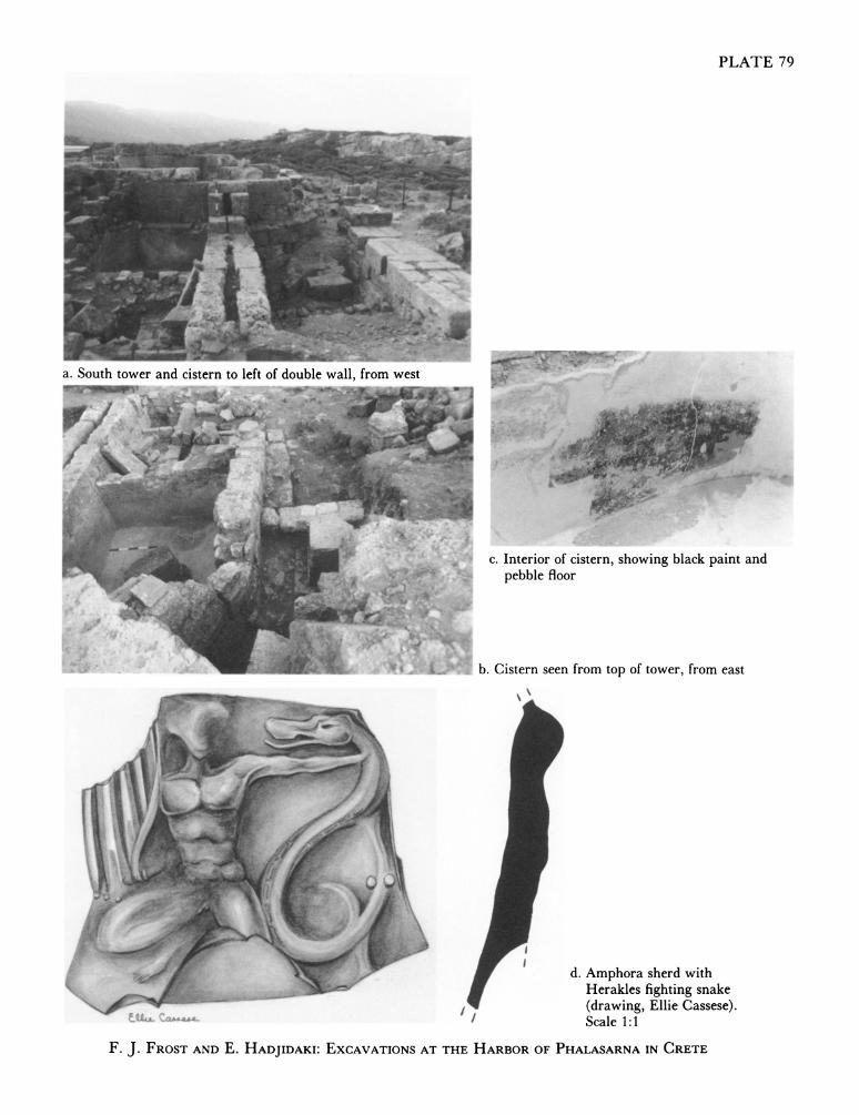
PLATE 79
a. South tower and cistern to left of double wall, from west
c Interior of cistern, showing black paint and S 11
. pebble floor
1. b. Cistern seen from top of tower, from east
d. Amphora sherd with
_s~~~~~~~~~~~~~~~~~~~~Hrke fightin snk
*~~~~~~~~ (dawng Eli Csses)
~~~~~~~ pebb~~~~~~~~~~~~~~cle 1:1o
FJ.FOTANEHAJAK ECVTOS- ATTEHRBRO HAAAN IRT
a. North tower before excavation, from southeast, double acropolis b. North tower from north of Phalasarna in background
'5 ~ ~ ~
4%~~~~~~~~~~~~~~~~~~~~~~~~~~~V
c.North tower and gateway to right, from south d. Steps descending from north tower, from southeast
FJ.FROST AND E. HADJIDAKI: EXCAVATIONS AT THE HARBOR OF PHALASARNA IN CRETE
Y~~~#k2f t~i%~~o.
a $~~~~~~~~~~?~~~~~flC~~~~~~~~~Wt 4#'~~~~~~~~~~~~~~~~4 ~ ~ ~ ~ ~ ~ ~ ~ ~ s-
40#.~ ~ ~ ~ ~ ~ ~~~~Srcue nwetr otfctos fhro rmes
WA %...H ir~ ~~ ~ ~~ ~ ~ ~~ ~ ~ ~ ~ ~ ~ ~ ~ ~~~~~~~~~~~~~~~~~~~~~~~~~~~~~~~~~~~~~~~~~~~~~~~~~T
F.~~~~~~~ J.FOTADE AJDK: XAAINWTTEHRORO HLSRAI RT
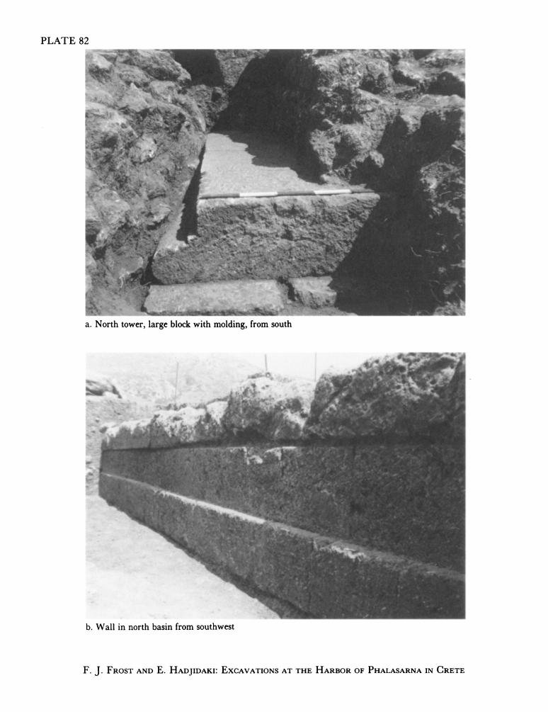
PLATE 82
Li_-
I,-
a. North tower, large block with molding, from south
_~~~~
lw
b. Wall in north basin from southwest
F. J. FROST AND E. HADJIDAKI: EXCAVATIONS AT THE HARBOR OF PHALASARNA IN CRETE