Embed Size (px)
Citation preview
.sc iencedi rect .com
HO ST E D BY Avai lab le at wwwINFORMATION PROCESSING IN AGRICULTURE 2 (2015) 208–216
journa l homepage: www.elsevier .com/ locate / inpa
Exposing vocabularies for soil as Linked Open Data
http://dx.doi.org/10.1016/j.inpa.2015.10.0022214-3173 � 2015 China Agricultural University. Production and hosting by Elsevier B.V. All rights reserved.
* Corresponding author at: Consiglio per la ricerca in agricoltura e l’analisi dell’economia agraria (CREA), Agrobiology andResearch Centre, Piazza M. D’Azeglio 30, 50121 Firenze, Italy. Tel.: +39 0552491239; fax: +39 055241485.
E-mail address: [email protected] (G. L’Abate).
Peer review under the responsibility of China Agricultural University.
Giovanni L’Abate a,*, Caterina Caracciolo c, Valeria Pesce b, Guntram Geser e,Vassilis Protonotarios d, Edoardo A.C. Costantini a
aConsiglio per la ricerca in agricoltura e l’analisi dell’economia agraria (CREA), Agrobiology and Pedology Research Centre, Firenze, ItalybGlobal Forum on Agricultural Research, Rome, Italyc Food and Agriculture Organization of the United Nations, Rome, ItalydUniversity of Alcala, Alcala de Henares, Spaine Salzburg Research, Salzburg, Austria
A R T I C L E I N F O
Article history:
Received 2 January 2014
Received in revised form
9 October 2015
Accepted 14 October 2015
Available online 10 November 2015
Keywords:
Agriculture
Soil
Knowledge Organization Systems
Vocabularies
Resource Description Framework
Linked Open Data
INSPIRE
A B S T R A C T
Standards to describe soil properties are well established, with many ISO specifications and
a few international thesauri available for specific applications. Besides, in recent years, the
European directive on ‘‘Infrastructure for Spatial Information in the European Community
(INSPIRE)” has brought together most of the existing standards into a well defined model.
However, the adoption of these standards so far has not reached the level of semantic inter-
operability, defined in the paper, which would facilitate the building of data services that
reuse and combine data from different sources.
This paper reviews standards for describing soil data and reports on the work done within
the EC funded agINFRA project to apply Linked Data technologies to existing standards and
data in order to improve the interoperability of soil datasets. The main result of this work is
twofold. First, an RDF vocabulary for soil concepts based on the UML INSPIRE model was
published. Second, a KOS (Knowledge Organization System) for soil data was published
and mapped to existing relevant KOS, based on the analysis of the SISI database of the
CREA of Italy. This work also has a methodological value, in that it proposes and applies
a methodology to standardize metadata used in local scientific databases, a very common
situation in the scientific domain. Finally, this work aims at contributing towards a wider
adoption of the INSPIRE directive, by providing an RDF version of it.
� 2015 China Agricultural University. Production and hosting by Elsevier B.V. All rights
reserved.
1. Introduction: data interoperability, metadataand the agINFRA project
In an era where data are produced at extremely high rates
from a wide variety of sources and have to be made available
to multiple stakeholders, from researchers and scientist to
the general learners, the need for quickly identifying relevant
data and linking or somehow combining data coming from
heterogeneous data sources is strongly felt. The term nor-
mally used to define the set of features that data or metadata
need to have in order to allow for this linking and combining
of heterogeneous data is ‘‘data interoperability”. ‘‘Data
Pedology
I n f o r m a t i o n P r o c e s s i n g i n A g r i c u l t u r e 2 ( 2 0 1 5 ) 2 0 8 –2 1 6 209
interoperability is a feature of datasets and of information
services that give access to datasets, whereby data can easily
be retrieved, processed, re-used, and re-packaged (‘‘oper-
ated”) by other systems.” [1].
In recent years, advocates of data interoperability have
moved away from recommending the use of homogeneous
metadata and formats, and embraced instead the view that
it can be reached by using semantically defined classes, prop-
erties, concepts, and by identifying them with resolvable Uni-
form Resource Identifiers (URIs), in order to aloe for easy
reuse of them. The resulting web of interlinked things is ter-
med ‘‘Linked Data”, and the type of interoperability that
results from it is usually called ‘‘semantic interoperability” [2].
A few examples exist of applications that adopt the linked
data approach in agricultural domain, like AGRIS [3]. Users of
AGRIS can search for bibliographic references as well as full
text documents and other types of data. The backbone of
the AGRIS infrastructure, what allows the various pieces of
information to be linked together, is the AGROVOC [4,5] the-
saurus. However, the limited availability of linked data in agri-
culture hampers the diffusion of initiatives like AGRIS. Here is
where agINFRA comes into play.
Data interoperability depends on the way data are
described and classified. Two things are necessary to describe
data. First, one needs metadata elements to describe various
aspects of the data, e.g., title and abstract for publications, or
porosity for a soil observation. Then, values for those meta-
data elements are needed. These values may be either ‘‘free
values” (as in the case of the title of a book, or depth in meters
of a soil sample), or they may be taken from ‘‘controlled
vocabularies,” or ‘‘authority data”, such as thesauri that pro-
vide subject heading references for the metadata element
‘‘subject”, or allowed types of documents for the metadata
element ‘‘document type”.
The ‘‘metadata elements” used to describe a given type of
data, or a dataset, are usually referred to as ‘‘metadata vocab-
ulary”, ‘‘metadata sets”, ‘‘metadata element sets”, or simply
‘‘vocabularies”, while the ‘‘controlled vocabularies” allowed
for any of the metadata elements are also often called ‘‘au-
thority data”, ‘‘value vocabularies” or ‘‘Knowledge Organiza-
tion Systems (KOSs)”. A common source of confusion is that
the term ‘‘vocabulary” (cf. [6]) is often used as a short for both
dimensions. We often use one or the other of these forms,
although we prefer to keep the two notions separate and tend
to talk about ‘‘metadata elements” that may be grouped
together in ‘‘metadata vocabularies”, and that may take their
values from KOS, or controlled vocabularies.
Metadata sets and KOSs have a long history, but they have
gained renewed interest in the context of use of the RDF
(Resource Description Framework) triple-based data model.
To ensure that the description of data by means of RDF triples
(statements formed by ‘‘subject – predicate – object”) is unam-
biguous, the predicate used in the triple must be unambigu-
ous. The way to ensure that predicates are unambiguous is
to provide them with a defined semantics and collect them
in public vocabularies, described and promoted so as to
become standard. Each metadata element (predicate of an
RDF triple) is then given an URI, and the same is done for
concept used as value of the element (the object of that triple).
Metadata elements expressed as RDF vocabularies have then
‘‘machine-readable” semantics: ‘‘objects” described with RDF
vocabularies can be ‘‘operated” bymachines. In general, if ele-
ments in metadata vocabularies are linked together, they will
be Linked Open Data (LOD) vocabularies. For instance, contin-
uing with the terminology proper of RDF triples, consider the
link between properties as in the case property ‘‘themes” in
the W3C Data Catalog Vocabulary (DCAT), defined as ‘‘sub-
property” of ‘‘subject” in the Dublin Core metadata vocabulary
[7], or the links between objects defined in KOSs, like ‘‘soil den-
sity” from the AGROVOC thesaurus and ‘‘soil density” from the
NAL Thesaurus. In general, we say that data described with
any linked vocabulary qualify as Linked Open Data.
Following the line of reasoning described above, agINFRA
first focussed on identifying and recommending existing
RDF vocabularies or publishing new ones if necessary. agIN-
FRA [8] is a project (2011–2015) co-funded by the European
Commission, within the FP7 Research and Innovation funding
programme. agINFRA aims to facilitate the accessibility of
agricultural data by providing the workflows and necessary
grid and cloud based infrastructures required for the develop-
ment of large agricultural data pools, which will be available
to all stakeholders. In this direction, agINFRA aims to provide
the tools and methodology to be used for the publication of
the data managed by project partners as Linked Open Data
(LOD). This is expected to significantly facilitate the interoper-
ability between heterogeneous data sources, not previously
linked in any way. The first step of the agINFRA consortium
towards the publication of vocabularies as linked data was
the identification of the metadata sets and KOSs used by
the agINFRA data providers in their data sources [9], and their
publication as LOD if these were not already published. agIN-
FRA deals with data (and metadata) pertaining to different
areas, namely bibliography, education, germplasm, and soil.
This paper reports on the work done in particular on soil data.
The paper is organized as follow: Section 2 is a review on
standards for soil data. Section 3 describes the work done
within agINFRA project and reports on the obtained results.
Conclusions follow in Section 4.
2. An overview of metadata vocabularies andKOSs for soil data
2.1. Soil metadata vocabularies
Several disciplines look at the soil in different ways (e.g. Engi-
neering, Biology [10,11], Soil cartography [12,13]) and there-
fore typically use different references for characterizing soil
features, like depth, history, chemical composition, morphol-
ogy, and classification, as well as sampling and laboratory
methodologies, and geographical reference systems.
For soil data, different metadata standards already exist
[11,14,15]. They are formalized in various ways, from database
structures to ISO standards [16] to XML implementations
[17,18] to, in a few cases, RDF [19,20].
The international Working Group on Soil Information
Standards (WG-SIS) [14], an initiative within the International
Union of Soil Science, aims to develop, promote and maintain
internationally recognized and adopted standards for the
exchange and collation of consistent harmonized soils data
210 I n f o r m a t i o n P r o c e s s i n g i n A g r i c u l t u r e 2 ( 2 0 1 5 ) 2 0 8 –2 1 6
and information. Geographical aspects of soil data are cov-
ered by well established standards, namely the ISO standards
ISO 19115 ‘‘Geographical Information – Metadata” [21] and ISO
19119 ‘‘Geographic Information – Services” [22]. They cover
geographic information and services, respectively. Taken
together, they fully describe datasets, including individual
geographic features and feature properties. Moreover, ISO
19139 ‘‘Geographic Information – Metadata – XML Schema
implementation” [23] defines the Geographic MetaData XML
(gmd) encoding, and XML Schema implementation for ISO
19115, including the extensions for imagery and gridded data.
The adoption of these ISO standards is growing. For example,
the U.S. Federal Geographic Data Committee (FGDC) recently
recommended that users of the Content Standard for Digital
Geospatial Metadata (CSDGM) [24,25] adopt the ISO standard.
For soil data and terrain attributes, the World SOil and
TERrain (SOTER) Digital Database is a major initiative, started
by the International Society of Soil Science (ISSS) in 1986. The
Geoscience Markup Language (GeoSciML) was developed for
the SOTER model, and then extended by SoTerML [26,27],
the XML language ‘‘Soil and Terrain and Markup Language”,
developed by the Centre for Geospatial Science in the Univer-
sity of Nottingham, compliant with another ISO standard, the
ISO/TC190/SC 1 N140 ‘‘Recording and exchange of soil-related
data”.
A recent initiative to harmonize different soil schemas is
the Soil-ML project [28], a soil equivalent of the GeoSciML
[18] providing Definitions for application schema ‘‘ISO 28258
Definitions” [29].
2.2. The INSPIRE directive
In 2007, the European Union established the directive on
Infrastructure for Spatial Information in Europe (INSPIRE)
[30] to provide an infrastructure for spatial information in
Europe and support Community environmental policies, as
well as policies or activities which may have an impact on
the environment. Within that framework, also a comprehen-
sive standard covering both geographic and scientific aspects
of soil data was created. One of the goals of INSPIRE is to har-
monize different national norms. The section on standards
for soil has recently been completed.
INSPIRE defines a data model, described in the INSPIRE
Implementing Rules on interoperability of spatial data sets
and services [31,32], and the data specification guidance doc-
uments specific for soil [33].
The INSPIRE data models developed by the INSPIRE The-
matic Working Groups, are graphically represented according
to the UML (Unified Modelling Language) notation, and are
based on the INSPIRE XML schema. INSPIRE was designed
according to the ISO standard ISO/TS 19103:2005 ‘‘Geographic
information – Conceptual schema language” [34]. Application
schemas are specified in UML notation, version 2.1 according
to ISO 19109 ‘‘Geographic Information – Rules for application
schema” [35] and the Generic Conceptual Model.
INSPIRE thus provides standards both for the metadata
and the data model, and for the controlled values to be used
(KOSs).
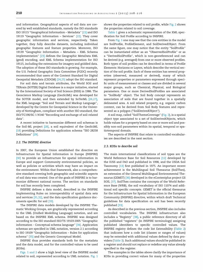
Figs. 1 and 2 show a high level view of the INSPIRE model
related to soil, represented according to UML notation. Fig. 1
shows the properties related to soil profile, while Fig. 2 shows
the properties related to soil coverage.
Table 1 gives a schematic representation of the XML spec-
ification for Soil Profile according to INSPIRE.
From Fig. 1 one may see that the core entities in the model
are SoilProfile, ProfileElement, and SoilDerivedObject. From
the same figure, one may notice that the entity ‘‘SoilProfile”
can be instantiated either as an ‘‘ObservedSoilProfile” or as
a ‘‘DerivedSoilProfile”, which is non-georeferenced and can
be derived (e.g. averaged) from one or more observed profiles.
Both types of soil profiles can be described in terms of Profile
Elements: Horizons or Layers, which describe the vertical sec-
tion of the soil profile. Each of these entities has several prop-
erties (observed, measured or derived), many of which
represent properties or parameters expressed through speci-
fic units of measurement or classes and are divided in several
major groups, such as Chemical, Physical, and Biological
parameters. One or more DerivedSoilProfiles are associated
to ‘‘SoilBody” object. The Soil Body concept represents an
association of soils that are found together in a spatially
delineated area. A soil related property, e.g. organic carbon
content, can be derived from Soil Body features and repre-
sented as a polygon (‘‘SoilDerivedObject”).
A soil map, called ‘‘SoilThemeCoverage” (Fig. 2), is a spatial
object type associated to a set of SoilDerivedObjects, which
holds values for a property based on one or more soil and pos-
sibly non-soil parameters within its spatial, temporal or spa-
tiotemporal domain.
The aspects of INSPIRE that relate to controlled vocabular-
ies are described in the next section.
2.3. KOSs to describe soil
The main international classifications of soil types are the
World Reference Base for Soil Resources [12] developed by
the IUSS and FAO and published in 1998, and the USDA Soil
Taxonomy [13] first published in 1975. An important recent
achievement is the Multilingual Soil Thesaurus (SoilThes),
an extension of the General Multilingual Environmental The-
saurus (GEMET) [36] developed in the eContentplus project GS
SOIL [37]. SoilThes contains the concepts of the World Refer-
ence Base (WRB), the soil vocabulary of ISO 11074 and addi-
tional soil specific concepts. GEMET is the official thesaurus
for the Infrastructure for Spatial Information in the European
Community (INSPIRE) directive, within which draft Technical
guidelines for data specification on soil has been recently
published [33].
As described in the previous section, INSPIRE also includes
controlled vocabularies. The INSPIRE infrastructure also
includes a ‘‘Registry” [38], a public reference directory of all
the published ‘‘registers” (in INSPIRE terminology) assigning
published identifiers to specific controlled values. The
INSPIRE registry defines the code list Extensibility (Table 2)
that indicates how a code list (classes or ranges of values)
may be extended with additional values defined by data pro-
viders (Table 3). Such additional values should be published in
a register and should not replace or redefine any value already
specified in the register.
The examples in the tables above clarify the importance of
KOSs in providing correct values for many of the properties

Fig. 1 – A fragment of the INSPIRE model, covering ‘‘soil profile”. Simple arrows stand for Association (Knows); full white
arrows are used for Inheritance (Is a); full black rhombus means Composition (Has).
I n f o r m a t i o n P r o c e s s i n g i n A g r i c u l t u r e 2 ( 2 0 1 5 ) 2 0 8 –2 1 6 211
(metadata elements) specified in the INSPIRE model. The
ranges of these values can come from large classification sys-
tems or thesauri, as well as from small local lists of values.
While a few comprehensive thesauri and classifications have
been published as LOD, a wide abundance of smaller local
lists of values (as conceived in the INSPIRE local registries)
exist, that are seldom even published as KOSs, maybe because
they tend to be used in local databases only. Therefore, the
rendering of these small lists of values as KOSs is an interest-
ing work for agINFRA. Publishing these small internal lists in
a format compatible with the rest of the RDF-based infras-
tructure, i.e., by using SKOS (Simple Knowledge Organization
System) allows us to map the values to external URIs and
therefore make them LOD, thus making the data and applica-
tions using them more interoperable.
The INSPIRE infrastructure involves a number of items
which require clear descriptions and the possibility of refer-
encing through unique identifiers. Examples for such items
include INSPIRE themes, code lists, application schemas or
discovery services. Registers provide a means to assign iden-
tifiers to items and their labels, definitions and descriptions
(in different languages). The content of these registers are
based on the INSPIRE Directive, Implementing Rules and
Technical Guidelines.
Allowed ranges for controlled vocabularies in INSPIRE are
‘‘free values” (see Table 3), or sets of discrete values from con-
trolled values (i.e., values from a KOS). These second types of
values may also be further constrained so that only certain
values from a given KOS (e.g. the INSPIRE Registry or the the-
saurus of the US National Library (NALT) [19] may be accepted
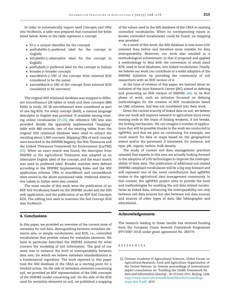
(see Table 4).
The existing metadata standards indicate the ranges and
accepted values for many of the properties: some values can
be taken from published classifications (provided that a refer-
ence to the classification is made), while the other lists are
either ISO standards or just local lists of values that have
not been published elsewhere (Extensible Code list according
to INSPIRE) [39].
One task of the agINFRA project is to publish most of these
lists as LOD.
3. Publishing LOD vocabularies for soil data withinagINFRA
In the work of achieving data interoperability within agINFRA,
we focussed on the Soil Information System of Italy (SISI)
database [40,41], the main agINFRA soil data base, maintained
by the Italian CREA (Consiglio per la ricerca in agricoltura e
Fig. 2 – A fragment of the INSPIRE model, covering ‘‘soil coverage”. Simple arrows are used for Association (Knows); full white
arrows are used for Inheritance (Is a).
212 I n f o r m a t i o n P r o c e s s i n g i n A g r i c u l t u r e 2 ( 2 0 1 5 ) 2 0 8 –2 1 6
l’analisi dell’economia agraria). Metadata elements used in
SISI mainly come from INSPIRE, while various standards are
relevant for their values, like for example the USDA Soil
Taxonomy and WRB.
In Europe, INSPIRE is the reference standard for soil data
organization and dissemination. Since agINFRA is an EC
funded project, INSPIRE was adopted as the starting point
for a LOD metadata vocabulary for soil data. INSPIRE is a good
starting point for both the definition of an RDF metadata
vocabulary, since it defines entities, attributes and relation,
and for the identification of KOSs that need to be published,
as it defines ‘‘registers” of values.
3.1. An RDF soil metadata vocabulary
As briefly described above (Section 2.2), INSPIRE has an UML
representation and an XML representation. The analysis of
the UML diagrams revealed that a representation of themodel
in RDF would not be difficult to achieve. Briefly, what is con-
sidered a ‘‘class” in UML is not very different from what is
considered a ‘‘class” in RDF, while UML attributes are concep-
tually very close to RDF ‘‘properties” (see [42] for a discussion
on the correspondences between UML and RDF). Therefore,
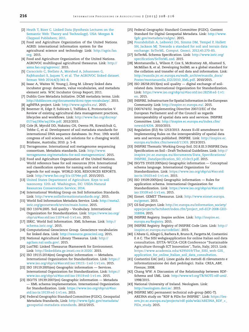
we transformed the main INSPIRE classes into RDF classes.
The diagrams in Fig. 3 also indicate the subclass relationships
and their main attributes and relationships into RDF proper-
ties. INSPIRE also has constraints and rules, which we decided
not to formalize in a complex ontology.
In the agINFRA approach, vocabularies are used to
exchange data and not to support applications. The vocabu-
laries created in agINFRA are not tightly coupled to applica-
tions, since this should not rely on rules and constraints
being enforced by the vocabulary. However, the INSPIRE rec-
ommendations can accompany the vocabulary and the soil
community may decide to enforce them in practice.
An RDF vocabulary was then developed to express the core
classes of the INSPIRE model. The diagram in Fig. 3 represents
the structure of such a vocabulary.
To create and maintain such an RDF vocabulary, the tool
Neologism [43] was used. The vocabulary was published
under the namespace http://vocabularies.aginfra.eu/soil (as
a work in progress).
3.2. New LOD KOSs for soil data
A few KOSs to describe soil are available as LOD. GEMET is
available as an RDF/SKOS linked dataset, mapped to AGRO-
VOC. SoilThes is also available as an RDF/SKOS dataset and
linked to GEMET; the USDA Soil Taxonomy is part of the
National Agricultural Library Thesaurus (NALT) [19], which
Table 1 – A schematic view of the INSPIRE XML representation of ‘‘soil profile”.
�feature type�SoilProfile
+ inspireId: (to be generated)+ WRBSoilName:
+ WRBSoilNameType+ WRBQualifierGroup: WRBQualifierGroupType+ qualifierPlace: prefix+ qualifierPosition: 1+ WRBqualifier: Haplic+ WRBspecifier: –
+ WRBQualifierGroup: WRBQualifierGroupType+ qualifierPlace: suffix+ qualifierPosition: 1+ WRBqualifier: Calcaric+ WRBspecifier: –
+ WRBReferenceSoilGroup: Arenosol+ isOriginalClassification: true
+ otherSoilName:+ soilName: Typic Xeropsamment+ soilClassificationScheme: DocumentCitation+ Name: Carta suoli Sicilia: convenzione con la Regione Sicilia per la realizzazione della Carta dei Suoli a scala 1:250,000nell’ambito del programma interregionale ‘‘Agricoltura e Qualita”+ shortName: Carta suoli Sicilia+ date: 2011+ link: http://www.sias.regione.sicilia.it/
+ isOriginalClassification: true+ localidentifier: DSP 59.9ARCA1.1+ soilProfileParameter: –+ validFrom: 2008+ validTo: 2009+ beginLifespanVersion: 2010+ endLifespanVersion: –
Table 2 – INSPIRE: code list extensibility.
Label Definition
Empty code list No values are specified for this code list in this register, i.e. it is allowed values tocomprise any values defined by data providers
Extensible with narrower values The code list can only be extended with narrower values, i.e. it is allowed values tocomprise the values specified in this register and narrower values defined by dataproviders
Extensible with values at any level The code list can be extended with additional values at any level, i.e. it is allowedvalues to comprise the values specified in this register and additional values at anylevel defined by data providers
Not extensible The code list cannot be extended, i.e. it is allowed values to comprise only thevalues specified in this register
I n f o r m a t i o n P r o c e s s i n g i n A g r i c u l t u r e 2 ( 2 0 1 5 ) 2 0 8 –2 1 6 213
is published as LOD. For the spatial aspect, soil data can rely
on many advanced RDF standards, mainly in the framework
of the EU INSPIRE Directive.
However, none of the above KOSs as LOD was exploited in
the SISI database, or not in their full potential. For example,
values from the above KOSs were used in the database only
as strings and not as URIs, with only indirect indication of
the source authority from which the values come. This is
not unusual in research databases: researchers know the
standards and use the correct values when submitting the
data. The source authority is implicit for them and they know
their colleagues will understand the meaning of the string. In
some cases, they even use the local language version of a
value. This all works well as long as data are used by human
beings, but it is problematic for data sharing and in general
for the use of the data within applications (i.e. machines),
for example to match (link) them with data coming from
other sources.
One case that is particularly difficult is the case of values
for which reference to a published thesaurus is recom-
mended, but only a specific subset of terms is valid for a
specific property. Actually, thesauri are rarely structured
around ‘‘facets” (or the various properties of entities that
can be described by the terms in the thesaurus): they usually
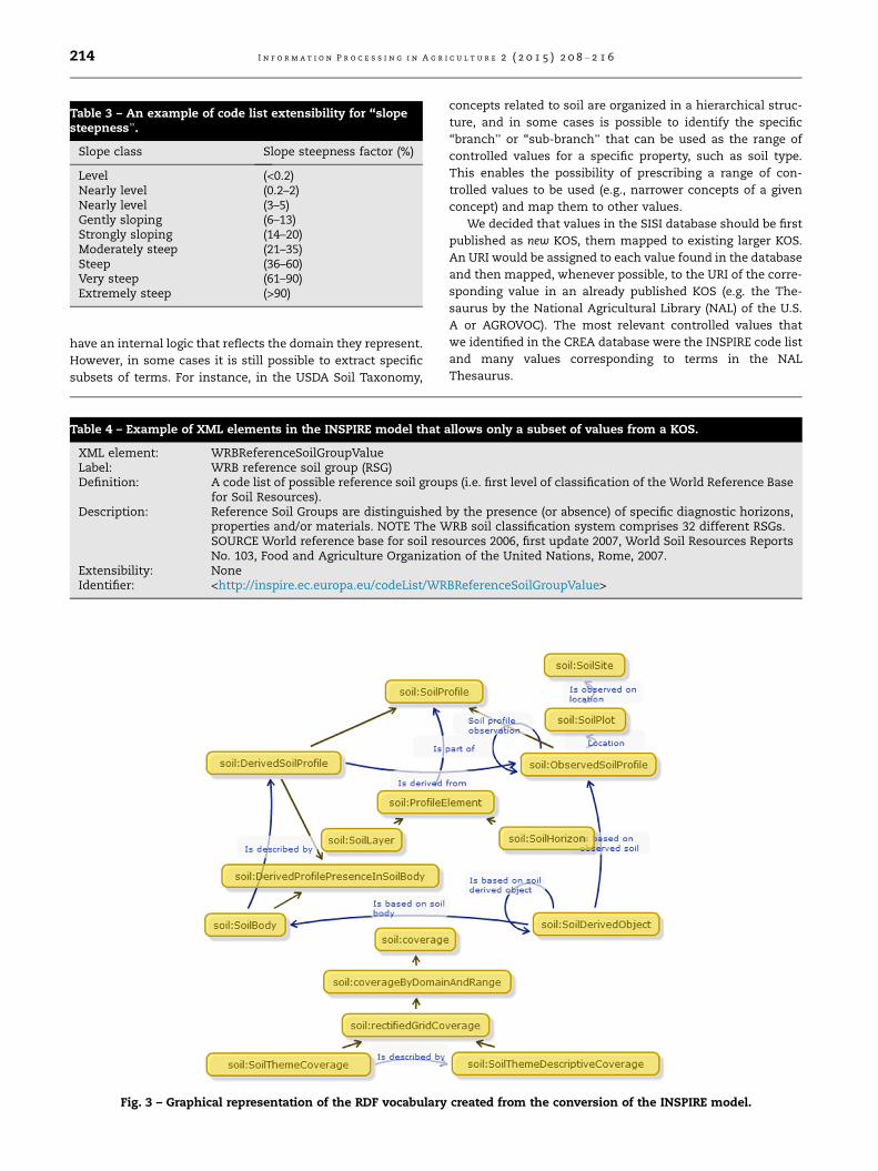
Table 3 – An example of code list extensibility for ‘‘slopesteepness”.
Slope class Slope steepness factor (%)
Level (<0.2)Nearly level (0.2–2)Nearly level (3–5)Gently sloping (6–13)Strongly sloping (14–20)Moderately steep (21–35)Steep (36–60)Very steep (61–90)Extremely steep (>90)
214 I n f o r m a t i o n P r o c e s s i n g i n A g r i c u l t u r e 2 ( 2 0 1 5 ) 2 0 8 –2 1 6
have an internal logic that reflects the domain they represent.
However, in some cases it is still possible to extract specific
subsets of terms. For instance, in the USDA Soil Taxonomy,
Fig. 3 – Graphical representation of the RDF vocabulary
Table 4 – Example of XML elements in the INSPIRE model that a
XML element: WRBReferenceSoilGroupValueLabel: WRB reference soil group (RSG)Definition: A code list of possible reference soil grou
for Soil Resources).Description: Reference Soil Groups are distinguished
properties and/or materials. NOTE The WSOURCE World reference base for soil resNo. 103, Food and Agriculture Organizati
Extensibility: NoneIdentifier: <http://inspire.ec.europa.eu/codeList/WR
concepts related to soil are organized in a hierarchical struc-
ture, and in some cases is possible to identify the specific
‘‘branch” or ‘‘sub-branch” that can be used as the range of
controlled values for a specific property, such as soil type.
This enables the possibility of prescribing a range of con-
trolled values to be used (e.g., narrower concepts of a given
concept) and map them to other values.
We decided that values in the SISI database should be first
published as new KOS, them mapped to existing larger KOS.
An URI would be assigned to each value found in the database
and then mapped, whenever possible, to the URI of the corre-
sponding value in an already published KOS (e.g. the The-
saurus by the National Agricultural Library (NAL) of the U.S.
A or AGROVOC). The most relevant controlled values that
we identified in the CREA database were the INSPIRE code list
and many values corresponding to terms in the NAL
Thesaurus.
created from the conversion of the INSPIRE model.
llows only a subset of values from a KOS.
ps (i.e. first level of classification of the World Reference Base
by the presence (or absence) of specific diagnostic horizons,RB soil classification system comprises 32 different RSGs.ources 2006, first update 2007, World Soil Resources Reportson of the United Nations, Rome, 2007.
BReferenceSoilGroupValue>
I n f o r m a t i o n P r o c e s s i n g i n A g r i c u l t u r e 2 ( 2 0 1 5 ) 2 0 8 –2 1 6 215
In order to automatically import used Concepts and URIs
into VocBench, a table was prepared that contained the fields
listed below. Rows in the table represent a concept:
� ID (= a unique identifier for the concept)
� prefLabelEn (= preferred label for the concept in
English)
� altLabelEn (= alternative label for the concept in
English)
� prefLabelIt (= preferred label for the concept in Italian)
� broader (= broader concept)
� exactMatch (= URI of the concept from external KOS
considered to be the same)
� narrowMatch (= URI of the concept from external KOS
considered to be narrower)
The original SISI relational database was mapped to differ-
ent microthesauri (28 tables in total) and their concepts (880
fields in total). All 28 microthesauri were considered as part
of one big KOS. For every concept (field), a natural language
descriptor in English was provided. If available among exist-
ing online vocabularies [19,20], the reference URI was also
provided. Beside the appositely implemented ‘‘mapping”
table with 880 records, two of the existing tables from the
original SISI relational database were used to extract the
resulting about 5,900 concepts. Mapping URIs of each concept
were searched in the INSPIRE Registry, the NALThesaurus and
the Linked Thesaurus Framework for Environment (LusTRE)
[20]. When an exact match was found, the descriptor from
INSPIRE or the Agricultural Thesaurus was adopted as an
alternative English label of the concept, and the exact match
was used as preferred label. Broader matches were defined
according to the INSPIRE Implementing Rules and the SISI
application schema. URIs to exactMatch and narrowMatch
were stored in the above mentioned table. Preferred Alterna-
tive Labels in Italian were also created.
The main results of this work were the publication of an
RDF Soil Vocabulary based on the INSPIRE model and the SISI
web application, and the publication of an RDF Soil Concepts
KOS. The editing tool used to maintain the Soil Concept KOS
was VocBench.
4. Conclusions
In this paper, we provided an overview of the current state of
metadata for soil data, distinguishing between metadata ele-
ments sets, or simply vocabularies, and KOS, i.e., controlled
vocabularies that provide values for metadata elements. We
have in particular described the INSPIRE initiative for what
concern the modeling of soil information. The goal of our
work was to enhance the level of interoperability between
data sets, for which we believe metadata standardization is
a fundamental ingredient. The work reported in this paper
took the SISI database of the CREA as a starting point for a
twofold action. On the side of metadata elements concerning
soil, we provided an RDF representation of the UML concepts
of the INSPIRE model concerning soil. On the side of the KOS
used for metadata elements on soil, we published a mapping
of the values used in the SISI database of the CREA to existing
controlled vocabularies. When no corresponding values in
known controlled vocabularies could be found, no mapping
was provided.
As a result of this work, the SISI database is nowmore LOD
oriented than before and therefore more suitable for data
interoperability. Moreover, our work also resulted in a
methodological achievement, in that it proposed and applied
a methodology to deal with the conversion of small sized
KOS, used in local databases, into linked vocabularies. Finally,
we believe our work can contribute to a wider adoption of the
INSPIRE initiative, by providing the community of soil
researchers with an RDF version of it.
At the time of revision of this paper, we learned about an
initiative of the Joint Research Centre (JRC) aimed at defining
and promoting an RDF version of INSPIRE [44]. In its first
phase of work, such an initiative focussed on defining
methodologies for the creation of RDF vocabularies based
on UML schemes. Soil was not considered into their work.
Given the current scarcity of linked data on soil, we believe
that our work will improve research in agriculture since every
missing node in the chain of linking weakens, if not breaks,
the linking mechanism. We can imagine a number of applica-
tions that will be possible thanks to the work we conducted in
agINFRA, and that we plan on continuing. For example, one
could search for data or maps based on the geographical
extent and/or the parameter if interested, for instance, soil
type, pH, organic carbon, bulk density.
The study of current soil data management practices
revealed that experts in this area are actually looking forward
to the adoption of LOD technologies to improve the interoper-
ability of their data. The publication of additional soil related
INSPIRE compliant vocabularies will be a big step forward and
will represent one of the novel contributions that agINFRA
makes to the agricultural data management community. In
this context, the agINFRA project aims to provide the tools
and methodologies for enabling the soil data related vocabu-
laries as linked data, enhancing the interoperability not only
between soil data sources but also between soil data sources
and sources of other types of data, like bibliographic and
educational.
Acknowledgements
The research leading to these results has received funding
from the European Union Seventh Framework Programme
(FP7/2007-2013) under grant agreement No. 283770.
R E F E R E N C E S
[1] Chinese Academy of Agricultural Sciences, Global Forum onAgricultural Research, Food and Agriculture Organization ofthe United Nations. In: Interim proceedings of internationalexpert consultation on ‘‘building the CIARD framework fordata and information sharing”, 20–23 June 2011, Beijing. Link:http://www.ciard.info/sites/default/files/IECProceedings-main-doc_0.pdf. 2015.
216 I n f o r m a t i o n P r o c e s s i n g i n A g r i c u l t u r e 2 ( 2 0 1 5 ) 2 0 8 –2 1 6
[2] Heath T, Bizer C. Linked Data (Synthesis Lectures on theSemantic Web: Theory and Technology). USA: Morgan &Claypool Publishers; 2011.
[3] Food and Agriculture Organization of the United Nations.AGRIS: international information system for theagricultural science and technology. Link: http://agris.fao.org. 2015.
[4] Food and Agriculture Organization of the United Nations.AGROVOC multilingual agricultural thesaurus. Link: http://aims.fao.org/agrovoc/. 2015.
[5] Caracciolo C, Stellato A, Morshed A, Johannsen G,Rajbhandari S, Jaques Y, et al. The AGROVOC linked dataset.Seman Web 2014;4(3):341–8.
[6] Isaac A, Waites W, Young J, Zeng M. Library linked dataincubator group: datasets, value vocabularies, and metadataelement sets. W3C Incubator Group Report; 2011.
[7] Dublin Core Metadata Initiative. DCMI metadata terms. Link:http://dublincore.org/documents/dcmi-type-vocabulary/. 2015.
[8] agINFRA project. Link: http://www.aginfra.eu/. 2015.[9] Besemer H, Edge P, Subirats I, Tsiflidou E, Protonotarios V.
Review of existing agricultural data management practices,lifecycles and workflows. Link: http://www.fao.org/docrep/017/aq190e/aq190e.pdf. 2012/2015.
[10] Cole JR, Myrold DD, Nakatsu CH, Owens PR, Kowalchuk G,Tebbe C, et al. Development of soil metadata standards forinternational DNA sequence databases. In: Proc. 19th worldcongress of soil science, soil solutions for a changing world.Brisbane, Australia; 2010. p. 5–8.
[11] Terragenome. International soil metagenome sequencingconsortium. Metadata standards. Link: http://www.terragenome.org/metadata-for-soil-metagenomics/. 2015.
[12] Food and Agriculture Organization of the United Nations.World reference base for soil resources 2014. Internationalsoil classification system for naming soils and creatinglegends for soil maps. WORLD SOIL RESOURCES REPORTS.Link: http://www.fao.org/3/a-i3794e.pdf. 2015/2015.
[13] United States Department of Agriculture. Keys to soiltaxonomy. 12th ed. Washington, DC: USDA-NaturalResources Conservation Service; 2014.
[14] International Working Group on Soil Information Standards.Link: http://www.soilinformationstandards.org/. 2015.
[15] World Soil Information Metadata Service. Link: http://meta2.isric.org/geonetwork/srv/en/main.home. 2015.
[16] ISO 11074:2005. Soil quality – Vocabulary. InternationalOrganization for Standardization. Link: https://www.iso.org/obp/ui/#iso:std:iso:11074:ed-1:v1:en. 2015.
[17] ISRIC. World Soil Information. XML Schemas. Link: http://schema.isric.org/. 2015.
[18] Computational Geoscience Group. Geoscience vocabulariesfor linked data. Link: http://resource.geosciml.org. 2015.
[19] National Agricultural Library Thesaurus. Link: http://agclass.nal.usda.gov/. 2015.
[20] LusTRE: Linked Thesaurus fRameowrk for Environment.Link: http://linkeddata.ge.imati.cnr.it:2020/. 2015.
[21] ISO 19115:2014(en) Geographic information — Metadata.International Organization for Standardization. Link: https://www.iso.org/obp/ui/#iso:std:iso:19115:-1:ed-1:v1:en. 2015.
[22] ISO 19119:2005(en) Geographic information — Services.International Organization for Standardization. Link: https://www.iso.org/obp/ui/#iso:std:iso:19119:ed-1:v1:en. 2015.
[23] ISO/TS 19139:2007(en) Geographic information — Metadata— XML schema implementation. International Organizationfor Standardization. Link: https://www.iso.org/obp/ui/#iso:std:iso:ts:19139:ed-1:v1:en. 2015.
[24] Federal Geographic Standard Committee (FGDC). GeospatialMetadata Standards, Link: http://www.fgdc.gov/metadata/geospatial-metadata-standards. 2012/2015.
[25] Federal Geographic Standard Committee (FGDC). ContentStandard for Digital Geospatial Metadata. Link: http://www.fgdc.gov/metadata/csdgm/. 2015.
[26] Pourabdollah A, Leibovici DG, Simms DM, Tempel P, HallettSH, Jackson MJ. Towards a standard for soil and terrain dataexchange: SoTerML. Comput. Geosci. 2012;45:270–83.
[27] SoTerML Schema Specification. Link: http://www.isric.org/specification/SoTerML.xsd. 2015.
[28] Montanarella L, Wilson P, Cox S, McBratney AB, Ahamed S,McMillan B, et al. Developing SoilML as a global standard forthe collation and transfer of soil data and information. Link:http://eusoils.jrc.ec.europa.eu/esdb_archive/eusoils_docs/Poster/montanarella_EGU2010_XML.pdf. 2010/2015.
[29] ISO 28258:2013(en) soil quality — digital exchange of soil-related data. International Organization for Standardization.Link: https://www.iso.org/obp/ui/#iso:std:iso:28258:ed-1:v1:en. 2015.
[30] INSPIRE. Infrastructure for Spatial Information in theEuropeanCommunity. Link: http://inspire.ec.europa.eu/. 2015.
[31] D007474/02. Implementing Directive 2007/2/EC of theEuropean Parliament and of the Council as regardsinteroperability of spatial data sets and services. INSPIRECommittee. Link: http://inspire.ec.europa.eu/index.cfm/newsid/4204. 2010/2015.
[32] Regulation (EU) No 1253/2013. Annex II+III amendment toImplementing Rules on the interoperability of spatial datasets and services published. INSPIRE. Link: http://inspire.ec.europa.eu/index.cfm/newsid/11303. 2013/2015.
[33] INSPIRE Thematic Working Group Soil. D2.8.III.3 INSPIRE DataSpecification on Soil – Draft Technical Guidelines. Link: http://inspire.jrc.ec.europa.eu/documents/Data_Specifications/INSPIRE_DataSpecification_SO_v3.0rc3.pdf. 2015.
[34] ISO/TS 19103:2005(en) Geographic information — Conceptualschema language. International Organization forStandardization. Link: https://www.iso.org/obp/ui/#iso:std:iso:ts:19103:ed-1:v1:en. 2015.
[35] ISO 19109:2005(en) Geographic information — Rules forapplication schema. International Organization forStandardization. Link: https://www.iso.org/obp/ui/#iso:std:iso:19109:ed-1:v1:en. 2015.
[36] Eionet. GEMET Thesaurus. Link: http://www.eionet.europa.eu/gemet. 2015.
[37] GS Soil project. Link: http://ec.europa.eu/information_society/apps/projects/factsheet/index.cfm?project_ref=ECP-2008-GEO-318004. 2015.
[38] INSPIRE Registry. Inspire archive. Link: http://inspire.ec.europa.eu/Registry. 2015.
[39] INSPIRE Registry. Registry of INSPIRE Code Lists. Link: http://inspire.ec.europa.eu/codelist/. 2015.
[40] L’Abate G, Allegri G, Barbera R, Bruno R, Fargetta M, CostantiniE A C. The SISI webgisapplication for online Italian soil dataconsultation. EFITA-WCCA-CIGR Conference ‘‘SustainableAgriculture through ICT Innovation”, Turin, Italy; 2013. Link:https://www.academia.edu/4295019/The_SISI_web-GIS_application_for_online_Italian_soil_data_consultation.
[41] Costantini EAC (ed.). Linee guida dei metodi di rilevamento einformatizzazione dei dati pedologici. Italia: CREA_ABP,Firenze; 2008.
[42] Chang WW. A Discussion of the Relationship between RDF-Schema and UML. Link: http://www.w3.org/TR/NOTE-rdf-uml/.1998/2015.
[43] National University of Ireland. Neologism. Link:http://neologism.deri.ie/. 2015.
[44] INSPIRE MIG permanent technical sub-group (MIG-T).ARE3NA study on ‘‘RDF & PIDs for INSPIRE”. Link: https://ies-svn.jrc.ec.europa.eu/projects/rdf-pids/wiki/ARE3NA_RDF_+_PIDs_study. 2015.


![linked art vocabs itwg.pptx [Read-Only] - Getty@getty.edu IIIF: Linked Interoperabilituy Art & Vocabularies @azaroth42 @workergnome rsanderson; dnewbury @getty.edu What is Linked Data?](https://img.pdfslide.net/doc/110x75/5ec9c48d0f2d6d7bf63ad6bb/linked-art-vocabs-itwgpptx-read-only-gettyedu-iiif-linked-interoperabilituy.jpg)