Embed Size (px)
Citation preview
Fairview Avenue Green Street Conceptual Design
Evaluating Off-site Mitigation through Green Infrastructure within a Public Right-of-Way
2014 GREEN INFRASTRUCTURE TECHNICAL ASSISTANCE PROGRAM Ada County Highway District
Garden City, ID
July 2015 EPA 832-R-15-011 Rendering: Tetra Tech, Inc.
ii
About the Green Infrastructure Technical Assistance Program
Stormwater runoff is a major cause of water pollution in urban areas. When rain falls in undeveloped areas, soil and plants absorb and filter the water. When rain falls on our roofs, streets, and parking lots, however, the water cannot soak into the ground. In most urban areas, stormwater is drained through engineered collection systems and discharged into nearby water bodies. The stormwater carries trash, bacteria, heavy metals, and other pollutants from the urban landscape, polluting the receiving waters. Higher flows also can cause erosion and flooding in urban streams, damaging habitat, property, and infrastructure.
Green infrastructure uses vegetation, soils, and natural processes to manage water and create healthier urban environments. At the scale of a city or county, green infrastructure refers to the patchwork of natural areas that provides habitat, flood protection, cleaner air, and cleaner water. At the scale of a neighborhood or site, green infrastructure refers to stormwater management systems that mimic nature by soaking up and storing water. Green infrastructure can be a cost-effective approach for improving water quality and helping communities stretch their infrastructure investments further by providing multiple environmental, economic, and community benefits. This multi-benefit approach creates sustainable and resilient water infrastructure that supports and revitalizes urban communities.
The U.S. Environmental Protection Agency (EPA) encourages communities to use green infrastructure to help manage stormwater runoff, reduce sewer overflows, and improve water quality. EPA recognizes the value of working collaboratively with communities to support broader adoption of green infrastructure approaches. Technical assistance is a key component to accelerating the implementation of green infrastructure across the nation and aligns with EPA’s commitment to provide community focused outreach and support in the President’s Priority Agenda Enhancing the Climate Resilience of America’s Natural Resources. Creating more resilient systems will become increasingly important in the face of climate change. As more intense weather events or dwindling water supplies stress the performance of the nation’s water infrastructure, green infrastructure offers an approach to increase resiliency and adaptability.
For more information, visit http://www.epa.gov/greeninfrastructure
iii
Acknowledgements
Principal USEPA Team Jamie Piziali, USEPA Christopher Kloss, USEPA Matt King, USEPA Krista Mendelman, USEPA Region 10
Community Team Joan Meitl, Ada County Highway District Erica Anderson-Maguire, Ada County Highway District Justin Bledsoe, Ada County Highway District Rob Bousfield, City of Boise Robbin Finch, City of Boise Jason Korn, Ada County Highway District Sarah Schafer, City of Boise Jay Story, West End Project Coordinator
Consultant Team Jonathan Smith, Tetra Tech Martina Frey, Tetra Tech Maureen Harris, Tetra Tech Kelly Meadows, Tetra Tech Alex Porteous, Tetra Tech Adam Orndorff, Tetra Tech
This report was developed under EPA Contract No. EP-C-11-009 as part of the 2014 EPA Green Infrastructure Technical Assistance Program.
iv
Contents
Executive Summary ...................................................................................................................................... vi
1 Introduction ........................................................................................................................................ 1
1.1 Water Quality Issues/Goals .......................................................................................................... 2
1.2 Project Overview and Goals ......................................................................................................... 2
1.3 Project Benefits ............................................................................................................................ 3
1.4 Local Challenges ........................................................................................................................... 4
2 Site Conditions .................................................................................................................................... 5
2.1 Site Selection ................................................................................................................................ 7
3 Design Approach ................................................................................................................................. 8
3.1 Site-Specific Constraints/Considerations ..................................................................................... 8
3.2 Stormwater Standards .................................................................................................................. 9
3.3 Stormwater Toolbox ................................................................................................................... 10
3.3.1 Permeable Pavement .......................................................................................................... 11
3.3.2 Bioretention ........................................................................................................................ 13
3.3.3 Tree Filter ............................................................................................................................ 16
4 Conceptual Design............................................................................................................................. 17
4.1 Concept Plan ............................................................................................................................... 17
4.2 Calculations ................................................................................................................................. 19
4.3 Costs ........................................................................................................................................... 20
5 Off-site Mitigation Policy Approach .................................................................................................. 22
5.1 Off-site Mitigation Models ......................................................................................................... 25
5.1.1 Bilateral Trading .................................................................................................................. 25
5.1.2 Citywide Trading ................................................................................................................. 26
5.1.3 Public Aggregation .............................................................................................................. 27
5.2 Preferred Off-site Mitigation Approach for Boise ...................................................................... 29
6 Conclusion ......................................................................................................................................... 31
7 References ......................................................................................................................................... 32
Appendix A: Fairview Avenue Green Street Conceptual Design................................................................. 33
Appendix B: Fairview Avenue Green Street Conceptual Design Calculations ............................................ 35
Appendix C: Fairview Avenue Green Street Conceptual Cost Estimates .................................................... 37
v
Figures
Figure 1. The Boise Metro Area is located along the scenic Boise River ...................................................... 1
Figure 2. Map of the Main-Fairview sub-district project area ...................................................................... 3
Figure 3. Many parcels along Main St. and Fairview Ave are vacant and have converted to informal parking areas ................................................................................................................................................. 5
Figure 4. Main Street traffic density is well under design capacity .............................................................. 6
Figure 5. The Fairview Avenue drainage system discharges directly into the Boise River ........................... 6
Figure 6. Fairview Avenue looking east from 25th Street .............................................................................. 7
Figure 7. Existing Fairview Avenue cross-section ......................................................................................... 8
Figure 8. Fairview Avenue Preferred Street Section ..................................................................................... 9
Figure 9. This infiltration basin contrasts with the surrounding residential neighborhood ....................... 10
Figure 10. Infiltration basins often become overgrown with weeds and other vegetation ....................... 11
Figure 11. Permeable paver side street parking installed on 36th Street, Garden City, ID ......................... 12
Figure 12. Private interests in Boise have adapted permeable pavement into parking systems ............... 12
Figure 13. Bioretention located in a parking median at the Ustick Library ................................................ 13
Figure 14. A bioswale along N 14th Street provides stormwater management for a commercial carwash .. 14
Figure 15. Bioretention implemented into a roadway to treat road runoff ............................................... 15
Figure 16. Bioretention integrated within a right-of-way vegetated fringe ............................................... 15
Figure 17. Example of a tree system which utilizes the area under the sidewalk to infiltrate stormwater while allowing adequate room for tree root growth .................................................................................. 16
Figure 18. Proposed green street conceptual design cross-section ........................................................... 17
Figure 19. View of the 2400 Block of Fairview Avenue looking east (top) and an artist’s rendering of the green street design (bottom) ........................................................................................................... 18
Tables
Table 1. Summary of green street design geometry and retention volume .............................................. 19
Table 2. Summary of green street conceptual design cost estimates ........................................................ 20
Table 3. Summary of conventional infiltration basin cost estimate for case study project ....................... 20
Table 4. Unit cost of retention comparison between green street and conventional infiltration practice estimates ............................................................................................... 21
Table 5. Impact of property value on conventional stormwater management unit cost .......................... 21
Table 6. Advantages and disadvantages of off-site mitigation ................................................................... 24
Table 7. Comparison of off-site mitigation models .................................................................................... 29
Table 8. Pertinent green street conceptual design parameters ................................................................. 36
Table 9. Detailed cost estimate for Fairview North .................................................................................... 37
Table 10. Detailed cost estimate for Fairview South .................................................................................. 38
vi
Executive Summary
Ada County Highway District and the City of Boise are among six co-permittees subject to a National Pollutant Discharge Elimination System Municipal Separate Storm Sewer System (MS4) permit covering Boise and Garden City in southwest Idaho. While stormwater retention standards for new development activities have been in place in some communities for over two decades, the most recent permit, issued in 2012, expands this standard to also cover redevelopment activities and establishes the minimum retention standard for all co-permittees (retention of runoff from 0.6 inches of rainfall in 24 hours).
In areas of new development the retention standard typically is addressed by implementing an infiltrating stormwater facility in a set-aside area. In redevelopment areas, existing infrastructure and space limitations make dedicating high-value parcel area for stormwater management less desirable to developers and can be a disincentive to redevelopment. An example of this scenario occurs just west of downtown Boise, specifically along Main Street and Fairview Avenue. These streets historically served as the primary east–west corridor for commercial and commuter traffic between downtown Boise and points west of the city. In the last 20 years, however, the construction of a nearby interstate bypass has significantly reduced traffic volume along both streets, resulting in dwindling commercial activity on adjacent parcels and high vacancy.
As a part of district-wide planning efforts in this area, the City of Boise identified Main Street and Fairview Avenue as priority locations for redevelopment with a vision to create a pedestrian-friendly retail/commercial corridor that link the downtown to the nearby Boise Greenbelt. The proposed plan—which calls for fewer travel lanes and the addition of streetside parking, trees, and other pedestrian-friendly amenities in the right-of-way—provides an opportunity to incorporate a green street concept into an existing roadway corridor while also managing stormwater.
The green street conceptual design developed for one block of Fairview Avenue identifies green infrastructure practices that are applicable for the right-of-way. Practices incorporated into the concept plan include permeable pavement, curbside bioretention planter boxes, and tree box systems to accept runoff from adjacent impermeable areas. The concept design is evaluated to determine the extent to which the green street features can provide off-site credit/mitigation for stormwater retention requirements in the adjacent property. The case study shows that the green street features can offset a portion of the stormwater requirements of the adjacent parcels through direct management of runoff within the right-of-way. The green street offset option is cost competitive when compared to on-site stormwater management and provides the additional community benefits associated with green infrastructure.
The concept design project serves as a demonstration project that will introduce green infrastructure practices to developers and the public. It will provide additional evidence of the feasibility and functionality of green infrastructure practices in a semi-arid climate where multiple jurisdictions share responsibility for stormwater management.
Options for development of a regional scale off-site mitigation program that can be undertaken by local agencies to coordinate on-site and off-site stormwater retention projects for improved flexibility and environmental benefit are also included. This report describes advantages and disadvantages of off-site mitigation and outlines several program models that could be considered for the region (bilateral trading, citywide trading, and public aggregation). One option that Boise area stakeholders could consider is a version of the public aggregation model in which green street projects are undertaken in upstream parts of the storm sewershed to create capacity in the drainage system and help the agencies meet their total maximum daily load (TMDL), MS4 permit, and other water quality obligations.
1
1 Introduction
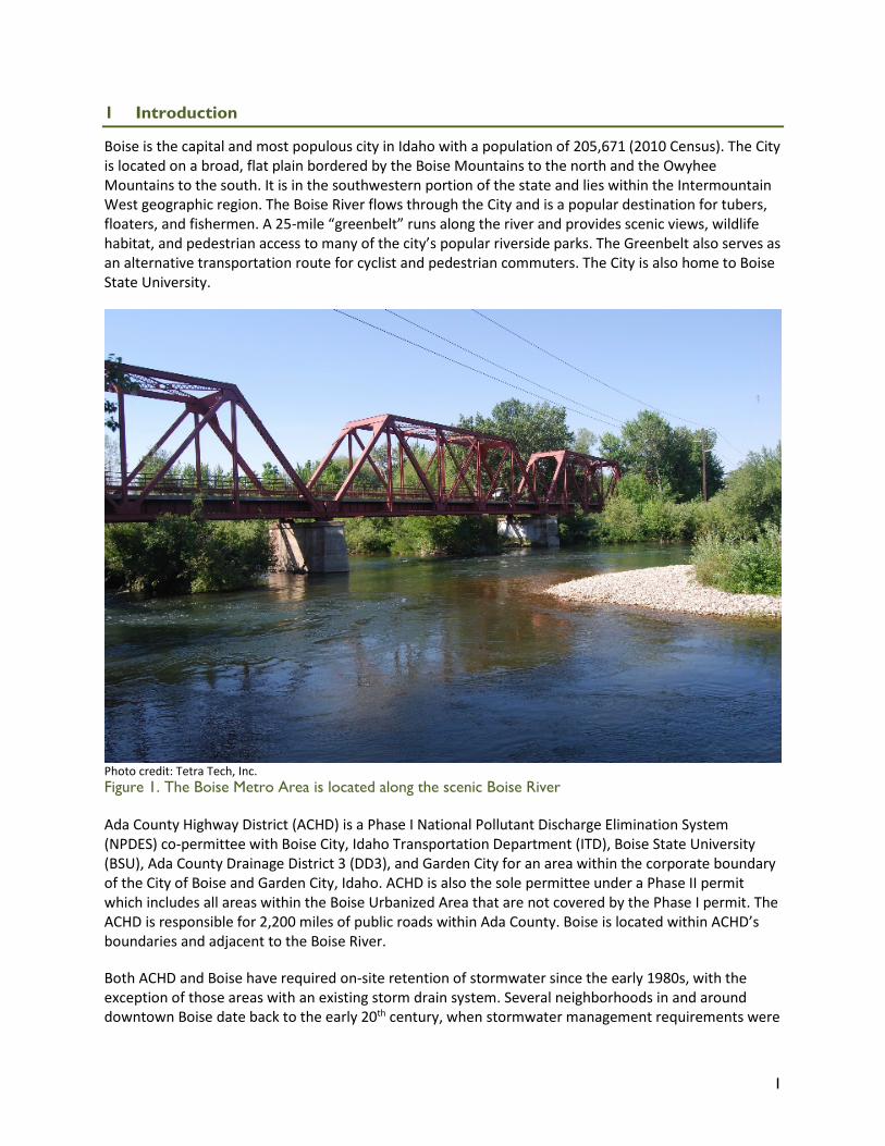
Boise is the capital and most populous city in Idaho with a population of 205,671 (2010 Census). The City is located on a broad, flat plain bordered by the Boise Mountains to the north and the Owyhee Mountains to the south. It is in the southwestern portion of the state and lies within the Intermountain West geographic region. The Boise River flows through the City and is a popular destination for tubers, floaters, and fishermen. A 25-mile “greenbelt” runs along the river and provides scenic views, wildlife habitat, and pedestrian access to many of the city’s popular riverside parks. The Greenbelt also serves as an alternative transportation route for cyclist and pedestrian commuters. The City is also home to Boise State University.
Photo credit: Tetra Tech, Inc. Figure 1. The Boise Metro Area is located along the scenic Boise River
Ada County Highway District (ACHD) is a Phase I National Pollutant Discharge Elimination System (NPDES) co-permittee with Boise City, Idaho Transportation Department (ITD), Boise State University (BSU), Ada County Drainage District 3 (DD3), and Garden City for an area within the corporate boundary of the City of Boise and Garden City, Idaho. ACHD is also the sole permittee under a Phase II permit which includes all areas within the Boise Urbanized Area that are not covered by the Phase I permit. The ACHD is responsible for 2,200 miles of public roads within Ada County. Boise is located within ACHD’s boundaries and adjacent to the Boise River.
Both ACHD and Boise have required on-site retention of stormwater since the early 1980s, with the exception of those areas with an existing storm drain system. Several neighborhoods in and around downtown Boise date back to the early 20th century, when stormwater management requirements were
2
minimal. Many of these neighborhoods discharge stormwater directly to the Boise River without treatment. This project aims to explore the potential for green infrastructure placed in the right-of-way of one such neighborhood to provide off-site mitigation of stormwater to adjacent parcels subject to potential redevelopment. Through this project, ACHD and the City of Boise also hope to integrate the concept of green infrastructure into future roadway improvements and educate developers, engineers, and other stakeholders on the benefits of green infrastructure in the right-of-way.
1.1 Water Quality Issues/Goals
The City is located on the water-quality limited Boise River, which has total maximum daily loads (TMDLs) for sediment and bacteria. Designation of a water segment as water-quality limited indicates that water quality does not meet and/or is not expected to meet applicable standards. Currently a TMDL is under development for phosphorus, and a TMDL for temperature is expected to be developed shortly thereafter. Several local agencies are co-permittees because multiple entities are responsible for overseeing stormwater management. The primary stormwater drainage system within the Phase I NPDES Permit area comprises the ACHD-owned and -operated municipal separate storm sewer system (MS4), privately owned on-site drainage facilities, and systems operated by the other NPDES co-permittees. While on-site retention and treatment requirements for stormwater have been in place since the 1980s, redevelopment projects have been allowed to discharge to ACHD’s drainage network with treatment and permission. However, the most recent NDPES Phase I permit issued for the co-permittees requires redevelopment areas to also meet retention criteria. The Phase I permit also contains an off-site mitigation requirement as follows: “For projects that cannot meet 100% infiltration/evapotranspiration/reuse requirements onsite, the Permittees’ program may allow off-site mitigation within the same subwatershed, subject to siting restrictions established by the Permittee.” (USEPA Region 10 2012).
1.2 Project Overview and Goals
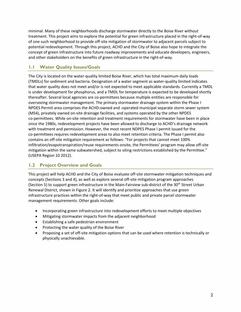
This project will help ACHD and the City of Boise evaluate off-site stormwater mitigation techniques and concepts (Sections 3 and 4), as well as explore several off-site mitigation program approaches (Section 5) to support green infrastructure in the Main-Fairview sub-district of the 30th Street Urban Renewal District, shown in Figure 2. It will identify and prioritize approaches that use green infrastructure practices within the right-of-way that meet public and private parcel stormwater management requirements. Other goals include:
• Incorporating green infrastructure into redevelopment efforts to meet multiple objectives • Mitigating stormwater impacts from the adjacent neighborhood • Establishing a safe pedestrian environment • Protecting the water quality of the Boise River • Proposing a set of off-site mitigation options that can be used where retention is technically or
physically unachievable.
3
Source: Tetra Tech, Inc. Figure 2. Map of the Main-Fairview sub-district project area
1.3 Project Benefits
With the expansion of the Interstate 184 Boise Connector in the early 1990s, the project area now experiences a relatively low volume of traffic and has streets that are overly wide. Installing streetscape, which can include green infrastructure, is a key step toward transforming the area’s character and creating a setting that will attract mixed use redevelopment. Using green infrastructure for stormwater management will meet the objectives of stormwater quality improvement, Boise River protection, and community livability by improving aesthetics, providing green space, and contributing to community cohesion. Urban greening will encourage use of outdoor spaces for social activity and attract businesses and the public into this area as it redevelops, demonstrating the multiple benefits of green infrastructure.
The development of an off-site mitigation program to fund off-setting projects will maximize the use of future green infrastructure projects in the area. The design project will serve as a demonstration project that will introduce green infrastructure practices to developers and the public. It will provide evidence of the feasibility and functionality of green infrastructure practices in a semi-arid climate where multiple jurisdictions have responsibility of managing stormwater.
4
1.4 Local Challenges
ACHD currently uses green infrastructure practices on a limited basis. This is in part due to the additional work needed to adapt such practices to the local semi-arid climate, develop design standards, and gain public acceptance. Additionally, identification of off-site mitigation opportunities and sources of funding is needed to support green infrastructure implementation in areas where on-site retention options are limited.
Any approach selected for this project needs to address the multiple jurisdictions and varied legal authorities that share responsibility in the area. The Main Street storm drainage, which includes parts of Main Street and Fairview Avenue, has an older storm drain system which discharges directly to the Boise River with very little existing on-site retention and limited stormwater treatment. Additional retrofits that disconnect this system from impervious surfaces or treat runoff before it enters the system might be necessary to significantly improve stormwater runoff discharging to the river.
5
2 Site Conditions
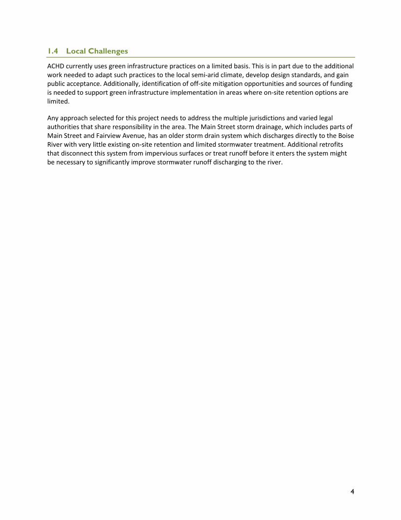
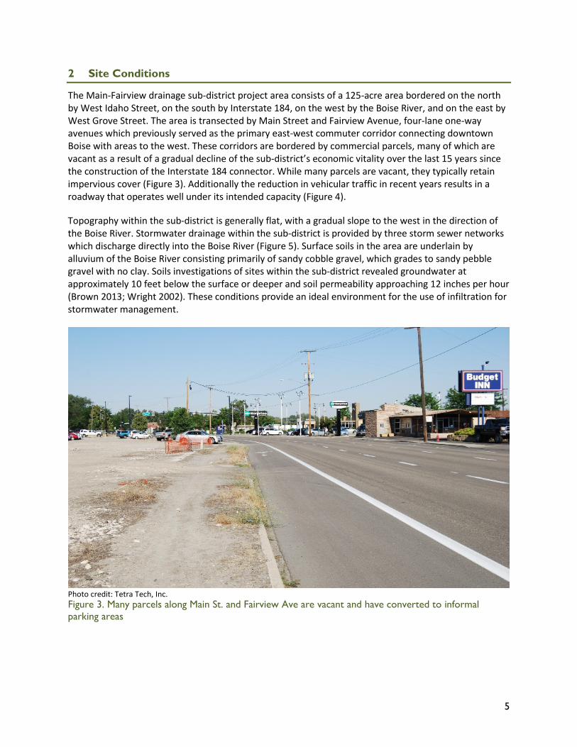
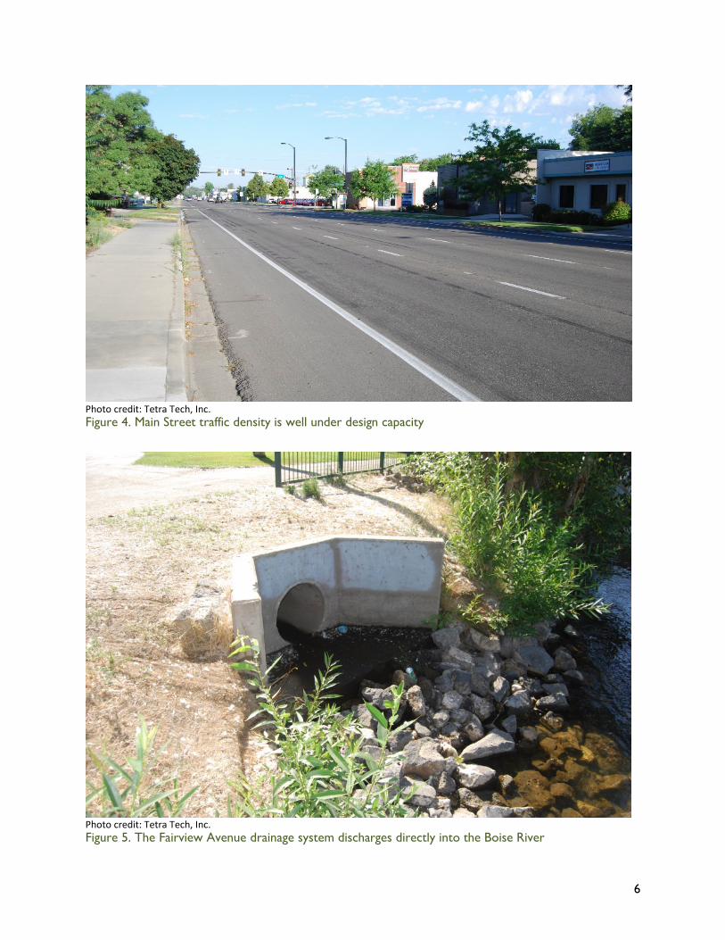
The Main-Fairview drainage sub-district project area consists of a 125-acre area bordered on the north by West Idaho Street, on the south by Interstate 184, on the west by the Boise River, and on the east by West Grove Street. The area is transected by Main Street and Fairview Avenue, four-lane one-way avenues which previously served as the primary east-west commuter corridor connecting downtown Boise with areas to the west. These corridors are bordered by commercial parcels, many of which are vacant as a result of a gradual decline of the sub-district’s economic vitality over the last 15 years since the construction of the Interstate 184 connector. While many parcels are vacant, they typically retain impervious cover (Figure 3). Additionally the reduction in vehicular traffic in recent years results in a roadway that operates well under its intended capacity (Figure 4).
Topography within the sub-district is generally flat, with a gradual slope to the west in the direction of the Boise River. Stormwater drainage within the sub-district is provided by three storm sewer networks which discharge directly into the Boise River (Figure 5). Surface soils in the area are underlain by alluvium of the Boise River consisting primarily of sandy cobble gravel, which grades to sandy pebble gravel with no clay. Soils investigations of sites within the sub-district revealed groundwater at approximately 10 feet below the surface or deeper and soil permeability approaching 12 inches per hour (Brown 2013; Wright 2002). These conditions provide an ideal environment for the use of infiltration for stormwater management.
Photo credit: Tetra Tech, Inc. Figure 3. Many parcels along Main St. and Fairview Ave are vacant and have converted to informal parking areas
6
Photo credit: Tetra Tech, Inc. Figure 4. Main Street traffic density is well under design capacity
Photo credit: Tetra Tech, Inc. Figure 5. The Fairview Avenue drainage system discharges directly into the Boise River
7
2.1 Site Selection
In order to evaluate the potential for a green street retrofit within the project area, the project team conducted an on-site walking tour in July 2014. As a result of the characteristics described in Section 2, Main Street and Fairview Avenue were identified as the focus area for selection of a concept design site. The primary objective of the tour was to observe existing conditions within the right-of-way of both streets with a particular focus on identifying utility conflicts, selecting green infrastructure elements suitable for the corridors, and evaluating potential locations to implement the conceptual design.
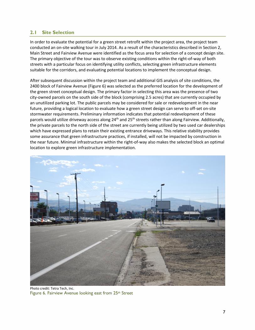
After subsequent discussion within the project team and additional GIS analysis of site conditions, the 2400 block of Fairview Avenue (Figure 6) was selected as the preferred location for the development of the green street conceptual design. The primary factor in selecting this area was the presence of two city-owned parcels on the south side of the block (comprising 2.5 acres) that are currently occupied by an unutilized parking lot. The public parcels may be considered for sale or redevelopment in the near future, providing a logical location to evaluate how a green street design can serve to off-set on-site stormwater requirements. Preliminary information indicates that potential redevelopment of these parcels would utilize driveway access along 24th and 25th streets rather than along Fairview. Additionally, the private parcels to the north side of the street are currently being utilized by two used car dealerships which have expressed plans to retain their existing entrance driveways. This relative stability provides some assurance that green infrastructure practices, if installed, will not be impacted by construction in the near future. Minimal infrastructure within the right-of-way also makes the selected block an optimal location to explore green infrastructure implementation.
Photo credit: Tetra Tech, Inc. Figure 6. Fairview Avenue looking east from 25th Street
8
3 Design Approach
3.1 Site-Specific Constraints/Considerations
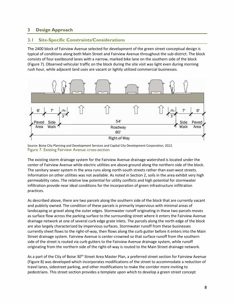
The 2400 block of Fairview Avenue selected for development of the green street conceptual design is typical of conditions along both Main Street and Fairview Avenue throughout the sub-district. The block consists of four eastbound lanes with a narrow, marked bike lane on the southern side of the block (Figure 7). Observed vehicular traffic on the block during the site visit was light even during morning rush hour, while adjacent land uses are vacant or lightly utilized commercial businesses.
Source: Boise City Planning and Development Services and Capital City Development Corporation, 2012. Figure 7. Existing Fairview Avenue cross-section
The existing storm drainage system for the Fairview Avenue drainage watershed is located under the center of Fairview Avenue while electric utilities are above ground along the northern side of the block. The sanitary sewer system in the area runs along north-south streets rather than east-west streets. Information on other utilities was not available. As noted in Section 2, soils in the area exhibit very high permeability rates. The relative low potential for utility conflicts and high potential for stormwater infiltration provide near ideal conditions for the incorporation of green infrastructure infiltration practices.
As described above, there are two parcels along the southern side of the block that are currently vacant and publicly owned. The condition of these parcels is primarily impervious with minimal areas of landscaping or gravel along the outer edges. Stormwater runoff originating in these two parcels moves as surface flow across the parking surface to the surrounding street where it enters the Fairview Avenue drainage network at one of several curb edge grate inlets. The parcels along the north edge of the block are also largely characterized by impervious surfaces. Stormwater runoff from these businesses currently sheet flows to the right-of-way, then flows along the curb gutter before it enters into the Main Street drainage system. Fairview Avenue is center-crowned so that surface runoff from the southern side of the street is routed via curb gutters to the Fairview Avenue drainage system, while runoff originating from the northern side of the right-of-way is routed to the Main Street drainage network.
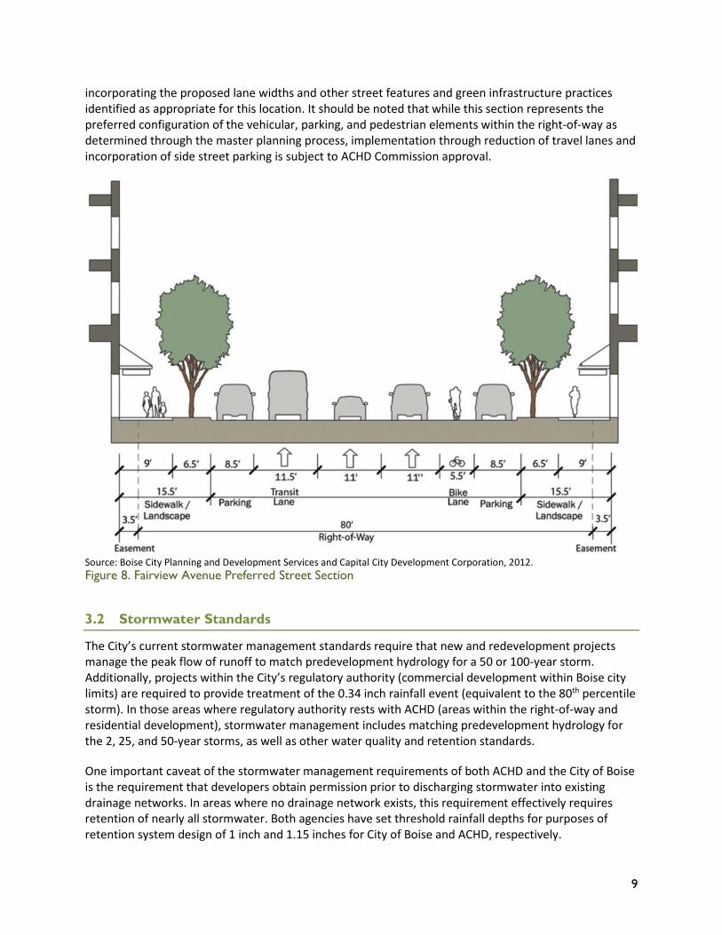
As a part of the City of Boise 30th Street Area Master Plan, a preferred street section for Fairview Avenue (Figure 8) was developed which incorporates modifications of the street to accommodate a reduction of travel lanes, sidestreet parking, and other modifications to make the corridor more inviting to pedestrians. This street section provides a template upon which to develop a green street concept
9
incorporating the proposed lane widths and other street features and green infrastructure practices identified as appropriate for this location. It should be noted that while this section represents the preferred configuration of the vehicular, parking, and pedestrian elements within the right-of-way as determined through the master planning process, implementation through reduction of travel lanes and incorporation of side street parking is subject to ACHD Commission approval.
Source: Boise City Planning and Development Services and Capital City Development Corporation, 2012. Figure 8. Fairview Avenue Preferred Street Section
3.2 Stormwater Standards
The City’s current stormwater management standards require that new and redevelopment projects manage the peak flow of runoff to match predevelopment hydrology for a 50 or 100-year storm. Additionally, projects within the City’s regulatory authority (commercial development within Boise city limits) are required to provide treatment of the 0.34 inch rainfall event (equivalent to the 80th percentile storm). In those areas where regulatory authority rests with ACHD (areas within the right-of-way and residential development), stormwater management includes matching predevelopment hydrology for the 2, 25, and 50-year storms, as well as other water quality and retention standards.
One important caveat of the stormwater management requirements of both ACHD and the City of Boise is the requirement that developers obtain permission prior to discharging stormwater into existing drainage networks. In areas where no drainage network exists, this requirement effectively requires retention of nearly all stormwater. Both agencies have set threshold rainfall depths for purposes of retention system design of 1 inch and 1.15 inches for City of Boise and ACHD, respectively.
10
The most recent NPDES Phase I permit issued in 2013, however, requires co-permittees to adopt a retention standard of 0.6 inches for both new and redevelopment areas, regardless of options for downstream discharge. This requirement is in the process of being adopted by both ACHD and the City of Boise, both of which will likely require a retention standard greater than 0.6 inches for new development so that volume control will also be addressed. The impact of these regulations on areas of redevelopment, such as the Main-Fairview sub-district, is that development of these properties will require the same level of stormwater management as undeveloped parcels on the perimeter of the municipal area (retention of 0.6 inches of rainfall at a minimum).
3.3 Stormwater Toolbox
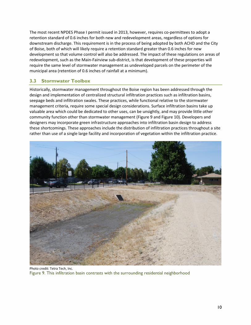
Historically, stormwater management throughout the Boise region has been addressed through the design and implementation of centralized structural infiltration practices such as infiltration basins, seepage beds and infiltration swales. These practices, while functional relative to the stormwater management criteria, require some special design considerations. Surface infiltration basins take up valuable area which could be dedicated to other uses, can be unsightly, and may provide little other community function other than stormwater management (Figure 9 and Figure 10). Developers and designers may incorporate green infrastructure approaches into infiltration basin design to address these shortcomings. These approaches include the distribution of infiltration practices throughout a site rather than use of a single large facility and incorporation of vegetation within the infiltration practice.
Photo credit: Tetra Tech, Inc. Figure 9. This infiltration basin contrasts with the surrounding residential neighborhood
11
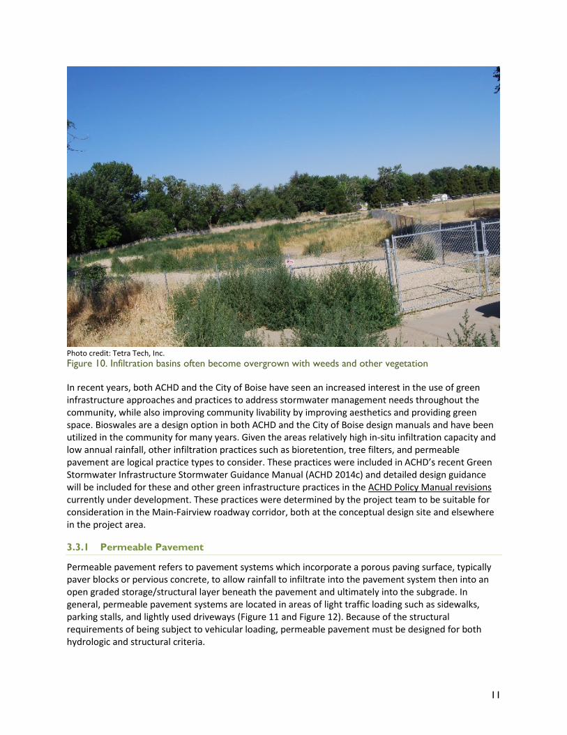
Photo credit: Tetra Tech, Inc. Figure 10. Infiltration basins often become overgrown with weeds and other vegetation
In recent years, both ACHD and the City of Boise have seen an increased interest in the use of green infrastructure approaches and practices to address stormwater management needs throughout the community, while also improving community livability by improving aesthetics and providing green space. Bioswales are a design option in both ACHD and the City of Boise design manuals and have been utilized in the community for many years. Given the areas relatively high in-situ infiltration capacity and low annual rainfall, other infiltration practices such as bioretention, tree filters, and permeable pavement are logical practice types to consider. These practices were included in ACHD’s recent Green Stormwater Infrastructure Stormwater Guidance Manual (ACHD 2014c) and detailed design guidance will be included for these and other green infrastructure practices in the ACHD Policy Manual revisions currently under development. These practices were determined by the project team to be suitable for consideration in the Main-Fairview roadway corridor, both at the conceptual design site and elsewhere in the project area.
3.3.1 Permeable Pavement
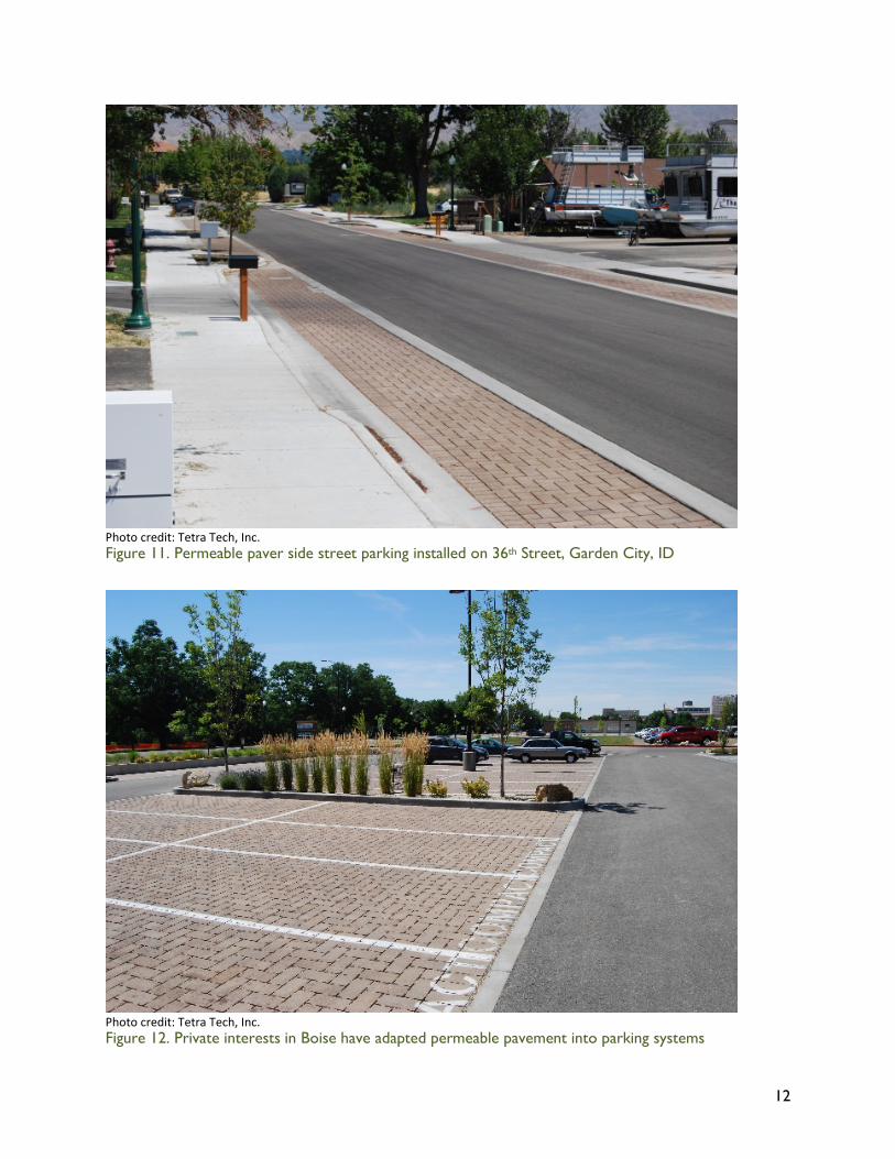
Permeable pavement refers to pavement systems which incorporate a porous paving surface, typically paver blocks or pervious concrete, to allow rainfall to infiltrate into the pavement system then into an open graded storage/structural layer beneath the pavement and ultimately into the subgrade. In general, permeable pavement systems are located in areas of light traffic loading such as sidewalks, parking stalls, and lightly used driveways (Figure 11 and Figure 12). Because of the structural requirements of being subject to vehicular loading, permeable pavement must be designed for both hydrologic and structural criteria.
12
Photo credit: Tetra Tech, Inc. Figure 11. Permeable paver side street parking installed on 36th Street, Garden City, ID
Photo credit: Tetra Tech, Inc. Figure 12. Private interests in Boise have adapted permeable pavement into parking systems
13
3.3.2 Bioretention
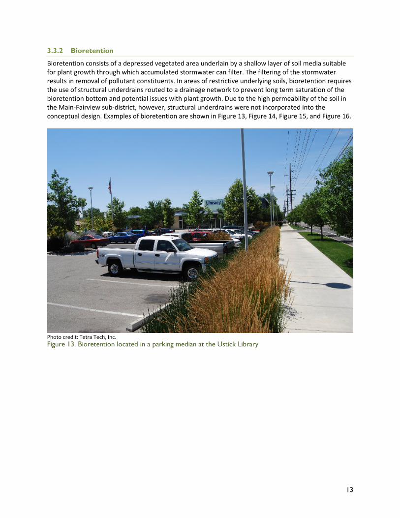
Bioretention consists of a depressed vegetated area underlain by a shallow layer of soil media suitable for plant growth through which accumulated stormwater can filter. The filtering of the stormwater results in removal of pollutant constituents. In areas of restrictive underlying soils, bioretention requires the use of structural underdrains routed to a drainage network to prevent long term saturation of the bioretention bottom and potential issues with plant growth. Due to the high permeability of the soil in the Main-Fairview sub-district, however, structural underdrains were not incorporated into the conceptual design. Examples of bioretention are shown in Figure 13, Figure 14, Figure 15, and Figure 16.
Photo credit: Tetra Tech, Inc. Figure 13. Bioretention located in a parking median at the Ustick Library
14
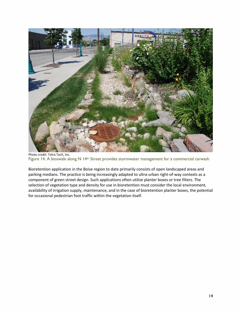
Photo credit: Tetra Tech, Inc. Figure 14. A bioswale along N 14th Street provides stormwater management for a commercial carwash
Bioretention application in the Boise region to date primarily consists of open landscaped areas and parking medians. The practice is being increasingly adapted to ultra-urban right-of-way contexts as a component of green street design. Such applications often utilize planter boxes or tree filters. The selection of vegetation type and density for use in bioretention must consider the local environment, availability of irrigation supply, maintenance, and in the case of bioretention planter boxes, the potential for occasional pedestrian foot traffic within the vegetation itself.
15
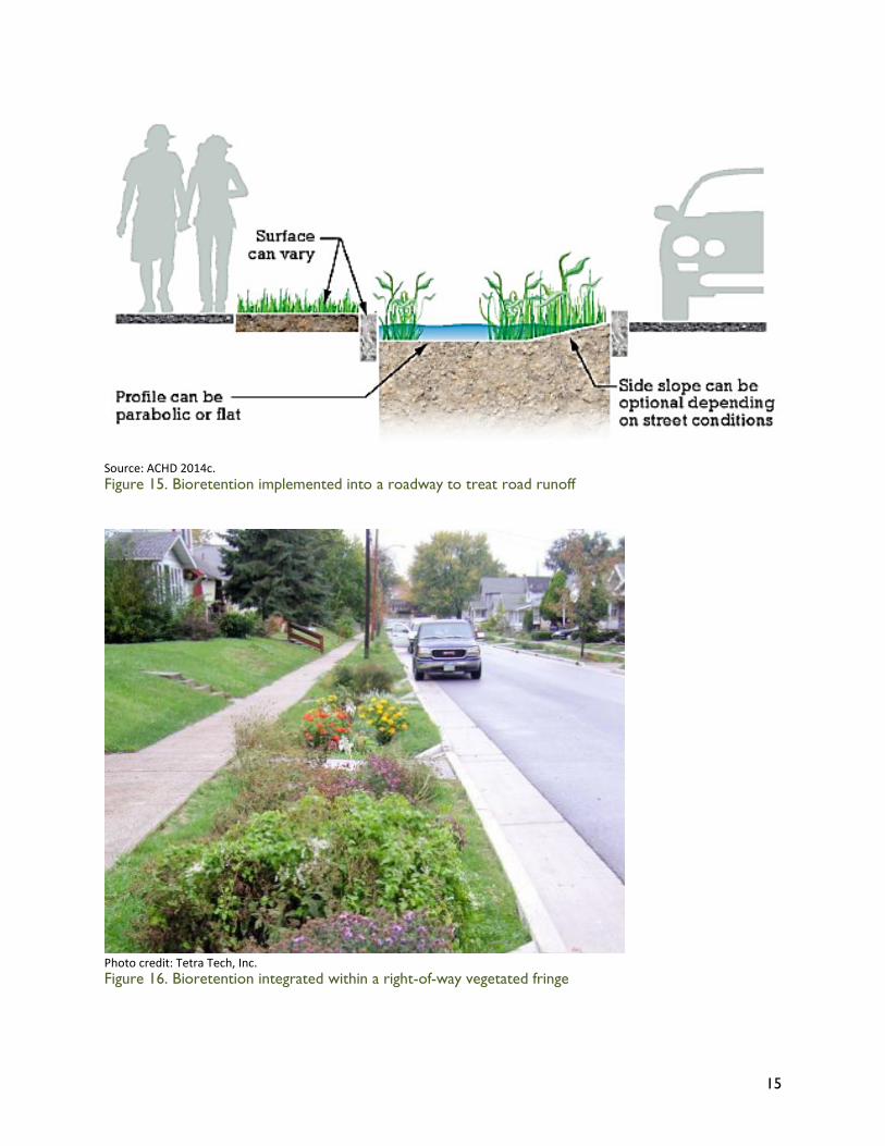
Source: ACHD 2014c. Figure 15. Bioretention implemented into a roadway to treat road runoff
Photo credit: Tetra Tech, Inc. Figure 16. Bioretention integrated within a right-of-way vegetated fringe
16
3.3.3 Tree Filter
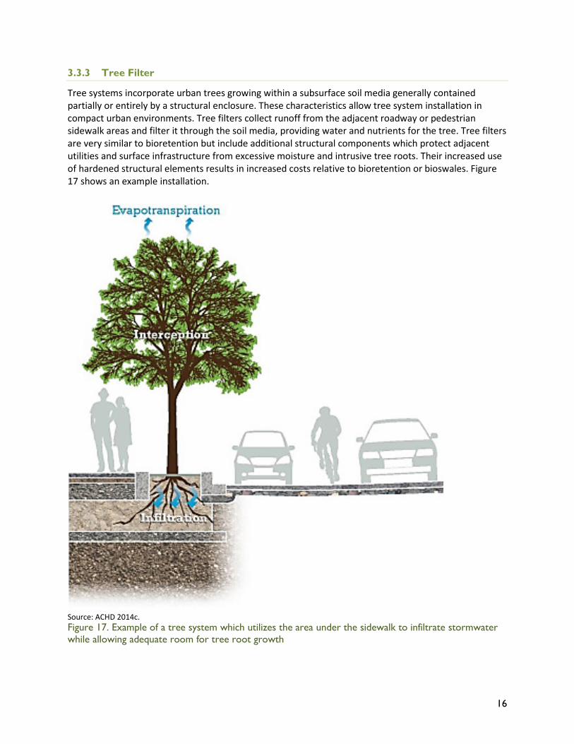
Tree systems incorporate urban trees growing within a subsurface soil media generally contained partially or entirely by a structural enclosure. These characteristics allow tree system installation in compact urban environments. Tree filters collect runoff from the adjacent roadway or pedestrian sidewalk areas and filter it through the soil media, providing water and nutrients for the tree. Tree filters are very similar to bioretention but include additional structural components which protect adjacent utilities and surface infrastructure from excessive moisture and intrusive tree roots. Their increased use of hardened structural elements results in increased costs relative to bioretention or bioswales. Figure 17 shows an example installation.
Source: ACHD 2014c. Figure 17. Example of a tree system which utilizes the area under the sidewalk to infiltrate stormwater while allowing adequate room for tree root growth
17
4 Conceptual Design
4.1 Concept Plan
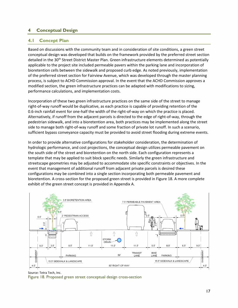
Based on discussions with the community team and in consideration of site conditions, a green street conceptual design was developed that builds on the framework provided by the preferred street section detailed in the 30th Street District Master Plan. Green infrastructure elements determined as potentially applicable to the project site included permeable pavers within the parking lane and incorporation of bioretention cells between the sidewalk and proposed curb edge. As noted previously, implementation of the preferred street section for Fairview Avenue, which was developed through the master planning process, is subject to ACHD Commission approval. In the event that the ACHD Commission approves a modified section, the green infrastructure practices can be adapted with modifications to sizing, performance calculations, and implementation costs.
Incorporation of these two green infrastructure practices on the same side of the street to manage right-of-way runoff would be duplicative, as each practice is capable of providing retention of the 0.6-inch rainfall event for one-half the width of the right-of-way on which the practice is placed. Alternatively, if runoff from the adjacent parcels is directed to the edge of right-of-way, through the pedestrian sidewalk, and into a bioretention area, both practices may be implemented along the street side to manage both right-of-way runoff and some fraction of private lot runoff. In such a scenario, sufficient bypass conveyance capacity must be provided to avoid street flooding during extreme events.
In order to provide alternative configurations for stakeholder consideration, the determination of hydrologic performance, and cost projections, the conceptual design utilizes permeable pavement on the south side of the street and bioretention on the north side. Each configuration represents a template that may be applied to suit block specific needs. Similarly the green infrastructure and streetscape geometries may be adjusted to accommodate site specific constraints or objectives. In the event that management of additional runoff from adjacent private parcels is desired these configurations may be combined into a single section incorporating both permeable pavement and bioretention. A cross-section for the proposed green street is provided in Figure 18. A more complete exhibit of the green street concept is provided in Appendix A.
Source: Tetra Tech, Inc. Figure 18. Proposed green street conceptual design cross-section
18
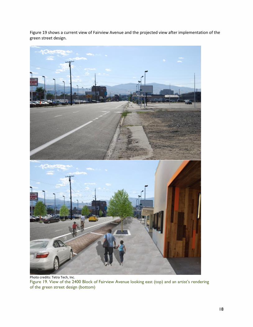
Figure 19 shows a current view of Fairview Avenue and the projected view after implementation of the green street design.
Photo credits: Tetra Tech, Inc. Figure 19. View of the 2400 Block of Fairview Avenue looking east (top) and an artist’s rendering of the green street design (bottom)
19
4.2 Calculations
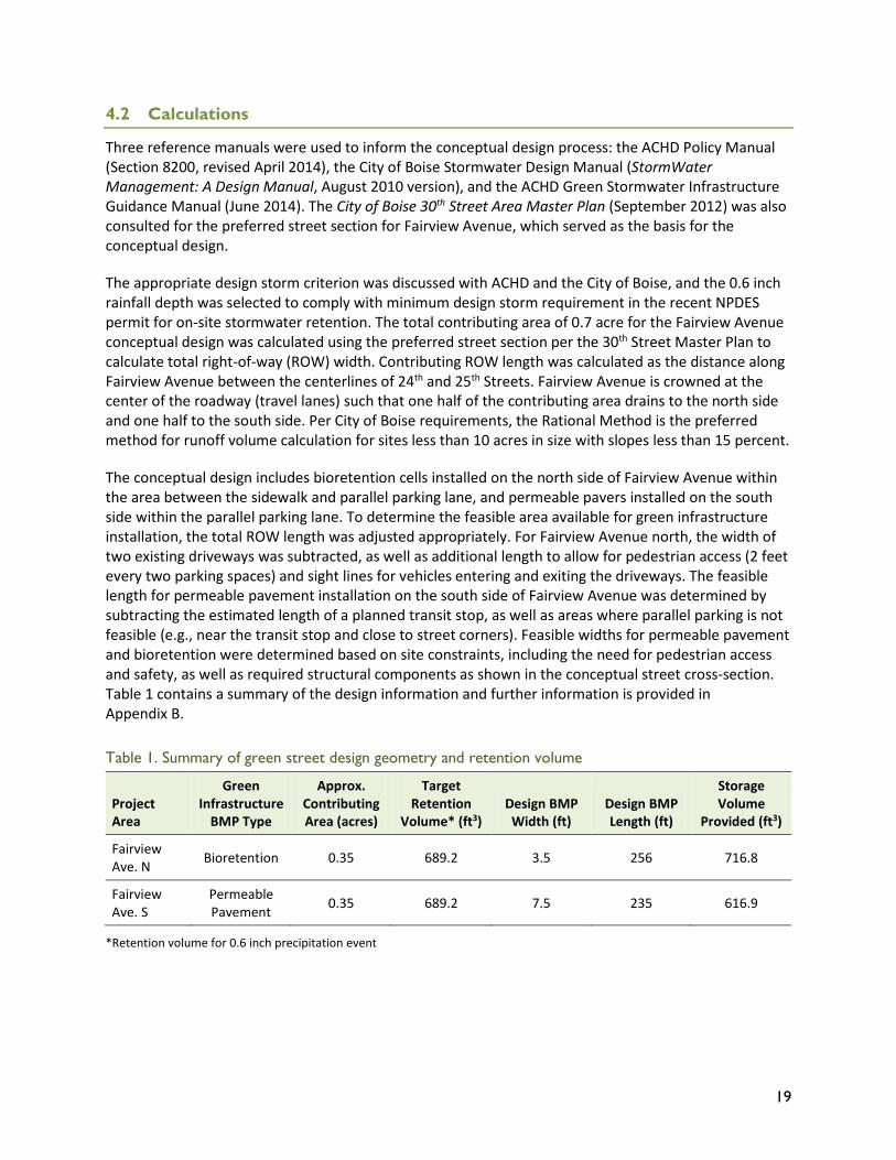
Three reference manuals were used to inform the conceptual design process: the ACHD Policy Manual (Section 8200, revised April 2014), the City of Boise Stormwater Design Manual (StormWater Management: A Design Manual, August 2010 version), and the ACHD Green Stormwater Infrastructure Guidance Manual (June 2014). The City of Boise 30th Street Area Master Plan (September 2012) was also consulted for the preferred street section for Fairview Avenue, which served as the basis for the conceptual design.
The appropriate design storm criterion was discussed with ACHD and the City of Boise, and the 0.6 inch rainfall depth was selected to comply with minimum design storm requirement in the recent NPDES permit for on-site stormwater retention. The total contributing area of 0.7 acre for the Fairview Avenue conceptual design was calculated using the preferred street section per the 30th Street Master Plan to calculate total right-of-way (ROW) width. Contributing ROW length was calculated as the distance along Fairview Avenue between the centerlines of 24th and 25th Streets. Fairview Avenue is crowned at the center of the roadway (travel lanes) such that one half of the contributing area drains to the north side and one half to the south side. Per City of Boise requirements, the Rational Method is the preferred method for runoff volume calculation for sites less than 10 acres in size with slopes less than 15 percent.
The conceptual design includes bioretention cells installed on the north side of Fairview Avenue within the area between the sidewalk and parallel parking lane, and permeable pavers installed on the south side within the parallel parking lane. To determine the feasible area available for green infrastructure installation, the total ROW length was adjusted appropriately. For Fairview Avenue north, the width of two existing driveways was subtracted, as well as additional length to allow for pedestrian access (2 feet every two parking spaces) and sight lines for vehicles entering and exiting the driveways. The feasible length for permeable pavement installation on the south side of Fairview Avenue was determined by subtracting the estimated length of a planned transit stop, as well as areas where parallel parking is not feasible (e.g., near the transit stop and close to street corners). Feasible widths for permeable pavement and bioretention were determined based on site constraints, including the need for pedestrian access and safety, as well as required structural components as shown in the conceptual street cross-section. Table 1 contains a summary of the design information and further information is provided in Appendix B.
Table 1. Summary of green street design geometry and retention volume
Project Area
Green Infrastructure
BMP Type
Approx. Contributing Area (acres)
Target Retention
Volume* (ft3) Design BMP Width (ft)
Design BMP Length (ft)
Storage Volume
Provided (ft3)
Fairview Ave. N Bioretention 0.35 689.2 3.5 256 716.8
Fairview Ave. S
Permeable Pavement 0.35 689.2 7.5 235 616.9
*Retention volume for 0.6 inch precipitation event
20
4.3 Costs
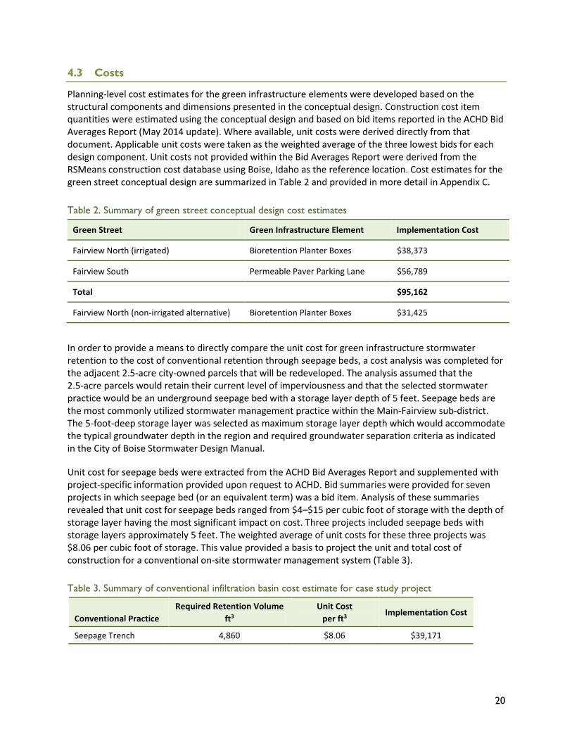
Planning-level cost estimates for the green infrastructure elements were developed based on the structural components and dimensions presented in the conceptual design. Construction cost item quantities were estimated using the conceptual design and based on bid items reported in the ACHD Bid Averages Report (May 2014 update). Where available, unit costs were derived directly from that document. Applicable unit costs were taken as the weighted average of the three lowest bids for each design component. Unit costs not provided within the Bid Averages Report were derived from the RSMeans construction cost database using Boise, Idaho as the reference location. Cost estimates for the green street conceptual design are summarized in Table 2 and provided in more detail in Appendix C.
Table 2. Summary of green street conceptual design cost estimates
Green Street Green Infrastructure Element Implementation Cost
Fairview North (irrigated) Bioretention Planter Boxes $38,373
Fairview South Permeable Paver Parking Lane $56,789
Total $95,162
Fairview North (non-irrigated alternative) Bioretention Planter Boxes $31,425
In order to provide a means to directly compare the unit cost for green infrastructure stormwater retention to the cost of conventional retention through seepage beds, a cost analysis was completed for the adjacent 2.5-acre city-owned parcels that will be redeveloped. The analysis assumed that the 2.5-acre parcels would retain their current level of imperviousness and that the selected stormwater practice would be an underground seepage bed with a storage layer depth of 5 feet. Seepage beds are the most commonly utilized stormwater management practice within the Main-Fairview sub-district. The 5-foot-deep storage layer was selected as maximum storage layer depth which would accommodate the typical groundwater depth in the region and required groundwater separation criteria as indicated in the City of Boise Stormwater Design Manual.
Unit cost for seepage beds were extracted from the ACHD Bid Averages Report and supplemented with project-specific information provided upon request to ACHD. Bid summaries were provided for seven projects in which seepage bed (or an equivalent term) was a bid item. Analysis of these summaries revealed that unit cost for seepage beds ranged from $4–$15 per cubic foot of storage with the depth of storage layer having the most significant impact on cost. Three projects included seepage beds with storage layers approximately 5 feet. The weighted average of unit costs for these three projects was $8.06 per cubic foot of storage. This value provided a basis to project the unit and total cost of construction for a conventional on-site stormwater management system (Table 3).
Table 3. Summary of conventional infiltration basin cost estimate for case study project
Conventional Practice Required Retention Volume
ft3 Unit Cost
per ft3 Implementation Cost
Seepage Trench 4,860 $8.06 $39,171
21
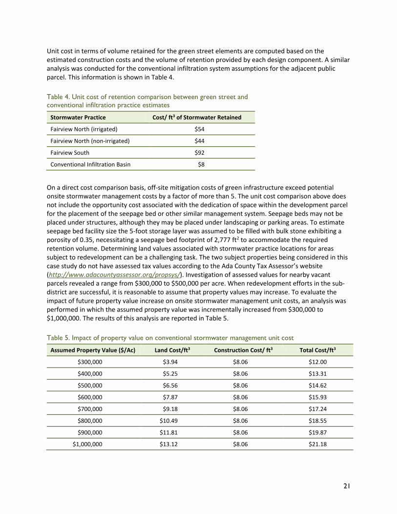
Unit cost in terms of volume retained for the green street elements are computed based on the estimated construction costs and the volume of retention provided by each design component. A similar analysis was conducted for the conventional infiltration system assumptions for the adjacent public parcel. This information is shown in Table 4.
Table 4. Unit cost of retention comparison between green street and conventional infiltration practice estimates
Stormwater Practice Cost/ ft3 of Stormwater Retained
Fairview North (irrigated) $54
Fairview North (non-irrigated) $44
Fairview South $92
Conventional Infiltration Basin $8
On a direct cost comparison basis, off-site mitigation costs of green infrastructure exceed potential onsite stormwater management costs by a factor of more than 5. The unit cost comparison above does not include the opportunity cost associated with the dedication of space within the development parcel for the placement of the seepage bed or other similar management system. Seepage beds may not be placed under structures, although they may be placed under landscaping or parking areas. To estimate seepage bed facility size the 5-foot storage layer was assumed to be filled with bulk stone exhibiting a porosity of 0.35, necessitating a seepage bed footprint of 2,777 ft2 to accommodate the required retention volume. Determining land values associated with stormwater practice locations for areas subject to redevelopment can be a challenging task. The two subject properties being considered in this case study do not have assessed tax values according to the Ada County Tax Assessor’s website (http://www.adacountyassessor.org/propsys/). Investigation of assessed values for nearby vacant parcels revealed a range from $300,000 to $500,000 per acre. When redevelopment efforts in the sub-district are successful, it is reasonable to assume that property values may increase. To evaluate the impact of future property value increase on onsite stormwater management unit costs, an analysis was performed in which the assumed property value was incrementally increased from $300,000 to $1,000,000. The results of this analysis are reported in Table 5.
Table 5. Impact of property value on conventional stormwater management unit cost
Assumed Property Value ($/Ac) Land Cost/ft3 Construction Cost/ ft3 Total Cost/ft3
$300,000 $3.94 $8.06 $12.00
$400,000 $5.25 $8.06 $13.31
$500,000 $6.56 $8.06 $14.62
$600,000 $7.87 $8.06 $15.93
$700,000 $9.18 $8.06 $17.24
$800,000 $10.49 $8.06 $18.55
$900,000 $11.81 $8.06 $19.87
$1,000,000 $13.12 $8.06 $21.18
22
5 Off-site Mitigation Policy Approach
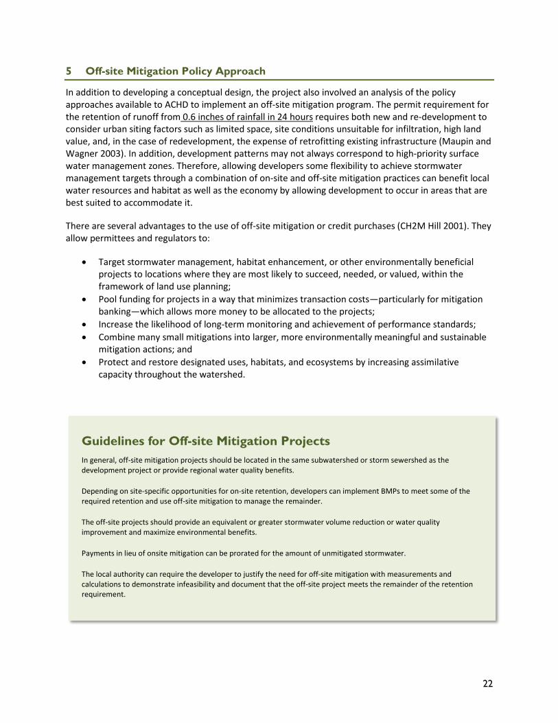
In addition to developing a conceptual design, the project also involved an analysis of the policy approaches available to ACHD to implement an off-site mitigation program. The permit requirement for the retention of runoff from 0.6 inches of rainfall in 24 hours requires both new and re-development to consider urban siting factors such as limited space, site conditions unsuitable for infiltration, high land value, and, in the case of redevelopment, the expense of retrofitting existing infrastructure (Maupin and Wagner 2003). In addition, development patterns may not always correspond to high-priority surface water management zones. Therefore, allowing developers some flexibility to achieve stormwater management targets through a combination of on-site and off-site mitigation practices can benefit local water resources and habitat as well as the economy by allowing development to occur in areas that are best suited to accommodate it.
There are several advantages to the use of off-site mitigation or credit purchases (CH2M Hill 2001). They allow permittees and regulators to:
• Target stormwater management, habitat enhancement, or other environmentally beneficial projects to locations where they are most likely to succeed, needed, or valued, within the framework of land use planning;
• Pool funding for projects in a way that minimizes transaction costs—particularly for mitigation banking—which allows more money to be allocated to the projects;
• Increase the likelihood of long-term monitoring and achievement of performance standards; • Combine many small mitigations into larger, more environmentally meaningful and sustainable
mitigation actions; and • Protect and restore designated uses, habitats, and ecosystems by increasing assimilative
capacity throughout the watershed.
Guidelines for Off-site Mitigation Projects In general, off-site mitigation projects should be located in the same subwatershed or storm sewershed as the development project or provide regional water quality benefits.
Depending on site-specific opportunities for on-site retention, developers can implement BMPs to meet some of the required retention and use off-site mitigation to manage the remainder.
The off-site projects should provide an equivalent or greater stormwater volume reduction or water quality improvement and maximize environmental benefits.
Payments in lieu of onsite mitigation can be prorated for the amount of unmitigated stormwater.
The local authority can require the developer to justify the need for off-site mitigation with measurements and calculations to demonstrate infeasibility and document that the off-site project meets the remainder of the retention requirement.
23
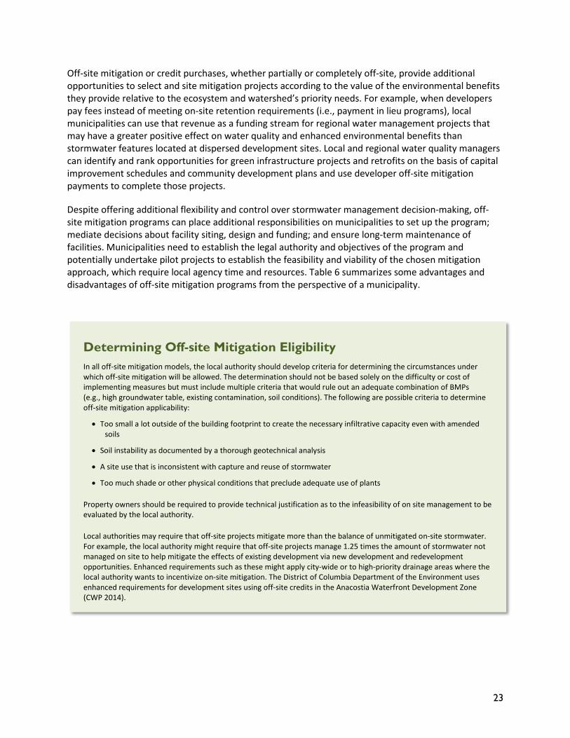
Off-site mitigation or credit purchases, whether partially or completely off-site, provide additional opportunities to select and site mitigation projects according to the value of the environmental benefits they provide relative to the ecosystem and watershed’s priority needs. For example, when developers pay fees instead of meeting on-site retention requirements (i.e., payment in lieu programs), local municipalities can use that revenue as a funding stream for regional water management projects that may have a greater positive effect on water quality and enhanced environmental benefits than stormwater features located at dispersed development sites. Local and regional water quality managers can identify and rank opportunities for green infrastructure projects and retrofits on the basis of capital improvement schedules and community development plans and use developer off-site mitigation payments to complete those projects.
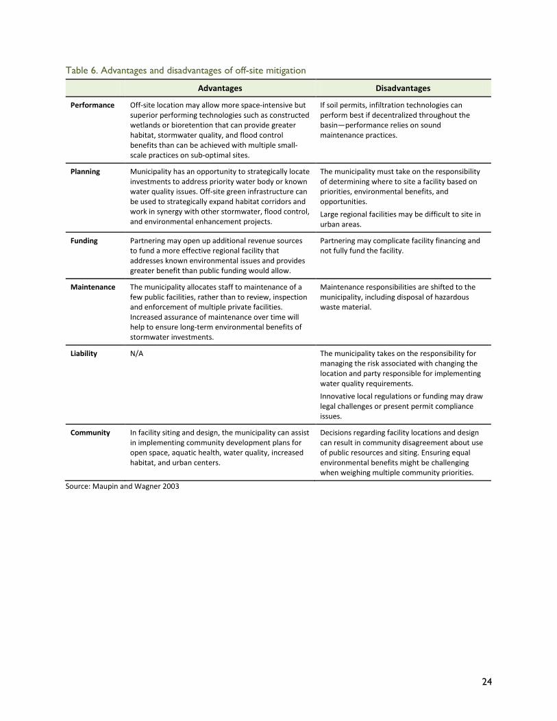
Despite offering additional flexibility and control over stormwater management decision-making, off-site mitigation programs can place additional responsibilities on municipalities to set up the program; mediate decisions about facility siting, design and funding; and ensure long-term maintenance of facilities. Municipalities need to establish the legal authority and objectives of the program and potentially undertake pilot projects to establish the feasibility and viability of the chosen mitigation approach, which require local agency time and resources. Table 6 summarizes some advantages and disadvantages of off-site mitigation programs from the perspective of a municipality.
Determining Off-site Mitigation Eligibility In all off-site mitigation models, the local authority should develop criteria for determining the circumstances under which off-site mitigation will be allowed. The determination should not be based solely on the difficulty or cost of implementing measures but must include multiple criteria that would rule out an adequate combination of BMPs (e.g., high groundwater table, existing contamination, soil conditions). The following are possible criteria to determine off-site mitigation applicability:
• Too small a lot outside of the building footprint to create the necessary infiltrative capacity even with amended soils
• Soil instability as documented by a thorough geotechnical analysis
• A site use that is inconsistent with capture and reuse of stormwater
• Too much shade or other physical conditions that preclude adequate use of plants
Property owners should be required to provide technical justification as to the infeasibility of on site management to be evaluated by the local authority.
Local authorities may require that off-site projects mitigate more than the balance of unmitigated on-site stormwater. For example, the local authority might require that off-site projects manage 1.25 times the amount of stormwater not managed on site to help mitigate the effects of existing development via new development and redevelopment opportunities. Enhanced requirements such as these might apply city-wide or to high-priority drainage areas where the local authority wants to incentivize on-site mitigation. The District of Columbia Department of the Environment uses enhanced requirements for development sites using off-site credits in the Anacostia Waterfront Development Zone (CWP 2014).
24
Table 6. Advantages and disadvantages of off-site mitigation
Advantages Disadvantages
Performance Off-site location may allow more space-intensive but superior performing technologies such as constructed wetlands or bioretention that can provide greater habitat, stormwater quality, and flood control benefits than can be achieved with multiple small-scale practices on sub-optimal sites.
If soil permits, infiltration technologies can perform best if decentralized throughout the basin—performance relies on sound maintenance practices.
Planning Municipality has an opportunity to strategically locate investments to address priority water body or known water quality issues. Off-site green infrastructure can be used to strategically expand habitat corridors and work in synergy with other stormwater, flood control, and environmental enhancement projects.
The municipality must take on the responsibility of determining where to site a facility based on priorities, environmental benefits, and opportunities. Large regional facilities may be difficult to site in urban areas.
Funding Partnering may open up additional revenue sources to fund a more effective regional facility that addresses known environmental issues and provides greater benefit than public funding would allow.
Partnering may complicate facility financing and not fully fund the facility.
Maintenance The municipality allocates staff to maintenance of a few public facilities, rather than to review, inspection and enforcement of multiple private facilities. Increased assurance of maintenance over time will help to ensure long-term environmental benefits of stormwater investments.
Maintenance responsibilities are shifted to the municipality, including disposal of hazardous waste material.
Liability N/A The municipality takes on the responsibility for managing the risk associated with changing the location and party responsible for implementing water quality requirements. Innovative local regulations or funding may draw legal challenges or present permit compliance issues.
Community In facility siting and design, the municipality can assist in implementing community development plans for open space, aquatic health, water quality, increased habitat, and urban centers.
Decisions regarding facility locations and design can result in community disagreement about use of public resources and siting. Ensuring equal environmental benefits might be challenging when weighing multiple community priorities.
Source: Maupin and Wagner 2003
25
5.1 Off-site Mitigation Models
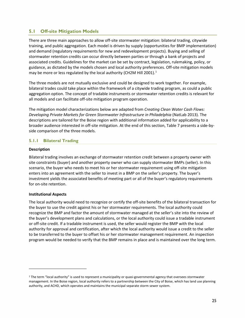
There are three main approaches to allow off-site stormwater mitigation: bilateral trading, citywide training, and public aggregation. Each model is driven by supply (opportunities for BMP implementation) and demand (regulatory requirements for new and redevelopment projects). Buying and selling of stormwater retention credits can occur directly between parties or through a bank of projects and associated credits. Guidelines for the market can be set by contract, legislation, rulemaking, policy, or guidance, as dictated by the models chosen and local authority preferences. Off-site mitigation models may be more or less regulated by the local authority (CH2M Hill 2001).1
The three models are not mutually exclusive and could be designed to work together. For example, bilateral trades could take place within the framework of a citywide trading program, as could a public aggregation option. The concept of tradable instruments or stormwater retention credits is relevant for all models and can facilitate off-site mitigation program operation.
The mitigation model characterizations below are adapted from Creating Clean Water Cash Flows: Developing Private Markets for Green Stormwater Infrastructure in Philadelphia (NatLab 2013). The descriptions are tailored for the Boise region with additional information added for applicability to a broader audience interested in off-site mitigation. At the end of this section, Table 7 presents a side-by-side comparison of the three models.
5.1.1 Bilateral Trading
Description
Bilateral trading involves an exchange of stormwater retention credit between a property owner with site constraints (buyer) and another property owner who can supply stormwater BMPs (seller). In this scenario, the buyer who needs to meet his or her stormwater requirement using off-site mitigation enters into an agreement with the seller to invest in a BMP on the seller’s property. The buyer’s investment yields the associated benefits of meeting part or all of the buyer’s regulatory requirements for on-site retention.
Institutional Aspects
The local authority would need to recognize or certify the off-site benefits of the bilateral transaction for the buyer to use the credit against his or her stormwater requirements. The local authority could recognize the BMP and factor the amount of stormwater managed at the seller’s site into the review of the buyer’s development plans and calculations, or the local authority could issue a tradable instrument or off-site credit. If a tradable instrument is used, the seller would register the BMP with the local authority for approval and certification, after which the local authority would issue a credit to the seller to be transferred to the buyer to offset his or her stormwater management requirement. An inspection program would be needed to verify that the BMP remains in place and is maintained over the long term.
1 The term “local authority” is used to represent a municipality or quasi-governmental agency that oversees stormwater management. In the Boise region, local authority refers to a partnership between the City of Boise, which has land use planning authority, and ACHD, which operates and maintains the municipal separate storm sewer system.
26
Financing Options
Buyers and sellers can work together to fund and implement BMPs off-site, or sellers can install BMPs for credits independently and sell them to interested buyers. Transactions would be negotiated between the two parties, and if a sufficient market exists, brokers can be used to make connections and facilitate transactions. In jurisdictions in which a stormwater fee and a credit system for on-site stormwater mitigation exist, bilateral transactions can achieve financial benefits associated with a stormwater fee reduction, which a buyer can use to offset his or her own stormwater fee.
Advantages and Disadvantages
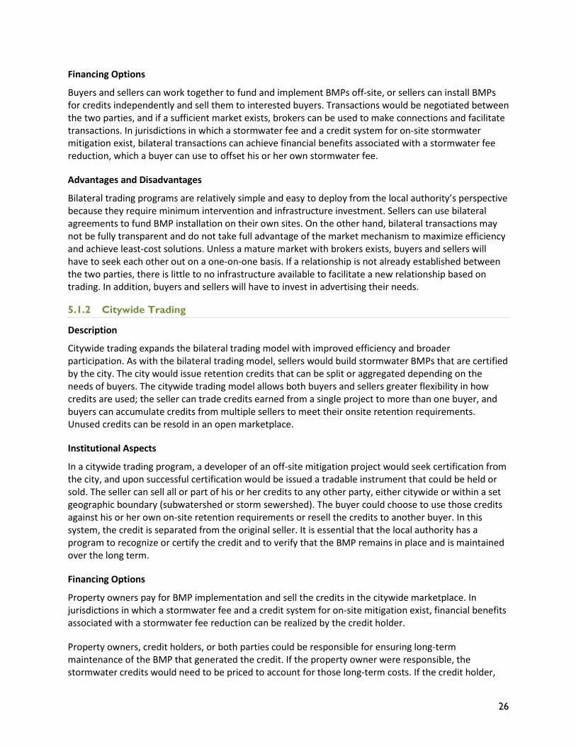
Bilateral trading programs are relatively simple and easy to deploy from the local authority’s perspective because they require minimum intervention and infrastructure investment. Sellers can use bilateral agreements to fund BMP installation on their own sites. On the other hand, bilateral transactions may not be fully transparent and do not take full advantage of the market mechanism to maximize efficiency and achieve least-cost solutions. Unless a mature market with brokers exists, buyers and sellers will have to seek each other out on a one-on-one basis. If a relationship is not already established between the two parties, there is little to no infrastructure available to facilitate a new relationship based on trading. In addition, buyers and sellers will have to invest in advertising their needs.
5.1.2 Citywide Trading
Description
Citywide trading expands the bilateral trading model with improved efficiency and broader participation. As with the bilateral trading model, sellers would build stormwater BMPs that are certified by the city. The city would issue retention credits that can be split or aggregated depending on the needs of buyers. The citywide trading model allows both buyers and sellers greater flexibility in how credits are used; the seller can trade credits earned from a single project to more than one buyer, and buyers can accumulate credits from multiple sellers to meet their onsite retention requirements. Unused credits can be resold in an open marketplace.
Institutional Aspects
In a citywide trading program, a developer of an off-site mitigation project would seek certification from the city, and upon successful certification would be issued a tradable instrument that could be held or sold. The seller can sell all or part of his or her credits to any other party, either citywide or within a set geographic boundary (subwatershed or storm sewershed). The buyer could choose to use those credits against his or her own on-site retention requirements or resell the credits to another buyer. In this system, the credit is separated from the original seller. It is essential that the local authority has a program to recognize or certify the credit and to verify that the BMP remains in place and is maintained over the long term.
Financing Options
Property owners pay for BMP implementation and sell the credits in the citywide marketplace. In jurisdictions in which a stormwater fee and a credit system for on-site mitigation exist, financial benefits associated with a stormwater fee reduction can be realized by the credit holder.
Property owners, credit holders, or both parties could be responsible for ensuring long-term maintenance of the BMP that generated the credit. If the property owner were responsible, the stormwater credits would need to be priced to account for those long-term costs. If the credit holder,
27
who has the long-term financial stake in ensuring that the BMP operates in perpetuity, is responsible for maintenance, the credit trade would need to include a maintenance agreement and easement to allow access. To ensure that maintenance agreements are not overlooked when credits are traded, the local authority can request this documentation when the credits are reviewed and approved.
Advantages and Disadvantages
A citywide trading program uses the market to encourage property owners to invest in BMP installation at or above the baseline. The citywide approach has more buyers and sellers, increasing liquidity, and offers more options for property owners with site constraints to connect with suppliers of off-site mitigation projects. An open market is more transparent in terms of the financial value of credits, allowing property owners to make informed investment decisions and encouraging cost-efficient BMPs. A citywide program might require more local authority resources for administration, credit certification, and oversight than a bilateral program.
5.1.3 Public Aggregation
Description
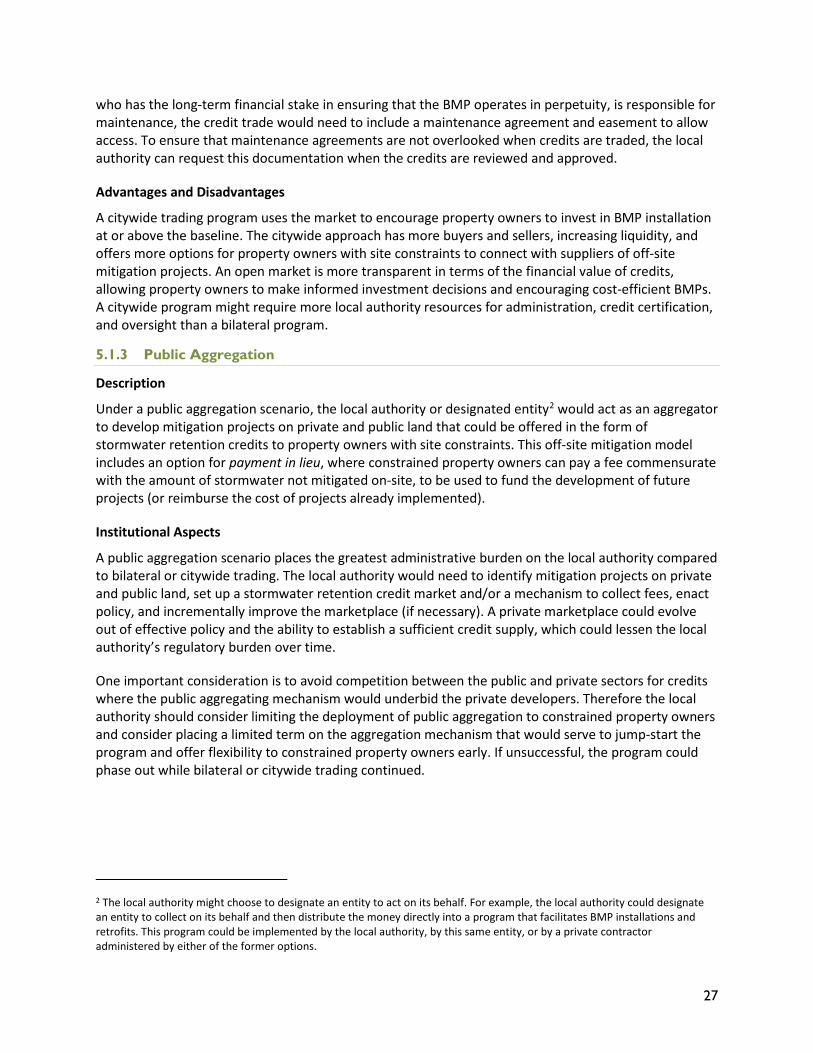
Under a public aggregation scenario, the local authority or designated entity2 would act as an aggregator to develop mitigation projects on private and public land that could be offered in the form of stormwater retention credits to property owners with site constraints. This off-site mitigation model includes an option for payment in lieu, where constrained property owners can pay a fee commensurate with the amount of stormwater not mitigated on-site, to be used to fund the development of future projects (or reimburse the cost of projects already implemented).
Institutional Aspects
A public aggregation scenario places the greatest administrative burden on the local authority compared to bilateral or citywide trading. The local authority would need to identify mitigation projects on private and public land, set up a stormwater retention credit market and/or a mechanism to collect fees, enact policy, and incrementally improve the marketplace (if necessary). A private marketplace could evolve out of effective policy and the ability to establish a sufficient credit supply, which could lessen the local authority’s regulatory burden over time.
One important consideration is to avoid competition between the public and private sectors for credits where the public aggregating mechanism would underbid the private developers. Therefore the local authority should consider limiting the deployment of public aggregation to constrained property owners and consider placing a limited term on the aggregation mechanism that would serve to jump-start the program and offer flexibility to constrained property owners early. If unsuccessful, the program could phase out while bilateral or citywide trading continued.
2 The local authority might choose to designate an entity to act on its behalf. For example, the local authority could designate an entity to collect on its behalf and then distribute the money directly into a program that facilitates BMP installations and retrofits. This program could be implemented by the local authority, by this same entity, or by a private contractor administered by either of the former options.
28
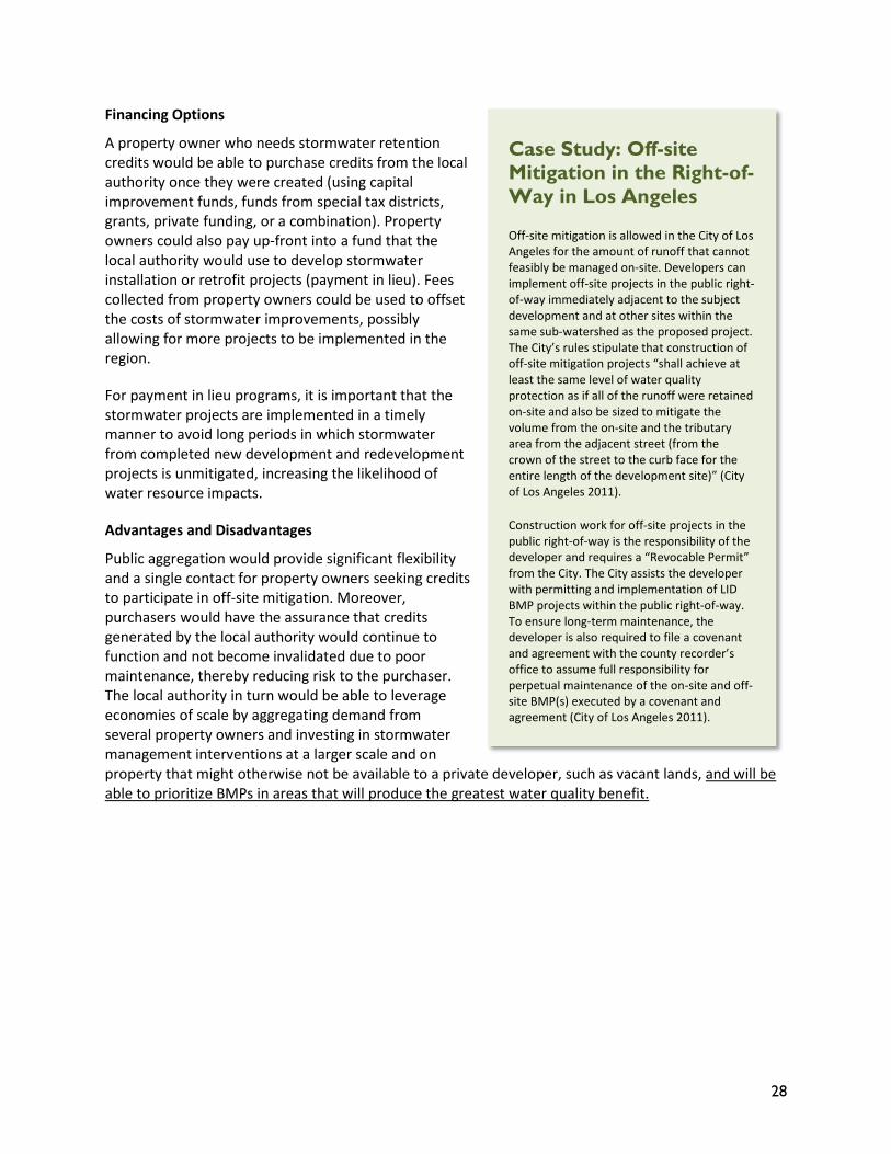
Financing Options
A property owner who needs stormwater retention credits would be able to purchase credits from the local authority once they were created (using capital improvement funds, funds from special tax districts, grants, private funding, or a combination). Property owners could also pay up-front into a fund that the local authority would use to develop stormwater installation or retrofit projects (payment in lieu). Fees collected from property owners could be used to offset the costs of stormwater improvements, possibly allowing for more projects to be implemented in the region.
For payment in lieu programs, it is important that the stormwater projects are implemented in a timely manner to avoid long periods in which stormwater from completed new development and redevelopment projects is unmitigated, increasing the likelihood of water resource impacts.
Advantages and Disadvantages
Public aggregation would provide significant flexibility and a single contact for property owners seeking credits to participate in off-site mitigation. Moreover, purchasers would have the assurance that credits generated by the local authority would continue to function and not become invalidated due to poor maintenance, thereby reducing risk to the purchaser. The local authority in turn would be able to leverage economies of scale by aggregating demand from several property owners and investing in stormwater management interventions at a larger scale and on property that might otherwise not be available to a private developer, such as vacant lands, and will be able to prioritize BMPs in areas that will produce the greatest water quality benefit.
Case Study: Off-site Mitigation in the Right-of-Way in Los Angeles
Off-site mitigation is allowed in the City of Los Angeles for the amount of runoff that cannot feasibly be managed on-site. Developers can implement off-site projects in the public right-of-way immediately adjacent to the subject development and at other sites within the same sub-watershed as the proposed project. The City’s rules stipulate that construction of off-site mitigation projects “shall achieve at least the same level of water quality protection as if all of the runoff were retained on-site and also be sized to mitigate the volume from the on-site and the tributary area from the adjacent street (from the crown of the street to the curb face for the entire length of the development site)” (City of Los Angeles 2011).
Construction work for off-site projects in the public right-of-way is the responsibility of the developer and requires a “Revocable Permit” from the City. The City assists the developer with permitting and implementation of LID BMP projects within the public right-of-way. To ensure long-term maintenance, the developer is also required to file a covenant and agreement with the county recorder’s office to assume full responsibility for perpetual maintenance of the on-site and off-site BMP(s) executed by a covenant and agreement (City of Los Angeles 2011).
29
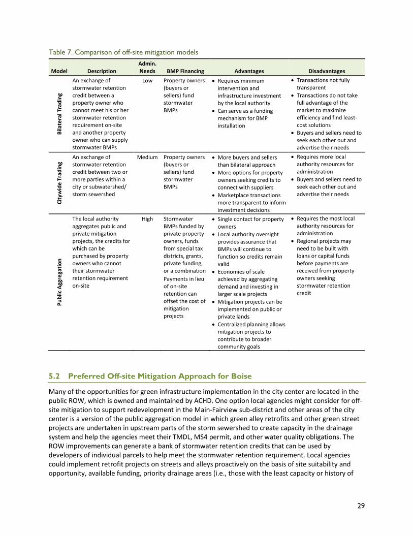
Table 7. Comparison of off-site mitigation models
Model Description Admin. Needs BMP Financing Advantages Disadvantages
Bila
tera
l Tra
ding
An exchange of stormwater retention credit between a property owner who cannot meet his or her stormwater retention requirement on-site and another property owner who can supply stormwater BMPs
Low Property owners (buyers or sellers) fund stormwater BMPs
• Requires minimum intervention and infrastructure investment by the local authority
• Can serve as a funding mechanism for BMP installation
• Transactions not fully transparent
• Transactions do not take full advantage of the market to maximize efficiency and find least-cost solutions
• Buyers and sellers need to seek each other out and advertise their needs
City
wid
e Tr
adin
g
An exchange of stormwater retention credit between two or more parties within a city or subwatershed/ storm sewershed
Medium Property owners (buyers or sellers) fund stormwater BMPs
• More buyers and sellers than bilateral approach
• More options for property owners seeking credits to connect with suppliers
• Marketplace transactions more transparent to inform investment decisions
• Requires more local authority resources for administration
• Buyers and sellers need to seek each other out and advertise their needs
Publ
ic A
ggre
gatio
n
The local authority aggregates public and private mitigation projects, the credits for which can be purchased by property owners who cannot their stormwater retention requirement on-site
High Stormwater BMPs funded by private property owners, funds from special tax districts, grants, private funding, or a combination Payments in lieu of on-site retention can offset the cost of mitigation projects
• Single contact for property owners
• Local authority oversight provides assurance that BMPs will continue to function so credits remain valid
• Economies of scale achieved by aggregating demand and investing in larger scale projects
• Mitigation projects can be implemented on public or private lands
• Centralized planning allows mitigation projects to contribute to broader community goals
• Requires the most local authority resources for administration
• Regional projects may need to be built with loans or capital funds before payments are received from property owners seeking stormwater retention credit
5.2 Preferred Off-site Mitigation Approach for Boise
Many of the opportunities for green infrastructure implementation in the city center are located in the public ROW, which is owned and maintained by ACHD. One option local agencies might consider for off-site mitigation to support redevelopment in the Main-Fairview sub-district and other areas of the city center is a version of the public aggregation model in which green alley retrofits and other green street projects are undertaken in upstream parts of the storm sewershed to create capacity in the drainage system and help the agencies meet their TMDL, MS4 permit, and other water quality obligations. The ROW improvements can generate a bank of stormwater retention credits that can be used by developers of individual parcels to help meet the stormwater retention requirement. Local agencies could implement retrofit projects on streets and alleys proactively on the basis of site suitability and opportunity, available funding, priority drainage areas (i.e., those with the least capacity or history of
30
flooding or where the greatest environmental benefit can be realized), and private-sector demand for credits. The green infrastructure retrofits might be integrated into pedestrian and bicycle safety improvements for cost-efficiency. ROW improvements could be made and in-lieu-of credits subsequently purchased by developers.
ACHD, the City of Boise, and other local stakeholders could form a committee to oversee the credit system, garner stakeholder input on its operation, and ensure proper accounting of new and future credits and associated costs. The committee would undertake an initial study to evaluate the costs associated with (1) building green infrastructure in the ROW, (2) long-term maintenance of the infrastructure, and (3) program administrative costs. This study would help to ensure that the price of credits reflects the life-cycle costs of the green infrastructure. The study would be updated periodically to include revised assumptions for life-cycle costs; for example, alleyways converted to green alleys might be less expensive to maintain over the long term than originally estimated. Updates to the study would also include a re-evaluation of demand to ensure that the pace of green infrastructure retrofits is in sync with demand for credits (and that reimbursement is timely).
So as not to discourage the private sector from generating stormwater credits by building more on-site retention capacity than the local standard requires, ACHD and the City of Boise can work with developers and property owners to identify such stormwater management opportunities across the district and incorporate their credits into the overall tracking system. The committee would work together to determine the priority by which credits would be reimbursed.
31
6 Conclusion
Many communities across the country have embraced green infrastructure stormwater practices to help meet local water quality goals and address water quantity issues. ACHD and the City of Boise have found that green infrastructure practices can be used in their communities to address these water resource concerns and provide compliance with pending NPDES Phase I permit post-construction stormwater requirements. The permit requires runoff reduction of 0.6-inches in 24 hours on both new development and redevelopment areas. In areas of new development, such requirements can be accomplished by dedicating appropriate areas of the project site for placement of stormwater infiltration practices. In areas subject to dense urban redevelopment, such as within the Main-Fairview sub-district, dedication of already limited site space to stormwater practices may serve as a disincentive to redevelopment when compared to undeveloped parcels on the urban fringe of Boise. Green infrastructure retrofits could be undertaken in the right-of-way (green alleys, green streets) to establish stormwater retention credits that can be purchased to help owners of redevelopment properties meet the 0.6-inch storm retention standard. The credit system can be administered by a committee of local stakeholders to ensure fairness and transparency.
A green street conceptual design for a one block section of Fairview Avenue adjacent to vacant lots under consideration for redevelopment provides a case study for how off-site mitigation of stormwater management using green infrastructure in a transportation right-of-way can incentivize redevelopment on adjacent parcels. The analysis revealed that the green street conceptual design could provide stormwater management mitigation for 0.7 acres of impervious area of the adjacent 2.5 acre private parcel. On a direct cost comparison basis, off-site mitigation costs of green infrastructure exceed potential onsite stormwater management costs by a factor of 6.
32
7 References
Ada County Highway District (ACHD). 2014a. ACHD Bid Averages. http://www.achdidaho.org/Departments/PP/files/Bid_Averages_Report.pdf
Ada County Highway District (ACHD). 2014b. ACHD Policy Manual. Section 8200 – ACHD Stormwater Design Tools and Approved BMPs. Accessed November 2014. http://www.achdidaho.org/AboutACHD/PolicyExhibits/PDF/Section_8200_Stormwater_Design_Manual.pdf
Ada County Highway District (ACHD). 2014c. Green Stormwater Infrastructure Guidance Manual. Accessed July 2015. http://www.partnersforcleanwater.org/media/3050/Boise_GC%202014%20-%20Section%2002%20ACHD_App7.pdf.
Boise City Planning and Development Services and Capital City Development Corporation. 2012. 30th Street Area Master Plan. Accessed June 27, 2014. http://pds.cityofboise.org/media/184351/30th_master_plan_ fin_07_30_2012.pdf.
CH2M Hill. 2001. Washington Stormwater Management Study: Report and Recommendations from the Stormwater Policy Advisory Committee. Prepared for the Washington State Department of Ecology and Washington State Department of Transportation. Accessed June 24, 2014. http://www.ecy.wa.gov/programs/wq/stormwater/commentdocs/finalreport.pdf.
City of Boise, Idaho. 2010. StormWater Management: A Design Manual. http://www.partnersforcleanwater.org/media/174240/22196_stormwaterdesignmanual2010.pdf
City of Los Angeles. 2011. Development Best Management Practices Handbook, Part B Planning Activities (Low Impact Development Manual). Fourth Edition. Accessed June 24, 2014. http://www.lastormwater.org/wp-content/files_mf/lidhandbookfinal62212.pdf
Center for Watershed Protection (CWP). 2013. District of Columbia Stormwater Management Guidebook. Accessed June 24, 2014. http://ddoe.dc.gov/node/610622.
Materials, Testing & Inspection. 2002. Geotechnical Engineering Report of Brady Law Chartered, 3101 Main Street, Boise Idaho. August 16, 2002. Prepared by B. Wright.
Materials, Testing & Inspection. 2013. Geotechnical Engineering Report of Medical Office Building, 3003 West Main Street, Boise, Idaho. September 12, 2013. Prepared by E. Brown.
Maupin, M., and T. Wagner. 2003. Regional Facility vs. On-site Development Regulations: Increasing Flexibility and Effectiveness in Development Regulation Implementation. City of Seattle, Washington. Accessed June 24, 2014. http://water.epa.gov/polwaste/nps/stormwater/upload/2003_03_26_NPS_natlstormwater03_22Maupin.pdf.
NatLab. 2013. Creating Clean Water Cash Flows: Developing Private Markets for Green Stormwater Infrastructure in Philadelphia. Accessed June 24, 2014. http://www.nrdc.org/water/stormwater/files/green-infrastructure-pa-report.pdf.
USEPA Region 10. 2012. Permit for Storm Water Discharges from Small Municipal Separate Storm Sewer Systems. Accessed February 12, 2015. http://www.epa.gov/region10/pdf/permits/npdes/id/ids027561_ms4_fp_2012.pdf.

33
Appendix A: Fairview Avenue Green Street Conceptual Design
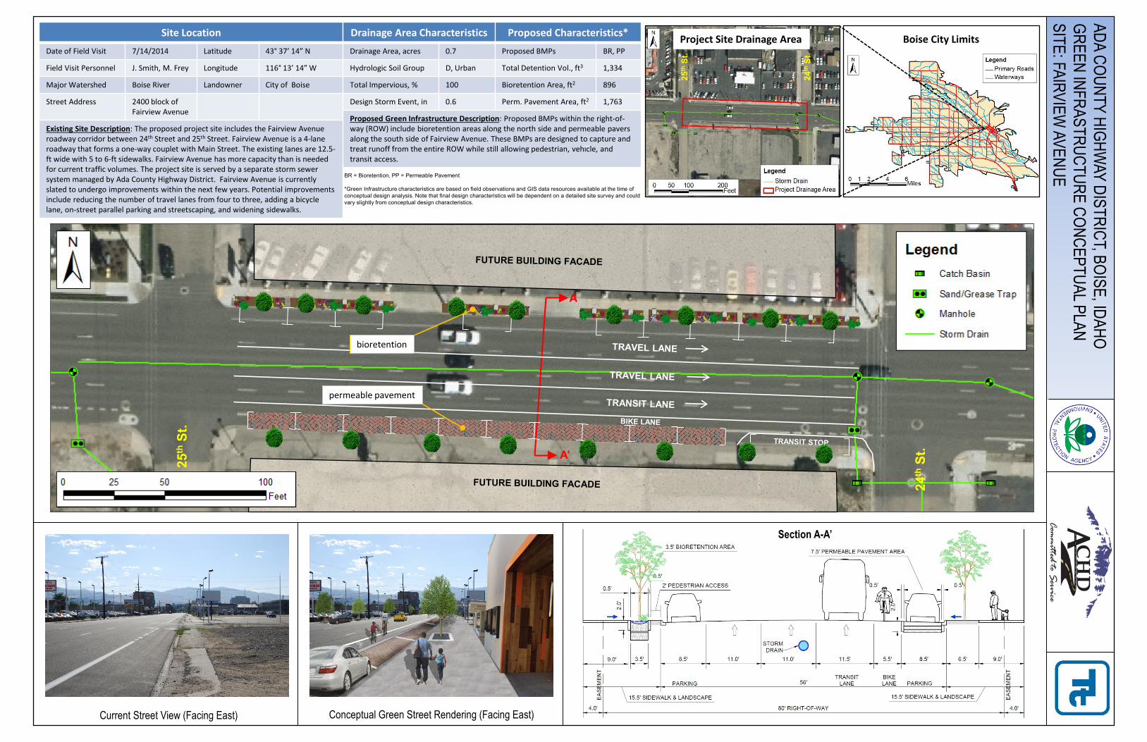
Current Street View (Facing East)
ADA COUNTY HIGHWAY DISTRICT, BOISE, IDAHO
GREEN INFRASTRUCTURE CONCEPTUAL PLANSITE: FAIRVIEW
AVENUEBR = Bioretention, PP = Permeable Pavement
*Green Infrastructure characteristics are based on field observations and GIS data resources available at the time of conceptual design analysis. Note that final design characteristics will be dependent on a detailed site survey and couldvary slightly from conceptual design characteristics.
Site LocationDate of Field Visit 7/14/2014 Latitude 43° 37’ 14” N
Field Visit Personnel J. Smith, M. Frey Longitude 116° 13’ 14” W
Major Watershed Boise River Landowner City of Boise
Street Address 2400 block of Fairview Avenue
Existing Site Description: The proposed project site includes the Fairview Avenue roadway corridor between 24th Street and 25th Street. Fairview Avenue is a 4-lane roadway that forms a one-way couplet with Main Street. The existing lanes are 12.5-ft wide with 5 to 6-ft sidewalks. Fairview Avenue has more capacity than is needed for current traffic volumes. The project site is served by a separate storm sewer system managed by Ada County Highway District. Fairview Avenue is currently slated to undergo improvements within the next few years. Potential improvements include reducing the number of travel lanes from four to three, adding a bicycle lane, on-street parallel parking and streetscaping, and widening sidewalks.
Drainage Area Characteristics Proposed Characteristics*Drainage Area, acres 0.7 Proposed BMPs BR, PP
Hydrologic Soil Group D, Urban Total Detention Vol., ft3 1,334
Total Impervious, % 100 Bioretention Area, ft2 896
Design Storm Event, in 0.6 Perm. Pavement Area, ft2 1,763
Proposed Green Infrastructure Description: Proposed BMPs within the right-of-way (ROW) include bioretention areas along the north side and permeable pavers along the south side of Fairview Avenue. These BMPs are designed to capture and treat runoff from the entire ROW while still allowing pedestrian, vehicle, and transit access.
Conceptual Green Street Rendering (Facing East)
A
A’
permeable pavement
25th
St.
24th
St.
bioretention
25th
St.
24th
St.
Project Site Drainage Area
Section A-A’
Boise City Limits
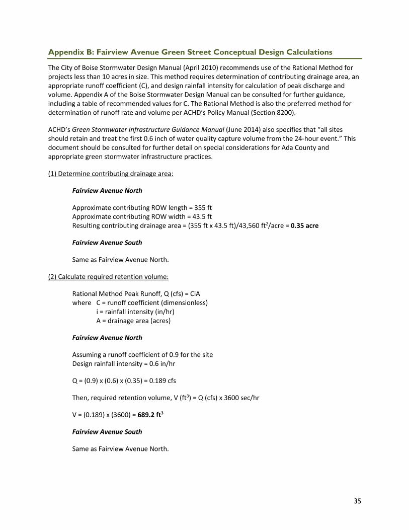
35
Appendix B: Fairview Avenue Green Street Conceptual Design Calculations
The City of Boise Stormwater Design Manual (April 2010) recommends use of the Rational Method for projects less than 10 acres in size. This method requires determination of contributing drainage area, an appropriate runoff coefficient (C), and design rainfall intensity for calculation of peak discharge and volume. Appendix A of the Boise Stormwater Design Manual can be consulted for further guidance, including a table of recommended values for C. The Rational Method is also the preferred method for determination of runoff rate and volume per ACHD’s Policy Manual (Section 8200).
ACHD’s Green Stormwater Infrastructure Guidance Manual (June 2014) also specifies that “all sites should retain and treat the first 0.6 inch of water quality capture volume from the 24-hour event.” This document should be consulted for further detail on special considerations for Ada County and appropriate green stormwater infrastructure practices.
(1) Determine contributing drainage area:
Fairview Avenue North
Approximate contributing ROW length = 355 ft Approximate contributing ROW width = 43.5 ft Resulting contributing drainage area = (355 ft x 43.5 ft)/43,560 ft2/acre = 0.35 acre
Fairview Avenue South
Same as Fairview Avenue North.
(2) Calculate required retention volume:
Rational Method Peak Runoff, Q (cfs) = CiA where C = runoff coefficient (dimensionless)
i = rainfall intensity (in/hr) A = drainage area (acres)
Fairview Avenue North
Assuming a runoff coefficient of 0.9 for the site Design rainfall intensity = 0.6 in/hr
Q = (0.9) x (0.6) x (0.35) = 0.189 cfs
Then, required retention volume, V (ft3) = Q (cfs) x 3600 sec/hr
V = (0.189) x (3600) = 689.2 ft3
Fairview Avenue South
Same as Fairview Avenue North.
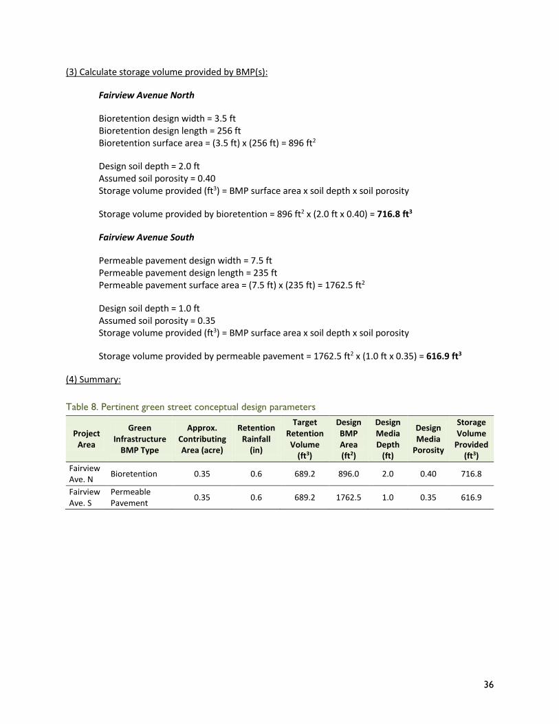
36
(3) Calculate storage volume provided by BMP(s):
Fairview Avenue North
Bioretention design width = 3.5 ft Bioretention design length = 256 ft Bioretention surface area = (3.5 ft) x (256 ft) = 896 ft2
Design soil depth = 2.0 ft Assumed soil porosity = 0.40 Storage volume provided (ft3) = BMP surface area x soil depth x soil porosity
Storage volume provided by bioretention = 896 ft2 x (2.0 ft x 0.40) = 716.8 ft3
Fairview Avenue South
Permeable pavement design width = 7.5 ft Permeable pavement design length = 235 ft Permeable pavement surface area = (7.5 ft) x (235 ft) = 1762.5 ft2
Design soil depth = 1.0 ft Assumed soil porosity = 0.35 Storage volume provided (ft3) = BMP surface area x soil depth x soil porosity
Storage volume provided by permeable pavement = 1762.5 ft2 x (1.0 ft x 0.35) = 616.9 ft3
(4) Summary:
Table 8. Pertinent green street conceptual design parameters
Project Area
Green Infrastructure
BMP Type
Approx. Contributing Area (acre)
Retention Rainfall
(in)
Target Retention Volume
(ft3)
Design BMP Area (ft2)
Design Media Depth
(ft)
Design Media
Porosity
Storage Volume
Provided (ft3)
Fairview Ave. N Bioretention 0.35 0.6 689.2 896.0 2.0 0.40 716.8
Fairview Ave. S
Permeable Pavement 0.35 0.6 689.2 1762.5 1.0 0.35 616.9
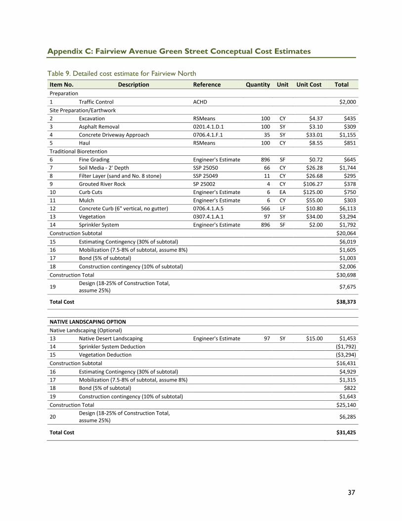
37
Appendix C: Fairview Avenue Green Street Conceptual Cost Estimates
Table 9. Detailed cost estimate for Fairview North Item No. Description Reference Quantity Unit Unit Cost Total Preparation 1 Traffic Control ACHD $2,000 Site Preparation/Earthwork 2 Excavation RSMeans 100 CY $4.37 $435 3 Asphalt Removal 0201.4.1.D.1 100 SY $3.10 $309 4 Concrete Driveway Approach 0706.4.1.F.1 35 SY $33.01 $1,155 5 Haul RSMeans 100 CY $8.55 $851 Traditional Bioretention 6 Fine Grading Engineer's Estimate 896 SF $0.72 $645 7 Soil Media - 2' Depth SSP 25050 66 CY $26.28 $1,744 8 Filter Layer (sand and No. 8 stone) SSP 25049 11 CY $26.68 $295 9 Grouted River Rock SP 25002 4 CY $106.27 $378 10 Curb Cuts Engineer's Estimate 6 EA $125.00 $750 11 Mulch Engineer's Estimate 6 CY $55.00 $303 12 Concrete Curb (6" vertical, no gutter) 0706.4.1.A.5 566 LF $10.80 $6,113 13 Vegetation 0307.4.1.A.1 97 SY $34.00 $3,294 14 Sprinkler System Engineer's Estimate 896 SF $2.00 $1,792 Construction Subtotal $20,064 15 Estimating Contingency (30% of subtotal) $6,019 16 Mobilization (7.5-8% of subtotal, assume 8%) $1,605 17 Bond (5% of subtotal) $1,003 18 Construction contingency (10% of subtotal) $2,006 Construction Total $30,698
19 Design (18-25% of Construction Total, assume 25%) $7,675
Total Cost $38,373
NATIVE LANDSCAPING OPTION Native Landscaping (Optional) 13 Native Desert Landscaping Engineer's Estimate 97 SY $15.00 $1,453 14 Sprinkler System Deduction ($1,792) 15 Vegetation Deduction ($3,294) Construction Subtotal $16,431 16 Estimating Contingency (30% of subtotal) $4,929 17 Mobilization (7.5-8% of subtotal, assume 8%) $1,315 18 Bond (5% of subtotal) $822 19 Construction contingency (10% of subtotal) $1,643 Construction Total $25,140
20 Design (18-25% of Construction Total, assume 25%) $6,285
Total Cost $31,425
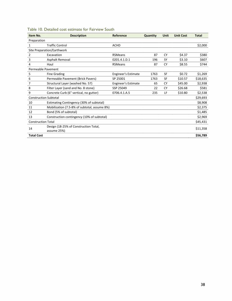
38
Table 10. Detailed cost estimate for Fairview South Item No. Description Reference Quantity Unit Unit Cost Total Preparation 1 Traffic Control ACHD $2,000 Site Preparation/Earthwork 2 Excavation RSMeans 87 CY $4.37 $380 3 Asphalt Removal 0201.4.1.D.1 196 SY $3.10 $607 4 Haul RSMeans 87 CY $8.55 $744 Permeable Pavement 5 Fine Grading Engineer's Estimate 1763 SF $0.72 $1,269 6 Permeable Pavement (Brick Pavers) SP 25001 1763 SF $10.57 $18,635 7 Structural Layer (washed No. 57) Engineer's Estimate 65 CY $45.00 $2,938 8 Filter Layer (sand and No. 8 stone) SSP 25049 22 CY $26.68 $581 9 Concrete Curb (6" vertical, no gutter) 0706.4.1.A.5 235 LF $10.80 $2,538 Construction Subtotal $29,693 10 Estimating Contingency (30% of subtotal) $8,908 11 Mobilization (7.5-8% of subtotal, assume 8%) $2,375 12 Bond (5% of subtotal) $1,485 13 Construction contingency (10% of subtotal) $2,969 Construction Total $45,431
14 Design (18-25% of Construction Total, assume 25%) $11,358
Total Cost $56,789