Embed Size (px)
Citation preview
Feasibility Report for
Hydro Facility Relicensing River Falls, Wisconsin | February 8, 2018
Engineers | Architects | Planners | Scientists
Short Elliott Hendrickson Inc., 3535 Vadnais Center Drive, St. Paul, MN 55110-5196 SEH is 100% employee-owned | sehinc.com | 651.490.2000 | 800.325.2055 | 888.908.8166 fax
Feb. 8, 2018 RE: City of River Falls Feasibility Report for Hydro Facility Relicensing SEH File No. 138553
Honorable Mayor and City Council City of River Falls City Hall, 222 Lewis Street River Falls, WI 54022
In accordance with your authorization, we have prepared the attached report entitled Feasibility Report for Hydro Facility Relicensing.
This report includes a background of the relicensing process, summary of public engagement efforts, description of the decision process, primary options considered, conclusions and recommendations for next steps. The decision to relicense or surrender the license to operate your hydro facilities is a difficult one, a combination of emotional and analytical factors. The decision needs to strike a balance between environmental, economic and social consideration and facilitate a 40- to 50-year vision for the community.
We recommend that the Council carefully consider this report and consult with City staff. We are available to review this report with you at your convenience.
Sincerely,
SHORT ELLIOTT HENDRICKSON INC.
Mark Lobermeier, PE
Project Manager
Acknowledgments Mayor and City Council Mayor: Dan Toland
At Large: Diane Odeen, Scott Morrissette, Jeff Bjork; District 1: Sean Downing; District 2: Christopher Gagne; District: 3: Hal Watson; and District 4: Todd Bjerstedt
Utility Advisory Board Adam Myszewski – President; Diane Odeen, Council Representative; Duane Pederson; Tim Thum; Kevin Swanson; and Patrick Richter,
Kinni Corridor Project Committee Chris Blasius, CEO, River Falls Chamber of Commerce and Tourism Bureau Rick Bowen, Director of Athletics (retired), University of Wisconsin-River Falls Jason Egerstrom, Communications Supervisor - City of Woodbury Dave Fodroczi, Executive Director (retired) - Kinnickinnic River Land Trust Gary Horvath, Vice President, Kiap-TU-Wish Chapter, Trout Unlimited Rita Kozak, Adjunct Professor, Sustainable Management Program, University of Wisconsin-River Falls Member, UWRF Kinni Consortium Patricia La Rue, Resident Lisa Moody, Member, City of River Falls Plan Commission Adam Myszewski, President, City of River Falls Utility Advisory Board Susan Reese, Chair, City of River Falls Parks and Recreation Advisory Board Dan Toland, Mayor, City of River Falls
City Staff Julie Bergstrom, Assistant City Administrator Angie Bond, Community Development Assistant Buddy Lucero, Community Development Director Amy Peterson, Development Services Director Scot Simpson, City Administrator Mike Stifter, Public Works Operations Director Kevin Westhuis, Utility Director Mary Zimmermann, Communications Manager
Tech Talk Presenters Lesley Brotowski, TRC Ed Freer, SEH Inc. Dr. Carrie Jennings, Freshwater Society of Minnesota Kent Johnson, Metropolitan Council Environmental Services & Kiap-TU-Wish Chapter of Trout Unlimited Bob Kost, SEH Inc. Cheryl Laatsch, WDNR Mark Lobermeier, SEH Inc. Ismael Martinez, IMO Marty Melchior, Inter-Fluve Dr. Matt Mitro, WDNR Don Ness, Former Mayor of Duluth MN Patrick Seeb, Destination Medical Center, Rochester, MN Scot Simpson, City of River Falls
Consultant Team SEH Inc.
Mark Lobermeier, Project Manager Tim Diedrich Deric Deuschle Ed Freer Bob Kost Sarah Lipkin Sularz Kristin Petersen Anna Springer Alex Thill Brad Woznak
IMO Ismael Martinez
Inter-Fluve
Marty Melchior Dan Mielke
TRC Solutions
Lesley Brotowski
With special thanks to the River Falls Library and St. Bridget Catholic Church for hosting several public meetings related to the project.
Table of Contents Executive summary…………………………………………………………………1
History and current conditions……………….…………………………………..3 Kinnickinnic River Dams and hydro facilities Licensing process
Planning process ………………..…………………………………………………21 Planning approach Committee development/roles/activities Inventory and analysis Planning framework Community design charrette Three scenarios for final consideration
Public engagement .………………..………………………………………………33 Engagement plan Community events and Tech Talks Surveys and comments Communications and marketing
Decision process……………………………………………………………………45 Kinni Corridor Committee consideration Utility Advisory Board recommendation Stakeholder input Committee recommendation
Conclusions, recommendations and next steps……………………….…….51
Literature review……………………….……………………………………….....55
Appendices A. Ecological implicationsB. Kick-off meeting summaryC. Frequently Asked QuestionsD. Utility Advisory Board resolutionE. Kinni Corridor Project Committee resolutionF. Project timeline
List of Figures
Figure 1 – Pre-settlement view of Junction Falls Figure 2 - Volunteers install the Quarry Road thermal monitoring station, May 1992 Figure 3 - Initial concept for Lake George Restoration (SEH, 1995) Figure 4 - 2005 Lake George proposed interceptors (Bonestroo 2005). Figure 5 - Concept for stormwater treatment within Lake George (Bonestroo 2005). Figure 6 - WDNR Classification of the Kinnickinnic River and tributaries. Figure 7 - Kiap-TU-Wish temperature monitoring sites Figure 8 – Working River Figure 9 - Rock and timber crib dam under the old Falls Street Bridge. Figure 10 – Junction Falls Dam, just below the Winter Street Bridge. Figure 11 – Powell Falls spillway. Figure 12 – Corridor Planning Process Figure 13 - Low flow over the falls below the Junction Falls dam Figure 14 – Cross section of the Kinnickinnic River following dam removal Figure 15 – River profile Figure 16- Restored Falls Figure 17 - Potential Floodway Reduction due to dam removal
List of Tables
Table 1 - Lake George Sediments Table 2 - 1990 Lake George Sediments Sampling Table 3 - 2014 Cost Estimates for Hydroelectric Relicensing Option Table 4 - Anticipated Effects of Dam Removal Table 5 - Discharge Frequency Values for Kinnickinnic River at River Falls
Feasibility Report for Hydro Facility Relicensing 1
Exec
utiv
e su
mm
ary
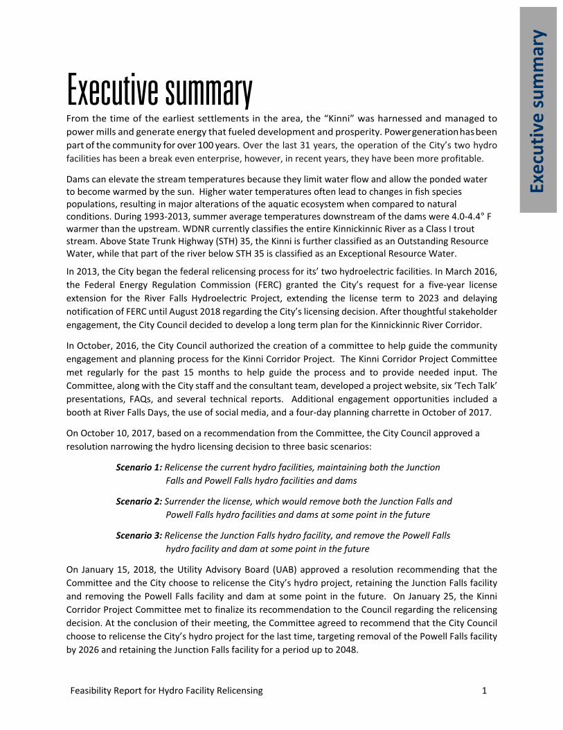
Executive summary From the time of the earliest settlements in the area, the “Kinni” was harnessed and managed to power mills and generate energy that fueled development and prosperity. Power generation has been part of the community for over 100 years. Over the last 31 years, the operation of the City’s two hydro facilities has been a break even enterprise, however, in recent years, they have been more profitable.
Dams can elevate the stream temperatures because they limit water flow and allow the ponded water to become warmed by the sun. Higher water temperatures often lead to changes in fish species populations, resulting in major alterations of the aquatic ecosystem when compared to natural conditions. During 1993-2013, summer average temperatures downstream of the dams were 4.0-4.4° F warmer than the upstream. WDNR currently classifies the entire Kinnickinnic River as a Class I trout stream. Above State Trunk Highway (STH) 35, the Kinni is further classified as an Outstanding Resource Water, while that part of the river below STH 35 is classified as an Exceptional Resource Water.
In 2013, the City began the federal relicensing process for its’ two hydroelectric facilities. In March 2016, the Federal Energy Regulation Commission (FERC) granted the City’s request for a five-year license extension for the River Falls Hydroelectric Project, extending the license term to 2023 and delaying notification of FERC until August 2018 regarding the City’s licensing decision. After thoughtful stakeholder engagement, the City Council decided to develop a long term plan for the Kinnickinnic River Corridor.
In October, 2016, the City Council authorized the creation of a committee to help guide the community engagement and planning process for the Kinni Corridor Project. The Kinni Corridor Project Committee met regularly for the past 15 months to help guide the process and to provide needed input. The Committee, along with the City staff and the consultant team, developed a project website, six ‘Tech Talk’ presentations, FAQs, and several technical reports. Additional engagement opportunities included a booth at River Falls Days, the use of social media, and a four-day planning charrette in October of 2017.
On October 10, 2017, based on a recommendation from the Committee, the City Council approved a resolution narrowing the hydro licensing decision to three basic scenarios:
Scenario 1: Relicense the current hydro facilities, maintaining both the Junction Falls and Powell Falls hydro facilities and dams
Scenario 2: Surrender the license, which would remove both the Junction Falls and Powell Falls hydro facilities and dams at some point in the future
Scenario 3: Relicense the Junction Falls hydro facility, and remove the Powell Falls hydro facility and dam at some point in the future
On January 15, 2018, the Utility Advisory Board (UAB) approved a resolution recommending that the Committee and the City choose to relicense the City’s hydro project, retaining the Junction Falls facility and removing the Powell Falls facility and dam at some point in the future. On January 25, the Kinni Corridor Project Committee met to finalize its recommendation to the Council regarding the relicensing decision. At the conclusion of their meeting, the Committee agreed to recommend that the City Council choose to relicense the City’s hydro project for the last time, targeting removal of the Powell Falls facility by 2026 and retaining the Junction Falls facility for a period up to 2048.


Feasibility Report for Hydro Facility Relicensing 3
Hist
ory
and
curr
ent c
ondi
tions
History and current conditions
Kinnickinnic River River Falls was founded at the confluence of the Kinnickinnic River and the South Fork. Junction Falls, just above the confluence was certainly part of what must have inspired Joel Foster, the area’s first white settler to write:
“I think I have found the New England of the Northwest, the same pure water, the same speckled trout, the same sumac, elder, etc. It looks as though the Almighty made this portion of the country first and made it on a perfect system, piling rocks up in beautiful mounds, spreading over them sufficient soil to dress and beautify.”
According to Schreiber (1998), the Kinnickinnic River has undergone a dramatic transformation, from a pristine cold water prairie trout stream to a degraded, marginal trout stream, and back again to one of the premier trout fisheries in western Wisconsin. Prior to the 1850s, the Kinnickinnic, the South Fork and their tributaries were excellent prairie brook trout streams. However, during the late 1800s through the early 1900s, the stream was severely degraded by agricultural activities, wastewater effluent, deforestation and construction of milling and power dams. Since the mid-1930s, the stream was greatly rehabilitated by conservation activities including soil erosion control programs, wastewater treatment and fish habitat restoration projects. (Schreiber, 1998).
Figure 1 – Pre-settlement view of Junction Falls
4 Feasibility Report for Hydro Facility Relicensing
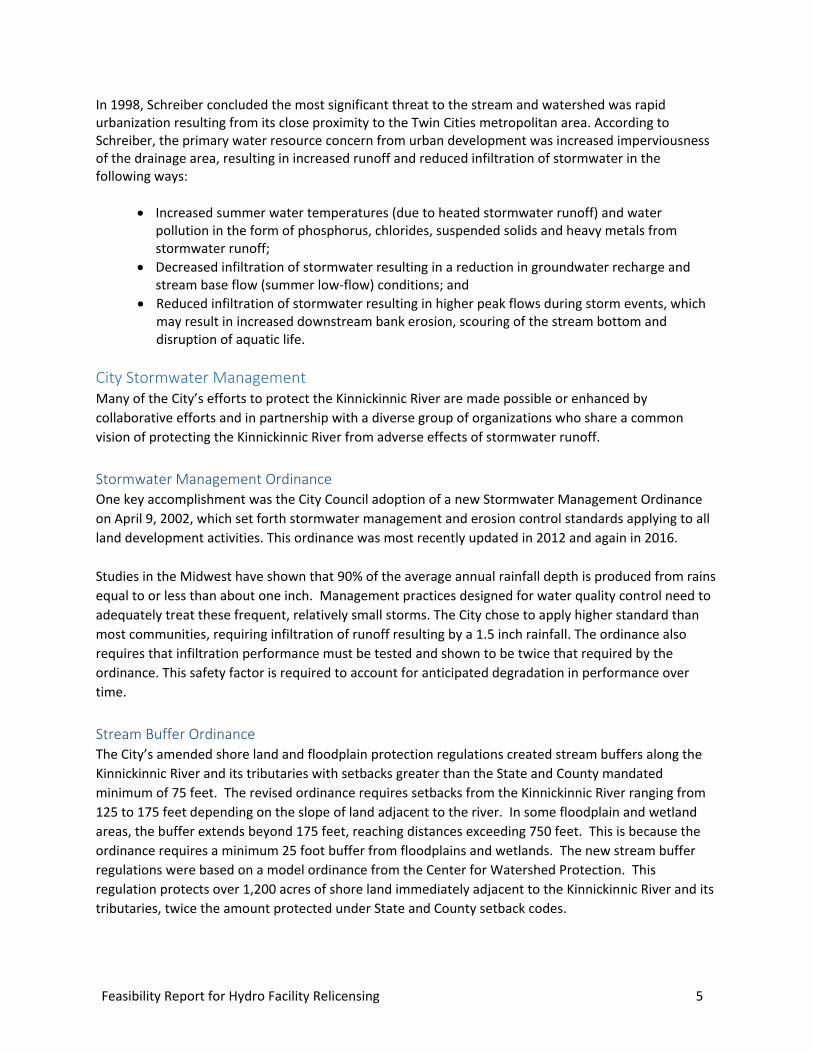
Watershed management efforts In 1991, the City received a grant from the Environmental Protection Agency to study the Kinnickinnic River and its tributaries. The “205J” plan (SEH, 1995) was groundbreaking in the ways it sought and achieved consent of two counties, four townships, the Wisconsin Department of Natural Resources (WDNR), University of Wisconsin River Falls (UW River Falls), Trout Unlimited and the City of River Falls. The 205J did not address the issue of dam relicensing or dam removal since the facilities had just been relicensed. However, the plan questioned the viability of the structures and helped reinfoirce an attitude of river protection, reducing the harmful effects of future development and protecting the river corridor above, through and below the City.
During the planning process, the Kiap-TU-Wish Chapter of Trout Unlimited initiated the historic thermal monitoring program that resulted in more than 20 years of data for evaluating changes in the cold water regime of the river. The 205j Plan set the stage for the Kinnickinnic Priority Watershed Project, which brought greater focus to the agricultural practices of the rural portions of the watershed. The 205J Plan also led to the development of the Lake George Stormwater Treatment Plan.
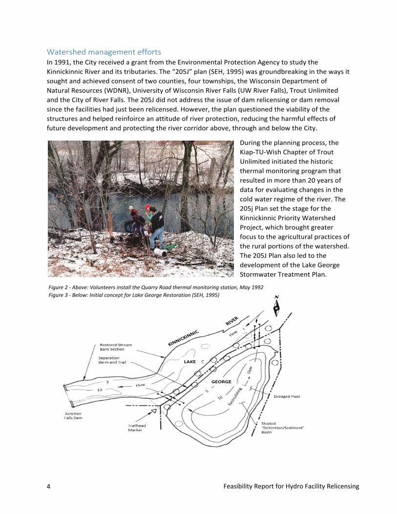
Figure 2 - Above: Volunteers install the Quarry Road thermal monitoring station, May 1992 Figure 3 - Below: Initial concept for Lake George Restoration (SEH, 1995)
Feasibility Report for Hydro Facility Relicensing 5
In 1998, Schreiber concluded the most significant threat to the stream and watershed was rapid urbanization resulting from its close proximity to the Twin Cities metropolitan area. According to Schreiber, the primary water resource concern from urban development was increased imperviousness of the drainage area, resulting in increased runoff and reduced infiltration of stormwater in the following ways:
• Increased summer water temperatures (due to heated stormwater runoff) and waterpollution in the form of phosphorus, chlorides, suspended solids and heavy metals fromstormwater runoff;
• Decreased infiltration of stormwater resulting in a reduction in groundwater recharge andstream base flow (summer low-flow) conditions; and
• Reduced infiltration of stormwater resulting in higher peak flows during storm events, whichmay result in increased downstream bank erosion, scouring of the stream bottom anddisruption of aquatic life.
City Stormwater Management Many of the City’s efforts to protect the Kinnickinnic River are made possible or enhanced by collaborative efforts and in partnership with a diverse group of organizations who share a common vision of protecting the Kinnickinnic River from adverse effects of stormwater runoff.
Stormwater Management Ordinance One key accomplishment was the City Council adoption of a new Stormwater Management Ordinance on April 9, 2002, which set forth stormwater management and erosion control standards applying to all land development activities. This ordinance was most recently updated in 2012 and again in 2016.
Studies in the Midwest have shown that 90% of the average annual rainfall depth is produced from rains equal to or less than about one inch. Management practices designed for water quality control need to adequately treat these frequent, relatively small storms. The City chose to apply higher standard than most communities, requiring infiltration of runoff resulting by a 1.5 inch rainfall. The ordinance also requires that infiltration performance must be tested and shown to be twice that required by the ordinance. This safety factor is required to account for anticipated degradation in performance over time.
Stream Buffer Ordinance The City’s amended shore land and floodplain protection regulations created stream buffers along the Kinnickinnic River and its tributaries with setbacks greater than the State and County mandated minimum of 75 feet. The revised ordinance requires setbacks from the Kinnickinnic River ranging from 125 to 175 feet depending on the slope of land adjacent to the river. In some floodplain and wetland areas, the buffer extends beyond 175 feet, reaching distances exceeding 750 feet. This is because the ordinance requires a minimum 25 foot buffer from floodplains and wetlands. The new stream buffer regulations were based on a model ordinance from the Center for Watershed Protection. This regulation protects over 1,200 acres of shore land immediately adjacent to the Kinnickinnic River and its tributaries, twice the amount protected under State and County setback codes.

6 Feasibility Report for Hydro Facility Relicensing
Illicit Discharge Detection and Elimination Ordinance In December 2007, the City adopted an Illicit Discharge Detection and Elimination Ordinance as part of a program to develop, implement and enforce a program to detect and remove illicit connections and discharges.
Innovative Stormwater strategies The City has implemented a variety of innovative strategies involving stormwater management and partnerships with area organizations including trout Unlimited, Kinnickinnic River Land Trust, Kinnickinnic River Priority Watershed Project, Wisconsin Department of Natural Resources, and private property owners. Some of those efforts have include:
• Lake George Area Stormwater Treatment Concept Plan (see description in next section)• Rainwater Garden Demonstration Project –• Stormwater Management Area Delineation and Education• West Side Stormwater Demonstration Project• Pervious Pavers• Permeable Concrete• Adopt-A Pond Program Catch Basin Markers• Rain to Rivers Program• Rain Barrel Rebate Program• City Website
Stormwater (MS4) Permit As authorized by the Clean Water Act, there is a nationwide permit program that controls water pollution by regulating pipes and channels that discharge storm water and pollutants into surface waters. The City received its initial MS4 Permit on October 1, 2006 and received a renewed permit in July 2014. UW-River Falls has their own Phase II permit; the City has signed an intergovernmental agreement with UW-River Falls in 2009 to work together on many of the requirements of these permits.
The City’s goal is to maintain this exceptional resource; this is done through 6, regulated, minimum control measures:
1. Public education and outreach.2. Public participation and involvement.3. Illicit discharge detection and elimination.4. Construction site pollutant control5. Post-construction storm water management.6. Pollution prevention/Good housekeeping.
At the end of every year, the City conducts a Public Hearing and files an annual report documenting that years’ compliance with its MS4 Permit. This information is available on the City’s website.
Feasibility Report for Hydro Facility Relicensing 7
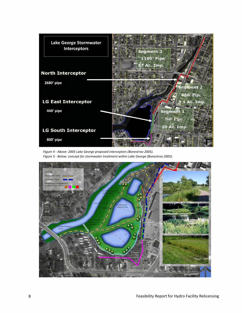
Lake George Area Stormwater Treatment Concept Plan The Lake George Area Stormwater Treatment Concept Plan (Bonestroo, 2005) advanced the concepts developed earlier studies (SEH, 1995), (Swanson, 1996). The purpose of this project was to develop an overall management strategy for that portion of the Upper Dam Minor Watershed of the Kinnickinnic River watershed, which includes downtown River Falls and Lake George. The Lake George Plan recommended converting Lake George to an artificial wetland and stream channel. The main features of this plan included the development of a multi-cell configuration with the smaller northernmost cell to be used as the first (pretreatment) cell in the system to which raw stormwater from the interceptor system would be discharged. Access would be provided to facilitate periodic removal of accumulated sediment.
In addition to evaluating reconfiguration alternatives for Lake George, the plan included identification and evaluation of watershed treatment practices to reduce thermal and total suspended solids loads to the river above Lake George. These practices generally emphasized pre-treating and infiltrating the first flush of runoff carried by storm sewers that serve some of the larger, higher impervious sewersheds in the project area.
Various options for reconfiguring Lake George focused on alternatives that would have a demonstrable positive effect on thermal regimes in the river below Lake George dam under both base flow and runoff conditions. All options evaluated included an interceptor pipe extending north from Lake George upstream along the east side of the river as far as Division Street. The interceptor would reduce the total suspended solids and thermal loads to the river above Lake George from the most highly impervious portion of the project area between Division Street and the lake. This raw runoff would be diverted by the interceptor to the Lake George area where the water could be treated and released in a controlled manner back to the river to minimize impact.
8 Feasibility Report for Hydro Facility Relicensing
Figure 4 - Above: 2005 Lake George proposed interceptors (Bonestroo 2005). Figure 5 - Below: concept for stormwater treatment within Lake George (Bonestroo 2005).
Feasibility Report for Hydro Facility Relicensing 9
Historical sedimentation The rate of sedimentation in Lake George - the reservoir formed by the Junction Falls Dam - has been quite high starting with the period of intense cultivation during the late 1800's. In the 1950's, according to Moe (1981), sediment was accumulating in Lake George at the rate of over 2,500 cubic yards per year. Moe estimated that improved upland soil conservation practices and extensive stream bank protection reduced erosion and the resulting sedimentation, reducing deposition in Lake George to a rate of less than 500 cubic yards per year (0.2 inches/year).
Swanson (1976) noted that since the current Junction Falls dam was built: “Much of Lake George had silted in, greatly limiting the potential use of the lake.” Swanson (1976) concluded that the sediments in Lake George had been deposited during major flood events and primarily in the years prior to 1960. Since 1960, Swanson believed that runoff and erosion control practices in the watershed and streambank protection on the upper Kinnickinnic River had reduced the rate of sedimentation in Lake George to minimal amounts.
Swanson (1976) concluded that because of the mineral rich sediments and shallow water, Lake George had limited value as a lake water resource. Swanson wrote “Lake George is a pleasant little lake and could have great recreational value because of its location in the City. This recreational value can only be enjoyed if the shoreline is improved and the lake sediment dredged out to improve lake depth and water quality.” Swanson found sediment depths averaging 4 to 5 feet with some areas exceeding 6 feet.
In 1981, Moe found that sediment ranged from 0- 8 feet thick on the bottom of Lake George, generally deeper near the dam. According to Moe (1981), the estimated total volume of soft sediment measured in the 1981 study was approximately 64,000 cubic yards.
Moe (1981) concluded that overall stormwater contributed only a small proportion of the sediment and nutrients delivered to the lake. Moe (1981) found that current nutrient delivery was not a controlling factor in Lake George; rather, the nutrient-rich sediments, deposited years ago, provided the medium for abundant plant growth in Lake George. According to Moe (1981), water and phosphorus moved through Lake George so rapidly (flushing every 21 hours), that current nutrient delivery to the lake was not a controlling factor.
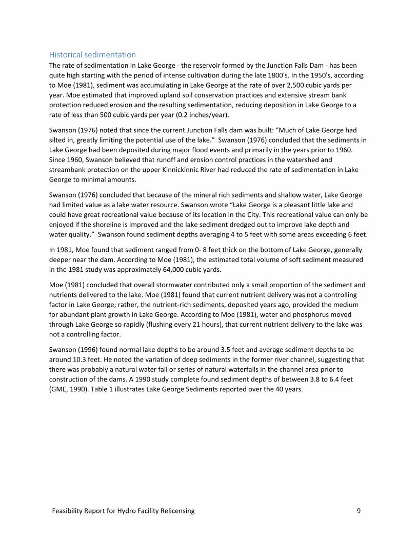
Swanson (1996) found normal lake depths to be around 3.5 feet and average sediment depths to be around 10.3 feet. He noted the variation of deep sediments in the former river channel, suggesting that there was probably a natural water fall or series of natural waterfalls in the channel area prior to construction of the dams. A 1990 study complete found sediment depths of between 3.8 to 6.4 feet (GME, 1990). Table 1 illustrates Lake George Sediments reported over the 40 years.

10 Feasibility Report for Hydro Facility Relicensing
Table 1 Lake George Sediments
Source
Area (acres)
Normal Ave.
Water Depth (feet)
Sediment Depths (feet)
Volume Acre-(feet)
Volume (cu. yds)
Sedimentation Rate
(Cu yds/year)
1976 Swanson, R. 11.3 4 – 5 30 48,400 533 1981 Moe 18 0 – 8 94 64,012 < 500 1990 GME 5 3.8 – 6.4 1996 Swanson et.al 18 3.5 8 128,000 1998 Schreiber 18
GME (1990) reported that the measured parameters of Lake George sediments were well below the values which would be considered as hazardous levels (in 1990).
Table 2 1990 Lake George Sediments Sampling (GME, 1990)
Parameter Range of Results (mg.kg) Total Organic Carbon 380 to > 16,000 Cadmium <0.25 to 0.35 Chromium <2.5 to 11 Chromium <2.5 to 11 Copper <0.25 to 6.4 Lead <2.5 to 15 Mercury <0.02
A more recent sediment analysis was completed by the City in 2016 (Inter-Fluve) as described later in this section of the report.
Fisheries The Kinnickinnic River supports a cold water fishery dominated by trout, where it remains free flowing and outside the influence of the reservoirs created by the two dams. Regionally, the Kinnickinnic River is known for its natural and self-sustaining trout fishery. However, the two dams separate the river and fish populations differ above and below the impoundments. Above the impoundments, where water temperatures are cooler, the native brook trout are more common. Below the impoundments, where water temperatures are warmer, brown trout are more common. The dams and reservoirs likely provide an effective barrier to fish migration. Prior to the dams being constructed, the falls likely provided a similar impediment to fish migration, but would have had less influence on temperature, hydrology amelioration, and water quality. Although the reservoirs are conducive for warm water species like sunfish and carp, these conditions often do not meet the requirements for the brook and brown trout fisheries the Kinnickinnic River is known for (Inter-Fluve, June 2017).
Feasibility Report for Hydro Facility Relicensing 11
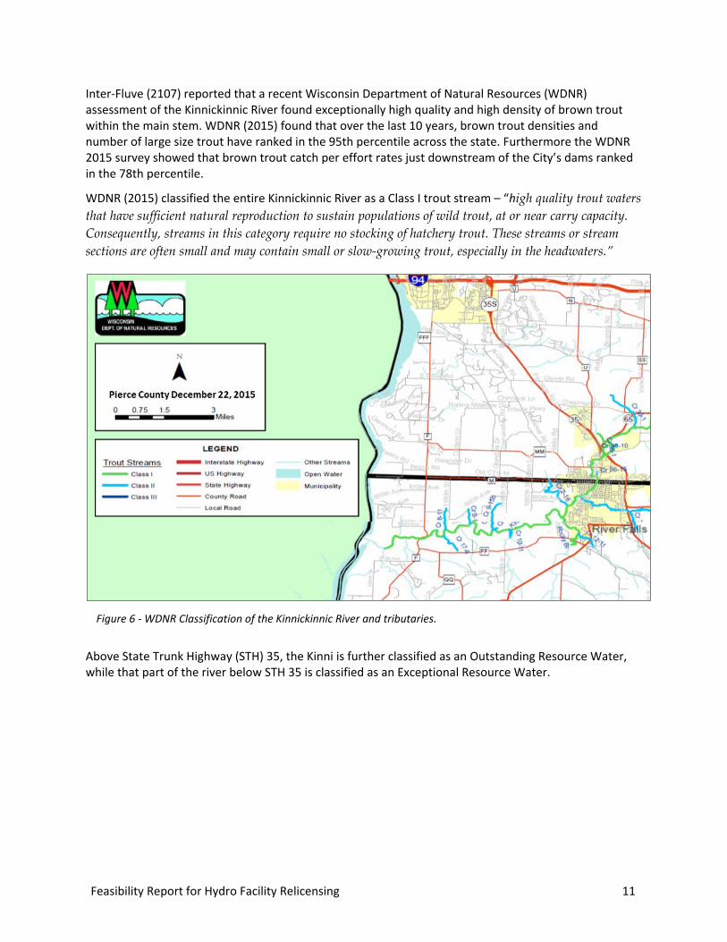
Inter-Fluve (2107) reported that a recent Wisconsin Department of Natural Resources (WDNR) assessment of the Kinnickinnic River found exceptionally high quality and high density of brown trout within the main stem. WDNR (2015) found that over the last 10 years, brown trout densities and number of large size trout have ranked in the 95th percentile across the state. Furthermore the WDNR 2015 survey showed that brown trout catch per effort rates just downstream of the City’s dams ranked in the 78th percentile.
WDNR (2015) classified the entire Kinnickinnic River as a Class I trout stream – “high quality trout waters that have sufficient natural reproduction to sustain populations of wild trout, at or near carry capacity. Consequently, streams in this category require no stocking of hatchery trout. These streams or stream sections are often small and may contain small or slow-growing trout, especially in the headwaters.”
Above State Trunk Highway (STH) 35, the Kinni is further classified as an Outstanding Resource Water, while that part of the river below STH 35 is classified as an Exceptional Resource Water.
Figure 6 - WDNR Classification of the Kinnickinnic River and tributaries.
12 Feasibility Report for Hydro Facility Relicensing
Stream Temperatures Dams tend to elevate the water temperatures because they limit water flow and allow the ponded water to stagnate and become exposed to the sun for a longer exposure time with a greater surface area. These higher water temperatures often lead to changes in fish species populations and a reduction of dissolved oxygen in the water column, resulting in major alterations of the aquatic ecosystem when compared to natural conditions.
Since 1992, the Kiap-TU-Wish Chapter of Trout Unlimited has been conducting temperature monitoring of the Kinnickinnic River and three tributaries (Sumner Creek, South Fork of the Kinnickinnic River, and Rocky Branch Creek) in the vicinity of River Falls, Wisconsin (Johnson, 2014). Figure 7 illustrates the location of the thermal monitoring stations.
“The impoundments have an overall constant warming effect of about 3° C (5° F) on downstream water temperatures during base flow” (Schreiber, 1998). Available temperature monitoring data obtained at four of the Kinnickinnic River monitoring sites can be used to evaluate the thermal impacts of the two impoundments (Lake George and Lake Louise) created by the City of River Falls hydropower facilities. (Johnson, 2014). Johnson (2014) reported that on average during the 1993-2013 period of record, downstream summer average temperatures at Upper and Lower Glen Park were 2.2-2.4° C (4.0-4.4° F) warmer than the upstream summer average temperatures at Quarry Road and Division Street. According to Johnson, this temperature differential is even greater in July (the warmest summer month), with downstream temperatures 2.3-2.8° C (4.3-4.9° F) higher than upstream temperatures. Furthermore, throughout the summer period, the downstream temperatures at Upper and Lower Glen Park more
Outstanding Resource Waters (ORWs) and Exceptional Resource Waters (ERWs)
Wisconsin has designated many of the state’s highest quality waters as Outstanding Resource Waters (ORWs) or Exceptional Resource Waters (ERWs). Waters designated as ORW or ERW are surface waters which provide outstanding recreational opportunities, support valuable fisheries and wildlife habitat, have good water quality, and are not significantly impacted by human activities. ORW and ERW status identifies waters that the State of Wisconsin has determined warrant additional protection from the effects of pollution. These designations are intended to meet federal Clean Water Act obligations requiring Wisconsin to adopt an “anti-degradation” policy that is designed to prevent any lowering of water quality – especially in those waters having significant ecological or cultural value.
ORWs receive the state’s highest protection standards, with ERWs a close second. ORWs and ERWs share many of the same environmental and ecological characteristics. They differ in the types of discharges each receives, and the level of protection established for the waterway after it is designated.
• ORWs: ORWs typically do not have any point sources discharging pollutants directly to the water (for instance, noindustrial sources or municipal sewage treatment plants), though they may receive runoff from nonpoint sources.New discharges may be permitted only if their effluent quality is equal to or better than the background water qualityof that waterway at all times—no increases of pollutant levels are allowed.
• ERWs: If a waterbody has existing point sources at the time of designation, it is more likely to be designated as anERW. Like ORWs, dischargers to ERW waters are required to maintain background water quality levels; however,exceptions can be made for certain situations when an increase of pollutant loading to an ERW is warranted becausehuman health would otherwise be compromised.

Feasibility Report for Hydro Facility Relicensing 13
frequently exceed the critical temperature thresholds that support healthy cold water macroinvertebrate and brown trout communities in the Kinnickinnic River. (Johnson, 2014).
Johnson (2014) concluded that the temperature data obtained at each monitoring site can be compared to critical temperature thresholds that must be maintained to support healthy cold water communities in the Kinnickinnic River and its tributaries. These thresholds are as follows:
• Temperatures ≤ 17º C = river temperatures optimal for macroinvertebrate survival• Temperatures ≤ 19º C = river temperatures optimal for brown trout growth• Temperatures ≤ 20º C = river temperatures optimal for brown trout survival• Temperatures > 19º C = river temperatures exceed physiological limit for brown trout• Temperatures > 22º C = river temperatures exceed the survival tolerance threshold and upper
metabolic limit for brown trout• Temperatures > 25º C = river temperatures exceed the lethal threshold for brown trout
Figure 7 - Kiap-TU-Wish temperature monitoring sites.
14 Feasibility Report for Hydro Facility Relicensing
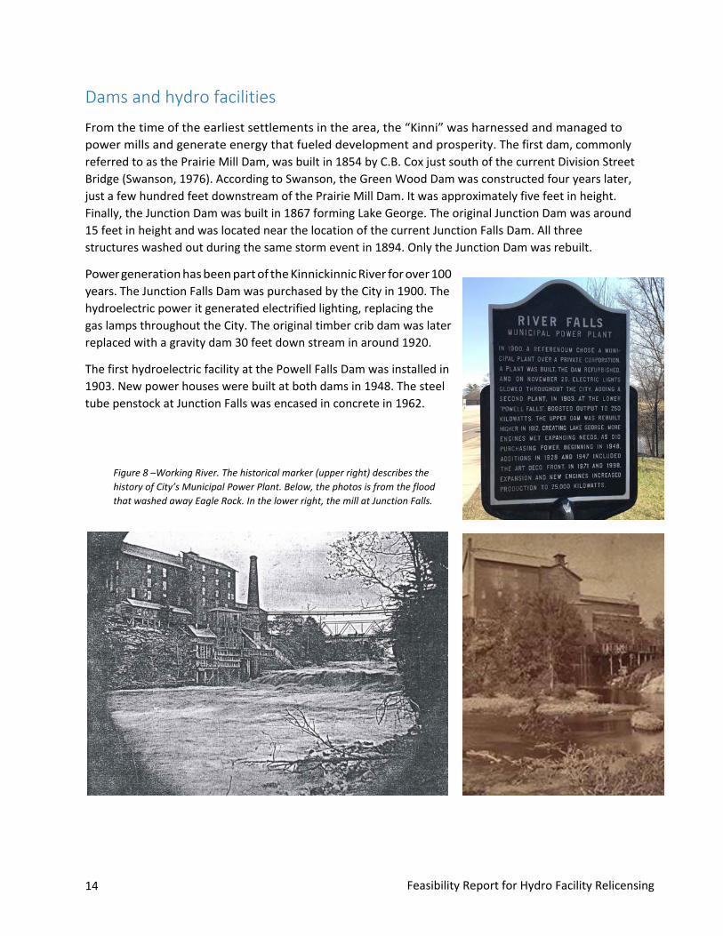
Dams and hydro facilitiesFrom the time of the earliest settlements in the area, the “Kinni” was harnessed and managed to power mills and generate energy that fueled development and prosperity. The first dam, commonly referred to as the Prairie Mill Dam, was built in 1854 by C.B. Cox just south of the current Division Street Bridge (Swanson, 1976). According to Swanson, the Green Wood Dam was constructed four years later, just a few hundred feet downstream of the Prairie Mill Dam. It was approximately five feet in height. Finally, the Junction Dam was built in 1867 forming Lake George. The original Junction Dam was around 15 feet in height and was located near the location of the current Junction Falls Dam. All three structures washed out during the same storm event in 1894. Only the Junction Dam was rebuilt.
Power generation has been part of the Kinnickinnic River for over 100 years. The Junction Falls Dam was purchased by the City in 1900. The hydroelectric power it generated electrified lighting, replacing the gas lamps throughout the City. The original timber crib dam was later replaced with a gravity dam 30 feet down stream in around 1920.
The first hydroelectric facility at the Powell Falls Dam was installed in 1903. New power houses were built at both dams in 1948. The steel tube penstock at Junction Falls was encased in concrete in 1962.
Figure 8 –Working River. The historical marker (upper right) describes the history of City’s Municipal Power Plant. Below, the photos is from the flood that washed away Eagle Rock. In the lower right, the mill at Junction Falls.

Feasibility Report for Hydro Facility Relicensing 15
Original license and hydro operations The River Falls Hydroelectric Project (P-10489) (Project)was granted a 30-year license from the Federal Energy Regulatory Commission (FERC) on Sept. 27, 1988 that expires on Aug. 31, 2018. The City of River Falls currently owns, operates, and maintains the hydroelectric facilities at the Junction Falls (Upper) and Powell Falls (Lower) dams.
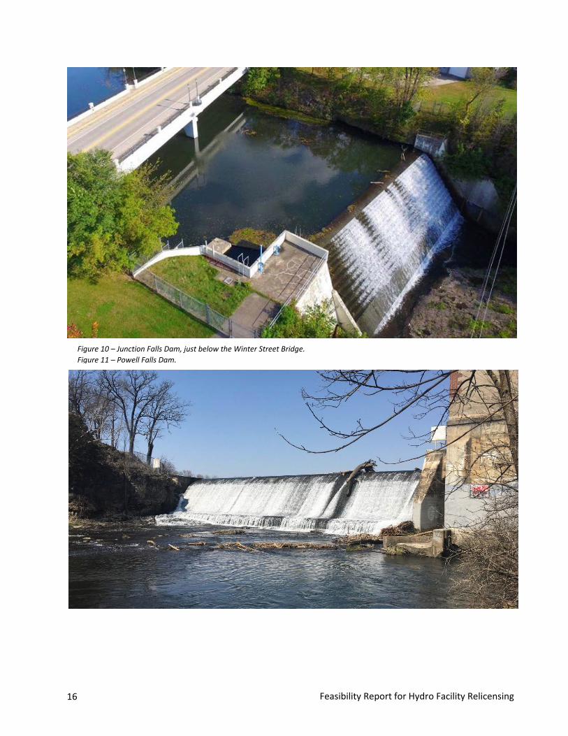
Junction Falls Hydro Facility • Constructed in 1920• Reconstructed in 1990• 140 feet long spillway• Crest length of 115 feet• Maintains Lake George, 16 acres in area• Rated Capacity – 250 kW• Produced 1,474,268 kWh in 2016• Produced $144,000 in revenue in 2016• Provided power for 110 – 185 homes in 2016• Inspection report completed in Sep. 2017
identified no threats to dam safety; caulkingand brush removal were recommended.
• No significant planned capital expendituresfor the foreseeable future, assuming a 50 yearuseful life ending in 2040.
• $25,000 - $50,000 in exterior buildingmaintenance recommended.
• Improvement from 1990 will be fullydepreciated in 2030.
Powell Falls Hydro Facility • Reconstructed in 1966• 110 feet long spillway, 22 feet in height• Maintains Lake Louise, 15.4 acres in area• Rated Capacity – 125 kW• Produced 635,637 kWh in 2016• Produced $62,102 in revenue in 2016• Provided for power 50-85 homes in 2016• Inspection report in 2014 identified no
threats to dam safety.• Possible capital expenditures for the
spillway repair and repair of generatingequipment ($250,000 estimated).
• $25,000 - $50,000 in exterior buildingmaintenance recommended.
Figure 9 - Rock and timber crib dam under the old Falls Street Bridge. Circa 1910. (approx. 30 feet up stream of existing dam)
16 Feasibility Report for Hydro Facility Relicensing
Figure 10 – Junction Falls Dam, just below the Winter Street Bridge. Figure 11 – Powell Falls Dam.
Feasibility Report for Hydro Facility Relicensing 17
Licensing process 2013 – Pre-Application Document (PAD) On Nov. 27, 2013, the City submitted its notice of intent to relicense the Project and pre-application document to FERC. Consistent with FERC regulations, an initial consultation meeting was held at the project facilities and the River Falls City Hall on March 24, 2014. It was widely attended by community members and other interested parties from the region and state. Initial comments and study requests from stakeholders were received by the City for consideration by May 23, 2014.
2014 – City and stakeholder discussions Two studies, sediment analysis and recreational use, were identified by the stakeholder group as important information to inform the launch of the proposed Kinnickinnic River Corridor Plan process. Other areas of study contained in the stakeholder requests, such as temperature modeling and wildlife and vegetation studies, would to be evaluated by staff and stakeholders as part of the corridor planning process.
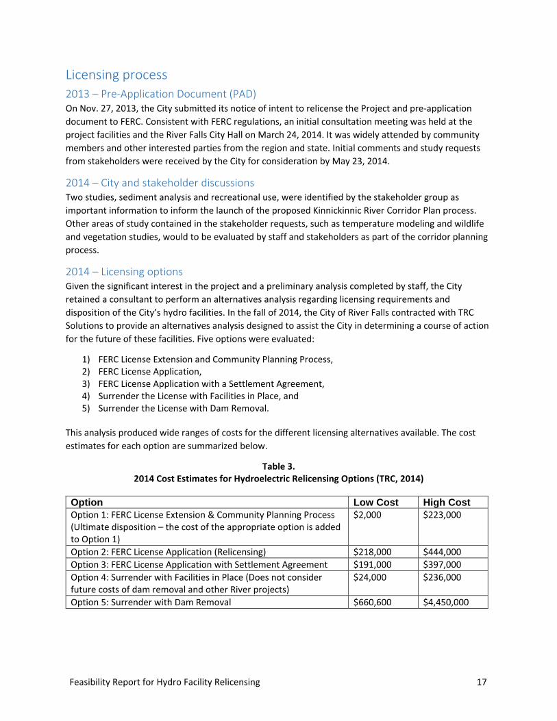
2014 – Licensing options Given the significant interest in the project and a preliminary analysis completed by staff, the City retained a consultant to perform an alternatives analysis regarding licensing requirements and disposition of the City’s hydro facilities. In the fall of 2014, the City of River Falls contracted with TRC Solutions to provide an alternatives analysis designed to assist the City in determining a course of action for the future of these facilities. Five options were evaluated:
1) FERC License Extension and Community Planning Process,2) FERC License Application,3) FERC License Application with a Settlement Agreement,4) Surrender the License with Facilities in Place, and5) Surrender the License with Dam Removal.
This analysis produced wide ranges of costs for the different licensing alternatives available. The cost estimates for each option are summarized below.
Table 3. 2014 Cost Estimates for Hydroelectric Relicensing Options (TRC, 2014)
Option Low Cost High Cost Option 1: FERC License Extension & Community Planning Process (Ultimate disposition – the cost of the appropriate option is added to Option 1)
$2,000 $223,000
Option 2: FERC License Application (Relicensing) $218,000 $444,000 Option 3: FERC License Application with Settlement Agreement $191,000 $397,000 Option 4: Surrender with Facilities in Place (Does not consider future costs of dam removal and other River projects)
$24,000 $236,000
Option 5: Surrender with Dam Removal $660,600 $4,450,000
18 Feasibility Report for Hydro Facility Relicensing
License extension On Jan. 13, 2015, the City Council adopted a resolution that supported pursuit of a license extension from FERC, and supported the Kinnickinnic River Corridor Planning strategy. The proposed comprehensive planning strategy included a community process for determining the disposition of the hydro facilities and incorporated a decision point for whether the hydroelectric operations would continue, consistent with FERC regulations.
On July 2, 2015, the City of River Falls submitted to FERC an Application for Amendment of the License to extend the current hydroelectric license for five years. This would give the City and community the opportunity to continue with the proposed Kinnickinnic River Corridor Plan process. There was also a 30-day public comment period for individuals and groups to comment on this application, which ended on Sept. 21, 2015.
On March 17, 2016, FERC granted the City’s request for a five-year license extension for the River Falls Hydroelectric Project (P-10489) to accommodate the Kinnickinnic River Corridor Planning Process. This action extended the license term to 2023 and delayed any notice by the City to FERC to Aug. 31, 2018 regarding the City’s decision to relicense or surrender the license.
Sediment study Following of the November 2013 PAD and the first stage consultation with stakeholders, the City commissioned a comprehensive and detailed sediment study. The main focus of the work was to assess the quantity and quality of impounded sediment behind both dams, and to determine the potential volume of sediment that may be evacuated or need to be excavated in the event of dam removal. The City hired Inter-Fluve to complete the study.
Inter-Fluve presented their findings to the City in March 2016. Their report discussed how the two dams have historically acted like sediment traps. Inter-Fluve (2016) described how reduced energy in Lake George and Lake Louise not only limits transport of coarse sediment, but also creates areas where fine material, including silt, clay, and organics, can fall out of suspension and accumulate.
Inter-Fluve (2016) estimated the total volume of sediment in Lake George (that area between the Winter St. Bridge and the E. Division St. Bridge) to be 166,800 cubic yards. Overall, it appears that the current impoundment has roughly the same or slightly less sediment than reported by Downing (2016). Inter-Fluve estimated the volume stored in Lake Louise to be 163,800 cubic yards. The majority of the Lake Louise sediment exists in the lower two thirds of the impoundment.
Pollutants and Contaminants Inter-Fluve’s assessed the magnitude and distribution of sediment contamination in the River Falls impoundments. Sediment samples were collected at 12 locations, including six sites in each impoundment. The collected material was analyzed for physical characteristics, metals, PCBs, organochlorine pesticides, and PAHs.
Based on the analysis, Inter-Fluve (2016) suggests that the main channel sediments in Lake George are relatively uncontaminated, although they found concentrations of two PAH compounds exceeded their respective threshold effect concentrations (TECs). In the off-channel floodplain sediments of Lake George, concentrations of mercury, lead, arsenic, hexavalent chromium, total PCBs, and three PAH compounds exceed TECs or EPA screening levels in some of the sediment core samples.

Feasibility Report for Hydro Facility Relicensing 19
Similarly, in Lake Louise, Inter-Fluve (2016) found the downstream channel sediments to be relatively uncontaminated. However, a high concentration of arsenic was present at in one sampling location, exceeding the probable effect concentration (PEC). The cadmium concentration at the same location exceeds the TEC. Arsenic concentrations exceed EPA screening levels for human health concerns at three sites. Concentrations of 10 PAH compounds exceed their respective TECs and PECs in one location, suggesting that the site may be a contaminant concern. In the Lake Louise floodplain sediments, concentrations of mercury, nickel, arsenic, and hexavalent chromium exceed their respective TECs or EPA screening levels. In addition, concentrations of seven PAH compounds exceed their respective TECs, MECs, PECs, or EPA screening levels. PAH contamination in the upper portion of sample one of the floodplain samples is of particular concern.
Implications for Sediment Management Inter-Fluve (2016) recommends that sediment management options in a dam removal scenario should be based on regulatory guidance regarding management of contaminants and ecological impacts. Review of contaminant data should be completed by the Wisconsin DNR to determine the need for any further sampling and testing, if any. Preliminary designs be include construction logistics, sediment management and water routing options during construction.

Feasibility Report for Hydro Facility Relicensing 21
Plan
ning
pro
cess
Planning process Planning Approach As the relicensing process got underway, it was apparent that many stakeholders had strong interests in how the Kinnickinnic River and its surrounding corridor should be planned for and managed. The need for a holistic plan that considered the river's role—and its relationship to the two hydro-electric dams and their impoundments (Lake George and Lake Louise)—was needed to balance demand from user groups and promote sensitive land use that is in the best interest of the community. The City Council determined that a carefully thought out multi-phased process that would lead to a comprehensive long term plan for the broader Kinnickinnic River Corridor was needed.
The City developed a scope of services for a multi-phased planning process based on comprehensive community engagement and support. A fully-implemented plan for the river corridor was envisioned to comprise three phases:
Phase 1 – Analysis, Feasibility, and Preliminary Concept Plans
Phase 2 – Final Design and Permitting
Phase 3 – Design Implementation and Construction
On January 13, 2015 Council adopted a strategy and timeline to develop a comprehensive Kinnickinnic River Corridor Plan that included a community process for determining the future of the hydroelectric operations, consistent with FERC regulations for scheduled notifications. The planning process would include continued and incremental study of the river corridor and project area, in consultation with stakeholders and community through the process to inform the long-term vision for the corridor land use and to inform the short-term licensing decision
On July 12, 2016, Short Elliott Hendrickson Inc. (SEH) was awarded the contract for Phase I - of the Kinnickinnic River Corridor Plan. On October 25, 2016, the Council approved an 11-person Kinni Corridor Project Committee (see Acknowledgements), the project schedule and the public engagement plan, officially initiating the three-year, process to develop a comprehensive long-term plan for the Kinnickinnic River Corridor, and facilitate a decision to keep or remove one or both of the City's hydroelectric facilities.
22 Feasibility Report for Hydro Facility Relicensing
Committee development/roles/activities The Kinni River Corridor Project Committee was established to serve in an advisory capacity and provide oversight to the City staff and consultant team during Kinni planning and public engagement efforts.
The Committee’s role was designed to increase transparency and inclusivity in plan development, and ensure objectivity in the public process for completing the corridor plan. While the community needs to guide the discussion and outcomes for the Corridor Plan, and how the future of the river contributes to that plan, the Committee must ensure that the plan facilitates and supports City Council decisions regarding hydro relicensing, and guide future decisions regarding disposition of the City dams.
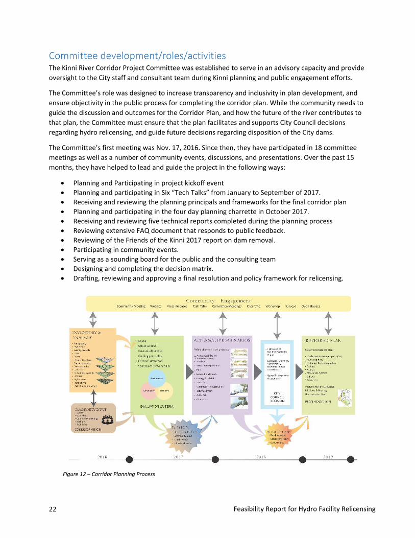
The Committee’s first meeting was Nov. 17, 2016. Since then, they have participated in 18 committee meetings as well as a number of community events, discussions, and presentations. Over the past 15 months, they have helped to lead and guide the project in the following ways:
• Planning and Participating in project kickoff event• Planning and participating in Six “Tech Talks” from January to September of 2017.• Receiving and reviewing the planning principals and frameworks for the final corridor plan• Planning and participating in the four day planning charrette in October 2017.• Receiving and reviewing five technical reports completed during the planning process• Reviewing extensive FAQ document that responds to public feedback.• Reviewing of the Friends of the Kinni 2017 report on dam removal.• Participating in community events.• Serving as a sounding board for the public and the consulting team• Designing and completing the decision matrix.• Drafting, reviewing and approving a final resolution and policy framework for relicensing.
Figure 12 – Corridor Planning Process
Feasibility Report for Hydro Facility Relicensing 23
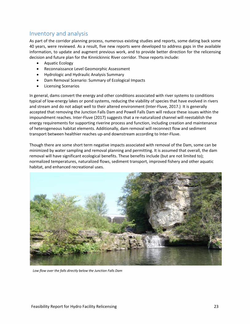
Inventory and analysis As part of the corridor planning process, numerous existing studies and reports, some dating back some 40 years, were reviewed. As a result, five new reports were developed to address gaps in the available information, to update and augment previous work, and to provide better direction for the relicensing decision and future plan for the Kinnickinnic River corridor. Those reports include:
• Aquatic Ecology• Reconnaissance Level Geomorphic Assessment• Hydrologic and Hydraulic Analysis Summary• Dam Removal Scenario: Summary of Ecological Impacts• Licensing Scenarios
In general, dams convert the energy and other conditions associated with river systems to conditions typical of low-energy lakes or pond systems, reducing the viability of species that have evolved in rivers and stream and do not adapt well to their altered environment (Inter-Fluve, 2017.) It is generally accepted that removing the Junction Falls Dam and Powell Falls Dam will reduce these issues within the impoundment reaches. Inter-Fluve (2017) suggests that a re-naturalized channel will reestablish the energy requirements for supporting riverine process and function, including creation and maintenance of heterogeneous habitat elements. Additionally, dam removal will reconnect flow and sediment transport between healthier reaches up-and downstream according to Inter-Fluve.
Though there are some short term negative impacts associated with removal of the Dam, some can be minimized by water sampling and removal planning and permitting. It is assumed that overall, the dam removal will have significant ecological benefits. These benefits include (but are not limited to); normalized temperatures, naturalized flows, sediment transport, improved fishery and other aquatic habitat, and enhanced recreational uses.
Low flow over the falls directly below the Junction Falls Dam

24 Feasibility Report for Hydro Facility Relicensing
Ecological Implications of dam removal One of the primary considerations of the potential Federal Energy Regulatory Commission (FERC) relicensing of the two hydroelectric dams on the Kinnickinnic River is the ecological implications from potential modifications of the existing structures.
Large river ecology is complicated and complex, primarily because rivers are dynamic systems, and there are multiple internal, external, and temporal variables to consider. In an effort to provide clarity, several elements that are key components of river health and productivity have been selected for discussion. For this report, a set of twelve (12) metrics were evaluated for each reach of the Kinnickinnic River to provide a qualitative summary of the River’s conditions pre and post dam removal. This summary serves to review existing data, and aid the City in a determination on ecological benefits and impairments from the proposed dam removal. The anticipated impact of the dam removal’s impact to the selected metrics is summarized in Table 4. A description of each of the metrics in Table 4 are found in Appendix A.
Table 4 Anticipated Effects of Dam Removal
Metric Reach of Kinnickinnic River
Upper Middle Lower
Fisheries Increase Increase lotic species, decrease lentic species
Increase lotic species, decrease lentic species
Macroinvertebrates No change Increased lotic, decreased lentic
Increased lotic, decreased lentic
Macrophytes No change Increase Increase
Temperature No change Decrease Decrease
Turbidity No change Increase temporarily then decrease
Increase temporarily then decrease
Sediment Movement No change Increase Increase
Pollutant Filtration No change Decrease Decrease
Nutrient Dynamics No change Increase Increase
Wetlands No change Increase Increase
Flow Rate Increase Increase Increase
Flood Storage No change Decrease Decrease
Invasive Species Increase Increase Increase

Feasibility Report for Hydro Facility Relicensing 25
Planning Framework The Committee worked together with City staff and the consultant team to develop planning frameworks to guide the ultimate corridor planning efforts. The graphically-oriented planning frameworks form the foundation of the corridor plan, scheduled to be completed in late 2018. The following planning principles, intended to strengthen and support the Kinni Corridor Plan, were developed to guide the process:
1. Heritage, culture and community character2. Social, environmental and economic sustainability3. Ecological health, performance and stewardship4. Inclusiveness and sense of place5. Economic vitality6. Mix of uses and activities7. Physical, visual and social connections8. Public health and wellness9. Resiliency10. Commitment to community engagement
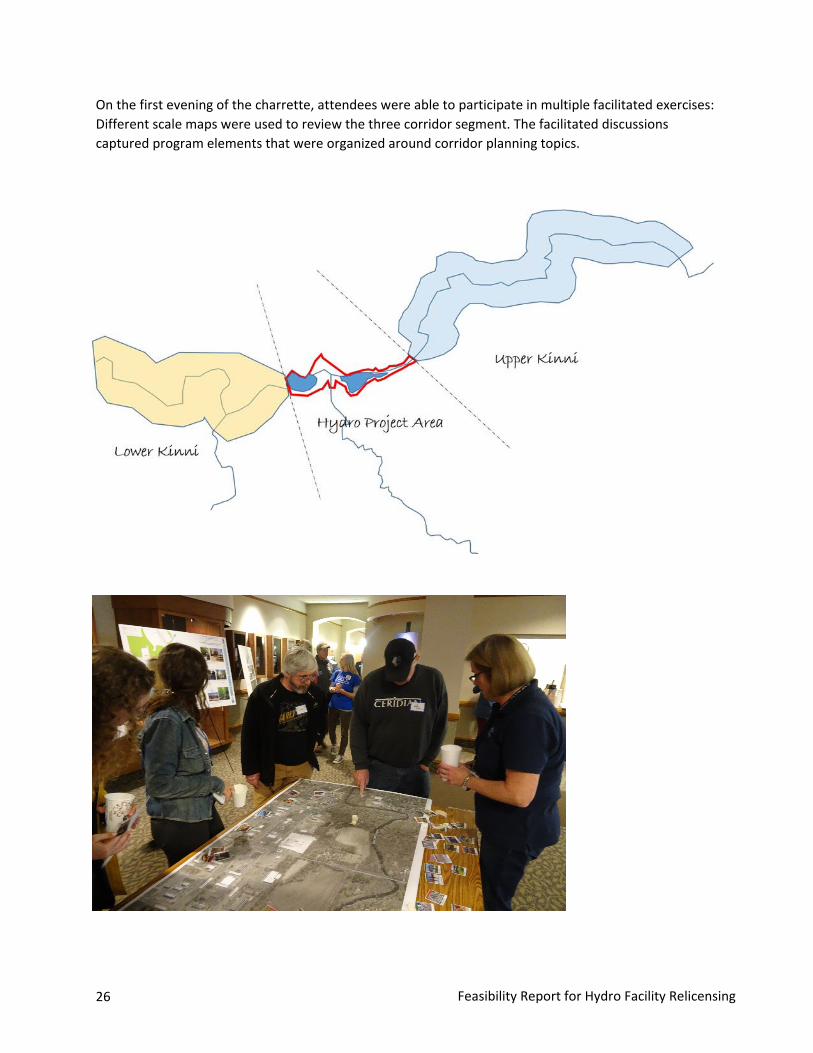
Community design charrette A Community Design Charrette was held Oct. 25-28, 2017, at the River Falls Public Library. Consultants worked with community members to create design concepts around the three scenarios adopted by the Council on Oct. 10, 2017.
The planning charrette process is often described as a ‘creative cyclone’, where preparation of base information and community education efforts drive a multi-day planning effort, and where experts and planners interact with City official, staff and citizens to development corridor alternatives using multiple feedback loops in a fully transparent process.
The charrette built on the work completed to date and generated several alternative outcomes for the corridor. After the final relicensing decision, those alternatives will be refined into a preferred alternative and implementation plan. The charrette was completed without cost constraints; the vision for the community resulting from the charrette will ultimately translated into an implementation plan where the cost, financing and schedule for improvements will be developed.
26 Feasibility Report for Hydro Facility Relicensing
On the first evening of the charrette, attendees were able to participate in multiple facilitated exercises: Different scale maps were used to review the three corridor segment. The facilitated discussions captured program elements that were organized around corridor planning topics.

Feasibility Report for Hydro Facility Relicensing 27
On the second day, the planning team worked from an open studio on the main level of the library. These working sessions were open to the public as the team began to develop corridor concepts as the public offered ideas and suggestions.
On the last evening, the design concepts developed during the charrette were presented to the public. Two basic scenarios were described for the Lake Goerge Area; a fully restored open water option with the dam in place and an alternative with a more natural restoration of the flood plain area within the reservoir area, similar to what had been described earlier in the Lake George Plan.
Both alternatives included recreation opportunities and incorporation of improved access.
28 Feasibility Report for Hydro Facility Relicensing
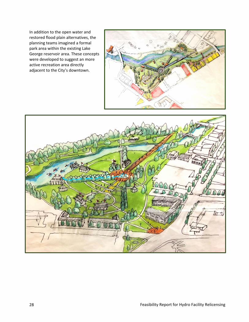
In addition to the open water and restored flood plain alternatives, the planning teams imagined a formal park area within the existing Lake George reservoir area. These concepts were developed to suggest an more active recreation area directly adjacent to the City’s downtown.
Feasibility Report for Hydro Facility Relicensing 29
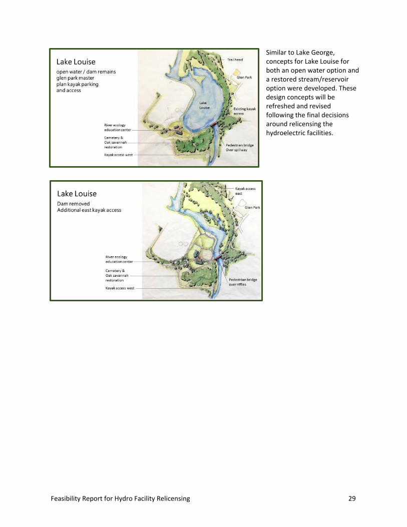
Similar to Lake George, concepts for Lake Louise for both an open water option and a restored stream/reservoir option were developed. These design concepts will be refreshed and revised following the final decisions around relicensing the hydroelectric facilities.
30 Feasibility Report for Hydro Facility Relicensing
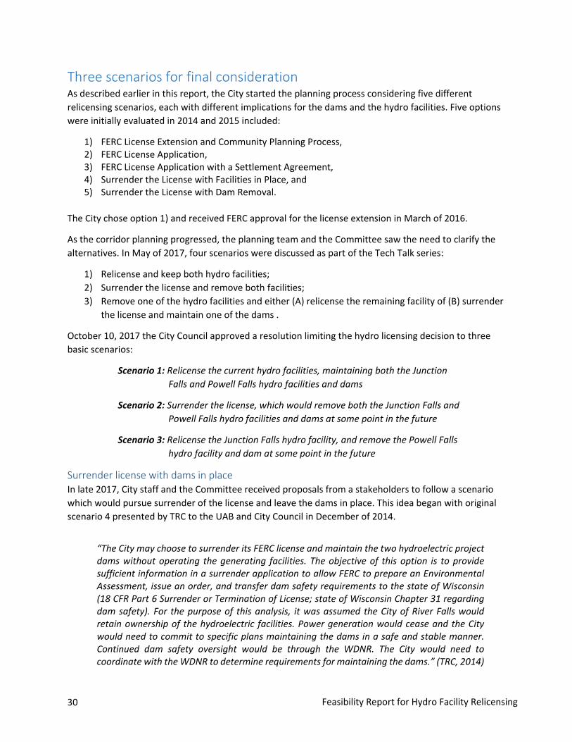
Three scenarios for final consideration As described earlier in this report, the City started the planning process considering five different relicensing scenarios, each with different implications for the dams and the hydro facilities. Five options were initially evaluated in 2014 and 2015 included:
1) FERC License Extension and Community Planning Process,2) FERC License Application,3) FERC License Application with a Settlement Agreement,4) Surrender the License with Facilities in Place, and5) Surrender the License with Dam Removal.
The City chose option 1) and received FERC approval for the license extension in March of 2016.
As the corridor planning progressed, the planning team and the Committee saw the need to clarify the alternatives. In May of 2017, four scenarios were discussed as part of the Tech Talk series:
1) Relicense and keep both hydro facilities;2) Surrender the license and remove both facilities;3) Remove one of the hydro facilities and either (A) relicense the remaining facility of (B) surrender
the license and maintain one of the dams .
October 10, 2017 the City Council approved a resolution limiting the hydro licensing decision to three basic scenarios:
Scenario 1: Relicense the current hydro facilities, maintaining both the Junction Falls and Powell Falls hydro facilities and dams
Scenario 2: Surrender the license, which would remove both the Junction Falls and Powell Falls hydro facilities and dams at some point in the future
Scenario 3: Relicense the Junction Falls hydro facility, and remove the Powell Falls hydro facility and dam at some point in the future
Surrender license with dams in place In late 2017, City staff and the Committee received proposals from a stakeholders to follow a scenario which would pursue surrender of the license and leave the dams in place. This idea began with original scenario 4 presented by TRC to the UAB and City Council in December of 2014.
“The City may choose to surrender its FERC license and maintain the two hydroelectric project dams without operating the generating facilities. The objective of this option is to provide sufficient information in a surrender application to allow FERC to prepare an Environmental Assessment, issue an order, and transfer dam safety requirements to the state of Wisconsin (18 CFR Part 6 Surrender or Termination of License; state of Wisconsin Chapter 31 regarding dam safety). For the purpose of this analysis, it was assumed the City of River Falls would retain ownership of the hydroelectric facilities. Power generation would cease and the City would need to commit to specific plans maintaining the dams in a safe and stable manner. Continued dam safety oversight would be through the WDNR. The City would need to coordinate with the WDNR to determine requirements for maintaining the dams.” (TRC, 2014)

Feasibility Report for Hydro Facility Relicensing 31
After a number of conversations, an exchange of opinions and view points, and a review of the options available under either federal or potential state jurisdiction (as suggested in the proposed scenario), the position of the staff and consulting team is that the “Surrender in place” scenario proposed by stakeholders is effectively current Scenario 2 – Remove both facilities. Therefore, the surrender license with dams in place scenario was eliminated from further consideration.


Feasibility Report for Hydro Facility Relicensing 33
Publ
ic e
ngag
emen
t
Public engagement Engagement Plan A Community Engagement Plan was adopted by the City Council on Oct. 25, 2016. The plan’s integrative approach focused on “inclusive and creative engagement that will bring all voices to the planning table and ensure meaningful consideration of all stakeholder interests. In order to allow every voice to be heard, we will employ multiple tools and activities that range from in-person, face-to-face meetings to online activities.”
The goals of the engagement program were designed to: • Welcome, encourage and value participation by all River Falls citizens• Value divergent viewpoints• Offer multiple, targeted engagement opportunities for citizens, partners, and stakeholders• Provide information that is timely, transparent, factual, and reliable• Present technically-rich details in accessible and easy to understand formats• Create fun and engaging outreach tools• Build and maintain momentum during the process• Encourage volunteerism to increase community buy-in and ownership
Community events and Tech Talks Project Kick-Off - Dec. 8, 2017, River Falls Public Library Nearly 350 community members attended the Kinni Corridor Project kick, where activities included:
• A short presentation• Two interactive mapping exercises• Four information stations facilitated by staff and consultants• Two mapping exhibits• “Your Kinni Story” video book• Video preview: “A Trip Down the Kinni”• Kid’s activities station• Survey and comment table
City kicks off Kinni Corridor Project By about 6:45 p.m. last Thursday, the public library's lower level was packed with an estimated 340 people. They all came to learn more and express themselves on what city employees have called the biggest decision River Falls has ever made. It all revolves around the future of the Kinnickinnic River, and its two dams.
"This is a historic project," said Mayor Dan Toland in a brief presentation of the project to the city. He said it was the city's biggest community planning effort since 1854, and encouraged event-goers to take time to learn about what he called the complex issues involved in the city's Kinni Corridor Project.
-- River Falls Journal, Dec. 16, 2016
34 Feasibility Report for Hydro Facility Relicensing
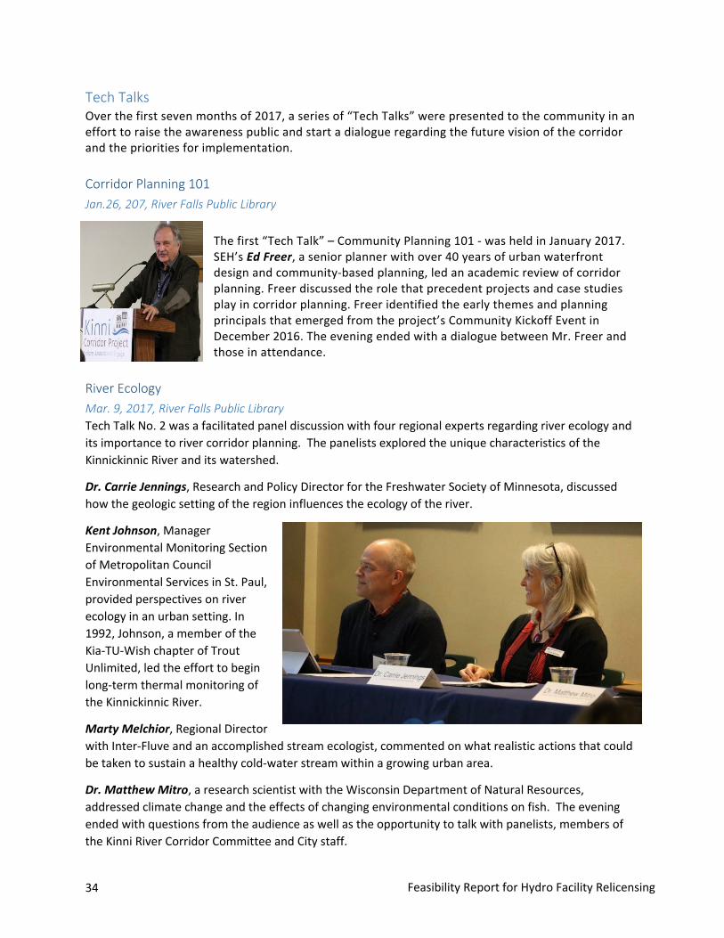
Tech Talks Over the first seven months of 2017, a series of “Tech Talks” were presented to the community in an effort to raise the awareness public and start a dialogue regarding the future vision of the corridor and the priorities for implementation.
Corridor Planning 101 Jan.26, 207, River Falls Public Library
The first “Tech Talk” – Community Planning 101 - was held in January 2017. SEH’s Ed Freer, a senior planner with over 40 years of urban waterfront design and community-based planning, led an academic review of corridor planning. Freer discussed the role that precedent projects and case studies play in corridor planning. Freer identified the early themes and planning principals that emerged from the project’s Community Kickoff Event in December 2016. The evening ended with a dialogue between Mr. Freer and those in attendance.
River Ecology Mar. 9, 2017, River Falls Public Library Tech Talk No. 2 was a facilitated panel discussion with four regional experts regarding river ecology and its importance to river corridor planning. The panelists explored the unique characteristics of the Kinnickinnic River and its watershed.
Dr. Carrie Jennings, Research and Policy Director for the Freshwater Society of Minnesota, discussed how the geologic setting of the region influences the ecology of the river.
Kent Johnson, Manager Environmental Monitoring Section of Metropolitan Council Environmental Services in St. Paul, provided perspectives on river ecology in an urban setting. In 1992, Johnson, a member of the Kia-TU-Wish chapter of Trout Unlimited, led the effort to begin long-term thermal monitoring of the Kinnickinnic River.
Marty Melchior, Regional Director with Inter-Fluve and an accomplished stream ecologist, commented on what realistic actions that could be taken to sustain a healthy cold-water stream within a growing urban area.
Dr. Matthew Mitro, a research scientist with the Wisconsin Department of Natural Resources, addressed climate change and the effects of changing environmental conditions on fish. The evening ended with questions from the audience as well as the opportunity to talk with panelists, members of the Kinni River Corridor Committee and City staff.

Feasibility Report for Hydro Facility Relicensing 35
Economic and Neighborhood Development Apr. 6, 2017 – St. Bridget Catholic Church Tech Talk No. 3 featured Don Ness, former mayor of Duluth, MN. Ness shared stories and experiences about transformational waterfront-related projects in Duluth Minnesota to illustrate the complexities and interconnectivity of a long-term development project, as well as the importance of active participation in the community planning process. Prior to the keynote, River Falls City Administrator Scot Simpson provided introductory remarks. The last half-hour of the meeting was devoted to questions and answers from community participants.
Hydro Facilities and Relicensing May 18, 2017 – St. Bridget Catholic Church
Tech Talk No. 4 featured a three-part presentation regarding hydroelectric generation, a description of the City’s two hydroelectric facilities, and a review of the federal relicensing process. Lesley Brotkowski, a senior ecologist with TRC Solutions, provided an overview of hydroelectric facilities the Federal Energy Regulatory Commission (FERC) process for relicensing the City’s two hydro facilities. In 2014 she was she was a key member of the TRC team who provided an alternatives analysis to the City River Falls to help determine a course of action for the future of the two hydroelectric facilities.
Brotowski told the audience that the City had two basic options, to relicense the hydro facilities or to surrender the license. She added that in
relicensing, the City could keep one or both its hydro facilities. In a surrender scenario, she indicated that the process is more complicated from an environmental perspective. Brotowski clarified that once the license is surrendered, the City could not generate electricity,
Mark Lobermeier, a senior principal with SEH Inc. and program manager assisting the City with the Kinnickinnic Corridor Planning effort, presented information specific to the operation of the City’s two hydroelectric facilities. Lobermeier indicated that the Junction Falls powers up to 169 homes, and Powell Falls provides power up to 101 homes. From 1986 to 2016, the hydro facilities produced net revenues of $1,063,394, an average of about $34,300 per year. From 2010-2016, net revenues averaged approximately $65,400 per year. Lobermeier noted that over the 31 years of financial records, the operation of the City’s two hydro facilities has been a break even enterprise, however, in recent years, they have been more profitable for the City.
36 Feasibility Report for Hydro Facility Relicensing
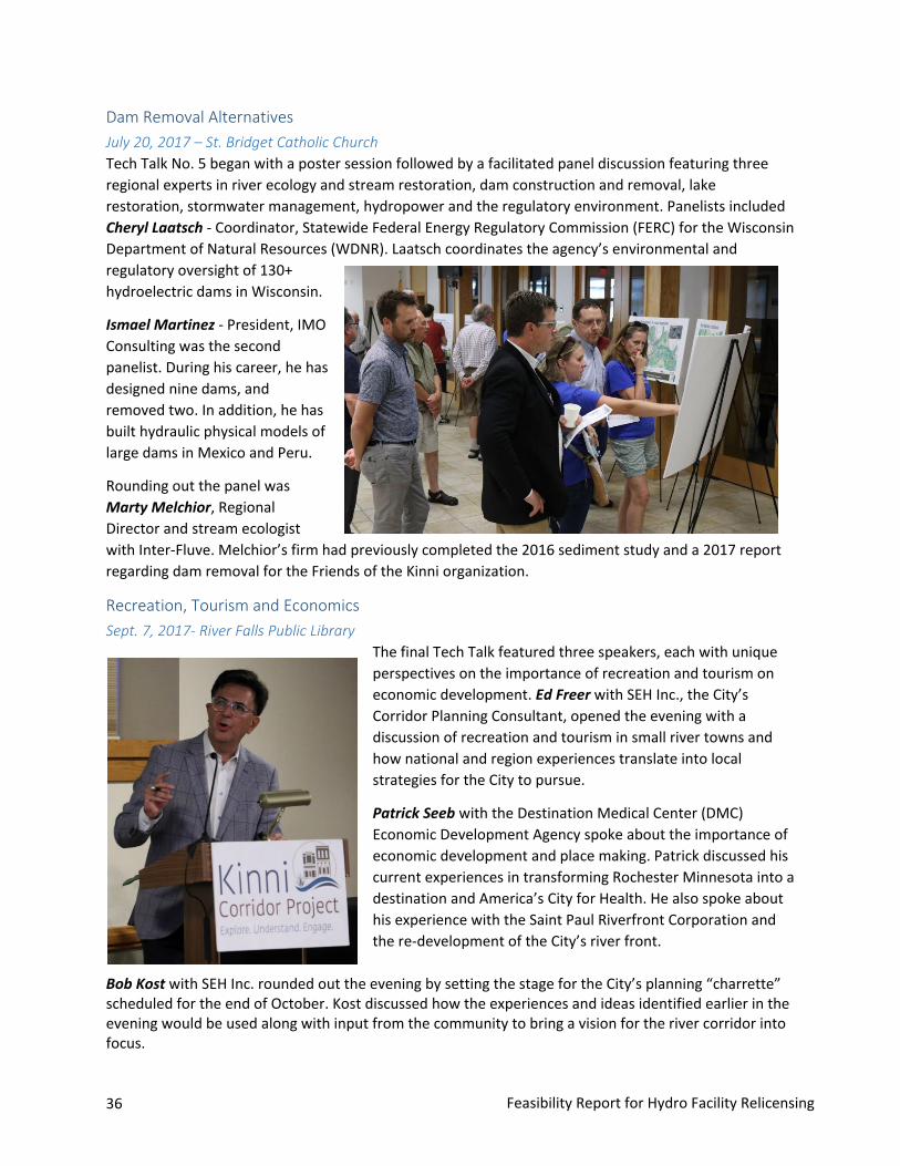
Dam Removal Alternatives July 20, 2017 – St. Bridget Catholic Church Tech Talk No. 5 began with a poster session followed by a facilitated panel discussion featuring three regional experts in river ecology and stream restoration, dam construction and removal, lake restoration, stormwater management, hydropower and the regulatory environment. Panelists included Cheryl Laatsch - Coordinator, Statewide Federal Energy Regulatory Commission (FERC) for the Wisconsin Department of Natural Resources (WDNR). Laatsch coordinates the agency’s environmental and regulatory oversight of 130+ hydroelectric dams in Wisconsin.
Ismael Martinez - President, IMO Consulting was the second panelist. During his career, he has designed nine dams, and removed two. In addition, he has built hydraulic physical models of large dams in Mexico and Peru.
Rounding out the panel was Marty Melchior, Regional Director and stream ecologist with Inter-Fluve. Melchior’s firm had previously completed the 2016 sediment study and a 2017 report regarding dam removal for the Friends of the Kinni organization.
Recreation, Tourism and Economics Sept. 7, 2017- River Falls Public Library
The final Tech Talk featured three speakers, each with unique perspectives on the importance of recreation and tourism on economic development. Ed Freer with SEH Inc., the City’s Corridor Planning Consultant, opened the evening with a discussion of recreation and tourism in small river towns and how national and region experiences translate into local strategies for the City to pursue.
Patrick Seeb with the Destination Medical Center (DMC) Economic Development Agency spoke about the importance of economic development and place making. Patrick discussed his current experiences in transforming Rochester Minnesota into a destination and America’s City for Health. He also spoke about his experience with the Saint Paul Riverfront Corporation and the re-development of the City’s river front.
Bob Kost with SEH Inc. rounded out the evening by setting the stage for the City’s planning “charrette” scheduled for the end of October. Kost discussed how the experiences and ideas identified earlier in the evening would be used along with input from the community to bring a vision for the river corridor into focus.
Feasibility Report for Hydro Facility Relicensing 37
Presentations and focus groups Buddy Lucero, the City’s project manager for the planning process, gave a number of presentations to community groups over the past 15 months, which included:
• Downtown Design Review Committee• Great Rivers Confluence Symposium• Historic Preservation Commission• Kinni River Land Trust• Leadership River Falls• Parks and Recreation Advisory Board• River Falls Chamber of Commerce• River Falls School District• Sensible Land Use Coalition• St. Croix River Association• UW-River Falls
On Aug. 10, 2017, Mark Lobermeier and Bob Kost, SEH consultants, facilitated a focus group with 18 downtown business owners to talk about the project, share ideas, and hear concerns.
During the charrette in October 2017, Lobermeier and Kost met with 14 students from UW-River Falls who use the Kinnickinnic River to study watershed and land use issues. One of the instructors commented that the “opportunity to see options, and discuss alternatives with design staff was a great experience for the students and faculty.”
On Nov. 15, 2017, the City of River Falls hosted a meeting of state and federal agencies interested in the Kinnickinnic River Corridor Plan and the pending licensing decision regarding the Junction Falls and Powell Falls hydro facilities. Agency personal shared their thoughts about the regulatory process, including federal and state permitting, and potential funding programs for dam removal, lake management and recreational enhancements.
City celebrations
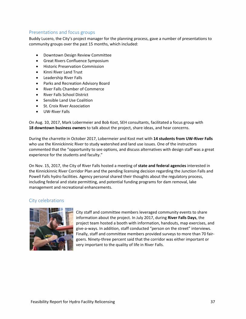
City staff and committee members leveraged community events to share information about the project. In July 2017, during River Falls Days, the project team hosted a booth with information, handouts, map exercises, and give-a-ways. In addition, staff conducted “person on the street” interviews. Finally, staff and committee members provided surveys to more than 70 fair-goers. Ninety-three percent said that the corridor was either important or very important to the quality of life in River Falls.

38 Feasibility Report for Hydro Facility Relicensing
In August 2017, Committee members hosted a Kinni Project booth at the City’s Annual Customer Appreciation Event sponsored by River Falls Municipal Utilities. They provided information about the project and upcoming events to the over 700 attendees.
Surveys and comments Project staff and consultants have been collecting feedback, comments, and questions throughout the process through the following formats:
• Online survey in December 2016/January 2017; 1,365 surveyswere completed with 1,583 written comments (Appendix B)
• Mapping exercise at kick-off event (Appendix B)• River Falls Days written survey• Comment cards from all events• Comments submitted online via project website• Emails and letters from individuals and groups• Tech Talk spoken and written questions/comments (Appendix C)• Video interviews
City staff reviewed the feedback and summarized the most prevalent themes from the surveys and comments received during the planning process which included the following:
Dam Removal Over the planning process, there has been significant input regarding dam removal. Reasons ranged from wanting the river to be restored to its pre-dam state to having more opportunities for recreation. Many comments included the desire to showcase the river and make it a focal point of the community. Questions included how the dam removal would affect the fish and waterfowl habitat; how dam removal would impact river temperature; how the river might look in a dam removal scenario; and what would happen with any reclaimed land resulting from elimination of Lake George and Lake Louise.
Those in support of dam removal believe the approach to be more environmentally conscious, and could add more spaces for recreation along the river. Questions regarding ways in which to integrate other forms of renewable energy sources in lieu of the dams were also mentioned, as removal includes the loss of power generation. Comments also addressed how removing dams and restoring a free-flowing river could add additional opportunities for tourism and riverfront development.
Feasibility Report for Hydro Facility Relicensing 39
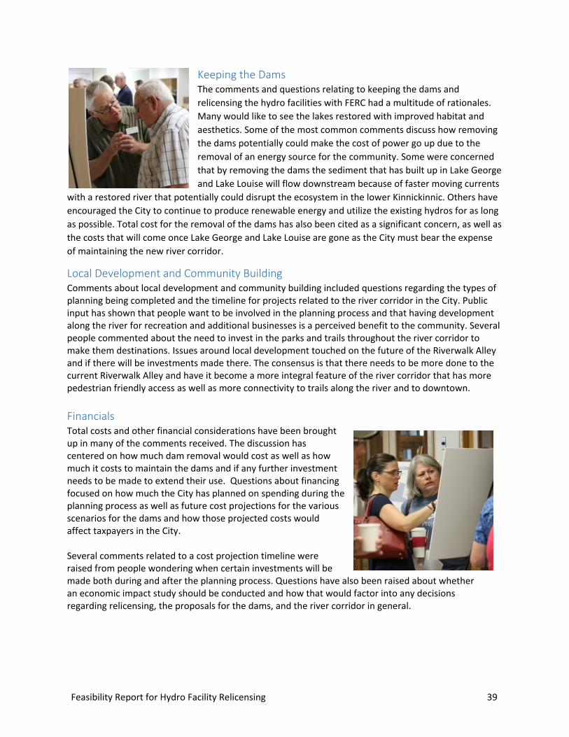
Keeping the Dams The comments and questions relating to keeping the dams and relicensing the hydro facilities with FERC had a multitude of rationales. Many would like to see the lakes restored with improved habitat and aesthetics. Some of the most common comments discuss how removing the dams potentially could make the cost of power go up due to the removal of an energy source for the community. Some were concerned that by removing the dams the sediment that has built up in Lake George and Lake Louise will flow downstream because of faster moving currents
with a restored river that potentially could disrupt the ecosystem in the lower Kinnickinnic. Others have encouraged the City to continue to produce renewable energy and utilize the existing hydros for as long as possible. Total cost for the removal of the dams has also been cited as a significant concern, as well as the costs that will come once Lake George and Lake Louise are gone as the City must bear the expense of maintaining the new river corridor.
Local Development and Community Building Comments about local development and community building included questions regarding the types of planning being completed and the timeline for projects related to the river corridor in the City. Public input has shown that people want to be involved in the planning process and that having development along the river for recreation and additional businesses is a perceived benefit to the community. Several people commented about the need to invest in the parks and trails throughout the river corridor to make them destinations. Issues around local development touched on the future of the Riverwalk Alley and if there will be investments made there. The consensus is that there needs to be more done to the current Riverwalk Alley and have it become a more integral feature of the river corridor that has more pedestrian friendly access as well as more connectivity to trails along the river and to downtown.
Financials Total costs and other financial considerations have been brought up in many of the comments received. The discussion has centered on how much dam removal would cost as well as how much it costs to maintain the dams and if any further investment needs to be made to extend their use. Questions about financing focused on how much the City has planned on spending during the planning process as well as future cost projections for the various scenarios for the dams and how those projected costs would affect taxpayers in the City.
Several comments related to a cost projection timeline were raised from people wondering when certain investments will be made both during and after the planning process. Questions have also been raised about whether an economic impact study should be conducted and how that would factor into any decisions regarding relicensing, the proposals for the dams, and the river corridor in general.
40 Feasibility Report for Hydro Facility Relicensing
Recreation In terms of recreation, many respondents made comments expressing the need to improve public access to the Kinnickinnic River for all age groups. The need for better access points to the river from downtown/Main Street locations were mentioned frequently. Commenters also indicated that the river is an underutilized resource that can be made more prominent by making visual improvements along popular trails, paths, and walkways. Respondents were mixed about the use of the river with some conveying that they wanted to make sure that the Kinnickinnic was not “over-recreated” with kayakers/boats and others stating that the river should be shared and used responsibly by all. Others identified recreation use conflicts, in particular between kayakers and fisherman.
Environment Respondents seemed to have a universal consensus when they considered the environment of the Kinnickinnic River Corridor in that they believed that it was the strongest asset that River Falls possesses. Protecting the environment within the Corridor was mentioned a majority of the time in all the comments collected. Commenters also suggested that certain areas should be “returned back to the wild” to preserve the Kinni for years to come such as taking out the railroad embankment and restoring native prairies. Many respondents also expressed the need for greater collaboration between entities such as the River Falls School District, SCRA, and the Kinnickinnic River Land Trust, encouraging more community education and preservation initiatives to protect the environment.
Ecology In conjunction with discussing the need to preserve the environment, many respondents also mentioned the need to enhance the ecology of the corridor. If development were to occur within certain sections of the corridor, it should be conducted in a way that minimizes ecological disturbances. When mentioning ecology, commenters also stressed the need to protect trout populations so that the Kinni within River Falls can maintain its Class 1 trout stream designation. A number of respondents also were concerned about upstream and downstream protection of the Kinni that laid outside of the corridor.
Economic Development Analysis Many respondents commented on the need to conduct an economic benefit analysis for the corridor, chiefly what benefits or hindrances may occur if the dams were removed. Respondents said that an analysis was also needed regardless of the decision on the dams citing the need to balance the unique character of River Falls with increased growth in the region.
Feasibility Report for Hydro Facility Relicensing 41
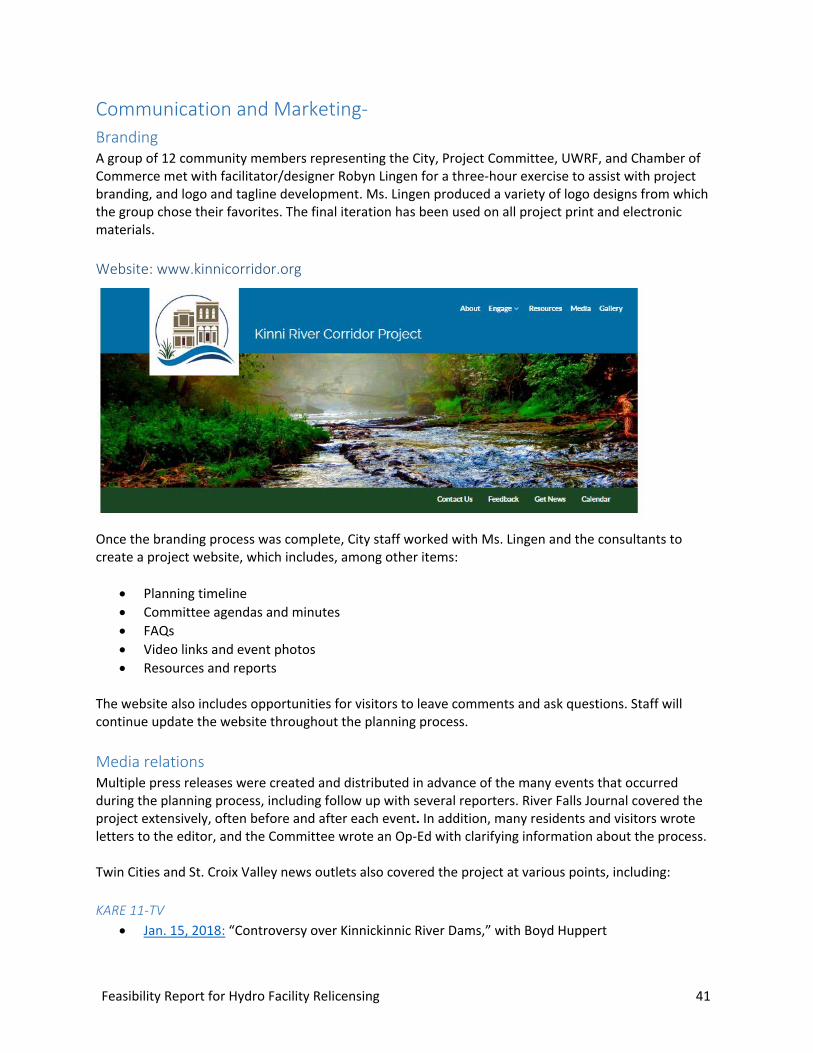
Communication and Marketing- Branding A group of 12 community members representing the City, Project Committee, UWRF, and Chamber of Commerce met with facilitator/designer Robyn Lingen for a three-hour exercise to assist with project branding, and logo and tagline development. Ms. Lingen produced a variety of logo designs from which the group chose their favorites. The final iteration has been used on all project print and electronic materials.
Website: www.kinnicorridor.org
Once the branding process was complete, City staff worked with Ms. Lingen and the consultants to create a project website, which includes, among other items:
• Planning timeline• Committee agendas and minutes• FAQs• Video links and event photos• Resources and reports
The website also includes opportunities for visitors to leave comments and ask questions. Staff will continue update the website throughout the planning process.
Media relations Multiple press releases were created and distributed in advance of the many events that occurred during the planning process, including follow up with several reporters. River Falls Journal covered the project extensively, often before and after each event. In addition, many residents and visitors wrote letters to the editor, and the Committee wrote an Op-Ed with clarifying information about the process.
Twin Cities and St. Croix Valley news outlets also covered the project at various points, including:
KARE 11-TV • Jan. 15, 2018: “Controversy over Kinnickinnic River Dams,” with Boyd Huppert
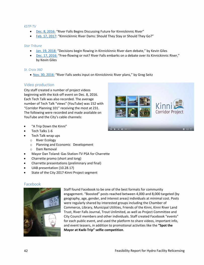
42 Feasibility Report for Hydro Facility Relicensing
KSTP-TV • Dec. 8, 2016: “River Falls Begins Discussing Future for Kinnickinnic River”• Feb. 17, 2017: “Kinnickinnic River Dams: Should They Stay or Should They Go?”
Star Tribune • Jan. 19, 2018: “Decisions begin flowing in Kinnickinnic River dam debate,” by Kevin Giles• Dec. 17, 2016: “Free-flowing or not? River Falls embarks on a debate over its Kinnickinnic River,”
by Kevin Giles
St. Croix 360 • Nov. 30, 2016: “River Falls seeks input on Kinnickinnic River plans,” by Greg Seitz
Video production City staff created a number of project videos beginning with the kick-off event on Dec. 8, 2016. Each Tech Talk was also recorded. The average number of Tech Talk “views” (YouTube) was 152 with “Corridor Planning 101” receiving the most at 231. The following were recorded and made available on YouTube and the City’s cable channels:
• "A Trip Down the Kinni”• Tech Talks 1-6• Tech Talk wrap ups
o River Ecologyo Planning and Economic Developmento Dam Removal
• Mayor Dan Toland: Gas Station-TV PSA for Charrette• Charrette promo (short and long)• Charrette presentations (preliminary and final)• UAB presentation (10.28.17)• State of the City 2017-Kinni Project segment
Facebook Staff found Facebook to be one of the best formats for community engagement. “Boosted” posts reached between 4,000 and 8,000 targeted (by geography, age, gender, and interest areas) individuals at minimal cost. Posts were regularly shared by interested groups including the Chamber of Commerce, Library, Municipal Utilities, Friends of the Kinni, Kinni River Land Trust, River Falls Journal, Trout Unlimited, as well as Project Committee and City Council members and other individuals. Staff created Facebook “events” for each public event, and used the platform to share videos, important info, and event teasers, in addition to promotional activities like the “Spot the Mayor at Kwik-Trip” selfie competition.

Feasibility Report for Hydro Facility Relicensing 43
Additional marketing/communication activities • River Falls journal print advertisements• Chamber e-news• Flyers for community bulletin boards and distribution• CitySource (City) newsletter articles• UWRF e-newsletter• Email event invitations• Kinni Project e-newsletter (charrette prep)• Multiple community calendar listings• Cable TV public service announcements

Feasibility Report for Hydro Facility Relicensing 45
Decision process Kinni Corridor Committee consideration On Nov. 7, 2017, after review with six committee members, the Kinni Planning Committee received the decision matrix (see next page). The matrix was designed to be a tool for the Committee to help organize their thoughts, ideas and concerns about the decision process. Each Committee member was asked to complete the matrix to the best of their ability in an effort to determine a preliminary direction from the group.
On Dec. 7, 2017, the Committee received a summary of the completed matrix results. The summary showed a majority of committee members supporting the ultimate long-term removal of both dams along with implementation of Lake George and stormwater enhancements. As the discussion progressed, the Committee suggested a filter to refine their thinking based on the following:
• Focus on the vision of the corridor 40-50 years from now;• Understand the need to inform a relicensing or surrender decision based on the best available
information;• Recognize that the City can relicense and then surrender later but can’t surrender now and
relicense later; and• Recognize that just because the City has a license to produce electricity, it is not required to
produce electricity.
On Dec. 21, 2017, the Committee participated in a facilitated discussion regarding the future of the hydro facilities. At the conclusion of that meeting, the Committee understood the concept of pursuing scenario 2 as a long-term goal and utilizing relicensing of Junction Falls as the shorter-term implementation path.
On Jan. 11, 2018, the Committee worked to validate the preliminary direction they arrived at on Dec. 21. A policy framework was presented and refined as part of the meeting.
Deci
sion
pro
cess
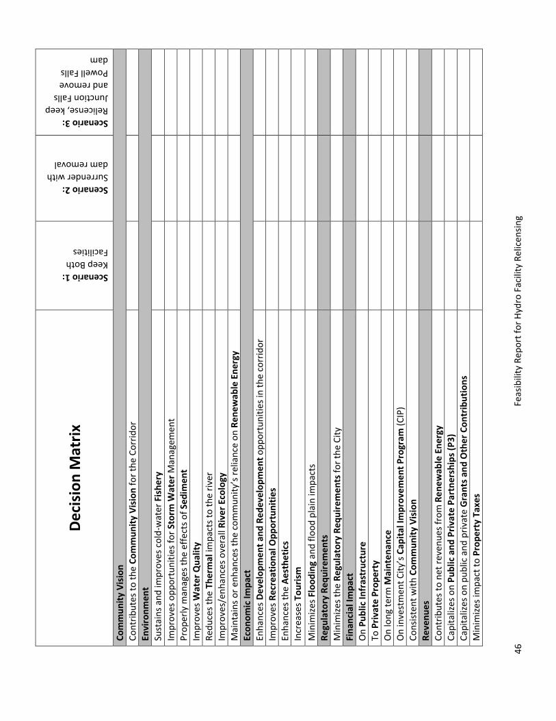
46
Feas
ibili
ty R
epor
t for
Hyd
ro F
acili
ty R
elic
ensin
g
Deci
sion
Mat
rix
Scenario 1: Keep Both Facilities
Scenario 2: Surrender with dam removal
Scenario 3: Relicense, keep Junction Falls and remove Powell Falls dam
Com
mun
ity V
isio
n Co
ntrib
utes
to th
e Co
mm
unity
Vis
ion
for t
he C
orrid
or
Envi
ronm
ent
Sust
ains
and
impr
oves
col
d-w
ater
Fis
hery
Im
prov
es o
ppor
tuni
ties f
or S
torm
Wat
er M
anag
emen
t Pr
oper
ly m
anag
es th
e ef
fect
s of S
edim
ent
Impr
oves
Wat
er Q
ualit
y Re
duce
s the
The
rmal
impa
cts t
o th
e riv
er
Impr
oves
/enh
ance
s ove
rall
Rive
r Eco
logy
M
aint
ains
or e
nhan
ces t
he c
omm
unity
’s re
lianc
e on
Ren
ewab
le E
nerg
y Ec
onom
ic Im
pact
En
hanc
es D
evel
opm
ent a
nd R
edev
elop
men
t opp
ortu
nitie
s in
the
corr
idor
Im
prov
es R
ecre
atio
nal O
ppor
tuni
ties
Enha
nces
the
Aest
hetic
s In
crea
ses T
ouris
m
Min
imize
s Flo
odin
g an
d flo
od p
lain
impa
cts
Regu
lato
ry R
equi
rem
ents
M
inim
izes t
he R
egul
ator
y Re
quire
men
ts fo
r the
City
Fi
nanc
ial I
mpa
ct
On
Publ
ic In
fras
truc
ture
To
Priv
ate
Prop
erty
O
n lo
ng te
rm M
aint
enan
ce
On
inve
stm
ent C
ity’s
Cap
ital I
mpr
ovem
ent P
rogr
am (C
IP)
Cons
isten
t with
Com
mun
ity V
isio
n Re
venu
es
Cont
ribut
es to
net
reve
nues
from
Ren
ewab
le E
nerg
y Ca
pita
lizes
on
Publ
ic a
nd P
rivat
e Pa
rtne
rshi
ps (P
3)
Capi
taliz
es o
n pu
blic
and
priv
ate
Gra
nts a
nd O
ther
Con
trib
utio
ns
Min
imize
s im
pact
to P
rope
rty
Taxe
s
Feasibility Report for Hydro Facility Relicensing 47
Utility Advisory Board recommendation On December 18, 2017, the UAB received a presentation regarding an overview of the hydroelectric operations, the relicensing process and options available for the UAB regarding the licensing decision. In addition, the base project costs for the three scenarios were discussed (as shown on the following page).
On Jan. 15, 2018, the Utility Advisory Board (UAB) conducted a public hearing regarding the three licensing scenarios before them for consideration. Nearly 100 individuals attended the meeting; 29 addressed the board. The scenarios considered by the UAB included:
Scenario 1 – Relicense and maintain both the Junction Falls and Powell Falls facilities.
Under Scenario 1, the City would seek a new 40-year license that would allow the City to continue to (but not be required to) generate power from the two hydro facilities. During this period, it is anticipated that no funds will be invested in Powell Falls to make identified structural and generation improvements.
Scenario 2: Surrender the license, and remove both the Junction Falls and Powell Falls hydro facilities and dams at some point in the future. Under Scenario 2, the City would endorse the ultimate removal of both facilities, surrendering the license for Hydroelectric Project P-10489, thus eliminating power generation effective Aug. 31, 2023, coincident with the expiration of the existing license. Implied in Scenario 2 is the timely remove both of facilities including establishment of a free-flowing river, developing stream habitat and restoring the adjacent reclaimed flood plain within the limits of the City’s financial capacity and available funding from non-City sources.
Scenario 3: Relicense and maintain the Junction Falls facility. Under Scenario 3, the City would seek a new 40-year license that would allow the it to continue to (but not be required to) generate power from the Junction Falls facility. During this period, the City could continue to produce power throughout the 40-year duration of the license, which would expire in 2063. Implied in Scenario 3 is the timely removal of the Powell Falls facility including establishment of a free-flowing river below the Junction Falls dam, developing stream habitat and restoring the adjacent reclaimed flood within the limits of the City’s financial capacity and available funding from non-City sources.
UAB resolution The UAB’s meeting concluded with the UAB passing a resolution recommending that the Kinni Corridor Committee and the City Council choose to relicense the City’s hydro project, retaining the Junction Falls facility and removing the Powell Falls facility and dam at some point in the future.
The recommendation reads: (Complete resolution is included in Appendix D.)
NOW, THEREFORE, BE IT RESOLVED that the Utility Advisory Board (UAB) of the City of River Falls hereby recommends relicense of the Junction Falls hydro facility, and removal the Powell Falls hydro facility and dam at some point in the future. Any hydro or dam related expenditures over $5,000 will be brought to the Utility Advisory Board and City Council for review and approval.
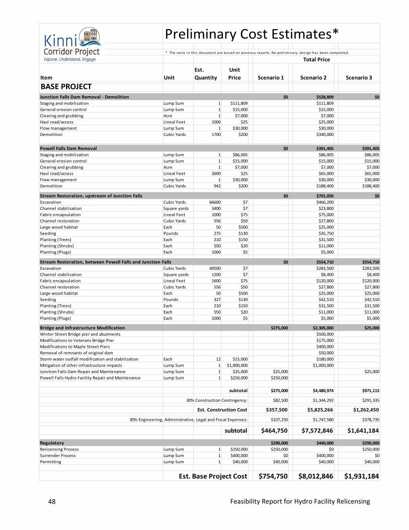
48 Feasibility Report for Hydro Facility Relicensing
Preliminary Cost Estimates** The costs in this document are based on previous reports . No prel iminary des ign has been completed.
Item UnitEst. Quantity
Unit Price Scenario 1 Scenario 2 Scenario 3
BASE PROJECTJunction Falls Dam Removal - Demolition $0 $528,809 $0Staging and mobilization Lump Sum 1 $111,809 $111,809 General erosion control Lump Sum 1 $15,000 $15,000 Clearing and grubbing Acre 1 $7,000 $7,000 Haul road/access Lineal Feet 1000 $25 $25,000 Flow management Lump Sum 1 $30,000 $30,000 Demolition Cubic Yards 1700 $200 $340,000
Powell Falls Dam Removal $0 $391,405 $391,405Staging and mobilization Lump Sum 1 $86,005 $86,005 $86,005General erosion control Lump Sum 1 $15,000 $15,000 $15,000Clearing and grubbing Acre 1 $7,000 $7,000 $7,000Haul road/access Lineal Feet 2600 $25 $65,000 $65,000Flow management Lump Sum 1 $30,000 $30,000 $30,000Demolition Cubic Yards 942 $200 $188,400 $188,400
Stream Restoration, upstream of Junction Falls $0 $701,050 $0Excavation Cubic Yards 66600 $7 $466,200 Channel stabilization Square yards 3400 $7 $23,800 Fabric encapsulation Lineal Feet 1000 $75 $75,000 Channel restoration Cubic Yards 556 $50 $27,800 Large wood habitat Each 50 $500 $25,000 Seeding Pounds 275 $130 $35,750 Planting (Trees) Each 210 $150 $31,500 Planting (Shrubs) Each 550 $20 $11,000 Planting (Plugs) Each 1000 $5 $5,000
Stream Restoration, between Powell Falls and Junction Falls $0 $554,710 $554,710Excavation Cubic Yards 40500 $7 $283,500 $283,500Channel stabilization Square yards 1200 $7 $8,400 $8,400Fabric encapsulation Lineal Feet 1600 $75 $120,000 $120,000Channel restoration Cubic Yards 556 $50 $27,800 $27,800Large wood habitat Each 50 $500 $25,000 $25,000Seeding Pounds 327 $130 $42,510 $42,510Planting (Trees) Each 210 $150 $31,500 $31,500Planting (Shrubs) Each 550 $20 $11,000 $11,000Planting (Plugs) Each 1000 $5 $5,000 $5,000
Bridge and Infrastructure Modification $275,000 $2,305,000 $25,000Winter Street Bridge pier and abutments $500,000Modifications to Veterans Bridge Pier $175,000Modifications to Maple Street Piers $400,000Removal of remnants of original dam $50,000Storm water outfall modification and stabilization Each 12 $15,000 $180,000Mitigation of other infrastructure impacts Lump Sum 1 $1,000,000 $1,000,000Junction Falls Dam Repair and Maintenance Lump Sum 1 $25,000 $25,000 $25,000Powell Falls Hydro Facility Repair and Maintenance Lump Sum 1 $250,000 $250,000
subtotal $275,000 $4,480,974 $971,115
30% Construction Contingency: $82,500 $1,344,292 $291,335
Est. Construction Cost $357,500 $5,825,266 $1,262,450
30% Engineering, Administrative, Legal and Fiscal Expenses: $107,250 $1,747,580 $378,735
subtotal $464,750 $7,572,846 $1,641,184
Regulatory $290,000 $440,000 $290,000Relicensing Process Lump Sum 1 $250,000 $250,000 $0 $250,000Surrender Process Lump Sum 1 $400,000 $0 $400,000 $0Permitting Lump Sum 1 $40,000 $40,000 $40,000 $40,000
Est. Base Project Cost $754,750 $8,012,846 $1,931,184
Total Price
Feasibility Report for Hydro Facility Relicensing 49
Stakeholder input Beginning in late December 2017, the Committee received correspondence from several stakeholder groups and citizens regarding the future of the City’s hydro facilities:
River Alliance of Wisconsin – December 20, 2017
“Surrender the license for the River Falls hydroelectric project…”
Driftless Area Restoration Effort – Dec. 21, 2017
“We support the City surrendering the FERC licenses for both dams accompanied by an agreement for a removal schedule with the regulatory agencies, stakeholders and Corps of Engineers.”
Friends of the Kinni – Dec. 21, 2017
“We are writing today in strong support of the complete restoration of the Kinnickinnic River through removal of both of our dams.”
St. Croix River Association – January 2, 2018
“The St. Croix River Association supports the recommendation that 1) FERC licenses for both dams along the Kinnickinnic River be surrendered and 2) the City proceed in developing and implementing a dam removal plan to return the natural hydrologic and ecological systems of the Kinnickinnic River.”
Kiap-TU-Wish Chapter of Trout Unlimited – Jan. 8, 2018
“…strongly urge you to recommend removal of both dams to the City Council.”
Notes regarding Preliminary Cost Estimates:
1. All costs shown are 2017 dollars2. No design work has been completed at this stage in the planning process.3. Costs for removal of the Junction Falls and Powell Falls facilities, along with the costs from stream
restoration are taken from the January 2017 Inter-Fluve report prepared for the Friends of the Kinniand presented to the Kinni Corridor Project Committee.
4. Structural and aesthetic modifications to bridge piers will be required at Winter Street, VeteransBridge at River Walk and Maple Street. Other public and private utilities may also require modification
5. The cost for Engineering, Legal and Fiscal expenses includes design and construction, grant writing,debt service, easements and land acquisition, permitting and monitoring
6. Costs for relicensing and license surrender are taken from TRC solutions, May 2017
50 Feasibility Report for Hydro Facility Relicensing
Kinnickinnic River Land Trust – Jan. 11, 2018
“We strongly urge the City to plan for dam removal and river restoration in a fiscally prudent and manageable short to mid-term timeline. The Trust is prepared to continue to work with the City towards this goal.”
Friends of the Kinni – Jan. 15, 2018
Michael Page of the FOTK voiced his support to the UAB for “… license surrender and dam removal in a timely fashion.”
Friends of the Kinni – Jan. 25, 2018 UAB Meeting
“As a committee you are charged with presenting to the City Council a resolution for your best recommendation based on the Kinni Corridor Planning to date.”
Committee recommendation: Jan. 25, 2018 Following the UAB’s Jan. 15 meeting, the Committee met again on Jan. 25, 2018, to receive the recommendation from the UAB, finalize its recommendation to the City Council and provide any final comment on the final report due to the Council on Feb. 13, 2018. The committee was greeted with the following statement as a reminder of their responsibility to make the best recommendation based on the Kinni Corridor Planning process to date:
“We can achieve some of our objectives if we let other people achieve some of theirs”
At the conclusion of their meeting on Jan. 25, the Committee agreed to forward a recommendation to the City Council to endorse ultimate removal of both of the City’s hydro facilities and to recommend that the City Council choose to relicense the City’s hydro project for the last time, targeting the removal of the Powell Falls facility by 2026 and retaining the Junction Falls facility for a period up to 2048, within the parameters of a policy framework and settlement agreement. (The resolution is found in Appendix E.)
The measure of cooperation and compromise reached by the Committee after considering the alternatives for the City can be summed up by the following quote in response to the Committee’s final recommendations:
“I think we’ve got to a place where both sides got something and both sides gave up something; you probably reached a middle ground pretty well.” William Hanson, Jan. 26, 2018
Feasibility Report for Hydro Facility Relicensing 51 Conc
lusi
ons,
reco
mm
enda
tions
and
nex
t ste
ps
Conclusions, recommendations and next steps Conclusions Based on the information presented in this report, it is concluded that:
1. The City of River Falls has initiated the development of a corridor plan to help establish thelong term-vision for the Kinnickinnic River corridor and to inform the licensing decision;
2. The City Council has established an 11-person Kinni Corridor Project Committee to guide theplanning process and to recommend to the City Council an appropriate action regarding therelicensing decision on or before Feb. 27, 2018;
3. The Kinni Corridor Project Committee, City staff and consultants undertook a comprehensiveanalysis of existing conditions, public input and relevant studies;
4. The City of River Falls operates two hydroelectric facilities on the Kinnickinnic River known asHydroelectric Project (P-10489);
5. The hydroelectric facilities are operated under license from the Federal Energy RegulatoryCommission (FERC);
6. The current FERC license expires as of Aug. 31, 2023;
7. The City is required to notify FERC regarding its intentions for future licensing by Aug. 31,2018;
8. The process for submitting sufficient notice and pre-application documents to FERC shouldbegin by March 1, 2018; and
9. The City Council has identified three licensing scenarios: (1) relicense both facilities, (2)surrender the license, and (3) relicense the Junction Falls facility; and
10. The Utility Advisory Board (UAB) of the City of River Falls has recommended scenario (3)that the City relicense the Junction Falls hydro facility, and remove the Powell Falls hydrofacility and dam at some point in the future, and that any hydro- or dam-relatedexpenditures over $5,000 will be brought to the UAB and City Council for review andapproval.
52 Feasibility Report for Hydro Facility Relicensing
11. The Kinni Corridor Project Committee hereby finds that the future of the Kinnickinnic RiverCorridor should be based on a long-term vision of a free flowing Kinnickinnic River, includingassociated ecological restoration to maintain the current classifications as a Class I troutstream, an Outstanding Resource Water above STH 35 and an Exceptional Resource Waterbelow STH 35 as defined by the WDNR.
Recommendations Based on the conclusions in this report, is recommended that the City Council relicense the hydroelectric project for the final time, with a settlement agreement that incorporates the provisions of this resolution, and take steps to pursue the long-term vision for the Kinnickinnic River Corridor within the following policy framework:
1. The City shall aggressively continue efforts to complete Phase 1 and Phase 2 of the CorridorPlan that will define implementation action plans and dates that achieve the long-termvision of the corridor.
2. The corridor planning process shall establish a fiscally responsible financing plan toimplement the recommendations of the final Corridor Plan including ultimate dam removaland stream restoration.
3. The City will proceed immediately to define and complete necessary steps to remove thePowell hydroelectric facilities and complete associated stream restoration by the target dateof 2026.
4. The City shall document the Powell hydroelectric facility removal process to evaluateecological restoration successes and failures and use those findings to enhance strategiesfor the ultimate removal of the Junction Falls hydroelectric facilities and associated riverrestoration.
5. The City will take necessary steps to remove the Junction Falls facilities and completeassociated stream restoration by the target date of 2048, unless funding is available tocomplete the removal of facilities and associated stream restoration by a date no earlierthan 2040, or unless the trend of ecological conditions on the Kinnickinnic River havedegraded to a point where the need for the project becomes more immediate. Any futurehydro or dam related expenditures over $5,000 shall be brought to the Utility AdvisoryBoard and City Council for review and approval.
6. The City shall continue to pursue its renewable energy policies to create greater amounts ofclean energy from other sources and identify strategies for reducing overall consumptioncompared to the current situation.
Feasibility Report for Hydro Facility Relicensing 53
7. The City shall develop and implement a Lake George Rehabilitation Plan includingcomprehensive stormwater strategies within the contributing subwatersheds, in accordancewith the adopted Corridor Plan and dates related to future removal of the Junction Fallsfacilities.
8. The City shall develop additional policies for increasing funding to support stormwatermanagement best practices in order to minimize the thermal and pollutant impact on theriver.
9. The City shall aggressively pursue policies to address land use development impacts in theupper Kinnickinnic River Watershed that would diminish the quantity and quality of futuregroundwater sources that contribute to the Kinnickinnic River and its current thermalcondition above the City.
Next Steps Based on the final decision by the City Council, the next steps included the following:
1. Notifying FERC and WDNR of the licensing decision.
2. Entering into an agreement with a qualified consultant to assist in the development of the NOI,the PAD and the license application.
3. Developing a matrix of permitting requirements and applicable agencies.
4. Developing a matrix of potential funding alternatives.
5. Preparing budget information for inclusion in the City’s 2019 – 2020 budget.
6. Develop draft and final version of the Kinni Corridor Plan by 2019.
7. Begin implementation of the adopted Kinni Corridor Plan beginning in 2019.

Feasibility Report for Hydro Facility Relicensing 55
Lite
ratu
re re
view
Literature review Ayres Associates, 2014. “Inspection Report, River Falls Hydroelectric Project, FERC Project No. P-10489, Powell Falls Dam River Falls, Wisconsin”
Ayres Associates, 2017. “Inspection Report River Falls Hydroelectric Project FERC Project No. P-10489 Junction Falls Dam River Falls, Wisconsin Prepared for: River Falls Municipal Utilities River Falls, Wisconsin”
Bonestroo Rosene Anderlik and Associates, 2005. “Lake George Area Stormwater Treatment Concept Plan: Final Report”
Downing, 2006. “Lake George Report and Lake Depth Study”
GME, 1990. “The Lake George Sediment Sampling Study”
Inter-Fluve, 2016. “Lake George and Lake Louise Sediment Assessment Report”
Inter-Fluve, June 2017. “Dam Removal Scenario: Summary of Ecological Impacts”
Inter-Fluve, June 2017. “Reconnaissance Level Geomorphic Assessment”
Inter-Fluve. 2017. “Restoration of the Kinnickinnic River through Dam Removal”
Johnson, 2014. “Evaluating the Thermal and Hydrological Impacts of Kinnickinnic River Hydropower Impoundments in River Falls. Kiap-TU-Wish Chapter, Trout Unlimited”
Kiap-TU-Wish Chapter of Trout Unlimited, 2014. “A Study to Assess the Water Resource Impacts of City of River Falls (WI) Hydropower Facilities on the Kinnickinnic River”
Mitro, M., J. Lyons, and S. Sharma. 2011. “Wisconsin Initiative on Climate Change Impacts: Coldwater Fish and Fisheries Working Group Report”
Moe, 1981. “Lake George Study”
Pierce County, 2011. “Pierce County Flood Insurance Study (FIS)”
Schreiber, 1998. “Kinnickinnic River Priority Watershed Surface Water Resources Appraisal Report. Wisconsin Department of Natural Resources, West Central Region”
SEH, 1995. “Water Management Plan (205J Plan) for the Kinnickinnic River and Its Tributaries”
SEH, 2013. “City of River Falls North Kinnickinnic River Monitoring Project: 2013 Report”
Swanson, 1976. “A hydrologic study of Lake George and the Upper Kinnickinnic River Watershed”
Swanson, 1996. “Lake George Management Plan”
TRC Solutions, 2014. “Relicensing Alternatives Report”

56 Feasibility Report for Hydro Facility Relicensing
WDNR 2015. “Wisconsin Department of Natural Resources, Fisheries Management Stream Classification, Report – Kinnickinnic River”
WDNR, 1985. “Lake George Feasibility Study Results & Management Alternatives”
Wisconsin Department of Natural Resources; Wisconsin Department of Agriculture, Trade, and Consumer Protection; and St. Croix and Pierce County Land Conservation Departments, 1999. “Nonpoint Source Control Plan for the Kinnickinnic River Priority Watershed Project. Publication WT-522”
WDNR, 2013. “Regional and Property Analysis for the Development of a Master Plan for Department of Natural Resources Properties along Trout and Small Mouth Bass streams in the Driftless Area”

Appendix A: Ecological implications

A-1
Ecological implications Fisheries It is anticipated that fish populations within the Kinnickinnic River will generally rise throughout the project corridor following dam removal. This is likely to be only to cold water species, however, as the fishery within the two reservoirs would likely be eliminated. Provided the falls themselves were restored, the historic natural isolation of the upper and lower reaches would be preserved. This barrier to migration and interaction is natural, and would have no harm on the populations. In some regards, the separation is encouraged, as it may also isolated and control the spread of undesirable species as well. The greatest benefit to fisheries from the dam removal would be the downstream reaches, which would be expected to have a decrease in water temperature, and increase in hydrologic variability leading to a more dynamic flow regime, and a balance in sedimentation.
Macroinvertebrates Like fisheries, the macroinvertebrate populations vary depending on the location within the system. Upstream reaches support an abundance of mayflies, stoneflies, and caddisflies, often those associated with the smaller cold water habitat that is present, particularly in riffles and areas with hard cobble. Below the dams is a similar assemblage, but species tend to shift to larger and more productive species, including those that filter feed and rely on large stable substrate for anchoring themselves within higher flows. The removal of the dams may aid in the passage of invertebrates from upstream to downstream, particularly those that have a terrestrial adult stage and can migrate populations for short distances regardless of impediments to flows.
Macrophytes Macrophytes include plants living in wetlands or in truly aquatic environments like shallow lakes. Reservoirs associated with dams are often too deep to promote the habitat and growth of macrophytes more than a thin band around the perimeter. While it is not anticipated that the quick moving water within the River will stimulate plant growth, removal of the dams will rehabilitate shallow water and wetland habitat adjacent to the River allowing macorphyte communities to develop.
Temperature Dams elevate the water temperatures because they limit water flow and allow the ponded water to stagnate and become exposed to the sun for a longer exposure time with a greater surface area. These higher water temperatures often lead to changes in fish species populations and a reduction of dissolved oxygen in the water column, resulting in major alterations of the community when compared to natural conditions.
WDNR generally supports dam removal or modification as being important in improving water temperature conditions in the lower Kinnickinnic River. Peak water temperatures in summer will decrease as residence time and solar exposure are decreased. The initial temperature change is likely to cause “thermal shock” to many species that reside in the reservoir and surrounding reaches of the
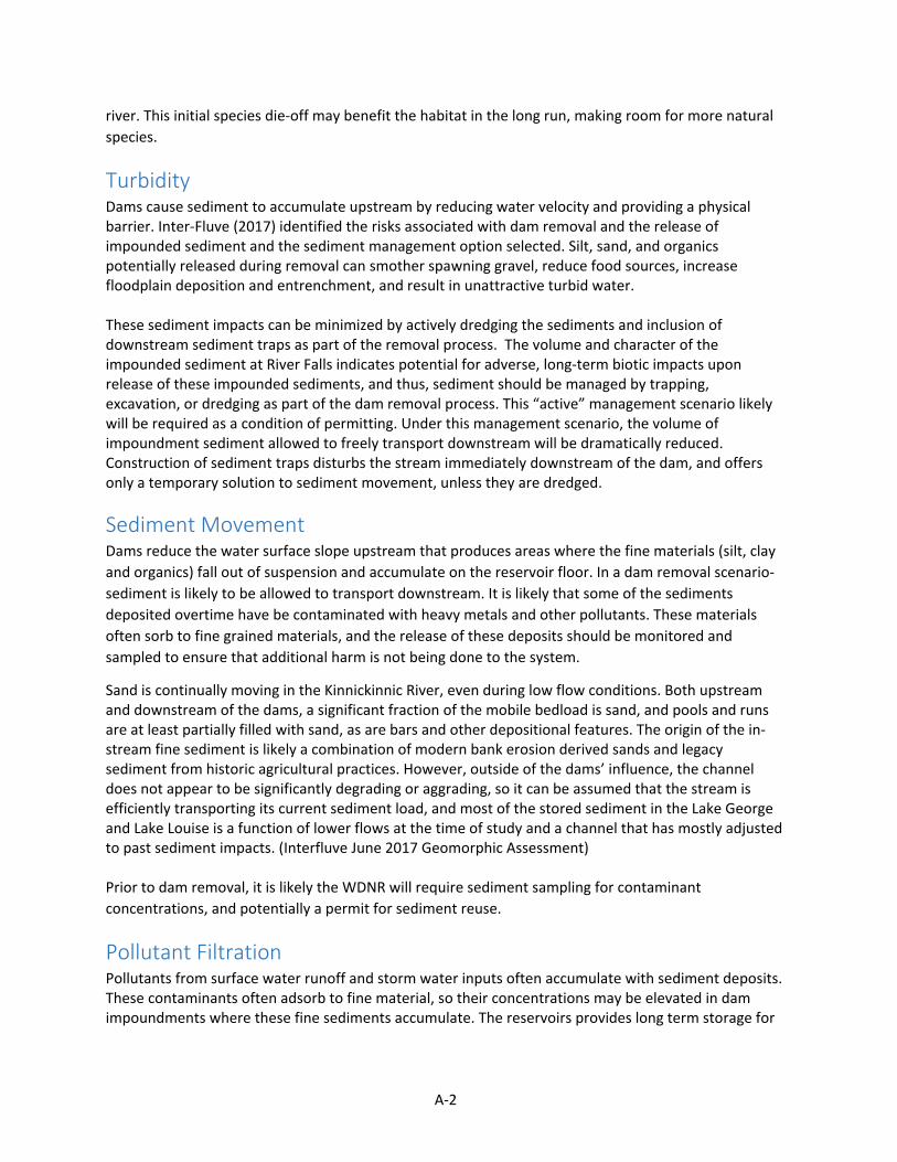
A-2
river. This initial species die-off may benefit the habitat in the long run, making room for more natural species.
Turbidity Dams cause sediment to accumulate upstream by reducing water velocity and providing a physical barrier. Inter-Fluve (2017) identified the risks associated with dam removal and the release of impounded sediment and the sediment management option selected. Silt, sand, and organics potentially released during removal can smother spawning gravel, reduce food sources, increase floodplain deposition and entrenchment, and result in unattractive turbid water.
These sediment impacts can be minimized by actively dredging the sediments and inclusion of downstream sediment traps as part of the removal process. The volume and character of the impounded sediment at River Falls indicates potential for adverse, long-term biotic impacts upon release of these impounded sediments, and thus, sediment should be managed by trapping, excavation, or dredging as part of the dam removal process. This “active” management scenario likely will be required as a condition of permitting. Under this management scenario, the volume of impoundment sediment allowed to freely transport downstream will be dramatically reduced. Construction of sediment traps disturbs the stream immediately downstream of the dam, and offers only a temporary solution to sediment movement, unless they are dredged.
Sediment Movement Dams reduce the water surface slope upstream that produces areas where the fine materials (silt, clay and organics) fall out of suspension and accumulate on the reservoir floor. In a dam removal scenario- sediment is likely to be allowed to transport downstream. It is likely that some of the sediments deposited overtime have be contaminated with heavy metals and other pollutants. These materials often sorb to fine grained materials, and the release of these deposits should be monitored and sampled to ensure that additional harm is not being done to the system.
Sand is continually moving in the Kinnickinnic River, even during low flow conditions. Both upstream and downstream of the dams, a significant fraction of the mobile bedload is sand, and pools and runs are at least partially filled with sand, as are bars and other depositional features. The origin of the in-stream fine sediment is likely a combination of modern bank erosion derived sands and legacy sediment from historic agricultural practices. However, outside of the dams’ influence, the channel does not appear to be significantly degrading or aggrading, so it can be assumed that the stream is efficiently transporting its current sediment load, and most of the stored sediment in the Lake George and Lake Louise is a function of lower flows at the time of study and a channel that has mostly adjusted to past sediment impacts. (Interfluve June 2017 Geomorphic Assessment)
Prior to dam removal, it is likely the WDNR will require sediment sampling for contaminant concentrations, and potentially a permit for sediment reuse.
Pollutant Filtration Pollutants from surface water runoff and storm water inputs often accumulate with sediment deposits. These contaminants often adsorb to fine material, so their concentrations may be elevated in dam impoundments where these fine sediments accumulate. The reservoirs provides long term storage for
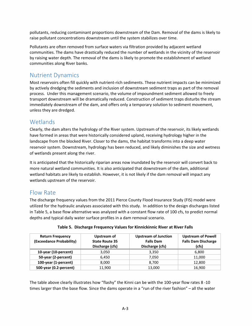
A-3
pollutants, reducing contaminant proportions downstream of the Dam. Removal of the dams is likely to raise pollutant concentrations downstream until the system stabilizes over time.
Pollutants are often removed from surface waters via filtration provided by adjacent wetland communities. The dams have drastically reduced the number of wetlands in the vicinity of the reservoir by raising water depth. The removal of the dams is likely to promote the establishment of wetland communities along River banks.
Nutrient Dynamics Most reservoirs often fill quickly with nutrient-rich sediments. These nutrient impacts can be minimized by actively dredging the sediments and inclusion of downstream sediment traps as part of the removal process. Under this management scenario, the volume of impoundment sediment allowed to freely transport downstream will be dramatically reduced. Construction of sediment traps disturbs the stream immediately downstream of the dam, and offers only a temporary solution to sediment movement, unless they are dredged.
Wetlands Clearly, the dam alters the hydrology of the River system. Upstream of the reservoir, its likely wetlands have formed in areas that were historically considered upland, receiving hydrology higher in the landscape from the blocked River. Closer to the dams, the habitat transforms into a deep water reservoir system. Downstream, hydrology has been reduced, and likely diminishes the size and wetness of wetlands present along the river.
It is anticipated that the historically riparian areas now inundated by the reservoir will convert back to more natural wetland communities. It is also anticipated that downstream of the dam, additional wetland habitats are likely to establish. However, it is not likely if the dam removal will impact any wetlands upstream of the reservoir.
Flow Rate The discharge frequency values from the 2011 Pierce County Flood Insurance Study (FIS) model were utilized for the hydraulic analyses associated with this study. In addition to the design discharges listed in Table 5, a base flow alternative was analyzed with a constant flow rate of 100 cfs, to predict normal depths and typical daily water surface profiles in a dam removal scenario.
Table 5. Discharge Frequency Values for Kinnickinnic River at River Falls
Return Frequency (Exceedance Probability)
Upstream of State Route 35 Discharge (cfs)
Upstream of Junction Falls Dam
Discharge (cfs)
Upstream of Powell Falls Dam Discharge
(cfs) 10-year (10-percent) 3,050 3,350 6,800 50-year (2-percent) 6,450 7,050 11,000
100-year (1-percent) 8,000 8,700 12,800 500-year (0.2-percent) 11,900 13,000 16,900
The table above clearly illustrates how “flashy” the Kinni can be with the 100-year flow rates 8 -10 times larger than the base flow. Since the dams operate in a “run of the river fashion” – all the water
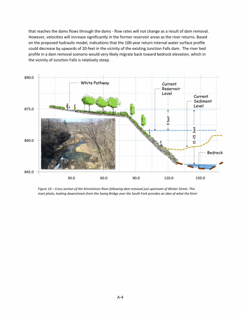
A-4
that reaches the dams flows through the dams - flow rates will not change as a result of dam removal. However, velocities will increase significantly in the former reservoir areas as the river returns. Based on the proposed hydraulic model, indications that the 100-year return interval water surface profile could decrease by upwards of 20-feet in the vicinity of the existing Junction Falls dam. The river bed profile in a dam removal scenario would very likely migrate back toward bedrock elevation, which in the vicinity of Junction Falls is relatively steep.
Figure 14 – Cross section of the Kinnickinnic River following dam removal just upstream of Winter Street. This inset photo, looking downstream from the Swing Bridge over the South Fork provides an idea of what the Kinni
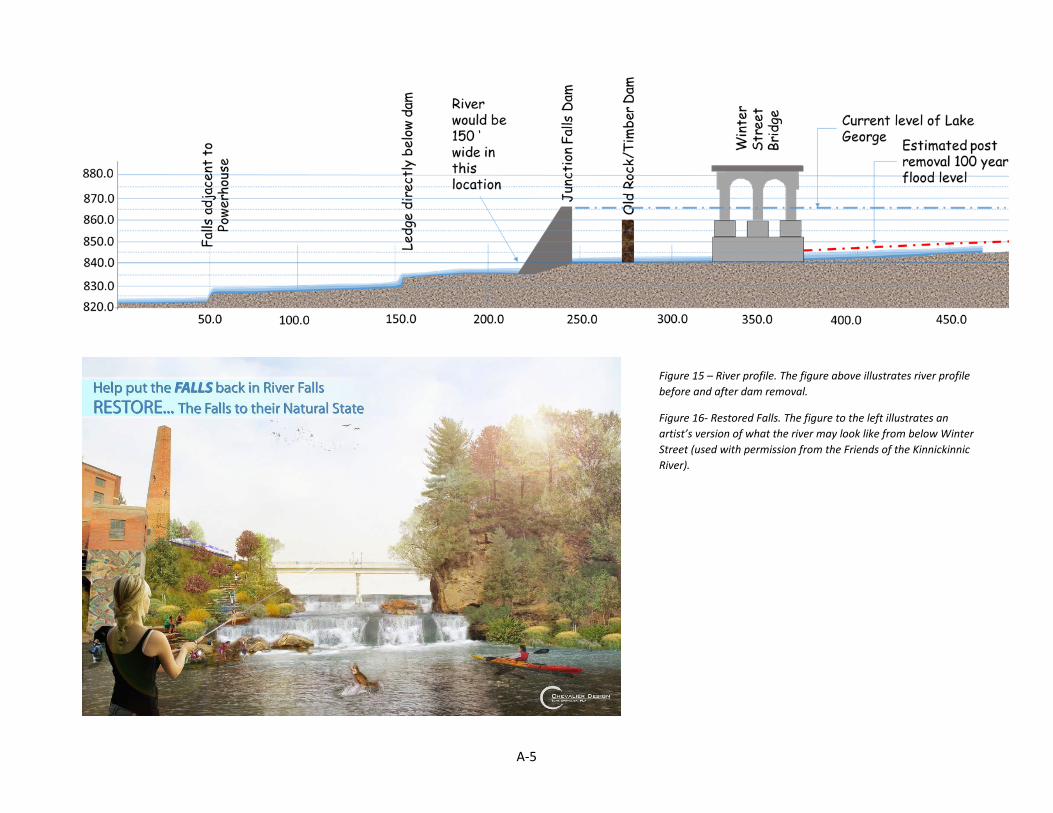
A-5
Figure 15 – River profile. The figure above illustrates river profile before and after dam removal.
Figure 16- Restored Falls. The figure to the left illustrates an artist’s version of what the river may look like from below Winter Street (used with permission from the Friends of the Kinnickinnic River).
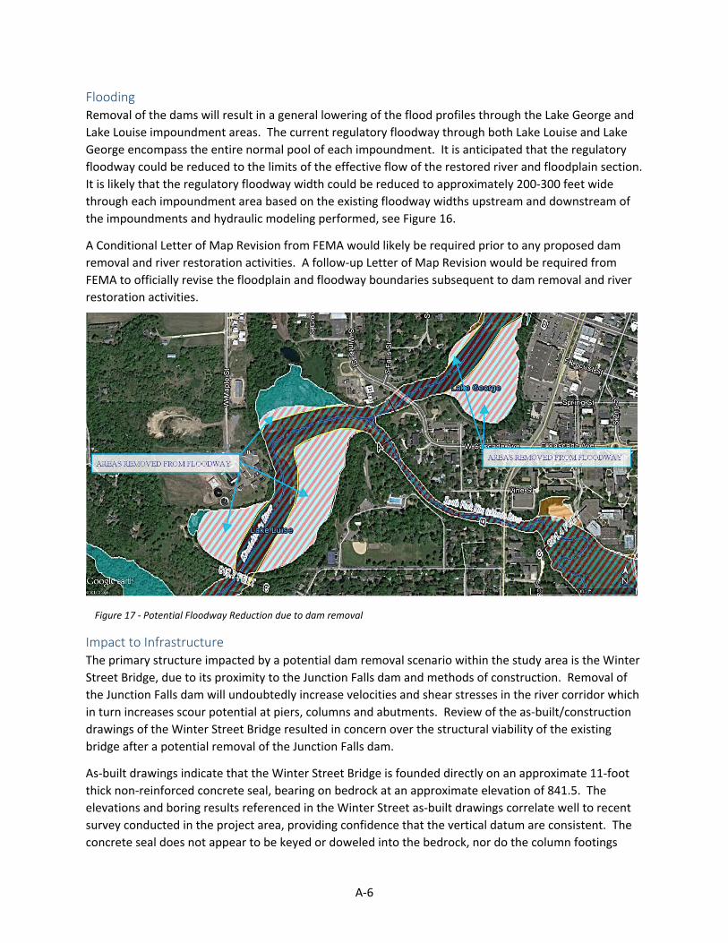
A-6
Flooding Removal of the dams will result in a general lowering of the flood profiles through the Lake George and Lake Louise impoundment areas. The current regulatory floodway through both Lake Louise and Lake George encompass the entire normal pool of each impoundment. It is anticipated that the regulatory floodway could be reduced to the limits of the effective flow of the restored river and floodplain section. It is likely that the regulatory floodway width could be reduced to approximately 200-300 feet wide through each impoundment area based on the existing floodway widths upstream and downstream of the impoundments and hydraulic modeling performed, see Figure 16.
A Conditional Letter of Map Revision from FEMA would likely be required prior to any proposed dam removal and river restoration activities. A follow-up Letter of Map Revision would be required from FEMA to officially revise the floodplain and floodway boundaries subsequent to dam removal and river restoration activities.
Impact to Infrastructure The primary structure impacted by a potential dam removal scenario within the study area is the Winter Street Bridge, due to its proximity to the Junction Falls dam and methods of construction. Removal of the Junction Falls dam will undoubtedly increase velocities and shear stresses in the river corridor which in turn increases scour potential at piers, columns and abutments. Review of the as-built/construction drawings of the Winter Street Bridge resulted in concern over the structural viability of the existing bridge after a potential removal of the Junction Falls dam.
As-built drawings indicate that the Winter Street Bridge is founded directly on an approximate 11-foot thick non-reinforced concrete seal, bearing on bedrock at an approximate elevation of 841.5. The elevations and boring results referenced in the Winter Street as-built drawings correlate well to recent survey conducted in the project area, providing confidence that the vertical datum are consistent. The concrete seal does not appear to be keyed or doweled into the bedrock, nor do the column footings
Figure 17 - Potential Floodway Reduction due to dam removal

A-7
appear to be doweled into the seal. The aforementioned items pose challenges due to a potential lowering of the water surface profile and associated changes to the loading of the structure.
Based on a potential steep river gradient, high velocities and transitions to a critical/supercritical flow regime could be expected in a removal scenario presenting concerns with high shear stresses near the Winter Street bridge seal. Lastly with removal of the dam, floodplain debris and hydrodynamic forces would need to be accounted for when analyzing the viability of the existing structure.
Other structures would be impacted by a dam removal scenario and would warrant further analysis, such as the pedestrian bridge and Maple Street Bridge, but to a far lesser degree due to their respective proximities to the Junction Falls dam.
Flood Storage As described above (Turbidity and Sediment Movement) smaller material often accumulate upstream of a dam in the reservoir. As sediment gathers, it fills the reservoir and limits the water storage capacity of the Reservoir. Limited capacity diminishes the flood storage capacity. Downstream, the flood frequency of the River is reduced as the Dam controls water flow. The extent, duration, and magnitude of the potential impact are difficult to predict based on the current assessment, but the Kinnickinnic River’s existing sand and Class 1 trout waters status suggests a full release of sand is inadvisable, and any release should, and likely will be limited by permitting agencies.
Invasive Species Occurrence The two impoundments both isolate and perpetuate the risk of invasive species establishment.


Appendix B: Kick-off meeting summary


1
December 8th, 2016 - River Falls, Wisconsin
Open House 1 Summary
Appendix B 1
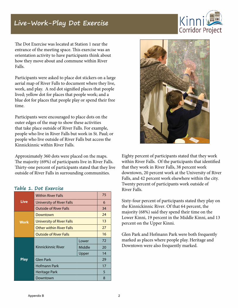
Live-Work-Play Dot Exercise
The Dot Exercise was located at Station 1 near the entrance of the meeting space. This exercise was an orientation activity to have participants think about how they move about and commune within River Falls.
Participants were asked to place dot stickers on a large aerial map of River Falls to document where they live, work, and play. A red dot signified places that people lived; yellow dot for places that people work; and a blue dot for places that people play or spend their free time.
Participants were encouraged to place dots on the outer edges of the map to show these activities that take place outside of River Falls. For example, people who live in River Falls but work in St. Paul; or people who live outside of River Falls but access the Kinnickinnic within River Falls.
Approximately 360 dots were placed on the maps. The majority (69%) of participants live in River Falls. Thirty-one percent of participants stated that they live outside of River Falls in surrounding communities.
Live
Within River Falls 75
University of River Falls 6
Outside of River Falls 34
Work
Downtown 24
University of River Falls 13
Other within River Falls 27
Outside of River Falls 16
Play
Kinnickinnic River
Lower 72
Middle 20
Upper 14
Glen Park 29
Hofmann Park 17
Heritage Park 5
Downtown 8
Eighty percent of participants stated that they work within River Falls. Of the participants that identified that they work in River Falls, 38 percent work downtown, 20 percent work at the University of River Falls, and 42 percent work elsewhere within the city. Twenty percent of participants work outside of River Falls.
Sixty-four percent of participants stated they play on the Kinnickinnic River. Of that 64 percent, the majority (68%) said they spend their time on the Lower Kinni, 19 percent in the Middle Kinni, and 13 percent on the Upper Kinni.
Glen Park and Hofmann Park were both frequently marked as places where people play. Heritage and Downtown were also frequently marked.
Table 1. Dot Exercise
Appendix B 2
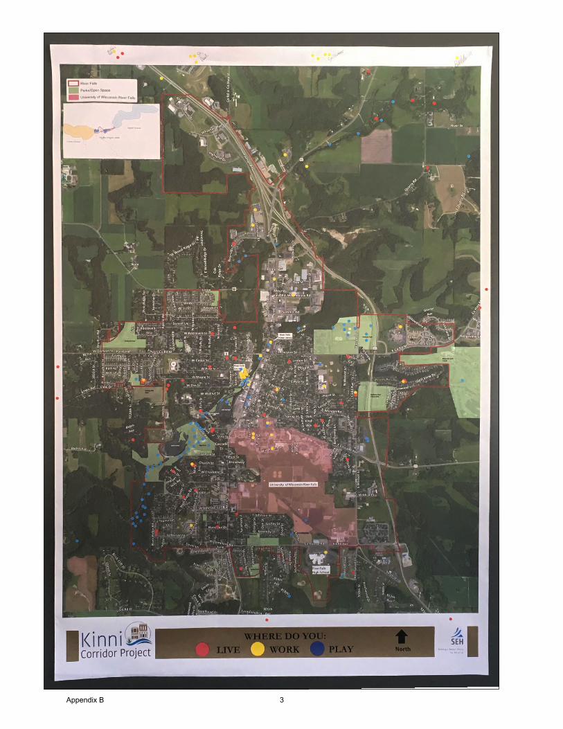
Appendix B 3
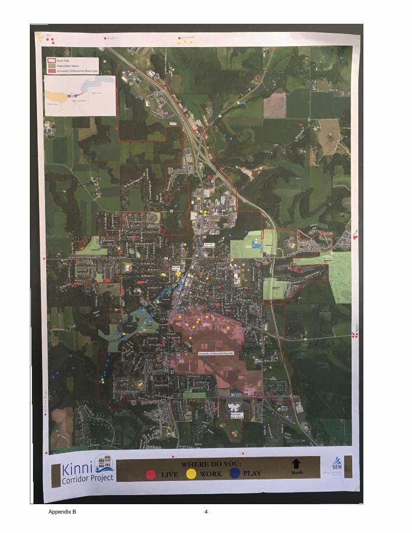
Appendix B 4

Corridor Plan Mapping Exercise
At Station 6, three large 6 foot aerial maps of the Kinnickinnic were displayed. The six mile stretch of the River was displayed in three segments to glean specific information about the Upper Kinni, Middle Kinni, and Lower Kinni. Participants were asked two questions:
• What should stay the same?• What should change?
Markers, pens, and post-it notes were available on each table for the participants to leave feedback and/or draw on the layouts. Project staff were present at the tables to help facilitate discussions.
Approximately 240 comments were left on the map. Five general topic areas emerged from the feedback.
• Recreation topics received the mostcomments,with 43 percent of the total commentsreceived.
• Preservation of open space/natural areas and thehydro-electric power decision both received 17percent of the total comments received.
• Economic Development and EnvironmentalIssues both received 9 percent.
Sub-topics and segment specific issues also emerged as a result of this exercise and are summarized in future pages. Comments were recorded verbatim from the maps. A complete list of comments and summarized sub-topics can be found in the appendix.
Recreation 105 43%
Hydro-Electric Power Facilities/Lakes
42 17%
Preservation of Open Space 41 17%
Economic Development 21 9%
Environmental Issues 21 9%
Other 13 5%
Total 243 100%
Table 2. Corridor Summary- General Themes
Appendix B 5
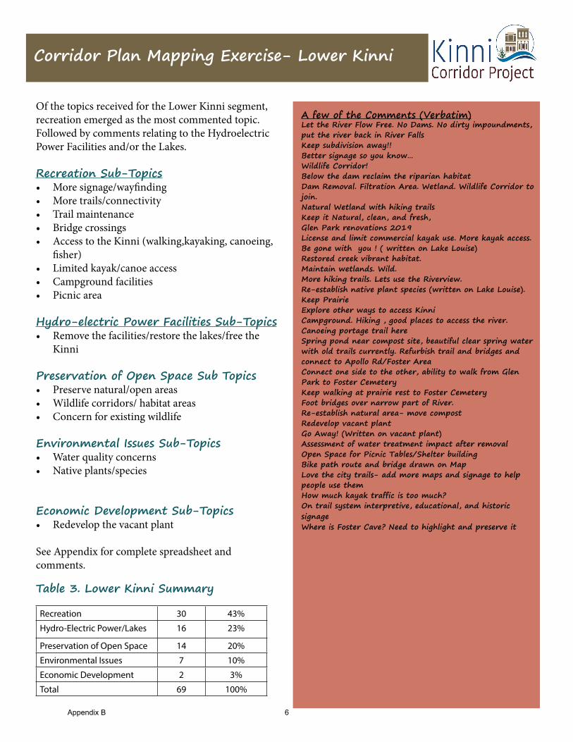
Corridor Plan Mapping Exercise- Lower Kinni
Of the topics received for the Lower Kinni segment, recreation emerged as the most commented topic. Followed by comments relating to the Hydroelectric Power Facilities and/or the Lakes.
Recreation Sub-Topics• More signage/wayfinding• More trails/connectivity• Trail maintenance• Bridge crossings• Access to the Kinni (walking,kayaking, canoeing,
fisher)• Limited kayak/canoe access• Campground facilities• Picnic area
Hydro-electric Power Facilities Sub-Topics• Remove the facilities/restore the lakes/free the
Kinni
Preservation of Open Space Sub Topics• Preserve natural/open areas• Wildlife corridors/ habitat areas• Concern for existing wildlife
Environmental Issues Sub-Topics• Water quality concerns• Native plants/species
Economic Development Sub-Topics• Redevelop the vacant plant
See Appendix for complete spreadsheet and comments.
Recreation 30 43%
Hydro-Electric Power/Lakes 16 23%
Preservation of Open Space 14 20%
Environmental Issues 7 10%
Economic Development 2 3%
Total 69 100%
Table 3. Lower Kinni Summary
A few of the Comments (Verbatim)Let the River Flow Free. No Dams. No dirty impoundments, put the river back in River FallsKeep subdivision away!! Better signage so you know…Wildlife Corridor!Below the dam reclaim the riparian habitatDam Removal. Filtration Area. Wetland. Wildlife Corridor to join.Natural Wetland with hiking trailsKeep it Natural, clean, and fresh, Glen Park renovations 2019License and limit commercial kayak use. More kayak access. Be gone with you ! ( written on Lake Louise)Restored creek vibrant habitat.Maintain wetlands. Wild.More hiking trails. Lets use the Riverview.Re-establish native plant species (written on Lake Louise). Keep PrairieExplore other ways to access KinniCampground. Hiking , good places to access the river. Canoeing portage trail hereSpring pond near compost site, beautiful clear spring water with old trails currently. Refurbish trail and bridges and connect to Apollo Rd/Foster AreaConnect one side to the other, ability to walk from Glen Park to Foster CemeteryKeep walking at prairie rest to Foster Cemetery Foot bridges over narrow part of River. Re-establish natural area- move compostRedevelop vacant plantGo Away! (Written on vacant plant)Assessment of water treatment impact after removal Open Space for Picnic Tables/Shelter buildingBike path route and bridge drawn on Map Love the city trails- add more maps and signage to help people use them How much kayak traffic is too much?On trail system interpretive, educational, and historic signageWhere is Foster Cave? Need to highlight and preserve it
Appendix B 6
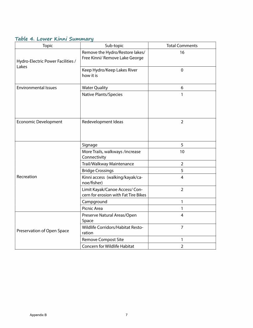
Topic Sub-topic Total Comments
Hydro-Electric Power Facilities /Lakes
Remove the Hydro/Restore lakes/Free Kinni/ Remove Lake George
16
Keep Hydro/Keep Lakes River how it is
0
Environmental Issues Water Quality 6Native Plants/Species 1
Economic Development Redevelopment Ideas 2
Recreation
Signage 5More Trails, walkways /increase Connectivity
10
Trail/Walkway Maintenance 2Bridge Crossings 5Kinni access (walking/kayak/ca-noe/fisher)
4
Limit Kayak/Canoe Access/ Con-cern for erosion with Fat Tire Bikes
2
Campground 1Picnic Area 1
Preservation of Open Space
Preserve Natural Areas/Open Space
4
Wildlife Corridors/Habitat Resto-ration
7
Remove Compost Site 1Concern for Wildlife Habitat 2
Table 4. Lower Kinni Summary
Appendix B 7

Corridor Plan Mapping Exercise- Middle Kinni
Recreation Sub-Topics• More signage/wayfinding• More trails/connectivity• Trail maintenance• Bridge crossings• Whitewater kayaking features• Access to the Kinni (walking,kayaking, canoeing,
fisher)• Campground facilities• Picnic area/beach/play areas• Improvements to RiverwalkHydro-electric Power Facilities Sub-Topics• Remove the facilities/restore the lakes/free the
Kinni• Keep the facilities/keep the lakes/keep the River
how it isEconomic Development Sub-Topics• Redevelop the vacant plant• Develop high density housing• Traffic concerns along the commercail area• Utilize the River in the commercail area/Orient
Buildings to the Kinni.Preservation of Open Space Sub Topics• Preserve natural/open areas• Wildlife corridors/ habitat areas• Work with private land owners for land trusts and
conservation easements• Concern for existing wildlife
Environmental Issues Sub-Topics• Water quality concerns• Heat pollution• Goose feces• Native species• Stormwater managementSee Appendix for complete spreadsheet andcomments.
Recreation 48 36%
Hydro-Electric Power Facilities/Lakes
24 18%
Economic Development 19 14%
Preservation of Open Space 19 14%
Environmental Issues 14 11%
Other 9 7%
Total 133 100%
Table 5. Middle Kinni Summary
A few of the Comments (Verbatim)Acquire or obtain natural area/easement Formal trail connection from River to BluffRedevelop entire are for high density housingHelp downtown businesses embrace the waterfront Walkway bridge back over Kinni to Family Fresh/DQ from parking lotImprove alley RiverwalkConnect Riverwalk to trails behind Family Fresh/DQ Kayak/Canoe landing by downtownUse stomwater fee to pay for management plansKeep view/accessRedevelop for open space/ detention pond. Yes reduce water pollutionLake George is great for migrating ducks in the spring. They also need habitat.Keep the hydro and expand improve if possible, if it proves to be the more cost effective choiceBetter highlight river from downtown areaRiverwalk under utilized building space facing river. Wife and I love to cross the bridge and see the geese and ducks. Don’t do anything to mess that upRestore natural rapids. Beautiful downtownFilter Street runoff before it gets to the riverNatural playground like the one at Kinnickinnic State Park , plus trailsNative Habitat RestorationWildlife Corridor to connect upper and lower Balance Habitat and Access/Use. Keep Wild
Appendix B 8
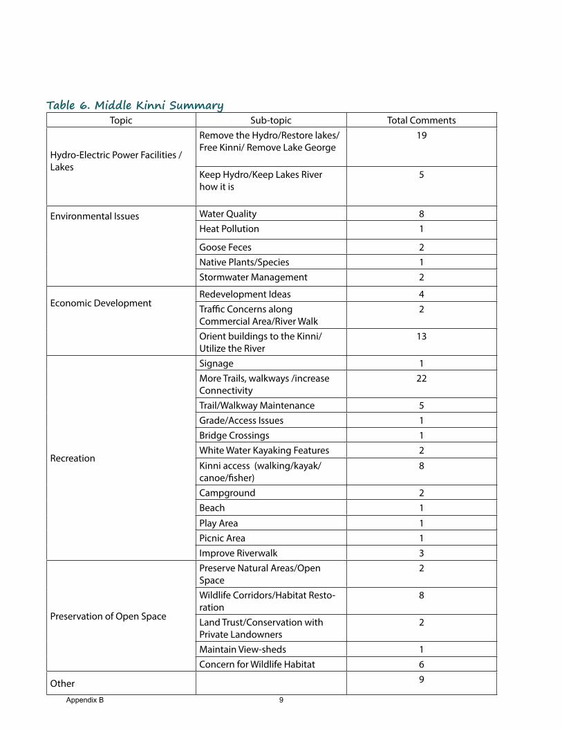
Topic Sub-topic Total Comments
Hydro-Electric Power Facilities /Lakes
Remove the Hydro/Restore lakes/Free Kinni/ Remove Lake George
19
Keep Hydro/Keep Lakes River how it is
5
Environmental Issues Water Quality 8Heat Pollution 1
Goose Feces 2Native Plants/Species 1Stormwater Management 2
Economic DevelopmentRedevelopment Ideas 4Traffic Concerns along Commercial Area/River Walk
2
Orient buildings to the Kinni/Utilize the River
13
Recreation
Signage 1More Trails, walkways /increase Connectivity
22
Trail/Walkway Maintenance 5Grade/Access Issues 1Bridge Crossings 1White Water Kayaking Features 2
Kinni access (walking/kayak/canoe/fisher)
8
Campground 2Beach 1
Play Area 1Picnic Area 1Improve Riverwalk 3
Preservation of Open Space
Preserve Natural Areas/Open Space
2
Wildlife Corridors/Habitat Resto-ration
8
Land Trust/Conservation with Private Landowners
2
Maintain View-sheds 1Concern for Wildlife Habitat 6
Other 9
Table 6. Middle Kinni Summary
Appendix B 9

Corridor Plan Mapping Exercise- Upper Kinni
Recreation Sub-Topics• More signage/wayfinding• More trails/connectivity• Access to the Kinni (walking,kayaking, canoeing,
fisher)
Hydro-electric Power Facilities Sub-Topics• Remove the facilities/restore the lakes/free the
Kinni• Keep the facilities/keep the lakes/keep the River
how it is
Preservation of Open Space Sub Topics• Preserve natural/Open areas• Wildlife corridors/ habitat areas• Work with private land owners for land trusts and
conservation easements• View-sheds of the River
See Appendix for complete spreadsheet and comments.
Recreation 27 66%
Preservation of Open Space 8 20%
Other 4 10%
Hydro-Electric Power Facilities/Lakes
2 5%
Total 41 100%
Table 7. Upper Kinni Summary
A few of the Comments (Verbatim)Like Canoeing Need more Walking paths along RiverA fine run to downtownPut Kinni Trails Map on websiteI wish there was a walking path here Walking/biking path drawn on map in the southeast quad-rant of Paulson Road and Main StreetAgree. Trails for walk, bike, ski, non-motorized along whole corridor Hiking Trails-more of canoeing kayakingLand conservancy with mowed trails Connect to Glen Park/ Lake Louise via trailsFisherman Access issues/parkingWe love access on 65! Mow walking trails please and free flowing river- take out the dams- we want to see the falls. Wayfinding to Kinni Access from Main street and through out townThese are gorgeous views Ways to incorporate public access to these views Land Trust Green Space Important There is good fishing right here
Appendix B 10
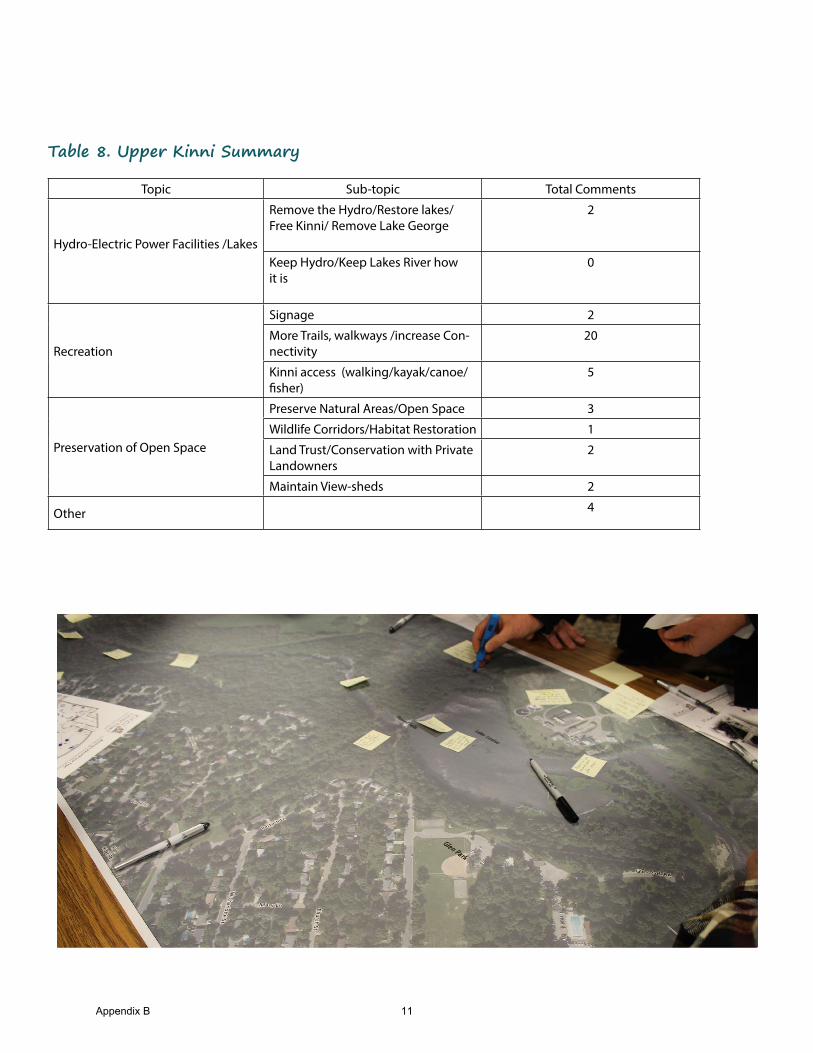
Table 8. Upper Kinni Summary
Topic Sub-topic Total Comments
Hydro-Electric Power Facilities /Lakes
Remove the Hydro/Restore lakes/Free Kinni/ Remove Lake George
2
Keep Hydro/Keep Lakes River how it is
0
Recreation
Signage 2
More Trails, walkways /increase Con-nectivity
20
Kinni access (walking/kayak/canoe/fisher)
5
Preservation of Open Space
Preserve Natural Areas/Open Space 3
Wildlife Corridors/Habitat Restoration 1
Land Trust/Conservation with Private Landowners
2
Maintain View-sheds 2
Other 4
Appendix B 11
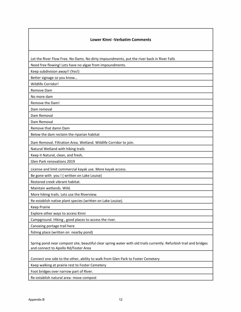
Lower Kinni -Verbatim Comments
Let the River Flow Free. No Dams. No dirty impoundments, put the river back in River Falls
Need free flowing! Lets have no algae from impoundments.
Keep subdivision away!! (Yes!)
Better signage so you know…
Wildlife Corridor!
Remove Dam
No more dam
Remove the Dam!
Dam removal
Dam Removal
Dam Removal
Remove that damn Dam
Below the dam reclaim the riparian habitat
Dam Removal. Filtration Area. Wetland. Wildlife Corridor to join.
Natural Wetland with hiking trails
Keep it Natural, clean, and fresh,
Glen Park renovations 2019
License and limit commercial kayak use. More kayak access.
Be gone with you ! ( written on Lake Louise)
Restored creek vibrant habitat.
Maintain wetlands. Wild.
More hiking trails. Lets use the Riverview.
Re-establish native plant species (written on Lake Louise).
Keep Prairie
Explore other ways to access Kinni
Campground. Hiking , good places to access the river.
Canoeing portage trail here
fishing place (written on nearby pond)
Spring pond near compost site, beautiful clear spring water with old trails currently. Refurbish trail and bridges and connect to Apollo Rd/Foster Area
Connect one side to the other, ability to walk from Glen Park to Foster Cemetery
Keep walking at prairie rest to Foster Cemetery
Foot bridges over narrow part of River.
Re-establish natural area- move compost
Appendix B 12
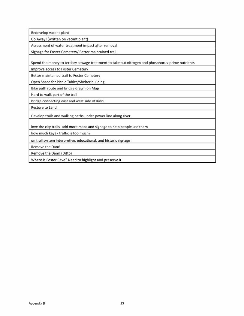
Redevelop vacant plant
Go Away! (written on vacant plant)
Assessment of water treatment impact after removal
Signage for Foster Cemetery/ Better maintained trail
Spend the money to tertiary sewage treatment to take out nitrogen and phosphorus-prime nutrients
Improve access to Foster Cemetery
Better maintained trail to Foster Cemetery
Open Space for Picnic Tables/Shelter building
Bike path route and bridge drawn on Map
Hard to walk part of the trail
Bridge connecting east and west side of Kinni
Restore to Land
Develop trails and walking paths under power line along river
love the city trails- add more maps and signage to help people use them
how much kayak traffic is too much?
on trail system interpretive, educational, and historic signage
Remove the Dam!
Remove the Dam! (Ditto)
Where is Foster Cave? Need to highlight and preserve it
Appendix B 13
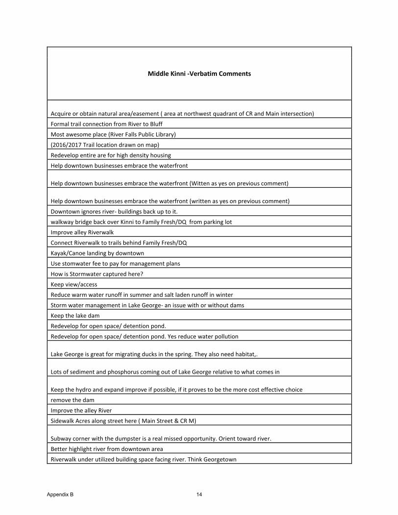
Middle Kinni -Verbatim Comments
Acquire or obtain natural area/easement ( area at northwest quadrant of CR and Main intersection)
Formal trail connection from River to Bluff
Most awesome place (River Falls Public Library)
(2016/2017 Trail location drawn on map)
Redevelop entire are for high density housing
Help downtown businesses embrace the waterfront
Help downtown businesses embrace the waterfront (Witten as yes on previous comment)
Help downtown businesses embrace the waterfront (written as yes on previous comment)
Downtown ignores river- buildings back up to it.
walkway bridge back over Kinni to Family Fresh/DQ from parking lot
Improve alley Riverwalk
Connect Riverwalk to trails behind Family Fresh/DQ
Kayak/Canoe landing by downtown
Use stomwater fee to pay for management plans
How is Stormwater captured here?
Keep view/access
Reduce warm water runoff in summer and salt laden runoff in winter
Storm water management in Lake George- an issue with or without dams
Keep the lake dam
Redevelop for open space/ detention pond.
Redevelop for open space/ detention pond. Yes reduce water pollution
Lake George is great for migrating ducks in the spring. They also need habitat,.
Lots of sediment and phosphorus coming out of Lake George relative to what comes in
Keep the hydro and expand improve if possible, if it proves to be the more cost effective choice
remove the dam
Improve the alley River
Sidewalk Acres along street here ( Main Street & CR M)
Subway corner with the dumpster is a real missed opportunity. Orient toward river.
Better highlight river from downtown area
Riverwalk under utilized building space facing river. Think Georgetown
Appendix B 14
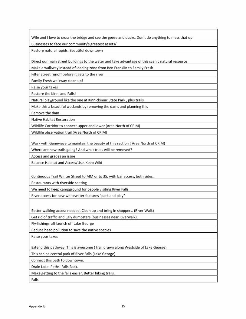
Wife and I love to cross the bridge and see the geese and ducks. Don’t do anything to mess that up
Businesses to face our community's greatest assets/
Restore natural rapids. Beautiful downtown
Direct our main street buildings to the water and take advantage of this scenic natural resource
Make a walkway instead of loading zone from Ben Franklin to Family Fresh
Filter Street runoff before it gets to the river
Family Fresh walkway clean up!
Raise your taxes
Restore the Kinni and Falls!
Natural playground like the one at Kinnickinnic State Park , plus trails
Make this a beautiful wetlands by removing the dams and planning this
Remove the dam
Native Habitat Restoration
Wildlife Corridor to connect upper and lower (Area North of CR M)
Wildlife observation trail (Area North of CR M)
Work with Genevieve to maintain the beauty of this section ( Area North of CR M)
Where are new trails going? And what trees will be removed?
Access and grades an issue
Balance Habitat and Access/Use. Keep Wild
Continuous Trail Winter Street to MM or to 35, with bar access, both sides.
Restaurants with riverside seating
We need to keep campground for people visiting River Falls.
River access for new whitewater features "park and play"
Better walking access needed. Clean up and bring in shoppers. (River Walk)
Get rid of traffic and ugly dumpsters (businesses near Riverwalk)
Fly-fishing/raft launch off Lake George
Reduce head pollution to save the native species
Raise your taxes
Extend this pathway. This is awesome ( trail drawn along Westside of Lake George)
This can be central park of River Falls (Lake George)
Connect this path to downtown.
Drain Lake. Paths. Falls Back.
Make getting to the falls easier. Better hiking trails.
Falls
Appendix B 15
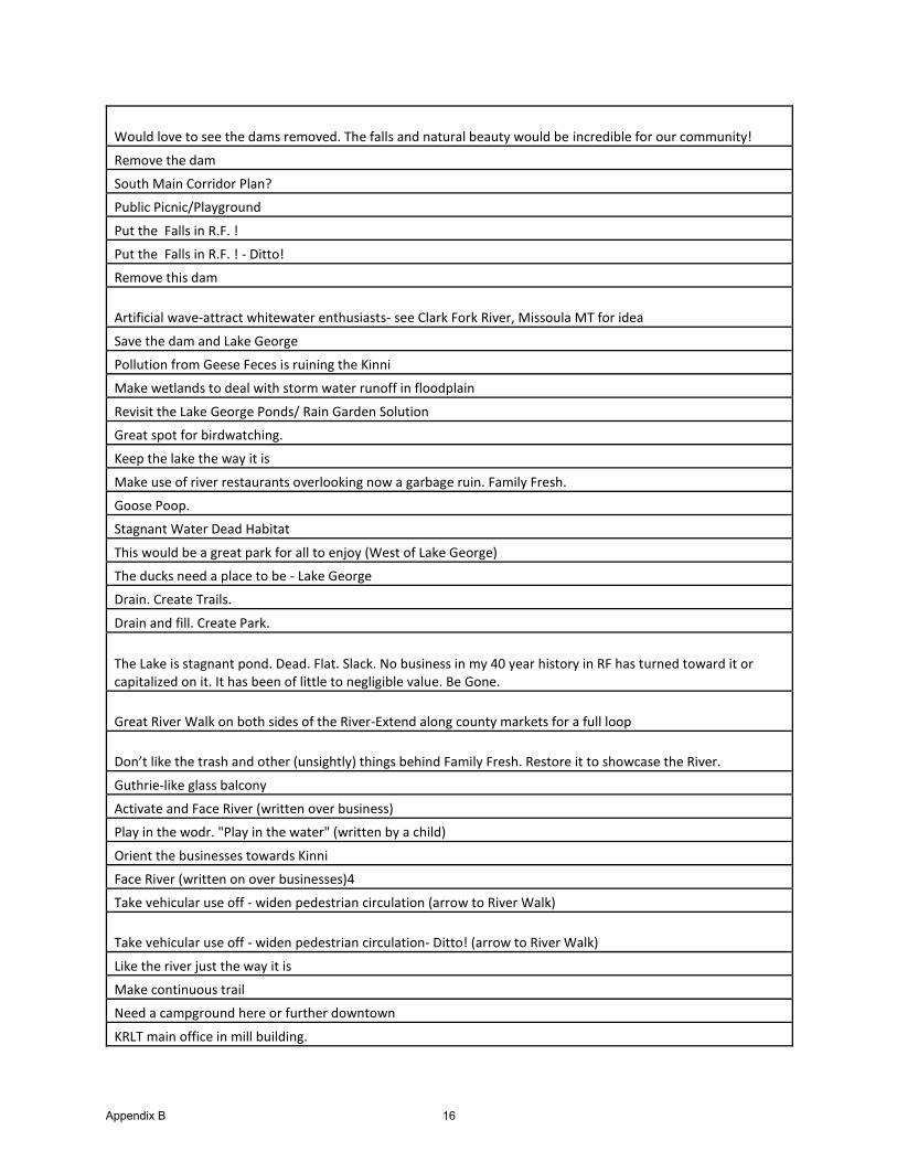
Would love to see the dams removed. The falls and natural beauty would be incredible for our community!
Remove the dam
South Main Corridor Plan?
Public Picnic/Playground
Put the Falls in R.F. !
Put the Falls in R.F. ! - Ditto!
Remove this dam
Artificial wave-attract whitewater enthusiasts- see Clark Fork River, Missoula MT for idea
Save the dam and Lake George
Pollution from Geese Feces is ruining the Kinni
Make wetlands to deal with storm water runoff in floodplain
Revisit the Lake George Ponds/ Rain Garden Solution
Great spot for birdwatching.
Keep the lake the way it is
Make use of river restaurants overlooking now a garbage ruin. Family Fresh.
Goose Poop.
Stagnant Water Dead Habitat
This would be a great park for all to enjoy (West of Lake George)
The ducks need a place to be - Lake George
Drain. Create Trails.
Drain and fill. Create Park.
The Lake is stagnant pond. Dead. Flat. Slack. No business in my 40 year history in RF has turned toward it or capitalized on it. It has been of little to negligible value. Be Gone.
Great River Walk on both sides of the River-Extend along county markets for a full loop
Don’t like the trash and other (unsightly) things behind Family Fresh. Restore it to showcase the River.
Guthrie-like glass balcony
Activate and Face River (written over business)
Play in the wodr. "Play in the water" (written by a child)
Orient the businesses towards Kinni
Face River (written on over businesses)4
Take vehicular use off - widen pedestrian circulation (arrow to River Walk)
Take vehicular use off - widen pedestrian circulation- Ditto! (arrow to River Walk)
Like the river just the way it is
Make continuous trail
Need a campground here or further downtown
KRLT main office in mill building.
Appendix B 16
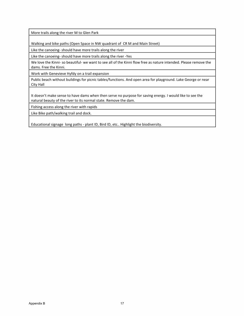
More trails along the river M to Glen Park
Walking and bike paths (Open Space in NW quadrant of CR M and Main Street)
Like the canoeing- should have more trails along the river
Like the canoeing- should have more trails along the river -Yes
We love the Kinni- so beautiful- we want to see all of the Kinni flow free as nature intended. Please remove the dams. Free the Kinni.
Work with Genevieve Hyfdy on a trail expansion
Public beach without buildings for picnic tables/functions. And open area for playground. Lake George or near City Hall
It doesn’t make sense to have dams when then serve no purpose for saving energy. I would like to see the natural beauty of the river to its normal state. Remove the dam.
Fishing access along the river with rapids
Like Bike path/walking trail and dock.
Educational signage long paths - plant ID, Bird ID, etc.. Highlight the biodiversity.
Appendix B 17
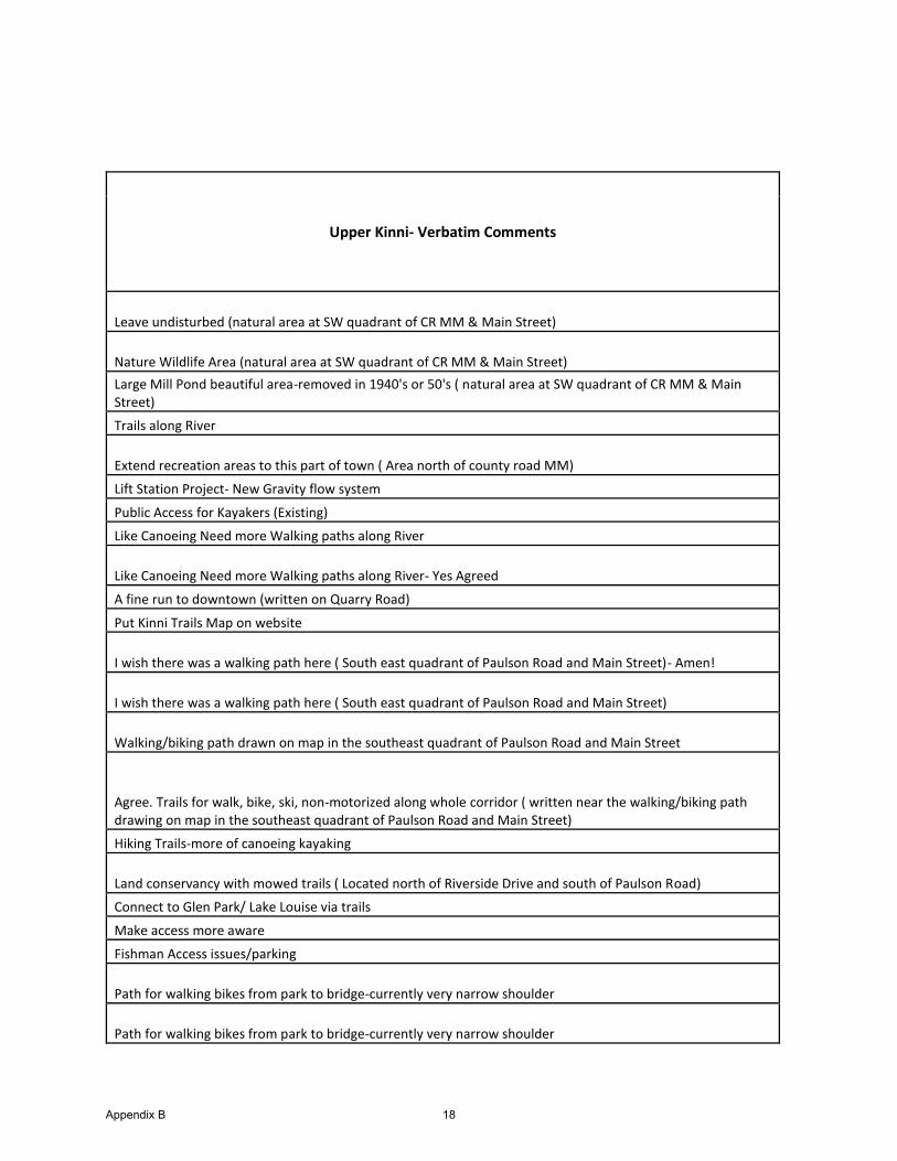
Upper Kinni- Verbatim Comments
Leave undisturbed (natural area at SW quadrant of CR MM & Main Street)
Nature Wildlife Area (natural area at SW quadrant of CR MM & Main Street)
Large Mill Pond beautiful area-removed in 1940's or 50's ( natural area at SW quadrant of CR MM & Main Street)
Trails along River
Extend recreation areas to this part of town ( Area north of county road MM)
Lift Station Project- New Gravity flow system
Public Access for Kayakers (Existing)
Like Canoeing Need more Walking paths along River
Like Canoeing Need more Walking paths along River- Yes Agreed
A fine run to downtown (written on Quarry Road)
Put Kinni Trails Map on website
I wish there was a walking path here ( South east quadrant of Paulson Road and Main Street)- Amen!
I wish there was a walking path here ( South east quadrant of Paulson Road and Main Street)
Walking/biking path drawn on map in the southeast quadrant of Paulson Road and Main Street
Agree. Trails for walk, bike, ski, non-motorized along whole corridor ( written near the walking/biking path drawing on map in the southeast quadrant of Paulson Road and Main Street)
Hiking Trails-more of canoeing kayaking
Land conservancy with mowed trails ( Located north of Riverside Drive and south of Paulson Road)
Connect to Glen Park/ Lake Louise via trails
Make access more aware
Fishman Access issues/parking
Path for walking bikes from park to bridge-currently very narrow shoulder
Path for walking bikes from park to bridge-currently very narrow shoulder
Appendix B 18
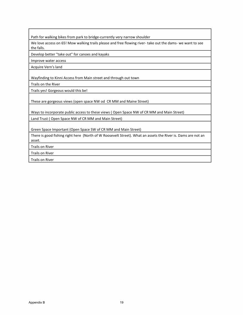
Path for walking bikes from park to bridge-currently very narrow shoulder
We love access on 65! Mow walking trails please and free flowing river- take out the dams- we want to see the falls.
Develop better "take out" for canoes and kayaks
Improve water access
Acquire Vern's land
Wayfinding to Kinni Access from Main street and through out town
Trails on the River
Trails yes! Gorgeous would this be!
These are gorgeous views (open space NW od CR MM and Maine Street)
Ways to incorporate public access to these views ( Open Space NW of CR MM and Main Street)
Land Trust ( Open Space NW of CR MM and Main Street)
Green Space Important (Open Space SW of CR MM and Main Street)
There is good fishing right here (North of W Roosevelt Street). What an assets the River is. Dams are not an asset.
Trails on River
Trails on River
Trails on River
Appendix B 19


Appendix C: Frequently Asked Questions


C-1
Kinni Corridor Project Questions and Answers Updated 9.21.17
I. Project Basics, Planning Process, and CharretteWhat is the Kinni Corridor Project all about? In 2016, the City of River Falls embarked on a comprehensive, three-year planning process focused on the Kinnickinnic River Corridor and the existing and future relationship of the community with the river and adjoining urban and undeveloped areas. When complete, the Corridor Plan will establish a future vision for the area and strategies for implementation. The Plan will address land use, economic development, renewable energy, recreation, tourism, and conservation opportunities to best meet the needs of the community.
What is a “River Corridor”? A river corridor includes both a river and the areas surrounding it. The breadth or width of the Kinni Corridor varies but is generally less than one mile either side of the center of the river.
How many miles of the Kinni are in the “Corridor”? The Kinnickinnic River is 22 miles long. The segment that runs through River Falls and the surrounding towns – and considered for the project’s purposes to be in the “corridor” – is seven miles long. The segment of the river that flows through the City proper is approximately three miles long.
Who oversees the Project? An 11-member Kinni Corridor Project Committee provides oversight and guides project activities. Staff and consultant teams work together to support the committee and keep project activities on track. Buddy Lucero, Community Development Director, is the project manager. The committee with recommend a preferred option to the River Falls City Council in June 2019.
How long will the planning process take? When will a decision be made about future of the corridor? The corridor plan is expected to be adopted in June 2019. Decisions regarding the future of the corridor will be made and refined throughout the planning process.
How has the community been engaged in the planning process? A variety of public engagement strategies have been used to establish and continue the conversation with the entire community, including the project website; social media; a series of community discussions call “Tech Talks” regarding topics of interest; surveys; two community planning workshops; talks at local service clubs, organizations, neighborhoods, and faith communities; booths at a variety of community events; and more.
C-2
When will the Council make a decision regarding dam removal? The City will decide about licensing the two hydroelectric projects in February 2018 to allow for 5.5 years for the licensing or surrender process to be completed before the current license expires in 2023. There is no schedule regarding decisions to remove one or both of the dams. That decision will depend on the licensing decision as well as the results of the corridor plan.
Why not have a citywide vote? Why just let the City Council make such an important decision? While it would be possible to have a referendum vote, the process that the Council decided on was to use the corridor planning process to increase the awareness of the community regarding the importance of the river to the community and the merits of dams staying or dams being removed. The process will continue to allow for public input and public comment right up to the Council’s final decision which is expected in February 2018.
When do we decide on our core guiding principles? At Tech Talk No. 6, the speakers talked about the planning principals that often apply to projects like the corridor study. Early in the project, the Committee discussed the value of a mission and vision statement and planning principals. The discussion was tabled until after the charrette to allow the entire Committee and the community to become more knowledgeable regarding all the issues involved. The Committee will begin discussing planning principals at their October 5 meeting. After the charrette (at the end of October), and again after the Council’s decision regarding relicensing, the planning principals will be reviewed and refined before completing the corridor plan based on the preferred scenario for the corridor.
Is the Lake George park/walking area a must? How much would the project be without it? There are no “musts” at this stage. As the project progresses through the charrette scheduled for Oct. 25-28, additional ideas will be developed and refined, and several preferred alternatives will bedeveloped, which may or may not include a Lake George park and walking areas. Once the alternativesare identified, a cost analysis will be developed.
How is the Corridor Committee marketing the charrette to let all community members know that they should attend? The Committee will use social media (Facebook, Twitter, and YouTube), and traditional media sources like the River Falls Journal (ads, articles, and editorials), utility bill inserts, posters/flyers, event calendars, and the City newsletter to spread the word about the charrette.
Is there any opportunity to involve the school district in planning charrette? The involvement of the school district along with other groups and individuals will greatly benefit the outcome of the charrette. The charrette will include multiple touch points for all members of the community to participate.
What exactly will the public be able to contribute on day two (Thursday) of the charrette? On day two of the charrette, the public is invited to join with members of the planning team who will be working to develop concept scenarios for the corridor. Interactions will likely be one-on-one or via small group informal dialogue to best capture the ideas from the community.
C-3
II. River Ecology
How do the dams impact the ecology of the river? In general, dams slow the flow of water and change the habitat in the area of the reservoir from riverine to lake/pond. Both the dams operate in a “run-of-river” fashion, so the same amount of water that flows to the reservoir flows through the dam. Therefore, reduced flows are not an issue. Because the Kinni is a cold-water stream, the reservoirs warm up and contribute to a warming of the lower river. The reservoirs can trap sediments from upstream, preventing excess downstream sedimentation. However, reducing downstream sedimentation can also starve the lower river of sediment that would contribute to greater in-stream habitat diversity on the lower river.
How common are cold water streams in this region? The Kinni lies in the northern part of the geologic region called the Driftless Area, 24,000 square miles of unglaciated land in Wisconsin, Illinois, Iowa, and Minnesota. This area is recognized nationally for an abundance of trout streams. That said, the Kinnickinnic River is uncommon amongst streams in this region. The Kinni is designated as an Outstanding Resource Water (OWR) by the DNR and is considered one of the most outstanding Class I Trout streams in the state.
How does the uniqueness of the Kinni affect the value of restoring the river ecosystem? The uniqueness of the resources demands that efforts to protect and enhance the ecosystem and to ensure the long-term viability of the resources should be a very high priority. According to the WDNR, the Kinnickinnic River has one of the highest densities of brown trout in the state. Trout densities range from 2,000 to 12,000 trout per stream mile. The river is classified as an Outstanding Resource Water (OWR) above STH 35 and the remaining portion of the river classified as Class I trout is an Exception Resource Water (ERW). The trout fishery and aquatic habitat is threatened by agricultural and urbanization. To put the Kinni in perspective, of Wisconsin’s 53,413 streams and rivers, only 254 are designated as ORW, and 1,544 are designated as ERW. Wisconsin has a total of 42,000 stream/river miles in the state. Based on the current ORW/ERW list, a total of 3,179 stream miles (7.6%) have been designated as ORW, and 4,668 stream miles (11%) have been designated as ERW (source: WDNR).
Don’t the dams now, and restored waterfalls with dams removed, prevent upstream fish passage? The dams prevent fish passage today. In a dam removal scenario, the natural cascades in the Kinni are expected to continue to serve as barrier to upstream fish migration.
Is upstream movement of invasive species really an issue with dam removal? The barriers to invasive species include the cold-water conditions of the river and the dams. In a dam removal scenarios, the falls would likely serve as a natural barrier to invasive species.
What are the negative impacts of our dams on the ecology of the river including fish, fowl, and other river/lake wildlife? The primary negative impacts related to the dams include the discharge of warm water from the two reservoirs during the summer season and infrequent changes in flow when the bar screens of the hydro facility intakes are cleaned.
Are there any positive impacts of our dams on river ecology? The reservoirs that the dams create – Lake George and Lake Louise – represent habitat diversity that benefits wildlife specifically.
C-4
If you were to decide whether or not to remove the dams solely on environment impact, would you keep or remove OUR dams? The Lower Kinni is currently a Class I trout stream. However, there are several factors that threaten the long-term health of the ecosystem, including the dams. Removal of the dams will change the lower Kinni – for example – by reducing the temperatures in the lower reaches of the river and contributing to thelong-term viability of the resource. Assuming that the only issue under consideration is the long-term health of the river, then dam removal would make sense. That said, other threats including climate change, agricultural runoff, loss of ground water influences above I-94, and urban stormwater are also significant factors to be considered.
Should we spend millions to clean up the Kinni only to see it later re-contaminated in 20-30 years? The Kinni is not contaminated at present, so the risk of recontamination is quite limited. However, any significant public works project such as dam removal or stream restoration includes ongoing maintenance ensure the long-term performance of the improvements. If, for example, the reservoirs were dredged and all the sediment was removed, the removal effort would need to be repeated periodically to maintain the deepened reservoir condition. Without maintenance, and upstream runoff controls, the dredging project would need to be repeated.
III. SedimentWhen were the reservoirs considered to be filled in? Based on four studies including 1985, 1998, 2006 and 2016, the sediment depth in Lake George has been determined to be approximately five feet deep.
How much sediment would actually need to be removed from Lake George/Louise under optimal dam removal conditions and how much sediment could be locked in place through vegetation and other stormwater management actions/design? In an optimal dam removal scenario, the amount of sediment removed and hauled away from Lake George or Lake Louise would be minimized to reduce cost. The sediment could remain within the current footprint of the reservoir, subject to flood plain, wetland, and buffer regulations. The goal would be to leave as much sediment in place as possible.
Is there any human health risk associated with placing reservoir sediment in the river corridor? Based on the 2016 Sediment Study completed by Inter-Fluve for the City of River Falls, there is a very low health risk associated with placing reservoir sediment in the river corridor.
If the dams are removed, how does sediment from that activity compare to the erosion entering the river from cropland erosion? In a dam removal scenario, the dam removal would be done in a way to minimize the amount of sediment that would be discharged to the lower river. Sediment transport from dam removal will be a one-time event as opposed to the annual sediment loading from within the City and from the agricultural areas upstream. These upstream sources overtime were responsible for filling of the two impoundments.
Removing both dams will put more sediment in Lake St. Croix. What will be done about this issue? There is little sediment retention occurring today in either Lake George or Lake Louise, so, in a post-dam removal scenario, any increase in sediment loading to Lake St. Croix is expected to be acceptable.
C-5
If the makeup of the sediment is sand/gravel, is it possible that there is a market where this might be sold for construction and provide cost offset? While it is possible there is some market value to the material, no efforts to estimate how much material could be utilized or sold. It is unlikely that the sediment could be marketed unless a very large project nearby was taking place at the same time.
How much sediment would be released from the river channel under optimal dam removal conditions? In a dam removal or partial dam removal scenario, removal efforts would be conducted to retain as much sediment as possible, minimizing the release of sediment to the Lower Kinni to the maximum extent possible.
How much of the sediment can be sequestered in the river corridor without hauling out for placement elsewhere? The goal of any dam removal project will be to minimize the amount of sediment released downstream. How and where the existing sediment will be sequestered has not been determined.
IV. Watershed, Waterfalls and Public InfrastructureHow would the water be released into the stream as the dams are removed? Today, the dams are operated in a “run-of-the-river” fashion meaning all the water that flows to the dams flows through the dam. Because the reservoirs are nearly full of sediment, the amount of water to be released is not too large. In a dam removal scenario, a slow release of water would be planned to minimize impacts to river ecology.
There is a floating monitoring station on Lake George. What is it monitoring? The floating monitoring station was installed by the Friends of the Kinni to collect basic water chemistry and temperature data during the summer of 2017.
If the dams were to be removed, how high will the new falls be? Dam removal will not create ‘new’ falls. With the dams removed, the river will wash away remaining sediments that overlay the existing bedrock gorge below Lake George and the historic river channel below Lake Louise. Based on sediment mapping and measurement of the bedrock surfaces along with available topographic maps, it appears that a series of cascades, each dropping between 4-6 feet, will occur over several hundred feet from upstream of the Winter Street Bridge to the confluence of the South Fork. A similar drop is also expected in the vicinity of Powell Falls.
What is being done to ensure that the townships in the upper watershed are establishing regulations to address stormwater storage and infiltration and to control agricultural erosion using buffers, in an effort to reduce sediment coming down the upper Kinni? Beginning in the early 1990s, the four townships adjoining the City participated with River Falls in the development of the Kinnickinnic River Watershed Planning process referred to as the “205j Plan.” Similarly, the townships were at the table when the state-funded Priority Watershed Plan for the Kinnickinnic River was developed in 1998. The townships and counties will continue to play an important role in the future health of the river that comes to and through the City. Private groups like the Kinnickinnic River Land Trust will also play a significant role.
C-6
Upstream of River Falls, what will prevent agricultural runoff from contributing sediment and nutrients to Lake George? Threats to the Kinnickinnic River upstream of the City, including agricultural runoff, remain a serious concern for the long-term health of the river through and below the City. The Priority Watershed Plan completed in the late 1999s created a strategy to begin to address some of these threats. The City will continue to work with neighboring townships and St. Croix County to ensure that all land use activities and water withdrawal proceed with the health of the river in mind.
Will utility crossings be affected by dam removal? There are several utility crossings that will need to be evaluated and either protected or reconstructed as part of a dam removal project.
Will the wastewater treatment plant outlet be affected? The wastewater treatment plant will not be affected, however, depending on the final level of Lake Louise or a restored river in the vicinity of the plant in a dam removal scenario, some modification to the outlet may be required to prevent scour and other impacts of a lowered river profile compared to today.
V. Cost, Financing, and Economics Where did the $300,000 for this study come from? The $300,000 for the Kinni Corridor Study was budgeted by the City of River Falls, with 50% from the electric fund and 50% from property taxes.
Is the relicensing decision contingent on funding? No, however the cost of maintaining or removing the dams are two important factors to be considered as part of the licensing decision. Both relicense and surrender costs have similar regulations and administrative costs.
At what point do we need to secure funding? Funding for plan implementation would not be sought until after the decision regarding licensing (February 2018) and after subsequent decisions regarding the disposition of the two dams and community input on the corridor plan.
How much will electric rates go up if the dams are removed and restoration is complete? Rate increases due to dam and/or hydro generation removal have not been calculated. An increase in rates could relate to the City’s desire to recover lost hydroelectric revenues over time, amortization of undepreciated assets, and recovery of the costs of dam removal. In 2016, the City’s net revenues (electricity sold from hydro generation less maintenance costs) from the sale of 2.1 million kWh was $125,840. The cost to replace the same kWh with purchased power would be $165,233, resulting in net revenues of $40,807.
What costs besides the relicensing costs might we be required to cover once a license is granted? If the license is granted, the City will continue to address all maintenance and operations costs relative to the two hydro facilities. It is anticipated that at some point within the 30-year license period that one of the two dams will undergo structural rehabilitation in order to keep the facility in proper operating condition. These costs would be included in a future City Capital Improvement Plan as part of the City’s normal budgeting process. The costs of the facility are depreciated over the life of the structure and the license period.
C-7
What is the likelihood that the Army Corp of Engineers will engage in a dam removal project? The United States Army Corps of Engineers (ACE) has several programs that involve funding and technical assistance that may be applicable to a dam removal project. One example is Section 206 of the Water Resources Development Act of 1996 related to Aquatic Ecosystem Restoration. The 206 program for example would include both funding and technical service (design) by the ACE. The involvement of the ACE would be dependent on availability of federal funding as well as the availability of the local cost share which might vary from 35 -50%.
Does the City recognize that the hydros will need to be replaced at some point? Are we saving money for this eventuality? The financial projects for the future of hydro operations include anticipated maintenance and repair of both dams through the next licensing period.
What are some of the overall costs of dams that are removed of the same size as the dams in River Falls? There are too many variables to make an apples to apples comparison of the costs of removing a dam of the same height or width as the Junction Falls or Powell Falls dams.
How many city maintenance jobs will be gained or lost with removing the dams? No city maintenance jobs are expected to be lost in a dam removal scenario. The City may need to add seasonal help to maintain the repurposed reservoir areas in a post-dam removal scenario.
What is the increased cost of dam removal to a City taxpayer per $100,000 of house value? The cost to City taxpayers will depend on the overall costs for removal and restoration, as well as the amount of public and private dollars that may be available to reduce the City’s cost share for the project.
What type of private funding might be available in River Falls? Cash or in-kind (construction)? Depending on the types of improvements being considered, there are a variety of sources of private funds that can be sought to reduce the City’s costs for the projects. Contributions could include a combination of cash and in-kind services, but it is unlikely that there would be much private construction effort. Then the City evaluates its hydroelectric profits and losses, why doesn’t the City include all the costs that it has to pay out? The financial reports that the City has kept are based on the reporting it is required to make relative the operation of the hydro facilities. Historically, the City has not allocated overhead costs related to labor and benefits, and other costs to the hydro facilities. The City is reviewing what the applicable costs would be if it was to report such costs as part of the next generation of financial analysis of the hydro operations.
What costs will we need to incur for future maintenance to our dams? What state are they in, what repairs are needed and when? How much will they cost and who is responsible for paying for them? Based on the inspection reports completed in 2009, both dams are in reasonable shape. In 2015, the City reviewed the condition of the Powell Falls dam and estimated the cost of making minor repairs to the concrete structure to be approximately $125,000. The City is responsible to pay for the maintenance of both facilities.
C-8
Exactly which taxpayers bear the brunt of this project – City of River Falls, County? The answer depends in part on how many different sources of funding are available. The City taxpayers will be a primary source of funding. In addition, there may be contributions from Pierce and St. Croix County, State of Wisconsin, and the federal government.
Based on a $12 million expenditure for dam removal, what is the anticipated property tax impact for the home owner? The cost to City taxpayers will depend on the overall costs for removal and restoration, as well as the amount of public and private dollars that may be available to reduce the City’s cost share for the project. The July 2017 estimate of dam removal cost came in at over $12 million. That number is expected to evolve over the next several months. Once there is greater refinement of potential costs as well as the potential sources of funding the impact on homeowners can be estimated.
VI. Tourism, Recreation, and Economic DevelopmentWould dam removal enhance development and bring more tourists into the City? Existing studies from other dam removal and stream restoration projects would suggest that the City would be likely to attract more visitors. However, in many of the precedent studies, the existing streams were badly degraded and it was the enhancement of the stream that helped increase tourism. The Kinni is already a regional destination. The corridor plan itself could also be the catalyst for increasing tourism in River Falls. An economic impact study could be one tool for better quantifying what this might look like.
How will the City account for increased trash in the river from canoers and kayakers – increased damage to the area from people who are using the river for free? This is a current issue and would be expected to increase if access and recreation opportunities are increased because of the corridor plan, with or without dam removal. Education, receptacles, and increase maintenance may be required.
What economic impact studies will be done as part of corridor planning? No economic impact studies are currently planned for by the City prior to the charrette. Once the charrette generates alternatives for the future of the corridor, cost analysis of those alternatives will be developed. In addition, there has been interest on the part of several private parties to complete an independent economic impact study to inform the relicensing decision scheduled for February 2018.
Does dam removal reduce the recreational activities to only being a river community that is only accessed by fly fisherman and kayakers? Not necessarily. Hiking, bird watching and other activities remain or may be enhanced.
How does dam removal benefit the general population of the City? The benefits related to dam removal include enhancing the long-term health and viability of the river and maintaining/improving local economic conditions related to recreation and tourism.
What is the projected increase in revenue to local businesses (for their benefit)? The positive economic impact to local businesses in a dam removal scenario can only be estimated based on current visitors to the City and an estimated number of increased visits following dam removal. The economic impacts are currently being reviewed.

C-9
What are the potential economic benefits of a restored river with rapids, waterfalls, stormwater infiltration ponds, and park system along the river? A specific economic impact statement has not been prepared at this time. The planning charrette will define several alternatives for the river corridor and the vision for the river and the reservoirs. Once complete, an economic analysis could be developed.
What are the economic and recreational impacts of dam removal? Dam removal, and the stream restoration that is associated with dam removal, will enhance the long-term health and viability of the river. The river is already a center of recreational opportunities for fishing, kayaking, hiking, bird watching, etc. The stream restoration relates to about less than a mile of the river. To the extent that there can be a significant increase in visitors seeking the recreational opportunities throughout the corridor, local business could expect to see a positive economic change.
How will the corridor plan consider the needs of active people looking to retire in an interactive community? The answer depends on the alternatives generated as part of the charrette. Based on current community feedback, the plan will likely emphasis a more walkable corridor, enhancement to the Riverwalk area and improved access to the river at a variety of locations.
How can we balance/regulate/share the use of the river so that it does not end up like the Apple River in Somerset? Using a comparison to another river utilization like the Apple River can help to frame the future vision for the river and the entire corridor. Assuming that River Falls does not want to end up like Somerset, there would need to be use/access controls to ensure the proper balance of recreational users on a daily and on a seasonal basis.
In terms of attracting youth to the community, should we focus on permanent residents or temporary recreational use visitors? The answer depends on the community’s vision for the future of River Falls. The right answer is some combination of both.
How big do we want the City to grow? When do we get too big? At what point do we become too large and lose our uniqueness? This is a question that the community and the Council wrestle with and will continue to wrestle with in the future. There will never be uniform agreement on the right size for River Falls. But planning efforts like the Corridor Plan help define a future state for the community that will help to answer the growth question going forward.
How do you overcome zoning regulations in order to build or have a restaurant on the river bank as shown in some of the images during Tech Talk No. 6? How can real estate development exist if zoning will not permit it on or near the river? The image, like a handful of properties in River Falls, shows an existing building on the stream bank which has been in place long before the current zoning and buffer requirements were put into place. It is highly unlikely that new development built directly on the bank of any river would meet with approval in any community. That said, zoning can be used to encourage the types of development that can enhance the community and strike a balance between protecting the river buffer and providing access and proximity to the resource, consistent with local, regional and state regulation.

C-10
Do kayak rental companies, either locally based or from the Twin Cities, pay any access or user fees to use City-funded access points? If not, should they? No user or access fees are currently paid to the City for anyone accessing the river across City properties. At present, there are no near-term plans to develop and access related user-fee system.
Zoning is a way to move from negative to positive. How can we assist local development of the built environment to enhance our community if zoning prohibits this? It is important that zoning aligns with community plans for development as well as resource protection. Zoning is often viewed negatively when it restricts development. Relative to the corridor plan, tools like overlay zoning which may promote flexibility and conditional uses may be part of the answer to help realize the community vision. What percentage of the kayakers, taking 2 or 4 hour trips, actually rent hotels for their trips? Don’t the vast majority either live locally or get bussed in for one day? Specific information regarding kayakers’ activities are not currently available. This information could be collected as part of an economic impact study. It is likely that a significant number of kayakers visit the City on a daily basis and do not generate a lot of business for area hotels. VII. Lake George and Lake Louise How would the land reclaimed around Lake George and Lake Louise be used? In a dam removal scenario, the land that ‘emerges’ after the lake drawdown that is not within the floodplain could be repurposed consistent with City and state buffers and setbacks. The corridor planning process will develop alternatives for how these areas might be redeveloped if the dams were removed. How will the City account for sediment that is stirred up so that it doesn’t pollute downstream? The sediment study prepared by for the City in 2016 indicated that there is a very low risk for health issues or pollution occurring because of the sediment in Lake George and Lake Louise. Is Lake George providing storm water management capabilities to the Kinni currently? Or is the sediment too high currently to provide such benefits? Lake George is generally colder than the stormwater which enters the lake during the first flush of runoff during a summer storm event. The lake reduces the thermal spike from stormwater flows, but warm rain water still flows into the river. The reservoir also retains coarse sediments and associated pollutants in the vicinity of each stormwater outfall. The lake is fairly shallow, which limits its effectiveness for retaining finer sediments and soluble pollutants. Generally, the lakes have limited positive stormwater management benefits in their current state. What costs will we need to incur for future maintenance to the dams? What state are they in, what repairs are needed and when? How much will they cost and who is responsible for paying for them? Based on the inspection reports completed in 2009 and 2017, both dams are in good shape. In 2015, the City reviewed the condition of the Powell Falls Dam and estimated the cost of making minor repairs to the concrete structure to be approximately $125,000. The City is responsible to pay for the maintenance of both facilities. The costs are recorded and depreciated over time to be recovered in the rates of the utility.

C-11
The Lake George Restoration Plan represented an idea for improving Lake George and discharging colder water to Lake Louise without removing the Junction Falls dam. Why didn’t the project move forward? The plan called for the construction of storm water interceptor (a large pipe) to collect runoff from numerous individual outfalls along the east side of the river from Lake George north to Division Street. The interceptor would discharge into a series of ponds created within the area that is now Lake George to improve the thermal and chemical conditions of the runoff before discharging it back into the river. The multi-million-dollar concept did not move forward due to a lack of funding and unsuccessful attempts to secure grant funding.
Who owns the land under the mill ponds? The City of River Falls owns all the property under Lake Louise and Lake George.
Will removal of Lake George and Lake Louise impact the trout food chain (less mayfly hatch and other food sources)? Removal of the dams will change the trout food chain in the lower Kinni. In the short term, some negative effects will occur from sedimentation, etc. The temperature will become colder over time in the lower river which will also change stream habitat for trout and aquatic invertebrates. Some changes may be negative and some will be positive. Simply said, it will be different than it is today.
I heard that 35 years ago, a company, Volrath, put mercury in Lake George – what has happened to this mercury? No information is readily available to address this question at this time. Further investigation is required. However, there is no evidence that Volrath put mercury into Lake George.
How would replacing Lake George and Lake Louise with 1,000 feet of additional river improve either the trout systems or hotel room stays over and above the nature experiences that are already here? The stream restoration generally associated with dam removal and the replacement of Lake George ad Lake Louise involves over 4,000 feet of additional river. The restoration would lower and stabilize the temperatures of the lower river, which would improve river ecology and trout habitat specifically. In addition, newly restored or created habitat in the 4,000 feet of stream restoration will improve trout habitat as well. For some, this change will enhance the nature experiences already present in the City. For others, the loss of the impoundments may be viewed as a loss of nature experience for those who enjoy the passive recreational opportunities offers by the reservoirs. The City does not have current information regarding hotel stays in River Falls so it is difficult to project how that may change as a result of a stream restoration project.
VIII. Hydroelectric FacilitiesIf these dams did not exist, would FERC approve building dams in these locations? The Wisconsin Department of Natural Resources would regulate the construction of a new dam regardless of location. Other local, state and federal Agencies would also be involved including FERC who would approve the hydroelectric facilities through their licensing process. That said, it is unlikely that any dam could be constructed today on a Class I trout stream.
Are the relicensing costs included in the City's preliminary financial analysis? The preliminary financial analysis includes $300,000 in relicensing costs between 2018 and 2020.

C-12
Are there opportunities for other upgrades to the generators to increase their capacity to further increase the value of the dams? Undoubtedly there are equipment upgrades that could be considered to increase the output of the hydro facilities, however no such analysis has been completed to date.
Should we keep the hydros so we can power our community in the situation where our major power source is cut off for some reason? It is both smart and practical for the City to have the ability to provide some power to the community if there is an interruption in the primary power supplies to the City.
What is the historic value of the hydro facilities? Is the original dam historic i.e. National Historic Register? No recent work has been done to assess the historical nature of the dams, the hydroelectric facilities, or the original timber dam.
IX. Precedent ProjectsWhat is happening with the dam on the Willow River in North Hudson? In 2016 the DNR decided to rebuild the Little Falls dam to restore Little Falls Lake. The $19 million project includes removal of the existing dam and reconstruction of a new dam that will restore the 172-acre reservoir.
What is the economic experience of other communities that have removed dams, such as Chagrin Falls, Ohio and Baraboo, Wisconsin? In general, many of the regional and national dam removal projects result in the restoration of a degraded waterway. The restoration incudes re-establishment of native fisheries and natural flood plains and riparian properties. What makes the Kinni different is that the lower river is not expected to improve significantly because of dam removal as it is already a Class I river and is already a regional and national destination, making the economic experiences of other communities hard to project onto River Falls.
Are there any dam removals examples in other communities that you can share? There are many dam removal examples to review. Three examples were summarized on a poster of precedent projects for Tech Talk No. 5 and can be viewed on the project website.


Appendix D: Utility Advisory Board resolution

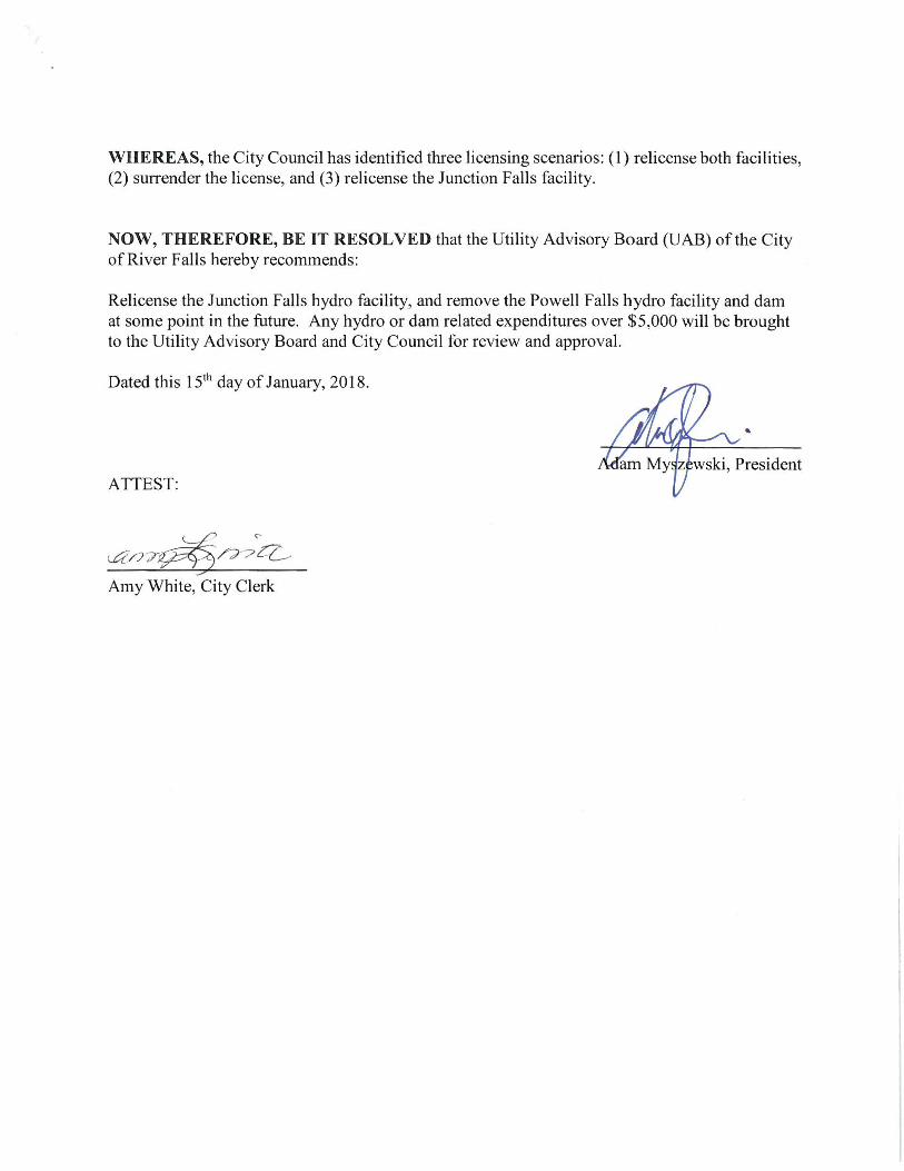

Appendix E: Kinni Corridor Project Committee resolution

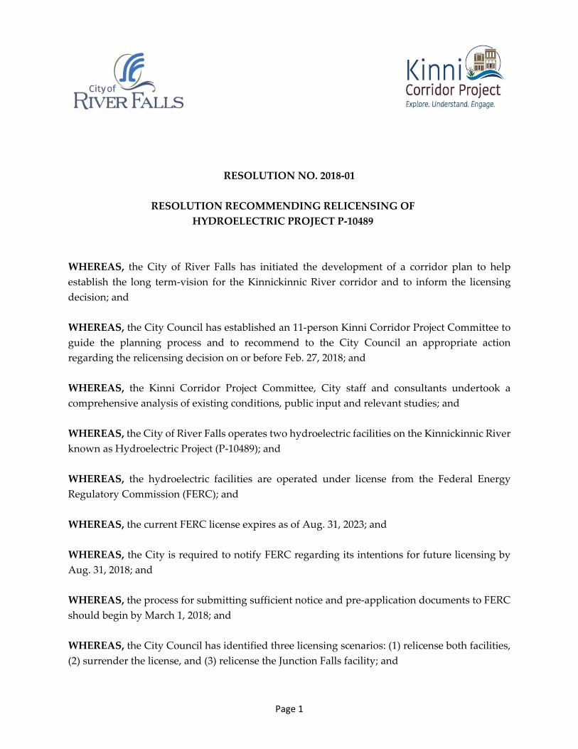
Page 1
RESOLUTION NO. 2018-01
RESOLUTION RECOMMENDING RELICENSING OF HYDROELECTRIC PROJECT P-10489
WHEREAS, the City of River Falls has initiated the development of a corridor plan to help establish the long term-vision for the Kinnickinnic River corridor and to inform the licensing decision; and
WHEREAS, the City Council has established an 11-person Kinni Corridor Project Committee to guide the planning process and to recommend to the City Council an appropriate action regarding the relicensing decision on or before Feb. 27, 2018; and
WHEREAS, the Kinni Corridor Project Committee, City staff and consultants undertook a comprehensive analysis of existing conditions, public input and relevant studies; and
WHEREAS, the City of River Falls operates two hydroelectric facilities on the Kinnickinnic River known as Hydroelectric Project (P-10489); and
WHEREAS, the hydroelectric facilities are operated under license from the Federal Energy Regulatory Commission (FERC); and
WHEREAS, the current FERC license expires as of Aug. 31, 2023; and
WHEREAS, the City is required to notify FERC regarding its intentions for future licensing by Aug. 31, 2018; and
WHEREAS, the process for submitting sufficient notice and pre-application documents to FERC should begin by March 1, 2018; and
WHEREAS, the City Council has identified three licensing scenarios: (1) relicense both facilities, (2) surrender the license, and (3) relicense the Junction Falls facility; and
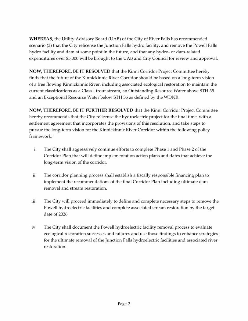
Page-2
WHEREAS, the Utility Advisory Board (UAB) of the City of River Falls has recommended scenario (3) that the City relicense the Junction Falls hydro facility, and remove the Powell Falls hydro facility and dam at some point in the future, and that any hydro- or dam-related expenditures over $5,000 will be brought to the UAB and City Council for review and approval.
NOW, THEREFORE, BE IT RESOLVED that the Kinni Corridor Project Committee hereby finds that the future of the Kinnickinnic River Corridor should be based on a long-term vision of a free flowing Kinnickinnic River, including associated ecological restoration to maintain the current classifications as a Class I trout stream, an Outstanding Resource Water above STH 35 and an Exceptional Resource Water below STH 35 as defined by the WDNR.
NOW, THEREFORE, BE IT FURTHER RESOLVED that the Kinni Corridor Project Committee hereby recommends that the City relicense the hydroelectric project for the final time, with a settlement agreement that incorporates the provisions of this resolution, and take steps to pursue the long-term vision for the Kinnickinnic River Corridor within the following policy framework:
i. The City shall aggressively continue efforts to complete Phase 1 and Phase 2 of theCorridor Plan that will define implementation action plans and dates that achieve thelong-term vision of the corridor.
ii. The corridor planning process shall establish a fiscally responsible financing plan toimplement the recommendations of the final Corridor Plan including ultimate damremoval and stream restoration.
iii. The City will proceed immediately to define and complete necessary steps to remove thePowell hydroelectric facilities and complete associated stream restoration by the targetdate of 2026.
iv. The City shall document the Powell hydroelectric facility removal process to evaluateecological restoration successes and failures and use those findings to enhance strategiesfor the ultimate removal of the Junction Falls hydroelectric facilities and associated riverrestoration.
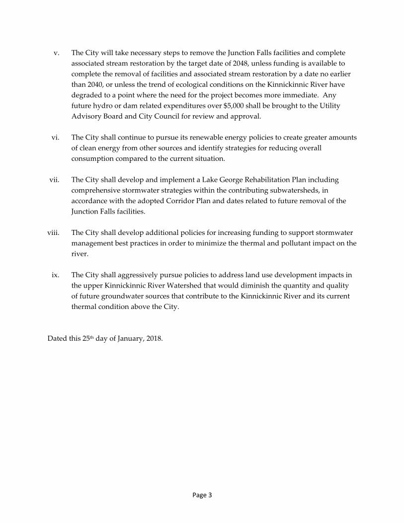
Page 3
v. The City will take necessary steps to remove the Junction Falls facilities and completeassociated stream restoration by the target date of 2048, unless funding is available tocomplete the removal of facilities and associated stream restoration by a date no earlierthan 2040, or unless the trend of ecological conditions on the Kinnickinnic River havedegraded to a point where the need for the project becomes more immediate. Anyfuture hydro or dam related expenditures over $5,000 shall be brought to the UtilityAdvisory Board and City Council for review and approval.
vi. The City shall continue to pursue its renewable energy policies to create greater amountsof clean energy from other sources and identify strategies for reducing overallconsumption compared to the current situation.
vii. The City shall develop and implement a Lake George Rehabilitation Plan includingcomprehensive stormwater strategies within the contributing subwatersheds, inaccordance with the adopted Corridor Plan and dates related to future removal of theJunction Falls facilities.
viii. The City shall develop additional policies for increasing funding to support stormwatermanagement best practices in order to minimize the thermal and pollutant impact on theriver.
ix. The City shall aggressively pursue policies to address land use development impacts inthe upper Kinnickinnic River Watershed that would diminish the quantity and qualityof future groundwater sources that contribute to the Kinnickinnic River and its currentthermal condition above the City.
Dated this 25th day of January, 2018.
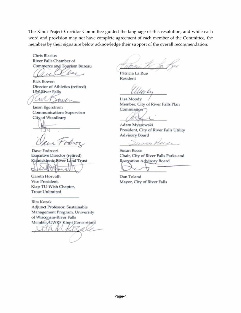
Page-4
The Kinni Project Corridor Committee guided the language of this resolution, and while each word and provision may not have complete agreement of each member of the Committee, the members by their signature below acknowledge their support of the overall recommendation:

Appendix F: Project timeline

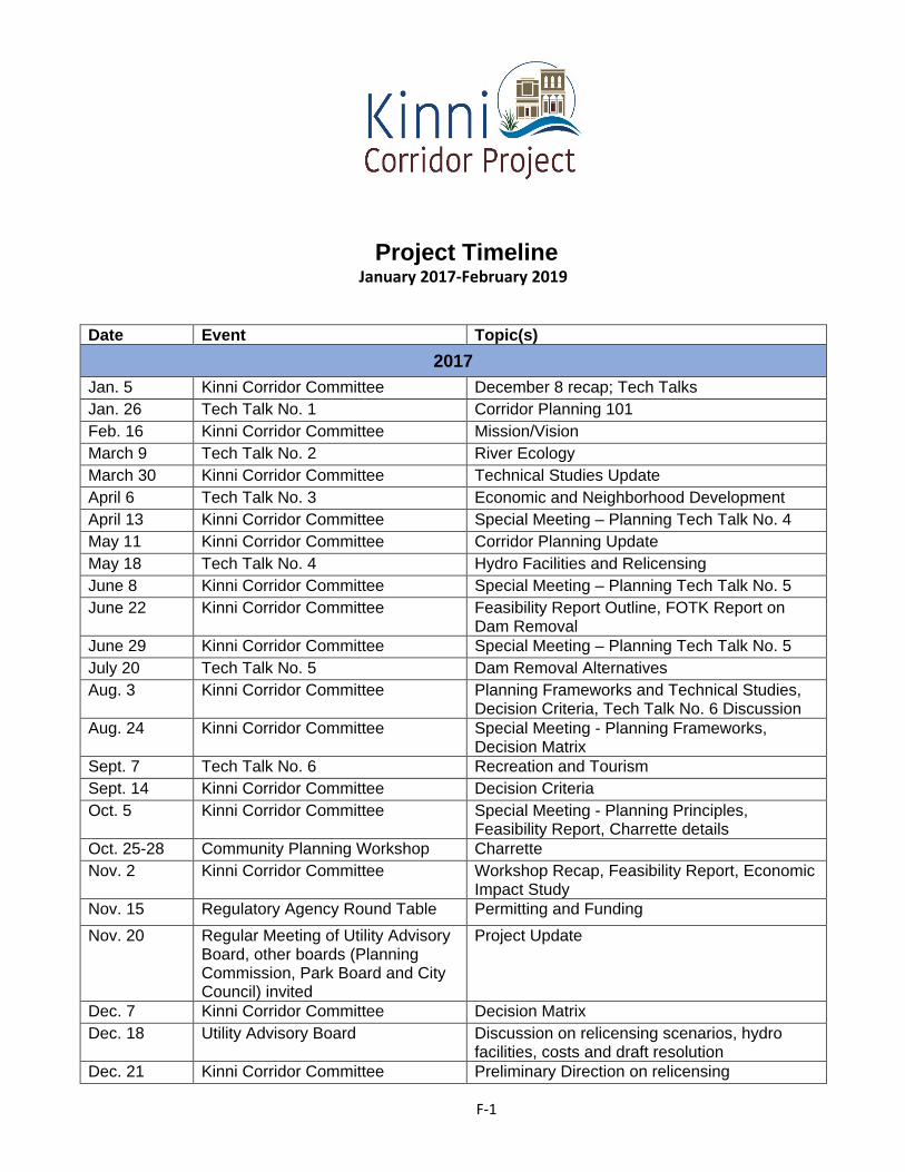
F-1
Project Timeline January 2017-February 2019
Date Event Topic(s) 2017
Jan. 5 Kinni Corridor Committee December 8 recap; Tech Talks Jan. 26 Tech Talk No. 1 Corridor Planning 101 Feb. 16 Kinni Corridor Committee Mission/Vision March 9 Tech Talk No. 2 River Ecology March 30 Kinni Corridor Committee Technical Studies Update April 6 Tech Talk No. 3 Economic and Neighborhood Development April 13 Kinni Corridor Committee Special Meeting – Planning Tech Talk No. 4 May 11 Kinni Corridor Committee Corridor Planning Update May 18 Tech Talk No. 4 Hydro Facilities and Relicensing June 8 Kinni Corridor Committee Special Meeting – Planning Tech Talk No. 5 June 22 Kinni Corridor Committee Feasibility Report Outline, FOTK Report on
Dam Removal June 29 Kinni Corridor Committee Special Meeting – Planning Tech Talk No. 5 July 20 Tech Talk No. 5 Dam Removal Alternatives Aug. 3 Kinni Corridor Committee Planning Frameworks and Technical Studies,
Decision Criteria, Tech Talk No. 6 Discussion Aug. 24 Kinni Corridor Committee Special Meeting - Planning Frameworks,
Decision Matrix Sept. 7 Tech Talk No. 6 Recreation and Tourism Sept. 14 Kinni Corridor Committee Decision Criteria Oct. 5 Kinni Corridor Committee Special Meeting - Planning Principles,
Feasibility Report, Charrette details Oct. 25-28 Community Planning Workshop Charrette Nov. 2 Kinni Corridor Committee Workshop Recap, Feasibility Report, Economic
Impact Study Nov. 15 Regulatory Agency Round Table Permitting and Funding Nov. 20 Regular Meeting of Utility Advisory
Board, other boards (Planning Commission, Park Board and City Council) invited
Project Update
Dec. 7 Kinni Corridor Committee Decision Matrix Dec. 18 Utility Advisory Board Discussion on relicensing scenarios, hydro
facilities, costs and draft resolution Dec. 21 Kinni Corridor Committee Preliminary Direction on relicensing
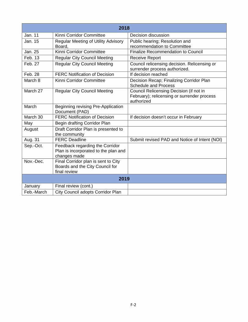
F-2
2018 Jan. 11 Kinni Corridor Committee Decision discussion Jan. 15 Regular Meeting of Utility Advisory
Board, Public hearing; Resolution and recommendation to Committee
Jan. 25 Kinni Corridor Committee Finalize Recommendation to Council Feb. 13 Regular City Council Meeting Receive Report Feb. 27 Regular City Council Meeting Council relicensing decision. Relicensing or
surrender process authorized. Feb. 28 FERC Notification of Decision If decision reached March 8 Kinni Corridor Committee Decision Recap; Finalizing Corridor Plan
Schedule and Process March 27 Regular City Council Meeting Council Relicensing Decision (if not in
February); relicensing or surrender process authorized
March Beginning revising Pre-Application Document (PAD)
March 30 FERC Notification of Decision If decision doesn’t occur in February May Begin drafting Corridor Plan August Draft Corridor Plan is presented to
the community Aug. 31 FERC Deadline Submit revised PAD and Notice of Intent (NOI) Sep.-Oct. Feedback regarding the Corridor
Plan is incorporated to the plan and changes made
Nov.-Dec. Final Corridor plan is sent to City Boards and the City Council for final review
2019 January Final review (cont.) Feb.-March City Council adopts Corridor Plan