Embed Size (px)
Citation preview
FEMA NFIP Metadata Profile: Basemap 1 February 2018
FEMA NFIP Metadata Profile1 for
Basemap Datasets
Version 1.0.6 Legend: Required Elements:
Text with Regular Font: Elements that appear in regular font were required in the Federal Geographic Data Committee (FGDC) standard and remain required for Federal Emergency Management Agency (FEMA) National Flood Insurance Program (NFIP) purposes. They are noted as “Optionality: Mandatory”.
Text with Bold Font: Elements that appear in bold font were required if applicable in the FGDC standard but were made required for NFIP purposes. They are noted as “Optionality: Mandatory for FEMA”.
Optional Elements:
Text with Gray Font: Elements that appear in gray font were required if applicable or optional in the FGDC standard and are optional for NFIP purposes. They are noted as “Optionality: Optional” or “Optionality: Optional for FEMA”.
FEMA Business Rules and Recommendations:
Text highlighted in gray contains profile-specific comments, recommendations and business rules regarding the noted element. They are noted as “FEMA Business Rules”.
Notes:
(1) An asterisk (*) after an element means that this element can be repeated an unlimited number of times. Example:
1.1.10 OnLink* -- Online Linkage – etc. means onlink can be repeated. (Note that OnLink is the “official” abbreviation for Online Linkage and hence should be used as the column name in the database.)
(2) All required elements are shown in bold and regular text (no gray!). Optional elements (shown in gray text), if supplied are also supported.
(3) “MIP Submission Date” is the date on which an “intermediate” study artifact or Draft, Preliminary or Effective Flood Insurance Rate Map (FIRM) dataset was entered into the Mapping Information Platform (MIP) database.
(4) Basemap metadata files should be named according to the convention: <Project ID>_BaseMap_metadata. The Project ID may be an 8-digit Hydrologic Unit Code (HUC) identifying the watershed; a text description of the area’s flooding source (e.g., Delaware Bay); or a FEMA Community Identification (CID) or Federal Information Processing Standards (FIPS) code identifying the primary county or community mapped.
1 Federal Geographic Data Committee (FGDC) Content Standard for Digital Geospatial Metadata (CSDGM), FGDC-STD-001-1998. Available at https://www.fgdc.gov/metadata/csdgm-standard.
FEMA NFIP Metadata Profile: Basemap 2 February 2018
1 Idinfo – Identification Information – Basic information about the data set. Optionality: Mandatory FEMA Business Rules: This section is required for all FGDC-compliant metadata.
1.1 Citation -- Citation -- information to be used to reference the data set
Optionality: Mandatory FEMA Business Rules: The Citation section describes the Data Package.
1.1.1 Citeinfo -- Citation Information -- the recommended reference to be used for the data set. Optionality: Mandatory
1.1.1.1 Origin* -- Originator -- the name of an organization or individual that developed the data set.
Optionality: Mandatory Domain: free text FEMA Business Rules: For existing data, Originator would be the data provider. For data developed for the study, Originator would be the responsible party, for example the Mapping Partner, Indefinite Delivery/Indefinite Quantity (IDIQ) contractor, Cooperating Technical Partner (CTP), or other Federal agency.
1.1.1.2 Pubdate -- Publication Date -- the date when the data set is published or otherwise made available for release.
Optionality: Mandatory Domain: free date FEMA Business Rules: Must be in the form of YYYYMMDD For existing data, Publication Date would be the date the data was published by the originator. For data developed for the study, Publication Date would be the submittal date to the MIP.
1.1.1.3 Pubtime -- Publication Time -- the time of day when the data set is published or otherwise made available for
Optionality: Optional Domain: "Unknown" free time
1.1.1.4 Title -- Title -- the name by which the data set is known.
Optionality: Mandatory Domain: FEMA Business Rules: Title should be of format: “name of data-package type for MIP Project Title”, where name of data-package type reflects this submission and the “MIP Project Title” follows rules for constructing MIP project titles (e.g., “Basemap Framework Submission for Alexandria VA”).
1.1.1.5 Edition -- Edition -- the version of the title.
Optionality: Mandatory for FEMA
FEMA NFIP Metadata Profile: Basemap 3 February 2018
Domain: FEMA Business Rules: This should match the latest VERSION_ID in the FIRM Database (e.g., “Version 2.5.3.6”).
1.1.1.6 Geoform -- Geospatial Data Presentation Form -- the mode in which the geospatial data are represented.
Optionality: Mandatory for FEMA Domain: FEMA Business Rules: “FGDC-Framework-Basemap”
1.1.1.7 Serinfo -- Series Information -- the identification of the series publication of which the data set is a part.
Optionality: Optional for FEMA 1.1.1.7.1 Sername -- Series Name -- the name of the series publication of which the data set is a part.
Optionality: Optional for FEMA Domain: free text
1.1.1.7.2 Issue -- Issue Identification -- information identifying the issue of the series publication of which the data set is a part.
Optionality: Optional for FEMA Domain: free text
1.1.1.8 Pubinfo -- Publication Information -- publication details for published data sets.
Optionality: Mandatory for FEMA
1.1.1.8.1 Pubplace -- Publication Place -- the name of the city (and state or province, and country, if needed to identify the city) where the data set was published or released.
Optionality: Mandatory Domain: free text
1.1.1.8.2 Publish -- Publisher -- the name of the individual or organization that published the data set.
Optionality: Mandatory Domain: free text FEMA Business Rules: User has the option of specifying whether these data will be distributed directly by FEMA or by the user’s organization (FEMA maintains an archived copy in this case). If the user will be distributing the data, then this contact information should be identical to the distribution contact information (Section 6). See also element 1.9 Point of Contact
1.1.1.9 Othercit -- Other Citation Details -- other information required to complete the citation.
Optionality: Optional for FEMA Domain: free text
1.1.1.10 Onlink* -- Online Linkage -- the name of an online computer resource that contains the data set. Entries should follow the Uniform Resource Locator (URL) convention of the Internet.
Optionality: Mandatory for FEMA Domain: free text
FEMA NFIP Metadata Profile: Basemap 4 February 2018
1.1.1.11 Lworkcit -- Larger Work Citation -- the information identifying a larger work in which the data set is included.
Optionality: Mandatory for FEMA FEMA Business Rules: Lworkcit refers to the FEMA case under which the data package was uploaded. The ‘lworkcit’ element is a compound element and does not take a value.
1.1.1.11.1 Citeinfo
Optionality: Mandatory FEMA Business Rules: Note: This Citeinfo block is used to reference the FEMA Case study.
1.1.1.11.1.1 Origin*
Optionality: Mandatory Domain: FEMA Business Rules: “Federal Emergency Management Agency”
1.1.1.11.1.2 Pubdate
Optionality: Mandatory Domain: FEMA Business Rules: “Unknown”
1.1.1.11.1.3 Pubtime
Optionality: Optional 1.1.1.11.1.4 Title
Optionality: Mandatory Domain: FEMA Business Rules: Title must be “FEMA CASE num” where num is the case number associated to the project by FEMA of the form: “yy-rr-nnnnS” where: yy = year rr = FEMA region number nnnn = 4-character project code.
1.1.1.11.1.5 Edition
Optionality: Optional for FEMA 1.1.1.11.1.6 Geoform
Optionality: Optional for FEMA 1.1.1.11.1.7 Serinfo/sername & serinfo/issue
Optionality: Optional for FEMA 1.1.1.11.1.8 Pubinfo/pubplace & pubinfo/publish
Optionality: Optional for FEMA 1.1.1.11.1.9 Othercit
Optionality: Optional for FEMA
FEMA NFIP Metadata Profile: Basemap 5 February 2018
1.1.1.11.1.10 Onlink Optionality: Optional
1.1.1.11.1.11 Lworkcit
Optionality: Optional for FEMA 1.2 Descript -- Description -- a characterization of the data set, including its intended use and limitations.
Optionality: Mandatory
1.2.1 Abstract -- Abstract -- a brief narrative summary of the data set. Optionality: Mandatory Domain: FEMA Business Rules: “Basemap datasets comprise five of the seven FGDC themes of geospatial data that are used by most GIS applications (Note: the framework themesof orthoimagery and elevation are packaged in separate NFIP Metadata Profiles): cadastral, geodetic control, governmental unit, transportation, and hydrography (water areas and lines). These data include an encoding of the geographic extent of the features and a minimal number of attributes needed to identify and describe the features. (Source: Circular A-16)”
1.2.2 Purpose -- Purpose -- a summary of the intentions with which the data set was developed.
Optionality: Mandatory Domain: FEMA Business Rules: “The Basemap datasets reflect the reference features (i.e., roads, streets, hydrographic features, political jurisdiction boundaries) needed by users to locate properties on FIRMs. (Source: Guidelines and Standards for Flood Risk Analysis and Mapping)”
1.2.3 Suppl -- Supplemental Information -- other descriptive information about the data set.
Optionality: Optional Domain: free text
1.3 Timeperd --Time Period of Content -- time period(s) for which the data set corresponds to the currentness reference.
Optionality: Mandatory 1.3.1 Timeinfo – Time Period of Information – Information about date and time of event.
Optionality: Mandatory 1.3.1.1 Sngdate – Single Date/Time – means of encoding a single date and time.
Optionality: Mandatory 1.3.1.1.2 Caldate – Calendar Date – the year (and optionally month, or month and day)
Optionality: Mandatory Domain: single_date FEMA Business Rules: Must be in the form of YYYYMMDD
FEMA NFIP Metadata Profile: Basemap 6 February 2018
For Draft or Preliminary data, date should be MIP Submission Date. For Effective data, date should be Effective Date.
1.3.2 Current -- Currentness Reference -- the basis on which the time period of content information is determined.
Optionality: Mandatory Domain: FEMA Business Rules: For Draft or Preliminary data, Currentness Reference should be “MIP Submission Date”. For Effective data, Currentness Reference should be “FIRM and FIS Effective Date”. Currentness Reference must synchronize with Progress element (1.4.1), see guidance under element 1.4.1.
1.4 Status -- Status -- the state of and maintenance information for the data set.
Optionality: Mandatory
1.4.1 Progress -- Progress -- the state of the data set. Optionality: Mandatory Domain: "Complete" "In work" FEMA Business Rules: Note that the Progress element must synchronize with Currentness Reference (1.3.2) as follows: when Progress is “In work”, Currentness Reference is “MIP Submission Date”; alternatively, when Progress is “Complete”, Currentness Reference is “FIRM and FIS Effective Date”.
1.4.2 Update -- Maintenance and Update Frequency -- the frequency with which changes and additions are made to the data set after the initial data set is completed.
Optionality: Mandatory Domain: FEMA Business Rules: "Unknown"
1.5 Spdom -- Spatial Domain - the geographic areal domain of the data set.
Optionality: Mandatory 1.5.1 Bounding -- Bounding Coordinates - the limits of coverage of a data set expressed by latitude and longitude values in the order western-most, eastern-most, northern-most, and southern-most. For data sets that include a complete band of latitude around the earth, the West Bounding Coordinate shall be assigned the value -180.0, and the East Bounding Coordinate shall be assigned the value 180.0
Optionality: Mandatory 1.5.1.1 Westbc -- West Bounding Coordinate -- western-most coordinate of the limit of coverage expressed in longitude.
Optionality: Mandatory Domain: -180.0 <= real number < 180.0
1.5.1.2 Eastbc -- East Bounding Coordinate -- eastern-most coordinate of the limit of coverage expressed in longitude.
Optionality: Mandatory Domain: -180.0 <= real number <= 180.0
FEMA NFIP Metadata Profile: Basemap 7 February 2018
1.5.1.3 Northbc -- North Bounding Coordinate -- northern-most coordinate of the limit of coverage expressed in latitude.
Optionality: Mandatory Domain: -90.0 <= real number <= 90.0; North Bounding Coordinate >= South Bounding Coordinate
1.5.1.4 Southbc -- South Bounding Coordinate -- southern-most coordinate of the limit of coverage expressed in latitude.
Optionality: Mandatory Domain: -90.0 <= real number <= 90.0; South Bounding Coordinate <= North Bounding Coordinate
1.5.2 Dsgpoly* -- Data Set G-Polygon -- coordinates defining the outline of an area covered by a data set.
Optionality: Optional 1.5.2.1 Dsgpolyo -- Data Set G-Polygon Outer G-Ring -- the closed nonintersecting boundary of an interior area.
Optionality: Optional 1.5.2.2 Dsgpolyx -- Data Set G-Polygon Exclusion G-Ring -- the closed nonintersecting boundary of a void area (or "hole" in an interior area).
Optionality: Optional 1.6 Keywords -- Keywords -- words or phrases summarizing an aspect of the data set.
Optionality: Mandatory 1.6.1 Theme* -- Theme -- subjects covered by the data set (for a list of some commonly-used thesauri, see Part IV: Subject/index term sources in Network Development and MAchine-Readable Cataloging (MARC) Standards Office, 1988, USMARC code list for relators, sources, and description conventions: Washington, Library of Congress).
Optionality: Mandatory FEMA Business Rules: All metadata submissions must have two separate ‘theme’ elements, each referencing distinct topic category thesauri and keywords. The first theme element should reference the International Organization for Standardization (ISO) “ISO 19115 Topic Category” thesaurus (theme.themekt) and keywords (theme.themekey). The second ‘theme’ element should reference the “FEMA NFIP Topic Category” thesaurus and keywords.
1.6.1.1 Themekt -- Theme Keyword Thesaurus -- reference to a formally registered thesaurus or a similar authoritative source of theme keywords.
Optionality: Mandatory Domain: "None" free text FEMA Business Rules: “ISO 19115 Topic Category” and “FEMA NFIP Topic Category”
1.6.1.2 Themekey* -- Theme Keyword -- common-use word or phrase used to describe the subject of the data set.
Optionality: Mandatory Domain:
FEMA NFIP Metadata Profile: Basemap 8 February 2018
FEMA Business Rules: For the “ISO 19115 Topic Category” thesaurus, for FGDC-Framework-Basemap submissions, these keywords are required: “transportation” In addition, data producers should use the following additional ISO Topic Category keywords such as those from the following list that are applicable to this submission: ”farming” “biota” “environment” “boundaries” “economy” “elevation” “geoscientificInformation” “health” “climatologyMeteorologyAtmosphere” “imageryBaseMapsEarthCover” “intelligenceMilitary” “inlandWaters” “location” “oceans” “planningCadastre” “society” “structure” “utilitiesCommunication” For the “FEMA NFIP Topic Category” thesaurus, for FGDC-Framework-Basemap submissions, data producers can use any other keywords as free text.
1.6.2 Place* -- Place -- geographic locations characterized by the data set.
Optionality: Mandatory for FEMA 1.6.2.1 Placekt -- Place Keyword Thesaurus -- reference to a formally registered thesaurus or a similar authoritative source of place keywords.
Optionality: Mandatory for FEMA Domain: "None" "Geographic Names Information System" free text
1.6.2.2 Placekey* -- Place Keyword -- the geographic name of a location covered by a data set.
Optionality: Mandatory for FEMA Domain: FEMA Business Rules: The following seven (7) Place Keywords are required for each Place (1.6.2) element:
• “REGION num” where num is the FEMA Region number. • “STATE abbreviation” where abbreviation is the 2-letter FIPS-standard
state abbreviation (e.g., “STATE VA” for Virginia). • “COUNTY name” where name is the name of the county. • “COUNTY-FIPS code” where code is the county FIPS code. • “COMMUNITY name” where name is name of the community. • “FEMA-CID code” where code is the FEMA Community ID code. • “HYDROLOGIC UNIT code” where code is the 8-digit Hydrologic Unit
Code (HUC). Users may include additional Place Keyword elements using free text.
1.6.3 Stratum* -- Stratum -- layered, vertical locations characterized by the data set.
Optionality: Optional for FEMA 1.6.3.1 Stratkt -- Stratum Keyword Thesaurus -- reference to a formally registered thesaurus or a similar authoritative source of stratum keywords.
Optionality: Optional for FEMA Domain: "None" free text
1.6.3.2 Stratkey* -- Stratum Keyword -- the name of a vertical location used to describe the locations covered by a data set.
FEMA NFIP Metadata Profile: Basemap 9 February 2018
Optionality: Optional for FEMA Domain: free text
1.6.4 Temporal* -- Temporal -- time period(s) characterized by the data set.
Optionality: Optional for FEMA 1.6.4.1 Tempkt -- Temporal Keyword Thesaurus -- reference to a formally registered thesaurus or a similar authoritative source of temporal keywords.
Optionality: Optional for FEMA Domain: "None" free text
1.6.4.2 Tempkey* -- Temporal Keyword -- the name of a time period covered by a data set.
Optionality: Optional for FEMA Domain: free text
1.7 Accconst -- Access Constraints -- restrictions and legal prerequisites for accessing the data set. These include any access constraints applied to assure the protection of privacy or intellectual property, and any special restrictions or limitations on obtaining the data set.
Optionality: Mandatory Domain: FEMA Business Rules: “Restricted” “View-only” “None”
1.8 Useconst -- Use Constraints -- restrictions and legal prerequisites for using the data set after access is granted. These include any use constraints applied to assure the protection of privacy or intellectual property, and any special restrictions or limitations on using the data set.
Optionality: Mandatory Domain: FEMA Business Rules: “Acknowledgment of FEMA would be appreciated in products derived from these data. These digital data are produced for the purposes of updating/creating a FIRM Database and/or Flood Risk Products”.
1.9 Ptcontac -- Point of Contact -- contact information for an individual or organization that is knowledgeable about the data set.
Optionality: Optional FEMA Business Rules: The user may wish to provide Point of Contact information here (Section 1.9) in cases where the Originator (1.1.1) of the dataset is not also the Distributor (6.1) of the dataset, for whom Contact Information is provided in Section 6.1. In cases such as this, providing Contact Information here will facilitate contact with the Originator of the dataset.
1.9.1 Cntinfo -- Contact Information -- Identity of, and means to communicate with, person(s) and organization(s) associated with the data set.
Optionality: Optional 1.9.1.1 Cntperp2 -- Contact Person Primary -- the name of the individual to which the contact type.
Optionality: Optional 1.9.1.1.1 Cntper -- Contact Person -- the name of the individual to which the contact type applies.
Optionality: Optional Domain: free text
2 Note: Use of the Cntinfo.Cntperp and Cntinfo.Cntorgp elements is mutually exclusive.
FEMA NFIP Metadata Profile: Basemap 10 February 2018
1.9.1.1.2 Cntorg -- Contact Organization -- the name of the organization to which the contact type applies.
Optionality: Optional Domain: free text
1.9.1.2 Cntorgp2-- Contact Organization Primary -- the organization, and the member of the organization associated with the data set. Used in cases where the association of the organization to the data set is more significant than the association of the person to the data set.
Optionality: Optional Domain: Compound
1.9.1.2.1 Cntorg -- Contact Organization -- the name of the organization to which the contact type applies.
Optionality: Optional Domain: free text
1.9.1.2.2 Cntper -- Contact Person -- the name of the individual to which the contact type applies. Optionality: Optional Domain: free text
1.9.1.3 Cntpos -- Contact Position -- the title of individual. Optionality: Optional Domain: free text
1.9.1.4 Cntaddr* -- Contact Address -- the address for the organization or individual.
Optionality: Optional 1.9.1.4.1 Addrtype -- Address Type -- the information provided by the address.
Optionality: Optional Domain: "mailing" "physical" "mailing and physical", free text
1.9.1.4.2 Address* -- Address -- an address line for the address.
Optionality: Optional Domain: free text
1.9.1.4.3 City -- City -- the city of the address.
Optionality: Optional Domain: free text
1.9.1.4.4 State -- State or Province -- the state or province of the address.
Optionality: Optional Domain: free text
1.9.1.4.5 Postal -- Postal Code -- the ZIP or other postal code of the address.
Optionality: Optional Domain: free text
1.9.1.4.6 Country -- Country -- the country of the address.
Optionality: Optional Domain: FEMA Business Rules: USA
1.9.1.5 Cntvoice* -- Contact Voice Telephone -- the telephone number by which individuals can speak to the organization or individual.
Optionality: Optional
FEMA NFIP Metadata Profile: Basemap 11 February 2018
Domain: free text 1.9.1.6 Cnttdd* -- Contact Telephone Device for the Deaf/Text Telephone (TDD/TTY) Telephone -- the telephone number by which hearing impaired individuals can contact the organization or individual.
Optionality: Optional Domain: free text
1.9.1.7 Cntfax* -- Contact Facsimile Telephone -- the telephone number of a facsimile machine of the organization or individual.
Optionality: Optional Domain: free text
1.9.1.8 Cntemail* -- Contact Electronic Mail Address -- the address of the electronic mailbox of the organization or individual.
Optionality: Optional Domain: free text
1.9.1.9 Hours -- Hours of Service -- time period when individuals can speak to the organization or individual.
Optionality: Optional Domain: free text
1.9.1.10 Cntinst -- Contact Instructions -- supplemental instructions on how or when to contact the individual or organization.
Optionality: Optional Domain: free text
1.10 Browse* -- Browse Graphic -- a graphic that provides an illustration of the data set. The graphic should include a legend for interpreting the graphic.
Optionality: Optional 1.10.1 Browsen -- Browse Graphic File Name -- name of a related graphic file that provides an illustration of the data set.
Optionality: Optional Domain: free text
1.10.2 Browsed -- Browse Graphic File Description -- a text description of the illustration.
Optionality: Optional Domain: free text
1.10.3 Browset -- Browse Graphic File Type -- graphic file type of a related graphic file.
Optionality: Optional Domain: domain values in the table below; free text Value Definition "CGM" Computer Graphics Metafile "EPS" Encapsulated Postscript format "EMF" Enhanced Metafile "GIF" Graphic Interchange Format "JPEG" Joint Photographic Experts Group format "PBM" Portable Bit Map format "PS" Postscript format "TIFF" Tagged Image File Format "WMF" Windows metafile
FEMA NFIP Metadata Profile: Basemap 12 February 2018
Value Definition "XWD" X-Windows Dump
1.11 Datacred -- Data Set Credit -- recognition of those who contributed to the data set.
Optionality: Optional Domain: free text
1.12 Secinfo -- Security Information -- handling restrictions imposed on the data set because of national security, privacy, or other concerns.
Optionality: Optional FEMA Business Rules: Security information is optional; however, if some of the data contain sensitive information (bridges, dams, etc.), the publisher can specify that information in this section
1.12.1 Secsys -- Security Classification System -- name of the classification system.
Optionality: Optional Domain: free text
1.12.2 Secclass -- Security Classification -- name of the handling restrictions on the data set.
Optionality: Optional Domain: "Top secret" "Secret" "Confidential" "Restricted" "Unclassified" "Sensitive" free text
1.12.3 Sechandl -- Security Handling Description -- additional information about the restrictions on handling the data set.
Optionality: Optional Domain: free text
1.13 Native -- Native Data Set Environment -- a description of the data set in the producer's processing environment, including items such as the name of the software (including version), the computer operating system, file name (including host-, path-, and filenames), and the data set size.
Optionality: Mandatory for FEMA FEMA Business Rules: This section is used to capture information about production of the FIRM Database. It must include the software release of any submitted geodatabase. Domain is free text Example: “Original data development environment may vary. Finishing of the data is done using Esri’s ArcGIS software. The submitted geodatabase was created using ArcGIS version 10.3.
1.14 Crossref* -- Cross Reference -- information about other, related data sets that are likely to be of interest.
Optionality: Optional FEMA Business Rules: The Cross Reference section is used to relate the Study Package to the Effective Map/Flood Insurance Study (FIS). This relationship is more generally established using the COMMUNITY [name] and FEMA-CID [code] in the place keyword elements list (see 1.6.2.2).
1.14.1 Citeinfo – Citation Information -- the recommended reference to be used for the data set.
Optionality: Optional
FEMA NFIP Metadata Profile: Basemap 13 February 2018
1.14.1.1 Origin*
Optionality: Optional 1.14.1.2 Pubdate
Optionality: Optional 1.14.1.3 Pubtime
Optionality: Optional 1.14.1.4 Title
Optionality: Optional 1.14.1.5 Edition
Optionality: Optional 1.14.1.6 Geoform
Optionality: Optional 1.14.1.7 Serinfo/sername & serinfo/issue
Optionality: Optional 1.14.1.8 Pubinfo/pubplace & pubinfo/publish
Optionality: Optional 1.14.1.9 Othercit
Optionality: Optional 1.14.1.10 Onlink*
Optionality: Optional 1.14.1.11 lworkcit
Optionality: Optional 2 dataqual -- Data Quality Information -- General assessment of the quality of the data set
Optionality: Mandatory for FEMA FEMA Business Rules: This section is required for all FGDC-Framework-Basemap submissions.
2.1 Attracc -- Attribute Accuracy -- an assessment of the accuracy of the identification of entities and assignment of attribute values in the data set.
Optionality: Mandatory for FEMA 2.1.1 Attraccr -- Attribute Accuracy Report -- an explanation of the accuracy of the identification of the entities and assignments of values in the data set and a description of the tests used.
Optionality: Mandatory Domain: FEMA Business Rules: “The FIRM Database consists of vector files and associated attributes produced in conjunction with the hard copy FEMA FIRM. Attribute accuracy was tested by manual comparison of source graphics with hardcopy plots and a symbolized display on an interactive computer graphic system”.
FEMA NFIP Metadata Profile: Basemap 14 February 2018
“Independent quality control testing of the FIRM Database was also performed”.
2.1.2 Qattracc* -- Quantitative Attribute Accuracy Assessment -- a value assigned to summarize the accuracy of the identification of the entities and assignments of values in the data set and the identification of the test that yielded the value.
Optionality: Optional 2.1.2.1 Attraccv -- Attribute Accuracy Value -- an estimate of the accuracy of the identification of the entities and assignments of attribute values in the data set.
Optionality: Optional Domain: "Unknown" free text 2.1.2.2 Attracce -- Attribute Accuracy Explanation -- the identification of the test that yielded the Attribute Accuracy Value.
Optionality: Optional Domain: free text
2.2 Logic -- Logical Consistency Report -- an explanation of the fidelity of relationships in the data set and tests used. Optionality: Mandatory
Domain: FEMA Business Rules: “Polygons intersecting the neatline are closed along the border. Segments making up the outer and inner boundaries of a polygon tie end-to-end to completely enclose the area. Line segments are a set of sequentially numbered coordinate pairs. No duplicate features exist nor duplicate points in a data string. Intersecting lines are separated into individual line segments at the point of intersection. Point data are represented by two sets of coordinate pairs, each with the same coordinate values. Tests for logical consistency are performed by FIRM topology verification software”.
2.3 Complete -- Completeness Report -- information about omissions, selection criteria, generalization, definitions used, and other rules used to derive the data set.
Optionality: Mandatory Domain: FEMA Business Rules: “The Basemap datasets represent all the features utilized during the study mapping process to spatially position the FIRM information and highlight the specific prioritization process laid out in the Guidelines and Standards for Flood Risk Analysis and Mapping in their selection for use”.
The final selection criteria, and rationale for inclusion should also be outlined here, along with rationale for exclusion of use of specific base map datasets if applicable.
2.4 Posacc -- Positional Accuracy -- an assessment of the accuracy of the positions of spatial objects.
Optionality: Mandatory for FEMA 2.4.1 Horizpa -- Horizontal Positional Accuracy -- an estimate of accuracy of the horizontal positions of the spatial objects.
FEMA NFIP Metadata Profile: Basemap 15 February 2018
Optionality: Mandatory for FEMA
2.4.1.1 Horizpar -- Horizontal Positional Accuracy Report -- an explanation of the accuracy of the horizontal coordinate measurements and a description of the tests used.
Optionality: Mandatory Domain: free text FEMA Business Rules: “The NSSDA is used to report the horizontal accuracy of the base map data used by FEMA to produce a FIRM. The NSSDA uses radial accuracy (Accuracyr) to report the radius of a circle of uncertainty, such that the true or theoretical location of a point falls within that circle 95 percent of the time. (Guidelines and Standards for Flood Risk Analysis and Mapping)”
2.4.1.2 Qhorizpa* -- Quantitative Horizontal Positional Accuracy Assessment -- numeric value assigned to summarize the accuracy of the horizontal coordinate measurements and the identification of the test that yielded the value.
Optionality: Mandatory for FEMA 2.4.1.2.1 Horizpav -- Horizontal Positional Accuracy Value -- an estimate of the accuracy of the horizontal coordinate measurements in the data set expressed in (ground) meters.
Optionality: Mandatory Domain: free real FEMA Business Rules: “11.5824” meters (38 feet)
2.4.1.2.2 Horizpae -- Horizontal Positional Accuracy Explanation – the identification of the test that yielded the Horizontal Positional Accuracy Value.
Optionality: Mandatory Domain: free text FEMA Business Rules: “The minimum horizontal positional accuracy for FIRM base map data is that of the default base map, the USGS DOQs, which have an NSSDA radial accuracy of 38 feet. Data that meet higher accuracy standards are also acceptable. Accuracyr of 38 feet is the same as radial root mean square error (RMSEr) of 22 feet. (Guidelines and Standards for Flood Risk Analysis and Mapping)”
2.4.2 Vertacc -- Vertical Positional Accuracy -- an estimate of accuracy of the vertical positions in the data set.
Optionality: Optional 2.4.2.1 Vertaccr -- Vertical Positional Accuracy Report -- an explanation of the accuracy of the vertical coordinate measurements and a description of the tests used.
Optionality: Optional Domain: free text
2.4.2.2 Qvertpa* -- Quantitative Vertical Positional Accuracy Assessment -- numeric value assigned to summarize the accuracy of vertical coordinate measurements and the identification of the test that yielded the value.
Optionality: Optional 2.4.2.2.1 Vertaccv -- Vertical Positional Accuracy Value -- an estimate of the accuracy of the vertical coordinate measurements in the data set expressed in (ground) meters.
Optionality: Optional Domain: free real
FEMA NFIP Metadata Profile: Basemap 16 February 2018
2.4.2.2.2 Vertacce -- Vertical Positional Accuracy Explanation – the identification of the test that yielded the Vertical Positional Accuracy Value.
Optionality: Optional Domain: free text
2.5 Lineage -- Lineage -- information about the events, parameters, and source data which constructed the data set, and information about the responsible parties.
Optionality: Mandatory 2.5.1 Srcinfo* -- Source Information -- list of sources and a short discussion of the information contributed by each.
Optionality: Mandatory for FEMA FEMA Business Rules: Basemap datasets must reference all sources used in their production. Publishers should create a unique source information entry for each of the following types of input sources that were used:
- BASE - FIRM - FHBM - FBFM - LOMC - FIS - STUDY - SURVEY - TOPO - TSDN - REF
The type of the source is indicated under source citation abbreviation. Each source information element must be uniquely labeled using the source citation abbreviation “lineage/srcinfo/srccitea” element (2.5.1.5). Use guidance described in the FIRM Database Technical Reference Table 3: “The Mapping Partner shall assign each data source a Source Citation Abbreviation (e.g., BASE1, BASE2, BASE3)”. Source citation abbreviation elements may be subsequently referenced by optional "lineage/procstep/srcused" elements (2.5.2.2). Source citations should be provided for each of the entity types listed in Entity Types (enttyp) elements (5.1.). Additional entities may be added as free text to describe submitted data that are not contained within the FIRM Database
2.5.1.1 Srccite -- Source Citation -- reference for a source data set.
Optionality: Mandatory 2.5.1.1.1 Citeinfo
Optionality: Mandatory 2.5.1.1.1.1 Origin*
FEMA NFIP Metadata Profile: Basemap 17 February 2018
Optionality: Mandatory 2.5.1.1.1.2 Pubdate
Optionality: Mandatory 2.5.1.1.1.3 Pubtime
Optionality: Optional 2.5.1.1.1.4 Title
Optionality: Mandatory 2.5.1.1.1.5 Edition
Optionality: Optional for FEMA 2.5.1.1.1.6 Geoform
Optionality: Optional for FEMA 2.5.1.1.1.7 Serinfo/sername & serinfo/issue
Optionality: Optional for FEMA 2.5.1.1.1.8 Pubinfo/pubplace & pubinfo/publish
Optionality: Optional for FEMA 2.5.1.1.1.9 Othercit
Optionality: Optional for FEMA 2.5.1.1.1.10 Onlink*
Optionality: Optional 2.5.1.1.1.11 lworkcit
Optionality: Optional for FEMA 2.5.1.2 srcscale -- Source Scale Denominator -- the denominator of the representative fraction on a map (for example, on a 1:24,000-scale map, the Source Scale Denominator is 24000).
Optionality: Optional for FEMA Domain: integer > 1 FEMA Business Rules: Note: This is an integer number and must not contain a comma character, decimal point nor the numerator part of the representative fraction.
2.5.1.3 Typesrc -- Type of Source Media -- the medium of the source data set.
Optionality: Mandatory Domain: FEMA Business Rules: "online" "CD-ROM" “DVD-ROM” "electronic mail system" free text
2.5.1.4 Srctime -- Source Time Period of Content -- time period(s) for which the source data set corresponds to the ground.
Optionality: Mandatory 2.5.1.4.1 Srccurr -- Source Currentness Reference -- the basis on which the source time period of content information of the source data set is determined.
Optionality: Mandatory
FEMA NFIP Metadata Profile: Basemap 18 February 2018
Domain: "ground condition" "publication date" free text 2.5.1.5 Srccitea -- Source Citation Abbreviation -- short-form alias for the source citation.
Optionality: Mandatory Domain: FEMA Business Rules: Can be one of the following (Note that if more than one instance of a source was used, then the citation abbreviations are numbered; (e.g., BASE1, BASE2, etc.) : - BASE - FIRM - FHBM - FBFM - LOMC - FIS - STUDY - SURVEY - TOPO - TSDN - REF
2.5.1.6 Srccontr -- Source Contribution -- brief statement identifying the information contributed by the source to the data set.
Optionality: Mandatory Domain: free text
2.5.2 Procstep* -- Process Step -- information about a single event.
Optionality: Mandatory 2.5.2.1 Procdesc -- Process Description -- an explanation of the event and related parameters or tolerances.
Optionality: Mandatory Domain: free text FEMA Business Rules: “All Flood Risk Projects that will result in a digital FIRM require a digital base map that reflects reference features (i.e., roads, streets, hydrographic features, political jurisdiction boundaries) needed by users to locate properties on FIRMs. During the Discovery phase, the base map sources are identified and obtained for use by FEMA for FIRM production. Early coordination with all communities affected by a Flood Risk Project is an important part of the Discovery process described in FEMA’s Guidelines and Standards for Flood Risk Analysis and Mapping. All acquired base map data are listed in the Discovery Report. These data and any outstanding data requirements are discussed with the project stakeholders during the Discovery Meeting”.
2.5.2.2 Srcused* -- Source Used Citation Abbreviation -- the Source Citation Abbreviation of a data set used in the processing step.
Optionality: Optional for FEMA Domain: Source Citation Abbr. <srccitea> from the Source info entries for the data set.
FEMA NFIP Metadata Profile: Basemap 19 February 2018
2.5.2.3 Procdate -- Process Date -- the date when the event was completed. Optionality: Mandatory
Domain: "Unknown" "Not complete" free date 2.5.2.4 Proctime -- Process Time -- the time when the event was completed.
Optionality: Optional Domain: free time
2.5.2.5 Srcprod -- Source Produced Citation Abbreviation -- the Source Citation Abbreviation of an intermediate data set that (1) is significant in the opinion of the data producer, (2) is generated in the processing step, and (3) is used in later processing steps.
Optionality: Optional for FEMA Domain: Source Citation Abbr. from the Source info entries for the data set.
2.5.2.6 Proccont -- Process Contact -- the party responsible for the processing step information.
Optionality: Optional 2.5.2.6.1 Cntinfo – Contact Information -- Identity of, and means to communicate with, person(s) and organization(s) associated with the data set.
Optionality: Optional 2.5.2.6.1.1 Cntperp2 -- Contact Person Primary -- the name of the individual to which the contact type.
Optionality: Optional 2.5.2.6.1.1.1 Cntper -- Contact Person -- the name of the individual to which the contact type applies.
Optionality: Optional Domain: free text
2.5.2.6.1.1.2 Cntorg -- Contact Organization -- the name of the organization to which the contact type applies. Optionality: Optional Domain: free text
2.5.2.6.1.2 Cntorgp2 -- Contact Organization Primary -- the organization, and the member of the organization associated with the data set. Used in cases where the association of the organization to the data set is more significant than the association of the person to the data set.
Optionality: Optional Domain: Compound
2.5.2.6.1.2.1 Cntorg -- Contact Organization -- the name of the organization to which the contact type applies. Optionality: Optional Domain: free text
2.5.2.6.1.2.2 Cntper -- Contact Person -- the name of the individual to which the contact type applies. Optionality: Optional Domain: free text
2.5.2.6.1.3 Cntpos -- Contact Position -- the title of individual. Optionality: Optional Domain: free text
2.5.2.6.1.4 Cntaddr* -- Contact Address -- the address for the organization or individual.
Optionality: Optional
FEMA NFIP Metadata Profile: Basemap 20 February 2018
2.5.2.6.1.4.1 Addrtype -- Address Type -- the information provided by the address. Optionality: Optional Domain: "mailing" "physical" "mailing and physical", free text
2.5.2.6.1.4.2 Address* -- Address -- an address line for the address. Optionality: Optional Domain: free text
2.5.2.6.1.4.3 City -- City -- the city of the address. Optionality: Optional Domain: free text
2.5.2.6.1.4.4 State -- State or Province -- the state or province of the address. Optionality: Optional Domain: free text
2.5.2.6.1.4.5 Postal -- Postal Code -- the ZIP or other postal code of the address. Optionality: Optional Domain: free text
2.5.2.6.1.4.6 Country -- Country -- the country of the address. Optionality: Optional Domain: free text
2.5.2.6.1.5 Cntvoice* -- Contact Voice Telephone -- the telephone number by which individuals can speak to the organization or individual.
Optionality: Optional Domain: free text
2.5.2.6.1.6 Cnttdd* -- Contact TDD/TTY Telephone -- the telephone number by which hearing impaired individuals can contact the organization or individual.
Optionality: Optional Domain: free text
2.5.2.6.1.7 Cntfax* -- Contact Facsimile Telephone -- the telephone number of a facsimile machine of the organization or individual.
Optionality: Optional Domain: free text
2.5.2.6.1.8 Cntemail* -- Contact Electronic Mail Address -- the address of the electronic mailbox of the organization or individual.
Optionality: Optional Domain: free text
2.5.2.6.1.9 Hours -- Hours of Service -- time period when individuals can speak to the organization or individual.
Optionality: Optional Domain: free text
2.5.2.6.1.10 Cntinst -- Contact Instructions -- supplemental instructions on how or when to contact the individual or organization.
Optionality: Optional Domain: free text
FEMA NFIP Metadata Profile: Basemap 21 February 2018
2.6 Cloud -- Cloud Cover -- area of a data set obstructed by clouds, expressed as a percentage of the spatial extent.
Optionality: Optional Domain: 0 <= Integer <= 100 "Unknown"
3 3 Spdoinfo – Spatial Data Organization Information – the mechanism used to represent spatial information in the dataset.
Optionality: Optional for FEMA FEMA Business Rules: This section not required for FGDC-Framework-Basemap submissions.
3.1 Indspref -- Indirect Spatial Reference -- name of types of geographic features, addressing schemes, or other means through which locations are referenced in the data set.
Optionality: Optional for FEMA Domain: free text
3.2 Direct -- Direct Spatial Reference Method -- the system of objects used to represent space in the data set.
Optionality: Optional for FEMA Domain: "Point" "Vector" "Raster"
3.3 Ptvcinf3 -- Point and Vector Object Information -- the types and numbers of vector or nongridded point spatial objects in the data set.
Optionality: Optional 3.3.1 Sdtsterm* -- SDTS Terms Description -- point and vector object information using the terminology and concepts from Spatial Data Transfer Standard (SDTS)
Optionality: Optional 3.3.1.1 Sdtstype -- SDTS Point and Vector Object Type -- name of point and vector spatial objects used to locate zero-, one-, and two-dimensional spatial locations in the data set.
Optionality: Optional Domain: "Point" "Entity point" "Label point" "Area point" "Node, planar graph" "Node, network" "String" "Link" "Complete chain" "Area chain" "Network chain, planar graph" "Network chain, nonplanar graph" "Circular arc, three point center" "Elliptical arc" "Uniform B-spline" "Piecewise Bezier" "Ring with mixed composition" "Ring composed of strings" "Ring composed of chains" "Ring composed of arcs" "G-polygon" "GT-polygon composed of rings" "GT-polygon composed of chains" "Universe polygon composed of rings" "Universe polygon composed of chains" "Void polygon composed of rings" "Void polygon composed of chains"
3.3.1.2 Ptvctnt -- Point and Vector Object Count -- the total number of the point or vector object type occurring in the data set.
Optionality: Optional Domain: Integer > 0
3.3.2 Vpfterm -- VPF Terms Description -- point and vector object information using the terminology and concepts from Department of Defense, 1992, Vector Product Format (VPF) (MILSTD- 600006)
Optionality: Optional
3 Note: Use of the spdoinfo.ptvctinf and spdoinfo.rastinfo elements is mutually exclusive.
FEMA NFIP Metadata Profile: Basemap 22 February 2018
3.3.2.1 Vpflevel -- VPF Topology Level -- the completeness of the topology carried by the data set. The levels of completeness are defined in Department of Defense, 1992, Vector Product Format (MIL-STD-600006).
Optionality: Optional Domain: 0 <= Integer <= 3
3.3.2.2 Vpfinfo* -- VPF Point and Vector Object Information -- information about VPF point and vector objects
Optionality: Optional 3.3.2.2.1 Vpftype -- VPF Point and Vector Object Type -- name of point and vector spatial objects used to locate zero-, one-, and two-dimensional spatial locations in the data set.
Optionality: Optional Domain: "Node" "Edge" "Face" "Text"
3.3.2.2.2 Vpfcnt -- VPF Point and Vector Object Count.
Optionality: Optional Domain: Integer > 0
3.4 Rastinfo3 -- Raster Object Information -- the types and numbers of raster spatial objects in the data set.
Optionality: Optional 3.4.1 Rasttype -- Raster Object Type -- raster spatial objects used to locate zero-, two-, or three-dimensional locations in the data set.
Optionality: Optional Domain: "Point" "Pixel" "Grid Cell" "Voxel"
3.4.2 Rowcount -- Row Count -- the maximum number of raster objects along the ordinate (y) axis. For use with rectangular raster objects.
Optionality: Optional Domain: Integer > 0
3.4.3 Colcount -- Column Count -- the maximum number of raster objects along the abscissa (x) axis. For use with rectangular raster objects.
Optionality: Optional Domain: Integer > 0
3.4.4 Vrtcount -- Vertical Count -- the maximum number of raster objects along the vertical (z) axis. For use with rectangular volumetric raster objects (voxels).
Optionality: Optional Domain: Integer > 0
4 Spref -- Spatial Reference Information – the description of the reference frame for, and the means to encode coordinates in the data set.
Optionality: Mandatory for FEMA FEMA Business Rules: This section is required for all FGDC-Framework-Basemap submissions
4.1 Horizsys -- Horizontal Coordinate System Definition -- the reference frame or system from which linear or angular quantities are measured and assigned to the position that a point occupies. Optionality: Mandatory
FEMA Business Rules: Must specify either Geograph (4.1.1) OR Planar (4.1.2) OR Local (4.1.3), exclusive.
FEMA NFIP Metadata Profile: Basemap 23 February 2018
4.1.1 Geograph4 -- Geographic -- the quantities of latitude and longitude which define the position of a point on the Earth's surface with respect to a reference spheroid.
Optionality: Mandatory if applicable 4.1.1.1 Latres -- Latitude Resolution -- the minimum difference between two adjacent latitude values expressed in Geographic Coordinate Units of measure.
Optionality: Mandatory if applicable Domain: real > 0.0
4.1.1.2 Longres -- Longitude Resolution -- the minimum difference between two adjacent longitude values expressed in Geographic Coordinate Units of measure.
Optionality: Mandatory if applicable Domain: real > 0.0
4.1.1.3 Geogunit -- Geographic Coordinate Units -- units of measure used for the latitude and longitude values.
Optionality: Mandatory if applicable Domain: "Decimal degrees" "Decimal minutes" "Decimal seconds" "Degrees and decimal minutes" "Degrees, minutes, and decimal seconds" "Radians" "Grads"
4.1.2 Planar* -- Planar5 -- the quantities of distances, or distances and angles, which define the position of a point on a reference plane to which the surface of the Earth has been projected.
Optionality: Mandatory if applicable 4.1.2.1 Mapproj5 -- Map Projection -- the systematic representation of all or part of the surface of the Earth on a plane or developable surface.
Optionality: Mandatory if applicable 4.1.2.1.1 Mapprojn – Map Projection Name – name of the map projection.
Optionality: Mandatory if applicable Domain: "Albers Conical Equal Area" "Azimuthal Equidistant" "Equidistant Conic" "Equirectangular" "General Vertical Nearsided Projection" "Gnomonic" "Lambert Azimuthal Equal Area" "Lambert Conformal Conic" "Mercator" "Modified Stereographic for Alaska" "Miller Cylindrical" "Oblique Mercator" "Orthographic" "Polar Stereographic" "Polyconic" "Robinson" "Sinusoidal" "Space Oblique Mercator" "Stereographic" "Transverse Mercator" "van der Grinten" free text
4.1.2.1.2 [map projection parameters for selected projection, e.g., projection center, meridian, false easting/northing, etc. See 1.]
Optionality: Mandatory if applicable 4.1.2.2 Gridsys5 -- Grid Coordinate System -- a plane-rectangular coordinate system usually based on, and mathematically adjusted to, a map projection so that geographic positions can be readily transformed to and from plane coordinates.
Optionality: Mandatory if applicable 4.1.2.2.1 Gridsysn -- Grid Coordinate System Name -- name of the grid coordinate system.
4 Note: Use of the horizsys.geograph, horizsys.planar and horizsys.local elements is mutually exclusive (i.e., only one of these can be used). 5 Note: Use of the planar.mapproj, planar.gridsys and planar.localp elements is mutually exclusive (i.e., only one of these can be used).
FEMA NFIP Metadata Profile: Basemap 24 February 2018
Optionality: Mandatory if applicable Domain: "Universal Transverse Mercator" "Universal Polar Stereographic" "State Plane Coordinate System 1927" "State Plane Coordinate System 1983" "ARC Coordinate System" "other grid system"
4.1.2.2.2 [grid system parameters for selected grid system, see 1 E.g., Universal Transverse Mercator ( UTM) or state zone]
Optionality: Mandatory if applicable 4.1.2.3 Localp5 -- Local Planar -- any right-handed planar coordinate system of which the z-axis coincides with a plumb line through the origin that locally is aligned with the surface of the Earth.
Optionality: Mandatory if applicable 4.1.2.3.1 Localpd – Local planar description
Optionality: Mandatory if applicable 4.1.2.3.2 Localpgi – Georeference Information
Optionality: Mandatory if applicable 4.1.2.4 Planci -- Planar Coordinate Information -- information about the coordinate system developed on the planar surface.
Optionality: Mandatory if applicable 4.1.2.4.1 Plance – planar coordinate encoding method (Domain: “Coordinate pair” “Distance and bearing” “Row and column”)
Optionality: Mandatory if applicable 4.1.2.4.2 Coordrep6 – coordinate representation (specify either coordrep OR distbrep NOT BOTH)
Optionality: Mandatory if applicable 4.1.2.4.2.1 Absres – Abscissa resolution (Domain: real)
Optionality: Mandatory if applicable 4.1.2.4.2.2 Ordres – Ordinate resolution (Domain: real)
Optionality: Mandatory if applicable 4.1.2.4.3 Distbrep6– distance and bearing representation
Optionality: Optional for FEMA 4.1.2.4.3.1 Distres – Distance resolution (Domain: real)
Optionality: Optional for FEMA 4.1.2.4.3.2 Bearres – Bearing resolution (Domain: real)
Optionality: Optional for FEMA 4.1.2.4.3.3 Bearunit – Bearing units (Domain: “Decimal degrees” “Decimal minutes” “Decimal seconds” “Degrees and decimal minutes” “Degrees, minutes, and decimal seconds” “Radians” “Grads”
Optionality: Optional for FEMA 4.1.2.4.3.4 Bearrefd – Bearing reference direction (Domain: “North” “South”)
Optionality: Optional for FEMA
6 Note: Use of the planci.coordrep and planci.distbrep elements is mutually exclusive.
FEMA NFIP Metadata Profile: Basemap 25 February 2018
4.1.2.4.3.5 Bearrefm – Bearing reference meridian (Domain: “Assumed” “Grid” “Magnetic” “Astronomic” “Geodetic”)
Optionality: Optional for FEMA 4.1.2.4.4 Plandu – planar distance units
Optionality: Mandatory if applicable 4.1.3 Local4 -- Local -- a description of any coordinate system that is not aligned with the surface of the Earth.
Optionality: Mandatory if applicable 4.1.3.1 Localdes -- Local Description -- a description of the coordinate system and its orientation to the surface of the Earth.
Optionality: Mandatory if applicable Domain: free text
4.1.3.2 Localgeo -- Local Georeference Information -- a description of the information provided to register the local system to the Earth (e.g., control points, satellite ephemeral data, inertial navigation data).
Optionality: Mandatory if applicable Domain: free text
4.1.4 Geodetic -- Geodetic Model -- parameters for the shape of the earth.
Optionality: Mandatory for FEMA 4.1.4.1 Horizdn -- Horizontal Datum Name -- the identification given to the reference system used for defining the coordinates of points.
Optionality: Mandatory for FEMA Domain: "North American Datum of 1927" "North American Datum of 1983" free text
4.1.4.2 Ellips -- Ellipsoid Name -- identification given to established representations of the Earth's shape.
Optionality: Mandatory Domain: "Clarke 1866" "Geodetic Reference System 80" free text
4.1.4.3 Semiaxis -- Semi-major Axis -- radius of the equatorial axis of the ellipsoid.
Optionality: Mandatory Domain: real > 0.0
4.1.4.4 Denflat -- Denominator of Flattening Ratio -- the denominator of the ratio of the difference between the equatorial and polar radii of the ellipsoid when the numerator is set to 1.
Optionality: Mandatory Domain: Denominator of Flattening > 0.0
4.2 Vertdef -- Vertical Coordinate System Definition -- the reference frame or system from which vertical distances (altitudes or depths) are measured.
Optionality: Optional for FEMA 4.2.1 Altsys -- Altitude System Definition -- the reference frame or system from which altitudes (elevations) are measured. The term "altitude"' is used instead of the common term "elevation" to conform to the terminology in Federal Information Processing Standards 70-1 and 173.
Optionality: Optional for FEMA
FEMA NFIP Metadata Profile: Basemap 26 February 2018
4.2.1.1 Altdatum -- Altitude Datum Name -- the identification given to the surface taken as the surface of reference from which altitudes are measured.
Optionality: Optional for FEMA Domain: "National Geodetic Vertical Datum of 1929" "North American Vertical Datum of 1988" free text
4.2.1.2 Altres* -- Altitude Resolution -- the minimum distance possible between two adjacent altitude values, expressed in Altitude Distance Units of measure.
Optionality: Optional for FEMA Domain: real > 0.0
4.2.1.3 Altunits -- Altitude Distance Units -- units in which altitudes are recorded.
Optionality: Optional for FEMA Domain: "meters" "feet" free text
4.2.1.4 Altenc -- Altitude Encoding Method -- the means used to encode the altitudes.
Optionality: Optional for FEMA Domain: "Explicit elevation coordinate included with horizontal coordinates" "Implicit coordinate" "Attribute values"
4.2.2 Depthsys -- Depth System Definition -- the reference frame or system from which depths are measured.
Optionality: Optional for FEMA 4.2.2.1 Depthdn -- Depth Datum Name -- the identification given to surface of reference from which depths are measured.
Optionality: Optional for FEMA Domain: see FGDC standard
4.2.2.2 Depthres* -- Depth Resolution -- the minimum distance possible between two adjacent depth values, expressed in Depth Distance Units of measure.
Optionality: Optional for FEMA Domain: real > 0.0
4.2.2.3 Depthdu -- Depth Distance Units -- units in which depths are recorded.
Optionality: Optional for FEMA Domain: "meters" "feet" free text
4.2.2.4 Depthem -- Depth Encoding Method -- the means used to encode depths.
Optionality: Optional for FEMA Domain: "Explicit depth coordinate included with horizontal coordinates" "Implicit coordinate" "Attribute values"
5 Eainfo – Entity and Attribute Information – details about information content of the data set, including entity types, their attributes and the domains from which attribute values may be assigned.
Optionality: Mandatory for FEMA FEMA Business Rules: This section is required for all FGDC-Framework-Basemap submissions. This section describes the various elements of the submission package.
5.1 Detailed* -- Detailed Description -- description of the entities, attributes, attribute values, and related characteristics encoded in the data set.
Optionality: Mandatory
FEMA NFIP Metadata Profile: Basemap 27 February 2018
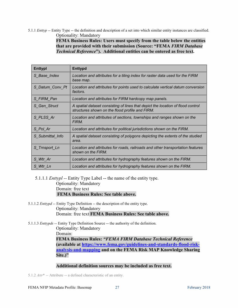
5.1.1 Enttyp -- Entity Type -- the definition and description of a set into which similar entity instances are classified. Optionality: Mandatory FEMA Business Rules: Users must specify from the table below the entities that are provided with their submission (Source: “FEMA FIRM Database Technical Reference”). Additional entities can be entered as free text.
5.1.1.1 Enttypl -- Entity Type Label -- the name of the entity type.
Optionality: Mandatory Domain: free text FEMA Business Rules: See table above.
5.1.1.2 Enttypd -- Entity Type Definition -- the description of the entity type.
Optionality: Mandatory Domain: free text FEMA Business Rules: See table above.
5.1.1.3 Enttypds -- Entity Type Definition Source -- the authority of the definition.
Optionality: Mandatory Domain: FEMA Business Rules: “FEMA FIRM Database Technical Reference (available at https://www.fema.gov/guidelines-and-standards-flood-risk-analysis-and-mapping and on the FEMA Risk MAP Knowledge Sharing Site.)” Additional definition sources may be included as free text.
5.1.2 Attr* -- Attribute -- a defined characteristic of an entity.
Enttypl Enttypd
S_Base_Index Location and attributes for a tiling index for raster data used for the FIRM base map.
S_Datum_Conv_Pt Location and attributes for points used to calculate vertical datum conversion factors.
S_FIRM_Pan Location and attributes for FIRM hardcopy map panels.
S_Gen_Struct A spatial dataset consisting of lines that depict the location of flood control structures shown on the flood profile and FIRM.
S_PLSS_Ar Location and attributes of sections, townships and ranges shown on the FIRM.
S_Pol_Ar Location and attributes for political jurisdictions shown on the FIRM.
S_Submittal_Info A spatial dataset consisting of polygons depicting the extents of the studied area.
S_Trnsport_Ln Location and attributes for roads, railroads and other transportation features shown on the FIRM.
S_Wtr_Ar Location and attributes for hydrography features shown on the FIRM.
S_Wtr_Ln Location and attributes for hydrography features shown on the FIRM.
FEMA NFIP Metadata Profile: Basemap 28 February 2018
Optionality: Optional for FEMA 5.1.2.1 Attrlabl -- Attribute Label -- the name of the attribute.
Optionality: Optional for FEMA Domain: free text
5.1.2.2 Attrdef -- Attribute Definition -- the description of the attribute.
Optionality: Optional for FEMA Domain: free text
5.1.2.3 Attrdefs -- Attribute Definition Source -- the authority of the definition.
Optionality: Optional for FEMA Domain: free text
5.1.2.4 Attrdomv* -- Attribute Domain Values -- the valid values that can be assigned for an attribute.
Optionality: Optional for FEMA 5.1.2.4.1 Edom – enumerated domain (value & definition & source)
Optionality: Optional for FEMA 5.1.2.4.2 Rdom – range domain
Optionality: Optional for FEMA 5.1.2.4.3 Codesetd – codeset domain
Optionality: Optional for FEMA 5.1.2.4.4 Udom – unrepresentable domain
Optionality: Optional for FEMA 5.1.2.5 Begdatea* -- Beginning Date of Attribute Values -- earliest or only date for which the attribute values are current. In cases when a range of dates are provided, this is the earliest date for which the information is valid.
Optionality: Optional Domain: free date
5.1.2.6 Enddatea* -- Ending Date of Attribute Values -- latest date for which the information is current. Used in cases when a range of dates are provided.
Optionality: Optional Domain: free date
5.1.2.7 Attrvai -- Attribute Value Accuracy Information -- an assessment of the accuracy of the assignment of attribute values.
Optionality: Optional 5.1.2.7.1 Attrva – attribute value accuracy
Optionality: Optional 5.1.2.7.2 Attrvae – attribute value accuracy explanation
Optionality: Optional 5.1.2.8 Attrmfrq -- Attribute Measurement Frequency -- the frequency with which attribute values are added.
Optionality: Optional Domain: "Unknown" "As needed" "Irregular" "None planned" free text
5.2 Overview* -- Overview Description -- summary of, and citation to detailed description of, the information content of the data set.
FEMA NFIP Metadata Profile: Basemap 29 February 2018
Optionality: Mandatory for FEMA 5.2.1 Eaover -- Entity and Attribute Overview -- detailed summary of the information contained in a data set.
Optionality: Mandatory Domain: FEMA Business Rules: “The Basemap submission is made up of several data themes containing both spatial and attribute information. These data together represent the current basemap layers for the subject area as identified by FEMA”.
5.2.2 Eadetcit* -- Entity and Attribute Detail Citation -- reference to the complete description of the entity types, attributes, and attribute values for the data set.
Optionality: Mandatory Domain: FEMA Business Rules: “FEMA’s FIRM Database Technical Reference contains a detailed description of the data themes and references to other relevant information”.
6 distinfo – Distribution Information – information about the distributor of and options for obtaining the dataset. *
Optionality: Mandatory for FEMA FEMA Business Rules: This section is required for all FGDC-Framework-Basemap submissions. The distributor of the data can be either FEMA or the publisher of the metadata.
6.1 Distrib -- Distributor -- the party from whom the data set may be obtained.
Optionality: Mandatory FEMA Business Rules: If FEMA is the Distributor (6.1) of the data, then the FEMA information for the elements provided below should be used. If FEMA is not the Distributor of the FIRM data, then contact information for the Distributor must be provided in Section 6.1.
6.1.1 -- Contact Information -- Identity of, and means to communicate with, person(s) and organization(s) associated with the data set.
Optionality: Mandatory 6.1.1.1 Cntperp2 -- Contact Person Primary -- the name of the individual to which the contact type.
Optionality: Optional FEMA Business Rules: Contact Person Primary (Cntperp 6.1.1.1) is not used; Contact Organization Primary (Cntorgp 6.1.1.2) serves as primary contact.
6.1.1.2 Cntorgp2 -- Contact Organization Primary -- the organization, and the member of the organization associated with the data set. Used in cases where the association of the organization to the data set is more significant than the association of the person to the data set.
Optionality: Mandatory Domain: Compound
FEMA NFIP Metadata Profile: Basemap 30 February 2018
6.1.1.2.1 Cntorg -- Contact Organization -- the name of the organization to which the contact type applies.
Optionality: Mandatory Domain: free text FEMA Business Rules: FEMA, Mapping Information Platform
6.1.1.2.2 Cntper -- Contact Person -- the name of the individual to which the contact type applies. Optionality: Optional Domain: free text
6.1.1.3 Cntpos -- Contact Position -- the title of individual.
Optionality: Optional Domain: free text
6.1.1.4 Cntaddr* -- Contact Address -- the address for the organization or individual.
Optionality: Mandatory 6.1.1.4.1 Addrtype -- Address Type -- the information provided by the address.
Optionality: Mandatory Domain: free text FEMA Business Rules: mailing address
6.1.1.4.2 Address* -- Address -- an address line for the address.
Optionality: Mandatory for FEMA Domain: free text FEMA Business Rules: 500 C Street, S.W.
6.1.1.4.3 City -- City -- the city of the address.
Optionality: Mandatory Domain: free text FEMA Business Rules: Washington
6.1.1.4.4 State -- State or Province -- the state or province of the address.
Optionality: Mandatory Domain: free text FEMA Business Rules: District of Columbia
6.1.1.4.5 Postal -- Postal Code -- the ZIP or other postal code of the address.
Optionality: Mandatory Domain: free text FEMA Business Rules: 20472
6.1.1.4.6 Country -- Country -- the country of the address.
Optionality: Mandatory for FEMA Domain: free text FEMA Business Rules: USA
6.1.1.5 Cntvoice* -- Contact Voice Telephone -- the telephone number by which individuals can speak to the organization or individual.
Optionality: Mandatory
FEMA NFIP Metadata Profile: Basemap 31 February 2018
Domain: free text FEMA Business Rules: 1-877-336-2627
6.1.1.6 Cnttdd* -- Contact TDD/TTY Telephone -- the telephone number by which hearing-impaired individuals can contact the organization or individual.
Optionality: Optional Domain: free text
6.1.1.7 Cntfax* -- Contact Facsimile Telephone -- the telephone number of a facsimile machine of the organization or individual.
Optionality: Optional Domain: free text
6.1.1.8 Cntemail* -- Contact Electronic Mail Address -- the address of the electronic mailbox of the organization or individual.
Optionality: Mandatory for FEMA Domain: free text FEMA Business Rules: [email protected]
6.1.1.9 Hours -- Hours of Service -- time period when individuals can speak to the organization or individual. Optionality: Optional Domain: free text
6.1.1.10 Cntinst -- Contact Instructions -- supplemental instructions on how or when to contact the individual or organization.
Optionality: Optional Domain: free text
6.2 Resdesc -- Resource Description -- the identifier by which the distributor knows the data set. Optionality: Optional for FEMA Domain: free text
6.3 Distliab -- Distribution Liability -- statement of the liability assumed by the distributor.
Optionality: Mandatory Domain: free text FEMA Business Rules: “No warranty expressed or implied is made by FEMA regarding the utility of the data on any other system nor shall the act of distribution constitute any such warranty”.
6.4 Stdorder* -- Standard Order Process -- the common ways in which the data set may be obtained or received, and related instructions and fee information.
Optionality: Mandatory for FEMA FEMA Business Rules: Note: the child elements, <nondig> (6.4.1) and <digform> (6.4.2) are mutually exclusive (i.e., only one can occur within a given <stdorder> element).
6.4.1 Nondig -- Non-digital Form -- the description of options for obtaining the data set on non-computer- compatible media.
Optionality: Optional Domain: free text
FEMA NFIP Metadata Profile: Basemap 32 February 2018
6.4.2 Digform* -- Digital Form -- the description of options for obtaining the data set on computer-compatible media
Optionality: Mandatory 6.4.2.1 Digtinfo -- Digital Transfer Information - description of the form of the data to be distributed.
Optionality: Mandatory
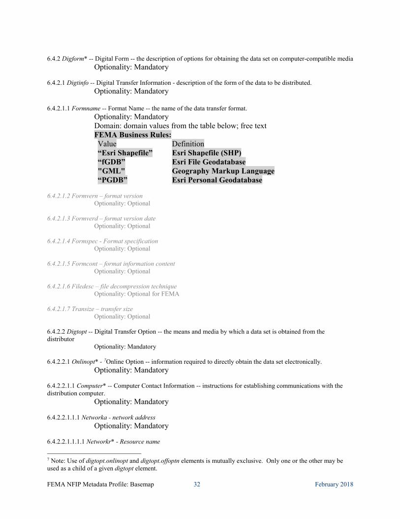
6.4.2.1.1 Formname -- Format Name -- the name of the data transfer format. Optionality: Mandatory Domain: domain values from the table below; free text FEMA Business Rules: Value Definition “Esri Shapefile” Esri Shapefile (SHP) “fGDB” Esri File Geodatabase "GML" Geography Markup Language “PGDB” Esri Personal Geodatabase
6.4.2.1.2 Formvern – format version
Optionality: Optional 6.4.2.1.3 Formverd – format version date
Optionality: Optional 6.4.2.1.4 Formspec - Format specification
Optionality: Optional 6.4.2.1.5 Formcont – format information content
Optionality: Optional 6.4.2.1.6 Filedesc – file decompression technique
Optionality: Optional for FEMA 6.4.2.1.7 Transize – transfer size
Optionality: Optional 6.4.2.2 Digtopt -- Digital Transfer Option -- the means and media by which a data set is obtained from the distributor
Optionality: Mandatory 6.4.2.2.1 Onlinopt* - 7Online Option -- information required to directly obtain the data set electronically.
Optionality: Mandatory 6.4.2.2.1.1 Computer* -- Computer Contact Information -- instructions for establishing communications with the distribution computer.
Optionality: Mandatory 6.4.2.2.1.1.1 Networka - network address
Optionality: Mandatory 6.4.2.2.1.1.1.1 Networkr* - Resource name
7 Note: Use of digtopt.onlinopt and digtopt.offoptn elements is mutually exclusive. Only one or the other may be used as a child of a given digtopt element.
FEMA NFIP Metadata Profile: Basemap 33 February 2018
Optionality: Mandatory Domain: FEMA Business Rules: https://hazards.fema.gov or URL where dataset may be obtained.
6.4.2.2.1.2 Accinstr -- Access Instructions -- instructions on the steps required to access the data set.
Optionality: Optional 6.4.2.2.1.3 Oncomp – Online Computer and Operating system
Optionality: Optional 6.4.2.2.2 Offoptn7 -- Offline Option -- information about media-specific options for receiving the data set.
Optionality: Optional 6.4.2.2.2.1 Offmedia – Offline Media
Optionality: Optional Domain: free text
6.4.2.2.2.2 Reccap – recording capacity
Optionality: Optional 6.4.2.2.2.3 Recfmt – recording format
Optionality: Optional 6.4.2.2.2.4 Compat – compatibility information
Optionality: Optional 6.4.3 Fees -- Fees -- the fees and terms for retrieving the data set.
Optionality: Mandatory Domain: FEMA Business Rules: “Contact Distributor” free text
6.4.4 Ordering -- Ordering Instructions -- general instructions and advice about, and special terms and services provided for, the data set by the distributor.
Optionality: Optional Domain: free text
6.4.5 Turnarnd -- Turnaround -- typical turnaround time for the filling of an order.
Optionality: Optional Domain: free text
6.5 Custom -- Custom Order Process -- description of custom distribution services available, and the terms and conditions for obtaining these services.
Optionality: Optional for FEMA Domain: free text
6.6 Techpreq -- Technical Prerequisites -- description of any technical capabilities that the consumer must have to use the data set in the form(s) provided by the distributor.
Optionality: Optional Domain: free text
6.7 Availabl -- Available Time Period -- the time period when the data set will be available from the distributor.
Optionality: Optional
FEMA NFIP Metadata Profile: Basemap 34 February 2018
Domain: timeperiod (single, multiple, range of dates)
7 metainfo – Metadata Reference Information – information on the currentness of the metadata information and the responsible party.
Optionality: Mandatory FEMA Business Rules: This section is required for all FGDC-compliant metadata.
7.1 Metd -- Metadata Date -- the date that the metadata were created or last updated.
Optionality: Mandatory Domain: single_date FEMA Business Rules: Must be in the form of YYYYMMDD
7.2 Metrd -- Metadata Review Date -- the date of the latest review of the metadata entry.
Optionality: Optional Domain: free date; Metadata Review Date later than Metadata Date
7.3 Metfrd -- Metadata Future Review Date -- the date by which the metadata entry should be reviewed.
Optionality: Optional Domain: free date; Metadata Future Review Date later than Metadata Review Date
7.4 Metc -- Metadata Contact -- the party responsible for the metadata information.
Optionality: Mandatory 7.4.1 Cntinfo – Contact Information -- Identity of, and means to communicate with, person(s) and organization(s) associated with the data set.
Optionality: Mandatory 7.4.1.1 Cntperp8 -- Contact Person Primary -- the name of the individual to which the contact type.
Optionality: Mandatory Domain: Compound
7.4.1.1.1 Cntper -- Contact Person -- the name of the individual to which the contact type applies.
Optionality: Mandatory Domain: free text
7.4.1.1.2 Cntorg -- Contact Organization -- the name of the organization to which the contact type applies.
Optionality: Mandatory Domain: free text
7.4.1.2 Cntorgp8 -- Contact Organization Primary -- the organization, and the member of the organization associated with the data set. Used in cases where the association of the organization to the data set is more significant than the association of the person to the data set.
Optionality: Optional FEMA Business Rules: Contact Organization Primary (Cntorgp 7.4.1.2) is not used; Contact Person Primary (Cntperp 7.4.1.1) serves as primary contact.
8 Note: Use of the Cntinfo.Cntperp and Cntinfo.Cntorgp elements is mutually exclusive. Cntinfo.Cntperp is specified in this context as mandatory so the Cntinfo.Cntorgp element must not be used here.
FEMA NFIP Metadata Profile: Basemap 35 February 2018
7.4.1.3 Cntpos -- Contact Position -- the title of individual.
Optionality: Optional Domain: free text
7.4.1.4 Cntaddr* -- Contact Address -- the address for the organization or individual.
Optionality: Mandatory 7.4.1.4.1 Addrtype -- Address Type -- the information provided by the address.
Optionality: Mandatory Domain: free text
7.4.1.4.2 Address* -- Address -- an address line for the address.
Optionality: Mandatory for FEMA Domain: free text
7.4.1.4.3 City -- City -- the city of the address.
Optionality: Mandatory Domain: free text
7.4.1.4.4 State -- State or Province -- the state or province of the address.
Optionality: Mandatory Domain: free text
7.4.1.4.5 Postal -- Postal Code -- the ZIP or other postal code of the address.
Optionality: Mandatory Domain: free text
7.4.1.4.6 Country -- Country -- the country of the address.
Optionality: Mandatory for FEMA Domain: free text
7.4.1.5 Cntvoice* -- Contact Voice Telephone -- the telephone number by which individuals can speak to the organization or individual.
Optionality: Mandatory Domain: free text
7.4.1.6 Cnttdd* -- Contact TDD/TTY Telephone -- the telephone number by which hearing-impaired individuals can contact the organization or individual.
Optionality: Optional Domain: free text
7.4.1.7 Cntfax* -- Contact Facsimile Telephone -- the telephone number of a facsimile machine of the organization or individual.
Optionality: Optional Domain: free text
7.4.1.8 Cntemail* -- Contact Electronic Mail Address -- the address of the electronic mailbox of the organization or individual. Optionality: Mandatory for FEMA
Domain: free text
FEMA NFIP Metadata Profile: Basemap 36 February 2018
7.4.1.9 Hours -- Hours of Service -- time period when individuals can speak to the organization or individual.
Optionality: Optional Domain: free text
7.4.1.10 Cntinst -- Contact Instructions -- supplemental instructions on how or when to contact the individual or organization.
Optionality: Optional Domain: free text
7.5 Metstdn -- Metadata Standard Name -- the name of the metadata standard used to document the data set.
Optionality: Mandatory Domain: "FGDC Content Standard for Digital Geospatial Metadata" free text
7.6 Metstdv -- Metadata Standard Version -- identification of the version of the metadata standard used to document the data set.
Optionality: Mandatory Domain: “FGDC-STD-001-1998”, free text
7.7 Mettc -- Metadata Time Convention -- form used to convey time of day information in the metadata entry. Used if time of day information is included in the metadata for a data set.
Optionality: Optional for FEMA Domain: "local time" "local time with time differential factor" "universal time"
7.8 Metac -- Metadata Access Constraints -- restrictions and legal prerequisites for accessing the metadata. These include any access constraints applied to assure the protection of privacy or intellectual property, and any special restrictions or limitations on obtaining the metadata.
Optionality: Optional Domain: free text
7.9 Metuc -- Metadata Use Constraints -- restrictions and legal prerequisites for using the metadata after access is granted. These include any metadata use constraints applied to assure the protection of privacy or intellectual property, and any special restrictions or limitations on using the metadata.
Optionality: Optional Domain: free text
7.10 Metsi -- Metadata Security Information -- handling restrictions imposed on the metadata because of national security, privacy, or other concerns.
Optionality: Optional 7.10.1 Metscs -- Metadata Security Classification System -- name of the classification system for the metadata.
Optionality: Optional Domain: free text
7.10.2 Metsc -- Metadata Security Classification -- name of the handling restrictions on the metadata.
Optionality: Optional Domain: "Top secret" "Secret" "Confidential" "Restricted" "Unclassified" "Sensitive" free text
7.10.3 Metshd -- Metadata Security Handling Description -- additional information about the restrictions on handling the metadata.
Optionality: Optional Domain: free text
FEMA NFIP Metadata Profile: Basemap 37 February 2018
7.11 Metextns* -- Metadata Extensions a reference to extended elements to the standard which may be defined by a metadata producer or a user community. Extended elements are elements outside the Standard, but needed by the metadata producer. If extended elements are created, they must follow the guidelines in Appendix D, Guidelines for Creating Extended Elements to the Content Standard for Digital Geospatial Metadata.
Optionality: Mandatory for FEMA 7.11.1 Onlink* -- Online Linkage -- the name of an online computer resource that contains the metadata extension information for the data set. Entries should follow the Uniform Resource Locator convention of the Internet.
Optionality: Mandatory for FEMA Domain: FEMA Business Rules: Two onlinks are required: - Link to URL on MIP for information on this profile: https://hazards.fema.gov - Link to the data’s Ethernet POWERLINK Standardization Group (EPSG) code (in the form of a URL). More info about EPSG code can be found at: https://www.epsg.org/.
7.11.2 Metprof -- Profile Name -- the name given to a document that describes the application of the Standard to a specific user community.
Optionality: Mandatory for FEMA Domain: FEMA Business Rules: “FEMA NFIP Metadata Content and Format Standard”
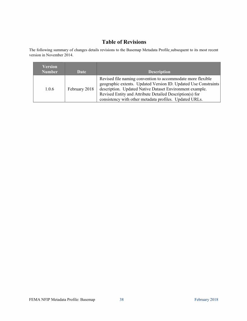
FEMA NFIP Metadata Profile: Basemap 38 February 2018
Table of Revisions The following summary of changes details revisions to the Basemap Metadata Profile subsequent to its most recent version in November 2014.
Version Number Date Description
1.0.6 February 2018
Revised file naming convention to accommodate more flexible geographic extents. Updated Version ID. Updated Use Constraints description. Updated Native Dataset Environment example. Revised Entity and Attribute Detailed Description(s) for consistency with other metadata profiles. Updated URLs.