Embed Size (px)
Citation preview
Fire Rescue Training Techniques
Exchange with Bangkok, Hanoi, Jakarta, Kuala Lumpur, and Taipei
Objective: To develop rescue technique trainersTo systematically develop emergency responders’ abilities to cope with a range of challenging, complex disasters by passing on fire rescue training techniques.
Overview: Two-phased programDomestic training: Fire/rescue members in leadership positions are accepted from participating cities as trainees.Overseas training: After completion of the domestic training session, participants return home to become trainers. TFD instructors are then sent to the training sessions held by these new trainers to confirm their skills and provide support.
<Past Achievements>
Details: Examples of basic fire rescue skills instruction• Ropework (for equipment & people) • One rope bridge crossing/Rappelling • High angle rescue • Confined space rescue • NBC (nuclear, biological and chemical) disaster management• Victim transportation • Safety management awareness
75
InfrastructureD
isaster preventionEnvironm
entH
ealth, IndustryFire Rescue Tokyo Fire Department No. 35
Session for rope rescue anchor creation
Session for horizontal stretcher rescue froma single suspension point
Session for a ladder rescue (with a victim trapped below)
Session for rappeling
YEAR & CITY Foreign Trainees Accepted TFD Members Sent Out Local Training Session Participants2008: Bangkok 6 5 602009: Kuala Lumpur 2 3 212010: Bangkok 6 3 752011: Jakarta 2 5 342012: Bangkok 6 5 402013: Hanoi 6 3 482014: Hanoi 6 3 512015: Jakarta 5 - -2016: Taipei 6 3 80
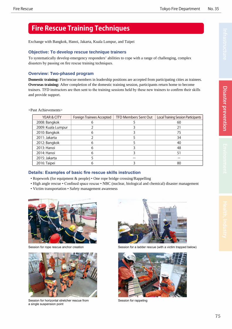
Fussa Higashimurayama
Mitaka Akasaka
Hongo
ShimuraSenju
Joto
Oi
Shibuya-kuHachioji City
NBC Fire Rescue Task Forces
Fire station with hazmat unit
9th HQ Fire Rescue Task Forces
3rd HQFire Rescue Task Forces
Response Technology for Special Incidents (e.g. NBC*)(*nuclear, biological, and chemical)
Exchange with France, Korea, Taiwan, the United States, Vietnam, etc.
Objective: To respond to special disastersTo handle hazmat/NBC disasters.
Overview: Fire Rescue Task Forces for NBC disasters and Hazmat UnitsThe 3rd and 9th Fire Rescue Task Forces are in service as “high-performance” units to specially deal with hazmat/NBC disasters. In addition, there are nine Hazmat Units that are specially equipped for chemical disasters.
TFD Service Area
Details: Special vehicles & equipmentSpecial vehicles and equipment are deployed to the 3rd and 9th Fire District HQ Fire Rescue Task Forces.
77
InfrastructureD
isaster preventionEnvironm
entH
ealth, IndustryFire Rescue Tokyo Fire Department No. 36
Special Incident TrucksSpecial incident trucks carry advanced equipment, such as analyzing equipment, to respond to NBC disasters. The TFD is the only organization in Japan to have special incident trucks with enhanced radiation protection features such as barriers of lead and water to shield the vehicle, as well as positive air pressure inside the vehicle.
Rescue RobotThe remote-controlled arms of the robot remove debris. The robot’s conveyor belt is used to rescue victims by drawing them inside.
Detection RobotThe remote-controlled cameras of the robot are used for fact-finding at disaster scenes that cannot be entered by rescue personnel. Its instruments also detect and measure radiation, flammable gases, chemicals, and other substances.

Fire Department Earthquake Preparedness SystemsExchange with China, France, Israel, Portugal, Romania, and the United States
Objective: To mitigate earthquake damageTo mitigate earthquake damage by putting together and systemizing necessary information in data systems to help emergency responders take appropriate action immediately after a devastating earthquake.
Overview: Temporal and spatial understanding of the disaster situation and firefighting capabilitiesA set of 10 unique systems was developed to support the TFD’s firefighting activities for earthquake damage mitigation. The systems allow temporal and spatial understanding of the disaster situation such as fire and building collapse (outbreaks and spread estimates), and response capabilities such as the number of firefighters and vehicles that can be mobilized.
Details: Examples of systems●Earthquake Damage Estimation SystemThis system estimates the risk of fire outbreaks, fatalities, building/ground damage, road obstructions and other kinds of damage immediately after an earthquake.
● Fire Spread Simulation SystemThis system estimates both the spread of fire and the number of necessary firefighting units based on weather conditions (e.g. wind direction/velocity), city composition, expected building collapse, and other factors, and depicts this on maps where necessary information such as building shape, structure, and number of floors have been entered beforehand.
79
InfrastructureD
isaster preventionEnvironm
entH
ealth, IndustryFire Rescue Tokyo Fire Department No. 37
1 hour later
Bldg. Collapse Estimates (Ward A)Fatality Estimates (Ward A)Fire Outbreak Estimates (Ward A)
Damage Estimation (64 items) *EXAMPLE
*EXAMPLE*EXAMPLE*EXAMPLE
2 hours later 3 hours later
Fire Spread Simulation System
Earthquake Damage Estimation System
Ward: ANumber of Fires: ○○ Burned Area: ○○○○m2
Number of Fatalities: ○○•••
Fires Fatalities Building Collapse
Make roadside buildings fire and earthquake resistant
Rebuilding for fireproofing; construct community roads, parks, etc.
Build shared residences, etc., through projects that have legal authority
Form firebreak belts; develop evacuation/rescue routes
Fireproof Zone
Designated Route for Improvement
Improvement of Districts with Close-Set Wooden Houses Objective: To turn areas with close-set wooden houses into communities that do not burn or spread fireOf areas with close-set wooden houses, which contain a high concentration of aging wooden structures, those expected to sustain particularly serious damage when a major earthquake occurs have been designated as development districts*.In order to eliminate this danger, Tokyo is promoting the fireproofing of these neighborhoods and development of firebreak belts in an integrated manner.
*Districts covering an area totaling approx. 6,900 ha(About 11% of the land area of the wards, containing about 300,000 wooden houses and a population of about 1.8 million people)
Overview: Prompt resolution of issues through two initiativesTokyo designates areas in particular need of improvement as fireproof zones, and is promoting the fireproofing of buildings through tax incentives and subsidies for the cost of rebuilding.In addition, Tokyo designates roads that will be effective in blocking the spread of fire and facilitating evacuation as designated routes for improvement. While extending support to property rights holders to assist them in rebuilding their lives, Tokyo works for early completion of these roads.
Details: Examples of initiatives1) Fireproof zones
• Provision of subsidies to cover demolition costs and design costs to rebuild houses
• Reduction/exemption of Tokyo Metropolitan tax
• Provision of plans by experts to support displaced residents
• House-to-house surveys of local residents’ needs
2) Designated routes for improvement• Conducting surveys on residents/businesses
in the area regarding their wishes; establishment of consultation desks using private sector businesses
• Assistance with relocation expenses, finding replacement land for relocation or introducing metropolitan housing
81
InfrastructureD
isaster preventionEnvironm
entH
ealth, IndustryEarthquake Preparedness Bureau of Urban Development No. 38
Replacement of an old wooden building with a fireproof one
Development of a city-planned road
Seismic Resistance of Buildings along Disaster Response Routes
Objective: To prevent the blockage of disaster response routes following a major earthquake
Overview: Carrying out seismic inspections and retrofitting• It is mandatory for owners of buildings located alongside designated routes to carry out seismic inspections• The TMG subsidizes building owners for the cost of seismic retrofitting.
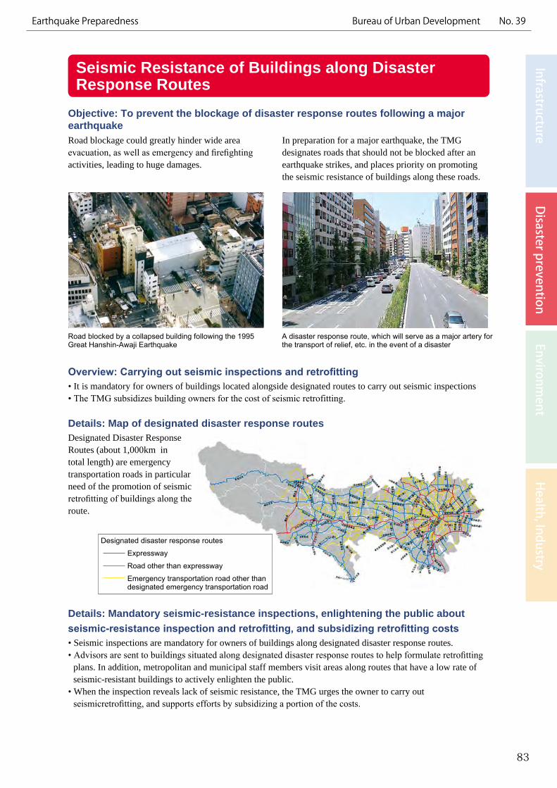
Details: Map of designated disaster response routesDesignated Disaster Response Routes (about 1,000km in total length) are emergency transportation roads in particular need of the promotion of seismic retrofitting of buildings along the route.
Details: Mandatory seismic-resistance inspections, enlightening the public about seismic-resistance inspection and retrofitting, and subsidizing retrofitting costs• Seismic inspections are mandatory for owners of buildings along designated disaster response routes.• Advisors are sent to buildings situated along designated disaster response routes to help formulate retrofitting
plans. In addition, metropolitan and municipal staff members visit areas along routes that have a low rate of seismic-resistant buildings to actively enlighten the public.
• When the inspection reveals lack of seismic resistance, the TMG urges the owner to carry out seismicretrofitting, and supports efforts by subsidizing a portion of the costs.
83
InfrastructureD
isaster preventionEnvironm
entH
ealth, IndustryEarthquake Preparedness Bureau of Urban Development No. 39
Road blocked by a collapsed building following the 1995 Great Hanshin-Awaji Earthquake
A disaster response route, which will serve as a major artery for the transport of relief, etc. in the event of a disaster
Road blockage could greatly hinder wide area evacuation, as well as emergency and firefighting activities, leading to huge damages.
In preparation for a major earthquake, the TMG designates roads that should not be blocked after an earthquake strikes, and places priority on promoting the seismic resistance of buildings along these roads.
Designated disaster response routes
Expressway
Road other than expressway
Emergency transportation road other than designated emergency transportation road
Measures to Suppress the Surfacing of Manholes Due to Liquefaction
Exchange with New Zealand
Objective: To mitigate the uplift of manholes and ensure transportation functionsLiquefaction from the strong shaking of an earthquake could result in buoyant forces lifting the manholes. As this would have a large impact on sewer functions and passage of emergency vehicles, manholes are being fitted with mechanisms to prevent uplifting during an earthquake.
Overview: Releasing excess pressure into the manholesThis technology installs pressure control devices on the wall of the manhole, and by releasing the excess pressure generated from liquefaction into the manhole, the uplift of the manhole is suppressed.
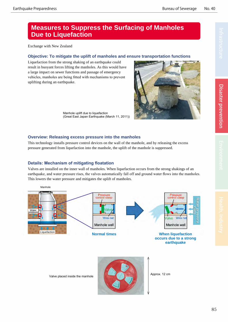
Details: Mechanism of mitigating floatationValves are installed on the inner wall of manholes. When liquefaction occurs from the strong shakings of an earthquake, and water pressure rises, the valves automatically fall off and ground water flows into the manholes. This lowers the water pressure and mitigates the uplift of manholes.
85
InfrastructureD
isaster preventionEnvironm
entH
ealth, IndustryEarthquake Preparedness Bureau of Sewerage No. 40
Manhole uplift due to liquefaction(Great East Japan Earthquake (March 11, 2011))
Valve placed inside the manholeApprox. 12 cm
Manhole
Normal times When liquefaction occurs due to a strong
earthquake
Water pressure
Liquefaction
Collection and Provision of Ground Survey ResultsObjective: To broadly use ground survey data to implement measures for disaster preparedness, construction, and the environmentTokyo has created a database of ground survey results to be used as a basic reference source for earthquake measures, including liquefaction measures, and the construction of urban infrastructure. The database is also available online for broad use of the information by the residents of Tokyo.
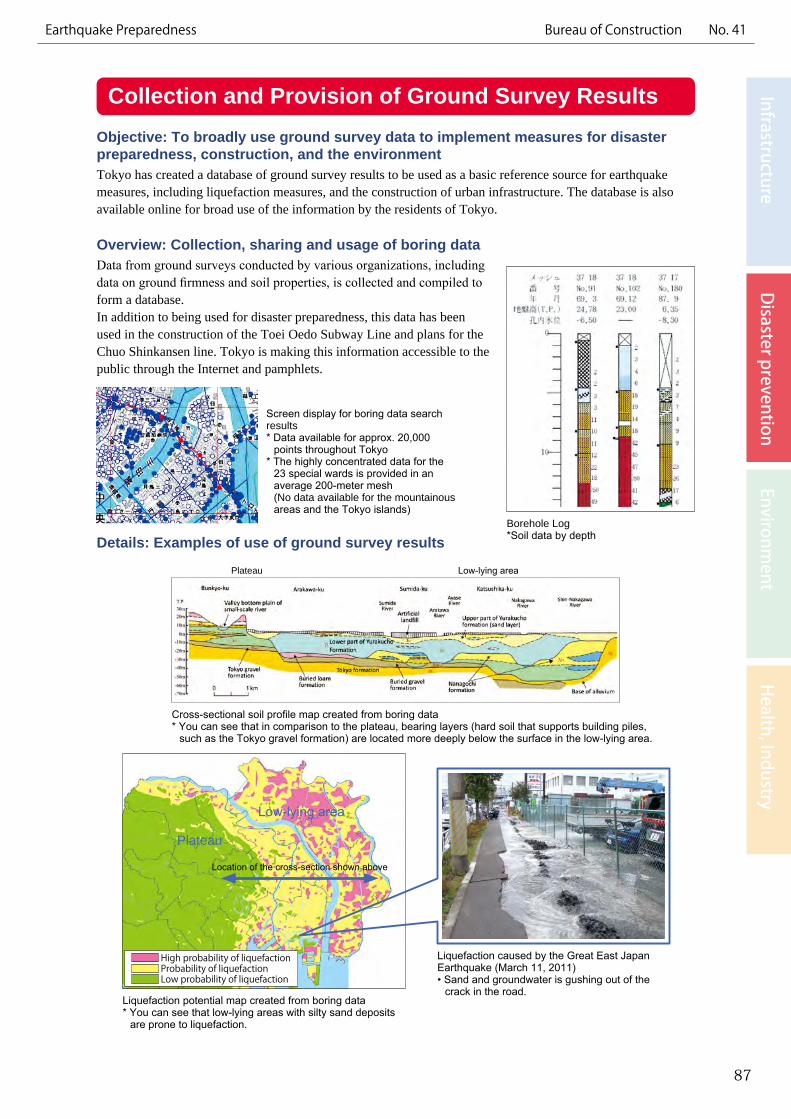
Overview: Collection, sharing and usage of boring data Data from ground surveys conducted by various organizations, including data on ground firmness and soil properties, is collected and compiled to form a database.In addition to being used for disaster preparedness, this data has been used in the construction of the Toei Oedo Subway Line and plans for the Chuo Shinkansen line. Tokyo is making this information accessible to the public through the Internet and pamphlets.
Details: Examples of use of ground survey results
87
InfrastructureD
isaster preventionEnvironm
entH
ealth, IndustryEarthquake Preparedness Bureau of Construction No. 41
Screen display for boring data search results* Data available for approx. 20,000
points throughout Tokyo* The highly concentrated data for the
23 special wards is provided in an average 200-meter mesh(No data available for the mountainous areas and the Tokyo islands)
Cross-sectional soil profile map created from boring data* You can see that in comparison to the plateau, bearing layers (hard soil that supports building piles,
such as the Tokyo gravel formation) are located more deeply below the surface in the low-lying area.
Liquefaction potential map created from boring data* You can see that low-lying areas with silty sand deposits
are prone to liquefaction.
Liquefaction caused by the Great East Japan Earthquake (March 11, 2011)• Sand and groundwater is gushing out of the
crack in the road.
Borehole Log*Soil data by depth
High probability of liquefactionProbability of liquefactionLow probability of liquefaction
Plateau
Low-lying area
Location of the cross-section shown above
Plateau Low-lying area
Floodgate
Floodwall gate
Development and Management of Shoreline Protection Facilities
Objective: To prevent flood damage caused by storm surges and tsunamisFacilities protect the lowland waterfront area of Tokyo, which makes up approximately 40% of the land of the ward area and has a population of about 3.0 million, from flood damage caused by storm surges and tsunamis.
Overview: Structural and non-structural measures● Technology related to the construction of shoreline protection
facilities such as floodgates, seawalls, and interior embankment structures
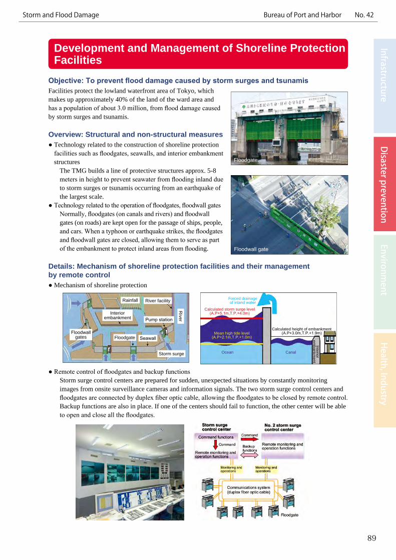
The TMG builds a line of protective structures approx. 5-8 meters in height to prevent seawater from flooding inland due to storm surges or tsunamis occurring from an earthquake of the largest scale.
● Technology related to the operation of floodgates, floodwall gatesNormally, floodgates (on canals and rivers) and floodwall gates (on roads) are kept open for the passage of ships, people, and cars. When a typhoon or earthquake strikes, the floodgates and floodwall gates are closed, allowing them to serve as part of the embankment to protect inland areas from flooding.
Details: Mechanism of shoreline protection facilities and their management by remote control● Mechanism of shoreline protection
● Remote control of floodgates and backup functions
Storm surge control centers are prepared for sudden, unexpected situations by constantly monitoring images from onsite surveillance cameras and information signals. The two storm surge control centers and floodgates are connected by duplex fiber optic cable, allowing the floodgates to be closed by remote control. Backup functions are also in place. If one of the centers should fail to function, the other center will be able to open and close all the floodgates.
89
InfrastructureD
isaster preventionEnvironm
entH
ealth, IndustryStorm and Flood Damage Bureau of Port and Harbor No. 42
Rainfall River facility
Interior embankment Pump station
River
Floodwall gates Floodgate Seawall
Storm surge
Forced drainageof inland water
Interiorem
bankment
Calculated storm surge level(A.P+5.1m,T.P.+4.0m)
Calculated height of embankment(A.P+3.0m,T.P.+1.9m)Mean high tide level
(A.P+2.1m,T.P.+1.0m)
Ocean Canal
Reduction of Flood Damage through River Basin Measures Objective: To reduce flood damage• We aim to reduce urban flood damage by inhibiting the direct flow of rainwater into rivers and the sewer
system during a torrential downpour through maximum use of rainwater retention and rainwater infiltration.
Overview: Implementation of river basin measures• Installation of rainwater storage and infiltration facilities at public facilities such as schoolyards and parks• Promotion of the installation of rainwater runoff control facilities through efforts such as subsidizing programs
conducted by the municipalities for installation of infiltration inlets at private residences
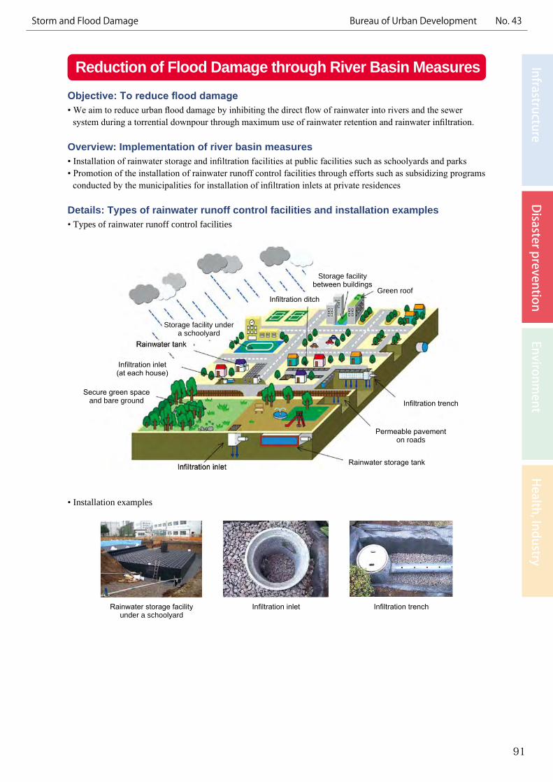
Details: Types of rainwater runoff control facilities and installation examples• Types of rainwater runoff control facilities
• Installation examples
91
InfrastructureD
isaster preventionEnvironm
entH
ealth, IndustryStorm and Flood Damage Bureau of Urban Development No. 43
Rainwater storage facility under a schoolyard
Infiltration inlet Infiltration trench
Secure green space and bare ground
Permeable pavement on roads
Rainwater storage tank
Storage facility under a schoolyard
Storage facility between buildings
Infiltration inlet (at each house)
Infiltration ditch
Infiltration trench
Green roof
2005 torrential rain (Myoshoji River)1982 typhoon (Kanda River)
Flood Control through Regulating ReservoirsExchanges with Seoul and Beijing, etc.
Objective: To prevent flood damage caused by typhoons and torrential rainsWith torrential rains occurring more frequently in recent years, the TMG is promoting the improvement of small and medium-sized rivers to protect the lives and livelihoods of Tokyo citizens from floods resulting from typhoons and heavy rains.
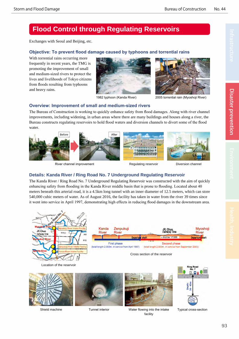
Overview: Improvement of small and medium-sized riversThe Bureau of Construction is working to quickly enhance safety from flood damages. Along with river channel improvements, including widening, in urban areas where there are many buildings and houses along a river, the Bureau constructs regulating reservoirs to hold flood waters and diversion channels to divert some of the flood water.
Details: Kanda River / Ring Road No. 7 Underground Regulating ReservoirThe Kanda River / Ring Road No. 7 Underground Regulating Reservoir was constructed with the aim of quickly enhancing safety from flooding in the Kanda River middle basin that is prone to flooding. Located about 40 meters beneath this arterial road, it is a 4.5km long tunnel with an inner diameter of 12.5 meters, which can store 540,000 cubic meters of water. As of August 2016, the facility has taken in water from the river 39 times since it went into service in April 1997, demonstrating high effects in reducing flood damages in the downstream area.
93
InfrastructureD
isaster preventionEnvironm
entH
ealth, IndustryStorm and Flood Damage Bureau of Construction No. 44
River channel improvement Regulating reservoir Diversion channel
Underground regulating reservoir
River Diversion Channel
Location of the reservoir
Shield machine Tunnel interior Typical cross-sectionWater flowing into the intake facility
Cross section of the reservoir
Before After
Flood damage
Flood Control through Sewerage Storage Facilities
Objective: Mitigation of flood damage To make Tokyo a safe and sound place for its residents by securing urban functions through the advancement of measures to control flooding in the event of localized intense rainfall, which has been occurring frequently in recent years. One way to mitigate flood damage is to temporarily store stormwater in sewer system storage facilities.
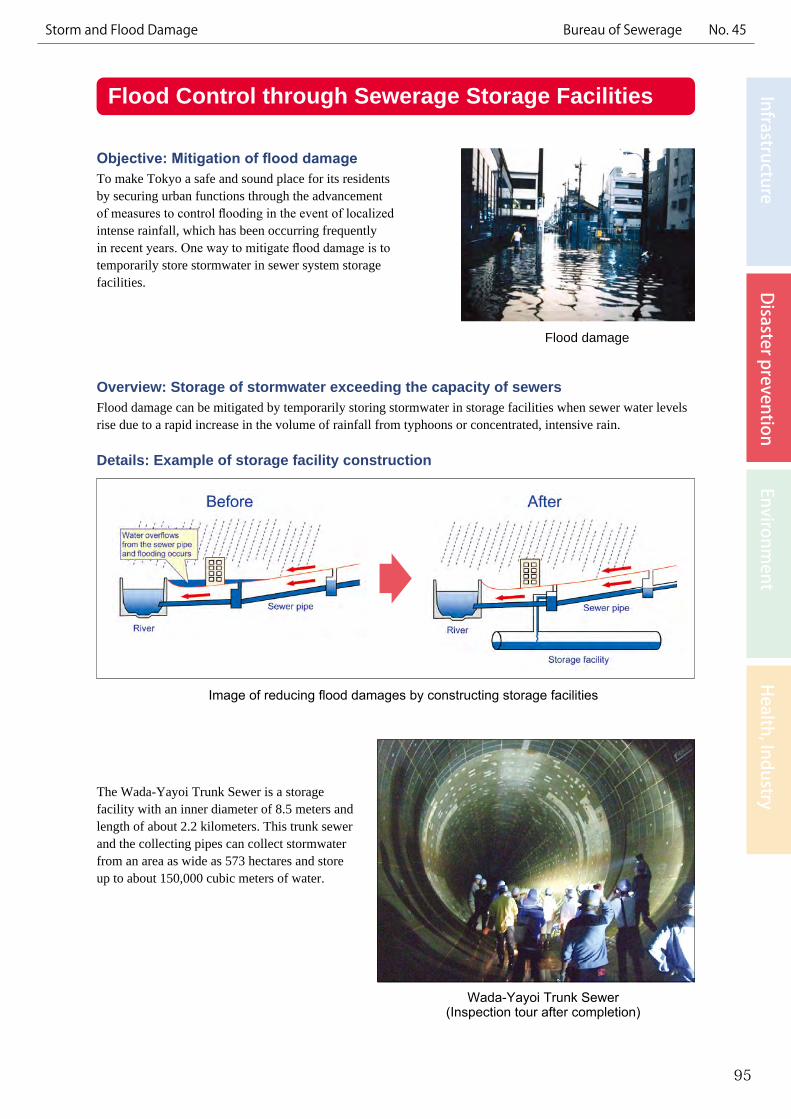
Overview: Storage of stormwater exceeding the capacity of sewersFlood damage can be mitigated by temporarily storing stormwater in storage facilities when sewer water levels rise due to a rapid increase in the volume of rainfall from typhoons or concentrated, intensive rain.
Details: Example of storage facility construction
The Wada-Yayoi Trunk Sewer is a storage facility with an inner diameter of 8.5 meters and length of about 2.2 kilometers. This trunk sewer and the collecting pipes can collect stormwater from an area as wide as 573 hectares and store up to about 150,000 cubic meters of water.
95
InfrastructureD
isaster preventionEnvironm
entH
ealth, IndustryStorm and Flood Damage Bureau of Sewerage No. 45
Image of reducing flood damages by constructing storage facilities
Wada-Yayoi Trunk Sewer(Inspection tour after completion)
Rise in river level (Meguro River)
Information Provision on Heavy Rainfall and FloodingExchange with Tigre (Argentina) and the United States, etc.
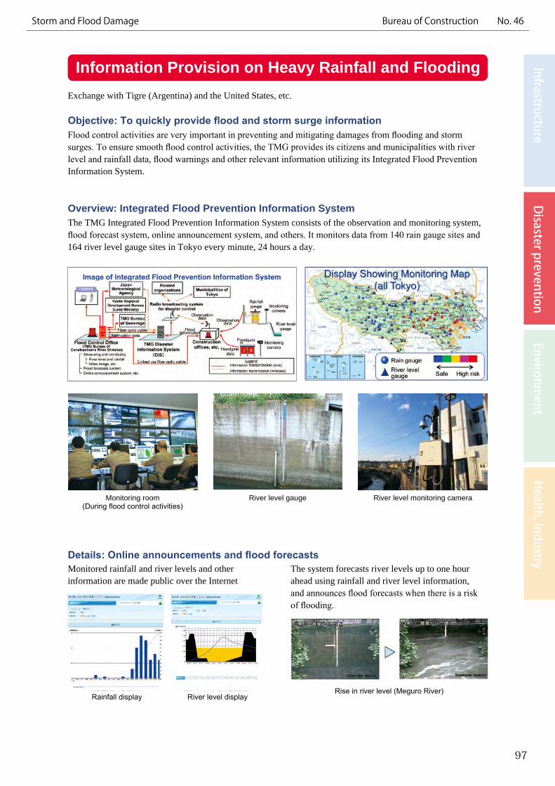
Objective: To quickly provide flood and storm surge informationFlood control activities are very important in preventing and mitigating damages from flooding and storm surges. To ensure smooth flood control activities, the TMG provides its citizens and municipalities with river level and rainfall data, flood warnings and other relevant information utilizing its Integrated Flood Prevention Information System.
Overview: Integrated Flood Prevention Information SystemThe TMG Integrated Flood Prevention Information System consists of the observation and monitoring system, flood forecast system, online announcement system, and others. It monitors data from 140 rain gauge sites and 164 river level gauge sites in Tokyo every minute, 24 hours a day.
Details: Online announcements and flood forecasts
97
InfrastructureD
isaster preventionEnvironm
entH
ealth, IndustryStorm and Flood Damage Bureau of Construction No. 46
Monitoring room (During flood control activities)
River level gauge River level monitoring camera
Monitored rainfall and river levels and other information are made public over the Internet
The system forecasts river levels up to one hour ahead using rainfall and river level information, and announces flood forecasts when there is a risk of flooding.
Rainfall display River level display