Embed Size (px)
Citation preview
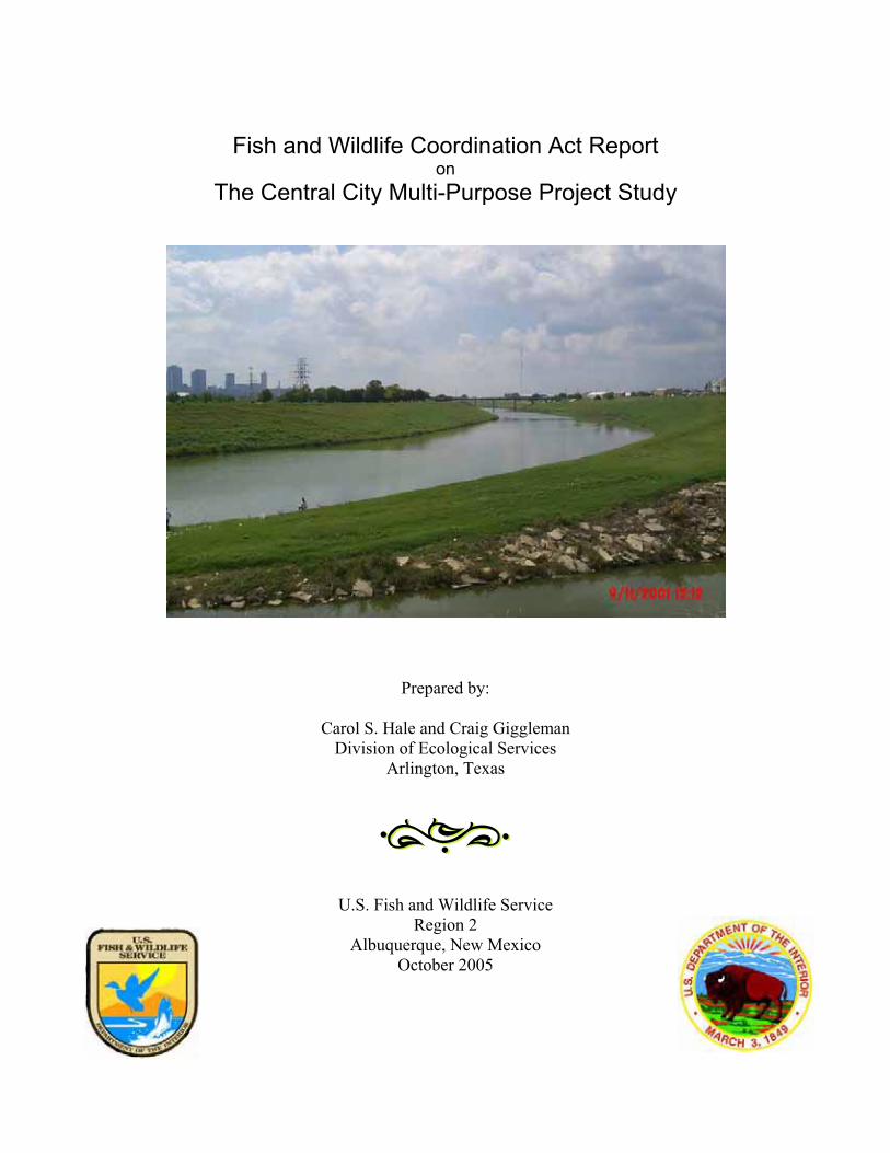
Fish and Wildlife Coordination Act Report on
The Central City Multi-Purpose Project Study
Prepared by:
Carol S. Hale and Craig GigglemanDivision of Ecological Services
Arlington, Texas
U.S. Fish and Wildlife ServiceRegion 2
Albuquerque, New Mexico October 2005
i
Executive Summary
This document constitutes the Secretary of the Interior’s report for the Central City Interim Feasibility Study in accordance with Section 2(b) of the Fish and Wildlife Coordination Act (FWCA) and is meant to accompany the U.S. Army Corps of Engineers (Corps’) final Detailed Project Report. The purpose of this report is to identify and evaluate anticipated impacts of implementing the proposed project on fish and wildlife resources within the Trinity River floodplain in Tarrant County, Texas and to recommend conservation and mitigation measures for resource protection.
The Corps initiated this study at the request of Tarrant Regional Water District (TRWD) to examine opportunities to reduce flood damage, restore ecosystems, and provide additional and improved recreational opportunities along the West and Clear Forks of the Trinity River and its tributaries within the City of Fort Worth. Implementing the proposed Central City locally preferred plan (LPP), known as the Community Based Alternative, provides the basic infrastructure for the proposed overall City of Fort Worth’s plan known as the Trinity River Vision Master Plan. In December 2004, the U.S. Congress authorized the Corps in Section 216 of the Consolidated Appropriation Act, 2005, to undertake the Central City project as generally described in the Trinity River Vision Master Plan. The sponsor anticipates that this plan would transform the Central City project area into a thriving business and urban residential development to boost the local economy.
Due to the lack of suitable habitat and the urbanized character of the project area, it is unlikely that any federally listed threatened or endangered species would utilize any of the study areas.Consequently, no adverse affects to federally listed species are expected to occur by implementation of any of the proposed alternatives.
The U.S. Fish and Wildlife Service (Service) is concerned that implementation of the LPP would result in the loss of highly productive shallow lotic riffle-pool sequences on Marine Creek and the loss of lotic habitat on lower Lebow Creek. The habitats at Marine and Lebow Creeks currently support exceptional fish communities, therefore, mitigation in the form of stream restoration or enhancement would be necessary. The Service supports the Corps’ September 13, 2005 habitat mitigation plan that includes stream mitigation and enhancement for the Lebow Creek and Ham Branch. The Service looks forward to assisting in the development of detail specifications of this mitigation plan.
Although the degree and extent of sediment contamination in the project area is unknown, the Service is concerned that there is a likelihood that contaminated sediments would be re-suspended into the water column from the excavation activities proposed in the LPP. Consequently, the Service recommends that the degree and extent of sediment contamination within the project area be further analyzed prior to the commencement of excavation operations. The Service is also concerned that the proposed project would result in an increase in road-base pollutants (i.e., oil, grease, metals, etc.) in storm water runoff, thus adversely affecting water
ii
quality in the Trinity River. The Service recommends implementing best management practices that minimize or eliminate pollutants entering the river.
The Service is concerned that wetlands, riparian woodlands, and upland woodlands would be impacted by the proposed LPP. However, the proposed habitat improvement efforts in the Riverbend, Rockwood, and West Fork South zones would adequately compensate for this loss. The riparian woodlands developed beyond that required for mitigating the riparian woodland habitat that would be lost due to the LPP, could serve as out-of-kind compensation for the impacted upland woodlands. The upland woodlands habitat being impacted in the Riverbend area is good quality and it would take time for the proposed developed woodlands to mature into what was lost. The Service also recommends that a habitat management and monitoring plan be developed for the habitat restoration sites.
The Service commends the Corps and the sponsor for incorporating the habitat improvement and aquatic mitigation plans into the Community Based Alternative. These efforts would fully compensate for the impacts caused by this alternative to the Category 3 and 4 habitats within the project area. The Service recommends that future plans for the project area incorporate more aspects of the conceptual Ecosystem Restoration Plan throughout the project area, such as creating riparian woodlands along the West Fork of the Trinity River east of Interstate Highway 35, development of a nature area with an outdoor interpretive infrastructure, and restoring riparian buffers that could assist in maintaining water quality. These actions would provide additional benefits to fish and wildlife resources, and the public’s enjoyment of these resources, throughout the entire area.
Finally, the Principles and Guidelines Based Alternative appears to be the least environmentally damaging action. However, it does not meet the congressionally mandated objectives for this project. The ecosystem restoration included in the Community Based Alternative, along with our recommendations stated above, will compensate for natural resources impacted by the project.
iii
Acknowledgements
We thank the U.S. Army Corps of Engineers (Corps), Fort Worth District, Planning, Environmental and Regulatory Division for providing the U.S. Fish and Wildlife Service the opportunity to be involved in the planning of the Central City Project and for providing the information necessary for completing this report. We especially acknowledge the work of Billy Colbert, Environmental Planner, and Larry Thornton, Geographical Information Specialist, of the Corps. Mr. Colbert assisted with field work, data analysis and review, and provided most information regarding the planning of the proposed project. Mr. Thornton provided the GIS layers and information required for completing this document.
We also thank Danny Allen and Gordon Linam of the Texas Parks and Wildlife Department. Mr. Allen assisted with field work, and reviewed and provided input on the planning aid reports and this document. Mr. Linam assisted with field work and provided technical expertise that was essential in completing the planning aid reports.
We would also like to express our deepest gratitude to Brent Bristow, Curtis Hoagland (former Service employee), Jacob Lewis, and Tom Cloud of the Fish and Wildlife Service. Mr. Bristow and Mr. Hoagland assisted in conducting field work. Mr. Lewis, using the GIS information provided by the Corps, created maps and provided information necessary for the habitat and alternatives analysis. Mr. Cloud reviewed all supportive reports generated by the Service and provided insightful guidance necessary in completing this report.
iv
Table of Contents
Executive Summary ......................................................................................................................... i Acknowledgements........................................................................................................................ iii Table of Contents........................................................................................................................... iv List of Tables .................................................................................................................................. v List of Figures ................................................................................................................................ vi Introduction..................................................................................................................................... 1 Background Information................................................................................................................. 2
Interagency Biologist Group Ecosystem Restoration Plan......................................................... 4 Description of the Project Area....................................................................................................... 6 Fish and Wildlife Resource Concerns and Planning Objectives .................................................... 7 Evaluation Methods ........................................................................................................................ 8 Description of Fish and Wildlife Resources ................................................................................. 10
Aquatic Habitats........................................................................................................................ 10 Terrestrial Habitats.................................................................................................................... 12 Endangered and Threatened Species ........................................................................................ 18
Project Plan Alternatives and Objectives...................................................................................... 19 No Action Alternative............................................................................................................... 19 Community Alternative ............................................................................................................ 19 Principles & Guidelines Alternative ......................................................................................... 21
Alternative Impacts Analysis and Discussion............................................................................... 24 Future Without Project.............................................................................................................. 27 Future With Community Alternative ........................................................................................ 28 Future With Principles & Guidelines Alternative..................................................................... 30
Evaluation and Comparison of the Locally Preferred Plan and Alternatives ............................... 31 Recommended Fish and Wildlife Conservation Measures........................................................... 32 Summary of Findings and FWS Position...................................................................................... 34 Literature Cited ............................................................................................................................. 36 Appendices.................................................................................................................................... 41
v
List of Tables
Table 1. HSI Values for the Existing Riparian Woodland Habitat per Indicator Species within the Central City Project Area...................................................................................................... 13
Table 2. HSI Values for the Existing Grassland Habitat per Indicator Species within the Central City Project Area................................................................................................................... 13
Table 3. HSI Values for the Existing Upland Forest Habitat per Indicator Species within the Central City Project Area...................................................................................................... 14
Table 4. HSI Values for the Existing Emergent Wetlands per Indicator Species within the Central City Project Area...................................................................................................... 14
Table 5. Summary of Existing Habitat Acres, Suitibility Indices, and Habitat Units ................. 15 Table 6. Estimated Future Habitat Acres and AAHUs Without Project...................................... 25 Table 7. Estimated Alternative Impacts to Habitats Within 50 Years......................................... 26

vi
List of Figures
Figure 1. Habitat within the Central City Project Area ................................................................. 3 Figure 2. Ecosystem Restoration Plan ........................................................................................... 5 Figure 3. Community Based Alternative ..................................................................................... 20 Figure 4. Ham Branch Habitat Restoration.................................................................................. 22 Figure 5. Principles and Guidelines Alternative .......................................................................... 23
1
Fish and Wildlife Coordination Act Report on the
Central City Interim Feasibility Study
Introduction
This document constitutes the Secretary of the Interior’s report on the Central City Interim Feasibility Study. It is submitted by the U.S. Fish and Wildlife Service (Service) to the U.S. Army Corps of Engineers (Corps) under the authority, and in accordance with, Section 2(b) of the Fish and Wildlife Coordination Act (FWCA) (48 Stat. 401, as amended; 16 U.S.C. 661 etseq.) to accompany the Corps’ final Detailed Project Report. It has been coordinated with the Texas Parks and Wildlife Department (TPWD) as noted in the letter in the Appendix, dated June 17, 2005.
The purpose of this report is to identify and evaluate anticipated impacts of implementing the proposed project on fish and wildlife resources within the Trinity River floodplain in Tarrant County, Texas and to recommend conservation and mitigation measures for resource protection. This report is based on the data collected during field investigations by the Service, TPWD, and Corps staff; information received from the Corps and project sponsor, Tarrant Regional Water District (TRWD); and review comments from TPWD. Several planning aid reports and memorandums have previously been submitted to the Corps regarding the existing environmental conditions within the project area.
Authority for the Corps’ investigations on the Upper Trinity River Basin was given by the U.S. Senate Committee on Environmental Public Works Resolution dated April 22, 1988. The Corps initiated this study at the request of TRWD to examine opportunities to reduce flood damage, restore ecosystems, and provide additional and improved recreational opportunities along the West and Clear Forks of the Trinity River and its tributaries within the City of Fort Worth. In December, 2004, the U.S. Congress authorized the Corps to undertake the Central City project as generally described in the April 2003 Trinity River Vision Master Plan. The Trinity River Vision Master Plan is a cooperative initiative between the TRWD, Streams and Valleys (a local non-profit parks organization), City of Fort Worth, and Corps with input from several private entities and businesses. The sponsor anticipates that this plan would transform the Central City area into a thriving business and urban residential development to boost the local economy.
This report includes (1) a summary of the habitat assessments and studies conducted by the Service throughout the Central City project planning process, (2) an impact analysis of the Corps’ planning alternatives, and (3) recommendations on conservation and mitigation measures to reduce adverse project related impacts. A more detailed description of existing habitat conditions can be found in the following reports and memorandums the Service has previously submitted to the Corps:
Residual Organochlorine Pesticide Contamination in Fish Collected from the Trinity River within the Proposed Central City Multi-purpose Projects Area,
2
Tarrant County, Texas, April 2004. Existing Habitat Conditions Planning Aid Report for the Central City Interim Feasibility Study, Fort Worth, Texas, June 18, 2004. December 2, 2004 memorandum. HSIs and Analysis for the Central City Project Extended Area Upstream.Baseline Fisheries Survey of Marine Creek within the Proposed Central City Multi-Purpose Project Area, Tarrant County, Texas, January 2005. February 1, 2005 Memorandum. Corrections for the HSI Averages contained in the December 2, 2004 memo regarding the Central City Project Extended Area Upstream.Baseline Fisheries Survey of Lebow Creek within the Proposed Central City Multi-Purpose Project Area, Tarrant County, Texas, April 2005. Baseline Fisheries Survey of Ham Branch, Tarrant County, Texas, July 20, 2005. Numerous Emails providing information and comments throughout the planning process.
A complete citation for these reports is included in the Literature Cited section of this document.
Background Information
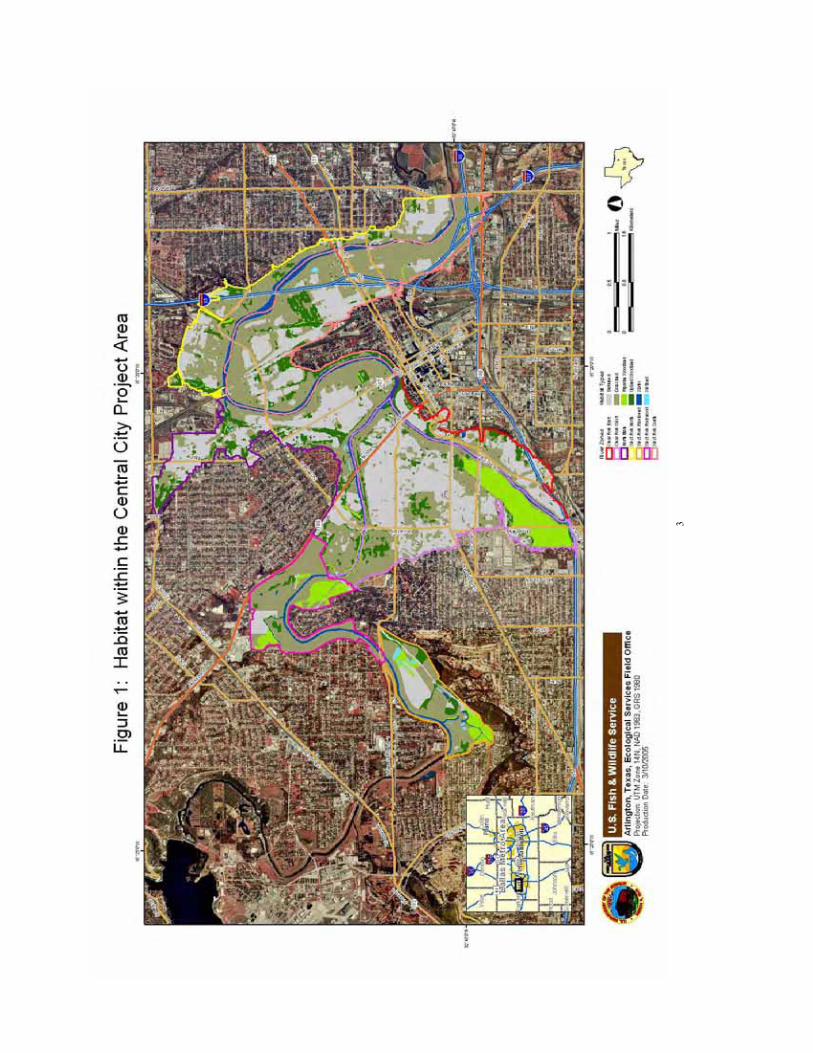
The proposed Central City project area is located in proximity of the confluence of the West and Clear Forks of the Trinity River adjacent to the heavily urbanized downtown Fort Worth business district, within the flood plain known as the Fort Worth Floodway in Tarrant County, Texas (Figure 1). The current floodway is part of a Corps project completed in 1957, and extended in 1971, to provide flood protection for central areas of the City located within the former flood plains of the Trinity River. The 1957 project consisted of widening and straightening sections of 9.9 miles of the river and building a series of levees along each side. Aquatic natural resources in the river were substantially modified by this and other flood damage reduction activities completed later.
The Corps has conducted numerous flood control investigations in the Upper Trinity River Basin since the mid-1980s leading up to the current planning efforts. The June 13, 2000 ProgrammaticEnvironmental Impact Statement (PEIS), Upper Trinity River Basin, Trinity River, Texasidentified 90 preliminary potential projects addressing flood damage reduction, ecosystem restoration, and recreation. That year, the Fort Worth District Corps of Engineers (Corps) initiated the West and Clear Forks of the Trinity River Interim Feasibility Study which included a group of flood control, ecosystem restoration, and recreation projects that are proposed along the West and Clear Forks of the Trinity River and several tributaries between Benbrook Lake and Highway East Loop 820. Investigations of the project area were conducted by Service personnel in October 2000 and January, February, April, and May 2001, and a FWCA planning aid report was completed November 3, 2001 (USFWS, 2001).
The Central City project is the second of the comprehensive West and Clear Forks of the Trinity River Interim Feasibility Study projects in Tarrant County, Texas. It was initiated in 2001 at the request of TRWD to evaluate potential modifications to the existing levee system that would
3
4
enhance current levels of flood protection, facilitate urban revitalization, restore components of the natural riverine system in the project area, and provide major quality of life enhancements for regional citizens.
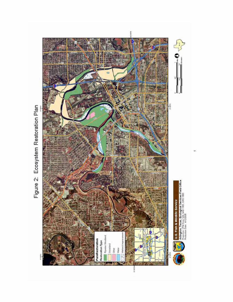
Interagency Biologist Group Ecosystem Restoration Plan
On January 15, 2002, a group of interagency biologists convened to discuss the existing and potential wildlife habitats along the Trinity River in Tarrant County. This group included biologists from the TPWD, Corps, Environmental Protection Agency, Stream Team (an interagency advisory group), and the Service. The mission of this group was to find ways to maintain, enhance, and restore the physical and ecological integrity of the Trinity River watershed in Tarrant County, thereby increasing the long-term economic and recreation values of the river. This group developed an ecosystem preservation and restoration plan for the Central City Planning effort, which included all the river zones, except the Riverbend and Rockwood zones as these zones were added to the project area after the restoration plan was developed. The habitat restoration recommendations were based on the 1981 soils report (USDA, 1981). It became known as the Ecosystem Restoration Plan (Figure 2). The purpose of this plan was to provide a wide range of project alternatives for the Central City project that would present opportunities within the project area to:
- Restore “natural” geomorphic characteristics of the river, such as sinuosity, pools, riffles, and runs by creating a more stable system with reduced amounts of erosion, sediment load, and flooding; and have more aquatic habitat and esthetics values. These characteristics could help improve water quality. - Restore, enhance, or create habitat in the project area to include herbaceous wetlands, riverine aquatics, riparian (bottomland) woodland, and native grassland. This would provide continuous riparian habitat connectivity along at least one side for the river to serve as a wildlife corridor.
Major aspects of this alternative would include: 1. Cutting back portions of the bank to create stream-side wetlands for aquatic habitat
and assist in flood control and reducing velocity. 2. Creating off-stream herbaceous wetlands. 3. Relocating portions of the levee system to provide for restored habitats. 4. Planting native trees and shrubs to create bottomland hardwood woodlands. The
location would depend on soils. 5. Planting native grasses and herbs to create native prairies. The location would depend
on soils. 6. Allow development of Main Street as a thriving business area with restaurants, shops,
ball park, trails, and an amphitheater. Other types of recreation and entertainment amenities could be available.
7. Constructing a Cultural/Outdoor Interpretation Center.
5
.
6
The Ecosystem Restoration Plan, in its entirety, is not meant to be a proposed alternative for consideration in this project. The Ecosystem Restoration Plan is conceptual, since the biologistsdid not have all the information required to refine the plan, such as boundaries of the project area, elevations, 100-year floodplain line, historic site locations, the boundaries of the ballpark and amphitheater, and other restrictions. This plan was used to identify habitat restoration opportunities within the project area and could be used for planning future projects and management plans.
Description of the Project Area
The study area encompasses approximately 5,322.04 acres along approximately 2.4 miles of the Clear Fork of the Trinity River from Interstate Highway 30 north to the confluence of the West Fork and 12 miles of the West Fork of the Trinity River from the Riverbend Nature Area to Riverside Drive. The project area was divided by the Corps into six river zones for project planning convenience (Figure 1). The Clear Fork West (CFW) zone is located west of the confluence, between the south shore of the West Fork and the north shore of the Clear Fork. The Clear Fork East (CFE) zone is located along the southeast shore of the Clear Fork between I-30 and the confluence. The North Main (NM) zone is located along the north shore of the West Fork between Rockwood Park and Samuels Avenue. The West Fork North (WFN) zone is located along the north shore of the West Fork between Samuels Avenue and Riverside Drive. The West Fork South (WFS) zone is located along the south shore of the West Fork between the confluence and Riverside Drive. The West Fork Riverbend/Rockwood zone is located along both sides of the river between 16th Street and Dennis Street. The Service separated this zone into two sections at White Settlement Road for analysis. This report will refer to these two zones as the Rockwood zone and the Riverbend zone for a total of seven zones to be discussed in this report. The Rockwood zone includes portions of Rockwood Park and Municipal Golf Course and the Greenwood Cemetery lands. The Riverbend zone is located along the south side of the river, with a bluff bordering the southeast boundary, and west of the River Crest Country Club.
The project area is located within the Grand Prairie of the Cross Timbers and Prairies ecoregion of Texas and the Fort Worth Prairie natural vegetational area (Diggs et al. 1999). Historically, the area was open prairie with a few scattered post oak (Quercus stellata) and live oak (Quercusvirginiana) motts. Ashe juniper (Juniperus ashei) and mesquite (Prosopis grandulosa) trees grew in some areas (USDA 1981). The bottomland woodlands were predominately pecan (Caryaillinoensis), elms (Ulmus sp.), and oaks (Quercus sp.).
Soil types within the project area are dominated by the Frio soil series, which are nearly level, deep clayey soils (USDA 1981). Trees that are suitable for this soil type are American elm (Ulmus americana), cedar elm (Ulmus crassifolia), hackberry (Celtis sp.), oaks, pecan, red bud (Cercis canadensis), and sweetgum (Liquidambar styraciflua). The tree species noted most often in the project area during the study were pecan, American elm, cedar elm, hackberry, black willow (Salix nigra), red mulberry (Morus rubra), and cottonwood (Populus deltoides).

7
Historically, little bluestem (Schizachyrium scoparium), silver bluestem (Bothriochloa laguroides), side-oats grama (Bouteloua curtipendula), tall grama (Bouteloua pectinata), and buffalograss (Buchloe dactyloides) were the predominate grass species (Diggs et al. 1999). Most of these grasses have been eliminated in the Cross Timbers ecoregion through extensive livestock grazing and urban development. The predominate grasses now are Texas wintergrass (Nassella leucotricha), Canada wildrye (Elymus canadensis), bermudagrass (Cynodon dactylon),and johnsongrass (Sorghun halepense), with many other less common grasses, such as common sandbur (Cenchrus spinifex), crabgrass (Digitaria sp.), dallisgrass (Paspalum dilatatum), Hall’s panicum (Panicum hallii), purple lovegrass (Erogrostis spectabilis), lovegrass (Eragrostis sp.),old field threeawn (Aristida oligantha), panic grass (Panicum sp.), silver bluestem (Bothriochloalaguroides), stinkgrass (Eragrostis cilianensis), Texas panicum (Panicum texanum), white tridens (Tridens albescens), wild oats (Chasmanthium latifolium), windmill grass (Chloris verticillata), and wooly rosette grass (Panicum acuminatum).
The project area is used by both resident and migratory wildlife species that are somewhat tolerant of human activity. Migratory waterfowl and shorebirds, and resident wood ducks (Aixsponsa), use the river and its tributaries and local emergent wetlands. The woodlands are most likely used by a variety of migratory and resident passerine bird, owl, and hawk species. Some common resident bird species that may be observed in the study area are sparrow (Emberizidaesp.), northern mockingbird (Mimus polyglottos), American robin (Turdus migratorius), northern cardinal (Cardinalis cardinalis), blue jay (Cyanocitta cristata), common grackle (Quiscalus quiscula), scissor-tailed flycatcher (Tyrannus forficatus), common crow (Corvusbrachyrhynchos), American kestrel (Falco sparverius), and red-tailed hawk (Buteo jamaicensis). Mammals that may utilize the different habitat types in the study area include raccoon (Procyonlotor), striped skunk (Mephitis mephitis), opossum (Didelphis virginiana), coyote (Canislatrans), bobcat (Lynx rufus), eastern cottontail (Sylvilagus floridanus), fox squirrel (Sciurusniger), and small rodents. Various species of frogs and turtles may be found in the river and wetlands, while lizards and snakes can be found throughout the study area. A list of faunal and floral species that were observed during field investigations in the project area is included on each observation sheet in Appendix B in the Service’s June 18, 2004 report.
Fish and Wildlife Resource Concerns and Planning Objectives
A June 2004 City of Fort Worth public meeting announcement states that the locally preferred plan (LPP) for the Central City project includes “widening and deepening the meandering Trinity River to create a waterfront similar to Town Lake in Austin or San Antonio's River Walk while addressing ecosystem restoration activities, trail developments, and linkages to neighborhoods, downtown and other special areas such as the Cultural and Historical districts.” The LPP, known as the Community Based Alternative, would provide the basic infrastructure for the proposed city plan, the Trinity River Vision Master Plan.
The website for the Trinity River Vision Master Plan (www.trinityrivervision.org) states that the vision of the plan is “to preserve and enhance the river corridors so that they remain as essential greenways for open space, trails, neighborhood focal points, wildlife, and special recreation
8
areas. These riparian corridors are critical elements in preserving environmental quality and a high quality of life that attracts people to locate and stay in Fort Worth. Downtown waterfront initiatives will help accomplish a renaissance of the greater Downtown area resulting in a sustainable mix of people living, working, playing, and learning in the Central City area.”
The Service is concerned that implementing the Community Based Alternative would result in the loss of an estimated 1,875 linear feet of highly productive shallow lotic riffle-pool sequences on Marine Creek and the loss of 400 feet of lotic habitat on lower Lebow Creek. The proposed project would result in the addition of approximately 120 acres of channelized aquatic lentic habitat on the Trinity River that is of limited ecological value in comparison to the lotic habitat that would be lost within Marine and Lebow Creeks.
Based on the projected significant increase in future traffic on White Settlement Road and North Main Street, the Service is also concerned about the associated increase in road-base pollutants (i.e., oil, grease, metals, etc.) in storm water runoff adversely affecting water quality in the Trinity River.
In addition, the Service is concerned that the proposed Community Based Alternative would impact an additional 8.8 acres of emergent wetlands, 34.51 acres of riparian woodlands and 67.9 acres of upland woodlands, reducing biodiversity within the project area.
Evaluation Methods
The Service’s Habitat Evaluation Procedures (HEP) (USFWS 1980) was used to evaluate the existing terrestrial habitats in the project area. These habitats were analyzed according to each river zone. The HEP requires the use of Habitat Suitability Index (HSI) models developed for indicator species that best represent groups of species that use the habitats. A complete description of the habitat analysis can be found in the Service’s June 18, 2004 planning aid report (Hale and Giggleman 2004). An interagency team comprised of Service, TPWD, and Corps personnel cooperated in collecting the habitat field data required by the HEP in 2001, 2004, and 2005 to complete this report.
Ten wildlife indicator species were selected to represent the wildlife communities that use the four habitats evaluated. The raccoon, fox squirrel, Carolina chickadee (Parus carolinensis),barred owl (Strix varia), wood duck, and red-tailed hawk were selected to represent those species that use riparian/bottomland hardwoods. The raccoon, green heron (Butorides striatus), and wood duck were selected to represent the wildlife community in emergent wetlands. The eastern meadowlark (Sturnella magna), eastern cottontail, and red-tailed hawk were selected to represent the wildlife community in the grasslands. The red-tailed hawk, hairy woodpecker (Picoidesvillosus), raccoon, and fox squirrel were selected to represent the upland forest community.
Baseline terrestrial habitat conditions are expressed as a numeric function (HSI value) ranging from 0.0 to 1.0, where 0.0 represents no suitable habitat for an indicator species and 1.0 represents optimum conditions for the species. HSI values ranging from 0.99 to 0.75 represents
9
“good” habitat. HSI values ranging from 0.74 to 0.50 represent habitats considered “average.” HSI values ranging from 0.49 to 0.25 represent habitats considered “below average.” HSI values ranging from 0.24 to 0.01 represent habitats considered “poor.” Habitat units (HU) are calculated by multiplying the numeric HSI values by the amount of acres of habitat available. The average annual habitat units (AAHUs) are calculated by summing the cumulative HU’s across all impact intervals (0, 1, 10, and 50 years) in the period of analysis and dividing the total HU’s by the number of years (50 years) in the economic life of the project.
Fish communities within the proposed project area were assessed by the Service in 2003 and 2005. These assessments consisted of conducting field sampling at multiple sites on the Trinity River, Marine Creek, Lebow Creek, and Ham Branch and evaluating the resulting data with indices of biotic integrity and a degradation index (Hale and Giggleman 2004; Giggleman and Lewis 2005a; Giggleman and Lewis 2005b; Giggleman and Lewis 2005c). An index of biotic integrity (IBI) provides a means to assess aquatic life use within a given water body using multiple metrics. The statewide IBI developed by Twidwell and Davis (1989) incorporates 12 metrics to define species richness, trophic composition, and abundance. Each one of these metrics is scored with values ranging from low (1) to high (5). In turn, aquatic life use values are determined by adding each metric score for a total score. These scores can range from limited to exceptional.
Accounting for the high variability in fish assemblages in aquatic systems between various ecological regions (eco-regions) in Texas, Linam et al. (2002) developed regionalized IBIs. The project area is located in the region designated by Linam et al. (2002) as the Subhumid Agricultural Plains which incorporates the variability of fish species inhabiting aquatic systems in Ecoregions 27 (Central Great Plains), 29 (Central Oklahoma/Texas Plains), and 32 (Texas Blackland Prairies). The regionalized IBI for this area consists of 11 metrics and incorporates many of the same metrics as the statewide IBI, with the exceptions that it emphasizes the number of native cyprinid species, eliminates the consideration of darter species as a separate metric, and breaks down the total number of individual fish sampled into individuals collected per unit effort. As with the statewide index, resulting scores can range from limited to exceptional.
Still, another method of evaluating the fish assemblage within a given water body is by determining the fish-community degradation index. Four metrics are considered in calculating this index (Land et al. 1998). These are the percent of tolerant individual fish species at the site; the percent of omnivorous fish at the site; the percent of non-native fish at the site; and the percent of fish with anomalies (disease) at the site (Moring, pers. comm. 2003). As with the IBIs, each one of these metrics is scored with values ranging from low (1) to moderate (3) to high (5). A low degradation rating is indicative of a fish community that is comprised of species that are intolerant to physical and chemical disturbances and represent a balanced trophic structure (Moring, pers. comm. 2003). Moderate degradation indicates community degradation associated with the loss of intolerant species in conjunction with the increase of tolerant, omnivorous, and/or non-native species, whereas high degradation is indicative of an assemblage that is comprised primarily of species that are omnivorous and tolerant to physical and chemical disturbances (Moring, pers. comm. 2003).
10
In addition to assessing fish community structure within the project area, an analytical contaminants screen following U.S. Environmental Protection Agency Method 8081A was performed on a subset of fish collected from the Trinity River. The purpose of this screen was to evaluate residual organochlorine pesticide contamination within these fish.
Description of Fish and Wildlife Resources
Aquatic Habitats
The Clear Fork of the Trinity River is a fourth order stream with a drainage basin that encompasses approximately 500 square miles (mi2). The West Fork of the Trinity River is a fifth order stream that drains an area consisting of approximately 2,100 mi2. The river is classified as a fifth order stream after the confluence of the two forks, with a watershed encompassing approximately 2,610 miles2. Downstream of the confluence, and within the proposed project area, the river is fed by three tributaries, Marine Creek, Lebow Creek, and Ham Branch. Marine Creek is a perennial stream that drains approximately 25 mi2. Lebow Creek is an intermittent stream with a watershed that encompasses approximately 3 mi2. Ham Branch is a perennial tributary of the West Fork of the Trinity River that appears to receive the majority of its continuous inflow (less than one cubic foot per second) and storm water from the downtown area.
Aquatic habitat within the Clear Fork, West Fork, and the Trinity River downstream of the confluence of the two forks is dominated by runs associated with deep pools resulting from previous in-stream modifications (i.e., channelization and placement of low water dams). Banks are almost vertical. Siltation and accumulation of thick organic material along the channel edges are common. In-stream structural habitat within this area consists of overhanging grassy vegetation, low water dams, bridge pilings, and concrete slabs. The substrate is dominated by silt, sand, and gravel. During assumed summer low flow conditions in 2003, water depth averaged 7 feet in the Clear Fork, 10 feet in the West Fork, and 9 feet in the river downstream of the confluence of the two forks (Hale and Giggleman 2004). Results of a baseline fisheries survey conducted by the Service in 2003, characterized the fish assemblages within this portion of the Trinity River as high. A total of 4,614 fish comprising 12 families and 30 species were collected during this survey (Hale and Giggleman 2004).
Aquatic habitat within Marine Creek from Exchange Avenue to the confluence with the Trinity River consists of approximately 1,180 linear feet of riffle habitat, 2,985 linear feet of pool habitat, and 164 linear feet of run habitat. The substrate is composed of limestone bedrock intermixed with cobble, gravel, and sand. Results of a baseline fisheries survey conducted on the creek by the Service in 2005 (Giggleman and Lewis 2005a), classified the fish community from the base of the waterfall to below the South Pacific Rail Road bridge, approximately 1,000 feet upstream of the confluence with the West Fork of the Trinity River, as exceptional, and the fish community 3,000 feet upstream of the confluence as high aquatic use value. The fish community
11
within the overall study area was characterized as exceptional. A total of 1,234 fish, representing 16 species from 6 families, were collected during this survey.
Aquatic habitat within Lebow Creek is dominated by small shallow riffle-pool sequences with similar substrate as Marine Creek (Colbert, pers. comm. 2005). Results of a baseline fisheries survey conducted on this creek by the Service in 2005 (Giggleman and Lewis 2005b), classified the fish assemblage in this stream as exceptional. A total of 463 fish, representing 12 species from 6 families, were collected during this survey.
The Service conducted a fisheries survey on Ham Branch in Harmon Field Park on May 16, 2005 (Giggleman and Lewis 2005c). A total of 231 fish, comprising 6 species from 3 families, were collected from Ham Branch. In addition, numerous crayfish were observed while sampling and four red-eared sliders (Trachemys scripta elegans), two snapping turtles (Chelydraserpentina), one pallid spiny softshell turtle (Apalone spiniferus pallidus), and one blotched water snake (Nerodia erythrogaster transversa) were collected and released. The fish community demonstrated a limited aquatic life use value. Based on this and the limited aquatic habitat observed while sampling, it appears that this stream would be a suitable site to implement mitigation measures for stream modifications expected to occur in Marine and Lebow Creeks from construction activities associated with the proposed Central City Project.
Floating litter is common along the banks of the Trinity River. The Clear Fork below 7th Street and the Trinity River downstream of the confluence of the two forks are located within a portion of the Trinity River that has been placed on the State of Texas 303(d) List as being an impaired water body (TCEQ 2002). These sections of the Trinity River are not meeting the designated fish consumption use due to elevated organochlorine contaminants in fish tissues (TCEQ 2002). A fish consumption advisory was issued for these portions of the Trinity River in 1990 and modified in 2002 (TDSHS 2003). The premise of this advisory is that persons are prohibited from possessing any species of fish from this area because of elevated polychlorinated biphenyls (PCBs), chlordane, and dichloro-diphenyl-dichloroethylene (DDE) (TDSHS 2003). Sediments collected from the Trinity River at Beach Street (downstream of the project area) between 1992 and 1993 by the U.S. Geological Survey contained elevated residual chlordane and dichloro-diphenyl-trichloroethane (DDT) isomers and metabolites (Moring 1997). Fish collected from the Clear Fork in 1996 and from the West Fork in 1996 and 1998 contained detectable amounts of chlordane (TCEQ 2001). In 2003, detectable amounts of chlordane, DDE, DDT, dieldrin, and toxaphene were measured in fish collected from the Trinity River within the project area by the Service. These organochlorine contaminants have not been commercially produced in the United States for over 15 years. Consequently, these contaminants may be entering the system either through non-point sources from stormwater run-off within the watershed or fish inhabiting this portion of the Trinity River may be accumulating these contaminants from previously contaminated sediments by direct consumption of contaminated sediments and/or the consumption of contaminated prey items and sequestering them into their body tissues (TCEQ 2001). In either case, available data does not appear to warrant modifying the current consumption advisory at this time (Tennant, pers. comm. 2005).
12
The degree and extent of contamination in sediments within the project area have not been defined nor delineated, however sediments collected from the Trinity River at Beach Street (downstream of the project area) between 1992 and 1993 by the U.S. Geological Survey contained elevated residual chlordane and dichloro-diphenyl-trichloroethane (DDT) isomers and metabolites (Moring 1997).
Terrestrial Habitats
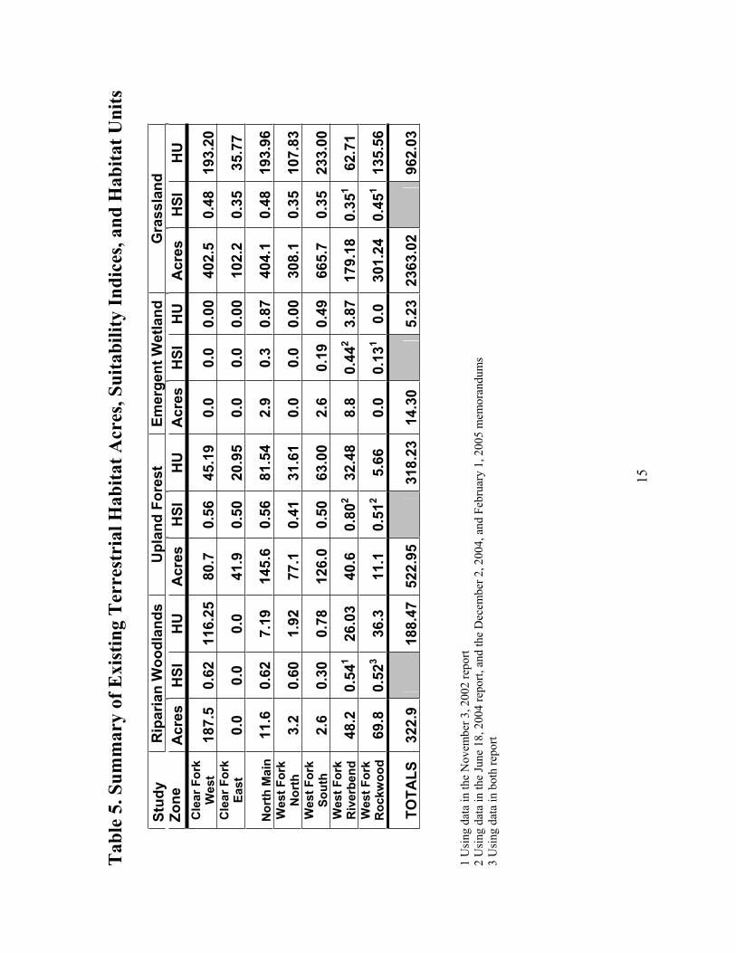
Currently, the project area contains 299.6 acres (5.6 percent) of open water, 1799.27 acres (33.8 percent) of urban development or disturbed land, and four terrestrial wildlife habitats (60.6 percent). These wildlife habitats include 322.9 acres of riparian woodlands, 2,363.02 acres of grasslands, 522.95 acres of upland woodlands, and 14.3 acres of emergent wetlands. Detailed descriptions of these habitats are contained in the Service’s June 18, 2004 planning aid report and December 2, 2004 memorandum.
The HSI values included in the June 18, 2004 report were preliminary using the data available at that time. Considering the concerns of the Corps and the sponsor, the Service determined that the grassland habitat suitability indices presented in the report, and the December 2, 2004 and February 1, 2005 memorandums, were too high for a fair assessment of impacts and the determination of required mitigation. Two of the grassland indicator species are multi-habitat users, the eastern cottontail and red-tailed hawk; therefore, the indices in the other habitats these species use required adjustments as well. Furthermore, the project boundary was expanded between the December 2004 and February 2005 reports. Considering these concerns, new information, and project changes, another review of the HEP models and field data was conducted and adjustments were made to these HSI values as shown in Tables 1-5. Tables 1-4 contain the updated HSI values for each species in each habitat, with an overall HSI value and HUs for each habitat. Table 5 displays a summary of the total acres, HSI values, and habitat units for each river zone.
Riparian Woodlands
Making up only 6.1 percent of the project area, the riparian woodlands consist of mature hard-mast producing trees along the floodway and its tributaries and areas that are periodically flooded. Riparian woodlands are complex ecosystems that contain unique habitats that are important to a variety of animals. Riparian forest habitats are essential to maintain biodiversity and provide important wildlife travel corridors. In optimum conditions, this cover type provides food, cover, nesting habitat, and living space to forest dependent species. The trees, shrubs, grasses, and forbs they contain provide food (Halls 1973), resting, migration and dispersal cover (Burk et al. 1990, Halls 1973), and breeding habitat for many fish, mammal, bird (Dickson and Huntley 1987), reptile and amphibian species (Rudolph and Dickson 1990, Brode and Bury1984). Trees, branches, and leaves falling from riparian corridors into the water provide food and cover for aquatic organisms (Cummins et al.1989, Flebbe 1999, Maser and Sedell 1994). Over hanging trees and shrubs provide shade that lowers the water temperature to a level required for healthy fish populations (Biro 1998, Cole 1983, Ringler et al. 1975, Young 1999).
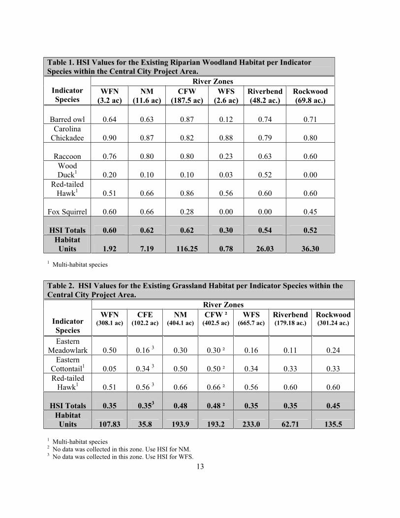
13
1 Multi-habitat species
Table 1. HSI Values for the Existing Riparian Woodland Habitat per Indicator Species within the Central City Project Area.
River ZonesIndicatorSpecies
WFN(3.2 ac)
NM(11.6 ac)
CFW(187.5 ac)
WFS(2.6 ac)
Riverbend(48.2 ac.)
Rockwood(69.8 ac.)
Barred owl 0.64 0.63 0.87 0.12 0.74 0.71Carolina
Chickadee 0.90 0.87 0.82 0.88 0.79 0.80
Raccoon 0.76 0.80 0.80 0.23 0.63 0.60WoodDuck1 0.20 0.10 0.10 0.03 0.52 0.00
Red-tailedHawk1 0.51 0.66 0.86 0.56 0.60 0.60
Fox Squirrel 0.60 0.66 0.28 0.00 0.00 0.45
HSI Totals 0.60 0.62 0.62 0.30 0.54 0.52Habitat
Units 1.92 7.19 116.25 0.78 26.03 36.30
Table 2. HSI Values for the Existing Grassland Habitat per Indicator Species within the Central City Project Area.
River Zones
IndicatorSpecies
WFN(308.1 ac)
CFE(102.2 ac)
NM(404.1 ac)
CFW ² (402.5 ac)
WFS(665.7 ac)
Riverbend(179.18 ac.)
Rockwood(301.24 ac.)
EasternMeadowlark 0.50 0.16 3 0.30 0.30 ² 0.16 0.11 0.24
EasternCottontail1 0.05 0.34 3 0.50 0.50 ² 0.34 0.33 0.33Red-tailed
Hawk1 0.51 0.56 3 0.66 0.66 ² 0.56 0.60 0.60
HSI Totals 0.35 0.353 0.48 0.48 ² 0.35 0.35 0.45Habitat
Units 107.83 35.8 193.9 193.2 233.0 62.71 135.5
1 Multi-habitat species2 No data was collected in this zone. Use HSI for NM.3 No data was collected in this zone. Use HSI for WFS.

14
1 Multi-habitat species2 No data was collected in this section. Use HSIs for North Main.3 No data was collected in this zone. Use HSI for WFS.
Table 3. HSI Values for the Existing Upland Forest Habitat per Indicator Species within the Central City Project Area.
River ZonesIndicatorSpecies WFN
(77.1 ac)CFE 3
(41.9 ac)NM
(145.6 ac)CFW ²
(80.80 ac)WFS
(126.0 ac)Riverbend
(40.6 ac.)Rockwood
(11.1 ac.)Downy
Woodpecker 0.94 0.00 3 0.67 0.67 ² 0.00 0.90 0.00Carolina
Chickadee 0.79 0.88 3 0.90 0.90 ² 0.88 0.95 0.50
Raccoon 0.55 0.80 3 0.58 0.58 ² 0.80 0.97 0.97Red-tailed
Hawk1 0.51 0.56 3 0.66 0.66 ² 0.56 0.60 0.67
Barred Owl 0.00 0.68 3 0.56 0.56 ² 0.68 0.88 0.88Eastern
Cottontail1 0.05 0.34 3 0.50 0.50 ² 0.34 0.33 0.33
Fox Squirrel 0.00 0.22 3 0.08 0.08 ² 0.22 0.98 0.22HSI Totals 0.41 0.50 3 0.56 0.56 2 0.50 0.80 0.51
HabitatUnits 31.61 20.9 81.54 45.19 63.0 32.48 5.66
Table 4. HSI Values for the Existing Emergent Wetlands perIndicator Species within the Central City Project Area.
River ZonesIndicatorSpecies
NM(2.9 ac)
WFS(2.6 ac)
Riverbend(8.8 ac.)
Green Heron 0.55 0.55 0.62Raccoon 0.26 0.00 0.17
Wood Duck1 0.10 0.03 0.52HSI Totals 0.30 0.19 0.44
Habitat Units 0.87 0.49 3.87
1 Multi-habitat Species
15
Tab
le 5
. Sum
mar
y of
Exi
stin
g T
erre
stri
al H
abita
t Acr
es, S
uita
bilit
y In
dice
s, an
d H
abita
t Uni
ts
Rip
aria
n W
oodl
ands
U
plan
d Fo
rest
Emer
gent
Wet
land
Gra
ssla
ndSt
udy
Zone
Acr
esH
SIH
UA
cres
HSI
HU
Acr
esH
SIH
UA
cres
HSI
HU
Cle
ar F
ork
Wes
t18
7.5
0.62
116.
2580
.70.
5645
.19
0.0
0.0
0.00
402.
50.
4819
3.20
Cle
ar F
ork
East
0.0
0.0
0.0
41.9
0.50
20.9
50.
00.
00.
0010
2.2
0.35
35.7
7
Nor
th M
ain
11.6
0.62
7.19
145.
60.
5681
.54
2.9
0.3
0.87
404.
10.
4819
3.96
Wes
t For
k N
orth
3.2
0.60
1.92
77.1
0.41
31.6
10.
00.
00.
0030
8.1
0.35
107.
83W
est F
ork
Sout
h2.
60.
300.
7812
6.0
0.50
63.0
02.
60.
190.
4966
5.7
0.35
233.
00W
est F
ork
Riv
erbe
nd48
.20.
541
26.0
340
.60.
802
32.4
88.
80.
442
3.87
179.
180.
351
62.7
1W
est F
ork
Roc
kwoo
d69
.80.
523
36.3
11.1
0.51
25.
660.
00.
131
0.0
301.
240.
451
135.
56
TOTA
LS32
2.9
188.
4752
2.95
318.
2314
.30
5.23
2363
.02
962.
03
1U
sing
data
in th
eN
ovem
ber 3
, 200
2 re
port
2 U
sing
dat
a in
the
June
18,
200
4 re
port,
and
the
Dec
embe
r 2, 2
004,
and
Feb
ruar
y 1,
200
5m
emor
andu
ms
3 U
sing
dat
ain
both
repo
rt
16
Large trees are important as nesting habitat for the fox squirrel and red-tailed hawk, and escape cover for raccoons, wood ducks, and passerines, including neotropical birds. Large mast producing trees and shrubs provide food for the fox squirrel. Brush piles and snags provide necessary food, cover, and shelter for the raccoon and passerines. The close proximity to water is important for the raccoon and wood duck.
Riparian woodland corridors are critical in maintaining an abundance of quality water to meet future demands. They have several hydrological and biological functions, including flood control, surface water storage, ground water supply recharge, and biological diversity (Dickson 1989, Gregory 1991, Williams et al. 1997). Vegetation in riparian corridors acts as a filter trapping sediment, organics, nutrients, and pesticides from surface runoff from agricultural fields, pastures, and lawns, therefore improving water quality (Lowrance et al. 1984, Henley etal. 2000).
Table 1 displays the Riparian Woodland HSI values and HUs for each river zone. Riparian woodlands within the project area provide average quality habitat for the riparian evaluation species, with 188.47 HUs. The WFS zone provides only poor riparian woodland habitat. This habitat is fragmented into small, scattered bottomland hardwood stands on public and private lands along tributaries of the Clear and West Forks of the Trinity River. Trinity Park is the largest stand of this habitat type. There are very few large mast producing trees in many locations throughout the project area, except for some bur oaks that may become mast producers in the future. Many of these woodlands are periodically flooded and are predominately composed of cedar elm, American elm, pecan, Chinaberry (Melia azedarach), cottonwood, bur oak (Quercus macrocarpa), and sugar hackberry (Celtis laevigata). Other tree species noted were gum bumelia (Sideroxylon lanuginosum), red mulberry, and green ash (Fraxinus pennsylvanica).
The most limiting factors for the riparian woodland habitat in the project area are fragmentation, the low number of trees with potentially suitable nest cavities, the percent of water surface covered by potential brood and winter cover for the wood duck, and the lack of large mast producing trees utilized by the fox squirrel and the barred owl.
Grasslands
Forty-four percent of the project area is grassland. Grasslands provide open space, a food source for passerines and the eastern cottontail, and cover for escape and nesting by means of tall grass, scattered brush piles, and shrubs for a variety of animals. Red-tailed hawks hunt for prey in open grasslands. There are two types of grasslands in the study area, managed and unmanaged. Managed grasslands are located in lawns, parks, sump areas and the floodway on and along the levees that are routinely mowed. They are comprised of short native and introduced grasses and forbs, and sometimes scattered trees. A few acres are located on private lands. Unmanaged grasslands are fallow fields also containing a combination of native and introduced grasses, forbs, and trees, but the composition is different from those in the short grass areas. There are very few of these grasslands in the project area. The grass species found in the data plots were

17
Bermuda grass, dallisgrass, crabgrass, johnsongrass, rescue grass, rye, wild oats, little barley, Texas wintergrass, foxtail, white tridens, and brome.
Table 2 shows grassland habitat values in each river zone are below average with a total of 962.03 HUs. The grassland HSI value is higher along the edges of riparian and upland woodlands, or brush areas which provide cover for birds and small mammals. Most of the grasslands throughout the project area are too far from brush and woodlands and are too frequently mowed and cleared to provide enough cover to make good grassland habitat.
Upland Woodlands
Upland forests make up 9.8 percent of the project area. This type of habitat provides food, cover, nesting habitat, and living space to forest dependent species. Large trees are important as nesting habitat for the fox squirrel and red-tailed hawk. Many migratory bird species utilize these stands for food and/or cover. The upland forest habitat in the project area is dominated by cedar elm and sugar hackberry. Other tree species associated with this forest type include green ash, American elm, post oak, black locust, pecan, and box elder. The shrub layer consists of wooly bumelia, soapberry, privet, cedar elm, Chinaberry, black locust, and sugar hackberry.
Table 3 shows the upland woodland HSI values for all river zones to be average habitat, except the Riverbend area with good upland woodland habitat and the WFN with below average habitat values. There is a total of 318.23 HUs of upland woodland habitat. The most limiting factor in this habitat was the lack of large trees required by the fox squirrel and the barred owl and mast producing trees required by the fox squirrel. The WFS zone lacked snags large enough to provide habitat for the downy woodpecker.
Emergent Wetlands
Emergent wetlands make up only 0.3 percent of the project area. Emergent wetlands provide food and cover for fish, resident and migratory birds, small mammals, invertebrates, and the predators that feed on these species. Wetlands are important nesting habitat for waterfowl. There were no wetlands found in the CFW, CFE, WFN, and Rockwood zones. Wetlands in the project area consists of rushes, sedges, wetland grasses, and aquatic plants located along the edges of the river and creeks, small impoundments, sumps, and seasonally flooded areas. Some of these wetlands are permanent, but most are seasonal. The emergent wetlands in the sump areas along the floodway have the potential of providing relatively good habitat for wildlife species if enhanced with vegetation for cover.
Table 4 displays the HSI values for the indicator species for emergent wetlands ranged from poor to below average, but the overall HSI value of this habitat is poor with only 5.23 HUs. Lack of adequate cover and permanent water for the wood duck and the raccoon were the limiting factors in this habitat.
18
Endangered and Threatened Species
The only federally listed threatened or endangered species known to occur in Tarrant County are the endangered whooping crane (Grus americana), endangered interior least tern (Sternaantillarum), and threatened bald eagle (Haliaeetus leucocephalus).
Endangered whooping cranes may be encountered in any county in north central Texas during migration, including Tarrant County. Autumn migration normally begins in mid-September, with most birds arriving on the wintering grounds at Aransas National Wildlife Refuge between late October and mid-November. Spring migration occurs during March and April. Whooping cranes prefer isolated areas away from human activity for feeding and roosting, with vegetated wetlands and wetlands adjacent to cropland being utilized along the migration route. Foods consumed usually include frogs, fish, plant tubers, crayfish, insects, and waste grains in harvested fields.Due to the lack of suitable habitat and it=s urbanized nature, it is unlikely that this species would utilize any of the study area.
The endangered interior least tern nests in colonies on bare to sparsely vegetated sandbars along rivers and streams in Texas from May through August. Nesting areas are ephemeral, changing as sandbars form, move and become vegetated. Because natural nesting sites have become sparse, interior least terns have nested in atypical/non-natural areas, which provide similar habitat requirements. For example, one colony has been nesting for several years at the Southside Wastewater Treatment Plant in Dallas, downstream of the project area. Non-natural nesting sites include sandpits, exposed areas near reservoirs, gravel levee roads, dredged islands, gravel rooftops, and dike-fields. In recent years, terns have been utilizing artificial habitat more frequently within the Dallas area with small colonies being established in highly developed areas. Ground disturbance related to construction activities near the Trinity River may incidentally create areas that are attractive to least terns for use as potential nesting sites. Should least terns arrive at any of the project areas during the breeding season, construction activities should cease immediately and the Service should be notified to discuss alternative development plans or the need for consultation under Section 7 of the Endangered Species Act.
Bald eagles are considered winter and possible spring residents of Tarrant County. Bald eagles nest, roost, and perch in tall trees near water and feed primarily on fish and waterfowl. Winter habitat includes reservoirs, lakes, playas, rivers, and marshes. The project areas and/or adjacent lands contain large trees suitable for perching and nesting by bald eagles. Wintering bald eagles have been documented at Lake Worth upstream of the project area. Most wintering bald eagles migrate north February through March and migrate late in the summer. Due to the development and disturbance in the study area, it is also unlikely that this area would be used by eagles.
19
Project Plan Alternatives and Objectives
The Corps has identified two action alternatives for this project in addition to the No Action Alternative. The No Action Alternative would maintain the status quo of the project area with no proposed flood control improvements, environmental restoration, or economic development actions.
Community Based Alternative
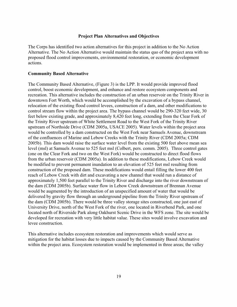
The Community Based Alternative, (Figure 3) is the LPP. It would provide improved flood control, boost economic development, and enhance and restore ecosystem components and recreation. This alternative includes the construction of an urban reservoir on the Trinity River in downtown Fort Worth, which would be accomplished by the excavation of a bypass channel, relocation of the existing flood control levees, construction of a dam, and other modifications to control stream flow within the project area. The bypass channel would be 290-320 feet wide, 30 feet below existing grade, and approximately 8,420 feet long, extending from the Clear Fork of the Trinity River upstream of White Settlement Road to the West Fork of the Trinity River upstream of Northside Drive (CDM 2005a, USACE 2005). Water levels within the project area would be controlled by a dam constructed on the West Fork near Samuels Avenue, downstream of the confluences of Marine and Lebow Creeks with the Trinity River (CDM 2005a; CDM 2005b). This dam would raise the surface water level from the existing 500 feet above mean sea level (msl) at Samuels Avenue to 525 feet msl (Colbert, pers. comm. 2005). Three control gates (one on the Clear Fork and two on the West Fork) would be constructed to direct flood flows from the urban reservoir (CDM 2005a). In addition to these modifications, Lebow Creek would be modified to prevent permanent inundation to an elevation of 525 feet msl resulting from construction of the proposed dam. These modifications would entail filling the lower 400 feet reach of Lebow Creek with dirt and excavating a new channel that would run a distance of approximately 1,500 feet parallel to the Trinity River and discharge into the river downstream of the dam (CDM 2005b). Surface water flow in Lebow Creek downstream of Brennan Avenue would be augmented by the introduction of an unspecified amount of water that would be delivered by gravity flow through an underground pipeline from the Trinity River upstream of the dam (CDM 2005b). There would be three valley storage sites constructed, one just east of University Drive, north of the West Fork of the river, one located in Riverbend Park, and one located north of Riverside Park along Oakhurst Scenic Drive in the WFS zone. The site would be developed for recreation with very little habitat value. These sites would involve excavation and levee construction.
This alternative includes ecosystem restoration and improvements which would serve as mitigation for the habitat losses due to impacts caused by the Community Based Alternative within the project area. Ecosystem restoration would be implemented in three areas; the valley

Figu
re 3
:C
omm
unity
Bas
ed A
ltern
ativ
e
20
21
storage mitigation area at Riverbend Park in the Riverbend zone, in two old oxbows within the Rockwood zone, and Ham Branch in Harmon Park east of the downtown area in the WFS zone. The proposed ecosystem restoration activities would include restoration of 15.02 acres of wetlands and 34.5 acres of riparian woodlands; establishment of 42.2 acres of native grasslands, 92.7 acres of riparian woodlands, and 45.5 acres of upland woodlands; enhancement of 13.3 acres of existing upland woodlands; preservation of 74.36 acres of riparian woodland; and reestablishment of three historic oxbow stream channels (5.08 acres).
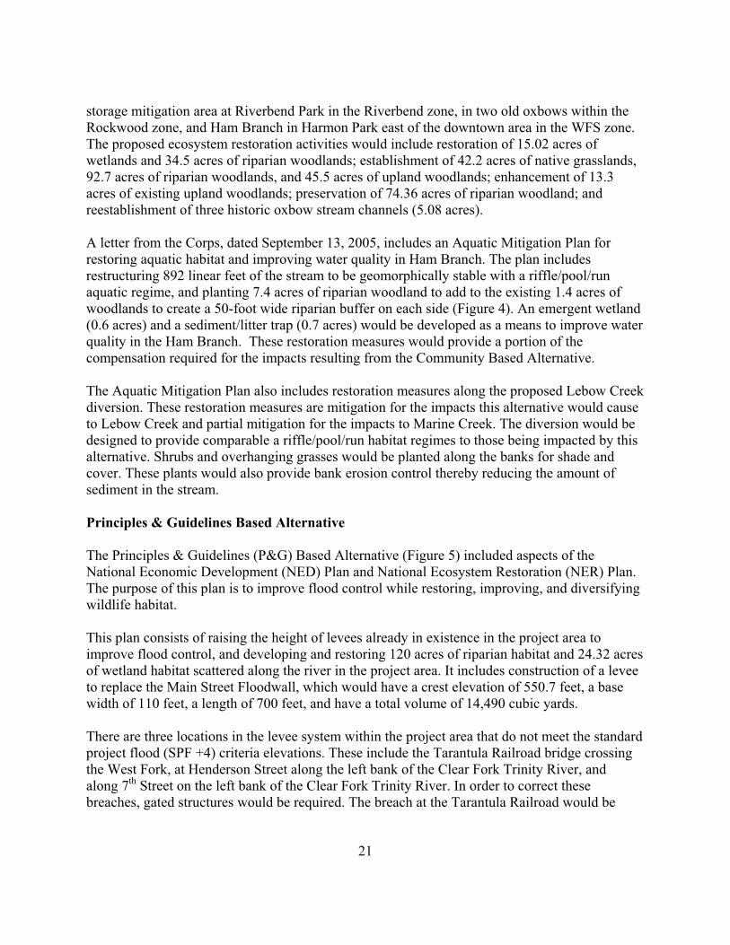
A letter from the Corps, dated September 13, 2005, includes an Aquatic Mitigation Plan for restoring aquatic habitat and improving water quality in Ham Branch. The plan includes restructuring 892 linear feet of the stream to be geomorphically stable with a riffle/pool/run aquatic regime, and planting 7.4 acres of riparian woodland to add to the existing 1.4 acres of woodlands to create a 50-foot wide riparian buffer on each side (Figure 4). An emergent wetland (0.6 acres) and a sediment/litter trap (0.7 acres) would be developed as a means to improve water quality in the Ham Branch. These restoration measures would provide a portion of the compensation required for the impacts resulting from the Community Based Alternative.
The Aquatic Mitigation Plan also includes restoration measures along the proposed Lebow Creek diversion. These restoration measures are mitigation for the impacts this alternative would cause to Lebow Creek and partial mitigation for the impacts to Marine Creek. The diversion would be designed to provide comparable a riffle/pool/run habitat regimes to those being impacted by this alternative. Shrubs and overhanging grasses would be planted along the banks for shade and cover. These plants would also provide bank erosion control thereby reducing the amount of sediment in the stream.
Principles & Guidelines Based Alternative
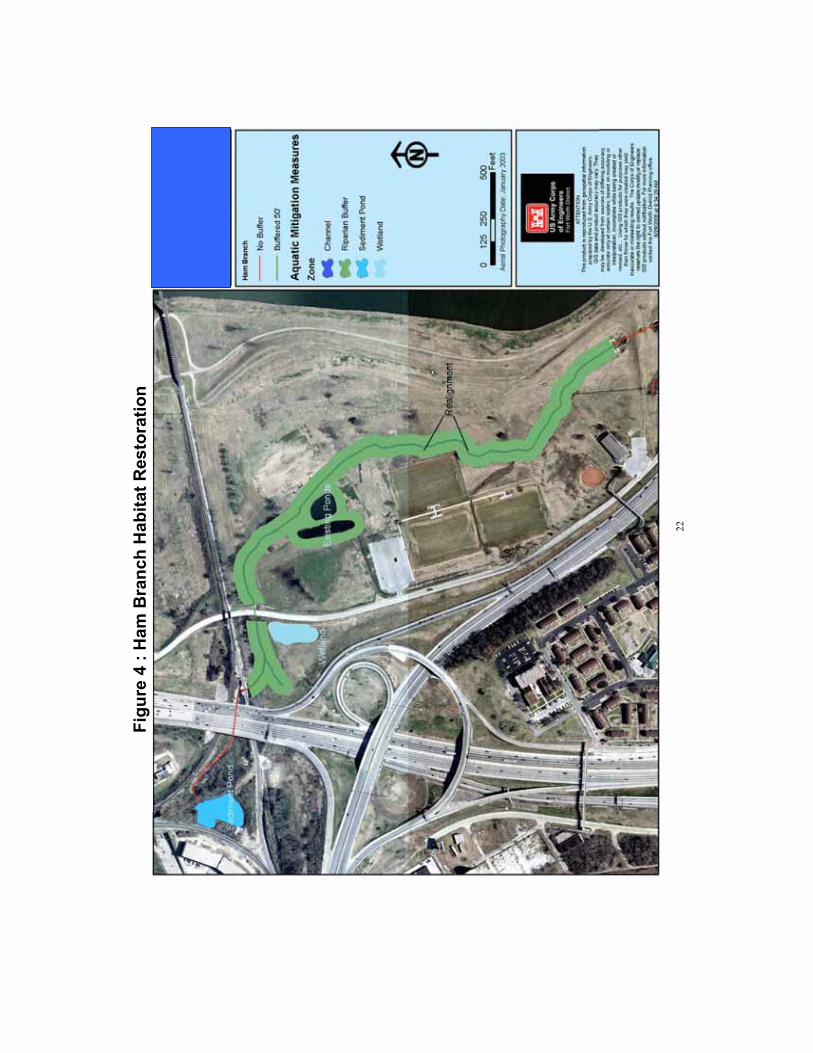
The Principles & Guidelines (P&G) Based Alternative (Figure 5) included aspects of the National Economic Development (NED) Plan and National Ecosystem Restoration (NER) Plan. The purpose of this plan is to improve flood control while restoring, improving, and diversifying wildlife habitat.
This plan consists of raising the height of levees already in existence in the project area to improve flood control, and developing and restoring 120 acres of riparian habitat and 24.32 acres of wetland habitat scattered along the river in the project area. It includes construction of a levee to replace the Main Street Floodwall, which would have a crest elevation of 550.7 feet, a base width of 110 feet, a length of 700 feet, and have a total volume of 14,490 cubic yards.
There are three locations in the levee system within the project area that do not meet the standard project flood (SPF +4) criteria elevations. These include the Tarantula Railroad bridge crossing the West Fork, at Henderson Street along the left bank of the Clear Fork Trinity River, andalong 7th Street on the left bank of the Clear Fork Trinity River. In order to correct these breaches, gated structures would be required. The breach at the Tarantula Railroad would be
22
Figu
re 4
: H
am B
ranc
h H
abita
t Res
tora
tion
23
24
closed by use of a permanent five feet high hinged gate that could be closed during peak flows with a winch. Both the planned Henderson Street and 7th Street gate structures would consist of double swing gates, two feet in height, which could be closed by a winch. Raising the two segments of the levee loop (along the right bank of the West Fork Trinity River and the left bank of the Clear Fork Trinity River) that do not meet the SPF +4 flood criteria elevations would require 180,700 cubic yards of fill. The new fill material would be placed on the riverside of the levee in order to stay within the current right-of-way limits and not disturb sump areas and private property. An 18-acre site would be excavated as hydraulic mitigation for this fill material in the flood plain to an average depth of 6 feet and 1V:3H side slopes.
Alternative Impacts Analysis and Discussion
It is difficult to predict what will happen in the future for the project area. However, using historic land use trends and the calculated HSIs, predictions of habitat conditions with or without the project can be expressed in terms of HUs.
The following basic assumptions, regarding changes in the habitats, were made for the future with or without project conditions.
Some existing open spaces will be developed in the future. Portions of the Trinity River Vision Plan will be implemented even if the proposed project is not implemented, particularly in the North Main zone. Other developments will occur as well. Existing wildlife habitats will change, if not diminish. Their quality could improve with time or deteriorate depending on natural events or changes in land use, but the amount of each habitat is expected to decrease. There will always be demands and pressures on wildlife habitat in urban areas. Currently, we know of no other plans that include habitat enhancement in the future, therefore, it is assumed that any habitat improvements would occur naturally if the proposed project was not implemented. As the riparian and upland woodlands age, the size and maturity of individual trees and stands and the height of herbaceous vegetation would increase. Non-native invasive plant species will continue to be a problem in all habitats. Demands for recreational public use will increase in the project area. The extensive mowing and other current management practices in the floodway are expected to continue.
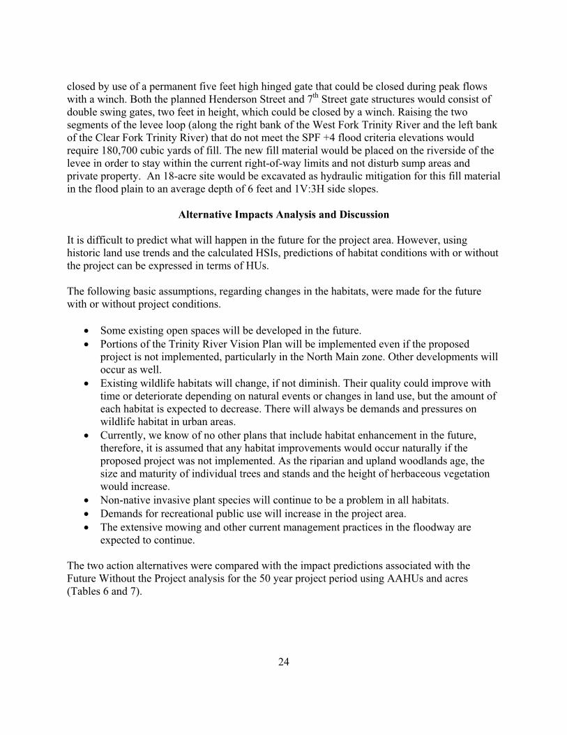
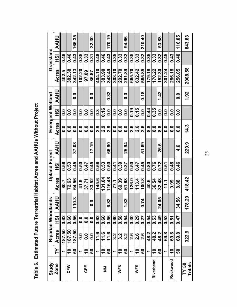
The two action alternatives were compared with the impact predictions associated with the Future Without the Project analysis for the 50 year project period using AAHUs and acres (Tables 6 and 7).
25
Tabl
e 6.
Est
imat
ed F
utur
e Te
rres
tria
l Hab
itat A
cres
and
AA
HU
s W
ithou
t Pro
ject
Rip
aria
n W
oodl
ands
U
plan
d Fo
rest
Emer
gent
Wet
land
Gra
ssla
ndSt
udy
Zone
TYA
cres
HSI
AA
HU
Acr
esH
SIA
AH
UA
cres
HSI
AA
HU
Acr
esH
SIA
AH
U1
187.
500.
6280
.70.
560.
00.
040
2.5
0.48
1018
7.50
0.60
72.6
30.
530.
00.
038
2.38
0.46
CFW
5018
7.50
0.56
110.
364
.56
0.45
37.0
80.
00.
00.
034
2.13
0.43
166.
351
0.0
0.0
41.9
0.50
0.0
0.0
102.
200.
3510
0.0
0.0
37.7
10.
470.
00.
097
.09
0.33
CFE
500.
00.
00.
033
.52
0.45
17.1
90.
00.
00.
086
.87
0.31
32.3
01
11.6
0.62
145.
60.
562.
90.
340
4.10
0.48
1011
.60.
6013
1.04
0.53
2.9
0.16
383.
900.
46N
M50
11.6
0.56
6.82
116.
480.
5066
.90
2.9
0.0
0.32
343.
490.
4317
0.19
13.
20.
6077
.10.
410.
00.
030
8.10
0.35
103.
20.
5869
.39
0.39
0.0
0.0
292.
700.
33W
FN50
3.2
0.54
1.82
61.6
80.
3725
.94
0.0
0.0
0.0
261.
890.
3294
.66
12.
60.
3012
6.0
0.50
2.6
0.19
665.
700.
3510
2.6
0.29
113.
40.
472.
60.
1563
2.42
0.33
WFS
502.
60.
270.
7410
0.8
0.45
51.6
92.
60.
00.
1856
5.85
0.32
210.
401
48.2
0.54
40.6
0.80
8.8
0.44
179.
180.
3510
48.2
0.53
36.5
40.
768.
80.
3517
0.22
0.33
Riv
erbe
nd50
48.2
0.49
24.0
532
.48
0.72
26.5
8.8
0.0
1.42
152.
300.
3253
.88
169
.80.
5211
.10.
510.
00.
030
1.24
0.45
1069
.80.
519.
990.
480.
00.
028
6.18
0.43
Roc
kwoo
d
5069
.80.
4734
.56
8.88
0.46
4.6
0.0
0.0
0.0
256.
050.
4011
6.05
TY 5
0 To
tals
322.
917
8.29
418.
4222
9.9
14.3
1.92
2008
.58
843.
83
26
Tabl
e 7.
Est
imat
ed A
ltern
ativ
e Im
pact
s to
Ter
rest
rial H
abita
ts W
ithin
50
Year
s
P&G
Bas
ed
Alte
rnat
ive
Exis
ting
Futu
re W
ithou
t Pr
ojec
tC
omm
unity
Bas
edA
ltern
ativ
e
Res
ou
rce
Acr
esH
Us
Acr
esA
AH
Us
Acr
esA
AH
Us
Acr
esA
AH
Us
Rip
aria
nW
oodl
and
322.
918
8.47
322.
917
8.29
396.
021
8.72
420.
9722
4.75
Emer
gent
Wet
land
14.3
5.23
14.3
1.92
24.3
224
.16
21.1
214
.95
Gra
ssla
nd23
63.0
296
2.03
2008
.58
843.
8320
28.9
834.
6217
29.2
477
3.27
Upl
and
Woo
dlan
d52
2.95
318.
2341
8.42
229.
941
8.00
232.
6841
4.92
213.
53
Tota
ls32
23.1
714
73.9
627
64.2
012
53.9
428
60.3
1310
.18
2586
.25
1226
.50
27
Future Without Project
Riparian woodlands: Riparian woodland acreage would probably remain the same without the project, because the existing riparian woodlands are either protected within parks or are difficult to develop, and there would be very little riparian woodlands created by humans or natural succession. Management and land uses would probably not change. Trees would mature over time and produce more mast and cavities for wildlife use, but the habitat values would decrease approximately ten percent due to an increase of public use in the local parks and continued encroachment of non-native vegetation. Therefore, even without a project it is anticipated that habitat values will be average to below average. Trinity Park and the Botanical Gardens, located in the CFW zone, constitute the largest contiguous stand of riparian woodland within the project area. The acreage is not expected to decrease, but public use, the decline of the existing mature mast producing trees without recruitment, and encroachment of non-native vegetation is expected to increase resulting in a decrease in habitat value. Riparian woodland habitat acres within the NM zone are expected to remain the same. There would be an estimated 322.9 acres of riparian habitat within 50 years, yielding 178.29 AAHUs (Table 6). The existing flood control system, including the related flooding problems, will remain if the project is not implemented.
Grasslands: It is estimated that grassland habitat values would decrease 12 percent, and acreage is predicted to decrease by 15 percent within the period of analysis in all zones due to a change in their use and increased mowing of the few existing good quality grasslands. The amount of grassland acreage will also decrease due to future development, not included in this project, throughout the project area, particularly in the NM zone. Only small habitat changes are expected in the CFE zone, because it is already heavily developed. There would be an estimated 2,008.58 acres of grassland with 843.83 AAHUs in 50 years without this project (Table 6).
Upland Woodlands: Upland woodland habitat values would decrease over time by 28 percent, and acreage would decrease approximately ten percent for the first ten years, then another ten percent over the next 40 years. Development would most likely occur in parts of this habitat, but much of it is already protected in parks and cemeteries. Habitat values will go down due to further fragmentation, public use, and continued encroachment of non-native vegetation. There would be an estimated 418.42 acres (229.9 AAHUs) of upland in the project area within 50 years (Table 6).
Emergent Wetlands: The habitat values for the few acres of emergent wetlands within the project area would slowly decrease approximately 20 percent during the first ten years and then down to 0.0 in time, as they may silt in or become filled for development. The wetland located at the confluence of the Clear and West Forks of the Trinity River would most likely remain, but could fill-in with silt. There would be an estimated 14.3 acres (1.92 AAHUs) of emergent wetlands within 50 years (Table 6).
Aquatic Habitat: Assessments conducted in the 1970s and 1980s in the Trinity River characterized the fish communities as stressed (Kleinsasser and Linam 1989). This was attributed to poor water quality from point source pollutant loading within the system
28
(Kleinsasser and Linam, 1989; Moring 1997). Since that time, more stringent water quality regulations have been developed to address both point source and non-point source loading. Although elevated contaminants are still present (Giggleman and Lewis 2004), results of recent surveys indicate that the fish community is recovering (Hale and Giggleman 2004; Giggleman and Lewis 2005a; Giggleman and Lewis 2005b). In addition, previous in-stream modifications(i.e., low water dams) within the project area have resulted in the Trinity River functioning more as a lentic then a lotic system. Consequently, provided that contaminant loading is not increased and current water levels are not reduced, the fish community inhabiting this system should remain stable.
Future With Community Based Alternative
All of the river zones would be impacted by this alternative. The impoundment of the river by the construction of the associated dam at Samuels Avenue would raise on average the surface water level by 7 feet. Surface water elevation would be increased in Marine Creek by 25 feet. In addition, the lower 400 foot reach of Lebow Creek, located in the WFN zone, would be filled and a new channel approximately 1,500 feet long would be excavated. Existing aquatic and terrestrial habitats would be impacted by the raised water level of the proposed urban reservoir. The CFW and NM zones would be directly impacted by construction of the bypass channel. The WFN and WFS zones would be impacted by the proposed Samuels Avenue Dam. It is assumed that if this alternative is implemented, the Trinity River Vision Master Plan would also be fully implemented resulting in additional impacts to habitat values in the future. Impacts of the Trinity River Vision Master Plan, if it were fully implemented after completion of this project, are not evaluated in this document.
The Community Based Alternative would adversely impact 8.8 acres (1.31 AAHUs) of emergent wetlands, 34.1 acres (17.67 AAHUs) of riparian woodlands, 67.9 acres (48.82 AAHUs) of upland woodlands, and 271.31 acres (100.33 AAHUs) of grasslands. However, this alternative includes opportunities for ecosystem restoration and enhancement to offset the impacts it causes. Riparian woodlands and emergent wetlands habitat types would increase in acreage and AAHUs over the 50 year project period (Table 7). Grasslands and upland woodlands habitat types would decrease in acreage and AAHUs.
Riparian woodlands: Almost all of the existing riparian woodland habitat (over 30 acres) in the Riverbend zone would be lost to the hydraulic mitigation planned in that zone, except for the woodlands that would be isolated by the proposed levee to be built through the largest stand of riparian woods. This isolation would change the hydrology of the stand, possibly turning it into upland. The NM zone would lose 3.7 acres of riparian woodland habitat. A total of 34.1 acres of riparian woodland habitat would be impacted in the project area if this alternative is implemented. However, this alternative includes developing/restoring (127.24 acres) and improving (19.5 acres) existing riparian habitat in the Riverbend, Rockwood, and WFS zones to mitigate this loss. There would be an increase of approximately 11.5 acres of riparian woodland in the Rockwood zone, due to riparian woodland development at the two old oxbows, an increase of approximately 82.89 acres of riparian woodland in the Riverbend area, and an increase of 7.4
29
acres along Ham Branch in the WFS zone. The amount of riparian woodlands in the CFW, CFE, and WFN zones would remain the same. Under this alternative, it is estimated that there would be a total increase of 97.97 acres and 46.38 AAHUs of riparian woodlands, for a total of 420.97 acres of riparian woodlands with 224.75 AAHUs in the project area over the 50 year period of analysis (Table 7).
The proposed riparian buffer along Ham Branch would be too narrow to provide additional significant riparian woodland habitat. It could provide temporary refuge for small urban wildlife and migratory birds, and help to improve the water quality in that area.
Grasslands: All of the zones would lose grassland acreage if the Community Based Alternative was implemented. A total of 278.8 acres of poor valued non-native grassland would be converted to other habitats, levees, or open water, with a decrease of 70.55 grassland AAHUs. The Riverbend zone grasslands would decrease by 146.77 acres, but 42.39 acres of native grasses would be created as a riparian buffer. Overall, it is estimated that there would be 1,729.24 acres of grasslands with 773.27 AAHUs in the project area in 50 years.
Upland Woodlands: All the zones would sustain upland woodland habitat losses if the Community Based Alternative was implemented. Plans for the Riverbend zone include 13.3 acres of upland woodland improvement and 45.5 acres of upland woodland development. The Riverbend zone would gain 24.24 acres, but lose 2.46 AAHUs of upland woodland habitat because it would take time for the proposed developed woodland to mature into what was lost. The CFW zone would lose an additional 3.16 acres, the CFE zone would lose an additional 1.65 acres, the NM zone would lose an additional 10.05 acres, the WFN zone would lose an additional 3.1 acres, and the WFS zone would lose 3.01 acres. This alternative would yield a net loss of 3.4 acres of upland woodland habitat for an overall estimate of 414.92 acres with 213.53 AAHUs in the project area in 50 years.
Emergent Wetlands: Implementation of this alternative would impact 8.8 acres of existing emergent wetlands and develop 15.02 acres of wetlands for an increase of 6.22 acres with 14.47 AAHUs in the Riverbend zone. Development of a 0.6 acre emergent wetland is planned on Ham Branch in the WFS zone, which would yield an additional 0.56 AAHUs. There would be no change in emergent wetland acreage in any other zone. An estimated 21.12 acres of emergent wetlands with 14.95 AAHUs would exist in the project area in 50 years.
Aquatic Habitat: The Community Based Alternative would result in the creation of approximately 120 acres of channelized aquatic habitat on the Trinity River by the construction of the bypass channel. Impacts to the fish assemblages within the Clear Fork, West Fork, and the Trinity River downstream of the confluence of the two forks are expected to be negligible because previous in-stream modifications (i.e., low water dams) have already created deep pool habitat which has resulted in this portion of the Trinity River functioning more as a lentic than lotic system. Impacts to the fish community within the lower 1,000 feet of Marine Creek are also expected to be minimal, because this portion of the stream is directly influenced by the Trinity River. However, impacts to Marine Creek upstream of this area are expected to be significant
30
because an estimated 1,875 linear feet of shallow riffle-pool sequences would be eliminated by inundation with approximately 25 feet of water. Aquatic habitat will be decreased by approximately, 0.80 AAHUs of exceptional aquatic habitat in the lower reach and 0.56 AAHUs of high quality habitat in the upper reach of Marine Creek. Impacts to the lower 400 feet of Lebow Creek are also expected to be significant (0.10 AAHUs) because the aquatic habitat within this area will be completely eliminated by proposed fill operations. Existing habitat within Lebow Creek upstream of this area is not expected to be adversely affected. A total of approximately 1.46 AAHUs of existing exceptional and high quality stream habitat would be lost if the Community Based Alternative is implemented.
The Corps’ September 12, 2005 proposed Aquatic Mitigation Plan for the Central City project includes mitigation measures to offset the adverse impacts associated with this alternative to aquatic habitats within Marine Creek and lower Lebow Creek. The Lebow Creek habitat improvements are estimated to provide 0.72 aquatic AAHUs. The Ham Branch aquatics restoration would provide 0.8 AAHUs, 0.55 AAHU’s over without project conditions. The habitat restoration measures in Ham Branch and Lebow Creek combined would provide an estimated increase of 1.52 aquatic AAHUs, which would be 0.06 over what would be lost if the Community Based Alternative was implemented.
This alternative includes restoring 5.08 acres of aquatic habitat in an old river oxbow within the Riverbend zone, and two oxbows in the Rockwood zone, which would yield approximately 4.3 AAHUs.
Future With Principles & Guidelines Based Alternative
Values for all habitats would increase under the P&G Based Alternative, except upland woodlands, which would only decrease by 0.4 acres compared to the future without the plan (Tablre 7). No action would be taken in the CFE, Riverbend, or Rockwood zones.
Riparian woodlands: The P&G Based Alternative would yield a greater amount of riparian woodland habitat by 73.1 acres and 40.43 AAHUs over the 50 year period without the project (Table 7). Riparian woodland habitat development (31.12 acres with 3.72 AAHU gain) would occur in the NM zone along the river on each side of Henderson Street. The WFS zone would gain 16.47 acres with a gain of 4.92 AAHUs of riparian woodland habitat. The WFN would gain 22.01 acres with 3.25 AAHUs.
Grasslands: Grassland habitat would increase an additional 20.9 acres with 22.43 AAHUs overall.
Upland Woodlands: Upland woodland habitat would decrease by 0.4 acre, but the AAHUs would increase by 2.78, since as upland woodlands are expected to improve with age.
Emergent Wetlands: The P&G Based Alternative would provide an additional 10 acres and 22.24 AAHUs of emergent wetland habitat. The existing emergent wetland at the confluence of
31
the West and Clear Forks would be enlarged by 1.41 acres. A 3.59 acre emergent wetland would be constructed just south of the Oakwood Cemetery along the north side of the West Fork in the NM zone. Construction of 16.56 acres of wetlands would occur in the WFS zone at several locations.
Aquatic Habitat: Proposed oxbow habitat restoration measures within the NM zone just west of the railroad track between the West Forks and the Oakwood Cemetery, as well as the adjacent river habitat alternative would increase aquatic habitat by 2.54 acres with 3.9 AAHUs.
Evaluation and Comparison of the Alternatives
The following is a comparison of the locally preferred plan, the Community Based Alternative, with the other alternatives in regards to how they will impact fish and wildlife resources over the 50 year project analysis period.
No Action Alternative: Through the course of normal urban development within the project area over a period of 50 years, some losses to fish and wildlife resources in all habitats are expected to occur under this alternative.
Community Based Alternative: Adverse impacts to all habitats within the project area are expected to occur with this alternative. Construction activities associated with this alternative would result in the loss of riparian woodland, emergent wetland, grassland, upland woodland, and aquatic lotic habitats.
However, adverse impacts to fish and wildlife resources associated with this alternative would be compensated for through in-kind and out-of-kind mitigation. The habitat mitigation sites would be established in areas that would not be directly impacted by construction activities and/or habitat modification. This alternative would result in an increase of aquatic lentic habitat in the form of oxbows and lotic habitat in two creeks within the project area. Impacts to the riparian woodland habitat would be adequately compensated for by in-kind compensation with approximately 46.46 AAHUs over future without project conditions. Upland woodland habitat would decrease by 16.37 AAHUs, but the overage of riparian woodland habitat, which is considered more valuable due to greater biodiversity and habitat rarity, would compensate for this loss as out-of-kind mitigation. Emergent wetland habitat would be significantly increased by almost 17 AAHUs over future without project conditions. Grassland habitat would decrease because this is where project construction and the development of other habitats would occur, but the existing grasslands in the project area are considered poor habitat.
This alternative would have greater impacts to fish and wildlife resources than the other alternatives, but the proposed habitat restoration and improvements would compensate for these losses.
Principles & Guidelines Based Alternative: This alternative would result in the improvement of existing riparian woodland and emergent wetland habitats, while not adversely impacting fish
32
and wildlife resources within the entire project area. In addition, this alternative would produce a significant gain in aquatic lentic habitat by the creation of oxbows within the project area as well as riparian woodland habitat by implementation of a planting scheme on 40 acres. Habitat improvements would be more widely scattered across the project area. Existing upland woodlands would not be impacted. Because of these actions, it is expected that this alternative would fully meet the ecosystem restoration objectives within the project area. Unavoidable impacts to habitat within the project area associated with this alternative are minimal. The small amount of habitat that would be lost through construction activities would be fully compensated for through mitigation. High quality riparian and wetland habitats would be established in lieu of grasslands which are of limited ecological value. Consequently, the losses to fish and wildlife resources associated with this alternative are expected to be minimal and would be acceptable from a fish and wildlife resource perspective.
Recommended Fish and Wildlife Conservation Measures
The Service has evaluated this project in accordance with the guidelines and directives contained in its Fish and Wildlife Mitigation Policy (Federal Register 46(15):7644-7663; January 23, 1981). The Mitigation Policy is the basis by which the Service makes recommendations, in order of priority, to avoid, minimize, rectify, reduce or eliminate the loss over time, or compensate project-related impacts to fish and wildlife resources. Our recommendations are based on the value and relative abundance of the affected habitats to the evaluation species. The Policy includes four Resource Categories (1-4) to provide a consistent value rating for wildlife habitats. Based on the HSI values and IBI evaluations, the Service has designated a Resource Category for each terrestrial habitat in each river zone assessed and aquatic habitat in each stream segment studied.
Aquatic Habitat
The fisheries survey conducted by the Service in 2005 on Marine Creek demonstrated that the shallow riffle-pool sequences which would be lost by the Community Based Alternative currently supports an exceptional and high valued fish community. The habitat in lower Lebow Creek also supports an exceptional fish assemblage. The aquatic habitat in this reach would be totally lost with implementation of the proposed Community Based Alternative.
The Service has designated the aquatic habitats within Marine and Lebow Creeks as Resource Category 3. Category 3 habitat is of high to medium value for the evaluation species and is relatively abundant on a national basis. The mitigation goal for this category is no net loss of habitat value while minimizing loss of in-kind values. As noted in our baseline habitat assessment, Marine and Lebow Creeks support exceptional fisheries, and therefore, impacts to these systems should be minimized and/or compensated before any enhancement of these resources can occur.
It is estimated that 1,875 linear feet of shallow riffle-pool sequences would be lost on Marine Creek and 400 feet of lotic habitat would be lost on Lebow Creek with the construction of
33
Samuels Avenue dam at its currently proposed location, therefore, it would be necessary to mitigate these losses of high quality aquatic habitats. This mitigation would entail constructing a series of riffle pool sequences with a stable streambed supported by stable banks and a riparian corridor. The stream should have a sufficient longitudinal profile (slope) to maintain adequate flow regimes. Substrate composition should be similar to Marine Creek. Lebow Creek, including the proposed excavated channel, may be a suitable area for this type of mitigation. However, because of differences in watersheds and associated stream dynamics between the two creeks, construction activities in Lebow Creek may not provide sufficient habitat to mitigate for the combined lost habitat within the two streams. Consequently, the Service supports the Corps ‘ September 13, 2005 Aquatics Mitigation Plan that proposes developing additional stream mitigation features in Lebow Creek and Ham Branch.
Although the degree and extent of contamination in sediments within the portion of the Trinity River that would be impacted by the proposed bypass excavation are unknown, the Service is concerned that there is a likelihood that contaminated sediments would be re-suspended into the water column from the excavation activities. This in turn would allow these contaminants to become more readily available to the aquatic biota inhabiting the river. Therefore, the Service recommends that the degree and extent of sediment contamination within the project area be further analyzed prior to the commencement of excavation operations. The Service also recommends that best management practices be implemented to control the increased pollutant loading in storm water runoff associated with construction activities and the projected increase in traffic usage within this area. Finally, the Service recommends that the proposed river channel and lake shore be planted with streamside vegetation verses concrete or rock walls where possible to reduce potential erosion and sedimentation loading within the river.
Terrestrial Habitat
All terrestrial habitats within the project area have medium to low habitat value for the evaluation species and have been designated as Resource Category 4. The mitigation planning goal for Category 4 habitat is to minimize loss of habitat value. Out-of-kind habitat values may be used for mitigation. Habitat improvements and restoration measures proposed for the project may be used for the mitigation of adverse impacts associated with the construction of the preferred plan of development
The proposed Community Based Alternative would impact 34.51 acres of existing riparian woodland habitat, 3.7 acres (2.17 AAHUs) in the NM zone and 30.81 acres (14.72 AAHUs) in the Riverbend zone. Riparian woodlands are one of the most important habitats within the Cross Timbers and Prairies Ecoregion. Only a small percent of the riparian woodlands remain in the ecoregion. Numerous federal, state, and private studies have documented the increased vulnerability and scarcity of bottomland hardwood forest in Texas and the rest of the United States. Statewide, over 63 percent (TPWD 1997) of the bottomland hardwood forests have been lost to human activities, including residential, commercial, and industrial developments in urbanized areas. Based on the importance of this habitat and the past impacts from floodway

34
construction and other developments, the Service supports the Corps’ proposal to restore and develop additional riparian habitat in the Riverbend and WFS Zones.
Executive Order 13186, directs Federal agencies to incorporate migratory bird conservation measures into their projects that are likely to have measurable negative impacts on migratory bird populations. Under the Community Based Alternative, upland woodland habitats would sustain a loss in all the river zones for at least 50 years, the life of the project. Although, there would be a net gain of 24.24 acres under the Community Based Alternative in 50 years, there would be a loss of 2.46 AAHUs. Upland woodlands provide habitat for a different guild of birds than riparian woodland habitats. Many birds listed in the Service’s Birds of Conservation Concern 2002 (USFWS 2002) may use the upland woodland habitat in the project area. The Riverbend woodlands are good quality habitat and the woodlands that would replace them would take many more years to be as valuable. The Service recommends that this loss to the upland woodland habitat be mitigated. Consequently, the additional AAHUs for riparian woodlands that would be created in the Community Based Alternative could be considered as out-of-kind compensation for the upland woodland habitat losses.
Executive Order 11990 requires all Federal agencies to “take action to minimize the destruction, loss or degradation of wetlands, and to preserve and enhance the natural and beneficial values of wetlands in carrying out the agency's responsibilities.” Wetlands are of national importance and have been documented as one of the most productive and important habitats for a variety of fish and wildlife species. The Community Based Alternative includes a loss of 8.8 acres (1.42 AAHUs) of wetlands in the Riverbend Area. The 15.62 acres (14.34 AAHUs) of emergent wetlands proposed to be created in the Riverbend and WFS zones would fully compensate for this loss and for any of the smaller emergent wetlands scattered throughout the project area that were not captured in the GIS mapping.
There is an advantage to concentrating all the restoration efforts in one area. A larger contiguous tract is more valuable than scattered, fragmented, smaller areas. Consequently, we encourage the Corps and the sponsor to consider incorporating some of the habitat restoration recommendations included in the Service’s June 18, 2004 report and in the interagency Ecosystem Restoration Plan into other projects plans in the future within the Central City project area to create a continuous riparian corridor throughout the project area. We also recommend that a habitat management and monitoring plan for the habitat restoration areas be developed.
Summary of Findings and Fish and Wildlife Service’s Position
Due to the lack of suitable habitat and the urbanized character of the project area, it is unlikely that any federally listed threatened or endangered species would utilize any of the study areas.Thus, no adverse affects to federally listed species are expected to occur with implementation of any of the proposed alternatives.
No detrimental affects to fish communities within the project area would be expected to occur from the No Action and P & G Based Alternatives, whereas adverse impacts would result from
35
the Community Based Alternative to Marine and Lebow Creeks. If modifications can not be made to the Community Based Alternative to reduce and/or eliminate the impacts to 1,875 linear feet of shallow lotic riffle-pool sequences in Marine Creek and 400 feet of lotic habitat on lower Lebow Creek, then it will be necessary to mitigate for the lost aquatic habitat within these two streams.
The Community Based alternative would also impact all of the terrestrial habitat types within the project area: wetlands, upland woodlands, riparian woodlands, aquatic, and grasslands. However, the Community Based alternative includes habitat restorations measures to compensate for these impacts. Upland woodlands would be partially compensated by out-of-kind mitigation using the additional riparian woodlands developed beyond those required to fully compensate for the existing riparian woodlands that would be impacted.
The Service commends the Corps and the sponsor for incorporating the habitat improvement and aquatic mitigation plans into the Community Based Alternative. These efforts would fully compensate for the impacts caused by this alternative to the Category 3 and 4 habitats within the project area. The Service recommends that future plans for the project area incorporate more aspects of the conceptual Ecosystem Restoration Plan throughout the project area, such as creation of riparian woodlands along the West Fork of the Trinity River east of Interstate Highway 35, development of a nature area with an outdoor interpretive infrastructure, and restorion of riparian buffers that could assist in maintaining water quality. These actions would provide additional benefits to fish and wildlife resources, and the public’s enjoyment of these resources, throughout the entire project area.
The P & G Based Alternative would be the least environmental damaging alternative and would yield fewer impacts to existing habitats while creating valuable riparian woodlands and emergent wetlands. This alternative would provide approximately 25 acres of riparian woodlands less than the Community Based Alternative, but the habitat would be more distributed throughout the project area and function as a continuous wildlife corridor. In addition, this alternative would not prevent the objectives of the Central City project to enhance current levels of flood protection, facilitate urban revitalization, and restore components of the natural riverine system from being achieved. However, this alternative does not meet the new project objectives as stated in Section 216 of the 2005 Consolidated Appropriations Act.
Greater adverse ecological impacts would occur with the Community Based Alternative, however, these impacts could be compensated by the ecosystem restoration improvements proposed in the plan.
36
Literature Cited
Biro, Peter A. 1998. Staying Cool: Behavioral Thermoregulation during summer by young-of-year brook trout in a lake. Transactions of the American Fisheries Society 127 (2): 212–222.
Brode, J.M. and R.B. Bury. 1984. The importance of riparian systems to amphibians and reptiles. Pages 30-36 in R.E. Warner and K.M. Hendrix, eds. California Riparian System: Ecology, Conservation, and Productive Management. Univ. of California Press: Berkley
Burk, J.D., G.A. Hurst, D.R. Smith, B.D. Leopold, and J.G. Dickson. 1990. Wild turkey use of streamside management zones in loblolly pine plantations. Proc. National Wild Turkey Symp. 6:84-89.
Camp, Dresser, and McKee, Inc. (CDM). 2005a. Technical Memorandum ECO-5: Water Aesthetic and Quality Management (Final Draft).
Camp, Dresser, and McKee, Inc. (CDM). 2005b. Technical Memorandum ECO-7: Conceptual Aquatic Habitat Mitigation Plan for Marine Creek Impacts (Final Draft).
Cole, G.A. 1983. Textbook of limnology. 3rd ed. The C.V. Mosby Company: St. Louis.
Cummins, K.W.,M.A. Wilzbach, D.M. Gates, J.B. Perry, and W.B. Taliaferro. 1989. Shredders and riparian vegetation: leaf litter that falls into streams influences communities of stream invertebrates. Bioscience 39(1): 24-30.
Dickson, J.G. 1989. Streamside zones and wildlife in southern U.S. forests. Pages131-133 inGreswell, R.E., B. Kershner, eds. Practical Approaches to riparian resource management: an educational workshop. U.S. Bureau of Land Management, Billings, Montana.
Dickson, J.G.,and J.C. Huntley. 1987. Riparian zones and wildlife in southern forest: the problem and squirrel relationships. Pages 37-39 in J.G. Dickson and O.E. Maughan, eds. Managing southern forests for wildlife and fish. U.S. Forest Service. Gen. Tech. Rep. SO-65.
Diggs, G.M., Jr., B.L. Lipscomb, and R. J. O’Kennon.1999. Shinners & Mahler’s illustrated flora of North Central Texas. Botanical Research Institute of Texas and Austin College. 1626 pp.
Flebbe, P.A. 1999. Trout use of woody debris and habitat in Wine Spring Creek, North Carolina. Forest Ecology and Management 114:367-376.
Giggleman, C. and J. Lewis. 2004. Residual Organochlorine Pesticide Contamination in Fish Collected from the Trinity River within the Proposed Central City Multi-purpose Projects Area, Tarrant County, Texas. U.S. Fish and Wildlife Service. Arlington, Texas.
37
Giggleman, C. and J. Lewis. 2005a. Baseline Fisheries Survey of Marine Creek within the Proposed Central City Multi-Purpose Project Area, Tarrant County, Texas. U.S. Fish and Wildlife Service. Arlington, Texas.
Giggleman, C. and J. Lewis. 2005b. Baseline Fisheries Survey of Lebow Creek within the Proposed Central City Multi-Purpose Project Area, Tarrant County, Texas. U.S. Fish and Wildlife Service. Arlington, Texas.
Giggleman, C. and J. Lewis. 2005c. Baseline Fisheries Survey of Ham Branch, Tarrant County, Texas. U.S. Fish and Wildlife Service. Arlington, Texas.
Gregory, S.V., F.J. Swanson, W.A. McKee, and K.W. Cummins. 1991. An ecosystem perspective of riparian zones. Bioscience 41:540-551.
Hale, C. HSIs and Analysis for the Central City Project Extended Area Upstream. Memorandum to Billy Colbert. December 2, 2004.
Hale, C. Corrections for the HSI Averages. Memorandum to Billy Colbert. February 1, 2005.
Hale, C. and C. Giggleman. 2004. Existing Habitat Conditions and Planning Aid Report for the Central City Interim Feasibility Study, Ft. Worth, Texas. U.S. Fish and Wildlife Service. Arlington, Texas.
Halls, L.K. 1973. Managing deer habitat in loblolly-shortleaf pine forest. Journal of Forestry 71:752-757.
Henley, W.F., M.A. Patterson, R.J. Neves, and A.D. Lemly. 2000. Effects of sedimentation and turbidity on lotic food webs: a concise review for natural resource managers. Reviews in Fisheries Science 8(2):125-139.
Kleinsasser, L.J. and G.W. Linam. 1989. Water Quality and Fish Assemblages in the Trinity River, Texas, between Fort Worth and Lake Livingston. Texas Parks and Wildlife Department. Austin, Texas.
Land, L.F., J.B. Moring, P.C. Van Metre, D.C. Reutter, B.J. Mahler, A.A. Shipp, and R.L. Ulrey. 1998. Water Quality in the Trinity River Basin, Texas, 1992-95. U.S. Geological Survey. Denver, Colorado. 39 pp.
Linam, G.W., L.J. Kleinsasser, and K.B. Mayes. 2002. Regionalization of the Index of Bitoic Integrity for Texas Streams (River Studies Report No. 17). Texas Parks and Wildlife Department. Austin, Texas.
Lowrance, R.T., J. Fail, Jr., O. Hendrickson, Jr., R. Leonard, and L. Asmussen. 1984. Riparian forest as nutrient filters in agricultural watersheds. Bioscience 34:374-377.
38
Maser, C., and J. Sedell. 1994. From the forest to the sea: the ecology of wood in streams, rivers, estuaries, and oceans. St. Lucie Press: Delray Beach, Florida.
Moring, J.B. 1997. Occurrence and Distribution of Organochlorine Compounds in Biological Tissue and Bed Sediment from Streams in the Trinity River Basin, Texas 1992-93. U.S. Geological Survey. Austin, Texas. 19 pp.
Ringler, N.H. and J.D. Hall. 1975. Effects of logging on water temperature and dissolved oxygen in spawning beds. Transactions of the American Fisheries Society 104:111–121.
Rudolph, D.C. and J.G. Dickson. 1990. Streamside zone width and amphibians and reptiles abundance. Southwestern Naturalist 35:472-476.
Texas Commission on Environmental Quality (TCEQ). 2001. Eleven Total Maximum Daily Loads for Legacy Pollutants in Streams and Reservoirs in Fort Worth. Texas Commission on Environmental Quality. Fort Worth, Texas. 25 pp.
Texas Commission on Environmental Quality (TCEQ). 2002. Texas Clean Water Act Section 303(d) List. Texas Commission on Environmental Quality. Austin, Texas. 40 pp.
Texas Department of State Health Services (TDSHS). 2003. Fish Consumption Advisories and Bans. Texas Department of Health Seafood Safety Division. Austin, Texas. 29 pp.
Texas Parks and Wildlife Department (TPWD). 1997. The Texas Water Conservation Plan. Texas Parks and Wildlife Department, Austin, Texas. 50pp.
Twidwell, S.R. and J.R. Davis. 1989. An Assessment of Six Least Disturbed Unclassified Texas Streams. Texas Water Commission. Austin, Texas. 243 pp.
U.S. Army Corps of Engineers (USACE). 2000. Final programmatic environmental impact statement Upper Trinity River Basin, Trinity River, Texas. U.S. Army Corps of Engineers, Fort Worth District.
U.S. Army Corps of Engineers. 2005. Draft environmental impact statement, Upper Trinity River Central City, Fort Worth, Texas. U.S. Army Corps of Engineers, Fort Worth District.
U.S. Fish and Wildlife Service.1980. The habitat evaluation procedures. USDI Fish and Wildlife Service, Ecological Services Manual 102. 124 pp.
U.S. Fish and Wildlife Service. 2001. Planning Aid Letter for the Upper Trinity River Basin Interim Feasibility Study for the Clear and West Forks of the Trinity River and Tributaries, Tarrant County, Texas. 35 pp.
39
U.S. Fish and Wildlife Service (USFWS). 2002. Birds of conservation concern 2002. Division of Migratory Bird Management, Arlington, Virginia. 99 pp.
USDA, Soil Conservation Service. 1981. Soil survey of Tarrant County, Texas. National Cooperative Soil Survey. 218 pp.
Williams, J.E., C.A. Wood, and M.P. Dombeck, eds. 1997. Watershed restoration: principles and practices. American Fisheries Society, Bethesda, Maryland.
Young, K.A., S.G. Hinch, T.G. Northcote. 1999. Status of resident coastal cutthroat trout and their habitat twenty-five years after riparian logging. North American Journal of Fisheries Management 19 (4):901–911.
40
Personnal communications relevant to proposed project:
Colbert, B. 2005. U.S. Army Corps of Engineers. Ft. Worth, Texas. 817/886-1712.
Moring, J.B. 2003. U.S. Geological Survey. Austin, Texas. 512/927-3585.
Tennant, M. 2005. Texas Department of State Health Services. Austin, Texas. 512/719-0215.

41
Appendices