Embed Size (px)
Citation preview

Flood Risk Management Report March 2016
53 Highgate Street, Stratfield
J. No. 3024
1
Kozarovski and Partners
14/52 Kingsway
Cronulla NSW 2230
0412 997767
Date: 9 March 2016
Flood Risk Management Report for
No. 53 Highgate Street, Stratfield
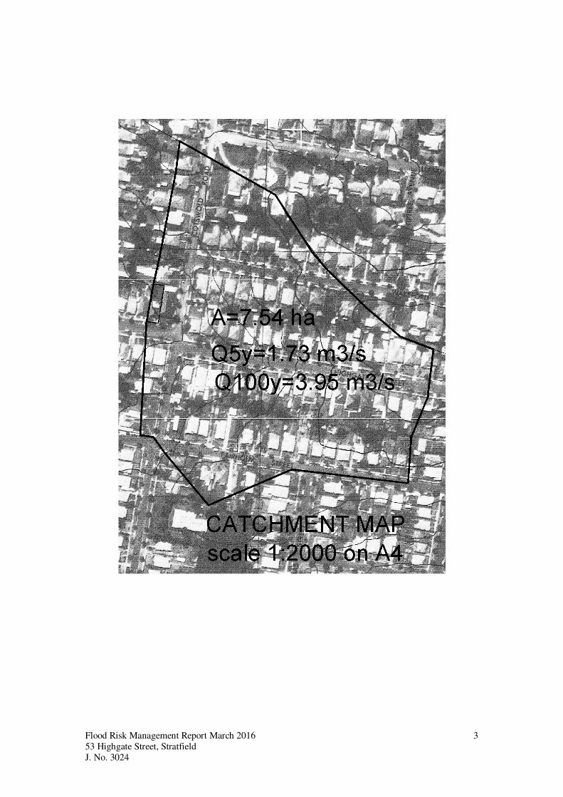
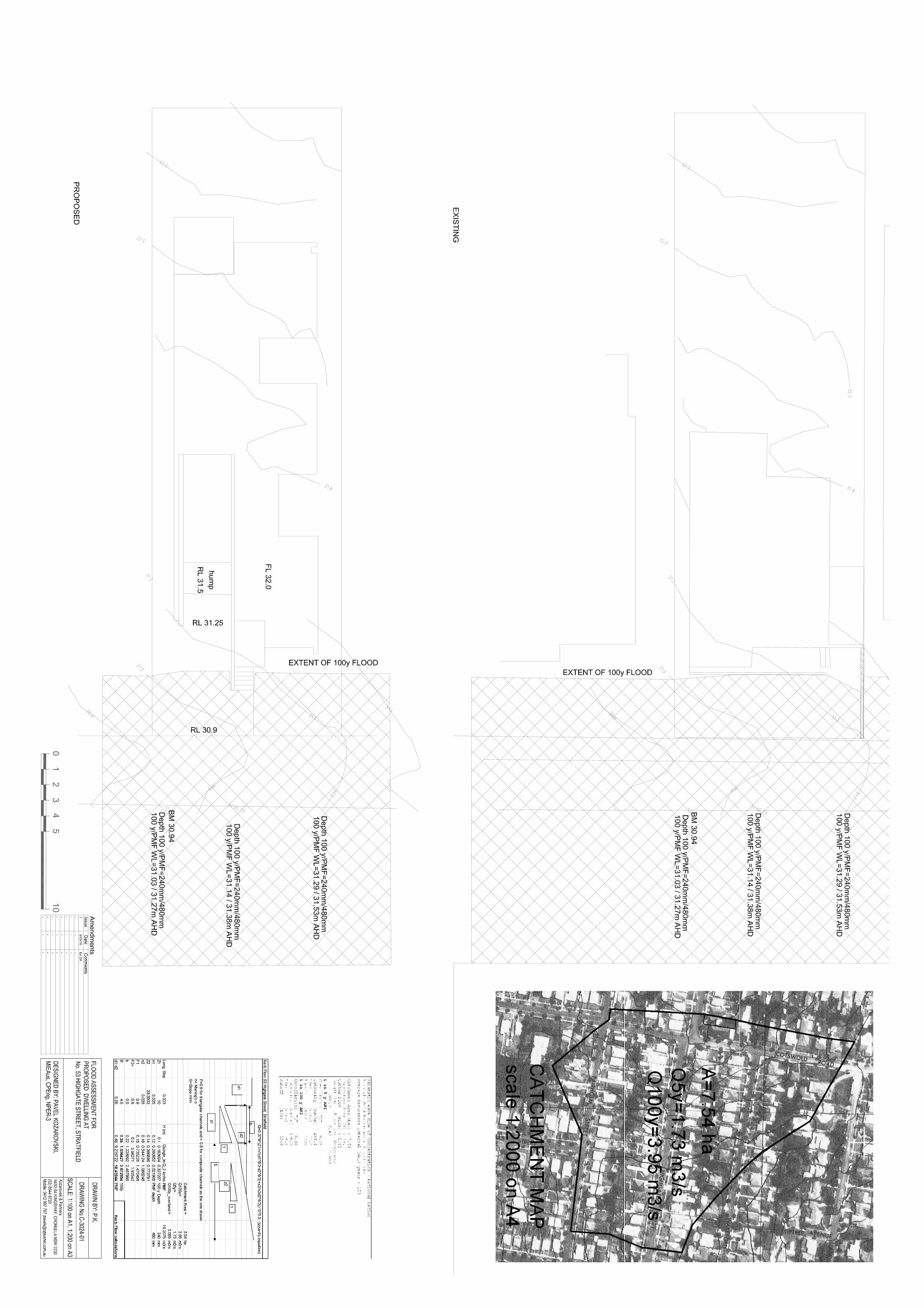
Overview A relatively small catchment with an area of 3.54 ha gravitates to Highgate Street. The catchment can
generate some 3.95m3/s during the 100 year flood event. The draiange systems have been designed to
convey the runoff during the 1 in 5 year storm. It was assumed that draiange system would be
operating at 50% capacity. The 1 in 100 year overland flow is therefore: 3.95 – 1.73/2=3.08 m3/s.
The corresponding to the 100 year flow depth of 240 mm was calculated using Izaard’s equation.
Most of the 100 year flow would be contained within the street with only a portion of the front yard
being inundated by the 100 year flood. The extent of flood and the estimated flood levels are shown on
Drawing C-3024-01.
The minimum floor level of the development would have to be set 500 mm above the 100 year flood
level. The relevant flood level is at 31.29 m AHD and the minimum Floor level is 31.79m AHD. The
adopted floor level is at RL 32.0 m AHD which is higher than the PMF level.
The minimum hump level protecting the basement from flooding must be set 300 mm above the 100
year flood level. The relevant flood level is at RL 31.14 and the minimum hump level should be set at
RL 31.44 m AHD. The adopted hump level is at RL 31.50 m AHD which is higher than the PMF
level.
Categorization of the Flood Risk The subject site is partially affected by the 100 year flood, with low hydraulic hazard and it is classified to be in a medium flood risk precinct.
Floor level The proposed floor level is at RL 32.00 m AHD which is more than 500 mm above the 100 year flood
level.
Flood impact The proposed dwelling will not have any impact on flood behavior. The existing dwarf wall between
No. 51 and No. 53 will be removed, increasing the conveyance. No flood storage will be lost due to
the development
Evacuation Evacuation from this site would not be required because the proposed floor level would be above the
PMF level.
Building material The proposed dwelling would have to be constructed form flood compatible materials up to RL 32.00m
AHD.
Flood warning/signage The flood depths and velocities through the site are negligible and flood warning signage is not
required.
______________
Flood Risk Management Report March 2016
53 Highgate Street, Stratfield
J. No. 3024
2
Pavel Kozarovski, MIEAust, CPEng, NPER-3
Appendix A
Catchment Map
Rational Formula Calculations
Kerb Flow Calculations
Flood Risk Management Report March 2016
53 Highgate Street, Stratfield
J. No. 3024
3
Flood Risk Management Report March 2016
53 Highgate Street, Stratfield
J. No. 3024
4
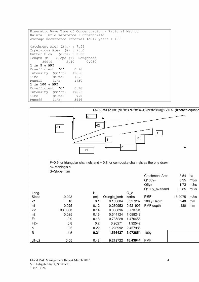
Kinematic Wave Time of Concentration - Rational Method
Rainfall Grid Reference : Strathfield
Average Recurrence Interval (ARI) years : 100
Catchment Area (Ha.) : 7.54
Impervious Area (%) : 75.0
Gutter Flow (mins) : 0.00
Length (m) Slope (%) Roughness
300.0 2.40 0.030
1 in 5 y ARI
Co-efficient "C" 0.76
Intensity (mm/hr) 108.8
Time (mins) 12.2
Runoff (l/s) 1730
1 in 100 y ARI
Co-efficient "C" 0.96
Intensity (mm/hr) 196.5
Time (mins) 9.6
Runoff (l/s) 3946
Q=0.375F(Z1/n1(d1^8/3-d2^8/3)+z2/n2d2^8/3))*S^0.5 (Izzard's equation)
F=0.9 for triangular channels and = 0.8 for composite channels as the one drawn
n= Maning's n
S=Slope m/m
Catchment Area 3.54 ha
Q100y= 3.95 m3/s
Q5y= 1.73 m3/s
Q100y_overland 3.085 m3/s Long. Slope 0.023
H (m) Qsingle_kerb
Q_2 kerbs PMF 18.2075 m3/s
Z1 10 0.1 0.163604 0.327207 100 y Depth 240 mm
n1 0.025 0.12 0.260952 0.521905 PMF depth 480 mm
Z2 33.3333 0.14 0.386896 0.773791
n2 0.025 0.16 0.544124 1.088248
F1 0.9 0.18 0.735228 1.470456
F2= 0.8 0.2 0.96271 1.92542
b 0.5 0.22 1.228992 2.457985
B 4.5 0.24 1.536427 3.072854 100y
d1-d2 0.05 0.48 9.219722 18.43944 PMF


![Final Major Project - Highgate Cemetery [Brief]](https://img.pdfslide.net/doc/110x75/568c4d071a28ab4916a267f8/final-major-project-highgate-cemetery-brief.jpg)