Embed Size (px)
Citation preview
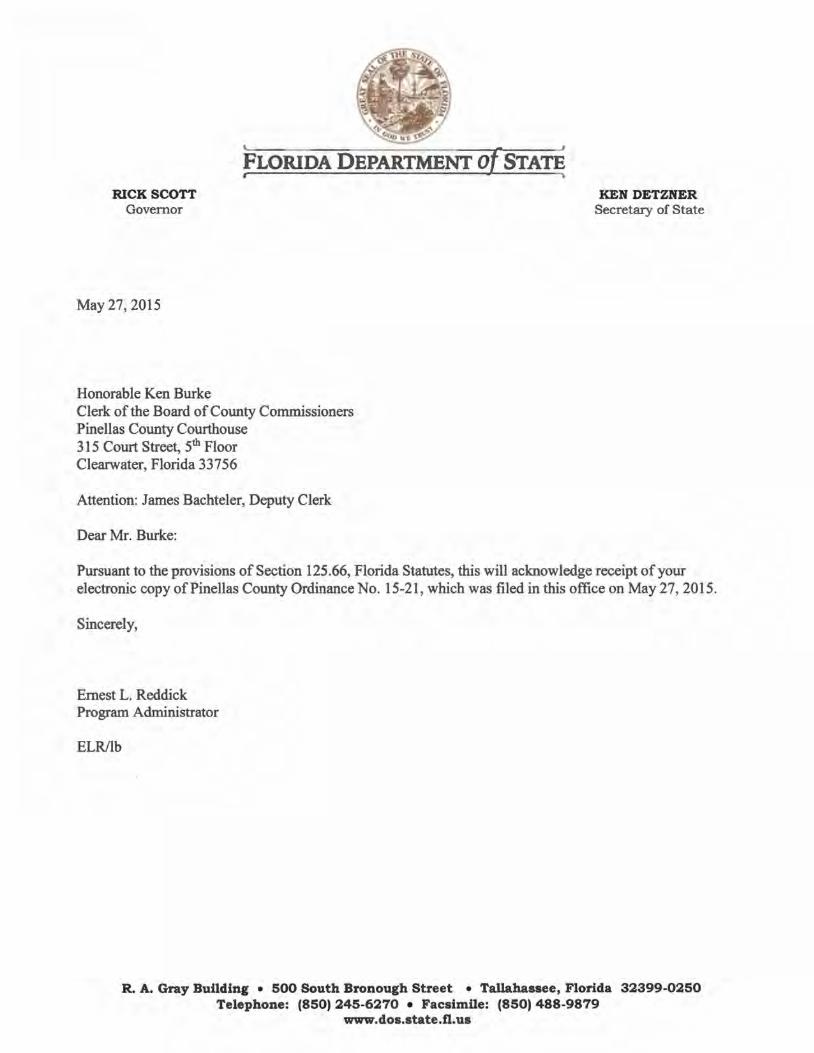
RICK SCOTT Governor
May 27,2015
Honorable Ken Burke
fLORIDA DEPARTMENT of. STAT~
Clerk of the Board of County Commissioners Pinellas County Courthouse 315 Court Street, 5th Floor Clearwater, Florida 33756
Attention: James Bachteler, Deputy Clerk
Dear Mr. Burke:
KEN DETZNER Secretary of State
Pursuant to the provisions of Section 125.66, Florida Statutes, this will acknowledge receipt of your electronic copy ofPinellas County Ordinance No. 15-21, which was filed in this office on May 27, 2015.
Sincerely,
Ernest L. Reddick Program Administrator
ELR/lb
R. A. Gray Building • 500 South Bronough Street • Tallahassee, Florida 32399-0250 Telephone: (850) 245-6270 • Facsimile: (850) 488-9879
www.dos.state.fl.us
Bachteler, James J
From: Sent: To: Cc: Attachments:
Bryant, Linda C. [[email protected]] Wednesday, May 27, 2015 1:00 PM Bachteler, James J County Ordinances Pinellas20150527 _Ordinance2015_15_21_Ack.pdf
The Department of State is committed to excellence. Please take our Customer Satisfaction Survey.
1
ORDINANCE NO. 15- 21
AN ORDINANCE OF PINELLAS COUNTY AMENDING CHAPTER 158 OF THE PINELLAS
COUNTY LAND DEVELOPMENT CODE, REPEALING ARTICLE III OF CHAPTER 170 OF
THE PINELLAS COUNTY LAND DEVELOPMENT CODE; ADOPTING FLOOD HAZARD
MAPS; DESIGNATING A FLOODPLAIN ADMINISTRATOR; ADOPTING PROCEDURES AND
CRITERIA FOR DEVELOPMENT IN FLOOD HAZARD AREAS, AND FOR OTHER
PURPOSES; ADOPTING LOCAL ADMINISTRATIVE AMENDMENTS TO THE FLORIDA
BUILDING CODE; ADOPTING LOCAL TECHNICAL AMENDMENTS TO THE FLORIDA
BUILDING CODE; PROVIDING FOR APPLICABILITY; PROVIDING FOR INCLUSION IN THE
CODE, PROYIDING FOR REPEALS AND AMENDMENTS; PROVIDING FOR OTHER
MODIFICATIONS THAT MAY ARISE FROM REVIEW OF THE ORDINANCE AT THE PUBLIC
HEARINGS AND WITH RESPONSIBLE PARTIES; PROVIDING FOR SEVERABILITY;
PROVIDING FOR AREA EMBRACED; AND PROVIDING FOR AN EFFECTIVE DATE.
WHEREAS, the Legislature of the State of Florida has, in Chapter 125 - County Government Florida Statutes, conferred upon counties the authority to adopt regulations designed to promote the public health, safety, and general welfare of its citizenry; and
WHEREAS, the Federal Emergency Management Agency has identified special flood hazard areas within the boundaries of Pinellas County and such areas may be subject to periodic inundation which may result in loss of life and property, health and safety hazards, disruption of commerce and governmental services, extraordinary public expenditures for flood protection and relief, and impairment of the tax base, all of which adversely affect the public health, safety and general welfare, and
WHEREAS, Pinellas County was accepted for participation in the National Flood Insurance Program on June 18, 1971 and the Pinellas County Board of County Commissioners desires to continue to meet the requirements ofTitle 44 Code of Federal Regulations, Sections 59 and 60, necessary for such participation; and
WHEREAS, Chapter 553, Florida Statutes, was adopted by the Florida Legislature to provide a mechanism for the uniform adoption, updating, amendment, interpretation and enforcement of a state building code, called the Florida Building Code; and
WHEREAS, section 553.73(5), Florida Statutes, allows adoption of local administrative amendments and local technical amendments to the Florida Building Code to implement the National Flood Insurance Program; and
WHEREAS, the Pinellas County Board of County Commissioners is adopting a requirement to increase the minimum elevation requirement for buildings and structures in flood hazard areas and a requirement to limit partitioning of enclosed areas below elevated buildings in flood hazard areas and, pursuant to section 553.73(5), Florida Statutes, is formatting that requirement to coordinate with the Florida Building Code; and
1
WHEREAS, the Pinellas County Board of County Commissioners has determined that it is in the public interest to adopt the proposed floodplain management regulations that are coordinated with the Florida Building Code.
NOW, THEREFORE, BE IT ORDAINED by the Board of County Commissioners of Pinellas County that the following floodplain management regulations, and the following local administrative amendments to the 2010 Florida Building Code, are hereby adopted:
SECTION 1. RECITALS.
The foregoing whereas clauses are incorporated herein by reference and made a part hereof.
SECTION 2. This ordinance specifically repeals and replaces CHAPTER 158 with the following, and repeals Article III of CHAPTER 170.
DIVISION 1. ADMINISTRATION
SECTION 158-101- GENERAL
Sec. 158-101.1 - Title. These regulations shall be known as the Floodplain Management Ordinance of Pinellas County hereinafter referred to as "this ordinance."
Sec. 158-101.2 - Scope. The provisions of this ordinance shall apply to all development that is wholly within or partially within any flood hazard area, including but not limited to the subdivision of land; filling, grading, and other site improvements and utility installations; construction, alteration, remodeling, enlargement, improvement, replacement, repair, relocation or demolition of buildings, structures, and facilities that are exempt from the Florida Building Code; placement, installation, or replacement of manufactured homes and manufactured buildings; installation or replacement of tanks; placement of recreational vehicles; installation of swimming pools; and any other development.
Sec. 158-101.3 -Intent. The purposes of this ordinance and the flood load and flood resistant construction requirements of the Florida Building Code are to establish minimum requirements to safeguard the public health, safety, and general welfare and to minimize public and private losses due to flooding through regulation of development in flood hazard areas to:
( 1) Minimize unnecessary disruption of commerce, access and public service during times of flooding;
(2) Require the use of appropriate construction practices in order to prevent or minimize future flood damage;
(3) Manage filling, grading, dredging, m1mng, paving, excavation, drilling operations, storage of equipment or materials, and other development which may increase flood damage or erosion potential;
2
( 4) Manage the alteration of flood hazard areas, watercourses, and shorelines to minimize the impact of development on the natural and beneficial functions of the floodplain;
(5) Minimize damage to public and private facilities and utilities;
( 6) Help maintain a stable tax base by providing for the sound use and development of flood hazard areas;
(7) Minimize the need for future expenditure of public funds for flood control projects and response to and recovery from flood events; and
(8) Meet the require~ents of the National Flood Insurance Program for community participation as set forth in the Title 44 Code of Federal Regulations, Section 59.22.
Sec.158-101.4 - Coordination with the Florida Building Code. This ordinance is intended to be administered and enforced in conjunction with the Florida Building Code. Where cited, ASCE 24 refers to the edition of the standard that is referenced by the Florida Building Code.
Sec.158-101.5 - Warning. The degree of flood protection required by this ordinance and the Florida Building Code, as amended by this community, is considered the minimum reasonable for regulatory purposes and is based on scientific and engineering considerations. Larger floods can and will occur. Flood heights may be increased by man-made or natural causes. This ordinance does not imply that land outside of mapped special flood hazard areas, or that uses permitted within such flood hazard areas, will be free from flooding or flood damage. The flood hazard areas and base flood elevations contained in the Flood Insurance Study and shown on Flood Insurance Rate Maps and the requirements of Title 44 Code of Federal Regulations, Sections 59 and 60 may be revised by the Federal Emergency Management Agency, requiring this community to revise these regulations to remain eligible for participation in the National Flood Insurance Program. No guaranty of vested use, existing use, or future use is implied or expressed by compliance with this ordinance.
Sec.158-101.6 - Disclaimer of Liability. This ordinance shall not create liability on the part of the Board of County Commissioners of Pinellas County or by any officer or employee thereof for any flood damage that results from reliance on this ordinance or any administrative decision lawfully madehereunder.
SECTION 158-102.APPLICABILITY
Sec. 158-102.1- General. Where there is a conflict between a general requirement and a specific requirement, the specific requirement shall be applicable.
Sec. 158-102.2 - Areas to which this ordin;mce applies. This ordinance shall apply to flood hazard areas established in Section 158-102.3 within the following areas:
(1) All areas within the Unincorporated area of Pinellas County;
3
(2) Property, easements, right-of-way and/or any other areas which the County has jurisdiction over outside the unincorporated areas of the County;
(3) Any activities which would have an effect on floodplains within the areas described in (1) and (2) above.
Sec. 158-102.3 - Basis for establishing flood hazard areas. The Flood Insurance Study for Pinellas County, Florida and Incorporated Areas dated August 18, 2009 and all subsequent amendments and revisions, and the accompanying Flood Insurance Rate Maps (FIRM), and all subsequent amendments and revisions to such maps, are adopted by reference as a part of this ordinance and shall serve as the minimum basis for establishing flood hazard areas. When limited data is available from FEMA Flood Insurance Study and Flood Insurance Rate Maps, the County will refer to the best available data through locally determined flood map data. Locally determined data shall include but not limited to Watershed Management Plans and the County's Stormwater Management Plan maps and profiles and the County Storm Drainage Basin Study technical appendices nos. 1 through 52, consecutively, and any subsequent amendments. These sources are adopted by reference and made a part of this chapter. Studies and maps that establish flood hazard areas are on file at the Building and Development Review Services, 31 0 Court Street, Clearwater, Fl 33756.
Sec. 158-102.4- Submission of additional data to establish flood hazard areas. To establish flood hazard areas and base flood elevations, pursuant to Section 15 8-105 of this ordinance, the Floodplain Administrator may require submission of additional data. Where field surveyed topography prepared by a Florida licensed professional surveyor or digital topography accepted by the community indicates that ground elevations:
( 1) Are below the closest applicable base flood elevation, even in areas not delineated as a special flood hazard area on a FIRM, the area shall be considered as flood hazard area and subject to the requirements of this ordinance and, as applicable, the requirements of the Florida Building Code.
(2) Are above the closest applicable base flood elevation, the area shall be regulated as special flood hazard area unless the applicant obtains a Letter of Map Change that removes the area from the special flood hazard area.
Sec. 158-102.5 - Other laws. The provisions of this ordinance shall not be deemed to nullify any provisions of local, state or federal law.
Sec. 158-102.6- Abrogation and greater restrictions. This ordinance supersedes any ordinance in effect for management of development in flood hazard areas. However, it is not intended to repeal or abrogate any existing ordinances including but not limited to land development regulations, zoning ordinances, stormwater management regulations, or the Florida Building Code. In the event of a conflict between this ordinance and any other ordinance, the more restrictive shall govern. This ordinance shall not impair any deed restriction, covenant or easement, but any land that is subject to such interests shall also be governed by this ordinance.
4
Sec. 158-102.7- Interpretation. In the interpretation and application ofthis ordinance, all .1 provisions shall be:
(1) Considered as minimum requirements;
( (2) Liberally construed in favor of the governing body; and
(3) Deemed neither to limit nor repeal any other powers granted under state statutes.
SECTION 158-103 DUTIES AND POWERS OF THE FLOODPLAIN ADMINISTRATOR
Sec. 158-103.1 - Designation. The County Administrator shall designate the Floodplain Administrator. The Floodplain Administrator may delegate performance of certain duties to other employees.
Sec. 158-103.2 -General. The Floodplain Administrator is authorized and directed to administer and enforce the provisions of this ordinance. The Floodplain Administrator shall have the authority to render interpretations of this ordinance consistent with the intent and· purpose of this ordinance and may establish policies and procedures in order to clarify the application of its provisions. Such interpretations, policies, and procedures shall not have the effect of waiving requirements specifically provided in this ordinance without the granting of a variance pursuant to Section 158-107 ofthis ordinance.
Sec. 158-103.3 -Applications and permits. The Floodplain Administrator, in coordination with other pertinent offices of the community, shall:
(1) Review applications and plans to determine whether proposed new development will be located in flood hazard areas;
(2) Review applications for modification of any existing development in flood hazard areas for compliance with the requirements of this ordinance;
(3) Interpret flood hazard area boundaries where such interpretation is necessary to determine the exact location of boundaries (for example, where there appears to be a conflict between a mapped boundary and actual field conditions); a person contesting the determination shall have the opportunity to appeal the interpretation;
(4) Provide available flood elevation and flood hazard information;
(5) Determine whether additional flood hazard data shall be obtained from other sources or shall be developed by an applicant;
(6) Review applications to determine whether proposed development will be reasonably safe from flooding;
5
(7) Issue floodplain development permits or approvals for development other than buildings and structures that are subject to the Florida Building Code, including buildings, structures and facilities exempt from the Florida Building Code, when compliance with this ordinance is demonstrated, or disapprove the same in the event of noncompliance, including filling of property for any other purpose other than minor landscaping; and
(8) Coordinate with and provide comments to the Building Official to assure that applications, plan reviews, and inspections for buildings and structures in flood hazard areas comply with the applicable provisions of this ordinance.
Sec. 158-103.4- Findings of Fact
The board of county commissioners hereby finds and declares that:
(1) Because of variations in rainfall and the amount of storm water runoff, flooding is a natural, recurring phenomenon.
(2) The floodprone areas of the county are subject to. periodic inundation which could r~sult in loss of life, property damage, health and safety hazards, disruption of commerce and governmental services, extraordinary public expenditures for flood protection and relief, and impairment of the tax base, all of which could adversely affect the public health, safety and general welfare.
(3) These flood losses are caused, in part, by the cumulative effect of obstructions and fill in floodplains causing increases in flood heights and velocities, and by the occupancy in floodprone areas Of uses vulnerable to damage by floods or hazardous to other lands which are inadequately elevated, floodproofed or otherwise protected from flood damages.
(4) Flooding and lands that are subject to flooding (flood-prone1 lands) serve the following important functions in the hydrologic cycle and ecological system:
a. Flood-prone lands provide natural storage and conveyance of floodwaters;
b. The water on flooded lands may provide recharge to groundwater and is a basic source of flow to rivers, streams and estuaries;
c. Temporary storage of surface waters on flood-prone lands regulates flood elevations and the timing, velocity and rate of flood discharges;
d. Flood-prone lands and the natural vegetation thereon maintain water quality by reducing erosion, removing nutrients and other pollutants and allowing sediment to settle;
6
(5) Development of flood-prone lands is inconsistent with their natural functions, and improper management of floodwaters have the following significant adverse impacts on the health, safety and welfare of the community:
a. The owners of homes and business structures located in frequently flooded areas and their customers, guests, employees, children and future generations are subjected to unreasonable risk of personal injury and property damage.
b. Expensive and dangerous search and rescue and disaster relief operations must be conducted when developed properties are flooded.
c. Roads and utilities associated with development are subject to damage from flooding at great expense to taxpayers and rate payers.
d. Flooding of developed properties leads to demands for government to construct expensive and often environmentally damaging projects to control floodwaters. J
e. Loss of natural water storage capacity leads to reduction in the available water supply and a reduction in the stormwater treatment effectiveness in these areas.
f. The level, velocity, frequency and duration of flooding on other lands are often increased when floodwaters are obstructed, diverted, displaced or channelized.
g. Water quality is degraded, freshwater inflows to estuaries are disrupted and valuable wetland and wildlife habitat is lost.
h. Property values are lowered and economic activity 1s disrupted by damaging floods.
Sec. 158-103.5 - Substantial improvement and substantial damage determinations. For applications for building permits to improve buildings and structures, including alterations, movement, enlargement, replacement, repair, change of occupancy, additions, rehabilitations, renovations, substantial improvements, repairs of substantial damage, and any other improvement of or work on such buildings and structures, the Floodplain Administrator, in coordination with the Building Official, shall:
(1) Estimate the market value, or require the applicant to obtain an appraisal of the market value prepared by a qualified independent appraiser, of the building or structure before the start of construction of the proposed work; in the case of repair, the market value of the building or structure shall be the market value before the damage occurred and before any repairs are made;
7
(2) Compare the cost to perform the improvement, the cost to repair a damaged building to its pre-damaged condition, or the combined costs of improvements and repairs, if applicable, to the market value of the building or structure;
(3) Determine and document whether the proposed work constitutes substantial improvement or repair of substantial damage; and
( 4) Notify the applicant if it is determined that the work constitutes substantial improvement or repair of substantial damage and that compliance with the flood resistant construction requirements of the Florida Building Code, NFIP and this ordinance is required.
Sec. 158-103.6 - Modifications of the strict application of the requirements of the Florida Building Code. The Floodplain Administrator shall review requests submitted to the Building Official that seek approval to modify the strict application of the flood load and flood resistant construction requirements of the Florida Building Code to determine whether such requests require the granting of a variance pursuant to Section 158-107 of this ordinance.
Sec. 158-103.7 - Notices and orders. The Floodplain Administrator shall coordinate with appropriate local agencies for the issuance of all necessary notices or orders to ensure compliance with this ordinance.
Sec. 158-103.8 -Inspections. The Floodplain Administrator shall make the required inspections as specified in Section 158-106 of this ordinance for development that is not subject to the Florida Building Code, including buildings, structures and facilities exempt from the Florida Building Code, ahd including filling of property for any purpose other than minor landscaping. The Floodplain Administrator shall inspect flood hazard areas to determine if development is undertaken without issuance of a permit.
Sec. 158-103.9 - Other duties of the Floodplain Administrator. The Floodplain Administrator shall have other duties, including but not limited to:
(1) Establish, in coordination with the Building Official, procedures for administering and documenting determinations of substantial improvement and substantial damage made pursuant to Section 158-103.5 ofthis ordinance;
(2) Require that applicants proposing alteration of a watercourse notify adjacent communities and the Florida Division of Emergency Management, St<:J.te Floodplain Management Office and the Southwest Florida Water Management District, and submit copies of such notifications to the Federal Emergency Management Agency (FEMA);
(3) Require applicants who submit hydrologic and hydraulic engineering analyses to support permit applications to submit to FEMA the data and information necessary to maintain the Flood Insurance Rate Maps if the analyses propose to change base flood elevations, flood hazard area boundaries, or floodway designations; such submissions shall be made within 6 months of such data becoming available;
8
( 4) Review required design certifications and documentation of elevations specified by this ordinance and the Florida Building Code and this ordinance to determine that such certifications and documentations are complete;
(5) Notify the Federal Emergency Management Agency when the corporate boundaries of Pinellas County are modified; and
(6) Advise applicants for new buildings and structures, including substantial improvements that are located in any unit of the Coastal Barrier Resources System established by the Coastal Barrier Resources Act (Pub. L. 97-348) and the Coastal Barrier Improvement Act of 1990 (Pub. L. 101-591) that federal flood insurance is not available on such construction; areas subject to this limitation are identified on Flood Insurance Rate Maps as "Coastal Barrier Resource System Areas" and "Otherwise Protected Areas."
Sec. 158-103.10 -Floodplain management records. Regardless of any limitation on the period required for retention of public records, the Floodplain Administrator shall maintain and permanently keep and make available for public inspection all records that are necessary for the administration of this ordinance and the flood resistant construction requirements of the Florida Building Code, including Flood Insurance Rate Maps; Letters of Change; records of issuance of permits and denial of permits; determinations of whether proposed work constitutes substantial improvement or repair of substantial damage; required design certifications and documentation of elevations specified by the Florida Building Code and this ordinance; notifications to adjacent communities, FEMA, and the state related to alterations of watercourses; assurances that the flood carr)ring capacity of altered watercourses will ·be maintained; documentation related to appeals and variances, including justification for issuance or denial; and records of enforcement actions taken pursuant to this ordinance and the flood resistant construction requirements of the Florida Building Code. These records shall be available for public inspection at the Pinellas County Development Review Services.
SECTION 158-104 PERMITS
Sec. 158-104.1 - Permits and approv.als required. Any owner or owner's authorized agent (hereinafter "applicant") who intends to undertake any development activity within the scope of this ordinance, including buildings, structur~s and facilities exempt from the Florida Building Code, which is wholly within or partially within any flood hazard area shall first make application to the Floodplain Administrator, and the Building Official if applicable, and shall obtain the required permit(s) and approval(s). In addition:
(1) No development of any land or structure shall be commenced until such time as the all the proper zoning clearances, building permits, or land development permits habitat permits and other required approvals have been issued.
(2) No land development permit may be issued for any development or use of any land or structure encompassed by the provisions of this chapter until the requirements of this chapter and all other floodplain management regulations have been met.
9
(3) All development and/or use of any land or structures within the scope of this chapter for which a development permit has been issued shall, at all times, continue to conform to the requirements of this chapter and the final approved development order or site plan for which the development permit was issued.
(4) More restrictive requirements imposed by other local and state legislation currently in effect or as amended shall take precedence over the terms of this chapter.
Sec. 158-104.2- Floodplain development permits or approvals. Floodplain development permits or approvals shall be issued pursuant to this ordinance for any development activities not subject to the requirements of the Florida Building Code, including buildings, structures and facilities exempt from the Florida Building Code. Depending on the nature and extent of proposed development that includes a building or structure, the Floodplain Administrator may determine that a floodplain development permit or approval is required in addition to a building permit.
Sec. 158-104.2.1 - Buildings, structures and facilities exempt from the Florida Building Code. Pursuant to the requirements of federal regulation for participation in the National Flood Insurance Program (44 C.F.R. Sections 59 and 60), floodplain development permits or approvals shall be required for the following buildings, structures and facilities that are exempt from the Florida Building Code and any further exemptions provided by law, which are subject to the requirements of this ordinance:
( 1) Railroads and ancillary facilities associated with the railroad.
(2) Nonresidential farm buildings on farms, as provided in section 604.50, F.S.
(3) Temporary buildings or sheds used exclusively for construction purposes.
(4) Mobile or modular structures used as temporary offices.
(5) Those structures or facilities of electric utilities, as defined in section 366.02, F.S., which are directly involved in the generation, transmission, or distribution of electricity
(6) Chickees constructed by the Miccosukee Tribe of Indians of Florida or the Seminole Tribe of Florida. As used in this paragraph, the term "chickee" means an open-sided wooden hut that has a thatched roof of palm or palmetto or other traditional materials, and that does not incorporate any electrical, plumbing, or other non-wood features.
(7) Family mausoleums not exceeding 250 square feet in area which are prefabricated and assembled on site or preassembled and delivered on site and have walls, roofs, and a floor constructed of granite, marble, or reinforced concrete.
(8) Temporary housing provided by the Department of Corrections to any prisoner in the state correctional system.
10
(9) Structures identified in section 553.73(10)(k), F.S., are not exempt from the Florida Building Code if such structures are located in flood hazard areas established on Flood Insurance Rate Maps
Sec. 158-104.3 - Application for a permit or approval. To obtain a floodplain development permit or approval, the applicant shall first file an application in writing on a form furnished by the community. The information provided shall:
(1) Identify and describe the development to be covered by the permit or approval.
(2) Describe the land on which the proposed development is to be conducted by legal description, street address or similar description that will readily identify and definitively locate the site.
(3) Indicate the use and occupancy for which the proposed development is intended.
( 4) Be accompanied by a site plan or construction documents as specified in Section 15 8-1 05 of this ordinance.
(5) State the valuation of the proposed work.
(6) Be signed by the applicant or the applicant's authorized agent.
(7) Give such other data and information as required by the Floodplain Administrator.
Sec. 158-104.4 - Validity of permit or approval. The issuance of a floodplain development permit or approval pursuant to this ordinance shall not be construed to be a permit for, or approval of, any violation of this ordinance, the Florida Building Codes, or any other ordinance of this community. The issuance of permits based on submitted applications, construction documents, and information shall not prevent the Floodplain Administrator from requiring the correction of errors and omissions.
Sec. 158-104.5- Expiration. A floodplain development permit or approval shall become invalid unless the work authorized by such permit is commenced within 180 days after its issuance, or if the work authorized is suspended or abandoned for a period of 180 days after the work commences. Extensions for periods of not more than 180 days each shall be requested in writing and justifiable cause shall be demonstrated.
Sec. 158-104.6 - Suspension or revocation. The Floodplain Administrator is authorized to suspend or revoke a floodplain development permit or approval if the permit was issued in error, on the basis of incorrect, inaccurate or incomplete information, or in violation of this ordinance or any other ordinance, regulation or requirement of this community.
Sec. 158-104.7 - Other permits required. Floodplain development permits and building permits shall include a condition that all other applicable state or federal permits be obtained before commencement of the permitted development, including but not limited to the following:
11
(1) The Southwest Florida Water Management District; section 373.036, F.S.
(2) Florida Department of Health for onsite sewage treatment and disposal systems; section 381.0065, F.S. and Chapter 64E-6, F.A.C.
(3) Florida Department of Environmental Protection for construction, reconstruction, changes, or physical activities for shore protection or other activities seaward of the coastal construction control line; section 161.141, F.S.
( 4) Florida Department of Environmental Protection for activities subject to the Joint Coastal Permit; section 161.055, F.S.
(5) Florida Department of Environmental Protection for activities that affect wetlands and alter surface water flows, in conjunction with the U.S. Army Corps of Engineers; Section 404 of the Clean Water Act.
(6) Federal permits and approvals.
SECTION 158-105 SITE PLANS AND CONSTRUCTION DOCUMENTS
Sec. 158-105.1 - Information for development in flood hazard areas. The site plan or construction documents for any development subject to the requirements of this ordinance shall be drawn to scale and shall include, as applicable to the proposed development:
(1) Delineation of flood hazard area~, floodway boundaries which include the 1 00-year and/or 25-year (if delineated) boundaries, and flood zone(s), base flood elevation(s), and ground elevations if necessary for review of the proposed development.
(2) Where base flood elevations, or floodway data are not included on the FIRM or in the Flood Insurance Study, they shall be established in accordance with Section 158-105.2(2) or (3) of this ordinance.
(3) Where the parcel on which the proposed development will take place will have more than 50 lots or is larger than 5 acres and the base flood elevations are not included on the FIRM or in the Flood Insurance Study, such elevations shall be established in accordance with Section 158-105.2(1) ofthis ordinance.
(4) Location of the proposed activity and proposed structures, and locations of existing buildings and structures; in coastal high hazard areas, new buildings shall be located landward of the reach of mean high tide.
(5) Location, extent, amount, and proposed final grades of any filling, grading, or excavation, including any proposed compensatory excavation.
(6) Where the placement of fill is proposed, the amount, type, and source of fill 'material; compaction specifications; a description of the intended purpose of the fill areas; and
12
evidence that the proposed fill areas are the minimum necessary to achieve the intended purpose.
(7) Delineation of the Coastal Construction CQntrol Line or notation that the site is seaward of the coastal construction control line, if applicable.
(8) Extent of any proposed alteration of sand dunes and mangrove stands provided such alteration is approved by the Florida Department of Environmental Protection and in accordance with Section 166, Article II, Division 3 of the County's Land Development Code, as applicable.
(9) Existing and proposed alignment of any proposed alteration of a watercourse.
( 1 0) Elevation of all structures, in relation to the datum on the Flood Insurance Rate Map, of the lowest floor, including basement, or lowest horizontal structural member, as applicable.
(11) Datum used to determine the floodplain elevation and source of data. A datum ofNAVD 88 shall be used.
The Floodplain Administrator is authorized to waive the submission of site plans, construction documents, and other data that are required by this ordinance but that are not required to be prepared by a registered design professional if it is found that the nature of the proposed development is such that the review of such submissions is not necessary to ascertain compliance with this ordinance.
Sec.· 158-105.2 - Information in flood hazard areas without base flood elevations (approximat~ Zone A). Where flood hazard areas are delineated on the FIRM and base flood elevation data have not been provided, the Floodplain Administrator shall:
(1) Require the applicant to include base flood elevation data prepared in accordance with currently accepted engineering practices.
(2) Obtain, review, and provide to applicants base flood elevation and floodway data available from a federal or state agency or other source or require the applicant to obtain and use base flood elevation and floodway data available from a federal or state agency or other source.
(3) Where base flood elevation and floodway data are not available from another source, where the available data are deemed by the' Floodplain Administrator to not reasonably reflect flooding conditions, or where the available data are known to be scientifically or technically incorrect or otherwise inadequate:
(a) Require the applicant to include base flood elevation data prepared m accordance with currently accepted engineering practices; or
13
(b) Specify that the base flood elevation is three (3) feet above the highest adjacent grade at the location of the development, provided there is no evidence indicating flood depths have been or may be greater than three (3) feet.
(4) Upon approval of base flood elevation data, incorporate the data into the stormwater management plan.
(5) Where the base flood elevation data are to be used to support a Letter of Map Change from FEMA, advise the applicant that the analyses shall be prepared by a Florida licensed engineer in a format required by FEMA, and that it shall be the responsibility of the applicant to satisfy the submittal requirements and pay the processing fees.
Sec. 158-105.3 - Twenty-five-year floodways and floodplains. If the limits of the 25 year floodplain and floodway are available and approved by the County, no development is allowed within the limits of the 25 year floodway. In addition, development is only allowed within the 25 year floodplain that is outside the limits of the 100 year floodway. Engineering studies and analyses shall be submitted to demonstrate the compensatory excavation hydraulically balances the proposed development, redevelopment or fill for development within the 25 year floodplain.
Sec. 158-105.4 - Additional analyses and certifications. As applicable to the location and nature of the proposed development activity, and in addition to the requirements of this section, the applicant shall have the following analyses signed and sealed by a Florida licensed engineer for submission with the site plan and construction documents:
(1) For development activities proposed to be located in a regulatory floodway, a floodway encroachment analysis that demonstrates that the encroachment of the proposed development will not cause any increase in base flood elevations; where the applicant proposes to undertake development activities that do increase base flood elevations, the applicant shall submit such analysis to FEMA as specified in Section 158-105.5 of this ordinance and shall submit the Conditional Letter of Map Revision, if issued by FEMA, with the site plan and construction documents.
(2) For development activities proposed to be located in a riverine flood hazard area for which base flood elevations are included in the Flood Insurance Study or on the FIRM and floodways have not been designated, hydrologic and hydraulic analyses that demonstrate that the cumulative effect of the proposed development, when combined with all other existing and anticipated flood hazard area encroachments, will not increase the base flood elevation at any point within the areas identified in Section 158-102.2 of this ordinance.
(3) For alteration of a watercourse, an engineering analysis prepared in accordance with standard engineering practices which demonstrates that the flood-carrying capacity of the altered or relocated portion of the watercourse will not be decreased, and certification that the altered watercourse shall be maintained in a manner which preserves the channel's
14
flood-carrying capacity; the applicant shall submit the analysis to FEMA as specified in Section 158-105.5 of this ordinance.
( 4) For activities that propose to alter sand dunes and mangrove stands in coastal high hazard areas (Zone V), an engineering analysis that demonstrates that the proposed alteration will not increase the potential for flood damage.
Sec. 158-105.5- Submission of additional data. When additional hydrologic, hydraulic or other engineering data, studies, and additional analyses are submitted to support an application, the applicant has the right to seek a Letter of Map Change from FEMA to change the base flood elevations, change floodway boundaries, or change boundaries of flood hazard areas shown on FIRMs, and to submit such data to FEMA for such purposes. The analyses shall be prepared by a Florida licensed engineer in a format required by FEMA. Submittal requirements and processing fees shall be the responsibility of the applicant.
SECTION 158-106 INSPECTIONS
Sec. 158-106.1- General. Development for which a floodplain development permit or approval is required shall be subject to inspection.
Sec. 158-106.1.1 -Development other than buildings and structures. The Floodplain Administrator shall inspect all development to determine compliance with the requirements of this ordinance and the conditions of issued floodplain development permits or approvals.
Sec. 158-106.1.2 - Buildings, structures and facilities exempt from the Florida Building Code. The Floodplain Administrator shall inspect buildings, structures and facilities exempt from the Florida Building Code to determine compliance with the requirements of this ordinance and the conditions of issued floodplain development permits or approvals.
Sec. 158-106.1.2.1 - Buildings, structures and facilities exempt from the Florida Building Code, lowest floor inspection. Upon placement of the lowest floor, including basement, and prior to further vertical construction, the owner of a building, structure or facility exempt from the Florida Building Code, or the owner's authorized agent, shall submit to the Floodplain Administrator:
( 1) If a design flood elevation was used to determine the required elevation of the lowest floor, the certification of elevation of the lowest floor prepared and sealed by a Florida licensed professional surveyor; or
(2) If the elevation used to determine the required elevation of the lowest floor was determined in accordance with Section 158-105.2(3)(b) ofthis ordinance, the documentation of height of the lowest floor above highest adjacent grade, prepared by the owner or the owner's authorized agent.
15
Sec. 158-106.1.2.2 - Buildings, structures and facilities exempt from the Florida Building Code, final inspection. As part of the final inspection, the owner or owner's authorized agent shall submit to the Floodplain Administrator a final certification of elevation of the lowest floor or final documentation of the height of the lowest floor above the highest adjacent grade; such certifications and documentations shall be prepared as specified in Section 158-106.1.2.1 of this ordinance.
Sec. 158-6.1.3 - Manufactured homes. The Building Official shall inspect manufactured homes that are installed or replaced in flood hazard areas to determine compliance with the requirements of this ordinance and the conditions of the issued permit. Upon placement of a manufactured home, certification of the elevation of the lowest floor shall be submitted to the Building Official.
SECTION 158-107 VARIANCES AND APPEALS
Sec. 158-107.1- General. The County Administrator shall designate a variance review board that shall hear and decide on requests for appeals and requests for variances from the strict application of this ordinance. Pursuant to section 553.73(5), F.S., the variance review board shall hear and decide on requests for appeals and requests for variances from the strict application of the flood resistant construction requirements of the Florida Building Code. This section does not apply to Section 31 09 of the Florida Building Code, Building.
Sec. 158-107.2- Appeals. The variance review board shall hear and decide appeals when it is alleged there is an error in any requirement, decision, or determination made by the Floodplain Administrator in the administration and enforcement of this ordinance. Any person aggrieved by the decision of variance review board may appeal such decision to the Circuit Court, as provided by Florida Statutes.
Sec. 158-107.3- Limitations on authority to grant variances. The variance review board shall base his/her decisions on variances on technical justifications submitted by applicants, the considerations for issuance in Section 158-107.5 of this ordinance, the conditions of issuance set forth in Section 158-107.6 of this ordinance, and the comments and recommendations of the Floodplain Administrator and the Building Official. The variance review board has the right to attach such conditions as it deems necessary to further the purposes and objectives of this ordinance.
Sec. 158-107.3.1 - Restrictions in floodways. A variance shall not be issued for any proposed development in a floodway if any increase in base flood elevations would result, as evidenced by the applicable analyses and certifications required in Section 158-105.4 of this ordinance.
Sec. 158-107.4 - Historic buildings. A variance is authorized to be issued for the repair, improvement, or rehabilitation of a historic building that is determined eligible for the exception to the flood resistant construction requirements of the Florida Building Code, Existing Building, Chapter 11 Historic Buildings, upon a determination that the proposed repair, improvement, or
16
rehabilitation will not preclude the building's continued designation as a historic building and the variance is the minimum necessary to preserve the historic character and design of the building. If the proposed work precludes the building's continued designation as a historic building, a variance shall not be granted and the building and any repair, improvement, and rehabilitation shall be subject to the requirements of the Florida Building Code.
Sec. 158-107.5 - Considerations for issuance of variances. In reviewing requests for variances, the variance review board shall consider all technical evaluations, all relevant factors, all other applicable provisions of the Florida Building Code, this ordinance, and the following:
(1) The danger that materials and debris may be swept onto other lands resulting in further injury or damage;
(2) The danger to life and property due to flooding or erosion damage;
(3) The susceptibility of the proposed development, including contents, to flood damage and the effect of such damage on current and future owners; ,
(4) The importance ofthe services provided by the proposed development to the community;
(5) The availability of alternate locations for the proposed development that are subject to lower risk of flooding or erosion;
(6) The compatibility of the proposed development with existing and anticipated development;
(7) The relationship of the proposed development to the comprehensive plan and flqodplain management program for the area;
(8) The safety of access to the property in times of flooding for ordinary and emergency vehicles;
(9) The expected heights, velocity, duration, rate of rise and debris and s~diment transport of the floodwaters and the effects of wave action, if applicable, expected at the site; and
(10) The costs of providing governmental services during and after flood conditions including maintenance and repair of public utilities and facilities such as sewer, gas, electrical and water systems, streets and bridges. ,
Sec. 158-107.6- Conditions for issuance ofvariances. Variances shall be issued only upon:
(1) Submission by the applicant, of a showing of good and sufficient cause that the unique characteristics of the size, configuration, or topography of the site limit compliance with any provision of this ordinance or the required elevation standards. The burden shall be on the applicant to provide documentation, sufficient to the satisfaction of the Floodplain
17
Administrator, to show that the standards and conditions required for the granting of a variance have been met.
(2) Determination by the variance review board that:
(a) Failure to grant the variance would result in exceptional hardship due to the physical characteristics of the land that render the lot undevelopable; increased costs to satisfy the requirements or inconvenience do not constitute hardship. For purpose of this section, an exceptional hardship can only be caused by a peculiar and unique circumstance related directly to the land and shall not be the result of inconvenience, aesthetic consideration, physical or medical handicap, personal preference, financial considerations, or any after-the-fact circumstance created by the inhabitants of the structure or the present or previous property owners;
(b) The granting of a variance will not result in increased flood heights, additional threats to public safety, extraordinary public expense, nor create nuisances, cause fraud on or victimization of the public or conflict with existing local laws and ordinances; and
(c) The variance is the minimum necessary, considering the flood hazard, to afford relief;
(3) Receipt of a signed statement by the applicant that the variance, if granted, shall be recorded in the Office of the Clerk of the Court in such a manner that it appears in the chain of title of the affected parcel of land; and
(4) If the request is for a variance to allow construction of the lowest floor of a new building, or substantial improvement of a building, below the required elevation, a copy in the record of a written notice from the Floodplain Administrator to the applicant for the variance, specifying the difference between the base flood elevation and the proposed elevation of the lowest floor, stating that the cost of federal flood insurance will be commensurate with the increased risk resulting from the reduced floor elevation, and stating that construction below the base flood elevation increases risks to life and property.
SECTION 158-108 VIOLATIONS
Sec. 158-108.1 - Violations. Any development that is not within the scope of the Florida Building Code but that is regulated by this ordinance that is performed without an issued permit, that is in conflict with an issued permit, or that does not fully comply with this ordinance, shall be deemed a violation of this ordinance. A building or structure without the documentation of elevation of the lowest floor, other required design certifications, or other evidence of compliance required by this ordinance or the Florida Building Code is presumed to be a violation until such time as that documentation is provided.
18
Sec. 158-108.2- Authority. For development that is not within the scope of the Florida Building Code but that is regulated by this ordinance and that is determined to be a violation, the Floodplain Administrator is authorized to serve notices of violation or stop work orders to owners of the property involved, to the owner's agent, or to the person or persons performing the work.
Sec. 158-108.3- Unlawful continuance. Any person who shall continue any work after having been served with a notice of violation or a stop work order, except such work as that person is directed to perform to remove or remedy a violation or unsafe condition, shall be subject to penalties as prescribed by law.
SECTION 158-109 ENFORCEMENT; PENALTIES
Sec. 158-109.1 - The owners of property subject to this chapter shall be responsible for compliance with this chapter with respect to their property. Enforcement action taken by the county or state may be brought against the owner and/or persons or entities in control of the property, including a contractor working on the property.
Sec. 158-109.2 - Any person who violates any provision of this article shall be punished as provided in section 134-8.
Sec. 158-109.3 -Any person or agency violating the provisions of this chapter may be required to restore land to its undisturbed condition and may be held responsible for any damages occurring as a result of the violation.
DIVISION 2 DEFINITIONS
SECTION 158-201 GENERAL
Sec. 158-201.1 Scope. Unless otherwise expressly stated, the following words and terms shall, for the purposes of this ordinance, have the meanings shown in this section.
Sec. 158-201.2 Terms defined in the Florida Building Code. Where terms are not defined in this ordinance and are defined in the Florida Building Code, such terms shall have the meanings ascribed to them in that code.
Sec. 158-201.3 Terms not defined. Where terms are not defined in this ordinance or the Florida Building Code, such terms shall have ordinarily accepted meanings such as the context implies.
SECTION 158-202 DEFINITIONS
Adverse impact means any modifications, alterations or effects on a feature or characteristic of water or floodprone lands, including their quality, quantity, hydrodynamics, surface area, species composition, living resources, aesthetics or usefulness for human or natural uses which are or potentially may be harmful or injurious to human health, welfare, safety or property, to biological productivity, diversity or stability or which may unreasonably interfere with the
19
enjoyment of life or property, including outdoor recreation. The term includes secondary and cumulative as well as direct impacts.
Alteration of a watercourse. A dam, impoundment, channel relocation, change in channel alignment, channelization, or change in cross-sectional area of the channel or the channel capacity, or any other form of modification which may alter, impede, retard or change the direction and/or velocity ofthe riverine flow of water during conditions of the base flood.
Appeal. A request for a review of the Floodplain Administrator's interpretation of any provision of this ordinance or a request for a variance.
Applicant means the owner of the property for which a development permit is sought, or his authorized agent.
ASCE 24. A standard titled Flood Resistant Design and Construction that is referenced by the Florida Building Code. ASCE 24 is developed and published by the American Society of Civil Engineers, Reston, VA.
Base flood. A flood having a !-percent chance of being equaled or exceeded in any given year. [Also defined in FBC, B, Section 1612.2.] The base flood is commonly referred to as the "100-year flood" or the "1-percent-annual chance flood."
Base flood elevation. The elevation of the base flood, including wave height, relative to the National Geodetic Vertical Datum (NGVD), North American Vertical Datum (NAVD) or other datum specified on the Flood Insurance Rate Map (FIRM). [Also defined in FBC, B, Section 1612.2.]
Basement. The portion of a building having its floor subgrade (below ground level) on all sides. [Also defined in FBC, B, Section 1612.2.]
Breakaway walls means a partition or wall that is independent of supporting structural members and that is intended to withstand design wind forces but to collapse from a water load less than that which would occur during the base flood, without causing collapse, displacement or other structural damage to the elevated portion of the building or supporting foundation system. Breakaway walls are designed and constructed to meet the requirements of the FBC, Residential, Section R322.3.4 or ASCE 24 for walls below the design flood elevation.
Coastal Barrier Resource Act of 1982 (CBRA) For the purposes of the NFIP, the Coastal Barrier Resources Act of 1982 designated certain portions of the Gulf and East Coasts and undeveloped coastal barriers. These areas are shown on the appropriate flood insurance maps panels and have certain flood insurance coverage restrictions.
Coastal construction control line. The line established by the State of Florida pursuant to section 161.053, F.S., and recorded in the official records of the community, which defines that portion of the beach-dune system subject to severe fluctuations based on a 1 00-year storm surge, storm waves or other predictable weather conditions.
20
Coastal high hazard area. A special flood hazard area extending from offshore to the inland limit of a primary frontal dune along an open coast and any other area subject to high velocity wave action from storms or seismic sources. Coastal high hazard areas are also referred to as "high hazard areas subject to high velocity wave action" or "V Zones" and are designated on Flood Insurance Rate Maps (FIRM) as Zone Vl-V30, VE, or V. This term is not to be confused with the 'coastal high hazard area' defined in the Pinellas County Comprehensive Plan, which is based upon the Sea, Lake, and Overland Surges from Hurricanes (SLOSH) model, and used for land use planning purposes. [Note:· The FBC,B defines and uses the term "flood hazard areas subject to high velocity wave action" and the FBC, Ruses the term "coastal high hazard areas."]
Compensatory excavation means that excavation within or directly contiguous to a floodplain for the purpose of hydraulically balancing proposed fill.
County Administrator means the chief executive officer of the county responsible to the board of county commissioners for the execution of this article and the delegation of responsibilities for the individual tasks contained in this article.
Designflood. The flood associated with the greater of the following two areas: [Also defined in FBC, B, Section 1612.2.]
(1) Area with a floodplain subject to a !-percent or greater chance of flooding in any year; or
(2) Area designated as a flood hazard area on the community's flood hazard map, or otherwise legally designated.
Design flood elevation. The elevation of the "design flood," including wave height, relative to the datum specified on the community's legally designated flood hazard map. In areas designated as Zone AO, the design flood elevation shall be the elevation of the highest existing grade of the building's perimeter plus the depth number (in feet) specified on the flood hazard map. In areas designated as Zone AO where the depth number is not specified on the map, the depth number shall be taken as being equal to 3 feet. [Also defined in FBC, B, Section 1612.2.]
Development. Any man-made change to improved or unimproved real estate, including but not limited to, buildings or other structures, tanks, temporary structures, temporary or permanent storage of equipment or materials, mining, dredging, filling, grading, paving, excavations, drilling operations or any other land disturbing activities. For the purposes of this ch~pter, development shall include, but is not limited to, the following activities or uses:
(1) A reconstruction, alteration of the size, or change in the external appearance of a structure;
(2) A change in the intensity of use of land, such as an increase in the number of dwelling units in a structure or on land or an increase in the number of businesses, manufacturing establishments, offices, or dwelling units in a structure or on land;
21
(3) Alteration of a shore or bank of a seacoast, river, stream, lake, pond, or canal, including any coastal construction as defined in F.S. § 161.021;
(4) Commencement of drilling, except to obtain soil samples, mining, or excavation on a parcel of land;
(5) Demolition of a structure;
(6) Clearing of land as an adjunct of construction; and
(7) Deposit of refuse, solid or liquid waste, or fill on a parcel of land.
Encroachment. The placement of fill, excavation, buildings, permanent structures or other development into a flood hazard area which may impede or alter the flow capacity of riverine flood hazard areas.
Existing building and existing structure. Any buildings and structures for which the "start of construction" commenced before June 18, 1971. [Also defined in FBC, B, Section 1612.2.]
Existing manufactured home park or subdivision. A manufactured home park or subdivision for which the construction of facilities for servicing the lots on which the manufactured homes are to be affixed (including, at a minimum, the installation of utilities, the construction of streets, and either final site grading or the pouring of concrete pads) is completed before June 18, 1971.
Expansion to an existing manufactured home park or subdivision. The preparation ofadditional sites by the construction of facilities for servicing the lots on which the manufactured homes are to be affixed (including the installation of utilities, the construction of streets, and either final site grading or the pouring of concrete pads).
Federal Emergency Management Agency (FEMA). The federal agency that, in addition to carrying out other functions, administers the National Flood Insurance Program.
Flood or flooding. A general and temporary condition of partial or complete inundation of normally dry land from: [Also defined in FBC, B, Section 1612.2.]
(1) The overflow of inland or tidal waters.
(2) The unusual and rapid accumulation or runoff of surface waters from any source.
Flood damage-resistant materials. Any construction material capable of withstanding direct and prolonged contact with floodwaters without sustaining any damage that requires more than cosmetic repair. [Also defined in FBC, B, Section 1612.2.]
Flood hazard area. The greater of the following two areas: [Also defined in FBC, B, Section 1612.2.]
22
(1) The area within a floodplain subject to a 1-percent or greater chance of flooding in any year.
(2) The area designated as a flood hazard area on the community's flood hazard map, or otherwise legally designated.
Floodplain means the lateral extent of inundation by an event of given statistical frequency, such as special flood hazard areas as designated in the FIRMs, and 1 00-year and 25-year floodplain as designated in County Watershed Management Plans and the county stormwater master plan (SWMP) or any other source approved by the County's Floodplain Administrator.
Flood Insurance Rate Map (FIRM). The offiCial map of the community on which the Federal Emergency Management Agency has delineated both special flood hazard areas and the risk premium zones applicable to the community. [Also defined in FBC, B, Section 1612.2.]
Flood Insurance Study (FIS). The offi~ial report provided by the Federal Emergency Management Agency that contains the Flood Insurance Rate Map, the Flood Boundary and Flood way Map (if applicable), the water surface elevations of the base flood, and supporting technical data. [Also defined in FBC, B, Section 1612.2.]
Floodplain Administrator. The office or position designated ahd charged with the administration and enforcement of this ordinance (may be referred to as the Floodplain Manager) as designated by the County Administrator.
Floodplain development permit or approval. An official document or certificate issued by the community, or other evidence of approval or concurrence, which authorizes performance of specific development activities that are located in flood hazard areas and that are determined to be compliant with this ordinance.
Floodway. The channel of a river or other riverine watercourse and the adjacent land areas that must be reserved in order to discharge the base flood without cumulatively increasing the water surface elevation more than one (1) foot. [Also defined in FBC, B, Section 1612.2.] The County has a no rise policy within the floodways.
Floodway encroachment analysis. An engineering analysis of the impact that a proposed encroachment into a floodway is expected to have on the floodway boundaries and base flood elevations; the evaluation shall be prepared by a qualified Florida licensed engineer using standard engineering methods and models.
Floodprone area. Any land area susceptible to being inundated by water from any source.
Florida Building Code. The family of codes adopted by the Florida Building Commission, including: Florida Building Code, Building; Florida Building Code, Residential; Florida Building Code, Existing Building; Florida Building Code, Mechanical; Florida Building Code, Plumbing; Florida Building Code, Fuel Gas.
23
. Freeboard means a level higher than the base flood elevation. It is a factor of safety usually expressed in feet above a flood level for purposes of flood plain management. Freeboard compensates for the many unknown factors that could contribute to flood heights greater than the height calculated for a selected size flood and floodway conditions, such as wave action or the hydrological effect of urbanization on the watershed.
Hazardous material means those chemicals or substances that are physical hazards or health hazards as defined and classified in the Florida Building Code and the Florida Fire Prevention Code, whether the materials are- in usable or waste condition. [Defined in FBC, B, Section 307]
Highest adjacent grade. The highest natural elevation of the ground surface prior to construction next to the proposed walls or foundation of a structure.
Historic structure. Any structure that is determined eligible for the exception to the flood hazard area requirements of the Florida Building Code, Existing Building, Chapter 11 Historic Buildings.
Letter of Map Change (LOMC). An official determination issued by FEMA that amends or revises an effective Flood Insurance Rate Map or Flood Insurance Study. Letters ofMap Change include:
Letter of Map Amendment (LOMA): An amendment based on technical data showing that a property was incorrectly included in a designated special flood hazard area. A LOMA amends the current effective Flood Insurance Rate Map and establishes that a specific property, portion of a property, or structure is not located in a special flood hazard area.
Letter of Map Revision (LOMR): A revision based on technical data that may show changes to flood zones, flood elevations, special flood hazard area boundaries and floodway delineations, and other planimetric features.
Letter of Map Revision Based on Fill (LOMR"'F): A determination that a structure or parcel of land has been elevated by fill above the base flood elevation and is, therefore, no longer located within the special flood hazard area. In order to qualify for this determination, the fill must have been permitted and placed in accordance with the· community's floodplain management regulations.
Conditional Letter of Map Revision (CLOMR): A formal review and comment as to whether a proposed flood protection project or other project complies with the minimum NFIP requirements for such projects with respect to delineation of special flood hazard areas. A CLOMR does not revise the effective Flood Insurance Rate Map or Flood Insurance Study; upon submission and approval of certified as-built documentation, a Letter of Map Revision may be issued by FEMA to revise the effective FIRM.
Light-duty truck. As defined in 40 C.P.R. 86.082-2, any motor vehicle rated at 8,500 pounds Gross Vehicular Weight Rating or less which has a vehicular curb weight of 6,000 pounds or less
24
and which has a basic vehicle frontal area of 45 square feet or less, which is:
(1) Designed primarily for purposes of transportation of property or is a derivation of such a vehicle, or
(2) Designed primarily for transportation of persons and has a capacity of more than 12 persons; or
(3) Available with special features enabling off-street or off-highway operation and use.
Lowest floor. The lowest floor of the lowest enclosed area of a building or structure, including basement, but excluding any unfinished or flood-resistant enclosure, usable solely for vehicle parking, building access or limited storage provided that such enclosure is not built so as to render the structure in violation of the non-elevation requirements of the Florida Building Code or ASCE 24. [Also defined in FBC, B, Section 1612.2.]
Major drainage system means a system of natural or manmade drainageways such as streams, ditches or canals that collect stormwater runoff from watersheds identified by name or number in the County's Watershed Management Plans or stormwater management plan.
Manufactured home. A structure, transportable in one or more sections, which is eight (8) feet or more in width and greater than four hundred ( 400) square feet, and which is built on a permanent, integral chassis and is designed for use with or without a permanent foundation when attached to the required utilities. The term "manufactured home" does not include a "recreational vehicle" or "park trailer." [Also defined in 15C-1.0101, F.A.C.]
Manufactured home park or subdivision. A parcel (or contiguous parcels) of land divided into two or more manufactured home lots for rent or sale.
Market value. The price at which a property will change hands between a willing buyer and a willing seller, neither party being under compulsion to buy or sell and both having reasonable
· knowledge of relevant facts. As used in this ordinance, the term refers to the market value of buildings and structures, excluding the land and other improvements on the parcel. Market value may be established by a qualified independent appraiser, Actual Cash Value (replacement cost depreciated for age and quality of construction), or approximate market value as identified by the Property Appraiser from which the taxable value is derived. ,
New construction. For the purposes of administration of this ordinance and the flood resistant construction requirements of the Florida Building Code, structures for which the "start of construction" commenced on or after June 18, 1971 and includes any subsequent improvements to such structures. For the purposes of determining NFIP flood insurance rates, structures for which the start of construction commenced on or after the effective date of an initial FIRM or after December 31, 1974, whichever is later, and includes any subsequent improvements to such structures.
25
New manufactured home park or subdivision. A manufactured home park or subdivision for which the construction of facilities for servicing the lots on which the manufactured homes are to be affixed (including at a minimum, the installation of utilities, the construction of streets, and either final site grading or the pouring of concrete pads) is completed on or after June 18, 1971.
North American Vertical Datum of 1988 (NAVD) means the vertical datum used by the Federal Emergency Management Agency (FEMA) as the basis for published flood elevations.
Otherwise Protected Areas (OPA 'S) are undeveloped coastal barriers that are within the boundaries of areas established under federal, state or local law, or held by a qualified organization, primarily for wildlife refuge, sanctuary, recreational or natural resource conservation purposes. The only Federal spending limitation within OPA'S is Federal flood msurance.
Park trailer. A transportable unit which has a body width not exceeding fourteen (14) feet and which is built on a single chassis and is designed to provide seasonal or temporary living quarters when connected to utilities necessary for operation of installed fixtures and appliances. [Defined in 320.01, F.S.]
Recreational vehicle. A vehicle, including a park trailer, which is: [See section 320.01, F.S.)
( 1) Built on a single chassis;
(2) Four hundred (400) square feet or less when measured at the largest horizontal projection;
(3) Designed to be self-propelled or permanently towable by a light-duty truck; and
( 4) Designed primarily not for use as a permanent dwelling but as temporary living quarters for recreational, camping, travel, or seasonal use.
Sand dunes. Naturally occurring accumulations of sand in ridges or mounds landward of the beach.
Special flood hazard area. An area in the floodplain subject to a 1 percent or greater chance of flooding in any given year. Special flood hazard areas are shown on FIRMs as Zone A, AO, A1-A30, AE, A99, AH, CAZ, V1-V30, VE or V. [Also defined in FBC, B Section 1612.2.]
Start of construction. The date of issuance for new construction and substantial improvements, provided the actual start of construction, repair, reconstruction, rehabilitation, addition, placement, or other improvement is within 180 days of the date of the issuance. The actual start of construction means either the first placement of permanent construction of a building (including a manufactured home) on a site, such as the pouring of slab or footings, the installation of piles, the construction of columns.
Permanent construction does not include land preparation (such as clearing, grading, or filling), the installation of streets or walkways, excavation for a basement, footings, piers, or foundations,
26
the erection of temporary forms or the installation of accessory buildings such as garages or sheds not occupied as dwelling units or not part of the main buildings. For a substantial improvement, the actual "start of construction" means the first alteration of any wall, ceiling, floor or other structural part of a building, whether or not that alteration affects the external dimensions of the building. [Also defined in FBC, B Section 1612.2.]
Substantial damage. Damage of any origin sustained by a building or structure whereby the cost of restoring the building or structure to its before-damaged condition would equal or exceed 50 percent of the market value of the building or structure before the damage occurred. [Also defined in FBC, B Section 1612.2.]
Substantial improvement. Any repair, reconstruction, rehabilitation, addition, or other improvement of a building or structure, the cost of which equals or exceeds 50 percent of the market value of the building or structure before the improvement or repair is started. If the structure has incurred "substantial damage," any repairs are considered substantial improvement regardless of the actual repair work performed. The term does not, however, include either: [Also defined in FBC, B, Section 1612.2.]
(1) Any project for improvement of a building required to correct existing health, sanitary, or safety code violations identified by the building official and that are the minimum necessary to assure safe living conditions.
(2) Any alteration of a historic structure provided the alteration will not preclude the structure's continued designation as a historic structure. [See Instructions and Notes]
Twenty-five (25) year flood means the flood having a four percent chance of being equaled or exceeded in any given year.
Wetland means all those waters, fresh and saline, or areas which are inundated or saturated by surface water or groundwater at a frequency and duration sufficient to support, and that under normal circumstances do support, a prevalence of vegetation specifically adapted to life in saturated conditions. Such wetland vegetative indicators shall be those species listed in the Florida Administrative Code. Wetlands include, but are not limited to, rivers, lakes, streams, springs, impoundments, swamps, hydric hammocks, marshes, bogs, sinkholes, estuaries, sloughs, cypress heads, mangrove forests, bayheads, bayous, bays, and open marine waters, whether on private or public lands and whether they are manmade or natural. Wetlands shall not include stormwater retention ponds.
Variance. A grant of relief from the requirements of this ordinance, or the flood resistant construction requirements of the Florida Building Code, which permits construction in a manner that would not otherwise be permitted by this ordinance or the Florida Building Code.
Watercourse. A river, creek, stream, channel or other topographic feature in, on, through, or over which water flows at least periodically.
27
DIVISION 3 FLOOD RESISTANT DEVELOPMENT
SECTION 158-301 LIMITATIONS ON DEVELOPMENT
Sec. 158-301.1 Development not permitted in floodways, isolated wetlands, and preservation areas. No new development, substantial improvement, or fill shall be permitted within the 100-year floodway, the 25-year floodway, isolated wetlands, or environmentally sensitive areas that are designated as preservation areas on the future land use map adopted by the local government.
Sec. 158-301.2 Development permitted outside of floodways. Development, redevelopment or fill is permitted outside of floodways if compensatory excavation is provided. Engineering
. studies and analyses shall be submitted to demonstrate the compensatory excavation hydraulically balances the proposed development, redevelopment or fill. Compensatory excavation shall be taken between the seasonal high water level and the base flood elevation and shall not result in adverse impact to the special flood hazard area. Compensatory excavation shall become part of the special flood hazard area and not be separated from it by an open channel or closed conduit such as culvert pipe. The Floodplain Administrator may waive the requirement for compensatory excavation if the applicant demonstrates that no adverse effects will result from the proposed activities outside the floodway and within the floodplain.
Sec. 158-301.3 General. No encroachments, including fill material or structures, shall be located within a distance of the stream bank equal to three times the width of the stream at the top of bank or 20 feet on each side from top of bank, whichever is greater, unless certification by a registered professional engineer is provided demonstrating that such encroachments shall not result in any increase in flood levels during the occurrence of the base flood discharge
SECTION 158-302 BUILDINGS AND STRUCTURES
Sec. 158-302.1 Design and construction of buildings, structures and facilities exempt from the Florida Building Code. Pursuant to Section 158-104.2.1 of this ordinance, buildings, structures, and facilities that are exempt from the Florida Building Code, including substantial improvement or repair of substantial damage of such buildings, structures and facilities, shall be designed and constructed in accordance with the flood load and flood resistant construction requirements of ASCE 24. Structures exempt from the Florida Building Code that are not walled and roofed buildings shall comply with the requirements ofSection 158-308 of this ordinance.
Sec. 158-302.2 Buildings and structures seaward of the coastal construction control line. If extending, in whole or in part, seaward of the coastal construction control line and also located, in whole or in part, in a flood hazard area:
(1) Buildings and structures shall be designed and constructed to comply with the more restrictive applicable requirements of the Florida Building Code, Building Section 3109
. and Section 1612 or Florida Building Code, Residential Section R322.
(2) Minor structures and non-habitable major structures as defined in section 161.54, F.S.,
28
shall be designed and constructed to comply with the intent and applicable provisions of this ordinance and ASCE 24.
SECTION 158-303 SUBDIVISIONS
Sec. 158-303.1 Minimum requirements. Subdivision proposals, including proposals for manufactured home parks and subdivisions, shall be reviewed to determine that:
( 1) Such proposals are consistent with the need to minimize :flood damage and will be reasonably safe from flooding;
(2) All public utilities and facilities such as sewer, gas, electric, communications, and water systems are located and constructed to minimize or eliminate flood damage; and
(3) Adequate drainage is provided to reduce exposure to flood hazards; in Zones AH and AO, adequate drainage paths shall be provided to guide floodwaters around and away from proposed structures.
Sec. 158-03.2 Subdivision plats. Where any portion of proposed subdivisions, including manufactured home parks and subdivisions, lies within a flood hazard area, the following shall be required in addition to the other items that are required to be shown on plats by the County:
( 1) Delineation of flood hazard areas, flood way boundaries and flood zones, and design flood elevations, as appropriate, shall be shown on preliminary plats;
(2) Where the subdivision has more than 50 lots or is larger than 5 acres and base flood elevations are not included on the FIRM, the base flood elevations determined in accordance with Section 158-105.2(1) ofthis ordinance; and
(3) Compliance with the site improvement and utilities requirements of Section 158-304 of this ordinance. ·
SECTION 158-304 SITE IMPROVEMENTS, UTILITIES AND LIMITATIONS
Sec. 158-304.1 Minimum requirements. All proposed new development shall be reviewed to determine that: ·
(1) Such proposals are consistent with the need to minimize flood damage and will be reasonably safe from flooding; '
(2) All public utilities and facilities such as sewer, gas, electric, communications, and water systems are located and constructed to minimize or eliminate flood damage; and
. (3) Adequate drainage is provided to reduce exposure to flood hazards; in Zones AH and AO, adequate drainage paths shall be provided to guide floodwaters around and away. from proposed structures.
29
Sec. 158-304.2 Sanitary sewage facilities. All new and replacement sanitary sewage facilities, private sewage treatment plants (including all pumping stations and collector systems), and onsite waste disposal systems shall be designed in accordance with the standards for onsite sewage treatment and disposal systems in Chapter 64E-6, F.A.C. and ASCE 24 Chapter 7 to minimize or eliminate infiltration of floodwaters into the facilities and discharge from the facilities into flood waters, and impairment of the facilities and systems.
Sec. 158-304.3 Water supply facilities. All new and replacement water supply facilities shall be designed in accordance with the water well construction standards in Chapter 62-532.500, F.A.C. and ASCE 24 Chapter 7 to minimize or eliminate infiltration of floodwaters into the systems.
Sec. 158-304.4 Limitations on sites in regulatory floodways. No development, including but not limited to site improvements, and land disturbing activity involving fill or regrading, shall be authorized in the regulatory floodway unless the floodway encroachment analysis required in Section 158-105.4(1) of this ordinance demonstrates that the proposed development or land disturbing activity will not result in any increase in the base flood elevation.
Sec. 158-304.5 Limit~tions on placement of fill. Subject to the limitations of this ordinance, fill shall be the minimum necessary for the intended purpose and shall be designed to be stable under conditions of flooding including rapid rise and rapid drawdown of floodwaters, prolonged inundation, and protection against flood-related erosion and scour. In addition to these requirements, if intended to support buildings and structures (Zone A only), fill shall comply with the requirements of the Florida Building Code .
. Sec. 158-304.6 Limitations on sites in coastal high hazard areas (Zone V). In coastal high hazard areas, alteration of sand dunes shall be permitted only if such alteration is approved by the Florida Department of Environmental Protection, and alteration of mangrove standards shall be permitted only if permitted by Pinellas County pursuant to Section 166, Article II, Division 3 of the County's Land Development Code, and only if the engineering analysis required by Section 15 8-1 05 .4( 4) of this ordinance demonstrates that the proposed alteration will not increase the potential for flood damage. Construction or restoration of dunes under or around elevated buildings and structures shall comply with Section 158-308.8(3) ofthis ordinance.
SECTION 158-305 MANUFACTURED HOMES
Sec. 158-305.1 General. All manufactured homes installed in flood hazard areas shall be installed by an installer that is licensed pursuant to section 320.8249, F.S., and shall comply with the requirements of Chapter 15C-1, F.A.C. and the requirements of this ordinance. If located seaward of the coastal construction control line, all manufactured homes shall comply with the more restrictive of the applicable requirements.
Sec. 158-305.1.1 Limitations on installations in coastal high hazard areas (Zone V). New installations of manufactured homes shall be permitted only in existing manufactured home parks and existing manufactured home subdivisions.
30
Sec. 158-305.2 Foundations. All new manufactured homes and replacement manufactured homes installed in ·flood hazard areas shall be installed on permanent, reinforced foundations that:
(1) In flood hazard areas (Zone A) other than coastal high hazard areas, are designed in accordance with the foundation requirements of the Florida Building Code, Residential Section R322.2 and this ordinance.
(2) In coastal high hazard areas (Zone V), are designed in accordance with the foundation requirements of the Florida Building Code, Residential Section R322.3 and this ordinance.
Sec. 158-305.3 Anchoring. All new manufactured homes and replacement manufactured homes shall be installed using methods and practices which minimize flood damage and shall be securely anchored to an adequately anchored foundation system to resist flotation, collapse or lateral movement. Methods of anchoring include, but are not limited to, use of over-the-top or frame ties to ground anchors. This anchoring requirement is in addition to applicable state and local anchoring requirements for wind resistance.
Sec. 158-305.4 Elevation. Manufactured homes that are placed, replaced, or substantially improved shall comply with Section 158-305.4.1 or 158-305.4.2 ofthis ordinance, as applicable.
Sec. 158-305.4.1 General elevation requirement. Unless subject to the requirements of Section 158-305.4.2 of this ordinance, all manufactured homes that are placed, replaced, or substantially improved on sites located: (a) outside of a manufactured home park or subdivision; (b) in a new manufactured home park or subdivision; (c) in an expansion to an existing manufactured home park or subdivision; or (d) in an existing manufactured home park or subdivision upon which a manufactured home has incurred "substantial damage" as the result of a flood, shall be elevated such that the bottom of the frame is at or above the elevation required, as applicable to the flood hazard area, in the Florida Building Code, Residential Section R322.2 (Zone A) or Section R322.3 (Zone V).
Sec. 158-305.4.2 Elevation requirement for certain existing manufactured home parks and subdivisions. Manufactured homes that are not subject to Section 158-305.4.1 of this ordinance, including manufactured homes that are placed, replaced, or substantially improved on sites located in an existing manufactured home park or subdivision, unless on a site where substantial damage as result of flooding has occurred, shall be elevated such that either the:
( 1) Bottom of the frame of the manufactured home is at or above the elevation required, as applicable to the flood hazard area, in the Florida Building Code, Residential Section R322.2 (Zone A) or Section R322.3 (Zone V); or
(2) Bottom of the frame is supported by reinforced piers or other foundation elements of at least equivalent strength that are not less than 36 inches in height above grade.
Sec. 158-305.5 Enclosures. Enclosed areas below elevated manufactured homes shall comply with the requirements of the Florida Building Code, Residential Section R322 for such enclosed areas, as applicable to the flood hazard area.
31

Sec. 158-305.6 Utility equipment. Utility equipment that serves manufactured homes, including electric, heating, ventilation, plumbing, and air conditioning equipment and other service facilities, shall comply with the requirements of the Florida Building Code, Residential Section R322, as applicable to the flood hazard area.
SECTION 158-306 RECREATIONAL VEHICLES AND PARK TRAILERS
Sec. 158-306.1 Temporary placement. Recreational vehicles and park trailers placed temporarily in flood hazard areas shall:
(1) Be on the site for fewer than 180 consecutive days; or
(2) Be fully licensed and ready for highway use, which means the recreational vehicle or park model is on wheels or jacking system, is attached to the site only by quickdisconnect type utilities and security devices, and has no permanent attachments such as additions, rooms, stairs, decks and porches.
Sec. 158-306.2 Permanent placement. Recreational vehicles and park trailers that do not meet the limitations in Section 158-306.1 of this ordinance for temporary placement shall meet the requirements of Section 158-305 of this ordinance for manufactured homes.
SECTION 158-307 TANKS
Sec. 158-307.1 Underground tanks. Underground tanks in flood hazard areas shall be anchored to prevent flotation, collapse or lateral movement resulting from hydrodynamic and hydrostatic loads during conditions of the design flood, including the effects of buoyancy assuming the tank is empty.
Sec. 158-307.2 Above-ground tanks, not elevated. Above-ground tanks that do not meet the elevation requirements of Section 158-307.3 of this ordinance shall:
(1) Be permitted in flood hazard areas (Zone A) other than coastal high hazard areas, provided the tanks are anchored or otherwise designed and constructed to prevent flotation, collapse or lateral movement resulting fror;n hydrodynamic and hydrostatic loads during conditions of the design flood, including the effects of buoyancy assuming the tank is empty and the effects of flood-borne debris.
(2) Not be permitted in coastal high hazard areas (Zone V).
Sec. 158-307.3 Above-ground tanks, elevated. Above-ground tanks in flood hazard areas shall be attached to and elevated to or above the design flood elevation on a supporting structure that is designed to prevent flotation, collapse or lateral movement during conditions of the design flood. Tank-supporting structures shall meet the foundation requirements of the applicable flood hazard area.
32
Sec. 158-307.4 Tank inlets and vents. Tank inlets, fill openings, outlets and vents shall be:
( 1) At or above the design flood elevation oi fitted with covers designed to prevent the inflow of floodwater or outflow of the contents of the tanks during conditions of the design flood; and
(2) Anchored to prevent lateral movement resulting from hydrodynamic and hydrostatic loads, including the effects of buoyancy, during conditions of the design flood.
SECTION 158-308 OTHER DEVELOPMENT
Sec. 158-308.1 General requirements for other development. All development, including man-made changes to improved or unimproved real estate for which specific provisions are not specified in this ordinance or the Florida Building Code, shall:
(1) Be located and constructed to minimize flood damage;
(2) Meet the limitations of Section 158-304.4 of this ordinance if located in a regulated floodway;
(3) Be anchored to prevent flotation, collapse or lateral movement resulting from hydrostatic loads, including the effects of buoyancy, during conditions ofthe design flood;
(4) Be constructed of flood damage-resistant materials; and
(5) Have mechanical, plumbing, and electrical systems above the design flood elevation, except that minimum electric service required to address life safety and electric code requirements is permitted below the design flood elevation provided it conforms to the provisions of the electrical part of building code for wet locations.
Sec. 158-,308.2 Fences in regulated floodways. Fences in regulated floodways that have the potential to block the passage of floodwaters, such as stockade fences and wire mesh fences, shall meet the limitations of Section 158-304.4 of this ordinance.
Sec. 158-308.3 Retaining walls, sidewalks and driveways in regulated floodways. Retaining walls and sidewalks and driveways that involve the placement of fill in regulated flood ways shall meet the limitations of Section 158-304.4 ofthis ordinance.
Sec. 158-308.4 Roads and watercourse crossings in regulated floodways. Roads and watercourse crossings, including roads, bridges, culverts, low-water crossings and similar means for vehicles or pedestrians to travel from one side of a watercourse to the other side, that encroach into regulated floodways shall meet the limitations of Section 158-304.4 of this ordinance. Alteration of a watercourse that is part of a road or watercourse crossing shall meet the requirements of Section 158-105.4(3) ofthis ordinance.
33
Sec. 158-308.5 Concrete slabs used as parking pads, enclosure floors, landings, decks, walkways, patios and similar nonstructural uses in coastal high hazard areas (Zone V). In coastal high hazard areas, concrete slabs used as parking pads, enclosure floors, landings, decks, walkways, patios and similar nonstructural uses are permitted beneath or adjacent to buildings and structures provided the concrete slabs are designed and constructed to be:
(1) Structurally independent of the foundation system of the building or structure;
(2) Frangible and not reinforced, so as to minimize debris during flooding that is capable of causing significant damage to any structure; and
(3) Have a maximum slab thickness of not more than four (4) inches.
Sec. 158-308.6 Decks and patios in coastal high hazard areas (Zone V). In addition to the requirements of the Florida Building Code, in coastal high hazard areas decks and patios shall be located, designed, and constructed in compliance with the following:
( 1) A deck that is structurally attached to a building or structure shall have the bottom of the lowest horizontal structural member at or above the design flood elevation and any supporting members that extend below the design flood elevation shall comply with the foundation requirements that apply to the building or structure, which shall be designed to accommodate any increased loads resulting from the attached deck.
(2) A deck or patio that is located below the design flood elevation shall be structurally independent from buildings or structures and their foundation systems, and shall be designed and constructed either to remain intact and in place during design flood conditions or to break apart into small pieces to minimize debris during flooding that is capable of causing structural damage to the building or structure or to adjacent buildings and structures.
(3) A deck or patio that has a vertical thickness of more than twelve (12) inches or that is constructed with more than the minimum amount of fill necessary for site drainage shall not be approved unless an analysis prepared by a qualified registered design professional demonstrates no harmful diversion of floodwaters or wave DffiUP and wave reflection that would increase damage to the building or structure or to adjacent buildings and structures.
(4) A deck or patio that has a vertical thickness of twelve (12) inches or less and that is at natural grade or on nonstructural fill material that is similar to and compatible with local soils and is the minimum amount necessary for site drainage may be approved without requiring analysis of the impact on diversion of floodwaters or wave runup and wave reflection.
Sec. 158-308.7 Other development in coastal high hazard areas (Zone V). In coastal high hazard areas, development activities other than buildings and structures shall be permitted only if
34
also authorized by the appropriate federal, state or local authority; if located outside the footprint of, and not structurally attached to, buildings and structures; and if analyses prepared by qualified registered design professionals demonstrate no harmful diversion of floodwaters or wave runup and wave reflection that would increase damage to adjacent buildings and structures. Such other development activities include but are not limited to:
(1) Bulkheads, seawalls, retaining walls, revetments, and similar erosion control structures;
(2) Solid fences and privacy walls, and fences prone to trapping debris, unless designed and constructed to fail under flood conditions less than the design flood or otherwise function to avoid obstruction of floodwaters; and
(3) On-site sewage treatment and disposal systems defined in 64E-6.002, F.A.C., as filled systems or mound systems.
Sec. 158-308.8 Nonstructural fill in coastal high hazard areas (Zone V). In coastal high hazard areas:
(1) Minor grading and the placement of minor quantities of nonstructutal fill shall be permitted for landscaping and for drainage purposes under and around buildings.
(2) Nonstructural fill with finished slopes that are steeper than one unit vertical to five units horizontal shall be permitted only if an analysis prepared by a qualified registered design profession~! demonstrates no harmful diversion of floodwaters or wave runup and wave reflection that would increase damage to adjacent buildings and structures.
(3) Where authorized by the Florida Department of Environmental Protection or applicable local approval, sand dune construction and restoration of sand dunes under or around elevated buildings are permitted without additional engineering analysis or certification of the diversion of floodwater or wave runup and wave reflection if the scale and location of the dune work is consistent with local beach-dune morphology and the vertical clearance is maintained between the top of the sand dune and the lowest horizontal structural member of the building
SECTION 158-309 HAZARDOUS MATERIALS
Sec. 158-309.1 Manufacture and storage of hazardous materials. Structures used for the manufacture or storage of hazardous materials shall not be permitted in any floodplain or floodway. Sec. 158-309.2 Discharge of hazardous materials. It shall be unlawful for any person to discharge, cause to be discharged, or allow to be discharged any hazardous materials within any floodplain or floodway.
SECTION 3. The Florida Building Code, Residential is hereby amended by the following technical ~endments to the Florida Building Code, Building.
35
Modify Sec. R322.2.1 to read as follows:
R322.2.1 Elevation requirements.
1. Buildings and structures in flood hazard areas not designated as Coastal A Zones shall have the lowest floors elevated to or above the base flood elevation plus 1 foot or the design flood elevation, whichever is higher.
2. Buildings and structures in flood hazard areas designated as Coastal A Zones shall have the lowest floors elevated to or above the base flood elevation plus 1 foot (305 mm), or to the design flood elevation, whichever is higher.
3. In areas of shallow flooding (AO Zones), buildings and structures shall have the lowest floor (including basement) elevated at least as high above the highest adjacent
grade as the depth number specified in feet on the FIRM plus 1 foot, or at least 3 feet if a depth number is not specified.
4. Basement floors that are below grade on all sides shall be elevated to or above the base flood elevation plus 1 foot or the design flood elevation;whichever is higher.
Exception: Enclosed areas below the design flood elevation, including basements whose floors are not below grade on all sides, shall meet the requirements of Section R322.2.2.
Modify Sec. R322.3.2 to read as follows:
R322.3.2 Elevation requirements.
1. All buildings and structures erected within coastal high-hazard areas shall be elevated so that the lowest portion of all structural members supporting the lowest floor, with the exception of mat or raft foundations, piling, pile caps, columns, grade beams and bracing, is:
1.1 Located at or above the base flood elevation plus 1 foot or the design flood elevation, whichever is higher, if the lowest horizontal structural member is oriented parallel to the direction .of wave approach, where parallel shall mean less than or equal to 20 degrees (0.35 rad) from the direction of approach, or
1.2 Located at the base flood elevation plus 2 feet, or the design flood elevation, whichever is higher, if the lowest horizontal structural member is oriented perpendicular to the direction of wave approach, where perpendicular shall mean greater than 20 degrees(0.35 rad) from the direction of approach.
2. Basement floors that are below grade on all sides are prohibited.
36
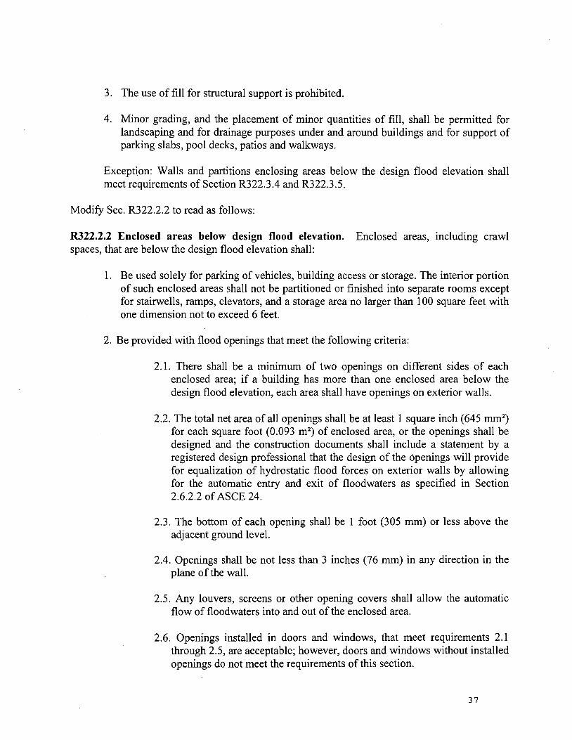
3. The use of fill for structural support is prohibited.
4. Minor grading, and the placement of minor quantities of fill, shall be permitted for landscaping and for drainage purposes under and around buildings and for support of parking slabs, pool decks, patios and walkways.
Exception: Walls and partitions enclosing areas below the design flood elevation shall meet requirements of Section R322.3.4 and R322.3.5.
Modify Sec. R322.2.2 to read as follows:
R322.2.2 Enclosed areas below design flood elevation. Enclosed areas, including crawl spaces, that are below the design flood elevation shall:
1. Be used solely for parking of vehicles, building access or storage. The interior portion of such enclosed areas shall not be partitioned or finished into separate rooms except for stairwells, ramps, elevators, and a storage area no larger than 1 00 square feet with one dimension not to exceed 6 feet.
2. Be provided with flood openings that meet the following criteria:
2.1. There shall be a minimum of two openings on different sides of each enclosed area; if a building has more than one enclosed area below the design flood elevation, each area shall have openings on exterior walls.
2.2. The total net area of all openings shall be at least 1 square inch (645 mm2)
for each square foot (0.093 m2) of enclosed area, or the openings shall be
designed and the construction documents shall include a statement by a registered design professional that the design of the openings will provide for equalization of hydrostatic flood forces on exterior walls by allowing for the automatic entry and exit of floodwaters as specified in Section 2.6.2.2 of ASCE 24.
2.3. The bottom of each opening shall be 1 foot (305 mm) or less above the adjacent ground level.
2.4. Openings shall be not less than 3 inches (76 mm) in any direction in the plane of the wall.
2.5. Any louvers, screens or other opening covers shall allow the automatic flow of floodwaters into and out of the enclosed area.
2.6. Openings installed in doors and windows, that meet requirements 2.1 through 2.5, are acceptable; however, doors and windows without installed openings do not meet the requirements of this section.
37
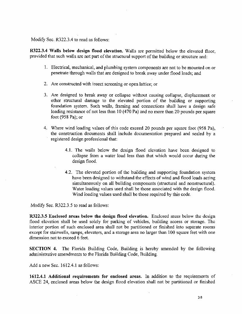
Modify Sec. R322.3.4 to read as follows:
R322.3.4 Walls below design flood elevation. Walls are permitted below the elevated floor, provided that such walls are not part of the structural support ofthe building or structure and:
1. Electrical, mechanical, and plumbing system components are not to be mounted on or penetrate through walls that are designed to break away under flood loads; and
2. Are constructed with insect screening or open lattice; or
3. Are designed to break away or collapse without causing collapse, displacement or other structural damage to the elevated portion of the building or supporting foundation system. Such walls, framing and connections shall have a design safe loading resistance of not less than 10 ( 4 70 Pa) and no more than 20 pounds per square foot (958 Pa); or
4. Where wind loading values of this code exceed 20 pounds per square foot (958 Pa), the construction documents shall include documentation prepared and sealed by a registered design professional that:
4.1. The walls below the design flood elevation have been designed to collapse from a water load less than that which would occur during the design flood.
4.2. The elevated portion of the building and supporting foundation system have been designed to withstand the effects of wind and flood loads acting simultaneously on all building components (structural and nonstructural). Water loading values used shall be those associated with the design flood. Wind loading values used shall be those required by this code.
Modify Sec. R322.3.5 to read as follows:
R322.3.5 Enclosed areas below the design flood elevation. Enclosed areas below the design flood elevation shall be used solely for parking of vehicles, building access or storage. The interior portion of such enclosed area shall not be partitioned or finished into separate rooms except for stairwells, ramps, elevators, and a storage area no larger than 1 00 square feet with one dimension not to exceed 6 feet.
SECTION 4. The Florida Building Code, Building is hereby amended by the following administrative amendments to the Florida Building Code, Building.
Add a new Sec. 1612.4.1 as follows:
1612.4.1 Additional requirements for enclosed areas. In addition to the requirements of ASCE 24, enclosed areas below the design flood elevation shall not be partitioned or finished
38
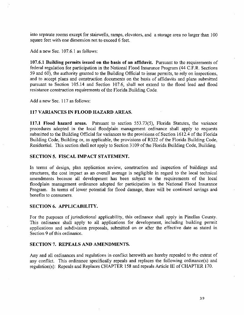
into separate rooms except for stairwells, ramps, elevators, and a storage area no larger than 1 00 square feet with one dimension not to exceed 6 feet.
Add a new Sec. 107.6.1 as follows:
107.6.1 Building permits issued on the basis of an affidavit. Pursuant to the requirements of federal regulation for participation in the National Flood Insurance Program (44 C.F.R. Sections 59 and 60), the authority granted to the Building Official to issue permits, to rely on inspections, and to accept plans and construction documents on the basis of affidavits and plans submitted pursuant to Section 105.14 and Section 107 .6, shall not extend to the flood load and flood resistance construction requirements of the Florida Building Code.
Add a new Sec. 117 as follows:
117 VARIANCES IN FLOOD HAZARD AREAS.
117.1 Flood hazard areas. Pursuant to section 553.73(5), Florida Statutes, the variance procedures adopted in the local floodplain management ordinance shall apply to requests submitted to the Building Official for variances to the provisions of Section 1612.4 of the Florida Building Code, Building or, as applicable, the provisions of R322 of the Florida Building Code, Residential. This section shall not apply to Section 3109 of the Florida Building Code, Building.
SECTION 5. FISCAL IMPACT STATEMENT.
In terms of design, plan application review, construction and inspection of buildings and structures, the cost impact as an overall average is negligible in regard to the local technical amendments because all development has been subject to the requirements of the local floodplain management ordinance adopted for participation in the National Flood Insurance Program. In terms of lower potential for flood damage, there will be continued savings and benefits to consumers.
SECTION 6. APPLICABILITY.
For the purposes of jurisdictional applicability, this ordinance shall apply in Pinellas County. This ordinance shall apply to all applications for development, including building permit applications and subdivision proposals, submitted on or after the effective date as stated in Section 9 of this ordinance.
SECTION 7. REPEALS AND AMENDMENTS.
Any and all ordinances and regulations in conflict herewith are hereby repealed to the extent of any conflict. This ordinance specifically repeals and replaces the following ordinance(s) and regulation(s): Repeals and Replaces CHAPTER 158 and repeals Article III of CHAPTER 170.
39
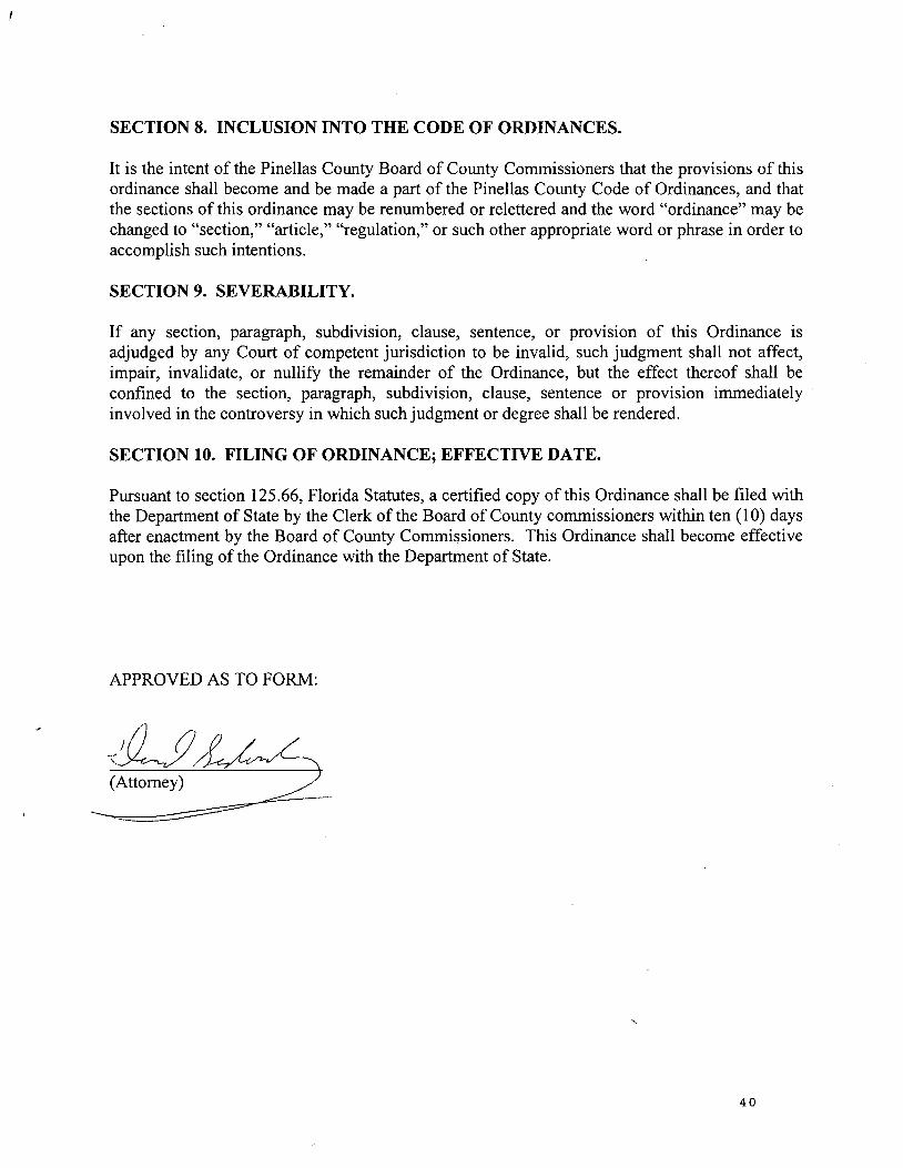
SECTION 8. INCLUSION INTO THE CODE OF ORDINANCES.
It is the intent of the Pinellas County Board of County Commissioners that the provisions of this ordinance shall become and be made a part of the Pinellas County Code of Ordinances, and that the sections of this ordinance may be renumbered or relettered and the word "ordinance" may be changed to "section," "article," "regulation," or such other appropriate word or phrase in order to accomplish such intentions.
SECTION 9. SEVERABILITY.
If any section, paragraph, subdivision, clause, sentence, or provlSlon of this Ordinance is adjudged by any Court of competent jurisdiction to be invalid, such judgment shall not affect, impair, invalidate, or nullify the remainder of the Ordinance, but the effect thereof shall be confined to the section, paragraph, subdivision, clause, sentence or provision immediately involved in the controversy in which such judgment or degree shall be rendered.
SECTION 10. FILING OF ORDINANCE; EFFECTIVE DATE.
Pursuant to section 125.66, Florida Statutes, a certified copy of this Ordinance shall be filed with the Department of State by the Clerk of the Board of County commissioners within ten ( 1 0) days after enactment by the Board of County Commissioners. This Ordinance shall become effective upon the filing of the Ordinance with the Department of State.
APPROVED AS TO FORM:
--1Lf/~ ~~ttomey) ,
40
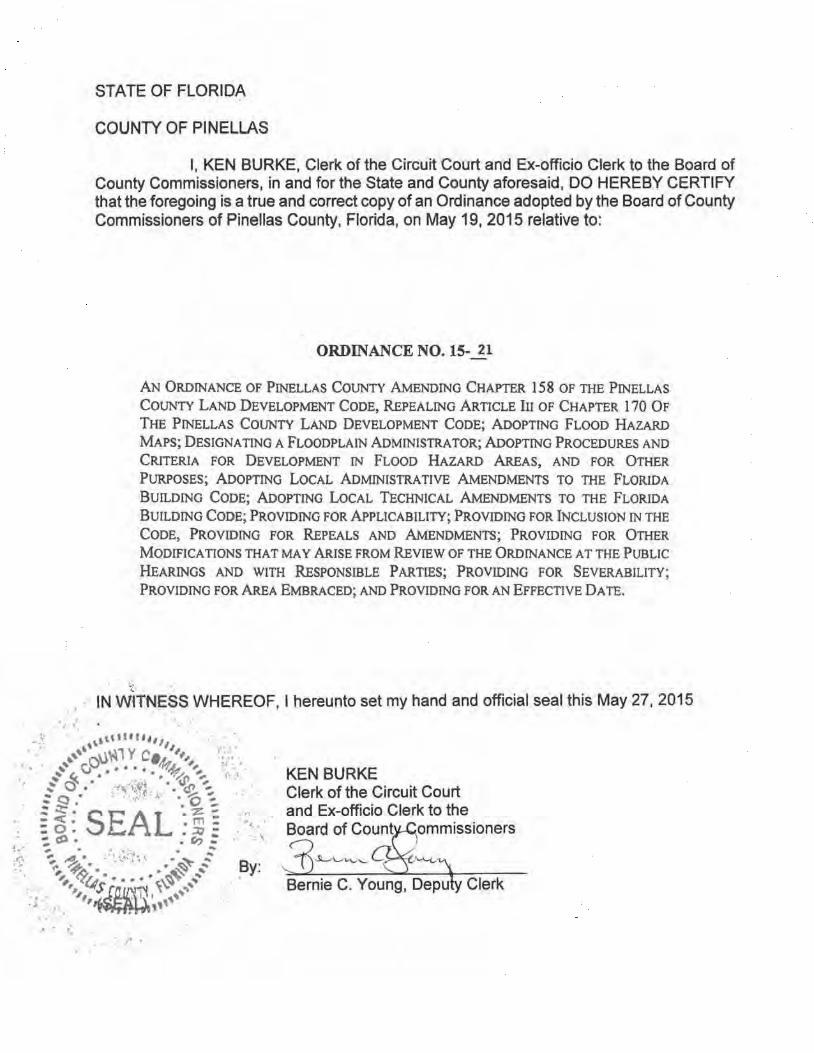
I '
, . ,.
STATE OF FLORIDA
COUNTY OF PINELLAS
I, KEN BURKE, Clerk of the Circuit Court and Ex-officio Clerk to the Board of County Commissioners, in and for the State and County aforesaid, DO HEREBY CERTIFY that the foregoing is a true and correct copy of an Ordinance adopted by the Board of County Commissioners of Pinellas County, Florida, on May 19, 2015 relative to:
ORDINANCE NO. 15-..1_1
AN ORDINANCE OF PINELLAS COUNTY AMENDING CHAPTER 158 OF THE PINELLAS
COUNTY LAND DEVELOPMENT CODE, REPEALING ARTICLE III OF CHAPTER 170 OF
THE PINELLAS COUNTY LAND DEVELOPMENT CODE; ADOPTING FLOOD HAZARD
MAPS; DESIGNATING A FLOODPLAIN ADMINISTRATOR; ADOPTING PROCEDURES AND
CRITERIA FOR DEVELOPMENT IN FLOOD HAZARD AREAS, AND FOR OTHER
PURPOSES; ADOPTING LOCAL ADMINISTRATIVE AMENDMENTS TO THE FLORIDA
BUILDING CODE; ADOPTING LoCAL TECHNICAL AMENDMENTS TO THE FLORIDA
BUILDING CODE; PROVIDING FOR APPLICABILITY; PROVIDING FOR lNCLUSlON IN THE
CODE, PROVIDING FOR REPEALS AND AMENDMENTS; PROVIDING FOR OTHER
MODIFICATIONS THAT MAY ARISE FROM REVIEW OF THE ORDINANCE AT THE PUBLIC
HEARINGS AND WITH R.ESPONSffiLE P ARTIES; PROVIDING FOR SEVERABILITY;
PROVIDING FOR AREA EMBRACED; AND PROVIDING FOR AN EFFECTIVE DATE.
IN WtTNESS WHEREOF, I hereunto set my hand and official seal this May 27, 2015
KEN BURKE Clerk of the Circuit Court and Ex-officio Clerk to the Board of Count
' '
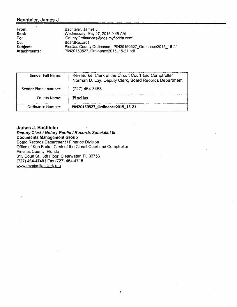
Bachteler, James J
From: Sent: To: Cc: Subject: Attachments:
Sender Full Name:
Sender Phone number:
County Name:
Ordinance Number:
James J. Bachteler
Bachteler, James J Wednesday, May 27, 2015 9:46AM '[email protected]' Board Records Pinellas County Ordinance - PIN20150527 _Ordinance2015_15-21 PIN20150527 _ Ordinance2015_15-21.pdf
Ken Burke, Clerk of the Circuit Court and Comptroller Norman D. Loy, Deputy Clerk, Board Records Department
(727) 464-3458
Pinellas
PIN20150527 _Ordinance2015_15-21
Deputy Clerk I Notary Public I Records Specialist Ill Documents Management Group Board Records Department I Finance Division Office of Ken Burke, Clerk of the Circuit Court and Comptroller Pinellas County, Florida 315 Court St., 5th Floor, Clearwater, FL 33756 (727) 46447491 Fax (727) 464-4716 www.mypinellasclerk.org
1