Embed Size (px)
Citation preview
Utah Geological Survey
MITIGATING SURFACE FAULTING: DEVELOPING AN EARTHQUAKE FAULT ZONING ACT FOR THE NEW MILLENNIUM
Eldon Gath Earth Consultants International, 1642 E. 4th Street, Santa Ana, California 92705
ABSTRACT
Following the 1971 San Fernando earthquake, enactment of the Alquist-Priolo (A-P) “Earthquake Fault Zoning Act” in 1972 initiated an important program to mitigate surface-faulting hazard in California. The legislative intent of the act was to pro-hibit most new structures intended for human occupancy from being built across active faults (defined as a fault which has had surface displacement in Holocene time [about the past 11,000 years]) to avoid fault-rupture hazards in future earthquakes. While progressive for its time, the A-P Act has become a 40-year old law in need of revision and modernization to reflect the four decades of improved knowledge about fault hazards and earthquake engineering of soils and structures since its adoption. When the A-P Act was first enacted, the science of paleoseismology was not yet established, and few geologists understood or could realistically quantify the fault-rupture process, much less its temporal and spatial predictability. Today, many geolo-gists specialize in this field, and have the skills to quantify discrete coseismic fault displacements. Engineers now routinely provide practical performance-based structural mitigation alternatives for other kinds of ground-displacement hazards (e.g., landslides and mining subsidence), in contrast to the current policy of fault avoidance, regardless of displacement, recurrence, or kinematics for surface-faulting mitigation.
The public, and the geologic and engineering professions are better served by upgrading fault-zoning laws for consistency with the risks accepted for other natural hazards. It is herein proposed to replace the A-P defined “active fault” term for resi-dential development, currently reflecting any amount of Holocene-age surface rupture, with “hazardous fault,” defined as a fault with movement within 500 years of its average recurrence interval or already past it. This definition is consistent with the 10% probability of exceedance in 50 years depicted on current U.S. Geological Survey (USGS) seismic-hazard maps and used in most residential building codes. For higher density projects, or for critical facilities and infrastructure, the 500-year hazard window can be expanded to 1000 and 2500 years, respectively. Recognizing that fault offsets, regardless of age, and to some extent magnitude, can be mitigated by performance-based engineering design, it is also proposed that a revised A-P Act permit any mitigation alternative that results in a life-safety solution consistent with enacted building codes, recognizing that in many cases, avoidance may still be the only alternative. In addition to structures, modern fault zoning needs to reflect the significance of underground infrastructure within fault zones (e.g., water and sewer lines, electrical utilities), and require similar mitigation alternatives to protect communities from loss of their lifeline utility connections.
INTRODUCTION
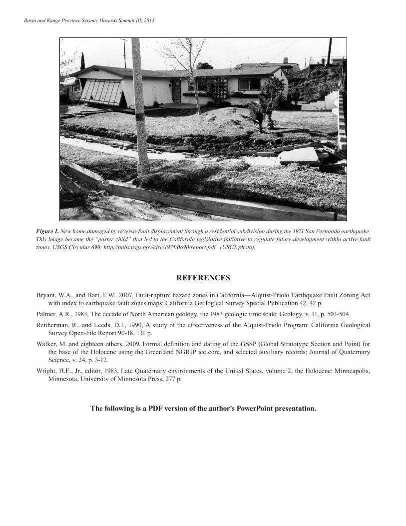
In 1971, the M6.6 San Fernando earthquake produced 20 km of surface rupture along the San Fernando/Sierra Madre fault at the base of the San Gabriel Mountains. The 1.5 m reverse-slip rupture through a new housing development (figure 1) was the triggering event that led to the 1972 legislative adoption of a hazard-zoning law designed to prohibit future disasters due to surface-fault rupture through new residential subdivisions. Originally named the Alquist-Priolo Special Geological Studies Act (A-P Act), the name was changed in 1994 to the Earthquake Fault Zoning Act to better reflect its emphasis on the fault-rupture hazard (Bryant and Hart, 1994; Reitherman and Leeds, 1990).
From the Act’s Preface: “The purpose of the Alquist-Priolo Earthquake Fault Zoning Act is to regulate development near active faults so as to mitigate the hazard of surface fault rupture.” [Emphasis added.]
The A-P Act further defines its purpose: “The purpose of this Act is to prohibit the location of most structures for human occupancy across the traces of active faults and to thereby mitigate the hazard of fault rupture.” [Emphasis added.] This change from the simple “mitigate” purpose noted above, is a critical distinction. While mitigate is open to options for engi-neering solutions, the only mitigation alternative now permitted by the law is avoidance; a binary solution, and one which is increasingly dated by the 40+ year progress of the geological, geotechnical, and structural engineering disciplines.
Basin and Range Province Seismic Hazards Summit III, 2015
With its adoption in 1972, the A-P Act became the vehicle for an aggressive program of fault zoning by the California Geologi-cal Survey (CGS), and the mandating of fault avoidance in the planning of housing developments within those zones. Included with the A-P Act are a series of implementation guidelines and definitions prepared by the California State Mining and Geol-ogy Board (SMGB) (Bryant and Hart, 2007). This paper does not focus on the history of the A-P Act other than as a foundation from which to propose future modifications to the now four-decade old law and its current implementation.
The text of the A-P Act itself does not provide specifics of its technical implementation other than to spell out its enforcement responsibilities. The geological details of the program lie within the SMGB’s definitions (Bryant and Hart, 2007), for example:
For the purposes of the A-P Act, an active fault is defined by the SMGB as one which has “had surface displacement within Holocene time (about the last 11,000 years)”
“No structure for human occupancy, identified as a project under Section 2621.6 of the Act, shall be permitted to be placed across the trace of an active fault. Furthermore, as the area within fifty (50) feet of such active faults shall be presumed to be underlain by active branches of that fault unless proven otherwise by an appropriate geologic investigation …, no such structures shall be permitted in this area.”
Among the perhaps unintended impacts of the A-P Act due to this language are:
All faults are considered equally hazardous, despite their varying rupture magnitudes or rupture recurrence intervals.
Surface-rupture hazards are hugely over stated compared to any other hazard zoning in California municipal plans;
Surface-rupture hazards are hugely over stated compared to the seismic shaking values used in design codes;
Utilities and lifelines are preferentially placed within fault zones;
Existing structures within A-P Zones often are not seismically retrofitted because they may be on a Holocene fault and the retrofit permit could trigger a fault investigation requirement. The unintended consequence here is that the fault under the structure may represent a significantly lower hazard than the regional ground-shaking hazard;
Mitigation options other than simple avoidance are available today, which can, in some cases, provide better develop-ment options, but are not allowed by the A-P Act;
Better mitigation alternatives will be developed in the future, and also will not be allowed unless the A-P Act is modi-fied; and
Fault rupture avoidance costs jobs and dollars, while alternative mitigation provides jobs and more development op-tions.
IMPORTANT CONSIDERATIONS IN A NEW FAULT ZONING ACT
Preserve Professional Judgment
There needs to be room in a profession for professionals to utilize their experience and judgment in making decisions and recommendations. If everything is quantitatively prescribed by either code, standard, or law, then the decision for public safety has been shifted to the code, standard, and/or law writers, and geologic and geotechnical professionals are reduced to technicians merely taking measurements and samples. Interpretation, which is critical to the geologic site-characterization process, will have been eliminated. Professional judgment rests within the words “interpret”, “about”, “approximately”, and “estimate”; not within 11,000.00 years, 4.00 inches, 50.00 feet, etc. The earth is more complicated than such precision implies, and to force the profession into using such precision is inappropriate, unprofessional, and may compromise both public safety and the public purse.
Utah Geological Survey
Soften Thresholds
When something numerical is placed into law, or even code, it is almost impossible to change later, despite evolving knowl-edge, materials, techniques, and acceptance. Take the "about 11,000 years" aspect of the current A-P Act. When that A-P Act was crafted, an “active fault” was defined as a fault that has Holocene rupture. An attempt was then made to help users by trying to define what that meant (“about the last 11,000 years”). Wright (1983, from the Preface) defined the Holocene as “… that portion of the Quaternary period of geologic time that follows the last major phase of continental glaciation; it extends from about 10,000 or 12,000 years ago up to the present.” The “about” word in the A-P Act could thus easily be identified as ±1000 years. But in typical fashion, the geologic profession has defined the Holocene as starting 10,000 years ago (Palmer, 1983), and most recently 11,700 years ago (Walker and others, 2009). Absent geological judgment; however, that matters little to the rigid applier of numerical criteria; 11,700 = 11,700, not 11,500. Not even 12,800 ± 2000, which I have seen rejected by a reviewer as “not old enough to permit the project.” The age of the last rupture must be 11,700.00, or less. In such rigid defini-tions, we are challenging a key geological issue; it is generally not possible to measure or date anything more accurately than 5-10% in perfect conditions, and maybe 20% in non-ideal stratigraphy.
Measuring discrete coseismic displacements at a project-specific site also poses significant challenges: (1) stratigraphic and pedogenic thicknesses are variable, (2) coseismic slip along a fault can vary by a factor of 2 or more in any earthquake, (3) kinematics of slip can vary depending on fault sense, strike, and geology, and (4) the techniques for mitigation are constantly in a state of flux as new analytical techniques, testing, instrumentation, materials, and ideas become available. Per our profes-sional licenses, engineering mitigation and its permissible thresholds are not within the geologist’s purview. Our responsibil-ity is site characterization, meaning an appropriately detailed investigation that will provide a quantitative estimation of future coseismic displacements. This displacement estimation will be unlikely to be more precise than ± 25% without a near-perfect convergence of stratigraphy and structure, with hundreds of survey points defining them.
Balance Risks
The California A-P Act’s definition of an active fault as having Holocene (now 11,700 yr B.P.) surface rupture is inconsistent with any other hazard’s acceptable risk. Probabilistic thresholds of 1 in 10,000 are applied to the proposed Yucca Mountain nuclear waste repository, nuclear power plants, and some dams. Applying it for relatively low density, low rise, wood framed, residential structures, is so far outside of the normal risk acceptance of all other hazards, that we look foolish to much of the engineering profession, and incomprehensible to our clients. Why should we legally require avoidance for 1 in 11,700 year surface rupture (regardless of the magnitude of that rupture, the timing since the last event, or the recurrence between events), when the structure is only designed to resist 1 in 500 year earthquake shaking levels, or is sited within a 1 in 100 year flood plain? How can this not seem absurd? And furthermore, the definition and assumption (or avoidance) of risk is not our pro-fession’s to define. The engineering geologist’s job is quantitative geologic site characterization, and risk is the purview of the owner and society, basing their decisions on our data and its interpretation.
Allow Multiple Mitigation Alternatives
The A-P Act mandate that fault avoidance is the only permitted mitigation alternative should be abandoned in favor of alterna-tive, and perhaps complimentary, mitigation strategies. Mitigation alternatives are provided for seismic shaking, liquefaction, subsidence, landslides, flooding, and fires. Why is fault rupture so feared that avoidance is the only solution? Acceptable risk for other hazards hinges on mitigation; to have a law that prohibits mitigation for fault rupture, indicates that geologists feel we not capable of understanding faults well enough to mitigate rupture. While this might have been true in the 1970s, this is very definitely no longer the case. There is an extensive body of knowledge, research, and available techniques to permit a geolo-gist to understand the pattern of surface rupture from past earthquakes, to appreciate the kinematic and geologic factors that control that rupture pattern, to quantitatively understand the past rupture behavior of a fault, and to use all of that knowledge to extrapolate forward and develop reasonably constrained and supported parameters for future rupture mitigation. But, the actual mitigation is not our responsibility. Our responsibility is accurate and quantitative site (and fault) characterization so that the engineers can develop and explore alternative mitigation approaches, and the owner can make a decision regarding the best mitigation alternative. It may be that the best (or only) mitigation alternative is still avoidance. But, it is not within our profession’s knowledge base or professional license to make that determination. Geologists are not involved in the financial aspects of a project, we do not know what is economically feasible, and we may not know what is technically feasible. The geologist makes the determination of past (and therefore estimated future) displacements, then it is the responsibility of the owner, engineer, and society to determine the proper level of risk acceptance and best mitigation measure.
Basin and Range Province Seismic Hazards Summit III, 2015
Upgrade the Profession
Until we recognize that having a Professional Geologist (PG) or Engineering (EG) license does not mean we know everything, nor does it mean that we need not continue to learn anything new, we are stuck in a perpetual "do" loop. As in "I can do any-thing." As a geotechnical professional, you are only licensed to do what you are competent to do, and being the professional that you are, you should be able to recognize what you do know, and what you do not know. Experience with detailed fault characterizations, as required for a mitigation option other than avoidance, lie within the competence of only a few dozen geol-ogists. Nevertheless, the science of paleoseismology is not without its maturity. There are at least a dozen professors across the U.S. who are actively graduating students with an emphasis in neotectonics or paleoseismology. Most of these students go into industry where their academic knowledge is allowed to whither because all they need to do is make a binary determination whether the last surface displacement on a fault is older or younger than Holocene. This does not require extensive training or experience. There are many geologists in industry, many still too young to have a PG, who do have the skills and knowledge to take these investigations to new and better levels as would be required for mitigation. But, they need to get their ideas through the untrained, but stubbornly "knowledgeable," PG to whom they report. If fault-rupture mitigation is to be allowed as an option, then this current group of appropriately trained individuals will be the leaders in this new effort. Furthermore, it will open up new employment opportunities for the future graduates of paleoseismology programs.
Arguments are made that fault-rupture displacements and future rupture forecasts cannot be relied upon because of lack of consistency in current paleoseismic investigations. These are temporal issues, and as hundreds of new and detailed paleo-seismic studies are conducted over the coming years in response to the mitigation options available for development projects, we will further improve our understanding of earthquake recurrence. If paleoseismology cannot currently be used to reliably predict future fault hazards, then let future researchers improve it so that it can be a viable tool. There was a time, decades ago, when landslide mitigation was also in its infancy, but today geological characterization and geotechnical mitigation are such common practices, at least in California, that they are now unremarked upon. Fault-rupture-hazard characterization might today be difficult, but tomorrow always brings new scientific and application breakthroughs.
Upgrade Reviewers
If we are to permit mitigation, then by default, a significant improvement in the technical competency of the practitioners in quantitative fault characterization is necessary. It is impossible to simply wish this to happen, it requires enforcement, and unless there are other ideas out there, the current enforcement arm of the profession lies with those working in the review sector (both public and some private). Simply digging hundreds (thousands) of meters of trench does not ensure a competent and quantitatively defensible job. Indeed many times less is better, but only if in the right place. A lot of those mega-trenches actually remove the data necessary for slip-per-event measurements. It will be vital to the success of fault-rupture mitigation to find some mechanism within which the reviewing community contains sufficient technical knowledge to allow it to dif-ferentiate quantity from quality, to be aware that their professional judgment is also in play, and that nothing is ever known 100% of the time. This has not been my experience even now, and if we are going to make interpretations more complex than “is it exactly greater than 11,700 years old?”, then there is a long way to go before this can be expected. It is like having a 55 mph speed limit on a straight road in Nevada and no law enforcement; it is not going to happen.
The Geological Survey’s Role
Even in light of the comments above regarding reviewers, I am strongly not in favor of a reviewer role for the state geological survey. The CGS’s role should be to continue to review the academic and industry findings for application to real-time A-P Act map revisions. The CGS should not be the reviewer of choice for cities or counties to turn to for assistance, and they most definitely should not be the “consultant” of choice for public agencies or private industry. I am a strong private sector advo-cate, not just because I believe in the capitalistic system, but because I think that the proper role of government is regulation, not application, and review is an application. Perhaps the best interim solution would be to empanel local review boards for fault-rupture-mitigation projects.
Professional Licensure
There seems to be considerable discussion (and belief) that an Engineering Geologist license should be required for fault investigation projects because the results of these studies lead directly into engineering. While this is only an issue in those few states that have an engineering geology license program, it is also a distracting argument. Most university professors are able to qualify for a PG license, but are unable to qualify for an EG license because of their lack of appropriate experience

Utah Geological Survey
working under an EG. It is incorrect to think that such a professor is (by law) not qualified to perform fault investigations to quantify rupture kinematics. What I find more disturbing is the apparent arrogance of (some) EG’s that by having such a li-cense they are thereby qualified to perform fault studies, though there is no basis from which to define their actual competency for conducting such studies. I am not in favor of yet another license within the geological profession. What I am in favor of is the development of more action to actually regulate incompetence, and thereby make us all more willing to seek technical assistance when we know that we do not know enough to do something correctly ourselves. Professional ethics cannot be licensed, but it is much more important than a license.
Engineering and Planning
I have noted above that with regard to the A-P Act, geologists take a lot of positions that do not seem to be ours to take. We use the word “Prohibit” a lot. Are we really able to rewrite the A-P Act and believe that prohibiting utilities within fault zones will not bring down the thunder from nearly everyone farther up the development chain? When you consider that the life expectancy of a sewer line is <10% of the recurrence interval of most faults, how and why do you expect to be taken seriously using “prohibit.” An earthquake is simply another of the design cycles for that pipeline. We really need to communicate the risks better where there is a clearly dangerous situation, but ultimately, they are not our risks to assume, and I question our role in prohibiting anything.
Viability of Slip-Per-Event Measurements
It generally requires a unique set of geological conditions to allow any quantification of slip-per-event at a specific location along a fault. Most paleoseismic research sites focus on determining slip-rate and recurrence-interval data. Along any given fault there are typically only a handful of sites that will reliably yield these data, and the degree of variability from site to site is sometimes nearly 50%. To expect that most random development sites will yield both sediments and structures adequate to even estimate a slip-per-event (and slip kinematics) value, let alone actually permit a direct measurement, is to simply be unaware of the science involved in doing such investigations. Be aware also, that if we are going to do more than prohibit development, then the investigations will become several orders of magnitude more complex. We will have to be able to rely upon work done elsewhere along the fault, we will have to be able to rely upon empirical measurements and observations from other faults and earthquakes, and the number of geologists who currently can do this work well is very small. But, just because something is difficult, should not prohibit those able to, or lucky enough to, do it. Just be aware that this will be a very rare event indeed, and will be fraught with considerable professional judgment and risk acceptance. But, at the same time, this will move our geologic profession much farther along than it is today, and it will gain us greater respect within the engineering community, which is moving rapidly along a probabilistic and performance-based design philosophy. In addition, the profes-sional ability to capture and incorporate uncertainly in design decisions is so rapidly evolving in the engineering community that the geologist’s “we cannot know this perfectly” is becoming an old story.
GENERAL OBSERVATIONS PERTINENT TO THE A-P ACT
1. The current A-P Maps are static. In a digital age, it should be possible to require regular updates to zones and zone widths as new data becomes available. Why does a zone need to be 1500 feet wide through a subdivision when all of the Holocene faults were accurately mapped before the subdivision was approved and the hazard thereby mitigated? What about Holocene faults that are outside of A-P Zones? What about the many faults that are demonstrated to be pre-Holocene? Hazard maps should be dynamic, and evolve as the hazard is better defined, just like all geologic un-derstanding evolves with new data.
2. The SMGB’s original Technical Advisory Board’s proposed change from zero to four inches of displacement achieves too little. Depending on the fault kinematics, the geotechnical and structural characteristics of the project, the creativ-ity of the design team, the competence of the reviewing team, and on future technologies and professional develop-ment, the only thing that should be mentioned in the A-P Act is mitigation per building code provisions. If the fault displacement cannot be mitigated to acceptable safety levels within code, then avoidance is the solution. But let geolo-gists, engineers, and owners at least try to be creative first.
3. Fault-rupture risk needs to be balanced against other societally accepted risks. It should be appropriate to the perfor-mance from ground shaking applied within the structural codes. It should be appropriate to the floodplain hazard upon
Basin and Range Province Seismic Hazards Summit III, 2015
which it is sited. It should be appropriate to the geotechnical mitigation designs for the mitigation of other seismic issues.
4. The "one size fits all” methodology of the current zoning is inappropriate and inconsistent to other engineering solu-tions. Engineering safety considerations are different for a single-family home, for a shopping mall, for a high rise building, or for a hospital. I propose a hazard window of 500 years from average recurrence for residential develop-ment, 1000 years for high occupancy structures, and 2500 years for critical structures (see examples below).
5. I propose that if a secondary fault has not experienced renewed displacement in 2-3 main trace events, then it should no longer be considered a hazardous fault.
6. Professional judgment must be preserved in the process somehow. Perhaps an appeals board for contentious project proposals. Perhaps just a highly competent review board?
7. There needs to be a digitally accessible clearinghouse for all paleoseismic investigations so that the State and all other professionals can benefit from these investigations. The current archival system does not adequately facilitate real-time accessibility and utility of the investigation data. Within 10 years, we will have solidly constrained recurrence intervals on all of these faults. We will have constrained kinematics for the last couple of earthquake events. We will have actually applied a lot of the fault-rupture documentation out there because for the first time it will be important to know how faults rupture through bends and steps We will begin to really understand main trace rupture and second-ary dispersed ground deformation effects. Currently, all of this is trashed. But just think how nice it would be to have such a database for statewide seismic hazard and risk modeling.
PROPOSAL FOR A-P ACT REVISION
Moderate the prohibition of structures across faults as the only permitted mitigation measure by adding “unless ap-propriate mitigation measures are implemented to comply with the intent of the Act.”
The intent being to mitigate the fault-rupture hazard to a satisfactory degree per building codes, which could include mitigation by avoidance if the cost (investigation, design, or construction) is too high or the displacements are too large.
This will bring the geologic risk of fault rupture into compliance with socially and technically accepted risk management for other geologic and natural hazards. Additionally, revise the definition of an “active fault” to better conform to the level of hazard by recognizing that not all projects pose equal risk, so scale the hazard triggers by vulnerability and risk.
Add … “a fault shall be considered hazardous and subject to mitigation for residential projects if it is within 500 years of its average recurrence interval.” This conforms to the 10% probability of exceedence in 50 years for ground shaking that generally applies to design of single-family homes.
And … “a fault shall be considered hazardous and subject to mitigation for high density occupancy projects if it is within 1000 years of its average recurrence.” This conforms to the 10% probability of exceedence in 100 years for ground shaking that is generally applied to life safety of larger structures.
And … “a fault shall be considered hazardous and subject to mitigation for critical facilities projects if it is within 2500 years of its average recurrence.” This is conformable to the 2% probability of exceedence for ground shaking that forms the basis of most codes for critical infrastructure.
And … “a secondary fault shall be considered non-hazardous if it can be shown to have not ruptured during two or three (or more for critical structures) main trace events.
These revisions will allow geologists to do their jobs to adequately characterize a fault’s paleoseismic history and displace-ment kinematics.
Utah Geological Survey
Examples
1. Santa Monica fault: Most recent event ~3 ka. Recurrence interval 10+ ka. Today – active fault per A-P Act, subject to avoidance for all projects. Proposal – not a hazardous fault for any project.
2. Hollywood fault: Most recent event ~8.5 ka. Recurrence interval ~10 ka. Today – active fault per A-P Act, subject to avoidance for all projects. Proposal – not a hazardous fault for residential projects, but a critical facility would be required to investigate the hazard, and using professional judgment, a large high-occupancy facility could be required to investigate the fault-hazard exposure.
3. Whittier fault: Most recent event ~1.6-2.0 ka. Recurrence interval ~2 ka. Today – active fault for any project under A-P Act, subject to avoidance for all projects. Proposal – hazardous fault and subject to mitigation for all projects.
4. Northern Newport-Inglewood fault: Most recent event Holocene. Recurrence interval unknown. Today – active fault per A-P Act, subject to avoidance for all projects. Proposal – unknown most recent event and recurrence would require additional data collection to define fault unless setbacks are imposed.
5. San Jacinto fault (SJF) and secondary traces: Main SJF recurrence interval 250 years. Most recent event ~250 years ago. Hazardous fault. Secondary traces, last ruptured 5 ka, 20 SJF events ago during migration of extensional step-over. Not a hazardous fault for any project.
SUMMARY
The intent of this paper is to present a path forward to modernize the California Alquist-Priolo Earthquake Fault Zoning Act, or to assist other states in writing their own fault-rupture-hazard policy, to better reflect the advances that have been made in earthquake geology, geotechnical engineering, structural engineering, and materials science in the 40+ years since the A-P Act was passed. The Act’s original intent to mitigate the hazard of surface-fault rupture by requiring detailed geological in-vestigations evolved into the simple prescriptive mitigation of avoidance of faults as the only approved mitigation alternative for buildings for human occupancy. In doing so, most residential subdivisions were designed with the faults aligned with the development’s major roadway network, which often also contain the primary underground utility lifelines for a subdivision, an unsafe condition and unintended consequence of a fault-avoidance-only policy.
Allowing the new definition of a hazardous fault to better reflect other defined societal hazard criteria, and permitting alterna-tive mitigation for those hazardous faults will lead to a more robust geological knowledge base for many faults, and an im-proved seismic-hazard database, across the state. Detailed geological investigations of fault kinematics will become the new standard of practice, and geotechnical and structural engineering will likewise see increased applicability. Making the fault-hazard-zoning maps more dynamic will eliminate wasted effort in those areas where the hazard has been fully constrained, and allow for new findings to be rapidly distributed to affected communities and practitioners. An open discourse about the unintended consequences of the current A-P Act’s language and its interpretation should lead to an improved awareness of the true costs of strict fault-rupture avoidance. It is well past time to fix this Act.
Basin and Range Province Seismic Hazards Summit III, 2015
E. Gath
3
In 1971, the M6.6 San Fernando earthquake produced 20 km of surface rupture along the
San Fernando/Sierra Madre fault at the base of the San Gabriel Mountains. The 1.5 m
reverse-slip rupture through a new housing development (figure 1) was the triggering
event that led to the 1972 legislative adoption of a hazard-zoning law designed to prohibit
future disasters due to surface-fault rupture through new residential subdivisions.
Originally named the Alquist-Priolo Special Geological Studies Act (A-P Act), the name
was changed in 1994 to the Earthquake Fault Zoning Act to better reflect its emphasis on
the fault-rupture hazard (Bryant and Hart, 1994; Reitherman and Leeds, 1990).
Figure 1. New home damaged by reverse-fault displacement through a residential subdivision during the
1971 San Fernando earthquake. This image became the “poster child” that led to the California legislative
initiative to regulate future development within active fault zones. USGS Circular 690:
http://pubs.usgs.gov/circ/1974/0690/report.pdf (USGS photo).
From the Act’s Preface: “The purpose of the Alquist-Priolo Earthquake Fault
Figure 1. New home damaged by reverse-fault displacement through a residential subdivision during the 1971 San Fernando earthquake. This image became the “poster child” that led to the California legislative initiative to regulate future development within active fault zones. USGS Circular 690: http://pubs.usgs.gov/circ/1974/0690/report.pdf (USGS photo).
REFERENCES
Bryant, W.A., and Hart, E.W., 2007, Fault-rupture hazard zones in California—Alquist-Priolo Earthquake Fault Zoning Act with index to earthquake fault zones maps: California Geological Survey Special Publication 42, 42 p.
Palmer, A.R., 1983, The decade of North American geology, the 1983 geologic time scale: Geology, v. 11, p. 503-504.
Reitherman, R., and Leeds, D.J., 1990, A study of the effectiveness of the Alquist-Priolo Program: California Geological Survey Open-File Report 90-18, 131 p.
Walker, M. and eighteen others, 2009, Formal definition and dating of the GSSP (Global Stratotype Section and Point) for the base of the Holocene using the Greenland NGRIP ice core, and selected auxiliary records: Journal of Quaternary Science, v. 24, p. 3-17.
Wright, H.E., Jr., editor, 1983, Late Quaternary environments of the United States, volume 2, the Holocene: Minneapolis, Minnesota, University of Minnesota Press, 277 p.
The following is a PDF version of the author's PowerPoint presentation.