Embed Size (px)
Citation preview
GeographyGuidance for Key Stages 2 and 3
Yr Adran Plant, Addysg, Dysgu Gydol Oes a Sgiliau
Department for Children, Education, Lifelong Learning and Skills
Audience Teachers at Key Stages 2 and 3; local education authorities; tutors in initial teacher training; and others with an interest in continuing professional development.
Overview These materials provide key messages for planning learning and teaching in geography. They include profiles of learners’ work to exemplify the standards set out in the level descriptions and illustrate how to use level descriptions to make best-fit judgementsat the end of Key Stage 3.
Action To review learning plans and activities at Key Stages 2 and 3, and to required prepare to make judgements at the end of Key Stage 3.
Further Enquiries about this document should be directed to: information Curriculum and Assessment Division
Department for Children, Education, Lifelong Learning and SkillsWelsh Assembly GovernmentFloor 10, Southgate HouseWood Street CardiffCF10 1EW
Tel: 0800 083 6003Fax: 029 2037 5496e-mail: C&A3-14.C&[email protected]
Additional Can be obtained from:copies Tel: 0845 603 1108 (English medium)
0870 242 3206 (Welsh medium)Fax: 01767 375920 e-mail: [email protected]
Or by visiting the Welsh Assembly Government’s website www.wales.gov.uk/educationandskills
Related Geography in the National Curriculum for Wales; Skills framework documents for 3 to 19-year-olds in Wales; Making the most of learning:
Implementing the revised curriculum; Ensuring consistency in teacher assessment: Guidance for Key Stages 2 and 3 (Welsh Assembly Government, 2008)
This guidance is also available in Welsh.
GeographyGuidance for Key Stages 2 and 3
Ref: CAD/GM/0001ISBN: 978 0 7504 4613 6
A-EAC-02-01-044/KE© Crown copyright November 2008
Introduction 2
Using these materials 4
Section 1
Key messages for learning and teaching in geography 7
Section 2
Expectations and progression in geography 25
Section 3
Using the level descriptions in Key Stage 2 35
Cathy – characteristics of Levels 3 and 4 37
Alan – characteristics of Levels 4 and 5 44
Rachel – characteristics of Levels 5 and 6 53
Section 4
Making judgements at the end of Key Stage 3 63
Richard – Level 5 65
Emma – Level 6 73
Stephen – Level 8 84
Acknowledgements 98
Contents
2 Geography: Guidance for Key Stages 2 and 3
The programmes of study set out the opportunities that learnersshould be given at each key stage and provide the basis from whichyou, as a teacher, can plan learning and teaching. They are dividedinto two sections, Skills and Range. The Skills section lists the skillsto be developed in a subject and the Range section comprises theopportunities and contexts through which these skills should bedeveloped and consolidated.
Ongoing formative assessment – assessment for learning – liesat the heart of good teaching. Through the assessments that youmake in the course of your teaching, you will build up an extensiveknowledge of your learners’ strengths, as well as the areas thatneed further development, and you will use this knowledge to helpyou plan for the next steps in their learning. Learners will also gainunderstanding of specific learning goals and the associated successcriteria so that, supported by you, they can develop their capacity forself-assessment and peer assessment. In this way, they can establishtheir current position, set and move towards targets, and discover ifand when the targets have been reached. Individual targets are linkedto improving the quality of a learner’s work, as highlighted throughformative feedback, and are therefore linked to success criteria forspecific tasks. Level descriptions do not make effective targets asthese describe attainment across the breadth of the programme ofstudy at the end of a key stage.
Level descriptions can help to inform your planning, teaching andassessment at Key Stages 2 and 3 by indicating expectations atparticular levels and progression in the subject. Evidence fromassessment for learning will indicate where more time is needed toconsolidate learning and when learners are ready to move on. Youmay wish to keep some evidence so that you can discuss a learner’swork and progress with them and/or with colleagues orparents/guardians. However, there is no statutory requirement tokeep unnecessarily complex records or detailed evidence on everylearner.
The essential function of level descriptions is to help you makerounded summative judgements at the end of Key Stage 3 about alearner’s overall performance. Level descriptions are designed neitherto be used to ‘level’ individual pieces of work nor for the productionof half-termly or termly data. It is only by the end of the key stagethat you will have built up sufficient knowledge about a learner’sperformance across a range of work, and in a variety of contexts, toenable you to make a judgement in relation to the level descriptions.
Introduction
3Geography: Guidance for Key Stages 2 and 3
It may be that some learners will be more advanced in some aspectsof the work than in others, and that no one level description providesan exact fit. That is to be expected, and the range of individuallearners’ work included in these materials illustrates the making ofbest-fit judgements under those circumstances. Manyschools/departments have found it helpful to develop theirown learner profiles to support moderation of end of key stagejudgements. These profiles also help to maintain a commonunderstanding of standards when they are reviewed annually andrefreshed when necessary.
When making judgements at the end of Key Stage 3, you shoulddecide which level description best fits a learner’s performance. Theaim is for a rounded judgement that:
• is based on your knowledge of how the learner performs across a range of contexts
• takes into account different strengths and areas for development in that learner’s performance
• is checked against adjacent level descriptions to ensure that the level judged to be the most appropriate is the closest overall match to the learner’s performance in the attainment target.
National curriculum outcomes have been written for learners workingbelow Level 1. These are non-statutory and guidance on their use isplanned.

4 Geography: Guidance for Key Stages 2 and 3
This booklet is divided into four sections.
Section 1 highlights key messages for learning and teaching in geography.
Section 2 highlights expectations and progression in geography.
Section 3 contains a series of Key Stage 2 learner profiles. These are designed to show the characteristics of the level descriptions.
Section 4 contains a series of Key Stage 3 learner profiles. These are designed to show the use of the level descriptions in coming to judgements about a learner’s overall performance at the end of the key stage.
This booklet is for reference when you wish to:
• review your learning plans and activities
• consider the standards set out in the revised geography Order
• work with other teachers to reach a shared understanding of the level descriptions
• prepare to make judgements at the end of the key stage
• develop your own learner profiles
• support transition from Key Stage 2 to Key Stage 3.
For ease of reference, the level descriptions are included in aleaflet with this booklet.
A CD-ROM is also included with this booklet. It contains a PDFversion of Geography in the National Curriculum for Wales, Skills framework for 3 to 19-year-olds in Wales and this guidance.
Using these materials
5Geography: Guidance for Key Stages 2 and 3
This guidance is part of a series of materials that will help teachersat Key Stages 2 and 3 to implement the revised curriculum and itsassociated assessment arrangements. The series includes:
• Making the most of learning: Implementing the revised curriculum – overview guidance on implementing the new
curriculum
• Skills framework for 3 to 19-year-olds in Wales – which includes guidance about progression in skills
• Ensuring consistency in teacher assessment: Guidance for Key Stages 2 and 3
• A curriculum for all learners: Guidance to support teachers of learners with additional learning needs
• specific guidance for all national curriculum subjects, personal and social education, careers and the world of work, and religious education.

6 Geography: Guidance for Key Stages 2 and 3
7Geography: Guidance for Key Stages 2 and 3
Section1Key messages for learning and teachingin geography
8 Geography: Guidance for Key Stages 2 and 3
The focus of this section is to help you plan for your teaching of the revised programmes of study to be relevant and motivating for each learner, i.e. to be learner centred. You should plan to provide opportunities for learners to develop skills through a breadth of contexts, places, environments and issues, that are identified under the heading Range. You should use Skills and Range as a flexible framework from which it is possible to select contexts and develop activities that will be relevant and motivating for learners.
Developing a Skills focus
Your scheme of work should ensure that learners have the opportunities to develop, practise and apply the four skills identified in the programmes of study for geography and the Skills framework for 3 to 19-year-olds in Wales. Progress in Locating places, environments and patterns, Understanding, places, environments and patterns, Investigating and Communicating should form a relevant and realistic experience through which learners are able to develop skills for life. Useful questions to guide your planning and develop a skills focus would be:
• Have I planned sequences of activities that progress skills?
• Which geographical skill(s) from the programme of study does this lesson develop?
• What is the purpose of this activity? Does this activity introduce a new skill, consolidate a skill or apply and extend a skill?
A scheme of work is more likely to support the development of a range of skills if it offers opportunities for learners to:
• work practically taking a ‘hands on’ approach, using personal experience and proactive investigation
• work in a variety of settings in groups, individually, in the classroom and outdoors around the school and in fieldwork
• use thinking skills to think critically and creatively about their geography
• use a variety of communication skills.
9Geography: Guidance for Key Stages 2 and 3
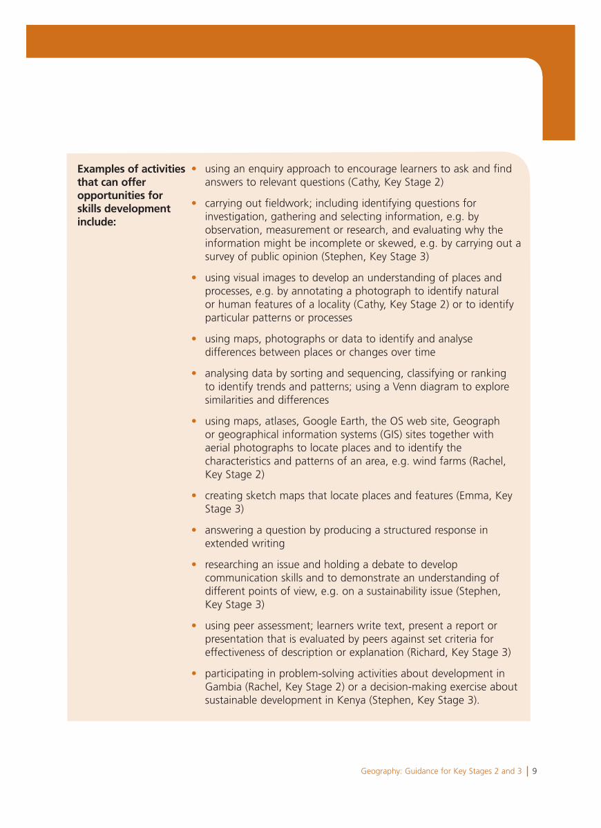
Examples of activitiesthat can offeropportunities forskills developmentinclude:
• using an enquiry approach to encourage learners to ask and find answers to relevant questions (Cathy, Key Stage 2)
• carrying out fieldwork; including identifying questions for investigation, gathering and selecting information, e.g. by observation, measurement or research, and evaluating why the information might be incomplete or skewed, e.g. by carrying out a survey of public opinion (Stephen, Key Stage 3)
• using visual images to develop an understanding of places and processes, e.g. by annotating a photograph to identify natural or human features of a locality (Cathy, Key Stage 2) or to identify particular patterns or processes
• using maps, photographs or data to identify and analyse differences between places or changes over time
• analysing data by sorting and sequencing, classifying or ranking to identify trends and patterns; using a Venn diagram to explore similarities and differences
• using maps, atlases, Google Earth, the OS web site, Geograph or geographical information systems (GIS) sites together with aerial photographs to locate places and to identify the characteristics and patterns of an area, e.g. wind farms (Rachel, Key Stage 2)
• creating sketch maps that locate places and features (Emma, Key Stage 3)
• answering a question by producing a structured response in extended writing
• researching an issue and holding a debate to develop communication skills and to demonstrate an understanding of different points of view, e.g. on a sustainability issue (Stephen, Key Stage 3)
• using peer assessment; learners write text, present a report or presentation that is evaluated by peers against set criteria for effectiveness of description or explanation (Richard, Key Stage 3)
• participating in problem-solving activities about development in Gambia (Rachel, Key Stage 2) or a decision-making exercise about sustainable development in Kenya (Stephen, Key Stage 3).
10 Geography: Guidance for Key Stages 2 and 3
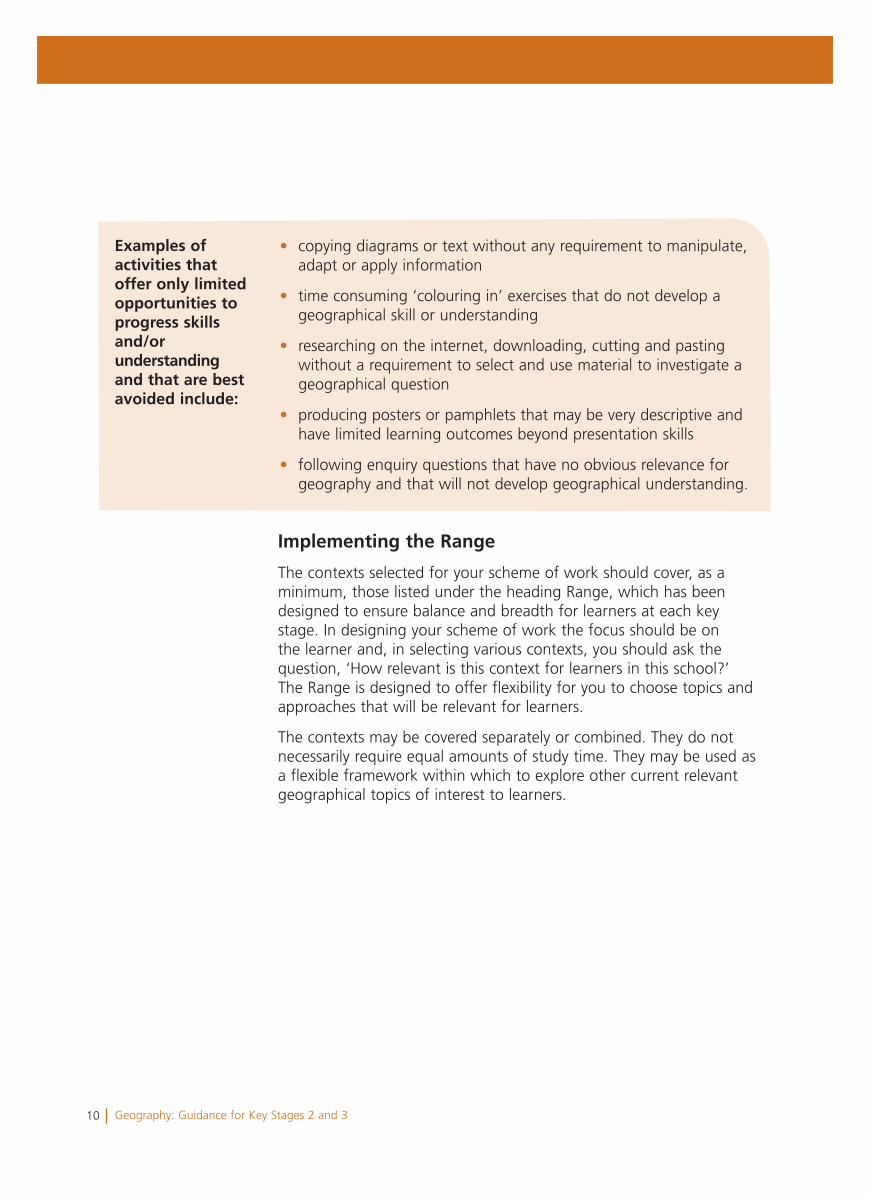
• copying diagrams or text without any requirement to manipulate, adapt or apply information
• time consuming ‘colouring in’ exercises that do not develop a geographical skill or understanding
• researching on the internet, downloading, cutting and pasting without a requirement to select and use material to investigate a geographical question
• producing posters or pamphlets that may be very descriptive and have limited learning outcomes beyond presentation skills
• following enquiry questions that have no obvious relevance for geography and that will not develop geographical understanding.
Examples of activities that offer only limited opportunities to progress skills and/orunderstandingand that are best avoided include:
Implementing the Range
The contexts selected for your scheme of work should cover, as a minimum, those listed under the heading Range, which has been designed to ensure balance and breadth for learners at each key stage. In designing your scheme of work the focus should be on the learner and, in selecting various contexts, you should ask the question, ‘How relevant is this context for learners in this school?’ The Range is designed to offer flexibility for you to choose topics and approaches that will be relevant for learners.
The contexts may be covered separately or combined. They do not necessarily require equal amounts of study time. They may be used as a flexible framework within which to explore other current relevant geographical topics of interest to learners.
11Geography: Guidance for Key Stages 2 and 3
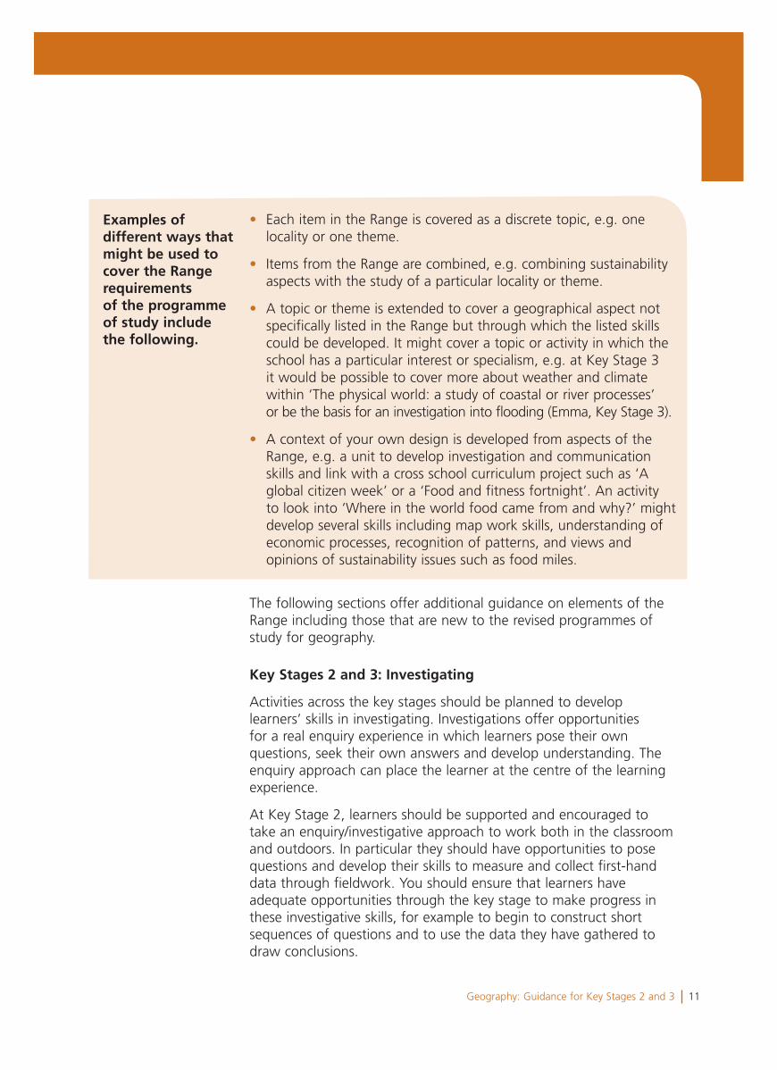
• Each item in the Range is covered as a discrete topic, e.g. one locality or one theme.
• Items from the Range are combined, e.g. combining sustainability aspects with the study of a particular locality or theme.
• A topic or theme is extended to cover a geographical aspect not specifically listed in the Range but through which the listed skills could be developed. It might cover a topic or activity in which the school has a particular interest or specialism, e.g. at Key Stage 3 it would be possible to cover more about weather and climate within ‘The physical world: a study of coastal or river processes’
or be the basis for an investigation into flooding (Emma, Key Stage 3).
• A context of your own design is developed from aspects of the Range, e.g. a unit to develop investigation and communication skills and link with a cross school curriculum project such as ‘A global citizen week’ or a ‘Food and fitness fortnight’. An activity to look into ‘Where in the world food came from and why?’ might develop several skills including map work skills, understanding of economic processes, recognition of patterns, and views and opinions of sustainability issues such as food miles.
Examples of different ways that might be used to cover the Range requirementsof the programmeof study include the following.
The following sections offer additional guidance on elements of the Range including those that are new to the revised programmes of study for geography.
Key Stages 2 and 3: Investigating
Activities across the key stages should be planned to develop learners’ skills in investigating. Investigations offer opportunities for a real enquiry experience in which learners pose their own questions, seek their own answers and develop understanding. The enquiry approach can place the learner at the centre of the learning experience.
At Key Stage 2, learners should be supported and encouraged to take an enquiry/investigative approach to work both in the classroom and outdoors. In particular they should have opportunities to pose questions and develop their skills to measure and collect first-hand data through fieldwork. You should ensure that learners have adequate opportunities through the key stage to make progress in these investigative skills, for example to begin to construct short sequences of questions and to use the data they have gathered to draw conclusions.
12 Geography: Guidance for Key Stages 2 and 3
At Key Stage 3, learners should have opportunities to investigate more complex questions and become more independent, analytical and evaluative in their enquiry work. Investigations do not need to be very large pieces of work and should avoid becoming lengthy, unstructured, descriptive projects. Rather, they should offer opportunities for learners both in the classroom and through fieldwork to practice and engage with each of the stages of investigation, particularly those requiring analysis, learning and evaluation.
During the key stage, learners should carry out at least one complete group investigation and one independent investigation, the demand of which should encourage progression towards GCSE research and fieldwork.
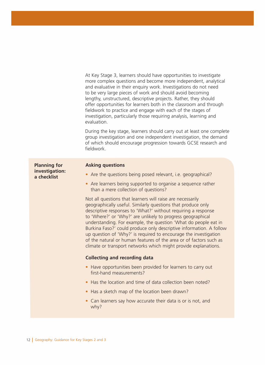
Asking questions
• Are the questions being posed relevant, i.e. geographical?
• Are learners being supported to organise a sequence rather than a mere collection of questions?
Not all questions that learners will raise are necessarilygeographically useful. Similarly questions that produce onlydescriptive responses to ‘What?’ without requiring a responseto ‘Where?’ or ‘Why?’ are unlikely to progress geographicalunderstanding. For example, the question ‘What do people eat inBurkina Faso?’ could produce only descriptive information. A followup question of ‘Why?’ is required to encourage the investigationof the natural or human features of the area or of factors such asclimate or transport networks which might provide explanations.
Collecting and recording data
• Have opportunities been provided for learners to carry out first-hand measurements?
• Has the location and time of data collection been noted?
• Has a sketch map of the location been drawn?
• Can learners say how accurate their data is or is not, and why?
Planning for investigation:a checklist
13Geography: Guidance for Key Stages 2 and 3
Organising and analysing
• Can learners identify and interpret what the data shows?
• Can learners analyse the opinions gathered in their survey?
Encourage learners to annotate tables or graphs or talk throughwhat they can see in the information. For example, as an initialinterpretation, can they identify the highest/lowest, smallest/largestor the average? Support learners to recognise differences fromplace to place and time to time, and begin to see the ‘big picture’of trends and patterns.
Drawing conclusions
• From their organised data, can learners draw factual conclusions about the similarities and contrasts, causes and effects or interactions between features or processes?
• Can they begin to develop explanations?
• Can learners weigh evidence to make decisions or support a point of view?
Evaluating the investigation
• Do learners evaluate their investigations?
Encourage learners to reflect on their work by responding to evaluative questions such as:
• Did I complete what I set out to achieve?
• How could I have improved my investigation?
• How valid were my results?
• How could this investigation have been extended?
• What do I need to investigate next?
• What have I learned?
14 Geography: Guidance for Key Stages 2 and 3
Key Stages 2 and 3: Asking and answering questions
Each programme of study provides a list of key questions that underpin learning in geography. They are generic to all contexts and can be used to help learners develop their skills in geography. A shortened form of these questions might be written as the five Ws – ‘Who?’, ‘What?’, ‘Where?’, ‘When?’, ‘Why?’ The questions provide a template to encourage learners to develop beyond description to analysis and explanation through an investigative approach.
Key Stages 2 and 3: Fieldwork
It is a requirement of the programmes of study that learners carry out fieldwork to observe and investigate real places and processes. Planned visits to different parts of Wales or exchanges to schools in other countries provide a window on the real world and broaden learners‘ experience. However, learners should also be provided with opportunities to carry out practical fieldwork investigations to practice, develop and progress their skills. Fieldwork should involve first-hand measuring and collecting of data whether on school premises, in the local area or further afield (Rachel, Key Stage 2; Richard, Key Stage 3).
Key Stages 2 and 3: Geography in the news
The programmes of study require learners to study ‘Geography in the news’ to help develop an appreciation that ‘geography is all around’ and relevant to their everyday lives in the twenty-first century. You will need to develop strategies for incorporating ‘Geography in the news’ into your scheme of work that will balance the need for immediacy with the need to plan ahead. Not all news will be geographical or offer obvious opportunities to develop geographical skills. News to which the key questions can be applied is likely to indicate that the item can usefully be considered ‘Geography in the news’, e.g. ‘Where is it happening?’, ‘What is that place like?’, ‘How and why is it changing?’, ‘Which processes are occurring?’, ‘What patterns and trends can be identified?’, ‘How are people’s lives being affected?’ (Alan, Key Stage 2).
15Geography: Guidance for Key Stages 2 and 3
• Local scale geography: A planned unit of work that uses a local investigation of a current issue/problem. Examples might be ‘Traffic problems in our town’, ‘Building a new retail park’ or ‘The Impact of a new industrial development’ (Stephen, Key Stage 3).
• Up-to-date examples: An item that can be included within an aspect of the Range to ensure a topic is up-to-date. For example, learners research the impact of a recent flood as part of their investigation into hazardous environments or conduct a survey or a debate to develop views and opinions about migration.
• Immediate interest lesson: A lesson replacing a planned lesson at short notice to address a dramatic event but that provides opportunities to address the same skills development as the planned activities, e.g. a lesson on the tsunami that looks at patterns of impacts, or causes and effect, or points of view/opinions.
• A research activity that develops understanding of the processes of change by following up a previous event, e.g. ‘How is Cardiff Bay developing?’ or ‘The effects of the tsunami three years on’ (Stephen, Key Stage 3).
• A view of the world: A short class activity, a wall display, regular timetable slot or a school link with other countries, kept up-to-date by learners to address questions, e.g. ‘Where in the world?’, ‘What is happening?’, ‘Why?’
• The geography of an event as it develops: Following a current event or issue of interest to learners, e.g. a major sporting event such as a World Cup or the Olympics to analyse global connections. An investigation into the spread of a disease, such as foot and mouth disease or bird flu, that could offer opportunities to consider the links between producers, consumers, economic development and sustainability.
Examples of how ‘Geography in the news’ might be covered in a scheme of work include the following.
16 Geography: Guidance for Key Stages 2 and 3
Key Stage 2: Choosing an aspect of the geography of thewhole of Wales
In deciding on which aspect of the geography of the whole ofWales to incorporate into your scheme of work, useful questions toconsider would be:
• Will it provide learners with an opportunity to investigate what Wales is like?
• Will it provide a vehicle for learners to develop a basic knowledge of the geography of Wales before commencing Key Stage 3?
Any topic chosen should be designed for learners to appreciate theshape and size of Wales, to recognise its main natural and humanfeatures, and to be able to think about the key questions in relationto Wales. Some examples of investigations into an aspect of thegeography of the whole of Wales are:
• Why do we have national parks?
• Why are our rivers important?
• Where do we live?
• How and why are our towns on the coast the same or different?
• What is the weather of Wales like?
• Investigating wind farms in Wales (Alan, Key Stage 2).
Your chosen aspect will usually need to draw on other aspects. Forexample, an investigation into the ‘Where?’ and ‘Why?’ of farmingin Wales would need to consider the weather in Wales. Similarly aninvestigation into the ‘Where?’ and ‘Why?’ of the towns of Walescould introduce the natural background of mountains and rivers toexplain the locations of the towns. Your chosen aspect could alsoprovide a vehicle for designing a theme that integrates differentareas of the curriculum, e.g. with history or with science (Alan,Key Stage 2).
17Geography: Guidance for Key Stages 2 and 3
Examples of investigative questions and activities to develop the fourskills of the programme of study include the following.
Locational skills
Learners investigate the question ‘Where are our national parks?’
They explore the locations using the atlas. They think about whovisits a national park, where the visitors come from and how farthey might travel. They describe the pattern of the location of thenational parks.
Understanding places
Learners investigate the questions ‘What are these places like?’ and‘Are they different or all the same?’
Learners use photographs, maps, an OS map and grid referencesto identify what visitors would see in the national park. They plan adaytrip to a national park.
Investigating
Learners work independently and in groups to carry out aninvestigation to find answers to geographical questions. Theyidentify questions to ask and answer, e.g. ‘How can I find out whatthe weather is like in the national parks?’ Learners identify theirown questions in which they are interested, e.g. ‘How can we makenational parks better?’
They collect first-hand information, e.g. by carrying out a surveyin the school about visits to national parks. They collect secondaryinformation by conducting internet research. They use Google Earthor Multimap to plan routes and places to visit.
Communicating
Learners present their conclusions, views, opinions and decisions.
They make a presentation, e.g. including sketch maps, annotatedphotographs, PowerPoint slides, on their chosen question, e.g. ‘Whyare national parks a good idea?’ or ‘How could we improve thevisitor areas?’
This sequence of activities could include a visit to a national parkwhere learners could have experience of collecting first-handinformation, for example through surveys of environmental quality orvisitor numbers.
An example of an aspect of the geography of the whole of Wales: national parks
18 Geography: Guidance for Key Stages 2 and 3
Key Stage 2: Living in other countries: Choosing twocontrasting localities
Localities should be chosen that provide learners with an opportunityto compare their own lives in Wales with two different contrastinglocalities elsewhere in the world. You may select localities withdifferent economic characteristics and that contrast in some wayfrom the learner’s own locality, e.g. localities that have differentnatural (physical) characteristics. The localities chosen shouldprovide opportunities to identify both similarities and contrastsbetween countries and use a combination of some of the following:contrasts of climate (hot or cold countries), contrasts of location(rural or urban) and contrasts of wealth (economically developedor economically less developed). Localities should be selected thatwill encourage careful observation and investigation and provideopportunities to counter generalisations and stereotyping aboutpeople’s lives in other parts of the world, e.g. to counter theassumptions that all people are poor in an African country or thatall are rich in a European country. Schools could use opportunities tolink with schools in their contrasting localities.
Contrasting localities might typically be:
• an urban locality in a tropical country, such as Lesotho or Botswana, and a rural locality in a cold country, such as Finland
• an urban locality in Europe or China, such as Paris or Beijing, and a rural locality in the tropical West Indies, such as St Lucia.
• How is my locality in Wales different from…?
• What do I already know about…?
• Where is…?
• How would I get to…?
• How can I find out more about…?
• What is the weather like? Why?
• What are the buildings like? Why?
• What jobs do people do? Why?
• How do people travel? Why?
• How do people use and care for their environment? Why?
Examples of geographicalquestions about contrastinglocalities
19Geography: Guidance for Key Stages 2 and 3
Geography and skills across the curriculum
A non-statutory Skills framework for 3 to 19-year-olds in Wales hasbeen developed in order to provide guidance about continuity andprogression in developing thinking, communication, ICT and numberfor learners from 3 to 19.
At Key Stages 2 and 3, learners should be given opportunities tobuild on the skills they have started to acquire and develop duringthe Foundation Phase. Learners should continue to acquire, develop,practise, apply and refine these skills through group and individualtasks in a variety of contexts across the curriculum. Progress can beseen in terms of the refinement of these skills and by their applicationto tasks that move from: concrete to abstract; simple to complex;personal to the ‘big picture’; familiar to unfamiliar; and supported toindependent and interdependent.
Icons have been used in the geography Order to signal explicitrequirements for the development of skills and learning across thecurriculum. However, in planning a scheme of work relevant forlearners you will identify other opportunities to enrich learning.
Developing thinking
Learners develop their thinking across the curriculum through theprocesses of planning, developing and reflecting.
In geography, learners will have opportunities to:
• investigate, plan enquiries and carry out fieldwork (Richard, Key Stage 3)
• gather, sort and evaluate information, draw conclusions and form opinions to develop their understanding about places, environments and the geographical issues that affect the world around them (Rachel, Key Stage 2)
• reflect on what they have learned in one context to develop more abstract understanding, and apply their skills and knowledge to different places, environments and issues.
20 Geography: Guidance for Key Stages 2 and 3
You should plan your schemes of work to provide opportunities forlearners to use these skills and develop their geographical thinkingby:
• finding out where Places are and appreciating the importance of a location in explaining the character of places, environments and issues
• recognising that features around them are not evenly distributed and that they form Patterns for which there are explanations (Emma, Key Stage 3)
• identifying and investigating the Processes that create features and cause change (Alan, Key Stage 2)
• recognising different Linkages; how natural and human processes interact, interrelate, are interconnected or may be interdependent (Emma, Key Stage 3)
• applying their understanding at different Scales from the personal to local, regional, national, international and global.
Developing communication
Learners develop their communication skills across the curriculumthrough the skills of oracy, reading, writing and widercommunication.
In geography, learners will have opportunities to:
• select, use, apply and combine a variety of skills to communicate their geographical understanding, including through extended writing with specialist terminology, maps and images (Stephen, Key Stage 3)
• investigate to acquire information, assess the authenticity and bias of data and media reports, and adapt their own presentations to different audiences
• discuss geographical issues, develop and justify their ideas, views and opinions in debates and through multimedia presentations (Rachel, Key Stage 2; Stephen, Key Stage 3).
21Geography: Guidance for Key Stages 2 and 3
Developing ICT
Learners develop their ICT skills across the curriculum by finding,developing, creating and presenting information and ideas and by using a wide range of equipment and software.
In geography, learners will have opportunities to:
• use ICT skills to access the internet for worldwide information (Cathy, Key Stage 2)
• use geographical information systems (GIS), satellite imagery and software for mapping technology to analyse data and study patterns
• use equipment in fieldwork to gather and organise information and select programmes to enhance their presentations of findings.
Developing number
Learners develop their number skills across the curriculum by usingmathematical information, calculating, and interpreting and presenting findings.
In geography, learners will have opportunities to:
• apply number skills in the classroom and in fieldwork to measure, gather and analyse data (Richard, Key Stage 3)
• use mathematical information to understand direction, distances and scale, and to determine locations when using plans, maps and globes.
22 Geography: Guidance for Key Stages 2 and 3
Geography and learning across the curriculum
At Key Stages 2 and 3, learners should be given opportunities tobuild on the experiences gained during the Foundation Phase, and topromote their knowledge and understanding of Wales, their personaland social development and well-being, and their awareness of theworld of work.
Geographical activities can provide opportunities to develop bothpersonal and social education (PSE) and the Curriculum Cymreig, andemphasise geography’s relevance in the twenty-first century to theeveryday lives of learners.
Curriculum Cymreig
Activities could provide opportunities for learners to:
• explore the diversity of the natural and human landscapes in Wales through investigations and fieldwork (Richard, Key Stage 3)
• examine the economic processes that have changed Wales and how decision making at local, national and European levels can affect Wales’ development
• explore the reasons for economic and environmental issues that affect communities in Wales, including their own.
Personal and social education
Activities could provide opportunities for learners to:
• develop an appreciation of their role as local and global citizens and the diversity of communities in Wales and other countries
• investigate how and why environments change and the importance of sustainability (Alan, Key Stage 2)
• enquire into the links between producers and consumers and how people’s economic and environmental actions in one part of the world can impact on the lives of others; research information about places and peoples to counter stereotyping (Rachel, Key Stage 2)
23Geography: Guidance for Key Stages 2 and 3
• make well-informed judgments about issues, develop their own views and opinions, and appreciate the values and attitudes of others (Stephen, Key Stage 3)
• develop a sense of place and identity through investigating the links between communities and between regions in Wales, as well as understanding relationships between Wales and other countries.
Careers and the world of work
Activities could provide opportunities for learners to:
• investigate factors that affect the economy in their local community, in Wales and globally, and the potential impact on employment opportunities, including on their own career development
• develop valuable work-related skills and techniques, including the use of GIS, using and creating maps, carrying out investigations, problem solving and decision making.

24 Geography: Guidance for Key Stages 2 and 3
25Geography: Guidance for Key Stages 2 and 3
Section 2Expectations and progression ingeography
26 Geography: Guidance for Key Stages 2 and 3
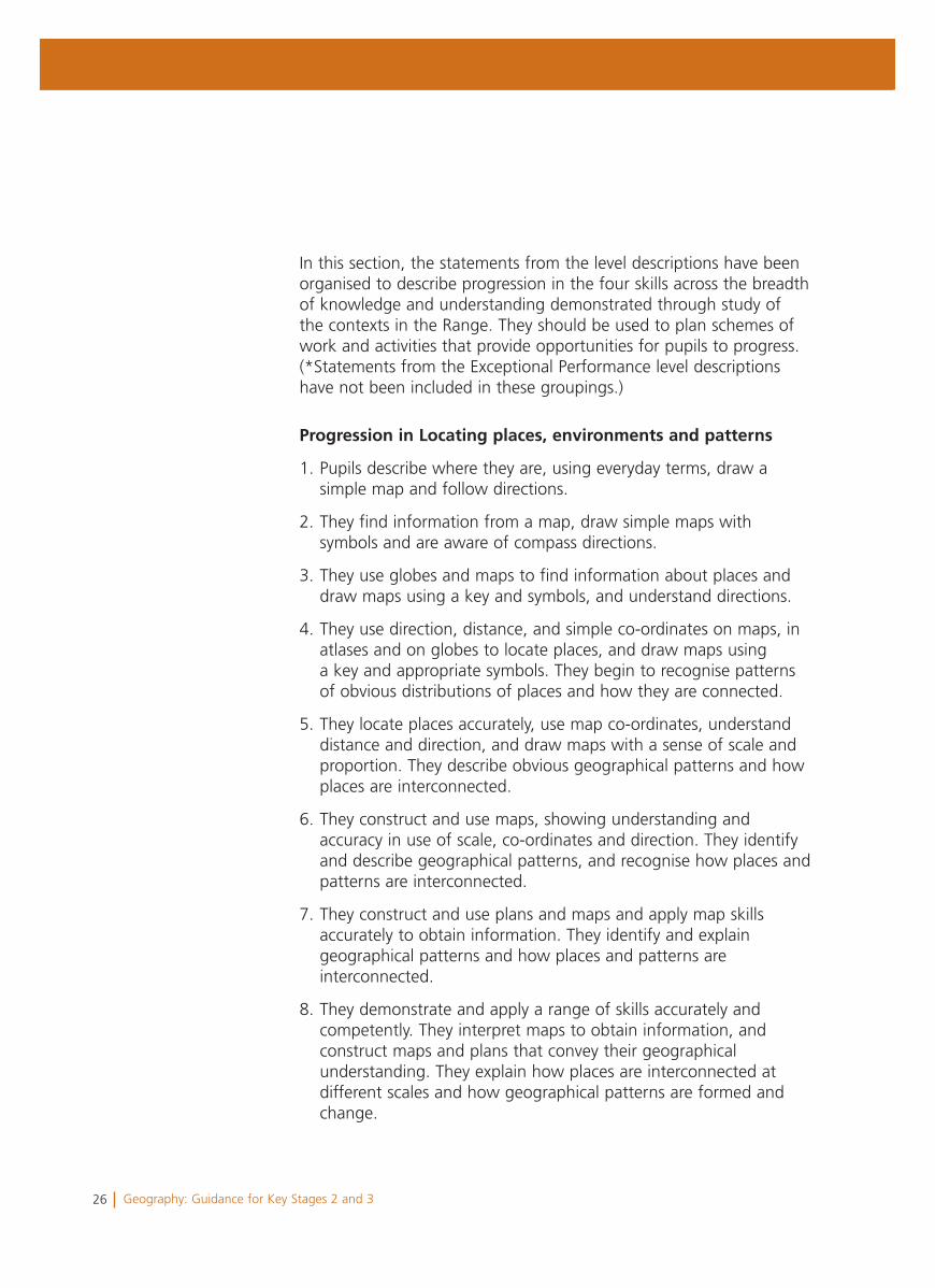
In this section, the statements from the level descriptions have been organised to describe progression in the four skills across the breadth of knowledge and understanding demonstrated through study of the contexts in the Range. They should be used to plan schemes of work and activities that provide opportunities for pupils to progress. (*Statements from the Exceptional Performance level descriptions have not been included in these groupings.)
Progression in Locating places, environments and patterns
1. Pupils describe where they are, using everyday terms, draw a simple map and follow directions.
2. They find information from a map, draw simple maps with symbols and are aware of compass directions.
3. They use globes and maps to find information about places and draw maps using a key and symbols, and understand directions.
4. They use direction, distance, and simple co-ordinates on maps, in atlases and on globes to locate places, and draw maps using a key and appropriate symbols. They begin to recognise patterns of obvious distributions of places and how they are connected.
5. They locate places accurately, use map co-ordinates, understand distance and direction, and draw maps with a sense of scale and proportion. They describe obvious geographical patterns and how places are interconnected.
6. They construct and use maps, showing understanding and accuracy in use of scale, co-ordinates and direction. They identify and describe geographical patterns, and recognise how places and patterns are interconnected.
7. They construct and use plans and maps and apply map skills accurately to obtain information. They identify and explain geographical patterns and how places and patterns are interconnected.
8. They demonstrate and apply a range of skills accurately and competently. They interpret maps to obtain information, and construct maps and plans that convey their geographical understanding. They explain how places are interconnected at different scales and how geographical patterns are formed and change.
27Geography: Guidance for Key Stages 2 and 3
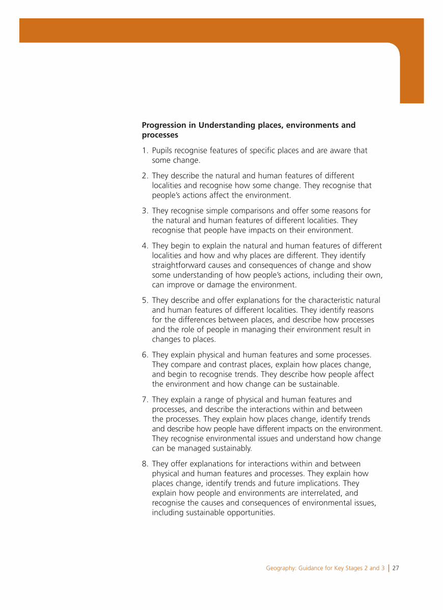
Progression in Understanding places, environments and processes
1. Pupils recognise features of specific places and are aware that some change.
2. They describe the natural and human features of different localities and recognise how some change. They recognise that people’s actions affect the environment.
3. They recognise simple comparisons and offer some reasons for the natural and human features of different localities. They recognise that people have impacts on their environment.
4. They begin to explain the natural and human features of different localities and how and why places are different. They identify straightforward causes and consequences of change and show some understanding of how people’s actions, including their own, can improve or damage the environment.
5. They describe and offer explanations for the characteristic natural and human features of different localities. They identify reasons for the differences between places, and describe how processes and the role of people in managing their environment result in changes to places.
6. They explain physical and human features and some processes. They compare and contrast places, explain how places change, and begin to recognise trends. They describe how people affect the environment and how change can be sustainable.
7. They explain a range of physical and human features and processes, and describe the interactions within and between the processes. They explain how places change, identify trends and describe how people have different impacts on the environment.They recognise environmental issues and understand how change can be managed sustainably.
8. They offer explanations for interactions within and between physical and human features and processes. They explain how places change, identify trends and future implications. They explain how people and environments are interrelated, and recognise the causes and consequences of environmental issues, including sustainable opportunities.
28 Geography: Guidance for Key Stages 2 and 3
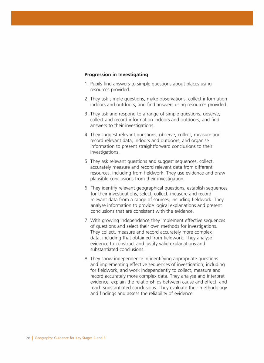
Progression in Investigating
1. Pupils find answers to simple questions about places using resources provided.
2. They ask simple questions, make observations, collect information indoors and outdoors, and find answers using resources provided.
3. They ask and respond to a range of simple questions, observe, collect and record information indoors and outdoors, and find answers to their investigations.
4. They suggest relevant questions, observe, collect, measure and record relevant data, indoors and outdoors, and organise information to present straightforward conclusions to their investigations.
5. They ask relevant questions and suggest sequences, collect, accurately measure and record relevant data from different resources, including from fieldwork. They use evidence and draw plausible conclusions from their investigation.
6. They identify relevant geographical questions, establish sequences for their investigations, select, collect, measure and record relevant data from a range of sources, including fieldwork. They analyse information to provide logical explanations and present conclusions that are consistent with the evidence.
7. With growing independence they implement effective sequences of questions and select their own methods for investigations. They collect, measure and record accurately more complex data, including that obtained from fieldwork. They analyse evidence to construct and justify valid explanations and substantiated conclusions.
8. They show independence in identifying appropriate questions and implementing effective sequences of investigation, including for fieldwork, and work independently to collect, measure and record accurately more complex data. They analyse and interpret evidence, explain the relationships between cause and effect, and reach substantiated conclusions. They evaluate their methodology and findings and assess the reliability of evidence.
29Geography: Guidance for Key Stages 2 and 3
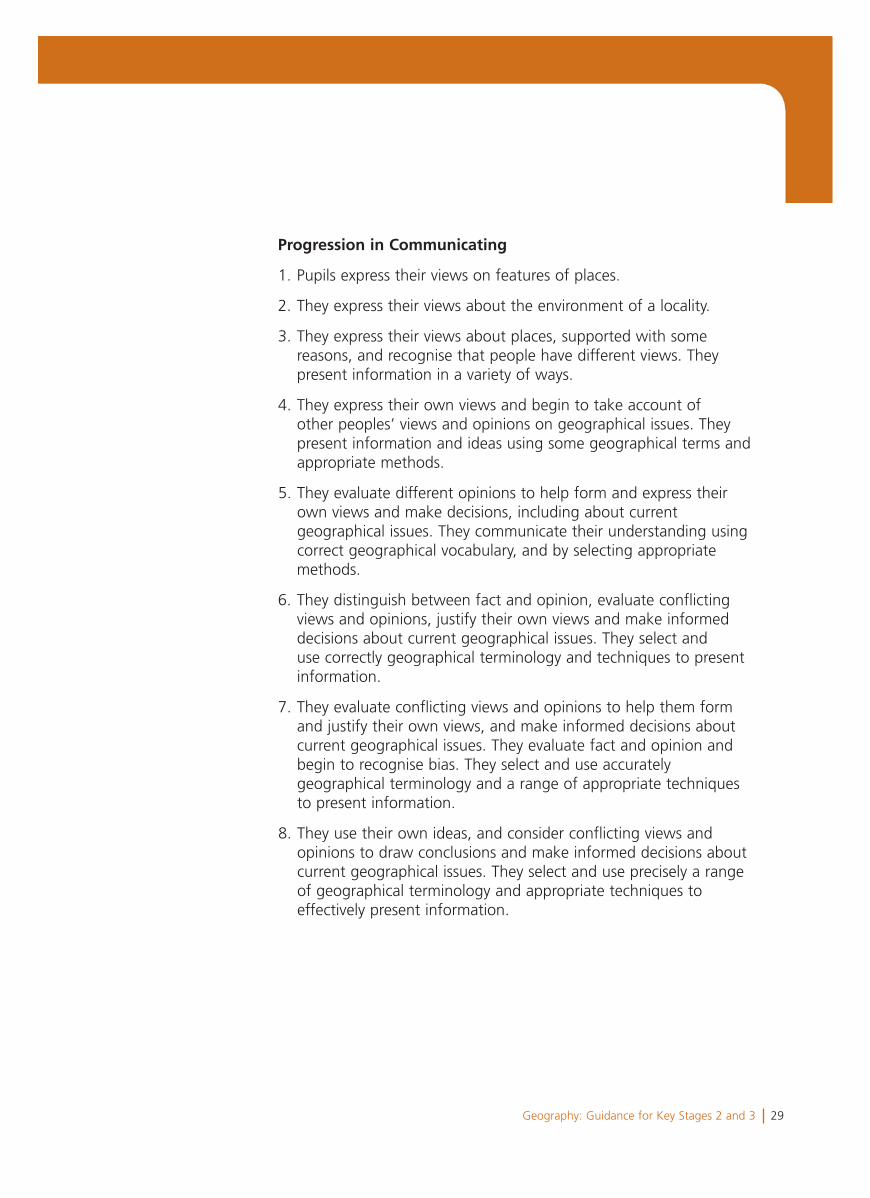
Progression in Communicating
1. Pupils express their views on features of places.
2. They express their views about the environment of a locality.
3. They express their views about places, supported with some reasons, and recognise that people have different views. They present information in a variety of ways.
4. They express their own views and begin to take account of other peoples’ views and opinions on geographical issues. They present information and ideas using some geographical terms and appropriate methods.
5. They evaluate different opinions to help form and express their own views and make decisions, including about current geographical issues. They communicate their understanding using correct geographical vocabulary, and by selecting appropriate methods.
6. They distinguish between fact and opinion, evaluate conflicting views and opinions, justify their own views and make informed decisions about current geographical issues. They select and use correctly geographical terminology and techniques to present information.
7. They evaluate conflicting views and opinions to help them form and justify their own views, and make informed decisions about current geographical issues. They evaluate fact and opinion and begin to recognise bias. They select and use accurately geographical terminology and a range of appropriate techniques to present information.
8. They use their own ideas, and consider conflicting views and opinions to draw conclusions and make informed decisions about current geographical issues. They select and use precisely a range of geographical terminology and appropriate techniques to effectively present information.
30 Geography: Guidance for Key Stages 2 and 3
Progression in the range of knowledge and understanding
Pupils should progress their skills through an increasing range of knowledge and understanding of places, environments and issues from the immediate locality to national and global scales.
Progression in locational awareness
Developing a sense of locational or spatial awareness is an important skill for everyday life. In geography, pupils should be supported and encouraged to apply their location skills and enhance their understanding in every possible circumstance. Essential ways of developing those skills are:
• ensuring that for every context or topic, pupils can answer the question ‘Where is this?’; if pupils are confused about a location, they are unlikely to be able to understand the factors that influence the geography of that place
• integrating map work into the context of the lesson so that it has a relevance and a purpose rather than teaching a ‘map skills lesson’
• ensuring that pupils have access to resources that provide a clear sense of place, maps of different scales, atlases, Google Earth, the OS website, GIS sites, and aerial and satellite images
• carrying out fieldwork to appreciate the scale of the real world
• encouraging pupils to draw their own sketch maps, whenever possible, to support their written work; unlike downloading a map from the internet, drawing a sketch map will require pupils not only to combine an understanding of mapping skills (scale, direction, etc.) but to select information that can support their argument or point of view and convey extended understanding
• ensuring that sketch maps and plans demonstrate an understanding of:
– the types of features that occur in the area of the map or plan
– where those features are located in relation to other features
– the patterns formed by the relative position of similar and different features
– how the real world can be represented by increasingly abstract symbols and increasingly accurate scale.
31Geography: Guidance for Key Stages 2 and 3
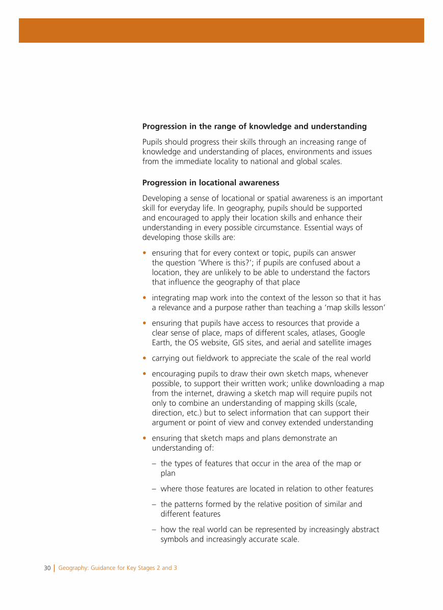
The following examples illustrate aspects of progression in sketch maps.
Work characteristic of Level 2
A simple sketch map using pictorial symbols showing a limited range of geographical features but with a sense of the relative positions of features.
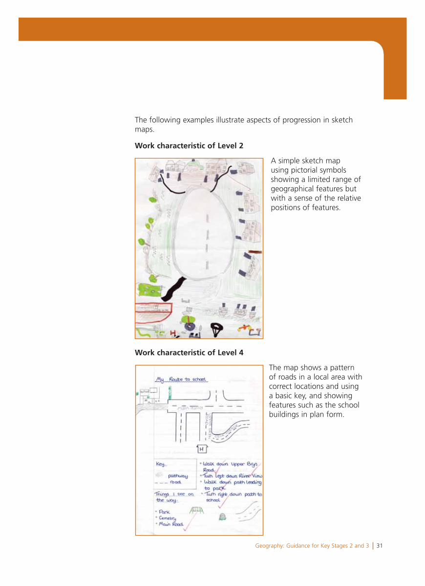
Work characteristic of Level 4
The map shows a pattern of roads in a local area with correct locations and using a basic key, and showing features such as the school buildings in plan form.
32 Geography: Guidance for Key Stages 2 and 3
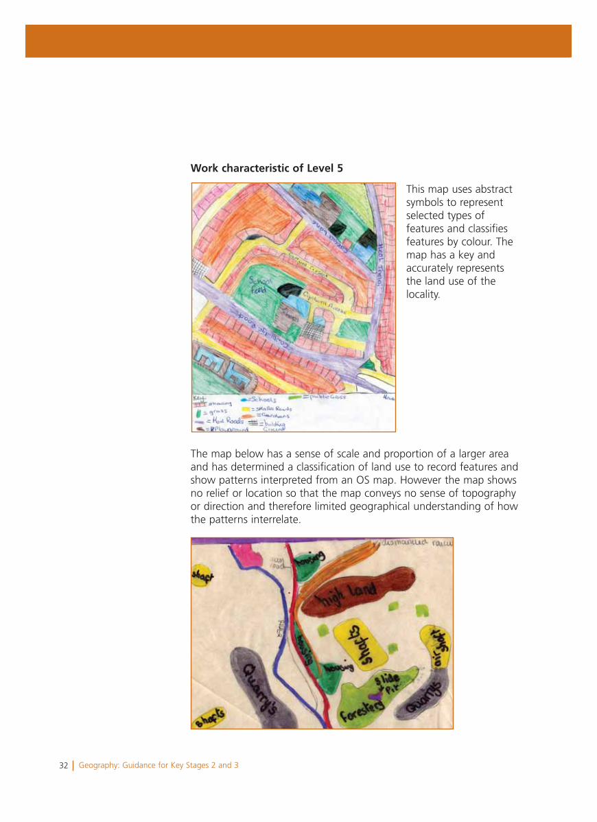
Work characteristic of Level 5
This map uses abstract symbols to represent selected types of features and classifies features by colour. The map has a key and accurately represents the land use of the locality.
The map below has a sense of scale and proportion of a larger area and has determined a classification of land use to record features and show patterns interpreted from an OS map. However the map shows no relief or location so that the map conveys no sense of topography or direction and therefore limited geographical understanding of how the patterns interrelate.
33Geography: Guidance for Key Stages 2 and 3
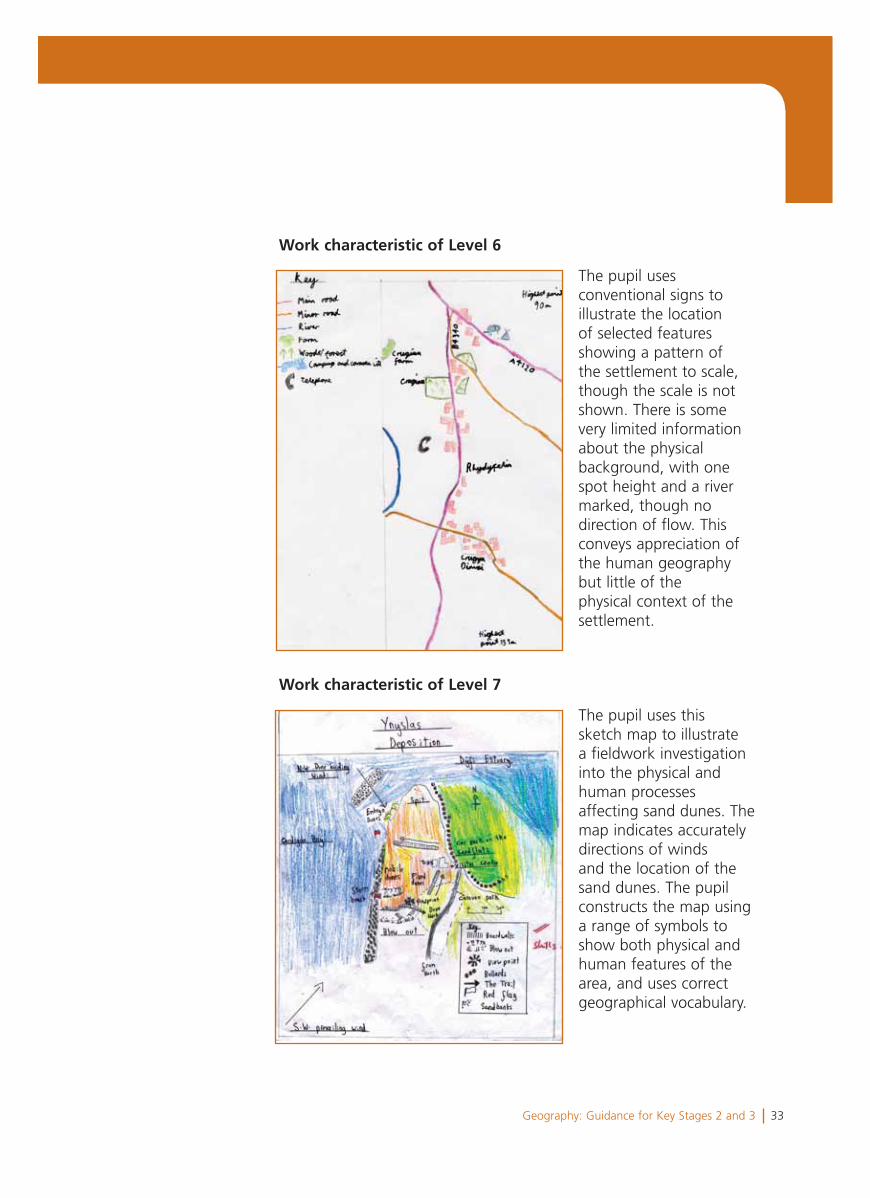
Work characteristic of Level 6
The pupil uses conventional signs to illustrate the location of selected features showing a pattern of the settlement to scale, though the scale is not shown. There is some very limited information about the physical background, with one spot height and a river marked, though no direction of flow. This conveys appreciation of the human geography but little of the physical context of the settlement.
Work characteristic of Level 7
The pupil uses this sketch map to illustrate a fieldwork investigation into the physical and human processes affecting sand dunes. The map indicates accurately directions of winds and the location of the sand dunes. The pupil constructs the map using a range of symbols to show both physical and human features of the area, and uses correct geographical vocabulary.
34 Geography: Guidance for Key Stages 2 and 3
Work characteristic of Level 8
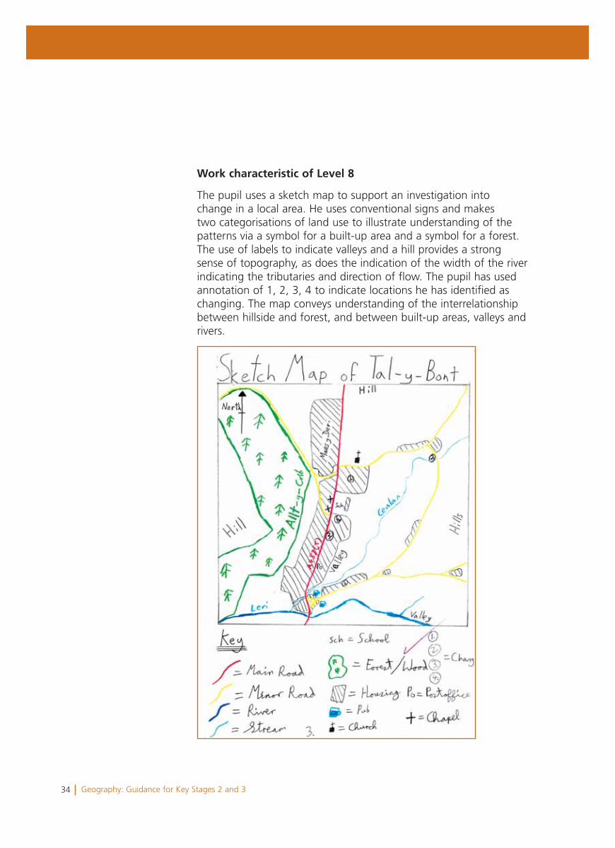
The pupil uses a sketch map to support an investigation into change in a local area. He uses conventional signs and makes two categorisations of land use to illustrate understanding of the patterns via a symbol for a built-up area and a symbol for a forest. The use of labels to indicate valleys and a hill provides a strong sense of topography, as does the indication of the width of the river indicating the tributaries and direction of flow. The pupil has used annotation of 1, 2, 3, 4 to indicate locations he has identified as changing. The map conveys understanding of the interrelationship between hillside and forest, and between built-up areas, valleys and rivers.
Map 8 here
35Geography: Guidance for Key Stages 2 and 3
Section 3Using the level descriptions in Key Stage 2
36 Geography: Guidance for Key Stages 2 and 3
There is no requirement to make end of key stage judgements ingeography at Key Stage 2. However, knowledge of the characteristicsof the level descriptions will help you to recognise learners’ strengths,as well as areas for improvement, and to plan for progression.
You may find the following points useful when considering theprofiles in this section.
• The learner profiles are not presented as a model for how you should collect evidence about your learners. Decisions about collecting evidence, and about its purpose and use, are matters for teachers working within an agreed school policy.
• The commentaries on the pieces of work have been written to indicate particular qualities of the work and make links to characteristics of the level descriptions. They are not intended as an example of a report to parents/guardians.
• The materials in each learner profile can only represent a small part of the information and experiences that make up a teacher’s knowledge of each learner. They do not reflect the extent of the knowledge of each learner that you will have built up over time across a range of different contexts. You will use this knowledge to recognise learners’ strengths and areas for development, and to plan for progression.
• Some of your learners may need to use a range of alternative forms of communication to show what they know, what they understand and what they can do.
37Geography: Guidance for Key Stages 2 and 3
Cathy is an 11-year-old learner in Key Stage 2.
Her teacher knows much more about Cathy’s performance than can be included here. However, this profile has been selected to illustrate characteristic features of Cathy’s work across a range of activities. Each example is accompanied by a brief commentary to provide a context and indicate particular qualities in the work.
Cathy’s profile shows some characteristics of Levels 3 and 4, but mainly characteristics of Level 3.
Cathy’s teacher planned for the class to investigate three aspects of the programme of study in Year 6. In addition to investigating a new topic of ‘What is it like to live in Kirua?’, pupils extended their earlier study of the local area by carrying out fieldwork to develop their understanding of similarities and differences of local human features. As an environmental issue and topic in the news, pupils also carried out an investigation into deforestation. The teacher covered other geography in the news fortnightly by discussions based on a news display board organised by the pupils. The scheme of work for the year provided opportunities for the pupils to develop across each of the four skills of the programme of study.
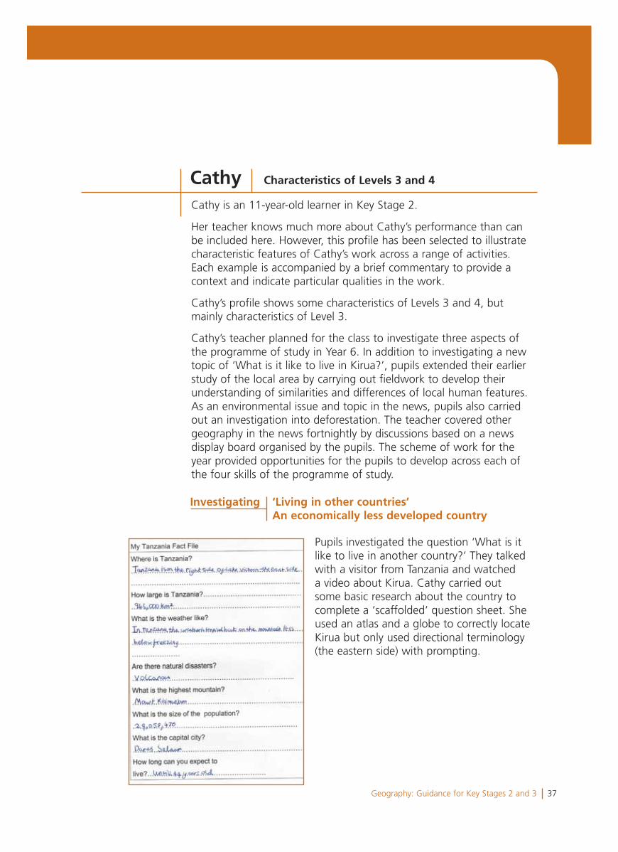
Pupils investigated the question ‘What is it like to live in another country?’ They talked with a visitor from Tanzania and watched a video about Kirua. Cathy carried out some basic research about the country to complete a ‘scaffolded‘ question sheet. She used an atlas and a globe to correctly locate Kirua but only used directional terminology (the eastern side) with prompting.
Cathy Characteristics of Levels 3 and 4
Investigating ‘Living in other countries’ An economically less developed country
38 Geography: Guidance for Key Stages 2 and 3
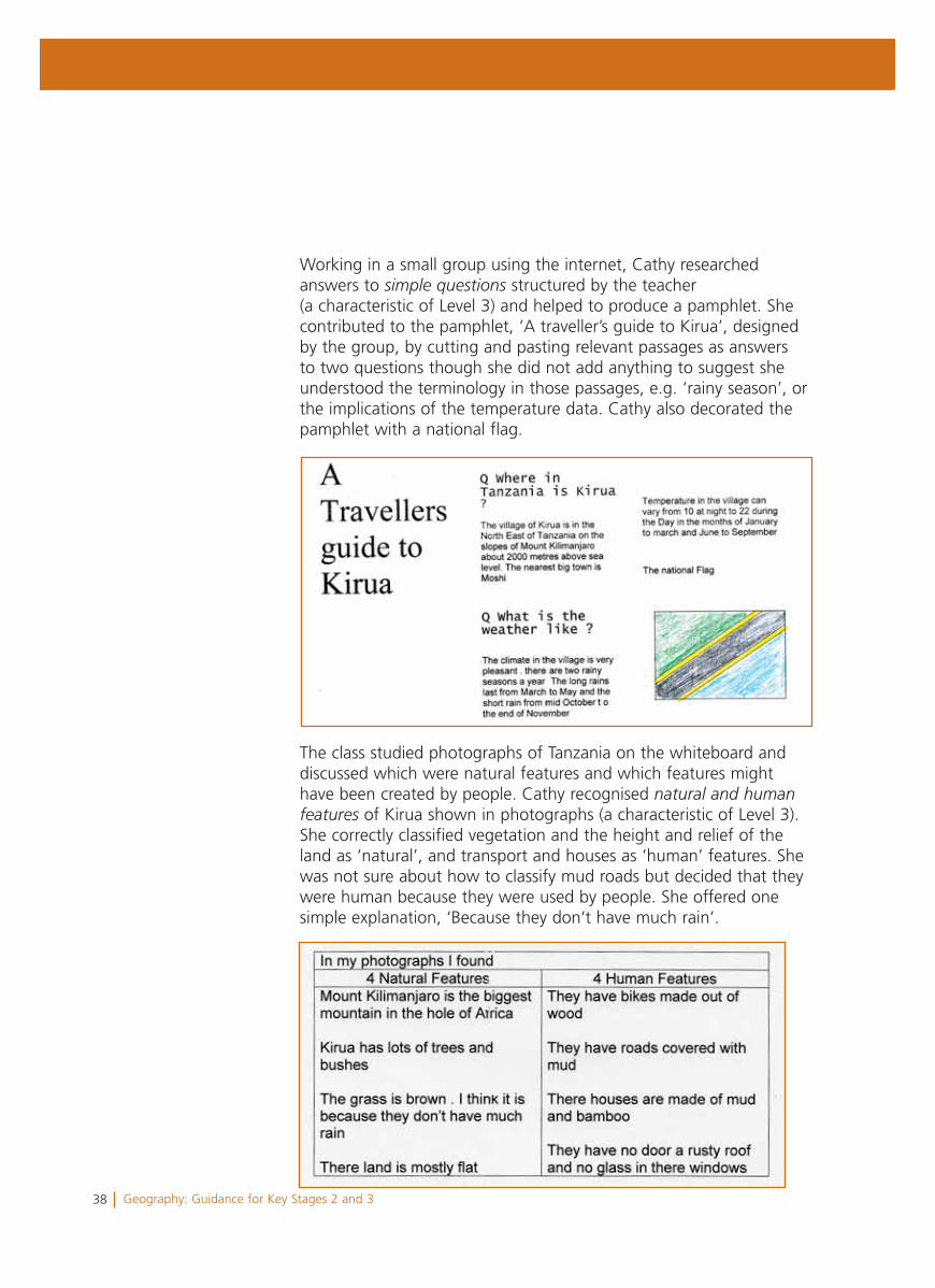
Working in a small group using the internet, Cathy researched answers to simple questions structured by the teacher (a characteristic of Level 3) and helped to produce a pamphlet. She contributed to the pamphlet, ‘A traveller’s guide to Kirua’, designed by the group, by cutting and pasting relevant passages as answers to two questions though she did not add anything to suggest she understood the terminology in those passages, e.g. ‘rainy season’, or the implications of the temperature data. Cathy also decorated the pamphlet with a national flag.
The class studied photographs of Tanzania on the whiteboard and discussed which were natural features and which features might have been created by people. Cathy recognised natural and humanfeatures of Kirua shown in photographs (a characteristic of Level 3). She correctly classified vegetation and the height and relief of the land as ‘natural’, and transport and houses as ‘human’ features. She was not sure about how to classify mud roads but decided that they were human because they were used by people. She offered one simple explanation, ‘Because they don’t have much rain’.
39Geography: Guidance for Key Stages 2 and 3
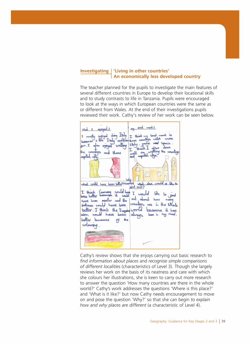
The teacher planned for the pupils to investigate the main features of several different countries in Europe to develop their locational skills and to study contrasts to life in Tanzania. Pupils were encouraged to look at the ways in which European countries were the same as or different from Wales. At the end of their investigations pupils reviewed their work. Cathy‘s review of her work can be seen below.
Cathy’s review shows that she enjoys carrying out basic research to find information about places and recognise simple comparisonsof different localities (characteristics of Level 3). Though she largely reviews her work on the basis of its neatness and care with which she colours her illustrations, she is keen to carry out more research to answer the question ‘How many countries are there in the whole world?’ Cathy’s work addresses the questions ‘Where is this place?’ and ‘What is it like?’ but now Cathy needs encouragement to move on and pose the question ’Why?’ so that she can begin to explainhow and why places are different (a characteristic of Level 4).
Investigating ‘Living in other countries’ An economically less developed country
40 Geography: Guidance for Key Stages 2 and 3
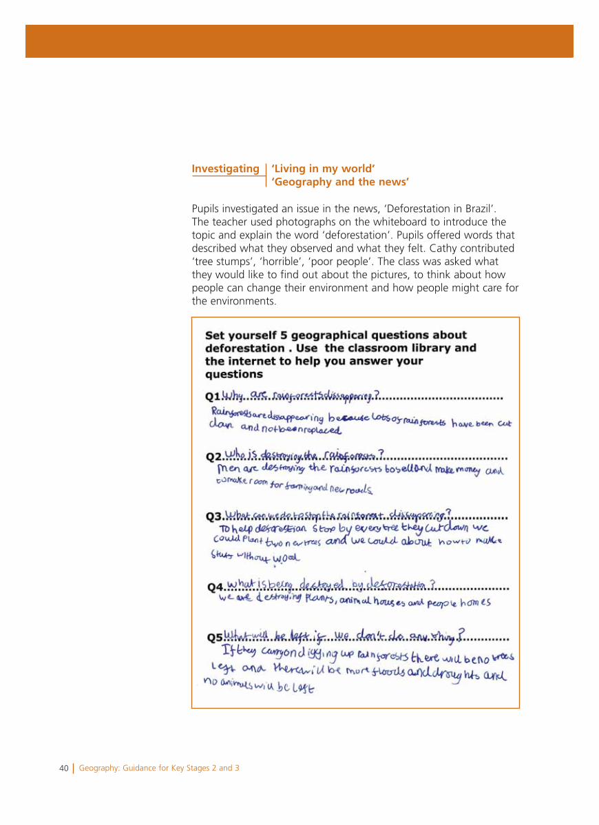
Pupils investigated an issue in the news, ‘Deforestation in Brazil’. The teacher used photographs on the whiteboard to introduce the topic and explain the word ‘deforestation’. Pupils offered words that described what they observed and what they felt. Cathy contributed ‘tree stumps’, ‘horrible’, ‘poor people’. The class was asked what they would like to find out about the pictures, to think about how people can change their environment and how people might care for the environments.
Investigating ‘Living in my world’ ‘Geography and the news’
41Geography: Guidance for Key Stages 2 and 3
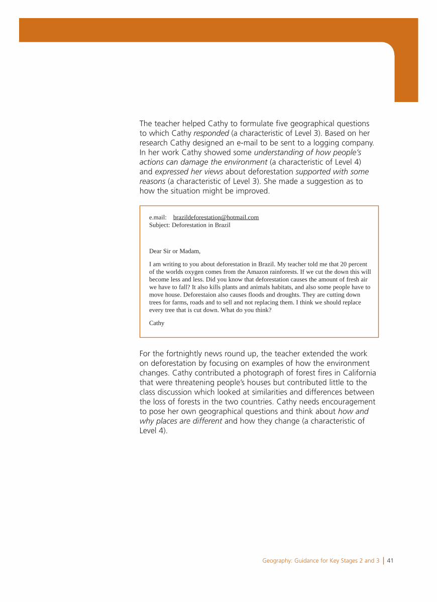
The teacher helped Cathy to formulate five geographical questions to which Cathy responded (a characteristic of Level 3). Based on her research Cathy designed an e-mail to be sent to a logging company. In her work Cathy showed some understanding of how people’sactions can damage the environment (a characteristic of Level 4) and expressed her views about deforestation supported with somereasons (a characteristic of Level 3). She made a suggestion as to how the situation might be improved.
For the fortnightly news round up, the teacher extended the work on deforestation by focusing on examples of how the environment changes. Cathy contributed a photograph of forest fires in California that were threatening people’s houses but contributed little to the class discussion which looked at similarities and differences between the loss of forests in the two countries. Cathy needs encouragement to pose her own geographical questions and think about how andwhy places are different and how they change (a characteristic of Level 4).
e.mail: [email protected]: Deforestation in Brazil
Dear Sir or Madam,
I am writing to you about deforestation in Brazil. My teacher told me that 20 percentof the worlds oxygen comes from the Amazon rainforests. If we cut the down this willbecome less and less. Did you know that deforestation causes the amount of fresh airwe have to fall? It also kills plants and animals habitats, and also some people have tomove house. Deforestaion also causes floods and droughts. They are cutting downtrees for farms, roads and to sell and not replacing them. I think we should replaceevery tree that is cut down. What do you think?
Cathy
42 Geography: Guidance for Key Stages 2 and 3
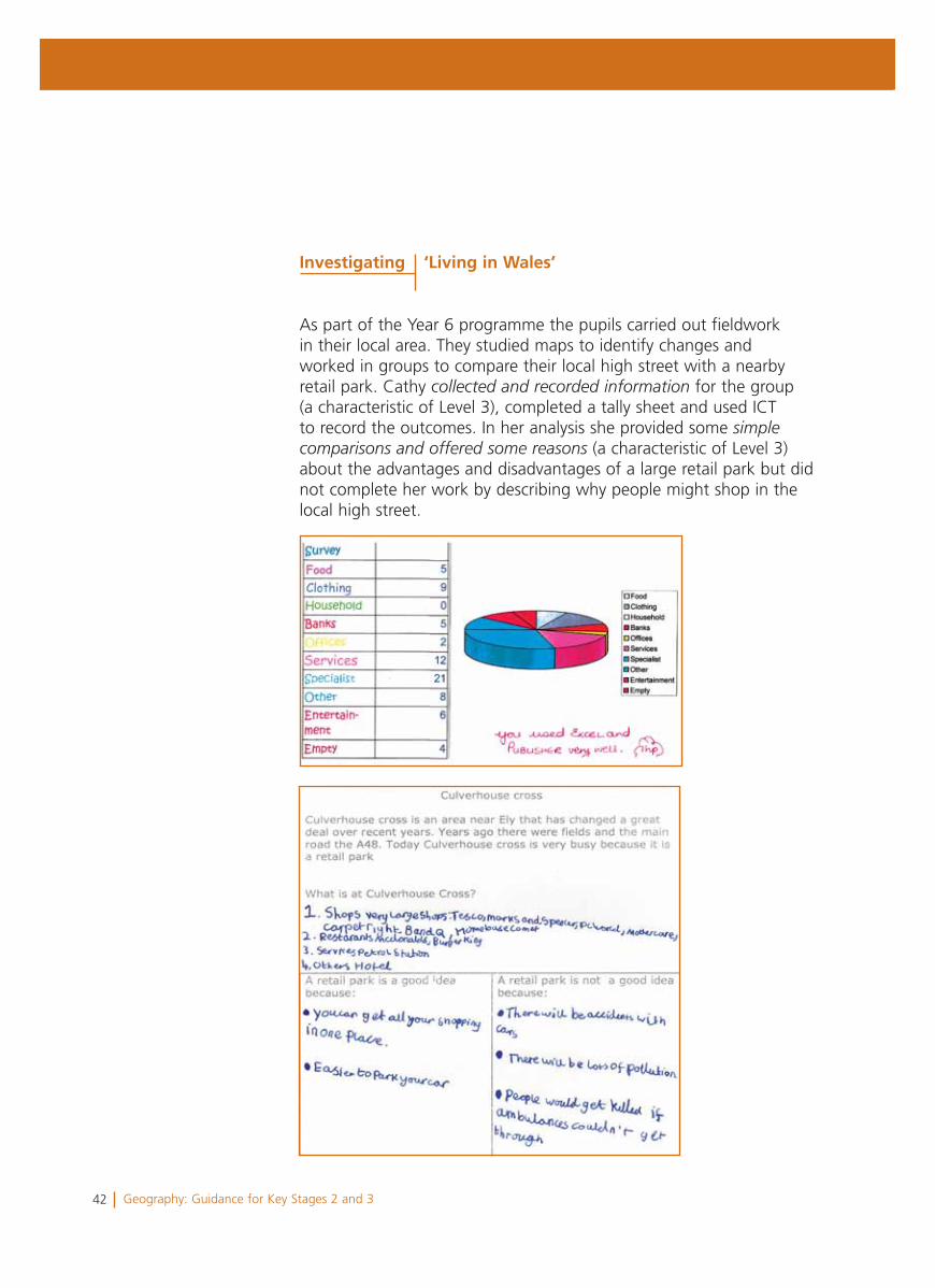
As part of the Year 6 programme the pupils carried out fieldwork in their local area. They studied maps to identify changes and worked in groups to compare their local high street with a nearby retail park. Cathy collected and recorded information for the group (a characteristic of Level 3), completed a tally sheet and used ICT to record the outcomes. In her analysis she provided some simplecomparisons and offered some reasons (a characteristic of Level 3) about the advantages and disadvantages of a large retail park but did not complete her work by describing why people might shop in the local high street.
Investigating ‘Living in Wales’
43Geography: Guidance for Key Stages 2 and 3
Summary
Cathy’s profile shows some characteristics of Level 3 and Level 4 but mainly the characteristics of Level 3.
She demonstrates some knowledge and understanding of the character of different localities and environments and describes geographical features. She can offer some simple comparisons and reasons. She also recognises that people have an impact on their environment, and shows some understanding of cause and effects. In her investigations she responds to simple questions, and collects and records information. She reviews her work thoughtfully but concentrates on presentation rather than what she might have learned.
Overall the teacher considered that Cathy had progressed in each of the four skills of the programme of study, particularly in locating places and expressing a point of view. As a next step, Cathy needs to develop her descriptions and begin to explore explanations by posing the question ‘Why?’
44 Geography: Guidance for Key Stages 2 and 3
Alan is a 10-year-old learner in Key Stage 2.
His teacher knows much more about Alan’s performance than can be included here. However, this profile has been selected to illustrate characteristic features of Alan’s work across a range of activities. Each example is accompanied by a brief commentary to provide a context and indicate particular qualities in the work.
Alan’s profile shows some characteristics of Levels 4 and 5, but mainly characteristics of Level 4.
Alan’s teacher planned for the class to investigate coastal towns as an aspect of the geography of the whole of Wales and carry out a fieldwork visit to Llandudno. The teacher also planned an emphasis on issues associated with sustainability for the Year 6 scheme of work. The proposal to site a wind farm locally provided an opportunity for a topic to link with science, investigate a local issue in the news and investigate global warming. The scheme of work for the year provided opportunities for the pupils to develop across each of the four skills of the programme of study.
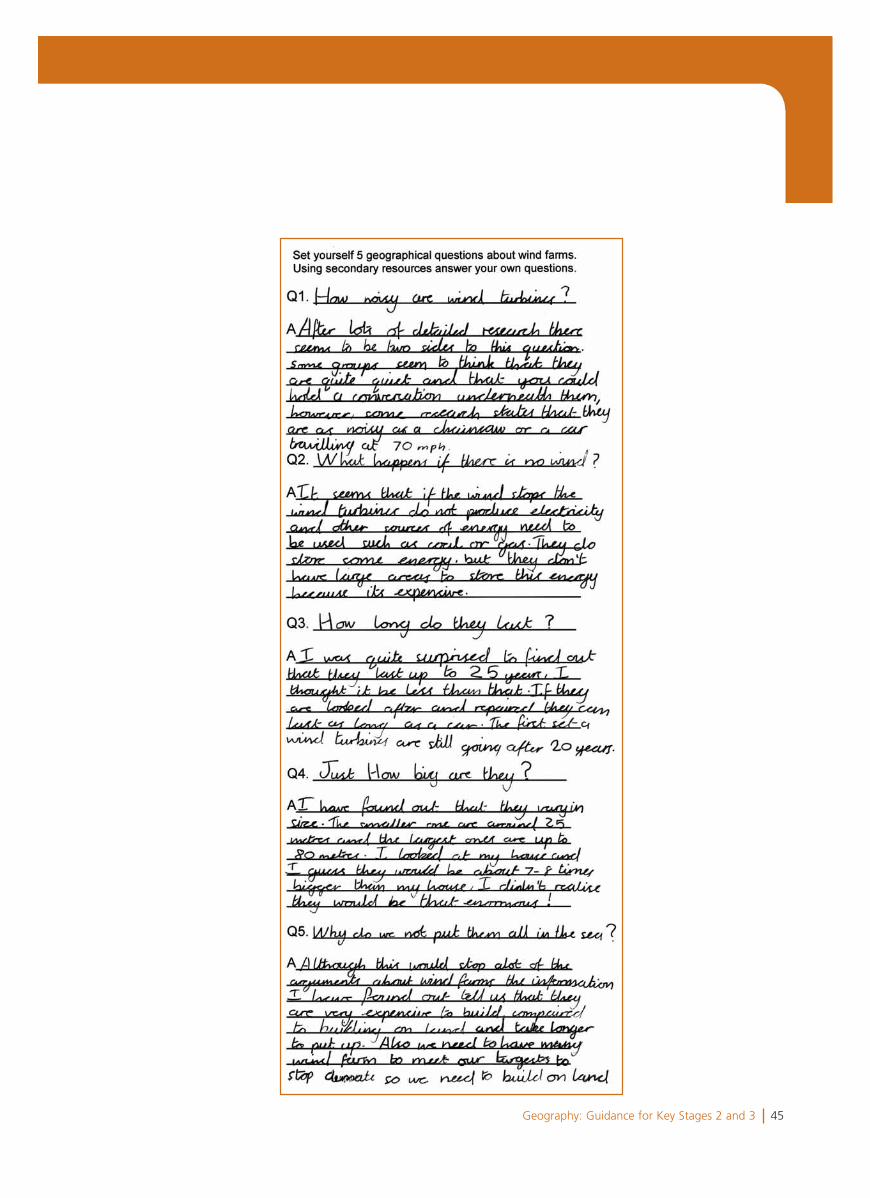
As the first part of an investigation into the production and use of energy, pupils carried out a survey of when and where electricity was used in the school. Pupils were encouraged to identify what they knew about wind farms and construct five geographical questions to guide further investigation. Alan suggested relevant questions forinvestigation (a characteristic of Level 4), e.g. ‘Why do we not put them in the sea?’ Some questions, e.g. ‘How long will they last?’, that reflected his interest in science, proved less relevant to the issue of where to site the wind farm. He worked enthusiastically and independently using the internet, software and a number of science books to find answers to his questions.
Alan Characteristics of Levels 4 and 5
Investigating ‘Living in Wales’ A local issue
45Geography: Guidance for Key Stages 2 and 3
46 Geography: Guidance for Key Stages 2 and 3
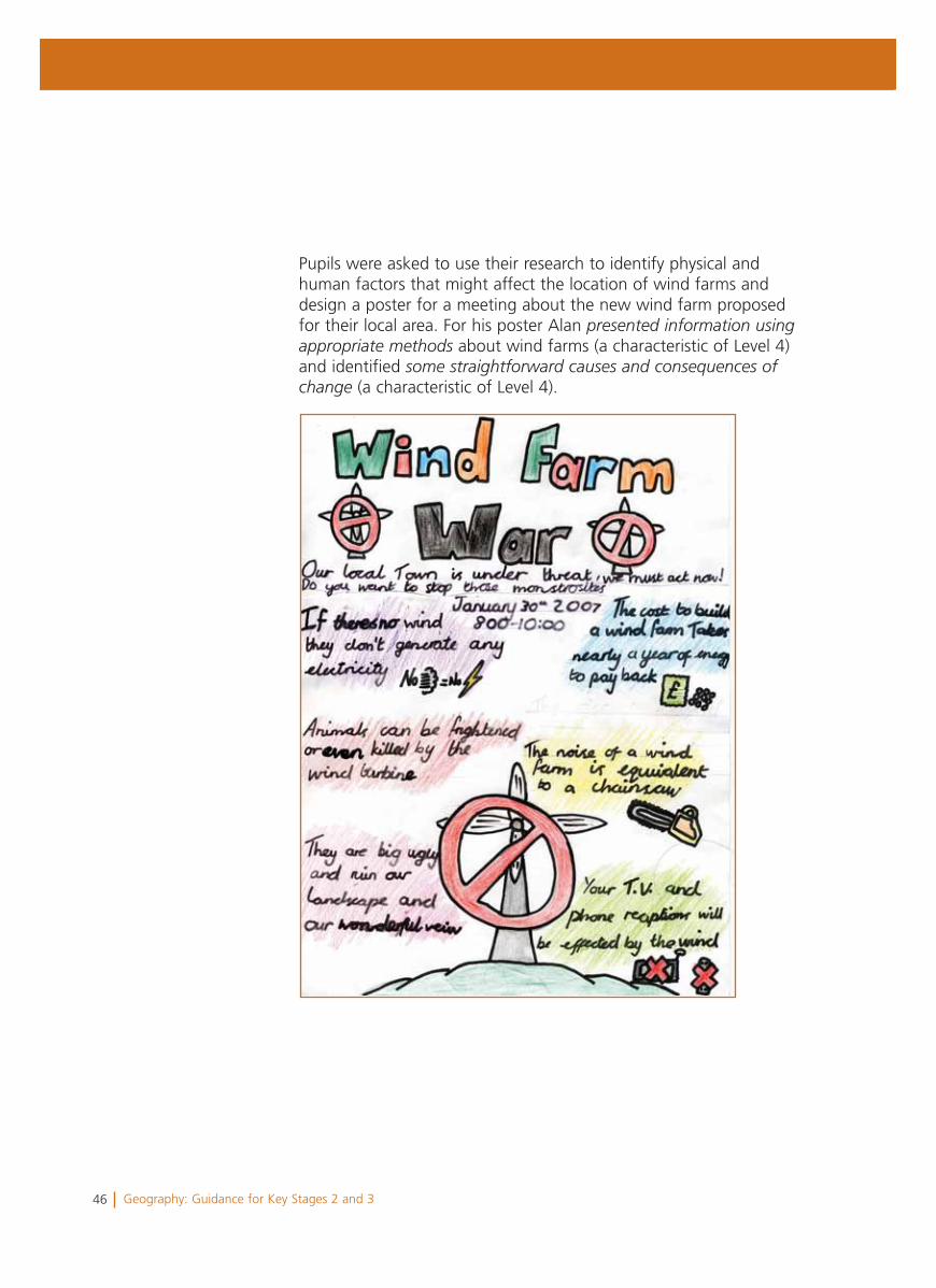
Pupils were asked to use their research to identify physical and human factors that might affect the location of wind farms and design a poster for a meeting about the new wind farm proposed for their local area. For his poster Alan presented information usingappropriate methods about wind farms (a characteristic of Level 4) and identified some straightforward causes and consequences ofchange (a characteristic of Level 4).
47Geography: Guidance for Key Stages 2 and 3
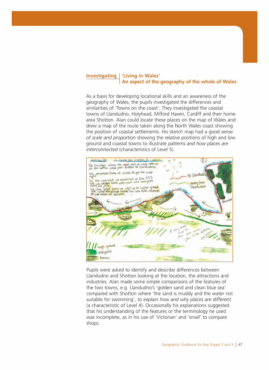
As a basis for developing locational skills and an awareness of the geography of Wales, the pupils investigated the differences and similarities of ‘Towns on the coast’. They investigated the coastal towns of Llandudno, Holyhead, Milford Haven, Cardiff and their home area Shotton. Alan could locate these places on the map of Wales and drew a map of the route taken along the North Wales coast showing the position of coastal settlements. His sketch map had a good senseof scale and proportion showing the relative positions of high and low ground and coastal towns to illustrate patterns and how places areinterconnected (characteristics of Level 5).
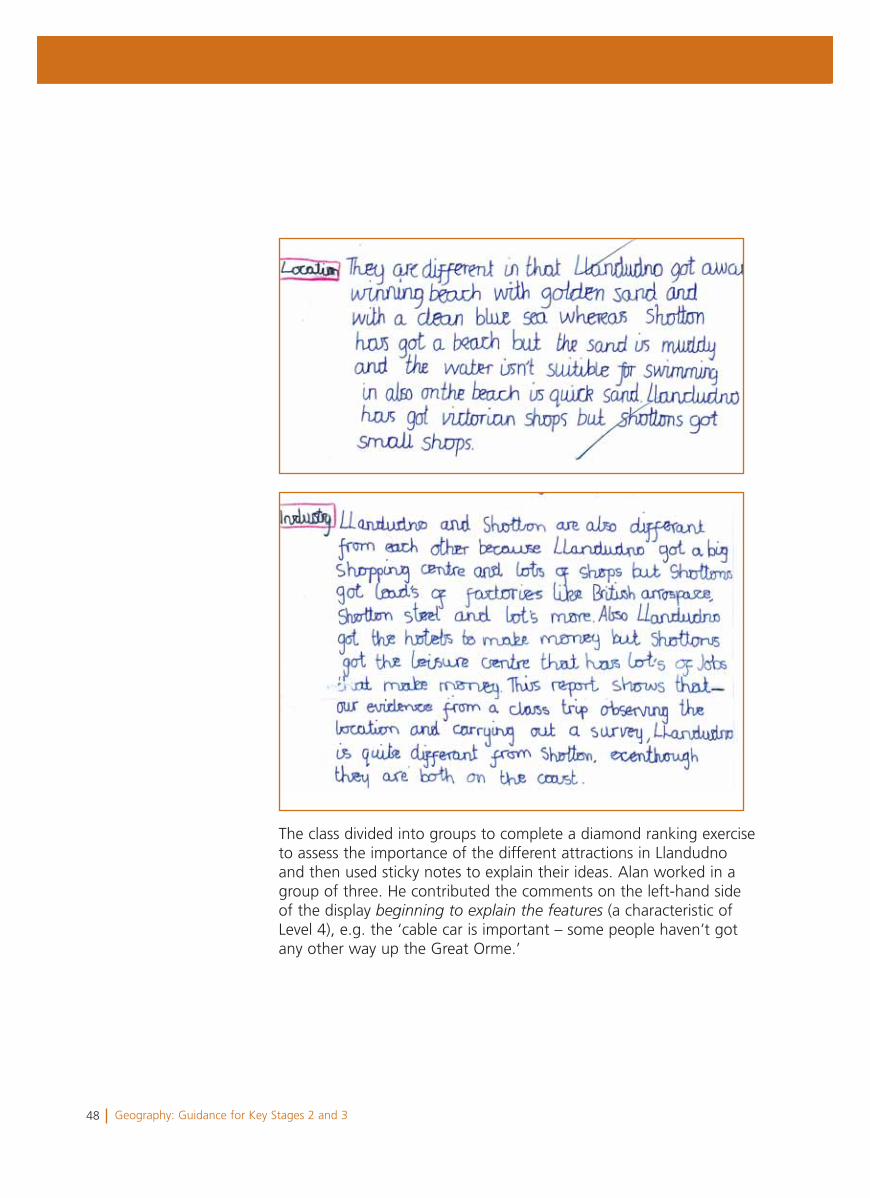
Pupils were asked to identify and describe differences between Llandudno and Shotton looking at the location, the attractions and industries. Alan made some simple comparisons of the features of the two towns, e.g. Llandudno’s ‘golden sand and clean blue sea’ compared with Shotton where ‘the sand is muddy and the water not suitable for swimming’, to explain how and why places are different(a characteristic of Level 4). Occasionally his explanations suggested that his understanding of the features or the terminology he used was incomplete, as in his use of ‘Victorian’ and ‘small’ to compare shops.
Investigating ‘Living in Wales’ An aspect of the geography of the whole of Wales
48 Geography: Guidance for Key Stages 2 and 3
The class divided into groups to complete a diamond ranking exercise to assess the importance of the different attractions in Llandudno and then used sticky notes to explain their ideas. Alan worked in a group of three. He contributed the comments on the left-hand side of the display beginning to explain the features (a characteristic of Level 4), e.g. the ‘cable car is important – some people haven’t got any other way up the Great Orme.’

49Geography: Guidance for Key Stages 2 and 3
50 Geography: Guidance for Key Stages 2 and 3
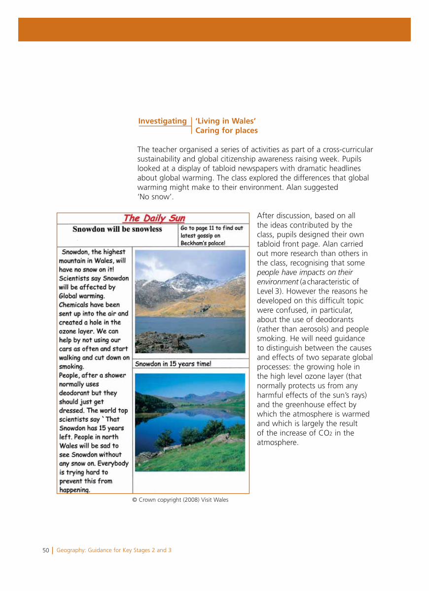
The teacher organised a series of activities as part of a cross-curricular sustainability and global citizenship awareness raising week. Pupils looked at a display of tabloid newspapers with dramatic headlines about global warming. The class explored the differences that global warming might make to their environment. Alan suggested ‘No snow’.
After discussion, based on all the ideas contributed by the class, pupils designed their own tabloid front page. Alan carried out more research than others in the class, recognising that somepeople have impacts on theirenvironment (a characteristic ofLevel 3). However the reasons he developed on this difficult topic were confused, in particular, about the use of deodorants (rather than aerosols) and people smoking. He will need guidance to distinguish between the causes and effects of two separate global processes: the growing hole in the high level ozone layer (that normally protects us from any harmful effects of the sun’s rays) and the greenhouse effect by which the atmosphere is warmed and which is largely the result of the increase of CO2 in the atmosphere.
Investigating ‘Living in Wales’ Caring for places
© Crown copyright (2008) Visit Wales
51Geography: Guidance for Key Stages 2 and 3
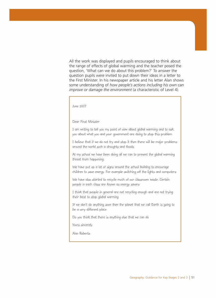
All the work was displayed and pupils encouraged to think about the range of effects of global warming and the teacher posed the question, ‘What can we do about this problem?’ To answer the question pupils were invited to put down their ideas in a letter to the First Minister. In his newspaper article and his letter Alan shows some understanding of how people’s actions including his own canimprove or damage the environment (a characteristic of Level 4).
June 2007
Dear First Minister
I am writing to tell you my point of view about global warming and to ask you about what you and your government are doing to stop this problem
I believe that if we do not try and stop it then there will be major problems around the world such a droughts and floods
At my school we have been doing all we can to prevent the global warming threat from happening.
We have put up a lot of signs around the school building to encourage children to save energy. For example switching off the lights and computers
We have also started to recycle much of our classroom waste. Certain people in each class are known as energy savers
I think that people in general are not recycling enough and are not trying their best to stop global warming
If we don’t do anything soon then the planet that we call Earth is going to be a very different place
Do you think that there is anything else that we can do
Yours sincerely
Alan Roberts
52 Geography: Guidance for Key Stages 2 and 3
Summary
Alan’s profile shows some characteristics of Level 3 and Level 5 but mainly the characteristics of Level 4.
He shows knowledge and understanding of places, environments and issues at more than one scale in his work on a local wind farm, the coastal towns of Wales and global warming, and he can locate places accurately.
In his investigations he researches broadly scientific aspects of processes, though the resulting explanations are sometimes confused or incomplete. He does identify some straightforward causes and consequences of change and he shows some understanding of how people’s actions, including his own, affect the environment.
Alan suggests some suitable questions for investigation and uses a variety of secondary sources to carry out his investigations from which he draws plausible conclusions. It was not possible to identify if Alan could accurately measure relevant data as his class did not have the opportunity to carry out any fieldwork during Year 6, though they had carried out a traffic survey at the beginning of Year 5.
Overall the teacher considers that Alan has progressed in each of the four skills of the programme of study, particularly in Locating places, environments and patterns. As a next step, Alan needs to identify relevant questions that can help him to understand and explain why places are different and how they change. Alan also needs to develop his understanding of his own observations by asking the follow up question ‘Why?’
53Geography: Guidance for Key Stages 2 and 3
Rachel is an 11-year-old learner in Key Stage 2.
Her teacher knows much more about Rachel’s performance than can be included here. However, this profile has been selected to illustrate characteristic features of Rachel’s work across a range of activities. Each example is accompanied by a brief commentary to provide a context and indicate particular qualities in the work.
Rachel’s profile shows some characteristics of Levels 5 and 6, but mainly characteristics of Level 5.
Rachel’s teacher planned opportunities for the class to investigate issues at different scales, locally, nationally and in another country. The aim was for pupils to develop their skills in evaluating evidence and communicating their ideas in a variety of different ways. The scheme of work for the year provided opportunities for the pupils to develop across each of the four skills of the programme of study.
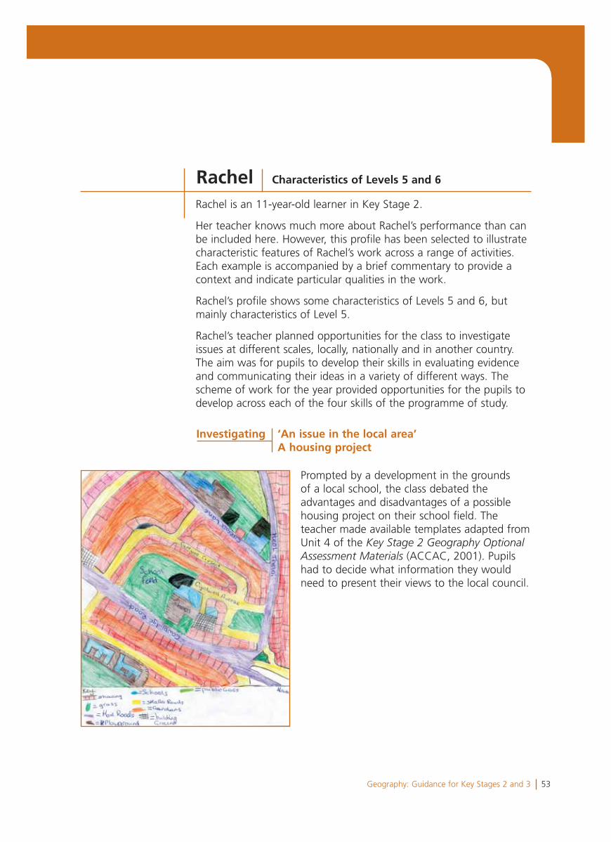
Prompted by a development in the grounds of a local school, the class debated the advantages and disadvantages of a possible housing project on their school field. The teacher made available templates adapted from Unit 4 of the Key Stage 2 Geography OptionalAssessment Materials (ACCAC, 2001). Pupils had to decide what information they would need to present their views to the local council.
Rachel Characteristics of Levels 5 and 6
Investigating ‘An issue in the local area’A housing project
54 Geography: Guidance for Key Stages 2 and 3
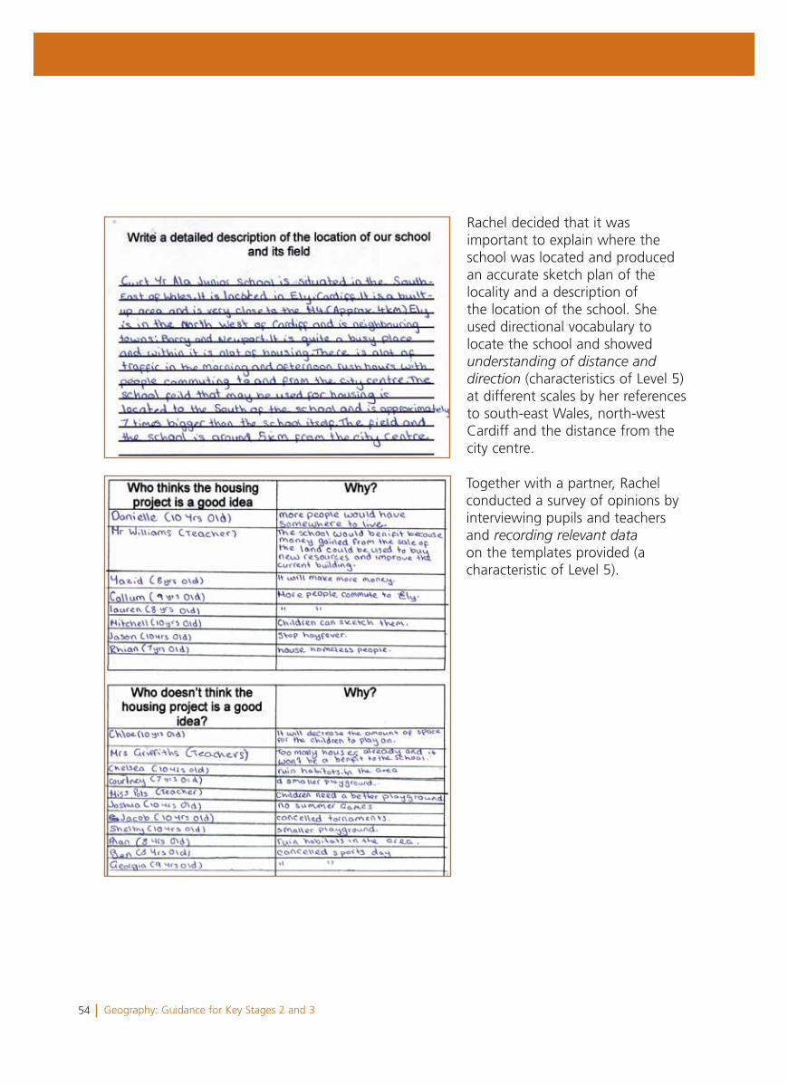
Together with a partner, Rachel conducted a survey of opinions by interviewing pupils and teachers and recording relevant dataon the templates provided (a characteristic of Level 5).
Rachel decided that it was important to explain where the school was located and produced an accurate sketch plan of the locality and a description of the location of the school. She used directional vocabulary to locate the school and showedunderstanding of distance anddirection (characteristics of Level 5) at different scales by her references to south-east Wales, north-west Cardiff and the distance from the city centre.
55Geography: Guidance for Key Stages 2 and 3
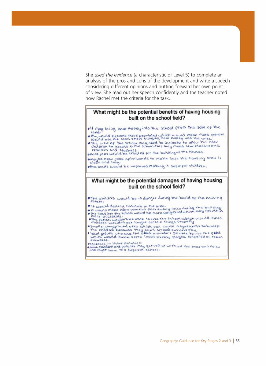
She used the evidence (a characteristic of Level 5) to complete an analysis of the pros and cons of the development and write a speech considering different opinions and putting forward her own point of view. She read out her speech confidently and the teacher noted how Rachel met the criteria for the task.
56 Geography: Guidance for Key Stages 2 and 3
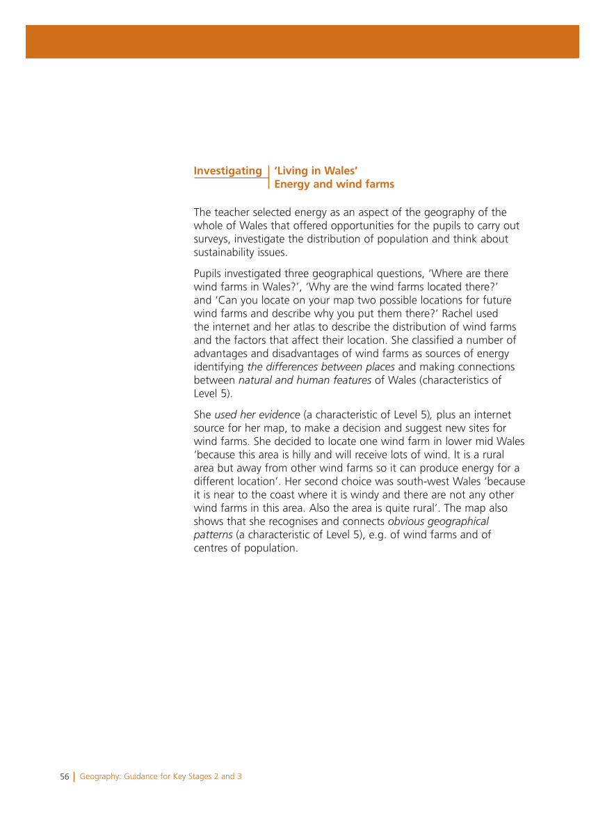
The teacher selected energy as an aspect of the geography of the whole of Wales that offered opportunities for the pupils to carry out surveys, investigate the distribution of population and think about sustainability issues.
Pupils investigated three geographical questions, ‘Where are there wind farms in Wales?’, ‘Why are the wind farms located there?’ and ‘Can you locate on your map two possible locations for future wind farms and describe why you put them there?’ Rachel used the internet and her atlas to describe the distribution of wind farms and the factors that affect their location. She classified a number of advantages and disadvantages of wind farms as sources of energy identifying the differences between places and making connections between natural and human features of Wales (characteristics of Level 5).
She used her evidence (a characteristic of Level 5), plus an internet source for her map, to make a decision and suggest new sites for wind farms. She decided to locate one wind farm in lower mid Wales ‘because this area is hilly and will receive lots of wind. It is a rural area but away from other wind farms so it can produce energy for a different location’. Her second choice was south-west Wales ‘because it is near to the coast where it is windy and there are not any other wind farms in this area. Also the area is quite rural’. The map also shows that she recognises and connects obvious geographicalpatterns (a characteristic of Level 5), e.g. of wind farms and of centres of population.
Investigating ‘Living in Wales’Energy and wind farms
57Geography: Guidance for Key Stages 2 and 3
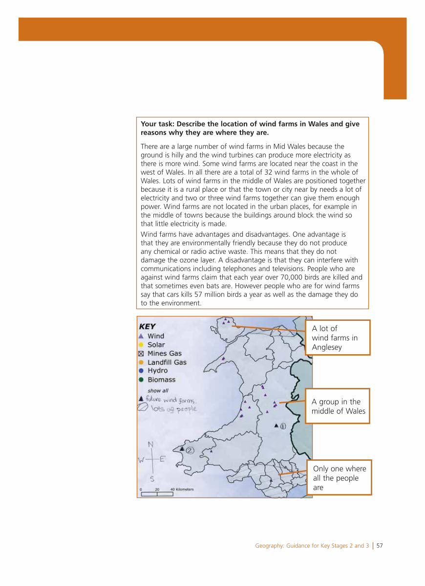
Your task: Describe the location of wind farms in Wales and give reasons why they are where they are.
There are a large number of wind farms in Mid Wales because the ground is hilly and the wind turbines can produce more electricity as there is more wind. Some wind farms are located near the coast in the west of Wales. In all there are a total of 32 wind farms in the whole of Wales. Lots of wind farms in the middle of Wales are positioned together because it is a rural place or that the town or city near by needs a lot of electricity and two or three wind farms together can give them enough power. Wind farms are not located in the urban places, for example in the middle of towns because the buildings around block the wind so that little electricity is made.
Wind farms have advantages and disadvantages. One advantage is that they are environmentally friendly because they do not produce any chemical or radio active waste. This means that they do not damage the ozone layer. A disadvantage is that they can interfere with communications including telephones and televisions. People who are against wind farms claim that each year over 70,000 birds are killed and that sometimes even bats are. However people who are for wind farms say that cars kills 57 million birds a year as well as the damage they do to the environment.
A lot of wind farms in Anglesey
A group in the middle of Wales
Only one where all the people are
58 Geography: Guidance for Key Stages 2 and 3
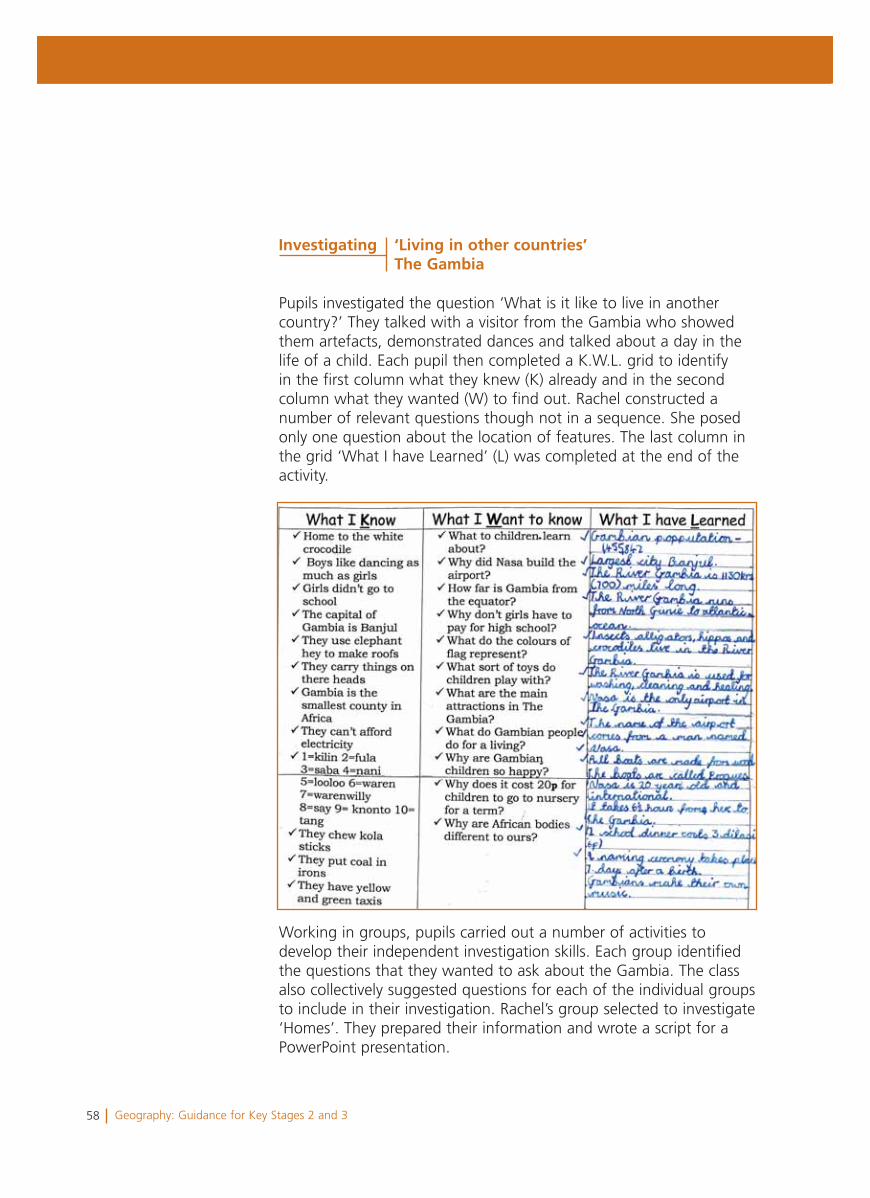
Pupils investigated the question ‘What is it like to live in another country?’ They talked with a visitor from the Gambia who showed them artefacts, demonstrated dances and talked about a day in the life of a child. Each pupil then completed a K.W.L. grid to identify in the first column what they knew (K) already and in the second column what they wanted (W) to find out. Rachel constructed a number of relevant questions though not in a sequence. She posed only one question about the location of features. The last column in the grid ‘What I have Learned’ (L) was completed at the end of the activity.
Working in groups, pupils carried out a number of activities to develop their independent investigation skills. Each group identified the questions that they wanted to ask about the Gambia. The class also collectively suggested questions for each of the individual groups to include in their investigation. Rachel’s group selected to investigate ‘Homes’. They prepared their information and wrote a script for a PowerPoint presentation.
Investigating ‘Living in other countries’The Gambia
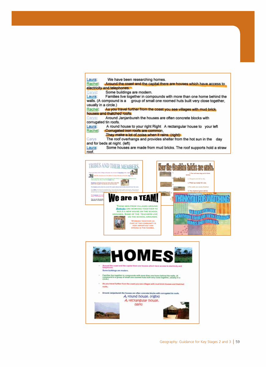
59Geography: Guidance for Key Stages 2 and 3
This is the Head of the Village at Boraba. He is from the Mandinka tribe. (right)
(left) The chairperson of the Mother's Club at Boraba is from the Fula tribe.
Some Gambian teachers visited England. Here Rohey is showing the children how tomake attaya tea. She is from the Wolof tribe.
Mandinka and Fula are the two main tribes at Borabaand in the Gambia. The Wolofs are the third tribe.
The Wolofs particularly live around the capital, Banjul and Serakunda both near the coast.
The Jolas are known for growing rice. They also live where palm trees grow. They processthem for oil. It is also possible to make wine from the sap of the trunk. Only the Christianswould drink this as Muslims do not drink alcohol.
The Serahulie are found mainly in Eastern Gambia and are thought to be one of the oldesttribes. Traditionally they are farmers and potters.
The Aku are the people who chose to return to their homeland after slavery wasabolished. in America. Their language is a broken English.
60 Geography: Guidance for Key Stages 2 and 3
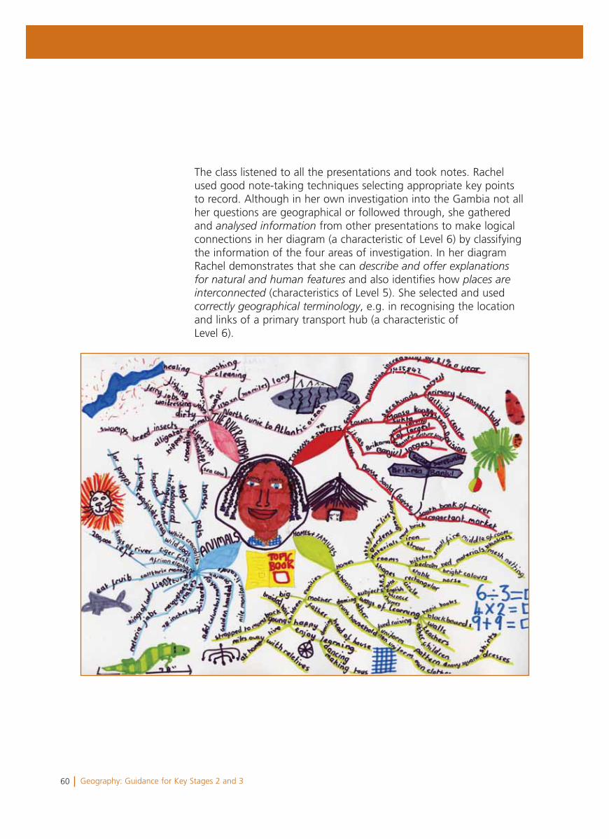
The class listened to all the presentations and took notes. Rachel used good note-taking techniques selecting appropriate key points to record. Although in her own investigation into the Gambia not all her questions are geographical or followed through, she gathered and analysed information from other presentations to make logical connections in her diagram (a characteristic of Level 6) by classifying the information of the four areas of investigation. In her diagram Rachel demonstrates that she can describe and offer explanationsfor natural and human features and also identifies how places areinterconnected (characteristics of Level 5). She selected and used correctly geographical terminology, e.g. in recognising the location and links of a primary transport hub (a characteristic of Level 6).
61Geography: Guidance for Key Stages 2 and 3
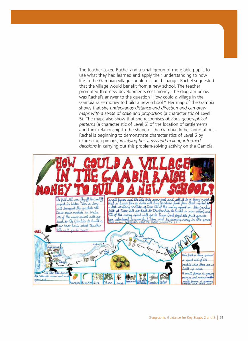
The teacher asked Rachel and a small group of more able pupils to use what they had learned and apply their understanding to how life in the Gambian village should or could change. Rachel suggested that the village would benefit from a new school. The teacher prompted that new developments cost money. The diagram below was Rachel’s answer to the question ‘How could a village in the Gambia raise money to build a new school?’ Her map of the Gambia shows that she understands distance and direction and can drawmaps with a sense of scale and proportion (a characteristic of Level 5). The maps also show that she recognises obvious geographicalpatterns (a characteristic of Level 5) of the location of settlements and their relationship to the shape of the Gambia. In her annotations, Rachel is beginning to demonstrate characteristics of Level 6 by expressing opinions, justifying her views and making informeddecisions in carrying out this problem-solving activity on the Gambia.
62 Geography: Guidance for Key Stages 2 and 3
Summary
Rachel’s profile shows mainly the characteristics of Level 5, though she is beginning to demonstrate some characteristics of Level 6.
Rachel demonstrates knowledge and understanding of the character of different localities and environments, and in her maps and her descriptions demonstrates that she understands distance and direction, and recognises obvious geographical patterns.
She identifies the differences between places, makes connections between natural and human features offering explanations for the characteristics of places, as her work on wind farms in Wales and the Gambia illustrates.
She works independently in her research, demonstrating a range of investigative skills and suggests solutions when addressing issues. She collects only a limited range of primary data in her opinion survey though she uses secondary information including an internet source in her research on wind farms. She does not demonstrate her ability to gather data by measurement although she had done this in a simple traffic survey carried out in Year 5.
In her suggestions for the new school in the Gambia, Rachel is beginning to demonstrate elements of Level 6 characteristics in expressing opinions as she does in justifying views and making decisions in a problem-solving activity. She uses a range of presentational methods including a well-organised PowerPoint presentation. She correctly uses a very good range of vocabulary, including ‘rural’, ‘urban’, ‘town’, ‘city’, ‘environmentally friendly’ and ‘primary transport hub’.
Rachel is an independent learner with a breadth of skills, and a confident communicator who employs a wide range of presentational skills and geographical vocabulary. As a next step, Rachel needs to develop her practical investigating skills including measurement and recording of primary data. She should also be encouraged to organise her questions into a sequence to consider both ‘Where?’ and ‘Why does this happen?’
63Geography: Guidance for Key Stages 2 and 3
Section 4Making judgements at the end of Key Stage 3
64 Geography: Guidance for Key Stages 2 and 3
This section shows how level descriptions can be used when makingjudgements about which level best describes a learner’s overallperformance at the end of the key stage.
You may find the following points useful when considering theprofiles in this section.
• The learner profiles are not presented as a model for how you should collect evidence about your learners. Although you will want to be able to explain why you have awarded a particular level to a learner at the end of the key stage, there is no requirement for judgements to be explained in this way or supported by detailed collections of evidence on each learner. Decisions about collecting evidence, and about its purpose and use, are matters for teachers working within an agreed school policy.
• The commentaries on the pieces of work have been written to explain the judgement made about a learner’s performance. They are not intended as an example of a report to parents/guardians.
• The materials in each learner profile can only represent a small part of the information and experiences that make up a teacher’s knowledge of each learner. They do not reflect the extent of the knowledge of each learner that you will have built up over time across a range of different contexts. You will use this knowledge to make a rounded judgement about the level that best fits each learner’s performance.
• You will arrive at judgements by taking into account strengths and weaknesses in performance across a range of contexts and over a period of time. Opportunities will need to be provided for learners to demonstrate attainment in all aspects of the level descriptions.
• Some of your learners may need to use a range of alternative forms of communication to show what they know, what they understand and what they can do.
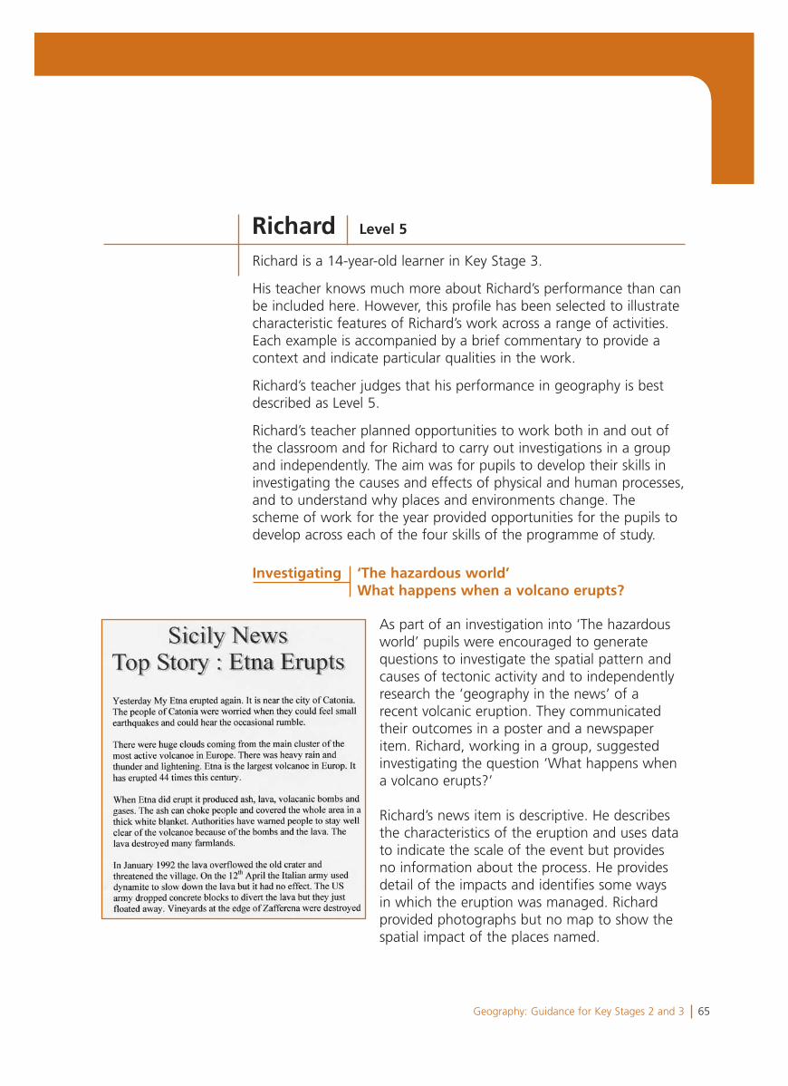
65Geography: Guidance for Key Stages 2 and 3
Richard is a 14-year-old learner in Key Stage 3.
His teacher knows much more about Richard’s performance than can be included here. However, this profile has been selected to illustrate characteristic features of Richard’s work across a range of activities. Each example is accompanied by a brief commentary to provide a context and indicate particular qualities in the work.
Richard’s teacher judges that his performance in geography is best described as Level 5.
Richard’s teacher planned opportunities to work both in and out of the classroom and for Richard to carry out investigations in a group and independently. The aim was for pupils to develop their skills in investigating the causes and effects of physical and human processes, and to understand why places and environments change. The scheme of work for the year provided opportunities for the pupils to develop across each of the four skills of the programme of study.
As part of an investigation into ‘The hazardous world’ pupils were encouraged to generate questions to investigate the spatial pattern and causes of tectonic activity and to independently research the ‘geography in the news’ of a recent volcanic eruption. They communicated their outcomes in a poster and a newspaper item. Richard, working in a group, suggested investigating the question ‘What happens when a volcano erupts?’
Richard’s news item is descriptive. He describes the characteristics of the eruption and uses data to indicate the scale of the event but provides no information about the process. He provides detail of the impacts and identifies some ways in which the eruption was managed. Richard provided photographs but no map to show the spatial impact of the places named.
Richard Level 5
Investigating ‘The hazardous world’ What happens when a volcano erupts?
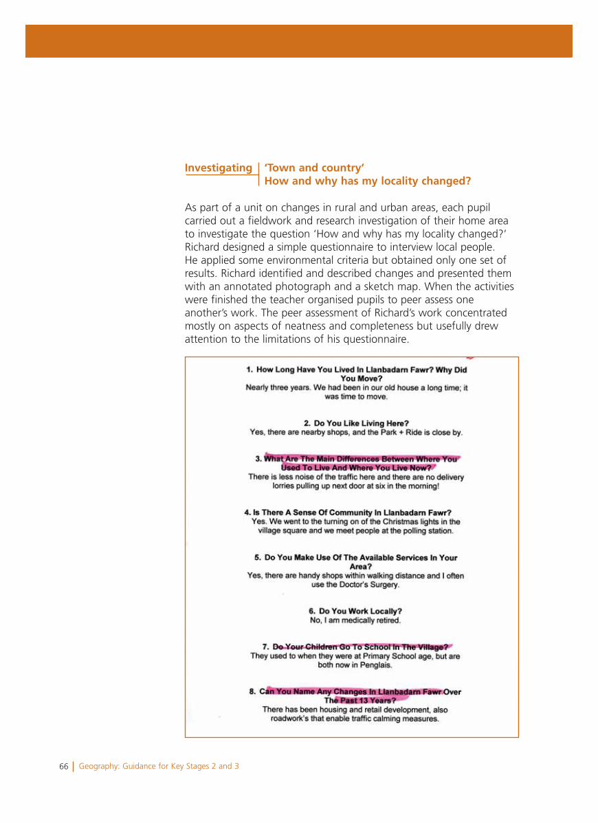
66 Geography: Guidance for Key Stages 2 and 3
As part of a unit on changes in rural and urban areas, each pupil carried out a fieldwork and research investigation of their home area to investigate the question ‘How and why has my locality changed?’ Richard designed a simple questionnaire to interview local people. He applied some environmental criteria but obtained only one set of results. Richard identified and described changes and presented them with an annotated photograph and a sketch map. When the activities were finished the teacher organised pupils to peer assess one another’s work. The peer assessment of Richard’s work concentrated mostly on aspects of neatness and completeness but usefully drew attention to the limitations of his questionnaire.
Investigating ‘Town and country’ How and why has my locality changed?
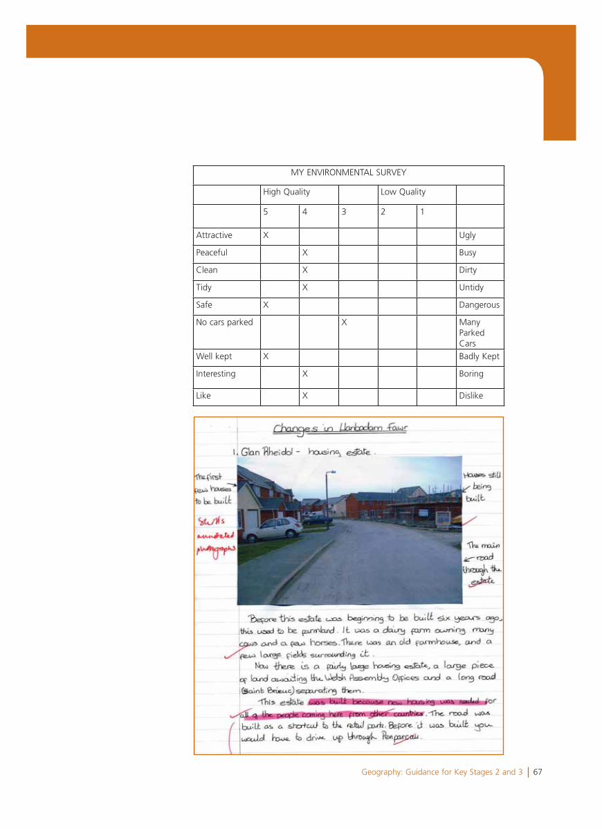
67Geography: Guidance for Key Stages 2 and 3
MY ENVIRONMENTAL SURVEY
High Quality Low Quality
5 4 3 2 1
Attractive X Ugly
Peaceful X Busy
Clean X Dirty
Tidy X Untidy
Safe X Dangerous
No cars parked X ManyParkedCars
Well kept X Badly Kept
Interesting X Boring
Like X Dislike
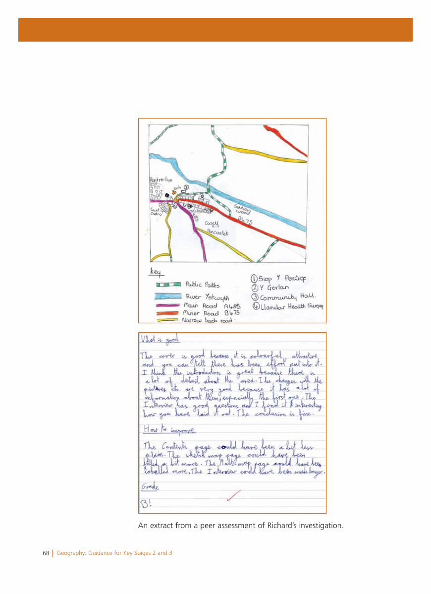
68 Geography: Guidance for Key Stages 2 and 3
An extract from a peer assessment of Richard’s investigation.
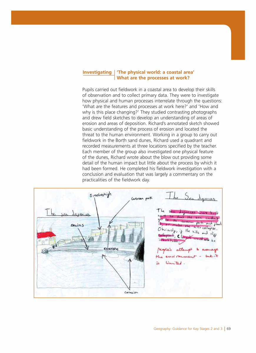
69Geography: Guidance for Key Stages 2 and 3
Pupils carried out fieldwork in a coastal area to develop their skills of observation and to collect primary data. They were to investigate how physical and human processes interrelate through the questions: ‘What are the features and processes at work here?’ and ‘How and why is this place changing?’ They studied contrasting photographs and drew field sketches to develop an understanding of areas of erosion and areas of deposition. Richard’s annotated sketch showed basic understanding of the process of erosion and located the threat to the human environment. Working in a group to carry out fieldwork in the Borth sand dunes, Richard used a quadrant and recorded measurements at three locations specified by the teacher. Each member of the group also investigated one physical feature of the dunes, Richard wrote about the blow out providing some detail of the human impact but little about the process by which it had been formed. He completed his fieldwork investigation with a conclusion and evaluation that was largely a commentary on the practicalities of the fieldwork day.
Investigating ‘The physical world: a coastal area’ What are the processes at work?
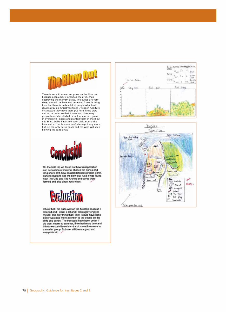
70 Geography: Guidance for Key Stages 2 and 3
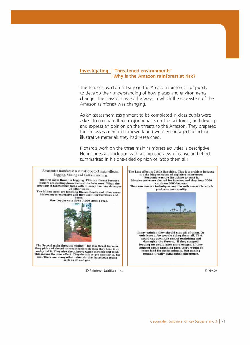
71Geography: Guidance for Key Stages 2 and 3
The teacher used an activity on the Amazon rainforest for pupils to develop their understanding of how places and environments change. The class discussed the ways in which the ecosystem of the Amazon rainforest was changing.
As an assessment assignment to be completed in class pupils were asked to compare three major impacts on the rainforest, and develop and express an opinion on the threats to the Amazon. They prepared for the assessment in homework and were encouraged to include illustrative materials they had researched.
Richard’s work on the three main rainforest activities is descriptive. He includes a conclusion with a simplistic view of cause and effect summarised in his one-sided opinion of ‘Stop them all!’
Investigating ’Threatened environments’ Why is the Amazon rainforest at risk?
© Raintree Nutrition, Inc. © NASA
72 Geography: Guidance for Key Stages 2 and 3
Summary and overall judgement
Levels 4, 5 and 6 were considered and Level 5 was judged to be the best fit.
Richard demonstrates knowledge and understanding of a rangeof places and environments at more than one scale, and he has a good sense of location and draws sketch maps with a sense of scaleand proportion (characteristics of Level 5). His maps demonstrate identification of patterns, as in his sketch map showing physical and human characteristics of the Borth sand dune area (a characteristic of Level 6).
Richard describes features, e.g. of his home locality, the Amazon rainforest and the volcanic eruption, and he describes the role ofpeople in managing their environment in his work on the eruption of Mount Etna and the blow out (characteristics of Level 5). However he provides few details of processes to explain different features or how places change. Some explanations are incomplete or confusing as in his home locality study, e.g. ‘The estate was built for people coming from other countries’, and in his work on the Amazon, e.g. ‘They use modern techniques and the soils are acid, which produces poor quality’.
He worked well in practical situations and collected and recordedrelevant data from sources both working in a fieldwork group and also for his independent investigation of his locality (a characteristic of Level 5). However, because he conducted only one interview, he had insufficient information to draw plausible conclusions from his questionnaire. He is able to present straightforward conclusions to his research and expresses his own view on the geographical issue of deforestation and change in his home locality (characteristics of Level 4).
Richard’s strengths are locating skills, constructing sketch maps, and using a variety of presentation and communication skills. He works well when provided with sectioned headings and a structure within which to work. As a next step, Richard needs to develop his depth of explanation and identification of linkages of cause and effect. He will need support to develop his investigating skills in planning and following through an investigation from asking questions to formulating a conclusion.
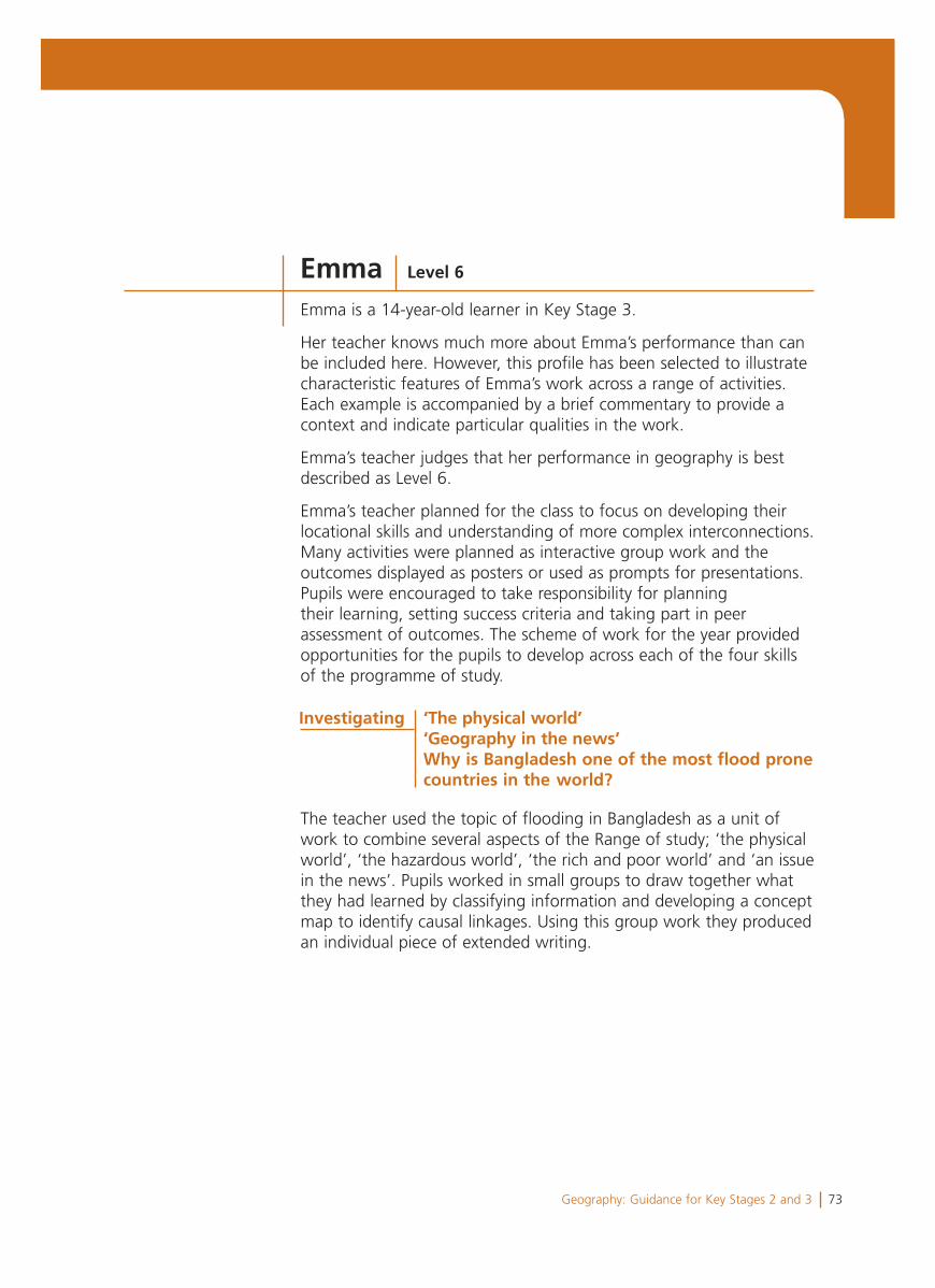
73Geography: Guidance for Key Stages 2 and 3
Emma is a 14-year-old learner in Key Stage 3.
Her teacher knows much more about Emma’s performance than can be included here. However, this profile has been selected to illustrate characteristic features of Emma’s work across a range of activities. Each example is accompanied by a brief commentary to provide a context and indicate particular qualities in the work.
Emma’s teacher judges that her performance in geography is best described as Level 6.
Emma’s teacher planned for the class to focus on developing their locational skills and understanding of more complex interconnections. Many activities were planned as interactive group work and the outcomes displayed as posters or used as prompts for presentations. Pupils were encouraged to take responsibility for planning their learning, setting success criteria and taking part in peer assessment of outcomes. The scheme of work for the year provided opportunities for the pupils to develop across each of the four skills of the programme of study.
The teacher used the topic of flooding in Bangladesh as a unit of work to combine several aspects of the Range of study; ‘the physical world’, ‘the hazardous world’, ‘the rich and poor world’ and ‘an issue in the news’. Pupils worked in small groups to draw together what they had learned by classifying information and developing a concept map to identify causal linkages. Using this group work they produced an individual piece of extended writing.
Emma Level 6
Investigating ‘The physical world’ ‘Geography in the news’Why is Bangladesh one of the most flood prone countries in the world?
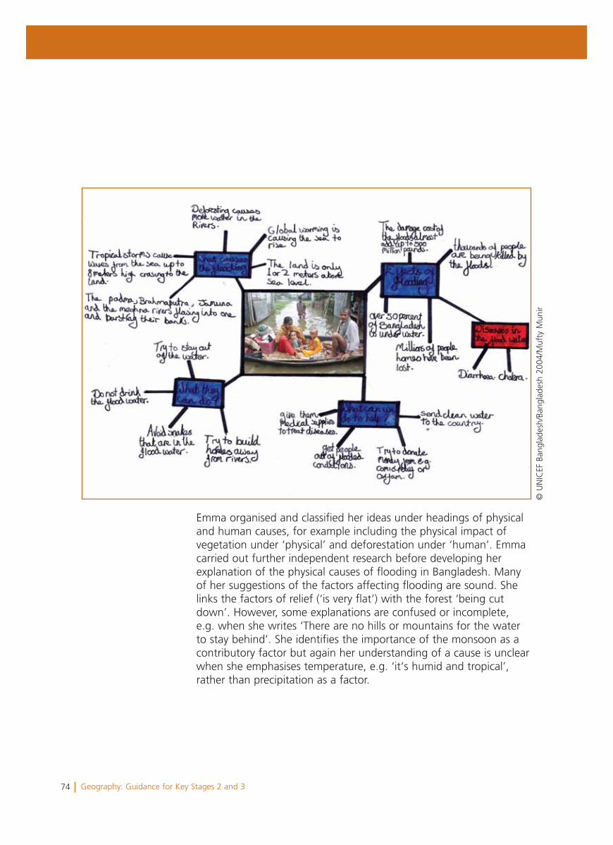
74 Geography: Guidance for Key Stages 2 and 3
Emma organised and classified her ideas under headings of physical and human causes, for example including the physical impact of vegetation under ‘physical’ and deforestation under ‘human’. Emma carried out further independent research before developing her explanation of the physical causes of flooding in Bangladesh. Many of her suggestions of the factors affecting flooding are sound. She links the factors of relief (‘is very flat’) with the forest ‘being cut down’. However, some explanations are confused or incomplete, e.g. when she writes ‘There are no hills or mountains for the water to stay behind’. She identifies the importance of the monsoon as a contributory factor but again her understanding of a cause is unclear when she emphasises temperature, e.g. ‘it‘s humid and tropical’, rather than precipitation as a factor.
© U
NIC
EF B
angl
ades
h/Ba
ngla
desh
200
4/M
ufty
Mun
ir
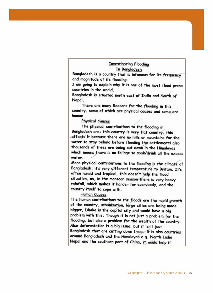
75Geography: Guidance for Key Stages 2 and 3
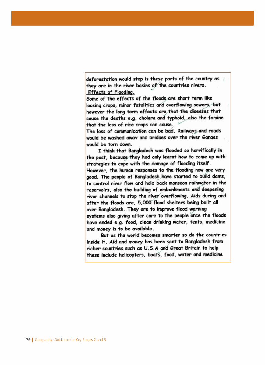
76 Geography: Guidance for Key Stages 2 and 3
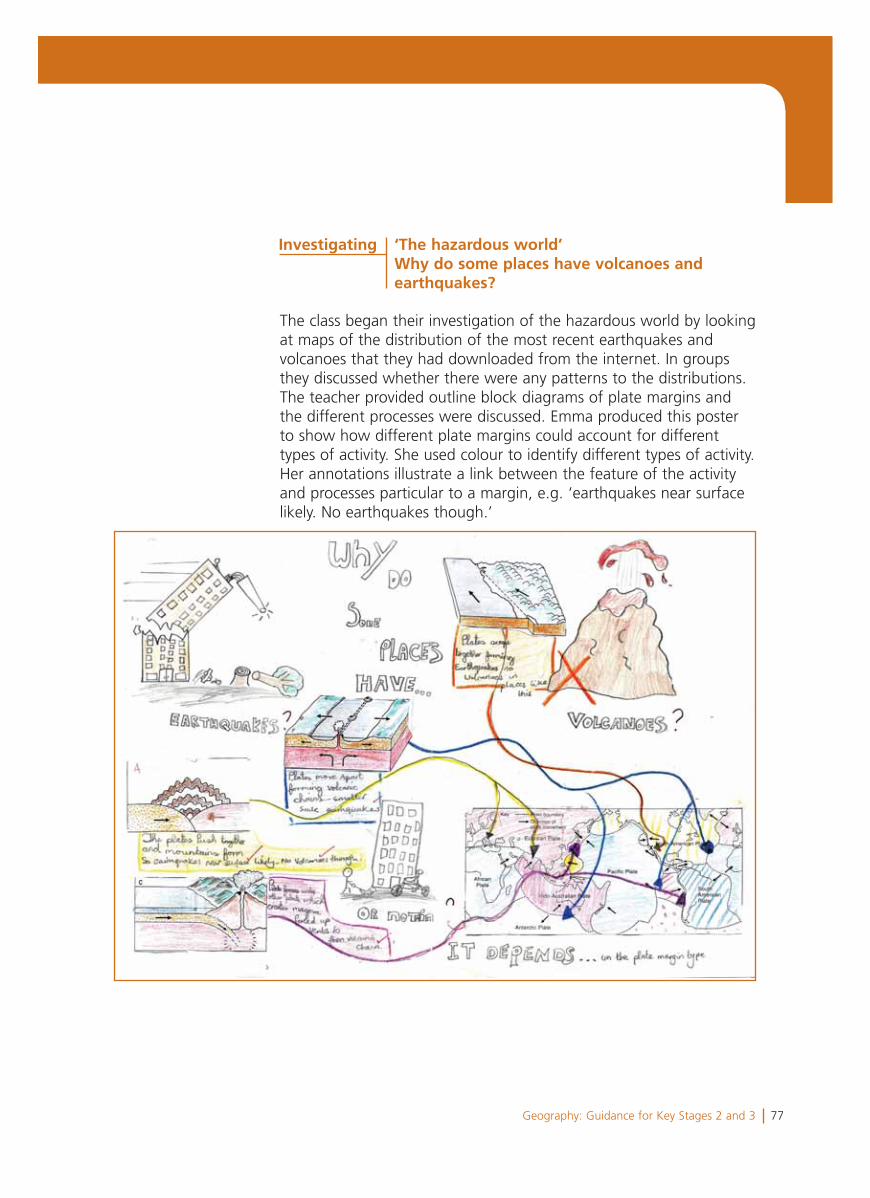
77Geography: Guidance for Key Stages 2 and 3
The class began their investigation of the hazardous world by looking at maps of the distribution of the most recent earthquakes and volcanoes that they had downloaded from the internet. In groups they discussed whether there were any patterns to the distributions. The teacher provided outline block diagrams of plate margins and the different processes were discussed. Emma produced this poster to show how different plate margins could account for different types of activity. She used colour to identify different types of activity. Her annotations illustrate a link between the feature of the activity and processes particular to a margin, e.g. ‘earthquakes near surface likely. No earthquakes though.’
Investigating ‘The hazardous world’ Why do some places have volcanoes and earthquakes?
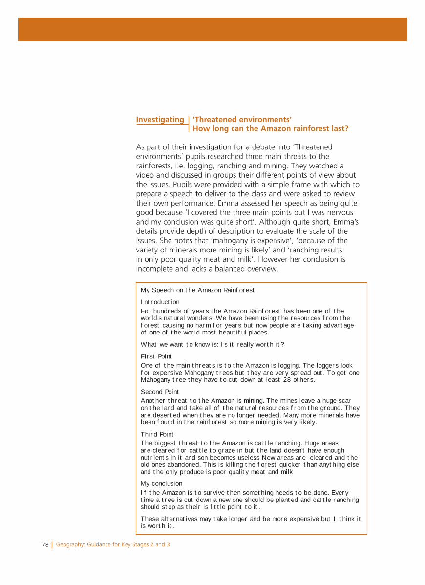
78 Geography: Guidance for Key Stages 2 and 3
As part of their investigation for a debate into ‘Threatened environments’ pupils researched three main threats to the rainforests, i.e. logging, ranching and mining. They watched a video and discussed in groups their different points of view about the issues. Pupils were provided with a simple frame with which to prepare a speech to deliver to the class and were asked to review their own performance. Emma assessed her speech as being quite good because ‘I covered the three main points but I was nervous and my conclusion was quite short’. Although quite short, Emma’s details provide depth of description to evaluate the scale of the issues. She notes that ‘mahogany is expensive’, ‘because of the variety of minerals more mining is likely’ and ‘ranching results in only poor quality meat and milk’. However her conclusion is incomplete and lacks a balanced overview.
My Speech on the Amazon Rainforest
IntroductionFor hundreds of years the Amazon Rainforest has been one of the world’s natural wonders. We have been using the resources from the forest causing no harm for years but now people are taking advantage of one of the world most beautiful places.
What we want to know is: Is it really worth it?
First PointOne of the main threats is to the Amazon is logging. The loggers look for expensive Mahogany trees but they are very spread out. To get one Mahogany tree they have to cut down at least 28 others.
Second PointAnother threat to the Amazon is mining. The mines leave a huge scar on the land and take all of the natural resources from the ground. They are deserted when they are no longer needed. Many more minerals have been found in the rainforest so more mining is very likely.
Third PointThe biggest threat to the Amazon is cattle ranching. Huge areas are cleared for cattle to graze in but the land doesn’t have enough nutrients in it and son becomes useless New areas are cleared and the old ones abandoned. This is killing the forest quicker than anything else and the only produce is poor quality meat and milk
My conclusionIf the Amazon is to survive then something needs to be done. Every time a tree is cut down a new one should be planted and cattle ranching should stop as their is little point to it.
These alternatives may take longer and be more expensive but I think it is worth it.
Investigating ‘Threatened environments’How long can the Amazon rainforest last?
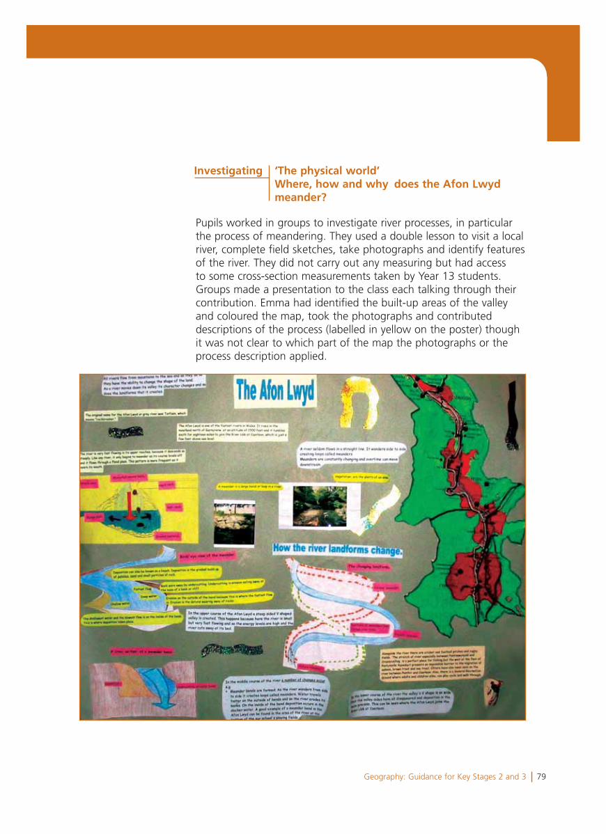
79Geography: Guidance for Key Stages 2 and 3
Pupils worked in groups to investigate river processes, in particular the process of meandering. They used a double lesson to visit a local river, complete field sketches, take photographs and identify features of the river. They did not carry out any measuring but had access to some cross-section measurements taken by Year 13 students. Groups made a presentation to the class each talking through their contribution. Emma had identified the built-up areas of the valley and coloured the map, took the photographs and contributed descriptions of the process (labelled in yellow on the poster) though it was not clear to which part of the map the photographs or the process description applied.
Investigating ‘The physical world’ Where, how and why does the Afon Lwyd meander?
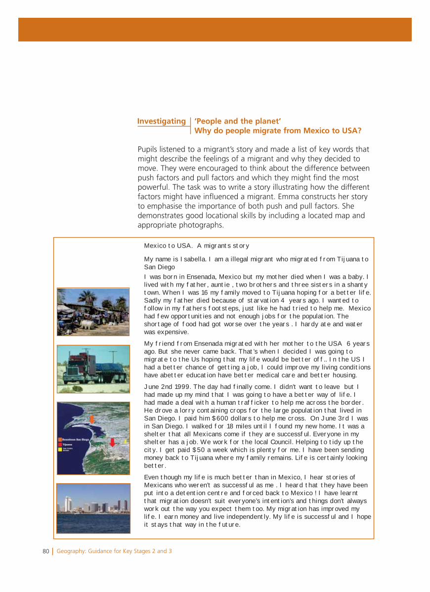
80 Geography: Guidance for Key Stages 2 and 3
Mexico to USA. A migrants story
My name is Isabella. I am a illegal migrant who migrated from Tijuana to San DiegoI was born in Ensenada, Mexico but my mother died when I was a baby. I lived with my father, auntie , two brothers and three sisters in a shanty town. When I was 16 my family moved to Tijuana hoping for a better life. Sadly my father died because of starvation 4 years ago. I wanted to follow in my fathers footsteps, just like he had tried to help me. Mexico had few opportunities and not enough jobs for the population. The shortage of food had got worse over the years . I hardy ate and water was expensive.
My friend from Ensenada migrated with her mother to the USA 6 years ago. But she never came back. That’s when I decided I was going to migrate to the Us hoping that my life would be better off.. In the US I had a better chance of getting a job, I could improve my living conditions have abetter education have better medical care and better housing.
June 2nd 1999. The day had finally come. I didn’t want to leave but I had made up my mind that I was going to have a better way of life. I had made a deal with a human trafficker to help me across the border. He drove a lorry containing crops for the large population that lived in San Diego. I paid him $600 dollars to help me cross. On June 3rd I was in San Diego. I walked for 18 miles until I found my new home. It was a shelter that all Mexicans come if they are successful. Everyone in my shelter has a job. We work for the local Council. Helping to tidy up the city. I get paid $50 a week which is plenty for me. I have been sending money back to Tijuana where my family remains. Life is certainly looking better.
Even though my life is much better than in Mexico, I hear stories of Mexicans who weren’t as successful as me . I heard that they have been put into a detention centre and forced back to Mexico ! I have learnt that migration doesn’t suit everyone’s intention’s and things don’t always work out the way you expect them too. My migration has improved my life. I earn money and live independently. My life is successful and I hope it stays that way in the future.
Pupils listened to a migrant’s story and made a list of key words that might describe the feelings of a migrant and why they decided to move. They were encouraged to think about the difference between push factors and pull factors and which they might find the most powerful. The task was to write a story illustrating how the different factors might have influenced a migrant. Emma constructs her story to emphasise the importance of both push and pull factors. She demonstrates good locational skills by including a located map and appropriate photographs.
Investigating ‘People and the planet’Why do people migrate from Mexico to USA?
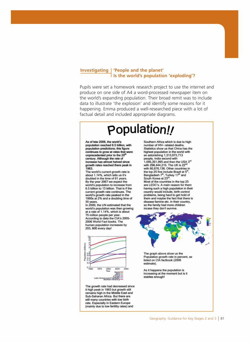
81Geography: Guidance for Key Stages 2 and 3
Pupils were set a homework research project to use the internet and produce on one side of A4 a word-processed newspaper item on the world’s expanding population. Their broad remit was to include data to illustrate ‘the explosion’ and identify some reasons for it happening. Emma produced a well-researched piece with a lot of factual detail and included appropriate diagrams.
Investigating ‘People and the planet’Is the world’s population ‘exploding’?

82 Geography: Guidance for Key Stages 2 and 3
Summary and overall judgement
Levels 5, 6 and 7 were considered and Level 6 was judged to be the best fit.
Emma has begun to apply knowledge and understanding at differentscales (a characteristic of Level 6). She has work on volcanoes at the global scale, on Bangladesh at the national scale, on the Amazon rainforest at a regional scale and on the Afon Lwyd at a local scale. She locates places accurately, e.g. in her work on migration she uses a located map and appropriate photographs, though she is reluctant to construct her own sketch maps. In her work on plate margins and migration to Mexico, her annotations and use of maps demonstrate that she identifies and recognises how places and patterns areinterconnected (a characteristic of Level 7). She identifies clearly the underlying principle of the pattern of different types of activity and of plate margins in her summary, e.g. ‘It all depends on the plate margin.’
She explains physical and human features and some processes(a characteristic of Level 6). However her understanding is more secure in the simple causal narrative of migration, e.g. ‘I wanted a better way of life’, than in the detail of physical processes though she explains some of the factors that influence the processes. In her work on Bangladesh and the Amazon, she begins to explain the relationship between physical and human features and howpeople affect their environments and how change can be sustainable(characteristics of Level 6).
She has excellent research skills and is able to select, collect andapply secondary data (a characteristic of Level 6) and to presentconclusions consistent with the evidence (a characteristic of Level 6) in her work on the population explosion. She asks andresponds to relevant questions (a characteristic of Level 5) but has had little opportunity to identify and establish sequences of her own questions.
She expresses her own view (a characteristic of Level 5) about the exploitation of the rainforest but does not evaluate conflicting views. She selects and uses correctly geographical terminology (a characteristic of Level 6) and can communicate her findings.
83Geography: Guidance for Key Stages 2 and 3
Emma’s work illustrates that she can identify and describe causal links and patterns but does not always understand the reasons for those linkages. As a next step she will need to develop sound explanations using logical cause and effect steps with detailed evidence. She should also be encouraged to address the question ‘Why?’ to provide more developed answers. For example, her work on the Amazon could have included justification as to why she considered ‘there to be little point to cattle ranching’ and why ’there might be different view points’ on that issue. She will also need support to establish sequences for investigation and to have the opportunities to collect and record primary data. Emma downloads appropriate materials from the internet. As a next step she needs to select and adapt materials and use her own illustrative materials including sketch maps.
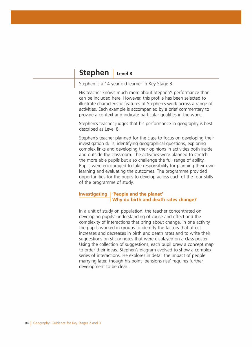
84 Geography: Guidance for Key Stages 2 and 3
Stephen is a 14-year-old learner in Key Stage 3.
His teacher knows much more about Stephen’s performance than can be included here. However, this profile has been selected to illustrate characteristic features of Stephen’s work across a range of activities. Each example is accompanied by a brief commentary to provide a context and indicate particular qualities in the work.
Stephen’s teacher judges that his performance in geography is best described as Level 8.
Stephen’s teacher planned for the class to focus on developing their investigation skills, identifying geographical questions, exploring complex links and developing their opinions in activities both inside and outside the classroom. The activities were planned to stretch the more able pupils but also challenge the full range of ability. Pupils were encouraged to take responsibility for planning their own learning and evaluating the outcomes. The programme provided opportunities for the pupils to develop across each of the four skills of the programme of study.
In a unit of study on population, the teacher concentrated on developing pupils’ understanding of cause and effect and the complexity of interactions that bring about change. In one activity the pupils worked in groups to identify the factors that affect increases and decreases in birth and death rates and to write their suggestions on sticky notes that were displayed on a class poster. Using the collection of suggestions, each pupil drew a concept map to order their ideas. Stephen’s diagram evolved to show a complex series of interactions. He explores in detail the impact of people marrying later, though his point ‘pensions rise’ requires further development to be clear.
Stephen Level 8
Investigating ‘People and the planet’Why do birth and death rates change?
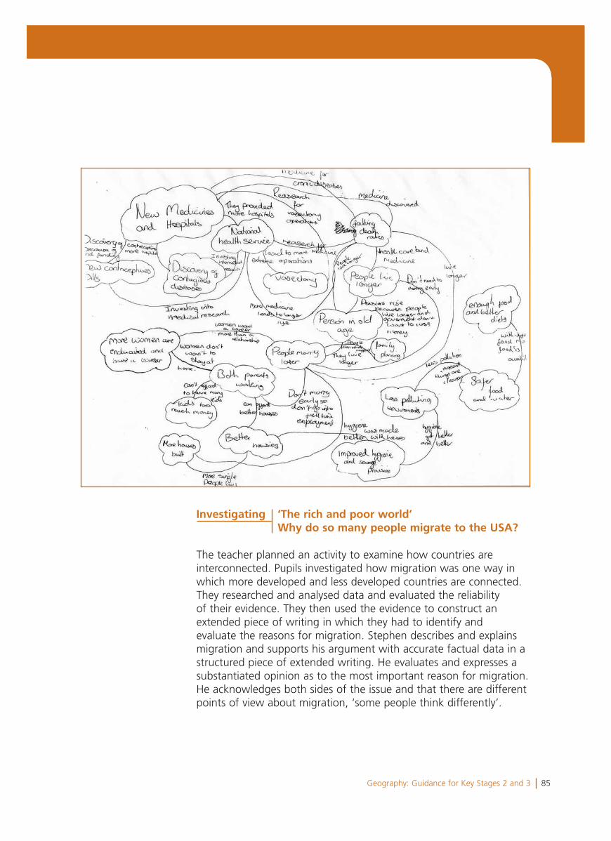
85Geography: Guidance for Key Stages 2 and 3
The teacher planned an activity to examine how countries are interconnected. Pupils investigated how migration was one way in which more developed and less developed countries are connected. They researched and analysed data and evaluated the reliability of their evidence. They then used the evidence to construct an extended piece of writing in which they had to identify and evaluate the reasons for migration. Stephen describes and explains migration and supports his argument with accurate factual data in a structured piece of extended writing. He evaluates and expresses a substantiated opinion as to the most important reason for migration. He acknowledges both sides of the issue and that there are different points of view about migration, ‘some people think differently’.
Investigating ‘The rich and poor world’ Why do so many people migrate to the USA?
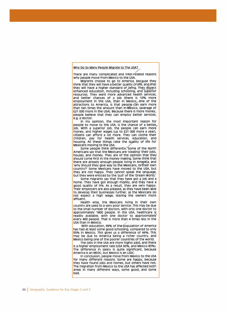
86 Geography: Guidance for Key Stages 2 and 3
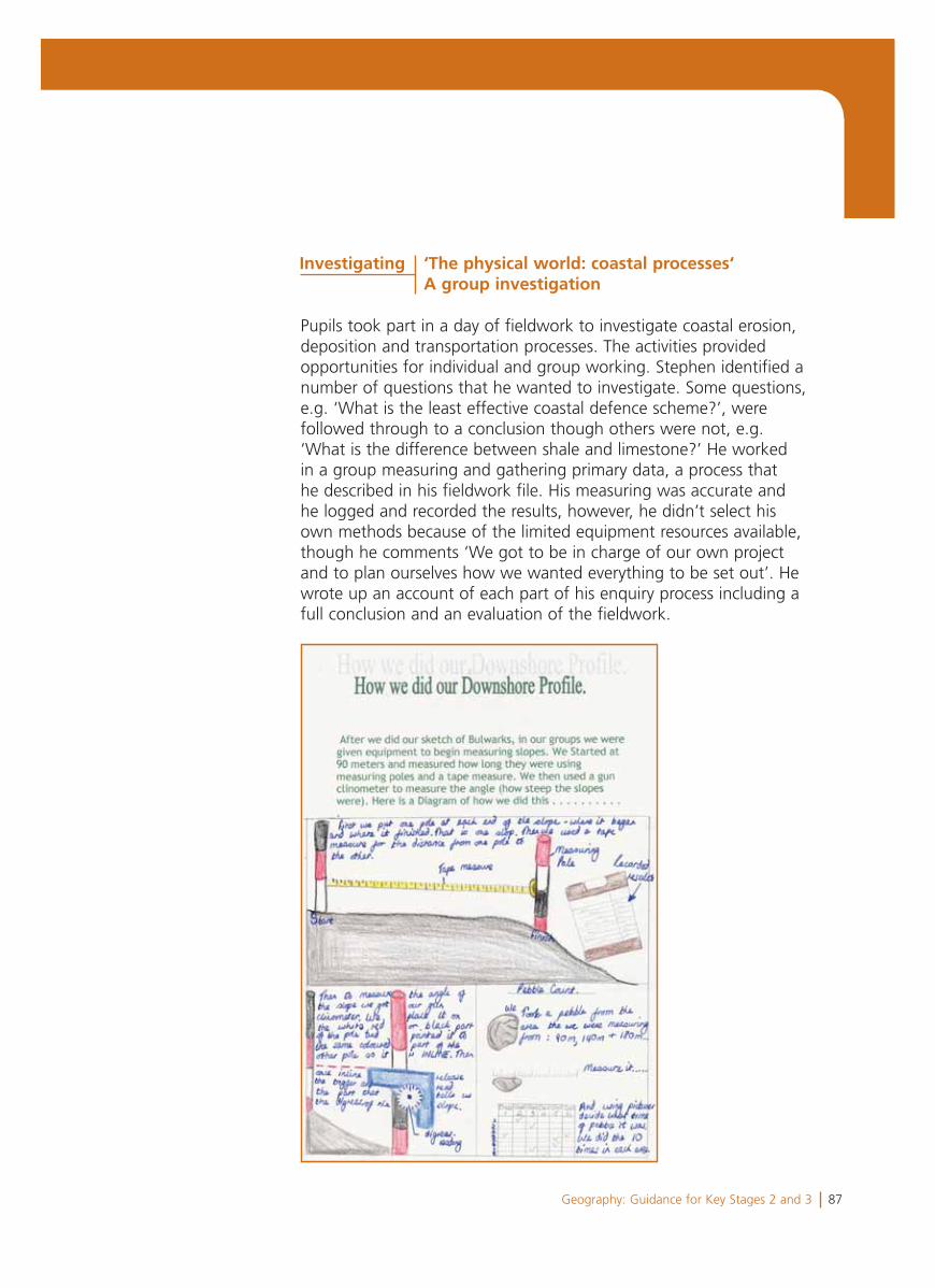
87Geography: Guidance for Key Stages 2 and 3
Pupils took part in a day of fieldwork to investigate coastal erosion, deposition and transportation processes. The activities provided opportunities for individual and group working. Stephen identified a number of questions that he wanted to investigate. Some questions, e.g. ‘What is the least effective coastal defence scheme?’, were followed through to a conclusion though others were not, e.g. ‘What is the difference between shale and limestone?’ He worked in a group measuring and gathering primary data, a process that he described in his fieldwork file. His measuring was accurate and he logged and recorded the results, however, he didn’t select his own methods because of the limited equipment resources available, though he comments ‘We got to be in charge of our own project and to plan ourselves how we wanted everything to be set out’. He wrote up an account of each part of his enquiry process including a full conclusion and an evaluation of the fieldwork.
Investigating ‘The physical world: coastal processes‘ A group investigation
88 Geography: Guidance for Key Stages 2 and 3
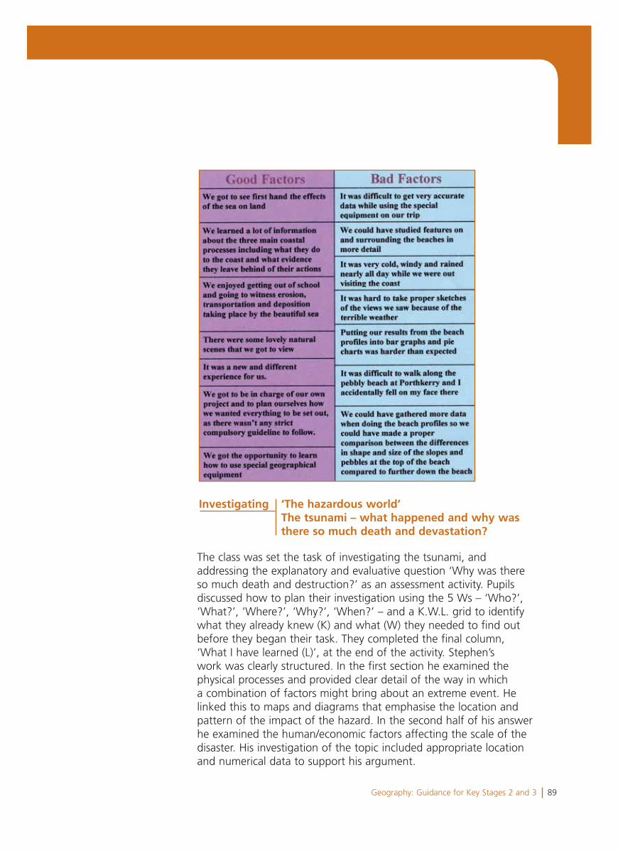
89Geography: Guidance for Key Stages 2 and 3
The class was set the task of investigating the tsunami, and addressing the explanatory and evaluative question ‘Why was there so much death and destruction?’ as an assessment activity. Pupils discussed how to plan their investigation using the 5 Ws – ‘Who?’, ‘What?’, ‘Where?’, ‘Why?’, ‘When?’ – and a K.W.L. grid to identify what they already knew (K) and what (W) they needed to find out before they began their task. They completed the final column, ‘What I have learned (L)’, at the end of the activity. Stephen’s work was clearly structured. In the first section he examined the physical processes and provided clear detail of the way in which a combination of factors might bring about an extreme event. He linked this to maps and diagrams that emphasise the location and pattern of the impact of the hazard. In the second half of his answer he examined the human/economic factors affecting the scale of the disaster. His investigation of the topic included appropriate location and numerical data to support his argument.
Investigating ‘The hazardous world’ The tsunami – what happened and why was there so much death and devastation?
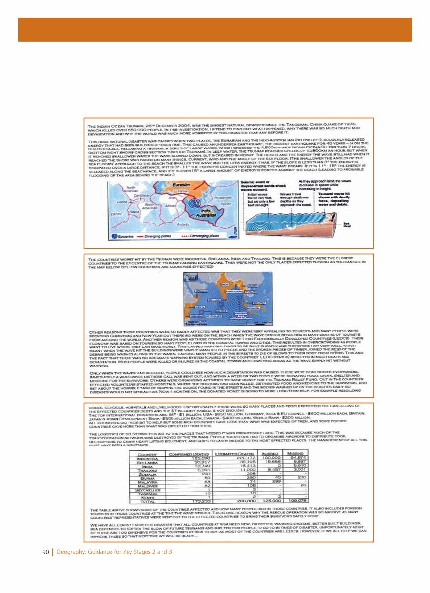
90 Geography: Guidance for Key Stages 2 and 3
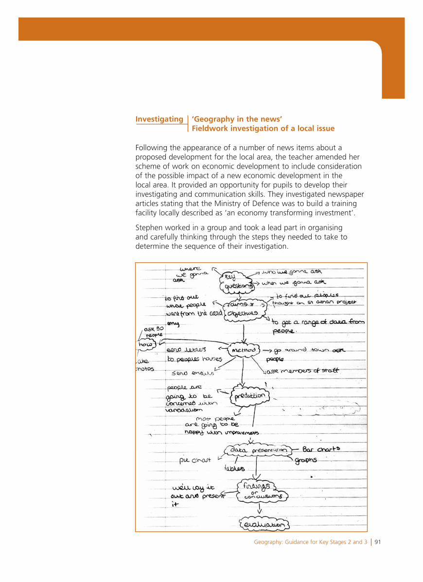
91Geography: Guidance for Key Stages 2 and 3
Following the appearance of a number of news items about a proposed development for the local area, the teacher amended her scheme of work on economic development to include consideration of the possible impact of a new economic development in the local area. It provided an opportunity for pupils to develop their investigating and communication skills. They investigated newspaper articles stating that the Ministry of Defence was to build a training facility locally described as ‘an economy transforming investment’.
Stephen worked in a group and took a lead part in organising and carefully thinking through the steps they needed to take to determine the sequence of their investigation.
Investigating ‘Geography in the news’Fieldwork investigation of a local issue
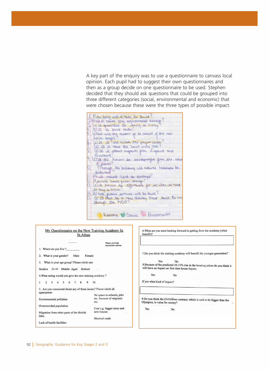
92 Geography: Guidance for Key Stages 2 and 3
A key part of the enquiry was to use a questionnaire to canvass local opinion. Each pupil had to suggest their own questionnaires and then as a group decide on one questionnaire to be used. Stephen decided that they should ask questions that could be grouped into three different categories (social, environmental and economic) that were chosen because these were the three types of possible impact.
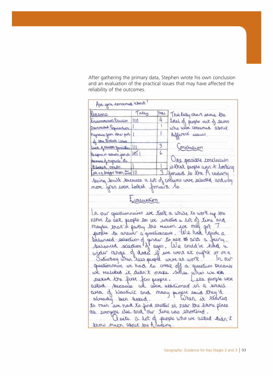
93Geography: Guidance for Key Stages 2 and 3
After gathering the primary data, Stephen wrote his own conclusion and an evaluation of the practical issues that may have affected the reliability of the outcomes.
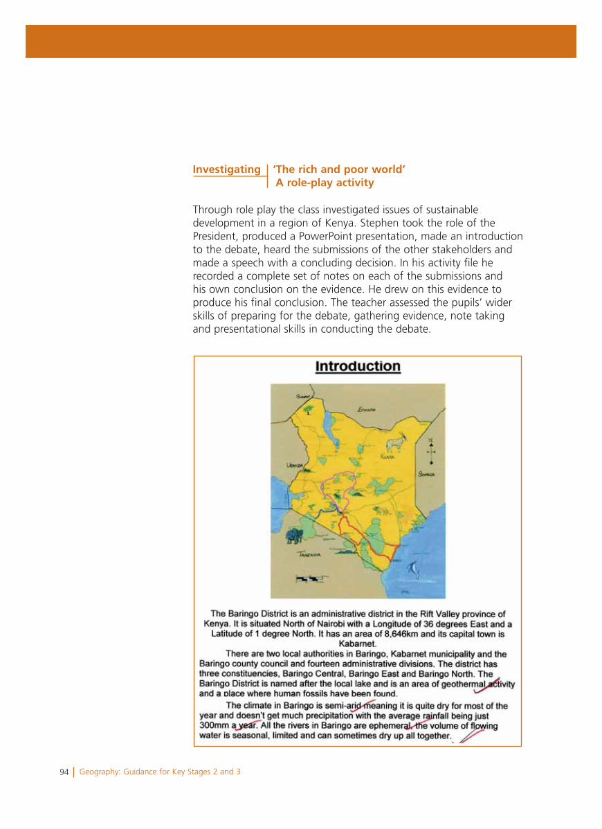
94 Geography: Guidance for Key Stages 2 and 3
Through role play the class investigated issues of sustainable development in a region of Kenya. Stephen took the role of the President, produced a PowerPoint presentation, made an introduction to the debate, heard the submissions of the other stakeholders and made a speech with a concluding decision. In his activity file he recorded a complete set of notes on each of the submissions and his own conclusion on the evidence. He drew on this evidence to produce his final conclusion. The teacher assessed the pupils’ wider skills of preparing for the debate, gathering evidence, note taking and presentational skills in conducting the debate.
Investigating ‘The rich and poor world’A role-play activity
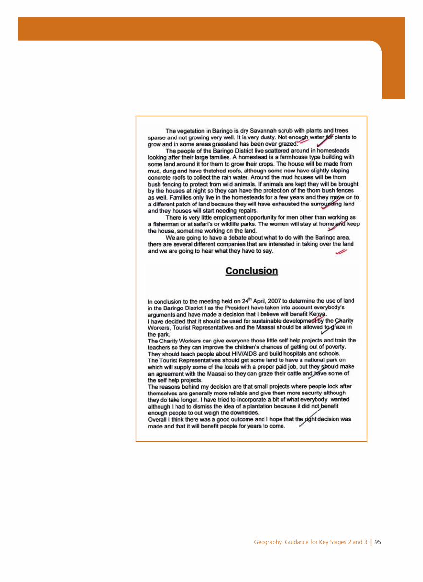
95Geography: Guidance for Key Stages 2 and 3
96 Geography: Guidance for Key Stages 2 and 3
Summary and overall judgement
Levels 7 and 8 were considered and Level 8 was judged to be the best fit.
Stephen shows and applies his knowledge and understanding ofa wide range of places, environments and issues (a characteristic of Level 8). He uses the internet, large scale plans and the atlas to obtain information and locate his investigations though he rarely constructs his own sketch maps or annotated diagrams. In his investigation into the tsunami he is able to identify and explain howpatterns are formed and explain a range of physical and human features and how they were connected (a characteristic of Level 8).
Stephen offers good explanations for interactions between physicaland human features and processes (a characteristic of Level 8) where he recognises that the economics that have driven coastal developments had resulted in more people being affected by the tsunami. He also provides a clear explanation of the complexity of factors affecting the energy of a tsunami. Further evidence that he is capable of working beyond Level 7 is demonstrated in the concept map in which he recognised the complexity of interactions between processes though not all points are clearly expressed, e.g. ‘pensions rise’. In his coastal fieldwork and in the debate on Kenya he recognises environmental issues (a characteristic of Level 7), e.g. ’in some areas the land becomes overgrazed’ and ‘they will have exhausted the land’, however he does not provide a valid explanation of why that happens.
Stephen showed different skills in conducting the two investigations. In both, he demonstrated the ability to work independently and evaluate the process. In the coastal fieldwork he collected accuratelyprimary data and came to substantiated conclusions for some of the questions investigated (characteristics of Level 7). In the independent investigation of a local issue he implemented a sequence of questionsfor the investigation (a characteristic of Level 7). For both investigationshe evaluated the process, identifying and acknowledging limitations, ‘we could have gathered more data’, though in some instances the points were simplistic, e.g. ’it was difficult to walk along the pebbly beach’.
97Geography: Guidance for Key Stages 2 and 3
In his work on migration, Stephen describes and explains the process and supports his argument with accurate factual data in a structured piece of extended writing. He considers different points of view andmakes an informed decision (a characteristic of Level 7). Herecognises that migration has both ‘good and bad effects in different areas’. The teacher assesses Stephen’s skills in the debate as characteristic of Level 8 because he showed independencein identifying appropriate questions during the debate, used his own ideas and considered conflicting views and opinions to draw conclusions, e.g. ‘I dismissed the idea of a plantation because it did not benefit enough people to outweigh the downsides’. In the debate, Stephen spoke confidently and used precise terminology, e.g. ‘dry savannah scrub’, some of which was newly acquired through his research, e.g. ‘rivers are ephemeral’.
As a next step, Stephen should construct his own diagrams, plans and maps to convey geographical understanding and draw on data to identify trends and future implications, as well as how patterns evolve and change. He will need support to develop his investigative skills, including collecting more complex primary data and carry out a complete enquiry independently.
98 Geography: Guidance for Key Stages 2 and 3
Acknowledgements
The Department for Children, Education, Lifelong Learning and Skills (DCELLS) would like to thank the many teachers, schools, local authorities, the National Advisory Panel for the Humanities and other organisations who have helped in the development of this guidance.
Special thanks are given to Eryl Samuel for his invaluable assistance and to the Guidance Group, Jan Bond, Andy Freem, Rhys Huws, Jane Jones, Manon Lewis, Huw Raw Rees, Helen Turner, Lisa Mead and Nigel Vaughan (Estyn) who gave up valuable time to assist us in the development of this guidance.
DCELLS would also like to thank those pupils and parents/guardians who agreed to allow examples of work to be reproduced in this guidance.
In particular, DCELLS is grateful to the following schools for providing help and materials:
Cornist Park School, Flintshire Croesyceiliog School, TorfaenCwrt yr Ala Junior School, CardiffCyfartha High School, Merthyr TydfilGolftyn Primary School, Flintshire Hirwaun Primary School, Rhondda Cynon TaffLlanishen High School, CardiffLlantwit Major School, Vale of GlamorganMilbank Primary School, Cardiff Penglais Comprehensive School, CeredigionTaliesin Junior School, FlintshireTrelai Primary School, Cardiff.
DCELLS would like to thank the following who granted permisson to reproduce copyright material in this guidance:
Visit Wales (page 50)Raintree Nutrition, Inc. (page 71)NASA (page 71)UNICEF Bangladesh/Bangladesh 2004/Mufty Munir (page 74)Wikipedia (http://creativecommons.org/licenses/by/2.5) (page 80)Ian Britton, FreeFoto.com (page 80)PDPhoto.org (www.pdphoto.org) (page 80).

99Geography: Guidance for Key Stages 2 and 3


![[PPT]Presentación de PowerPoint - Bienvenidos - …b2b-empretel.com/albums/albums/Material_Webinar/130424... · Web viewCuenta con configuraciones de 4/8 cámaras con iluminadores](https://img.pdfslide.net/doc/110x75/5b282b607f8b9a6c448b59a3/pptpresentacion-de-powerpoint-bienvenidos-b2b-web-viewcuenta-con-configuraciones.jpg)